created 1600 utc september 19, 2010 · 9/19/2010 · created 1600 utc september 19, 2010 ......
TRANSCRIPT
Tri-Agency Forecast Discussion for September 19, 2010
Created 1600 UTC September 19, 2010
GRIP Forecast Team: Cerese Albers Inglish, Dave Zelinsky, Jon Zawislak, Joshua
Cossuth, and Ryan Truchelut, Lesley Leary, Dave Kofron, Diana Stovern
Summary: Today is a no-fly day for all tri-agency aircraft. There are currently no targets
of interest to the campaign within flight range, but that could change shortly as PGI-46L
moves closer to the Caribbean. PGI-46L has more convection associated with it today,
however there is a lot of disagreement in the models about whether this system will
undergo genesis or not. One very interesting feature with this potential target is the heavy
dust load to the north of the system that is expected to be advected all the way into the
Caribbean, and could even be near Puerto Rico in 60 hours from now. PREDICT has
plans to fly PGI-46L tomorrow at 1200 UTC, and it will be interesting to see what they
find. With the end of the tri-agency participation approaching, it will be interesting to see
if PGI-45L can make it across the Atlantic or if it will recurve north to the west of the
Cape Verde islands and remain out of reach. Other than these two potential targets, the
tri-agency domain remains fairly inactive for the coming days.
Forecast for 1600 UTC 9/19/2010:
Synoptic Overview:
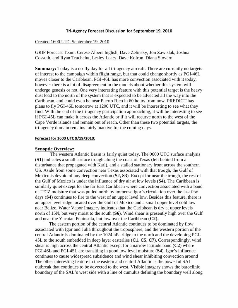
The western Atlantic Basin is fairly quiet today. The 0600 UTC surface analysis
(S1) indicates a small surface trough along the coast of Texas (left behind from a
disturbance that propagated with Karl), and a stalled stationary front across the southern
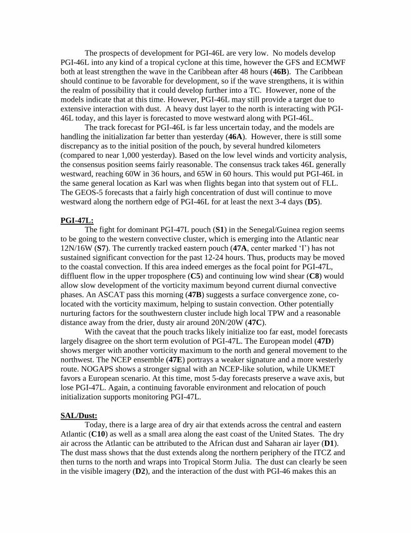
US. Aside from some convection near Texas associated with that trough, the Gulf of
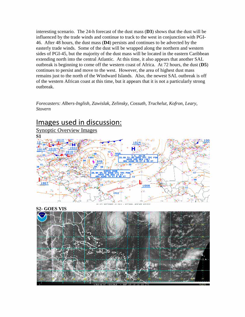
Mexico is devoid of any deep convection (S2, S3). Except for near the trough, the rest of
the Gulf of Mexico is under the influence of dry air at low levels (S4). The Caribbean is
similarly quiet except for the far East Caribbean where convection associated with a band
of ITCZ moisture that was pulled north by immense Igor’s circulation over the last few
days (S4) continues to fire to the west of an upper level low. Besides this feature, there is
an upper level ridge located over the Gulf of Mexico and a small upper level cold low
near Belize. Water Vapor Imagery indicates that the Caribbean is dry at upper levels
north of 15N, but very moist to the south (S6). Wind shear is presently high over the Gulf
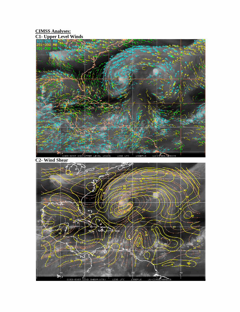
and near the Yucatan Peninsula, but low over the Caribbean (C2).
The eastern portion of the central Atlantic continues to be dominated by flow
associated with Igor and Julia throughout the troposphere, and the western portion of the
central Atlantic is dominated by the 1024 hPa ridge to the north and the developing PGI-
45L to the south embedded in deep layer easterlies (C1, C5, C7). Correspondingly, wind
shear is high across the central Atlantic except for a narrow latitude band (C2) where
PGI-46L and PGI-45L are transiting in good low level moisture (S4). Igor’s influence
continues to cause widespread subsidence and wind shear inhibiting convection around
The other interesting feature in the eastern and central Atlantic is the powerful SAL
outbreak that continues to be advected to the west. Visible imagery shows the baroclinic
boundary of the SAL’s west side with a line of cumulus defining the boundary well along

52W, and the deep convection is firing on the southern boundary of the SAL along 13N
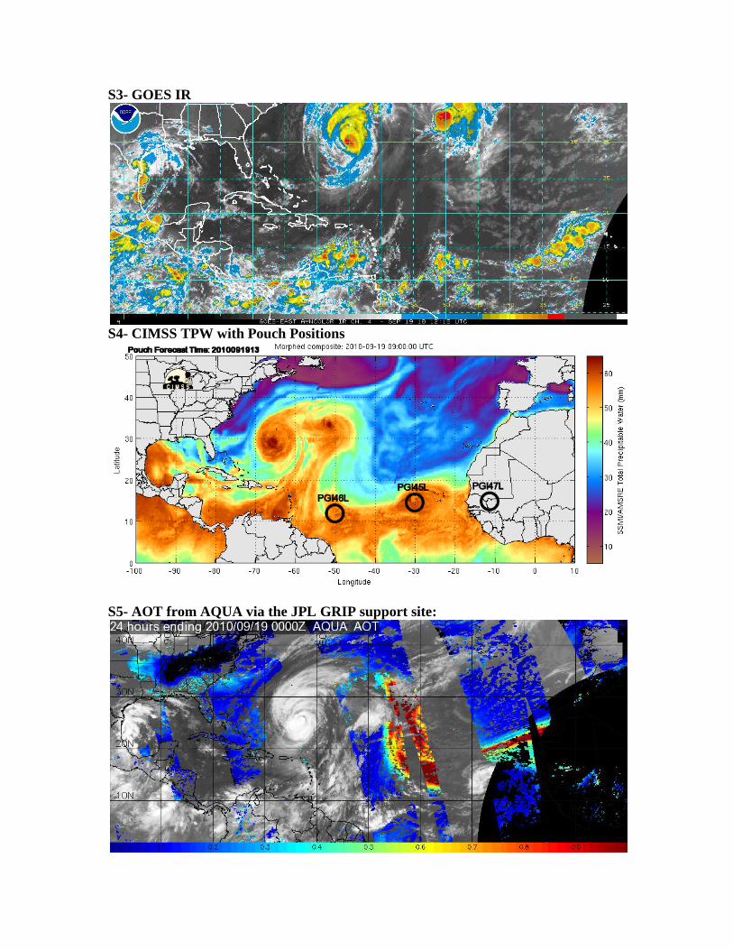
(S2). AOT values (S5) are very high associated with this SAL outbreak and it is
interacting with convection associated with PGI-46L. It will be interesting to see if the
GEOS-5 forecast for the dust verifies and it is advected into the Caribbean as far as
Puerto Rico in 60 hours. Based on the synoptic flow that should prevail as Igor moves
north, this is a distinct possibility.
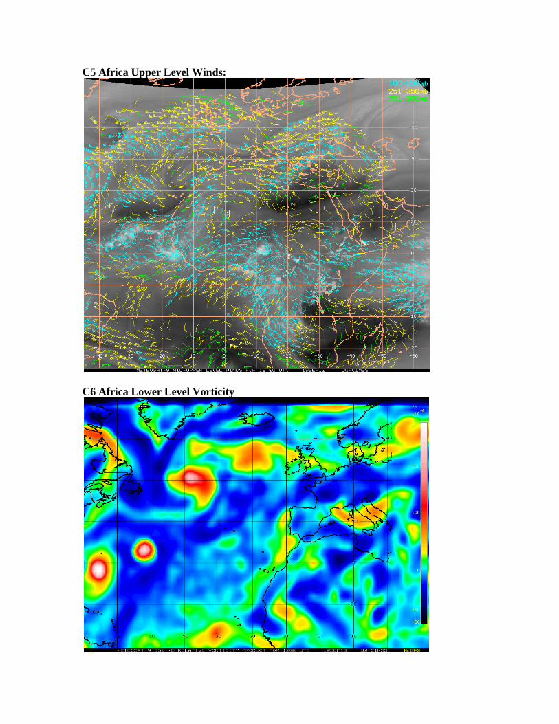
In the East Atlantic and West Africa, PGI-45L is located to the west of the Cape
Verde Islands and PGI-47L is entering Senegal (S4), and an upper level low is
approaching Europe (C5). A moisture maximum extends to 20N with PGI-45L and PGI-
47L remains embedded in deep layer moisture (S4, C5). At low levels, winds indicate the
continued flow of monsoonal moisture into West Africa (C7) but wind shear values over
southern portions of West Africa are high (C8). Steering flow (C9) for the region
indicates that AEWs should move west on a southerly track, and that is a semi permanent
feature this time of year.
Features of Interest:
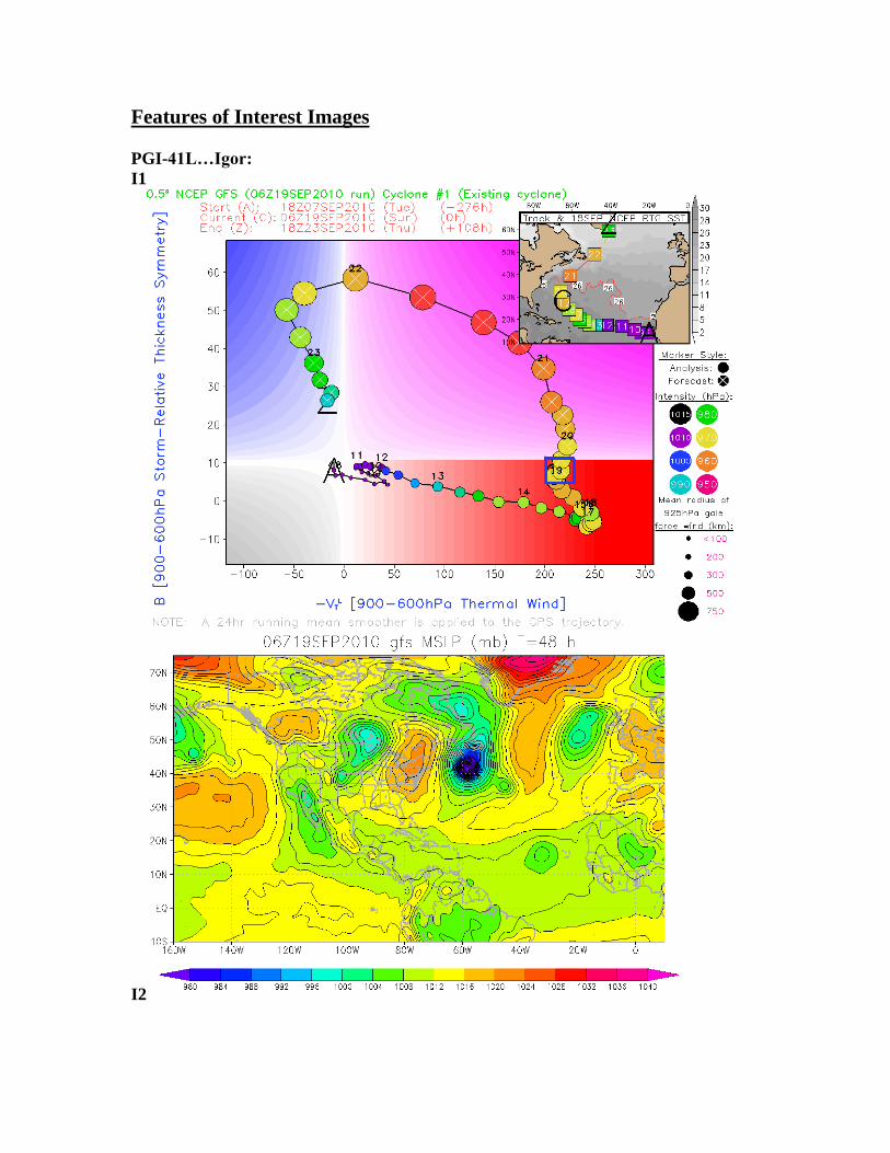
Hurricane Igor:
Igor has been downgraded to a category 1 storm with a central pressure is 949 hPa,
maximum sustained winds estimated to be 75 knots, and a radius of gale force winds at
about 500 km (NHC/I1). TPW imagry shows dry air to starting to entrain into the center
of the storm which will help to weaken it as it moves into an area of high wind shear.
The first signs of extratropical transition are becoming apparent with the structure of the
inner-core becoming assymetrical and an undetectable eyewall according to NHC aircraft
reports. It will be considered extratropical within the next 24 hours (I1). Currently, Igor
is on a NNW track moving at 10 knots but is expected to start a northeastern track as it
gets caught into the outer flow of the subtropical ridge. ECMWF and GFS expect it to
merge with Julia in the next 48 hours but it should remain a large and relatively strong
extratropical cyclone as it makes this transition (I2).
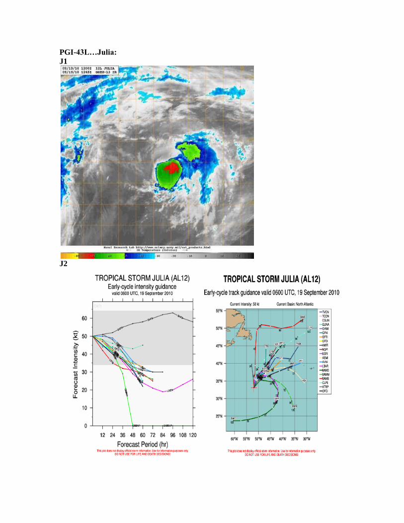
Tropical Storm Julia:
Julia remained consistent overnight with an estimated central pressure of 998 hPa with
maximum sustained winds of 45 kts. The system's course has transitioned from a NNW
heading (330) to a N heading (360) and slowed substantially from 17 kts to 12 kts. This
morning the system deepened slightly to an estimated minimum central pressure of 995
hPa continuing northward at 14 kts with a heading of 355. As of 0900 UTC Julia was
located at 33.6N/51.8W appearing as a broad area of low pressure with its center not
clearly visible and it is continuing out of the tropics (J1).
Early-cycle track guidance shows very little consensus with ensemble members varying
from extreme re-curvature with Julia to straight northward tracks and Julia dissipating in
the North Atlantic (J2). ECMWF has Julia becoming absorbed by Igor at 72 hrs and then
re-emerging as an independent low pressure system again at 96 hrs before dissipating,
while the GFS has Julia dissipating almost completely by 54 hrs with a small area of low
pressure joining the massive low pressure center of Igor. Early-cycle intensity guidance

shows good consensus among ensemble members with Julia rapidly weakening and the
majority of members estimating the system to be degraded from tropical storm status
within 48 hrs (J2).
PGI-45L/ AL94:
As of 1200 UTC, Invest 94L is centered near 15N 31W. This system has become better
organized in the past 24 hours, with the NHC forecasting a 70% chance of tropical
cyclone formation within 48 hours and a 65% chance of development in 48 hours based
on a Dvorak T-Number of 2.0 from TAFB at 1145 UTC. Westerly motion in low cloud
elements is apparent in morning visible satellite imagery (45A), and the feature’s broad
surface circulation now appears closed, though elongated southwest to northeast. 94L is
located in a narrow band of reasonably favorable 10-15 knot westerly shear sandwiched
between much stronger westerly shear to the north driven by an upper-level trough axis
and some easterly shear south of 10N (45A). Sea surface temperatures exceed 28C, and
there is low-level convergence and upper-level divergence co-located with 94L (45B).
Dry air remains a concern as precipitable water is low north and west of the system but
adequate within the circulation envelope itself and to the south and east of the invest (S4,
S6).
Though cloud tops have warmed somewhat this morning, 94L is one decent convective
burst away from genesis and some development now appears likely as most global
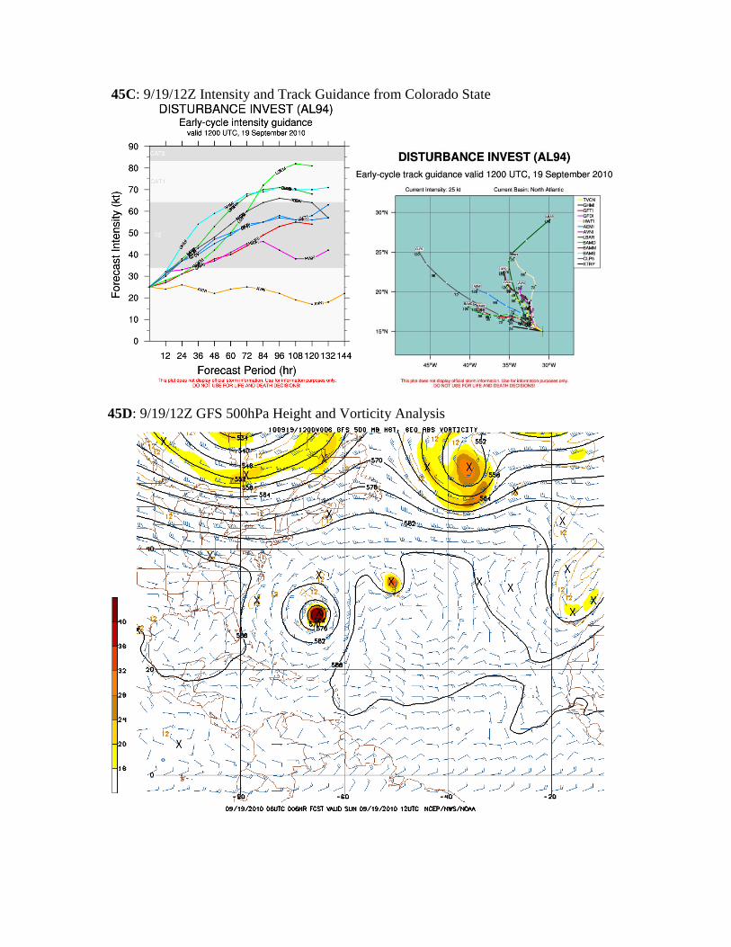
models now support modest intensification. Hurricane dynamical and statistical-
dynamical models unanimously bring 94L to tropical storm intensity within 36 hours and
the consensus is that it will plateau in intensity at around 55 knots between 72 and 120
hours (45C). The solution broadly makes physical sense as increasing the strength of
94L’s circulation will likely result in the ingestion of mid-level dry air into the core and
act as a check on future intensification.
While 94L is a good candidate to become Tropical Storm Lisa by mid-week, the track
forecast remains unusual and problematic. This system is caught in an area of weak low-
and mid-level steering currents between ridging centered near 34N/45W and a mid- and
upper-level trough extending north-northeastward from roughly 20N/20W (45D). The
invest has moved WNW at around 5 knots over the last 24 hours, and as the ridging and
troughing both build and shift westward over the next four days, 94L will move even
more glacially WNW/NW though the middle of next week. While there is significant
spread in the 0000 UTC model solutions, it is worth noting that most of the guidance
holds 94L east of 35W through 120 hours and none of the models move the system past
40W by Wednesday (45C).
PGI-46L:
Convection fired overnight in association with PGI-46L, however it remains very
unorganized (46A). Lower level winds indicate the presence of slight cyclonic turning,
but the system remains little more than a weak wave. The western component of PGI-
46L has entirely separated from the eastern component which is now being stretched
along the ITCZ.
The prospects of development for PGI-46L are very low. No models develop
PGI-46L into any kind of a tropical cyclone at this time, however the GFS and ECMWF
both at least strengthen the wave in the Caribbean after 48 hours (46B). The Caribbean
should continue to be favorable for development, so if the wave strengthens, it is within
the realm of possibility that it could develop further into a TC. However, none of the
models indicate that at this time. However, PGI-46L may still provide a target due to
extensive interaction with dust. A heavy dust layer to the north is interacting with PGI-
46L today, and this layer is forecasted to move westward along with PGI-46L.
The track forecast for PGI-46L is far less uncertain today, and the models are
handling the initialization far better than yesterday (46A). However, there is still some
discrepancy as to the initial position of the pouch, by several hundred kilometers
(compared to near 1,000 yesterday). Based on the low level winds and vorticity analysis,
the consensus position seems fairly reasonable. The consensus track takes 46L generally
westward, reaching 60W in 36 hours, and 65W in 60 hours. This would put PGI-46L in
the same general location as Karl was when flights began into that system out of FLL.
The GEOS-5 forecasts that a fairly high concentration of dust will continue to move
westward along the northern edge of PGI-46L for at least the next 3-4 days (D5).
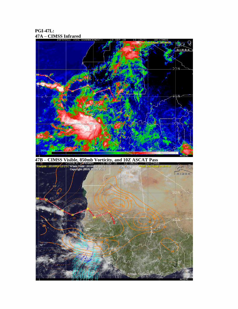
PGI-47L:
The fight for dominant PGI-47L pouch (S1) in the Senegal/Guinea region seems
to be going to the western convective cluster, which is emerging into the Atlantic near
12N/16W (S7). The currently tracked eastern pouch (47A, center marked ‘I’) has not
sustained significant convection for the past 12-24 hours. Thus, products may be moved
to the coastal convection. If this area indeed emerges as the focal point for PGI-47L,
diffluent flow in the upper troposphere (C5) and continuing low wind shear (C8) would
allow slow development of the vorticity maximum beyond current diurnal convective
phases. An ASCAT pass this morning (47B) suggests a surface convergence zone, co-
located with the vorticity maximum, helping to sustain convection. Other potentially
nurturing factors for the southwestern cluster include high local TPW and a reasonable
distance away from the drier, dusty air around 20N/20W (47C).
With the caveat that the pouch tracks likely initialize too far east, model forecasts
largely disagree on the short term evolution of PGI-47L. The European model (47D)
shows merger with another vorticity maximum to the north and general movement to the
northwest. The NCEP ensemble (47E) portrays a weaker signature and a more westerly
route. NOGAPS shows a stronger signal with an NCEP-like solution, while UKMET
favors a European scenario. At this time, most 5-day forecasts preserve a wave axis, but
lose PGI-47L. Again, a continuing favorable environment and relocation of pouch
initialization supports monitoring PGI-47L.
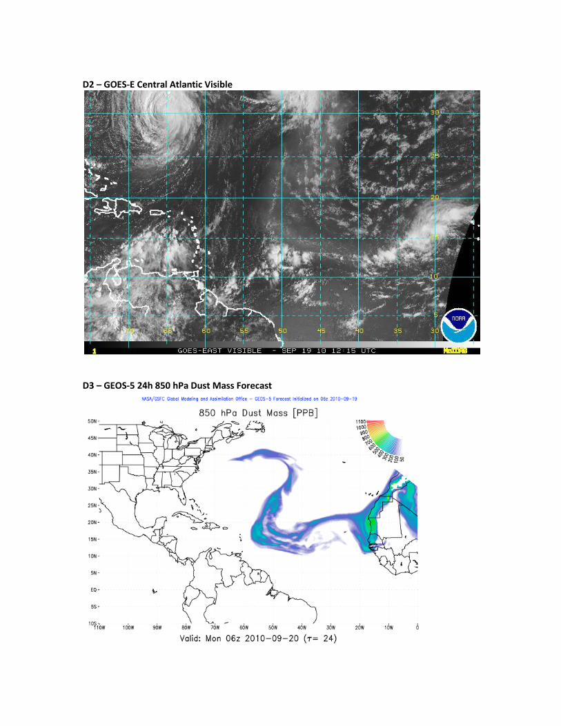
SAL/Dust: Today, there is a large area of dry air that extends across the central and eastern
Atlantic (C10) as well as a small area along the east coast of the United States. The dry
air across the Atlantic can be attributed to the African dust and Saharan air layer (D1).
The dust mass shows that the dust extends along the northern periphery of the ITCZ and
then turns to the north and wraps into Tropical Storm Julia. The dust can clearly be seen
in the visible imagery (D2), and the interaction of the dust with PGI-46 makes this an
interesting scenario. The 24-h forecast of the dust mass (D3) shows that the dust will be
influenced by the trade winds and continue to track to the west in conjunction with PGI-
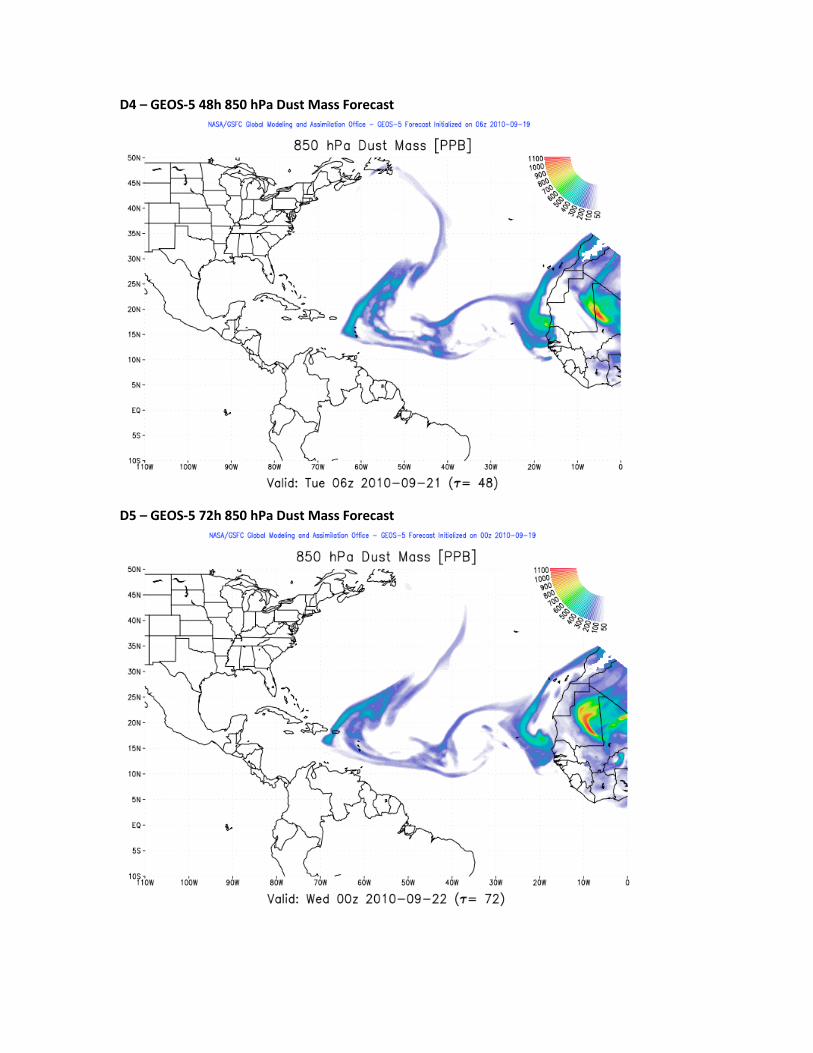
46. After 48 hours, the dust mass (D4) persists and continues to be advected by the
easterly trade winds. Some of the dust will be wrapped along the northern and western
sides of PGI-45, but the majority of the dust mass will be located in the eastern Caribbean
extending north into the central Atlantic. At this time, it also appears that another SAL
outbreak is beginning to come off the western coast of Africa. At 72 hours, the dust (D5)
continues to persist and move to the west. However, the area of highest dust mass
remains just to the north of the Windward Islands. Also, the newest SAL outbreak is off
of the western African coast at this time, but it appears that it is not a particularly strong
outbreak.
Forecasters: Albers-Inglish, Zawislak, Zelinsky, Cossuth, Truchelut, Kofron, Leary,
Stovern
Images used in discussion: Synoptic Overview Images S1
S2- GOES VIS
S3- GOES IR
S4- CIMSS TPW with Pouch Positions
S5- AOT from AQUA via the JPL GRIP support site:

S6- GOES Water Vapor:
S7- METEOSAT IR
CIMSS Analyses:
C1- Upper Level Winds
C2- Wind Shear

C3- 200 hPa Vorticity
C4- 850 hPa Vorticity
C5 Africa Upper Level Winds:
C6 Africa Lower Level Vorticity

C7 Africa Lower Level Winds
C8 Africa Wind Shear

C9 700-850mb Steering Flow over Africa
C10- CIMSS SAL tracking product, showing mostly Dry Air locations.
Features of Interest Images
PGI-41L…Igor:
I1
I2
PGI-43L…Julia:
J1
J2

PGI-45L:
45A: CIMSS Shear and Visible
45B: CIMSS SST, Low-Level Convergence, and Upper-Level Divergence
45C: 9/19/12Z Intensity and Track Guidance from Colorado State
45D: 9/19/12Z GFS 500hPa Height and Vorticity Analysis

PGI-46L:
46A
46B
PGI-47L:
47A – CIMSS Infrared
47B – CIMSS Visible, 850mb Vorticity, and 10Z ASCAT Pass

47C – CIMSS TPW overlaid with SAL product
47D – RSMAS ECMWF Ensemble (72h 850mb vorticity)

47E – RSMAS NCEP Ensemble (72h 850mb vorticity)
Dust/SAL: D1 – GEOS-5 00h 850 hPa Dust Mass
D2 – GOES-E Central Atlantic Visible
D3 – GEOS-5 24h 850 hPa Dust Mass Forecast
D4 – GEOS-5 48h 850 hPa Dust Mass Forecast
D5 – GEOS-5 72h 850 hPa Dust Mass Forecast