creating map books
DESCRIPTION
tutorial data driven arcgis 10.1TRANSCRIPT

Creating Map Books
Using Data Driven Pages
Presented By:
Daniel Allen, GISP
September 20, 2011

GIS-SIG Program Meeting
September 20, 2011
Presented By
Daniel Allen, GISP
Introduction
• What is the definition of a map book?
– It is a book of maps
• Series of maps with a similar theme that breaks a
large area into smaller maps

GIS-SIG Program Meeting
September 20, 2011
Presented By
Daniel Allen, GISP
History of Map Books
• Starting at ArcGIS 8.x, you only have one
map layout for each .MXD file
• Who has made a map book by doing this?

GIS-SIG Program Meeting
September 20, 2011
Presented By
Daniel Allen, GISP
Introduction
• How many people have used developer
sample DS Mapbook at ArcGIS 9.x?
• ESRI incorporated this functionality into
ArcGIS 10.x as Data Driven Pages.

GIS-SIG Program Meeting
September 20, 2011
Presented By
Daniel Allen, GISP
Getting Started
• Map books are based on an index layer
• Use existing feature class as index layer
• Create a new index grid layer using
ArcToolbox

GIS-SIG Program Meeting
September 20, 2011
Presented By
Daniel Allen, GISP
Index Layers
• Grid
• Strip
• Asymmetrical

GIS-SIG Program Meeting
September 20, 2011
Presented By
Daniel Allen, GISP
Index Layers
• Grid Index
– Symmetrical
• Map pages are equal size and scale

GIS-SIG Program Meeting
September 20, 2011
Presented By
Daniel Allen, GISP
Index Layers
• Strip Index
– Corridor map
• Index follows a feature like stream or utility
alignment route

GIS-SIG Program Meeting
September 20, 2011
Presented By
Daniel Allen, GISP
Index Layers
• Asymmetrical
– Use existing polygon feature class
– Each map has its own unique boundary
• Example: use state boundaries to create a map
series showing a map zoomed into each state
boundary
• Creates cartographic challenges if maps are at
different scales
GIS-SIG Program Meeting
September 20, 2011
Presented By
Daniel Allen, GISP
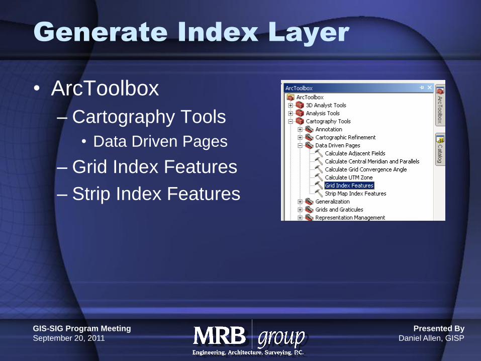
Generate Index Layer
• ArcToolbox
– Cartography Tools
• Data Driven Pages
– Grid Index Features
– Strip Index Features

GIS-SIG Program Meeting
September 20, 2011
Presented By
Daniel Allen, GISP
Generate Index Layer
• Grid Index
– Requirements
• Need a base layer to build the index grid from
– Ex. Sanitary sewer system
• Need to know the viewable area of your printed map
• Need to consider if you want to show a small portion
of the adjoining maps on each map in the map book
• Need to know your map scale

GIS-SIG Program Meeting
September 20, 2011
Presented By
Daniel Allen, GISP
Generate Index Layer

GIS-SIG Program Meeting
September 20, 2011
Presented By
Daniel Allen, GISP
Generate Index Layer
• Start editing session and fine tune the grid
index layer to avoid map pages that are
nearly empty
GIS-SIG Program Meeting
September 20, 2011
Presented By
Daniel Allen, GISP
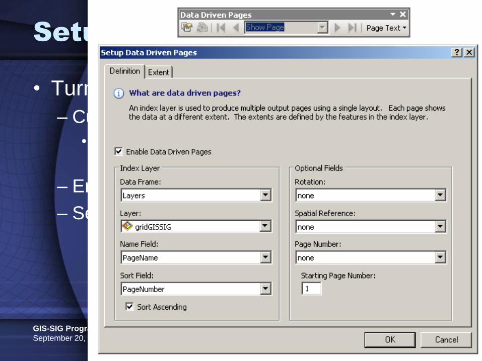
Setup Data Driven Pages
• Turn on Data Driven Pages Toolbar
– Customize
• Toolbars
– Data Driven Pages
– Enable Data Driven Pages
– Set Parameters

GIS-SIG Program Meeting
September 20, 2011
Presented By
Daniel Allen, GISP
Setup Data Driven Pages
• Set Extent
– Center and maintain current scale (set map
scale first)
– Data Driven Scale
• Take scale from attribute table of index layer
(Current Bug Report)

GIS-SIG Program Meeting
September 20, 2011
Presented By
Daniel Allen, GISP
Dynamic Map Elements
• Dynamic map elements change depending
on map page
• Map title
• Page number
• Author
• File Path
• Adjacent Page Numbers

GIS-SIG Program Meeting
September 20, 2011
Presented By
Daniel Allen, GISP
Dynamic Map Elements
• Adjacent page numbers
– ArcToolbox / Data Driven Pages / Calculate
Adjacent Fields

GIS-SIG Program Meeting
September 20, 2011
Presented By
Daniel Allen, GISP
Dynamic Map Elements
• Insert / Dynamic Text / Page Number
• Modify Text to look for adjacent page
numbers
• Search ESRI Help for “Using Dynamic Text
With Data Driven Pages”

GIS-SIG Program Meeting
September 20, 2011
Presented By
Daniel Allen, GISP
Page Definition Queries
• Page definition queries
– Filter content to only show what is inside or
outside of your grid index layer for each map
sheet

GIS-SIG Program Meeting
September 20, 2011
Presented By
Daniel Allen, GISP
Locator Map
• Locator Map
• Highlights grid cell for each active page
– Create new data frame
– Copy your index layer to the new data frame
• Setup page definition query
GIS-SIG Program Meeting
September 20, 2011
Presented By
Daniel Allen, GISP
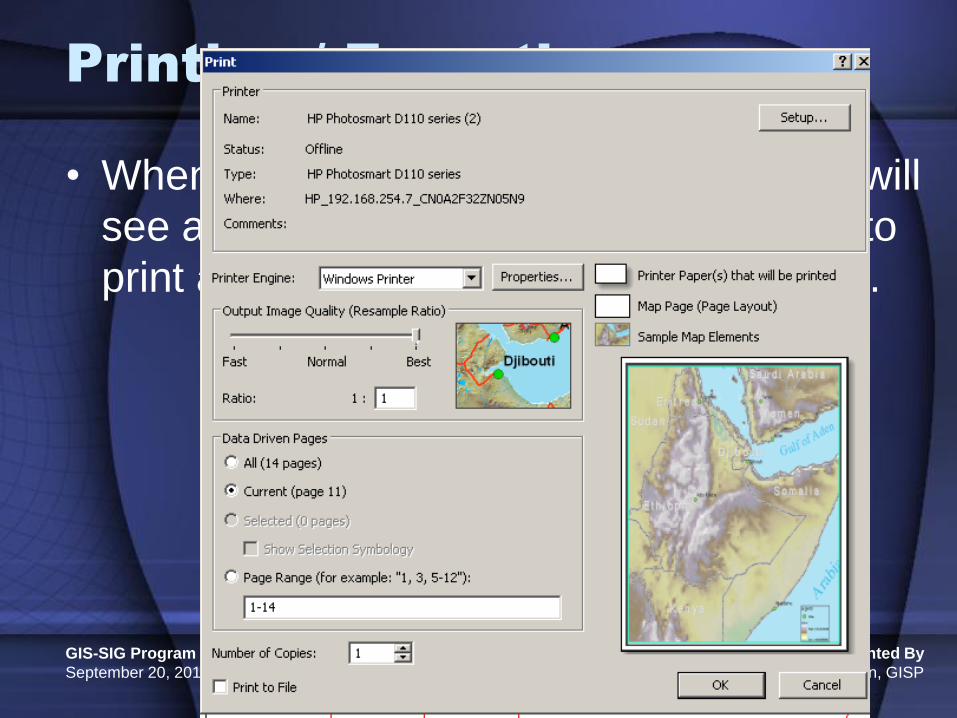
Printing / Exporting
• When data driven pages in enabled you will
see an option on the print/export screen to
print any or all data driven pages at once.

GIS-SIG Program Meeting
September 20, 2011
Presented By
Daniel Allen, GISP
Printing / Exporting
• Title page and index page should be setup
as separate .MXD files
• Use Python scripting or custom ESRI
Toolbox to export multiple .MXD files to one
• Google search for “arcpy.mapping sample
script tools”

GIS-SIG Program Meeting
September 20, 2011
Presented By
Daniel Allen, GISP
Conclusion
• Questions?
• Live Demo
• Contact Info:
– Daniel Allen, GISP
MRB Group, P.C.
585-381-9250