cruising guide to florida’s big bend - … · chapter 14 lake seminole and the flint river to...
TRANSCRIPT

CRUISING GUIDE TO
FLORIDA’S BIG BEND

Apalachicola River Beach
Chicago, Calumet, Des Plaines, Illinois, Mississippi, Ohio, Cumberland, and Tennessee
By Captain Rick Rhodes
PELICAN PUBLISHING COMPANYGRETNA 2003
CRUISING GUIDE TOFLORIDA’S BIG BEND

Copyright © 2003By Rick RhodesAll rights reserved
Drawings by Pat ChampagnePhotographs by author, Cecile Sangiamo, and Kent Wiley
Library of Congress Cataloging-in-Publication Data
Rhodes, Rick.Cruising guide to Florida’s Big Bend / by Rick Rhodes.
p. cm.Includes bibliographical references (p. ) and index.ISBN 1-58980-072-91. Boats and boating—Florida—Big Bend Region—Guidebooks. 2.Intracoastal waterways—Florida—Big Bend Region—Guidebooks. 3. Inlandnavigation—Florida—Big Bend Region—Guidebooks. 4. Big Bend Region(Fla.)—Guidebooks. I. Title.GV776.F6 B547 2003796.1’09759—dc21
2002015615
Information in this guidebook is based on authoritative data available atthe time of printing. Prices and hours of operation of businesses listed are sub-ject to change without notice. Readers area asked to take this into accountwhen conulting this guide. Drawings and NOAA chart extracts are not for usein navigation.
The publisher and the author make no guarantee as to the accuracyor reliablity of the information contained within this guidebook and willnot accept any liablity for injuries or damages caused to the reader by fol-lowing this data.
Printed in the United States of America
Published by Pelican Publishing Company, Inc.1000 Burmaster Street, Gretna, Louisiana 70053

Contents
Introduction 7Chapter 1 History 15Chapter 2 Wildlife, Flora, Recreation, and Industry 23Chapter 3 Navigating along the Gulf of Mexico 31Chapter 4 Navigating up the Coastal Rivers 51Chapter 5 The Apalachicola Region 61Chapter 6 The Carrabelle Region 73Chapter 7 Western Apalachee Bay and Alligator Harbor 85Chapter 8 The St. Marks Region and Eastern Apalachee Bay 103Chapter 9 The Steinhatchee Region, from Keaton Beach to Horseshoe Beach 125Chapter 10 The Suwannee and Cedar Key Region 141Chapter 11 The Crystal River Region, from the Withlacoochee to the
Homosassa River 169Chapter 12 The Hudson Region, from Bayport to Anclote Key 195Chapter 13 The Apalachicola River, from Apalachicola to Chattahoochee, FL 231Chapter 14 Lake Seminole and the Flint River to Bainbridge, GA 255Chapter 15 The Chattahoochee River, from Lake Seminole to Lake Eufaula 275Chapter 16 Lake Eufaula to Columbus, GA 283Chapter 17 The Suwannee River, from Suwannee to Little River Springs 317
Acknowledgments and Dedication 339Appendix A List of U.S. Government Chart Books, Corps of Engineers Aerial
Photograph Book, and Independent Charts and Maps 341
Appendix B GPS Location Indices on the Gulf of Mexico 343Appendix C GPS and Other Location Indices on Lake Eufaula 345Appendix D List of NOAA and USGS Chart Extracts and Other Sketches 346
Bibliography 349Index 351
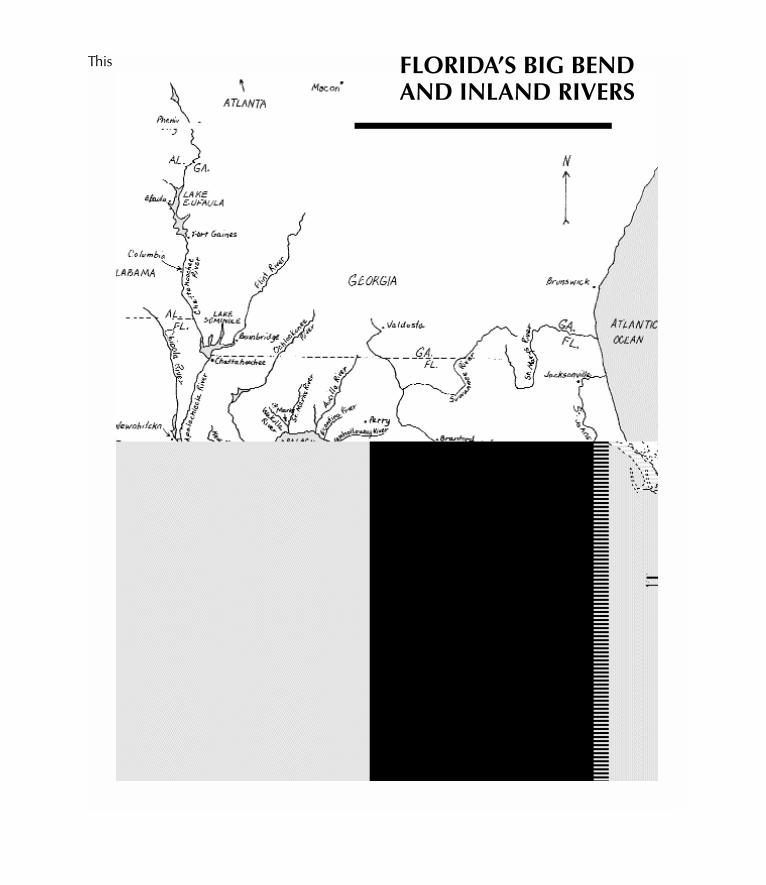
This FLORIDA’S BIG BENDAND INLAND RIVERS
guide covers the west coast of Florida fromApalachicola to Anclote Key (i.e., near PortRichey) on the Gulf of Mexico. This coast, orparts of it, have been known or are known as the“Nature Coast” (from Wakulla to Pasco coun-ties), the “Forgotten Coast” (centered aroundApalachicola and Carrabelle), and the “HiddenCoast” (a section around the middle of the BigBend) or the “Big Bend.” In this book, we’ll justcall the coastal area—from Apalachicola to PortRichey—the “Big Bend of Florida,” even thoughwe’ll be covering a slightly expanded area fromwhat is traditionally thought of as the Big Bend.Florida’s Big Bend can also be viewed as thatuncongested coastal link connecting the urbansprawl associated with the Tampa area to thestrip of modern coastal developments stretch-ing westward from Panama City, Florida. Thisswath of coastline is nearly 300 miles long andis a sizable chunk of Florida’s entire coastline.And this region consists of about forty percent ofFlorida’s entire Gulf Coast.
West of Apalachicola, the coast has a pro-tected Intracoastal Waterway (ICW). This GulfCoast intracoastal waterway extends westwardthrough the panhandle of Florida, Alabama,Mississippi, and Louisiana, all the way to southPadre Island, Texas (or for more than 1,000 mileswest and south of Apalachicola). At the otherend of the Big Bend, the Florida coast south ofAnclote Key also has an ICW extending about150 miles south to Fort Myers, Florida. At FortMyers, there is an adjoining waterway connect-ing the Gulf of Mexico to the Atlantic Ocean
through Lake Okeechobee. On Florida’s eastcoast, at Stuart, this “Okeechobee Waterway”connects to the Atlantic ICW. The Atlantic ICWprovides protected waters for about 1,100 milesbetween Miami and Norfolk, Virginia. South ofMiami and Fort Myers, and throughout much ofthe Florida Keys, there are many long stretchesof ICW-like protected waters. But on this part ofFlorida’s coast—the Big Bend coast—there isNO protected waterway. For this section, cruis-ers will have to plunge into the moody Gulf ofMexico. This coastal section between Carrabelleand Anclote Key is the longest “unprotected”portion of “open water” between Newport,Rhode Island, and Port Isabel, Texas, in a coastalstretch of about 3,000 miles.
While on previous boating research, throughthe heartland of America (from Chicago, Illinois,to Mobile, Alabama), I heard much apprehen-sion among fellow boaters about this forthcom-ing unprotected long jaunt into the loomingGulf of Mexico. Down on my luck—hurtingafter a fifth knee operation and recently unem-ployed—I aimed to turn things around withanother “long, low-budget boat trip.” In earlyOctober 2001, I trailered my live-aboard 25-footNimble Nomad to Apalachicola, Florida. Theplan was to explore along the Gulf Coast south-ward toward Anclote Key and to go into asmany of the Gulf Coast channels and rivers thatI possibly could. While researching along theGulf, small-craft advisories (with winds fore-casted over 18 knots or 20 miles per hour) wereposted every single day that I was out in this big
Introduction
fickle body of water. Nevertheless, no day wasever lost due to the adverse weather. (On a few ofthose days, the seas grew as big as five feet highon the Gulf.) It was sometimes uncomfortable,but along the way and upon learning more andmore about this part of the Gulf of Mexico, myapprehension and fear ebbed. And there wasanother enchanting element to this research: thenearly two dozen calm and charming rivers onthis part of Florida’s coast.
Like the Mississippi, the Ohio, and other majorinland rivers, the Apalachicola-Chattahoochee-Flint River System is maintained by the U.S. ArmyCorps of Engineers. Given overhead-clearanceconsiderations, commercial barges and manysea-going vessels can travel over 250 miles fromthe Gulf of Mexico up the Apalachicola andChattahoochee rivers to Columbus, Georgia—and within about 100 miles of Atlanta. From LakeSeminole, and near where the states of Florida,Alabama, and Georgia meet, the Flint River takesa navigable route about 30 miles to lovely Bain-bridge, Georgia. The Suwannee River, like theApalachicola-Chattahoochee-Flint River System,extends far inland, away from the Gulf. Less thana mere century ago, steamboats plied over 100miles up the bucolic Suwannee River. Today, theriver is no longer maintained as an official navi-gable waterway. Nevertheless, many sea-goingvessels, given overhead-clearance constraints,can reach neighborly Branford, Florida, about 80miles from the Gulf of Mexico. These fourmajor Gulf-flowing rivers—the Suwannee,Apalachicola, Chattahoochee, and Flint—havetheir own devoted chapters in this guide.
Besides these four, there are another 17 riversthat were explored inland from the Gulf of Mex-ico to varying degrees—the Carrabelle, New,Crooked, Ochlockonee, Sopchoppy, St. Marks,
Wakulla, Aucilla, Econfina, Fenholloway, Stein-hatchee, Waccasassa, Withlacoochee, Crystal,Homosassa, Weeki Wachee, and Pithlachasco-tee. We also explored and noted observations onApalachicola Bay, St. George Sound, Dog Island,Alligator Harbor, Apalachee Bay, OchlockoneeBay, Spring Creek, Shell Point, Kings Bay, andGulf Harbors.
Along the Gulf of Mexico, we spent time in,and will present highlights of the towns of,Apalachicola, Carrabelle, Panacea, St. Marks,Keaton Beach, Steinhatchee, Horseshoe Beach,Cedar Key, Yankeetown, Crystal River,Homosassa, Hernando Beach, Hudson, PortRichey, and New Port Richey.
While on the haunting Apalachicola River, wevisited Fort Gadsden, Blountstown, and Chatta-hoochee. We went as far as attractive Bain-bridge, Georgia, on the Flint River. Uponcircuiting the Chattahoochee River, we visitedEufaula, Alabama, and Florence and Columbusin Georgia. We spent time on Lake Seminole andLake Eufaula. From our tour on the SuwanneeRiver, we can tell you about Suwannee, ManateeSprings, Fanning Springs, Old Town, Branford,and the Santa Fe River. The map in the introduc-tion depicts some of the important rivers andhighlights in this region.
In the past, many cruising boats have looked atthe Big Bend of Florida on their charts and then“waited for the weather” (and sometimes waitedand waited) to make “that crossing in the Gulfof Mexico.” Instead of waiting, and then rushingacross the Big Bend, why not slow down, “smellthe tupelo blossoms” in this part of Florida, andpoke your bow into some great Florida rivers?At the very worse, and depending on your tim-ing, you may have to wait for a short time for thatlow tide to rise before entering a few of the more
8 CRUISING GUIDE TO FLORIDA’S BIG BEND

shallow rivers. Here is just one of many possiblesouthbound itineraries for requiring either fiveand a half or three and a half feet of draft atmean low water (MLW) beneath the keel. Andgenerally, there are no overhead obstacles alongthis itinerary. Actually, in many of these chan-nels, we discovered significantly more waterdepth, even factoring at lower water than whatNOAA or the U.S. Coast Pilot has stated. Wehave noted some of these disparities. If you areheading north from Clearwater, reverse thistable and read from the bottom up. And tran-sient rates between Carrabelle and the Suwan-nee River are often most reasonable (usuallyanywhere between four dollars for the entireboat to 50 cents per foot, per night).
Book OrganizationThe first four chapters of this book are catch-
the-flavor and how-to chapters designed to giveyou an appreciation of the area and offer yousome helpful and region-specific boating sug-gestions. The next eight chapters cover thecoast along the Gulf of Mexico and up thesmaller Gulf Coastal rivers. These eight chaptersare organized from points northwest to pointssoutheast. If you are traveling in the reversedirection (from the Tampa Bay area to the north-west), these eight regional chapters are short andeasy to follow. The last chapters (chapters 13-17)cover the four major boating rivers flowing intothe Gulf of Mexico from the Big Bend area. TheApalachicola-Chattahoochee-Flint River Systemis covered in chapters 13-16. Lastly, but by farfrom the least, we end with a trip up the idyllicSuwannee River in chapter 17.
Mileage throughout this guide is stated twoways. Along the coast and in the Gulf of Mexico,we use nautical miles. Once inside the coastal
rivers, we switch to river or statute miles. Eightstatute miles is equivalent to about seven nauti-cal miles. Once in a river (and sometimes evenin a channel), the location of a facility isdescribed using the common river convention ofLDB or RDB. The LDB is the LEFT descendingbank and RDB is the RIGHT descending bank.
GPS way points are often used along thecoast in the Gulf of Mexico. Often, but notalways, if you plug in one of our GPS waypoints, you would have about a 180-degree“safe-semicircle of approach” from the sea-ward direction before arriving at that waypoint. Nonetheless, when approaching one ofour GPS way points, do not neglect othercommon-sense cues (shoally areas, obstruc-tions in the water, and other waterborne traffic).
Barbara Edler, one of our book reviewers,suggested highlighting or flagging the moredangerous navigational nuances. I thought thiswas a great idea, but I didn’t want to overdoit or make it too complicated. So, when warn-ing readers of potential overhead-clearanceobstacles, or cautioning them that they’vearrived at the lowest obstacle in a series ofoverhead clearances, the word HAZARD wasused; so take note. The same goes forinstances where readers are being forewarnedof potentially dangerous situations beneath oron the surface of the water. And just becausewe may note the hazard by use of small capsin a certain section does not mean that therecouldn’t still be dangers lurking nearby. Thisnotation is meant to be a supplement—a redflag—to better assist you in safe navigation.
Cautionary NoteIn researching this guide, we expended great
effort to ensure accuracy and provide you with
INTRODUCTION 9

Note: On day six, there are overhead powerlines over the Homosassa River and over a possible spur route on the Crys-tal River.
aThis does not include about seven to eight miles from Carrabelle to the Gulf of Mexico and another estimated eightmiles up the St. Marks River channel and the St. Marks River before reaching the town of St. Marks.
b McGriff Pass Channel, leading to the town of Suwannee and the Suwannee River, starts about 20 nautical milesnorth of the Cedar Key Channel. In 2001, the McGriff Pass Channel was only three to four feet deep, MLW. How-ever, by the fall of 2002, work should have begun on dredging this channel to six feet deep, MLW, making Suwan-nee another enticing stopover for deeper-draft vessels.
c There are no real marinas for transients in Cedar Key. There is a nice semiprotected anchorage off Atsena Otie Keyand a protected dinghy dock close to dozens of restaurants, all of Cedar Key. Willis Marina (inaccessible to travelingboats) can run fuel out to the city docks for transient boats.
Day FROM TO Naut. Control Marina Restau- CommentsMiles Depth in Facilities rants
Chn-Rvr
(At Start of Day) (At End of Day) (Along (MLW) (At end (At end (At end of day)Coast) of day) of day)
— Gulf ICW Apalachicola — 12 feet four eight Soon leaving the
ICW
1 Apalachicola Carrabelle 28 12 feet five four A real boater’s town2 Carrabelle St. Marks 36a 6 feet three four Loaded with
Florida history and local color
3 St. Marks Steinhatchee 46 51/2 feet three three Great fishing, scalloping
4 Steinhatchee Cedar Key 46b 6+ feet nonec dozen+ The night at anchor5 Cedar Key Withlacoochee 28 51/2 feetd three one A unique mix of
River Old and New Florida
6a Withlacoochee Crystal Rivere 30 51/2 feetfg two three The clearest spring-fed water around
OR6b Withlacoochee Homosassae 46 31/2 feetgh five six The last bastion
River River of Old Florida before Tampa
7 Crystal or Port Richey 39 or 51/2 + feeti two four Try to visit New23 Port Richey—
upriver
8 Port Richey Clearwater 22 9 feet many many Back on the ICW
10 CRUISING GUIDE TO FLORIDA’S BIG BEND

the most up-to-date information. However, itis not possible to guarantee total accuracy.Nothing ever remains the same. Marinas,restaurants, other shoreside facilities, and thelevel of accommodation at marinas andrestaurants change. On-the-water navigationalinformation—such as shoals, the location of ariver channel, aids to navigation, and waterdepths—is also subject to change.
For navigating in the Gulf of Mexico, NOAAcharts are the present standard. For navigatingon the Apalachicola-Chattahoochee-Flint RiverSystem, the U.S. Army Corps of Engineers’ aerialphotograph book is the best resource. TheMobile, Alabama, Corps of Engineers District
publishes this aerial photograph book. There isno official public information for navigating onthe Suwannee River.
This guidebook is intended to be a supplementto official U.S. government publications. Failureto follow the current navigation realities, evenwhen it differs from the situation presented in thisguide, could result in an accident. We haveworked hard to help minimize your risks andoffer you options, but there are many potentialhazards in any boating situation. Safe boating isultimately in the hands of the captain and crew.The author disclaims liability for loss or damageto persons or property that may occur as a resultof interpreting information in this guidebook.
INTRODUCTION 11
d Despite only a five-and-a-half-foot stated depth, we encountered much deeper controlling depths at about ten tothirteen feet, MLW.
e We think there are two quite different, and equally good, options at the end of day six. Crystal River is a shorterrun from the north (by about 16 miles) and has a slightly deeper channel. Crystal River is New Florida—with all its con-veniences and trappings—and a good “auto destination.”
On the other hand, the Homosassa River is quite different. More varied and economical haunts can be foundalong the Homosassa. We got the impression that the Homosassa River was a bit more boater friendly and moreaccommodating than the “car touristy” Crystal River area. There may also be more bargains for boaters on theHomosassa. Both rivers are well known for manatees. Maybe the best thing to do is visit both rivers.
f The NOAA controlling depth is stated at five and a half feet, MLW. We thought there was more water, but theU.S. Coast Pilot indicated that there was even less water.
g One branch of the Crystal River (leading to one of the marinas) has an overhead power line. The Homosassa Riveralso has an overhead power line. There are anomalies with both of these power lines. The 47-foot line over the Crystal Riverspur was knocked down and replaced with a “temporarily lower” line in early 2002. The U.S. Coast Pilot and NOAAcan’t agree on the height clearance of that Homosassa River power line—55 feet versus 45 feet. Before negotiating beneatheither of these lines, if you’re not comfortable, use your VHF radio and ask for some local knowledge.
h As it is on the Crystal River, you must navigate a long channel on the Homosassa River—more than 10 mileslong—before reaching an area of a half-dozen marinas and a few restaurants. Although reasonably deep throughmost of its length, there is a shallow spot in the Homosassa Channel, near the entrance to the river, that is about fourfeet deep, MLW, and about a foot shallower than the Crystal River Channel at MLW.
iThe controlling depth is stated at five and a half feet. We found it deeper, at six to ten feet, MLW.


CRUISING GUIDE TO
FLORIDA’S BIG BEND

Our boat at anchor on the Apalachicola River