cryosat ground segment - earth online - esa · cryosat-2 ocean processor cryosat ocean netcdf pfs...
TRANSCRIPT

CryoSat-2 Ocean Processor
CryoSat Ocean NetCDF PFS (L1b&L2)
Doc. No.: Issue:
Date: Page:
C2-RS-ACS-ESL-5266 3.1 28/09/2017 1
Advanced Computer Systems – 2016
CRYOSAT Ground Segment
CryoSat Ocean NetCDF Product
Format Specification (L1b&L2)
[PFS-OCE]
C2-RS-ACS-ESL-5266
Issue: 3.1
Date: 28/09/2017

CryoSat-2 Ocean Processor
CryoSat Ocean NetCDF PFS (L1b&L2)
Doc. No.: Issue:
Date: Page:
C2-RS-ACS-ESL-5266 3.1 28/09/2017 2
Advanced Computer Systems – 2016
Document Signature Table
APPROVAL TABLE
Date
Name Function Signature
P.L. MANTOVANI Project Manager
P. FEMENIAS ESA Technical Officer
S. BADESSI CryoSat PDGS Manager
CONTRACTOR TABLE
Name Function Signature Date
Author S. Urien [CLS] COP Engineer
Verification T. Geminale System Engineer
Quality
Assurance A. Giustiniani Quality Manager
Approval P.L. Mantovani IPF Project Manager

CryoSat-2 Ocean Processor
CryoSat Ocean NetCDF PFS (L1b&L2)
Doc. No.: Issue:
Date: Page:
C2-RS-ACS-ESL-5266 3.1 28/09/2017 3
Advanced Computer Systems – 2016
Distribution List
Internal Distribution
Name No. Copies
P. Mantovani 1
D. Decandia 1
T. Geminale 1
External Distribution
Company Name No. Copies
ESA-ESRIN J. Bouffard– Data Quality Manager 1
ESA-ESRIN P. Femenias – IPF Technical Officer 1
ESA-ESRIN T. Parrinello- CryoSat 2 Mission Manager 1
ARESYS D. D’Aria 1
CLS S. Urien 1
MSSL S. Baker 1
UoP J. Fernandes 1

CryoSat-2 Ocean Processor
CryoSat Ocean NetCDF PFS (L1b&L2)
Doc. No.: Issue:
Date: Page:
C2-RS-ACS-ESL-5266 3.1 28/09/2017 4
Advanced Computer Systems – 2016
Document Change Record
Issue/Rev. Class
(R=Review
/A=Approval)
Date Reason for Change Changed
Pages/Paragraphs
1.0draft R 02/05/2016 First Issue All
2.0draft 22/07/2016 Accounting for 2nd collocation meeting
All
1.0 R 29/07/2016 First Official Issue All
1.1 R 19/09/2016 Implementation of ESA’s comments
1.2 R 22/03/2017 Implementation of ESA’s comments, before COP CONFORM final AR
All
2.0 R 03/04/2017 Introduction of the L1b SAR and SARin products merging SAR (or SARin) figures with PLRM figures
Sections 2.1, 2.3, 3.1 and 3.3 Appendix A
2.1 R 11/05/2017 Update of L1b SAR and SARin merge products: use of “hr” suffix for HR, instead of use of “plrm” suffix” for PLRM
3.0 R 06/06/2017 Generic improvement of
the text Description of the P2P products Conventions used for the variable names explained Explanation of the use of the indices between 1Hz and 20 Hz measurements L1b variable names and long_names have been reviewed
COG has been replaced with CoM in the “long_name” and “comment” attributes “long_name” of L2 HR variables reviewed L2 20 Hz Variables flag_instr_op_mode_20_plrm_ku and
Section 2.1
Section 2.1 and section 5 added. Section 2.4 added Section 2.5 Section 3.1, 3.3.22, 3.3.40 and Appendix A
Section 3.1.1, 3.1.3, 3.1.4, 3.3.8, 3.3.10, 4.1.1, 4.1.5, 4.3.7, 4.3.69 -> 4.3.72, 4.3.79 -> 4.3.82 Section 3.3 Section 4.1.1, 4.1.2, 4.3.10 and 4.3.11

CryoSat-2 Ocean Processor
CryoSat Ocean NetCDF PFS (L1b&L2)
Doc. No.: Issue:
Date: Page:
C2-RS-ACS-ESL-5266 3.1 28/09/2017 5
Advanced Computer Systems – 2016
flag_instr_op_mode_20_ku have been added L2 20 Hz Variables time_1hz_20_ku and time_1hz_20_plrm_ku have been added
Section 4.1.1, 4.1.2, 4.3.135 and 4.3.136
3.1 R 21/09/2017 General improvement for V3.10 CLS COP delivery
Section 3: - off_nadir_pitch_angle_
str_20_ku, off_nadir_roll_angle_str_20_ku, off_nadir_yaw_angle_str_20_ku, flag_instr_conf_rx_str_in_use_20_ku, flag_instr_mode_att_ctrl_20_ku
variables suppressed in L1B product Section 3.3 added Section 4:
- Fix for plrm variables. Comment modified to have “Not provided in LRM” in place of “Set to
FillValue in LRM” Section 4.3 added

CryoSat-2 Ocean Processor
CryoSat Ocean NetCDF PFS (L1b&L2)
Doc. No.: Issue:
Date: Page:
C2-RS-ACS-ESL-5266 3.1 28/09/2017 6
Advanced Computer Systems – 2016
TABLE OF CONTENTS
1 INTRODUCTION ................................................................................................................ 16
1.1 PURPOSE AND SCOPE ............................................................................................................... 16
1.2 DOCUMENT STRUCTURE ........................................................................................................... 17
1.3 APPLICABLE & REFERENCE DOCUMENTS ........................................................................................ 19
1.3.1 Applicable Documents .................................................................................................. 19
1.3.2 Reference Documents ................................................................................................... 19
1.4 ACRONYMS AND ABBREVIATIONS................................................................................................. 20
2 GENERAL OVERVIEW ........................................................................................................ 21
2.1 OVERVIEW OF THE CRYOSAT OCEAN PRODUCTION.......................................................................... 21
2.2 CRYOSAT OCEAN PRODUCTS FILE NAMES ...................................................................................... 24
2.3 OVERVIEW OF THE NETCDF ....................................................................................................... 25
2.4 CRYOSAT NETCDF VARIABLE NAME CONVENTIONS ................................................................. 26
2.5 NETCDF PRIMITIVES ................................................................................................................ 27
2.5.1 Dimensions and Indices ................................................................................................ 27
2.5.2 Types .......................................................................................................................... 28
2.5.3 Attributes ..................................................................................................................... 29
3 L1B PRODUCT FORMAT SPECIFICATION .......................................................................... 30
3.1 L1B PRODUCT FORMAT SPECIFICATION – LIST OF VARIABLES ...................................................... 30
3.1.1 20-Hz Time and Orbit ................................................................................................... 31
3.1.2 20-Hz Measurements .................................................................................................... 36
3.1.3 1-Hz Time and Orbit ..................................................................................................... 40
3.1.4 1-Hz Corrections Group ................................................................................................. 42
3.1.5 20-Hz Waveforms ......................................................................................................... 45
3.2 L1B PRODUCT FORMAT SPECIFICATION – GLOBAL ATTRIBUTES ................................................... 48
3.3 TABLE OF REFERENCE DSD VS L1B PROCESSORS ........................................................................... 57
3.4 L1B PRODUCT FORMAT SPECIFICATION –CDL DUMP ........................................................................ 61
3.4.1 agc_01_ku(time_01)..................................................................................................... 61
3.4.2 agc_20 _ku(time_20_ku) .............................................................................................. 61
3.4.3 agc_ch1_20_hr_ku(time_20_hr_ku) .............................................................................. 61
3.4.4 agc_ch2_20_hr_ku(time_20_hr_ku) .............................................................................. 62
3.4.5 agc_cor_01(time_01) ................................................................................................... 62
3.4.6 alt_01(time_01) ........................................................................................................... 62
3.4.7 alt_20_hr_ku(time_20_hr_ku) ....................................................................................... 63

CryoSat-2 Ocean Processor
CryoSat Ocean NetCDF PFS (L1b&L2)
Doc. No.: Issue:
Date: Page:
C2-RS-ACS-ESL-5266 3.1 28/09/2017 7
Advanced Computer Systems – 2016
3.4.8 alt_20_ku(time_20_ku) ................................................................................................. 63
3.4.9 beam_dir_vec_20_hr_ku(time_20_hr_ku,space_3d) ....................................................... 63
3.4.10 cog_cor_01(time_01) ................................................................................................... 63
3.4.11 coherence_waveform_20_hr_ku(time_20_hr_ku, ns_20_hr_ku) ...................................... 64
3.4.12 cor2_applied_20_ku(time_20_ku) .................................................................................. 64
3.4.13 cor2_applied_20_hr_ku(time_20_hr_ku) ........................................................................ 64
3.4.14 dop_angle_start_20_hr_ku(time_20_hr_ku) ................................................................... 64
3.4.15 dop_angle_stop_20_hr_ku(time_20_hr_ku) ................................................................... 66
3.4.16 dop_cor_01_ku(time_01) .............................................................................................. 66
3.4.17 dop_cor_20_hr_ku(time_20_hr_ku) ............................................................................... 66
3.4.18 dop_cor_20_ku(time_20_ku) ........................................................................................ 67
3.4.19 echo_numval_20_hr_ku(time_20_hr_ku) ....................................................................... 67
3.4.20 echo_numval_20_ku(time_20_ku) ................................................................................. 67
3.4.21 echo_scale_20_ku(time_20_ku) .................................................................................... 67
3.4.22 echo_scale_20_hr_ku(time_20_hr_ku) .......................................................................... 67
3.4.23 echo_scale_pwr_20_hr_ku(time_20_hr_ku) ................................................................... 68
3.4.24 flag_cor_status_01(time_01) ......................................................................................... 68
3.4.25 flag_cor_err_01(time_01) ............................................................................................. 69
3.4.26 flag_echo_20_hr_ku(time_20_hr_ku) ............................................................................ 69
3.4.27 flag_instr_conf_rx_bwdt_20_ku(time_20_ku) ................................................................. 70
3.4.28 flag_instr_conf_rx_bwdt_20_hr_ku(time_20_hr_ku) ....................................................... 70
3.4.29 flag_instr_conf_rx_flags_20_ku(time_20_ku) ................................................................. 70
3.4.30 flag_instr_conf_rx_flags_20_hr_ku(time_20_hr_ku) ....................................................... 71
3.4.31 flag_instr_conf_rx_in_use_20_ku(time_20_ku)............................................................... 71
3.4.32 flag_instr_conf_rx_in_use_20_hr_ku(time_20_hr_ku) ..................................................... 71
3.4.33 flag_instr_conf_rx_str_in_use_20_hr_ku(time_20_hr_ku) ............................................... 72
3.4.34 flag_instr_conf_rx_trk_mode_20_ku(time_20_ku) .......................................................... 73
3.4.35 flag_instr_conf_rx_trk_mode_20_hr_ku(time_20_hr_ku) ................................................ 73
3.4.36 flag_instr_mode_att_ctrl_20_hr_ku(time_20_hr_ku) ....................................................... 73
3.4.37 flag_instr_mode_flags_20_hr_ku(time_20_hr_ku) .......................................................... 74
3.4.38 flag_instr_op_mode_20_hr_ku(time_20_hr_ku) ............................................................. 74
3.4.39 flag_instr_op_mode _20_ku(time_20_ku) ...................................................................... 74
3.4.40 flag_mcd_20_ku(time_20_ku) ....................................................................................... 75
3.4.41 flag_mcd_20_hr_ku(time_20_hr_ku) ............................................................................. 75

CryoSat-2 Ocean Processor
CryoSat Ocean NetCDF PFS (L1b&L2)
Doc. No.: Issue:
Date: Page:
C2-RS-ACS-ESL-5266 3.1 28/09/2017 8
Advanced Computer Systems – 2016
3.4.42 flag_trk_cycle_20_ku(time_20_ku) ................................................................................ 76
3.4.43 flag_trk_cycle_20_hr_ku(time_20_hr_ku) ...................................................................... 76
3.4.44 h0_applied_20_ku(time_20_ku) .................................................................................... 76
3.4.45 h0_applied_20_hr_ku(time_20_hr_ku) .......................................................................... 76
3.4.46 h0_fai_word_20_ku(time_20_ku) .................................................................................. 77
3.4.47 h0_fai_word_20_hr_ku(time_20_hr_ku) ........................................................................ 77
3.4.48 h0_lai_word_20_ku(time_20_ku) .................................................................................. 77
3.4.49 h0_lai_word_20_hr_ku(time_20_hr_ku) ......................................................................... 77
3.4.50 hf_fluct_cor_01(time_01).............................................................................................. 78
3.4.51 ind_first_meas_20hz_01(time_01) ................................................................................. 78
3.4.52 ind_meas_1hz_20_ku(time_20_ku) ............................................................................... 78
3.4.53 instr_cor_gain_rx_20_hr_ku(time_20_hr_ku) ................................................................. 78
3.4.54 instr_cor_gain_tx_rx_20_hr_ku(time_20_hr_ku) ............................................................ 78
3.4.55 instr_cor_range_rx_20_hr_ku(time_20_hr_ku) ............................................................... 79
3.4.56 instr_cor_range_tx_rx_20_hr_ku(time_20_hr_ku) .......................................................... 80
3.4.57 instr_ext_ph_cor_20_hr_ku(time_20_hr_ku) .................................................................. 80
3.4.58 instr_int_ph_cor_20_hr_ku(time_20_hr_ku) ................................................................... 80
3.4.59 int_path_cor_01(time_01) ............................................................................................ 81
3.4.60 inter_base_vec_20_hr_ku(time_20_hr_ku,space_3d) ...................................................... 81
3.4.61 internal_cor_sig0_01(time_01) ...................................................................................... 81
3.4.62 inv_bar_cor_01(time_01) .............................................................................................. 82
3.4.63 iono_cor_gim_01(time_01) ........................................................................................... 82
3.4.64 lat_01(time_01) ........................................................................................................... 82
3.4.65 lat_20_ku(time_20_ku) ................................................................................................. 83
3.4.66 lat_20_hr_ku(time_20_hr_ku) ....................................................................................... 83
3.4.67 load_tide_sol1_01(time_01) .......................................................................................... 83
3.4.68 load_tide_sol2_01(time_01) .......................................................................................... 84
3.4.69 lon_01(time_01) ........................................................................................................... 84
3.4.70 lon_20_ku(time_20_ku) ................................................................................................ 84
3.4.71 lon_20_hr_ku(time_20_hr_ku) ...................................................................................... 84
3.4.72 look_angle_start_20_hr_ku(time_20_hr_ku) .................................................................. 85
3.4.73 look_angle_stop_20_hr_ku(time_20_hr_ku) ................................................................... 85
3.4.74 mod_dry_tropo_cor_01(time_01) .................................................................................. 85
3.4.75 mod_wet_tropo_cor_01(time_01) ................................................................................. 86

CryoSat-2 Ocean Processor
CryoSat Ocean NetCDF PFS (L1b&L2)
Doc. No.: Issue:
Date: Page:
C2-RS-ACS-ESL-5266 3.1 28/09/2017 9
Advanced Computer Systems – 2016
3.4.76 noise_power_20_ku(time_20_ku) .................................................................................. 86
3.4.77 noise_power_20_hr_ku(time_20_hr_ku) ........................................................................ 86
3.4.78 ns_20_ku(ns_20_ku) .................................................................................................... 87
3.4.79 num_meas_20hz_01(time_01) ...................................................................................... 87
3.4.80 ocean_tide_eq_01(time_01) .......................................................................................... 87
3.4.81 ocean_tide_non_eq_01(time_01) .................................................................................. 88
3.4.82 ocean_tide_sol1_01(time_01) ....................................................................................... 88
3.4.83 ocean_tide_sol2_01(time_01) ....................................................................................... 89
3.4.84 off_nadir_pitch_angle_str_20_hr_ku(time_20_hr_ku) ..................................................... 89
3.4.85 off_nadir_roll_angle_str_20_hr_ku(time_20_hr_ku) ........................................................ 90
3.4.86 off_nadir_yaw_angle_str_20_hr_ku(time_20_hr_ku) ...................................................... 90
3.4.87 orb_alt_rate_01(time_01) ............................................................................................. 91
3.4.88 orb_alt_rate_20_ku(time_20_ku) .................................................................................. 91
3.4.89 orb_alt_rate_20_hr_ku(time_20_hr_ku) ......................................................................... 91
3.4.90 ph_diff_waveform_20_hr_ku(time_20_hr_ku, ns_20_hr_ku) ........................................... 92
3.4.91 ph_slope_cor_20_hr_ku(time_20_hr_ku) ....................................................................... 92
3.4.92 pole_tide_01(time_01).................................................................................................. 92
3.4.93 pwr_waveform_20_ku(time_20_ku) .............................................................................. 93
3.4.94 pwr_waveform_20_hr_ku(time_20_hr_ku, ns_20_hr_ku) ................................................ 93
3.4.95 rec_count_20_ku(time_20_ku) ...................................................................................... 94
3.4.96 rec_count_20_hr_ku(time_20_hr_ku) ............................................................................ 94
3.4.97 sat_vel_vec_20_hr_ku(time_20_hr_ku,space_3d) ........................................................... 94
3.4.98 scale_factor_20_ku(time_20_ku) ................................................................................... 94
3.4.99 seq_count_20_ku(time_20_ku) ..................................................................................... 95
3.4.100 seq_count_20_hr_ku(time_20_hr_ku) ........................................................................ 95
3.4.101 solid_earth_tide_01(time_01) .................................................................................... 95
3.4.102 stack_centre_20_hr_ku(time_20_hr_ku) ..................................................................... 95
3.4.103 stack_centre_angle_20_hr_ku(time_20_hr_ku) ........................................................... 96
3.4.104 stack_kurtosis_20_hr_ku(time_20_hr_ku) .................................................................. 96
3.4.105 stack_number_after_weighting_20_hr_ku(time_20_hr_ku) .......................................... 96
3.4.106 stack_number_before_weighting_20_hr_ku(time_20_hr_ku) ....................................... 97
3.4.107 stack_scaled_amplitude_20_hr_ku(time_20_hr_ku) .................................................... 97
3.4.108 stack_skewness_20_hr_ku(time_20_hr_ku) ................................................................ 97
3.4.109 stack_std_20_hr_ku(time_20_hr_ku) ......................................................................... 98

CryoSat-2 Ocean Processor
CryoSat Ocean NetCDF PFS (L1b&L2)
Doc. No.: Issue:
Date: Page:
C2-RS-ACS-ESL-5266 3.1 28/09/2017 10
Advanced Computer Systems – 2016
3.4.110 stack_std_angle_20_hr_ku(time_20_hr_ku) ................................................................ 98
3.4.111 surf_type_01(time_01) .............................................................................................. 98
3.4.112 time_01(time_01) ..................................................................................................... 99
3.4.113 time_20_ku(time_20_ku) ........................................................................................... 99
3.4.114 time_20_hr_ku(time_20_hr_ku) ................................................................................. 99
3.4.115 tot_gain_ch1_20_hr_ku(time_20_hr_ku) .................................................................... 99
3.4.116 tot_gain_ch2_20_hr_ku(time_20_hr_ku) .................................................................... 99
3.4.117 tracker_range_20_ku(time_20_ku) ........................................................................... 100
3.4.118 transmit_pwr_20_hr_ku(time_20_hr_ku) .................................................................. 100
3.4.119 uso_cor_01_ku(time_01) ......................................................................................... 100
3.4.120 uso_cor_20_ku(time_20_ku) ................................................................................... 100
3.4.121 uso_cor_20_hr_ku(time_20_hr_ku) .......................................................................... 101
3.4.122 wind_speed_mod_u_01(time_01) ............................................................................ 101
3.4.123 wind_speed_mod_v_01(time_01) ............................................................................ 101
3.4.124 window_del_20_hr_ku(time_20_hr_ku) .................................................................... 102
4 L2 PRODUCT FORMAT SPECIFICATION .......................................................................... 103
4.1 L2 PRODUCT FORMAT SPECIFICATION –LIST OF VARIABLES ........................................................... 103
4.1.1 20-Hz - Time and Orbit ............................................................................................... 104
4.1.2 20-Hz – PLRM Time and Orbit (only filled for SAR/SARin operating modes) .................... 108
4.1.3 20-Hz - Range Measurements ..................................................................................... 111
4.1.4 20-Hz – PLRM Range Measurements (only filled for SAR/SARin operating modes) .......... 113
4.1.5 1-Hz - Range Corrections ............................................................................................ 114
4.1.6 1-Hz – PLRM Range Corrections (only filled for SAR/SARin operation modes) ................. 116
4.1.7 20-Hz - SWH and Backscatter ..................................................................................... 116
4.1.8 20-Hz – PLRM SWH and Backscatter (only filled for SAR/SARin operating modes) .......... 120
4.1.9 1-Hz SWH and Backscatter Correction ......................................................................... 123
4.1.10 1-Hz PLRM SWH and Backscatter Correction (only filled for SAR/SARin operating modes) 124
4.1.11 1-Hz - Geophysical Figures .......................................................................................... 124
4.1.12 1-Hz – PLRM Geophysical Figures (only filled for SAR/SARin operating modes) ............... 127
4.1.13 20-Hz - SSHA ............................................................................................................. 127
4.1.14 20-Hz – PLRM SSHA (only filled for SAR/SARin operating modes) .................................. 128
4.2 L2 PRODUCT FORMAT SPECIFICATION – GLOBAL ATTRIBUTES ........................................................ 129
4.3 TABLE OF REFERENCE DSD VS L2 PROCESSORS ........................................................................... 138
4.4 L2 PRODUCT FORMAT SPECIFICATION – CDL DUMP ....................................................................... 142

CryoSat-2 Ocean Processor
CryoSat Ocean NetCDF PFS (L1b&L2)
Doc. No.: Issue:
Date: Page:
C2-RS-ACS-ESL-5266 3.1 28/09/2017 11
Advanced Computer Systems – 2016
4.4.1 agc_01_ku(time_01)................................................................................................... 142
4.4.2 agc_cor_01 (time_01) ................................................................................................ 142
4.4.3 alt_01(time_01) ......................................................................................................... 142
4.4.4 alt_20_ku(time_20_ku) ............................................................................................... 142
4.4.5 alt_20_plrm_ku(time_20_plrm_ku) .............................................................................. 143
4.4.6 cog_cor_01(time_01) ................................................................................................. 143
4.4.7 dop_cor_01_ku(time_01) ............................................................................................ 143
4.4.8 flag_instr_op_mode_01(time_01) ................................................................................ 144
4.4.9 flag_instr_op_mode_20_ku(time_20_ku) ..................................................................... 144
4.4.10 flag_instr_op_mode_20_plrm_ku(time_20_plrm_ku) .................................................... 144
4.4.11 flag_mcd_20_ku(time_20_ku) ..................................................................................... 144
4.4.12 geoid_01(time_01) ..................................................................................................... 145
4.4.13 gpd_wet_tropo_cor_01(time_01) ................................................................................ 146
4.4.14 gpd_wet_tropo_cor_qual_01(time_01) ........................................................................ 146
4.4.15 hf_fluct_cor_01(time_01)............................................................................................ 146
4.4.16 ind_first_meas_20hz_01(time_01) ............................................................................... 147
4.4.17 ind_first_meas_20hz_01_plrm_ku(time_01) ................................................................. 147
4.4.18 ind_meas_1hz_20_ku(time_20_ku) ............................................................................. 147
4.4.19 ind_meas_1hz_20_plrm_ku(time_20_plrm_ku) ............................................................ 147
4.4.20 int_path_cor_01(time_01) .......................................................................................... 147
4.4.21 internal_cor_sig0_01 (time_01) ................................................................................... 148
4.4.22 inv_bar_cor_01(time_01) ............................................................................................ 148
4.4.23 iono_cor_gim_01(time_01) ......................................................................................... 148
4.4.24 lat_01(time_01) ......................................................................................................... 149
4.4.25 lat_20_ku(time_20_ku) ............................................................................................... 149
4.4.26 lat_20_plrm_ku(time_20_plrm_ku) .............................................................................. 149
4.4.27 load_tide_sol1_01(time_01) ........................................................................................ 149
4.4.28 load_tide_sol2_01(time_01) ........................................................................................ 150
4.4.29 lon_01(time_01) ......................................................................................................... 150
4.4.30 lon_20_ku(time_20_ku) .............................................................................................. 150
4.4.31 lon_20_plrm_ku(time_20_plrm_ku) ............................................................................. 150
4.4.32 mean_dyn_topo_sol1_01(time_01) .............................................................................. 151
4.4.33 mean_dyn_topo_sol2_01(time_01) .............................................................................. 151
4.4.34 mean_sea_surf_sol1_01(time_01) ............................................................................... 151

CryoSat-2 Ocean Processor
CryoSat Ocean NetCDF PFS (L1b&L2)
Doc. No.: Issue:
Date: Page:
C2-RS-ACS-ESL-5266 3.1 28/09/2017 12
Advanced Computer Systems – 2016
4.4.35 mean_sea_surf_sol2_01(time_01) ............................................................................... 151
4.4.36 mod_dry_tropo_cor_01(time_01) ................................................................................ 152
4.4.37 mod_instr_cor_range_01_ku(time_01) ........................................................................ 152
4.4.38 mod_instr_cor_range_01_plrm_ku(time_01) ................................................................ 152
4.4.39 mod_instr_cor_sig0_01_ku(time_01) ........................................................................... 153
4.4.40 mod_instr_cor_sig0_01_plrm_ku(time_01) .................................................................. 153
4.4.41 mod_instr_cor_swh_01_ku(time_01) ........................................................................... 153
4.4.42 mod_instr_cor_swh_01_plrm_ku(time_01) .................................................................. 154
4.4.43 mod_wet_tropo_cor_01(time_01) ............................................................................... 154
4.4.44 mqe_ocean_20_ku(time_20_ku) ................................................................................. 154
4.4.45 mqe_ocean_20_plrm_ku(time_20_plrm_ku)................................................................. 155
4.4.46 num_meas_20hz_01(time_01) .................................................................................... 155
4.4.47 num_meas_20hz_01_plrm_ku(time_01) ...................................................................... 155
4.4.48 ocean_tide_eq_01(time_01) ........................................................................................ 155
4.4.49 ocean_tide_non_eq_01(time_01) ................................................................................ 156
4.4.50 ocean_tide_sol1_01(time_01) ..................................................................................... 156
4.4.51 ocean_tide_sol2_01(time_01) ..................................................................................... 156
4.4.52 odle_01(time_01) ....................................................................................................... 157
4.4.53 off_nadir_angle_wf_ocean_01_ku(time_01) ................................................................. 157
4.4.54 off_nadir_angle_wf_ocean_01_plrm_ku(time_01) ........................................................ 157
4.4.55 off_nadir_pitch_angle_str_20_ku(time_20_ku) ............................................................. 157
4.4.56 off_nadir_roll_angle_str_20_ku(time_20_ku) ............................................................... 158
4.4.57 off_nadir_yaw_angle_str_20_ku(time_20_ku) .............................................................. 158
4.4.58 orb_alt_rate_01(time_01) ........................................................................................... 158
4.4.59 peakiness_01_ku(time_01) ......................................................................................... 158
4.4.60 peakiness_01_plrm_ku(time_01) ................................................................................. 159
4.4.61 peakiness_20_ku(time_20_ku) .................................................................................... 159
4.4.62 peakiness_20_plrm_ku(time_20_plrm_ku) ................................................................... 159
4.4.63 pole_tide_01(time_01)................................................................................................ 159
4.4.64 qual_ssha_01_ku(time_01) ......................................................................................... 160
4.4.65 qual_ssha_01_plrm_ku(time_01) ................................................................................. 160
4.4.66 qual_ssha_20_ku(time_20_ku) .................................................................................... 160
4.4.67 qual_ssha_20_plrm_ku(time_20_plrm_ku) ................................................................... 160
4.4.68 range_ocean_01_ku(time_01) ..................................................................................... 161

CryoSat-2 Ocean Processor
CryoSat Ocean NetCDF PFS (L1b&L2)
Doc. No.: Issue:
Date: Page:
C2-RS-ACS-ESL-5266 3.1 28/09/2017 13
Advanced Computer Systems – 2016
4.4.69 range_ocean_01_plrm_ku(time_01) ............................................................................ 161
4.4.70 range_ocean_20_ku(time_20_ku) ............................................................................... 161
4.4.71 range_ocean_20_plrm_ku(time_20_plrm_ku)............................................................... 162
4.4.72 range_ocean_numval_01_ku(time_01) ........................................................................ 162
4.4.73 range_ocean_numval_01_plrm_ku(time_01) ................................................................ 162
4.4.74 range_ocean_qual_20_ku(time_20_ku) ....................................................................... 162
4.4.75 range_ocean_qual_20_plrm_ku(time_20_plrm_ku) ...................................................... 163
4.4.76 range_ocean_rms_01_ku(time_01) ............................................................................. 163
4.4.77 range_ocean_rms_01_plrm_ku(time_01) ..................................................................... 163
4.4.78 range_ocog_01_ku(time_01) ...................................................................................... 164
4.4.79 range_ocog_01_plrm_ku(time_01) .............................................................................. 164
4.4.80 range_ocog_20_ku(time_20_ku) ................................................................................. 164
4.4.81 range_ocog_20_plrm_ku(time_20_plrm_ku) ................................................................ 164
4.4.82 range_ocog_numval_01_ku(time_01) .......................................................................... 165
4.4.83 range_ocog_numval_01_plrm_ku(time_01) ................................................................. 165
4.4.84 range_ocog_qual_20_ku(time_20_ku) ......................................................................... 165
4.4.85 range_ocog_qual_20_plrm_ku(time_20_plrm_ku) ........................................................ 165
4.4.86 range_ocog_rms_01_ku(time_01) ............................................................................... 166
4.4.87 range_ocog_rms_01_plrm_ku(time_01) ....................................................................... 166
4.4.88 retracking_ocean_qual_20_ku(time_20_ku) ................................................................. 166
4.4.89 retracking_ocean_qual_20_plrm_ku(time_20_plrm_ku) ................................................ 167
4.4.90 scale_factor_20_ku(time_20_ku) ................................................................................. 167
4.4.91 scale_factor_20_plrm_ku(time_20_plrm_ku) ................................................................ 167
4.4.92 sea_state_bias_01_ku(time_01) .................................................................................. 168
4.4.93 sea_state_bias_01_plrm_ku(time_01).......................................................................... 168
4.4.94 seq_count_01(time_01) .............................................................................................. 168
4.4.95 sig0_ocean_01_ku(time_01) ....................................................................................... 169
4.4.96 sig0_ocean_01_plrm_ku(time_01) ............................................................................... 169
4.4.97 sig0_ocean_20_ku(time_20_ku) .................................................................................. 169
4.4.98 sig0_ocean_20_plrm_ku(time_20_plrm_ku) ................................................................. 170
4.4.99 sig0_ocean_numval_01_ku(time_01) ........................................................................... 170
4.4.100 sig0_ocean_numval_01_plrm_ku(time_01) ............................................................... 170
4.4.101 sig0_ocean_qual_20_ku(time_20_ku) ...................................................................... 170
4.4.102 sig0_ocean_qual_20_plrm_ku(time_20_plrm_ku) ...................................................... 171

CryoSat-2 Ocean Processor
CryoSat Ocean NetCDF PFS (L1b&L2)
Doc. No.: Issue:
Date: Page:
C2-RS-ACS-ESL-5266 3.1 28/09/2017 14
Advanced Computer Systems – 2016
4.4.103 sig0_ocean_rms_01_ku(time_01) ............................................................................. 171
4.4.104 sig0_ocean_rms_01_plrm_ku(time_01) .................................................................... 171
4.4.105 sig0_ocog_01_ku(time_01) ...................................................................................... 172
4.4.106 sig0_ocog_01_plrm_ku(time_01) ............................................................................. 172
4.4.107 sig0_ocog_20_ku(time_20_ku) ................................................................................ 172
4.4.108 sig0_ocog_20_plrm_ku(time_20_plrm_ku) ............................................................... 173
4.4.109 sig0_ocog_numval_01_ku(time_01) ......................................................................... 173
4.4.110 sig0_ocog_numval_01_plrm_ku(time_01) ................................................................. 173
4.4.111 sig0_ocog_qual_20_ku(time_20_ku) ........................................................................ 173
4.4.112 sig0_ocog_qual_20_plrm_ku(time_20_plrm_ku) ....................................................... 175
4.4.113 sig0_ocog_rms_01_ku(time_01) .............................................................................. 175
4.4.114 sig0_ocog_rms_01_plrm_ku(time_01) ...................................................................... 175
4.4.115 solid_earth_tide_01(time_01) .................................................................................. 176
4.4.116 square_swh_ocean_01_ku(time_01) ........................................................................ 176
4.4.117 square_swh_ocean_01_plrm_ku(time_01) ................................................................ 176
4.4.118 ssha_01_ku(time_01) .............................................................................................. 177
4.4.119 ssha_01_plrm_ku(time_01) ..................................................................................... 177
4.4.120 ssha_20_ku(time_20_ku) ........................................................................................ 178
4.4.121 ssha_20_plrm_ku(time_20_plrm_ku)........................................................................ 178
4.4.122 surf_type_01(time_01) ............................................................................................ 179
4.4.123 swh_ocean_01_ku(time_01) .................................................................................... 179
4.4.124 swh_ocean_01_plrm_ku(time_01) ............................................................................ 179
4.4.125 swh_ocean_20_ku(time_20_ku) ............................................................................... 180
4.4.126 swh_ocean_20_plrm_ku(time_20_plrm_ku) .............................................................. 180
4.4.127 swh_ocean_numval_01_ku(time_01) ....................................................................... 180
4.4.128 swh_ocean_numval_01_plrm_ku(time_01) ............................................................... 180
4.4.129 swh_ocean_qual_20_ku(time_20_plrm_ku) .............................................................. 181
4.4.130 swh_ocean_qual_20_plrm_ku(time_20_plrm_ku) ...................................................... 181
4.4.131 swh_ocean_rms_01_ku(time_01) ............................................................................. 181
4.4.132 swh_ocean_rms_01_plrm_ku(time_01) .................................................................... 182
4.4.133 time_01(time_01) ................................................................................................... 182
4.4.134 time_1hz_20_ku(time_20_ku) .................................................................................. 182
4.4.135 time_1hz_20_plrm_ku(time_20_ku) ......................................................................... 182
4.4.136 time_20_ku(time_20_ku) ......................................................................................... 182

CryoSat-2 Ocean Processor
CryoSat Ocean NetCDF PFS (L1b&L2)
Doc. No.: Issue:
Date: Page:
C2-RS-ACS-ESL-5266 3.1 28/09/2017 15
Advanced Computer Systems – 2016
4.4.137 time_20_plrm_ku(time_20_plrm_ku) ........................................................................ 183
4.4.138 uso_cor_01_ku(time_01) ......................................................................................... 183
4.4.139 wind_speed_alt_01_ku(time_01) ............................................................................. 183
4.4.140 wind_speed_alt_01_plrm_ku(time_01) ..................................................................... 183
4.4.141 wind_speed_mod_u_01(time_01) ............................................................................ 184
4.4.142 wind_speed_mod_v_01(time_01) ............................................................................ 185
5 CRYOSAT POLE TO POLE OCEAN PRODUCTS .................................................................. 186
APPENDIX A: VARIABLES TO PRODUCTS MAPPING ............................................................. 187
APPENDIX B: DEFAULT SETTING OF THE ATTRIBUTE: _FILLVALUE ..................................... 194
APPENDIX C: TIMESTAMPS DATA TYPE ................................................................................ 196
APPENDIX D: EE TO NETCDF MIGRATION ............................................................................ 197
CryoSat-2 Ocean Processor
CryoSat Ocean NetCDF PFS (L1b&L2)
Doc. No.: Issue:
Date: Page:
C2-RS-ACS-ESL-5266 3.1 28/09/2017 16
Advanced Computer Systems – 2016
1 INTRODUCTION
This document specifies the NetCDF format of the Level-1b and Level-2 Near-Real Time (NOP), Intermediate (IOP) and Geophysical (GOP) Ocean Products generated by the CryoSat ocean processing
chains.
1.1 PURPOSE AND SCOPE
The purpose of the document is to specify the NetCDF product structure and content of the Level-1b and
Level 2 products generated by the CryoSat ocean processing.
Since the beginning of the mission (2010), all CryoSat products had been generated in EE (Earth Explorer)
a bespoke format devised for the CryoSat products at the time of the CryoSat-1 mission and derived from the ENVISAT products format with the purpose to maximise the reuse of decoding/analysis tools
developed for this mission.
In 2015 the Agency decided to migrate from this Earth Explorer format to the more flexible and up-to-
date NetCDF model for those products that are intended to be distributed to the users.
This new format is called CONFORM (CryOsat Netcdf FORMat) and is applicable to the whole CryoSat
ocean production.

CryoSat-2 Ocean Processor
CryoSat Ocean NetCDF PFS (L1b&L2)
Doc. No.: Issue:
Date: Page:
C2-RS-ACS-ESL-5266 3.1 28/09/2017 17
Advanced Computer Systems – 2016
1.2 DOCUMENT STRUCTURE
The document includes the following sections:
Section 1 – Introduction Introduction to the whole document
Section 2 - General Overview This section gives an overview of the CryoSat ocean production as well as a short introduction to
the NetCDF.
Section 3 - Level-1b Format Description This section contains the specification of the L1b
ocean CONFORM products. In particular:
• section 3.1 lists the variables of the L1b products and links each of them to the
relevant CDL dump
• section 3.2 lists the variables of the
products and links each of them to the relevant CDL dump
• section 3.3 contains the CDL dump of
each variable
• section 3.4 specifies the global attributes of each product
Section 4 - Level 2 Format Description This section contains the specification of the L2 ocean CONFORM products. In particular:
• section 4.1 lists the variables of the L2
products and links each of them to the relevant CDL dump
• section 4.2 lists the variables of the
products and links each of them to the relevant CDL dump
• section 4.3 contains the CDL dump of
each variable
• section 4.4 specifies the global attributes
of each product
Section 5- CryoSat Ocean CONFORM Products Here is the list of CONFORM ocean products
Appendix A – Variables to Products Mapping In this section there is the variable name list alphabetically ordered and for each variable it is
shows in which product types it can be used
Appendix B : Default Setting of the Attribute:
_FillValue
In this section the list of _FillValues for each variable type is listed

CryoSat-2 Ocean Processor
CryoSat Ocean NetCDF PFS (L1b&L2)
Doc. No.: Issue:
Date: Page:
C2-RS-ACS-ESL-5266 3.1 28/09/2017 18
Advanced Computer Systems – 2016
Appendix C: Timestamps Data Type In this section it is demonstrated that the
timestamps used in the CONFORM products are reliable till January 2034
Appendix D - EE to NetCDF Migration This section contains a short description of the general rules followed to migrate from the EE
format to CONFORM

CryoSat-2 Ocean Processor
CryoSat Ocean NetCDF PFS (L1b&L2)
Doc. No.: Issue:
Date: Page:
C2-RS-ACS-ESL-5266 3.1 28/09/2017 19
Advanced Computer Systems – 2016
1.3 APPLICABLE & REFERENCE DOCUMENTS
1.3.1 Applicable Documents
Document Title Identifier Reference
CCN #3: CONFORM [IPF1-CCN3]
Issue 1.0 C2-CN-ACS-GS-5343 [CCN3-TN]
Minute of CCN#3 and CCN#4 KO meeting C2-MN-ACS-GS-5248 [CCN3-KO]
1.3.2 Reference Documents
Document Title Identifier Reference
IEEE Standard for Binary Floating-Point Arithmetic.
ANSI/IEEE Std 754-1985
Institute of Electrical and Electronics Engineers Issued 1985
IEEE-754 [IEEE]
CCSDS Recommendation Time Code Formats
Blue Book Issue 2.0, April 1990
CCSDS 301.0-B-2 [CCSDS-
TIMEGUIDE]
IOP & GOP Product Format Specification C2-RS-ACS-ESL-5213 [COP-FMT]

CryoSat-2 Ocean Processor
CryoSat Ocean NetCDF PFS (L1b&L2)
Doc. No.: Issue:
Date: Page:
C2-RS-ACS-ESL-5266 3.1 28/09/2017 20
Advanced Computer Systems – 2016
1.4 ACRONYMS AND ABBREVIATIONS
AGC Automatic Gain Control CAL Calibration CCSDS CONFORM
Consultative Committee for Space Data Systems CryOsat Necdf FORMat
DSR Data Set Record EE Earth Explorer EO Earth Observation ESA European Space Agency FBR Full Bit Rate GOP Geophysical Ocean Product ID IDentifier I/O IOP
Input/Output Intermediate Ocean Product
IPF Instrument Processing Facility ISP Instrument Source Packet L1B Level 1B LRM Low Rate Mode MDS Measurement Data Set MJD Modified Julian Day MPH NetCDF NOP
Main Product Header Network Common Data Form Near-real-time Ocean Product
NPM Noise Power Measurement PDS
PLRM
Payload Data System
Pseudo LRM PTR Point Target Response SIRAL Synthetic Interferometric Radar ALtimeter SOW Statement Of Work SPH Specific Product Header TAI International Atomic Time Reference TBC To Be Clarified TBD To Be Defined TRK TRaKing UTC Universal Time Co-ordinates XML eXtensible Markup Language WGS84 World Geodetic System 1984

CryoSat-2 Ocean Processor
CryoSat Ocean NetCDF PFS (L1b&L2)
Doc. No.: Issue:
Date: Page:
C2-RS-ACS-ESL-5266 3.1 28/09/2017 21
Advanced Computer Systems – 2016
2 GENERAL OVERVIEW
2.1 OVERVIEW OF THE CRYOSAT OCEAN PRODUCTION
The CryoSat ocean chains process SIRAL instrument Level 0 LRM, SAR and SARin products to generate L1b and L2 ocean products by applying the processing algorithms specified for the ocean.
The ocean processing chains provide three classes of products sorted according to their delivering latency:
Near-Real Time Ocean Products (NOP) – delivered three hours after acquisition
Intermediate Ocean Products (IOP) – delivered 48 hours after acquisition
Geophysical Ocean Products (GOP) – delivered one month after acquisition
The processing applied to generate these products is the same and the only difference lies in the different
types of auxiliary files (i.e. corrections and orbit) used for the generation: the shorter the latency, the poorer the accuracy of the orbit used for the generation.
All these products are further classified according to processing level (L1b and L2) and the acquisition
mode (LRM, SAR and SARin) and therefore the total ocean production consists of the following products:
L1b Ocean Products – nine products:
• L1b LRM (NOP, IOP and GOP) containing LRM measurements and data
• L1b SAR (NOP, IOP and GOP) containing PLRM (data acquired in SAR mode and reduced to
a sequence of LRM-like echoes) and SAR measurements and data
• L1b SARin (NOP, IOP and GOP) containing PLRM (data acquired in SARin mode and reduced
to a sequence of LRM-like echoes) and SARin measurements and data
L2 Ocean Products – nine products:
• L2 LRM (NOP, IOP and GOP) containing LRM measurements and data
• L2 SAR (NOP, IOP and GOP) containing PLRM and SAR measurements and data
• L2 SARin (NOP, IOP and GOP) containing PLRM and PSAR (i.e. the two SARin channels data
averaged in the L1b processing and retracked as SAR data in the L2 processing) measurements
and data

CryoSat-2 Ocean Processor
CryoSat Ocean NetCDF PFS (L1b&L2)
Doc. No.: Issue:
Date: Page:
C2-RS-ACS-ESL-5266 3.1 28/09/2017 22
Advanced Computer Systems – 2016
Beside the products listed above, one more set of L2 products is generated by the CryoSat Ocean Chains
and they are the pole to pole products, i.e. multi-mode L2 products with a half-orbit coverage (from one pole to the other): LRM, SAR and SARin L2 products are concatenated into a single P2P product.
Accordingly, the list of products has to be completed with:
Pole to Pole Ocean Products – two products:
• IOP P2P containing LRM, SAR and SARin L2 IOP data and covering half an orbit.
• GOP P2P containing LRM, SAR and SARin L2 GOP data and covering half an orbit.
NOP P2P products do not exist because of the three hours latency constraint.
The complete set of the L1b and L2 CryoSat Ocean Product and their dependencies is depicted in figure 2.1-1 where each product is identified by the following file types:.
The following table provides the Product Identification for each CONFORM product generated by the IPF1.
Product Identification Description
SIR_NOPM1B NRT L1B LRM Ocean Product
SIR_NOPR1B NRT L1B SAR Ocean Product
SIR_NOPN1B NRT L1B SARin Ocean Product
SIR_IOPM1B Intermediate L1B LRM Ocean Product
SIR_IOPR1B Intermediate L1B SAR Ocean Product
SIR_IOPN1B Intermediate L1B SARin Ocean Product
SIR_GOPM1B Geophysical L1B LRM Ocean Product
SIR_GOPR1B Geophysical L1B SAR Ocean Product
SIR_GOPN1B Geophysical L1B SARin Ocean Product
SIR_NOPM_2 NRT L2 LRM Ocean Product
SIR_NOPR_2 NRT L2 SAR Ocean Product
SIR_NOPN_2 NRT L2 SARin Ocean Product
SIR_IOPM_2 Intermediate L2 LRM Ocean Product
SIR_IOPR_2 Intermediate L2 SAR Ocean Product
SIR_IOPN_2 Intermediate L2 SARin Ocean Product
SIR_GOPM_2 Geophysical L2 LRM Ocean Product
SIR_GOPR_2 Geophysical L2 SAR Ocean Product
SIR_GOPN_2 Geophysical L2 SARin Ocean Product
SIR_IOP_2_ Intermediate L2 Pole-to-Pole Ocean Product
SIR_GOP_2_ Geophysical L2 Pole-to-Pole Ocean Product
Table 3-1: CryoSat Ocean CONFORM products list

CryoSat-2 Ocean Processor
CryoSat Ocean NetCDF PFS (L1b&L2)
Doc. No.: Issue:
Date: Page:
C2-RS-ACS-ESL-5266 3.1 28/09/2017 23
Advanced Computer Systems – 2016
COP LRM
COP SAR
COP SARin
COP LRM
L1b NOP L2 NOP
SIR_NOPR1B
SIRxLRM_0_
DOR_NAV_0_
STRxATT_0_
SIRxSAR_0_SIRXTKSA0_
DOR_NAV_0_
STRxATT_0_
DOR_NAV_0_
STRxATT_0_
SIRxSIN_0_SIRXTKSI0_
SIRxLRM_0_
STRIATTCOP
SIRxSAR_0_SIRXTKSA0_
AUX_ORBDOP
STRIATTCOP
AUX_ORBDOP
STRIATTCOP
SIRxSIN_0_SIRXTKSI0_
SIRxLRM_0_
AUX_ORBDOR
STR_ATTCOP
SIRxSAR_0_SIRXTKSA0_
AUX_ORBDOR
STR_ATTCOP
AUX_ORBDOR
STR_ATTCOP
SIRxSIN_0_SIRXTKSI0_
SIR_NOPM_2
Pole-to Pole Products
Pole-to Pole Products
IOP P2PSIR_IOP_2_
GOP P2PSIR_GOP_2_
SIR_NOPR_2
SIR_NOPN_2
SIR_NOPM1B
SIR_NOPN1B
COP LRM
COP SAR
COP SARin
L1b IOP
SIR_IOPR1B
SIR_IOPM1B
SIR_IOPN1B
SIR_IOPM_2
SIR_IOPR_2
SIR_IOPR_2
COP LRM
COP SAR
COP SARin
L1b GOP
SIR_GOPR1B
SIR_GOPM1B
SIR_GOPN1B
SIR_GOPM_2
SIR_GOPR_2
SIR_GOPN_2
COP SAR
COP SARin
COP LRM
L2 IOP
COP SAR
COP SARin
COP LRM
L2 GOP
COP SAR
COP SARin
Figure 2.1-1 The CryoSat Ocean Products

CryoSat-2 Ocean Processor
CryoSat Ocean NetCDF PFS (L1b&L2)
Doc. No.: Issue:
Date: Page:
C2-RS-ACS-ESL-5266 3.1 28/09/2017 24
Advanced Computer Systems – 2016
2.2 CRYOSAT OCEAN PRODUCTS FILE NAMES
The file name of each CryoSat Ocean Product is built up as follows:
MM_CCCC_TTTTTTTTTT_yyyymmddThhmmss_YYYYMMDDTHHMMSS_bvvv.nc
where
MM is the mission identifier CS for CryoSat
CCCC is the file class (i.e.: OPER for routine operation, NRT_ for Near Real Time, RPRO for Reprocessing, TEST for Testing or TIxx for stand alone IPF1 testing associated to Test Data Sets
tagged as Tixx, LTA_ for products generated in the Long Term Archive ).
TTTTTTTTTT is the file type and corresponds to the Product ID of the Table 3-1
yyyymmddThhmmss is the validity start time and corresponds to the time of the first valid record stored in the Interim FBR.
YYYYMMDDTHHMMSS is the validity stop time and correspond to time of the last valid record
stored in the Interim FBR.
b is the baseline identifier as read-in from the PCONF
vvv is the version number
For example, in case of an operational Intermediate L1B Ocean product of the SIRAL instrument in baseline C and version 1 the name could be:
CS_OPER_ SIR_IOP1B_20170624T075728_20170624T080231_C001.nc

CryoSat-2 Ocean Processor
CryoSat Ocean NetCDF PFS (L1b&L2)
Doc. No.: Issue:
Date: Page:
C2-RS-ACS-ESL-5266 3.1 28/09/2017 25
Advanced Computer Systems – 2016
2.3 OVERVIEW OF THE NETCDF
NetCDF (Network Common Data Form) is a set of software libraries and self-describing, machine-
independent data formats that support the creation, access, and sharing of array-oriented scientific data.
The version of the NetCDF libraries used for the CryoSat ice production is NetCDF-4 CF compliant and
consists of the following elements:
• DIMENSIONS:
A dimension is used to represent a real physical dimension (for example, time, latitude, longitude, and height) or to index other quantities (for example number of records or waveforms or samples).
A dimension can also be used to index other quantities (waveforms index for example). A NetCDF dimension has both a name and a length and can be limited or unlimited (i.e. a dimension
that can be appended to).
• VARIABLES:
Variables are used to store the bulk of the data in a NetCDF dataset. A variable represents an array of values of the same type. A scalar value is treated as a 0-dimensional array. A variable has a
name, a data type, and a shape described by its list of dimensions specified when the variable is created. A variable may also have associated attributes, which may be added, deleted or changed
after the variable is created.
• COORDINATE VARIABLES:
A variable can have the same name as a dimension and in this case the variable is called a coordinate variable. It typically defines a physical coordinate corresponding to that dimension. If a
dimension has a corresponding coordinate variable, then this provides an alternative, and often
more convenient, means of specifying position along it. Current application packages that make use of coordinate variables commonly assume they are numeric vectors and strictly monotonic (all
values are different and either increasing or decreasing).
• ATTRIBUTES:
Attributes are used to store information about the data (ancillary data or metadata). Most attributes provide information about a specific variable. These are identified by the name (or ID) of that
variable, together with the name of the attribute.
• GLOBAL ATTRIBUTES:
Some attributes provide information about the dataset as a whole and are called global attributes. In particular, the global attributes used in the CryoSat products contains the information that were
present in the EE header (see [PROD-FMT])

CryoSat-2 Ocean Processor
CryoSat Ocean NetCDF PFS (L1b&L2)
Doc. No.: Issue:
Date: Page:
C2-RS-ACS-ESL-5266 3.1 28/09/2017 26
Advanced Computer Systems – 2016
2.4 CRYOSAT NETCDF VARIABLE NAME CONVENTIONS
The names of the CryoSat NetCDF variables are as much as possible self-explaining and a specific effort
has been done to align them to the same kind of variables used in other current and future altimetric
missions (e.g. Sentinel 3 and Sentinel 6/Jason-CS).
Moreover, the following template has been used for the L1b variables names: variable_name_F1_F2_F3 where:
• Variable_name is a self-explaining name for the variable. This lowercase name can contain
underscores and numbers (e.g. cor2_applied) and it is mandatory
• F1: this field can be 01 or 20 to state whether the variable is a 1-Hz or a 20-Hz variable (e.g. cor2_applied_20) and it is mandatory
• F2: this field can only hold hr (i.e. high resolution) and it is used for the variables computed by
processing native SAR or SARin waveforms. This suffix is not used for variable computed with PLRM waveforms and it is therefore optional. Example: cor2_applied_20 or cor2_applied_20_hr
• F3: this field can only hold ku and it is used flag variable computed with data coming from the
satellite (Ku-band) and therefore it is optional. Example: cor2_applied_20_ku or cor2_applied_20_hr_ku but wind_speed_mod_v_01
The conventions used for L2 variables names are alike but not exactly the same. In this case the convention is:
variable_name_F1_F4_F3 where:
• Variable_name is a self-explaining name for the variable. This lowercase name can contain
underscores and numbers (e.g. lon) and it is mandatory
• F1: this field can be 01 or 20 to state whether the variable is a 1-Hz or a 20-Hz variable (e.g.
lon_20) and it is mandatory
• F4: this field can only hold plrm and it is used for the variables computed by processing PLRM L1 data. This suffix is not used for variable computed with high resolution (SAR/SARin) L1b variables
and it is therefore optional. Example: lon_20 or lon_20_plrm
• F3: this field can only hold ku and it is used flag variable computed with data coming from the satellite (Ku-band) and therefore it is optional. Example: lon_20 _ku or lon_20_plrm_ku but
wind_speed_mod_v_01

CryoSat-2 Ocean Processor
CryoSat Ocean NetCDF PFS (L1b&L2)
Doc. No.: Issue:
Date: Page:
C2-RS-ACS-ESL-5266 3.1 28/09/2017 27
Advanced Computer Systems – 2016
2.5 NETCDF PRIMITIVES
2.5.1 Dimensions and Indices
The following dimensions are used in the CryoSat ocean CONFORM L1b products:
Dimensions
Name Description Size Units Type Limited/
Unlimited
time_01 Timestamp of the 1Hz power
waveforms
Number of 1 Hz measurements in the
product file
UTC seconds since 2000-
01-01
00:00:00.0
double Limited
time_20_hr_ku Timestamp of
the 20Hz high resolution
power
waveforms
Number of 20 Hz HR
measurements in the product file
TAI seconds
since 2000-01-01
00:00:00.0
double Limited
time_20_ku Timestamp of
the 20Hz
power waveforms
Number of 20 Hz
measurements in the
product file
UTC seconds
since 2000-
01-01 00:00:00.0
double Limited
ns_20_hr_ku Number of samples in
one high
resolution waveform
Number of samples in one HR waveform
count short Limited
ns_20_ku Number of
samples in one low
resolution waveform
Number of samples in
one LR waveform
count short Limited
space_3d 3 dimensions
of space (x,y,z)
3 count short Limited

CryoSat-2 Ocean Processor
CryoSat Ocean NetCDF PFS (L1b&L2)
Doc. No.: Issue:
Date: Page:
C2-RS-ACS-ESL-5266 3.1 28/09/2017 28
Advanced Computer Systems – 2016
The following dimensions are used in the CryoSat ocean CONFORM L2 products:
Dimensions
Name Description Size Units Type Limited/
Unlimited
time_01 Timestamp of
the 1Hz measurements
Number of 1 Hz
measurements in the product file
UTC seconds
since 2000-01-01
00:00:00.0
double Limited
time_20_ku Timestamp of the 20Hz
measurements
Number of 20 Hz measurements in the
product file
UTC seconds since 2000-
01-01
00:00:00.0
double Limited
time_20_plrm_ku Timestamp of
the 20Hz low resolution
measurements
Number of 20 Hz low
resolution measurements in the
product file
TAI seconds
since 2000-01-01
00:00:00.0
double Limited
The following indices are used in the CryoSat ocean products:
Indices
Name Description L1b L2
ind_first_meas_20hz_01 Index of the first 20Hz measurement of the 1Hz packet
x x
ind_first_meas_20hz_01_plrm_ku Index of the first 20Hz PLRM measurement of the 1Hz packet
x
ind_meas_1hz_20_ku Index of the 1Hz measurement to which belongs the 20Hz measurement
x x
ind_meas_1hz_20_plrm_ku Index of the 1Hz measurement to which belongs the 20Hz PLRM measurement
x
2.5.2 Types
The following types are used in the CryoSat ocean CONFORM products:
Types
Name Description
byte 8-bit data signed
short 16-bit signed integer
int 32-bit signed integer
double IEEE double precision floating
point (64 bits)

CryoSat-2 Ocean Processor
CryoSat Ocean NetCDF PFS (L1b&L2)
Doc. No.: Issue:
Date: Page:
C2-RS-ACS-ESL-5266 3.1 28/09/2017 29
Advanced Computer Systems – 2016
2.5.3 Attributes
The following attributes are used in the CryoSat ocean CONFORM products:
Attributes
Name Description
add_offset If present, this number is to be added to the date after it is
read by an application. If both scale_factor and add_offset attributes are present, the date are first scaled before the
offset is added.
calendar Reference time calendar
comment Miscellaneous information about the data or the methods
used to produce it
coordinates Identified auxiliary coordinates variables
_FillValue A value used to represent missing or undefined data
flag_meanings Use in conjunction with flag_values to provide descriptive
words or phrase for each flag value.
flag_values Provide a list of the flag values. Use in conjunction with
flag_meanings. flag_mask Provide a list of number of independent Boolean conditions
using bit field notation. Use in conjunction with
flag_meanings. institution Institution which provides the data
long_name A descriptive name that indicates a variable’s content. This
name is not standardized.
quality_flag Name of the variable(s) (quality flag) representing the quality of the current variable
scale_factor If present, the date is to be multiplied by this factor after
the data are read by an application. See also add_offset attribute
source Data source (model features, or observation)
standard_name A standard name that references a description of a variables’ content in the standard name table.
tai_utc_difference Difference between TAI and UTC reference time
units Unit of a variable’s content. The value of this attribute must be a string that can be recognized by the UNIDATA’s
Udunits package.

CryoSat-2 Ocean Processor
CryoSat Ocean NetCDF PFS (L1b&L2)
Doc. No.: Issue:
Date: Page:
C2-RS-ACS-ESL-5266 3.1 28/09/2017 30
Advanced Computer Systems – 2016
3 L1B PRODUCT FORMAT SPECIFICATION
3.1 L1B PRODUCT FORMAT SPECIFICATION – LIST OF VARIABLES
The contents of the CryoSat science ocean products can be logically grouped in:
1. 20-Hz Time and Orbit
2. 20-Hz Measurements
3. 1-Hz Time and Orbit
4. 1-Hz Corrections
5. 20-Hz-Waveforms
This logical classification could be implemented in the NetCDF 4.0 model by means of a specific structure
called group, however this feature is not used in the CryoSat products because users could be forced to
update their existing analysis/visualisation tools in order to keep up with these new NetCDF features.
Nevertheless the logic behind this grouping is kept in the definition of the products and the remaining of
this section will follow this hierarchy for the format specification.

CryoSat-2 Ocean Processor
CryoSat Ocean NetCDF PFS (L1b&L2)
Doc. No.: Issue: Date: Page:
C2-RS-ACS-ESL-5266 3.1 28/09/2017 31
Advanced Computer Systems – 2016
3.1.1 20-Hz Time and Orbit
20-Hz Time and Orbit
Variable Name Dimension long_name units EE Field
time_20_ku time_20_ku UTC: 20 Hz s 20-Hz Data Record Time
(MDSR Time Stamp)
time_20_hr_ku time_20_hr_ku TAI: 20 Hz s /
ind_meas_1hz_20_ku time_20_ku index of the 1Hz measurement: 20 Hz count /
flag_instr_op_mode_20_ku time_20_ku mode id - operative mode : 20 Hz FLAG /
flag_instr_ op_mode_20_hr_ku time_20_hr_ku mode id - operative mode : 20 Hz from HR
data
FLAG 20-Hz Mode ID
flag_instr_mode_att_ctrl_20_hr_ku time_20_hr_ku mode id -platform attitude control: 20 Hz
from HR data
FLAG /
flag_instr_mode_flags_20_hr_ku time_20_hr_ku mode id - identifies the siral instrument
measurement mode from HR data
FLAG /
seq_count_20_ku time_20_ku sequence counter: 20 Hz count 20-Hz Source Sequence
Counter

CryoSat-2 Ocean Processor
CryoSat Ocean NetCDF PFS (L1b&L2)
Doc. No.: Issue: Date: Page:
C2-RS-ACS-ESL-5266 3.1 28/09/2017 32
Advanced Computer Systems – 2016
20-Hz Time and Orbit
Variable Name Dimension long_name units EE Field
seq_count_20_hr_ku time_20_hr_ku sequence counter: 20 Hz from HR data count /
flag_instr_conf_rx_in_use_20_ku time_20_ku instrument configuration flag - rx chain in
use : 20 Hz
FLAG 20-Hz Instrument
Configuration
flag_instr_conf_rx_in_use_hr_20_ku time_20_hr_ku instrument configuration flag - rx chain in
use : 20 Hz from HR data
FLAG /
flag_instr_conf_rx_bwdt_20_ku time_20_ku instrument configuration flag -bandwidth:
20 Hz
FLAG 20-Hz Instrument
Configuration
flag_instr_conf_rx_bwdt_20_hr_ku time_20_hr_ku instrument configuration flag-bandwidth:
20 Hz from HR data
FLAG /
flag_instr_conf_rx_trk_mode_20_ku time_20_ku instrument configuration flag -tracking
mode: 20 Hz
FLAG 20-Hz Instrument
Configuration
flag_instr_conf_rx_trk_mode_20_hr_ku time_20_hr_ku instrument configuration flag -tracking
mode: 20 Hz from HR data
FLAG /
flag_instr_conf_rx_flags_20_ku time_20_ku instrument configuration flag -flags: 20 Hz FLAG 20-Hz Instrument
Configuration

CryoSat-2 Ocean Processor
CryoSat Ocean NetCDF PFS (L1b&L2)
Doc. No.: Issue: Date: Page:
C2-RS-ACS-ESL-5266 3.1 28/09/2017 33
Advanced Computer Systems – 2016
20-Hz Time and Orbit
Variable Name Dimension long_name units EE Field
flag_instr_conf_rx_flags_20_hr_ku time_20_hr_ku instrument configuration flag -flags: 20 Hz
from HR data
FLAG /
rec_count_20_ku time_20_ku record counter: 20 Hz count 20-Hz Burst counter
rec_count_20_hr_ku time_20_hr_ku record counter: 20 Hz from HR data count /
lat_20_ku time_20_ku latitude: 20 Hz degrees_
north
20-Hz Latitude of
measurement
lat_20_hr_ku time_20_hr_ku latitude: 20 Hz from HR data degrees_
north
/
lon_20_ku time_20_ku longitude: 20 Hz degrees_e
ast
20-Hz Longitude of
measurement
lon_20_hr_ku time_20_hr_ku longitude: 20 Hz from HR data degrees_e
ast
/
alt_20_ku time_20_ku altitude of CoM above reference
ellipsoid[WGS84]: 20 Hz
m 20-Hz Altitude of CoM above
reference ellipsoid
alt_20_hr_ku time_20_hr_ku altitude of CoM above reference ellipsoid
[WGS84] : 20 Hz from HR data
m /

CryoSat-2 Ocean Processor
CryoSat Ocean NetCDF PFS (L1b&L2)
Doc. No.: Issue: Date: Page:
C2-RS-ACS-ESL-5266 3.1 28/09/2017 34
Advanced Computer Systems – 2016
20-Hz Time and Orbit
Variable Name Dimension long_name units EE Field
orb_alt_rate_20_ku time_20_ku centre of mass altitude rate with respect to
the reference ellipsoid [WGS84]: 20 Hz
m/s 20-Hz Instantaneous
altitude rate derived from
orbit
Satellite velocity vector
orb_alt_rate_20_hr_ku time_20_hr_ku centre of mass altitude rate with respect to
the reference ellipsoid: 20 Hz from HR data
m/s /
flag_mcd_20_ku time_20_ku measurement confidence data: 20 Hz FLAG 20-Hz Level 1b
Measurement Confidence
Data (flag word)
flag_mcd_20_hr_ku time_20_hr_ku measurement confidence data: 20 Hz from
HR data
FLAG /
flag_instr_conf_rx_str_in_use_20_hr_ku time_20_hr_ku instrument configuration flags - star
tracker used: 20 Hz form HR data
FLAG /
inter_base_vec_20_hr_ku
time_20_hr_ku,spa
ce_3d
interferometric baseline direction vector in
crf from HR data
m /

CryoSat-2 Ocean Processor
CryoSat Ocean NetCDF PFS (L1b&L2)
Doc. No.: Issue: Date: Page:
C2-RS-ACS-ESL-5266 3.1 28/09/2017 35
Advanced Computer Systems – 2016
20-Hz Time and Orbit
Variable Name Dimension long_name units EE Field
off_nadir_roll_angle_str_20_hr_ku time_20_hr_ku off nadir roll angle derived from star
tracker data: 20 Hz from HR data
degrees /
off_nadir_pitch_angle_str_20_hr_ku time_20_hr_ku off nadir pitch angle derived from star
tracker data: 20 Hz from HR data
degrees /
off_nadir_yaw_angle_str_20_hr_ku time_20_hr_ku off nadir yaw angle derived from star
tracker data: 20 Hz from HR data
degrees /
ph_diff_waveform_20_hr_ku time_20_hr_ku,ns_
20_hr_ku
l1b Phase Difference waveform rad /
sat_vel_vec_20_hr_ku
time_20_hr_ku,
space_3d
velocity vector in itrf m/s /
beam_dir_vec_20_hr_ku time_20_hr_ku,
space_3d
real beam direction vector in crf m /
Table 3.1.1-1 – 20-Hz Time and Orbit Variables

CryoSat-2 Ocean Processor
CryoSat Ocean NetCDF PFS (L1b&L2)
Doc. No.: Issue: Date: Page:
C2-RS-ACS-ESL-5266 3.1 28/09/2017 36
Advanced Computer Systems – 2016
3.1.2 20-Hz Measurements
20-Hz Measurements
Variable Name Dimension long_name units EE Field
window_del_20_hr_ku time_20_hr_ku calibrated window delay (2way) s /
tracker_range_20_ku time_20_ku corrected tracker range: 20 Hz m 20-Hz Tracker Range
h0_applied_20_ku time_20_ku range height initial word (12.5/256 ns): 20
Hz
count 20-Hz H0 Initial Height
Word
h0_applied_20_hr_ku time_20_hr_ku range height initial word: 20 Hz from HR
data
s /
agc_ch1_20_hr_ku time_20_hr_ku agc gain applied on rx channel 1 HR. Gain
calibration corrections are applied
dB /
agc_ch2_20_hr_ku time_20_hr_ku agc gain applied on rx channel 2 HR. Gain
calibration corrections are applied
dB /
cor2_applied_20_ku time_20_ku range height rate initial word (3.05 ps): 20
Hz
count 20-Hz COR2 Height Rate
cor2_applied_20_hr_ku time_20_hr_ku range height rate initial word: 20 Hz from
HR data
seconds/r
c
/

CryoSat-2 Ocean Processor
CryoSat Ocean NetCDF PFS (L1b&L2)
Doc. No.: Issue: Date: Page:
C2-RS-ACS-ESL-5266 3.1 28/09/2017 37
Advanced Computer Systems – 2016
20-Hz Measurements
Variable Name Dimension long_name units EE Field
h0_lai_word_20_ku time_20_ku coarse range word (12.5 ns): 20 Hz count 20-Hz Coarse Range word
LAI
h0_lai_word_20_hr_ku time_20_hr_ku coarse range word (12.5 ns): 20 Hz from
HR data
s /
h0_fai_word_20_ku time_20_ku fine range word (12.5/256 ns): 20 Hz count 20-Hz Fine Range word FAI
h0_fai_word_20_hr_ku time_20_hr_ku fine range word (12.5/256 ns): 20 Hz from
HR data
s /
uso_cor_20_ku time_20_ku uso correction on the altimeter range (2-
way) : 20 Hz
m 20-Hz USO drift correction
uso_cor_20_hr_ku time_20_hr_ku uso correction on the altimeter range (2-
way) : 20 Hz from HR data
/ /
dop_cor_20_ku time_20_ku doppler correction on the altimeter range:
20 Hz
m 20-Hz Doppler correction
dop_cor_20_hr_ku time_20_hr_ku doppler correction on the altimeter range:
20 Hz from HR data
m /

CryoSat-2 Ocean Processor
CryoSat Ocean NetCDF PFS (L1b&L2)
Doc. No.: Issue: Date: Page:
C2-RS-ACS-ESL-5266 3.1 28/09/2017 38
Advanced Computer Systems – 2016
20-Hz Measurements
Variable Name Dimension long_name units EE Field
instr_cor_range_tx_rx_20_hr_
ku
time_20_hr_ku 2-way instrument range correction (tx-rx
chain) from HR data
m /
instr_cor_range_rx_20_hr_ku time_20_hr_ku instrument gain correction (rx only chain)
from HR data
m /
instr_cor_gain_tx_rx_20_hr_k
u
time_20_hr_ku instrument gain correction (tx-rx chain)
from HR data
dB /
instr_cor_gain_rx_20_hr_ku time_20_hr_ku 2-way instrument range correction (rx only
chain) from HR data
dB /
instr_int_ph_cor_20_hr_ku time_20_hr_ku internal phase correction computed from
the cal-4 from HR data
rad /
instr_ext_ph_cor_20_hr_ku time_20_hr_ku external phase correction taken from the
ipfdb file from HR data
rad /
agc_20_ku time_20_ku corrected AGC: 20 Hz dB 20-Hz AGC
tot_gain_ch1_20_hr_ku time_20_hr_ku total fixed gain on channel 1 HR dB /
tot_gain_ch2_20_hr_ku time_20_hr_ku total fixed gain on channel 2 HR dB /
transmit_pwr_20_hr_ku time_20_hr_ku transmitted power from HR data Watt /

CryoSat-2 Ocean Processor
CryoSat Ocean NetCDF PFS (L1b&L2)
Doc. No.: Issue: Date: Page:
C2-RS-ACS-ESL-5266 3.1 28/09/2017 39
Advanced Computer Systems – 2016
20-Hz Measurements
Variable Name Dimension long_name units EE Field
scale_factor_20_ku time_20_ku scaling factor for backscatter coefficient
evaluation: 20 Hz
dB 20-Hz Scaling Factor for
Backscatter Coefficient
Evaluation
noise_power_20_ku time_20_ku noise power measurement: 20 Hz dB 20-Hz Noise power
measurement
noise_power_20_hr_ku time_20_hr_ku noise power measurement: 20 Hz from HR
data
dB /
ph_slope_cor_20_hr_ku time_20_hr_ku phase slope correction from HR data rad /
Table 3.1.2-1 – 20-Hz Measurements Variables

CryoSat-2 Ocean Processor
CryoSat Ocean NetCDF PFS (L1b&L2)
Doc. No.: Issue: Date: Page:
C2-RS-ACS-ESL-5266 3.1 28/09/2017 40
Advanced Computer Systems – 2016
3.1.3 1-Hz Time and Orbit
20-Hz Time and Orbit Group
Variable Name Dimension long_name units EE Field
time_01 time_01 UTC: 1 Hz seconds
since
2000-01-
01
00:00:00.
0
Data Record Time (MDSR
Time Stamp)
ind_first_meas_20hz_01 time_01 index of the first 20Hz measurement: 1 Hz count /
num_meas_20hz_01 time_01 number of 20Hz measurements: 1 Hz count /
lat_01 time_01 latitude: 1 Hz degrees_
north
Latitude of measurement
lon_01 time_01 longitude: 1 Hz degrees_e
ast
Longitude of measurement
alt_01 time_01 center of mass altitude of the satellite: 1 Hz m Altitude of CoM above
reference ellipsoid

CryoSat-2 Ocean Processor
CryoSat Ocean NetCDF PFS (L1b&L2)
Doc. No.: Issue: Date: Page:
C2-RS-ACS-ESL-5266 3.1 28/09/2017 41
Advanced Computer Systems – 2016
20-Hz Time and Orbit Group
Variable Name Dimension long_name units EE Field
orb_alt_rate_01 time_01 centre of mass altitude rate: 1 Hz m/s Instantaneous altitude rate
derived from orbit
Satellite velocity vector
Table 3.1.3-1 – 1-Hz Time and Orbit Variables

CryoSat-2 Ocean Processor
CryoSat Ocean NetCDF PFS (L1b&L2)
Doc. No.: Issue: Date: Page:
C2-RS-ACS-ESL-5266 3.1 28/09/2017 42
Advanced Computer Systems – 2016
3.1.4 1-Hz Corrections Group
1-Hz Corrections
Variable Name Dimension long_name units EE Field
cog_cor_01 time_01 distance antenna-CoM correction on
altimeter range: 1 Hz
m Distance antenna- CoM
uso_cor_01_ku time_01 uso correction on the altimeter range (2-
way): 1 Hz
m USO drift correction
dop_cor_01_ku time_01 doppler correction on the altimeter range: 1
Hz
m Doppler correction
int_path_cor_01 time_01 internal path correction on the altimeter
range: 1 Hz
m Range internal calibration
correction (CAL1)
agc_01_ku time_01 corrected AGC: 1 Hz dB AGC (Corrected)
agc_cor_01 time_01 correction for instrumental errors on AGC: 1
Hz
dB AGC Correction
internal_cor_sig0_01 time_01 internal calibration correction on the
backscatter coefficient: 1 Hz
dB Backscatter coefficient
internal calibration
correction (CAL1)

CryoSat-2 Ocean Processor
CryoSat Ocean NetCDF PFS (L1b&L2)
Doc. No.: Issue: Date: Page:
C2-RS-ACS-ESL-5266 3.1 28/09/2017 43
Advanced Computer Systems – 2016
1-Hz Corrections
Variable Name Dimension long_name units EE Field
mod_dry_tropo_cor_01 time_01 model dry tropospheric correction: 1 Hz m Dry Tropospheric Correction
mod_wet_tropo_cor_01 time_01 model wet tropospheric correction: 1 Hz m Wet Tropospheric
Correction
inv_bar_cor_01 time_01 inverse barometric correction: 1 Hz m Inverse Barometric
Correction
hf_fluct_cor_01 time_01 inverted barometer height correction: 1 Hz m Dynamic Atmospheric
Correction
iono_cor_gim_01 time_01 GIM ionospheric correction: 1 Hz m GIM Ionospheric Correction
ocean_tide_sol1_01 time_01 geocentric ocean tide height (solution 1): 1
Hz
m Elastic Ocean Tide
ocean_tide_sol2_01 time_01 geocentric ocean tide height (solution 2): 1
Hz
m Elastic Ocean Tide
ocean_tide_eq_01 time_01 equilibrium long-period ocean tide height m Long Period Ocean Tide
ocean_tide_non_eq_01 time_01 non-equilibrium long-period ocean tide
height
m /

CryoSat-2 Ocean Processor
CryoSat Ocean NetCDF PFS (L1b&L2)
Doc. No.: Issue: Date: Page:
C2-RS-ACS-ESL-5266 3.1 28/09/2017 44
Advanced Computer Systems – 2016
1-Hz Corrections
Variable Name Dimension long_name units EE Field
load_tide_sol1_01 time_01 load tide height for geocentric ocean tide
(solution 1): 1 Hz
m Ocean Loading Tide
load_tide_sol2_01 time_01 load tide height for geocentric ocean tide
(solution 2): 1 Hz
m Ocean Loading Tide
solid_earth_tide_01 time_01 solid earth tide height: 1 Hz m Solid Earth Tide
pole_tide_01 time_01 geocentric tide height: 1 Hz m Geocentric Polar Tide
wind_speed_mod_u_01 time_01 U component of the model wind vector: 1 Hz m/s U-component of the wind
vector
wind_speed_mod_v_01 time_01 V component of the model wind vector: 1 Hz m/s V-component of the wind
vector
surf_type_01 time_01 surface type: 1 Hz FLAG Surface type flag
flag_cor_status_01 time_01 correction status flags: 1 Hz FLAG Correction status flags
flag_cor_err_01 time_01 correction error flags: 1 Hz FLAG Correction error flags
Table 3.1.4-1 – 1-Hz Corrections Variables

CryoSat-2 Ocean Processor
CryoSat Ocean NetCDF PFS (L1b&L2)
Doc. No.: Issue: Date: Page:
C2-RS-ACS-ESL-5266 3.1 28/09/2017 45
Advanced Computer Systems – 2016
3.1.5 20-Hz Waveforms
20-Hz Waveform
Variable Name Dimension long_name units EE Field
pwr_waveform_20_ku time_20_ku,
ns_20_ku
waveform samples (scaled): 20 Hz count 20-Hz Scaled
Power Echo
Waveform [128]
echo_scale_pwr_20_hr_ku time_20_hr_ku echo scale power (a power of 2) from HR data count /
pwr_waveform_20_hr_ku time_20_hr_ku,
ns_20_hr_ku
l1b power waveform scaled 0-65535 from HR data count /
echo_scale_20_ku time_20_ku echo scale factor: 20 Hz count 20-Hz Echo Scale
Factor
echo_scale_ 20_hr_ku time_20_hr_ku echo scale factor : 20 Hz from HR data count /
echo_numval_20_ku time_20_ku
number of echoes averaged: 20 Hz count 20-Hz Number of
echoes averaged
echo_numval_20_hr_ku time_20_hr_ku
number of echoes averaged: 20 Hz from HR data count /

CryoSat-2 Ocean Processor
CryoSat Ocean NetCDF PFS (L1b&L2)
Doc. No.: Issue: Date: Page:
C2-RS-ACS-ESL-5266 3.1 28/09/2017 46
Advanced Computer Systems – 2016
20-Hz Waveform
Variable Name Dimension long_name units EE Field
flag_echo_20_hr_ku time_20_hr_ku flags for errors or information about L1b 20Hz power
waveform from HR data
FLAG /
flag_trk_cycle_20_ku time_20_ku
tracking cycle report: 20 Hz FLAG 20-Hz Flags
flag_trk_cycle_20_hr_ku time_20_hr_ku
tracking cycle report (as extracted from the L0): 20
Hz from HR data
FLAG /
dop_angle_start_20_hr_ku time_20_hr_ku doppler angle start from HR data rad /
dop_angle_stop_20_hr_ku time_20_hr_ku doppler angle stop from HR data rad /
look_angle_start_20_hr_ku time_20_hr_ku look angle start from HR data rad /
look_angle_stop_20_hr_ku time_20_hr_ku look angle stop from HR data rad /
stack_number_after_weighting_20_hr_ku time_20_hr_ku number of contributing beams in the stack after
weighting from HR data
count /
stack_number_before_weighting_20_hr_ku time_20_hr_ku number of contributing beams in the stack before
weighting from HR data
count /
coherence_waveform_20_hr_ku time_20_hr_ku l1b coherence waveform from HR data count /

CryoSat-2 Ocean Processor
CryoSat Ocean NetCDF PFS (L1b&L2)
Doc. No.: Issue: Date: Page:
C2-RS-ACS-ESL-5266 3.1 28/09/2017 47
Advanced Computer Systems – 2016
20-Hz Waveform
Variable Name Dimension long_name units EE Field
stack_std_20_hr_ku time_20_hr_ku Gaussian power fitting: std wrt beam number from HR
data
count /
stack_centre_20_hr_ku time_20_hr_ku gaussian power fitting: center wrt beam number from
HR data
count /
stack_scaled_amplitude_20_hr_ku time_20_hr_ku gaussian power fitting: amplitude from HR data dB /
stack_skewness_20_hr_ku time_20_hr_ku gaussian power fitting: skewness wrt beam number
from HR data
count /
stack_kurtosis_20_hr_ku time_20_hr_ku gaussian power fitting: kurtosis wrt beam number
from HR data
count /
stack_std_angle_20_hr_ku time_20_hr_ku gaussian power fitting: std wrt boresight angle from
HR data
rad /
stack_centre_angle_20_hr_ku time_20_hr_ku gaussian power fitting: center wrt boresight angle
from HR data
rad /
Table 3.1.5-1 – 20-Hz Waveforms Variables

Cryosat-2 Ocean Processor
CryoSat Ocean NetCDF PFS (L1b&L2)
Doc. No.: Issue:
Date: Page:
C2-RS-ACS-ESL-5266 3.1 28/09/2017 48
Advanced Computer Systems – 2016
3.2 L1B PRODUCT FORMAT SPECIFICATION – GLOBAL
ATTRIBUTES
The global attributes contains general information about the product and are listed in this section.
The classification of each attribute is adopted for the sake of clarity and to trace each attribute back to
the EE Header field where the attribute comes from.
In any real product the attributes are not grouped but simply listed inside the CONFORM product.
Product Identification Information
Attribute Name Description Values
product_name Product File Name any string
processing_stage Processing stage code
identifier.
RPRO = Reprocessing
OFFL = Routine Operation
NRT_ = Near Real Time
TEST = Test
LTA_ = Long Term Archive
reference_document Reference DFCB Document
describing the product
any string
acquisition_station Acquisition station Kiruna
mission Mission
processing_centre Processing center

Cryosat-2 Ocean Processor
CryoSat Ocean NetCDF PFS (L1b&L2)
Doc. No.: Issue:
Date: Page:
C2-RS-ACS-ESL-5266 3.1 28/09/2017 49
Advanced Computer Systems – 2016
Data Processing Information
Attribute Name Description Values
creation_time Processing Time
(Product Generation Time)
sensing_start Sensing start
sensing_stop Sensing stop
software_version Processor Name and software
version number
Orbit Information
Attribute Name Description Values
phase Phase Code (set to X if not
used)
cycle_number Cycle Number
rel_orbit_number Relative Orbit Number at
sensing start time
abs_orbit_number Absolute Orbit Number at
sensing start time
state_vector_time UTC state vector time
delta_ut1 Universal Time Correction:
DUT1 = UT1 – UTC
x_position X position in Earth Fixed
Reference
If not used set to
+0000000.000
y_position Y position in Earth Fixed
Reference
If not used set to
+0000000.000

Cryosat-2 Ocean Processor
CryoSat Ocean NetCDF PFS (L1b&L2)
Doc. No.: Issue:
Date: Page:
C2-RS-ACS-ESL-5266 3.1 28/09/2017 50
Advanced Computer Systems – 2016
Orbit Information
Attribute Name Description Values
z_position Z position in Earth Fixed
Reference
If not used set to
+0000000.000
x_velocity X velocity in Earth Fixed
Reference
If not used set to
+0000.000000
y_velocity Y velocity in Earth Fixed
Reference
If not used set to
+0000.000000
z_velocity Z velocity in Earth Fixed
Reference
If not used set to
+0000.000000
vector_source Source of Orbit State Vector
Record
fos_predicted
doris_navigator
doris_precise
fos_restituted
doris_preliminary
Leap Second Information
Attribute Name Description Values
leap_utc UTC Time of the occurrence of
the leap second.
If a leap second occurred in the
product window the field is set
by a devoted function in the

Cryosat-2 Ocean Processor
CryoSat Ocean NetCDF PFS (L1b&L2)
Doc. No.: Issue:
Date: Page:
C2-RS-ACS-ESL-5266 3.1 28/09/2017 51
Advanced Computer Systems – 2016
Leap Second Information
Attribute Name Description Values
CFI EXPLORER_ORBIT library
(see [EXPL_ORB-SUM] for
details), otherwise it is not set.
It corresponds to the time after
the Leap Second occurrence
(i.e. midnight of the day after
the leap second)
leap_sign If a leap second occurred in the
product window the field is set
to the expected value by a
devoted function in the CFI
EXPLORER_ORBIT library (see
[EXPL_ORB-SUM] for details),
otherwise it is not set
leap_err This field is always not set
considering that CRYOSAT
products have true UTC times
Product Confidence Data Information
Attribute Name Description Values
product_err Product Error Flag 1 errors have been
reported in the Product
0 no errors
Product Time Information
Attribute Name Description Values
first_record_time TAI of the first record in the
Main MDS of this product
last_record_time TAI of the last record in the
Main MDS of this product

Cryosat-2 Ocean Processor
CryoSat Ocean NetCDF PFS (L1b&L2)
Doc. No.: Issue:
Date: Page:
C2-RS-ACS-ESL-5266 3.1 28/09/2017 52
Advanced Computer Systems – 2016
Product Orbit Information
Attribute Name Description Values
abs_orbit_start Absolute Orbit Number at
sensing start time.
rel_time_asc_node_start Relative time since crossing
ascending node time relative to
start time of data sensing.
abs_orbit_stop Absolute Orbit Number at
sensing stop time.
rel_time_asc_node_stop Relative time since crossing
ascending node time relative to
stop time of data sensing.
equator_cross_time Time of equator crossing at the
ascending node relative to the
sensing start time.
equator_cross_long Longitude of equator crossing
at the ascending node relative
to the sensing start time
(positive East, 0 = Greenwich)
referred to WGS84.
ascending_flag Orbit Orientation at the sensing
start time
A=Ascending
D=Descending
Product Location Information
Attribute Name Description Values
first_record_lat WGS84 latitude of the first
record in the Main MDS
(positive north)

Cryosat-2 Ocean Processor
CryoSat Ocean NetCDF PFS (L1b&L2)
Doc. No.: Issue:
Date: Page:
C2-RS-ACS-ESL-5266 3.1 28/09/2017 53
Advanced Computer Systems – 2016
Product Location Information
Attribute Name Description Values
first_record_lon WGS84 longitude of the first
record in the Main MDS
(positive East, 0 = Greenwich)
last_record_lat WGS84 latitude of the last
record in the Main MDS
(positive north
last_record_lon WGS84 longitude of the last
record in the Main MDS
(positive East, 0 = Greenwich)
SIRAL Level 0 Quality information
Attribute Name Description Values
l0_proc_flag Processing errors significance
flag
1 errors (percentage of
errors greater than
threshold)
0 no errors
l0_processing_quality Percentage of quality checks
successfully passed during ISP
processing
max allowed +10000
l0_proc_thresh Minimum acceptable
percentage of quality threshold
that must be passed during ISP
processing
max allowed +10000
l0_gaps_flag Flag to indicate gaps in input
data
1 gaps
0 no gaps
l0_gaps_num Number of gaps detected
during ISP processing

Cryosat-2 Ocean Processor
CryoSat Ocean NetCDF PFS (L1b&L2)
Doc. No.: Issue:
Date: Page:
C2-RS-ACS-ESL-5266 3.1 28/09/2017 54
Advanced Computer Systems – 2016
SIRAL Instrument Configuration
Attribute Name Description Values
instr_id Instrument_Identifier A = SIRAL Nominal
B = SIRAL Redundant
sir_op_mode SIRAL Operative Mode lrm
sar
sarin
sir_configuration SIRAL Rx Configuration rx_1
rx_2
both
unknown
Level 1 Surface Statistics
Attribute Name Description Values
open_ocean_percent Percentage of output L1B
records detected on open
ocean or semi-enclosed seas
close_sea_percent Percentage of output L1B
records detected on close seas
or lakes
continent_ice_percent Percentage of output L1B
records detected on
continental ice
land_percent Percentage of output L1B
records detected on land

Cryosat-2 Ocean Processor
CryoSat Ocean NetCDF PFS (L1b&L2)
Doc. No.: Issue:
Date: Page:
C2-RS-ACS-ESL-5266 3.1 28/09/2017 55
Advanced Computer Systems – 2016
SIRAL Level 1 Processing information
Attribute Name Description Values
l1b_prod_status Complete/Incomplete Product
Completion Flag (0 or 1).
1 if the product has a duration
shorter than the input Level 0
l1b_proc_flag Processing errors significance
flag
1 errors (percentage of errors greater than threshold)
0 no errors
l1b_proc_flag_hr HR Processing errors significance flag
1 errors (percentage of errors
greater than threshold)
0 no errors
l1b_processing_quality Percentage of quality checks
successfully passed during
Level 1B processing (max
allowed +10000)
l1b_processing_quality_hr Percentage of quality checks
successfully passed during
Level 1B HR processing (max
allowed +10000)
l1b_proc_thresh Minimum acceptable
percentage of quality threshold
that must be passed during
Level 1B processing (max
allowed +10000)
l1b_proc_thresh_hr Minimum acceptable
percentage of quality threshold
that must be passed during
Level 1B HR processing (max
allowed +10000)

Cryosat-2 Ocean Processor
CryoSat Ocean NetCDF PFS (L1b&L2)
Doc. No.: Issue:
Date: Page:
C2-RS-ACS-ESL-5266 3.1 28/09/2017 56
Advanced Computer Systems – 2016
Reference DSD
Attribute Name Description Values
xref_siral_l0 SIRAL L0 file name(s)
xref_siral_l0_hr SIRAL L0 file name(s) for HR
processing
xref_uso USO file name
xref_uso_hr USO file name for HR
processing
xref_orbit Orbit file name(s)
xref_orbit_hr Orbit file name(s) for HR
processing
xref_siral_characterisation SIRAL IPFDB file name
xref_siral_characterisation_hr SIRAL IPFDB file name for HR
processing
xref_meteo Meteo file name(s)
xref_pole_location Pole location file name
xref_gim GIM file name(s)
xref_mog2d MOG2D file name(s)
xref_cal1 L1B CAL1 file name
xref_cal1_hr L1B CAL1 file name for HR
processing
xref_cal2 L1B CAL2 file name
xref_cal2_hr L1B CAL2 file name for HR
processing
xref_constants Constants File
xref_earth_tide Cartwright File
xref_long_period_tide FES File
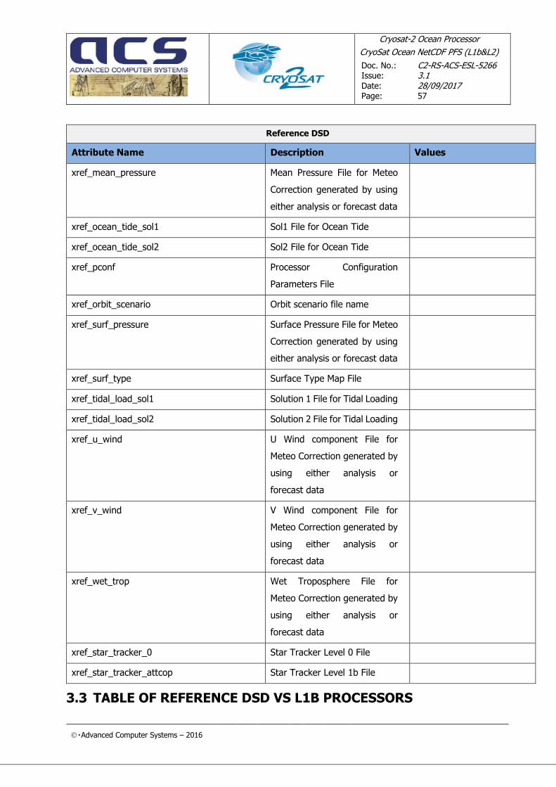
Cryosat-2 Ocean Processor
CryoSat Ocean NetCDF PFS (L1b&L2)
Doc. No.: Issue:
Date: Page:
C2-RS-ACS-ESL-5266 3.1 28/09/2017 57
Advanced Computer Systems – 2016
Reference DSD
Attribute Name Description Values
xref_mean_pressure Mean Pressure File for Meteo
Correction generated by using
either analysis or forecast data
xref_ocean_tide_sol1 Sol1 File for Ocean Tide
xref_ocean_tide_sol2 Sol2 File for Ocean Tide
xref_pconf Processor Configuration
Parameters File
xref_orbit_scenario Orbit scenario file name
xref_surf_pressure Surface Pressure File for Meteo
Correction generated by using
either analysis or forecast data
xref_surf_type Surface Type Map File
xref_tidal_load_sol1 Solution 1 File for Tidal Loading
xref_tidal_load_sol2 Solution 2 File for Tidal Loading
xref_u_wind U Wind component File for
Meteo Correction generated by
using either analysis or
forecast data
xref_v_wind V Wind component File for
Meteo Correction generated by
using either analysis or
forecast data
xref_wet_trop Wet Troposphere File for
Meteo Correction generated by
using either analysis or
forecast data
xref_star_tracker_0 Star Tracker Level 0 File
xref_star_tracker_attcop Star Tracker Level 1b File
3.3 TABLE OF REFERENCE DSD VS L1B PROCESSORS

Cryosat-2 Ocean Processor
CryoSat Ocean NetCDF PFS (L1b&L2)
Doc. No.: Issue:
Date: Page:
C2-RS-ACS-ESL-5266 3.1 28/09/2017 58
Advanced Computer Systems – 2016
PROCESSORS
L1b
NOP
LRM
NOP
SAR
NOP
SRN
IOP
LRM
IOP
SAR
IOP
SRN
GOP
LRM
GOP
SAR
GOP
SRN
Input Data File File Type
xref_siral_l0/ xref_siral_l0_hr
SIR1LRM_0_
SIR2LRM_0_ M M
M
SIR1SAR_0_
SIR2SAR_0_ M M
M
SIR1SIN_0_
SIR2SIN_0_ M M
M
SIR1TKSA0_
SIR2TKSA0_ M M
M
SIR1TKSI0_
SIR2TKSI0_ M M
M
xref_pconf None M M M M M M M M M
xref_siral_characterisation/
xref_siral_characterisation_hr
AUX_IPFDBA
AUX_IPFDBB M M M M M M
M M M
xref_orbit_scenario MPL_ORBREF M M M M M M M M M
xref_orbit/xref_orbit_hr
DOR_NAV_0 M M M
AUX_ORBDOP M M M
AUX_ORBDOR M M M
MPL_ORBPRE M M M M M M M M M
xref_uso DOR_USO_0_ M M M M M M M M M
xref_surf_pressure
AUX_SURFPS M M M M M M
AUXISURFPS O O O
AUX_SEAMPS M M M M M M

Cryosat-2 Ocean Processor
CryoSat Ocean NetCDF PFS (L1b&L2)
Doc. No.: Issue:
Date: Page:
C2-RS-ACS-ESL-5266 3.1 28/09/2017 59
Advanced Computer Systems – 2016
PROCESSORS
L1b
NOP
LRM
NOP
SAR
NOP
SRN
IOP
LRM
IOP
SAR
IOP
SRN
GOP
LRM
GOP
SAR
GOP
SRN
xref_mean_pressure AUXISEAMPS O O O
xref_wet_trop
AUX_WETTRP M M M M M M
AUXIWETTRP O O O
xref_u_wind
AUX_U_WIND M M M M M M
AUXIU_WIND O O O
xref_v_wind
AUX_V_WIND M M M M M M
AUXIV_WIND O O O
xref_meteo AUX_ALTGRD M M M M M M M M M
xref_mog2d
AUX_MOG_2D M M M
AUXIMOG_2D O O O O O O
xref_pole_location AUX_POLLOC M M M M M M M M M
xref_gim
AUX_IONGIM M M M M M M
AUXIIONGIM O O O
xref_cal1/xref_cal1_hr
SIR1LRC11B
SIR2LRC11B M M
M
SIR1SAC11B
SIR2SAC11B M M M M
M M
SIR_SIC11B M M M
xref_cal2/xref_cal2_hr
SIR1SAC21B
SIR2SAC21B M M M M
M M
SIR1SIC21B M M M

Cryosat-2 Ocean Processor
CryoSat Ocean NetCDF PFS (L1b&L2)
Doc. No.: Issue:
Date: Page:
C2-RS-ACS-ESL-5266 3.1 28/09/2017 60
Advanced Computer Systems – 2016
PROCESSORS
L1b
NOP
LRM
NOP
SAR
NOP
SRN
IOP
LRM
IOP
SAR
IOP
SRN
GOP
LRM
GOP
SAR
GOP
SRN
SIR2SIC21B
xref_star_tracker_0 STR_ O O
xref_star_tracker_attcop STR_ATTCOP M M M M
xref_constants None M M M M M M M M M
xref_earth_tide None M M M M M M M M M
xref_ocean_tide_sol1 None M M M M M M M M M
xref_ocean_tide_sol2 None M M M M M M M M M
xref_long_period_tide None M M M M M M M M M
xref_surf_type None M M M M M M M M M
xref_tidal_load_sol1 None M M M M M M M M M
xref_tidal_load_sol2 None M M M M M M M M M

CryoSat-2 Ocean Processor
CryoSat Ocean NetCDF PFS (L1b&L2)
Doc. No.: Issue:
Date: Page:
C2-RS-ACS-ESL-5266 3.1 28/09/2017 61
Advanced Computer Systems – 2016
3.4 L1B PRODUCT FORMAT SPECIFICATION –CDL DUMP
3.4.1 agc_01_ku(time_01)
short agc_01_ku(time_01) ;
agc_01_ku:_FillValue = -32768s;
agc_01_ku:long_name = "corrected AGC: 1 Hz" ;
agc_01_ku:units = "dB" ;
agc_01_ku:add_offset = 0. ;
agc_01_ku:scale_factor = 0.01 ;
agc_01_ku:coordinates = "lon_01 lat_01" ;
agc_01_ku:comment = "AGC corrected for instrumental errors [agc_cor_01]"
;
3.4.2 agc_20 _ku(time_20_ku)
short agc_20_ku(time_20_ku) ;
agc_20_ku:_FillValue = -32768s;
agc_20_ku:long_name = "corrected AGC: 20 Hz" ;
agc_20_ku:units = "dB" ;
agc_20_ku:add_offset = 0. ;
agc_20_ku:scale_factor = 0.01 ;
agc_20_ku:coordinates = "lon_20_ku lat_20_ku" ;
agc_20_ku:comment = "AGC corrected for instrumental errors [agc_cor_01]"
;
3.4.3 agc_ch1_20_hr_ku(time_20_hr_ku)
int agc_ch1_20_hr_ku(time_20_hr_ku) ;
agc_ch1_20_hr_ku:_FillValue = -2147483648;
agc_ch1_20_hr_ku:units = "dB" ;
agc_ch1_20_hr_ku:long_name = "agc gain applied on rx channel 1 HR. Gain
calibration corrections are applied" ;
agc_ch1_20_hr_ku:comment = "Calibrated AGC gain applied on Rx channel 1.
This is the sum of AGC stages 1 and 2 plus
the corresponding corrections given in the variable instr_cor_gain_tx_rx_20_ku." ;
agc_ch1_20_hr_ku:add_offset = 0.0 ;
agc_ch1_20_hr_ku:scale_factor = 0.01 ;

CryoSat-2 Ocean Processor
CryoSat Ocean NetCDF PFS (L1b&L2)
Doc. No.: Issue:
Date: Page:
C2-RS-ACS-ESL-5266 3.1 28/09/2017 62
Advanced Computer Systems – 2016
3.4.4 agc_ch2_20_hr_ku(time_20_hr_ku)
int agc_ch2_20_hr_ku(time_20_hr_ku) ;
agc_ch2_20_hr_ku:_FillValue = -2147483648 ;
agc_ch2_20_hr_ku:units = "dB" ;
agc_ch2_20_hr_ku:long_name = "agc gain applied on rx channel 2 HR. gain
calibration corrections are applied" ;
agc_ch2_20_hr_ku:comment = "Calibrated AGC gain applied on Rx channel 2.
This is the sum of AGC stages 1 and 2 plus the corresponding corrections given in the variable instr_cor_gain_rx_20_ku." ;
agc_ch2_20_hr_ku:add_offset = 0.0 ;
agc_ch2_20_hr_ku:scale_factor = 0.01 ;
3.4.5 agc_cor_01(time_01)
short agc_cor_01(time_01) ;
agc_cor_01:_FillValue = -32768s;
agc_cor_01:long_name = "correction for instrumental errors on AGC: 1 Hz"
;
agc_cor_01:units = "dB" ;
agc_cor_01:add_offset = 0. ;
agc_cor_01:scale_factor = 0.01 ;
agc_cor_01:coordinates = "lon_01 lat_01" ;
agc_cor_01:comment = "AGC correction determined from the values provided
in the IPF data base." ;
3.4.6 alt_01(time_01)
int alt_01(time_01) ;
alt_01:_FillValue =-2147483648;
alt_01:long_name = " center of mass altitude of the satellite: 1 Hz" ; alt_01:units = "m" ;
alt_01:standard_name = "height_above_reference_ellipsoid" ;
alt_01:scale_factor = 0.001 ;
alt_01:coordinates = "lon_01 lat_01" ;
alt_01:comment = "Altitude of satellite center of mass above the reference
ellipsoid." ;

CryoSat-2 Ocean Processor
CryoSat Ocean NetCDF PFS (L1b&L2)
Doc. No.: Issue:
Date: Page:
C2-RS-ACS-ESL-5266 3.1 28/09/2017 63
Advanced Computer Systems – 2016
3.4.7 alt_20_hr_ku(time_20_hr_ku)
int alt_20_hr_ku(time_20_hr_ku) ;
alt_20_hr_ku:_FillValue = -2147483648 ;
alt_20_hr_ku:units = "m" ;
alt_20_hr_ku:long_name = "altitude of CoM above reference ellipsoid
[WGS84]: 20 Hz from HR data" ;
alt_20_hr_ku:standard_name = "height_above_reference_ellipsoid" ;
alt_20_hr_ku:comment = "Altitude of the Satellite CoM above reference
ellipsoid [WGS84]." ;
alt_20_hr_ku:add_offset = 0.0 ;
alt_20_hr_ku:scale_factor = 0.001 ;
3.4.8 alt_20_ku(time_20_ku)
int alt_20_ku(time_20_ku) ;
alt_20_ku:_FillValue = -2147483648;
alt_20_ku:long_name = Altitude of satellite center of mass above the
reference ellipsoid." ;
alt_20_ku:units = "m" ;
alt_20_ku:standard_name = "height_above_reference_ellipsoid" ;
alt_20_ku:scale_factor = 0.001 ;
alt_20_ku:coordinates = "lon_20_ku lat_20_ku" ;
alt_20_ku:comment = "Altitude of satellite center of mass above the
reference ellipsoid." ;
3.4.9 beam_dir_vec_20_hr_ku(time_20_hr_ku,space_3d)
int beam_dir_vec_20_hr_ku(time_20_hr_ku, space_3d) ;
beam_dir_vec_20_hr_ku:_FillValue = -2147483648 ;
beam_dir_vec_20_hr_ku:units = "m" ;
beam_dir_vec_20_hr_ku:long_name = "real beam direction vector in crf" ;
beam_dir_vec_20_hr_ku:comment = "Real beam direction vector described in the CryoSat Reference Frame, components: [1] x, [2]
y, [3] z." ;
beam_dir_vec_20_hr_ku:add_offset = 0.0 ;
beam_dir_vec_20_hr_ku:scale_factor = 1.e-06 ;
3.4.10 cog_cor_01(time_01)
short cog_cor_01(time_01) ;
cog_cor_01:_FillValue = -32768s;
cog_cor_01:long_name = "distance antenna-CoMOG correction on altimeter
range: 1 Hz" ;
cog_cor_01:units = "m" ;
cog_cor_01:add_offset = 0. ;
cog_cor_01:scale_factor = 0.001 ;
cog_cor_01:coordinates = "lon_01 lat_01" ;
cog_cor_01:comment = "Distance antenna-CoMOG determined from the value
provided in the IPF data base." ;

CryoSat-2 Ocean Processor
CryoSat Ocean NetCDF PFS (L1b&L2)
Doc. No.: Issue:
Date: Page:
C2-RS-ACS-ESL-5266 3.1 28/09/2017 64
Advanced Computer Systems – 2016
3.4.11 coherence_waveform_20_hr_ku(time_20_hr_ku,
ns_20_hr_ku)
short coherence_waveform_20_hr_ku(time_20_hr_ku, ns_20_hr_ku) ;
coherence_waveform_20_hr_ku:_FillValue = -32768s ;
coherence_waveform_20_hr_ku:units = "count" ;
coherence_waveform_20_hr_ku:long_name = "l1b coherence waveform from HR
data " ;
coherence_waveform_20_hr_ku:comment = "The L1b 20Hz coherence waveform is
a fully-calibrated, high resolution, multilooked
coherence computed from the complex echoes on the
two receiving channels (SARin only)." ;
coherence_waveform_20_hr_ku:add_offset = 0.0 ;
coherence_waveform_20_hr_ku:scale_factor = 0.001 ;
3.4.12 cor2_applied_20_ku(time_20_ku)
int cor2_applied_20_ku(time_20_ku) ;
cor2_applied_20_ku:_FillValue = -2147483648;
cor2_applied_20_ku:long_name = "range height rate initial word (3.05 ps):
20 Hz" ;
cor2_applied_20_ku:units = "count" ;
cor2_applied_20_ku:coordinates = "lon_20_ku lat_20_ku" ;
cor2_applied_20_ku:comment = "COR2 is the on-board tracker height rate
over the radar cycle, forwarded from telemetry." ;
3.4.13 cor2_applied_20_hr_ku(time_20_hr_ku)
int cor2_applied_20_hr_ku(time_20_hr_ku) ;
cor2_applied_20_hr_ku:_FillValue = -2147483648 ;
cor2_applied_20_hr_ku:units = "seconds/rc" ;
cor2_applied_20_hr_ku:long_name = " range height rate initial word: 20 Hz
" ;
cor2_applied_20_hr_ku:comment = "COR2 is the on-board tracker height rate
over the radar cycle, forwarded from telemetry." ;
cor2_applied_20_hr_ku:add_offset = 0.0 ;
cor2_applied_20_hr_ku:scale_factor = 3.05e-12 ;
3.4.14 dop_angle_start_20_hr_ku(time_20_hr_ku)
int dop_angle_start_20_hr_ku(time_20_hr_ku) ;
dop_angle_start_20_hr_ku:_FillValue = -2147483648 ;
dop_angle_start_20_hr_ku:units = "rad" ;
dop_angle_start_20_hr_ku:long_name = "doppler angle start from HR data"
;
dop_angle_start_20_hr_ku:add_offset = 0.0 ;
dop_angle_start_20_hr_ku:scale_factor = 1.e-07 ;
dop_angle_start_20_hr_ku:commment = "Value of Doppler Angle for the first
single look echo in the stack. It is the angle
between: (a) perpendicular to the velocity vector,
(b) direction satellite - surface location. The

CryoSat-2 Ocean Processor
CryoSat Ocean NetCDF PFS (L1b&L2)
Doc. No.: Issue:
Date: Page:
C2-RS-ACS-ESL-5266 3.1 28/09/2017 65
Advanced Computer Systems – 2016
Doppler angle depends on velocity vector and on
geometry." ;

CryoSat-2 Ocean Processor
CryoSat Ocean NetCDF PFS (L1b&L2)
Doc. No.: Issue:
Date: Page:
C2-RS-ACS-ESL-5266 3.1 28/09/2017 66
Advanced Computer Systems – 2016
3.4.15 dop_angle_stop_20_hr_ku(time_20_hr_ku)
int dop_angle_stop_20_hr_ku(time_20_hr_ku) ;
dop_angle_stop_20_hr_ku:_FillValue = -2147483648 ;
dop_angle_stop_20_hr_ku:units = "rad" ;
dop_angle_stop_20_hr_ku:long_name = "doppler angle stop from HR data" ;
dop_angle_stop_20_hr_ku:add_offset = 0.0;
dop_angle_stop_20_hr_ku:scale_factor = 1.e-07 ;
dop_angle_stop_20_hr_ku:commment = "Value of Doppler Angle for the last
single look echo in the stack. It is the angle
between: (a) perpendicular to the velocity vector,
(b) direction satellite - surface location. The
Doppler angle depends on velocity vector and on
geometry." ;
3.4.16 dop_cor_01_ku(time_01)
short dop_cor_01_ku(time_01) ;
dop_cor_01_ku:_FillValue = -32768s;
dop_cor_01_ku:long_name = "doppler correction on the altimeter range: 1
Hz" ;
dop_cor_01_ku:units = "m" ;
dop_cor_01_ku:add_offset = 0. ;
dop_cor_01_ku:scale_factor = 0.001 ;
dop_cor_01_ku:coordinates = "lon_01 lat_01" ;
dop_cor_01_ku:comment = "This is the Doppler range correction due to the
satellite altitude rate. It is computed from the component of the satellite
velocity in the nadir direction." ;
3.4.17 dop_cor_20_hr_ku(time_20_hr_ku)
int dop_cor_20_hr_ku(time_20_hr_ku) ;
dop_cor_20_hr_ku:_FillValue = -2147483648 ;
dop_cor_20_hr_ku:units = "m" ;
dop_cor_20_hr_ku:long_name = "doppler correction on altimeter range: 20
Hz from HR data" ;
dop_cor_20_hr_ku:commment = "This is the Doppler range correction due to
the satellite altitude rate. It is computed for the
component of satellite velocity in the nadir
direction. Correction applied to L1B LRM waveforms
only." ;
dop_cor_20_hr_ku:add_offset = 0.0 ;
dop_cor_20_hr_ku:scale_factor = 0.001 ;

CryoSat-2 Ocean Processor
CryoSat Ocean NetCDF PFS (L1b&L2)
Doc. No.: Issue:
Date: Page:
C2-RS-ACS-ESL-5266 3.1 28/09/2017 67
Advanced Computer Systems – 2016
3.4.18 dop_cor_20_ku(time_20_ku)
short dop_cor_20_ku(time_20_ku) ;
dop_cor_20_ku:_FillValue = -32768s;
dop_cor_20_ku:long_name = "doppler correction on the altimeter range: 20
Hz" ;
dop_cor_20_ku:units = "m" ;
dop_cor_20_ku:add_offset = 0. ;
dop_cor_20_ku:scale_factor = 0.001 ;
dop_cor_20_ku:coordinates = "lon_20_ku lat_20_ku" ;
dop_cor_20_ku:comment = " This is the Doppler range correction due to the satelitte
altitude rate. It is computed from the component of the satellite velocity in the nadir direction." ;
3.4.19 echo_numval_20_hr_ku(time_20_hr_ku)
short echo_numval_20_hr_ku(time_20_hr_ku) ;
echo_numval_20_hr_ku:_FillValue = -32768s ;
echo_numval_20_hr_ku:units = "count" ;
echo_numval_20_hr_ku:long_name = "number of echoes averaged: 20 Hz from
HR data" ;
echo_numval_20_hr_ku:add_offset = 0s ;
echo_numval_20_hr_ku:scale_factor = 1s ;
echo_numval_20_hr_ku:commment = "For LRM is the number of echoes averaged
to compute the corresponding L1B 20Hz power waveform.
For SAR/SARin is the number of single look echoes in
the Surface Sample Stack that have been multilooked
to compute the corresponding L1B 20Hz power waveform This variable only include one receiveing channel
however, In SARIn, single looks from both channels
are averaged in order to reduce the SNR.." ;
3.4.20 echo_numval_20_ku(time_20_ku)
short echo_numval_20_ku(time_20_ku) ;
echo_numval_20_ku:_FillValue = -32768s;
echo_numval_20_ku:long_name = "number of echoes averaged: 20 Hz" ;
echo_numval_20_ku:units = "count" ;
echo_numval_20_ku:coordinates = "lon_20_ku lat_20_ku" ;
echo_numval_20_ku:comment = "Number of individual echoes averaged to
compute the corresponding 20 Hz power waveform [pwr_waveform_20_ku]." ;
3.4.21 echo_scale_20_ku(time_20_ku)
short echo_scale_20_ku(time_20_ku) ;
echo_scale_20_ku:long_name = "echo scale factor: 20 Hz" ;
echo_scale_20_ku:units = "count" ;
echo_scale_20_ku:add_offset = 32768. ;
echo_scale_20_ku:scale_factor = 1. ;
echo_scale_20_ku:coordinates = "lon_20_ku lat_20_ku" ;
echo_scale_20_ku:comment = "The 20 Hz power waveform scaling factor,
computed in order to best fit each waveform within 2 bytes." ;
3.4.22 echo_scale_20_hr_ku(time_20_hr_ku)

CryoSat-2 Ocean Processor
CryoSat Ocean NetCDF PFS (L1b&L2)
Doc. No.: Issue:
Date: Page:
C2-RS-ACS-ESL-5266 3.1 28/09/2017 68
Advanced Computer Systems – 2016
int echo_scale_20_hr_ku(time_20_hr_ku) ;
echo_scale_20_hr_ku:_FillValue = -2147483648;
echo_scale_20_hr_ku:units = "count" ;
echo_scale_20_hr_ku:long_name = "echo scale factor: 20 Hz from HR
data " ;
echo_scale_20_hr_ku:add_offset = 0.0 ;
echo_scale_20_hr_ku:scale_factor = 1.e-09;
echo_scale_20_hr_ku:comment = "The 20Hz power waveform scaling
factor, computed in order to best fit each
waveform within 2 bytes. The scaling, needed to
convert the L1B 1Hz average power waveform into
Watt, is applied as follows:
pwr_waveform_20_ku(time_20_ku,ns_20_ku)
*echo_scale_factor_20_ku(time_20_ku)*2^echo_s
cale_pwr_20_ku(time_20_ku)." ;
3.4.23 echo_scale_pwr_20_hr_ku(time_20_hr_ku)
int echo_scale_pwr_20_hr_ku(time_20_hr_ku) ;
echo_scale_pwr_20_hr_ku:_FillValue = -2147483648 ;
echo_scale_pwr_20_hr_ku:units = "count" ;
echo_scale_pwr_20_hr_ku:long_name = "echo scale power (a power of 2) from
HR data" ;
echo_scale_pwr_20_hr_ku:add_offset = 0 ;
echo_scale_pwr_20_hr_ku:scale_factor = 1 ;
echo_scale_pwr_20_hr_ku:commment = "The 20Hz power waveform power scaling
factor, computed in order to best fit each
waveform within 2 bytes. The scaling, needed to
convert the L1B 1Hz average power waveform into
Watt, is applied as follows:
pwr_waveform_20_ku(time_20_ku,ns_20_ku)
*echo_scale_factor_20_ku(time_20_ku)*2^echo_s
cale_pwr_20_ku(time_20_ku)." ;
3.4.24 flag_cor_status_01(time_01)
int flag_cor_status_01(time_01) ;
flag_cor_status_01:_FillValue = -1 ;
flag_cor_status_01:long_name = "correction status flag: 1 Hz" ;
flag_cor_status_01:flag_masks = 2048, 1024, 512, 256, 128, 64, 32, 16, 8,
4, 2, 1 ;
flag_cor_status_01:flag_meanings = "model_dry_called model_wet_called
inv_bar_called hf_fluctuations_called iono_gim_called iono_model_called
ocean_tide_called ocean_tide_equil_called load_tide_called solid_earth_called
pole_tide_called surface_type_called" ;
flag_cor_status_01:comment = "Correction status flag- showing which
correction algorithms have been called." ;
flag_cor_status_01:coordinates = "lon_01 lat_01" ;

CryoSat-2 Ocean Processor
CryoSat Ocean NetCDF PFS (L1b&L2)
Doc. No.: Issue:
Date: Page:
C2-RS-ACS-ESL-5266 3.1 28/09/2017 69
Advanced Computer Systems – 2016
3.4.25 flag_cor_err_01(time_01)
int flag_cor_err_01(time_01) ;
flag_cor_err_01:_FillValue = -1 ;
flag_cor_err_01:long_name = "correction error flag: 1 Hz" ;
flag_cor_err_01:flag_masks = 2048, 1024, 512, 256, 128, 64, 32, 16, 8, 4,
2, 1 ;
flag_cor_err_01:flag_meanings = "model_dry_error model_wet_error
inv_bar_error hf_fluctuations_error iono_gim_error iono_model_error
ocean_tide_equil_error long_tide_error load_tide_error solid_earth_error
pole_tide_error surface_type_error" ;
flag_cor_err_01:comment = "Correction error flag- showing if a correction
algorithm returned an error when called." ;
flag_cor_err_01:coordinates = "lon_01 lat_01" ;
3.4.26 flag_echo_20_hr_ku(time_20_hr_ku)
short flag_echo_20_hr_ku(time_20_hr_ku) ;
flag_echo_20_hr_ku:_FillValue = -1s;
flag_echo_20_hr_ku:long_name = "flags for errors or information about L1b
20Hz power waveform from HR data" ;
flag_echo_20_hr_ku:flag_masks = -32768s, 16384s, 8192s, 4096s, 2048s,
1024s, 512s, 256s;
flag_echo_20_hr_ku:flag_meanings = "approx_beam_steering
exact_beam_steering
doppler_weighting_computed
doppler_weighting_applied
multi_look_incomplete
beam_angle_steering_error
anti_aliased_power_echoes
auto_beam_steering" ;
flag_echo_20_hr_ku:commment = "Flags for errors or information about L1b
20Hz power waveform." ;

CryoSat-2 Ocean Processor
CryoSat Ocean NetCDF PFS (L1b&L2)
Doc. No.: Issue:
Date: Page:
C2-RS-ACS-ESL-5266 3.1 28/09/2017 70
Advanced Computer Systems – 2016
3.4.27 flag_instr_conf_rx_bwdt_20_ku(time_20_ku)
byte flag_instr_conf_rx_bwdt_20_ku(time_20_ku) ;
flag_instr_conf_rx_bwdt_20_ku:_FillValue = -128b ;
flag_instr_conf_rx_bwdt_20_ku:long_name = "instrument configuration flag
- bandwidth: 20 Hz" ;
flag_instr_conf_rx_bwdt_20_ku:flag_values = 0b, 1b, 2b ;
flag_instr_conf_rx_bwdt_20_ku:flag_meanings = "unknown 320_mhz 40_mhz" ;
flag_instr_conf_rx_bwdt_20_ku:coordinates = "lon_20_ku lat_20_ku" ;
flag_instr_conf_rx_bwdt_20_ku:comment = "This flag contains the
instrument acquisition band." ;
3.4.28 flag_instr_conf_rx_bwdt_20_hr_ku(time_20_hr_ku)
byte flag_instr_conf_rx_bwdt_20_hr_ku(time_20_hr_ku) ;
flag_instr_conf_rx_bwdt_20_hr_ku:_FillValue = -128b;
flag_instr_conf_rx_bwdt_20_hr_ku:long_name = "instrument configuration
flag – bandwidth: 20 Hz
from HR data" ;
flag_instr_conf_rx_bwdt_20_hr_ku:flag_values = 0b, 1b, 2b ;
flag_instr_conf_rx_bwdt_20_hr_ku:flag_meanings = "unknown 320_mhz
40_mhz" ;
flag_instr_conf_rx_bwdt_20_hr_ku:commment = "This flag contains the
instrument acquisition band." ;
3.4.29 flag_instr_conf_rx_flags_20_ku(time_20_ku)
int flag_instr_conf_rx_flags_20_ku(time_20_ku) ;
flag_instr_conf_rx_flags_20_ku:_FillValue = -2147483648 ;
flag_instr_conf_rx_flags_20_ku:long_name = "instrument configuration
flag - flags: 20 Hz" ;
flag_instr_conf_rx_flags_20_ku:flag_masks = -128b, 64b, 32b, 16b, 8b, 4b,
2b, 1b ;
flag_instr_conf_rx_flags_20_ku:flag_meanings = "siral_redundant
external_cal open_loop loss_of_echo real_time_error echo_saturation
rx_band_attenuated cycle_report_error" ;
flag_instr_conf_rx_flags_20_ku:coordinates = "lon_20_ku lat_20_ku" ;
flag_instr_conf_rx_flags_20_ku:comment = "This flag contains the status
of the instrument acquisition." ;

CryoSat-2 Ocean Processor
CryoSat Ocean NetCDF PFS (L1b&L2)
Doc. No.: Issue:
Date: Page:
C2-RS-ACS-ESL-5266 3.1 28/09/2017 71
Advanced Computer Systems – 2016
3.4.30 flag_instr_conf_rx_flags_20_hr_ku(time_20_hr_ku)
byte flag_instr_conf_rx_flags_20_hr_ku(time_20_hr_ku) ;
flag_instr_conf_rx_flags_20_hr_ku:long_name = "instrument configuration
flag – flags: 20 Hz from HR
data" ;
flag_instr_conf_rx_flags_20_hr_ku:flag_masks = -128b, 64b, 32b, 16b, 8b,
4b, 2b, 1b ;
flag_instr_conf_rx_flags_20_hr_ku:flag_meanings = "siral_redundant
external_cal open_loop
loss_of_echo real_time_error
echo_saturation
rx_band_attenuated
cycle_report_error" ;
flag_instr_conf_rx_flags_20_hr_ku:commment = "This flag contains the
status of the instrument tracking." ;
3.4.31 flag_instr_conf_rx_in_use_20_ku(time_20_ku)
byte flag_instr_conf_rx_in_use_20_ku(time_20_ku) ;
flag_instr_conf_rx_in_use_20_ku:_FillValue = -128b ;
flag_instr_conf_rx_in_use_20_ku:long_name = "instrument configuration
flag - rx chain in use: 20 Hz" ;
flag_instr_conf_rx_in_use_20_ku:flag_values = 0b, 1b, 2b, 3b ;
flag_instr_conf_rx_in_use_20_ku:flag_meanings = "unknown rx1 rx2 both" ;
flag_instr_conf_rx_in_use_20_ku:coordinates = "lon_20_ku lat_20_ku" ;
flag_instr_conf_rx_in_use_20_ku:comment = "This flag contains the
instrument channel in use." ;
3.4.32 flag_instr_conf_rx_in_use_20_hr_ku(time_20_hr_ku)
byte flag_instr_conf_rx_in_use_20_hr_ku(time_20_hr_ku) ;
flag_instr_conf_rx_in_use_20_hr_ku:_FillValue = -128b ;
flag_instr_conf_rx_in_use_20_hr_ku:long_name = "instrument configuration
flag- rx chain in use: 20 Hz
from HR data" ;
flag_instr_conf_rx_in_use_20_hr_ku:flag_values = 0b, 1b, 2b, 3b ;
flag_instr_conf_rx_in_use_20_hr_ku:flag_meanings = "unknown rx1 rx2
both";
flag_instr_conf_rx_in_use_20_hr_ku:commment = "This flag contains the
instrument chain in use." ;

CryoSat-2 Ocean Processor
CryoSat Ocean NetCDF PFS (L1b&L2)
Doc. No.: Issue:
Date: Page:
C2-RS-ACS-ESL-5266 3.1 28/09/2017 72
Advanced Computer Systems – 2016
3.4.33 flag_instr_conf_rx_str_in_use_20_hr_ku(time_20_hr_ku)
byte flag_instr_conf_rx_str_in_use_20_hr_ku(time_20_hr_ku) ;
flag_instr_conf_rx_str_in_use_20_hr_ku:_FillValue = -128b ;
flag_instr_conf_rx_str_in_use_20_hr_ku:long_name = "instrument
configuration flags:
star tracker used: 20
Hz from HR data " ;
flag_instr_conf_rx_str_in_use_20_hr_ku:flag_values = 0b, 1b, 2b, 3b, 4b
;
flag_instr_conf_rx_str_in_use_20_hr_ku:flag_meanings = "no_str_tracker
tracker_1 tracker_2
tracker_3
attref_file" ;
flag_instr_conf_rx_str_in_use_20_hr_ku:comment = "Star tracker
identification flag showing the
source of the platform pointing. 0:
No Star Tracker data used. 1: Data
from Star Tracker 1 used. 2: Data from
Star Tracker 2 used. 3: Data from Star
Tracker 3 used. 4: Data from the Star
Tracker selected on board by AOCS
used." ;

CryoSat-2 Ocean Processor
CryoSat Ocean NetCDF PFS (L1b&L2)
Doc. No.: Issue:
Date: Page:
C2-RS-ACS-ESL-5266 3.1 28/09/2017 73
Advanced Computer Systems – 2016
3.4.34 flag_instr_conf_rx_trk_mode_20_ku(time_20_ku)
byte flag_instr_conf_rx_trk_mode_20_ku(time_20_ku) ;
flag_instr_conf_rx_trk_mode_20_ku:_FillValue = -128b ;
flag_instr_conf_rx_trk_mode_20_ku:long_name = "instrument configuration
flag - tracking mode: 20 Hz" ;
flag_instr_conf_rx_trk_mode_20_ku:flag_values = 0b, 1b, 2b, 3b ;
flag_instr_conf_rx_trk_mode_20_ku:flag_meanings = "unknown lrm sar sarin"
;
flag_instr_conf_rx_trk_mode_20_ku:coordinates = "lon_20_ku lat_20_ku" ;
flag_instr_conf_rx_trk_mode_20_ku:comment = "Tracking Mode." ;
3.4.35 flag_instr_conf_rx_trk_mode_20_hr_ku(time_20_hr_ku)
byte flag_instr_conf_rx_trk_mode_20_hr_ku(time_20_hr_ku) ;
flag_instr_conf_rx_trk_mode_20_hr_ku:_FillValue = -128b ;
flag_instr_conf_rx_trk_mode_20_hr_ku:long_name = "instrument
configuration flag - tracking
mode : 20 Hz from HR data" ;
flag_instr_conf_rx_trk_mode_20_hr_ku:flag_values = 0b, 1b, 2b, 3b ;
flag_instr_conf_rx_trk_mode_20_hr_ku:flag_meanings = "unknown lrm sar
sarin" ;
flag_instr_conf_rx_trk_mode_20_hr_ku:comment = "Tracking Mode." ;
3.4.36 flag_instr_mode_att_ctrl_20_hr_ku(time_20_hr_ku)
byte flag_instr_mode_att_ctrl_20_hr_ku (time_20_hr_ku) ;
flag_instr_mode_att_ctrl_20_hr_ku:_FillValue = -128b ;
flag_instr_mode_att_ctrl_20_hr_ku:long_name = " mode id -platform
attitude control flag: 20 Hz from
HR data " ;
flag_instr_mode_att_ctrl_20_hr_ku:flag_values = 0b, 1b, 2b ;
flag_instr_mode_att_ctrl_20_hr_ku:flag_meanings = "unknown
local_normal_pointing
yaw_steering";
flag_instr_mode_att_ctrl_20_hr_ku:comment = "Platform attitude control
mode." ;

CryoSat-2 Ocean Processor
CryoSat Ocean NetCDF PFS (L1b&L2)
Doc. No.: Issue:
Date: Page:
C2-RS-ACS-ESL-5266 3.1 28/09/2017 74
Advanced Computer Systems – 2016
3.4.37 flag_instr_mode_flags_20_hr_ku(time_20_hr_ku)
byte flag_instr_mode_flags_20_hr_ku(time_20_hr_ku) ;
flag_instr_mode_flags_20_hr_ku:_FillValue = -128b ;
flag_instr_mode_flags_20_hr_ku:long_name = "mode id - identifies the
siral instrument measurement
mode from HR data" ;
flag_instr_mode_flags_20_hr_ku:flag_masks = 2b, 1b ;
flag_instr_mode_flags_20_hr_ku:flag_meanings = "sarin_degraded_case
cal4_packet_detection";
flag_instr_mode_flags_20_hr_ku:comment = "Instrument mode derived from
configuration bits in L0." ;
3.4.38 flag_instr_op_mode_20_hr_ku(time_20_hr_ku)
byte flag_instr_op_mode_20_hr_ku(time_20_hr_ku) ;
flag_instr_op_mode_20_hr_ku:_FillValue = -128b ;
flag_instr_op_mode_20_hr_ku:long_name = "mode id - operative mode : 20 Hz
from HR data" ;
flag_instr_op_mode_20_hr_ku:flag_values = "1b, 2b, 3b" ;
flag_instr_op_mode_20_hr_ku:flag_meanings = "lrm sar sarin" ;
flag_instr_op_mode_20_hr_ku:comment = "Mode ID - Identifies the SIRAL
instrument measurement mode." ;
3.4.39 flag_instr_op_mode _20_ku(time_20_ku)
byte flag_instr_op_mode_20_ku(time_20_ku) ;
flag_instr_op_mode_20_ku:_FillValue = -128b;
flag_instr_op_mode_20_ku:long_name = "mode id - operative mode: 20 Hz" ;
flag_instr_op_mode_20_ku:flag_values = 1b, 2b, 3b ;
flag_instr_op_mode_20_ku:flag_meanings = "lrm sar sarin" ;
flag_instr_op_mode_20_ku:coordinates = "lon_20_ku lat_20_ku" ;
flag_instr_op_mode_20_ku:comment = " Mode ID - Identifies the SIRAL
instrument measurement mode." ;

CryoSat-2 Ocean Processor
CryoSat Ocean NetCDF PFS (L1b&L2)
Doc. No.: Issue:
Date: Page:
C2-RS-ACS-ESL-5266 3.1 28/09/2017 75
Advanced Computer Systems – 2016
3.4.40 flag_mcd_20_ku(time_20_ku)
int flag_mcd_20_ku(time_20_ku) ;
flag_mcd_20_ku:long_name = "measurement confidence data: 20 Hz" ;
flag_mcd_20_ku:flag_masks = -2147483648, 1073741824, 536870912,
268435456, 134217728, 67108864, 33554432, 16777216, 8388608, 4194304, 2097152,
1048576, 524288, 262144, 131072, 65536, 32768, 16384, 8192, 4096, 2048, 128, 64,
32, 16, 8, 1;
flag_mcd_20_ku:flag_meanings = "block_degraded blank_block
datation_degraded orbit_prop_error orbit_file_change orbit_gap echo_saturated
other_echo_error sarin_rx1_error sarin_rx2_error window_delay_error agc_error
cal1_missing cal1_default doris_uso_missing ccal1_default trk_echo_error
echo_rx1_error echo_rx2_error npm_error azimuth_cal_missing
phase_pert_cor_missing cal2_missing cal2_default power_scale_error
attitude_cor_missing phase_pert_cor_default";
flag_mcd_20_ku:coordinates = "lon_20_ku lat_20_ku" ;
flag_mcd_20_ku:comment = "Measurement confidence flags. Generally the MCD
flags indicate problems when set. If the whole MCD is 0 then no problems or non-
nominal conditions were detected. Serious errors are indicated by setting bit 31
(SS bit 0), in which case the block must not be processed. Other error settings
can be regarded as warnings." ;
3.4.41 flag_mcd_20_hr_ku(time_20_hr_ku)
int flag_mcd_20_hr_ku(time_20_hr_ku) ;
flag_mcd_20_hr_ku:_FillValue = -1 ;
flag_mcd_20_hr_ku:long_name = "measurement confidence data: 20 Hz from
HR data" ;
flag_mcd_20_hr_ku:flag_masks = -2147483648, 1073741824, 536870912,
268435456, 134217728, 67108864, 33554432,
16777216, 8388608, 4194304, 2097152,
1048576, 524288, 262144, 131072, 65536,
32768, 16384, 8192, 4096, 2048, 128, 64, 32,
16, 8, 1 ;
flag_mcd_20_hr_ku:flag_meanings = "block_degraded blank_block
datation_degraded orbit_prop_error
orbit_file_change orbit_gap echo_saturated
other_echo_error sarin_rx1_error
sarin_rx2_error window_delay_error
agc_error cal1_missing cal1_default
doris_uso_missing ccal1_default
trk_echo_error echo_rx1_error
echo_rx2_error npm_error cal1_pwr_corr_type
phase_pert_cor_missing cal2_missing
cal2_default power_scale_error
attitude_cor_missing
phase_pert_cor_default" ;
flag_mcd_20_hr_ku:comment = " Measurement confidence flags. Generally the MCD flags indicate problems when set. If the
whole MCD is 0 then no problems or non-nominal
conditions were detected. Serious errors are
indicated by setting the most-significant bit
i.e. block_degraded, in which case the block
must not be processed. Other error settings can
be regarded as warnings.." ;

CryoSat-2 Ocean Processor
CryoSat Ocean NetCDF PFS (L1b&L2)
Doc. No.: Issue:
Date: Page:
C2-RS-ACS-ESL-5266 3.1 28/09/2017 76
Advanced Computer Systems – 2016
3.4.42 flag_trk_cycle_20_ku(time_20_ku)
short flag_trk_cycle_20_ku(time_20_ku) ;
flag_trk_cycle_20_ku:_FillValue = -32768;
flag_trk_cycle_20_ku:long_name = "tracking cycle report: 20 Hz" ;
flag_trk_cycle_20_ku:flag_values = 0b, 1b, 2b, 3b, 7b;
flag_trk_cycle_20_ku:flag_meanings = "no_errors loss_of_echo
run_time_error echo_saturation_error unknown_error" ;
flag_trk_cycle_20_ku:coordinates = "lon_20_ku lat_20_ku" ;
flag_trk_cycle_20_ku:comment = "Tracking cycle report forwarded from
telemetry." ;
3.4.43 flag_trk_cycle_20_hr_ku(time_20_hr_ku)
short flag_trk_cycle_20_hr_ku(time_20_hr_ku) ;
flag_trk_cycle_20_hr_ku:long_name = " tracking cycle report: 20 Hz from
HR data" ;
flag_trk_cycle_20_hr_ku:_FillValue = -32768 ;
flag_trk_cycle_20_hr_ku: flag_values = 0s, 1s, 2s, 3s, 7s ;
flag_trk_cycle_20_hr_ku:flag_meanings = "no_errors loss_of_echo
run_time_error echo_saturation_error
unknown_error" ;
flag_trk_cycle_20_hr_ku:commment = "Flags for errors or information about
L1b 20Hz power waveform for LRM/FDM case." ;
3.4.44 h0_applied_20_ku(time_20_ku)
int h0_applied_20_ ku(time_20_ku) ;
h0_applied_20_ku:_FillValue = -2147483648;
h0_applied_20_ku:long_name = "range height initial word (12.5/256 ns): 20
Hz" ;
h0_applied_20_ku:units = "count" ;
h0_applied_20_ku:coordinates = "lon_20_ku lat_20_ku" ;
h0_applied_20_ku:comment = "The H0 (initial altitude instruction)
forwarded from telemetry." ;
3.4.45 h0_applied_20_hr_ku(time_20_hr_ku)
int h0_applied_20_hr_ku(time_20_hr_ku) ;
h0_applied_20_hr_ku:_FillValue = -2147483648 ;
h0_applied_20_hr_ku:units = "seconds" ;
h0_applied_20_hr_ku:long_name = " range height initial word: 20 Hz from
HR data" ;
h0_applied_20_hr_ku:add_offset = 0. ;
h0_applied_20_hr_ku:scale_factor = 4.88e-11 ;
h0_applied_20_hr_ku:comment = "The H0 (initial altitude instruction)
forwarded from telemetry." ;

CryoSat-2 Ocean Processor
CryoSat Ocean NetCDF PFS (L1b&L2)
Doc. No.: Issue:
Date: Page:
C2-RS-ACS-ESL-5266 3.1 28/09/2017 77
Advanced Computer Systems – 2016
3.4.46 h0_fai_word_20_ku(time_20_ku)
int h0_fai_word_20_ku(time_20_ku) ;
h0_fai_word_20_ku:_FillValue = -2147483648;
h0_fai_word_20_ku:long_name = "fine range word (12.5/256 ns): 20 Hz" ;
h0_fai_word_20_ku:units = "count" ;
h0_fai_word_20_ku:coordinates = "lon_20_ku lat_20_ku" ;
h0_fai_word_20_ku:comment = "This is the Fine Altitude Instruction (FAI),
forwarded from telemetry." ;
3.4.47 h0_fai_word_20_hr_ku(time_20_hr_ku)
int h0_fai_word_20_hr_ku(time_20_hr_ku) ;
h0_fai_word_20_hr_ku:_FillValue = -2147483648 ;
h0_fai_word_20_hr_ku:units = "seconds" ;
h0_fai_word_20_hr_ku:long_name = " fine range word : 20 Hz from HR data"
;
h0_fai_word_20_hr_ku:add_offset = 0. ;
h0_fai_word_20_hr_ku:scale_factor = 4.88e-11 ;
h0_fai_word_20_hr_ku:comment = "This is the Fine Altitude Instruction
(FAI), computed from H0 and COR2." ;
3.4.48 h0_lai_word_20_ku(time_20_ku)
int h0_lai_word_20_ku(time_20_ku) ;
h0_lai_word_20_ku:_FillValue = -2147483648;
h0_lai_word_20_ku:long_name = "coarse range word (12.5 ns): 20 Hz" ;
h0_lai_word_20_ku:units = "count" ;
h0_lai_word_20_ku:coordinates = "lon_20_ku lat_20_ku" ;
h0_lai_word_20_ku:comment = "This is the Coarse Altitude Instruction
(LAI), forwarded from telemetry ." ;
3.4.49 h0_lai_word_20_hr_ku(time_20_hr_ku)
int h0_lai_word_20_hr_ku(time_20_hr_ku) ;
h0_lai_word_20_hr_ku:_FillValue = -2147483648 ;
h0_lai_word_20_hr_ku:units = "seconds" ;
h0_lai_word_20_hr_ku:long_name = "coarse range word: 20 Hz from HR data"
;
h0_lai_word_20_hr_ku:add_offset = 0. ;
h0_lai_word_20_hr_ku:scale_factor = 1.25e-08 ;
h0_lai_word_20_hr_ku:comment = "This is the Coarse Altitude Instruction
(LAI), computed from H0 and COR2." ;

CryoSat-2 Ocean Processor
CryoSat Ocean NetCDF PFS (L1b&L2)
Doc. No.: Issue:
Date: Page:
C2-RS-ACS-ESL-5266 3.1 28/09/2017 78
Advanced Computer Systems – 2016
3.4.50 hf_fluct_cor_01(time_01)
short hf_fluct_cor_01(time_01) ;
hf_fluct_cor_01:_FillValue = -32768s;
hf_fluct_cor_01:long_name = "high frequency fluctuations of the sea
surface topography: 1 Hz" ;
hf_fluct_cor_01:units = "m" ;
hf_fluct_cor_01:standard_name =
"sea_surface_height_correction_due_to_air_pressure_and_wind_at_high_frequency" ;
hf_fluct_cor_01:add_offset = 0. ;
hf_fluct_cor_01:scale_factor = 0.001 ;
hf_fluct_cor_01:coordinates = "lon_01 lat_01" ;
hf_fluct_cor_01:comment = "High frequency fluctuations of the sea surface
topography due to high frequency air pressure and wind effects. Also known as DAC
(Dynamical Atmospheric Correction). Provided as a correction to the inverted
barometer correction [inv_bar_cor_01]." ;
hf_fluct_cor_01:source = "2.1.0" ;
hf_fluct_cor_01:institution = "LEGOS/CLS/CNES" ;
3.4.51 ind_first_meas_20hz_01(time_01)
int ind_first_meas_20hz_01(time_01) ;
ind_first_meas_20hz_01:_FillValue = - 2147483648; ind_first_meas_20hz_01:long_name = "index of the first 20Hz measurement:
1 Hz" ;
ind_first_meas_20hz_01:units = "count" ;
ind_first_meas_20hz_01:comment = "Index of the first 20Hz measurement of
the 1Hz packet." ;
3.4.52 ind_meas_1hz_20_ku(time_20_ku)
short ind_meas_1hz_20_ku(time_20_ku) ;
ind_meas_1hz_20_ku:_FillValue = -32768s;
ind_meas_1hz_20_ku:long_name = "index of the 1Hz measurement: 20 Hz" ;
ind_meas_1hz_20_ku:units = "count" ;
ind_meas_1hz_20_ku:comment = "Index of the 1Hz measurement to which
belongs the 20Hz measurement." ;
3.4.53 instr_cor_gain_rx_20_hr_ku(time_20_hr_ku)
int instr_cor_gain_rx_20_hr_ku(time_20_hr_ku) ;
instr_cor_gain_rx_20_hr_ku:_FillValue = -2147483648 ;
instr_cor_gain_rx_20_hr_ku:units = "dB" ;
instr_cor_gain_rx_20_hr_ku:long_name = "instrument gain correction (rx
only chain) from HR data" ;
instr_cor_gain_rx_20_hr_ku:add_offset = 0. ;
instr_cor_gain_rx_20_hr_ku:scale_factor = 0.01 ;
instr_cor_gain_rx_20_hr_ku:comment = "Instrument Gain Correction (Rx only
chain) – It includes the power variation from CAL1 and the
AGC calibration values." ;
3.4.54 instr_cor_gain_tx_rx_20_hr_ku(time_20_hr_ku)

CryoSat-2 Ocean Processor
CryoSat Ocean NetCDF PFS (L1b&L2)
Doc. No.: Issue:
Date: Page:
C2-RS-ACS-ESL-5266 3.1 28/09/2017 79
Advanced Computer Systems – 2016
int instr_cor_gain_tx_rx_20_hr_ku(time_20_hr_ku) ;
instr_cor_gain_tx_rx_20_hr_ku:_FillValue = -2147483648 ;
instr_cor_gain_tx_rx_20_hr_ku:units = "dB" ;
instr_cor_gain_tx_rx_20_hr_ku:long_name = "instrument gain correction
(tx-rx chain) from HR data" ;
instr_cor_gain_tx_rx_20_hr_ku:add_offset = 0. ;
instr_cor_gain_tx_rx_20_hr_ku:scale_factor = 0.01 ;
instr_cor_gain_tx_rx_20_hr_ku:comment = "Instrument Gain Correction (Tx-
Rx chain) – It includes the power variation from CAL1 and the
AGC calibration values." ;
3.4.55 instr_cor_range_rx_20_hr_ku(time_20_hr_ku)
int instr_cor_range_rx_20_hr_ku(time_20_hr_ku) ;
instr_cor_range_rx_20_hr_ku:_FillValue = -2147483648 ;
instr_cor_range_rx_20_hr_ku:units = "m" ;
instr_cor_range_rx_20_hr_ku:long_name = "2-way instrument range
correction (rx only chain) from HR
data" ;
instr_cor_range_rx_20_hr_ku:add_offset = 0. ;
instr_cor_range_rx_20_hr_ku:scale_factor = 0.001 ;
instr_cor_range_rx_20_hr_ku:comment = "2-way instrument Range Correction
(Rx only chain) - It includes (a) the internal path delay from
CAL1, (b) the external group delay from ground
characterisation and (c) the vertical component of the COM –
Antenna distance." ;

CryoSat-2 Ocean Processor
CryoSat Ocean NetCDF PFS (L1b&L2)
Doc. No.: Issue:
Date: Page:
C2-RS-ACS-ESL-5266 3.1 28/09/2017 80
Advanced Computer Systems – 2016
3.4.56 instr_cor_range_tx_rx_20_hr_ku(time_20_hr_ku)
int instr_cor_range_tx_rx_20_hr_ku(time_20_hr_ku) ;
instr_cor_range_tx_rx_20_hr_ku:_FillValue = -2147483648 ;
instr_cor_range_tx_rx_20_hr_ku:units = "m" ;
instr_cor_range_tx_rx_20_hr_ku:long_name = "2-way instrument range
correction (tx-rx chain) from HR
data" ;
instr_cor_range_tx_rx_20_hr_ku:add_offset = 0. ;
instr_cor_range_tx_rx_20_hr_ku:scale_factor = 0.001 ;
instr_cor_range_tx_rx_20_hr_ku:comment = "2-way instrument Range
Correction (Tx-Rx chain). It includes (a) the internal path
delay from CAL1, (b) the external group delay from ground
characterisation and (c) the vertical component of the COM –
Antenna distance." ;
3.4.57 instr_ext_ph_cor_20_hr_ku(time_20_hr_ku)
int instr_ext_ph_cor_20_hr_ku(time_20_hr_ku) ;
instr_ext_ph_cor_20_hr_ku:_FillValue = -2147483648 ;
instr_ext_ph_cor_20_hr_ku:units = "rad" ;
instr_ext_ph_cor_20_hr_ku:long_name = "external phase correction taken
from the ipfdb file from HR data" ;
instr_ext_ph_cor_20_hr_ku:add_offset = 0. ;
instr_ext_ph_cor_20_hr_ku:scale_factor = 1.e-06 ;
instr_ext_ph_cor_20_hr_ku:comment = "External phase correction taken from
the IPFDB file (SARin only) to be added
to the internal phase correction term. The
external phase correction is the
temperature-averaged component of
external inter-channel phase difference
derived from phase difference sensitive
antenna subsystem, waveguides and
instrument waveguide switches. The
external phase correction doesn’t contain
internal instrument effects of
calibration coupler and duplexer which
are included in the internal phase
difference correction." ;
3.4.58 instr_int_ph_cor_20_hr_ku(time_20_hr_ku)
int instr_int_ph_cor_20_hr_ku(time_20_hr_ku) ;
instr_int_ph_cor_20_hr_ku:_FillValue = -2147483648 ;
instr_int_ph_cor_20_hr_ku:units = "rad" ;
instr_int_ph_cor_20_hr_ku:long_name = "internal phase correction computed
from the cal-4 from HR data" ;
instr_int_ph_cor_20_hr_ku:add_offset = 0. ;
instr_int_ph_cor_20_hr_ku:scale_factor = 1.e-06 ;
instr_int_ph_cor_20_hr_ku:comment = "Internal phase correction computed
from the latest available CAL-4 packet.
Applied in L1b SARin products only). " ;

CryoSat-2 Ocean Processor
CryoSat Ocean NetCDF PFS (L1b&L2)
Doc. No.: Issue:
Date: Page:
C2-RS-ACS-ESL-5266 3.1 28/09/2017 81
Advanced Computer Systems – 2016
3.4.59 int_path_cor_01(time_01)
short int_path_cor_01(time_01) ;
int_path_cor_01:_FillValue = -32768s ;
int_path_cor_01:long_name = "internal path correction on the altimeter
range: 1 Hz" ;
int_path_cor_01:units = "m" ;
int_path_cor_01:add_offset = 0. ;
int_path_cor_01:scale_factor = 0.001 ;
int_path_cor_01:coordinates = "lon_01 lat_01" ;
int_path_cor_01:comment = "Internal calibration correction on the
altimeter range" ;
3.4.60 inter_base_vec_20_hr_ku(time_20_hr_ku,space_3d)
int inter_base_vec_20_hr_ku(time_20_hr_ku, space_3d) ;
inter_base_vec_20_hr_ku:_FillValue = -2147483648 ;
inter_base_vec_20_hr_ku:units = "m" ;
inter_base_vec_20_hr_ku:long_name = "interferometric baseline direction
vector in crf from HR data" ;
inter_base_vec_20_hr_ku:add_offset = 0. ;
inter_base_vec_20_hr_ku:scale_factor = 1.e-06 ;
inter_base_vec_20_hr_ku:comment = " Direction vector from Tx-Rx antenna
reference point to Rx only antenna
reference point defined in the CryoSat
Reference Frame, components: [1] x, [2]
y, [3] z." ;
3.4.61 internal_cor_sig0_01(time_01)
short internal_cor_sig0_01(time_01) ;
internal_cor_sig0_01:_FillValue = -32768s ;
internal_cor_sig0_01:long_name = "internal calibration correction on the
backscatter coefficient: 1 Hz" ;
internal_cor_sig0_01:units = "dB" ;
internal_cor_sig0_01:add_offset = 0. ;
internal_cor_sig0_01:scale_factor = 0.01 ;
internal_cor_sig0_01:coordinates = "lon_01 lat_01" ;
internal_cor_sig0_01:comment = "Internal calibration correction applied
to the backscatter coefficient." ;

CryoSat-2 Ocean Processor
CryoSat Ocean NetCDF PFS (L1b&L2)
Doc. No.: Issue:
Date: Page:
C2-RS-ACS-ESL-5266 3.1 28/09/2017 82
Advanced Computer Systems – 2016
3.4.62 inv_bar_cor_01(time_01)
short inv_bar_cor_01(time_01) ;
inv_bar_cor_01:_FillValue = -32768s;
inv_bar_cor_01:long_name = "inverted barometer height correction: 1 Hz"
;
inv_bar_cor_01:units = "m" ;
inv_bar_cor_01:standard_name =
"sea_surface_height_correction_due_to_air_pressure_at_low_frequency" ;
inv_bar_cor_01:add_offset = 0. ;
inv_bar_cor_01:scale_factor = 0.001 ;
inv_bar_cor_01:coordinates = "lon_01 lat_01" ;
inv_bar_cor_01:comment = "Computed at the altimeter time-tag [time_01]
from the interpolation of 2 meteorological fields that surround the altimeter
time-tag. To be added to range measurement together with the high frequency
fluctuation [hf_fluct_cor_01] to correct for the depression of the ocean surface
caused by the local barometric pressure." ;
inv_bar_cor_01:source = "European Center for Medium Range Weather
Forecasting" ;
inv_bar_cor_01:institution = "ECMWF" ;
3.4.63 iono_cor_gim_01(time_01)
short iono_cor_gim_01(time_01) ;
iono_cor_gim_01:_FillValue = -32768s;
iono_cor_gim_01:long_name = "GIM ionospheric correction: 1 Hz" ;
iono_cor_gim_01:units = "m" ;
iono_cor_gim_01:standard_name =
"altimeter_range_correction_due_to_ionosphere" ;
iono_cor_gim_01:add_offset = 0. ;
iono_cor_gim_01:scale_factor = 0.001 ;
iono_cor_gim_01:coordinates = "lon_01 lat_01" ;
iono_cor_gim_01:comment = To be added to range measurement to correct for
the delay to the Radar pulse caused by free electrons in the ionosphere. Computed
from GPS ionospheric data." ;
iono_cor_gim_01:source = "GIM" ;
iono_cor_gim_01:institution = "NASA/JPL" ;
3.4.64 lat_01(time_01)
int lat_01(time_01) ;
lat_01:long_name = "latitude: 1 Hz" ;
lat_01:_FillValue =-2147483648;
lat_01:units = "degrees_north" ;
lat_01:standard_name = "latitude" ;
lat_01:add_offset = 0. ;
lat_01:scale_factor = 1.e-07 ;
lat_01:comment = "Positive latitude is North latitude, negative latitude
is South latitude" ;

CryoSat-2 Ocean Processor
CryoSat Ocean NetCDF PFS (L1b&L2)
Doc. No.: Issue:
Date: Page:
C2-RS-ACS-ESL-5266 3.1 28/09/2017 83
Advanced Computer Systems – 2016
3.4.65 lat_20_ku(time_20_ku)
int lat_20_ku(time_20_ku) ;
lat_20_ku:long_name = "latitude: 20 Hz" ;
lat_20_ku:_FillValue =-2147483648 ;
lat_20_ku:units = "degrees_north" ;
lat_20_ku:standard_name = "latitude" ;
lat_20_ku:add_offset = 0. ;
lat_20_ku:scale_factor = 1.e-07 ;
lat_20_ku:comment = "Positive latitude is North latitude, negative
latitude is South latitude" ;
3.4.66 lat_20_hr_ku(time_20_hr_ku)
int lat_20_hr_ku(time_20_hr_ku) ;
lat_20_hr_ku:units = "degrees_north" ;
lat_20_hr_ku:_FillValue = -2147483648 ;
lat_20_hr_ku:long_name = " latitude: 20 Hz from HR data" ;
lat_20_hr_ku:standard_name = "latitude" ;
lat_20_hr_ku:scale_factor = 1.e-07 ;
lat_20_hr_ku:add_offset = 0. ;
lat_20_hr_ku:comment = "Latitude of measurement [-90,+90]. Positive
latitude is North latitude, negative latitude is
South latitude. Note the scale factor." ;
3.4.67 load_tide_sol1_01(time_01)
short load_tide_sol1_01(time_01) ;
load_tide_sol1_01:_FillValue = -32768s;
load_tide_sol1_01:long_name = "load tide height for geocentric ocean tide
(solution 1): 1 Hz" ;
load_tide_sol1_01:units = "m" ;
load_tide_sol1_01:add_offset = 0. ;
load_tide_sol1_01:scale_factor = 0.001 ;
load_tide_sol1_01:coordinates = "lon_01 lat_01" ;
load_tide_sol1_01:comment = "This value has already been added to the
corresponding ocean tide height value recorded in the product
[ocean_tide_sol1_01]." ;
load_tide_sol1_01:source = "GOT4.10" ;
load_tide_sol1_01:institution = "GSFC" ;

CryoSat-2 Ocean Processor
CryoSat Ocean NetCDF PFS (L1b&L2)
Doc. No.: Issue:
Date: Page:
C2-RS-ACS-ESL-5266 3.1 28/09/2017 84
Advanced Computer Systems – 2016
3.4.68 load_tide_sol2_01(time_01)
short load_tide_sol2_01(time_01) ;
load_tide_sol2_01:_FillValue = -32768s;
load_tide_sol2_01:long_name = "load tide height for geocentric ocean tide
(solution 2): 1 Hz" ;
load_tide_sol2_01:units = "m" ;
load_tide_sol2_01:add_offset = 0. ;
load_tide_sol2_01:scale_factor = 0.001 ;
load_tide_sol2_01:coordinates = "lon_01 lat_01" ;
load_tide_sol2_01:comment = "This value contains the total load tide
height (short-period and long-period) for the geocentric ocean tide (solution 2).
To get only the pure ocean tide height (solution 2), do: [ocean_tide_sol2_01] +
[ocean_tide_non_eq_01] - [load_tide_sol2_01]. This value has already been added
to the corresponding ocean tide height value recorded in the product
[ocean_tide_sol2_01]." ;
load_tide_sol2_01:source = "FES2014b" ;
load_tide_sol2_01:institution = "LEGOS/CNES" ;
3.4.69 lon_01(time_01)
int lon_01(time_01) ;
lon_01:_FillValue =-2147483648;
lon_01:long_name = "longitude: 1 Hz" ;
lon_01:units = "degrees_east" ;
lon_01:standard_name = "longitude" ;
lon_01:add_offset = 0. ;
lon_01:scale_factor = 1.e-07 ;
lon_01:comment = "East longitude relative to Greenwhich meridian" ;
3.4.70 lon_20_ku(time_20_ku)
int lon_20_ku(time_20_ku) ;
lon_20_ku:_FillValue = -2147483648;
lon_20_ku:long_name = "longitude: 20 Hz" ;
lon_20_ku:units = "degrees_east" ;
lon_20_ku:standard_name = "longitude" ;
lon_20_ku:add_offset = 0. ;
lon_20_ku:scale_factor = 1.e-07 ;
lon_20_ku:comment = "East longitude relative to Greenwhich meridian" ;
3.4.71 lon_20_hr_ku(time_20_hr_ku)
int lon_20_hr_ku (time_20_hr_ku) ;
lon_20_hr_ku:units = "degrees_east" ;
lon_20_hr_ku:_FillValue = -2147483648 ;
lon_20_hr_ku:long_name = " longitude: 20 Hz from HR data" ;
lon_20_hr_ku:standard_name = "longitude" ;
lon_20_hr_ku:scale_factor = 1.e-07 ;
lon_20_hr_ku:add_offset = 0. ;
lon_20_hr_ku:comment = "Longitude of measurement [-180,+180]. Positive at
East. East longitude relative to Greenwich
meridian. Note the scale factor." ;

CryoSat-2 Ocean Processor
CryoSat Ocean NetCDF PFS (L1b&L2)
Doc. No.: Issue:
Date: Page:
C2-RS-ACS-ESL-5266 3.1 28/09/2017 85
Advanced Computer Systems – 2016
3.4.72 look_angle_start_20_hr_ku(time_20_hr_ku) int look_angle_start_20_hr_ku(time_20_hr_ku) ;
look_angle_start_20_hr_ku:_FillValue = -2147483648 ;
look_angle_start_20_hr_ku:units = "rad" ;
look_angle_start_20_hr_ku:long_name = "look angle start from HR data" ;
look_angle_start_20_hr_ku:add_offset = 0. ;
look_angle_start_20_hr_ku:scale_factor = 1.e-07 ;
look_angle_start_20_hr_ku:commment = "Value of Look Angle for the first
single look echo in the stack. It is the angle between: (a)
perpendicular from the satellite CoM to the surface, (b)
direction satellite - surface location. The look angle depends
purely on geometry.";
3.4.73 look_angle_stop_20_hr_ku(time_20_hr_ku)
int look_angle_stop_20_hr_ku(time_20_hr_ku) ;
look_angle_stop_20_hr_ku:_FillValue = -2147483648 ;
look_angle_stop_20_hr_ku:units = "rad" ;
look_angle_stop_20_hr_ku:long_name = " look angle stop from HR data " ;
look_angle_stop_20_hr_ku:add_offset = 0. ;
look_angle_stop_20_hr_ku:scale_factor = 1.e-07 ;
look_angle_stop_20_hr_ku:commment = "Value of Look Angle for the last
single look echo in the stack. It is the angle between: (a)
perpendicular from the satellite CoM to the surface, (b)
direction satellite - surface location. The look angle depends
purely on geometry." ;
3.4.74 mod_dry_tropo_cor_01(time_01)
short mod_dry_tropo_cor_01(time_01) ;
mod_dry_tropo_cor_01:_FillValue = 32768s;
mod_dry_tropo_cor_01:long_name = "model dry tropospheric correction: 1
Hz" ;
mod_dry_tropo_cor_01:units = "m" ;
mod_dry_tropo_cor_01:standard_name =
"altimeter_range_correction_due_to_dry_troposphere" ;
mod_dry_tropo_cor_01:add_offset = 0. ;
mod_dry_tropo_cor_01:scale_factor = 0.001 ;
mod_dry_tropo_cor_01:coordinates = "lon_01 lat_01" ;
mod_dry_tropo_cor_01:comment = "Computed at the altimeter time-tag
[time_01] from the interpolation of 2 meteorological fields that surround the
altimeter time-tag. To be added to range measurement to correct for the
propagation delay to the radar pulse, caused by the dry-gas component of the
Earth’s atmosphere." ;
mod_dry_tropo_cor_01:source = "European Center for Medium Range Weather
Forecasting" ;
mod_dry_tropo_cor_01:institution = "ECMWF" ;

CryoSat-2 Ocean Processor
CryoSat Ocean NetCDF PFS (L1b&L2)
Doc. No.: Issue:
Date: Page:
C2-RS-ACS-ESL-5266 3.1 28/09/2017 86
Advanced Computer Systems – 2016
3.4.75 mod_wet_tropo_cor_01(time_01)
short mod_wet_tropo_cor_01(time_01) ;
mod_wet_tropo_cor_01:_FillValue = -32768s;
mod_wet_tropo_cor_01:long_name = "model wet tropospheric correction: 1
Hz" ;
mod_wet_tropo_cor_01:units = "m" ;
mod_wet_tropo_cor_01:standard_name =
"altimeter_range_correction_due_to_wet_troposphere" ;
mod_wet_tropo_cor_01:add_offset = 0. ;
mod_wet_tropo_cor_01:scale_factor = 0.001 ;
mod_wet_tropo_cor_01:coordinates = "lon_01 lat_01" ;
mod_wet_tropo_cor_01:comment = "Computed at the altimeter time-tag
[time_01] from the interpolation of 2 meteorological fields that surround the
altimeter time-tag. To be added to range measurement to correct for the
propagation delay to the radar pulse, caused by the H20 component of the Earth’s
atmosphere." ;
mod_wet_tropo_cor_01:source = "European Center for Medium Range Weather
Forecasting" ;
mod_wet_tropo_cor_01:institution = "ECMWF" ;
3.4.76 noise_power_20_ku(time_20_ku)
int noise_power_20_ku(time_20_ku) ;
noise_power_20_ku:_FillValue = -2147483648 ;
noise_power_20_ku:long_name = "noise power measurement: 20 Hz" ;
noise_power_20_ku:units = "count" ;
noise_power_20_ku:coordinates = "lon_20_ku lat_20_ku" ;
noise_power_20_ku:comment = "Noise power measurement from telemetry." ;
3.4.77 noise_power_20_hr_ku(time_20_hr_ku)
int noise_power_20_hr_ku(time_20_hr_ku) ;
noise_power_20_hr_ku:_FillValue = -2147483648 ;
noise_power_20_hr_ku:units = "dB" ;
noise_power_20_hr_ku:long_name = "noise power measurement: 20 Hz from HR
data" ;
noise_power_20_hr_ku:add_offset = 0.0 ;
noise_power_20_hr_ku:scale_factor = 0.01 ;
noise_power_20_hr_ku:commment = "Noise power measurement. In SAR/SARin it
is estimated on the L1b 20Hz multilooked power waveform. In LRM
it is converted from telemetry units and scaled according to
the proper AGC value.." ;

CryoSat-2 Ocean Processor
CryoSat Ocean NetCDF PFS (L1b&L2)
Doc. No.: Issue:
Date: Page:
C2-RS-ACS-ESL-5266 3.1 28/09/2017 87
Advanced Computer Systems – 2016
3.4.78 ns_20_ku(ns_20_ku)
short ns_20_ku(ns_20_ku) ;
ns_20_ku:long_name = "number of samples in the waveforms" ;
ns_20_ku:units = "count" ;
ns_20_ku:comment = "Set to be compliant with CF convention." ;
3.4.79 num_meas_20hz_01(time_01)
short num_meas_20hz_01(time_01) ;
num_meas_20hz_01:long_name = "number of 20Hz measurements: 1 Hz" ;
num_meas_20hz_01:units = "count" ;
num_meas_20hz_01:_FillValue = -32768s;
num_meas_20hz_01:comment = "Number of 20Hz measurements used to derive
the 1Hz measurement." ;
3.4.80 ocean_tide_eq_01(time_01)
short ocean_tide_eq_01(time_01) ;
ocean_tide_eq_01:_FillValue = -32768s;
ocean_tide_eq_01:long_name = "equilibrium long-period ocean tide height:
1 Hz" ;
ocean_tide_eq_01:units = "m" ;
ocean_tide_eq_01:standard_name =
"sea_surface_height_amplitude_due_to_equilibrium_ocean_tide" ;
ocean_tide_eq_01:add_offset = 0. ;
ocean_tide_eq_01:scale_factor = 0.001 ;
ocean_tide_eq_01:coordinates = "lon_01 lat_01" ;
ocean_tide_eq_01:comment = "This value has already been added to the two
geocentric ocean tide height values recorded in the product [ocean_tide_sol1_01]
and [ocean_tide_sol2_01]. The permanent tide (zero frequency) is not included in
this parameter because it is included in the geoid and mean sea surface." ;
ocean_tide_eq_01:source = "Cartwright and Edden [1973] Corrected tables
of tidal harmonics - J. Geophys. J. R. Astr. Soc., 33, 253-264." ;

CryoSat-2 Ocean Processor
CryoSat Ocean NetCDF PFS (L1b&L2)
Doc. No.: Issue:
Date: Page:
C2-RS-ACS-ESL-5266 3.1 28/09/2017 88
Advanced Computer Systems – 2016
3.4.81 ocean_tide_non_eq_01(time_01)
short ocean_tide_non_eq_01(time_01) ;
ocean_tide_non_eq_01:_FillValue = -32768s;
ocean_tide_non_eq_01:long_name = "non-equilibrium long-period ocean tide
height: 1 Hz" ;
ocean_tide_non_eq_01:units = "m" ;
ocean_tide_non_eq_01:standard_name =
"sea_surface_height_amplitude_due_to_non_equilibrium_ocean_tide" ;
ocean_tide_non_eq_01:add_offset = 0. ;
ocean_tide_non_eq_01:scale_factor = 0.001 ;
ocean_tide_non_eq_01:coordinates = "lon_01 lat_01" ;
ocean_tide_non_eq_01:comment = "This parameter is computed as a
correction to the parameter ocean_tide_eq_01. It contains the long-period ocean
tide and the long period load tide components. This value can be added to
[ocean_tide_eq_01] (or [ocean_tide_sol1_01], [ocean_tide_sol2_01]) so that the
resulting value models the total non equilibrium ocean tide height." ;
ocean_tide_non_eq_01:source = "FES2014b" ;
ocean_tide_non_eq_01:institution = "LEGOS/CNES" ;
3.4.82 ocean_tide_sol1_01(time_01)
int ocean_tide_sol1_01(time_01) ;
ocean_tide_sol1_01:_FillValue = 2147483648;
ocean_tide_sol1_01:long_name = "geocentric ocean tide height (solution
1): 1 Hz" ;
ocean_tide_sol1_01:units = "m" ;
ocean_tide_sol1_01:standard_name =
"sea_surface_height_amplitude_due_to_geocentric_ocean_tide" ;
ocean_tide_sol1_01:add_offset = 0. ;
ocean_tide_sol1_01:scale_factor = 0.001 ;
ocean_tide_sol1_01:coordinates = "lon_01 lat_01" ;
ocean_tide_sol1_01:comment = "Solution 1 corresponds to GOT model.
Includes the corresponding loading tide [ocean_tide_sol1_01] and equilibrium
long-period ocean tide height [ocean_tide_eq_01]. The permanent tide (zero
frequency) is not included in this parameter because it is included in the geoid
and mean sea surface." ; ocean_tide_sol1_01:source = "GOT4.10" ;
ocean_tide_sol1_01:institution = "GSFC" ;

CryoSat-2 Ocean Processor
CryoSat Ocean NetCDF PFS (L1b&L2)
Doc. No.: Issue:
Date: Page:
C2-RS-ACS-ESL-5266 3.1 28/09/2017 89
Advanced Computer Systems – 2016
3.4.83 ocean_tide_sol2_01(time_01)
int ocean_tide_sol2_01(time_01) ;
ocean_tide_sol2_01:_FillValue = -2147483648;
ocean_tide_sol2_01:long_name = "geocentric ocean tide height (solution
2): 1 Hz" ;
ocean_tide_sol2_01:units = "m" ;
ocean_tide_sol2_01:standard_name =
"sea_surface_height_amplitude_due_to_geocentric_ocean_tide" ;
ocean_tide_sol2_01:add_offset = 0. ;
ocean_tide_sol2_01:scale_factor = 0.001 ;
ocean_tide_sol2_01:coordinates = "lon_01 lat_01" ;
ocean_tide_sol2_01:comment = "Solution 2 corresponds to FES model.
Includes the corresponding short-period part of the loading tide
[ocean_tide_sol2_01] and equilibrium long-period ocean tide height
[ocean_tide_eq_01]. The permanent tide (zero frequency) is not included in this
parameter because it is included in the geoid [geoid_01] and mean sea surface
([mean_sea_surf_01], [mean_sea_surf_02])." ; ocean_tide_sol2_01:source
= "FES2014b" ;
ocean_tide_sol2_01:institution = "LEGOS/CNES" ;
3.4.84 off_nadir_pitch_angle_str_20_hr_ku(time_20_hr_ku)
int off_nadir_pitch_angle_str_20_hr_ku(time_20_hr_ku) ;
off_nadir_pitch_angle_str_20_hr_ku:_FillValue = -2147483648 ;
off_nadir_pitch_angle_str_20_hr_ku:units = "degrees" ;
off_nadir_pitch_angle_str_20_hr_ku:long_name = " off nadir pitch angle
derived from star tracker data: 20 Hz
from HR data ";
off_nadir_pitch_angle_str_20_hr_ku:comment = "Pitch angle with respect to
the nadir pointing, measured by the STRs and post-
processed by ground facility." ;
off_nadir_pitch_angle_str_20_hr_ku:add_offset = 0.0 ;
off_nadir_pitch_angle_str_20_hr_ku:scale_factor = 1.e-07;

CryoSat-2 Ocean Processor
CryoSat Ocean NetCDF PFS (L1b&L2)
Doc. No.: Issue:
Date: Page:
C2-RS-ACS-ESL-5266 3.1 28/09/2017 90
Advanced Computer Systems – 2016
3.4.85 off_nadir_roll_angle_str_20_hr_ku(time_20_hr_ku)
int off_nadir_roll_angle_str_20_hr_ku(time_20_hr_ku) ;
off_nadir_roll_angle_str_20_hr_ku:_FillValue = -2147483648 ;
off_nadir_roll_angle_str_20_hr_ku:units = "degrees" ;
off_nadir_roll_angle_str_20_hr_ku:long_name = " off nadir roll angle
derived from star tracker data: 20 Hz
from HR data" ;
off_nadir_roll_angle_str_20_hr_ku:comment = "Roll angle with respect to
the nadir pointing, measured by the STRs and post-
processed by ground facility." ;
off_nadir_roll_angle_str_20_hr_ku:add_offset = 0.0 ;
off_nadir_roll_angle_str_20_hr_ku:scale_factor = 1.e-07 ;
3.4.86 off_nadir_yaw_angle_str_20_hr_ku(time_20_hr_ku)
int off_nadir_yaw_angle_str_20_hr_ku(time_20_hr_ku) ;
off_nadir_yaw_angle_str_20_hr_ku:_FillValue = -2147483648 ;
off_nadir_yaw_angle_str_20_hr_ku:units = "degrees" ;
off_nadir_yaw_angle_str_20_hr_ku:long_name = "off nadir yaw angle derived
from star tracker data: 20 Hz " ;
off_nadir_yaw_angle_str_20_hr_ku:comment = "Yaw angle with respect to the
nadir pointing, measured by the STRs and post-
processed by ground facility." ;
off_nadir_yaw_angle_str_20_hr_ku:add_offset = 0.0 ;
off_nadir_yaw_angle_str_20_hr_ku:scale_factor = 1.e-07 ;

CryoSat-2 Ocean Processor
CryoSat Ocean NetCDF PFS (L1b&L2)
Doc. No.: Issue:
Date: Page:
C2-RS-ACS-ESL-5266 3.1 28/09/2017 91
Advanced Computer Systems – 2016
3.4.87 orb_alt_rate_01(time_01)
short orb_alt_rate_01(time_01) ;
orb_alt_rate_01:_FillValue = -32768s;
orb_alt_rate_01:long_name = " centre of mass altitude rate: 1 Hz" ;
orb_alt_rate_01:units = "m/s" ;
orb_alt_rate_01:add_offset = 0. ;
orb_alt_rate_01:scale_factor = 0.001 ;
orb_alt_rate_01:coordinates = "lon_01 lat_01" ;
orb_alt_rate_01:comment = "Instantaneous altitude rate at the
Centre of Mass with respect to the reference ellipsoid." ;
3.4.88 orb_alt_rate_20_ku(time_20_ku)
short orb_alt_rate_20_ku(time_20_ku) ;
orb_alt_rate_20_ku:_FillValue = -32768s;
orb_alt_rate_20_ku:long_name = " centre of mass altitude rate with respect
to the reference ellipsoid [WGS84] : 20 Hz" ; orb_alt_rate_20_ku:units
= "m/s" ;
orb_alt_rate_20_ku:add_offset = 0. ;
orb_alt_rate_20_ku:scale_factor = 0.001 ;
orb_alt_rate_20_ku:coordinates = "lon_20_ku lat_20_ku" ;
orb_alt_rate_20_ku:comment = "Instantaneous altitude rate at the Centre
of Mass with respect to the reference ellipsoid." ;
3.4.89 orb_alt_rate_20_hr_ku(time_20_hr_ku)
int orb_alt_rate_20_hr_ku(time_20_hr_ku) ;
orb_alt_rate_20_hr_ku:_FillValue = -2147483648 ;
orb_alt_rate_20_hr_ku:units = "m/s" ;
orb_alt_rate_20_hr_ku:long_name = "centre of mass altitude rate with
respect to the reference ellipsoid
[WGS84] : 20 Hz from HR data" ;
orb_alt_rate_20_hr_ku:add_offset = 0. ;
orb_alt_rate_20_hr_ku:scale_factor = 0.001 ;
orb_alt_rate_20_hr_ku:comment = "Instantaneous altitude rate at the
Centre of Mass with respect to the reference ellipsoid
[WGS84]." ;

CryoSat-2 Ocean Processor
CryoSat Ocean NetCDF PFS (L1b&L2)
Doc. No.: Issue:
Date: Page:
C2-RS-ACS-ESL-5266 3.1 28/09/2017 92
Advanced Computer Systems – 2016
3.4.90 ph_diff_waveform_20_hr_ku(time_20_hr_ku,
ns_20_hr_ku)
int ph_diff_waveform_20_hr_ku(time_20_hr_ku, ns_20_hr_ku) ;
ph_diff_waveform_20_hr_ku:_FillValue = -2147483648 ;
ph_diff_waveform_20_hr_ku:units = "rad" ;
ph_diff_waveform_20_hr_ku:long_name = "l1b Phase Difference waveform" ;
ph_diff_waveform_20_hr_ku:add_offset = 0. ;
ph_diff_waveform_20_hr_ku:scale_factor = 1.e-06 ;
ph_diff_waveform_20_hr_ku:commment = "The L1b 20Hz phase difference
waveform is a fully-
calibrated, high resolution,
multilooked phase difference
computed from the complex
echoes on the two receiving
channels (SARIn only)." ;
3.4.91 ph_slope_cor_20_hr_ku(time_20_hr_ku)
int ph_slope_cor_20_hr_ku(time_20_hr_ku) ;
ph_slope_cor_20_hr_ku:_FillValue = -2147483648 ;
ph_slope_cor_20_hr_ku:units = "rad" ;
ph_slope_cor_20_hr_ku:long_name = "phase slope correction from HR data"
;
ph_slope_cor_20_hr_ku:add_offset = 0. ;
ph_slope_cor_20_hr_ku:scale_factor = 1.e-06 ;
ph_slope_cor_20_hr_ku:comment = "Differential group delay phase
difference slope correction across the whole bandwidth
(SARin only). It is composed by fixed contributions from
IPFDB and by variable contributions covering differences
between the CAL-1 and CAL-4 paths. Applied in L1B SARin
products." ;
3.4.92 pole_tide_01(time_01)
short pole_tide_01(time_01) ;
pole_tide_01:_FillValue = -32768s;
pole_tide_01:long_name = "geocentric tide height: 1 Hz" ;
pole_tide_01:units = "m" ;
pole_tide_01:standard_name =
"sea_surface_height_amplitude_due_to_pole_tide" ;
pole_tide_01:add_offset = 0. ;
pole_tide_01:scale_factor = 0.001 ;
pole_tide_01:coordinates = "lon_01 lat_01" ;
pole_tide_01:source = "Wahr [1985] Deformation of the Earth induced by
polar motion - J. Geophys. Res. (Solid Earth), 90, 9363-9368." ;
pole_tide_01:institution = "IERS/CNES" ;

CryoSat-2 Ocean Processor
CryoSat Ocean NetCDF PFS (L1b&L2)
Doc. No.: Issue:
Date: Page:
C2-RS-ACS-ESL-5266 3.1 28/09/2017 93
Advanced Computer Systems – 2016
3.4.93 pwr_waveform_20_ku(time_20_ku)
short pwr_waveform_20_ku(time_20_ku,ns_20_ku) ;
pwr_waveform_20_ku:long_name = "waveform samples (scaled): 20 Hz" ;
pwr_waveform_20_ku:units = "count" ;
pwr_waveform_20_ku:add_offset = 32768. ;
pwr_waveform_20_ku:scale_factor = 1. ;
pwr_waveform_20_ku:comment = "LRM mode: echo forwarded from
telemetry. SAR mode: echo retrieved by on-ground pseudo-LRM processing. The echo
is corrected from on-board FFT filtering effected, accounting for CAL2 gain
profile range window (CAL2). Scaled power echo waveform = real power echo * echo
scale factor (echo_scale_factor_20).The echo is corrected for the intermediate
frequency filter effect." ;
3.4.94 pwr_waveform_20_hr_ku(time_20_hr_ku, ns_20_hr_ku)
ushort pwr_waveform_20_hr_ku(time_20_hr_ku, ns_20_hr_ku) ;
pwr_waveform_20_hr_ku:units = "count" ;
pwr_waveform_20_hr_ku:long_name = "l1b power waveform scaled 0-65535 from
HR data" ;
pwr_waveform_20_hr_ku:add_offset = 0us ;
pwr_waveform_20_hr_ku:scale_factor = 1us ;
pwr_waveform_20_hr_ku:commment = "The L1b 20Hz power waveform is a fully-
calibrated waveform. For LRM it is a low
resolution pulse limited waveform. For SAR/SARin it
is a high resolution multilooked waveform.
Units are counts scaled to fit in the range 0-
65535." ;

CryoSat-2 Ocean Processor
CryoSat Ocean NetCDF PFS (L1b&L2)
Doc. No.: Issue:
Date: Page:
C2-RS-ACS-ESL-5266 3.1 28/09/2017 94
Advanced Computer Systems – 2016
3.4.95 rec_count_20_ku(time_20_ku)
int rec_count_20_ku(time_20_ku) ;
rec_count_20_ku:_FillValue = -2147483648;
rec_count_20_ku:long_name = "record counter: 20 Hz" ;
rec_count_20_ku:units = "count" ;
rec_count_20_ku:comment = "Record counter - progressive counter
incremented by 1 for each data block." ;
3.4.96 rec_count_20_hr_ku(time_20_hr_ku)
int rec_count_20_hr_ku(time_20_hr_ku) ;
rec_count_20_hr_ku:units = "count" ;
rec_count_20_hr_ku:long_name = "record counter: 20 Hz from HR data" ;
rec_count_20_hr_ku:comment = "Record counter - progressive counter
incremented by 1 for each record.
Surface Sample counter for SAR/SARin
L1B products." ;
3.4.97 sat_vel_vec_20_hr_ku(time_20_hr_ku,space_3d)
int sat_vel_vec_20_hr_ku(time_20_hr_ku, space_3d) ;
sat_vel_vec_20_hr_ku:_FillValue = -2147483648 ;
sat_vel_vec_20_hr_ku:units = "m/s" ;
sat_vel_vec_20_hr_ku:long_name = "velocity vector in itrf" ;
sat_vel_vec_20_hr_ku:add_offset = 0. ;
sat_vel_vec_20_hr_ku:scale_factor = 0.001 ;
sat_vel_vec_20_hr_ku:comment = "Satellite velocity vector in
International Terrestrial Reference
Frame in the International Earth Fixed
System. The 3 components are given
according to the'space_3d' dimension:
[1] x, [2] y, [3] z.";
3.4.98 scale_factor_20_ku(time_20_ku)
int scale_factor_20_ku(time_20_ku) ;
scale_factor_20_ku:_FillValue = -2147483648 ;
scale_factor_20_ku:long_name = "scaling factor for backscatter
coefficient evaluation: 20 Hz" ;
scale_factor_20_ku:units = "dB" ;
scale_factor_20_ku:add_offset = 0. ;
scale_factor_20_ku:scale_factor = 0.01 ;
scale_factor_20_ku:coordinates = "lon_20_ku lat_20_ku" ;
scale_factor_20_ku:comment = "This scaling factor represents the
backscatter coefficient for a waveform amplitude equal to 1. It is corrected for
AGC instrumental errors [agc_cor_01] and internal calibration
[internal_cor_sig0_01]" ;

CryoSat-2 Ocean Processor
CryoSat Ocean NetCDF PFS (L1b&L2)
Doc. No.: Issue:
Date: Page:
C2-RS-ACS-ESL-5266 3.1 28/09/2017 95
Advanced Computer Systems – 2016
3.4.99 seq_count_20_ku(time_20_ku)
int seq_count_20_ku(time_20_ku) ;
seq_count_20_ku:_FillValue = -2147483648 ;
seq_count_20_ku:long_name = "source sequence counter: 20 Hz" ;
seq_count_20_ku:units = "count" ;
seq_count_20_ku:comment = "Source Sequence Counter read from the L0 echo
telemetry packet.";
3.4.100 seq_count_20_hr_ku(time_20_hr_ku)
short seq_count_20_hr_ku(time_20_hr_ku) ;
seq_count_20_hr_ku:units = "count" ;
seq_count_20_hr_ku:long_name = " sequence counter: 20 Hz from HR data" ;
seq_count_20_hr_ku:add_offset = 0s ;
seq_count_20_hr_ku:scale_factor = 1s ;
seq_count_20_hr_ku:comment = "Source Sequence Counter read from the L0
echo telemetry packet." ;
3.4.101 solid_earth_tide_01(time_01)
short solid_earth_tide_01(time_01) ;
solid_earth_tide_01:_FillValue = -32768s;
solid_earth_tide_01:long_name = "solid earth tide height: 1 Hz" ;
solid_earth_tide_01:units = "m" ;
solid_earth_tide_01:standard_name =
"sea_surface_height_amplitude_due_to_earth_tide" ;
solid_earth_tide_01:add_offset = 0. ;
solid_earth_tide_01:scale_factor = 0.001 ;
solid_earth_tide_01:comment = "Solid earth tide - to be added to
the range to remove the effect of local tidal distortion in the Earth\'s crust."
; solid_earth_tide_01:source = "Cartwright and Edden [1973] Corrected
tables of tidal harmonics - J. Geophys. J. R. Astr. Soc., 33, 253-264." ;
3.4.102 stack_centre_20_hr_ku(time_20_hr_ku)
short stack_centre_20_hr_ku(time_20_hr_ku) ;
stack_centre_20_hr_ku:units = "count" ;
stack_centre_20_hr_ku:_FillValue = -32768s ;
stack_centre_20_hr_ku:long_name = "gaussian power fitting: center wrt
beam number" ;
stack_centre_20_hr_ku:add_offset = 0. ;
stack_centre_20_hr_ku:scale_factor = 0.01 ;
stack_centre_20_hr_ku:commment = "Position of the centre of Gaussian that
fits the range integrated power of the
single look echoes within a stack. Stack
centre as function of stack beam number."
;

CryoSat-2 Ocean Processor
CryoSat Ocean NetCDF PFS (L1b&L2)
Doc. No.: Issue:
Date: Page:
C2-RS-ACS-ESL-5266 3.1 28/09/2017 96
Advanced Computer Systems – 2016
3.4.103 stack_centre_angle_20_hr_ku(time_20_hr_ku)
short stack_centre_angle_20_hr_ku(time_20_hr_ku) ;
stack_centre_angle_20_hr_ku:_FillValue = -32768s ;
stack_centre_angle_20_hr_ku:units = "rad" ;
stack_centre_angle_20_hr_ku:long_name = "gaussian power fitting: center
wrt boresight angle from HR data
" ;
stack_centre_angle_20_hr_ku:add_offset = 0. ;
stack_centre_angle_20_hr_ku:scale_factor = 1.e-06 ;
stack_centre_angle_20_hr_ku:commment = "Position of the centre of
Gaussian that fits the range
integrated power of the single look
echoes within a stack. Centre as
function of the boresight angle,
that is the angle between: (a)
antenna boresight direction, (b)
direction satellite - surface
location. The pointing angle depends
on geometry and attitude (roll and
pitch)." ;
3.4.104 stack_kurtosis_20_hr_ku(time_20_hr_ku)
short stack_kurtosis_20_hr_ku(time_20_hr_ku) ;
stack_kurtosis_20_hr_ku:_FillValue = -999s ;
stack_kurtosis_20_hr_ku:units = "count" ;
stack_kurtosis_20_hr_ku:long_name = "gaussian power fitting: kurtosis wrt
beam number from HR data " ;
stack_kurtosis_20_hr_ku:add_offset = 0. ;
stack_kurtosis_20_hr_ku:scale_factor = 0.01 ;
stack_kurtosis_20_hr_ku:commment = "4th central moment computed on the
range integrated power of the single
look echoes within a stack. Kurtosis as
function of stack beam number.";
3.4.105 stack_number_after_weighting_20_hr_ku(time_20_hr_ku
)
short stack_number_after_weighting_20_hr_ku(time_20_hr_ku) ;
stack_number_after_weighting_20_hr_ku:_FillValue = -32768s ;
stack_number_after_weighting_20_hr_ku:units = "count" ;
stack_number_after_weighting_20_hr_ku:long_name = "number of
contributing beams in the stack after
weighting from HR data " ;
stack_number_after_weighting_20_hr_ku:add_offset = 0s ;
stack_number_after_weighting_20_hr_ku:scale_factor = 1s ;
stack_number_after_weighting_20_hr_ku:commment = "Number of contributing
beams in the stack after weighting:
number of single look echoes in the stack
after the Surface Sample Stack weighting
is applied." ;

CryoSat-2 Ocean Processor
CryoSat Ocean NetCDF PFS (L1b&L2)
Doc. No.: Issue:
Date: Page:
C2-RS-ACS-ESL-5266 3.1 28/09/2017 97
Advanced Computer Systems – 2016
3.4.106 stack_number_before_weighting_20_hr_ku(time_20_hr_k
u)
short stack_number_before_weighting_20_hr_ku(time_20_hr_ku) ;
stack_number_before_weighting_20_hr_ku:_FillValue = -32768s ;
stack_number_before_weighting_20_hr_ku:units = "count" ;
stack_number_before_weighting_20_hr_ku:long_name = "number of
contributing beams in the stack before
weighting from HR data " ;
stack_number_before_weighting_20_hr_ku:add_offset = 0s ;
stack_number_before_weighting_20_hr_ku:scale_factor = 1s ;
stack_number_before_weighting_20_hr_ku:commment = "Number of
contributing beams in the stack
before weighting: number of single
look echoes in the stack before the
Surface Sample Stack weighting is
applied." ;
3.4.107 stack_scaled_amplitude_20_hr_ku(time_20_hr_ku)
short stack_scaled_amplitude_20_hr_ku(time_20_hr_ku) ;
stack_scaled_amplitude_20_hr_ku:_FillValue = -32768s ;
stack_scaled_amplitude_20_hr_ku:units = "dB" ;
stack_scaled_amplitude_20_hr_ku:long_name = "gaussian power fitting:
amplitude from HR data " ;
stack_scaled_amplitude_20_hr_ku:add_offset = 0. ;
stack_scaled_amplitude_20_hr_ku:scale_factor = 0.01 ;
stack_scaled_amplitude_20_hr_ku:commment = "Amplitude of Gaussian that
fits the range integrated power of the
single look echoes within a stack." ;
3.4.108 stack_skewness_20_hr_ku(time_20_hr_ku)
short stack_skewness_20_hr_ku(time_20_hr_ku) ;
stack_skewness_20_hr_ku:_FillValue = -999s ;
stack_skewness_20_hr_ku:units = "count" ;
stack_skewness_20_hr_ku:long_name = "gaussian power fitting: skewness wrt
beam number from HR data " ;
stack_skewness_20_hr_ku:add_offset = 0.0 ;
stack_skewness_20_hr_ku:scale_factor = 0.01 ;
stack_skewness_20_hr_ku:commment = "3rd central moment computed on the
range integrated power of the single
look echoes within a stack. Skewness
as function of stack beam number." ;

CryoSat-2 Ocean Processor
CryoSat Ocean NetCDF PFS (L1b&L2)
Doc. No.: Issue:
Date: Page:
C2-RS-ACS-ESL-5266 3.1 28/09/2017 98
Advanced Computer Systems – 2016
3.4.109 stack_std_20_hr_ku(time_20_hr_ku)
short stack_std_20_hr_ku(time_20_hr_ku) ;
stack_std_20_hr_ku:units = "count" ;
stack_std_20_hr_ku:_FillValue = -32768s ;
stack_std_20_hr_ku:long_name = "Gaussian power fitting: std wrt beam
number from HR data " ;
stack_std_20_hr_ku:add_offset = 0. ;
stack_std_20_hr_ku:scale_factor = 0.01 ;
stack_std_20_hr_ku:commment = "Standard deviation of Gaussian that fits
the range integrated power of the single look
echoes within a stack. Standard deviation as
function of stack beam number." ;
3.4.110 stack_std_angle_20_hr_ku(time_20_hr_ku)
short stack_std_angle_20_hr_ku(time_20_hr_ku) ;
stack_std_angle_20_hr_ku:_FillValue = -32768s ;
stack_std_angle_20_hr_ku:units = "rad" ;
stack_std_angle_20_hr_ku:long_name = "gaussian power fitting: std wrt
boresight angle from HR data " ;
stack_std_angle_20_hr_ku:add_offset = 0. ;
stack_std_angle_20_hr_ku:scale_factor = 1.e-06 ;
stack_std_angle_20_hr_ku:commment = "Standard deviation of Gaussian that
fits the range integrated power of the single look
echoes within a stack. Standard deviation as
function of the boresight angle, that is the angle
between: (a) antenna boresight direction, (b)
direction satellite - surface location. The
boresight angle depends on geometry and attitude
(roll and pitch)." ;
3.4.111 surf_type_01(time_01)
byte surf_type_01(time_01) ;
surf_type_01:_FillValue = -128b ;
surf_type_01:long_name = "surface type: 1 Hz" ;
surf_type_01:flag_values = 0b, 1b, 2b, 3b ;
surf_type_01:flag_meanings = "ocean_or_semi_enclosed_sea
enclosed_sea_or_lake continental_ice land" ;
surf_type_01:coordinates = "lon_01 lat_01" ;
surf_type_01:source = "terrainbase 1.0" ;
surf_type_01:institution = "NOAA National Geophysical Data Center,
Boulder, Colorado." ;
surf_type_01:comment = "Computed using the TERRAINBASE model: 0= open
oceans or semi-enclosed seas; 1= enclosed seas or lakes; 2= continental ice; 3=
land. See Row, L.W., and D.A. Hastings, 1994. TerrainBase Worldwide Digital
Terrain Data on CD-ROM, Release 1.0." ;

CryoSat-2 Ocean Processor
CryoSat Ocean NetCDF PFS (L1b&L2)
Doc. No.: Issue:
Date: Page:
C2-RS-ACS-ESL-5266 3.1 28/09/2017 99
Advanced Computer Systems – 2016
3.4.112 time_01(time_01)
double time_01(time_01) ;
time_01:long_name = "UTC: 1 Hz" ;
time_01:units = "seconds since 2000-01-01 00:00:00.0" ;
time_01:standard_name = "time" ;
time_01:calendar = "gregorian" ;
time_01:tai_utc_difference = 34.;
3.4.113 time_20_ku(time_20_ku)
double time_20_ku(time_20_ku) ;
time_20_ku:long_name = "UTC: 20 Hz" ;
time_20_ku:units = "seconds since 2000-01-01 00:00:00.0" ;
time_20_ku:standard_name = "time" ;
time_20_ku:calendar = "gregorian" ;
time_20_ku:tai_utc_difference = 34.;
3.4.114 time_20_hr_ku(time_20_hr_ku)
double time_20_hr_ku(time_20_hr_ku) ;
time_20_hr_ku:units = "seconds since 2000-01-01 00:00:00.0" ;
time_20_hr_ku:long_name = " TAI: 20Hz" ;
time_20_hr_ku:standard_name = "time" ;
time_20_hr_ku:calendar = "gregorian" ;
time_20_hr_ku:comment = "Time in TAI: it contains the seconds since 1 Jan
2000. Time refers to the instant the L1B 20Hz
power waveform touches the surface." ;
3.4.115 tot_gain_ch1_20_hr_ku(time_20_hr_ku)
int tot_gain_ch1_20_hr_ku(time_20_hr_ku) ;
tot_gain_ch1_20_hr_ku:_FillValue = -2147483648 ;
tot_gain_ch1_20_hr_ku:units = "dB" ;
tot_gain_ch1_20_hr_ku:long_name = "total fixed gain on channel 1 HR" ;
tot_gain_ch1_20_hr_ku:add_offset = 0. ;
tot_gain_ch1_20_hr_ku:scale_factor = 0.01 ;
tot_gain_ch1_20_hr_ku:comment = "Total Fixed Gain On Channel 1 - total
fixed instrument gain applied on chain 1, this
is the gain applied by the RF unit. Applied
in L1B." ;
3.4.116 tot_gain_ch2_20_hr_ku(time_20_hr_ku)
int tot_gain_ch2_20_hr_ku(time_20_hr_ku) ;
tot_gain_ch2_20_hr_ku:_FillValue = -2147483648 ;
tot_gain_ch2_20_hr_ku:units = "dB" ;
tot_gain_ch2_20_hr_ku:long_name = "total fixed gain on channel 2 HR" ;
tot_gain_ch2_20_hr_ku:add_offset = 0. ;
tot_gain_ch2_20_hr_ku:scale_factor = 0.01 ;
tot_gain_ch2_20_hr_ku:comment = "Total Fixed Gain On Channel 2 - total
fixed instrument gain applied on chain 2, this
is the gain applied by the RF unit. Applied
in L1B." ;

CryoSat-2 Ocean Processor
CryoSat Ocean NetCDF PFS (L1b&L2)
Doc. No.: Issue:
Date: Page:
C2-RS-ACS-ESL-5266 3.1 28/09/2017 100
Advanced Computer Systems – 2016
3.4.117 tracker_range_20_ku(time_20_ku)
int tracker_range_20_ku(time_20_ku) ;
tracker_range_20_ku:_FillValue = -2147483648;
tracker_range_20_ku:long_name = "corrected tracker range: 20 Hz" ;
tracker_range_20_ku:units = "m" ;
tracker_range_20_ku:scale_factor = 0.001 ;
tracker_range_20_ku:coordinates = "lon_20_ku lat_20_ku" ;
tracker_range_20_ku:comment = "Tracker range corrected for USO frequency
drift [uso_cor_20_ku], internal path correction [int_path_cor_01] and Doppler
correction [dop_cor_20_ku]." ;
3.4.118 transmit_pwr_20_hr_ku(time_20_hr_ku)
int transmit_pwr_20_hr_ku(time_20_hr_ku) ;
transmit_pwr_20_hr_ku:_FillValue = -2147483648 ;
transmit_pwr_20_hr_ku:units = "Watt" ;
transmit_pwr_20_hr_ku:long_name = "transmitted power from HR data" ;
transmit_pwr_20_hr_ku:add_offset = 0. ;
transmit_pwr_20_hr_ku:scale_factor = 1.e-06 ;
transmit_pwr_20_hr_ku:comment = "The altimeter transmit power." ;
3.4.119 uso_cor_01_ku(time_01)
short uso_cor_01_ku(time_01) ;
uso_cor_01_ku:_FillValue = -32768s;
uso_cor_01_ku:long_name = "uso correction on the altimeter range (2-way):
1 Hz" ;
uso_cor_01_ku:units = "m" ;
uso_cor_01_ku:add_offset = 0. ;
uso_cor_01_ku:scale_factor = 0.001 ;
uso_cor_01_ku:coordinates = "lon_01 lat_01" ;
uso_cor_01_ku:comment = "Correction of the USO frequency drift on the
altimeter range" ;
3.4.120 uso_cor_20_ku(time_20_ku)
short uso_cor_20_ku(time_20_ku) ;
uso_cor_20_ku:_FillValue = -32768s;
uso_cor_20_ku:long_name = "uso correction on the altimeter range
(2-way): 20 Hz" ; uso_cor_20_ku:units = "m" ;
uso_cor_20_ku:add_offset = 0. ;
uso_cor_20_ku:scale_factor = 0.001 ;
uso_cor_20_ku:coordinates = "lon_20_ku lat_20_ku" ;
uso_cor_20_ku:comment = "Correction of the USO frequency drift on the
altimeter range" ;

CryoSat-2 Ocean Processor
CryoSat Ocean NetCDF PFS (L1b&L2)
Doc. No.: Issue:
Date: Page:
C2-RS-ACS-ESL-5266 3.1 28/09/2017 101
Advanced Computer Systems – 2016
3.4.121 uso_cor_20_hr_ku(time_20_hr_ku)
int uso_cor_20_hr_ku(time_20_hr_ku) ;
uso_cor_20_hr_ku:_FillValue = 2147483647 ;
uso_cor_20_hr_ku:long_name = "uso correction on the altimeter range (2-
way): 20 Hz from HR data" ;
uso_cor_20_hr_ku:add_offset = 0. ;
uso_cor_20_hr_ku:scale_factor = 1.e-15 ;
uso_cor_20_hr_ku:comment = "USO correction factor defined as the ratio
between the nominal and the modelled value.
This correction accounts for the different
between the nominal frequency provided in the
IPFDB and the modelled frequency deviation
provided by the DORIS USO drift file.
Correction to be applied by the user." ;
3.4.122 wind_speed_mod_u_01(time_01)
short wind_speed_mod_u_01(time_01) ;
wind_speed_mod_u_01:_FillValue = -32768s;
wind_speed_mod_u_01:long_name = "U component of the model wind vector: 1
Hz" ;
wind_speed_mod_u_01:units = "m/s" ;
wind_speed_mod_u_01:standard_name = "wind_speed" ;
wind_speed_mod_u_01:add_offset = 0. ;
wind_speed_mod_u_01:scale_factor = 0.001 ;
wind_speed_mod_u_01:coordinates = "lon_01 lat_01" ;
wind_speed_mod_u_01:comment = "computed at the altimeter time-tag
[time_01] from the interpolation of 2 meteorological fields that surround the
altimeter time-tag." ; wind_speed_mod_u_01:source = "European Center
for Medium Range Weather Forecasting" ;
wind_speed_mod_u_01:institution = "ECMWF" ;
3.4.123 wind_speed_mod_v_01(time_01)
short wind_speed_mod_v_01(time_01) ;
wind_speed_mod_v_01:_FillValue = -32768s;
wind_speed_mod_v_01:long_name = "V component of the model wind vector: 1
Hz" ;
wind_speed_mod_v_01:units = "m/s" ;
wind_speed_mod_v_01:standard_name = "wind_speed" ;
wind_speed_mod_v_01:add_offset = 0. ;
wind_speed_mod_v_01:scale_factor = 0.001 ;
wind_speed_mod_v_01:coordinates = "lon_01 lat_01" ;
wind_speed_mod_v_01:comment = "Computed at the altimeter time-tag
[time_01] from the interpolation of 2 meteorological fields that surround the
altimeter time-tag." ; wind_speed_mod_v_01:source = "European Center
for Medium Range Weather Forecasting" ;
wind_speed_mod_v_01:institution = "ECMWF" ;

CryoSat-2 Ocean Processor
CryoSat Ocean NetCDF PFS (L1b&L2)
Doc. No.: Issue:
Date: Page:
C2-RS-ACS-ESL-5266 3.1 28/09/2017 102
Advanced Computer Systems – 2016
3.4.124 window_del_20_hr_ku(time_20_hr_ku)
int64 window_del_20_hr_ku(time_20_hr_ku) ;
window_del_20_hr_ku:_FillValue = -9223372036854775808L ;
window_del_20_hr_ku:units = "seconds" ;
window_del_20_hr_ku:long_name = "calibrated window delay (2way) " ;
window_del_20_hr_ku:add_offset = 0.0 ;
window_del_20_hr_ku:scale_factor = 1.e-12 ;
window_del_20_hr_ku:comment = "Calibrated 2-way window delay: distance
from CoM to middle range window (at sample ns/2 from 0). It
includes all the range corrections given in the variable
instr_cor_range. This is a 2-way time and 2-way corrections are applied " ;

CryoSat-2 Ocean Processor
CryoSat Ocean NetCDF PFS (L1b&L2)
Doc. No.: Issue:
Date: Page:
C2-RS-ACS-ESL-5266 3.1 28/09/2017 103
Advanced Computer Systems – 2016
4 L2 PRODUCT FORMAT SPECIFICATION
4.1 L2 PRODUCT FORMAT SPECIFICATION –LIST OF VARIABLES
The contents of the CryoSat ocean products can be logically grouped in:
1. 1-Hz Time and Orbit
2. 1-Hz PLRM Time and Orbit
3. 1-Hz Range Measurements
4. 1-Hz PLRM Range Measurements
5. 1-Hz Range Corrections
6. 1-Hz PLRM Range Corrections
7. 1-Hz SWH and Backscatter
8. 1-Hz PLRM SWH and Backscatter
9. 1-Hz SWH and Backscatter Correction
10. 1-Hz PLRM SWH and Backscatter Correction
11. 1 Hz- Geophysical Figures
This logical classification could be implemented in the NetCDF 4.0 model by means of a specific structure
called group, however this feature is not used in the CryoSat products in order to assure the back
compatibility with previous versions of the NetCDF models.
Nevertheless the logic behind this grouping is kept in the definition of the products and the remaining of
this section will follow this hierarchy for the format specification.

CryoSat-2 Ocean Processor
CryoSat Ocean NetCDF PFS (L1b&L2)
Doc. No.: Issue: Date: Page:
C2-RS-ACS-ESL-5266 3.1 28/09/2017 104
Advanced Computer Systems – 2016
4.1.1 20-Hz - Time and Orbit
20Hz-Time and Orbit
Variable Name Dimension long_name units EE Field
time_01 time_01 UTC: 1 Hz seconds
since
2000-01-
01
00:00:00.
0
Data Record Time (MDSR
Time Stamp)
time_1hz_20_ku time_20_ku
UTC: 20 Hz ku band seconds
since
2000-01-
01
00:00:00.
0
time_20_ku time_20_ku
UTC: 20 Hz ku band seconds
since
2000-01-

CryoSat-2 Ocean Processor
CryoSat Ocean NetCDF PFS (L1b&L2)
Doc. No.: Issue: Date: Page:
C2-RS-ACS-ESL-5266 3.1 28/09/2017 105
Advanced Computer Systems – 2016
20Hz-Time and Orbit
Variable Name Dimension long_name units EE Field
01
00:00:00.
0
ind_first_meas_20hz_01
time_01 index of the first 20Hz measurement: 1 Hz count
num_meas_20hz_01
time_01 number of 20Hz measurement: 1 Hz count
ind_meas_1hz_20_ku time_20_ku
index of the 1Hz measurement: 20 Hz ku
band
count
seq_count_01 time_01 sequence count: 1 Hz count Source Sequence Counter
lat_01 time_01 latitude: 1 Hz degrees_
north
Latitude of measurement
lat_20_ku time_20_ku latitude: 20 Hz ku band degrees_
north
Latitude of measurement
lon_01 time_01 longitude: 1 Hz degrees_e
ast
Longitude of measurement

CryoSat-2 Ocean Processor
CryoSat Ocean NetCDF PFS (L1b&L2)
Doc. No.: Issue: Date: Page:
C2-RS-ACS-ESL-5266 3.1 28/09/2017 106
Advanced Computer Systems – 2016
20Hz-Time and Orbit
Variable Name Dimension long_name units EE Field
lon_20_ku
time_20_ku longitude: 20 Hz ku band degrees_e
ast
Longitude of measurement
alt_01 time_01 center of mass altitude of the satellite: 1
Hz
m Altitude of CoM above
reference ellipsoid
alt_20_ku time_20_ku center of mass altitude of the satellite: 20
Hz ku band
m Altitude of CoM above
reference ellipsoid
orb_alt_rate_01
time_01 center of mass altitude rate: 1 Hz m/s Instantaneous altitude rate
derived from orbit
Satellite velocity vector
peakiness_01_ku time_01 peakiness: 1 Hz Ku band count Peakiness
peakiness_20_ku
time_20_ku peakiness: 20 Hz ku band count Peakiness
mqe_ocean_20_ku time_20_ku mean quadratic error between waveform
and model / 'ocean' retracking: 20 Hz ku
band
count 20 Hz MQE

CryoSat-2 Ocean Processor
CryoSat Ocean NetCDF PFS (L1b&L2)
Doc. No.: Issue: Date: Page:
C2-RS-ACS-ESL-5266 3.1 28/09/2017 107
Advanced Computer Systems – 2016
20Hz-Time and Orbit
Variable Name Dimension long_name units EE Field
retracking_ocean_qual_20_ku time_20_ku quality flag for the 'ocean' retracking: 20
Hz ku band
FLAG Ocean retracking quality
flag_instr_op_mode_01 time_01 Instrument mode id – operative mode: 1
Hz
FLAG
flag_instr_op_mode_20_ku time_20_ku instrument mode id - operative mode: 20
Hz
FLAG
flag_mcd_20_ku time_20_ku measurement confidence data: 20 Hz ku
band
FLAG MCD
off_nadir_roll_angle_str_20_ku time_20_ku off nadir roll angle derived from star
tracker data: 20 Hz
degrees /
off_nadir_pitch_angle_str_20_ku time_20_ku off nadir pitch angle derived from star
tracker data: 20 Hz
degrees /
off_nadir_yaw_angle_str_20_ku time_20_ku off nadir yaw angle derived from star
tracker data: 20 Hz
degrees /

CryoSat-2 Ocean Processor
CryoSat Ocean NetCDF PFS (L1b&L2)
Doc. No.: Issue: Date: Page:
C2-RS-ACS-ESL-5266 3.1 28/09/2017 108
Advanced Computer Systems – 2016
4.1.2 20-Hz – PLRM Time and Orbit (only filled for SAR/SARin operating modes)
20-Hz – PLRM Time and Orbit
Variable Name Dimension long_name units EE Field
time_1hz_20_plrm_ku time_20_plrm_ku UTC: 20 Hz PLRM ku band seconds
since
2000-01-
01
00:00:00.
0
time_20_plrm_ku
time_20_plrm_ku UTC: 20 Hz PLRM ku band s /
ind_first_meas_20hz_01_plrm_ku
time_01 index of the first 20Hz PLRM
measurement: 1 Hz
count
num_meas_20hz_01_plrm_ku
time_01 number of 20Hz PLRM measurement: 1 Hz count

CryoSat-2 Ocean Processor
CryoSat Ocean NetCDF PFS (L1b&L2)
Doc. No.: Issue: Date: Page:
C2-RS-ACS-ESL-5266 3.1 28/09/2017 109
Advanced Computer Systems – 2016
20-Hz – PLRM Time and Orbit
Variable Name Dimension long_name units EE Field
ind_meas_1hz_20_plrm_ku time_20_plrm_ku
index of the 1Hz measurement: 20 Hz
PLRM ku band
count
lat_20_plrm_ku time_20_plrm_ku
latitude: 20 Hz PLRM ku band degrees_
north
/
lon_20_plrm_ku time_20_plrm_ku longitude: 20 Hz PLRM ku band degrees_e
ast
/
alt_20_plrm_ku time_20_plrm_ku center of mass altitude of the satellite: 20
Hz PLRM ku band
m /
peakiness_01_plrm_ku time_01 peakiness: 1 Hz PLRM ku band count /
peakiness_20_plrm_ku time_20_plrm_ku peakiness: 20 Hz PLRM ku band count /
mqe_ocean_20_plrm_ku time_20_plrm_ku mean quadratic error between waveform
and model 'ocean' retracking: 20 Hz PLRM
ku band
count /
retracking_ocean_qual_20_plrm_ku time_20_plrm_ku quality flag for ocean retracking: 20 Hz
PLRM ku band
FLAG /

CryoSat-2 Ocean Processor
CryoSat Ocean NetCDF PFS (L1b&L2)
Doc. No.: Issue: Date: Page:
C2-RS-ACS-ESL-5266 3.1 28/09/2017 110
Advanced Computer Systems – 2016
20-Hz – PLRM Time and Orbit
Variable Name Dimension long_name units EE Field
flag_instr_op_mode_20_plrm_ku time_20_ku instrument mode id - operative mode: 20
Hz PLRM ku band
FLAG

CryoSat-2 Ocean Processor
CryoSat Ocean NetCDF PFS (L1b&L2)
Doc. No.: Issue: Date: Page:
C2-RS-ACS-ESL-5266 3.1 28/09/2017 111
Advanced Computer Systems – 2016
4.1.3 20-Hz - Range Measurements
20Hz- Range Measurements
Variable Name Dimension long_name units EE Field
range_ocean_01_ku time_01 corrected 'ocean' altimeter range: 1 Hz ku
band
m Ocean range to ocean
surface
range_ocean_20_ku time_20_ku
corrected 'ocean' altimeter range: 20 Hz ku
band
m 20 Hz ocean range
range_ocean_rms_01_ku time_01 RMS of the 'ocean' altimeter range: 1 Hz
ku band
m Standard deviation of 20 Hz
ocean range
range_ocean_numval_01_ku time_01 number of valid points used to compute
the 'ocean' altimeter range: 1 Hz ku band
count Number of 20 Hz valid
points for ocean range
range_ocean_qual_20_ku time_20_ku quality flag for the 'ocean' altimeter range:
20 Hz ku band
FLAG Ocean range averaging
status flags
range_ocog_01_ku time_01 corrected 'ocog' altimeter range: 1 Hz ku
band
m Ice range to ocean surface
range_ocog_20_ku time_20_ku corrected 'ocog' altimeter range: 20 Hz ku
band
m 20 Hz Ice range
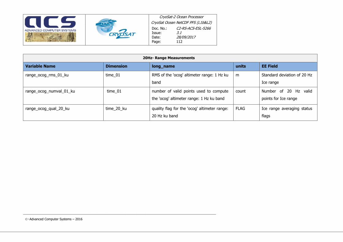
CryoSat-2 Ocean Processor
CryoSat Ocean NetCDF PFS (L1b&L2)
Doc. No.: Issue: Date: Page:
C2-RS-ACS-ESL-5266 3.1 28/09/2017 112
Advanced Computer Systems – 2016
20Hz- Range Measurements
Variable Name Dimension long_name units EE Field
range_ocog_rms_01_ku time_01 RMS of the 'ocog' altimeter range: 1 Hz ku
band
m Standard deviation of 20 Hz
Ice range
range_ocog_numval_01_ku time_01
number of valid points used to compute
the 'ocog' altimeter range: 1 Hz ku band
count Number of 20 Hz valid
points for Ice range
range_ocog_qual_20_ku time_20_ku quality flag for the 'ocog' altimeter range:
20 Hz ku band
FLAG Ice range averaging status
flags

CryoSat-2 Ocean Processor
CryoSat Ocean NetCDF PFS (L1b&L2)
Doc. No.: Issue: Date: Page:
C2-RS-ACS-ESL-5266 3.1 28/09/2017 113
Advanced Computer Systems – 2016
4.1.4 20-Hz – PLRM Range Measurements (only filled for SAR/SARin operating modes)
20-Hz – PLRM Range Measurements
Variable Name Dimension long_name units EE Field
range_ocean_01_plrm_ku time_01 corrected 'ocean' altimeter range: 1 Hz m /
range_ocean_20_plrm_ku time_20_plrm_ku corrected 'ocean' altimeter range: 20 Hz m /
range_ocean_rms_01_plrm_ku time_01 RMS of the 'ocean' altimeter range: 1 Hz m /
range_ocean_numval_01_plrm_ku time_01 number of valid points used to compute
the 'ocean' altimeter range: 1 Hz
count /
range_ocean_qual_20_plrm_ku time_20_plrm_ku quality flag for the ‘ocean’ altimeter
range: 20 Hz PLRM ku band
FLAG /
range_ocog_01_plrm_ku time_01 corrected 'ocog' altimeter range: 1 Hz m /
range_ocog_20_plrm_ku time_20_plrm_ku corrected 'ocog' altimeter range: 20 Hz m /
range_ocog_rms_01_plrm_ku time_01 RMS of the 'ocog' altimeter range: 1 Hz m /
range_ocog_numval_01_plrm_ku time_01 number of valid points used to compute
the 'ocog' altimeter range: 1 Hz
count /
range_ocog_qual_20_plrm_ku time_20_plrm_ku quality flag for the \'ocog\' altimeter
range: 20 Hz ku band
FLAG /

CryoSat-2 Ocean Processor
CryoSat Ocean NetCDF PFS (L1b&L2)
Doc. No.: Issue: Date: Page:
C2-RS-ACS-ESL-5266 3.1 28/09/2017 114
Advanced Computer Systems – 2016
4.1.5 1-Hz - Range Corrections
1-Hz - Range Corrections
Variable Name Dimension long_name units EE Field
dop_cor_01_ku time_01 doppler correction on the altimeter range:
1 Hz
m Doppler correction
uso_cor_01_ku time_01 uso correction on the altimeter range (2-
way): 1 Hz
m USO correction
cog_cor_01 time_01 distance antenna-CoM correction on
altimeter range: 1 Hz
m Distance antenna - CoM
int_path_cor_01 time_01 internal path correction on the altimeter
range: 1 Hz
m Range internal calibration
correction
mod_instr_cor_range_01_ku time_01 modeled instrumental correction on the
altimeter range: 1 Hz ku band
m Ocean range modeled
instrumental correction
mod_dry_tropo_cor_01 time_01 model dry tropospheric correction: 1 Hz m Dry Tropospheric Correction
mod_wet_tropo_cor_01 time_01 model wet tropospheric correction: 1 Hz m Wet Tropospheric
Correction
gpd_wet_tropo_cor_01 time_01 GPD+ wet tropospheric correction: 1 Hz m

CryoSat-2 Ocean Processor
CryoSat Ocean NetCDF PFS (L1b&L2)
Doc. No.: Issue: Date: Page:
C2-RS-ACS-ESL-5266 3.1 28/09/2017 115
Advanced Computer Systems – 2016
1-Hz - Range Corrections
Variable Name Dimension long_name units EE Field
gpd_wet_tropo_cor_qual_01
time_01 GPD+ wet tropospheric correction quality
flag: 1Hz
FLAG
inv_bar_cor_01 time_01 inverted barometer height correction: 1
Hz
m Inverse Barometric
Correction
hf_fluct_cor_01 time_01 high frequency fluctuations of the sea
surface topography: 1 Hz
m Dynamic Atmospheric
Correction
iono_cor_gim_01 time_01 GIM ionospheric correction: 1 Hz m GIM Ionospheric Correction
sea_state_bias_01_ku time_01 sea state bias correction: 1 Hz ku band m

CryoSat-2 Ocean Processor
CryoSat Ocean NetCDF PFS (L1b&L2)
Doc. No.: Issue: Date: Page:
C2-RS-ACS-ESL-5266 3.1 28/09/2017 116
Advanced Computer Systems – 2016
4.1.6 1-Hz – PLRM Range Corrections (only filled for SAR/SARin operation modes)
1-Hz – PLRM Range Corrections
Variable Name Dimension long_name units EE Field
mod_instr_cor_range_01_plrm_ku time_01 modeled instrumental correction on the
altimeter range: 1 Hz PLRM ku band
m /
sea_state_bias_01_plrm_ku time_01 sea state bias correction: 1 Hz PLRM ku
band
m /
4.1.7 20-Hz - SWH and Backscatter
20Hz- SWH and Backscatter
Variable Name Dimension long_name units EE Field
square_swh_ocean_01_ku time_01 corrected 'ocean' square of the significant
waveheight: 1 Hz ku band
m^2 Square of Significant Wave
Height
swh_ocean_01_ku time_01 corrected 'ocean' significant waveheight: 1
Hz ku band
m Significant Wave Height

CryoSat-2 Ocean Processor
CryoSat Ocean NetCDF PFS (L1b&L2)
Doc. No.: Issue: Date: Page:
C2-RS-ACS-ESL-5266 3.1 28/09/2017 117
Advanced Computer Systems – 2016
20Hz- SWH and Backscatter
Variable Name Dimension long_name units EE Field
swh_ocean_20_ku time_20_ku corrected 'ocean' significant waveheight:
20 Hz
m 20 Hz SWH
swh_ocean_rms_01_ku time_01 RMS of the 'ocean' significant waveheight:
1 Hz ku band
m Standard deviation of 20 Hz
SWH
swh_ocean_numval_01_ku time_01 number of valid points used to compute
the 'ocean' significant waveheight: 1 Hz ku
band
count Number of 20 Hz valid
points for SWH
swh_ocean_qual_20_ku time_20_ku quality flag for the 'ocean' significant
waveheight: 20 Hz ku band
FLAG SWH averaging status flags
sig0_ocean_01_ku time_01 corrected 'ocean' backscatter coefficient: 1
Hz ku band
dB Corrected ocean backscatter
coefficient
sig0_ocean_20_ku time_20_ku corrected 'ocean' backscatter coefficient:
20 Hz ku band
dB 20-Hz ocean backscatter
coefficient
sig0_ocean_rms_01_ku time_01 RMS of the 'ocean' backscatter coefficient:
1 Hz ku band
dB Standard deviation of 20 Hz
ocean backscatter
coefficient

CryoSat-2 Ocean Processor
CryoSat Ocean NetCDF PFS (L1b&L2)
Doc. No.: Issue: Date: Page:
C2-RS-ACS-ESL-5266 3.1 28/09/2017 118
Advanced Computer Systems – 2016
20Hz- SWH and Backscatter
Variable Name Dimension long_name units EE Field
sig0_ocean_numval_01_ku time_01 number of valid points used to compute
the 'ocean' backscatter coefficient: 1 Hz ku
band
count Number of 20 Hz valid
points for ocean backscatter
coefficient
sig0_ocean_qual_20_ku time_20_ku quality flag for the 'ocean' backscatter
coefficient: 20 Hz ku band
FLAG Ocean backscatter
averaging status flags
sig0_ocog_01_ku time_01 corrected 'ocog' backscatter coefficient: 1
Hz ku band
dB Corrected Ice backscatter
coefficient
sig0_ocog_20_ku time_20_ku corrected 'ocog' backscatter coefficient: 20
Hz ku band
dB 20-Hz Ice backscatter
coefficient [0..19]
sig0_ocog_rms_01_ku time_01 RMS of the 'ocog' backscatter coefficient: 1
Hz ku band
dB Standard deviation of 20 Hz
Ice backscatter coefficient
sig0_ocog_numval_01_ku time_01 number of valid points used to compute
the 'ocog' backscatter coefficient: 1 Hz ku
band
count Number of 20 Hz valid
points for Ice backscatter
coefficient
sig0_ocog_qual_20_ku time_20_ku quality flag for the 'ocog' backscatter
coefficient: 1 Hz ku band
FLAG Ice backscatter coefficient
averaging status flags

CryoSat-2 Ocean Processor
CryoSat Ocean NetCDF PFS (L1b&L2)
Doc. No.: Issue: Date: Page:
C2-RS-ACS-ESL-5266 3.1 28/09/2017 119
Advanced Computer Systems – 2016
20Hz- SWH and Backscatter
Variable Name Dimension long_name units EE Field
off_nadir_angle_wf_ocean_01_ku time_01 square of the off nadir angle derived from
waveforms: 1 Hz ku band
degrees^
2
Off nadir angle of the
satellite from waveforms
agc_01_ku time_01 corrected AGC: 1 Hz ku band dB Corrected AGC
scale_factor_20_ku time_20_ku scaling factor for backscatter coefficient
evaluation: 20 Hz ku band
dB Scaling factors for
backscatter coefficient
evaluation

CryoSat-2 Ocean Processor
CryoSat Ocean NetCDF PFS (L1b&L2)
Doc. No.: Issue: Date: Page:
C2-RS-ACS-ESL-5266 3.1 28/09/2017 120
Advanced Computer Systems – 2016
4.1.8 20-Hz – PLRM SWH and Backscatter (only filled for SAR/SARin operating modes)
20-Hz – PLRM SWH and Backscatter
Variable Name Dimension long_name units EE Field
square_swh_ocean_01_plrm_ku time_01 corrected 'ocean' square of the significant
waveheight: 1 Hz PLRM ku band
m^2 /
swh_ocean_01_plrm_ku time_01 corrected 'ocean' significant waveheight: 1
Hz PLRM ku band
m /
swh_ocean_20_plrm_ku time_20_plrm_ku corrected 'ocean' significant waveheight:
20 Hz PLRM ku band
m /
swh_ocean_rms_01_plrm_ku time_01 RMS of the 'ocean' significant waveheight:
1 Hz PLRM ku band
m /
swh_ocean_numval_01_plrm_ku time_01 number of valid points used to compute
the 'ocean' significant waveheight: 1 Hz
PLRM ku band
count /
swh_ocean_qual_20_plrm_ku time_20_plrm_ku quality flag for the 'ocean' significant
waveheight: 20 Hz PLRM ku band
FLAG /

CryoSat-2 Ocean Processor
CryoSat Ocean NetCDF PFS (L1b&L2)
Doc. No.: Issue: Date: Page:
C2-RS-ACS-ESL-5266 3.1 28/09/2017 121
Advanced Computer Systems – 2016
20-Hz – PLRM SWH and Backscatter
Variable Name Dimension long_name units EE Field
sig0_ocean_01_plrm_ku time_01 corrected 'ocean' backscatter coefficient: 1
Hz PLRM ku band
dB /
sig0_ocean_20_plrm_ku time_20_plrm_ku corrected 'ocean' backscatter coefficient:
20 Hz PLRM ku band
dB /
sig0_ocean_rms_01_plrm_ku time_01 RMS of the 'ocean' backscatter coefficient:
1 Hz PLRM ku band
dB /
sig0_ocean_numval_01_plrm_ku time_01 number of valid points used to compute
the 'ocean' backscatter coefficient: 1 Hz
PLRM ku band
count /
sig0_ocean_qual_20_plrm_ku time_20_plrm_ku quality flag for the 'ocean' backscatter
coefficient: 20 Hz PLRM ku band
FLAG /
sig0_ocog_01_plrm_ku time_01 corrected 'ocog' backscatter coefficient: 1
Hz PLRM ku band
dB /
sig0_ocog_20_plrm_ku time_20_plrm_ku corrected 'ocog' backscatter coefficient: 20
Hz PLRM ku band
dB /
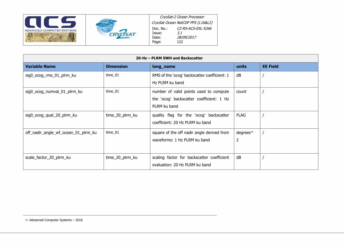
CryoSat-2 Ocean Processor
CryoSat Ocean NetCDF PFS (L1b&L2)
Doc. No.: Issue: Date: Page:
C2-RS-ACS-ESL-5266 3.1 28/09/2017 122
Advanced Computer Systems – 2016
20-Hz – PLRM SWH and Backscatter
Variable Name Dimension long_name units EE Field
sig0_ocog_rms_01_plrm_ku time_01 RMS of the 'ocog' backscatter coefficient: 1
Hz PLRM ku band
dB /
sig0_ocog_numval_01_plrm_ku time_01 number of valid points used to compute
the 'ocog' backscatter coefficient: 1 Hz
PLRM ku band
count /
sig0_ocog_qual_20_plrm_ku time_20_plrm_ku quality flag for the 'ocog' backscatter
coefficient: 20 Hz PLRM ku band
FLAG
/
off_nadir_angle_wf_ocean_01_plrm_ku time_01 square of the off nadir angle derived from
waveforms: 1 Hz PLRM ku band
degrees^
2
/
scale_factor_20_plrm_ku time_20_plrm_ku scaling factor for backscatter coefficient
evaluation: 20 Hz PLRM ku band
dB /

CryoSat-2 Ocean Processor
CryoSat Ocean NetCDF PFS (L1b&L2)
Doc. No.: Issue: Date: Page:
C2-RS-ACS-ESL-5266 3.1 28/09/2017 123
Advanced Computer Systems – 2016
4.1.9 1-Hz SWH and Backscatter Correction
1-Hz - SWH and Backscatter Correction
Variable Name Dimension long_name units EE Field
mod_instr_cor_swh_01_ku time_01 modeled instrumental correction on the
swh: 1 Hz ku band
m SWH modeled instrumental
correction (Ocean table)
agc_cor_01
time_01 correction for instrumental errors on AGC:
1 Hz
dB AGC correction
internal_cor_sig0_01 time_01 internal calibration correction on the
backscatter coefficient: 1 Hz
dB Sigma0 internal calibration
correction
mod_instr_cor_sig0_01_ku
time_01 modeled instrumental correction on the
sig0: 1 Hz ku band
dB Backscatter coefficient
modeled instrumental
correction (Ocean table)
atm_cor_sig0_01 time_01 atmospheric attenuation correction on the
backscatter coefficient: 1 Hz
dB Atmospheric attenuation

CryoSat-2 Ocean Processor
CryoSat Ocean NetCDF PFS (L1b&L2)
Doc. No.: Issue: Date: Page:
C2-RS-ACS-ESL-5266 3.1 28/09/2017 124
Advanced Computer Systems – 2016
4.1.10 1-Hz PLRM SWH and Backscatter Correction (only filled for SAR/SARin operating modes)
1-Hz – PLRM SWH and Backscatter Correction
Variable Name Dimension long_name units EE Field
mod_instr_cor_swh_01_plrm_ku time_01 modeled instrumental correction on the
swh: 1 Hz PLRM ku band
m /
mod_instr_cor_sig0_01_plrm_ku time_01 modeled instrumental correction on the
sig0: 1 Hz PLRM ku band
m /
4.1.11 1-Hz - Geophysical Figures
1-Hz - Geophysical Figures
Variable Name Dimension long_name units EE Field
mean_sea_surf_sol1_01 time_01 mean sea surface height (solution 1) above
reference ellipsoid: 1 Hz
m Mean Sea Surface height
(Solution 1)
mean_sea_surf_sol2_01 time_01 mean sea surface height (solution 2) above
reference ellipsoid: 1 Hz
m Mean Sea Surface height
(Solution 2)
geoid_01
time_01 geoid height: 1 Hz m Geoid height

CryoSat-2 Ocean Processor
CryoSat Ocean NetCDF PFS (L1b&L2)
Doc. No.: Issue: Date: Page:
C2-RS-ACS-ESL-5266 3.1 28/09/2017 125
Advanced Computer Systems – 2016
1-Hz - Geophysical Figures
Variable Name Dimension long_name units EE Field
odle_01 time_01 ocean depth/land elevation: 1 Hz m Ocean Depth / Land
Elevation
mean_dyn_topo_sol1_01 time_01 mean_dyn_topo_sol1_01(time_01)
mean dynamic topography above geoid
solution 1: 1 Hz
m Mean Dynamic Topography
height
mean_dyn_topo_sol2_01 time_01 mean_dyn_topo_sol2_01(time_01)
mean dynamic topography above geoid
solution 2: 1 Hz
m /
ocean_tide_sol1_01 time_01 geocentric ocean tide height (solution 1):
1 Hz
m Total geocentric ocean tide
height (Solution 1 : GOT)
ocean_tide_sol2_01 time_01 geocentric ocean tide height (solution 2):
1 Hz
m Total geocentric ocean tide
height (Solution 2 : FES)
ocean_tide_eq_01 time_01 equilibrium long-period ocean tide height:
1 Hz
m Long Period Tide Height

CryoSat-2 Ocean Processor
CryoSat Ocean NetCDF PFS (L1b&L2)
Doc. No.: Issue: Date: Page:
C2-RS-ACS-ESL-5266 3.1 28/09/2017 126
Advanced Computer Systems – 2016
1-Hz - Geophysical Figures
Variable Name Dimension long_name units EE Field
ocean_tide_non_eq_01 time_01 non-equilibrium long-period ocean tide
height: 1 Hz
m Non eq. long period ocean
tide height
load_tide_sol1_01 time_01 load tide height for geocentric ocean tide
(solution 1): 1 Hz
m Ocean Loading Tide
(Solution 1 : GOT)
load_tide_sol2_01 time_01 load tide height for geocentric ocean tide
(solution 2): 1 Hz
m Ocean Loading Tide
(Solution 2 : FES)
solid_earth_tide_01 time_01 solid earth tide height: 1 Hz m Solid Earth Tide
pole_tide_01 time_01 geocentric tide height: 1 Hz m Geocentric Polar Tide
wind_speed_alt_01_ku time_01 altimeter wind speed: 1 Hz ku band m/s Altimeter wind speed
wind_speed_mod_u_01 time_01 U component of the model wind vector: 1
Hz
m/s U-component of the model
wind vector
wind_speed_mod_v_01 time_01 V component of the model wind vector: 1
Hz
m/s V-component of the model
wind vector
surf_type_01 time_01 surface type: 1 Hz FLAG Surface type flag

CryoSat-2 Ocean Processor
CryoSat Ocean NetCDF PFS (L1b&L2)
Doc. No.: Issue: Date: Page:
C2-RS-ACS-ESL-5266 3.1 28/09/2017 127
Advanced Computer Systems – 2016
4.1.12 1-Hz – PLRM Geophysical Figures (only filled for SAR/SARin operating modes)
1 Hz- Geophysical Figures PLRM
Variable Name Dimension long_name units EE Field
wind_speed_alt_01_plrm_ku time_01 altimeter wind speed: 1 Hz PLRM ku band m/s /
4.1.13 20-Hz - SSHA
20-Hz - SSHA
Variable Name Dimension long_name units EE Field
ssha_01_ku time_01 sea surface height anomaly: 1 Hz ku band m /
ssha_20_ku time_20_ku sea surface height anomaly: 20 Hz ku band m /
qual_ssha_01_ku time_01 sea surface height anomaly quality flag: 1
Hz ku band
FLAG /
qual_ssha_20_ku time_20_ku sea surface height anomaly quality flag: 20
Hz ku band
FLAG /

CryoSat-2 Ocean Processor
CryoSat Ocean NetCDF PFS (L1b&L2)
Doc. No.: Issue: Date: Page:
C2-RS-ACS-ESL-5266 3.1 28/09/2017 128
Advanced Computer Systems – 2016
4.1.14 20-Hz – PLRM SSHA (only filled for SAR/SARin operating modes)
20-Hz – PLRM SSHA
Variable Name Dimension long_name units EE Field
ssha_01_plrm_ku time_01 sea surface height anomaly: 1 Hz PLRM ku
band
m /
ssha_20_plrm_ku time_20_plrm_ku sea surface height anomaly: 20 Hz PLRM
ku band
m /
qual_ssha_01_plrm_ku time_01 sea surface height anomaly quality flag: 1
Hz PLRM ku band
FLAG /
qual_ssha_20_plrm_ku time_20_plrm_ku sea surface height anomaly quality flag: 20
Hz PLRM ku band
FLAG /

CryoSat-2 Ocean Processor
CryoSat Ocean NetCDF PFS (L1b&L2)
Doc. No.: Issue:
Date: Page:
C2-RS-ACS-ESL-5266 3.1 28/09/2017 129
Advanced Computer Systems – 2016
4.2 L2 PRODUCT FORMAT SPECIFICATION – GLOBAL ATTRIBUTES
The global attributes contains general information about the product and are listed in this section.
The classification of each attribute is adopted for the sake of clarity and to trace each attribute back to
the EE Header field where the attribute comes from.
In any real product the attributes are not grouped but simply listed inside the CONFORM product.
Product Identification Information
Attribute Name Description Values
product_name Product File Name any string
processing_stage Processing stage code
identifier.
RPRO = Reprocessing
OFFL = Routine Operation
NRT_ = Near Real Time
TEST = Test
LTA_ = Long Term Archive
reference_document Reference DFCB Document
describing the product
any string
acquisition_station Acquisition Station any string
mission Mission name CryoSat
processing_centre Processing Facility PDS

CryoSat-2 Ocean Processor
CryoSat Ocean NetCDF PFS (L1b&L2)
Doc. No.: Issue:
Date: Page:
C2-RS-ACS-ESL-5266 3.1 28/09/2017 130
Advanced Computer Systems – 2016
Data Processing Information
Attribute Name Description Values
creation_time Processing Time
(Product Generation Time)
sensing_start sensing start time
sensing_stop sensing stop time
software_version Processor Name and software
version number
Orbit Information
Attribute Name Description Values
phase Phase Code (set to X if not
used)
cycle_number Cycle Number (set to +000 if
not used)
rel_orbit_number Relative Orbit Number at
sensing start time (set to
+00000 if not used)
abs_orbit_number Absolute Orbit Number at
sensing start time (set to
+00000 if not used)
state_vector_time UTC state vector time
delta_ut1 Universal Time Correction:
DUT1 = UT1 – UTC
x_position X position in Earth Fixed
Reference
If not used set to
+0000000.000
y_position Y position in Earth Fixed
Reference

CryoSat-2 Ocean Processor
CryoSat Ocean NetCDF PFS (L1b&L2)
Doc. No.: Issue:
Date: Page:
C2-RS-ACS-ESL-5266 3.1 28/09/2017 131
Advanced Computer Systems – 2016
Orbit Information
Attribute Name Description Values
If not used set to
+0000000.000
z_position Z position in Earth Fixed
Reference
If not used set to
+0000000.000
x_velocity X velocity in Earth Fixed
Reference
If not used set to
+0000.000000
y_velocity Y velocity in Earth Fixed
Reference
If not used set to
+0000.000000
z_velocity Z velocity in Earth Fixed
Reference
If not used set to
+0000.000000
vector_source Source of Orbit State Vector
Record
fos predicted
doris_navigator
doris_precise
fos_restituted
doris_preliminary

CryoSat-2 Ocean Processor
CryoSat Ocean NetCDF PFS (L1b&L2)
Doc. No.: Issue:
Date: Page:
C2-RS-ACS-ESL-5266 3.1 28/09/2017 132
Advanced Computer Systems – 2016
Leap Second Information
Attribute Name Description Values
leap_utc UTC Time of the occurrence of
the leap second.
If a leap second occurred in the
product window the field is set
by a devoted function in the
CFI EXPLORER_ORBIT library
(see [EXPL_ORB-SUM] for
details), otherwise it is not set.
It corresponds to the time after
the Leap Second occurrence
(i.e. midnight of the day after
the leap second)
leap_sign If a leap second occurred in the
product window the field is set
to the expected value by a
devoted function in the CFI
EXPLORER_ORBIT library (see
[EXPL_ORB-SUM] for details),
otherwise it is not set
leap_err This field is always not set
considering that CRYOSAT
products have true UTC times
Product Confidence Data Information
Attribute Name Description Values
product_err Product Error Flag 1 errors have been
reported in the Product
0 no errors

CryoSat-2 Ocean Processor
CryoSat Ocean NetCDF PFS (L1b&L2)
Doc. No.: Issue:
Date: Page:
C2-RS-ACS-ESL-5266 3.1 28/09/2017 133
Advanced Computer Systems – 2016
Product Time Information
Attribute Name Description Values
first_meas_time TAI of the first record in the
Main MDS of this product
last_meas_time TAI of the last record in the
Main MDS of this product
Product Orbit Information
Attribute Name Description Values
abs_orbit_start Absolute Orbit Number at
sensing start time.
rel_time_asc_node_start Relative time since crossing
ascending node time relative to
start time of data sensing.
abs_orbit_stop Absolute Orbit Number at
sensing stop time.
rel_time_asc_node_stop Relative time since crossing
ascending node time relative to
stop time of data sensing.
equator_cross_time Time of equator crossing at the
ascending node relative to the
sensing start time.
equator_cross_long Longitude of equator crossing
at the ascending node relative
to the sensing start time
(positive East, 0 = Greenwich)
referred to WGS84.
ascending_flag Orbit Orientation at the sensing
start time
A=Ascending
D=Descending

CryoSat-2 Ocean Processor
CryoSat Ocean NetCDF PFS (L1b&L2)
Doc. No.: Issue:
Date: Page:
C2-RS-ACS-ESL-5266 3.1 28/09/2017 134
Advanced Computer Systems – 2016
Product Location Information
Attribute Name Description Values
first_meas_lat WGS84 latitude of the first
record in the Main MDS
(positive north)
first_meas_lon WGS84 longitude of the first
record in the Main MDS
(positive East, 0 = Greenwich)
last_meas_lat WGS84 latitude of the last
record in the Main MDS
(positive north
last_meas_lon WGS84 longitude of the last
record in the Main MDS
(positive East, 0 = Greenwich)
SIRAL Instrument Configuration
Attribute Name Description Values
instr_id Instrument_Identifier A = SIRAL Nominal
B = SIRAL Redundnant
sir_op_mode SIRAL Operative Mode lrm
sar
sarin
sir_configuration SIRAL Rx Configuration rx_1
rx_2
both
unknown

CryoSat-2 Ocean Processor
CryoSat Ocean NetCDF PFS (L1b&L2)
Doc. No.: Issue:
Date: Page:
C2-RS-ACS-ESL-5266 3.1 28/09/2017 135
Advanced Computer Systems – 2016
Level 1 Surface Statistics
Attribute Name Description Values
open_ocean_percent Percentage of records detected
on open ocean or semi-
enclosed seas
close_sea_percent Percentage of records detected
on close seas or lakes
continent_ice_percent Percentage of records detected
on continental ice
land_percent Percentage of records detected
on land
Operative mode Statistics
Attribute Name Description Values
lrm_mode_percent Percentage of input L1B
records detected in LRM mode
sar_mode_percent Percentage of input L1B
records detected in SAR mode
sarin_mode_percent Percentage of input L1B
records detected in SARin
mode
SIRAL Level 1 Processing information
Attribute Name Description Values
l1b_prod_status Complete/Incomplete Product Completion Flag (0 or 1).
1 if the product has a duration
shorter than the input Level 0
l1b_proc_flag Processing errors significance flag
1 errors (percentage of errors greater than threshold)

CryoSat-2 Ocean Processor
CryoSat Ocean NetCDF PFS (L1b&L2)
Doc. No.: Issue:
Date: Page:
C2-RS-ACS-ESL-5266 3.1 28/09/2017 136
Advanced Computer Systems – 2016
SIRAL Level 1 Processing information
Attribute Name Description Values
0 no errors
l1b_processing_quality Percentage of quality checks
successfully passed during
Level 1B processing (max
allowed +10000)
l1b_proc_thresh Minimum acceptable
percentage of quality threshold
that must be passed during
Level 1B processing (max
allowed +10000)
SIRAL Level 2 Processing information
Attribute Name Description Values
L2_prod_status Complete/Incomplete Product Completion Flag (0 or 1).
1 if the product has a duration
shorter than the input Level 0
l2_proc_flag Processing errors significance flag
1 errors (percentage of errors
greater than threshold)
0 no errors
l2_processing_quality Percentage of quality checks
successfully passed during
Level 2 processing (max
allowed +10000)
l2_proc_thresh Minimum acceptable
percentage of quality threshold
that must be passed during
Level 2 processing (max
allowed +10000)

CryoSat-2 Ocean Processor
CryoSat Ocean NetCDF PFS (L1b&L2)
Doc. No.: Issue:
Date: Page:
C2-RS-ACS-ESL-5266 3.1 28/09/2017 137
Advanced Computer Systems – 2016
SIRAL Level 2 Processing information
Attribute Name Description Values
Reference DSD
Attribute Name Description Values
xref_siral_l0 SIRAL L0 file name(s)
xref_siral_l1b SIRAL L1b file name(s)
xref_uso USO file name
xref_orbit Orbit file nam(s)
xref_siral_characterisation SIRAL IPFDB file name
xref_meteo Meteo file name(s)
xref_pole_location Pole location file name
xref_gim GIM file name(s)
xref_mog2d MOG2D file name(s)
xref_cal1 L1B CAL1 file name
xref_cal2 L1B CAL2 file name
xref_constants Constants File
xref_earth_tide Cartwright File
xref_long_period_tide FES File
xref_mean_pressure Mean Pressure File for Meteo
Correction generated by using
either analysis or forecast data
xref_ocean_tide_sol1 Sol1 File for Ocean Tide
xref_ocean_tide_sol2 Sol2 File for Ocean Tide
xref_pconf Processor Configuration
Parameters File
xref_orbit_scenario Orbit scenario file name
xref_surf_pressure Surface Pressure File for Meteo
Correction generated by using
either analysis or forecast data

CryoSat-2 Ocean Processor
CryoSat Ocean NetCDF PFS (L1b&L2)
Doc. No.: Issue:
Date: Page:
C2-RS-ACS-ESL-5266 3.1 28/09/2017 138
Advanced Computer Systems – 2016
SIRAL Level 2 Processing information
Attribute Name Description Values
xref_surf_type Surface Type Map File
xref_tidal_load_sol1 Solution 1 File for Tidal Loading
xref_tidal_load_sol2 Solution 2 File for Tidal Loading
xref_u_wind U Wind component File for
Meteo Correction generated by
using either analysis or
forecast data
xref_v_wind V Wind component File for
Meteo Correction generated by
using either analysis or
forecast data
xref_wet_trop Wet Troposphere File for
Meteo Correction generated by
using either analysis or
forecast data
xref_geoid Geoid File
xref_mean_surface_sol1 Sol1 Mean Surface File
xref_mean_surface_sol2 Sol2 Mean Surface File
xref_mtd_sol1 Sol1 Mtd File
xref_mtd_sol2 Sol2 Mtd File
xref_sea_state_bias Sea State Bias File
xref_odle Ocean Depth/Land Elevation File
xref_gpd_wtc GPD+ - Wet tropospheric
correction FIle
4.3 TABLE OF REFERENCE DSD VS L2 PROCESSORS

CryoSat-2 Ocean Processor
CryoSat Ocean NetCDF PFS (L1b&L2)
Doc. No.: Issue:
Date: Page:
C2-RS-ACS-ESL-5266 3.1 28/09/2017 139
Advanced Computer Systems – 2016
PROCESSORS
L2
NOP
LRM
NOP
SAR
NOP
SRN
IOP
LRM
IOP
SAR
IOP
SRN
GOP
LRM
GOP
SAR
GOP
SRN
Input Data File File Type
xref_siral_l1b
SIR_NOPM1B M
SIR_NOPR1B M
SIR_NOPN1B M
SIR_IOPM1B M
SIR_IOPR1B M
SIR_IOPN1B M
SIR_GOPM1B M
SIR_GOPR1B M
SIR_GOPN1B M
xref_pconf None M M M M M M M M M
xref_siral_characterisation AUX_IPFDBA
AUX_IPFDBB M M M M M M M M M
xref_orbit_scenario MPL_ORBREF M M M M M M M M M
xref_orbit
DOR_NAV_0 M M M
AUX_ORBDOP M M M
AUX_ORBDOR M M M
MPL_ORBPRE M M M M M M M M M
xref_gpd_wtc AUX_GPDWTC M M M
xref_geoid None M M M M M M M M M
xref_mtd_sol1 None M M M M M M M M M
xref_mtd_sol2 None M M M M M M M M M
xref_odle None M M M M M M M M M

CryoSat-2 Ocean Processor
CryoSat Ocean NetCDF PFS (L1b&L2)
Doc. No.: Issue:
Date: Page:
C2-RS-ACS-ESL-5266 3.1 28/09/2017 140
Advanced Computer Systems – 2016
PROCESSORS
L2
NOP
LRM
NOP
SAR
NOP
SRN
IOP
LRM
IOP
SAR
IOP
SRN
GOP
LRM
GOP
SAR
GOP
SRN
xref_sea_state_bias None M M M M M M M M M

CryoSat-2 Ocean Processor
CryoSat Ocean NetCDF PFS (L1b&L2)
Doc. No.: Issue:
Date: Page:
C2-RS-ACS-ESL-5266 3.1 28/09/2017 141
Advanced Computer Systems – 2016
PROCESSORS
Pole-to-Pole
IOP GOP
xref_siral_l2
SIR_IOPM2_ M
SIR_IOPR2_ M
SIR_IOPN2_ M
SIR_GOPM2_ M
SIR_GOPR2_ M
SIR_GOPN2_ M
xref_orbit
AUX_ORBDOR
M
AUX_ORBDOP M
MPL_ORBPRE M M
MPL_ORBREF M M
xref_siral_characterisation AUX_IPFDBA
AUX_IPFDBB M M

CryoSat-2 Ocean Processor
CryoSat Ocean NetCDF PFS (L1b&L2)
Doc. No.: Issue:
Date: Page:
C2-RS-ACS-ESL-5266 3.1 28/09/2017 142
Advanced Computer Systems – 2016
4.4 L2 PRODUCT FORMAT SPECIFICATION – CDL DUMP
4.4.1 agc_01_ku(time_01)
short agc_01_ku(time_01) ;
agc_01_ku:_FillValue = -32768s;
agc_01_ku:long_name = "corrected AGC: 1 Hz ku band" ;
agc_01_ku:units = "dB" ;
agc_01_ku:add_offset = 0. ;
agc_01_ku:scale_factor = 0.01 ;
agc_01_ku:coordinates = "lon_01 lat_01" ;
agc_01_ku:comment = "AGC corrected for instrumental errors [agc_cor_01]"
;
4.4.2 agc_cor_01 (time_01)
short agc_cor_01 (time_01) ;
agc_cor_01:_FillValue = -32768s;
agc_cor_01:long_name = "correction for instrumental errors on AGC: 1 Hz
ku band" ;
agc_cor_01:units = "dB" ;
agc_cor_01:add_offset = 0. ;
agc_cor_01:scale_factor = 0.01 ;
agc_cor_01:coordinates = "lon_01 lat_01" ;
agc_cor_01:comment = "AGC correction determined from the values provided
in the IPF data base." ;
4.4.3 alt_01(time_01)
int alt_01(time_01) ;
alt_01:_FillValue = -2147483648;
alt_01:long_name = "altitude of CoM above reference ellipsoid [WGS84]: 1
Hz" ;
alt_01:units = "m" ;
alt_01:standard_name = "height_above_reference_ellipsoid" ;
alt_01:scale_factor = 0.001 ;
alt_01:coordinates = "lon_01 lat_01" ;
alt_01:comment = "Altitude of satellite center of mass above the reference
ellipsoid." ;
4.4.4 alt_20_ku(time_20_ku)
int alt_20_ku(time_20_ku) ;
alt_20_ku:_FillValue = -2147483648;
alt_20_ku:long_name = altitude of CoM above reference ellipsoid [WGS84]:
20 Hz ku band" ;
alt_20_ku:units = "m" ;
alt_20_ku:standard_name = "height_above_reference_ellipsoid" ;
alt_20_ku:scale_factor = 0.001 ;
alt_20_ku:coordinates = "lon_20_ku lat_20_ku" ;
alt_20_ku:comment = "Altitude of satellite center of mass above the
reference ellipsoid." ;

CryoSat-2 Ocean Processor
CryoSat Ocean NetCDF PFS (L1b&L2)
Doc. No.: Issue:
Date: Page:
C2-RS-ACS-ESL-5266 3.1 28/09/2017 143
Advanced Computer Systems – 2016
4.4.5 alt_20_plrm_ku(time_20_plrm_ku)
int alt_20_plrm_ku(time_20_plrm_ku) ;
alt_20_plrm_ku:_FillValue = -2147483648;
alt_20_plrm_ku:long_name = "center of mass altitude of the satellite: 20 Hz PLRM
ku band" ; alt_20_plrm_ku:units = "m" ;
alt_20_plrm_ku:standard_name = "height_above_reference_ellipsoid" ;
alt_20_plrm_ku:scale_factor = 0.001 ;
alt_20_plrm_ku:coordinates = "lon_20_plrm_ku lat_20_plrm_ku" ;
alt_20_plrm_ku:comment = " Not provided in LRM mode. Altitude of satellite center
of mass above the reference ellipsoid." ;atm_cor_sig0_01(time_01) short atm_cor_sig0_01(time_01) ;
atm_cor_sig0_01:_FillValue = -32768s;
atm_cor_sig0_01:long_name = "atmospheric attenuation correction on the
backscatter coefficient: 1 Hz" ;
atm_cor_sig0_01:units = "dB" ;
atm_cor_sig0_01:add_offset = 0. ;
atm_cor_sig0_01:scale_factor = 0.01 ;
atm_cor_sig0_01:coordinates = "lon_01 lat_01" ;
atm_cor_sig0_01:comment = "Computed from model wet tropospheric
correction [mod_wet_tropo_cor_01]" ;
4.4.6 cog_cor_01(time_01)
short cog_cor_01(time_01) ;
cog_cor_01:_FillValue = -32768s;
cog_cor_01:long_name = "distance antenna-CoM correction on
altimeter range: 1 Hz" ; cog_cor_01:units = "m" ;
cog_cor_01:add_offset = 0. ;
cog_cor_01:scale_factor = 0.001 ;
cog_cor_01:coordinates = "lon_01 lat_01" ;
cog_cor_01:comment = "Distance antenna-CoM determined from the value
provided in the IPF data base." ;
4.4.7 dop_cor_01_ku(time_01)
short dop_cor_01_ku(time_01) ;
dop_cor_01_ku:_FillValue = -32768s;
dop_cor_01_ku:long_name = "doppler correction on the altimeter range: 1
Hz" ;
dop_cor_01_ku:units = "m" ;
dop_cor_01_ku:add_offset = 0. ;
dop_cor_01_ku:scale_factor = 0.001 ;
dop_cor_01_ku:coordinates = "lon_01 lat_01" ;
dop_cor_01_ku:comment = "This is the Doppler range correction due to the
satellite altitude rate. It is computed from the component of the satellite velocity
in the nadir direction." ;

CryoSat-2 Ocean Processor
CryoSat Ocean NetCDF PFS (L1b&L2)
Doc. No.: Issue:
Date: Page:
C2-RS-ACS-ESL-5266 3.1 28/09/2017 144
Advanced Computer Systems – 2016
4.4.8 flag_instr_op_mode_01(time_01)
byte flag_instr_op_mode_01(time_01_ku) ;
flag_instr_op_mode_01:_FillValue = -128b;
flag_instr_op_mode_01:long_name = "mode id - operative mode: 1 Hz" ;
flag_instr_op_mode_01:flag_values = 1b, 2b, 3b ;
flag_instr_op_mode_01:flag_meanings = "lrm sar sarin" ;
flag_instr_op_mode_01:coordinates = "lon_01 lat_01" ;
flag_instr_op_mode_01:comment = "Mode ID - Identifies the SIRAL
instrument measurement mode." ;
4.4.9 flag_instr_op_mode_20_ku(time_20_ku)
byte flag_instr_op_mode_20_ku(time_20_ku) ;
flag_instr_op_mode_20_ku:_FillValue = -128b ;
flag_instr_op_mode_20_ku:comment = "Mode ID - Identifies the SIRAL
instrument measurement mode." ;
flag_instr_op_mode_20_ku:coordinates = "lon_20_ku lat_20_ku" ;
flag_instr_op_mode_20_ku:flag_meanings = "lrm sar sarin" ;
flag_instr_op_mode_20_ku:flag_values = 1b, 2b, 3b ;
flag_instr_op_mode_20_ku:long_name = "mode id - operative mode: 20 Hz" ;
4.4.10 flag_instr_op_mode_20_plrm_ku(time_20_plrm_ku)
byte flag_instr_op_mode_20_plrm_ku (time_20_plrm_ku) ;
flag_instr_op_mode_20_plrm_ku:_FillValue = -128b;
flag_instr_op_mode_20_plrm_ku:long_name = "mode id - operative mode: 20
Hz PLRM ku band" ;
flag_instr_op_mode_20_plrm_ku:flag_values = 1b, 2b, 3b ;
flag_instr_op_mode_20_plrm_ku:flag_meanings = "lrm sar sarin" ;
flag_instr_op_mode_20_plrm_ku:coordinates = "lon_20_ku_plrm
lat_20_ku_plrm" ;
flag_instr_op_mode_20_plrm_ku:comment = "Not provided in LRM mode. Mode
ID - Identifies the SIRAL instrument measurement mode." ;
4.4.11 flag_mcd_20_ku(time_20_ku)
int flag_mcd_20_ku(time_20_ku) ;
flag_mcd_20_ku:_FillValue = -1 ;
flag_mcd_20_ku:long_name = "measurement confidence data: 20 Hz" ;
flag_mcd_20_ku:flag_masks = -2147483648, 1073741824, 536870912,
268435456, 134217728, 67108864, 33554432, 16777216, 8388608, 4194304, 2097152, 1048576,
524288, 262144, 131072, 65536, 32768, 16384, 8192, 4096, 2048, 128, 64, 32, 16, 8, 1;
flag_mcd_20_ku:flag_meanings = "block_degraded blank_block
datation_degraded orbit_prop_error orbit_file_change orbit_gap echo_saturated
other_echo_error sarin_rx1_error sarin_rx2_error window_delay_error agc_error
cal1_missing cal1_default doris_uso_missing ccal1_default trk_echo_error
echo_rx1_error echo_rx2_error npm_error azimuth_cal_missing phase_pert_cor_missing
cal2_missing cal2_default power_scale_error attitude_cor_missing
phase_pert_cor_default";
flag_mcd_20_ku:coordinates = "lon_20_ku lat_20_ku" ;
flag_mcd_20_ku:comment = "Measurement confidence flags. Generally the MCD
flags indicate problems when set. If the whole MCD is 0 then no problems or non-nominal
conditions were detected. Serious errors are indicated by setting bit 31 (SS bit 0),
in which case the block must not be processed. Other error settings can be regarded as
warnings." ;

CryoSat-2 Ocean Processor
CryoSat Ocean NetCDF PFS (L1b&L2)
Doc. No.: Issue:
Date: Page:
C2-RS-ACS-ESL-5266 3.1 28/09/2017 145
Advanced Computer Systems – 2016
4.4.12 geoid_01(time_01)
int geoid_01(time_01) ;
geoid_01:_FillValue = -2147483648;
geoid_01:long_name = "geoid height: 1 Hz" ;
geoid_01:units = "m" ;
geoid_01:standard_name = "geoid_height_above_reference_ellipsoid" ;
geoid_01:add_offset = 0. ;
geoid_01:scale_factor = 0.001 ;
geoid_01:coordinates = "lon_01 lat_01" ;
geoid_01:comment = "Computed from the geoid model with a correction to
refer the value to the mean tide system i.e. includes the permanent tide (zero
frequency)" ;
geoid_01:source = "EGM2008" ;
geoid_01:institution = "GSFC" ;

CryoSat-2 Ocean Processor
CryoSat Ocean NetCDF PFS (L1b&L2)
Doc. No.: Issue:
Date: Page:
C2-RS-ACS-ESL-5266 3.1 28/09/2017 146
Advanced Computer Systems – 2016
4.4.13 gpd_wet_tropo_cor_01(time_01)
short gpd_wet_tropo_cor_01(time_01) ;
gpd_wet_tropo_cor_01:_FillValue = -32768s ;
gpd_wet_tropo_cor_01:long_name = "GPD+ wet tropospheric correction: 1 Hz"
;
gpd_wet_tropo_cor_01:units = "m" ;
gpd_wet_tropo_cor_01:standard_name =
"altimeter_range_correction_due_to_wet_troposphere" ;
gpd_wet_tropo_cor_01:add_offset = 0. ;
gpd_wet_tropo_cor_01:scale_factor = 0.001 ;
gpd_wet_tropo_cor_01:coordinates = "lon_01 lat_01" ;
gpd_wet_tropo_cor_01:comment = "Computed at the altimeter time-tag
[time_01] through OA space-time analysis using the GPD+ algorithm, by combining
all available observations. The correction has been calibrated with respect to
the SSM/I and SSM/IS imaging radiometers. A wet tropospheric correction must be
added (negative value) to the instrument range to correct this range measurement
for wet tropospheric range delays of the radar pulse. This correction is valid
over ocean surfaces only.";
gpd_wet_tropo_cor_01:institution = "UPorto" ;
4.4.14 gpd_wet_tropo_cor_qual_01(time_01)
byte gpd_wet_tropo_cor_qual_01(time_01) ;
gpd_wet_tropo_cor_qual_01:_FillValue = -128b ;
gpd_wet_tropo_cor_qual_01:long_name = "GPD+ wet tropospheric correction
quality flag: 1Hz" ;
gpd_wet_tropo_cor_qual_01:flag_values = 0b, 1b, 2b ;
gpd_wet_tropo_cor_qual_01:flag_meanings = "from_obs invalid from_model"
;
gpd_wet_tropo_cor_qual_01:coordinates = "lon_01 lat_01" ;
4.4.15 hf_fluct_cor_01(time_01)
short hf_fluct_cor_01(time_01) ;
hf_fluct_cor_01:_FillValue = -32768s;
hf_fluct_cor_01:long_name = "high frequency fluctuations of the sea
surface topography: 1 Hz" ;
hf_fluct_cor_01:units = "m" ;
hf_fluct_cor_01:standard_name =
"sea_surface_height_correction_due_to_air_pressure_and_wind_at_high_frequency" ;
hf_fluct_cor_01:add_offset = 0. ;
hf_fluct_cor_01:scale_factor = 0.001 ;
hf_fluct_cor_01:coordinates = "lon_01 lat_01" ;
hf_fluct_cor_01:comment = "High frequency fluctuations of the sea surface
topography due to high frequency air pressure and wind effects. Also known as DAC
(Dynamical Atmospheric Correction). Provided as a correction to the inverted barometer
correction [inv_bar_cor_01]." ;
hf_fluct_cor_01:source = "2.1.0" ;
hf_fluct_cor_01:institution = "LEGOS/CLS/CNES" ;

CryoSat-2 Ocean Processor
CryoSat Ocean NetCDF PFS (L1b&L2)
Doc. No.: Issue:
Date: Page:
C2-RS-ACS-ESL-5266 3.1 28/09/2017 147
Advanced Computer Systems – 2016
4.4.16 ind_first_meas_20hz_01(time_01)
int ind_first_meas_20hz_01(time_01) ;
ind_first_meas_20hz_01:long_name = "index of the first 20Hz measurement:
1 Hz" ;
ind_first_meas_20hz_01:units = "count" ;
ind_first_meas_20hz_01:_FillValue = - 2147483648; ind_first_meas_20hz_01:comment = "Index of the first 20Hz measurement of
the 1Hz packet." ;
4.4.17 ind_first_meas_20hz_01_plrm_ku(time_01)
short ind_first_meas_20hz_01_plrm_ku(time_01) ;
ind_first_meas_20hz_01_plrm_ku:long_name = "index of the first 20Hz PLRM
measurement: 1 Hz" ;
ind_first_meas_20hz_01_plrm_ku:units = "count" ;
ind_first_meas_20hz_01_plrm_ku:_FillValue = -32768s;
ind_first_meas_20hz_01_plrm_ku:comment = "Set to FillValue in LRM mode.
Index of the first 20Hz PLRM measurement of the 1Hz packet." ;
4.4.18 ind_meas_1hz_20_ku(time_20_ku)
short ind_meas_1hz_20_ku(time_20_ku) ;
ind_meas_1hz_20_ku:long_name = "index of the 1Hz measurement: 20 Hz ku
band" ;
ind_meas_1hz_20_ku:units = "count" ;
ind_meas_1hz_20_ku:_FillValue = -32768s;
ind_meas_1hz_20_ku:comment = "Index of the 1Hz measurement to which
belongs the 20Hz measurement." ;
4.4.19 ind_meas_1hz_20_plrm_ku(time_20_plrm_ku)
short ind_meas_1hz_20_plrm_ku(time_20_plrm_ku) ;
ind_meas_1hz_20_plrm_ku:long_name = "index of the 1Hz measurement: 20 Hz
PLRM ku band" ;
ind_meas_1hz_20_plrm_ku:units = "count" ;
ind_meas_1hz_20_plrm_ku:_FillValue = -32768s;
ind_meas_1hz_20_plrm_ku:comment = " Not provided in LRM mode. Index of the 1Hz measurement to which belongs the 20Hz PLRM measurement." ;
4.4.20 int_path_cor_01(time_01)
short int_path_cor_01(time_01) ;
int_path_cor_01:_FillValue = -32768s;
int_path_cor_01:long_name = "internal path correction on the altimeter
range: 1 Hz" ;
int_path_cor_01:units = "m" ;
int_path_cor_01:add_offset = 0. ;
int_path_cor_01:scale_factor = 0.001 ;
int_path_cor_01:coordinates = "lon_01 lat_01" ;
int_path_cor_01:comment = "Internal calibration correction on the
altimeter range" ;

CryoSat-2 Ocean Processor
CryoSat Ocean NetCDF PFS (L1b&L2)
Doc. No.: Issue:
Date: Page:
C2-RS-ACS-ESL-5266 3.1 28/09/2017 148
Advanced Computer Systems – 2016
4.4.21 internal_cor_sig0_01 (time_01)
short internal_cor_sig0_01(time_01) ;
internal_cor_sig0_01:_FillValue = -32768s ;
internal_cor_sig0_01:long_name = "internal calibration correction on the
backscatter coefficient: 1 Hz" ;
internal_cor_sig0_01:units = "dB" ;
internal_cor_sig0_01:add_offset = 0. ;
internal_cor_sig0_01:scale_factor = 0.01 ;
internal_cor_sig0_01:coordinates = "lon_01 lat_01" ;
internal_cor_sig0_01:comment = "Internal calibration correction applied
to the backscatter coefficient." ;
4.4.22 inv_bar_cor_01(time_01)
short inv_bar_cor_01(time_01) ;
inv_bar_cor_01:_FillValue = -32768s;
inv_bar_cor_01:long_name = "inverted barometer height correction: 1 Hz"
;
inv_bar_cor_01:units = "m" ;
inv_bar_cor_01:standard_name =
"sea_surface_height_correction_due_to_air_pressure_at_low_frequency" ;
inv_bar_cor_01:add_offset = 0. ;
inv_bar_cor_01:scale_factor = 0.001 ;
inv_bar_cor_01:coordinates = "lon_01 lat_01" ;
inv_bar_cor_01:comment = "Computed at the altimeter time-tag [time_01]
from the interpolation of 2 meteorological fields that surround the altimeter time-
tag. To be added to range measurement together with the high frequency fluctuation [hf_fluct_cor_01] to correct for the depression of the ocean surface caused by the
local barometric pressure." ; inv_bar_cor_01:source = "European Center for
Medium Range Weather Forecasting" ;
inv_bar_cor_01:institution = "ECMWF" ;
4.4.23 iono_cor_gim_01(time_01)
short iono_cor_gim_01(time_01) ;
iono_cor_gim_01:_FillValue = -32768s;
iono_cor_gim_01:long_name = "GIM ionospheric correction: 1 Hz" ;
iono_cor_gim_01:units = "m" ;
iono_cor_gim_01:standard_name =
"altimeter_range_correction_due_to_ionosphere" ;
iono_cor_gim_01:add_offset = 0. ;
iono_cor_gim_01:scale_factor = 0.001 ;
iono_cor_gim_01:coordinates = "lon_01 lat_01" ;
iono_cor_gim_01:comment = "To be added to range measurement to correct
for the delay to the Radar pulse caused by free electrons in the ionosphere. Computed
from GPS ionospheric data." ;
iono_cor_gim_01:source = "GIM" ;
iono_cor_gim_01:institution = "NASA/JPL" ;

CryoSat-2 Ocean Processor
CryoSat Ocean NetCDF PFS (L1b&L2)
Doc. No.: Issue:
Date: Page:
C2-RS-ACS-ESL-5266 3.1 28/09/2017 149
Advanced Computer Systems – 2016
4.4.24 lat_01(time_01)
int lat_01(time_01) ;
lat_01:long_name = "latitude: 1 Hz" ;
lat_01:_FillValue = -2147483648;
lat_01:units = "degrees_north" ;
lat_01:standard_name = "latitude" ;
lat_01:add_offset = 0. ;
lat_01:scale_factor = 1.e-07 ;
lat_01:comment = "Positive latitude is North latitude, negative latitude
is South latitude" ;
4.4.25 lat_20_ku(time_20_ku)
int lat_20_ku(time_20_ku) ;
lat_20_ku:long_name = "latitude: 20 Hz ku band" ;
lat_20_ku:_FillValue = -2147483648;
lat_20_ku:units = "degrees_north" ;
lat_20_ku:standard_name = "latitude" ;
lat_20_ku:add_offset = 0. ;
lat_20_ku:scale_factor = 1.e-07 ;
lat_20_ku:comment = "Positive latitude is North latitude, negative
latitude is South latitude" ;
4.4.26 lat_20_plrm_ku(time_20_plrm_ku)
int lat_20_plrm_ku(time_20_plrm_ku) ;
lat_20_plrm_ku:long_name = "latitude: 20 Hz PLRM ku band" ;
lat_20_plrm_ku:_FillValue = -2147483648;
lat_20_plrm_ku:units = "degrees_north" ;
lat_20_plrm_ku:standard_name = "latitude" ;
lat_20_plrm_ku:add_offset = 0. ;
lat_20_plrm_ku:scale_factor = 1.e-07 ;
lat_20_plrm_ku:comment = " Not provided in LRM mode. Positive latitude is North latitude, negative latitude is South latitude" ;
4.4.27 load_tide_sol1_01(time_01)
short load_tide_sol1_01(time_01) ;
load_tide_sol1_01:_FillValue = -32768s;
load_tide_sol1_01:long_name = "load tide height for geocentric ocean tide
(solution 1): 1 Hz" ;
load_tide_sol1_01:units = "m" ;
load_tide_sol1_01:add_offset = 0. ;
load_tide_sol1_01:scale_factor = 0.001 ;
load_tide_sol1_01:coordinates = "lon_01 lat_01" ;
load_tide_sol1_01:comment = "This value has already been added to the
corresponding ocean tide height value recorded in the product [ocean_tide_sol1_01]."
;
load_tide_sol1_01:source = "GOT4.10" ;
load_tide_sol1_01:institution = "GSFC" ;

CryoSat-2 Ocean Processor
CryoSat Ocean NetCDF PFS (L1b&L2)
Doc. No.: Issue:
Date: Page:
C2-RS-ACS-ESL-5266 3.1 28/09/2017 150
Advanced Computer Systems – 2016
4.4.28 load_tide_sol2_01(time_01)
short load_tide_sol2_01(time_01) ;
load_tide_sol2_01:_FillValue = -32768s;
load_tide_sol2_01:long_name = "load tide height for geocentric ocean tide
(solution 2): 1 Hz" ;
load_tide_sol2_01:units = "m" ;
load_tide_sol2_01:add_offset = 0. ;
load_tide_sol2_01:scale_factor = 0.001 ;
load_tide_sol2_01:coordinates = "lon_01 lat_01" ;
load_tide_sol2_01:comment = "This value contains the total load
tide height (short-period and long-period) for the geocentric ocean tide (solution 2).
To get only the pure ocean tide height (solution 2), do: [ocean_tide_sol2_01] +
[ocean_tide_non_eq_01] - [load_tide_sol2_01]. This value has already been added to the
corresponding ocean tide height value recorded in the product [ocean_tide_sol2_01]."
;
load_tide_sol2_01:source = "FES2014b" ;
load_tide_sol2_01:institution = "LEGOS/CNES" ;
4.4.29 lon_01(time_01)
int lon_01(time_01) ;
lon_01:long_name = "longitude: 1 Hz" ;
lon_01:_FillValue = -2147483648;
lon_01:units = "degrees_east" ;
lon_01:standard_name = "longitude" ;
lon_01:add_offset = 0. ;
lon_01:scale_factor = 1.e-07 ;
lon_01:comment = "East longitude relative to Greenwhich meridian" ;
4.4.30 lon_20_ku(time_20_ku)
int lon_20_ku(time_20_ku) ;
lon_20_ku:long_name = "longitude: 20 Hz ku band" ;
lon_20_ku:_FillValue = -2147483648;
lon_20_ku:units = "degrees_east" ;
lon_20_ku:standard_name = "longitude" ;
lon_20_ku:add_offset = 0. ;
lon_20_ku:scale_factor = 1.e-07 ;
lon_20_ku:comment = "East longitude relative to Greenwhich meridian" ;
4.4.31 lon_20_plrm_ku(time_20_plrm_ku)
int lon_20_plrm_ku(time_20_plrm_ku) ;
lon_20_plrm_ku:long_name = "longitude: 20 Hz PLRM ku band" ;
lon_20_plrm_ku:_FillValue = -2147483648;
lon_20_plrm_ku:units = "degrees_east" ;
lon_20_plrm_ku:standard_name = "longitude" ;
lon_20_plrm_ku:add_offset = 0. ;
lon_20_plrm_ku:scale_factor = 1.e-07 ;
lon_20_plrm_ku:comment = " Not provided in LRM mode. East longitude
relative to Greenwhich meridian" ;

CryoSat-2 Ocean Processor
CryoSat Ocean NetCDF PFS (L1b&L2)
Doc. No.: Issue:
Date: Page:
C2-RS-ACS-ESL-5266 3.1 28/09/2017 151
Advanced Computer Systems – 2016
4.4.32 mean_dyn_topo_sol1_01(time_01)
int mean_dyn_topo_sol1_01(time_01) ;
mean_dyn_topo_sol1_01:_FillValue = -2147483648;
mean_dyn_topo_sol1_01:long_name = "mean dynamic topography (solution 1)
above geoid: 1 Hz" ;
mean_dyn_topo_sol1_01:units = "m" ;
mean_dyn_topo_sol1_01:add_offset = 0. ;
mean_dyn_topo_sol1_01:scale_factor = 0.001 ;
mean_dyn_topo_sol1_01:coordinates = "lon_01 lat_01" ;
mean_dyn_topo_sol1_01:source = "CNES/CLS 13" ;
mean_dyn_topo_sol1_01:institution = "CNES/CLS" ;
4.4.33 mean_dyn_topo_sol2_01(time_01)
int mean_dyn_topo_sol2_01(time_01) ;
mean_dyn_topo_sol2_01:_FillValue = -2147483648;
mean_dyn_topo_sol2_01:long_name = "mean dynamic topography (solution 2)
above geoid: 1 Hz" ;
mean_dyn_topo_sol2_01:units = "m" ;
mean_dyn_topo_sol2_01:add_offset = 0. ;
mean_dyn_topo_sol2_01:scale_factor = 0.001 ;
mean_dyn_topo_sol2_01:coordinates = "lon_01 lat_01" ;
mean_dyn_topo_sol2_01:source = "DTU13" ;
mean_dyn_topo_sol2_01:institution = "DNSC" ;
4.4.34 mean_sea_surf_sol1_01(time_01)
int mean_sea_surf_sol1_01(time_01) ;
mean_sea_surf_sol1_01:_FillValue = -2147483648;
mean_sea_surf_sol1_01:long_name = "mean sea surface height (solution 1)
above reference ellipsoid: 1 Hz" ;
mean_sea_surf_sol1_01:units = "m" ;
mean_sea_surf_sol1_01:add_offset = 0. ;
mean_sea_surf_sol1_01:scale_factor = 0.001 ;
mean_sea_surf_sol1_01:coordinates = "lon_01 lat_01" ;
mean_sea_surf_sol1_01:source = "CNES-CLS-15" ;
mean_sea_surf_sol1_01:institution = "CNES/CLS" ;
4.4.35 mean_sea_surf_sol2_01(time_01)
int mean_sea_surf_sol2_01(time_01) ;
mean_sea_surf_sol2_01:_FillValue = -2147483648;
mean_sea_surf_sol2_01:long_name = "mean sea surface height (solution 2)
above reference ellipsoid: 1 Hz" ;
mean_sea_surf_sol2_01:units = "m" ;
mean_sea_surf_sol2_01:add_offset = 0. ;
mean_sea_surf_sol2_01:scale_factor = 0.001 ;
mean_sea_surf_sol2_01:coordinates = "lon_01 lat_01" ;
mean_sea_surf_sol2_01:source = "DTU13" ;
mean_sea_surf_sol2_01:institution = "DNSC" ;

CryoSat-2 Ocean Processor
CryoSat Ocean NetCDF PFS (L1b&L2)
Doc. No.: Issue:
Date: Page:
C2-RS-ACS-ESL-5266 3.1 28/09/2017 152
Advanced Computer Systems – 2016
4.4.36 mod_dry_tropo_cor_01(time_01)
short mod_dry_tropo_cor_01(time_01) ;
mod_dry_tropo_cor_01:_FillValue = -32768s;
mod_dry_tropo_cor_01:long_name = "model dry tropospheric correction: 1
Hz" ;
mod_dry_tropo_cor_01:units = "m" ;
mod_dry_tropo_cor_01:standard_name =
"altimeter_range_correction_due_to_dry_troposphere" ;
mod_dry_tropo_cor_01:add_offset = 0. ;
mod_dry_tropo_cor_01:scale_factor = 0.001 ;
mod_dry_tropo_cor_01:coordinates = "lon_01 lat_01" ;
mod_dry_tropo_cor_01:comment = "Computed at the altimeter time-tag
[time_01] from the interpolation of 2 meteorological fields that surround the altimeter
time-tag. To be added to range measurement to correct for the propagation delay to the
radar pulse, caused by the dry-gas component of the Earth’s atmosphere." ;
mod_dry_tropo_cor_01:source = "European Center for Medium Range Weather
Forecasting" ;
mod_dry_tropo_cor_01:institution = "ECMWF" ;
4.4.37 mod_instr_cor_range_01_ku(time_01)
short mod_instr_cor_range_01_ku(time_01) ;
mod_instr_cor_range_01_ku:_FillValue = -32768s;
mod_instr_cor_range_01_ku:long_name = "modeled instrumental correction on
the altimeter range: 1 Hz ku band" ;
mod_instr_cor_range_01_ku:units = "m" ;
mod_instr_cor_range_01_ku:add_offset = 0. ;
mod_instr_cor_range_01_ku:scale_factor = 0.001 ;
mod_instr_cor_range_01_ku:coordinates = "lon_01 lat_01" ;
mod_instr_cor_range_01_ku:source = "Cryosat-2 2015" ;
mod_instr_cor_range_01_ku:institution = "CLS" ;
mod_instr_cor_range_01_ku:comment = "Issued from instrumental look-up
tables correcting geophysical estimates from the approximation of the instrument
impulse response in the estimation step." ;
4.4.38 mod_instr_cor_range_01_plrm_ku(time_01)
short mod_instr_cor_range_01_plrm_ku(time_01) ;
mod_instr_cor_range_01_plrm_ku:_FillValue = -32768s;
mod_instr_cor_range_01_plrm_ku:long_name = "modeled instrumental
correction on the altimeter range: 1 Hz PLRM ku band" ;
mod_instr_cor_range_01_plrm_ku:units = "m" ;
mod_instr_cor_range_01_plrm_ku:add_offset = 0. ;
mod_instr_cor_range_01_plrm_ku:scale_factor = 0.001 ;
mod_instr_cor_range_01_plrm_ku:coordinates = "lon_01 lat_01" ;
mod_instr_cor_range_01_plrm_ku:source = "Cryosat-2 2015" ;
mod_instr_cor_range_01_plrm_ku:institution = "CLS" ;
mod_instr_cor_range_01_plrm_ku:comment = "Set to FillValue in LRM mode.
Issued from instrumental look-up tables correcting geophysical estimates from the
approximation of the instrument impulse response in the estimation step." ;

CryoSat-2 Ocean Processor
CryoSat Ocean NetCDF PFS (L1b&L2)
Doc. No.: Issue:
Date: Page:
C2-RS-ACS-ESL-5266 3.1 28/09/2017 153
Advanced Computer Systems – 2016
4.4.39 mod_instr_cor_sig0_01_ku(time_01)
short mod_instr_cor_sig0_01_ku(time_01) ;
mod_instr_cor_sig0_01_ku:_FillValue = -32768s;
mod_instr_cor_sig0_01_ku:long_name = "modeled instrumental correction on
the sig0: 1 Hz ku band" ;
mod_instr_cor_sig0_01_ku:units = "dB" ;
mod_instr_cor_sig0_01_ku:add_offset = 0. ;
mod_instr_cor_sig0_01_ku:scale_factor = 0.01 ;
mod_instr_cor_sig0_01_ku:coordinates = "lon_01 lat_01" ;
mod_instr_cor_sig0_01_ku:source = "Cryosat-2 2015" ;
mod_instr_cor_sig0_01_ku:institution = "CLS" ;
mod_instr_cor_sig0_01_ku:comment = "Issued from instrumental look-up
tables correcting geophysical estimates from the approximation of the instrument
impulse response in the estimation step." ;
4.4.40 mod_instr_cor_sig0_01_plrm_ku(time_01)
short mod_instr_cor_sig0_01_plrm_ku(time_01) ;
mod_instr_cor_sig0_01_plrm_ku:_FillValue = -32768s;
mod_instr_cor_sig0_01_plrm_ku:long_name = "modeled instrumental
correction on the sig0: 1 Hz PLRM ku band" ;
mod_instr_cor_sig0_01_plrm_ku:units = "dB" ;
mod_instr_cor_sig0_01_plrm_ku:add_offset = 0. ;
mod_instr_cor_sig0_01_plrm_ku:scale_factor = 0.01 ;
mod_instr_cor_sig0_01_plrm_ku:coordinates = "lon_01 lat_01" ;
mod_instr_cor_sig0_01_plrm_ku:source = "Cryosat-2 2015" ;
mod_instr_cor_sig0_01_plrm_ku:institution = "CLS" ;
mod_instr_cor_sig0_01_plrm_ku:comment = "Set to FillValue in LRM mode. Issued
from instrumental look-up tables correcting geophysical estimates from the
approximation of the instrument impulse response in the estimation step." ;
4.4.41 mod_instr_cor_swh_01_ku(time_01)
short mod_instr_cor_swh_01_ku(time_01) ;
mod_instr_cor_swh_01_ku:_FillValue = -32768s;
mod_instr_cor_swh_01_ku:long_name = "modeled instrumental correction on
the swh: 1 Hz ku band" ;
mod_instr_cor_swh_01_ku:units = "m" ;
mod_instr_cor_swh_01_ku:add_offset = 0. ;
mod_instr_cor_swh_01_ku:scale_factor = 0.001 ;
mod_instr_cor_swh_01_ku:coordinates = "lon_01 lat_01" ;
mod_instr_cor_swh_01_ku:source = "Cryosat-2 2015" ;
mod_instr_cor_swh_01_ku:institution = "CLS" ;
mod_instr_cor_swh_01_ku:comment = "Issued from instrumental look-up
tables correcting geophysical estimates from the approximation of the instrument
impulse response in the estimation step." ;

CryoSat-2 Ocean Processor
CryoSat Ocean NetCDF PFS (L1b&L2)
Doc. No.: Issue:
Date: Page:
C2-RS-ACS-ESL-5266 3.1 28/09/2017 154
Advanced Computer Systems – 2016
4.4.42 mod_instr_cor_swh_01_plrm_ku(time_01)
short mod_instr_cor_swh_01_plrm_ku(time_01) ;
mod_instr_cor_swh_01_plrm_ku:_FillValue = -32768s;
mod_instr_cor_swh_01_plrm_ku:long_name = "modeled instrumental
correction on the swh: 1 Hz PLRM ku band" ;
mod_instr_cor_swh_01_plrm_ku:units = "m" ;
mod_instr_cor_swh_01_plrm_ku:add_offset = 0. ;
mod_instr_cor_swh_01_plrm_ku:scale_factor = 0.001 ;
mod_instr_cor_swh_01_plrm_ku:coordinates = "lon_01 lat_01" ;
mod_instr_cor_swh_01_plrm_ku:source = "Cryosat-2 2015" ;
mod_instr_cor_swh_01_plrm_ku:comment = "Set to FillValue in LRM
mode. Issued from instrumental look-up tables correcting geophysical estimates from
the approximation of the instrument impulse response in the estimation step." ;
4.4.43 mod_wet_tropo_cor_01(time_01)
short mod_wet_tropo_cor_01(time_01) ;
mod_wet_tropo_cor_01:_FillValue = -32768s;
mod_wet_tropo_cor_01:long_name = "model wet tropospheric correction: 1
Hz" ;
mod_wet_tropo_cor_01:units = "m" ;
mod_wet_tropo_cor_01:standard_name =
"altimeter_range_correction_due_to_wet_troposphere" ;
mod_wet_tropo_cor_01:add_offset = 0. ;
mod_wet_tropo_cor_01:scale_factor = 0.001 ;
mod_wet_tropo_cor_01:coordinates = "lon_01 lat_01" ;
mod_wet_tropo_cor_01:comment = "Computed at the altimeter time-tag
[time_01] from the interpolation of 2 meteorological fields that surround the altimeter
time-tag. To be added to range measurement to correct for the propagation delay to the
radar pulse, caused by the H20 component of the Earth’s atmosphere." ;
mod_wet_tropo_cor_01:source = "European Center for Medium Range Weather
Forecasting" ;
mod_wet_tropo_cor_01:institution = "ECMWF" ;
4.4.44 mqe_ocean_20_ku(time_20_ku)
int mqe_ocean_20_ku(time_20_ku) ;
mqe_ocean_20_ku:_FillValue = -2147483648;
mqe_ocean_20_ku:long_name = "mean quadratic error between waveform and
model / \'ocean\' retracking: 20 Hz ku band" ;
mqe_ocean_20_ku:units = "count" ;
mqe_ocean_20_ku:add_offset = 0. ;
mqe_ocean_20_ku:scale_factor = 1.e-05 ;
mqe_ocean_20_ku:coordinates = "lon_20_ku lat_20_ku" ;
mqe_ocean_20_ku:source = "LRM: MLE4 retracking, SAR: SAMOSA v2.3
retracking." ;

CryoSat-2 Ocean Processor
CryoSat Ocean NetCDF PFS (L1b&L2)
Doc. No.: Issue:
Date: Page:
C2-RS-ACS-ESL-5266 3.1 28/09/2017 155
Advanced Computer Systems – 2016
4.4.45 mqe_ocean_20_plrm_ku(time_20_plrm_ku)
int mqe_ocean_20_plrm_ku(time_20_plrm_ku) ;
mqe_ocean_20_plrm_ku:_FillValue = -2147483648;
mqe_ocean_20_plrm_ku:long_name = "mean quadratic error between waveform
and model / \'ocean\' retracking: 20 Hz PLRM ku band" ;
mqe_ocean_20_plrm_ku:units = "count" ;
mqe_ocean_20_plrm_ku:add_offset = 0. ;
mqe_ocean_20_plrm_ku:scale_factor = 1.e-05 ;
mqe_ocean_20_plrm_ku:coordinates = "lon_20_plrm_ku lat_20_plrm_ku" ;
mqe_ocean_20_plrm_ku:source = "MLE4 retracking" ;
mqe_ocean_20_plrm_ku:comment = " Not provided in LRM mode. Set to
FillValue in LRM mode." ;
4.4.46 num_meas_20hz_01(time_01)
short num_meas_20hz_01(time_01) ;
num_meas_20hz_01:long_name = "number of 20Hz measurements: 1 Hz" ;
num_meas_20hz_01:units = "count" ;
num_meas_20hz_01:_FillValue = -32768s;
num_meas_20hz_01:comment = "Number of 20Hz measurements used to derive
the 1Hz measurement." ;
4.4.47 num_meas_20hz_01_plrm_ku(time_01)
short num_meas_20hz_01_plrm_ku (time_01) ;
num_meas_20hz_01_plrm_ku:long_name = "number of 20Hz PLRM measurements:
1 Hz" ;
num_meas_20hz_01_plrm_ku:units = "count" ;
num_meas_20hz_01_plrm_ku:_FillValue = -32768s;
num_meas_20hz_01_plrm_ku:comment = "Set to FillValue in LRM mode.
Number of 20Hz PLRM measurements used to derive the 1Hz measurement." ;
4.4.48 ocean_tide_eq_01(time_01)
short ocean_tide_eq_01(time_01) ;
ocean_tide_eq_01:_FillValue = -32768s;
ocean_tide_eq_01:long_name = "equilibrium long-period ocean tide height:
1 Hz" ;
ocean_tide_eq_01:units = "m" ;
ocean_tide_eq_01:standard_name =
"sea_surface_height_amplitude_due_to_equilibrium_ocean_tide" ;
ocean_tide_eq_01:add_offset = 0. ;
ocean_tide_eq_01:scale_factor = 0.001 ;
ocean_tide_eq_01:coordinates = "lon_01 lat_01" ;
ocean_tide_eq_01:comment = " This value has already been added to the two geocentric ocean tide height values recorded in the product
([ocean_tide_sol1_01] and [ocean_tide_sol2_01]). The permanent tide (zero frequency)
is not included in this parameter because it is included in the geoid [geoid_01] and
mean sea surface ([mean_sea_surf_sol1_01], [mean_sea_surf_sol2_01])." ;" ;
ocean_tide_eq_01:source = "Cartwright and Edden [1973] Corrected tables
of tidal harmonics - J. Geophys. J. R. Astr. Soc., 33, 253-264." ;

CryoSat-2 Ocean Processor
CryoSat Ocean NetCDF PFS (L1b&L2)
Doc. No.: Issue:
Date: Page:
C2-RS-ACS-ESL-5266 3.1 28/09/2017 156
Advanced Computer Systems – 2016
4.4.49 ocean_tide_non_eq_01(time_01)
short ocean_tide_non_eq_01(time_01) ;
ocean_tide_non_eq_01:_FillValue = -32768s;
ocean_tide_non_eq_01:long_name = "non-equilibrium long-period ocean tide
height: 1 Hz" ;
ocean_tide_non_eq_01:units = "m" ;
ocean_tide_non_eq_01:standard_name =
"sea_surface_height_amplitude_due_to_non_equilibrium_ocean_tide" ;
ocean_tide_non_eq_01:add_offset = 0. ;
ocean_tide_non_eq_01:scale_factor = 0.001 ;
ocean_tide_non_eq_01:comment = "This parameter is computed as a
correction to the parameter ocean_tide_eq_01. It contains the long-period ocean tide
and the long period load tide components. This value can be added to [ocean_tide_eq_01]
(or [ocean_tide_sol1_01], [ocean_tide_sol2_01]) so that the resulting value models the
total non equilibrium ocean tide height." ; ocean_tide_non_eq_01:source =
"FES2014b" ;
ocean_tide_non_eq_01:institution = "LEGOS/CNES" ;
4.4.50 ocean_tide_sol1_01(time_01)
int ocean_tide_sol1_01(time_01) ;
ocean_tide_sol1_01:_FillValue = -2147483648;
ocean_tide_sol1_01:long_name = "geocentric ocean tide height (solution
1): 1 Hz" ;
ocean_tide_sol1_01:units = "m" ;
ocean_tide_sol1_01:standard_name =
"sea_surface_height_amplitude_due_to_geocentric_ocean_tide" ;
ocean_tide_sol1_01:add_offset = 0. ;
ocean_tide_sol1_01:scale_factor = 0.001 ;
ocean_tide_sol1_01:coordinates = "lon_01 lat_01" ;
ocean_tide_sol1_01:comment = " Solution 1 corresponds to GOT model. Includes the corresponding loading tide [ocean_tide_sol1_01] and equilibrium long-
period ocean tide height [ocean_tide_eq_01]. The permanent tide (zero frequency) is
not included in this parameter because it is included in the geoid [geoid_01] and mean
sea surface ([mean_sea_surf_sol1_01], [mean_sea_surf_sol2_01])." ;" ;
ocean_tide_sol1_01:source = "GOT4.10" ;
ocean_tide_sol1_01:institution = "GSFC" ;
4.4.51 ocean_tide_sol2_01(time_01)
int ocean_tide_sol2_01(time_01) ;
ocean_tide_sol2_01:_FillValue = -2147483648;
ocean_tide_sol2_01:long_name = "geocentric ocean tide height (solution
2): 1 Hz" ;
ocean_tide_sol2_01:units = "m" ;
ocean_tide_sol2_01:standard_name =
"sea_surface_height_amplitude_due_to_geocentric_ocean_tide" ;
ocean_tide_sol2_01:add_offset = 0. ;
ocean_tide_sol2_01:scale_factor = 0.001 ;
ocean_tide_sol2_01:coordinates = "lon_01 lat_01" ;
ocean_tide_sol2_01:comment = " Solution 2 corresponds to FES model. Includes the corresponding short-period part of the loading tide [ocean_tide_sol2_01]
and equilibrium long-period ocean tide height [ocean_tide_eq_01]. The permanent tide
(zero frequency) is not included in this parameter because it is included in the geoid
[geoid_01] and mean sea surface ([mean_sea_surf_sol1_01], [mean_sea_surf_sol2_01])." ;
ocean_tide_sol2_01:source = "FES2014b" ;
ocean_tide_sol2_01:institution = "LEGOS/CNES" ;

CryoSat-2 Ocean Processor
CryoSat Ocean NetCDF PFS (L1b&L2)
Doc. No.: Issue:
Date: Page:
C2-RS-ACS-ESL-5266 3.1 28/09/2017 157
Advanced Computer Systems – 2016
4.4.52 odle_01(time_01)
int odle_01(time_01) ;
odle_01:_FillValue = -2147483648;
odle_01:long_name = "ocean depth/land elevation: 1 Hz" ;
odle_01:units = "m" ;
odle_01:add_offset = 0. ;
odle_01:scale_factor = 0.001 ;
odle_01:coordinates = "lon_01 lat_01" ;
odle_01:source = "ACE-2" ;
odle_01:institution = "ESA" ;
4.4.53 off_nadir_angle_wf_ocean_01_ku(time_01)
short off_nadir_angle_wf_ocean_01_ku(time_01) ;
off_nadir_angle_wf_ocean_01_ku:_FillValue = -32768s;
off_nadir_angle_wf_ocean_01_ku:long_name = "square of the off nadir angle
derived from waveforms: 1 Hz ku band" ;
off_nadir_angle_wf_ocean_01_ku:units = "degrees^2" ;
off_nadir_angle_wf_ocean_01_ku:add_offset = 0. ;
off_nadir_angle_wf_ocean_01_ku:scale_factor = 0.0001 ;
off_nadir_angle_wf_ocean_01_ku:coordinates = "lon_01 lat_01" ;
off_nadir_angle_wf_ocean_01_ku:source = "MLE4 retracking" ;
off_nadir_angle_wf_ocean_01_ku:comment = "Set to FillValue in SAR mode"
;
4.4.54 off_nadir_angle_wf_ocean_01_plrm_ku(time_01)
short off_nadir_angle_wf_ocean_01_plrm_ku(time_01) ;
off_nadir_angle_wf_ocean_01_plrm_ku:_FillValue = -32768s;
off_nadir_angle_wf_ocean_01_plrm_ku:long_name = "square of the off nadir
angle derived from waveforms: 1 Hz PLRM ku band" ;
off_nadir_angle_wf_ocean_01_plrm_ku:units = "degrees^2" ;
off_nadir_angle_wf_ocean_01_plrm_ku:add_offset = 0. ;
off_nadir_angle_wf_ocean_01_plrm_ku:scale_factor = 0.0001 ;
off_nadir_angle_wf_ocean_01_plrm_ku:coordinates = "lon_01 lat_01" ;
off_nadir_angle_wf_ocean_01_plrm_ku:source = "MLE4 retracking" ;
off_nadir_angle_wf_ocean_01_plrm_ku:comment = "Set to FillValue in LRM
mode." ;
4.4.55 off_nadir_pitch_angle_str_20_ku(time_20_ku)
int off_nadir_pitch_angle_str_20_ku(time_20_ku) ;
off_nadir_pitch_angle_str_20_ku:_FillValue = -2147483648;
off_nadir_pitch_angle_str_20_ku:long_name = "off nadir pitch angle
derived from star tracker data: 20 Hz" ;
off_nadir_pitch_angle_str_20_ku:units = "degrees" ;
off_nadir_pitch_angle_str_20_ku:comment = "Set to FillValue in LRM mode."
off_nadir_pitch_angle_str_20_ku:add_offset = 0. ;
off_nadir_pitch_angle_str_20_ku:scale_factor = 1.e-07 ;
off_nadir_pitch_angle_str_20_ku:coordinates = "lon_20_ku lat_20_ku" ;

CryoSat-2 Ocean Processor
CryoSat Ocean NetCDF PFS (L1b&L2)
Doc. No.: Issue:
Date: Page:
C2-RS-ACS-ESL-5266 3.1 28/09/2017 158
Advanced Computer Systems – 2016
4.4.56 off_nadir_roll_angle_str_20_ku(time_20_ku)
int off_nadir_roll_angle_str_20_ku(time_20_ku) ;
off_nadir_roll_angle_str_20_ku:_FillValue = -2147483648;
off_nadir_roll_angle_str_20_ku:long_name = "off nadir roll angle derived
from star tracker data: 20 Hz" ;
off_nadir_roll_angle_str_20_ku:units = "degrees" ;
off_nadir_roll_angle_str_20_ku:comment = "Set to FillValue in LRM mode."
off_nadir_roll_angle_str_20_ku:add_offset = 0. ;
off_nadir_roll_angle_str_20_ku:scale_factor = 1.e-07 ;
off_nadir_roll_angle_str_20_ku:coordinates = "lon_20_ku lat_20_ku" ;
4.4.57 off_nadir_yaw_angle_str_20_ku(time_20_ku)
int off_nadir_yaw_angle_str_20_ku(time_20_ku) ;
off_nadir_yaw_angle_str_20_ku:_FillValue = -2147483648;
off_nadir_yaw_angle_str_20_ku:long_name = "off nadir yaw angle derived
from star tracker data: 20 Hz" ;
off_nadir_yaw_angle_str_20_ku:units = "degrees" ;
off_nadir_yaw_angle_str_20_ku:comment = "Set to FillValue in LRM mode."
; off_nadir_yaw_angle_str_20_ku:add_offset = 0. ;
off_nadir_yaw_angle_str_20_ku:scale_factor = 1.e-07 ;
off_nadir_yaw_angle_str_20_ku:coordinates = "lon_20_ku lat_20_ku" ;
4.4.58 orb_alt_rate_01(time_01)
short orb_alt_rate_01(time_01) ;
orb_alt_rate_01:_FillValue = -32768s;
orb_alt_rate_01:comment = "Instantaneous altitude rate at the
Centre of Mass with respect to the reference ellipsoid." ;
orb_alt_rate_01:long_name = "centre of mass altitude rate with respect to
the reference ellipsoid [WGS84]: 1 Hz" ;
orb_alt_rate_01:units = "m/s" ;
orb_alt_rate_01:add_offset = 0. ;
orb_alt_rate_01:scale_factor = 0.001 ;
orb_alt_rate_01:coordinates = "lon_01 lat_01" ;
4.4.59 peakiness_01_ku(time_01)
int peakiness_01_ku(time_01) ;
peakiness_01_ku:_FillValue = -2147483648;
peakiness_01_ku:long_name = "peakiness: 1 Hz Ku band" ;
peakiness_01_ku:units = "count" ;
peakiness_01_ku:add_offset = 0. ;
peakiness_01_ku:scale_factor = 0.001 ;
peakiness_01_ku:coordinates = "lon_01 lat_01" ;
peakiness_01_ku:comment = "This is the ratio of the maximum power in the
waveform to the average of the waveform power to the right hand side of the expected
waveform leading edge location." ;

CryoSat-2 Ocean Processor
CryoSat Ocean NetCDF PFS (L1b&L2)
Doc. No.: Issue:
Date: Page:
C2-RS-ACS-ESL-5266 3.1 28/09/2017 159
Advanced Computer Systems – 2016
4.4.60 peakiness_01_plrm_ku(time_01)
int peakiness_01_plrm_ku(time_01) ;
peakiness_01_plrm_ku:_FillValue = -2147483648;
peakiness_01_plrm_ku:long_name = "peakiness: 1 Hz PLRM ku band" ;
peakiness_01_plrm_ku:units = "count" ;
peakiness_01_plrm_ku:add_offset = 0. ;
peakiness_01_plrm_ku:scale_factor = 0.001 ;
peakiness_01_plrm_ku:coordinates = "lon_01 lat_01" ;
peakiness_01_plrm_ku:comment = "Set to FillValue in LRM mode. This is the
ratio of the maximum power in the waveform to the average of the waveform power to the
right hand side of the expected waveform leading edge location." ;
4.4.61 peakiness_20_ku(time_20_ku)
int peakiness_20_ku(time_20_ku) ;
peakiness_20_ku:_FillValue = -2147483648;
peakiness_20_ku:long_name = "peakiness: 20 Hz ku band" ;
peakiness_20_ku:units = "count" ;
peakiness_20_ku:add_offset = 0. ;
peakiness_20_ku:scale_factor = 0.001 ;
peakiness_20_ku:coordinates = "lon_20_ku lat_20_ku" ;
peakiness_20_ku:comment = "This is the ratio of the maximum power in the
waveform to the average of the waveform power to the right hand side of the expected
waveform leading edge location." ;
4.4.62 peakiness_20_plrm_ku(time_20_plrm_ku)
int peakiness_20_plrm_ku(time_20_plrm_ku) ;
peakiness_20_plrm_ku:_FillValue = -2147483648;
peakiness_20_plrm_ku:long_name = "peakiness: 20 Hz PLRM ku band" ;
peakiness_20_plrm_ku:units = "count" ;
peakiness_20_plrm_ku:add_offset = 0. ;
peakiness_20_plrm_ku:scale_factor = 0.001 ;
peakiness_20_plrm_ku:coordinates = "lon_20_plrm_ku lat_20_plrm_ku" ;
peakiness_20_plrm_ku:comment = " Not provided in LRM mode. This is the ratio of the maximum power in the waveform to the average of the waveform power to the
right hand side of the expected waveform leading edge location." ;" ;
4.4.63 pole_tide_01(time_01)
short pole_tide_01(time_01) ;
pole_tide_01:_FillValue = -32768s;
pole_tide_01:long_name = "geocentric tide height: 1 Hz" ;
pole_tide_01:units = "m" ;
pole_tide_01:standard_name =
"sea_surface_height_amplitude_due_to_pole_tide" ;
pole_tide_01:add_offset = 0. ;
pole_tide_01:scale_factor = 0.001 ;
pole_tide_01:coordinates = "lon_01 lat_01" ;
pole_tide_01:source = "Wahr [1985] Deformation of the Earth induced by
polar motion - J. Geophys. Res. (Solid Earth), 90, 9363-9368." ;
pole_tide_01:institution = "IERS/CNES" ;

CryoSat-2 Ocean Processor
CryoSat Ocean NetCDF PFS (L1b&L2)
Doc. No.: Issue:
Date: Page:
C2-RS-ACS-ESL-5266 3.1 28/09/2017 160
Advanced Computer Systems – 2016
4.4.64 qual_ssha_01_ku(time_01)
byte qual_ssha_01_ku(time_01) ;
qual_ssha_01_ku:_FillValue = -128b ;
qual_ssha_01_ku:long_name = "sea surface height anomaly quality flag: 1
Hz ku band" ;
qual_ssha_01_ku:flag_values = 0b, 1b ;
qual_ssha_01_ku:flag_meanings = "good bad" ;
qual_ssha_01_ku:coordinates = "lon_01 lat_01" ;
qual_ssha_01_ku:source = "LRM: MLE4 retracking, SAR: SAMOSA v2.3
retracking." ;
4.4.65 qual_ssha_01_plrm_ku(time_01)
byte qual_ssha_01_plrm_ku(time_01) ;
qual_ssha_01_plrm_ku:_FillValue = -128b ;
qual_ssha_01_plrm_ku:long_name = "sea surface height anomaly quality
flag: 1 Hz PLRM ku band" ;
qual_ssha_01_plrm_ku:flag_values = 0b, 1b ;
qual_ssha_01_plrm_ku:flag_meanings = "good bad" ;
qual_ssha_01_plrm_ku:coordinates = "lon_01 lat_01" ;
qual_ssha_01_plrm_ku:source = "MLE4 retracking" ;
qual_ssha_01_plrm_ku:comment = "Set to FillValue in LRM mode." ;
4.4.66 qual_ssha_20_ku(time_20_ku)
byte qual_ssha_20_ku(time_20_ku20_ku) ;
qual_ssha_20_ku:_FillValue = -128b ;
qual_ssha_20_ku:long_name = "sea surface height anomaly quality flag: 20
Hz ku band" ;
qual_ssha_20_ku:flag_values = 0b, 1b ;
qual_ssha_20_ku:flag_meanings = "good bad" ;
qual_ssha_20_ku:coordinates = "lon_20_ku lat_20_ku" ;
qual_ssha_20_ku:source = "LRM: MLE4 retracking, SAR: SAMOSA v2.3
retracking." ;
4.4.67 qual_ssha_20_plrm_ku(time_20_plrm_ku)
byte qual_ssha_20_plrm_ku(time_20_plrm_ku) ;
qual_ssha_20_plrm_ku:_FillValue = -128b ;
qual_ssha_20_plrm_ku:long_name = "sea surface height anomaly quality
flag: 20 Hz PLRM ku band" ;
qual_ssha_20_plrm_ku:flag_values = 0b, 1b ;
qual_ssha_20_plrm_ku:flag_meanings = "good bad" ;
qual_ssha_20_plrm_ku:coordinates = "lon_20_plrm_ku lat_20_plrm_ku";
qual_ssha_20_plrm_ku:source = "MLE4 retracking" ;
qual_ssha_20_plrm_ku:comment = "Not provided in LRM mode." ;

CryoSat-2 Ocean Processor
CryoSat Ocean NetCDF PFS (L1b&L2)
Doc. No.: Issue:
Date: Page:
C2-RS-ACS-ESL-5266 3.1 28/09/2017 161
Advanced Computer Systems – 2016
4.4.68 range_ocean_01_ku(time_01)
int range_ocean_01_ku(time_01) ;
range_ocean_01_ku:_FillValue = -2147483648;
range_ocean_01_ku:long_name = "corrected \'ocean\' altimeter range: 1 Hz
ku band" ;
range_ocean_01_ku:units = "m" ;
range_ocean_01_ku:scale_factor = 0.001 ;
range_ocean_01_ku:coordinates = "lon_01 lat_01" ;
range_ocean_01_ku:comment = "Instrumental corrections included: USO drift
correction [uso_cor_01_ku], internal path correction [int_path_cor_01], distance
antenna-CoM [cog_cor_01], Doppler correction [dop_cor_01_ku], modeled instrumental
errors correction [mod_instr_cor_range_01_ku] and system bias" ;
range_ocean_01_ku:source = "LRM: MLE4 retracking, SAR: SAMOSA v2.3
retracking" ;
4.4.69 range_ocean_01_plrm_ku(time_01)
int range_ocean_01_plrm_ku(time_01) ;
range_ocean_01_plrm_ku:_FillValue = -2147483648;
range_ocean_01_plrm_ku:long_name = "corrected \'ocean\' altimeter range:
1 Hz PLRM ku band" ;
range_ocean_01_plrm_ku:units = "m" ;
range_ocean_01_plrm_ku:scale_factor = 0.001 ;
range_ocean_01_plrm_ku:coordinates = "lon_01 lat_01" ;
range_ocean_01_plrm_ku:comment = "Set to FillValue in LRM mode.
Instrumental corrections included: USO drift correction [uso_cor_01_ku], internal path
correction [int_path_cor_01], distance antenna-CoM [cog_cor_01], Doppler correction
[dop_cor_01_ku], modeled instrumental errors correction
[mod_instr_cor_range_01_plrm_ku] and system bias" ;
range_ocean_01_plrm_ku:source = "MLE4 retracking" ;
4.4.70 range_ocean_20_ku(time_20_ku)
int range_ocean_20_ku(time_20_ku) ;
range_ocean_20_ku:_FillValue = -2147483648;
range_ocean_20_ku:long_name = "corrected \'ocean\' altimeter range: 20 Hz
ku band" ;
range_ocean_20_ku:units = "m" ;
range_ocean_20_ku:scale_factor = 0.001 ;
range_ocean_20_ku:coordinates = "lon_20_ku lat_20_ku" ;
range_ocean_20_ku:comment = "Instrumental corrections included: USO drift
correction [uso_cor_01_ku], internal path correction [int_path_cor_01], distance
antenna-CoM [cog_cor_01], Doppler correction [dop_cor_01_ku], modeled instrumental
errors correction [mod_instr_cor_range_01_ku] and system bias" ;
range_ocean_20_ku:source = "LRM: MLE4 retracking, SAR: SAMOSA v2.3
retracking" ;

CryoSat-2 Ocean Processor
CryoSat Ocean NetCDF PFS (L1b&L2)
Doc. No.: Issue:
Date: Page:
C2-RS-ACS-ESL-5266 3.1 28/09/2017 162
Advanced Computer Systems – 2016
4.4.71 range_ocean_20_plrm_ku(time_20_plrm_ku)
int range_ocean_20_plrm_ku(time_20_plrm_ku) ;
range_ocean_20_plrm_ku:_FillValue = -2147483648;
range_ocean_20_plrm_ku:long_name = "corrected \'ocean\' altimeter range:
20 Hz PLRM ku band" ;
range_ocean_20_plrm_ku:units = "m" ;
range_ocean_20_plrm_ku:scale_factor = 0.001 ;
range_ocean_20_plrm_ku:coordinates = "lon_20_plrm_ku lat_20_plrm_ku" ;
range_ocean_20_plrm_ku:comment = "Not provided in LRM mode.
Instrumental corrections included: USO drift correction [uso_cor_01_ku], internal path
correction [int_path_cor_01], distance antenna-CoM [cog_cor_01], Doppler correction
[dop_cor_01_ku], modeled instrumental errors correction
[mod_instr_cor_range_01_plrm_ku] and system bias" ;
range_ocean_20_plrm_ku:source = "MLE4 retracking" ;
4.4.72 range_ocean_numval_01_ku(time_01)
byte range_ocean_numval_01_ku(time_01) ;
range_ocean_numval_01_ku:_FillValue = -128b ;
range_ocean_numval_01_ku:long_name = "number of valid points used to
compute the \'ocean\' altimeter range: 1 Hz ku band" ;
range_ocean_numval_01_ku:units = "count" ;
range_ocean_numval_01_ku:coordinates = "lon_01 lat_01" ;
range_ocean_numval_01_ku:source = "LRM: MLE4 retracking, SAR:
SAMOSA v2.3 retracking" ;
4.4.73 range_ocean_numval_01_plrm_ku(time_01)
byte range_ocean_numval_01_plrm_ku(time_01) ;
range_ocean_numval_01_plrm_ku:_FillValue = -128b ;
range_ocean_numval_01_plrm_ku:long_name = "number of valid points used to
compute the \'ocean\' altimeter range: 1 Hz PLRM ku band" ;
range_ocean_numval_01_plrm_ku:units = "count" ;
range_ocean_numval_01_plrm_ku:coordinates = "lon_01 lat_01" ;
range_ocean_numval_01_plrm_ku:source = "MLE4 retracking" ;
range_ocean_numval_01_plrm_ku:comment = "Set to FillValue in LRM mode."
;
4.4.74 range_ocean_qual_20_ku(time_20_ku)
byte range_ocean_qual_20_ku(time_20_ku) ;
range_ocean_qual_20_ku:_FillValue = -128b ;
range_ocean_qual_20_ku:long_name = "quality flag for the \'ocean\'
altimeter range: 20 Hz ku band" ;
range_ocean_qual_20_ku:flag_values = 0b, 1b ;
range_ocean_qual_20_ku:flag_meanings = "yes no" ;
range_ocean_qual_20_ku:coordinates = "lon_20_ku lat_20_ku" ;
range_ocean_qual_20_ku:comment = "Flag indicating the use or not of the
20-Hz estimate of the ocean retracking in the computation of 1Hz estimate" ;
range_ocean_qual_20_ku:source = "LRM: MLE4 retracking, SAR: SAMOSA
v2.3 retracking" ;

CryoSat-2 Ocean Processor
CryoSat Ocean NetCDF PFS (L1b&L2)
Doc. No.: Issue:
Date: Page:
C2-RS-ACS-ESL-5266 3.1 28/09/2017 163
Advanced Computer Systems – 2016
4.4.75 range_ocean_qual_20_plrm_ku(time_20_plrm_ku)
byte range_ocean_qual_20_plrm_ku(time_20_plrm_ku) ;
range_ocean_qual_20_plrm_ku:_FillValue = -128b ;
range_ocean_qual_20_plrm_ku:long_name = "quality flag for the \'ocean\'
altimeter range: 20 Hz PLRM ku band" ;
range_ocean_qual_20_plrm_ku:flag_values = 0b, 1b ;
range_ocean_qual_20_plrm_ku:flag_meanings = "yes no" ;
range_ocean_qual_20_plrm_ku:coordinates = "lon_20_plrm_ku
lat_20_plrm_ku" ;
range_ocean_qual_20_plrm_ku:comment = "Not provided in LRM mode. Flag
indicating the use or not of the 20-Hz estimate of the ocean retracking in the
computation of 1Hz estimate" ;
range_ocean_qual_20_plrm_ku:source = "MLE4 retracking" ;
4.4.76 range_ocean_rms_01_ku(time_01)
short range_ocean_rms_01_ku(time_01) ;
range_ocean_rms_01_ku:_FillValue = -32768s ;
range_ocean_rms_01_ku:long_name = "RMS of the \'ocean\' altimeter range:
1 Hz ku band" ;
range_ocean_rms_01_ku:units = "m" ;
range_ocean_rms_01_ku:add_offset = 0. ;
range_ocean_rms_01_ku:scale_factor = 0.001 ;
range_ocean_rms_01_ku:coordinates = "lon_01 lat_01" ;
range_ocean_rms_01_ku:comment = "Compression of high rate elements is
preceded by a detection of outliers. Only valid high-rate values are used to compute
this element" ;
range_ocean_rms_01_ku:source = "LRM: MLE4 retracking, SAR: SAMOSA v2.3
retracking" ;
4.4.77 range_ocean_rms_01_plrm_ku(time_01)
short range_ocean_rms_01_plrm_ku(time_01) ;
range_ocean_rms_01_plrm_ku:_FillValue = -32768s;
range_ocean_rms_01_plrm_ku:long_name = "RMS of the \'ocean\' altimeter
range: 1 Hz PLRM ku band" ;
range_ocean_rms_01_plrm_ku:units = "m" ;
range_ocean_rms_01_plrm_ku:add_offset = 0. ;
range_ocean_rms_01_plrm_ku:scale_factor = 0.001 ;
range_ocean_rms_01_plrm_ku:coordinates = "lon_01 lat_01" ;
range_ocean_rms_01_plrm_ku:comment = "Set to FillValue in LRM mode.
Compression of high rate elements is preceded by a detection of outliers. Only valid
high-rate values are used to compute this element" ;
range_ocean_rms_01_plrm_ku:source = "MLE4 retracking" ;

CryoSat-2 Ocean Processor
CryoSat Ocean NetCDF PFS (L1b&L2)
Doc. No.: Issue:
Date: Page:
C2-RS-ACS-ESL-5266 3.1 28/09/2017 164
Advanced Computer Systems – 2016
4.4.78 range_ocog_01_ku(time_01)
int range_ocog_01_ku(time_01) ;
range_ocog_01_ku:_FillValue = -2147483648;
range_ocog_01_ku:long_name = "corrected \'ocog\' altimeter range: 1 Hz ku
band" ;
range_ocog_01_ku:units = "m" ;
range_ocog_01_ku:scale_factor = 0.001 ;
range_ocog_01_ku:coordinates = "lon_01 lat_01" ;
range_ocog_01_ku:comment = " Set to FillValue in SAR mode.
Instrumental corrections included: USO drift correction [uso_cor_01_ku], internal path
correction [int_path_cor_01], distance antenna-CoM [cog_cor_01]" ;" ;
range_ocog_01_ku:source = "OCOG retracking" ;
4.4.79 range_ocog_01_plrm_ku(time_01)
int range_ocog_01_plrm_ku(time_01) ;
range_ocog_01_plrm_ku:_FillValue = -2147483648;
range_ocog_01_plrm_ku:long_name = "corrected \'ocog\' altimeter range: 1
Hz PLRM ku band" ;
range_ocog_01_plrm_ku:units = "m" ;
range_ocog_01_plrm_ku:scale_factor = 0.001 ;
range_ocog_01_plrm_ku:coordinates = "lon_01 lat_01" ;
range_ocog_01_plrm_ku:comment = "Set to FillValue in LRM mode.
Instrumental corrections included: USO drift correction [uso_cor_01_ku], internal path
correction [int_path_cor_01], distance antenna-CoM [cog_cor_01]" ;
range_ocog_01_plrm_ku:source = "OCOG retracking" ;
4.4.80 range_ocog_20_ku(time_20_ku)
int range_ocog_20_ku(time_20_ku) ;
range_ocog_20_ku:_FillValue = -2147483648;
range_ocog_20_ku:long_name = "corrected \'ocog\' altimeter range: 20 Hz
ku band" ;
range_ocog_20_ku:units = "m" ;
range_ocog_20_ku:scale_factor = 0.001 ;
range_ocog_20_ku:comment = " Set to FillValue in SAR mode. Instrumental corrections included: USO drift correction [uso_cor_01_ku], internal path correction
[int_path_cor_01], distance antenna-CoM [cog_cor_01]" ;" ;
range_ocog_20_ku:source = "OCOG retracking" ;
4.4.81 range_ocog_20_plrm_ku(time_20_plrm_ku)
int range_ocog_20_plrm_ku(time_20_plrm_ku) ;
range_ocog_20_plrm_ku:_FillValue = -2147483648;
range_ocog_20_plrm_ku:long_name = "corrected \'ocog\' altimeter range: 20
Hz PLRM ku band" ;
range_ocog_20_plrm_ku:units = "m" ;
range_ocog_20_plrm_ku:scale_factor = 0.001 ;
range_ocog_20_plrm_ku:coordinates = "lon_20_plrm_ku lat_20_plrm_ku" ;
range_ocog_20_plrm_ku:comment = "Not provided in LRM mode. Instrumental
corrections included: USO drift correction [uso_cor_01_ku], internal path correction
[int_path_cor_01], distance antenna-CoM [cog_cor_01]" ;
range_ocog_20_plrm_ku:source = "OCOG retracking" ;

CryoSat-2 Ocean Processor
CryoSat Ocean NetCDF PFS (L1b&L2)
Doc. No.: Issue:
Date: Page:
C2-RS-ACS-ESL-5266 3.1 28/09/2017 165
Advanced Computer Systems – 2016
4.4.82 range_ocog_numval_01_ku(time_01)
byte range_ocog_numval_01_ku(time_01) ;
range_ocog_numval_01_ku:_FillValue = -128b;
range_ocog_numval_01_ku:long_name = "number of valid points used to
compute the \'ocog\' altimeter range: 1 Hz ku band" ;
range_ocog_numval_01_ku:comment = "Set to FillValue in SAR mode." ;
range_ocog_numval_01_ku:units = "count" ;
range_ocog_numval_01_ku:coordinates = "lon_01 lat_01" ;
range_ocog_numval_01_ku:source = "OCOG retracking" ;
4.4.83 range_ocog_numval_01_plrm_ku(time_01)
byte range_ocog_numval_01_plrm_ku(time_01) ;
range_ocog_numval_01_plrm_ku:_FillValue = -128b;
range_ocog_numval_01_plrm_ku:long_name = "number of valid points used to
compute the \'ocog\' altimeter range: 1 Hz PLRM ku band" ;
range_ocog_numval_01_plrm_ku:units = "count" ;
range_ocog_numval_01_plrm_ku:coordinates = "lon_01 lat_01" ;
range_ocog_numval_01_plrm_ku:comment = "Set to FillValue in LRM mode." ;
range_ocog_numval_01_plrm_ku:source = "OCOG retracking" ;
4.4.84 range_ocog_qual_20_ku(time_20_ku)
byte range_ocog_qual_20_ku(time_20_ku) ;
range_ocog_qual_20_ku:_FillValue = -128b ;
range_ocog_qual_20_ku:long_name = "quality flag for the \'ocog\'
altimeter range: 20 Hz ku band" ;
range_ocog_qual_20_ku:flag_values = 0b, 1b ;
range_ocog_qual_20_ku:flag_meanings = "yes no" ;
range_ocog_qual_20_ku:coordinates = "lon_20_ku lat_20_ku" ;
range_ocog_qual_20_ku:comment = " Set to FillValue in SAR mode. Flag
indicating the use or not of the 20-Hz estimate of the ocean retracking in the
computation of 1Hz estimate" ;
range_ocog_qual_20_ku:source = "OCOG retracking" ;
4.4.85 range_ocog_qual_20_plrm_ku(time_20_plrm_ku)
byte range_ocog_qual_20_plrm_ku(time_20_plrm_ku) ;
range_ocog_qual_20_plrm_ku:_FillValue = -128b;
range_ocog_qual_20_plrm_ku:long_name = "quality flag for the \'ocog\'
altimeter range: 20 Hz PLRM ku band" ;
range_ocog_qual_20_plrm_ku:flag_values = 0b, 1b ;
range_ocog_qual_20_plrm_ku:flag_meanings = "yes no" ;
range_ocog_qual_20_plrm_ku:coordinates = "lon_20_plrm_ku lat_20_plrm_ku"
;
range_ocog_qual_20_plrm_ku:comment = "Not provided in LRM mode.
Flag indicating the use or not of the 20-Hz estimate of the ocean retracking in the
computation of 1Hz estimate" ; range_ocog_qual_20_plrm_ku:source = "OCOG
retracking" ;

CryoSat-2 Ocean Processor
CryoSat Ocean NetCDF PFS (L1b&L2)
Doc. No.: Issue:
Date: Page:
C2-RS-ACS-ESL-5266 3.1 28/09/2017 166
Advanced Computer Systems – 2016
4.4.86 range_ocog_rms_01_ku(time_01)
short range_ocog_rms_01_ku(time_01) ;
range_ocog_rms_01_ku:_FillValue = -32768s;
range_ocog_rms_01_ku:long_name = "RMS of the \'ocog\' altimeter range: 1
Hz ku band" ;
range_ocog_rms_01_ku:units = "m" ;
range_ocog_rms_01_ku:add_offset = 0. ;
range_ocog_rms_01_ku:scale_factor = 0.001 ;
range_ocog_rms_01_ku:coordinates = "lon_01 lat_01" ;
range_ocog_rms_01_ku:comment = " Set to FillValue in SAR mode. Compression of high rate elements is preceded by a detection of outliers. Only valid high-rate
values are used to compute this element" ;
range_ocog_rms_01_ku:source = "OCOG retracking" ;
4.4.87 range_ocog_rms_01_plrm_ku(time_01)
short range_ocog_rms_01_plrm_ku(time_01) ;
range_ocog_rms_01_plrm_ku:_FillValue = -32768s;
range_ocog_rms_01_plrm_ku:long_name = "RMS of the \'ocog\' altimeter
range: 1 Hz PLRM ku band" ;
range_ocog_rms_01_plrm_ku:units = "m" ;
range_ocog_rms_01_plrm_ku:add_offset = 0. ;
range_ocog_rms_01_plrm_ku:scale_factor = 0.001 ;
range_ocog_rms_01_plrm_ku:coordinates = "lon_01 lat_01" ;
range_ocog_rms_01_plrm_ku:comment = "Set to FillValue in LRM mode.
Compression of high rate elements is preceded by a detection of outliers. Only valid
high-rate values are used to compute this element" ;
range_ocog_rms_01_plrm_ku:source = "OCOG retracking" ;
4.4.88 retracking_ocean_qual_20_ku(time_20_ku)
byte retracking_ocean_qual_20_ku(time_20_ku) ;
retracking_ocean_qual_20_ku:_FillValue = -128b;
retracking_ocean_qual_20_ku:long_name = "\'ocean\' retracking quality
flag: 20 Hz ku band" ;
retracking_ocean_qual_20_ku:flag_values = 0b, 1b ;
retracking_ocean_qual_20_ku:flag_meanings = "yes no" ;
retracking_ocean_qual_20_ku:coordinates = "lon_20_ku lat_20_ku" ;
retracking_ocean_qual_20_ku:comment = "Flag indicating the use or not of
the 20-Hz estimate of the ocean retracking in the computation of 1Hz estimate" ;
retracking_ocean_qual_20_ku:source = "LRM: MLE4 retracking, SAR: SAMOSA
v2.3 retracking." ;

CryoSat-2 Ocean Processor
CryoSat Ocean NetCDF PFS (L1b&L2)
Doc. No.: Issue:
Date: Page:
C2-RS-ACS-ESL-5266 3.1 28/09/2017 167
Advanced Computer Systems – 2016
4.4.89 retracking_ocean_qual_20_plrm_ku(time_20_plrm_ku)
byte retracking_ocean_qual_20_plrm_ku(time_20_plrm_ku) ;
retracking_ocean_qual_20_plrm_ku:_FillValue = -128b ;
retracking_ocean_qual_20_plrm_ku:long_name = "\'ocean\' retracking
quality flag: 20 Hz PLRM ku band" ;
retracking_ocean_qual_20_plrm_ku:flag_values = 0b, 1b ;
retracking_ocean_qual_20_plrm_ku:flag_meanings = "yes no" ;
retracking_ocean_qual_20_plrm_ku:coordinates = "lon_20_plrm_ku
lat_20_plrm_ku" ;
retracking_ocean_qual_20_plrm_ku:comment = "Not provided in LRM mode.
Flag indicating the use or not of the 20-Hz estimate of the ocean retracking in the
computation of 1Hz estimate" ;
retracking_ocean_qual_20_plrm_ku:source = "MLE4 retracking" ;
4.4.90 scale_factor_20_ku(time_20_ku)
int scale_factor_20_ku(time_20_ku) ;
scale_factor_20_ku:_FillValue = -2147483648;
scale_factor_20_ku:long_name = "scaling factor for backscatter
coefficient evaluation: 20 Hz ku band" ;
scale_factor_20_ku:units = "dB" ;
scale_factor_20_ku:add_offset = 0. ;
scale_factor_20_ku:scale_factor = 0.01 ;
scale_factor_20_ku:coordinates = "lon_20_ku lat_20_ku" ;
scale_factor_20_ku:comment = "This scaling factor represents the
backscatter coefficient for a waveform amplitude equal to 1. It is corrected for AGC
instrumental errors [agc_cor_01] and internal calibration [internal_cor_sig0_01]" ;
4.4.91 scale_factor_20_plrm_ku(time_20_plrm_ku)
int scale_factor_20_plrm_ku(time_20_plrm_ku) ;
scale_factor_20_plrm_ku:_FillValue = -2147483648 ;
scale_factor_20_plrm_ku:long_name = "scaling factor for backscatter
coefficient evaluation: 20 Hz PLRM ku band" ;
scale_factor_20_plrm_ku:units = "dB" ;
scale_factor_20_plrm_ku:add_offset = 0. ;
scale_factor_20_plrm_ku:scale_factor = 0.01 ;
scale_factor_20_plrm_ku:coordinates = "lon_20_plrm_ku lat_20_plrm_ku" ;
scale_factor_20_plrm_ku:comment = "Not provided in LRM mode. This scaling
factor represents the backscatter coefficient for a waveform amplitude equal to 1. It
is corrected for AGC instrumental errors [agc_cor_01] and internal calibration
[internal_cor_sig0_01]" ;

CryoSat-2 Ocean Processor
CryoSat Ocean NetCDF PFS (L1b&L2)
Doc. No.: Issue:
Date: Page:
C2-RS-ACS-ESL-5266 3.1 28/09/2017 168
Advanced Computer Systems – 2016
4.4.92 sea_state_bias_01_ku(time_01)
short sea_state_bias_01_ku(time_01) ;
sea_state_bias_01_ku:_FillValue = -32768s;
sea_state_bias_01_ku:long_name = "sea state bias correction: 1 Hz ku band"
;
sea_state_bias_01_ku:units = "m" ;
sea_state_bias_01_ku:standard_name =
"sea_surface_height_bias_due_to_sea_surface_roughness" ;
sea_state_bias_01_ku:add_offset = 0. ;
sea_state_bias_01_ku:scale_factor = 0.001 ;
sea_state_bias_01_ku:coordinates = "lon_01 lat_01" ;
sea_state_bias_01_ku:comment = "A sea state bias correction must be added
(negative value) to the instrument range to correct this range measurement for sea
state delays of the radar pulse." ;
sea_state_bias_01_ku:source = "NTran 2015 empirical solution fitted on
Cryosat GOP Baseline-B data" ;
sea_state_bias_01_ku:institution = "ESA/CLS" ;
4.4.93 sea_state_bias_01_plrm_ku(time_01)
short sea_state_bias_01_plrm_ku(time_01) ;
sea_state_bias_01_plrm_ku:_FillValue = -32768s;
sea_state_bias_01_plrm_ku:long_name = "sea state bias correction: 1 Hz
PLRM ku band" ;
sea_state_bias_01_plrm_ku:units = "m" ;
sea_state_bias_01_plrm_ku:standard_name =
"sea_surface_height_bias_due_to_sea_surface_roughness" ;
sea_state_bias_01_plrm_ku:add_offset = 0. ;
sea_state_bias_01_plrm_ku:scale_factor = 0.001 ;
sea_state_bias_01_plrm_ku:coordinates = "lon_01 lat_01" ;
sea_state_bias_01_plrm_ku:comment = "Set to FillValue in LRM mode. A sea
state bias correction must be added (negative value) to the instrument range to correct
this range measurement for sea state delays of the radar pulse." ;
sea_state_bias_01_plrm_ku:source = "NTran 2015 empirical solution fitted
on Cryosat GOP Baseline-B data" ;
sea_state_bias_01_plrm_ku:institution = "ESA/CLS" ;
4.4.94 seq_count_01(time_01)
int seq_count_01(time_01) ;
seq_count_01:_FillValue = -2147483648;
seq_count_01:long_name = "sequence counter: 1 Hz" ;
seq_count_01:units = "count" ;
seq_count_01:comment = "Record counter from the L1b product." ;

CryoSat-2 Ocean Processor
CryoSat Ocean NetCDF PFS (L1b&L2)
Doc. No.: Issue:
Date: Page:
C2-RS-ACS-ESL-5266 3.1 28/09/2017 169
Advanced Computer Systems – 2016
4.4.95 sig0_ocean_01_ku(time_01)
short sig0_ocean_01_ku(time_01) ;
sig0_ocean_01_ku:_FillValue = -32768s;
sig0_ocean_01_ku:long_name = "corrected \'ocean\' backscatter
coefficient: 1 Hz ku band" ;
sig0_ocean_01_ku:units = "dB" ;
sig0_ocean_01_ku:standard_name =
"surface_backwards_scattering_coefficient_of_radar_wave" ;
sig0_ocean_01_ku:add_offset = 0. ;
sig0_ocean_01_ku:scale_factor = 0.01 ;
sig0_ocean_01_ku:coordinates = "lon_01 lat_01" ;
sig0_ocean_01_ku:comment = "Instrumental corrections included: AGC
instrumental errors correction [agc_cor_01], internal calibration correction
[internal_cor_sig0_01], modeled instrumental errors correction
[mod_instr_cor_sig0_01_ku], atmospheric attenuation correction [atm_cor_sig0_01] and
system bias" ;
sig0_ocean_01_ku:source = "LRM: MLE4 retracking, SAR: SAMOSA v2.3
retracking" ;
4.4.96 sig0_ocean_01_plrm_ku(time_01)
short sig0_ocean_01_plrm_ku(time_01) ;
sig0_ocean_01_plrm_ku:_FillValue = -32768s ;
sig0_ocean_01_plrm_ku:long_name = "corrected \'ocean\' backscatter
coefficient: 1 Hz PLRM ku band" ;
sig0_ocean_01_plrm_ku:units = "dB" ;
sig0_ocean_01_plrm_ku:standard_name =
"surface_backwards_scattering_coefficient_of_radar_wave" ;
sig0_ocean_01_plrm_ku:add_offset = 0. ;
sig0_ocean_01_plrm_ku:scale_factor = 0.01 ;
sig0_ocean_01_plrm_ku:coordinates = "lon_01 lat_01" ;
sig0_ocean_01_plrm_ku:comment = "Set to FillValue in LRM mode.
Instrumental corrections included: AGC instrumental errors correction [agc_cor_01],
internal calibration correction [internal_cor_sig0_01], modeled instrumental errors
correction [mod_instr_cor_sig0_01_plrm_ku], atmospheric attenuation correction
[atm_cor_sig0_01] and system bias" ;
sig0_ocean_01_plrm_ku:source = "MLE4 retracking" ;
4.4.97 sig0_ocean_20_ku(time_20_ku)
short sig0_ocean_20_ku(time_20_ku) ;
sig0_ocean_20_ku:_FillValue = -32768s;
sig0_ocean_20_ku:long_name = "corrected \'ocean\' backscatter
coefficient: 20 Hz ku band" ;
sig0_ocean_20_ku:units = "dB" ;
sig0_ocean_20_ku:standard_name =
"surface_backwards_scattering_coefficient_of_radar_wave" ;
sig0_ocean_20_ku:add_offset = 0. ;
sig0_ocean_20_ku:scale_factor = 0.01 ;
sig0_ocean_20_ku:coordinates = "lon_20_ku lat_20_ku" ;
sig0_ocean_20_ku:comment = "Instrumental corrections included: AGC
instrumental errors correction [agc_cor_01], internal calibration correction
[internal_cor_sig0_01], atmospheric attenuation correction [atm_cor_sig0_01] and
system bias" ;
sig0_ocean_20_ku:source = "LRM: MLE4 retracking, SAR: SAMOSA v2.3
retracking" ;

CryoSat-2 Ocean Processor
CryoSat Ocean NetCDF PFS (L1b&L2)
Doc. No.: Issue:
Date: Page:
C2-RS-ACS-ESL-5266 3.1 28/09/2017 170
Advanced Computer Systems – 2016
4.4.98 sig0_ocean_20_plrm_ku(time_20_plrm_ku)
short sig0_ocean_20_plrm_ku(time_20_plrm_ku) ;
sig0_ocean_20_plrm_ku:_FillValue = -32768s;
sig0_ocean_20_plrm_ku:long_name = "corrected \'ocean\' backscatter
coefficient: 20 Hz PLRM ku band" ;
sig0_ocean_20_plrm_ku:units = "dB" ;
sig0_ocean_20_plrm_ku:standard_name =
"surface_backwards_scattering_coefficient_of_radar_wave" ;
sig0_ocean_20_plrm_ku:add_offset = 0. ;
sig0_ocean_20_plrm_ku:scale_factor = 0.01 ;
sig0_ocean_20_plrm_ku:coordinates = "lon_20_plrm_ku lat_20_plrm_ku" ;
sig0_ocean_20_plrm_ku:comment = "Not provided in LRM mode. Instrumental
corrections included: AGC instrumental errors correction [agc_cor_01], internal
calibration correction [internal_cor_sig0_01], atmospheric attenuation correction
[atm_cor_sig0_01] and system bias" ;
sig0_ocean_20_plrm_ku:source = "MLE4 retracking" ;
4.4.99 sig0_ocean_numval_01_ku(time_01)
byte sig0_ocean_numval_01_ku(time_01) ;
sig0_ocean_numval_01_ku:_FillValue = -128b;
sig0_ocean_numval_01_ku:long_name = "number of valid points used to
compute the \'ocean\' backscatter coefficient: 1 Hz ku band" ;
sig0_ocean_numval_01_ku:units = "count" ;
sig0_ocean_numval_01_ku:coordinates = "lon_01 lat_01" ;
sig0_ocean_numval_01_ku:source = "LRM: MLE4 retracking, SAR: SAMOSA v2.3
retracking" ;
4.4.100 sig0_ocean_numval_01_plrm_ku(time_01)
byte sig0_ocean_numval_01_plrm_ku(time_01) ;
sig0_ocean_numval_01_plrm_ku:_FillValue = -128b;
sig0_ocean_numval_01_plrm_ku:long_name = "number of valid points used to
compute the \'ocean\' backscatter coefficient: 1 Hz PLRM ku band" ;
sig0_ocean_numval_01_plrm_ku:units = "count" ;
sig0_ocean_numval_01_plrm_ku:coordinates = "lon_01 lat_01" ;
sig0_ocean_numval_01_plrm_ku:comment = "Set to FillValue in LRM mode." ;
sig0_ocean_numval_01_plrm_ku:source = "MLE4 retracking" ;
4.4.101 sig0_ocean_qual_20_ku(time_20_ku)
byte sig0_ocean_qual_20_ku(time_20_ku) ;
sig0_ocean_qual_20_ku:_FillValue = -128b;
sig0_ocean_qual_20_ku:long_name = "quality flag for the \'ocean\'
backscatter coefficient: 20 Hz ku band" ;
sig0_ocean_qual_20_ku:flag_values = 0b, 1b ;
sig0_ocean_qual_20_ku:flag_meanings = "yes no" ;
sig0_ocean_qual_20_ku:coordinates = "lon_20_ku lat_20_ku" ;
sig0_ocean_qual_20_ku:comment = "Flag indicating the use or not of the
20-Hz estimate of the ocean retracking in the computation of 1Hz estimate" ;
sig0_ocean_qual_20_ku:source = "LRM: MLE4 retracking, SAR: SAMOSA v2.3
retracking" ;

CryoSat-2 Ocean Processor
CryoSat Ocean NetCDF PFS (L1b&L2)
Doc. No.: Issue:
Date: Page:
C2-RS-ACS-ESL-5266 3.1 28/09/2017 171
Advanced Computer Systems – 2016
4.4.102 sig0_ocean_qual_20_plrm_ku(time_20_plrm_ku)
byte sig0_ocean_qual_20_plrm_ku(time_20_plrm_ku) ;
sig0_ocean_qual_20_plrm_ku:_FillValue = -128b ;
sig0_ocean_qual_20_plrm_ku:long_name = "quality flag for the \'ocean\'
backscatter coefficient: 20 Hz PLRM ku band" ;
sig0_ocean_qual_20_plrm_ku:flag_values = 0b, 1b ;
sig0_ocean_qual_20_plrm_ku:flag_meanings = "yes no" ;
sig0_ocean_qual_20_plrm_ku:coordinates = "lon_20_plrm_ku lat_20_plrm_ku"
;
sig0_ocean_qual_20_plrm_ku:comment = "Not provided in LRM mode. Flag
indicating the use or not of the 20-Hz estimate of the \'ocean\' retracking in the
computation of 1Hz estimate" ;
sig0_ocean_qual_20_plrm_ku:source = "MLE4 retracking" ;
4.4.103 sig0_ocean_rms_01_ku(time_01)
short sig0_ocean_rms_01_ku(time_01) ;
sig0_ocean_rms_01_ku:_FillValue = -32768s;
sig0_ocean_rms_01_ku:long_name = "RMS of the \'ocean\' backscatter
coefficient: 1 Hz ku band" ;
sig0_ocean_rms_01_ku:units = "dB" ;
sig0_ocean_rms_01_ku:add_offset = 0. ;
sig0_ocean_rms_01_ku:scale_factor = 0.01 ;
sig0_ocean_rms_01_ku:coordinates = "lon_01 lat_01" ;
sig0_ocean_rms_01_ku:comment = "Compression of high rate elements is
preceded by a detection of outliers. Only valid high-rate values are used to compute
this element" ;
sig0_ocean_rms_01_ku:source = "LRM: MLE4 retracking, SAR: SAMOSA v2.3
retracking" ;
4.4.104 sig0_ocean_rms_01_plrm_ku(time_01)
short sig0_ocean_rms_01_plrm_ku(time_01) ;
sig0_ocean_rms_01_plrm_ku:_FillValue = -32768s;
sig0_ocean_rms_01_plrm_ku:long_name = "RMS of the \'ocean\' backscatter
coefficient: 1 Hz PLRM ku band" ;
sig0_ocean_rms_01_plrm_ku:units = "dB" ;
sig0_ocean_rms_01_plrm_ku:add_offset = 0. ;
sig0_ocean_rms_01_plrm_ku:scale_factor = 0.01 ;
sig0_ocean_rms_01_plrm_ku:coordinates = "lon_01 lat_01" ;
sig0_ocean_rms_01_plrm_ku:comment = "Set to FillValue in LRM mode.
Compression of high rate elements is preceded by a detection of outliers. Only valid
high-rate values are used to compute this element" ;
sig0_ocean_rms_01_plrm_ku:source = "MLE4 retracking" ;

CryoSat-2 Ocean Processor
CryoSat Ocean NetCDF PFS (L1b&L2)
Doc. No.: Issue:
Date: Page:
C2-RS-ACS-ESL-5266 3.1 28/09/2017 172
Advanced Computer Systems – 2016
4.4.105 sig0_ocog_01_ku(time_01)
short sig0_ocog_01_ku(time_01) ;
sig0_ocog_01_ku:_FillValue = -32768s;
sig0_ocog_01_ku:long_name = "corrected \'ocog\' backscatter coefficient:
1 Hz ku band" ;
sig0_ocog_01_ku:units = "dB" ;
sig0_ocog_01_ku:standard_name =
"surface_backwards_scattering_coefficient_of_radar_wave" ;
sig0_ocog_01_ku:add_offset = 0. ;
sig0_ocog_01_ku:scale_factor = 0.01 ;
sig0_ocog_01_ku:coordinates = "lon_01 lat_01" ;
sig0_ocog_01_ku:comment = " Set to FillValue in SAR mode. Instrumental
corrections included: AGC instrumental errors correction [agc_cor_01] and internal
calibration correction [internal_cor_sig0_01]" ;
sig0_ocog_01_ku:source = "OCOG retracking" ;
4.4.106 sig0_ocog_01_plrm_ku(time_01)
short sig0_ocog_01_plrm_ku(time_01) ;
sig0_ocog_01_plrm_ku:_FillValue = -32768s;
sig0_ocog_01_plrm_ku:long_name_plrm_ku = "corrected \'ocog\' backscatter
coefficient: 1 Hz PLRM ku band" ;
sig0_ocog_01_plrm_ku:units = "dB" ;
sig0_ocog_01_plrm_ku:standard_name =
"surface_backwards_scattering_coefficient_of_radar_wave" ;
sig0_ocog_01_plrm_ku:add_offset = 0. ;
sig0_ocog_01_plrm_ku:scale_factor = 0.01 ;
sig0_ocog_01_plrm_ku:coordinates = "lon_01 lat_01" ;
sig0_ocog_01_plrm_ku:comment = "Set to FillValue in LRM mode.
Instrumental corrections included: AGC instrumental errors correction [agc_cor_01] and
internal calibration correction [internal_cor_sig0_01]" ;
sig0_ocog_01_plrm_ku:source = "OCOG retracking" ;
4.4.107 sig0_ocog_20_ku(time_20_ku)
short sig0_ocog_20_ku(time_20_ku) ;
sig0_ocog_20_ku:_FillValue = -32768s;
sig0_ocog_20_ku:long_name = "corrected \'ocog\' backscatter coefficient:
20 Hz ku band" ;
sig0_ocog_20_ku:units = "dB" ;
sig0_ocog_20_ku:standard_name =
"surface_backwards_scattering_coefficient_of_radar_wave" ;
sig0_ocog_20_ku:add_offset = 0. ;
sig0_ocog_20_ku:scale_factor = 0.01 ;
sig0_ocog_20_ku:coordinates = "lon_20_ku lat_20_ku" ;
sig0_ocog_20_ku:comment = " Set to FillValue in SAR mode. Instrumental
corrections included: AGC instrumental errors correction [agc_cor_01] and internal
calibration correction [internal_cor_sig0_01]" ;
sig0_ocog_20_ku:source = "OCOG retracking" ;

CryoSat-2 Ocean Processor
CryoSat Ocean NetCDF PFS (L1b&L2)
Doc. No.: Issue:
Date: Page:
C2-RS-ACS-ESL-5266 3.1 28/09/2017 173
Advanced Computer Systems – 2016
4.4.108 sig0_ocog_20_plrm_ku(time_20_plrm_ku)
short sig0_ocog_20_plrm_ku(time_20_plrm_ku) ;
sig0_ocog_20_plrm_ku:_FillValue = -32768s;
sig0_ocog_20_plrm_ku:long_name = "corrected \'ocog\' backscatter
coefficient: 20 Hz PLRM ku band" ;
sig0_ocog_20_plrm_ku:units = "dB" ;
sig0_ocog_20_plrm_ku:standard_name =
"surface_backwards_scattering_coefficient_of_radar_wave" ;
sig0_ocog_20_plrm_ku:add_offset = 0. ;
sig0_ocog_20_plrm_ku:scale_factor = 0.01 ;
sig0_ocog_20_plrm_ku:coordinates = "lon_20_plrm_ku lat_20_plrm_ku" ;
sig0_ocog_20_plrm_ku:comment = "Not provided in LRM mode. Instrumental
corrections included: AGC instrumental errors correction [agc_cor_01] and internal
calibration correction [internal_cor_sig0_01]" ;
sig0_ocog_20_plrm_ku:source = "OCOG retracking" ;
4.4.109 sig0_ocog_numval_01_ku(time_01)
byte sig0_ocog_numval_01_ku(time_01) ;
sig0_ocog_numval_01_ku:_FillValue = -128b;
sig0_ocog_numval_01_ku:long_name = "number of valid points used to
compute the \'ocog\' backscatter coefficient: 1 Hz ku band" ;
sig0_ocog_numval_01_ku:units = "count" ;
sig0_ocog_numval_01_ku:coordinates = "lon_01 lat_01" ;
sig0_ocog_numval_01_ku:source = "OCOG retracking" ;
sig0_ocog_numval_01_ku:comment = "Set to FillValue in SAR mode." ;
4.4.110 sig0_ocog_numval_01_plrm_ku(time_01)
byte sig0_ocog_numval_01_plrm_ku(time_01) ;
sig0_ocog_numval_01_plrm_ku:_FillValue = -128b;
sig0_ocog_numval_01_plrm_ku:long_name = "number of valid points used to
compute the \'ocog\' backscatter coefficient: 1 Hz PLRM ku band" ;
sig0_ocog_numval_01_plrm_ku:units = "count" ;
sig0_ocog_numval_01_plrm_ku:coordinates = "lon_01 lat_01" ;
sig0_ocog_numval_01_plrm_ku:comment = "Set to FillValue in LRM mode." ;
sig0_ocog_numval_01_plrm_ku:source = "OCOG retracking" ;
4.4.111 sig0_ocog_qual_20_ku(time_20_ku)
byte sig0_ocog_qual_20_ku(time_20_ku) ;
sig0_ocog_qual_20_ku:_FillValue = -128b;
sig0_ocog_qual_20_ku:long_name = "quality flag for the \'ocog\'
backscatter coefficient: 20 Hz ku band" ;
sig0_ocog_qual_20_ku:flag_values = 0b, 1b ;
sig0_ocog_qual_20_ku:flag_meanings = "yes no" ;
sig0_ocog_qual_20_ku:coordinates = "lon_20_ku lat_20_ku" ;
sig0_ocog_qual_20_ku:comment = " Set to FillValue in SAR mode. Flag
indicating the use or not of the 20-Hz estimate of the \'ocog\' retracking in the
computation of 1Hz estimate" ;
sig0_ocog_qual_20_ku:source = "OCOG retracking" ;

CryoSat-2 Ocean Processor
CryoSat Ocean NetCDF PFS (L1b&L2)
Doc. No.: Issue:
Date: Page:
C2-RS-ACS-ESL-5266 3.1 28/09/2017 174
Advanced Computer Systems – 2016

CryoSat-2 Ocean Processor
CryoSat Ocean NetCDF PFS (L1b&L2)
Doc. No.: Issue:
Date: Page:
C2-RS-ACS-ESL-5266 3.1 28/09/2017 175
Advanced Computer Systems – 2016
4.4.112 sig0_ocog_qual_20_plrm_ku(time_20_plrm_ku)
byte sig0_ocog_qual_20_plrm_ku(time_20_plrm_ku) ;
sig0_ocog_qual_20_plrm_ku:_FillValue = -128b ;
sig0_ocog_qual_20_plrm_ku:long_name = "quality flag for the \'ocog\'
backscatter coefficient: 20 Hz PLRM ku band" ;
sig0_ocog_qual_20_plrm_ku:flag_values = 0b, 1b ;
sig0_ocog_qual_20_plrm_ku:flag_meanings = "yes no" ;
sig0_ocog_qual_20_plrm_ku:coordinates = "lon_20_plrm_ku lat_20_plrm_ku"
;
sig0_ocog_qual_20_plrm_ku:comment = "Not provided in LRM mode. Flag
indicating the use or not of the 20-Hz estimate of the \'ocog\' retracking in the
computation of 1Hz estimate" ;
sig0_ocog_qual_20_plrm_ku:source = "OCOG retracking" ;
4.4.113 sig0_ocog_rms_01_ku(time_01)
short sig0_ocog_rms_01_ku(time_01) ;
sig0_ocog_rms_01_ku:_FillValue = -32768s;
sig0_ocog_rms_01_ku:long_name = "RMS of the \'ocog\' backscatter
coefficient: 1 Hz ku band" ;
sig0_ocog_rms_01_ku:units = "dB" ;
sig0_ocog_rms_01_ku:add_offset = 0. ;
sig0_ocog_rms_01_ku:scale_factor = 0.01 ;
sig0_ocog_rms_01_ku:coordinates = "lon_01 lat_01" ;
sig0_ocog_rms_01_ku:comment = "Set to FillValue in SAR mode. Compression
of high rate elements is preceded by a detection of outliers. Only valid high-rate
values are used to compute this element" ;
sig0_ocog_rms_01_ku:source = "OCOG retracking" ;
4.4.114 sig0_ocog_rms_01_plrm_ku(time_01)
short sig0_ocog_rms_01_plrm_ku(time_01) ;
sig0_ocog_rms_01_plrm_ku:_FillValue = -32768s;
sig0_ocog_rms_01_plrm_ku:long_name = "RMS of the \'ocog\' backscatter
coefficient: 1 Hz PLRM ku band" ;
sig0_ocog_rms_01_plrm_ku:units = "dB" ;
sig0_ocog_rms_01_plrm_ku:add_offset = 0. ;
sig0_ocog_rms_01_plrm_ku:scale_factor = 0.01 ;
sig0_ocog_rms_01_plrm_ku:coordinates = "lon_01 lat_01" ;
sig0_ocog_rms_01_plrm_ku:comment = "Set to FillValue in LRM mode.
Compression of high rate elements is preceded by a detection of outliers. Only valid
high-rate values are used to compute this element" ;
sig0_ocog_rms_01_plrm_ku:source = "OCOG retracking" ;
CryoSat-2 Ocean Processor
CryoSat Ocean NetCDF PFS (L1b&L2)
Doc. No.: Issue:
Date: Page:
C2-RS-ACS-ESL-5266 3.1 28/09/2017 176
Advanced Computer Systems – 2016
4.4.115 solid_earth_tide_01(time_01)
short solid_earth_tide_01(time_01) ;
solid_earth_tide_01:_FillValue = -32768s;
solid_earth_tide_01:long_name = "solid earth tide height: 1 Hz" ;
solid_earth_tide_01:units = "m" ;
solid_earth_tide_01:standard_name =
"sea_surface_height_amplitude_due_to_earth_tide" ;
solid_earth_tide_01:add_offset = 0. ;
solid_earth_tide_01:scale_factor = 0.001 ;
solid_earth_tide_01:coordinates = "lon_01 lat_01" ;
solid_earth_tide_01:comment = "Solid earth tide - to be added to the range
to remove the effect of local tidal distortion in the Earth’s crust." ;
solid_earth_tide_01:source = "Cartwright and Edden [1973] Corrected
tables of tidal harmonics - J. Geophys. J. R. Astr. Soc., 33, 253-264." ;
4.4.116 square_swh_ocean_01_ku(time_01)
int square_swh_ocean_01_ku(time_01) ;
square_swh_ocean_01_ku:_FillValue = -2147483648;
square_swh_ocean_01_ku:long_name = "corrected \'ocean\' square of the
significant waveheight: 1 Hz ku band" ;
square_swh_ocean_01_ku:units = "m^2" ;
square_swh_ocean_01_ku:add_offset = 0. ;
square_swh_ocean_01_ku:scale_factor = 1.e-06 ;
square_swh_ocean_01_ku:coordinates = "lon_01 lat_01" ;
square_swh_ocean_01_ku:comment = "The modeled instrumental errors
correction [mod_instr_cor_swh_01_ku] and the system bias are not included" ;
square_swh_ocean_01_ku:source = "LRM: MLE4 retracking, SAR: SAMOSA v2.3
retracking" ;
4.4.117 square_swh_ocean_01_plrm_ku(time_01)
int square_swh_ocean_01_plrm_ku(time_01) ;
square_swh_ocean_01_plrm_ku:_FillValue = -2147483648;
square_swh_ocean_01_plrm_ku:long_name = "corrected \'ocean\' square of
the significant waveheight: 1 Hz PLRM ku band" ;
square_swh_ocean_01_plrm_ku:units = "m^2" ;
square_swh_ocean_01_plrm_ku:add_offset = 0. ;
square_swh_ocean_01_plrm_ku:scale_factor = 1.e-06 ;
square_swh_ocean_01_plrm_ku:coordinates = "lon_01 lat_01" ;
square_swh_ocean_01_plrm_ku:comment = "Set to FillValue in LRM mode. The
modeled instrumental errors correction [mod_instr_cor_swh_01_plrm_ku] and the system
bias are not included" ;
square_swh_ocean_01_plrm_ku:source = "MLE4 retracking" ;

CryoSat-2 Ocean Processor
CryoSat Ocean NetCDF PFS (L1b&L2)
Doc. No.: Issue:
Date: Page:
C2-RS-ACS-ESL-5266 3.1 28/09/2017 177
Advanced Computer Systems – 2016
4.4.118 ssha_01_ku(time_01)
short ssha_01_ku(time_01) ;
ssha_01_ku:_FillValue = -32768s;
ssha_01_ku:long_name = "sea surface height anomaly: 1 Hz ku band" ;
ssha_01_ku:units = "m" ;
ssha_01_ku:standard_name = "sea_surface_height_above_sea_level" ;
ssha_01_ku:add_offset = 0. ;
ssha_01_ku:scale_factor = 0.001 ;
ssha_01_ku:coordinates = "lon_01 lat_01" ;
ssha_01_ku:comment = "altitude of satellite [alt_01] - ku band corrected
ocean altimeter range [range_ocean_01_ku] - gim ionospheric correction
[iono_cor_gim_01] - model dry tropospheric correction [mod_dry_tropo_cor_01] - wet
tropospheric correction ([mod_wet_tropo_cor_01] for NOP/IOP products,
[gpd_wet_tropo_cor_01] for GOP off line products)- sea state bias correction in Ku band
[sea_state_bias_01_ku] - solid earth tide height [solid_earth_tide_01] - geocentric
ocean tide height solution 1 [ocean_tide_sol1_01] - geocentric pole tide height
[pole_tide_01] - inverted barometer height correction [inv_bar_cor_01] - high frequency
fluctuations of the sea surface topography ([hf_fluct_cor_01] for IOP/GOP off line
products only) - mean sea surface solution 1 [mean_sea_surf_sol1_01]" ;
ssha_01_ku:source = "LRM: MLE4 retracking, SAR: SAMOSA v2.3 retracking."
;
4.4.119 ssha_01_plrm_ku(time_01)
short ssha_01_plrm_ku(time_01) ;
ssha_01_plrm_ku:_FillValue = -32768s;
ssha_01_plrm_ku:long_name = "sea surface height anomaly: 1 Hz PLRM ku
band" ;
ssha_01_plrm_ku:units = "m" ;
ssha_01_plrm_ku:standard_name = "sea_surface_height_above_sea_level" ;
ssha_01_plrm_ku:add_offset = 0. ;
ssha_01_plrm_ku:scale_factor = 0.001 ;
ssha_01_plrm_ku:comment = "Set to FillValue in LRM mode. Altitude of
satellite [alt_01] - PLRM ku band corrected ocean altimeter range
[range_ocean_01_plrm_ku] - gim ionospheric correction [iono_cor_gim_01] - model dry
tropospheric correction [mod_dry_tropo_cor_01] - wet tropospheric correction
([mod_wet_tropo_cor_01] for NOP/IOP products, [gpd_wet_tropo_cor_01] for GOP off line
products) - sea state bias correction in PLRM Ku band [sea_state_bias_01_plrm_ku] -
solid earth tide height [solid_earth_tide_01] - geocentric ocean tide height solution
1 [ocean_tide_sol1_01] - geocentric pole tide height [pole_tide_01] - inverted
barometer height correction [inv_bar_cor_01] - high frequency fluctuations of the sea
surface topography ([hf_fluct_cor_01] for IOP/GOP off line products only) - mean sea
surface solution 1 [mean_sea_surf_sol1_01]" ;
ssha_01_plrm_ku:source = "MLE4 retracking" ;

CryoSat-2 Ocean Processor
CryoSat Ocean NetCDF PFS (L1b&L2)
Doc. No.: Issue:
Date: Page:
C2-RS-ACS-ESL-5266 3.1 28/09/2017 178
Advanced Computer Systems – 2016
4.4.120 ssha_20_ku(time_20_ku)
short ssha_20_ku(time_20_ku) ;
ssha_20_ku:_FillValue = -32768s;
ssha_20_ku:long_name = "sea surface height anomaly: 20 Hz ku band" ;
ssha_20_ku:units = "m " ;
ssha_20_ku:standard_name = "sea_surface_height_above_sea_level" ;
ssha_20_ku:add_offset = 0. ;
ssha_20_ku:scale_factor = 0.001 ;
ssha_20_ku:comment = "altitude of satellite [alt_20_ku] - ku band
corrected ocean altimeter range [range_ocean_20_ku] - gim ionospheric correction
[iono_cor_gim_01] - model dry tropospheric correction [mod_dry_tropo_cor_01] - wet
tropospheric correction ([mod_wet_tropo_cor_01] for NOP/IOP products,
[gpd_wet_tropo_cor_01] for GOP off line products) - sea state bias correction in Ku
band [sea_state_bias_01_ku] - solid earth tide height [solid_earth_tide_01] -
geocentric ocean tide height solution 1 [ocean_tide_sol1_01] - geocentric pole tide
height [pole_tide_01] - inverted barometer height correction [inv_bar_cor_01] - high
frequency fluctuations of the sea surface topography ([hf_fluct_cor_01] for IOP/GOP
off line products only) - mean sea surface solution 1 [mean_sea_surf_sol1_01]" ;
ssha_20_ku:source = "LRM: MLE4 retracking, SAR: SAMOSA v2.3 retracking."
;
4.4.121 ssha_20_plrm_ku(time_20_plrm_ku)
short ssha_20_plrm_ku(time_20_plrm_ku) ;
ssha_20_plrm_ku:_FillValue = -32768s;
ssha_20_plrm_ku:long_name = "sea surface height anomaly: 20 Hz PLRM ku
band" ;
ssha_20_plrm_ku:units = "m/s" ;
ssha_20_plrm_ku:standard_name = "sea_surface_height_above_sea_level" ;
ssha_20_plrm_ku:add_offset = 0. ;
ssha_20_plrm_ku:scale_factor = 0.001 ;
ssha_20_plrm_ku:comment = "Not provided in LRM mode. Altitude of satellite
[alt_20_plrm_ku] - PLRM ku band corrected ocean altimeter range
[range_ocean_20_plrm_ku] - gim ionospheric correction [iono_cor_gim_01] - model dry
tropospheric correction [mod_dry_tropo_cor_01] - wet tropospheric correction
([mod_wet_tropo_cor_01] for NOP/IOP products, [gpd_wet_tropo_cor_01] for GOP off line
products) - sea state bias correction in PLRM Ku band [sea_state_bias_01_plrm_ku] -
solid earth tide height [solid_earth_tide_01] - geocentric ocean tide height solution
1 [ocean_tide_sol1_01] - geocentric pole tide height [pole_tide_01] - inverted
barometer height correction [inv_bar_cor_01] - high frequency fluctuations of the sea
surface topography ([hf_fluct_cor_01] for IOP/GOP off line products only) - mean sea
surface solution 1 [mean_sea_surf_sol1_01]" ;
ssha_20_plrm_ku:source = "MLE4 retracking" ;

CryoSat-2 Ocean Processor
CryoSat Ocean NetCDF PFS (L1b&L2)
Doc. No.: Issue:
Date: Page:
C2-RS-ACS-ESL-5266 3.1 28/09/2017 179
Advanced Computer Systems – 2016
4.4.122 surf_type_01(time_01)
byte surf_type_01(time_01) ;
surf_type_01:_FillValue = -128b;
surf_type_01:long_name = "surface type: 1 Hz" ;
surf_type_01:flag_values = 0b, 1b, 2b, 3b ;
surf_type_01:flag_meanings = "ocean_or_semi_enclosed_sea
enclosed_sea_or_lake continental_ice land" ;
surf_type_01:coordinates = "lon_01 lat_01" ;
surf_type_01:source = "terrainbase 1.0" ;
surf_type_01:institution = "NOAA National Geophysical Data Center,
Boulder, Colorado." ;
surf_type_01:comment = "Computed using the TERRAINBASE model: 0= open
oceans or semi-enclosed seas; 1= enclosed seas or lakes; 2= continental ice; 3=
land. See Row, L.W., and D.A. Hastings, 1994. TerrainBase Worldwide Digital
Terrain Data on CD-ROM, Release 1.0." ;
4.4.123 swh_ocean_01_ku(time_01)
short swh_ocean_01_ku(time_01) ;
swh_ocean_01_ku:_FillValue = -32768s;
swh_ocean_01_ku:long_name = "corrected \'ocean\' significant waveheight:
1 Hz ku band" ;
swh_ocean_01_ku:units = "m" ;
swh_ocean_01_ku:standard_name = "sea_surface_wave_significant_height" ;
swh_ocean_01_ku:add_offset = 0. ;
swh_ocean_01_ku:scale_factor = 0.001 ;
swh_ocean_01_ku:coordinates = "lon_01 lat_01" ;
swh_ocean_01_ku:comment = "Instrumental corrections included:
modeled instrumental errors correction [mod_instr_cor_swh_01_ku] and system bias." ;
4.4.124 swh_ocean_01_plrm_ku(time_01)
short swh_ocean_01_plrm_ku(time_01) ;
swh_ocean_01_plrm_ku:_FillValue = -32768s;
swh_ocean_01_plrm_ku:long_name = "corrected \'ocean\' significant
waveheight: 1 Hz PLRM ku band" ;
swh_ocean_01_plrm_ku:units = "m" ;
swh_ocean_01_plrm_ku:standard_name =
"sea_surface_wave_significant_height" ;
swh_ocean_01_plrm_ku:add_offset = 0. ;
swh_ocean_01_plrm_ku:scale_factor = 0.001 ;
swh_ocean_01_plrm_ku:coordinates = "lon_01 lat_01" ;
swh_ocean_01_plrm_ku:comment = "Set to FillValue in LRM mode.
Instrumental corrections included: modeled instrumental errors correction
[mod_instr_cor_swh_01_plrm_ku] and system bias." ;
swh_ocean_01_plrm_ku:source = "MLE4 retracking" ;

CryoSat-2 Ocean Processor
CryoSat Ocean NetCDF PFS (L1b&L2)
Doc. No.: Issue:
Date: Page:
C2-RS-ACS-ESL-5266 3.1 28/09/2017 180
Advanced Computer Systems – 2016
4.4.125 swh_ocean_20_ku(time_20_ku)
short swh_ocean_20_ku(time_20_ku) ;
swh_ocean_20_ku:_FillValue = -32768s;
swh_ocean_20_ku:long_name = "corrected \'ocean\' significant waveheight:
20 Hz ku band" ;
swh_ocean_20_ku:units = "m" ;
swh_ocean_20_ku:standard_name = "sea_surface_wave_significant_height" ;
swh_ocean_20_ku:add_offset = 0. ;
swh_ocean_20_ku:scale_factor = 0.001 ;
swh_ocean_20_ku:coordinates = "lon_20_ku lat_20_ku" ;
swh_ocean_20_ku:comment = "Instrumental corrections included: modeled
instrumental errors correction [mod_instr_cor_swh_01_ku] and system bias." ;
swh_ocean_20_ku:source = "LRM: MLE4 retracking, SAR: SAMOSA v2.3
retracking";
4.4.126 swh_ocean_20_plrm_ku(time_20_plrm_ku)
short swh_ocean_20_plrm_ku(time_20_plrm_ku) ;
swh_ocean_20_plrm_ku:_FillValue = -32768s;
swh_ocean_20_plrm_ku:long_name = "corrected \'ocean\' significant
waveheight: 20 Hz PLRM ku band" ;
swh_ocean_20_plrm_ku:units = "m" ;
swh_ocean_20_plrm_ku:standard_name =
"sea_surface_wave_significant_height" ;
swh_ocean_20_plrm_ku:add_offset = 0. ;
swh_ocean_20_plrm_ku:scale_factor = 0.001 ;
swh_ocean_20_plrm_ku:coordinates = "lon_20_plrm_ku lat_20_plrm_ku" ;
swh_ocean_20_plrm_ku:comment = "Not provided in LRM mode. Instrumental
corrections included: modeled instrumental errors correction
[mod_instr_cor_swh_01_plrm_ku] and system bias." ;
swh_ocean_20_plrm_ku:source = "MLE4 retracking" ;
4.4.127 swh_ocean_numval_01_ku(time_01)
byte swh_ocean_numval_01_ku(time_01) ;
swh_ocean_numval_01_ku:_FillValue = -128b;
swh_ocean_numval_01_ku:long_name = "number of valid points used to
compute the \'ocean\' significant waveheight: 1 Hz ku band" ;
swh_ocean_numval_01_ku:units = "count" ;
swh_ocean_numval_01_ku:coordinates = "lon_01 lat_01" ;
swh_ocean_numval_01_ku:source = "LRM: MLE4 retracking, SAR: SAMOSA v2.3
retracking";
4.4.128 swh_ocean_numval_01_plrm_ku(time_01)
byte swh_ocean_numval_01_plrm_ku(time_01) ;
swh_ocean_numval_01_plrm_ku:_FillValue = -128b;
swh_ocean_numval_01_plrm_ku:long_name = "number of valid points used to
compute the \'ocean\' significant waveheight: 1 Hz PLRM ku band" ;
swh_ocean_numval_01_plrm_ku:units = "count" ;
swh_ocean_numval_01_plrm_ku:coordinates = "lon_01 lat_01" ;
swh_ocean_numval_01_plrm_ku:comment = "Set to FillValue in LRM mode." ;
swh_ocean_numval_01_plrm_ku:source = "MLE4 retracking" ;

CryoSat-2 Ocean Processor
CryoSat Ocean NetCDF PFS (L1b&L2)
Doc. No.: Issue:
Date: Page:
C2-RS-ACS-ESL-5266 3.1 28/09/2017 181
Advanced Computer Systems – 2016
4.4.129 swh_ocean_qual_20_ku(time_20_plrm_ku)
byte swh_ocean_qual_20_ku(time_20_ku) ;
swh_ocean_qual_20_ku:_FillValue = -128b;
swh_ocean_qual_20_ku:long_name = "quality flag for the \'ocean\'
significant waveheight: 20 Hz ku band" ;
swh_ocean_qual_20_ku:flag_values = 0b, 1b ;
swh_ocean_qual_20_ku:flag_meanings = "yes no" ;
swh_ocean_qual_20_ku:coordinates = "lon_20_ku lat_20_ku" ;
swh_ocean_qual_20_ku:comment = "Flag indicating the use or not of the 20-
Hz estimate of the ocean retracking in the computation of 1Hz estimate" ;
swh_ocean_qual_20_ku:source = "LRM: MLE4 retracking, SAR: SAMOSA v2.3
retracking";
4.4.130 swh_ocean_qual_20_plrm_ku(time_20_plrm_ku)
byte swh_ocean_qual_20_plrm_ku(time_20_plrm_ku) ;
swh_ocean_qual_20_plrm_ku:_FillValue = -128b;
swh_ocean_qual_20_plrm_ku:long_name = "quality flag for the \'ocean\'
significant waveheight: 20 Hz PLRM ku band" ;
swh_ocean_qual_20_plrm_ku:flag_values = 0b, 1b ;
swh_ocean_qual_20_plrm_ku:flag_meanings = "yes no" ;
swh_ocean_qual_20_plrm_ku:coordinates = "lon_20_plrm_ku lat_20_plrm_ku"
;
swh_ocean_qual_20_plrm_ku:comment = "Not provided in LRM mode. Flag
indicating the use or not of the 20-Hz estimate of the \'ocean\' retracking in the
computation of 1Hz estimate" ;
swh_ocean_qual_20_plrm_ku:source = "MLE4 retracking" ;
4.4.131 swh_ocean_rms_01_ku(time_01)
short swh_ocean_rms_01_ku(time_01) ;
swh_ocean_rms_01_ku:_FillValue = -32768s;
swh_ocean_rms_01_ku:long_name = "RMS of the \'ocean\' significant
waveheight: 1 Hz ku band" ;
swh_ocean_rms_01_ku:units = "m" ;
swh_ocean_rms_01_ku:add_offset = 0. ;
swh_ocean_rms_01_ku:scale_factor = 0.001 ;
swh_ocean_rms_01_ku:coordinates = "lon_01 lat_01" ;
swh_ocean_rms_01_ku:comment = "Compression of high rate elements is
preceded by a detection of outliers. Only valid high-rate values are used to compute
this element" ;
swh_ocean_rms_01_ku:source = "LRM: MLE4 retracking, SAR: SAMOSA v2.3
retracking";

CryoSat-2 Ocean Processor
CryoSat Ocean NetCDF PFS (L1b&L2)
Doc. No.: Issue:
Date: Page:
C2-RS-ACS-ESL-5266 3.1 28/09/2017 182
Advanced Computer Systems – 2016
4.4.132 swh_ocean_rms_01_plrm_ku(time_01)
short swh_ocean_rms_01_plrm_ku(time_01) ;
swh_ocean_rms_01_plrm_ku:_FillValue = -32768s;
swh_ocean_rms_01_plrm_ku:long_name = "RMS of the \'ocean\' significant
waveheight: 1 Hz PLRM ku band" ;
swh_ocean_rms_01_plrm_ku:units = "m" ;
swh_ocean_rms_01_plrm_ku:add_offset = 0. ;
swh_ocean_rms_01_plrm_ku:scale_factor = 0.001 ;
swh_ocean_rms_01_plrm_ku:coordinates = "lon_01 lat_01" ;
swh_ocean_rms_01_plrm_ku:comment = "Set to FillValue in LRM mode.
Compression of high rate elements is preceded by a detection of outliers. Only valid
high-rate values are used to compute this element" ;
swh_ocean_rms_01_plrm_ku:source = "MLE4 retracking" ;
4.4.133 time_01(time_01)
double time_01(time_01) ;
time_01:long_name = "UTC: 1 Hz" ;
time_01:units = "seconds since 2000-01-01 00:00:00.0" ;
time_01:standard_name = "time" ;
time_01:calendar = "gregorian" ;
time_01:tai_utc_difference = 34. ;
4.4.134 time_1hz_20_ku(time_20_ku)
double time_1hz_20_ku(time_20_ku) ;
time_1hz_20_ku:long_name = "UTC: 20 Hz ku band" ;
time_1hz_20_ku:units = "seconds since 2000-01-01 00:00:00.0" ;
time_1hz_20_ku:standard_name = "time" ;
time_1hz_20_ku:calendar = "gregorian" ;
time_1hz_20_ku:tai_utc_difference = < TAI UTC difference >;
time_1hz_20_ku:comment = “UTC time of the 1 Hz measurement to which
belongs the 20Hz measurement”;
4.4.135 time_1hz_20_plrm_ku(time_20_ku)
double time_1hz_20_plrm_ku(time_20_ku) ;
time_1hz_20_ plrm_ku:long_name = "UTC: 20 Hz PLRM ku band" ;
time_1hz_20_ plrm_ku:units = "seconds since 2000-01-01 00:00:00.0" ;
time_1hz_20_ plrm_ku:standard_name = "time" ;
time_1hz_20_ plrm_ku:calendar = "gregorian" ;
time_1hz_20_ plrm_ku:tai_utc_difference = < TAI UTC difference >;
time_1hz_20_ plrm_ku:comment = “Not provided in LRM mode. UTC time of the
1 Hz measurement to which belongs the 20Hz measurement”;
4.4.136 time_20_ku(time_20_ku)
double time_20_ku(time_20_ku) ;
time_20_ku:long_name = "UTC: 20 Hz ku band" ;
time_20_ku:units = "seconds since 2000-01-01 00:00:00.0" ;
time_20_ku:standard_name = "time" ;
time_20_ku:calendar = "gregorian" ;

CryoSat-2 Ocean Processor
CryoSat Ocean NetCDF PFS (L1b&L2)
Doc. No.: Issue:
Date: Page:
C2-RS-ACS-ESL-5266 3.1 28/09/2017 183
Advanced Computer Systems – 2016
time_20_ku:tai_utc_difference = 0. ;
4.4.137 time_20_plrm_ku(time_20_plrm_ku)
double time_20_plrm_ku(time_20_plrm_ku) ;
time_20_plrm_ku:long_name = "UTC: 20 Hz PLRM ku band" ;
time_20_plrm_ku:units = "seconds since 2000-01-01 00:00:00.0" ;
time_20_plrm_ku:standard_name = "time" ;
time_20_plrm_ku:calendar = "gregorian" ;
time_20_plrm_ku:tai_utc_difference = 34. ;
time_20_plrm_ku:comment = "Not provided in LRM mode" ;
4.4.138 uso_cor_01_ku(time_01)
short uso_cor_01_ku(time_01) ;
uso_cor_01_ku:long_name = "uso correction on the altimeter range (2-way):
1 Hz" ;
uso_cor_01_ku:units = "m" ;
uso_cor_01_ku:add_offset = 0. ;
uso_cor_01_ku:scale_factor = 0.001 ;
uso_cor_01_ku:coordinates = "lon_01 lat_01" ;
uso_cor_01_ku:comment = "Correction of the USO frequency drift on the
altimeter range" ;
4.4.139 wind_speed_alt_01_ku(time_01)
short wind_speed_alt_01_ku(time_01) ;
wind_speed_alt_01_ku:_FillValue = -32768s;
wind_speed_alt_01_ku:long_name = "altimeter wind speed: 1 Hz ku band" ;
wind_speed_alt_01_ku:units = "m/s" ;
wind_speed_alt_01_ku:standard_name = "wind_speed" ;
wind_speed_alt_01_ku:add_offset = 0. ;
wind_speed_alt_01_ku:scale_factor = 0.001 ;
wind_speed_alt_01_ku:coordinates = "lon_01 lat_01" ;
wind_speed_alt_01_ku:comment = "Should not be used over land" ;
wind_speed_alt_01_ku:source = "Abdalla [2007]" ;
wind_speed_alt_01_ku:institution = "ECMWF" ;
4.4.140 wind_speed_alt_01_plrm_ku(time_01)
short wind_speed_alt_01_plrm_ku(time_01) ;
wind_speed_alt_01_plrm_ku:_FillValue = -32768s;
wind_speed_alt_01_plrm_ku:long_name = "altimeter wind speed: 1 Hz PLRM ku
band" ;
wind_speed_alt_01_plrm_ku:units = "m/s" ;
wind_speed_alt_01_plrm_ku:standard_name = "wind_speed" ;
wind_speed_alt_01_plrm_ku:add_offset = 0. ;
wind_speed_alt_01_plrm_ku:scale_factor = 0.001 ;
wind_speed_alt_01_plrm_ku:coordinates = "lon_01 lat_01" ;
wind_speed_alt_01_plrm_ku:comment = "Set to FillValue in LRM mode. Should
not be used over land" ;
wind_speed_alt_01_plrm_ku:source = "Abdalla [2007]" ;
wind_speed_alt_01_plrm_ku:institution = "ECMWF" ;

CryoSat-2 Ocean Processor
CryoSat Ocean NetCDF PFS (L1b&L2)
Doc. No.: Issue:
Date: Page:
C2-RS-ACS-ESL-5266 3.1 28/09/2017 184
Advanced Computer Systems – 2016
4.4.141 wind_speed_mod_u_01(time_01)
short wind_speed_mod_u_01(time_01) ;
wind_speed_mod_u_01:_FillValue = -32768s;
wind_speed_mod_u_01:long_name = "U component of the model wind vector: 1
Hz" ;
wind_speed_mod_u_01:units = "m/s" ;
wind_speed_mod_u_01:standard_name = "wind_speed" ;
wind_speed_mod_u_01:add_offset = 0. ;
wind_speed_mod_u_01:scale_factor = 0.001 ;
wind_speed_mod_u_01:coordinates = "lon_01 lat_01" ;
wind_speed_mod_u_01:comment = "Computed at the altimeter time-tag
[time_01] from the interpolation of 2 meteorological fields that surround the altimeter
time-tag." ;
wind_speed_mod_u_01:source = "European Center for Medium Range Weather
Forecasting" ;
wind_speed_mod_u_01:institution = "ECMWF" ;

CryoSat-2 Ocean Processor
CryoSat Ocean NetCDF PFS (L1b&L2)
Doc. No.: Issue:
Date: Page:
C2-RS-ACS-ESL-5266 3.1 28/09/2017 185
Advanced Computer Systems – 2016
4.4.142 wind_speed_mod_v_01(time_01)
short wind_speed_mod_v_01(time_01) ;
wind_speed_mod_v_01:_FillValue = -32768s;
wind_speed_mod_v_01:long_name = "V component of the model wind vector: 1
Hz" ;
wind_speed_mod_v_01:units = "m/s" ;
wind_speed_mod_v_01:standard_name = "wind_speed" ;
wind_speed_mod_v_01:add_offset = 0. ;
wind_speed_mod_v_01:scale_factor = 0.001 ;
wind_speed_mod_v_01:coordinates = "lon_01 lat_01" ;
wind_speed_mod_v_01:comment = "Computed at the altimeter time-tag
[time_01] from the interpolation of 2 meteorological fields that surround the altimeter
time-tag." ;
wind_speed_mod_v_01:source = "European Center for Medium Range Weather
Forecasting" ;
wind_speed_mod_v_01:institution = "ECMWF" ;

CryoSat-2 Ocean Processor
CryoSat Ocean NetCDF PFS (L1b&L2)
Doc. No.: Issue:
Date: Page:
C2-RS-ACS-ESL-5266 3.1 28/09/2017 186
Advanced Computer Systems – 2016
5 CRYOSAT POLE TO POLE OCEAN PRODUCTS
The Pole-to-Pole products are multi-mode L2 products with a half-orbit coverage (from one pole to the other).
There are two types of P2P products:
• IOP P2P : in these products all the LRM, SAR and SARin L2 IOP products covering half an orbit (from pole to pole) are concatenated inside a single product with file type: SIR_IOP__2.
• GOP P2P: in these products all the LRM, SAR and SARin L2 GOP products covering half an orbit
(from pole to pole) are concatenated inside a single product with file type: SIR_GOP__2.
No additional processing is performed in these processors and this means that:
• The geophysical contents of each portion of the P2P products are exactly the same as the
contents of the single products covering that portion.
• In the transition between two modes inside the P2P products the continuity of the counters is not assured and it is up to the user to properly reconstruct the correct sequence by using the
variable mode

CryoSat-2 Ocean Processor
CryoSat Ocean NetCDF PFS (L1b&L2)
Doc. No.: Issue:
Date: Page:
C2-RS-ACS-ESL-5266 3.1 28/09/2017 187
Advanced Computer Systems – 2016
Appendix A: Variables to Products Mapping
The table below shows in which product each variable defined in section 3 and 4 can be found.
Variables to Products Mapping
Variable Name L1b L2
agc_01_ku x x
agc_20_ku x agc_ch1_20_hr_ku x agc_ch2_20_hr_ku x
agc_cor_01 x x
alt_01 x x
alt_20_ku x x
alt_20_hr_ku x alt_20_plrm_ku x
atm_cor_sig0_01 x
beam_dir_vec_20_hr_ku x
cog_cor_01 x x
coherence_waveform_20_hr_ku x
cor2_applied_20_ku x cor2_applied_20_hr_ku x dop_angle_start_20_hr_ku x
dop_angle_stop_20_hr_ku x
dop_cor_01_ku x x
dop_cor_20_ku x dop_cor_20_hr_ku x
echo_numval_20_ku x echo_numval_20_hr_ku x echo_scale_20_ ku x echo_scale_ _20_hr_ku x
echo_scale_pwr_20_hr_ku x
flag_cor_err_01 x
flag_cor_status_01 x
flag_echo_20_hr_ku x
flag_instr_conf_rx_bwdt_20_ku x
flag_instr_conf_rx_bwdt_20_hr_ku x

CryoSat-2 Ocean Processor
CryoSat Ocean NetCDF PFS (L1b&L2)
Doc. No.: Issue:
Date: Page:
C2-RS-ACS-ESL-5266 3.1 28/09/2017 188
Advanced Computer Systems – 2016
Variables to Products Mapping
Variable Name L1b L2
flag_instr_conf_rx_flags_20_ku x
flag_instr_conf_rx_flags_20_hr_ku x
flag_instr_conf_rx_in_use_20_ku x
flag_instr_conf_rx_in_use_20_hr_ku x
flag_instr_conf_rx_str_in_use_20_hr_ku x
flag_instr_conf_rx_trk_mode_20_ku x
flag_instr_conf_rx_trk_mode_20_hr_ku x
flag_instr_mode_att_ctrl_20_hr_ku x
flag_instr_mode_flags_20_hr_ku x
flag_instr_op_mode_20_plrm_ku x
flag_instr_op_mode_01 x
flag_instr_ _op_mode_20_hr_ku x
flag_instr_op_mode_20_ku x x
flag_mcd_20_ku x x
flag_mcd_20_hr_ku x
flag_trk_cycle_20_ku x
flag_trk_cycle_20_hr_ku x
geoid_01 x
gpd_wet_tropo_cor_01 x
gpd_wet_tropo_cor_qual_01 x
h0_applied_20_ku x h0_applied_20_hr_ku x
h0_fai_word_20_ku x h0_fai_word_20_hr_ku x
h0_lai_word_20_ku x
h0_lai_word_20_hr_ku x
hf_fluct_cor_01 x x
ind_first_meas_20hz_01 x x
ind_first_meas_20hz_01_plrm_ku x
ind_meas_1hz_20_ku x x
ind_meas_1hz_20_plrm_ku x instr_cor_gain_rx_20_hr_ku x instr_cor_gain_tx_rx_20_hr_ku x instr_cor_range_rx_20_hr_ku x instr_cor_range_tx_rx_20_hr_ku x instr_ext_ph_cor_20_hr_ku x

CryoSat-2 Ocean Processor
CryoSat Ocean NetCDF PFS (L1b&L2)
Doc. No.: Issue:
Date: Page:
C2-RS-ACS-ESL-5266 3.1 28/09/2017 189
Advanced Computer Systems – 2016
Variables to Products Mapping
Variable Name L1b L2 instr_int_ph_cor_20_hr_ku x
int_path_cor_01 x x
inter_base_vec_20_hr_ku x
internal_cor_sig0_01 x x
inv_bar_cor_01 x x
iono_cor_gim_01 x x
lat_01 x x
lat_20_ku x x
lat_20_ hr_ku x lat_20_ plrm_ku x
load_tide_sol1_01 x x
load_tide_sol2_01 x x
lon_01 x x
lon_20_ku x x
lon_20_ hr_ku x lon_20_ plrm_ku x
look_angle_start_20_hr_ku x
look_angle_stop_20_hr_ku x
mean_dyn_topo_sol1_01 x
mean_dyn_topo_sol2_01 x
mean_sea_surf_sol1_01 x
mean_sea_surf_sol2_01 x
mod_dry_tropo_cor_01 x x
mod_instr_cor_range_01_ku x
mod_instr_cor_range_01_plrm_ku x
mod_instr_cor_sig0_01_ku x
mod_instr_cor_sig0_01_plrm_ku x
mod_instr_cor_swh_01_ku x
mod_instr_cor_swh_01_plrm_ku x
mod_wet_tropo_cor_01 x x
mqe_ocean_20_ku x
mqe_ocean_20_plrm_ku x
noise_power_20_ku x noise_power_20_hr_ku x
ns_20_ku x
num_meas_20hz_01 x x
num_meas_20hz_01_plrm_ku x
ocean_tide_eq_01 x x

CryoSat-2 Ocean Processor
CryoSat Ocean NetCDF PFS (L1b&L2)
Doc. No.: Issue:
Date: Page:
C2-RS-ACS-ESL-5266 3.1 28/09/2017 190
Advanced Computer Systems – 2016
Variables to Products Mapping
Variable Name L1b L2
ocean_tide_non_eq_01 x x
ocean_tide_sol1_01 x x
ocean_tide_sol2_01 x x
odle_01 x
off_nadir_angle_wf_ocean_01_ku x
off_nadir_angle_wf_ocean_01_plrm_ku x
off_nadir_pitch_angle_str_20_ku x
off_nadir_pitch_angle_str_20_hr_ku x
off_nadir_roll_angle_str_20_ku x
off_nadir_roll_angle_str_20_hr_ku x
off_nadir_yaw_angle_str_20_ku x
off_nadir_yaw_angle_str_20_hr_ku x
orb_alt_rate_01 x x
orb_alt_rate_20_ku x orb_alt_rate_20_hr_ku x
peakiness_01_ku x
peakiness_01_plrm_ku x
peakiness_20_ku x
peakiness_20_plrm_ku x
ph_diff_waveform_20_hr_ku x
ph_slope_cor_20_hr_ku x
pole_tide_01 x x
pwr_waveform_20_ku x
pwr_waveform_20_hr_ku x
qual_ssha_01_ku x
qual_ssha_01_plrm_ku x
qual_ssha_20_ku x
qual_ssha_20_plrm_ku x
range_ocean_01_ku x
range_ocean_01_plrm_ku x
range_ocean_20_ku x
range_ocean_20_plrm_ku x
range_ocean_numval_01_ku x
range_ocean_numval_01_plrm_ku x
range_ocean_qual_20__ku x
range_ocean_qual_20_plrm_ku x
range_ocean_rms_01_ku x
range_ocean_rms_01_plrm_ku x

CryoSat-2 Ocean Processor
CryoSat Ocean NetCDF PFS (L1b&L2)
Doc. No.: Issue:
Date: Page:
C2-RS-ACS-ESL-5266 3.1 28/09/2017 191
Advanced Computer Systems – 2016
Variables to Products Mapping
Variable Name L1b L2
range_ocog_01_ku x
range_ocog_01_plrm_ku x
range_ocog_20_ku x
range_ocog_20_plrm_ku x
range_ocog_numval_01 x
range_ocog_numval_01_plrm_ku x
range_ocog_qual_20_ku x
range_ocog_qual_20_plrm_ku(time_20_plrm_ku) x
range_ocog_rms_01 x
range_ocog_rms_01_plrm_ku x
rec_count_20_ku x rec_count_20_hr_ku x
retracking_ocean_qual_20_ku x
retracking_ocean_qual_20_plrm_ku x
sat_vel_vec_20_hr_ku x
scale_factor_20_ku x x
scale_factor_20_plrm_ku x
sea_state_bias_01_ku x
sea_state_bias_01_plrm_ku x
seq_count_01 x
seq_count_20_ku x seq_count_20_hr_ku x
sig0_ocean_01_ku x
sig0_ocean_01_plrm_ku x
sig0_ocean_20_ku x
sig0_ocean_20_plrm_ku x
sig0_ocean_numval_01_ku x
sig0_ocean_numval_01_plrm_ku x
sig0_ocean_qual_20_ku x
sig0_ocean_qual_20_plrm_ku x
sig0_ocean_rms_01_ku x
sig0_ocean_rms_01_plrm_ku x
sig0_ocog_01_ku x
sig0_ocog_01_plrm_ku x
sig0_ocog_20_ku x
sig0_ocog_20_plrm_ku x
sig0_ocog_numval_01_ku( x
sig0_ocog_numval_01_plrm_ku x

CryoSat-2 Ocean Processor
CryoSat Ocean NetCDF PFS (L1b&L2)
Doc. No.: Issue:
Date: Page:
C2-RS-ACS-ESL-5266 3.1 28/09/2017 192
Advanced Computer Systems – 2016
Variables to Products Mapping
Variable Name L1b L2
sig0_ocog_qual_20_ku x
sig0_ocog_qual_20_plrm_ku x
sig0_ocog_rms_01_ku x
sig0_ocog_rms_01_plrm_ku x
solid_earth_tide_01 x x
square_swh_ocean_01_ku x
square_swh_ocean_01_plrm_ku x
ssha_01_ku x
ssha_01_plrm_ku x
stack_centre_20_hr_ku x
stack_centre_angle_20_hr_ku x
stack_kurtosis_20_hr_ku x
stack_number_after_weighting_20_hr_ku x
stack_number_before_weighting_20_hr_ku x
stack_scaled_amplitude_20_hr_ku x
stack_skewness_20_hr_ku x
stack_std_20_hr_ku x
stack_std_angle_20_hr_ku x
surf_type_01 x x
swh_ocean_01_ku x
swh_ocean_01_plrm_ku x
swh_ocean_20_ku x
swh_ocean_20_plrm_ku x
swh_ocean_numval_01_k x
swh_ocean_numval_01_plrm_ku x
swh_ocean_qual_20_ku x
swh_ocean_qual_20_plrm_ku x
swh_ocean_rms_01_ku x
swh_ocean_rms_01_plrm_ku x
time_01 x x
time_20_ku x x
time_20_hr_ku x time_20_plrm_ku x
tot_gain_ch1_20_hr_ku x
tot_gain_ch2_20_hr_ku x
tracker_range_20_ku x transmit_pwr_20_hr_ku x
uso_cor_01_ku x x

CryoSat-2 Ocean Processor
CryoSat Ocean NetCDF PFS (L1b&L2)
Doc. No.: Issue:
Date: Page:
C2-RS-ACS-ESL-5266 3.1 28/09/2017 193
Advanced Computer Systems – 2016
Variables to Products Mapping
Variable Name L1b L2
uso_cor_20_ku x uso_cor_20_hr_ku x
wind_speed_alt_01_ku x
wind_speed_alt_01_plrm_ku x
wind_speed_mod_u_01 x x
wind_speed_mod_v_01 x x
window_del_20_hr_ku x

CryoSat-2 Ocean Processor
CryoSat Ocean NetCDF PFS (L1b&L2)
Doc. No.: Issue:
Date: Page:
C2-RS-ACS-ESL-5266 3.1 28/09/2017 194
Advanced Computer Systems – 2016
Appendix B: Default Setting of the Attribute: _FillValue
By design, each variable of the CONFORM products has got a _FillValue attribute, which contains the
default value of that variable, i.e. the value the variable holds when its content hasn’t been changed by
the CryoSat processor.
The only exceptions to this rule are the variables that use the whole validity range of their types and
these are:
Variables with no _FillValue
name
type units comment
echo_scale_20_ku(time_20_ku) short count Echo scale factor
seq_count_20_hr_ku(time_20_hr_ku) short count Source Sequence Counter read from the
L0 echo telemetry packet
pwr_waveform_20_ku(time_20_ku, ns_20_ku) short count L1b 20Hz power
waveform
pwr_waveform_20_hr_ku(time_20_hr_ku,
ns_20_hr_ku)
ushort count L1b 20Hz power
waveform
rec_count_20_hr_ku(time_20_hr_ku) int count Record counter -
progressive counter
incremented by 1 for each data block.
flag_mcd_20_ku(time_20_ku) int /
For the above variables, the _FillValue is missing but it is possible to figure out whether the variables are
meaningful or not by checking the status of some flags.
In particular, as to the counters (i.e. rec_count_20_hr_ku and seq_count_20_hr_ku) there is no way to
know whether they are meaningful so the only case when their contents shouldn’t be used (as any other
variables) is when the whole block containing the counters are flagged as invalid (i.e. the following
bitfields are set in flag_mcd_20_ku: block_degraded blank_block datation_)
Likewise specific bitfields in the same flag are devoted to flag the validity or the errors in the waveforms.
For all the remaining variables (with a few exceptions, see later) the default _FillValue for each type is as
follows:
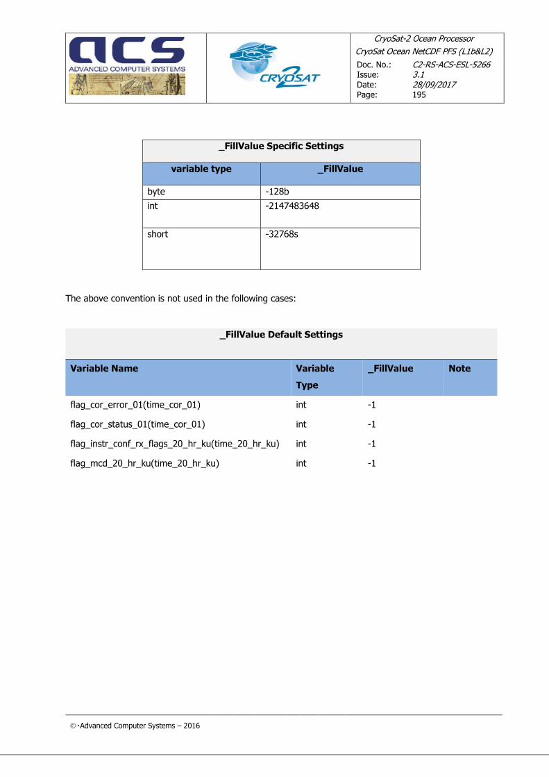
CryoSat-2 Ocean Processor
CryoSat Ocean NetCDF PFS (L1b&L2)
Doc. No.: Issue:
Date: Page:
C2-RS-ACS-ESL-5266 3.1 28/09/2017 195
Advanced Computer Systems – 2016
_FillValue Specific Settings
variable type
_FillValue
byte -128b
int -2147483648
short -32768s
The above convention is not used in the following cases:
_FillValue Default Settings
Variable Name Variable
Type
_FillValue Note
flag_cor_error_01(time_cor_01) int -1
flag_cor_status_01(time_cor_01) int -1
flag_instr_conf_rx_flags_20_hr_ku(time_20_hr_ku) int -1
flag_mcd_20_hr_ku(time_20_hr_ku) int -1

CryoSat-2 Ocean Processor
CryoSat Ocean NetCDF PFS (L1b&L2)
Doc. No.: Issue:
Date: Page:
C2-RS-ACS-ESL-5266 3.1 28/09/2017 196
Advanced Computer Systems – 2016
Appendix C: Timestamps Data Type
All the timestamps used in the CONFORM products represent the number of seconds since 1/1/2000 in
double precision. In this appendix it is shown that the current choice allows the represent timestamps with a precision of 1
microsecond till January 2034.
As the timestamps are typically added to or subtracted from each other, in order to preserve the
precision of these operations down to the microsecond, we need to keep the exact representation of the number till the 10-7, whose binary representation is around 2-23, i.e. 23 bits are needed to represent the
decimal part of the timestamps with a precision till 0,1 microseconds The IEEE 754 standard representation for double precision type reserves 54 bits for the representation of
the mantissa (53 bits plus 1 implicitly set), which means that the number of bits left to be used to
represent the integer part of the number of seconds is : 53-23 = 30 bits, which means that we have at disposal 230 -1 = 1,073,741,823 sec, i.e. 34 years.
Accordingly, the current representation allows to represent and manage timestamps in the CONFORM
without issues in arithmetic operations till January 2034, a date compatible with the mission lifetime.

CryoSat-2 Ocean Processor
CryoSat Ocean NetCDF PFS (L1b&L2)
Doc. No.: Issue:
Date: Page:
C2-RS-ACS-ESL-5266 3.1 28/09/2017 197
Advanced Computer Systems – 2016
Appendix D: EE to NetCDF migration
The purpose of this section is to give the CryoSat users some insight into the criteria adopted to implement
the migration from EE to CONFORM hoping that this can ease the analysis of the products in the new format.
The logic driving the migration is that this operation has to be implemented in two steps:
1. A version of the IPF1 software has to be released that generates baseline C CONFROM products.
This IPF1 version as well as the baseline C CONFORM products are hidden versions, i.e. the software is not installed in the operational platform and the products are not distributed but to a
selected groups of users to receive their feedback and suggestions for improvements.
2. The first official version of the IPF1 CONFORM software has to be the baseline D that has to
generate CONFORM products containing some evolution from baseline C.
Accordingly the contents of this section are applicable to the step one only, i.e. they explain how the
baseline C CONFORM products have been designed.
As of baseline D, the format will evolve without any relation to the EE format.
The Earth Explorer CryoSat Product consists of two files (figure 6-1):
• The XML Header File
• The Product File.
Figure 6-1: EE Product Structure

CryoSat-2 Ocean Processor
CryoSat Ocean NetCDF PFS (L1b&L2)
Doc. No.: Issue:
Date: Page:
C2-RS-ACS-ESL-5266 3.1 28/09/2017 198
Advanced Computer Systems – 2016
The CONFORM products consists of one file that contains the same information as the EE Product File
whilst the XML Header File doesn’t exist anymore in CONFORM and will no longer referred to in this section.
The EE Product File is defined taking the ENVISAT level-0 products as template and consists of:
• Main Product Header (MPH)
• Specific Product Header (SPH)
• Data Sets
Figure 6-2: EE Product File Structure
The MPH and SPH blocks are ASCII whereas the Data Sets are completely binary and each of them contains one or more Data Set Records.
All the EE CryoSat Products that have migrated to the NetCDF format contain one DS.
The general rules driving the migration are:
• The contents of the MPH and SPH have to be converted into NetCDF global attributes
MPH
SPH
DSD 1
DSD 2
.........
DSR 1
..........
DSR n
DSR 1
..........
DSR n
..........
DS 1
DS 2
DSD N
DSR 1
..........
DSR n
DS N
..........
..........

CryoSat-2 Ocean Processor
CryoSat Ocean NetCDF PFS (L1b&L2)
Doc. No.: Issue:
Date: Page:
C2-RS-ACS-ESL-5266 3.1 28/09/2017 199
Advanced Computer Systems – 2016
• each DS fields has been converted into a NetCDF variable
• Grouping within the product is only logical (i.e. the group feature of the NetCDF 4.0 is not used
but the rationale is kept in the variable naming)
• Three time dimensions are used:
o One time stamp for each 1Hz measurement.
o One time stamp for each 20Hz measurement.
o One time stamp to tag the time when the correction is applied.
• 20 Hz measurements are linked to the corresponding 1 Hz measurement by means of one index.
• _FillValue attribute is always filled with limited exceptions.
• Coding of binary flags:
o For flags coded in a single bit the same convention as S6 GPP is used
o For flags coded on more than one bit, a variable is created
END OF DOCUMENT