ct-37 seridan point farm - mht.maryland.gov
TRANSCRIPT

CT-37
Seridan Point Farm
Architectural Survey File
This is the architectural survey file for this MIHP record. The survey file is organized reverse-
chronological (that is, with the latest material on top). It contains all MIHP inventory forms, National
Register nomination forms, determinations of eligibility (DOE) forms, and accompanying documentation
such as photographs and maps.
Users should be aware that additional undigitized material about this property may be found in on-site
architectural reports, copies of HABS/HAER or other documentation, drawings, and the “vertical files” at
the MHT Library in Crownsville. The vertical files may include newspaper clippings, field notes, draft
versions of forms and architectural reports, photographs, maps, and drawings. Researchers who need a
thorough understanding of this property should plan to visit the MHT Library as part of their research
project; look at the MHT web site (mht.maryland.gov) for details about how to make an appointment.
All material is property of the Maryland Historical Trust.
Last Updated: 10-16-2012

CAPSULE SUMMARY CT-37 Sheridan Point Farm 6400 Sheridan Point Road Prince Frederick, Calvert County cl882 Private
The primary dwelling at Sheridan Point Farm, located at 6400 Sheridan Point Road, was
constructed in 1882 for Sally Broome Duke Morsell Dowell and substantially renovated between
1938 and 1958 to reflect the fashionable Colonial Revival style. This current structure replaced a
circa 1810 dwelling that was destroyed by fire in 1882. Like The Spout (CT-62), the house at
Sheridan Point Farm reflects a local and national trend of wealthy urbanites seeking escape from
the cities by purchasing and remodeling rural farmsteads in the Colonial Revival style taking
place during the second quarter of the 20th century. Despite development pressures from
Washington, D.C. commuters seeking inexpensive suburban housing, Sheridan Point Farm
remains intact, consisting of a 205-acre tract including cultivated fields, dwellings, barns,
agricultural and domestic outbuildings, remains intact. Sheridan Point Wharf (or Duke's Wharf),
no longer active, was located on the site and was a major loading point on the Patuxent River for
tobacco and passengers well into the 20th century. It is a significant example of the wharf
system, which played an essential role in the transportation, economy and development of Calvert
County during the 19th century.
The primary dwelling at Sheridan Point Farm is two-and-a-half stories in height. The main block
of the dwelling measures five bays wide and three bays deep. The solid foundation is constructed
of brick laid in stretcher bond. The wood-frame structure is clad in wide weatherboard siding that
is lapped on the northeast (land) facade and flush with beading on the southwest (river) facade.
The gable ends are faced with brick. The steeply pitched side gable roof is clad in asphalt
shingles and is pierced on both facades with three front-gabled dormers. The paired exterior-end
chimneys on the side elevations are constructed of brick laid in five-course American bond with
single shoulders and reconstructed corbeled caps. The southwest facade, facing the Patuxent
River, features a two-story piazza with two-story Tuscan posts. The one-story wings were added
in 1955. Two historic sheds, historic hunting cabin, gazebo, in-ground pool, greenhouse, ruins of
a shed, and dock further improve the property.

Maryland Historical Trust inventory NO CT-37
Maryland Inventory of
Historic Properties Form
1. Name of Property (indicate preferred name)
historic Sheridan Point Farm
other
2. Location street and number 6400 Sheridan Point Road not for publication
city, town Prince Frederick vicinity
county Calvert
3. Owner of Property (give names and mailing addresses of all owners)
name David M. Watson and Mary S. Watson
street and number 6400 Sheridan Point Road telephone Unknown
city, town Pr. Frederick state MD zip code 20678
4. Location of Legal Description courthouse, registry of deeds, etc. Calvert County Courthouse tax map and parcel: 29:8
city, town Pr. Frederick liber ABE 786 folio 673
5. Primary Location of Additional Data Contributing Resource in National Register District Contributing Resource in Local Historic District Determined Eligible for the National Register/Maryland Register Determined Ineligible for the National Register/Maryland Register Recorded by HABS/HAER Historic Structure Report or Research Report Other
6. Classification Category Ownership Current Function Resource Count
district hi' — a 9 " c u ' t u r e landscape Contributing Noncontributing ^F k..;iHirWc\ T7 . i commerce/trade recreation/culture 5 2 buildings _A_ Duiiaing^s; JX_ pnvate — . , — . . . — _ structure _ both ^ d e f e n s e __ religion sites
X domestic social 3 structures site — , . — . =- . . .
education transportation objects funerary work in progress 5̂ 5 Total
_ government unknown health care vacant/not in use Number of Contributing Resources industry other: previously listed in the inventory
r — — 1

7. Description Inventory No. CT-37
Condition
excellent deteriorated good ruins fair _X altered
Prepare both a one paragraph summary and a comprehensive description of the resource and its various elements as it exists today.
SETTING. Historically a rural property, the dwelling and surrounding domestic outbuildings are set on a large landscaped parcel sloping southward to the Patuxent River. The dwelling's siting resulted in the primary facade fronting the river to the southwest and the secondary facade on the land side facing northeast. The property is augmented with foundation plantings, mature trees and shrubs including maple trees, poplar trees, evergreen trees and boxwoods. A gravel drive accesses the property from Sheridan Point Road and circles on the east elevation of the main dwelling. Two historic sheds, historic hunting cabin, gazebo, in-ground pool, greenhouse, ruins of a shed, and dock further improve the property. A historic road leads from the north of the house to the dock along the water's edge.
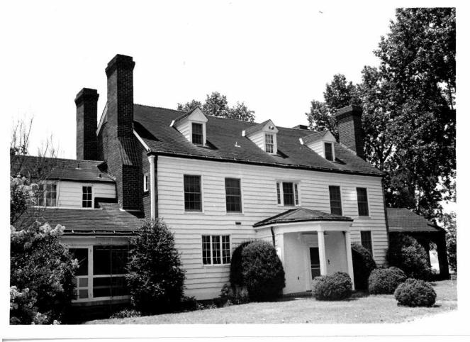
PRIMARY RESOURCE. The primary dwelling at Sheridan Point Farm, located at 6400 Sheridan Point Road, was constructed circa 1882 and substantially altered and enlarged between 1938 and 1958 to reflect the Colonial Revival style. This structure replaced the original dwelling on the site, which was erected circa 1810 and destroyed by fire in 1882. Prior to the 1955 renovation of the current wood-frame structure, the facade of the dwelling as indicated by historic photographs was five bays wide with a side gable roof, pediment, and central entry. A full-width porch with a small pediment and scrollwork augmented the first story. The building, heated by paired chimneys, was clad in weatherboard and enlarged by an addition. The shuttered window openings held 6/6 sash. Beginning in 1938, this wood-frame structure was substantially enlarged and ornamented to reflect the then-fashionable detailing of the Colonial Revival style. This renovation, ending in 1958, resulted in the raising of the roof structure and the construction of a two-story piazza and wing additions (added in 1955).
Standing two-and-a-half stories in height, the main block of the dwelling measures five bays wide and three bays deep. The solid foundation is constructed of brick laid in stretcher bond. The wood-frame structure is clad in wide weatherboard siding. This material is lapped on the northeast facade and flush with beading on the southwest facade. As a result of the 20th-century additions and alterations, the side elevations of the main block were clad in brick with a stretcher-bond pattern. The steeply pitched side gable roof is clad in asphalt shingles and has a shallow boxed cornice on the secondary facade. The roof is pierced on both the primary (river) and secondary (land) facades with three front-gabled dormers holding 6/6 wood-sash windows. The paired exterior-end chimneys on the side elevations are constructed of brick laid in five-course American bond with single shoulders and reconstructed corbeled caps. The central entry on the northeast elevation is covered by a half-hipped roof clad in asphalt shingles and supported by square wood posts. The southwest facade, facing the Patuxent River, features a two-story piazza that is Colonial Revival in style. The flat roof of the piazza is supported by two-story Tuscan posts and has a wide molded entablature with a plain frieze. The window openings on the main block are elongated 6/6 sash on the first story and standard 6/6 sash on the second story. The most ornate entry, located on the southwest (river) facade, is framed by sidelights, fanlight, and fluted pilaster surrounds.
The northwest wing, one story in height, is brick with a Flemish-bond pattern. It has segmental-arched openings on the northeast and southwest elevations. These openings are framed with soldier-coursed brick headers. The side gable roof is clad with asphalt shingles. The southeast addition, rising one-and-a-half stories in height, provides additional living space. Originally, this addition included a three-car garage on the first story that has since been converted into additional living space. (1) Constructed of brick laid in five-course American bond, the addition has a hipped roof sheathed in asphalt shingles and pierced by front-gabled wall dormers. The addition has a wide entablature with plain frieze and boxed cornice. The shed-roof dormers are clad in weatherboard and pierced by single and paired six-light casement windows. The first story has 6/6 sash windows and three sliding-glass doors that replaced the roll-up paneled garage doors.
SECONDARY RESOURCES. The two historic sheds, dating to circa 1920, are constructed of wood frame. Located to the north of the main dwelling, the one-story sheds are set on concrete block pier foundations and have gable roofs clad in asphalt sheets. One of the sheds is clad with flush horizontal weatherboard while the second shed has both vertical and horizontal weatherboard siding. A third wood-frame shed, set to the west of the house, dates from circa 1940. Clad in weatherboard siding, the shed is severely deteriorated and in ruins.

Maryland Historical Trust Inventory No. CT-37
Maryland Inventory of Historic Properties Form
Name Sheridan Point Farm Continuation Sheet
Number 7 Page l
The historic cabin is located along the water's edge to the northeast of the dock. The L-shaped cabin was constructed circa 1925. The building was originally located further out on the point and was moved to its current location after 1938. It stands one story in height on a brick pier foundation. The wood-frame structure is clad with flush weatherboard siding. The gable roof is covered in asphalt shingles and has wide overhanging eaves with knee brackets. The hinged openings hold four-light wood sash windows. The southern end of the building, an addition with a half-hipped roof, has screened openings and a single-leaf entry door.
The non-historic garage, located to the north of the house, was constructed circa 1981. It stands one-and-a-half stories in height and is clad in brick veneer on the southeast elevation. The side-gabled roof is covered in asphalt shingles and is pierced by a front-gabled dormer.
The non-historic greenhouse, built circa 1981, is located adjacent to the house on the southeast side. Standing one story in height, the metal and glass structure has a solid brick foundation.
The gazebo, dating from circa 1992 and relocated to the property in 1999, is constructed of wood frame with square posts and has been screened. It is covered by a polygonal roof with wood shingles. The gazebo is located to the west of the house adjacent to the pool. The in-ground pool, constructed circa 1981, has a one-room pool house and brick paved walks.
The long dock is located to the west of the house along the beaches of the Patuxent River. It is constructed of wood frame with round posts and wood decking.
ENDNOTES
(1) Wilfong, James. Photograph, cl965. James Wilfong Collection. Calvert County Historical Society, Prince Frederick, MD.

8. Significance inventory NO. CT-37
Period Areas of Significance Check and justify below
1600-1699 agriculture economics health/medicine performing arts 1700-1799 archeology education industry philospohy
X 1800-1899 _X_ architecture engineering invention politics/government x 1900-1999 art entertainment/ landscape architecture religion
2000- commerce recreation law science communications ethnic heritage literature social history community planning exploration/ maritime industry transportation conservation settlement military other:
Specific dates cl882, cl938 Architect/Builder Unknown
Construction dates cl882, cl938
Evaluation for:
National Register Maryland Register X not evaluated
Prepare a one-paragraph summary statement of significance addressing applicable criteria, followed by a narrative discussion of the history of the resource and its context. (For compliance reports, complete evaluation on a DOE Form - see manual.)
SIGNIFICANCE SUMMARY. The primary dwelling at Sheridan Point Farm, located at 6400 Sheridan Point Road, was constructed in 1882 and substantially renovated between 1938 and 1958 to reflect the Colonial Revival style. The present dwelling, constructed for Sally Broome Duke Morsell Dowell, replaced a circa 1810 structure on the property that burned in 1882. LikeThe Spout (CT-62), the house reflects a local and national trend of wealthy urbanites seeking escape from the cities by purchasing and remodeling rural farmsteads in the Colonial Revival style taking place during the second quarter of the 20th century. Despite development pressures from Washington, D.C. commuters seeking inexpensive suburban housing, Sheridan Point Farm remains intact, consisting of a 205-acre tract including cultivated fields, dwellings, barns, agricultural and domestic outbuildings. Sheridan Point Wharf (or Duke's Wharf), no longer active, was located on the site and was a major loading point on the Patuxent River for tobacco and passengers well into the 20th century. It is a significant example of the wharf system, which played an essential role in the transportation, economy and development of Calvert County during the 19th century.
HISTORY. Sheridan Point Farm takes its name from Thomas Sheridan (Sherridine), who settled in this area of Calvert County during the mid-17th century. (1) At that time, the tract was known as Turkey Buzzard. (2) The first reference to the placename Sheridan Point occurs in the Maryland tax list of 1783. (3) A house at Sheridan Point is known to have been in existence as early as 1814, but this early dwelling, owned by Dr. John Gray, was burned by the British during the War of 1812 (1812-1815). (4) The current dwelling at 6400 Sheridan Point Road was originally constructed circa 1882 by William H. Dowell and is said to have been a wedding gift for his wife, Sally Broome Duke Morsell Dowell. (5) It was a two-story wood-frame dwelling clad in lapped weatherboard with a side-gable roof. (6) The five-bay facade had a central gable and a one-story porch with segmental arches. The house had a two-story wood-frame shed-roof addition to one side, and exterior-end brick chimneys with a brick pent. During the late 19th century a wharf was established at Sheridan Point, also known as Duke's Wharf, and by 1878 a post office was operating at the wharf. (7) The wharf, located further out on the point than the current dock, was a regular stop on the Weems Steamboat Company line, and the old road to the landing is still visible on the site. Sally Dowell capitalized on the presence of the wharf by renting out rooms to steamboat passengers. (8)
In 1938, the property was acquired by James Angus Watson (1900-1971) of Silver Spring, Maryland and his wife, Mildred Murray Watson (d. 1978). (9) Watson was a West Point graduate and successful businessman who sold automobile equipment and trucks to the Army during World War II. (10) Between 1938 and 1958, the Watsons undertook a major Colonial Revival-style renovation of the house at Sheridan Point Farm. The renovation included the raising of the roof four feet, excavation of the basement, the construction of the wings and the two-story river-front porch. On the interior the wall between the north parlors was removed to create large double parlor, moldings and matelpieces throughout were reproduced. The Watsons also graded the land between the house and the Patuxent River and built the house closest to the main dwelling on Sheridan Point Road for tenant farmers. The one-story cabin had existed on the site when it was acquired by Watson and is said to have been used as a hunting cabin by people from Philadelphia. (11) During their tenure at Sheridan Point Farm, the Watsons raised beef cattle. Following the death of Mildred

Maryland Historical Trust Inventory No CT-37
Maryland Inventory of Historic Properties Form Name Sheridan Point Farm
Continuation Sheet Number g Page \
Watson in 1978, the property passed to her sons. To save the property from subdivision, one of the sons, David M. Watson, bought out his brothers and moved into the house with his wife, Mary, in 1981. A graduate of Princeton and Columbia Universities, David Watson was a financial investor who had worked on Wall Street for 15 years. The Watsons constructed the pool, current dock, and garage on the site, and converted the former attached garage into additional living space. The Watsons continue to live in the house with their son.
ENDNOTES
(1) Hutchins, Ailene W. Hunting Creek Hundred. Ailene Hutchins: Prince Frederick, 1992. p. 284.
(2) Hutchins, Ailene W. Hunting Creek Hundred. Ailene Hutchins: Prince Frederick, 1992. p. 284.
(3) Hutchins, Ailene W. Hunting Creek Hundred. Ailene Hutchins: Prince Frederick, 1992. p. 285.
(4) Hutchins, Ailene W. Hunting Creek Hundred. Ailene Hutchins: Prince Frederick, 1992. p. 286.
(5) Watson, David M. On-site interview by Carrie E. Albee. December 30, 2002.
(6) Photograph, c 1890. In the private collection of David M. Watson. Sheridan Point Farm, Prince Frederick, MD.
(7) The post office operated until 1910 when it was moved to Adelina. Hutchins, Ailene W. Hunting Creek Hundred. Ailene Hutchins: Prince Frederick, 1992. p. 287.
(8) Sundermann, Anne M. Harbours, Creekes and Places: The Steamboat Wharves and Landings of Calvert County, Maryland. Calvert County Historic District Commission: Prince Frederick, 2001. p. 50.
(9) Watson, David M. On-site interview by Carrie E. Albee. December 30,2002.
(10) Information on the Watson occupation was provided by David M. Watson. Watson, David M. On-site interview by Carrie E. Albee. December 30, 2002.
(11) Watson, David M. On-site interview by Carrie E. Albee. December 30,2002.

9. Major Bibliographical References inventory NO. cr-37
See continuation sheet.
10. Geographical Data
Acreage of surveyed property 205 Acres
Acreage of historical setting Unknown
Quadrangle name Mechanicsville Quadrangle scale 1:24,000
Verbal boundary description and justification
Sheridan Point Farm is located at 6400 Sheridan Point Road in Prince Frederick, Maryland. It has been associated with Tax Map 29, Parcel 8, Sub District 02 since its construction in the late 19th century. The current deed to the property can be found in the land records of Calvert County in the Calvert County Courthouse in Prince Frederick: Deed Book ABE 786, Page 673.
11. Form Prepared By name/title Carrie E. Albee and Laura V. Trieschmann, Architectural Historians
organization E H T Traceries, Inc. date 2/27/03
street and number 1121 5th Street, N W telephone 202-393-1199
city or town Washington state D C zip code 20001
The Maryland Inventory of Historic Properties was officially created by an Act of the Maryland Legislature to be found in the Annotated Code of Maryland, Article 41, Section 181 KA, 1974 supplement.
The survey and inventory are being prepared for information and record purposes only and do not constitute any infringement of individual property rights.
return to: Maryland Historical Trust
DHCD/DHCP
100 Community Place
Crownsville MD 21032
410-514-7600
Maryland Historical Trust inventory NO CT-37
Maryland Inventory of Historic Properties Form Name Sheridan Point Farm Continuation Sheet Number 9 Page j
Hutchins, Ailene W. Hunting Creek Hundred. Ailene Hutchins: Prince Frederick, 1992.
Photograph, cl890. In the private collection of David M. Watson. Sheridan Point Farm, Prince Frederick, MD.
Sundermann, Anne M. Harbours, Creekes and Places: The Steamboat Wharves and Landings of Calvert County, Maryland. Calvert County Historic District Commission: Prince Frederick, 2001.
Watson, David M. On-site interview by Carrie E. Albee. December 30, 2002.
Wilfong, James. Photograph, c 1965. James Wilfong Collection. Calvert County Historical Society, Prince Frederick, MD.


MECHANICSVILLE QUADRANGLE MARYLAND
7.5 MINUTE SERIES (TOPOGRAPHIC) NW/4 LEONARDTOWN 15' QUADRANGLE
=CT-37 (̂ Sheridan Point Farm ^6400 Sheridan Point Road Prince Frederick, Calvert County
iMechanicsville USGS Quad **=.,
MECHANICSVILLE, MD. NW/4 LEONARDTOWN 15' QUADRANGLE
N 3822.5—W7637.5 /7 .5
1953 PHOTOREVISED 1974
AMS 5660 I NW-SER1ES V833


CT-37
SHERIDON POINT FARM (site) late il8th.
The present Georgian Revival house at Sheriden Point incorporates and replaces a much earlier structure.

MARYLAND HISTORICAL TRUST CT-37
INVENTORY FORM FOR STATE HISTORIC SITES SURVEY
NAME HISTORIC
. Sheridan Point AND/OR COMMON
LOCATION STREETS NUMBER
Sheridan Po in t Road _ _ ^ _ _ _ _ _ _ CIJY. TOWN CONGRESSIONAL DISTRICT
Adelina VICINITY OF Calver t STATE COUNTY
MD '
CLASSIFICATION
CATEGORY OWNERSHIP STATUS PRESENT USE
—DISTRICT • _PUBLIC ^OCCUPIED XLAGRICULTURE —MUSEUM
X_BUILDING(S) J^PRIVATE —UNOCCUPIED —COMMERCIAL —PARK
—STRUCTURE —BOTH —WORK IN PROGRESS —EDUCATIONAL X.PRIVATE RESIDENCE
—SITE PUBLIC ACQUISIT ION ACCESSIBLE —ENTERTAINMENT —RELIGIOUS
—OBJECT —IN PROCESS —YES: RESTRICTED —GOVERNMENT —SCIENTIFIC
—BEING CONSIDERED _YES: UNRESTRICTED —INDUSTRIAL —TRANSPORTATION
J*NO —MILITARY —OTHER:
OWNER OF PROPERTY NAME
Mrs. Mildred Watson (James) T e l e p h o n e # : STREET & NUMBER
Sheridan Poin t Road t CITY. TOWN STATE , Z i p C O d e
• A d e l i n a — VICINITY OF
LOCATION OF LEGAL DESCRIPTION L i b e r #; AWR 1 COURTHOUSE. F o l i o # : 194. REGISTRY OF DEEDS.ETC.
Calvert County Courthouse STREET & NUMBER
CITY. TOWN STATE
EClaea Freder ick MJJ
REPRESENTATION IN EXISTING SURVEYS TITLE
DATE ' "
—FEDERAL -.STATE —COUNTY _LOCAL
DEPOSITORY FOR SURVEY RECORDS
CITY. TOWN STATE

DESCRIPTION CT-37
CONDITION CHECK ONE CHECK ONE
EXCELLENT _DETERIORATED _UNALTERED ^ORIGINAL SITE
_GOOD _RUINS A L T E R E D _MOVED DATE
_FAIR —UNEXPOSED
DESCRIBE THE PRESENT AND ORIGINAL (IF KNOWN) PHYSICAL APPEARANCE
Sheridan Point, the "residence of William H. Dowell, Esq."; is pictured in a late Nineteenth Century travel booklet produced by the Weems Steamboat Co. In the photograph one sees a five bay cross-gable house that has a central entrance. A full porch covers the first level and the centralness of the building is accentuated by a small pediment in the porch roof. The porch is further decorated by ornate gingerbread scrollwork.
The clapboarded exterior extends across the entire facade and addition. On one end of the building one can see a pair of chimneys that are connected by a two-story pent.
The windows are shuttered and appear to be 6/6.
The chimney pent and 6/6 windows support Mrs. Betty Briscoes information that an earlier house stood on this spot which was burned c. 18H.
CONTINUE ON SEPARATE SHEET IF NECESSARY

CT-37 SIGNIFICANCE
PERIOD AREAS OF SIGNIFICANCE - CHECK AND JUSTIFY BELOW
_PREHfSTORIC —ARCHEOLOGY-PREHISTORIC —COMMUNITY PLANNING —LANDSCAPE ARCHITECTURE _RELIGION
— 1400-1499 —ARCHEOLOGY-HISTORIC —CONSERVATION _LAW _SCIENCE
— 1500-1599 —^GRICULTURE —ECONOMICS _LITERATURE —SCULPTURE
— 1600-1699 ^ARCHITECTURE —EDUCATION _MILITARY —SOCIAL/HUMANITARIAN
— 1700-1799 ART —ENGINEERING _MUSIC —THEATER
2&800-1899 —COMMERCE _EXPLORATION/SETTLEMENT —PHILOSOPHY —TRANSPORTATION
— 1900- —COMMUNICATIONS ^INDUSTRY —POLITICS/GOVERNMENT —OTHER (SPECIFY)
—INVENTION
SPECIFIC DATES BUILDER/ARCHITECT
STATEMENT OF SIGNIFICANCE
MHT lists Sheridan Point Farm as a "site". Although the interior was not examined on July 14, 1977 the exterior of the present structure suggested that little original fabric remains. What exists now is a convincingly real Georgian structure complete with brick siding, fanlight windows and pedimented dormers. The chimneys appear to be much like those in the Weems photograph, however, the brick in the north chimneys is so like that seen in the modern porch on the end, it is assumed that they have been rebuilt.
CONTINUE ON SEPARATE SHEET IF NECESSARY

CT-37
MAJOR BIBLIOGRAPHICAL REFERENCES
CONTINUE ON SEPARATE SHEET IF NECESSARY
GEOGRAPHICAL DATA ACREAGE OF NOMINATED PROPERTY
VERBAL BOUNDARY DESCRIPTION
• .
LIST ALL STATES AND COUNTIES FOR PROPERTIES OVERLAPPING STATE OR COUNTY BOUNDARIES
STATE COUNTY
STATE COUNTY
FORM PREPARED BY Description and significance statements: Wayne Nield NAME/TITLE
Form compiled by; March 1978 ORGANIZATION . , , . DATE
757-2815 ' STREETS, NUMBER TELEPHONE
CITY OR TOWN STATE
The Maryland Historic Sites Inventory was officially created by an Act of the Maryland Legislature, to be found in the Annotated Code of Maryland, Article 41, Section 181 KA, 1974 Supplement.
The Survey and Inventory are being prepared for information and record purposes only and do not constitute any infringement of individual property rights.
RETURN TO: Maryland Historical Trust The Shaw House, 21 State Circle Annapolis, Maryland 21401 (301) 267-1438
PS- I 108

i. STATE M a r y l a n d HISTORIC AMERICAN BUILDINGS SURVEY
COUNTY C a l v e r t County INVENTORY CT -37 TOWN VICINITY
STREET NO.Sheri dan P o i n t 2 NAME S h e r i d a n P o i n t Farm -Watson House
DATE OR PERIOD „ ORIGINAL OWNER ^ t b o n f a m i l y ORIGINAL USE D w e l l i n g
. , , . ARCHITECT t, R e c o n s t r u c t e d ; PRESENT OWNER J . A . W a t s o n , J r .
' BUILDER STYLE: G e o r g i a n t o l o n i a l PRESENT USE D w e l l i n g WALL CONSTRUCTION 3- FOR LIBRARY OF CONGRESS USE
NO. OF STORIES 4. NOTABLE FEATURES, HISTORICAL SIGNIFICANCE AND DESCRIPTION OPEN TO PUBLIC
This large brick house is 5 bays wide and 3 deep. It has a central door and all the windows have 6/6 sashes. There are three 0/6 peaked dormers on the roof. There is a steeply sloped A-roof and double chimneys with two story brick pents at each end of the house. The house is Fiemi sh bond brick on the sides and clapboard on the front and back.
Unfortunate I y, this house has been almost; completely reconstructed and has nothing about it which appears old.
It is hardly more than a ghost of an old house.
Over-restored
5. PHYSICAL CONDITION OF STRUCTURE Endongered Inter ior Exter ior
6. LOCATION MAP (Plan Optional) 7. PHOTOGRAPH
3- PUBLISHED SOURCES (A<J*nor, Title, Pages) 9. NAME, ADDRESS AND TITLE OF RECORDER
INTERVIEWS, RECORDS, PHOTOS, ETC.
PAB 7 / 2 0 / 6 7
DATE OF RECORD