ctbuh.org/papers titleglobal.ctbuh.org/resources/papers/download/2873-x... · ·...
TRANSCRIPT

Title: X Information Modeling: Data-Driven Decision Making in the Design of TallBuildings
Authors: James von Klemperer, President, Kohn Pedersen Fox AssociatesLuc Wilson, Associate Principal, Kohn Pedersen Fox AssociatesMondrian Hsieh, Computational Designer, Kohn Pedersen Fox Associates
Subjects: Architectural/DesignUrban Design
Keywords: OptimizationUrban Planning
Publication Date: 2016
Original Publication: Cities to Megacities: Shaping Dense Vertical Urbanism
Paper Type: 1. Book chapter/Part chapter2. Journal paper3. Conference proceeding4. Unpublished conference paper5. Magazine article6. Unpublished
© Council on Tall Buildings and Urban Habitat / James von Klemperer; Luc Wilson; Mondrian Hsieh
ctbuh.org/papers

688 Data and Digital Modelling | 数据和数字化建模
Introduction
To match population growth, densification of global cities, and specifically building taller, we require a technical expertise that more and more resides with internationally practicing architects. For designers faced with complex urban environments, zoning regulations and structural requirements, designing for regional specificity can easily take a backseat. The subjective nature of regional specificity can make it tempting to repeat building typologies across culturally disparate locations. This paper presents a methodology for data driven decision-making termed X-Information Modeling or XIM. XIM integrates key criteria, both technical and regionally specific, into a design evaluation system that allows for iterative testing of design schemes. XIM was developed in collaboration with Muchan Park, Senior Designer & Data-Driven Design Specialist at Gansam Architects & Partners. This methodology seeks to balance the desire for specificity of place against the pressures of globalizing homogeneity.
The variable “X” represents flexible accommodation of objectives for
X Information Modeling: Data-Driven Decision Making in the Design of Tall Buildings
This paper outlines X-Information Modeling or XIM, a method of data-driven decision-making for the design of tall buildings. Developed over its application on more than 200 projects worldwide, XIM comprises a set of digital evaluation tools that match data analysis to 3D models, enabling designers to iterate tens-of-thousands of design options against criteria tailored to the building’s urban context. Particularly, for dense urban environments, this interactive design system helps designers respond to regionally specific constraints and objectives, such as zoning, climate, and market expectations. This paper demonstrates the application of this methodology in three use cases: the iterative design of a hypothetical skyscraper in Manhattan, a data-driven analysis of New York, London, and Shanghai, and in aiding a city planning department in a rezoning.
Keywords: Data, Optimization, Tall Buildings, Urban Analytics
本文概述了X信息模型(XIM),一种对于高层建筑设计的基于数据驱动的决策方法。它已经被发展运用在了全球超过200个项目上,XIM包含了一组数字化评估工具来与3D模型的分析数据相匹配,能使设计师去迭代成千上万的设计方案来针对建筑物所在的城市环境的定制标准。特别是,对于密集的城市环境中,这种互动设计系统可帮助设计人员应对区域特定的约束和目标,如区域划分,气候和市场预期。本文演示了这种方法的三个案例应用:一个假想的曼哈顿摩天大楼迭代设计,一个对于纽约、伦敦、上海的数据驱动分析,以及帮助城市规划部门重新分区。
关键词:数据、最优化、高层建筑、城市分析
Abstract | 摘要James von Klemperer President | 总裁 Kohn Pedersen Fox AssociatesKPF建筑设计事务所 New York City, USA 纽约,美国
James von Klemperer is President and Design Principal at Kohn Pedersen Fox Associates where he began as a young architect in 1983. His work ranges in scale from a house to a city, and he contributes closely to these efforts from conception to completion. In addition to focusing on his own projects, he leads the community of designers within the firm in exploring shared architectural agendas and goals. As President of the firm, he is responsible for leading the staff of 700 people in 6 offices around the world. Jamie received a Bachelor of Arts from Harvard University in 1979.
詹姆斯•冯•克伦佩勒,KPF建筑事务所总裁兼设计总监,于1983年加入KPF成为建筑师。他的工作尺度范围涵盖了从住宅到城市,从设计构思到项目完成均离不开他的紧密贡献。除了专注于其本身的工作项目之外,他领导着公司内部设计师去探索共享建筑议程与目标。作为KPF的总裁,他负责领导全球六所办公室的共七百名员工。James于1979年获得哈佛大学学士学位。
X 信息模型:高层建筑设计中的基于数据驱动的决策
序言
为了配合人口增长,全球城市的致密化以及建立更高的楼,这就需要越来越多的有技术专长的国际建筑师。对于设计人员面临着复杂的城市环境中,分区规则和结构要求,设计对于区域特异性可以很容易地让位。区域特异性的主观性可以使它很有诱惑力对于跨文化不同地点的重复建筑类型。本文提出了推动决策数据的方法称为的X信息模型或XIM。 XIM集成了关键的标准,技术和区域的具体,到设计评估系统,允许对设计方案的迭代测试。这种方法用来寻求平衡对于反对全球化同质化的压力,以及地方特殊性的愿望。
变量“X”代表的定量评价目标,如空间,发展,环境或分区。关键指标分配给这些目标提供了一个细微的认识特定的地点内工作的权衡。空间分析工具被创建来评估的标准,如视图分析或步行性的设计。这些指标纳入可视化响应,以便对设计方案进行快速评估。这种方法类似于引进MRI或X光射线到医学领域。他们让医生更快做出更明智的决策速度,同时还依赖于他们的专业知识和判断。同样,XIM加快设计和开发过程,同时允许更明智的决策。
Mondrian Hsieh Computational Designer | 数字化设计师 Kohn Pedersen Fox Associates KPF建筑设计事务所 New York City, USA 纽约,美国
Mondrian Hsieh is a computational designer at Kohn Pedersen Fox and researcher for KPF Urban Interface. His passion for digital media and architectural design has led him to many industries from high resolution reality capture in archaeological preservation to neuroscience data visualization. He was teaching assistant for architectural representation and design programming, and taught a studio in sustainable urban design at Columbia University. Mondrian holds a B.A. from the University of California, Berkeley, and a Masters of Architecture from Columbia University’s Graduate School of Architecture, Planning and Preservation where he won the Visual Studies Honors Award.
Mondrian Hsieh,KPF建筑事务所计算设计师兼KPF Urban Interface研究员。他热衷于数字媒介同时建筑设计将他引导入了很多行业领域从考古保护领域的高分辨率现实捕捉到神经科学的数据可实施化。他曾是哥伦比亚大学建筑助教,也曾带教过哥伦比亚大学可持续城市设计课程。Mondrian获得了加州大学伯克利分校的学士学位,以及哥伦比亚大学建筑硕士学位并取得视觉研究荣誉奖。
Luc Wilson Associate Principal | 副总监 Kohn Pedersen Fox Associates KPF建筑设计事务所 New York City, USA 纽约,美国
Luc Wilson is an associate principal at Kohn Pedersen Fox and the director of KPF Urban Interface, an initiative focused on urban analytics and technology development. He has applied a data-driven design methodology on over 200 projects globally ranging from master plans to rezonings to supertall towers. A critical aspect of this work is research collaborations with Columbia University, New York University, and the New York City Department of City Planning. He currently teaches within the Graduate School of Architecture Planning and Preservation at Columbia University and the Center for Data Science at NYU.
Luc Wilson,KPF建筑事务所设计副总监兼KPF Urban Interface主任,Urban Interface提倡聚焦于城市分析及技术发展。他已经将一种数据驱动的设计方式运用在了全球超过200个项目中,涵盖了从总体规划到用地变更及超高层领域。这项工作的一个重要方面是与哥伦比亚大学、纽约大学、纽约市城市规划署共同研究合作。Wilson目前执教于哥伦比亚大学建筑及规划研究生院以及纽约大学科学数据中心。
Volume 1 and 2 BOOK.indb 688 9/13/2016 11:45:36 AM

CTBUH 2016 Shenzhen · Guangzhou · Hong Kong Conference | 2016年CTBUH深圳 · 广州 · 香港国际会议 689
Figure 1. X-Information Modeling (XIM) Workflow. Implementation of visualization methods within the evaluation pipeline enables expert intervention and recursive updates to calibrate both evaluation models and input designs. (Source: KPF)图1. X信息模型(XIM)工作流程。在评价管道中的可视化方法的实现允许专家介入和递归更新来对评价模型和输入设计进行校准。 (来源: KPF)
quantitative evaluation, such as spatial, development, environmental, or zoning. Key metrics are assigned to these objectives to offer a nuanced understanding of the trade-offs operating within a particular place. Spatial analysis tools are created to evaluate designs for criteria, such as view analysis or walkability. These metrics are fed into responsive visualizations to allow for quick evaluation of design options. This methodology is analogous to the introduction of the MRI or X-Ray to medicine. They allow the doctor to make more informed decisions faster while still relying on their expertise and judgement. Similarly, XIM speeds up the design and development process while allowing for smarter decision making.
Methodology
XIM follows a five-step workflow for its visual data-driven analysis (Figure 1):
1. Develop Analysis Tools
2. Create Design Massings to analyze
3. Integrate tools and massings into a single Design Evaluation System
4. Iterate Multiple Options for a comprehensive understanding of performance
5. Use results for Design Decision Making
Analysis Tools
The core of the methodology lies in creating digital tools that derive spatial datasets which can be used later for evaluating design schemes. These tools are primarily built in off-the-shelf parametric modeling software. Figure 2 shows an example of how this method is used to create a landscape-view-analysis tool. Creating XIM tools involves identifying criteria that shape the early stages of building design. Common analysis criteria include views, daylight access, zoning compliance, floor plate efficiency, core-to-perimeter depth, and relative construction cost (the ratio of surface area to floor area.) The output from the tools are a metric and 3D visualization.
Overcoming a challenge analog analysis methods face, this methodology facilitates the process of analyzing competing objectives. For instance, one combination of XIM tools could be used to balance both interior and exterior criteria by simultaneously assessing the floor plate efficiency and daylight access of a building design. Another combination could be used to balance both client and city objectives by weighing a building’s views against the surrounding streets’ exposure to daylight.
Design Massings Two types of design massings can be used in the workflow: (1) distinct massing schemes developed by the design team for fast iterative analysis or (2) parametric
方法
XIM遵循它的可视化数据驱动分析五步工作流程(图1):
1. 发展分析工具
2. 创建设计体量分析
3. 整合工具和体量进入一个单一的设计评估系统
4. 迭代多个选项为全面了解性能
5. 使用分析结果进行设计决策
分析工具 该方法的核心在于创造推导出可以在以后用于评估设计方案时一起使用空间数据的数字化工具。这些工具主要建在场外的货架参数化建模软件。图2示出了这个方法被用来创建一个风景视图分析工具的一例。创建XIM工具包括确定塑造建筑设计的早期阶段标准。常见的分析标准包括视
Figure 2. Assumptions diagram for visibility analysis from a design massing to a curvilinear geographic feature, as an evaluation model this has become known as a landscape-view-analysis. (Source: KPF)图2. 可视性分析的假设图解从体量的设计到的曲线的地理要素,作为一种评估模型,已成为众所周知的景观视角分析。(来源: KPF)
Volume 1 and 2 BOOK.indb 689 9/13/2016 11:45:39 AM

690 Data and Digital Modelling | 数据和数字化建模
massings used to test a range of options. For the parametric massing input there are two types of models. The first is to create a parametric version of a specific scheme from the design team and is used for determining high performing variations. This is a way to take a preferred design scheme and calibrate it for high performance. The second is to create a generic parametric massing model designed to test a full range of massing variations across the site for a target area and program. Typically, massing blocks are iterated by varying their height, proportion, location within a site, and orientation. This second type of model is used to run what could be understood as a parametric site analysis, with results of which manifest in a performance envelope that establishes the framework for the project design.
Evaluation System The custom analysis tools are then integrated into a single evaluation system and applied to the massing input. The analysis tools are calibrated to the site and design massing. Next the metric output requires validation by the project team or appropriate expert. Integrating the analysis tools allows users to actively monitor the design scheme’s fulfillment of key criteria. Each tool is assigned a score weight indicating its relative importance in the mix of performance criteria. By quickly and iterative testing design schemes each subsequent design becomes better performing. Similarly, consultants and stakeholders can understand the impact of maximizing the performance of the objectives they are specifically concerned with relative to the broader range of objectives. City planners, for instance, can understand if certain bulk expectations for the design lead to unusable floor plates and, through iteration, come to a design scheme that balances both city and client objectives.
Iteration of Multiple Options Once the evaluation system is created, the design massing is iterated through either optimization of brute force testing of the parameter space, functions common in parametric software. Through iteration, ranging from hundreds to millions of options, the full range of performance across the site and within the context can be developed. In contrast, in a typical design workflow a handful of schemes are considered and within those schemes maybe dozens of iterations occur. Leverage digital design tools facilitates a comprehensive understanding of each design intention while keeping options available longer in the design process. Figure 4 illustrates the generation of multiple options for evaluation.
Design Decision-Making XIM ultimately aims to facilitate design decision-making and is not a generative methodology. It does not provide answers or single solutions; rather it supplies metrics and data that help designers, developers and stakeholders better and more quickly exercise their judgement in the decision-making process. This allows designers to more confidently discuss their design decisions from a defensible position. Additionally, when thousands of design options are iterated, it is necessary to devise methods of filtering results for comparison and evaluation to an understandable number of options, as demonstrated in case study one.
Visualization of Data In the design of a project data and metrics are only useful if they are actionable. To be actionable they need to be understandable, making concise data visualization fundamental to this methodology (Figure 3). This clarity is achieved with first a dashboard displaying metrics, typically combining numeric outputs with graphs and charts.
角,日照,分区达标,底板效率,核心到周边的深度,相对建设成本(面积为建筑面积的比率)。从工具输出的是一个度量和三维可视化。
克服方法面临挑战的模拟分析,这种方法有利于分析竞争目标的过程。例如,XIM工具通过一种组合可以同时评估底板效率平衡内部和外部的标准和建筑设计的日照时间,另一种组合可以用来平衡客户和城市目标,通过大楼视角来衡量暴露于日照下的周围街道。
体量设计 两种设计体量的类型可以在工作流中使用:(1)由设计团队进行快速迭代分析制定不同的体量方案或(2)用于测试各种选项范围的参数化的体量。参数化体量的输入有两种类型的模型。首先是从设计团队创建特定方案的参数版本,用于确定高性能的变化。这是得到一个倾向的设计方案并校准它以达到高性能的方法。二是建立旨在测试在场地中的一个保持目标面积和功能的全方位体量变化建立的通用的参数体量模型。通常情况下,体量块由改变一个位点,和在场地内的高度,比例,
Figure 3. Examples of analysis dashboards and analysis summaries for projects. Generally provided are multidimensional graphic techniques and persistent comparisons with baseline, or relative scores. (Source: KPF)图3. 关于项目的分析表盘和分析总结的例子。一般是提供多维的图形技术和与持续的基线准比较,或相对分数。(来源: KPF)
Volume 1 and 2 BOOK.indb 690 9/13/2016 11:45:39 AM

CTBUH 2016 Shenzhen · Guangzhou · Hong Kong Conference | 2016年CTBUH深圳 · 广州 · 香港国际会议 691
Second, are 3D views of the building and context colored with a gradient indicating the performance of a particular criteria used to identify specific aspects of the design contributing to low and high performance. Third, metrics need to be given context or point of reference in order to understand relative performance. Some metrics, such as daylight, have explicit performance targets, whereas others, such as views don’t. To give the appropriate context to understand changes in metrics a relatable project should be benchmarked, either a comparable precedent, or a “dumb” baseline design within the site. Finally, results need to summarized and represented in a way for clear comparison and evaluation between schemes. Data visualization should be used anytime data or metrics need to be communicated throughout the workflow and not necessarily just at the end of the process.
Use Cases
XIM’s applications are shown in three use cases.
1. Iterating millions of design options to optimize a design’s views in Lower Manhattan
2. Analysis neighborhoods in New York, London, and Shanghai
3. Assisting the Department of City Planning with revising zoning regulations around Grand Central Terminal
Use Case One: Building View This example shows the application of XIM’s iteration capacity toward optimizing the building views against other criteria in the design of a hypothetical project in Manhattan’s Financial District using the five-step workflow--Design Massing, Analysis
Tools, Evaluation System, Iteration and Design Decision-making.
Design Massing The project has three programmatic zones with the hotel on the bottom, service apartments in the middle, and high-end condominiums on top. To contain the three zones within a single building form, two parametric building types are used, the extruded form and lofted form, with rotation and proportion varied. These parametric models result in over one million possible configurations generated and analyzed in under a minute. Generation, evaluation, and optimization of this body is enabled by software developed in collaboration with the NYU Tandon School of Computer Science and published in the proceedings of ACM SIGGRAPH Asia 2015 (Doraiswarmy et al. 2015). Figure 4 shows a selection from the body of generated designs.
Analysis Tools and Evaluation System To quantify design qualities, evaluation metrics are combined and prioritized in relation to one another. The three evaluation models created prioritize different qualities:
1. Ambient Daylight: capturing how much sky is visible from a given point.
2. Landscape View: a measure of how much a specified landscape is visible.
3. Building Variation: a measure of the aesthetic variety of a view.
To compare variations in massings that prioritize different view qualities, the analysis method allows for variable weighting. We weigh the metrics to consider the following distributions: (1) Ambient Daylight 40%, River 40%, Building Variation 20%; (2) Ambient Daylight 40%, River 30%, Building Variation 30%; (3) Ambient Daylight 30%, River 40%, Building Variation 30%.
位置以及朝向来进行迭代。这种第二类型的模型用作参数化的现场分析,在一定性能范围内其结果确立了项目设计的框架。
评价系统 然后,自定义的分析工具集成到一个单一的评价体系,并应用到体量的输入。该分析工具被校准到场地和设计体量上。接下来数据输出需要由项目团队或适当的专家校验。整合分析工具使用户能够主动监控设计方案是否满足关键要求。每个工具被分配分数权重,它指示在性能标准组合中的相对重要性。通过快速迭代测试设计方案以后每次的设计性能更好。同样,顾问和利益相关者能够理解最大化他们特别关注的目标对于其他的目标的影响。例如,城市规划者可以理解,是否一定的建筑体块预期导致无法使用的楼板面积,并通过迭代,来达到一个平衡城市和客户目标的设计方案。
多方案迭代 一旦评估体系被创立,体量设计要么通过参数空间的蛮力测试,要么通过参数化软件的常用功能的来进行优化迭代。通过迭代,从几百到数以百万计的选项,而整个场地和环境范围内的性能变化将可被开发。与此相反,在一个典型的设计工作流程许多方案的会被考虑,而这些方案也许几十次迭代过程。利用数字化设计工具方便了每一个设计意图的全面了解,同时保持可供选择再在设计过程中。
设计决策 XIM最终的目的是促进设计决策,而不是一个生成方法。它不提供答案或解决单一;而其提供的指标和数据,帮助设计师,开发者和利益相关者更好更快速地行使自己的判断在决策过程。这使得设计人员能够更自信地从一个防御性的位置讨论他们的设计决策。此外,当数千设计选项被重复,有必要设计用于比较和评价一个可理解的数量的选项过滤方法,如案例一所表明的。
数据可视化 在一个项目数据和指标的设计中,只有当他们是可操作的才会变得有用。要成为可操作的,他们需要被理解,用这种方法从根本上使得简洁的数据可视化 (图3)。想要清楚的实现首先需要有仪表板显示的指标,通常结合图形和图表数字输出来实现。第二,是建筑物和彩色背景的3D视角用来指示的特定条件的性能的梯度,用于识别设计有助于低和高性能的特定方面。第三,指标需要给予背景或参考点,以便了解相对性能。一些指标,如日光,有明确的性能目标,而另一些,如景色则没有。为了给适当的背景来理解指标上的变化,应该有一个基准,无论是可比较的先例还是基线设计。最终,结果需要汇总总结,并用一种方式来清楚的比较和评价不同的方案。数据可视化应使用任何时间的数据
Figure 4. Portion of procedurally generated building designs, 3D interface, and results of initial filtration. (Source: KPF)图4. 程序化地产生的建筑设计,3D界面,以及初始过滤的结果的部分。(来源: KPF)
Volume 1 and 2 BOOK.indb 691 9/13/2016 11:45:40 AM

692 Data and Digital Modelling | 数据和数字化建模
As a competing objective an evaluation model for Internal Performance was also applied, which measures floor plate efficiency (ratio of core to usable area) and plan overlap between floors (structural efficiency) to quantifies the approximate feasibility of the scheme.
Iteration For this case study, a topology based approach was used to search the parameter space (range of massing variation) of tested design options rather than a traditional simple ranking approach. This method yields the optimal performers of several spatially distributed peaks of distinct designs rather than clustered similar designs of high performing options as is the case with traditional optimization techniques (Figure 5).Topological search for high performing solution types resulted in a total of 48 design types which are retained for examination and further development.
Design Decision-Making Determining which building options to develop further requires the comparison of the view performance and testing the feasibility of planning a viable building and identifying the desired balance of competing objectives and confirmation of design viability. This process is largely human driven after filtration for above average performing
designs. We selected the building design that maintains a balance between building efficiency and view scores. The selected optimization scheme and associated data is exported for use in CAD software.
Further geometric refinement is performed on the selected building design to ensure that other criteria, structure or zoning, are maintained. XIM uses Grasshopper and Rhino for this process. In particular, XIM calibrates the overall design to the building core’s location, the usability of individual floors, and data on view opportunities from earlier analyses. Parts of the massing are adjusted based on their programmatic use, and mechanical floors are introduced (Figure 6).
Continuity of Evaluation Objectives / Persistence of Generated Data In addition to the view metrics from individual windows of a building, the exported data also contain information about the best view direction for each window. This information can be used to design a facade with individual window panels tilted to take advantage of specific view opportunities (Figure 7). Persistent data evaluation improves building performance as more design decisions are made. The refined massing is then looped back into the workflow for analysis and iteration.
或指标进行沟通在整个工作流程中,但这并不是必须的,只是在过程结束阶段。
案例使用
XIM的应用在以下三个使用案例中得以体现
6. 迭代数以百万计的设计方案,以优化一个在曼哈顿下城的视角设计
7. 纽约、伦敦和上海的社区分析
8. 协助城市规划部门修订中央车站周围的分区条例
应用案例1:大楼视角 这个案例显示了XIM应用的迭代能力,针对于一个在曼哈顿金融区假设的大楼项目的视角优化,并应用了五步设计流程:体量设计、分析工具、评估系统、迭代及设计决策。
体量设计 这个项目有着三个功能分区,底层区域的酒店、中层区域的服务式公寓,以及高层的奢华住宅。为将这三个功能区放置于同一个建筑形态中,共使用了两种参数化大楼形态:挤压形态和放样形态并伴随着旋转及比例的改变。这些参数化模型所产生的超过100万种可能出现的布局在一分钟之内得以分析完成。本体的生成、分析和优化均由与纽约大学计算机学院
Figure 5. Diagrams Illustrating topological method for identifying discrete, formally different, optimal solutions. The x,y plane is composed by scale and rotation parameters, evaluation score is ranked on the z axis. Identification of peaks results in several distinct high performing types rather than a single optimal option. (Source: KPF)图5. 图解显示用来识别离散,形式上不同的,优化的解决方案的拓扑方法。在x,y平面由尺度和旋转参数组成,评价分数是排在z轴上。由几个不同的高性能类型,而不是一个单一的最佳选择得出的峰值的确定。 (来源: KPF)
Figure 6. Optimization yields several different options for design departure. From optimal results, a single option is selected for refinement. (Source: KPF)图6. 优化得到设计出发的几种不同的选择。从优化的结果中,一个方向被选中进行细化。(来源: KPF)
Volume 1 and 2 BOOK.indb 692 9/13/2016 11:45:41 AM

CTBUH 2016 Shenzhen · Guangzhou · Hong Kong Conference | 2016年CTBUH深圳 · 广州 · 香港国际会议 693
Use Case Two: Analyzing Context Differences among urban typologies are a challenge to comparing cities, take Shanghai’s hybrid grid to New York’s regimented grid or to London’s organic grid for example. XIM overcomes this difficulty by focusing the comparison on performance rather than geometry. To illustrate a data driven analysis methodology can be used to understand urban contexts, this case study makes use of Midtown Manhattan, Pudong, Shanghai, and Covent Garden, London.
To analyze the view corridors afforded by different cities, from an elevation point, an analysis tool was made to map the spectrum of open view corridors as planimetric contours (Figure 8). The tool then scores
the view as a percentage of key features encompassed by the contour.
Put to work, the tool reveals in Midtown Manhattan that open views below 100 meters are shallow, scarcely capturing a landmark or view corridor deeper than few blocks. By contrast, Pudong’s view corridors are deeper and broader, although view scores of both Shanghai and Manhattan change incrementally as the reference point goes up or down. Comparatively, Covent Garden’s view conditions are binary. Above the reference point’s immediate context, view corridors are expansive and long-range, but below they are shallow, stopped short by uniformly short building clusters. The tool visualizes the spatial analysis to articulate
合作发展的软件中得出,并发表于ACM SIGGRAPH Asia 2015 (Doraiswarmy et al. 2015) 。图4显示了生成设计中的选择。
分析工具和评价系统 为了量化设计品质,评价的各项指标被整合并相对地赋予先后次序。以下三种评价模型着重于不同的品质:
1. 环境日照:对于给定位置可见的天空大小
2. 景观视野:对于特定景观的可见程度
3. 形体变化:对于一个视角的建筑美学上的变化
为了比较区分不同视野品质的建筑形体上的区别,分析方法中允许权重的变化。我们根据以下原则来分配各个指标的权重:(1)环境日照 40%, 河流视野40%,形体变化20%;(2)环境日照 40%, 河流视野30%,形体变化30%; (3)环境日照 30%, 河流视野40%,形体变化30%
一个关于内部效能的评价模型作为一个竞争目标也被引入,它衡量楼面效率(核心筒和可用面积的比例)以及不同楼层的重叠程度(结构效率)来量化方案的大致的可行性。
迭代过程 对于这个案例,一种基于拓扑学的方法被用来寻找测试设计方案的参数空间(建筑形体变化的范围),而非传统的简单的排序方法。这种方法能够获得不同设计中的按空间分布的峰值的优化表现,而非使用传统方法得到的彼此相似的高效的设计 (图5)。基于拓扑学的对高效方案种类的搜索带来的总共48个设计种类,它们被保留进行测试和进一步发展。
设计决策制定 为了决定发展哪些建筑选项,我们需要比较它们的在视野上的表现以及建筑布局的可行性,并确定竞争目标之间期望的平衡和设计可行性。这个过程在筛选完平均效能以上的方案后主要由人来主导。我们选择了一个在建筑效率和视野分数上保持平衡的设计。这个入围的优化方案和相关信息被导出以应用到CAD软件中。
入围设计的用来满足其他要求的几何上进一步的优化被保留。在这个过程中XIM使用Grasshopper和Rhino 软件。XIM调整建筑核心筒的位置,每一层楼板的使用率,以及早期分析中得到的关于视野机会的信息。基于功能使用的要求部分体量得以调整,同时设备层也被加入(图6)。
评价目标的连续性/生成数据的持续性 除了从建筑的每个窗户的得到的视野指标,导出的数据还包含每个项目的最佳视野方向的信息。它可以被用来设计立面,使每
Figure 7. Evaluation results in useful information for later in the design process. In this case, the ideal direction for the best view of each facade panel is a product of evaluation and is thus exported and applied for detailed orientation of façades. (Source: KPF)图7. 评估产生了在稍后的设计过程中有用的信息。在这种情况下,对于每个立面面板上的最佳视角的理想方向是评估系统的产物,并且导出应用于详细的外墙的取向。 (来源: KPF)
Figure 8. Planimetric view contours at three progressive elevations, known as Urban-View-Analyses, for Covent Gardens, London; Manhattan, New York; and Pudong, Shanghai. (Source: KPF)图8. 对于伦敦康文特花园,纽约曼哈顿和上海浦东在三个渐进的高度上的平面测量的视图轮廓,也被称为 城市 - 视线 - 分析。(来源: KPF)
Volume 1 and 2 BOOK.indb 693 9/13/2016 11:45:44 AM

694 Data and Digital Modelling | 数据和数字化建模
个窗扇向最佳的视野机会倾斜(图7)。伴随越来越多的设计决定,持续的数据分析提高的建筑效能。之后被优化的形体又循环进入整个流程来进一步分析和迭代。
应用案例2:文脉分析 都市类型之间的差异是比较不同城市过程中的一个挑战,比如上海的混合的网格,对应纽约规整的网格或伦敦有机的网格。XIM通过比较性能上的而非几何上的差异来克服这个困难。一个以数据主导的分析方法的图示可以用来理解城市文脉。这个案例中包含曼哈顿中城区,上海浦东区以及伦敦的康文特花园。
为了分析这些城市中一个一定高度的视点的视野廊道,一种分析工具被用来测绘开放的视野通廊并以平面轮廓线的形式显示(图8),然后再对视野范围内的主要景观所占的百分比进行打分。
这个工具显示曼哈顿中城低于100米的视野局促,几乎不能捕捉到任何地表或者超过几个街区的范围。相比之下,虽
physical differences in urban grain which then can be used to inform the design of regionally integrated designs.
Applied to quantifying the pedestrian experience, a palette of XIM tools can be combined to set up an evaluation system of a ten minute walking experience in a city (Figure 9). The analysis measures a pedestrian’s perception of density and open space by aggregating the effects of pedestrian views along a walking path, height-to-width ratios of buildings, sky exposure and daylighting conditions of a given route generating metrics users can use to compare urban conditions (Figure 10).
The metric for pedestrian views analyzes the perception of the city block’s configuration and density. With Manhattan development heavily conforming to the orthogonal street grid, buildings reside predominantly along the periphery of the pedestrian field of view as few buildings are axially aligned to streets in Midtown. This analysis suggests that since pedestrians are infrequently confronted by buildings directly in line with their path, they are likely more sensitive to the spatial relief provided by periodic open spaces rather than the impact of any one particular building.
By contrast, given a path in Covent Garden, the analysis reveals that pedestrians become more intimately acquainted with urban density and building height, while their greater exposure to daylight and the sky remains consistent and is less noticeable. The tool visualizes shallow view corridors that radiate from London’s organic street intersections and terminate at building clusters, unlike the infinite views of the Manhattan grid. These view corridors imply that pedestrians experience a more continuous albeit close-up view of buildings, an observation supported by the low height-to-width ratio of the street wall and street width at Covent Garden.
As for Shanghai, the tool exposes how through a hybrid grid, high visibility and sky exposure makes the buildings themselves the focus of pedestrian views. This is in contrast to pedestrian focus being directed towards more intimate view corridors in Midtown Manhattan and Covent Garden, where perimeter blocks collectively frame the open space above the streets.
In the sense that XIM metrics parallel the application of purchasing power parity in making it possible to compare the GDPs of different countries, XIM has an important role to play in helping designers generate regionally attuned building designs necessary for socially sustainable urban growth, particularly in terms of accommodating urban grain and pedestrian experiences. These fundamental differences in the scale and configuration of Pudong’s built environment would typically make understanding Shanghai on the same terms as New York City or London challenging; however the use of this XIM evaluation system makes a more insightful comparison possible.
Use Case Three: Revising Zoning In this case study XIM was applied to assist the New York City Department of City Planning in revising bulk regulations for its East Midtown Rezoning proposal to keep New York globally competitive. To incentivize the redevelopment
Figure 9. Five and ten minute walking regions as defined by shortest path analysis along street centerlines for Covent Gardens, London; Manhattan, New York; and Pudong, Shanghai. (Source: KPF)图9. 对于伦敦康文特花园,纽约曼哈顿和上海浦东的由街道中线的最短路径分析定义的五分钟和十分钟步行区。(来源: KPF)
Figure 10. Pedestrian experience dashboards exposing 2D view sheds, street sections, sky masks, and sky exposure metrics along a moving point. Shown are snapshots of analysis in Covent Gardens, London; Manhattan, New York; and Pudong, Shanghai. (Source: KPF)图10. 步行体验仪表板沿运动点显示二维的视线遮挡,街道剖面,天空遮蔽,和天空可见性指标。对于伦敦康文特花园,纽约曼哈顿和上海浦东的分析截图。(来源: KPF)
Volume 1 and 2 BOOK.indb 694 9/13/2016 11:45:46 AM

CTBUH 2016 Shenzhen · Guangzhou · Hong Kong Conference | 2016年CTBUH深圳 · 广州 · 香港国际会议 695
然在上海和纽约视野范围都随着视点高度增长而递增,浦东的视线通廊更长更广。而康文特花园的视野则是有着双重特点。在周边环境之上的视点拥有广阔的视野,而在此之下视野则被整齐的周边建筑组团限制。这个工具将空间分析可视化,用来体现都市肌理的不同,这些之后可用来启发一些能够整合进区域环境的设计。
为了量化步行体验,一种XIM工具的色板可以用来建立一种基于10分钟城市步行体验的评价系统(图9)。这项分析通过累计步行者沿一定路径的视野效果来测量步行者视野内的城市密度,开放空间,建筑的高宽比,天空的可见程度以及这条线路的日照情况,而产生的这些数据可用来比较城市环境(图10)。
步行者的视觉数据分析了对于城市地块的形态和密度的感知。在曼哈顿,城市开发主要被正交的街道网格所影响,建筑主要坐落于沿行人视野范围的边界,几乎没有建筑是以街道为轴线布置的。这项分析表明:由于行人不时被沿着路径方向的建筑所限定,相对于特定建筑带来的影响,他们对于有时出现的开放空间所带来的空间密度的缓解更为敏感。
相反的,对于康文特花园中的一条路径,研究表明行人对于建筑密度和高度更为熟悉,同时日照和天空可见度保持恒定并且较不容易发觉。这个工具图示了从伦敦的有机街道交叉口出发而止于建筑组团的视觉廊道,不同于曼哈顿网格中无限延伸的视野。这些廊道表明康文特花园的行人拥有尽管是近距离的但是更具连续性的建筑视野,是一种一种由小的高宽比的街墙和街道宽度所支持的观察体验。
对于上海,研究表明通过一种混合的网格,高可见性和开放的天空,建筑成为行人视线的焦点。这与行人视焦被引导到更为私密的视觉廊道的曼哈顿中城和康文特花园形成对比,后两者的周边布置得城市地块集中地框出地面以上的开放空间。
在这个意义上,XIM指标平行于使其能够不同国家的国内生产总值比较购买力平价的应用。XIM在帮助设计师生成区域切合建筑设计必要的社会可持续发展的城市发展,特别是在适应城市肌理和行人经验方面发挥重要作用。浦东的建筑环境的规模和形态通常会使得了解上海富有挑战性, 对于纽约或伦敦也一样; 然而使用这种XIM评价体系使得更深入的比较成为可能。
应用案例3:修订区划 在这个案例中, XIM应用于协助城市的纽约市规划局为其东城重行区划建议修订建筑体块法规,以保持纽约的全球竞争力的大宗法规。为了激励老乙级写字楼的重新开发,它提出在中城东区的某些区域将FAR从基本的15提升至24。
of old Class B office buildings, it proposed to up zone East Midtown from an as-of-right FAR of 15 to a FAR of 24 in certain areas.
The increase in density necessitated first testing the capacity of existing bulk regulations and then developing strategies for accommodating the target densities while maintaining the quality of light at the streets. One of the bulk regulations, ZR 81-27 Daylight Evaluation (DE), is done manually by city planning and can take up to a day to evaluate a single building. The evaluation of a building involves mapping it from specific vantage points onto a spherical projection and then quantifying the percent of sky blocked. To assist the city a digital version of Daylight Evaluation (Figure 11) was constructed that evaluates a single building in five seconds. This was paired with an ambient daylight impact tool for surrounding streets to create the evaluation system for iteration.
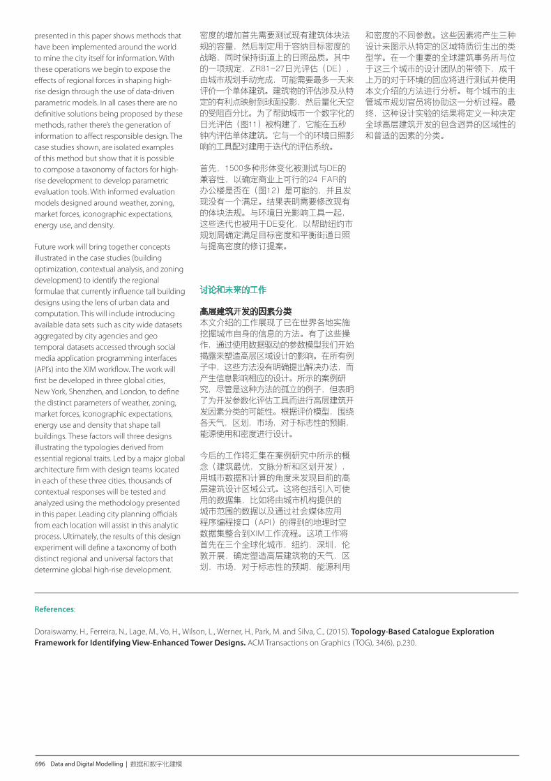
Figure 11. Outline for computational method for Daylight Evaluation. Evaluation of individual design schemes could be computed in five seconds, whereas manual calculation would take a day. (Source: KPF)图11. 日照评估计算方法的概述。单个设计方案的评估可以在5秒内计算得出,而人工计算则需要一天。 (来源: KPF)
Figure 12. Example of results yielded by evolutionary optimization techniques while using Daylight Evaluation as a fitness value. Over 1500 options within the parameter space of a commercially viable building design were tested with no successful convergence. (Source: KPF)图12. 采用日照评估作为为适应值由进化优化技术得到的结果的例子。对商业上可行的建筑设计的参数空间内的超过 1500多个选择进行,没有得到成功结果。(来源: KPF)
First, fifteen hundred massing variations were tested for compliance with DE to determine if a commercially viable 24 FAR office building (Figure 12) was possible and found that none did. The results revealed the need to revise existing bulk regulations. The iterations were also performed for variations of DE in conjunction with the ambient-daylight-impact tool to help NYC DCP identify revisions that would accommodate the target density and balance the increase in density with daylight access on streets.
Discussion and Future Work
Taxonomy of Factors for High- Rise Development The production of tall buildings is an increasingly global venture. But the constraints, burdens, and aspirations that shape them are local; specific to the cities these buildings become a part of. The work
Volume 1 and 2 BOOK.indb 695 9/13/2016 11:45:50 AM
696 Data and Digital Modelling | 数据和数字化建模
presented in this paper shows methods that have been implemented around the world to mine the city itself for information. With these operations we begin to expose the effects of regional forces in shaping high- rise design through the use of data-driven parametric models. In all cases there are no definitive solutions being proposed by these methods, rather there’s the generation of information to affect responsible design. The case studies shown, are isolated examples of this method but show that it is possible to compose a taxonomy of factors for high- rise development to develop parametric evaluation tools. With informed evaluation models designed around weather, zoning, market forces, iconographic expectations, energy use, and density.
Future work will bring together concepts illustrated in the case studies (building optimization, contextual analysis, and zoning development) to identify the regional formulae that currently influence tall building designs using the lens of urban data and computation. This will include introducing available data sets such as city wide datasets aggregated by city agencies and geo temporal datasets accessed through social media application programming interfaces (API’s) into the XIM workflow. The work will first be developed in three global cities, New York, Shenzhen, and London, to define the distinct parameters of weather, zoning, market forces, iconographic expectations, energy use and density that shape tall buildings. These factors will three designs illustrating the typologies derived from essential regional traits. Led by a major global architecture firm with design teams located in each of these three cities, thousands of contextual responses will be tested and analyzed using the methodology presented in this paper. Leading city planning officials from each location will assist in this analytic process. Ultimately, the results of this design experiment will define a taxonomy of both distinct regional and universal factors that determine global high-rise development.
密度的增加首先需要测试现有建筑体块法规的容量,然后制定用于容纳目标密度的战略,同时保持街道上的日照品质。其中的一项规定,ZR81-27日光评估(DE),由城市规划手动完成,可能需要最多一天来评价一个单体建筑。建筑物的评估涉及从特定的有利点映射到球面投影,然后量化天空的受阻百分比。为了帮助城市一个数字化的日光评估(图11)被构建了,它能在五秒钟内评估单体建筑。它与一个的环境日照影响的工具配对建用于迭代的评估系统。
首先,1500多种形体变化被测试与DE的兼容性,以确定商业上可行的24 FAR的办公楼是否在(图12)是可能的,并且发现没有一个满足。结果表明需要修改现有的体块法规。与环境日光影响工具一起,这些迭代也被用于DE变化,以帮助纽约市规划局确定满足目标密度和平衡街道日照与提高密度的修订提案。
讨论和未来的工作
高层建筑开发的因素分类 本文介绍的工作展现了已在世界各地实施挖掘城市自身的信息的方法。有了这些操作,通过使用数据驱动的参数模型我们开始揭露来塑造高层区域设计的影响。在所有例子中,这些方法没有明确提出解决办法,而产生信息影响相应的设计。所示的案例研究,尽管是这种方法的孤立的例子,但表明了为开发参数化评估工具而进行高层建筑开发因素分类的可能性。根据评价模型,围绕各天气,区划,市场,对于标志性的预期,能源使用和密度进行设计。
今后的工作将汇集在案例研究中所示的概念(建筑最优,文脉分析和区划开发),用城市数据和计算的角度来发现目前的高层建筑设计区域公式。这将包括引入可使用的数据集,比如将由城市机构提供的城市范围的数据以及通过社会媒体应用程序编程接口(API)的得到的地理时空数据集整合到XIM工作流程。这项工作将首先在三个全球化城市,纽约,深圳,伦敦开展,确定塑造高层建筑物的天气,区划,市场,对于标志性的预期,能源利用
References: Doraiswamy, H., Ferreira, N., Lage, M., Vo, H., Wilson, L., Werner, H., Park, M. and Silva, C., (2015). Topology-Based Catalogue Exploration Framework for Identifying View-Enhanced Tower Designs. ACM Transactions on Graphics (TOG), 34(6), p.230.
和密度的不同参数。这些因素将产生三种设计来图示从特定的区域特质衍生出的类型学。在一个重要的全球建筑事务所与位于这三个城市的设计团队的带领下,成千上万的对于环境的回应将进行测试并使用本文介绍的方法进行分析。每个城市的主管城市规划官员将协助这一分析过程。最终,这种设计实验的结果将定义一种决定全球高层建筑开发的包含迥异的区域性的和普适的因素的分类。
Volume 1 and 2 BOOK.indb 696 9/13/2016 11:45:50 AM