cultural heritage impact assessment of the proposed emergency nondabula water ... ba/appendix...
TRANSCRIPT

Nondabula Water Reticulation
Active Heritage cc for Royal Haskoning DHV i
CULTURAL HERITAGE IMPACT ASSESSMENT
OF THE PROPOSED EMERGENCY NONDABULA
WATER RETICULATION PROJECT, WARD 9 OF
THE NODWENGU TRADITIONAL COUNCIL,
ILEMBE REGIONAL MUNICIPALITY.
ACTIVE HERITAGE cc. FOR: ROYAL HASKONING DHV
Frans Prins
MA (Archaeology)
P.O. Box 947
Howick
3290
Fax: 0867636380
www.activeheritage.webs.com
15June 2015

Nondabula Water Reticulation
Active Heritage cc for Royal Haskoning DHV ii
TABLE OF CONTENTS
1 BACKGROUND INFORMATION ON THE PROJECT ........................................... 2
1.1. Details of the area surveyed: ........................................................................ 3
2 BACKGROUND TO ARCHAEOLOGICAL HISTORY OF AREA .......................... 3
3 BACKGROUND INFORMATION OF THE SURVEY ............................................. 8
3.1 Methodology ................................................................................................. 8
3.2 Restrictions encountered during the survey .................................................. 8
3.2.1 Visibility ..................................................................................................... 8
3.2.2 Disturbance ............................................................................................... 9
3.3 Details of equipment used in the survey ........................................................ 9
4 DESCRIPTION OF SITES AND MATERIAL OBSERVED ..................................... 9
4.1 Locational data ............................................................................................. 9
4.2 Description of the general area surveyed ...................................................... 9
5 STATEMENT OF SIGNIFICANCE (HERITAGE VALUE) .................................... 11
6 RECOMMENDATIONS ....................................................................................... 11
7 MAPS AND FIGURES ......................................................................................... 12
8 REFERENCES ........................................................................................................ 15
LIST OF TABLES
Table 1. Background information .................................................................................. 2
Table 2. Evaluation and statement of significance………………………………………..10
Table 3 Field rating and recommended grading of sites (SAHRA 2005) ..................... 11

Nondabula Water Reticulation
Active Heritage cc for Royal Haskoning DHV iii
LIST OF ABBREVIATIONS AND ACRONYMS
EIA Early Iron Age
ESA Early Stone Age
HISTORIC PERIOD Since the arrival of the white settlers - c. AD 1820 in this part of the
country
IRON AGE
Early Iron Age AD 200 - AD 1000
Late Iron Age AD 1000 - AD 1830
LIA Late Iron Age
LSA Late Stone Age
MSA Middle Stone Age
NEMA National Environmental Management Act, 1998 (Act No. 107 of 1998
and associated regulations (2006).
NHRA National Heritage Resources Act, 1999 (Act No. 25 of 1999) and
associated regulations (2000)
SAHRA South African Heritage Resources Agency
STONE AGE
Early Stone Age 2 000 000 - 250 000 BP
Middle Stone Age 250 000 - 25 000 BP
Late Stone Age 30 000 - until c. AD 200

Nondabula Water Reticulation
Active Heritage cc for Royal Haskoning DHV 1
EXECUTIVE SUMMARY
A cultural heritage survey of the proposed Emergency Nondabula Water Reticulation
Project, Ward 9 of the Nodwengu Traditional Council, ILembe Regional Municipality
identified no heritage sites or features on the footprint. There is no known archaeological
reason why the proposed development may not proceed on the footprint as planned.
The area is also not part of any known cultural landscape. However, attention is drawn
to the South African Heritage Resources Act, 1999 (Act No. 25 of 1999) and the
KwaZulu-Natal Heritage Act (Act no 4 of 2008) which, requires that operations that
expose archaeological or historical remains should cease immediately, pending
evaluation by the provincial heritage agency.
Nondabula Water Reticulation
Active Heritage cc for Royal Haskoning DHV 2
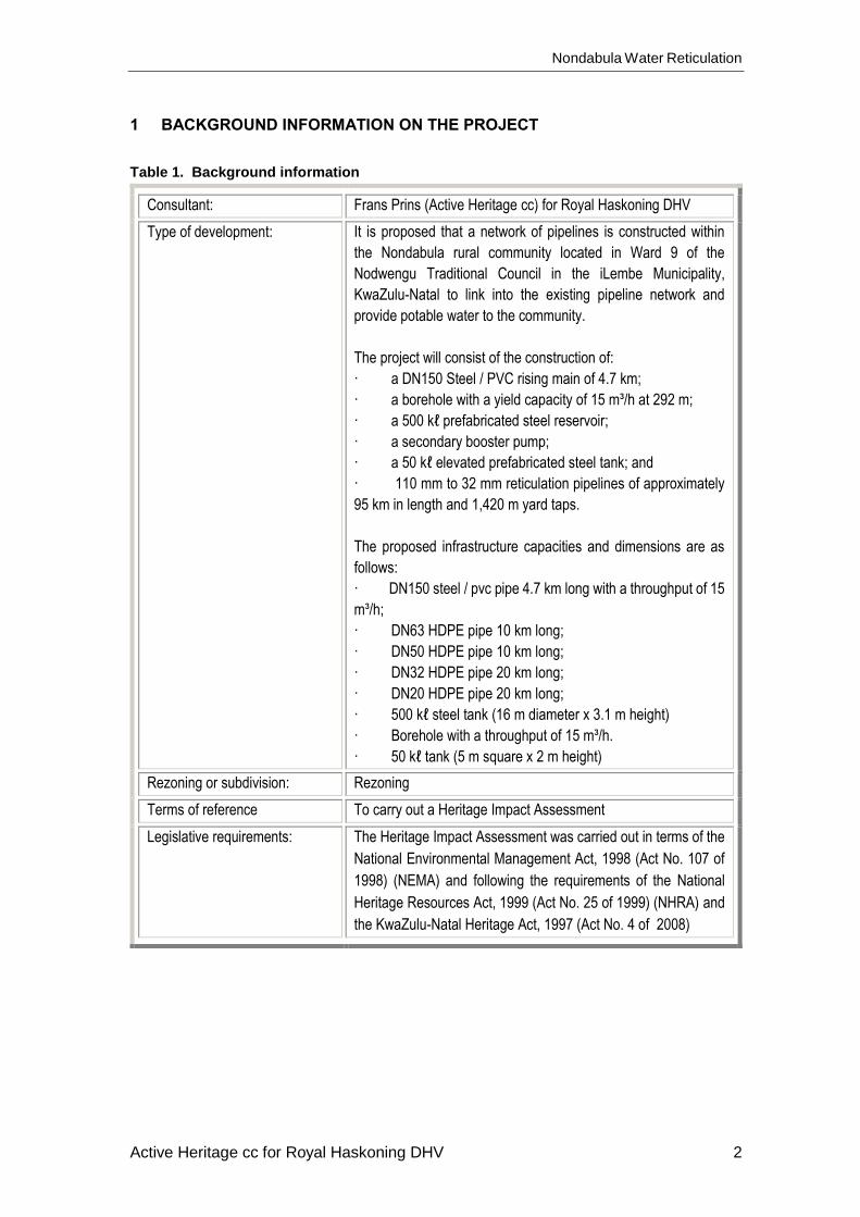
1 BACKGROUND INFORMATION ON THE PROJECT
Table 1. Background information
Consultant: Frans Prins (Active Heritage cc) for Royal Haskoning DHV
Type of development: It is proposed that a network of pipelines is constructed within
the Nondabula rural community located in Ward 9 of the
Nodwengu Traditional Council in the iLembe Municipality,
KwaZulu-Natal to link into the existing pipeline network and
provide potable water to the community.
The project will consist of the construction of:
· a DN150 Steel / PVC rising main of 4.7 km;
· a borehole with a yield capacity of 15 m³/h at 292 m;
· a 500 kℓ prefabricated steel reservoir;
· a secondary booster pump;
· a 50 kℓ elevated prefabricated steel tank; and
· 110 mm to 32 mm reticulation pipelines of approximately
95 km in length and 1,420 m yard taps.
The proposed infrastructure capacities and dimensions are as
follows:
· DN150 steel / pvc pipe 4.7 km long with a throughput of 15
m³/h;
· DN63 HDPE pipe 10 km long;
· DN50 HDPE pipe 10 km long;
· DN32 HDPE pipe 20 km long;
· DN20 HDPE pipe 20 km long;
· 500 kℓ steel tank (16 m diameter x 3.1 m height)
· Borehole with a throughput of 15 m³/h.
· 50 kℓ tank (5 m square x 2 m height)
Rezoning or subdivision: Rezoning
Terms of reference To carry out a Heritage Impact Assessment
Legislative requirements: The Heritage Impact Assessment was carried out in terms of the
National Environmental Management Act, 1998 (Act No. 107 of
1998) (NEMA) and following the requirements of the National
Heritage Resources Act, 1999 (Act No. 25 of 1999) (NHRA) and
the KwaZulu-Natal Heritage Act, 1997 (Act No. 4 of 2008)

Nondabula Water Reticulation
Active Heritage cc for Royal Haskoning DHV 3
1.1. Details of the area surveyed:
The study area lies between Tongaat and Dalton adjacent to the R614 within the ILembe
District Municipality (Fig 1). The most unique characteristic of the Municipality is its
predominantly rural character comprising mostly of tribal land (99.49%) which falls within
the Ingonyama Trust. The area is dominated by grassland and predominantly
indigenous woody vegetation in the river valleys. Exotic woodlot plantations occur in the
higher altitude areas. The footprint covers an area of approximately 6km x 4km. The
GPS coordinates for centre of the footprint is: S 29º 23’ 52.93” E 30º 52’ 51.01”. The
proposed development site is boarded by tribal communal areas and the entire area is
located within the catchment area of the Thukela River.
2 BACKGROUND TO ARCHAEOLOGICAL HISTORY OF AREA
The archaeological history of the Province of KwaZulu-Natal (KZN) dates back to about
2 million years and possibly older, which marks the beginning of the Stone Age. The
Stone Age in KZN was extensively researched by Professor Oliver Davies formerly of
the Natal Museum. The Stone Age period has been divided in to three periods namely:
Early Stone Age (ESA) dating between 2 million years ago to about 200 000 years ago,
Middle Stone Age (MSA) dating between 200 000 years ago to about 30 000 years ago,
and the Later Stone Age (LSA) which dates from 30 000 to about 2 000 year ago. The
Stone Age period ends around approximately 2 000 years ago when Bantu speaking
Age farmers from the north arrived in southern Africa. The Iron Age is also divided into
three periods, namely: Early Iron Age (EIA) dating between AD 200 and AD 900, Middle
Iron Age (MIA) dating between AD 900 and AD 1300, Late Iron Age (LIA) dating between
AD 1 300 and 1 820.
2.1 Stone Age
2.1.1 Early Stone Age (ESA)
The ESA is considered as the beginning of the stone tool technology. It dates back to
over 2 million years ago until 200 000 years ago. This period is characterised by
Oldowan and Acheulean industries. The Oldowan Industry, dating to approximately
between over 2 million years and 1.7 million years predates the later Acheulean. The
Oldowan Industry consists of very simple, crudely made core tools from which flakes are
struck a couple of times. To date, there is no consensus amongst archaeologists as to
which hominid species manufactured these artefacts. The Acheulean Industry lasted

Nondabula Water Reticulation
Active Heritage cc for Royal Haskoning DHV 4
from about 1.7 million years until 200 thousand years ago. Acheulean tools were more
specialized tools than those of the earlier industry. They were shaped intentionally to
carry out specific tasks such as hacking and bashing to remove limbs from animals and
marrow from bone. These duties were performed using the large sharp pointed artefacts
known as handaxes. Cleavers, with their sharp, flat cutting edges were used to carry out
more heavy duty butchering activities (Esterhuysen, 2007). The ESA technology lasted
for a very long time, from early to middle Pleistocene and thus seems to have been
sufficient to meet the needs of early hominids and their ancestors. Although not identified
on the footprint, ESA tools occurrence have been reported in other sites in KZN. Apart
from stone artefacts, the ESA sites in this Province have produced very little as regards
other archaeological remains. This has made it difficult to make inferences pointing to
economical dynamics of the ESA people in this part of the world. The diet of ESA peoples
has therefore had to be reconstructed on the basis of evidence from elsewhere that it
comprised primarily of animal and plant foods (Mazel 1989).
2.1.2 Middle Stone Age (MSA)
The MSA dates to between 200 000 and 30 000 years ago, coinciding with the
emergence of modern humans. The MSA technology is therefore believed to have been
manufactured by fully modern humans known as Homo sapiens who emerged around
250 000 years ago. While some of the sites belonging to this time period occur in similar
contexts as those of ESA, most of the MSA sites are located in rock shelters.
Palaeoenvironmental data suggest that the distribution of MSA sites in the high lying
Drakensberg and surrounding areas was influenced by the climate conditions,
specifically the amount and duration of snow (Carter, 1976). In general, the MSA stone
tools are smaller than those of the ESA. Although some MSA tools are made from
prepared cores, the majority of MSA flakes are rather irregular and are probably waste
material from knapping exercises. A variety of MSA tools include blades, flakes, scrapers
and pointed tools that may have been hafted onto shafts or handles and used as
spearheads. Between 70 000 and 60 000 years ago new tool types appear known as
segments and trapezoids. These tool types are referred to as backed tools from the
method of preparation. Residue analyses on the backed tools from South African MSA
sites including those in KZN indicate that these tools were certainly used as spear heads
and perhaps even arrow points (Wadley, 2007). A few sites with impressive MSA
deposits have been excavated in KZN. Perhaps the best known ones are Sibudu Cave
and Umhlatuzana Cave to the south of the study area, and Border Cave to the north of

Nondabula Water Reticulation
Active Heritage cc for Royal Haskoning DHV 5
the study area. All these sites provided impressive evidence for fine resolution data and
detailed stratigraphy (Wadley & Jacobs, 2006).
2.1.3 Late Stone Age (LSA)
Compared to the earlier MSA and ESA, more is known about the LSA which dates from
around 30 000 to 2 000 (possibly later) years ago. This is because LSA sites are more
recent than ESA and MSA sites and therefore achieve better preservation of a greater
variety of organic archaeological material. The Later Stone Age is usually associated
with the San (Bushmen) or their direct ancestors. The tools during this period were even
smaller and more diverse than those of the preceding Middle Stone Age period. LSA
tool technology is observed to display rapid stylistic change compared to the slower pace
in the MSA. The rapidity is more evident during the last 10 000 years. The LSA tool
sequence includes informal small blade tradition from about 22 000 – 12 000 years ago,
a scraper and adze-rich industry between 12 000 – 8 000 years ago, a backed tool and
small scraper industry between 8 000 – 4 000 years and ending with a variable set of
other industries thereafter (Wadley, 2007). Adzes are thought to be wood working tools
and may have also been used to make digging sticks and handles for tools. Scrapers
are tools that are thought to have been used to prepare hides for clothing and
manufacture of other leather items. Backed tools may have been used for cutting as well
as tips for arrows It was also during Later Stone Age times that the bow and arrow was
introduced into southern Africa – perhaps around 20 000 years ago. Because of the bow
and arrow and the use of traps and snares, Later Stone Age people were far more
efficient in exploiting their natural environment than Middle Stone Age people. Up until
2 000 years ago Later Stone Age people dominated the southern African landscape.
However, shortly after 2 000 years ago the first Khoi herders and Bantu-speaking agro
pastoralists immigrated into southern Africa from the north. This led to major
demographic changes in the population distribution of the subcontinent. San hunter-
gatherers were either assimilated or moved off to more marginal environments such as
the Kalahari Desert or some mountain ranges unsuitable for small-scale subsistence
farming and herding. The San in the coastal areas of KZN were the first to have been
displaced by incoming African agro pastoralists. However, some independent groups
continue to practice their hunter gatherer lifestyle in the foothills of the Drakensberg until
the period of white colonialisation around the 1840’s (Wright & Mazel, 2007). According
to the Natal Museum archaeological database Later Stone Age sites have been located
in the Tugela River in the past but these are mostly restricted to surface scatters. Also
dating to the LSA period is the impressive Rock Art found on cave walls and rock faces.
Nondabula Water Reticulation
Active Heritage cc for Royal Haskoning DHV 6
Rock Art can be in the form of rock paintings or rock engravings. The province of KZN
is renowned for the prolific San rock painting sites concentrated in the Drakensberg.
Rock art sites do occur outside the Drakensberg including Zululand, however, these
sites have not been afforded similar research attention as those sites occurring in the
Drakensberg. One rock art site is known to occur within the near vicinity of the project
area approximately 6km to the west of the footprint.
2.2 Iron Age
2.2.1 Early Iron Age (EIA)
Unlike the Stone Age people whose life styles were arguably egalitarian, Iron Age people
led quite complex life styles. Their way of life of greater dependence on agriculture
necessitated more sedentary settlements. They cultivated crops and kept domestic
animals such as cattle, sheep, goats and dogs. Pottery production is also an important
feature of Iron Age communities. Iron smelting was practised quite significantly by Iron
Age society as they had to produce iron implements for agricultural use. However no
smelting sites were discovered in the study area as it is the northern KZN that is rich in
abandoned iron smelting sites (Maggs, 1989). Although Iron Age people occasionally
hunted and gathered wild plants and shellfish, the bulk of their diet consisted of the crops
they cultivated as well as the meat of the animals they kept. EIA villages were relatively
large settlements strategically located in valleys beside rivers to take advantage of the
fertile alluvial soils for growing crops (Maggs, 1989). The EIA sites in KZN date to around
AD 500 to AD 900. Extensive research in the province of this period led to it being divided
in the following time lines according to ceramic styles (Maggs, 1989; Huffman 2007):
_ Msuluzi (AD 500);
_ Ndondondwane (AD 700 – 800);
_ Ntshekane (AD 800 – 900).
The archaeological data base of the Natal Museum indicates that ten Early Iron Age
sites occur in the immediate vicinity of the study area. Some well-known excavated sites
such as Mamba, Whosi and Ndondondwane (Huffman 2007) occurs in the immediate
vicinity of the project area on the banks of the Thukela River.
2.2.2 Late Iron Age (LIA)
The LIA is not only distinguished from the EIA by greater regional diversity of pottery
styles but is also marked by extensive stone wall settlements. However, in this part of
the world, stone walls were not common as the Nguni people used thatch and wood to
build their houses. This explains the failure to obtain sites from the aerial photograph
Nondabula Water Reticulation
Active Heritage cc for Royal Haskoning DHV 7
investigation of the study area. Trade played a major role in the economy of LIA
societies. Goods were traded locally and over long distances. The main trade goods
included metal, salt, grain, cattle and thatch. This led to the establishment of
economically driven centres and the growth of trade wealth. Keeping of domestic
animals, metal work and the cultivation of crops continued with a change in the
organisation of economic activities. Evidence for this stems from the fact that iron
smelting evidence was not found in almost every settlement (Maggs, 1989; Huffman
2007).
2.3 Historic Period
Oral tradition is the basis of the evidence of historical events that took place before
history could be recorded. This kind of evidence becomes even more reliable in cases
where archaeology could be utilised to back up the oral records. Sources of evidence
for socio political organization during the mid-eighteenth to early nineteenth century in
the study area and the larger former Natal Province suggest that the people here existed
in numerous small-scale political units of different sizes, population numbers and
political structures (Wright & Hamilton, 1989). This period was largely characterised by
rage and instability as political skirmishes broke due to the thirst for power and resources
between chiefdoms. During the 2nd half of the eighteenth century, stronger chiefdoms
and paramouncies emerged. However, these were not fully grown states as there was
no proper formal central political body established. This changed in the 1780’s when a
shift towards a more centralized political state occurred. This shift was mainly
characterized by population growth and geographical expansion of states. The most
important and largest and strongest states at the time were the Mabhudu, Ndwandwe
and Mthethwa. However, other smaller states, also established themselves in the
greater Tugela Region. These included in the south the Qwabe, Bhaca, Mbo, Hlubi,
Bhele, Ngwane and many others (Wright & Hamilton, 1989). The Zulu kingdom,
established by King Shaka however remained the most powerful in the region in the
early years of the 19th century. Shaka fought ruthlessly and often defeated his rivals and
conquered their cattle, wives and even burnt their villages. These wars are often referred
to as Difaqane and this period was characterised by rage and blood shedding. Shaka
was assassinated in 1828 at which time he had transformed the nature of the society in
the Natal and Zululand regions. He was succeeded by Dingaan (Wright & Hamilton,
1989). Dutch farmers unhappy with the British rule in Cape Town decided to explore into
the interior of the country, away from British rule. Some groups remained in the Eastern

Nondabula Water Reticulation
Active Heritage cc for Royal Haskoning DHV 8
Cape, others kept going and a few settled in the Orange Free State and the Transvaal.
A great number, led by Piet Retief and Gerrit Maritz, crossed the Drakensberg into Natal.
Here they encountered the Zulus who lured them into a trap and brutally massacred
many of them. This was only one of the many failures of the white settler expeditions in
the frontier areas and when the shocking news reached the Cape, more groups were
sent to the interior to revenge. A series of battles were fought but the most notable was
the Battle of Blood River in 1838 where the Boers defeated the Zulus. This ended the
Zulu threat to the white settlers and a permanent and formal settlement in Natal was
established. However the Zulu kingdom remained independent for a couple of decades.
The Republic of Natalia was annexed by the British in 1845 and in 1879 the Zulu
kingdom was also invaded (Wright & Hamilton, 1989). The Anglo-Zulu War has been
well recorded and an important occurrence took place at Jamesons Drift, to the north of
the project area, when a few British soldiers attempted to cross the Thukela River after
their defeat at the battle of Isandlwana. Although no relicts or artefacts survive from this
encounter the surrounding landscape is still imbued with the meaning of this important
period in the colonial history of KwaZulu-Natal.
3 BACKGROUND INFORMATION OF THE SURVEY
3.1 Methodology
A desktop study was conducted of the archaeological databases housed in the KwaZulu-
Natal Museum. In addition, the available archaeological and historical literature covering
the greater Thukela River catchment area was also consulted. The SAHRIS website was
consulted to assess previous heritage surveys done in the area.
Ground surveys, following standard and accepted archaeological procedures, was
conducted on the 6th and 16th June 2015.
3.2 Restrictions encountered during the survey
3.2.1 Visibility
Visibility is good. However, dense vegetation in the river valleys may have compromised
archaeological site visibility.
Nondabula Water Reticulation
Active Heritage cc for Royal Haskoning DHV 9
3.2.2 Disturbance
No disturbance of any potential heritage features was noted. Overgrazing and removal
of trees for fire wood led to the better archaeological visibility of the footprint.
3.3 Details of equipment used in the survey
GPS: Garmin Etrek
Digital cameras: Canon Powershot A460
All readings were taken using the GPS. Accuracy was to a level of 5 m.
4 DESCRIPTION OF SITES AND MATERIAL OBSERVED
4.1 Locational data
Province: KwaZulu-Natal
Towns: Situated between Dalton and Tongaat
Municipality: iLembe Regional Municipality
4.2 Description of the general area surveyed
The project area is classified as a rural area. The land use surrounding the study area
is flanked by indigenous woody vegetation in the river valleys and grasslands, mostly
disturbed, in the higher altitude areas (Fig 2). The footprint is situated in a communal
area with a large percentage of rural homesteads occupied by Zulu-speaking small-
scale subsistence farmers. Most of these are spatially ordered in the traditional Nguni
dispersed settlement pattern or more modern variations thereof. The majority of
homesteads, in the area demarcated for development, appear to have been built in the
last 30 years or so.
No heritage sites were located on the footprint.
The middle reaches of the Thukela River Valley has been thoroughly surveyed by
archaeologists during the last 30 years or so. This area was the focus of various
research projects by archaeologists associated with the then Natal and Ondini Museums
respectively (Huffman 2007). However, it appears that no surveys were conducted in
the project area (Ward 9 of the Nodwengu Traditional Council). Most surveys have been
conducted to the north west of the actual study area adjacent to the Tugela River. Three
Nondabula Water Reticulation
Active Heritage cc for Royal Haskoning DHV 10
Early Iron Age sites have also been excavated in the recent past notably by
archaeologist Len van Schalkwyk who has been working in this area for many years
(ibid). The records of the KwaZulu-Natal Museum indicate the presence of 2 Early Stone
Age sites, 3 Middle Stone Age sites, 6 Intermediate Stone Age sites, 8 Early Iron Age
sites, 3 Later Iron Age sites, and 2 Historical sites in this area. One rock art site occurs
near the project area about 6km to the west of the footprint. Although some rocky
outcrops occur in the valley flanks none of them had any shelters that may harbour
archaeological deposits (Fig 3). Particular care was taken to identify modern grave sites
but none were located within 40m from the identified in situ development proposal. There
is a possibility that some “invisible” graves may occur within the various homesteads
located in the footprint (Fig 4). These, however, were not evident during the ground
survey. The footprint is also not part of any known cultural landscape (Table 2).
Table 2. Evaluation and statement of significance.
Significance criteria in terms of Section 3(3) of the NHRA
Significance Rating
1. Historic and political significance - The importance of the cultural
heritage in the community or pattern of South Africa’s history.
None.
2. Scientific significance – Possession of uncommon, rare or endangered
aspects of South Africa’s cultural heritage.
None.
3. Research/scientific significance – Potential to yield information that will
contribute to an understanding of South Africa’s natural or cultural heritage.
None.
4. Scientific significance – Importance in demonstrating the principal
characteristics of a particular class of South Africa’s cultural places/objects.
None.
5. Aesthetic significance – Importance in exhibiting particular aesthetic
characteristics valued by a community or cultural group.
None.
6. Scientific significance – Importance in demonstrating a high degree of
creative or technical achievement at a particular period.
None.
7. Social significance – Strong or special association with a particular
community or cultural group for social, cultu-ral or spiritual reasons.
None.
8. Historic significance – Strong or special association with the life and work
of a person, group or organization of importance in the history of South
Africa.
None.
9. The significance of the site relating to the history of slavery in South Africa.
None.

Nondabula Water Reticulation
Active Heritage cc for Royal Haskoning DHV 11
5 STATEMENT OF SIGNIFICANCE (HERITAGE VALUE)
No heritage sites occur on the actual footprint and the field rating of relevant sites (Table
3) does not apply.
Table 3. Field rating and recommended grading of sites (SAHRA 2005)
Level Details Action
National (Grade I) The site is considered to be of
National Significance
Nominated to be declared by
SAHRA
Provincial (Grade II) This site is considered to be of
Provincial significance
Nominated to be declared by
Provincial Heritage Authority
Local Grade IIIA This site is considered to be of HIGH
significance locally
The site should be retained as a
heritage site
Local Grade IIIB This site is considered to be of HIGH
significance locally
The site should be mitigated, and
part retained as a heritage site
Generally Protected A High to medium significance Mitigation necessary before
destruction
Generally Protected B Medium significance The site needs to be recorded before
destruction
Generally Protected C Low significance No further recording is required
before destruction
6 RECOMMENDATIONS
The proposed development may proceed from a heritage perspective as no sites occur
on the actual footprint. However, the development must be limited to the actual footprint
or the in situ proposed development as outlined in the brief. Another heritage impact
assessment will be required should the developer decide to construct relevant access
roads or other infrastructure as these may threaten graves and other heritage features
that is not part of the present footprint. In addition, special care must be taken when
linking homesteads specifically with water piping as these may threaten graves situated
within the parameters of the actual homestead. In these instances it would be wise to
liaise with the homestead occupants before the laying of the pipeline. It should also be
pointed out that the KwaZulu-Natal Heritage Act requires that operations exposing
archaeological and historical residues should cease immediately pending an evaluation
by the heritage authorities.

Nondabula Water Reticulation
Active Heritage cc for Royal Haskoning DHV 12
7 MAPS AND FIGURES
Figure 1. Google aerial photograph showing the location of the proposed
Nondabula Water Reticulation Project adjacent to the R614 in the iLembe District
Municipality, KZN.

Nondabula Water Reticulation
Active Heritage cc for Royal Haskoning DHV 13
Figure 2. View over the project area. Most of the project area is covered by
grassland. Indigenous woody vegetation occurs in the valleys whilst exotic
woodlots occur on the higher altitudes. Rural homesteads are scattered in a
typical Nguni dispersed settlement pattern.

Nondabula Water Reticulation
Active Heritage cc for Royal Haskoning DHV 14
Figure 3. Although rocky outcrops occur in some valleys none harboured caves
or shelters with potential archaeological deposit.
Figure 4. Most of the proposed pipelines will follow the existing road network of
the project area. These often occur in the close proximity of rural settlements that
may harbour “invisible graves” within the homestead.

Nondabula Water Reticulation
Active Heritage cc for Royal Haskoning DHV 15
8 REFERENCES
Carter, P.L. 1976. ‘The Effect of Climatic Change on Settlement in Eastern Lesotho during the Middle and Later Stone Age.’ World Archaeology, 8, 198 – 206. Esterhuysen, A., 2007. The Earlier Stone Age. In Bonner, P., Esterhuysen, A., Jenkins, T. (eds.): A Search for Origins: Science, History and South Africa’s ‘Cradle of Humankind’. Johannesburg: Wits University Press. Pg 110 -121. Huffman, T. 2007. Handbook to the Iron Age: The Archaeology of Pre-Colonial Farming Societies in Southern Africa. University of KwaZulu-Natal Press, Pietermaritzburg. Loubser, J. 1993. Ndondondwane: the significance of features and finds from a ninth century site on the lower Thukela River, Natal. Natal Museum Journal of Humanities. 5: 109-151 Maggs, T. 1989. The Iron Age farming communities. In Duminy. A. & Guest, B.(eds). Natal and Zululand: From Earliest Times to 1910 – A New History: 28 - 48. University of KwaZulu-Natal Press. Mazel, A. 1989. The Stone Age peoples of Natal. In Duminy, A & Guest, B.(eds). Natal and Zululand: From Earliest Times to 1910 – A New History: 1 - 27. University of KwaZulu-Natal Press. SAHRA, 2005. Minimum Standards for the Archaeological and the Palaeontological Components of Impact Assessment Reports, Draft version 1.4. Van Schalkwyk, L. O, 1994a. Wosi: an early Iron Age village in the lower Thukela Basin, Natal. Natal Museum Journal of Humanities : 65-117 Van Schalkwyk, L. O, 1994b. Mamba Confluence: a preliminary report on an Early Iron Age industrial centre in the lower Thukela Basin, Natal. Natal Museum Journal of Humanities 6: 119-152 Wadley, L & Jacobs, Z. 2006. Sibudu Cave: background to the excavations, stratigraphy and dating. Southern African Humanities. 18 (1): 1-26. Wadley. L., 2007. The Middle Stone Age and Later Stone Age. In Bonner, P., Esterhuysen, A., Jenkins, T. (eds.): A Search for Origins: Science, History and South Africa’s ‘Cradle of Humankind’. Johannesburg: Wits University Press. Pg 122 -135. Wright, J. and Hamilton, C. 1989. Tradition and transformations – The Phongolo- Mzimkhulu region in the late eighteenth and early nineteenth centuries. In Duminy, A & Guest, B.(eds). 1989 Natal and Zululand: From Earliest Times to 1910 – A new history: 49 – 82. University of KwaZulu-Natal Press.
Nondabula Water Reticulation
Active Heritage cc for Royal Haskoning DHV 16