cultural mapping and indigenous peoples - … · cultural mapping and indigenous peoples ... 3.6...
TRANSCRIPT
CULTURAL MAPPING AND
INDIGENOUS PEOPLES
A report for UNESCO
Peter Poole
March 2003
CONTENTS 1 INTRODUCTION 2 IMPORTANCE OF ECONOMIC, SOCIAL AND CULTURAL RIGHTS FOR
INDIGENOUS PEOPLES 2.1 International Conventions and Declarations 2.2 The Universal Declaration On Cultural Diversity 2.3 Other UNESCO Programmes Linking Peoples to Land 2.4 The Situation of Pygmy Peoples in Terms of Cultural Security 2.5 Pygmy Peoples and Land 2.6 What is Cultural Mapping? 3 GENERAL INTRODUCTION TO COMMUNITY MAPPING 3.1 Global Diversity in Community-Based Mapping 3.2 Two main Mapping Strategies: Territorial and Community 3.3 Mapping Methodologies 3.4 Map Legends 3.5 Making a Geographically Accurate Map in Three Stages 3.6 Map and Landscape Model-Making in Indonesia and the Philippines. 3.7 The Developmental Effects of Community Map-Making 4 CONCLUDING REMARKS 4.1 Possible Next Steps 4.2 Cultural mapping training for Pygmies
1 INTRODUCTION This report focuses upon items 1 and 3 in the terms of references. Concerning item 2 (workshop consultation) there was insufficient time or opportunity during the workshop period to develop an inclusive discussion on the topic, much less plan field activities for each of the 7 countries represented. However, I held several informal talks with the Pygmy representatives and in Yaounde, met with NGO’s that have been supporting Baka communities in Cameroon, most interestingly with the Centre for Environment and Development, who have had experience in mapping with Baka communities and are keenly interested in continuing. The first section discusses the Universal Declaration on Cultural Diversity in relation to other global mechanisms of significance for indigenous peoples, as well as other UNESCO programmes. It also discusses economic, social and cultural rights for indigenous peoples and concludes with a summary of the situation of Pygmy peoples in terms of cultural security: their problems and their use so far of cultural mapping in addressing these. The main section deals with cultural mapping, its origins and its purposes and is illustrated with examples drawn from around the world. The final section proposes ways for UNESCO to follow up. 2 IMPORTANCE OF ECONOMIC, SOCIAL AND CULTURAL RIGHTS FOR
INDIGENOUS PEOPLES 2.1 International Conventions and Declarations For indigenous peoples the key collective rights that they clamour for recognition of are their rights to self-determination, in line with Article 1 of the International Covenant on Civil and Political Rights, and also their right to the collective ownership, control, management and use of their lands and territories. The latter right has been affirmed in the International Labour Organisation’s Convention 169 and has been repeatedly called attention to by the UN Human Rights Committee and the Committee on the Convention for All Types of Racial Discrimination. In its various approaches to the question of indigenous peoples and cultural heritage, UNESCO has also recognised the importance of a recognition of land rights and effective participation as prerequisites for cultural security and effective environmental protection. For example, the Convention Concerning the Protection of the World Cultural and Natural Heritage states that one of the intentions of listing areas of outstanding value for natural and cultural heritage as ‘World Heritage Sites’ is to ensure that they are managed and protected to the highest international standards.
Paragraph 14 of the Operational Guidelines for the Implementation of the World Heritage Convention notes:
Participation of local people in the nomination process is essential to make them feel a shared responsibility with the State Party in the maintenance of the site.
In evaluating the inclusion of any area in the World Heritage Sites list, UNESCO and its partner agencies are required to assess the management plan for the area and ensure there is clarity about the ownership and legal status of the property being proposed, in accordance with paragraphs 21 and 64(4 a,b) of the Operational Guidelines for the Implementation of the World Heritage Convention. The connection between Indigenous lands and cultural integrity, as well as the need to protect both, has been recognized by UNESCO numerous times in the past. For example, the 1981 UNESCO Declaration of San Jose on Ethno-Development and Ethnocide in Latin America,1 provides that:
For Indian peoples, the land is not only an object of possession and production. It forms the basis of their existence, both physical and spiritual, as an independent entity. Territorial space is the foundation and source of their relationship with the universe and the mainstay of their view of the world.
It continues that:
The Indian peoples have a natural and inalienable right to the territories that they possess as well as the right to recover the land taken away from them. This implies the right to the natural and cultural heritage that this territory contains and the right to determine freely how it will be used and exploited.
2.2 The Universal Declaration On Cultural Diversity In its Universal Declaration on Cultural Diversity, UNESCO notes the importance of States adopting inclusive ways of encouraging cultural diversity through policies of cultural pluralism. Article 2 – From cultural diversity to cultural pluralism notes:
In our increasingly diverse societies, it is essential to ensure harmonious interaction among people and groups with plural, varied and dynamic cultural identities as well as their willingness to live together. Policies for the inclusion and participation of all citizens are guarantees of social cohesion, the vitality of civil society and peace. Thus defined, cultural pluralism gives policy expression to the reality of cultural diversity. Indissociable from a democratic framework, cultural pluralism is conducive to cultural exchange and to the flourishing of
1 UNESCO Doc. FS82/WF.32 (1982).
creative capacities that sustain public life.
The Declaration explicitly recognises the importance of securing human rights as guarantees of cultural diversity and makes provisions not only for the recognition of the individual human rights of persons but also for the recognition of the implicitly collective human rights of indigenous peoples. Article 4 of the Declaration thus notes:
The defence of cultural diversity is an ethical imperative, inseparable from respect for human dignity. It implies a commitment to human rights and fundamental freedoms, in particular the rights of persons belonging to minorities and those of indigenous peoples. No one may invoke cultural diversity to infringe upon human rights guaranteed by international law, nor to limit their scope.
The TOR drew attention to Articles 2 (above) and 3 of the UDCD and Item 3 of the Action Plan.
Article 3 – Cultural diversity as a factor in development Cultural diversity widens the range of options open to everyone; it is one of the roots of development, understood not simply in terms of economic growth, but also as a means to achieve a more satisfactory intellectual, emotional, moral and spiritual existence.
Action Plan Item 3 Fostering the exchange of knowledge and best practices in regard to cultural pluralism with a view to facilitating, in diversified societies, the inclusion and participation of persons and groups from varied cultural backgrounds
Although the imperatives and sentiments expressed in the Declaration are clearly sympathetic in principle to the predicament of indigenous peoples in relation to national societies it seems to offer slight leverage to those who are severely disadvantaged by this relationship, by comparison for example with International Labour Organisation 169 or the Biodiversity Convention. The Declaration does not draw attention to the special cases where cultural identity is intimately linked with a homeland and thus fails to address the root problem faced by indigenous peoples: dispossession of their lands. Indigenous peoples have repeatedly stated that their cultural security is synonymous with, and entirely contingent upon, security of tenure. They are therefore unlikely to take account of any global instrument that does not offers legal opportunities for resolving land rights.
Action Plan Item 14. Respecting and protecting traditional knowledge, in particular that of indigenous peoples; recognizing the contribution of traditional knowledge, particularly with regard to environmental protection and the management of natural resources, and fostering synergies between modern science and local knowledge.
Action Plan Item 14 comes closer to the land issue. Not only is it specific to indigenous peoples, but it recognises the utility of their traditional knowledge for environmental protection . However, it does not contemplate any actions to facilitate the authors of this knowledge actually assuming responsibilities for environmental protection and management, themselves. Indigenous knowledge is operational knowledge; about practice. Like the “knowledge” of London taxi drivers; without London it is irrelevant 2.3 Other UNESCO Programmes Linking Peoples to Land There are two other UNESCO programmes that often have a direct and potentially supportive bearing upon indigenous peoples’ security of tenure and to that extent affect their cultural security. This positive potential has been recognised by some indigenous peoples organisations, to the extent that they have pursued serious inquiries about the prospects for biosphere reserves providing conditional security for indigenous lands as well as the prospects for local indigenous communities assuming operational and management responsibilities in biosphere reserves. These have not met with success. The UNESCO Man and the Biosphere Programme – MAB arose in the early 1970’s, providing housing and prospects for scientific refugees from the terminated 10-year International Biological Programme (IBP). During their tenure, they had identified a large number of “IBP Sites: localities of biological significance in need of protection”. MAB projected a new concept into the global scene: biosphere reserves, defined as “areas of terrestrial and coastal ecosystems promoting solutions to reconcile the conservation of biodiversity with its sustainable use”. People were inserted into the conservation equation and biosphere reserves would combine strictly protected core areas with buffer zones dedicated to compatible uses: traditional, sustainable, or experimentally sustainable. However, MAB officials found this concept difficult to promote to national governments and over time, the reconciliation aspect of biosphere reserves faded into the background. By the mid-eighties, the majority of biosphere reserves were in fact already national parks, although these would only have qualified as core zones within biosphere reserves. No longer an innovative exercise in conservation, MAB had become an endorsement programme for existing protected areas, There are at least six biosphere reserves in areas inhabited by pygmy peoples, but in the official MAB list none of these offer any information under the “socio-economic” category. In one of these, the Dja Faunal Reserve, Baka communities whose ancestral lands are now covered by the Reserve have been prevented from carrying out any activities within the protected area by ecoguards working for ECOFAC. Those who still remain within the Reserve to hunt or gather in the forest are not sanctioned to do so under the current protection regime 2and they have not been invited to participate in Biosphere Reserve-type activities.
2 Nguiffo, S (Forthcoming) One Forest for Two Dreams: The constraints of the Baka from Miatta due to the Dja Wildlife Reserve. IN: FPP (Forthcoming) Indigenous Peoples and Protected Areas in Africa: From principles to practice. Moreton-in-Marsh: FPP.
A second UNESCO instrument for conservation is the World Heritage Convention of 1972, since when 730 World Heritage Sites have been listed – in two categories: "cultural heritage" is a monument, group of buildings or site of historical, aesthetic, archaeological, scientific, ethnological or anthropological value. "Natural heritage" designates outstanding physical, biological, and geological features; habitats of threatened plants or animal species and areas of value on scientific or aesthetic grounds or from the point of view of conservation. Candidate sites, which are usually already legally protected, are nominated by countries. Three Natural World Heritage Sites affect Pygmy peoples. Batwa communities had been evicted from two of these well before they were nominated for the List (2.4.): Bwindi Impenetrable National Park, Uganda and Kahuzi-Biega National Park, Democratic Republic of Congo (DRC). Only one World Heritage Site, the Okapi Wildlife Reserve, DRC, mentions the presence of people: “The Reserve is of special interest for its cultural values, as it is inhabited by traditional nomadic pygmy Mbuti and Efe hunters”. This reserve is under severe threat from the ongoing conflict in Eastern DRC and many Pygmy communities have been forced to flee from the forest due to threats from armed marauders who have been targeting Pygmy communities in the area. Bwindi Impenetrable National Park, Uganda, was declared a Natural World Heritage Site in 1994. The area was declared an animal sanctuary in 1964, when Batwa were pressurized to leave, and gazetted as national park in 1991, when Batwa communities were finally forcibly expelled along with other neighbouring communities involved in agriculture and other forms of forest exploitation. The World Conservation Monitoring Centre (WCMC) provides more information on WH Sites than is available for biosphere reserves. In describing communities around the park , it notes that “Also present are between 50 and 100 Batwa families who have become disadvantaged following their eviction from the forest in 1964.” It also notes that:
The earliest evidence of forest clearance dates back 4,800 years, most likely due to the presence of the Batwa (hunter-gatherer) people manipulating vegetation with fire. This is the earliest evidence for cultivation anywhere in tropical Africa. It was not until approximately 2000 years ago that Bantu agriculturalists arrived in the region. The extensive knowledge of wild animals and plants possessed by the Batwa people is threatened with disappearance unless their way of life is restored, or their knowledge condensed onto paper.
2.4 The Situation of Pygmy Peoples in Terms of Cultural Security Pygmy societies are characterised by anthropologists as egalitarian ‘immediate-return’ societies3. They are mobile and flexible; they seek a direct and immediate return for their
3 Lewis, J 2000. The Batwa Pygmies of the Great Lakes Region. Minority Rights Group International, page 8
labour, they do not accumulate property or store surpluses, and are strongly orientated towards the present rather than the future. Economic inequality within the group is levelled by obligatory sharing. Social inequalities are resolved by teasing, joking, jeering and avoidance. Individuals with recognised skills or experience may be accepted as leaders in relevant situations, but there is no overall leader. Decisions are taken collectively and everyone may voice their opinion, the society is inclusive. Problems and conflicts are often dealt with by avoidance and moving away from the source of difficulty. Although the different present-day Pygmy peoples live many hundreds of kilometres apart, speak different languages and have different livelihoods these cultural characteristics are shared by the forest-dwelling groups, and to varying degrees are still evident in groups who lost their forest way of life many years ago, such as the Twa of the Great Lakes region 4. Forest-based Pygmy peoples consider themselves to be in an intimate, nurturing relationship with the forest, the forest will always be therefore them and provide what they need. They believe that the forest is the source of all abundance, and this is maintained by proper sharing between people or between people and forest spirits, and by singing and dancing rituals which ensure the support of spirits to help them satisfy all their needs 5. Their sense of quality of life is extremely closely linked to the well-being of the forest and its resources. Groups disenfranchised from their forest territories still feel connected to the forest, such as the Twa in eastern DRC, who were evicted in the 1970s during the creation of the Kahuzi-Biega National Park. ‘Even today one hears …them lament having lost their vital domain where they lived from hunting and gathering.’6 Twa elders in Rwanda also fondly recall how they hunted in the Nyungwe forest fifty years ago, and brought buffalo horns and elephant tusks to the Mwami Kings as tribute. For them, the forest was a utopia where life was easy, their culture was strong and they had self-respect. Forest-based Pygmy peoples have a wide range of specialised skills and knowledge necessary to carry out their forest-based livelihoods, including an incomparable knowledge of plants and animals, and skills in medicine, music, dance and crafts. Within their groups, forest-based Pygmy people are linked by a strong sense of connectedness to each other and the forest. Their social networks underpin their forest resource management systems, which are based on use rights for particular areas and resources, and enable goods from the forest and outside agencies to be distributed among the group.
4 For a detailed account of the history and contemporary situation of Pygmy peoples, see Jackson D 2001 Indigenous Peoples in Central Africa. A desk review for the International Labour Office. ILO Internal document. 5 Lewis J. 2002a Scarcity and Abundance. Contrasting conceptions of the forest in northern Congo-Brazzaville and issues for conservation. Paper prepared for Ninth International Conference on Hunting and Gathering Societies, Edinburgh 9-13 September 2002. MS page 6. 6 Barume, A. 2000 Heading towards extinction? Indigenous Rights in Africa: The case of the Twa of the Kahuzi-Biega National Park, Democratic Republic of Congo. Forest Peoples Programme and IWGIA. page 75.
The culture of egalitarianism which minimises differences in wealth, power and status within Pygmy communities make it difficult for these small, isolated groups to organise themselves to oppose powerful outside forces or to connect with development agencies to bring benefits to their communities. Cohesion and negotiating power are weakened by individualistic, opportunistic and autonomous behaviour, fragmentation of groups, and the ousting of temporary ‘leaders’ who are considered to have overstepped their boundaries or failed to share material benefits gained as a result of their leadership. Another factor making Pygmy people more vulnerable, is the cultural attitudes of outsiders - farming villages and cattle herders. They stereotype Pygmy people as sub-human, dirty, immoral, ignorant, backward, stupid and childish. Pygmy rights to have control over their own labour, their lands or their marriages, and to represent and speak for themselves are denied. They “are freely, even casually, dispossessed of the land by agricultural and pastoral people.” 7 In many cases Pygmy peoples are not permitted to eat or drink with other people, sit on the same bench, draw water from wells at the same time, or intermarry with non-Pygmy people (please note, intermarrying does occur in some places). Hunting and gathering is not recognised as a valid way of life, in contrast to farming and pastoralism. This prejudice leads to severe discrimination; violence against Pygmy peoples is commonplace and they have great difficulty in getting redress through official channels and the courts. 2.5 . Pygmy peoples and land Over the last 30 years, Pygmy peoples have been exposed to escalating discrimination, violence, pauperization and displacement. Much of their forests lie in a highly volatile war zone. There and elsewhere, their forests have been exposed to unregulated industrial logging and resource piracy, clearance for plantations, expansion of farms and ranches. Some observers reckon that the only significant stretches of forests to survive will be in protected areas. But this is no guarantee of protection for the peoples living there. Throughout Central Africa, forest communities are being displaced from protected areas. This has not always been so and marks a regressive change in protected area policies evident elsewhere in Africa, both in San territory and over lands used by nomadic pastoralists. Albert National Park (now Parc des Volcans) is the oldest in Africa. When established in 1924, Twa were permitted to remain within the park. But in the late 1990’s those Twa communities were removed, as well as Twa from the Nyungwe Forest Reserve in Rwanda. In the 1970’s and 1980’s, Batwa were evicted from the Kahuzi-Biega National Park without compensation or alternative land provision8. In Uganda, pressure to expel Batwa from Bwindi Forest Reserve came in 1964, when it was converted to an animal sanctuary primarily for gorilla preservation, and Batwa were also expelled from Mgahinga National Park in 1991. In 1995 the World Bank/GEF, which funded the parks, committed US$4.3 million to a Mgahinga Bwindi Impenetrable
7 Woodburn, James (1997) Indigenous discrimination: the ideological basis for local discrimination against hunter-gatherer minorities in sub-Saharan Africa. In Ethnic and Racial Studies, 20/2: page 350. 8 Barume 2000 op cit.
Forest Conservation Trust Fund. A portion of Trust revenues was allotted to buying land to compensate the Batwa but so far, only 326 acres have been bought to compensate the Batwa for the loss of their forests9. Unfortunately, the Bank/GEF elected to invest the Trust endowment offshore, exposing the Batwa to the stock market.10 Recent losses have been so great that the extent of the Trust’s programme had to be revised downwards, and in June 2002 the Batwa compensation component was eliminated, even though there are many affected Batwa households who are still landless. Forest peoples have also been adversely affected both by conventional economic development projects. In 1967 , the World Bank and the European Fund supported a scheme to replace the Gishwati Forest in Rwanda with cattle and potato farms (WRM 2000). In 1982, eucalyptus plantations were added to the scheme and the Bank estimated that only 12,500 acres of the forest needed to be protected. The Gishwati Forest was then reduced to 9,500 acres. By the late 1980’s the last forest-dwelling Twa, the Impunyu, had been removed from the Gishwati Forest11. Pygmy peoples’ customary rights to land and forest resources are not recognised in written law or in the customary rights systems of the dominant ‘Bantu’ society. In many cases Pygmy groups’ lands are overlain by villagers’ land claims. In some cases, access and use rights are mutually recognised by villagers and Pygmy groups, enabling co-existence between these two communities. In other areas, villagers may claim exclusive rights, as with some Mbendjele groups in northern Republic of Congo12, or consider the whole of the non-cultivated forest area to be common property to which villagers have priority of access, as is reported for Bantu people living in Bagyeli areas.13 Nevertheless, Pygmy groups who have retained access to forest resources are able to supply some or most of their needs for food, shelter, clothing, medicines and technology, and can trade or barter surpluses with neighbours. The failure of national, local and customary institutions to recognise Pygmy land rights is a major factor affecting their ability to maintain and develop their cultures and sustainable livelihoods. Groups that are expropriated of their forest lands, or whose forest resources are destroyed, rarely get compensation or alternative land provision. Loss of forest lands inevitably leads to social and cultural collapse, landlessness and severe unmet needs in terms of food security, shelter, clothing and medicines. 9 Kenrick, J. 2001. The Batwa of South West Uganda: World Bank Policy on Indigenous Peoples and the Conservation of the Bwindi and Mgahinga National Parks. Manila: Tebbatebba. 10 World Rainforest Movement (2000) Rwanda, The Un-Reported Plight of the Batwa. WRM Bulletin No 34, may 2000. 11 Thomas Griffiths and Marcus Colchester 2000 Indigenous Peoples, Forests and the World Bank: Policies and Practice. Report of a workshop held in Washington D.C., 9-10 May 2000. Forest Peoples Programme and Bank Information Centre. 12 Lewis J, 2002b Chimpanzees and Gorillas: Ethnic Stereotyping in the Ndoki Forest, northern Congo-Brazzaville. Paper prepared for Ninth International Conference on Hunting and Gathering Societies, Edinburgh 9-13 September 2002. 13 Van den Berg, J and Biesbrouck K 2000 The Social Dimension of Rainforest Management in Cameroon: issues for Co-Management. Tropenbos-Cameroon Series 4.
There are no documented instances of Pygmy peoples obtaining secure rights to control their forest lands and resources. Limited use rights have been accorded by some conservation agencies in buffer zones around national parks. For example, 1500 Aka people are permitted to hunt with nets and registered guns, gather forest produce and carry out limited cultivation in the buffer zone around the Dzanga-Sangha National Park in Central African Republic, and a sophisticated programme is being implemented around Lobeke and Boumba National Parks in South East Cameroon. But the core areas of both of these parks are out of bounds - only ecotourism and research may be carried out there. The project has thus put the Aka and Baka under greater pressure by reducing their hunting and gathering areas and increasing competition between Aka, Baka and villagers for forest resources14. The response of forest communities has taken two forms. One is to contest the evictions from the last remnants of their forests; the other is to seek alternative ways of making a living. In Uganda, the Batwa organization UOBDU (United Organisation for Batwa Development), representing 3000 Batwa, has been campaigning for land and access rights to traditional resources. In Rwanda, the Twa NGO, CAURWA (Community of Rwanda Indigenous Peoples) is working with 70 local Twa associations to develop alternative sources of income. FPP has also helped a Congolese NGO: Heritiers de la Justice, to set up a web page: www.heritiers.org which reports on Pygmy issues. Other Twa NGOs include the Association for the Promotion of the Batwa (APB) in Rwanda and the Programme for the integration and development of the Pygmy People of Kivu (PIDP-Kivu) in the DRC.15 The prospects for all Pygmy peoples in obtaining recognition of their land rights, are extremely slim. If the only forests to survive do so in protected areas then the prospects for forest-dwelling communities to continue, or resume, a forest-based way of life will probably depend upon reaching their reaching some kind of accommodation with conservation agencies whereby access to traditional resource is assured. This is not an unrealistic proposal; such accommodations have been reached in several countries that are not disposed to recognize to indigenous land rights as such – for example in collaborative projects between the WWF and forest communities in Indonesia.
Indigenous peoples in Africa facing discrimination and increasingly insecure tenure relationships will need to be allowed to transform their relationships with their neighbours and governments in order to protect their interests. . . documentation of their customary arrangements, by community mapping or otherwise, is needed if they are to enter into constructive negotiations with States – and before they are totally disenfranchised due to the pressures bearing upon them and their societies. 16
14 Jackson D. 2003 Sustainable livelihoods for Pygmy peoples. Indigenous Affairs. IWGIA (in press). Nelson, J (2003) Baka losing out to Lobeke and Boumba National Parks, South East Cameroon. WRM Bulletin, February 2003. Also see www.panda.org/resourcesustainability/indigenous/proj_cameroon.htm. 15 See Jackson 2001 for details of Pygmy organisations and support groups in seven African countries. 16 Nelson, John 2001. Sub-Saharan Africa. In: Marcus Colchester (ed.) A Survey of Indigenous Land Tenure. Report for the Land Tenure Service of the Food and Agriculture Organisation, Forest Peoples Programme, 93pp.
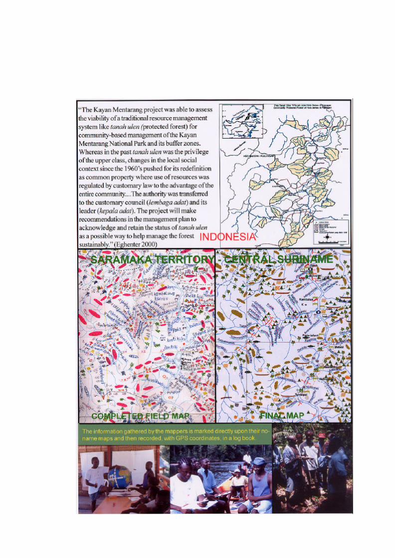
Community mapping has not been so widespread in Africa as in America or South and Southeast Asia. San in South Africa have successfully mapped and recovered parts of their traditional territory, both outside and inside Kgalagadi Transfrontier Park and San. In Namibia are now attempting the same in relation to Etosha National Park. Also in Namibia a certain amount of mapping has gone towards the establishment of community conservancies. Ogiek communities are attempting to map their customary lands in the Mau Forest, Kenya, before it is fragmented beyond recovery. Baka communities have been involved in community based mapping through work with the Centre for Environment and Development in Yaoundé, who over the past few years worked with communities to map their forest resources along the southern boundary of the Dja Reserve . This project led to the production of a series of maps based upon the communities’ own information, but the final maps were produced in the US, and were not available in Cameroon until over a year after the fieldwork had finished. In the context of a three year FPP project to support Bagyeli Pygmy communities in South West Cameroon CED is now implementing a community-based mapping programme which includes training and the purchase of the necessary equipment so that CED will be able to produce quickly detailed GIS maps in Yaoundé, using the geographical information collected by CED staff working with community members who will be trained to use GPS. At present there is a shortage of funds to expand this programme to continue the community mapping around the Dja Reserve, or to initiate community mapping projects with Baka from around the Lobéké and Boumba National Parks. There is a clear need to make this happen soon, given the intense pressure faced by Baka living in the forests in these two regions. 2.5 What is Cultural Mapping? The starting point for this discussion is concept resource paper “Cultural Cartography: Mapping and Auditing Cultural Resources as an Indigenous Community Process”. In the concept paper, “cultural mapping” is used in both a literal and a metaphorical senses, where it goes beyond strict cartography to include other cultural resources than land, “anthropological, sociological, archaeological, genealogical, linguistic, topographical, musicological and botanical”, which would be recorded by other appropriate techniques and equipment than maps. The concept paper uses “auditing” as a collective expression to cover this spectrum of activities. In this paper, “audit” will also be used in this collective sense, which includes mapping, but “mapping” will be used only in its literal sense, even if qualified as “cultural”. This distinction is important because mapping has come to mean something quite specific to many indigenous communities and their associations. It is widely valued as an appropriate instrument for recovering control of lost territory, or negotiating access rights
to traditional resources or of defending recognised territories against indiscriminate industrial resource extraction. A convenient expression for this is “tenure mapping.” Since the early 1970’s, tenure maps of historical indigenous presence in their lands have played a significant role in legal and political campaigns to obtain legal recognition of ancestral territories or prior access to traditional resources. Such maps are generated in the course of conversations within communities and travel over the territory. They show local names, traditional resources, seasonal movements and activities, and special places. Tenure maps are usually, although not necessarily, of collective territories shared by a number of communities. They range from the 2,000,000 sq km of the Inuit territory of Nunavut to a few square kilometres in areas where tenure is by single communities. Tenure maps play a legal and adversarial role, as evidence of prior occupation in campaigns to obtain legal recognition of ancestral indigenous territor ies. The ultimate objective is a recognised territory with unambiguous boundaries. For such transactions with outside interests, tenure maps need to be geographically accurate. To what extent does cultural mapping differ from tenure mapping? The short answer is that there is no difference, certainly in the process by which the maps are made and their cartographic forms. The only real difference lies in the way the maps are used. The purpose of tenure maps is to emphatically illustrate, with legally acceptable geographic precision, the historical and cultural linkages between indigenous peoples and their ancestral territories. By definition, the exclusive focus is upon cultural connections that can be placed upon a map, but then tenure negotiations are unavoidably about place. In terms of content, there would be little substantial difference between cultural and tenure mapping. Similarly, the other kinds of information gathered in the course of a comprehensive cultural audit would undoubtedly reinforce the legal case made by tenure maps. The distinction rests more upon the use to which the maps are put. In a cultural audit, the role assigned to maps in the concept paper is one of cultural revitalisation. In that context, the processes or methods chosen for community mapping may well have differential effects in terms of cultural revitalisation. This subject is taken up later but briefly: some map-making methods are more inclusive than others and to that extent their revitalising effects will be more immediate and affect more members of the community. In summary, both tenure mapping and cultural mapping focus upon the same kind of information, but they differ in intent. Both types mobilise the same information base but for different applications: security of tenure and cultural revitalisation .However, each of these purposes has different requirements in terms of map-making process and the degree of geographical accuracy. This variation should be taken into account in choosing the map-making approach most appropriate for cultural revitalisation. Participatory Rural Appraisal (PRA) exercises have often demonstrated the positive effects of mapping, as one variable subjected to community reflection. However, to
achieve this effect, maps do not need to be geographically accurate. People are familiar with the local terrain. They can be sketch maps or ephemeral maps, made on the ground with natural materials, which last as long as the discussion. Geographically accurate maps are made to deal with other interests, those with a competitive or antagonistic interest in indigenous lands. 3 GENERAL INTRODUCTION TO COMMUNITY MAPPING 3.1 Global Diversity in Community-Based Mapping Since the cartographic innovations of Inuit in the 1970’s a variety of community mapping methodologies have evolved around the world. Each is an opportunistic and pragmatic combination of high and low technologies and involves community members to varying degrees. Perhaps the most inclusive and engaging method is the group construction of three-dimensional models of community lands. This approach has emerged in Southeast Asia and the Philippines, where coastal communities are advanced enough to construct models of the sea bed of their marine territories. In Indonesia, community mapping has been directed towards providing evidence of ancestral use of land that have been incorporated into protected areas. In Malaysia, the issue is not gaining tenure but defending community lands that are already recognized – but not accurately mapped. Last year, a successful community case against a logging company prompted the Malaysian government to criminalise community mapping. In South Africa, San trackers who cannot read are using combinations of GPS (Global Positioning System) units and palm computers to map animal distributions. In the United States, tribal councils have long developed the competence to take over fish, forest and wildlife management and ecological restoration. During the twenty-five years that Inuit took to negotiate Nunavut, they elaborated their original tenure maps of 1975 into the most comprehensive data base in the Arctic and now retail environmental information to others. 3.2 Two main Mapping Strategies: Territorial and Community Against this background of diversity two main approaches have evolved. One is typical of America, but not exclusively so. It is where groups of ethnically or linguistically-related and neighbouring communities elect to map their collective territory, for the purpose of negotiating its legal recognition. This approach can be very effective in two ways. First, communities present a unified front in negotiation; one capable of pre-empting divisive strategies. Second, the mapping effort is focused upon delineating collective boundaries: the outer perimeter of a cluster of communities. Not only does this make for an economy of effort, but it leaves the matter of internal community boundaries to the communities to either resolve at their leisure or to leave flexible. The second approach focuses upon mapping community lands and boundaries. This may be a response to legal frameworks. In Peru and Ecuador for example, two exceptions to the American model, legal recognition is only available for individual communities. In
response, related communities try to delineate their borders so as to exactly fit their neighbours’ thus ending with a seamless collective territory. The community-lands approach is also common throughout Southeast Asia, where communities already possess various forms of traditional or customary tenure, but this is either ignored entirely by national legal systems or recognised in principle but ignored in practice. In the majority of cases, communal boundaries, although well-known to communities on the ground have never been accurately placed upon the official maps that are, for example, used for giving permits to logging and mining companies. 3.3 Mapping Methodologies A critical factor in selecting a methodology is whether the final map needs to be geographically accurate or whether a hand-drawn sketch map is sufficient. Generally, for dealing with internal community issues, a sketch map is sufficient, while geographically accurate maps are usually needed to deal with external interests. The 7 categories listed below vary in terms of technique, materials and equipment but have one essential feature in common: the source information that is mapped is local and traditional knowledge, gathered during interviews, recording sessions, group discussions. The categories are progressively more complicated but also gradually extend local control over the map-making process as well as over the data gathered and mapped. 1. Mapping During Participatory Rural Appraisal Mapping is one of several tools to facilitate local deliberations over land issues. The maps themselves are sketch maps, made with pen/paper, chalk-blackboard or drawn with natural materials on the ground. Usually, the maps last as long as the deliberations. 2. Placing Local Information Directly on Topographic Maps This method is common in northern and western Canada, and is comprehensively described in Chief Kerry’s Moose 17. It works where topographic maps are of good quality and people are familiar with them. Much of the traditional knowledge is gathered in conversation around a map and is then placed directly upon the map. This method also works well with aerial and satellite images – which are often more accessible to those who cannot read topographic map 3. Transferring Sketch Maps to Topographic Maps This method applies when topographic maps are not generally familiar and when communities rely upon external expertise in transferring locally-gathered data to such maps. Field workers are trained to gather information through interviews and to record it upon sketch maps. External or government cartographers are called upon to place this data upon topographic maps.
17 Tobias, Terry N, 2000. Chief Kerry's Moose: A Guidebook to Land Use and Occupancy Mapping, Research Design and Data Collection. Union of BC Indian Chiefs and Ecotrust Canada. 64 pp.
4. Collaborative Construction of 3-Dimensional Landscape Models is perhaps the most engaging and productive methodology. It is labour -intensive and virtually all community members can contribute either information or construction effort. The result is a large, detailed stereo-model of community lands. Since the shape of the landscape is based upon the contour lines on existing topographic maps, the model is geographically accurate, in fact more accurate that flat 2D maps. The only limitation is that there is only one model (However, this model can now also be replicated in a computer – see 7). 5. Using the Global Positioning System to Gather Local Information For this, community teams are trained to gather the same kinds of information but each datum is identified by coordinates of latitude and longitude. Local teams are trained to use GPS receivers in 4-6 weeks. Perhaps of special interest to the Cameroon seminar is CyberTracker, a system that has been used in South Africa by San trackers. This software was developed for animal surveys but could easily be adapted for cultural mappers. The system uses a palm top computer that has a special but off-the-shelf GPS accessory. For CyberTracker, the screen was programmed to show a series of animal images. Each time the tracker observed an animal, he would press that image and the observation is automatically recorded, to be downloaded to a laptop each day. The advantage of this is that it can be used by people who do not read. 6. Producing Geographically Accurate Maps with Graphics Software This method maximizes community-based content. For most forest peoples, the river system is the “geographic” reference, rather than latitude and longitude. The first stage is to extract the river system from topographic maps. The mappers place their local data on this “empty” field map. The river system is extracted either by manually tracing it and then scanning the trace, or by “tracing” it with a digitizing table/software. The results are similar: a virtual facsimile of the useful official cartography; the first method is low cost and labour-intensive.
7. Making Geographical Accurate Maps with GIS Geographic Information System This method is technically more demanding but ultimately more useful when there is a long term interested in maintaining and diversifying the traditional knowledge data base that is gathered in the course of tenure mapping. It also enables community-based groups to acquire and integrate landscape data from other sources: satellites etc. 3.4 Map Legends The four legends displayed on the next page span almost thirty years of community-based map-making. Tenure Mapping can be traced back to the 1970’s when this distinctive map genre evolved in the context of Inuit and Cree negotiations with Canada. The base maps, rivers and landforms, derived from official cartography but their content was distinctive: compilations of “map-biographies” of families of hunters, fishers, gatherers: seasonal movements about their territory and changes in resources. Names become vernacular again. This singular tenure map content has remained remarkably consistent; the only change has been that communities need no longer rely upon others to make the maps..
Inuit in the Northwest Territories, Canada, compiled a four -volume Inuit Land Use and Occupancy Study (ILOUS 1975) as evidence in their land negotiations - which lasted another 25 years. During that time, the Nunavut negotiating organisation, developed an advanced geomatic information base that combines traditional knowledge with data needed from global and national sources. One application of this data base is Planner, an internet-based programme that enables Inuit communities to deal with land settlement implementation problems and with proposals that affect their lands. The Nunavut data base is rapidly becoming the authoritative environmental information source for the Canadian Arctic and Nunavut is now retailing this data to others. Inuit have also had access to the means, and the time, to integrate into the Nunavut data base, a large accumulation of historical and practical information. All communities have access to a computer data base where, for example, one layer will display historical sites where videos of elders telling stories or singing about that place can be prompted.
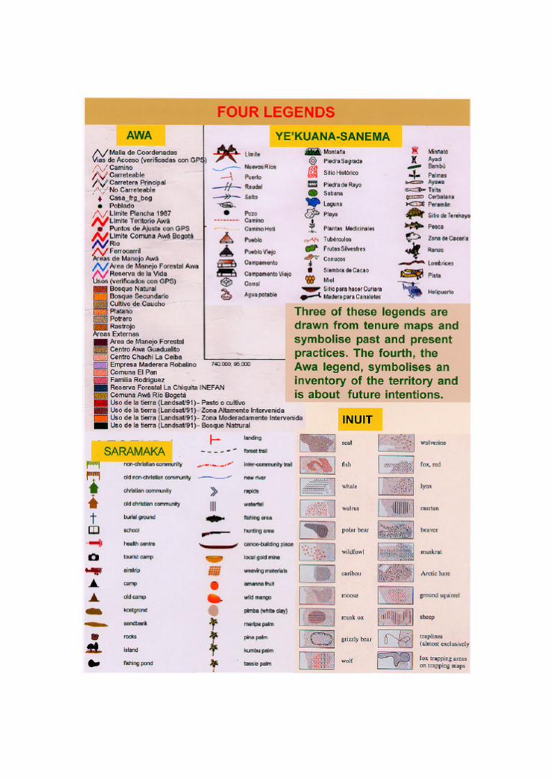
The Saramaka map (Suriname) was completed in late 2002 and is illustrated below. The strategic intent of project is not to obtain recognition of their territory but to oblige the government to respect treaties that already guarantee tenure. Saramaka are descended from escaped slaves who returned to liberate others - so successfully that in 1762 the Dutch sued for a treaty that recognized Saramaka Territory. Recently, the 20,000 Saramaka who now live in 63 communities along the Suriname River discovered that concessions to their forests had been let to Chinese logging companies. Suriname is not a signatory to any of the international conventions that respect indigenous peoples rights. Environmental regulation is minimal, as is official capacity to monitor environmental impacts. In 2000 the Association of Saramaka Authorities, Wanhati, filed a petition with the Inter-American Commission on Human Rights, asking it to mediate a friendly settlement. Failing that, the Commission will be asked for a binding decision. For this, a dramatic precedent was recently set in Nicaragua, where the Commission found that logging concessions could not be granted until Awas Tingi land was demarcated and titled. Recently, the Commission sent a letter to the Government of Suriname asking it to respond to the petition: to work towards a friendly settlement - and to restrain logging and mining in Saramaka territory until this issue is settled. The legend for the map of the Awa Territory, Ecuador, is distinct from the other three, primarily because it is focused upon the future. The 14 communities of the Awa Federation mobilised to gain recognition of their 1000 sq km territory in the 1980’s, first as an “Ethnic Forest Reserve”. They then acquired stronger tenure by exploiting a law that grants tenure to single communities, and stitching these together one at a time. One community, Rio Bogota, opted out of this process, feeling secure in their remoteness. Over the next 7 years, over two thirds of their lands were lost to settlers and loggers. The Awa meanwhile demarcated their Territory with an innovative device, the Manga: a clearcut belt running along 100 km of the more sensitive sectors of their 160km border, varying in width up to 10 m and planted with gardens, orchards, and buildings. The intent of the Manga is to accentuate their visibility at the edges of their territory: to pre-empt the common claims of intruders: that the land is “empty” and therefore available to anyone. 3.5 Making a Geographically Accurate Map in Three Stages The Kuyajani legend is employed on the map of Ye’kuana-Sanema territory (below) that illustrates the map-making method developed by the Forest Peoples Programme and its partner organisations in the course of seven or more projects in the Guiana shield. The object of these projects was to use the map-making process as a training context: to enable local groups to eventually assume responsibility for the entire map-making process. The guiding principle was to localise the mapping process to the maximum. This approach prompted the emergence of a complementary local-regional sharing of responsibilities. Community-based teams gather and map original and geographically accurate data. Inter -community associations develop mapping units, capable of producing final maps. Local mapping teams can learn in a few weeks how to gather and map geographically accurate field data. For this, the equipment costs $2-4K. The equipment to set up an independent mapping unit costs less than $10K. The technology and materials needed for local map-making are steadily rising in friendliness and declining in price.