cumming ranch - san diego county, california · el cajon, ca 92020 (619) ... cumming ranch specific...
TRANSCRIPT

Cumming Ranch Specific Plan
July 2012
SDC PDS RCVD 01-16-13 SP03-005


Cumming Ranch Specific Plan
SP 03-005
Prepared for:
County of San Diego
Department of Planning and Land Use 5201 Ruffin Road, Suite B
San Diego, CA 92123
Project Manager: Mark J. Linman Land Use and Development Consulting 11316 Rolling Hills Drive El Cajon, CA 92020 (619) 997-8288
Property Owner:
805 Properties 7338 Turnford Drive
San Diego, CA 92119 (619) 807-2483
Gene Driscoll Managing Partner
Cumming Ranch Specific Plan July 2012
i
Table of Contents
1.0 Introduction ..................................................................................... 1-1
1.1 Overview .......................................................................................................... 1-1
1.2 Regional Setting ............................................................................................... 1-1
1.3 Planning Context .............................................................................................. 1-2
1.4 Policy Framework ............................................................................................ 1-3
2.0 Project Description .......................................................................... 2-1
2.1 Location ........................................................................................................... 2-1
2.2 Physical Features ............................................................................................. 2-2
2.3 Existing Land Uses .......................................................................................... 2-5
2.4 Project Design .................................................................................................. 2-7
3.0 Cumming Ranch Specific Plan ....................................................... 2-8
3.1 Purpose of the Specific Plan ............................................................................ 3-9
3.2 Land Use Plan .................................................................................................. 3-9
3.2.1 Land Use Goal, Objectives and Policies ....................................................... 3-14
3.3 Conservation and Open Space ....................................................................... 3-16
3.3.1 Conservation and Open Space Plan ............................................................... 3-20
3.3.2 Conservation and Open Space Goal, Objectives and Policies ...................... 3-24
3.4 Circulation...................................................................................................... 3-26
3.4.1 Circulation Plan ............................................................................................. 3-30
3.4.2 Circulation Goal, Objectives and Policies ..................................................... 3-33
3.5 Public Facilities .............................................................................................. 3-35
3.5.1 Public Facilities Plan ..................................................................................... 3-39
3.5.2 Public Facilities Goal, Objectives and Policies ............................................. 3-45
3.6 Community Design ........................................................................................ 3-48
3.6.1 Community Design Plan ............................................................................... 3-49
3.6.2 Community Design Guidelines ..................................................................... 3-50
3.6.3 Community Design Goal, Objectives and Policies ....................................... 3-55

Cumming Ranch Specific Plan July 2012
ii
3.7 Development Program & Phasing ................................................................. 3-56
3.7.1 Development Phasing .................................................................................... 3-56
3.7.2 Development Approvals Required ................................................................ 3-57
3.7.3 Permitted Uses ............................................................................................... 3-59
4.0 General Plan Conformance ............................................................ 4-1
4.1 Land Use Element ............................................................................................ 4-1
4.2 Mobility Element ............................................................................................. 4-5
4.3 Conservation and Open Space Element ........................................................... 4-8
4.4 Housing Element ............................................................................................ 4-11
4.5 Safety Element ............................................................................................... 4-12
4.6 Noise Element ................................................................................................ 4-15
4.7 Ramona Community Plan .............................................................................. 4-17

Cumming Ranch Specific Plan July 2012
iii
List of Figures
Figure 1-1 Regional Location Map .................................................................................. 1-2
Figure 2-1 Vicinity Map .................................................................................................. 2-1
Figure 2-2 Project Area Map ........................................................................................... 2-3
Figure 2-3 Existing Topographic Map ............................................................................. 2-4
Figure 2-4 Existing Land Uses in the Project Vicinity .................................................... 2-6
Figure 3-1 Land Use Plan .............................................................................................. 3-10
Figure 3-2 Open Space Plan .......................................................................................... 3-21
Figure 3-3 Existing Roadway Conditions ...................................................................... 3-27
Figure 3-4 Internal Circulation Plan .............................................................................. 3-31
Figure 3-5 Water Facilities Plan .................................................................................... 3-40
Figure 3-6 Sewer Facilities Plan .................................................................................... 3-42
Figure 3-7 Typical Lot Development ............................................................................ 3-51
Figure 3-8 Generalized Zoning Map .............................................................................. 3-51
Appendices Appendix A: Project Facility Availability Letters Attachment: Cumming Ranch Specific Plan Map
Cumming Ranch Specific Plan July 2012
1-1
1.0 Introduction
1.1 Overview
This document is a Specific Plan for the Cumming Ranch property. The
Cumming Ranch Specific Plan sets forth the goals, policies and guidelines for the
development of residential land uses and preservation of open space within the
683-acre Specific Plan Area (SPA).
The Specific Plan text and exhibits establishes a comprehensive framework for
development of the Cumming Ranch. The Elements of the Cumming Ranch
Specific Plan establish specific criteria for the protection of open space and
sensitive resources while providing for the development of residential land uses
that are compatible with, and seamlessly integrate with the open space system.
The Cumming Ranch Specific Plan also provides for the necessary infrastructure
and improvements.
The final section of this document provides an analysis of the consistency of the
project with the goals, objectives and policies established by the Ramona
Community Plan and the County of San Diego General Plan.
1.2 Regional Setting
The Cumming Ranch SPA is part of the Ramona Community Planning Area
located in central San Diego County. The Cumming Ranch SPA is comprised of
approximately 683 acres and is located approximately 20 miles northeast of
downtown San Diego; approximately 11 miles east of Interstate 15 and

Cumming Ranch Specific Plan July 2012
1-2
approximately 15 miles north of Interstate 8 (see Figure 1-1, Regional Location
Map).
Figure 1-1 Regional Location Map
1.3 Planning Context
On August 4, 2011 the Board of Supervisors approved the County’s General Plan
Update (GPU). The General Plan Update removed the projects previous General
Plan designation of (21) Specific Plan, and replaced it with a mix of SR-2, SR-10
and RL-40 land use designations. It also removed project specific development
criteria for the Cumming Ranch project site in the Ramona Community Plan.
Cumming Ranch Specific Plan July 2012
1-3
More specifically, the General Plan Update assigned the following designations to
the project site:
194.5-acres @ SR-2 designation (1 dwelling unit per 2-acres) = 97 units,
236.6 acres @ SR-10 designation (1 dwelling unit per 10-acres) = 23 units
251.5 acres @ RL-40 designation (1 dwelling unit per 40-acres) = 6 units
Total = 126 units
Based on this land use distribution, the total number of dwelling units allowed on
the project site would be 126 units. Therefore, the 125-unit Cumming Ranch
project is consistent with the residential densities that are allowed under the
General Plans updated land use map.
1.4 Policy Framework
The San Diego County General Plan, Regional Land Use Element, Ramona
Community Plan and the Natural Communities Conservation Plan (NCCP) make
up the overall policy framework for the Cumming Ranch SPA. The Cumming
Ranch Specific Plan explains how the project promotes the long-term survival of
sensitive plant and animal species as outlined in the NCCP. In addition to the
adopted regulatory documents, there are other policies and concepts that influence
the development of the SPA.
On June 1, 2000 the Ramona Community Planning Group approved a conceptual
plan for the Ramona Grasslands Greenbelt (Ramona Grasslands Project). The
concept envisions the purchase of approximately 5,000 acres of privately owned
lands in the western area of Ramona for the purpose of establishing a grasslands
preserve. Funds from governmental agencies and conservation groups were
named as the source of funding for the project.

Cumming Ranch Specific Plan July 2012
1-4
On November 1, 2000 County Supervisor Dianne Jacob presented a proposal to
the County of San Diego Board of Supervisors to direct County staff to seek
potential funding sources for the Ramona Grasslands Project. The Board of
Supervisors unanimously endorsed this concept, with the provision that all
purchases be from willing sellers. Portions of the Cumming Ranch are located
within the conceptual boundaries of the Ramona Grasslands Project.
In July 2002, the County Department of Planning and Land Use prepared a draft
white paper that addressed the importance of the Ramona Grasslands as a
preserve and the challenge of balancing the needs between planned growth and
preservation.
The white paper stressed the need for the integration of ongoing major planning
activities in the area, including the North County Multiple Species Conservation
Program (MSCP) and the process to update the County of San Diego General
Plan (GP 2020). Efforts of conservation groups and others to obtain funds are a
part of the proposed integrated planning approach. The concept was discussed for
designating “hard line” boundaries of areas for conservation and for development
in the Ramona Grasslands. Additionally, the white paper outlined proposed
processes for funding and acquisitions.
An additional plan that influences the Cumming Ranch SPA is the conceptual
plan for the Santa Maria River Park. On March 3, 2000 the Ramona Community
Planning Group approved the conceptual plan for the Santa Maria River Park. The
plan envisions a linear park along the Santa Maria Creek that would connect
various parks, keys business areas within the Town Center and the planned
intergenerational center. It would include a series of pathways and hiking trails. In
July of 2001, the County of San Diego Board of Supervisors endorsed the plan
Cumming Ranch Specific Plan July 2012
1-5
and directed the Chief Administrative Officer to work with interested parties to
identify and obtain funding to acquire land along the Santa Maria Creek to
implement the plan.
The following discussions within this section describe issues and policies from
the Land Use Element, the Ramona Community Plan and other relevant County
of San Diego polices and ordinances affecting the Cumming Ranch SPA.
On August 4, 2011 the Board of Supervisors approved the County’s General
Plan Update (GPU). The General Plan Update removed the projects previous
General Plan designation of (21) Specific Plan, and replaced it with a mix of
SR-2, SR-10 and RL-40 land use designations. Land within the Semi-Rural
(SR) designation is intended for lower-density residential neighborhoods,
recreation, agricultural and commercial uses that support rural communities.
Land Use Element
The Land Use Element of the County General Plan states that in Semi-Rural
Lands the higher densities within the allowable range should be located near
Village areas, while lower densities should be located near Rural Land areas.
Site design methods that reduce on-site infrastructure costs and preserve
contiguous open space or agricultural operations are encouraged.
The Land Use Element describes Rural Lands as a category that is applied to
large open space and very-low-density private and publicly owned lands that
provide for agriculture, managed resource production, conservation, and
recreation… .

Cumming Ranch Specific Plan July 2012
1-6
Within the Cumming Ranch project site, there are approximately 194.5 acres
designated as SR-2, 236.6 acres designated as SR-10 and 251.5 acres
designated as RL-40.
The Community Character goal of the Ramona Community Plan is:
Ramona Community Plan
“The rural atmosphere of the Ramona community is preserved and enhanced,
while encouraging a balance of land uses that are compatible with a country
lifestyle.” The Ramona Community Plan includes policies to ensure that new
development integrates with the existing community and enhances the
community’s vision.
Project specific objectives, policies and recommendations for implementation
of the Cumming Ranch SPA are contained within the various elements of this
Specific Plan in order to ensure consistency and compatibility with the
Ramona Community Plan.
In addition to the San Diego County General Plan and the Ramona
Community Plan, there are a number of other polices and ordinances
implemented by the County of San Diego that provide guidelines or standards
that influence the design and implementation of the Cumming Ranch SPA.
These relevant policies and ordinances include the following:
Other Relevant Policies and Ordinances
The County Zoning Ordinance – The Zoning Ordinance is applicable to all
of the unincorporated areas of San Diego County. Within the Cumming

Cumming Ranch Specific Plan July 2012
1-7
Ranch SPA, all land and all structures and the construction,
reconstruction, alteration, expansion, or relocation of any structure must
conform to all regulations established in the Zoning Ordinance.
The County Subdivision Ordinance – The Subdivision Ordinance
establishes regulations for the subdivision of land within the
unincorporated areas of San Diego County, pursuant to the State of
California’s Subdivision Map Act. The ordinance addresses procedures,
design standards, agreements and improvement requirements for all
subdivided land.
The Natural Communities Conservation Program (NCCP) - The NCCP is
a regional program that plans for the long-term survival of sensitive plant
and animal species found in the NCCP Planning Area. The NCCP requires
that loss of natural habitat be consistent with the following findings:
1. The proposed habitat loss is consistent with the interim loss criteria in
the Conservation Guidelines and with any subregional process if
established by the subregion.
a. The habitat loss does not cumulatively exceed the 5% guideline.
b. The habitat loss will not preclude connectivity between areas of
high habitat values.
c. The habitat loss will not preclude or prevent the preparation of the
subregional NCCP.
d. The habitat loss has been minimized and mitigated to the
maximum extent practicable in accordance with Section 4.3 of the
NCCP Process Guidelines.

Cumming Ranch Specific Plan July 2012
1-8
2. The habitat loss will not appreciably reduce the likelihood of the
survival and recovery of listed species in the wild.
3. The habitat loss is incidental to otherwise lawful activities.
As part of the NCCP, the County of San Diego's Planning Department
envisions that the preparation and approval of three MSCP Subarea plans
upon completion will provide Endangered Species Act coverage for the
entire unincorporated area. The Cumming Ranch SPA is located within
the North County planning area.
The Biological Mitigation Ordinance (BMO) – The BMO establishes
mitigation standards for discretionary projects that are located outside of
biological core areas in order to achieve the conservation goals set forth in
the Subarea Plan for the Multiple Species Conservation Plan.
Dark Skies Ordinance (Light Pollution Code) – The County of San Diego
has established the Light Pollution Code to regulate outdoor lighting in
order to minimize the potentially detrimental effects of light pollution on
astronomical research at the Palomar Observatory and Mount Laguna
Observatory. The Cumming Ranch SPA is located approximately 35
miles west of the Mont Laguna Observatory and approximately 25 mile
south of the Palomar Observatory.
Board of Supervisors Policy I-116 – Policy I-116 establishes criteria for
the acquisition, development, operation and maintenance of non-
motorized trails and pathways. The County Trails Program has recently
completed the Draft Community Trails Master Plan (CTMP). The scope of

Cumming Ranch Specific Plan July 2012
1-9
the draft CTMP includes the unincorporated areas of the County of San
Diego. While the plan provides an overview of the whole County Trails
Program, its main focus is on development and management guidelines
that can be applied to community level trail systems. The Cumming Ranch
SPA lies within the Ramona segment of the draft CTMP.

Cumming Ranch Specific Plan July 2012
2-1
2.0 Project Description
2.1 Location
The 683-acre Cumming Ranch is located immediately west of the Ramona Town
Center and approximately ¼ mile north of the intersection of Highway 67 and
Highland Valley Road in the community of Ramona in the County of San Diego.
Highland Valley Road traverses the southern portion of the project site. Ingress
and egress are via Highland Valley Road. The eastern boundary of the property is
contiguous to the Ramona Town Center. The Ramona Airport borders the site to
the north. The Santa Maria Sewer Treatment Plant of the Ramona Municipal
Water District is located on a parcel that is inset along the eastern boundary of the
site (see Figure 2-1, Vicinity Map).
Figure 2-1 Vicinity Map

Cumming Ranch Specific Plan July 2012
2-2
2.2 Physical Features
The physical features of the Cumming Ranch SPA naturally divide the property
into three distinct areas. Area A is located in the southern portion of the site and
encompasses the area from the southern boundary northerly to an unnamed
drainage just south of Etcheverry Creek. The area between Area A and the Santa
Maria Creek is referred to as Area B with the remaining land north of Santa Maria
Creek referred to as Area C (see Figure 2-2, Project Area Map).
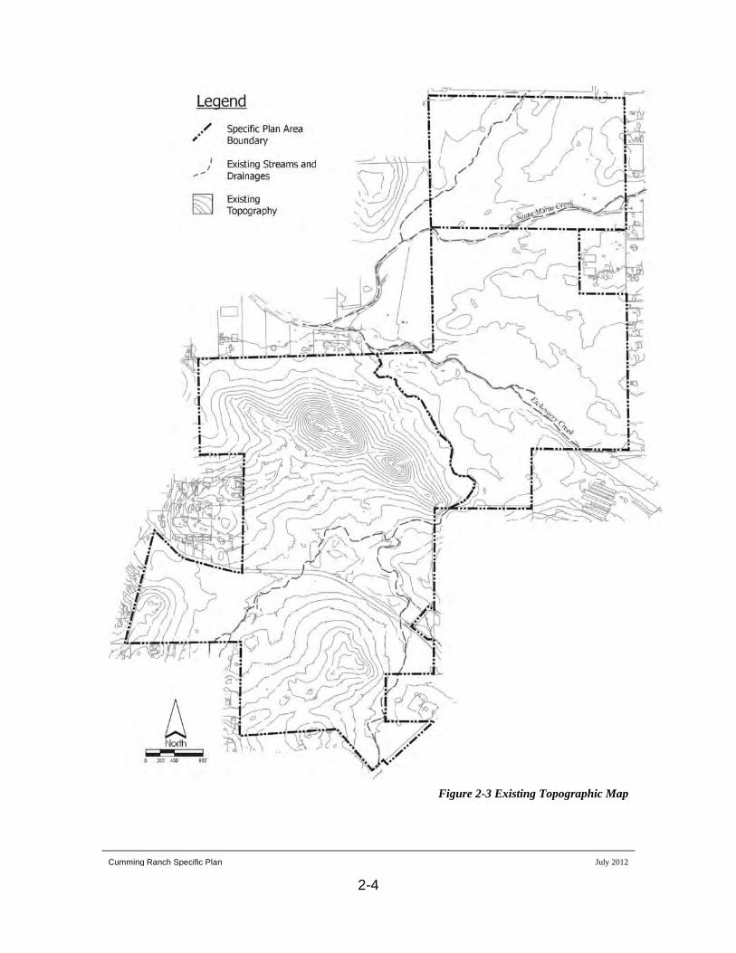
The topography of the southern portion of the property (Area A) is diverse,
consisting of rolling uplands interspersed with rocky outcrops and drainages.
Small stands of Engelmann and Coast oak are scattered within portions of the
area. A ridgeline of steeper hillsides in the northeasterly portion of the area
accentuates the diversity. Elevations in the southern area vary from 1,368 feet to
1,576 feet. Highland Valley Road bisects the southern portion of the property. A
small amount of frontage on Highway 67 is located in the southwest corner of the
property (see Figure 2-3, Existing Topographic Map).
The topography in the central area (Area B) consists mostly of a wide-open plain
area, extending from just south of Etcheverry Creek to the eastern boundary of the
property. Elevations range from 1,359 feet to 1,392 feet. The central area is
considered highly developable because of its level terrain and proximity to the
Town Center.
The northern area of the property (Area C) is located between the Santa Maria
Creek and Airport Road. About 50% of this area consists of creek area, wetlands
and shallow drainage areas (vernal swales). The remainder of the area consists of

Cumming Ranch Specific Plan July 2012
2-3
Figure 2-2 Project Area Map
Cumming Ranch Specific Plan July 2012
2-4
Figure 2-3 Existing Topographic Map

Cumming Ranch Specific Plan July 2012
2-5
non-native grasslands. A unique clustering of large boulders and rock
outcroppings appear along the eastern boundary. Elevations in the northern area
range from 1,365 feet to 1,400 feet with the higher elevations being in the north,
along Airport Road.
The primary drainages on the site are the Santa Maria Creek located in the
northern portion of the site and Etcheverry Creek through the central portion of
the site. These two creeks drain from the east to the west. Two smaller unnamed
drainages occur in the southern portion of the site, flowing northward and
ultimately join the Santa Maria Creek. Two shallow drainages running north to
south provide drainage for the north area of the property. The property contains
approximately one half of a mile of frontage on the Santa Maria Creek. These
drainages are shown on Figure 2-3.
The majority of the Cumming Ranch SPA has been disturbed by agricultural
operations. Natural vegetation occurs on portions of the site that were not
conducive to agricultural use. Natural vegetation occurs on the central ridge on
the site and interspersed throughout the site in and around the rock outcroppings
and on steeper slopes.
2.3 Existing Land Uses
Existing land uses on the project site and within the surrounding area are
shown on Figure 2-4. The Cumming Ranch SPA has historically been used
primarily for cattle grazing and dry-land farming of oat hay. There are no
Existing Specific Plan Area

Cumming Ranch Specific Plan July 2012
2-6
Figure 2-4 Existing Land Uses in the Project Vicinity
Updated Graphic
Cumming Ranch Specific Plan July 2012
2-7
buildings or structures on the site with the exception of two windmills and
remnants of cattle corrals. The liability of running cattle at this location,
coupled with the economics of dry farming, limits continued agricultural uses.
Approximately 56 acres in the northern portion of the Cumming Ranch SPA
are managed and operated as a mitigation bank for the sale of conservation
credits, primarily for vernal pools and wetland habitats. To date,
approximately 22 acres of mitigation credits have been sold and are protected
by conservation easements. These 22 acres are commonly referred to as the
Ramona Vernal Pool Reserve.
Located adjacent to the Cumming Ranch site to the east are single-family
homes on lots typically one to two acres in size. To the south and west of the
site is residential development on lots averaging from two to five acres in size.
North of the Area A boundary are homes on lots generally 5 acres and larger.
The Ramona Airport is located north of Area C.
Surrounding Properties
2.4 Project Design
The Cumming Ranch SPA is intended to accommodate the Ramona Grasslands
Project and still retain a modest level of residential development that is
compatible with the rural character of the existing Ramona community.
Approximately 67 percent of the SPA is designated as common open space with
residential land use designated on the balance (approximately 32 percent) of the
property. The plan also provides for associated infrastructure and public
pedestrian and equestrian trails.

Cumming Ranch Specific Plan July 2012
2-8
The Cumming Ranch SPA accommodates 125 dwelling units within Area A of
the SPA. Areas B and C are designated as open space. The overall density of the
Cumming Ranch SPA is 0.18 dwelling units per acre.
Area A consists of approximately 358.7 acres. Within Area A, approximately
215.4 acres are designated for residential lots and internal streets and
approximately 143.3 acres are designated as open space. A maximum of 125
dwelling units are allowed within Area A.
Area B, consisting of approximately 201.0 acres, will be made available for
purchase to the Ramona Grasslands Project under the terms of an option
agreement negotiated between the owner and the buyer. Area B is considered to
be within one of the key corridors to the Ramona Grasslands Project, providing
critical north/south connectivity with other grassland areas.
Area C, consisting of approximately 113.1 acres, is designated as Open Space and
will be donated by the property owner in fee title, at no cost, to the Ramona
Grasslands Project. Area C, like Area B, is considered to be located within a main
corridor to the proposed Ramona Grasslands Project.
This donation will be an environmentally significant component of the Ramona
Grasslands Project. The overall size of the preserve as a component of the
Ramona Grasslands Project ensures the long-term viability of the habitats and the
preservation of the Federally-listed San Diego Fairy Shrimp.

Cumming Ranch Specific Plan July 2012
3-9
3.0 Project Description
3.1 Purpose of the Specific Plan
The Cumming Ranch Specific Plan guides the development of a master planned
community. The Specific Plan systematically implements the General Plan by
further defining land use, residential density, development standards and essential
infrastructure facilities. It is a tool to help ensure the community is a high quality
living environment with specific attention to the natural environment of the site
and overall character of the surrounding properties. The Specific Plan serves as a
regulatory document, setting forth the required zoning and standards for the
development of Cumming Ranch.
3.2 Land Use Plan
Development within the Cumming Ranch SPA is designed to seamlessly integrate
with the designated open space within the SPA and to be compatible with the
surrounding properties. The land use plan is designed to preserve biological and
cultural resources within the SPA and to maintain the rural character of the
surrounding area. The distribution and density of the Cumming Ranch SPA land
uses are shown on Figure 3-1, Land Use Plan. A larger version of this exhibit is
also provided as an attachment to this document.
In addition to the division of the property into Areas A, B, and C for general land
use categories, Planning Area A is further divided into several subareas. The
subareas are divided based on physical site characteristics, open space design and
grading and infrastructure requirements. Development standards for the individual

Cumming Ranch Specific Plan July 2012
3-10
Figure 3-1 Land Use Plan

Cumming Ranch Specific Plan July 2012
3-11
subareas are provided in Section 3.7, Development Program & Phasing. A
detailed summary of the development areas is provided in Table 3-1,
Development Summary. Categories of land use designations include Open Space
and Rural Residential. The designated land uses will be implemented via various
discretionary permits or agreements as detailed in the Development Program
section of this report. The following sections provide descriptions of the land use
designations.
The Open Space land use designation is described in detail in Section 3.3 of
this document. The Cumming Ranch SPA establishes Open Space for those
lands that contain sensitive resources, protect aesthetic resources, provide
connections to on-site and off-site open space corridors and integrate with the
Ramona Grasslands Preserve. Approximately 457.8 acres or 67% of the
Cumming Ranch SPA is designated Open Space. Two Open Space land use
designations are established.
Open Space
Open Space 1 (OS-1) lands are those lands set aside for permanent
preservation. Development is not allowed within OS-1 with the exception of
trails, limited infrastructure and/or necessary public utilities. Approximately
256.8 acres or 38% of the Cumming Ranch SPA is designated as OS-1.
The Open Space 2 (OS-2) designation is a specific designation applied to Area
B of the Cumming Ranch SPA. The OS-2 designation allows trails,
infrastructure and public utilities. The intent of the OS-2 designation as
applied to Area B of the Cumming Ranch SPA is to provide an opportunity
for the Ramona Grasslands Project or similar conservation group or agency to

Cumming Ranch Specific Plan July 2012
3-12
Area "A"
Subarea Dwelling Units Acreage Average Lot
Size Density
1 4 5.5 1.4 0.732 54 73.6 1.4 0.733 18 29.6 1.6 0.614 27 39.6 1.5 0.685 16 32.0 2.0 0.506 6 7.9 1.3 0.76
Residential Lots 125 188.2 1.5 0.66Internal Streets --- 24.3 --- ---
HOA Lots 2.1 ---RMWD Lot 0.4 ---
Residential Subtotal 215.0 ---Open Space Lots 143.7 --- ---Total Area "A" 125 358.7 1.5 0.35
Area "B" Open Space 0 201.0 --- 0.00
Area "C" Open Space 0 113.1 --- 0.00
OtherROW - Highway 67 2.9 --- ---ROW - Highland Valley 6.9 --- ---
Total Other 9.8
Total Project Area 125 682.6 0.18
% of ProjectTotal Residential 125 215.0 --- 31.5%Total Open Space --- 457.8 --- 67.1%Total Other --- 9.8 --- 1.4%
682.6 100.0%
Table 3-1Development Summary

Cumming Ranch Specific Plan July 2012
3-13
acquire the property for permanent preservation. The existing agricultural uses
would be allowed to continue on Area B until the property is acquired for
open space. Necessary infrastructure and public utilities, trails and related
improvements are the only other uses allowed within lands designated OS-2.
Access to Area B will be through Area A on the existing dirt roads that are
currently used to access that portion of the site. Approximately 201.0 acres or
29% of the Cumming Ranch SPA is designated as OS-2.
The Cumming Ranch SPA provides for the development of 125 dwelling units
on lots ranging from 1.0 to 3.1 acres in size within Area A. The overall
residential density of the 683-acre Cumming Ranch SPA is 0.18 dwelling
units per acre (du/ac) or one dwelling unit per 5.46 acres. The density of the
residential development area within Area A is 0.35 du/ac with an average lot
size of 1.5 acres.
Rural Residential
The distribution of lot sizes is governed by the densities established for each
development subarea. Table 4-1 designates the acreage, number of lots and
specific density designators for each subarea. Lots located south of Highland
Valley Road have slightly higher densities and smaller lot sizes than those
areas located north of the road. Larger sized lots are designated for Subarea 5,
located in the northern portion of Area A, adjacent to larger sized lots located
to the north of the SPA.
The Cumming Ranch Specific Plan proposes 41 less residential dwelling units
than what was previously allowed in the Ramona Community Plan, before the
General Plan Update was adopted in August 2011. Prior to the General Plan

Cumming Ranch Specific Plan July 2012
3-14
Update, the Ramona Community Plan allowed a total of 166 residential
dwelling units. The Cumming Ranch Specific Plan proposes 125 residential
dwelling units, which is consistent with the County’s updated General Plan,
and it utilizes a range of lot sizes in order to tailor the development to the
unique features of the site and to retain larger areas of open space in common
lots. This approach provides greater control of the open space resources,
minimizes the potential for development encroachment and greater ease in
long-term management over individual easements on private lots.
3.2.1 Land Use Goal, Objectives and Policies
Provide for the orderly development of the Cumming Ranch SPA that is
sensitive to the natural resources, seamlessly integrates with the Ramona
Grasslands Project and is reflective of Ramona’s rural character and
country lifestyle.
Goal
Provide for the preservation of significant natural resources within
designated open space in cooperation with the establishment of the
Ramona Grasslands Project.
Objective LU-1
Concurrent with the approval of the Tentative Map, the lands
designated as Open Space shall be zoned with the S-88 Specific
Plan Use Regulation. This designation will defer to the Specific
Plan for the determination of appropriate uses, which are all open
space in character. The building type, lot size and density
designators shall not permit residential development.
Policy LU-1.1

Cumming Ranch Specific Plan July 2012
3-15
Prior to or concurrent with the approval of Final Maps and prior to
issuance of grading permits or improvement plans, open space
easements shall be granted over those portions of Area A
designated as OS-1.
Policy LU-1.2
Provide for Rural Residential development that is consistent with the
existing density established in the Ramona Community Plan, is sensitive to
the environmental resources and is compatible with the surrounding
community.
Objective LU-2
Concurrent with the approval of the Tentative Map, the lands
designated as Rural Residential shall be zoned with the S-88
Specific Planning Area Use Regulation. This designation will
defer to the Specific Plan for the determination of appropriate uses,
which are all residential in character. The primary uses within the
Rural Residential land use are Residential Use Types and Family
Residential.
Policy LU-2.1
The lands designated as Rural Residential shall be limited to the
development of 125 dwelling units within 6 subareas consistent
with the densities established in Table 4-1.
Policy LU-2.2
Future discretionary approvals for residential development shall
comply with the Community Design Element (Section 3.6) as
applicable to ensure compatibility with surrounding land uses.
Policy LU-2.3

Cumming Ranch Specific Plan July 2012
3-16
Provide necessary public services and facilities required to meet the needs
of the Cumming Ranch SPA.
Objective LU-3
A sewer pump station shall be constructed in accordance with the
requirements of the Ramona Municipal Water District. The pump
shall be located within the OS-1 area of Area A.
Policy LU 3-1
Contribute fire mitigation fees, school fees and in-lieu parkland
fees in accordance with the applicable requirements to ensure
provision of necessary services and facilities.
Policy LU 3-1
3.3 Conservation and Open Space
The Cumming Ranch Specific Plan has been formulated based on a
comprehensive analysis of the natural resources and unique features that exist on
the project site. The initial studies included biological surveys, cultural resource
surveys, floodplain analysis, slope analysis and viewshed analysis. The results of
these initial studies were used in the creation of the land use plan to concentrate
development in areas of less sensitivity and to ensure the protection of the
property’s natural resources. A complete analysis of the property’s
environmental resources is included in the Draft Environmental Impact Report
for the Cumming Ranch Project, available at the County of San Diego
Department of Planning and Land Use. A summary of these resources is
included below.

Cumming Ranch Specific Plan July 2012
3-17
The development area for the Cumming Ranch SPA is dominated by
agricultural land as the result of historic and on-going agricultural activities on
the property. However, overall, a total of sixteen vegetation communities are
located on the site. Native habitats are generally found on hilltops, among
rock outcroppings and within the drainages on the site, or within the northern
“preserve” portion of the site. These habitats include coastal sage scrub, oak
woodlands, chaparral and vernal pools. A detailed description of all of the on-
site habitats and the distribution of the habitats on the site is discussed in
Biological Technical Report for the Cumming Ranch SPA, an appendix to the
Draft Environmental Impact Report.
Biological Resources
Focused studies were also conducted on the property for the Arroyo
Southwestern Toad, Coastal California Gnatcatcher, Stephen’s Kangaroo Rat
and the Quino Checkerspot Butterfly. None of these species have been found
to occur on the property. The site includes foraging habitat for golden eagles
and other raptors. A summary of these studies is also provided in the
Biological Technical Report.
A large collection of vernal pools exists in the northernmost portion of the
Cumming Ranch SPA. The pools are primarily clustered along two shallow
type drainage areas (vernal swales and basins) that slope towards the Santa
Maria Creek. Focused studies have confirmed the presence of the San Diego
Fairy Shrimp (Branchinecta sandiegonensis) in certain pools. The San Diego
Fairy Shrimp is a Federally listed endangered species, but no vernal pools will
be impacted by the project.

Cumming Ranch Specific Plan July 2012
3-18
An initial archaeological reconnaissance of the Cumming Ranch SPA was
conducted in 1995. The results of that survey were utilized in the initial
project design in order to minimize impacts to sensitive cultural resources.
The property was formally surveyed for cultural resources in July and August
of 2003. As a result of this more detailed survey, some of the previous sites
were combined and additional milling sites were located, resulting in a total of
27 sites. In 2004, these sites were recorded and mapped and those that were
within potential development areas were tested. The majority of these sites are
milling features and are not considered significant. There are three sites
located within open space areas that are considered significant. One site
located within the development area is considered significant and requires
subsequent mitigation.
Cultural Resources
The Cultural Resources Survey Report is included as an appendix to the
Environmental Impact Report for the Cumming Ranch Project.
Floodways and 100-year floodplains have been mapped by the County of San
Diego Department of Public Works Flood Control Division for the portions of
Santa Maria Creek and Etcheverry Creek that occur within the Cumming
Ranch SPA. The Federal Emergency Mapping Agency (FEMA) also has
mapped floodplains for these creeks. The County of San Diego’s Resource
Protection Ordinance (RPO) regulates development of property affected by
floodplains. Development is also subject to FEMA regulations.
Floodplains

Cumming Ranch Specific Plan July 2012
3-19
A Preliminary Drainage Study has been completed for the Cumming Ranch
SPA to assess potential issues related to drainage and flood hazard. The
Preliminary Drainage Study is included as an appendix to the Environmental
Impact Report for the Cumming Ranch SPA.
Slopes
The Resource Protection Ordinance defines steep slopes as “All lands having
a slope with natural gradient of 25% or greater and a minimum rise of 50
feet, unless said land has been substantially disturbed by previous legal
grading. The minimum rise shall be measured vertically from the toe of slope
to the top of slope within the project boundary”. Steep slopes within the
Cumming Ranch SPA are limited due to the gentle nature of the existing
topography. The only areas of steep slopes within the SPA are located on the
ridgeline in the central portion of Area A.
The Santa Maria Valley is a unique visual resource within the Ramona
community. The broad valley with its open grasslands and agricultural areas
creates a strong sense of the rural character of the community. Areas B and C
lie within the Santa Maria Valley and contribute to the sense of openness
within the area. The open agricultural fields along Highway 67 and Highland
Valley Road within Area A also contribute to the rural character and sense of
openness. While not topographically unique or regionally significant, the
ridgeline on the north side of Highland Valley Road and the isolated hill on
the south side are considered to be visually significant features of the site.
Aesthetics/Visual Resources

Cumming Ranch Specific Plan July 2012
3-20
The Conservation And Open Space Element designates Highway 67 as part of
the County Scenic Highway System. The Ramona Community Plan also
addresses the importance of scenic resources and highways by stating on Page
36, “designation of selected major scenic routes through the Ramona
Community Planning Area will preserve the scenic integrity of the visual
corridors of these routes”.
3.3.1 Conservation and Open Space Plan
The initial formulation of the Cumming Ranch Specific Plan began with a
thorough assessment of the existing environmental resources that were located
on the property. This information was compiled and analyzed in combination
with other factors such as aesthetics, availability of utilities, existing roadways
and the relation of the property to the surrounding properties as well as the
overall community.
Figure 3-2, Open Space Plan, identifies the proposed open space areas within
the Cumming Ranch SPA. The majority of the open space is designated as
Open Space 1 (OS-1). OS-1 property will be placed in permanent open space
upon implementation of the project. The OS-1 land within Area C will be
donated in fee title by the owner to the Ramona Grasslands Preserve. Lands
designated as OS-1 within Area A will have open space easements granted to
the County of San Diego. All of Area B is designated as Open Space 2 (OS-
2). The owner will make Area B available to the Ramona Grasslands Preserve
or other conservation entity under an option to purchase. The existing
agricultural operations in Area B will be allowed to continue until the property
is acquired for open space use. Access to Area B will be through Area A on
the existing dirt roads that are currently used to access that portion of the site.

Cumming Ranch Specific Plan July 2012
3-21
Figure 3-2 Open Space Plan

Cumming Ranch Specific Plan July 2012
3-22
With the implementation of the Specific Plan, approximately 457.4 acres, or
67 percent of the SPA will be preserved.
The distribution of sensitive biological resources within the Cumming Ranch
SPA was a primary factor in the design of the open space plan. Development
areas and roadways were specifically designed to avoid sensitive biological
resources wherever possible. All vernal pools within the project site are
protected by open space. The majority of the sensitive habitat areas have been
preserved by inclusion in designated open space.
The Cumming Ranch SPA has been designed to avoid encroachment in the
floodplains of Santa Maria Creek and Etcheverry Creek. All floodways and
major floodplains within the SPA are preserved within open space. No
concrete channelization or concrete bank protection is proposed. All existing
creek and drainage banks will be left in their natural condition.
Preservation of viewsheds from surrounding roadways and preservation of
visually significant features of the project site was considered as part of the
overall land use design for the Cumming Ranch SPA. The extensive open
space within Areas B and C preserve and maintain the unique visual character
of the Santa Maria Valley. Buffers have been incorporated into the project
design along Highway 67 and Highland Valley Road to maintain the visual
character of those roadways. All steep slope areas within the Cumming Ranch
SPA are preserved within open space. Significant aesthetic resources of the
site within Area A have been preserved in open space. Preservation of the
drainages, ridgelines and rock outcrops serve to not only maintain the

Cumming Ranch Specific Plan July 2012
3-23
aesthetics and visual quality of the site but also protect and preserve the
biological and cultural resources associated with those areas. Riparian
planting will be provided at selected locations along the creeks and drainages
to enhance those habitats and add visual interest.
Certain natural features located within development areas such as significant
rock outcroppings will be protected by the designation of “building restricted
areas” on the Site Plan for the project site and will be required to be integrated
into the project design in compliance with the Design Guidelines developed
for the Cumming Ranch SPA. “Building restricted areas” will also be
implemented by the project’s Covenants, Conditions and Restrictions
(CC&R’s).
An additional factor that was analyzed in the initial assessment of the property
was the role of the Cumming Ranch SPA with respect to the Ramona
Grasslands Project. The Ramona Grasslands Project is a concept that
envisions the purchase of approximately 5,000 acres of privately owned lands
in the western area of Ramona for the purpose of establishing a grasslands
preserve. This concept has been endorsed by the County Board of Supervisors
with the condition that all property acquisitions are from willing sellers. The
owners of the Cumming Ranch SPA support the concept of the Ramona
Grasslands Project and are willing participants in the process.
In addition to the assessment of resources located within the Cumming Ranch
SPA, the relation of the SPA to the surrounding grasslands areas was also
analyzed. Existing and proposed open space, habitat types, ownership patterns
and acquisition potential were assessed.
Cumming Ranch Specific Plan July 2012
3-24
The result of these efforts was the creation of an open space network that is
consistent with the intent of the Ramona Grasslands Project, preserves the
majority of the sensitive habitats, landforms and drainages on site while
maintaining a portion of the property for residential development that will be
compatible with the onsite open space network, the neighboring properties
and the rural character of the community.
3.3.2 Conservation and Open Space Goal, Objectives and Policies
Create open space for the conservation of significant environmental
resources including sensitive habitats, floodplains, steep slopes, cultural
resources and visual resources.
Goal
Accommodate the Ramona Grasslands project by active participation to
ensure that the grasslands preserve concept becomes a reality.
Objective COS-1
Prior to or concurrent with the approval of Final Maps and prior to
issuance of grading permits or improvement plans, Area C shall be
granted in fee title to the Ramona Grasslands Preserve or other
conservation entity. The dedication shall provide for the
installation of facilities and improvements as specified in the
Cumming Ranch Specific Plan.
Policy COS-1.1

Cumming Ranch Specific Plan July 2012
3-25
Prior to the approval of Final Maps and prior to issuance of
grading permits or improvement plans, the owner shall enter into
an option agreement with the Ramona Grasslands Preserve or other
conservation entity for the sale of Area B as open space.
Policy COS-1.2
Protect designated Open Space areas in their natural state while
permitting limited compatible uses of the open space areas.
Objective COS-2
Concurrent with the approval of the Tentative Map, the lands
designated as Open Space shall be zoned with the S-88 Specific
Planning Area Use Regulation. This designation will refer to the
Specific Plan for the determination of appropriate uses, which are
all open space in character. The building type, lot size and density
designators shall not permit residential development.
Policy COS-2.1
Prior to or concurrent with the approval of Final Maps and prior to
issuance of grading permits or improvement plans, open space
easements shall be granted over those portions of Area A
designated as OS-1.
Policy COS-2.2
Prior to or concurrent with the approval of Final Maps and prior to
conveyance of any portion of the Open Space to the Ramona
Grasslands Preserve or other entity, easements for the pedestrian
Policy COS-2.3

Cumming Ranch Specific Plan July 2012
3-26
and equestrian trails shall be dedicated to the County of San Diego
with an easement to the Ramona Trails Association.
Minimize encroachment into biologically sensitive areas, floodplains and
steep slopes.
Objective COS-3
Implementing discretionary permits shall be reviewed for
conformance with the Cumming Ranch Specific Plan, Open Space
Plan.
Policy COS-2.2
3.4 Circulation
Regional access to the Cumming Ranch SPA is via State Route 67 (SR-67). Local
roadways that serve the SPA include Highland Valley Road and Dye Road. RCE
Traffic and Transportation Engineering prepared a Preliminary Traffic Study for
the Cumming Ranch SPA in order to evaluate potential transportation related
issues associated with the project. The study analyzes the existing roadway
system and traffic conditions within the project vicinity and evaluates potential
issues associated with the project. The following sections provide a brief
summary of the issues addressed within the traffic study. The complete traffic
study and a more detailed discussion of potential impacts and mitigation measures
are included in the Environmental Impact Report for the Cumming Ranch Project.
Cumming Ranch Specific Plan July 2012
3-27
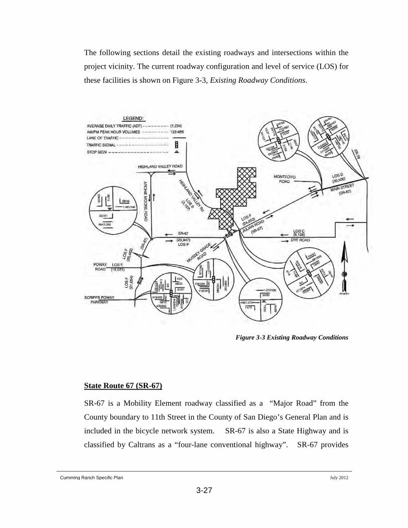
The following sections detail the existing roadways and intersections within the
project vicinity. The current roadway configuration and level of service (LOS) for
these facilities is shown on Figure 3-3, Existing Roadway Conditions.
Figure 3-3 Existing Roadway Conditions
SR-67 is a Mobility Element roadway classified as a “Major Road” from the
County boundary to 11th Street in the County of San Diego’s General Plan and is
included in the bicycle network system. SR-67 is also a State Highway and is
classified by Caltrans as a “four-lane conventional highway”. SR-67 provides
State Route 67 (SR-67)
Cumming Ranch Specific Plan July 2012
3-28
access to the Lakeside and Poway areas west of Ramona and Julian east of
Ramona. The roadway within the study area is developed with two through lanes
and shoulders and currently operates at level of service (LOS) F.
Highland Valley Road is a two-lane roadway that is classified as a “Community
Collector” in the County Mobility Element and is also included in the bicycle
network system. Highland Valley Road provides access to SR-67 for the
properties located to the north. The portion of the roadway within the study area
is currently improved to two lanes with shoulders with a pavement width of 36 to
40 feet and operates at LOS B.
Highland Valley Road
Dye Road is classified as a “Community Collector” (2.1C) in the County
Mobility Element and is also included in the bicycle network system. Dye Road
currently provides access to the San Diego Country Estates development as well
as the Barona Indian Reservation. Dye Road is included in the Ramona
Community Plan as a major component to the proposed “south bypass” to provide
alternatives to Julian Road and Main Street. The roadway within the study area is
currently improved to a two-lane facility with a pavement width of approximately
40 feet and operates at LOS C.
Dye Road
The County of San Diego has set standards for adequate traffic flow through an
existing intersection or roadway segment at LOS D or better. If the delay along
an existing roadway or intersection declines to LOS E (unstable flow) or worse, it
is considered an unacceptable condition by the County.
Intersections

Cumming Ranch Specific Plan July 2012
3-29
The intersection of SR-67 and Highland Valley Road currently operates at LOS E
during the AM peak hour and LOS D in the PM peak hour.
Non-Vehicular Transportation
Bike Lanes
: All Mobility Element roadways in the study area are open to travel
by bicycle and many connect to the County of San Diego bicycle network
system. The project proposes to improve Highland Valley Road adjacent to the
project site to provide “Community Collector” standards with bike lanes.
Public Transportation
: Bus service is provided for the Ramona area to Escondido,
via SR-78 and to El Cajon, via SR-67. No bus stops are currently located in the
project area. Development of this project as proposed will not adversely affect
the current bus service.
Trails
: There are currently no dedicated trails located within the Cumming Ranch
SPA. The Cumming Ranch SPA lies within the Ramona segment of the
Community Trails Master Plan titled Ramona Community Trails and Pathway
Plan. Within the Ramona Community Trails and Pathway Plan, the Trails and
Pathways for Ramona Map (County of San Diego 2004) shows portions of two
community trails and one pathway within or adjacent to the Cumming Ranch
SPA. The proposed alignments of the trails as part of the Cumming Ranch project
are similar to the location of the trails on the Trails and Pathways for Ramona
Map. The Cumming Ranch community trail system is expected to interconnect
and become part of a future regional trail system.

Cumming Ranch Specific Plan July 2012
3-30
3.4.1 Circulation Plan
The intent of the circulation plan for the Cumming Ranch SPA is to provide
for a safe and convenient circulation system based on the proposed land use
plan and addresses existing circulation issues within the region.
Regional Circulation
The Mobility Element of the San Diego General Plan and the Ramona
Community Plan has established a regional circulation network of roadways
to accommodate the buildout of the Ramona community.
Implementation of the Cumming Ranch SPA is anticipated to generate 1,500
average daily trips (ADT) based on a generation rate of 12 ADT per dwelling
unit with 8% AM and 10% PM peak hour trips. The net increase of traffic to
the street system during the AM peak is 120 trips and during the PM peak is
150 trips.
Vehicular circulation within the Cumming Ranch SPA will be accomplished
by implementation of an internal roadway network (shown on Figure 3-4,
Internal Circulation Plan) to be implemented in conjunction with
development of the residential portion of the SPA. The internal roadways will
be constructed as public streets with either 52 or 56 feet of right-of-way. All
internal project roadways will be constructed to rural development standards
with asphalt berms instead of concrete curbs and gutters. In keeping with the
rural character of the area, concrete sidewalks are not proposed. Pathways will
be provided along one side of all internal streets. Secondary emergency access
Internal Circulation
Cumming Ranch Specific Plan July 2012
3-31
Figure 3-4 Internal Circulation Plan

Cumming Ranch Specific Plan July 2012
3-32
is provided at two locations in order to comply with fire department access
requirements.
Non-Vehicular Circulation
Bike Lanes
: Improvements to Highland Valley Road within the SPA
boundary will include bike lanes as required by the Mobility Element and the
Ramona Community Plan.
Public Transportation
: There are no public transportation facilities existing or
proposed within the Cumming Ranch SPA. Implementation of the SPA will
not adversely affect the availability of public transportation.
Trails and Pathways:
The design of a scenic and meaningful trail system is
one the major objectives of the Cumming Ranch SPA. The Cumming Ranch
SPA designates a 2.9-mile public trail network as shown on Figure 3-4,
Internal Circulation Plan. A portion of the Cumming Ranch trail system is
expected to interconnect and become a part of the regional trail system,
including the trail system envisioned within the Santa Maria River Park plan.
The trail system has been established in consultation with the Transportation
and Trails Subcommittee of the Ramona Community Planning Group and the
Ramona Trails Association.
In addition to the designated pedestrian and equestrian trails, pathways will be
provided along one side of all internal streets. A community pathway will also
be provided along the north side of Highland Valley Road, through the project
site and off site to the intersection with Highway 67. This pathway will be
designed to meander within the shoulder of the roadway and may venture
Cumming Ranch Specific Plan July 2012
3-33
outside the existing right-of-way where appropriate in order to create greater
separation from vehicular traffic and a more pleasing experience to users of
the pathway.
3.4.2 Circulation Goal, Objectives and Policies
Develop a comprehensive circulation network that will efficiently serve the
future residents of the Cumming Ranch SPA, the existing community of
Ramona and the transportation needs of the region and minimizes impacts
to sensitive resources and retains the rural character of the community.
Goal
Provide a road network that minimizes grading and impacts to sensitive
resources.
Objective C-1
All internal roads shall be designed to minimize impacts to
sensitive habitats and existing natural features and shall be
generally consistent with the alignments shown in the Cumming
Ranch Specific Plan Circulation Element.
Policy C-1.1
All internal roads shall be designed to be consistent with the
County of San Diego Public Road Standards and the County of
San Diego Standards for Private Streets, as applicable.
Policy C-1.2
Cumming Ranch Specific Plan July 2012
3-34
Provide an internal circulation network that minimizes impacts to
adjoining residents.
Objective C-2
Access to Highland Valley Road shall be limited to the four public
street intersections as shown in the Circulation Element. Two
additional points of emergency egress/access are provided as
required by the Fire Marshal.
Policy C-2.1
Direct driveway access to Highland Valley Road is prohibited.
Policy C-2.2
Provide a meaningful and usable non-vehicular circulation system that
includes a public trail system based on the input from the local
community.
Objective C-3
Prior to or concurrent with the approval of Final Maps and prior to
conveyance of any portion of the Open Space to the Ramona
Grasslands Preserve or other entity, easements for the pedestrian
and equestrian trails shall be dedicated to the County of San Diego.
Policy C-3.1
Plans for the required improvements to Highland Valley Road
shall include bicycle lanes in accordance with the requirements of
the Ramona Community Plan and County standards for public
streets.
Policy C-3.2

Cumming Ranch Specific Plan July 2012
3-35
Plans for the required improvements to Highland Valley Road
shall include a public pathway located on the north side of the
road. The pathway shall be non-contiguous and meander to the
extent feasible in order to create a pleasurable experience for the
user.
Policy C-3.3
Work with County staff and the community to contribute to the resolution
of regional traffic issues.
Objective C-4
Future discretionary permits shall be conditioned to participate in
mitigation programs such as the Traffic Impact Fee program.
Policy C-4.1
3.5 Public Facilities
The Cumming Ranch project site is located within Phase 1 of the RMWD
Downtown Operational Storage Zone. Phase 1 encompasses the facilities within
the southwestern downtown area and Phase 2 within the northeastern downtown
area. Based on the outcome of the ongoing studies and engineering, it is likely
that the planned improvements to the Downtown Operational Storage Zone would
combine Phases 1 and 2 into a single storage zone and water would be delivered
to the project from a new reservoir located southwest of the intersection of SR 67
and Dye Road. It is anticipated that the new reservoir would have a total capacity
of 3 million gallons and would consist of two above ground storage tanks
Water Facilities

Cumming Ranch Specific Plan July 2012
3-36
constructed in two phases, with the first phase being completed within the next 5
years.
Existing water facilities in the vicinity of the Cumming Ranch project site include
a 20-inch-diameter pipeline located in SR 67. Bringing water from the west, this
pipeline transitions to a 16-inch-diameter main east of the intersection of Mussey
Grade Road. A 10-inch-diameter pipeline in the original alignment of Highland
Valley Road extends through the Cumming Ranch site and connects with the
pipeline in SR 67, a few hundred feet east of the property boundary.
Sewer service is also provided to the project area by the RMWD. Sewage from
the Cumming Ranch SPA will be transported to and treated at the Santa Maria
Wastewater Treatment Plant (SMWWTP), located adjacent the site to the
immediate east of the SPA at the northeast corner of Area B. The SMWWTP is
currently at or above capacity. The SMWWTP is currently designed and rated for
1.0 MGD. The facility’s capacity and spray fields for discharge are insufficient
during periods of heavy rainfall when the Average Dry Weather Flow (ADWF)
can approach or exceed the 1.0 MGD capacity. Heavy rainfall increases the
amount of wastewater entering the system and at the same time decreases the
efficiencies of the holding ponds and spray fields.
Sewer Service
Actions have been taken by the RMWD Board of Directors to upgrade and
expand the SMWWTP facilities. RMWD’s Board of Directors authorized the
awarding of a design services contract for Santa Maria Sewer Service Area
Facility Improvements. The Final Supplemental EIR (SEIR) for the expansion of
the SMWWTP from 1.0 MGD to 1.47 MGD was certified on May 25, 2010.

Cumming Ranch Specific Plan July 2012
3-37
According to the SEIR, the three-phase expansion is described as follows: Phase 1
would expand the plant to 1.14 MGD, which would provide service to the 4,087
EDUs connected as of June 30, 2005. Phase 2 would expand the plant to 1.28
MGD and provide treatment capacity for an additional 608 EDUs. Phase 3 would
expand the plant to 1.47 MGD, which would serve an additional 608 EDUs for a
total of 1,216 EDUs. The project would also construct two new wet weather
storage ponds located west of the existing ponds. The existing spray fields east of
Rangeland Road will be reconfigured as evaporation terraces.
The Cumming Ranch SPA is not within the Latent Sewer Powers Service area of
the RMWD and is not within the District’s Sphere of Influence. Sewer service is
expected to be available to serve the SPA upon completion of the required studies
and approval of the Local Agency Formation Commission (LAFCO) expansion of
latent sewer powers to include the SPA. Improvement requirements will be
established by RMWD based on the completion of a detailed study.
The Cumming Ranch SPA lies within the service area of the Ramona Fire
Department. The Ramona Fire Department is a division of the Ramona Municipal
Water District. The Ramona Fire Department operates under contract with the
California Department of Forestry (CDF) who provides fire and paramedic
personnel to the District. There are three fire stations located in Ramona. Station
82 is located to the immediate south of the Cumming Ranch SPA on Dye Road.
The Ramona Fire Department and the San Pasqual Volunteer Fire Department
have an Automatic Aid Agreement; in the event of an emergency, both agencies
have agreed to respond.
Fire
Cumming Ranch Specific Plan July 2012
3-38
The Ramona Fire Department has indicated that they are in an extreme budget
crisis and would not be able to adequately serve the project and continue to
maintain an appropriate level of service and protection for the rest of the
community.
The Ramona Unified School District (RUSD) provides school services to students
in Ramona. The RUSD provides school for grades kindergarten through high
school at five elementary schools, one middle school, two high schools and one
alternative school. The Cumming Ranch SPA lies wholly within the service area
of the RUSD.
Schools
Due to overcrowded conditions at schools within the area, the District is not able
to identify specific schools that students residing within the Cumming Ranch SPA
will ultimately attend. Students generated by the SPA will cause additional
impacts to the RUSD and mitigation will be required to offset those impacts.
The Ramona Community Plan sets forth the goal to develop a comprehensive plan
of local, neighborhood, community and regional park facilities. Existing
recreational opportunities for the Ramona community include Collier Park, a local
park located within the Ramona Town Center; the 166-acre Ramona Community
Park located on RMWD land approximately 4.0 miles east of the project site; and
the Holly Oaks Equestrian staging area, a 42-acre park located on Dye Road.
Recreational Facilities

Cumming Ranch Specific Plan July 2012
3-39
3.5.1 Public Facilities Plan
Prior to or concurrent with implementation of the residential land uses
proposed in the SPA, the various public facility and service providers will
require necessary improvements to facilities and infrastructure. These
improvements may include water, sewer, fire facility and school facility
improvements or upgrades. This element of the Specific Plan establishes
objectives and policies to ensure the timely provision of necessary
improvements.
Copies of the County’s Project Facility Availability Forms (DPLU #399) for
each of the above service providers are provided as an Appendix to this report.
Additional analysis is required by the service agencies before specific
conditions can be provided for implementation of the Cumming Ranch SPA.
The water demand for the build-out of the SPA is projected to average 69,250
gallons per day (gpd), with a maximum daily demand of 207,750 gpd. The
proposed on-site water distribution system is shown on Figure 3-5, Water
Facilities Plan. The proposed system would connect to a future 16-inch
diameter pipeline in Highland Valley Road. Water would be distributed
throughout the development area via new 8 and 12-inch diameter pipes
located within the project roadways. As required by RMWD, the onsite
pipelines would be looped to provide redundancy in supply, improve water
quality by avoiding dead end mains, and to meet fire flow demands and
pressures by providing water from two directions to supply hydrants.
Water Facilities

Cumming Ranch Specific Plan July 2012
3-40
Figure 3-5 Water Facilities Plan

Cumming Ranch Specific Plan July 2012
3-41
Water for the immediate project vicinity is currently provided from the Mount
Woodson Terminal Storage Reservoir; however, there is a limitation on the
quantity of water that can be delivered under the currently configured system.
RMWD is currently planning a new reservoir (consisting of two 1.5-million-
gallon tanks) that would serve the southwestern area (Phase I) of the Downtown
Operational Storage Zone. The Downtown Operational Storage Zone would be
served via the West End Terminal Storage Zone. The Cumming Ranch project is
expected to receive its water from the new reservoir. The water demand described
in this section would be within that anticipated and planned by RMWD and would
not require the installation of additional facilities beyond those already planned by
RMWD. Although these facilities are currently in the planning stage, it is
reasonable to anticipate these facilities would be operational within 5 years.
Sewage generated by the proposed home within the Cumming Ranch SPA would
be transported to and treated at the SMWWTP, located adjacent to the project site
east of Area B.
Sewer Facilities
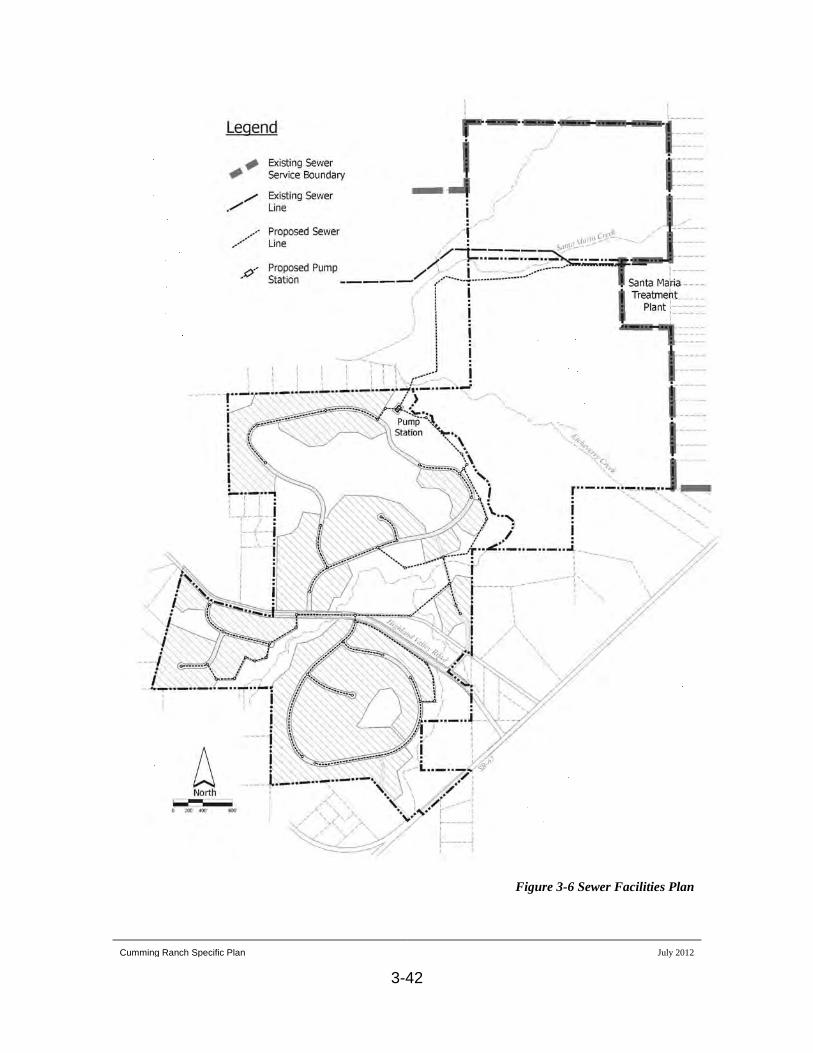
The proposed on-site sewer collection system is shown on Figure 3-6, On-site
Sewer System. Sewer mains would be installed throughout Area A to collect
effluent from the proposed homesites. The mains would not always be installed in
the project roadways but instead would follow the natural contours of the existing
terrain. Portions of the sewer mains are located within the common open space
lots. This design of the sewer collection system greatly reduces the required
grading for the future lots and provides a more rural appearance to the overall
development.
Cumming Ranch Specific Plan July 2012
3-42
Figure 3-6 Sewer Facilities Plan

Cumming Ranch Specific Plan July 2012
3-43
The existing SMWWTP is at a higher elevation than the residential land in the
northern portion of Area A, therefore it is necessary to pump the effluent to reach
the plant. As shown on Figure 3-6, the sewer mains would converge at a sewer
pump station located at a low point within the northern portion of Area A. From
there, the effluent will be pumped through force mains located within existing off-
site easements then within the trail alignment south of Santa Maria Creek to the
SMWWTP.
The SMWWTP is currently at or above capacity. RMWD is currently planning
major improvements and expansion of the SMWWTP, which would increase the
capacity of the facilities from 1.0 MGD to 1.47 MGD in three phases. This
expansion of wastewater service for over 1,216 additional EDUs would
adequately provide service for the Cumming Ranch project, which would add 125
dwelling units. RMWD has completed the CEQA environmental review process
required for implementation of the necessary improvements to the SMWWTP and
their spray fields to accommodate future demand, including the Cumming Ranch
project. The wastewater demand resulting from the proposed project would be
within that anticipated by RMWD and would not require the installation of
additional facilities beyond those already planned by RMWD.
The Ramona Fire Department will provide fire protection and paramedic service
to the Cumming Ranch SPA primarily from its existing Station 82 located just
south of the SPA on Dye Road. Response times are not expected to be
significantly altered as a result of implementation of the land use plan.
Fire Facilities
Cumming Ranch Specific Plan July 2012
3-44
The Ramona Fire Department, in conjunction with the County of San Diego’s
Fire Code Specialist, provide fire protection standards including roadway design
standards, access requirements, water flow requirements, fire hydrant location and
spacing and brush management standards. These standards have been considered
in the initial land use planning and will be implemented as required by conditions
of approval for future discretionary actions. The Cumming Ranch project will be
required to participate in a Community Facilities District as conditioned by the
Ramona Fire Department. The project developer shall be required to pay all fees
and meet all requirements of the Community Facilities District to the satisfaction
of the Ramona Fire Department.
As discussed above, the existing facilities of the RUSD are operating at or above
capacity resulting in overcrowded conditions. The District has indicated that
additional students generated by the Cumming Ranch SPA will further impact
these facilities. Impact fees will be required in accordance with Government Code
Sections 53080 and Section 65970 prior to issuance of building permits for
residential development within the Cumming Ranch SPA.
School Facilities
The County of San Diego’s General Plan Recreational Element recommends the
standard of 15 acres of local parks and 15 acres of regional parks per 1,000
persons. The Cumming Ranch project would ultimately be expected to generate
418 persons to the Ramona community and would generate the need for an
additional 6.3 acres of local park land and 6.3 acres of regional park land.
Recreational Facilities
Cumming Ranch Specific Plan July 2012
3-45
In order to address the timely provision of park land, the County has established
the Park Lands Dedication Ordinance. The ordinance requires either the
dedication of park land or the payment of in-lieu fees as a condition of all
proposed development. No public parks are proposed to be located within the
Cumming Ranch SPA and it is anticipated that future implementing approvals
would be conditioned to pay in-lieu fees.
In addition to the passive recreational opportunities provided by the dedication of
open space, recreational opportunities would also be provided within the
Cumming Ranch project by the dedication of 2.9 miles of public pedestrian and
equestrian trails.
3.5.2 Public Facilities Goal, Objectives and Policies
Provide for adequate public services and facilities to serve the permitted
land uses within the Cumming Ranch SPA.
Goal
Ensure that water service and facilities are available to the Cumming
Ranch SPA concurrent with demand.
Objective PF-1
Prior to approval of any Tentative Map for residential uses within
the Cumming Ranch SPA, a system evaluation analysis for water
facilities shall be prepared and submitted to RMWD for review and
approval.
Policy PF-1.1
Policy PF-1.2
Cumming Ranch Specific Plan July 2012
3-46
Prior to approval of Final Maps or improvement plans, a water
service commitment letter shall be obtained from RMWD to
ensure provision of adequate water service by the district.
Ensure that sewer treatment and disposal facilities are available to the
Cumming Ranch SPA concurrent with demand.
Objective PF-2
Prior to approval of any Tentative Map for residential uses within
the Cumming Ranch SPA, a system evaluation analysis for sewer
facilities shall be prepared and submitted to RMWD for review and
approval.
Policy PF-2.1
Prior to approval of Final Maps or improvement plans, the
residential portion of the Cumming Ranch SPA shall be annexed
into Latent Sewer Powers Service area of the RMWD.
Policy PF-2.2
Prior to approval of Final Maps or improvement plans, a sewer
service commitment letter shall be obtained from RMWD to
ensure provision of adequate water service by the district.
Policy PF-2.3
Ensure that adequate fire services and facilities are available to the
Cumming Ranch SPA concurrent with demand.
Objective PF-3

Cumming Ranch Specific Plan July 2012
3-47
Prior to approval of any Tentative Map for residential uses within
the Cumming Ranch SPA, the proposed development shall be
reviewed to ensure provision of fire protection standards including
roadway design standards, access requirements, water flow
requirements, fire hydrant location and spacing and brush
management standards.
Policy PF-3.1
Prior to approval of Final Maps or improvement plans, the fire
marshal shall establish minimum flow rates for fire hydrants within
the project. The RMWD shall provide verification that the
proposed facilities are designed to deliver the minimum fire flow
required.
Policy PF-3.2
Prior to approval of Final Maps, the project shall participate in a
Community Facilities District as conditioned by the Ramona Fire
Prevention Bureau. The project developer shall be required to pay
all fees and meet all requirements of the Community Facilities
District to the satisfaction of RMWD.
Policy PF-3.3
Prior to issuance of building permits for any residential
development within the Cumming Ranch SPA, fire mitigation fees
shall be paid to the satisfaction of the Director of the Department
of Planning and Land Use.
Policy PF-3.4

Cumming Ranch Specific Plan July 2012
3-48
Ensure that adequate school services and facilities are available to the
Cumming Ranch SPA concurrent with demand.
Objective PF-4
Prior to issuance of building permits for any residential
development within the Cumming Ranch SPA, appropriate school
fees shall be paid to the Ramona Municipal School District for
mitigation of school facilities impacts.
Policy PF-4.1
Ensure that adequate recreational services and facilities are available to
the future residents of the Cumming Ranch SPA.
Objective PF-5
Prior to issuance of building permits for any residential
development within the Cumming Ranch SPA, required park in-
lieu fees shall be paid to the satisfaction of the Director of Parks
and Recreation.
Policy PF-5.1
3.6 Community Design
The Cumming Ranch SPA is characterized by its agricultural fields on broad
valleys and rolling hillsides dotted with rock outcroppings and scattered oak trees.
Topographic variation within the SPA is minimal with the overall elevations on
site ranging from a low of approximately 1,360 feet at the western point of
Etcheverry Creek to approximately 1,576 feet at the peak of the ridgeline located
in the central portion of Area A. Steep slopes are limited to the upper slopes of the
central ridgeline and a small area located on the isolated hill in the southern

Cumming Ranch Specific Plan July 2012
3-49
portion of the SPA. The dominant landform on the site is the broad plain of the
Santa Maria Creek in the northern portion of the site at the border of Areas B and
C.
The overriding design theme established in the Ramona Community Plan and
carried forward in the Cumming Ranch SPA is to preserve and enhance the
existing rural character of the community. This is to be accomplished by the
preservation of floodways, ridgelines, oak groves, rock outcroppings and other
natural features.
3.6.1 Community Design Plan
The preservation and protection of the property’s many natural features is a
principal goal. This goal is achieved by both the allocation of lands between
development and preservation, and by careful integration of these important
elements into the overall plan and design.
The purpose of the Design Guidelines is to provide a visual cohesiveness
within the SPA by maintaining the natural features of the project site as a
visual focal point. The Guidelines are intended to provide a flexible guide or
framework that will successfully integrate the project with the neighboring
uses and retain the visual quality and linkages to the Ramona Grasslands
Project.
Implementation of the Design Guidelines will be twofold. The first level of
implementation will be through the review of subsequent discretionary
permits and approvals. The implementation of design elements within the
tentative maps, site plan, grading plans, improvement plans and landscape
Cumming Ranch Specific Plan July 2012
3-50
plans will provide the basis for the project design. The second phase of
implementation will be through the review and approval of site-specific plans
for individual lots. Review of lot development plans will be implemented via
the Homeowner’s Association Architectural Review Board. Specific
development procedures and guidelines will be established in the project
Covenants, Conditions and Restrictions (CC&R’s) and will be recorded
against all residential lots. A typical lot development incorporating many of
the following design guidelines is shown in Figure 3-7, Typical Lot
Development.
3.6.2 Community Design Guidelines
The design and construction of homes within the residential areas shall
maintain a consistent quality of design and materials that is compatible
with the rural character of the community.
General Guidelines
All new homes shall be sited on the individual lots to compliment adjacent
buildings and the visual setting.
The unique natural features of the site shall be retained and incorporated
into the site planning of individual lots.
Homes shall be oriented to take advantage of existing vistas without
impacting views from adjacent properties.
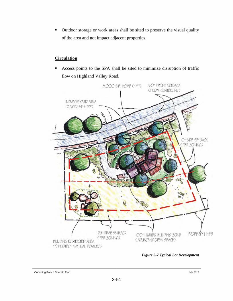
Cumming Ranch Specific Plan July 2012
3-51
Outdoor storage or work areas shall be sited to preserve the visual quality
of the area and not impact adjacent properties.
Access points to the SPA shall be sited to minimize disruption of traffic
flow on Highland Valley Road.
Circulation
Figure 3-7 Typical Lot Development

Cumming Ranch Specific Plan July 2012
3-52
Connections to the existing local roadway system shall be minimized to
reduce project traffic on local streets.
Pedestrian circulation shall be separated from vehicular traffic to the
extent feasible through the use of separated pathways within the right-of-
ways.
A public trail system shall be provided as established in consultation with
the Transportation and Trails Subcommittee and the Ramona Trails
Association.
The grading design shall retain to the greatest extent feasible the character
of the existing landform.
Landform Modification
Contour grading techniques shall be the dominant grading method used to
develop the project site. Contour grading is a method that creates artificial
slopes with rounded forms and varied slope ratios designed to simulate the
appearance of the natural terrain.
Grading and development shall be limited to below the top of major
ridgelines in order to maintain natural terrain lines.

Cumming Ranch Specific Plan July 2012
3-53
Disturbance of steep slopes, as defined by the Resource Protection
Ordinance, shall be minimized.
The design of internal roadways shall be compatible with the existing
terrain and minimize grading. Roadways shall be designed to maximize
aesthetic and environmental considerations.
The preservation of natural habitats and aesthetic resources such as rock
outcroppings, mature trees and ridgelines shall be encouraged.
Architectural detailing and material selection is essential to character
definition. It is not intended to define a specific architectural style or
building type for the residential area but the intent of the Design
Guidelines is to establish a level of quality and consistency that is
compatible with the rural character and country lifestyle of Ramona.
Architectural Character and Detailing
Materials and colors shall be compatible with the natural setting.
Rear of side elevations of buildings that are visible from public vantages
shall be finished in a quality, color and material that is similar to the
principal elevations.
All accessory buildings shall be designed to be compatible with the
primary structures.

Cumming Ranch Specific Plan July 2012
3-54
All mechanical equipment, including propane tanks and air conditioning
units shall be screened from public view.
In order to maintain the rural character of the area, street lighting is not
proposed.
Lighting Design
All exterior lighting shall be adequately controlled or screened to prevent
glare and spillover to adjacent properties. All lighting shall conform to the
requirements of the County’s Dark Sky Policy.
Night lighting shall be directed away from open space areas.
Landscaping will be informal and rural in nature.
Landscaping Guidelines
Landscaping shall utilize natural materials such as stone, wood rail fences,
boulders and drought-tolerant plant species.
The use of expansive lawn areas and water-intensive landscaping shall be
discouraged.

Cumming Ranch Specific Plan July 2012
3-55
All landscape areas shall use a variety of plant species selected from the
conceptual landscape plan.
Fencing types shall be consistent with those established in the conceptual
landscape plan.
Brush Management Zones shall be provided and maintained in accordance
with the requirements of the Ramona Fire Department.
3.6.3 Community Design Goal, Objectives and Policies
Create and maintain a high quality image for the Cumming Ranch SPA to
ensure the visual compatibility with the surrounding community and
natural environment.
Goal
Preserve the visual quality of the site through retention of unique natural
features, sensitive grading design and landscape designs that integrates
with the surrounding open space.
Objective CD-1
Sensitive ridgelines, drainages and natural habitats shall be
preserved in open space in accordance with the Open Space
Element.
Policy CD-1.1
Tentative maps for future residential lots shall identify unique
natural features within the lots and identify those areas as a
Policy CD-1.2
Cumming Ranch Specific Plan July 2012
3-56
“Building Restricted Area”. The Building Restricted Areas shall be
identified within the CC&R’s and be incorporated into the design
of the lot.
Tentative maps for future residential lots shall incorporate a
roadway design that is compatible with the existing terrain and
minimizes grading.
Policy CD-1.3
Tentative maps and grading plans for residential lots shall
incorporate contour grading and variable slope ratios to blend the
development with the surrounding terrain.
Policy CD-1.4
Prior to approval of Final Maps, CC&R’s shall be recorded against
all residential lots that include establishment of the Homeowner’s
Association Architectural Review Board and implementation of
the Design Guidelines.
Policy CD-1.5
3.7 Development Program & Phasing
3.7.1 Development Phasing
Phasing of development within the Cumming Ranch SPA is primarily
dependant on market factors. While it is possible that the entire SPA be
developed in a single phase, the project may be developed in phases. Certain
infrastructure improvements will be required to be in place prior to, or
concurrent with each individual phase. Phasing in not required to be consistent
with the numeric sequence of the subareas identified on the land use plan.

Cumming Ranch Specific Plan July 2012
3-57
3.7.2 Development Approvals Required
In addition to the approval of this Specific Plan, other discretionary and
ministerial permits will be required in order to implement the Cumming
Ranch SPA. These additional entitlements are discussed below.
A tentative map (TM) will be required to implement the Cumming Ranch
Specific Plan. A TM, pursuant to the County of San Diego Subdivision
Ordinance (Title 8, Division 1 of the Code of Regulatory Ordinances) is
required for all major subdivisions. The TM will show the general subdivision
design and such specific items such are lot areas, grading, street
improvements, drainage systems, utilities and necessary or required
easements. Implementation of the Cumming Ranch Specific Plan may be
accomplished with a single TM or may be accomplished with multiple TMs.
Tentative Subdivision Map
A zone reclassification is required to implement the changes to the zoning
designation of the project site. While the base S-88 zone will remain
unchanged, the development regulations depicted in the zoning box will be
revised to accurately reflect the intended development and/or preservation of
the SPA. Areas designated as Open Space in the SPA will have development
regulations that are consistent with that designation and do not allow further
development. The residential areas of the project will have an established lot
size, density and setback requirement that is consistent with the requirements
of the SPA. The proposed zoning designations are shown below in Section
3.7.3.
Rezone

Cumming Ranch Specific Plan July 2012
3-58
Prior to approval of the first final subdivision map, the Ramona Municipal
Water District will be required to receive approvals from the Local Agency
Formation Commission (LAFCO) for expansion of its sewer latent powers
authority.
Annexation to Sewer Service Area
A Minor Use Permit is required to implement performance standards for the
sewer pump station as specified in the Environmental Impact Report for the
Cumming Ranch SPA.
Minor Use Permit
A Site Plan is required for the overall site to implement certain development
standards for future construction on the lots including compliance with
sustainable building practices, implementation of energy conservation
measures, adherence to fire-safe construction practices and preservation of
natural features within the lots. A single Site Plan will address development
standards for all lots within the project. Individual lots are not required to
obtain approval of a separate Site Plan for development of the lot.
Site Plan Approval
Approval of Final Maps and Improvement Plans are required for
implementation of the land use plan. Final subdivision maps and improvement
plans are prepared subsequent to the approval of the TM and are subject to the
requirements and provisions of the Subdivision Ordinance. Final maps are
Final Map, Grading and Improvement Plans

Cumming Ranch Specific Plan July 2012
3-59
engineered drawings that contain detailed title and legal information
pertaining to the lots that are created. Grading, landscaping, existing and new
utilities, roadway construction and all other specific elements necessary for
project implementation are shown on the grading and improvement plans.
The proposed development may be subject to issuance of a Section 404 Permit
by the Army Corps of Engineers. This permit, required pursuant to the Clean
Water Act (33 U.S.C. 1344), is required for projects that propose to discharge
dredged or fill materials into Waters of the United States. While the land use
plan has been designed to avoid impacts to wetlands and other sensitive
habitats, some limited filling of minor drainage areas will be necessary to
implement the project.
Army Corps of Engineers Permit
A 1600 series agreement is required by the California Department of Fish and
Game for any project that impacts specified drainage areas.
California Department of Fish and Game Agreement
Building permits are required for the construction of all structures on the
property.
Building Permits
3.7.3 Permitted Uses
Generalized zoning for the Cumming Ranch SPA is shown on Figure 3-8,
Generalized Zoning Map. The existing S-88 zone will be retained subject to
the following use regulations for each of the zoning districts.

Cumming Ranch Specific Plan July 2012
3-60
Figure 3-8 Generalized Zoning Map
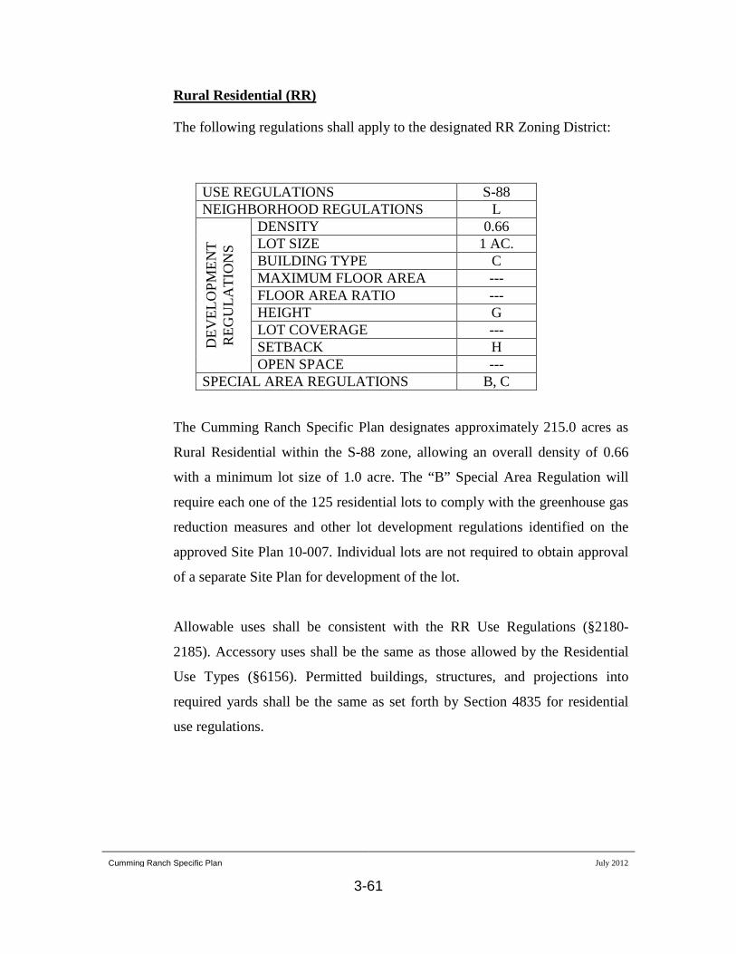
Cumming Ranch Specific Plan July 2012
3-61
The following regulations shall apply to the designated RR Zoning District:
Rural Residential (RR)
USE REGULATIONS S-88 NEIGHBORHOOD REGULATIONS L
DEV
ELO
PMEN
T R
EGU
LATI
ON
S DENSITY 0.66 LOT SIZE 1 AC. BUILDING TYPE C MAXIMUM FLOOR AREA --- FLOOR AREA RATIO --- HEIGHT G LOT COVERAGE --- SETBACK H OPEN SPACE ---
SPECIAL AREA REGULATIONS B, C
The Cumming Ranch Specific Plan designates approximately 215.0 acres as
Rural Residential within the S-88 zone, allowing an overall density of 0.66
with a minimum lot size of 1.0 acre. The “B” Special Area Regulation will
require each one of the 125 residential lots to comply with the greenhouse gas
reduction measures and other lot development regulations identified on the
approved Site Plan 10-007. Individual lots are not required to obtain approval
of a separate Site Plan for development of the lot.
Allowable uses shall be consistent with the RR Use Regulations (§2180-
2185). Accessory uses shall be the same as those allowed by the Residential
Use Types (§6156). Permitted buildings, structures, and projections into
required yards shall be the same as set forth by Section 4835 for residential
use regulations.

Cumming Ranch Specific Plan July 2012
3-62
Open Space
The following regulations shall apply to the designated OS-1 Zoning District:
(OS-1)
USE REGULATIONS S-88 NEIGHBORHOOD REGULATIONS ---
DEV
ELO
PMEN
T R
EGU
LATI
ON
S DENSITY --- LOT SIZE --- BUILDING TYPE A MAXIMUM FLOOR AREA --- FLOOR AREA RATIO --- HEIGHT --- LOT COVERAGE --- SETBACK --- OPEN SPACE ---
SPECIAL AREA REGULATIONS C, POR F
The Cumming Ranch Specific Plan designates approximately 256.8 acres as
Open Space 1 (OS-1) within the S-88 zone, which does not allow any
residential development. This zone designation applies to lands that are
intended to be preserved and maintained as permanent open space. No
development is allowed in these areas except pedestrian and equestrian trails
and necessary public facilities.
Cumming Ranch Specific Plan July 2012
3-63
The following regulations shall apply to the designated OS-2 Zoning District:
Open Space (OS-2)
USE REGULATIONS S-88 NEIGHBORHOOD REGULATIONS ---
DEV
ELO
PMEN
T R
EGU
LATI
ON
S DENSITY --- LOT SIZE --- BUILDING TYPE A MAXIMUM FLOOR AREA --- FLOOR AREA RATIO --- HEIGHT --- LOT COVERAGE --- SETBACK --- OPEN SPACE ---
SPECIAL AREA REGULATIONS C, POR F
The Cumming Ranch Specific Plan designates approximately 201.0 acres as
Open Space 2 (OS-2) within the S-88 zone, which does not allow any
residential development. This zone designation applies to lands that are
intended to be preserved and maintained as permanent open space. In addition
to the allowable land uses within OS-1, the OS-2 land allows continued
agricultural use of the land until it is acquired for open space use. Access to
the OS-2 lands shall be via the existing dirt roads that are currently used to
access that portion of the site.

Cumming Ranch Specific Plan July 2012
4-1
4.0 General Plan Conformance
The Cumming Ranch Specific Plan has been developed based on the goals and polices set
forth in the County of San Diego General Plan and the Ramona Community Plan. This
section addresses the conformance of the Cumming Ranch Specific Plan with the
applicable goals and policies of County of San Diego General Plan and the Ramona
Community Plan.
4.1 Land Use Element
The Land Use Element of the County of San Diego General Plan is a framework
that provides maps, goals and policies as to how lands are to be conserved and
developed in the unincorporated County.
Policy LU-1.2: Leapfrog Development. Prohibit leapfrog development which is
inconsistent with the Community Development Model. Leapfrog Development
restrictions do not apply to new villages that are designed to be consistent with
the Community Development Model, that provide necessary services and
facilities, and that are designed to meet the LEED-Neighborhood Development
Certification or an equivalent. For purposes of this policy, leapfrog development
is defined as Village densities located away from established Villages or outside
established water and sewer service boundaries.
Project Conformance:
The Cumming Ranch SPA is located immediately west of
the Ramona Town Center boundary and along major transportation corridors. The
overall density of the proposed project is 0.18 dwelling units per acre (or one
dwelling unit per 5.46 acres) which is not a Village density level.

Cumming Ranch Specific Plan July 2012
4-2
Policy LU-1.3: Development Patterns. Designate land use designations in
patterns to create or enhance communities and preserve surrounding rural lands.
Project Conformance:
The character of the Cumming Ranch project is
specifically designed to be consistent with the country lifestyle of Ramona. The
residential lot density and design and significant open space areas are all
characteristic of a rural setting. Various design elements, which will be
incorporated into the project, will reinforce the rural theme of the project and
enhance the sense of community.
Policy LU-1.8: Density Allocation on Project Sites. Permit changes in density
within a project site with parcels that have more than one land use designation to
provide flexibility in project design only when appropriate and consistent with the
applicable Community Plan and approved by Major Use Permit or Specific Plan.
The policy does not allow a project to receive more units than is established by
the Land Use Maps nor to supersede Housing Element requirements related to
achieving the County’s Regional Housing Needs Allocation.
Project Conformance:
The density proposed for the Cumming Ranch SPA is
consistent with the land use designations established in the San Diego County
General Plan and the Ramona Community Plan. The project utilizes the Specific
Plan to allocate density within the SPA to maximize the protection of sensitive
resources and enhance the project design.
Policy LU-2.3: Development Densities and Lot Sizes. Assign densities and
minimum lot sizes in a manner that is compatible with the character of each
unincorporated community.
Project Conformance: The overall density of the proposed project is consistent
with rural development. The minimum lot size established by the project will
provide a transition in land use intensity from the more densely developed
Cumming Ranch Specific Plan July 2012
4-3
properties to the east within the Ramona Town Center to the larger lot sizes
located to the west.
Policy LU-2.4: Relationship of Land Uses to Community Character. Ensure that
the land uses and densities within any Regional Category or Land Use
Designation depicted on the Land Use Map reflect the unique issues, character,
and development objectives for a Community Plan area, in addition to the
General Plan Guiding Principles.
Project Conformance:
The Cumming Ranch project site includes three separate
Land Use Designations. The General Plan designates 194.5 acres of the project
site with an SR-2 designation (1 dwelling unit per 2-acres), 236.6 acres with an
SR-10 designation (1 dwelling unit per 10-acres), and the remaining 251.5 acres
with an RL-40 designation (1 dwelling unit per 40-acres). Based on this land use
distribution, the total number of dwelling units allowed on the project site would
be 126 units. Therefore, the 125-unit project is consistent with the General Plan
land use designations. The proposed allocation of the development areas within
the project site is also consistent with the proposed land use designations with the
majority of the development concentrated in the southern portion of the site.
Policy LU-6.1: Environmental Sustainability. Require the protection of intact or
sensitive natural resources in support of the long-term sustainability of the
natural environment.
Project Conformance:
The Cumming Ranch Specific Plan has been designed to
maximize the preservation and protection of natural resources occurring on the
project site. Approximately 67% of the project area is designated as open space in
order to protect natural vegetation, wildlife habitat, watercourses and significant
landforms or features of the site.

Cumming Ranch Specific Plan July 2012
4-4
Policy LU-6.6: Integration of Natural Features into Project Design. Require
incorporation of natural features (including mature oaks, indigenous trees, and
rock formations) into proposed development and require avoidance of sensitive
environmental resources.
Project Conformance:
One of the primary goals of the project is to preserve the
unique natural features of the site. The significant landforms, drainages and
natural habitats are preserved in the designated open space. Implementation of the
design guidelines will ensure that significant natural features within the individual
lots will be preserved.
Policy LU-6.7: Open Space Network. Require projects with open space to design
contiguous open space areas that protect wildlife habitat and corridors; preserve
scenic vistas and areas; and connect with existing or planned recreational
opportunities.
Project Conformance:
The designated open space areas within the Cumming
Ranch SPA have been designed to minimize impacts to sensitive habitat areas,
provide continuous corridors throughout the project, preserve unique landforms
and vistas and integrate with adjoining open space systems.
Policy LU-6.8:
1) Retained in private ownership of the property owner or a third party
with a restrictive easement that limits use of the land as appropriate; or
Oversight of Open Space. Require that open space associated with
future development that is intended to be preserved in perpetuity either be:
2) Transferred into public ownership of an agency that manages preserved
open space.
The owner of the open space will be responsible for the maintenance and any
necessary management unless those responsibilities are delegated through an
adopted plan or agreement. Restrictive easements shall be dedicated to the
County or a public agency (approved by the County) with responsibilities that

Cumming Ranch Specific Plan July 2012
4-5
correspond with the purpose of the open space. When transferred to a third party
or public agency, a funding mechanism to support the future maintenance and
management of the property should be established to the satisfaction of the
County.
Project Conformance:
The project EIR includes a Draft Resource Management
Plan that details how the proposed open space will be managed in perpetuity. The
plan describes the ownership, management responsibilities, operations and
financial responsibility for maintaining all project open space.
4.2 Mobility Element
Policy M-2.1: Level of Service Criteria. Require development projects to provide
associated road improvements necessary to achieve a level of service of “D” or
higher on all Mobility Element roads except for those where a failing level of
service has been accepted by the County pursuant to the criteria specifically
identified in the accompanying text box (Criteria for Accepting a Road
Classification with Level of Service E/F). When development is proposed on
roads where a failing level of service has been accepted, require feasible
mitigation in the form of road improvements or a fair share contribution to a road
improvement program, consistent with the Mobility Element road network.
Project Conformance:
The proposed density for the Cumming Ranch is less than
that allowed by the General Plan and Ramona Community Plan. All project
generated traffic was anticipated and analyzed during the General Plan Update
process. Development of the Cumming Ranch will be required to provide
necessary roadway improvements to achieve or maintain the required levels of
service on all Mobility Element roads.

Cumming Ranch Specific Plan July 2012
4-6
Policy M-2.2: Access to Mobility Element Designated Roads. Minimize direct
access points to Mobility Element roads from driveways and other non-through
roads to maintain the capacity and improve traffic operations.
Project Conformance:
The Cumming Ranch project does not allow direct
driveway access to either Highland Valley Road or State Route 67. Project
roadway intersections with Highland Valley Road have been minimized to the
extent feasible while providing access to the development areas without creating
impacts to sensitive habitats.
Policy M-2.3: Environmentally Sensitive Road Design. Locate and design public
and private roads to minimize impacts to significant biological and other
environmental and visual resources. Avoid road alignments through floodplains
to minimize impacts on floodplain habitats and limit the need for constructing
flood control measures. Design new roads to maintain wildlife movement and
retrofit existing roads for that purpose. Utilize fencing to reduce road kill and to
direct animals to under crossings.
Project Conformance:
The proposed roadway system follows the natural terrain
and minimizes grading and impacts to natural resources. None of the proposed
project roads will be located within existing floodplain habitats. The existing
drainage facilities on Highland Valley Road will be increased in size to
adequately convey drainage and will be large enough to accommodate wildlife
movement.
Policy M-3.1: Public Road Rights-of-Way. Require development to dedicate
right-of-way for public roads and other transportation routes identified in the
Mobility Element roadway network (see Mobility Element Network Appendix),
Community Plans, or Road Master Plans. Require the provision of sufficient
right-of-way width, as specified in the County Public Road Standards and

Cumming Ranch Specific Plan July 2012
4-7
Community Trails Master Plan, to adequately accommodate all users, including
transit riders, pedestrians, bicyclists, and equestrians.
Project Conformance:
The proposed Cumming Ranch project will provide the
dedication of public rights-of-way for Highway 67 and Highland Valley Road in
accordance with the requirements of the Mobility Element, Ramona Community
Plan and the project traffic study. In addition, the project proposes dedication of
___ miles of public trail easements.
Policy M-3.2: Traffic Impact Mitigation. Require development to contribute its
fair share toward financing transportation facilities, including mitigating the
associated direct and cumulative traffic impacts caused by their project on both
the local and regional road networks. Transportation facilities include road
networks and related transit, pedestrian and bicycle facilities, and equestrian.
Project Conformance:
Tentative maps for the development of the Cumming
Ranch project will be conditioned to contribute its fair share toward financing of
transportation facilities.
Policy M-4.3: Rural Roads Compatible with Rural Character. Design and
construct public roads to meet travel demands in Semi-Rural and Rural Lands
that are consistent with rural character while safely accommodating transit stops
when deemed necessary, along with bicyclists, pedestrians, and equestrians.
Where feasible, utilize rural road design features (e.g., no curb and gutter
improvements) to maintain community character.
Project Conformance:
The proposed roadway network for the Cumming Ranch
Specific Plan will utilize a rural road standard with asphalt berms and pathways
along the shoulders instead of standard concrete curb, gutter and sidewalks.

Cumming Ranch Specific Plan July 2012
4-8
Policy M-11.8: Coordination with the County Trails Program. Coordinate the
proposed bicycle and pedestrian network and facilities with the Community Trails
Master Plan’s proposed trails and pathways.
Project Conformance:
The proposed trails and pathways plan for Cumming
Ranch has been designed to be in conformance with the Ramona Community
Trails Master Plan. The Transportation and Trails Subcommittee of the Ramona
Community Planning Group and the Ramona Trails Association were also
consulted in the design of the trails and pathways system.
Policy M-12.4: Land Dedication for Trails. Require development projects to
dedicate and improve trails or pathways where the development will occur on
land planned for trail or pathway segments shown on the Regional Trails Plan or
Community Trails Master Plan.
Project Conformance:
Dedications for trails and pathways will be made
conditions of approval on tentative maps within the Cumming Ranch Specific
Plan.
4.3 Conservation and Open Space Element
Policy COS-2.1: Protection, Restoration and Enhancement. Protect and enhance
natural wildlife habitat outside of preserves as development occurs according to
the underlying land use designation. Limit the degradation of regionally
important natural habitats within the Semi-Rural and Rural Lands regional
categories, as well as within Village lands where appropriate.
Project Conformance: The proposed Cumming Ranch land use plan designates a
total of 457.8 acres of open space, or approximately 67 percent of the property.
The design of the open space system is intended to preserve natural habitat areas,
Cumming Ranch Specific Plan July 2012
4-9
provide continuous corridors throughout the project, preserve unique landforms
and vistas and integrate with adjoining open space systems.
Policy COS-2.2: Habitat Protection Through Site Design. Require development to
be sited in the least biologically sensitive areas and minimize the loss of natural
habitat through site design.
Project Conformance:
Residential land uses within Cumming Ranch have been
designated primarily in areas that have been previously disturbed by historic
agricultural use of the project site in order to minimize impacts to natural habitats
and drainage areas.
Policy COS-3.1: Wetland Protection. Require development to preserve existing
natural wetland areas and associated transitional riparian and upland buffers
and retain opportunities for enhancement.
Project Conformance:
All significant drainage courses and wetland areas are
preserved by the proposed land use plan. Appropriate buffers to wetland habitats
are incorporated into the project design.
Policy COS-4.1: Water Conservation. Require development to reduce the waste of
potable water through use of efficient technologies and conservation efforts that
minimize the County’s dependence on imported water and conserve groundwater
resources.
Project Conformance:
The Cumming Ranch project does not propose the use of
wells or rely on groundwater resources. Existing wells on the site will be
abandoned as a condition of approval of the tentative map. Future development of
homes will be required to incorporate green building practices in accordance with
the California Green Building Code.

Cumming Ranch Specific Plan July 2012
4-10
Policy COS-7.1: Archaeological Protection. Preserve important archaeological
resources from loss or destruction and require development to include
appropriate mitigation to protect the quality and integrity of these resources.
Project Conformance:
The Cumming Ranch project has been designed to avoid
potential impacts to identified archaeological resources within the project site.
Appropriate mitigation will be required for any archaeological site where impacts
cannot be avoided.
Policy COS-11.1: Protection of Scenic Resources. Require the protection of
scenic highways, corridors, regionally significant scenic vistas, and natural
features, including prominent ridgelines, dominant landforms, reservoirs, and
scenic landscapes.
Project Conformance:
The Cumming Ranch project includes open space buffers
along major roadways and preservation of unique natural features for the
protection of scenic resources. The major landform feature of the site, the central
ridgeline through the central portion of the site is preserved in open space.
Policy COS-11.3:
• Creative site planning
Development Siting and Design. Require development within
visually sensitive areas to minimize visual impacts and to preserve unique or
special visual features, particularly in rural areas, through the following:
• Integration of natural features into the project
• Appropriate scale, materials, and design to complement the surrounding
natural landscape
• Minimal disturbance of topography
• Clustering of development so as to preserve a balance of open space
vistas, natural features, and community character.
• Creation of contiguous open space networks
Cumming Ranch Specific Plan July 2012
4-11
Project Conformance:
The Cumming Ranch project has been carefully designed
to maintain the scenic qualities of the project site and minimize visual impacts
through the use of minimal grading techniques, preservation of unique visual
features, preservation of an extensive contiguous open space system and siting of
individual homesites to minimize the impacts to natural habitats, rock
outcroppings and mature trees.
Policy COS-14.3: Sustainable Development. Require design of residential
subdivisions and nonresidential development through “green” and sustainable
land development practices to conserve energy, water, open space, and natural
resources.
Project Conformance:
The Cumming Ranch project incorporates numerous
green and sustainable practices and features to conserve energy, water, open space
and natural resources. These features include the provisions of trails and
pathways, a conceptual landscape design with a natural landscape palette, and the
requirement for a Site Plan that requires all future development to comply with
California Green Building Code requirements, onsite energy generation, reduction
in outdoor water consumption and use of solar water heaters in all proposed
homes.
4.4 Housing Element
Policy H-1.3: Housing near Public Services. Maximize housing in areas served
by transportation networks, within close proximity to job centers, and where
public services and infrastructure are available.
Project Conformance: The Cumming Ranch project site is located near the
intersection of two major roadways. No off site extension of roadways are
necessary to serve the project. The site is located contiguous to the Ramona Town
Cumming Ranch Specific Plan July 2012
4-12
Center and all required public services and infrastructure are available to serve the
site.
Policy H-1.8: Variety of Lot Sizes in Large-Scale Residential Developments.
Promote large-scale residential development in Semi-Rural that include a range
of lot sizes to improve housing choice.
Project Conformance:
The proposed lot sizes within the Cumming Ranch
project will be established with the tentative map for the proposed development.
In order to maintain the rural character of the area, a minimum lot size of one acre
is established by the Cumming Ranch Specific Plan. The total area designated for
residential use is over 188 acres which provides an opportunity for a range of lot
sizes for the 125 residential lots.
Policy H-2.1: Development That Respects Community Character. Require that
development in existing residential neighborhoods be well designed so as not to
degrade or detract from the character of surrounding development consistent with
the Land Use Element.
Project Conformance:
The overriding design theme established in the Cumming
Ranch Specific Plan is to preserve and enhance the existing rural character of the
community. This is to be accomplished by the project density, preservation of
floodways, ridgelines, oak groves, rock outcroppings and other natural features.
The project design includes significant open space, no street lights, the keeping of
horses and other large animals, agricultural use, preservation of significant hills,
drainages, and other natural features such that the community will view mostly
open rural space from public viewpoints.
4.5 Safety Element
Cumming Ranch Specific Plan July 2012
4-13
Policy S-3.1: Defensible Development. Require development to be located,
designed, and constructed to provide adequate defensibility and minimize the risk
of structural loss and life safety resulting from wildland fires.
Project Conformance:
The EIR for the Cumming Ranch project includes a Fire
Protection Plan that includes a catastrophic wildland fire analysis and provides
measures and requirements to reduce the potential for wildfire damage to the
project site. All measures contained in the Fire Protection Plan would be
incorporated into the proposed project. The plan addresses fuel management
zones, planting recommendations, structural fire protection, project access,
secondary access/egress and water supply.
Policy S-3.4: Service Availability. Plan for development where fire and
emergency services are available or planned.
Project Conformance:
Fire and emergency services are provided to the project
site through the Ramona Fire Department (RFD) and California Department of
Forestry and Fire Protection (CAL FIRE). Participation in a Community Facilities
District to adequately fund facilities, equipment and staff to serve the project will
be a condition of approval of the tentative map.
Policy S-3.5: Access Roads. Require development to provide additional access
roads when necessary to provide for safe access of emergency equipment and
civilian evacuation concurrently.
Project Conformance:
All project roadways have designed in accordance with
County of San Diego Public Road Standards and the Consolidated Fire Code to
provide for the safe access of emergency equipment and civilian evacuation.
Policy S-3.6: Fire Protection Measures. Ensure that development located within
fire threat areas implement measures that reduce the risk of structural and human
loss due to wildfire.

Cumming Ranch Specific Plan July 2012
4-14
Project Conformance:
All future homes within the project area will be required
to comply with all applicable regulations of the County of San Diego
Consolidated Fire Code.
Policy S-6.1: Water Supply. Ensure that water supply systems for development
are adequate to combat structural and wildland fires.
Project Conformance:
The water system for the Cumming Ranch project is
required to comply with the fire flow demands and pressures and all other water
supply standards of the San Diego Consolidated Fire Code.
Policy S-6.3: Funding Fire Protection Services. Require development to
contribute its fair share towards funding the provision of appropriate fire and
emergency medical services as determined necessary to adequately serve the
project.
Project Conformance:
The Cumming Ranch will be required to contribute to the Fire Mitigation Fee program, which would provide for fairshare funding of facilities and other capital improvements. In addition, the Cumming Ranch project shall participate in a Community Facilities District as required by the Ramona Fire Prevention Bureau. The project developer shall be required to pay all fees and meet all requirements of the Community Facilities District to the satisfaction of RMWD.
Policy S-9.2: Development in Floodplains. Limit development in designated
floodplains to decrease the potential for property damage and loss of life from
flooding and to avoid the need for engineered channels, channel improvements,
and other flood control facilities. Require development to conform to federal flood
proofing standards and siting criteria to prevent flow obstruction.
Project Conformance: The Cumming Ranch project has been designed to avoid
development within floodplains. A small portion of residential development areas
will be located within the delineated 100-year flood hazard area; however, no
building pads will be allowed within the limits of the lines of inundation. As part

Cumming Ranch Specific Plan July 2012
4-15
of the final map requirements, flowage easements would be placed over the
portion of these lots within the 100-year flood hazard area. These flowage
easements would restrict the construction of any facility or structure that could
impede the flow of water through the area during a flood.
Policy S-10.5: Development Site Improvements. Require development to provide
necessary on- and off-site improvements to stormwater runoff and drainage
facilities.
Project Conformance:
All necessary on- and off-site drainage facilities will be
made conditions of approval of the tentative map. Future development of the
project site will be required to conform to the applicable stormwater management
standards.
Policy S-15.3: Hazardous Obstructions within Airport Approach and Departure.
Restrict development of potentially hazardous obstructions or other hazards to
flight located within airport approach and departure areas or known flight
patterns and discourage uses that may impact airport operations or do not meet
Federal or State aviation standards.
Project Conformance:
No potentially hazardous obstructions or other hazards to
flight are anticipated. All future development will be required to conform to
Federal Regulation Title 14, Part 77 which establishes standards and notification
requirements for objects affecting navigable airspace.
4.6 Noise Element
Policy N-1.1: Noise Compatibility Guidelines. Use the Noise Compatibility
Guidelines (Table N-1) and the Noise Standards (Table N-2) as a guide in

Cumming Ranch Specific Plan July 2012
4-16
determining the acceptability of exterior and interior noise for proposed land
uses.
Project Conformance:
The Noise Element of the County’s General Plan sets a
standard for exterior noise levels at noise sensitive land uses (NSLUs) of 60 dBA
CNEL for single family residences. Noise protection easements will be required
for any residential lot where the projected noise level would exceed the standards.
The easement will require verification that there is a reasonable area of outdoor
use adjacent to each residence that is below the 60 dBA CNEL threshold.
Policy N-1.3: Sound Walls. Discourage the use of noise walls. In areas where the
use of noise walls cannot be avoided, evaluate and require where feasible, a
combination of walls and earthen berms and require the use of vegetation or
other visual screening methods to soften the visual appearance of the wall.
Project Conformance:
The distribution of residential use areas within the
Cumming Ranch is intended to minimize the need for noise walls. Noise
Protection Easements are required for lots where the exterior noise levels are
projected to exceed the General Plan thresholds. If it is determined that noise
walls are needed for individual lots, the Noise Protection Easement will include
design standards for walls to ensure that they do not create visual impacts.
Policy N-4.9: Airport Compatibility. Assure the noise compatibility of any
development projects that may be affected by noise from public or private airports
and helipads during project review by coordinating, as appropriate, with
appropriate agencies such as the San Diego County Regional Airport Authority
(SDCRAA) and the Federal Aviation Administration (FAA).
Project Conformance: The portions of the project site that will be developed for
residential uses are located approximately one mile south of the Ramona Airport.
According to the Ramona Airport Land Use Compatibility Plan no residential
uses would be located within the Ramona Airport’s 55 dBA CNEL.

Cumming Ranch Specific Plan July 2012
4-17
4.7 Ramona Community Plan
Policy LU-1.1.1: Require future Specific Plans be compatible with appropriate
guidelines and standards developed for the Ramona Community Plan.
Project Conformance:
The Cumming Ranch project has been designed to be
compatible with the applicable guidelines and standards of the Ramona
Community Plan as discussed in the following sections.
Policy LU-1.1.3: Require the smallest net lot size not be less than 50% for Semi
Rural 1 through Semi Rural 4 of the minimum lot size indicated in the General
Plan designation, and 2.5 acres for Semi Rural 10 or lower, for clustered
development projects.
Project Conformance:
The policy requires a 1-acre minimum lot size in SR-2
designated lands and a 2.5-acre minimum lot size in SR-10 designated lands for
clustered projects. Although all of the proposed lots would be at least 1-acre in
size, the proposed project is a Specific Plan and is not considered a “clustered
project”. The project site is zoned S-88 (specific plan area) and has a minimum 1-
acre lot size throughout the project site. The proposed project complies with the
overall densities identified in the General Plan and Ramona Community Plan.
Policy LU-2.1.2: Require all development proposals to demonstrate a diligent
effort to retain the significant natural features of the areas landscape. Encourage
existing topography and landforms, drainage courses, rock outcroppings,
vegetation and views to be incorporated into the design of home sites to the
maximum extent feasible.
Project Conformance: The proposed Cumming Ranch land use plan designates a
total of 457.8 acres of open space, or approximately 67 percent of the property.
Cumming Ranch Specific Plan July 2012
4-18
The project design incorporates minimal grading techniques, preservation of
unique visual features, preservation of an extensive contiguous open space system
and siting of individual homesites to minimize the impacts to natural habitats,
rock outcroppings and mature trees.
Policy LU-2.1.3: Require subdivisions proposing rural residential lots shall be
designed consistent with the topography of the site, to the maximum extent
feasible.
Project Conformance:
The residential development areas of the Cumming
Ranch project have been designed to be consistent with the topography of the site
and minimize required grading. Unique natural features within the lots are
required to be preserved and incorporated into the residential design.
Policy LU-2.1.4: Require residential development to minimize grading. Streets,
walkways, buildings, retaining walls, and other improvements shall not
significantly alter the natural landforms.
Project Conformance:
The project roadways and utility systems have been
designed to follow the existing contours of the site topography in order to
minimize to amount of grading and landform alteration.
Policy LU-2.1.6: Encourage proposed residential subdivisions to consider
provisions for connecting to Ramona’s non-motorized trail system as mapped in
the County Trails Plan.
Project Conformance: The project proposes to install and provide construction
funding for community trails and pathways within the project site and off-site on
Hardy Ranch.

Cumming Ranch Specific Plan
APPENDIX A
Project Facility Availability Forms
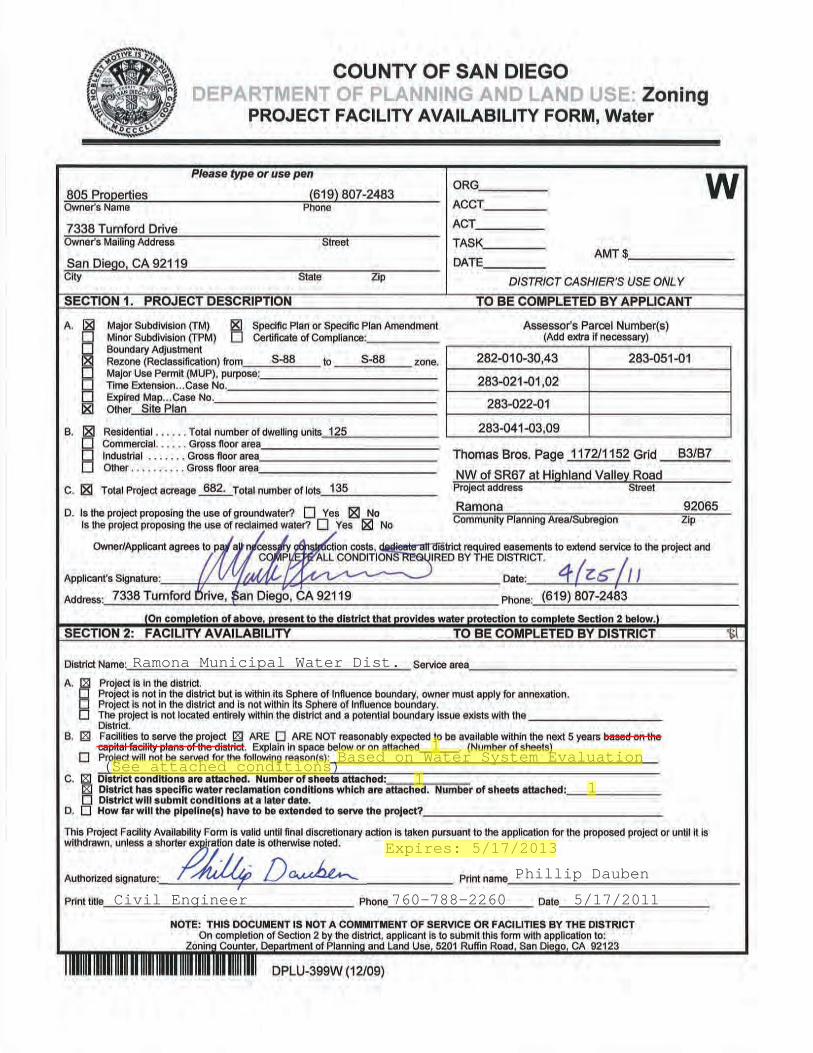
Ramona Municipal Water Dist.x
x x1
x 1
Expires: 5/17/2013
Phillip Dauben
Civil Engineer 760-788-2260 5/17/2011
Based on Water System Evaluation
x 1(See attached conditions)

Page 1 of 1
Conditions for Water Availability Letter (In District)_
a. Water facilities are reasonably expected to become available within five (5) years, if the following conditions are met:
A water commitment agreement is signed by the owner/developer and approved by the District that the owner/developer will assure the district that all actual costs of the facilities required by the project, including, but not limited to, administrative costs, design costs, and construction costs will be paid solely by the owner/developer in a timely fashion. The agreement shall state that the facilities required by the project will need to be completed before any connections shall be made.
b. Developer shall make a deposit (minimum of $2,000) with the District to cover all costs for any planning and system evaluation required by the District for addressing the facilities needed to serve this project. The amount of the deposit may vary depending on the project scope and additional deposit may be needed depending on actual costs. System evaluations typically require 4 to 6 weeks to complete. The Water System Evaluation shall be completed and a Water Service Agreement or Pre-Annexation Agreement executed before the Draft California Environmental Quality Act (CEQA) documents are prepared and before the District will sign a “Project Facility Commitment Form”.
c. Water availability and commitment letters are based on current ordinances, resolutions, rules, regulations, specifications, and guidelines of the District. Should these ordinances, resolutions, rules, regulations, specification, guidelines, and system conditions change from time to time, the applicant for shall be subject to the requirements in effect at the time of applying for water service.

Conditions for Reclaimed Water It is the policy of the Ramona Municipal Water District that reclaimed water shall be used in designated areas within the jurisdiction wherever its use is financially and technically feasible, and consistent with legal requirements, preservation of public health, safety and welfare, and the environment (LC 7.44.020). The conditions for reclaimed water use are as follows:
A. A reclaimed water service agreement is signed by the owner/developer and approved by the District that the owner/developer will assure the district that all actual costs of the facilities required by the project, including, but not limited to, administrative costs, design costs, and construction costs will be paid solely by the owner/developer in a timely fashion. The agreement shall state that the facilities required by the project will need to be completed before any connections shall be made.
B. For each reclaimed water service area, an evaluation of whether greenbelt irrigation, commercial
office buildings, filling of artificial lakes, or industrial process shall be limited the use of reclaimed water shall be made (LC 7.44.050). The District may mandate construction of reclaimed water distribution systems or other facilities in new developments for current or future reclaimed water use as a condition of any development.
C. Developer shall make a deposit (minimum of $2,000) with the District to cover all costs for any
planning and system evaluation required by the District for addressing the facilities needed to serve this project (LC 2.44.020 B). The amount of the deposit may vary depending on the project scope and additional deposits may be needed depending on actual costs. The Reclaimed Water System Evaluation shall be completed and a Reclaimed Water Service Agreement executed before the Draft California Environmental Quality Act (CEQA) documents are prepared and before the District will sign a “Project Facility Commitment Form”.
D. Reclaimed water requirements and conditions are based on the current ordinances,
resolutions, rules, regulations, specifications, and guidelines of the District. Should these ordinances, resolutions, rules, regulations, specification, guidelines, and system conditions change from time to time, the applicant for shall be subject to the requirements in effect at the time of applying for reclaimed water service.
Page 1 of 1

SR-67
MAINST
D ST
H ST
ASH ST
DYE RD
CEDAR ST
ELM
ST
PIN
EST
ASH
LEY
RD
MONTECITO RD
E STB ST
RA
MO
NA
ST
SAN
VIC
ENTE
RD
09THST
A ST
RA
NG
ELA
ND
RD
GEM LN
G ST
HANSON LN
11THST
08THST
HIGHLAND VALLEY RD
WALNUT ST
MA
PLE
ST
LA BREA ST
06THST
F ST
OA
KST
07THST
05THST
EL PASO ST
16THST
ALI
CE
ST
MUSSEY
GRADE
RD
POPLAR ST
ROBERTSON ST
CREELMAN LN
RAYMOND AV
SAW
DAY
ST
SH
UN
TER
ST
S14TH
ST
OLIVE ST
OA
K VA
LLEY RD
KEY
SER
RD
BARGER PL
PAM
OR
D
LILA
CR
D
PRIVATE RD
BO
UN
DA
R YAV
WARNOCK DR
DOS PICOS PARK RD
MO
NTE
CIT
OW
Y
S10TH
ST
LAM
AR
ST
SOU
THER
NO
AK
RD
WH
IRLW
IND
LN
DU
RG
INST
MAHOGANY RANCH RD
13THST
TOUB ST
CHABLIS RD
PALAST
SR-78
THO
MSE
N W
Y
DYE ST
HA
NSO
NW
Y
CO
OK
ST
AQUA LNDAY ST
CAM DEL INDIO
MA
RM
AC
DR
RANCHO MARIA LN
DU
RA
ZNIT
OS
RD
WO
OD
ENER
GY
RD
ROWLEY AV
BLUEGRASS RD
AIR
MA
ILLN
ELSO
LR
D
SER
ENA
HIL
LS D
R
12THST
KAY
DEE
LN
DURA
ZNIT
OS
PL
RANCHO DE ORO DR
LAK
YLN
BO
OR
TZLN
SONORA WY
AM
AR
ILLO
RD
ALLEY
BA
NJO
LN
SUM
MER
GLE
NR
D
MA
ND
EZD
R
WERNES ST
LAWRENCE LN
MOUNTAIN LN
VIA
TAQ
UIT
A
MARALN
PRIVATE RD
F ST
B ST
ALI
CE
ST
PRIVATE RD
OLIVE ST
PRIV
ATE
RD
P RIV
ATE
RD
PRIVATE RD
PRIVATE RD
PRIVATE RD
PRIVATE RD
PRIV
ATE
RD
PRIVATE R
D
PRIV
ATE
RD
PRIVATE RD
Vicinity MapCumming Ranch
Highland Valley Road & SR-67Owner: 805 Properties
.Legend
RMWD Boundary
Santa Maria Sewer Service Area
Active Latent Powers Boundary
Subject Parcel selection
Subject Parcels
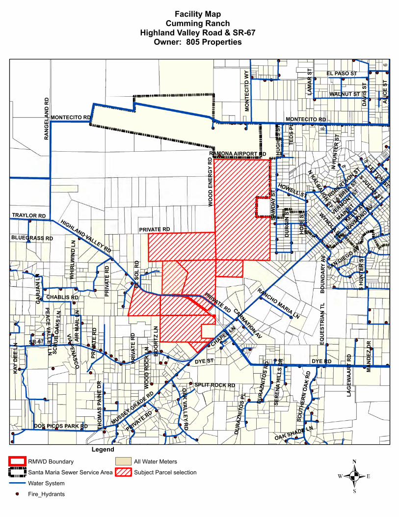
SR-67
DYE RD
MONTECITO RD
MAINST
HIGHLAND VALLEY RD
EL PASO ST
LA BREA ST
VERMONT ST
KELLYAV
ROBERTSON ST
SAW
DAY
ST
SH
UN
TER
ST
RA
NG
E LA
ND
RD ALI
CE
S T
WALNUT ST
HO
PES T
DA V
ISS T
MUSSEY GRADE RD
PRIVATE RD RAYMOND AV
WH
IRLW
IND
LN
DU
RG
INST
NKALBAUGH
ST
EQU
ESTR
I AN
TLB
OU
ND
ARY
AV
OA
KVA
LLEYR
D
L AM
AR
ST
CHABLIS RD
DOS PICOS PARK RD
SOU
THER
NO
AK
RD
MO
NTE
CIT
OW
Y
DYE ST
SPLIT ROCK RD
NH
UN
TER
ST
TRAYLOR RD
LETTONST
WYNOLA
ST
HU
GH
ESST
SJULIAN
ST
GA
RJA
NLN
RANCHO MARIA LN
HOWELL ST
RAMONA AIRPORT RD
DU
RA
ZNIT
OS
RD
TED
SPL
WO
OD
ENER
GY
RD
VIAPEN
ASC
O
BLUEGRASS RD
AIR
MA
ILLN
E LSO
LR
D
THO
MA
SPA
INE
DR
SER
ENA
HIL
LSD
R
DU
RA
ZNIT
OS
PL
SAN DIEGO AV
KAY
DEE
LN
WO
OD
RO
CK
LN BO
OR
TZLN
PEAC
EVA
LLEYLN
MA
ND
E ZD
R
CARNATIONAV
SCR
UB
OA
KS
LN
OAK SHADE LN
LAG
EWA
AR
TR
DCHAPEL LN
PRIV
A TE
RD
PRIV
ATE
RD
MONTECITO RD
PRIV
ATE
RD
PRIVATE RD
PRIVATE RD
8
6
8
8
8
Facility MapCumming Ranch
Highland Valley Road & SR-67Owner: 805 Properties
.Legend
RMWD Boundary
Santa Maria Sewer Service Area
Water System
Fire_Hydrants
All Water Meters
Subject Parcel selection
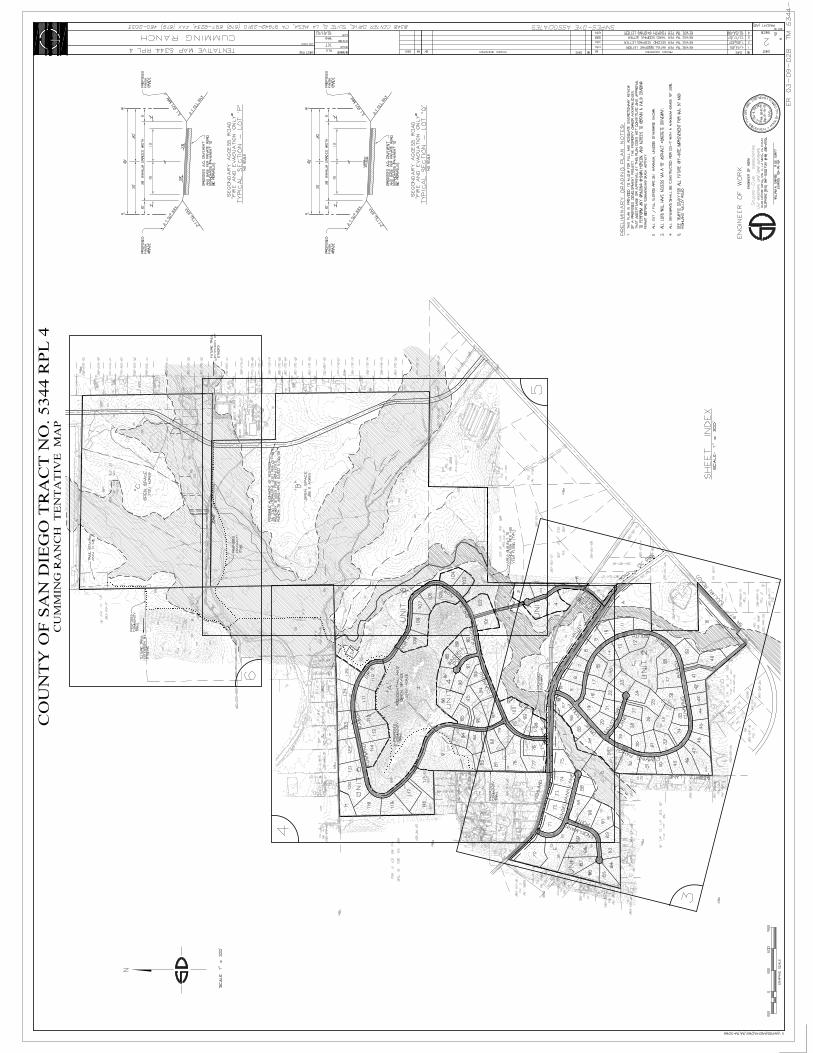
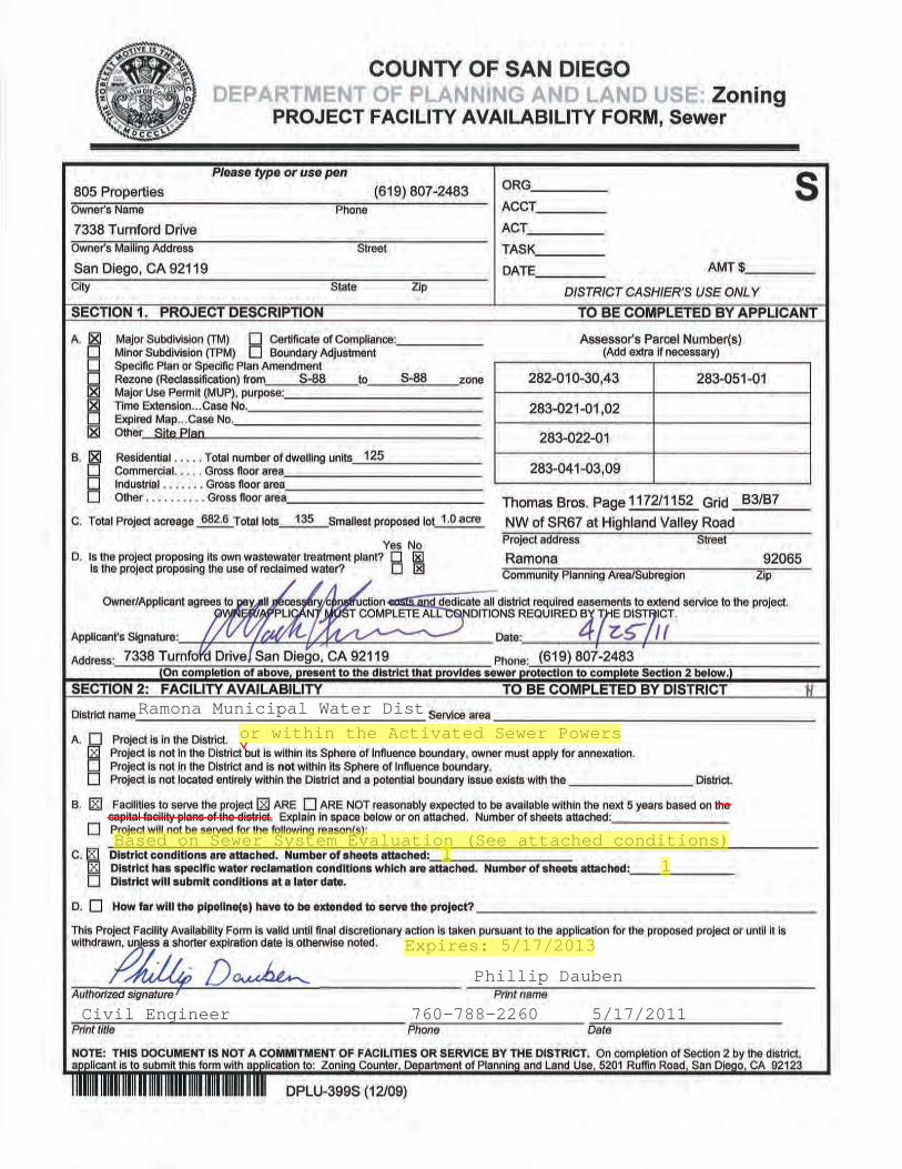
Based on Sewer System Evaluation (See attached conditions)
Ramona Municipal Water Dist.
Expires: 5/17/2013
Phillip Dauben
Civil Engineer 760-788-2260 5/17/2011
x
x x
x 1
or within the Activated Sewer Powers
x 1

Conditions for Sewer Availability Letter (Not in the Active Sewer Powers)_ a. The project is not within the Sewer Service Area and not within its Active Sewer Powers. b. Sewer facilities are not reasonably expected to become available within five (5) years unless
the following conditions are met: i. If a pre-annexation and/or pre-latent powers expansion agreement is signed by the owner/developer and approved by the District’s Directors whereby the District will request consideration from LAFCO to expand the latent sewer powers to include the project area and the owner/developer will assure the district that all actual costs of the facilities required by the project, including, but not limited to, administrative costs, design costs, construction costs and the cost of a percentage of the value of the existing facilities, will be paid solely by the owner/developer in a timely fashion. The pre-annexation and/or pre-latent powers expansion agreement should state that the facilities required by the project will need to be completed before any connections shall be made. ii. If the District adopts a resolution applying to LAFCO for expansion of its latent sewer powers to include the area. iii. If LAFCO approves the annexation and/or the expansion of latent powers to include the area. c. Developer shall make a deposit (minimum of $2,000) with the District to cover all costs for
any planning, system evaluation, and annexation required by the District for addressing the facilities needed to serve this project. The amount of the deposit may vary depending on the project scope and additional deposit may be needed depending on actual costs. The Sewer System Evaluation shall be completed and a Sewer Service Agreement or Pre-Annexation Agreement executed before the Draft California Environmental Quality Act (CEQA) documents are prepared and before the District will sign a “Project Facility Commitment Form”.
d. Sewer availability and commitment letters are based on current ordinances, resolutions, rules,
regulations, specifications, and guidelines of the District. Should these ordinances, resolutions, rules, regulations, specification, guidelines, and system conditions change from time to time, the applicant for shall be subject to the requirements in effect at the time of applying for water service.
Page 1 of 1
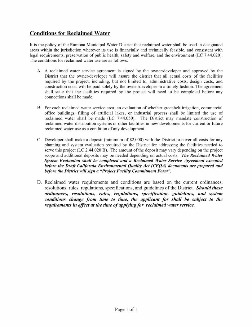
Conditions for Reclaimed Water It is the policy of the Ramona Municipal Water District that reclaimed water shall be used in designated areas within the jurisdiction wherever its use is financially and technically feasible, and consistent with legal requirements, preservation of public health, safety and welfare, and the environment (LC 7.44.020). The conditions for reclaimed water use are as follows:
A. A reclaimed water service agreement is signed by the owner/developer and approved by the District that the owner/developer will assure the district that all actual costs of the facilities required by the project, including, but not limited to, administrative costs, design costs, and construction costs will be paid solely by the owner/developer in a timely fashion. The agreement shall state that the facilities required by the project will need to be completed before any connections shall be made.
B. For each reclaimed water service area, an evaluation of whether greenbelt irrigation, commercial
office buildings, filling of artificial lakes, or industrial process shall be limited the use of reclaimed water shall be made (LC 7.44.050). The District may mandate construction of reclaimed water distribution systems or other facilities in new developments for current or future reclaimed water use as a condition of any development.
C. Developer shall make a deposit (minimum of $2,000) with the District to cover all costs for any
planning and system evaluation required by the District for addressing the facilities needed to serve this project (LC 2.44.020 B). The amount of the deposit may vary depending on the project scope and additional deposits may be needed depending on actual costs. The Reclaimed Water System Evaluation shall be completed and a Reclaimed Water Service Agreement executed before the Draft California Environmental Quality Act (CEQA) documents are prepared and before the District will sign a “Project Facility Commitment Form”.
D. Reclaimed water requirements and conditions are based on the current ordinances,
resolutions, rules, regulations, specifications, and guidelines of the District. Should these ordinances, resolutions, rules, regulations, specification, guidelines, and system conditions change from time to time, the applicant for shall be subject to the requirements in effect at the time of applying for reclaimed water service.
Page 1 of 1
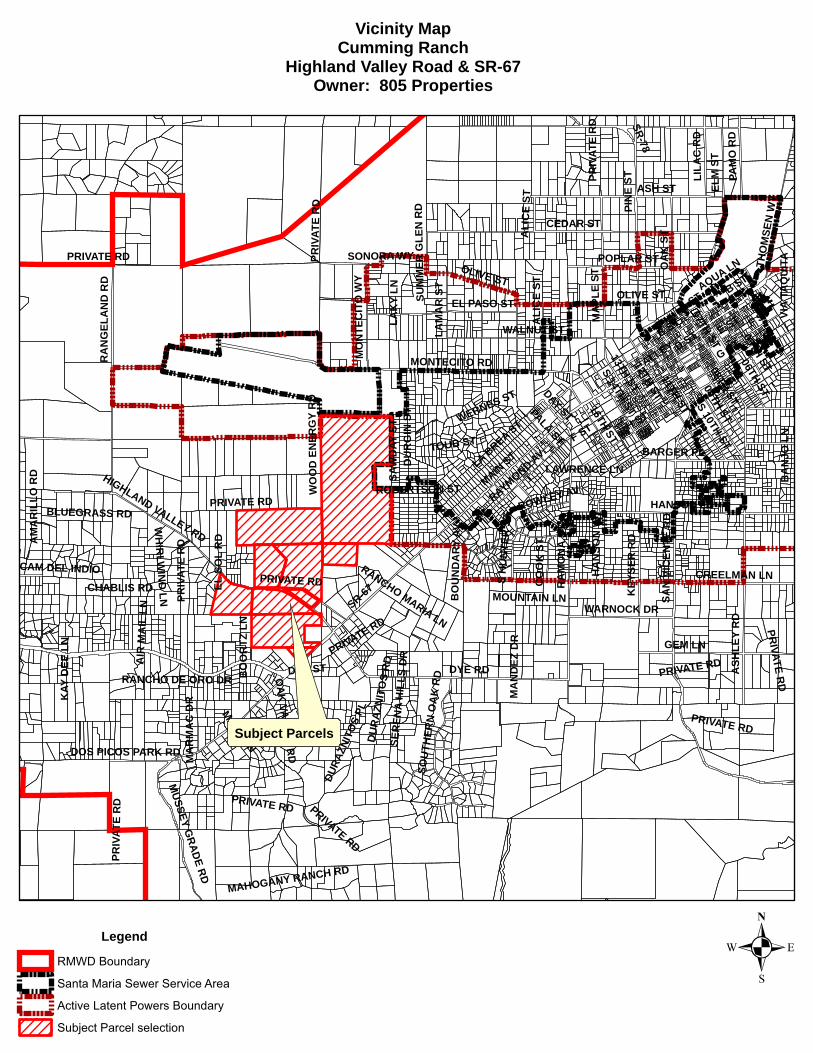
SR-67
MAINST
D ST
H ST
ASH ST
DYE RD
CEDAR ST
ELM
ST
PIN
EST
ASH
LEY
RD
MONTECITO RD
E STB ST
RA
MO
NA
ST
SAN
VIC
ENTE
RD
09THST
A ST
RA
NG
ELA
ND
RD
GEM LN
G ST
HANSON LN
11THST
08THST
HIGHLAND VALLEY RD
WALNUT ST
MA
PLE
ST
LA BREA ST
06THST
F ST
OA
KST
07THST
05THST
EL PASO ST
16THST
ALI
CE
ST
MUSSEY
GRADE
RD
POPLAR ST
ROBERTSON ST
CREELMAN LN
RAYMOND AV
SAW
DAY
ST
SH
UN
TER
ST
S14TH
ST
OLIVE ST
OA
K VA
LLEY RD
KEY
SER
RD
BARGER PL
PAM
OR
D
LILA
CR
D
PRIVATE RD
BO
UN
DA
R YAV
WARNOCK DR
DOS PICOS PARK RD
MO
NTE
CIT
OW
Y
S10TH
ST
LAM
AR
ST
SOU
THER
NO
AK
RD
WH
IRLW
IND
LN
DU
RG
INST
MAHOGANY RANCH RD
13THST
TOUB ST
CHABLIS RD
PALAST
SR-78
THO
MSE
N W
Y
DYE ST
HA
NSO
NW
Y
CO
OK
ST
AQUA LNDAY ST
CAM DEL INDIO
MA
RM
AC
DR
RANCHO MARIA LN
DU
RA
ZNIT
OS
RD
WO
OD
ENER
GY
RD
ROWLEY AV
BLUEGRASS RD
AIR
MA
ILLN
ELSO
LR
D
SER
ENA
HIL
LS D
R
12THST
KAY
DEE
LN
DURA
ZNIT
OS
PL
RANCHO DE ORO DR
LAK
YLN
BO
OR
TZLN
SONORA WY
AM
AR
ILLO
RD
ALLEY
BA
NJO
LN
SUM
MER
GLE
NR
D
MA
ND
EZD
R
WERNES ST
LAWRENCE LN
MOUNTAIN LN
VIA
TAQ
UIT
A
MARALN
PRIVATE RD
F ST
B ST
ALI
CE
ST
PRIVATE RD
OLIVE ST
PRIV
ATE
RD
P RIV
ATE
RD
PRIVATE RD
PRIVATE RD
PRIVATE RD
PRIVATE RD
PRIV
ATE
RD
PRIVATE R
D
PRIV
ATE
RD
PRIVATE RD
Vicinity MapCumming Ranch
Highland Valley Road & SR-67Owner: 805 Properties
.Legend
RMWD Boundary
Santa Maria Sewer Service Area
Active Latent Powers Boundary
Subject Parcel selection
Subject Parcels
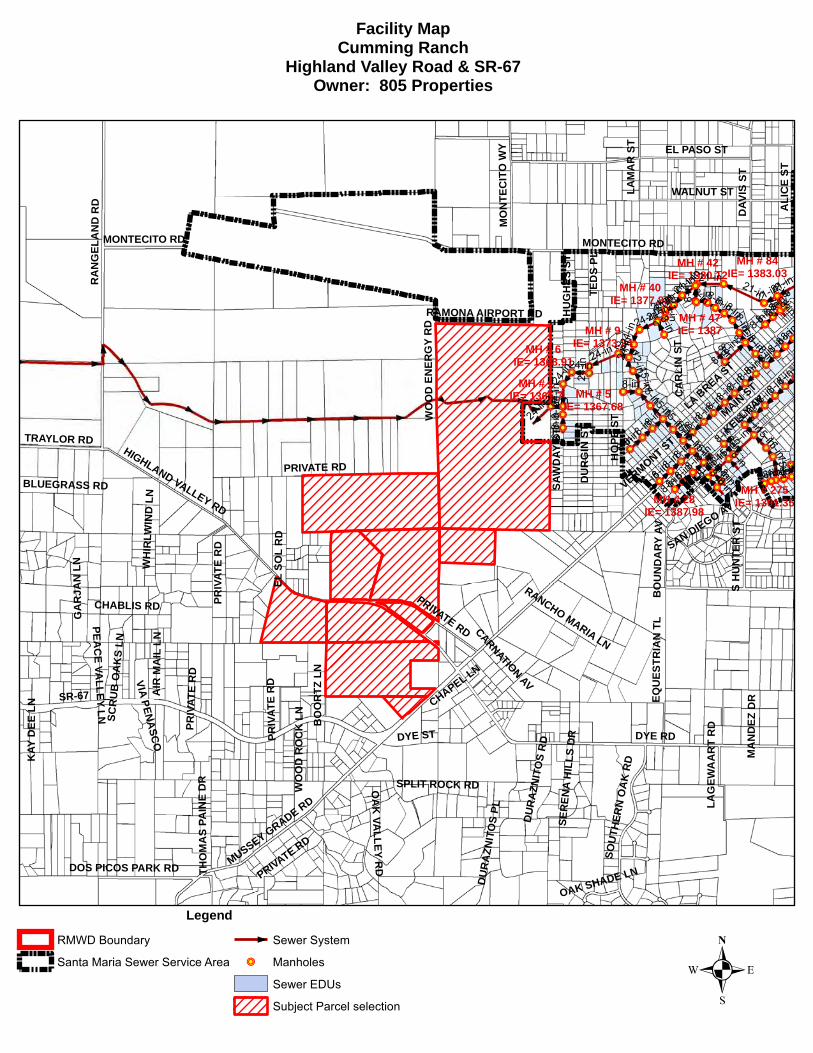
SR-67
DYE RD
MONTECITO RD
MAINST
HIGHLAND VALLEY RD
EL PASO ST
LA BREA ST
VERMONT STKELLY
AV
SAW
DAY
ST
SH
UN
TER
ST
RA
NG
E LA
ND
RD ALI
CE
S T
WALNUT ST
HO
PES T
DA V
ISS T
MUSSEY GRADE RD
PRIVATE RD
WH
IRLW
IND
LN
DU
RG
INST
EQU
ESTR
I AN
TLB
OU
ND
ARY
AV
OA
KVA
LLEYR
D
L AM
AR
ST
CHABLIS RD
DOS PICOS PARK RD
SOU
THER
NO
AK
RD
MO
NTE
CIT
OW
Y
DYE ST
SPLIT ROCK RD
TRAYLOR RD
HU
GH
ESST
GA
RJA
NLN
RANCHO MARIA LN
RAMONA AIRPORT RD
DU
RA
ZNIT
OS
RD
TED
SPL
WO
OD
ENER
GY
RD
VIAPEN
ASC
O
BLUEGRASS RD
AIR
MA
ILLN
ELSO
LR
D
THO
MA
SPA
INE
DR
SER
ENA
HIL
LSD
R
DU
RA
ZNIT
OS
PL
SAN DIEGO AV
KAY
DEE
LN
WO
OD
RO
CK
LN BO
OR
TZLN
CA
RLI
NST
PEAC
EVA
LLEYLN
MA
ND
E ZD
R
CARNATIONAV
SCR
UB
OA
KS
LN
OAK SHADE LN
LAG
EWA
AR
TR
DCHAPEL LN
PRIV
A TE
RD
PRIV
ATE
RD
MONTECITO RD
PRIV
ATE
RD
PRIVATE RD
PRIVATE RD
MH # 47IE= 1387
MH # 1IE= 1365.7
MH # 9IE= 1373.24MH # 6
IE= 1368.91
MH # 5IE= 1367.68
MH # 84IE= 1383.03
MH # 42IE= 1380.12
MH # 40IE= 1377.88
MH # 28IE= 1387.98
MH # 275IE= 1391.35
21-in
8-in
24-in
15-in
8-in
8-in
8-in
15-in
24-in
24-in 24
-in
12-in
8-in
8-in
8-in
21-in
8-in
15-in8-in
21-in
8-in
8-in
8-in
24-in
8-in
8-in
15-in
8-in
8-in
21-in
8-in
8-in
21-in
8-in
8-in
15-in
8-in
15-in
8-in
15-in8-in
15-in
8-in
8-in
8-in
8-in
8-in
8-in
24-in
8-in
24-in
8-in
24-in
21-in
8-in
24-in
8-in
8-in
8-in
8-in
8-in
21-in 21-in
8-in
24-in
15-in
8-in
8-in
8-in
8-in
8-in
8-in
21-in
8-in
15-in
8-in
15-in
15-in
21-in8-in
15-in
8-in
8-in
8-in
8-in
8-in
8-in
8-in
8-in
8-in
8-in
8-in
24-in
8-in
21-in
8-in
8-in 15-in
15-in
8-in
8-in
15-in
8-in
8-in
15-in
8-in
8-in
8-in
24-in
Facility MapCumming Ranch
Highland Valley Road & SR-67Owner: 805 Properties
.Legend
RMWD Boundary
Santa Maria Sewer Service Area
Sewer System
!P Manholes
Sewer EDUs
Subject Parcel selection


Cumming Ranch Specific Plan
ATTACHMENT
Cumming Ranch Specific Plan Map