current and future meteorological satellite program of china
TRANSCRIPT
Current and Future Meteorological Satellite Program of China
ZHANG Wenjian, DONG ChaohuaXU Jianmin, YANG Jun
China Meteorological AdministrationMay 30, 2005Beijing, CHINA

Outline of the Presentation
1. Current Meteorological Satellites2. Future Plans and Considerations
for China’s Met. Sat. Program3. Conclusion

1. Current Chinese Meteorological Satellites
1.1 Polar1.2 Geostationary

FY-1D: The Chinese Polar-orbiting Operational Satellite
FY-1D was launched on May 15, 2002Operation is now over design life and still health in operation

Characteristics of the 10-Ch. Radiometer of FY-1Channel Wavelength(µm) Purpose
1 0.58-0.68 2 0.84-0.89 Channel 1-6 3 3.55-3.95 Close to current 4 10.3-11.3 NOAA/AVHRR3 5 11.5-12.5 6 1.58-1.64 7 0.43-0.48 Ocean color 8 0.48-0.53 Ocean color 9 0.53-0.58 Ocean color 10 0.90-0.965 Water vapor


FY-1DHRPT Received At Europe

Global Multi-Orbit Mosaic Image

CompositeImagery ofAntarcticRegion byFY-1DGDPT
(Ch. 1,2,3 Composite. )

Current Chinese Meteorological Satellites
1.1 Polar1.2 Geostationary

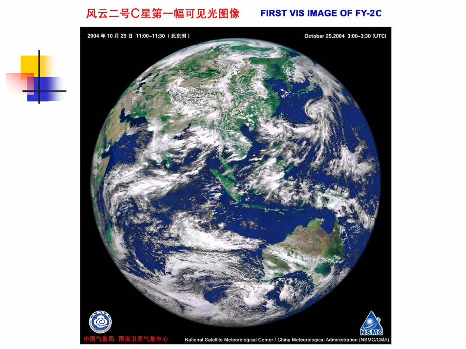
Successful launch of FY-2C
Launch and position
FY-2C launched at 09:20 (BJ), Oct. 19, 2004;
FY-2C Located at 105ºE on Oct. 24, 2004

FY-2C/D/E/F/G: operational series
FY-2 Op series is consists of FY-2C/D/E three satellites and 2 more satellites will be added (FY-2F&FY-2G) for connection to FY-4. The Op series is improved based on FY-2A/B with the major improvements on:
Five channel radiometers;More products for widely use in meteorology and Environment (Dr. XU will have more slides to show)More frequent observations during the main flooding season (June – August)
half-hourly image (48 images each day)
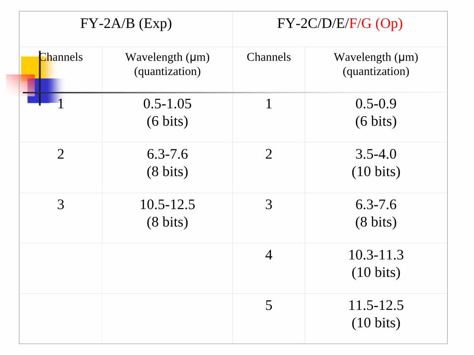
FY-2A/B (Exp) FY-2C/D/E/F/G (Op)
Channels Wavelength (µm)(quantization)
Channels Wavelength (µm)(quantization)
1 0.5-1.05(6 bits)
1 0.5-0.9(6 bits)
2 6.3-7.6(8 bits)
2 3.5-4.0(10 bits)
3 10.5-12.5(8 bits)
3 6.3-7.6(8 bits)
4 10.3-11.3(10 bits)
5 11.5-12.5(10 bits)


Fire spots in Australia
Land
Ocean
FY2C IR 33.9um

Cirrus
Snow
Fog
Lake
River
Snow
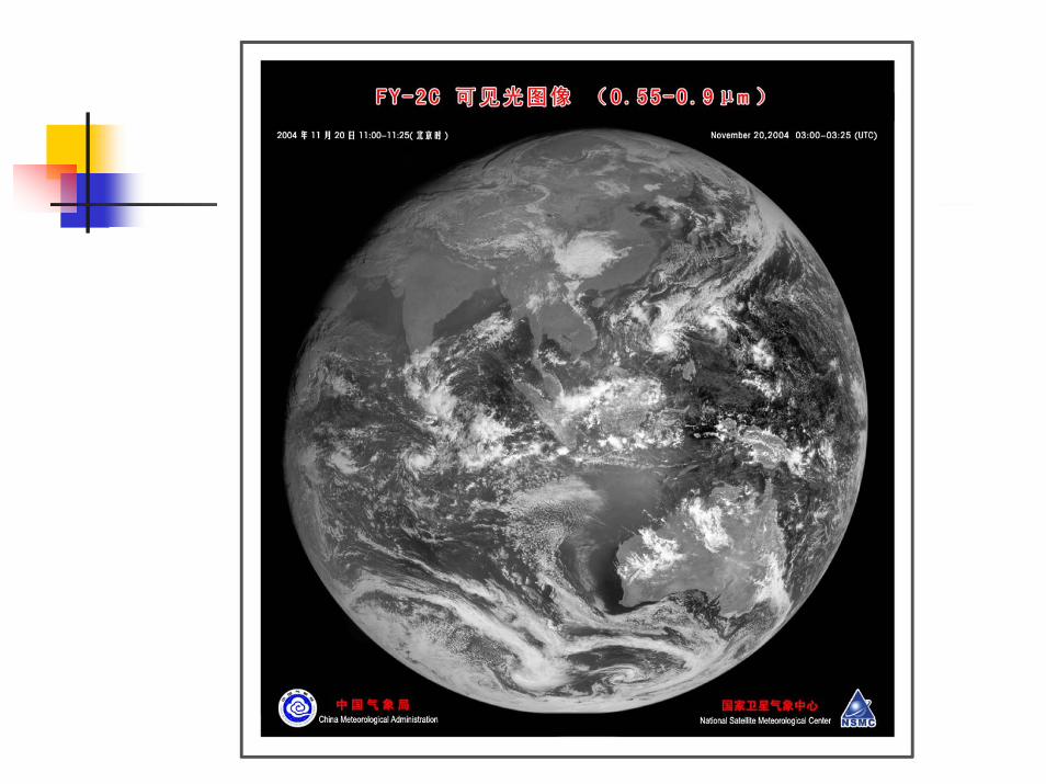
FY2C VIS

2. Future Plans and Considerations for China’s Met. Sat. Program
2.1 Polar Satellites Program 2.2 GEO Satellites Consideration

The 2nd gen. of polar satellites
Purpose of FY-3A/B (exp.)• Risk reduction in Engineering• Products development and validation• Utilization Demo in some area

Two phase of FY-3 series
There are two developing phases for FY-3: i.e..
Exp. Phase (2006-2009 in flight): 2 satellites with limited sounding capabilities
FY-3A Launch scheduled in Early 2007FY-3B launched scheduled in Early 2009
Operational Phase (flight after 2009 ): Satellites Constellation is planned with expanded sounding and imaging capabilities

FY-3A Satellite: Progress
Phase A (Design and Structure)Sept. 2000- Nov. 2003
Phase B (Engineering Model)Dec. 2003- July 2005
Phase C (Flight Model)Aug. 2005 – Dec. 2006 (Ready for Launch )

Main specifications of FY-3A
Orbit: Sun-synchronous polar-orbitingOrbit altitude: 836 km Inclination=98.728 degreeEccentricity: better than 0.0034Nodal crossing time: 10:10-10:20 am (LST, FY-3B could be at afternoon orbit)Orbit drifting: < 10 minutes (within 2 years)

Main specifications of FY-3A (cont.)
Power: 1100 watts (orbital average, estimated)Weight: 2200 kg (estimated now)Size : 4400*2000*2000 (X,Y,XZ :in stowed)
: 4400*10000*2000 (X,Y,Z : in flight) Design life: >= 3 years
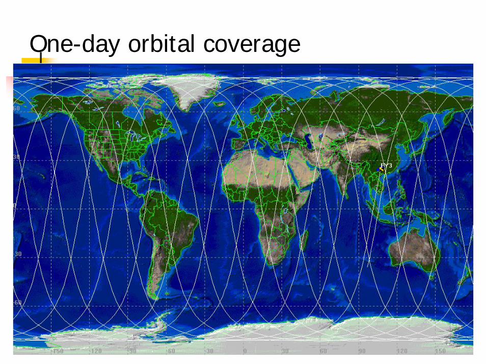
One-day orbital coverage

Satellite in flying mode

2005-6-13 31
Main Instruments on FY-3 (1) Sounding Mission(5 instruments)
Infrared Atmospheric Sounder (IRAS)MicroWave atmospheric Temperature Sounder (MWTS) MicroWave atmospheric Humidity Sounder (MWHS, AMSU-B like,onboard FY-3A/B ) Multichannel Atmospheric Infrared Sounder (MAIRS, OP. phase) Solar Backscatter Ultraviolet and Total Ozone Sounder (SBUV/TOS)

2005-6-13 32
Main Instruments on FY-3 (2) Imaging Mission(3 instruments)
Visible and Infrared Radiometer(VIRR, 10
channels, similar to radiometer aboard FY-1C)
Medium Resolution Spectral Imager(MERSI)
MicroWave Radiation Imager (MWRI)

2005-6-13 33
Main Instruments on FY-3 (3) Complementary Mission
Earth Radiation Budget Unit (ERBU)
Space Environment Monitor (SEM)
Data Collection System (DCS)

Data types: HRPT format
Band frequency: 1698-1710 MHzBand Width: 5.4 MHzModulation: QPSKData rate: 4.2 MbpsEncoding: CONV(7, ¾)Broadcasting: Real time

Data types: DPT format
DPT=Delayed Picture TransmissionBand frequency: 8025-8215/8215-8140 MHzBand Width: 140 MHzModulation: QPSKData rate: 110 MbpsEncoding: CONV(7, ¾)Broadcasting: Within China capture area

Data types: MPT format
MPT=Mission Picture TransmissionBand frequency: 7750-7850 MHzBand Width: 25 MHzModulation: QPSKData rate: 20 MbpsEncoding: CONV(7, ¾)Broadcasting: program controlled

Science Data Downlink Service Allocations
instrument HRPT MPT Stored time DPT
VIIR √ 810 min √IRAS √ 810 min √MWTS √ 810 min √MERSI √ 120 min √MWRI √ 810 min √TOMS/SBUV √ 810 min √SEM √ 810 min √ERBU √ 810 min √MWHS √ 810 min √


Larger Firing is needed for FY-3

Solar panel testing of FY-3A

FY-3 Operational Constellation Considerations
Instruments on FY-3A/B will be improved and refined for FY-3 Op satellitesTwo polar satellites in operation (one in the AM and one in the PM orbit, payload will be different for AM/PM satellites, time slots could be coordinated through WMO) One low inclination orbit satellite is planning, mainly for precipitation measurement (mainly Radar, Passive Microwave measurement). Details is still in discussion

FYFY--3 Ground Segment3 Ground Segment
7 receiving stations, one of the stations will be in high latitude place (Svabald)
Products from FY-3 will be broadcasted by DVBS

0° 180°
90° W
90° E
� �●
� ��
� � �●
� � � �●
� �●
� �●
Sval Bard
●
� �●
� � � �
� � � �

Data transmission to Beijing and then re-transmit (DVBS)This technology will be used in FY-3 data re-transmission

Future Geostationary Satellites

FY-2 D/E/F/G: launch schedule
FY-2D will be launched in early 2007 with current planBy then FY-2C would be still health, then two GEO constellation will be formed:
Wider coverage (possible FY-2C in 123E, and FY-2D in 87.5E, also for contingency) More frequent observations during the flooding season for overlap areas New products (ex. Stereo cloud, new wind-height assignment, etc. ) FY-2E is plan to launch in early 2009 to replace FY-2CFY-2F/G will replace FY-2D and FY-2E in 2011 and 2013, respectively

New Generation for Geo: FY-4
Considerations on FY-4Three-Axis StabilizationMore powerful imager and lightning mapperSounding capability (Spectrometer?)More powerful Data Collection PlatformsEnhanced ground control capabilityEnhanced application and services systems

Constellation including two series: refer to A series and B series
A: VIS and IR satellites, early launch around 2012
B: Microwave satellites, early launch around 2015
Now FY-4 is at the Pre-Phase A stage, schedule to be developed during 2006-2012, and launch after 2012
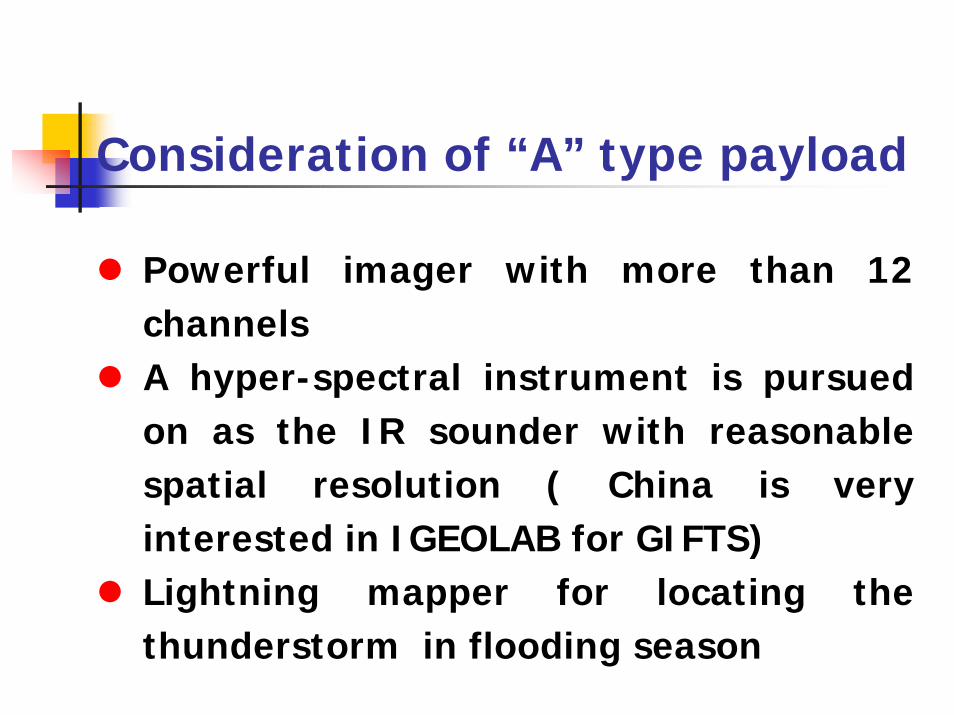
Consideration of “A” type payload
Powerful imager with more than 12 channels A hyper-spectral instrument is pursued on as the IR sounder with reasonable spatial resolution ( China is very interested in IGEOLAB for GIFTS)Lightning mapper for locating the thunderstorm in flooding season

Consideration of “B” type payload
Microwave sounder working on higher frequencies for sounding the cloudy atmosphere(China is also interested in IGeoLab of Geo Microwave project)CCD camera with high spatial resolution for frequent high resolution imagery observation for the severe weatherA Solar telescope and a SEM will be developed fro space weather service

FY-4 ground segment
To have enhanced control
capability
Application will cover weather,
climate and environment, as
well as rapid response fields

3. ConclusionTo meet national requirements and modernizing the meteorological service of China and world meteorological community. China will continue her effort to develop two types of satellites (LEO and GEO).Chinese satellites, as a integrated part of the space component of WMO GOS, are not only benefit the nation of China, but also reflect the contribution to the international Earth Observation community.

The EndThe End
Thanks !Thanks !