curriculum for the degree study program geographical ... · unigis msc – curriculum 2016w the...
TRANSCRIPT

UNIGIS MSc – Curriculum 2016W
Curriculum for the degree study program
"Geographical information science & systems (UNIGIS MSc)"
Curriculum version 2016W
published in the 201st Bulletin of the Paris Lodron-University Salzburg (PLUS) on July 27, 2016 https://online.uni-salzburg.at/plus_online/wbMitteilungsblaetter.display?pNr=1627233
Contents
Preliminary remarks ......................................................................................................................................... 2
§ 1 General information ................................................................................................................................... 2
§ 2 Entry requirements ..................................................................................................................................... 3
§ 3 Qualifications profile, professional fields and target groups ....................................................................... 3
(1) Objectives of the study program ................................................................................................................... 3
(2) Profile of qualifications and competencies (learning outcomes) .................................................................. 3
(3) Relevance of the university course to society and market demands ............................................................ 4
(4) Target groups ................................................................................................................................................ 5
§ 4 Organisation and structure of the study program ....................................................................................... 5
§ 5 Types of courses ......................................................................................................................................... 6
§ 6 Study content and scheduling ..................................................................................................................... 6
§ 7 Catalogue of “Electives Subjects” and/or bound “Elective Subjects” .......................................................... 9
§ 8 Master Thesis ............................................................................................................................................. 9
§ 9 Assessment of student performance and exams....................................................................................... 10
§ 10 Tuition fee .............................................................................................................................................. 10
§ 11 Evaluation ............................................................................................................................................... 10
§ 12 Coming into effect .................................................................................................................................. 10
§ 13 Transitional provisions ............................................................................................................................ 10
Annex I: Module descriptions ......................................................................................................................... 11
Impressum ........................................................................................................................................................ 21
Remark ........................................................................................................................................................... 21

UNIGIS MSc – Curriculum 2016W
The curriculum for the study program "Geographical Information Science & Systems (UNIGIS MSc)" has been proposed by the Curriculum Commission for geography of the University of Salzburg in its meeting on the 18.1.2016 and adopted by the Senate of the Paris Lodron University of Salzburg in the presented version on 21.06.2016.
The legal bases are the Federal Act no. 120/2002 on the Organisation of Universities and their Studies (Universitätsgesetz 2002) and the Statute of the University of Salzburg in its current version.
Preliminary remarks
University courses in Geoinformatics have been offered at Paris Lodron-University Salzburg since 1994. This curriculum serves the further development on the basis of professional and technical progress, educational experiences, current legal conditions and the requirements of the European higher education area.
This study program foresees the idea of “blended learning” in a flexible format including variable and open forms of study. It therefore allows organisational diversity. In particular it aims at distributed, in-service, continuing education and therefore learning materials, mentoring, communication media and organisation are designed to support a distance learning approach.
Within the existing international network of partner universities “UNIGIS International Association”, UNIGIS study programs are subject to continuous development and quality assurance under its established world-wide brand.
§ 1 General information
(1) In total, the "Geographical Information Science & Systems (UNIGIS MSc)" study program amounts to 120 ECTS credits. It is typically a part-time study, which comprises of four semesters. The program director considers specific didactic and organisational affordances to frame scheduling and operative implementations of the study program. Graduates are awarded the academic degree "Master of Science" (MSc).
(2) The workload is described in terms of European Credit Transfer System (ECTS) points. One ECTS point corresponds to a workload of approximately 25 hours and describes the average workload that is required to achieve the expected learning outcomes. The workload of an academic year equates to 1500 hours of student workload and thus is worth 60 ECTS credits.
(3) In accordance with the demand and the organizational capacities, the course is offered to cohorts of students. The program director is responsible to set starting dates in a suitable frequency. Due to the character of an in-service study program, semester-oriented regulations do not apply. Instead, flexible part time schedules are set by the program director.
(4) The program can be offered in German and English as well as in mixed language forms, where professional requirements and prior knowledge of students must be taken into account. Further, the course materials or tutoring can be offered in other languages if required. This can also be done in collaboration with appropriate partners.
(5) Students with disability or chronic disease shall not be discriminated by the design of the study program. The legal framework of the Convention for rights of people with

UNIGIS MSc – Curriculum 2016W
disabilities, the Equality Act and the principle of disadvantage compensation are fully applicable.
§ 2 Entry requirements
(1) A prerequisite for admission to the University course "Geographical Information Science & Systems (UNIGIS MSc)" is the successful completion of a relevant Bachelor degree or another equivalent course at a recognized domestic or foreign post-secondary educational institution (see UG 2002 § 64 (5)).
(2) Equivalent qualifications to §2 (1) can be recognized by the program director. This requires at least the general qualification for university entrance and several years of professional experience in the field of geoinformatics.
(3) The proof of sufficient language skills (language level B2 or higher according to GER, or proof of equivalent qualifications) may be required by the course management.
(4) Registration depends on available study places. The maximum number of admitted students is to be set by the program director, taking into account educational and organisational considerations. Allocation of study places are arranged in the order of binding registration according to evidence of the provision of all admission requirements.
(5) The program director may require each candidate to present him-/herself in an admission interview. This interview is mandatory for candidates that apply with reference to § 2 (2).
(6) The program director decides on the admission to the University course considering all necessary application documents.
§ 3 Qualifications profile, professional fields and target groups
(1) Objectives of the study program
Geoinformatics is a method-oriented interdisciplinary domain. It is based on spatial concepts and working methods used in the context of and in cooperation with numerous application fields (e.g. planning, resource management, logistics, mobility, nature and environmental protection, archaeology, marketing, or security). The skills taught in the study program "Geographical Information Science & Systems (UNIGIS MSc)" are based on technical and methodological contexts of space-oriented sciences such as e.g. the geography and require basic knowledge and skills in the practice of applied geoinformatics. While compulsory modules handle the essential core areas of Geoinformatics, the Electives allow for individual specialisation.
(2) Profile of qualifications and competencies (learning outcomes)
The close entanglement of conceptual methodological content with application scenarios by using modern GI software leads not only to a critical understanding of the theory, but provides also specialized skills for solving complex real-world problems. Geographic information sciences and their application in the form of geographic information systems thus provide the basis for the methodological and technical implementation of domain-specific knowledge. Competency in management of the common denominator ‘space’ thereby is an interface competence. This allows for the integration of various areas and disciplines to gain new insights and to develop innovative solutions.
UNIGIS MSc – Curriculum 2016W
Graduates of the study program "Geographical Information Science & Systems (UNIGIS MSc)" have the key competences of processing explicitly spatial information. Graduates are particularly
- familiar with the survey, the acquisition and the documentation of appropriate spatial data,
- able to identify the spatial entities and attributes that are relevant to a specific purpose and context, to model heterogeneous data sets and build an appropriate geo-database,
- trained to think spatially, which enables them to select suitable analysis methods to extract relevant spatial information for solving complex problems,
- able to publish existing data as standards-compliant geographic web services with appropriate metadata, and to design distributed geographic information system architectures and implement spatial data infrastructures, and
- trained in the use of cartographic principles for the visualisation and communication of spatial content.
The study program is scientifically sound and gives a competent approach to the methods and techniques of scientific work. Graduates are able to grasp complex problems to independently formulate research questions including hypothesis, objectives, general approach, methods, workflow, acquisition, evaluation and analysis of data as well as a clear, coherent and accurate presentation and interpretation of the results in written and oral format.
Student-centred learning and communication methods aim at establishing a solid foundation for “life-long learning”. Graduates of the course will be able to design their own complex projects and applications in the geo-informatics and to direct, as well as to cooperate within the framework of spatial data infrastructures. Alumni thus can provide well-founded decision support in all areas of the geoinformatics.
The study is compliant with the level 7 (Master) of the European Qualifications Framework.
(3) Relevance of the university course to society and market demands
The study program “Geographical Information Science & Systems (UNIGIS MSc)” meets the increasing demand for qualified professionals in various sectors of economy and management through its content as well as the format of in-service distance education.
Graduates of the study program "Geographical Information Science & Systems (UNIGIS MSc)" operate with emphasis on methodological and technical areas of expertise both in public administration (e.g., spatial data infrastructures and geo-informatics services and development, but also applied in spatial planning, regional management, mobility, environmental and nature protection) as well as in industry in a wide range of business fields. All sectors are covered from data collection and organisation, analytical evaluation and decision support, communication of spatial information as also general management. In-depth geo-informatics expertise is an often career-crucial additional qualification in all those professions, in which spatial data are relevant, for example in planning, energy - and resource management, conservation and environmental management, logistics, security management, software development, marketing, surveying or archaeology.
Graduates of the University course “UNIGIS MSc” can apply to following vocational fields, especially as additional qualification to their professional domain of origin:

UNIGIS MSc – Curriculum 2016W
- Geoinformatics (or related names) - Geographical information and spatial data infrastructure manager - Geodata acquisition - Data analysis and data visualization - Geo-application development
(4) Target groups
The study program addresses:
- Persons from different spatially oriented disciplines, who work with spatial data and want to efficiently acquire, manage, analyse and visualise it.
- Users of geoinformatics applications, who want to update their sectoral and/or autodidactic acquired knowledge with a theoretically well-founded, up-to-date foundation to develop independent solutions for complex problems, as well as
- self-employed (e.g. head of technical agencies) and employees from all sectors, including services, public administration, industry, non-profit business, NGOs as well as universities and research institutions that are (striving to be) entrusted with the coordination and management of GI working groups.
§ 4 Organisation and structure of the study program
The study program "Geographical Information Science & Systems (UNIGIS MSc)" includes 90 ECTS credit points for 11 modules in total. The Master Thesis counts for additional 30 ECTS credits.
Module ECTS
M 01 Introduction to Geoinformatics 6
M 02 Data Modelling and Data Structures 6
M 03 Spatial Data Acquisition and Data Sources 6
M 04 Project Management and GIS Organisation 6
M 05 Geodatabase Management 6
M 06 OpenGIS and distributed GI Infrastructures 6
M 07 Spatial Analysis 6
M 08 Spatial Statistics 6
M 09 Visualisation and Cartography 6
M 10 Learning Practice and Scientific Work 12
WM 01 Elective subjects "Applied Geoinformatics" 24
Master Thesis 30
Total 120

UNIGIS MSc – Curriculum 2016W
§ 5 Types of courses
The following course types are provided In the University course "Geographical Information Science & Systems (UNIGIS MSc)":
Lecture with lab (VU) the theoretical introduction to a field is combined with hands-on elements. A lecture with lab has no compulsory attendance. This type of course can be taken as supervised self-study distance learning unit.
Lab with lecture (UV) the theoretical introduction to a field is combined with hands-on elements, where the character of a lab dominates. The lecture is an immanent exam course with compulsory attendance.
§ 6 Study content and scheduling
In the following the modules and courses of UNIGIS MSc are listed. The association with a semester is a recommendation, where the sequence of courses ensures an optimal learning pathway.
The detailed descriptions of the modules together with the intended learning outcomes and acquired competences can be found in “Annex I: Module Descriptions”.
Study program "Geographical Information Science & Systems (UNIGIS MSc)"
Module Course hrs / week
Type ECTS Semester with ECTS
I II III IV
(1) Compulsory Modules
Module M 01: Introduction to Geoinformatics
M 01.1 Introduction to Geoinformatics 3 VU 6 6
Subtotal module M 01 3 6 6
Module M 02: Data Modelling and Data Structures
M 02.1 Data Modelling and Data Structures
3 VU 6 6
Subtotal module M 02 3 6 6
Module M 03: Data Acquisition and Data Sources
M 03.1 Data Acquisition and Data Sources 3 VU 6 6
Subtotal module M 03 3 6 6
Module M 04: Project management and GIS Organization

UNIGIS MSc – Curriculum 2016W
M 04.1 Project management and GIS Organization
3 VU 6 6
Subtotal module M 04 3 6 6
Module M 05: Geo-database Management
M 05.1 Geo-DBMS 3 VU 6 6
Subtotal module M 05 3 6 6
Module M 06: OpenGIS and Distributed GI infrastructures
M 06.1 OpenGIS and Distributed GI infrastructures
3 VU 6 6
Subtotal module M 06 3 6 6
Module M 07: Spatial Analysis
M 07.1 Spatial analysis 3 VU 6 6
Subtotal module M 07 3 6 6
Module M 08: Spatial Statistics
M 08.1 Spatial Statistics 3 VU 6 6
Subtotal module M 08 3 6 6
Module M 09: Visualisation and Cartography
M 09.1 Visualization and Cartography 3 VU 6 6
Subtotal module M 09 3 6 6
Module M 10: Learning Practice and Scientific Work
M 10.1 Introduction and Orientation 1 UV | VU
2 2
M 10.1 Mid-program Workshop | e-Portfolio
1 UV | VU
2 2
M 10.1 Master Thesis workshop | Presentation of the Master Thesis Proposal
1 UV 2 2
M 10.2 Academic Work 2 VU 3 3

UNIGIS MSc – Curriculum 2016W
M 10.3 Scientific Presentation of Master thesis
1 VU 3 3
Subtotal Module M 10 6 12 2 2 5 3
Total Compulsory Modules 33 66 20 20 23 3
(2) Elective modules according to the § 7
Module WM 01 “Elective Subjects”
A total of 24 ECTS are to be completed in the “Electives Subjects”. The courses offered in the “Electives Subjects” are based on current, professional qualification requirements, are subject to ongoing adjustment and are determined by the Curriculum Commission. The required ECTS for the “Elective Subjects” can also be covered according to the regulations in §7 (1).
WM 01.1 Application Development (using Java)
3 VU 6
WM 01.2 ArcGIS for Server 3 VU 6
WM 01.3 Developing applications with OSM
3 VU 6
WM 01.4 EuroGIS 3 VU 6
WM 01.5 Geoapplikationen mit VB.NET 3 VU 6
WM 01.6 Geomarketing 3 VU 6
WM 01.7 Geoprozessierung mit Python 3 VU 6
WM 01.8 Landschaftsanalyse mit GIS 3 VU 6
WM 01.9 Oracle Spatial 3 VU 6
WM 01.10 Photogrammetrie im Dienste der Geoinformatik
3 VU 6
WM 01.11 Remote Sensing 3 VU 6
WM 01.12 Spatial Simulation 3 VU 6
WM 01.13 Visualisieren von Geodaten mit SVG
3 VU 6
Subtotal Module WM 01 12 24 10 10 4
Total elective modules 12 24 10 10 4

UNIGIS MSc – Curriculum 2016W
(3) Master Thesis 30 3 27
Sum total 45 120 30 30 30 30
§ 7 Catalogue of “Electives Subjects” and/or bound “Elective Subjects”
(1) Complementary to the aforementioned courses, credits for the module WM 01 can also be covered by external courses (e.g. distance learning courses of other UNIGIS partner universities, Summer Schools, projects, workshops). Credits can be given for practice-oriented and professionally relevant training and educational courses provided that they are successfully completed (required certificate should include individual performance assessment, i.e. grading) at other accredited post-secondary educational institutions and that they advance and/or complement skills and knowledge acquired at UNIGIS compulsory modules. Credits can be awarded also for equivalent, scientific activities (e.g. publications).
(2) A subset of at least 12 ECTS within the Elective Subjects can be highlighted as individual specialisation, if their contents are coherent. The student can apply for and suggest an adequate label.
(3) All courses can be offered as distance learning units.
§ 8 Master Thesis
(1) The Master Thesis must contain theoretical and application-oriented components. Knowledge and competences acquired in the modules are to be applied to a specific research question or problem. The Master Thesis is worth 30 ECTS credits. The requirements for the Master Thesis are:
- With the Master Thesis a student shows the ability to do independent research in a selected topic in the field of "Geographical Information Science & Systems". Students are required to meet the principles of scientific work in terms of formal presentation, methodological approach and its content according to current scientific standards. Particular attention shall be given to the theoretical foundations, reference to the relevant literature, relation to currently active fields of research, relevance of the topic and the results, soundness of methodological conception, accuracy, comprehensibility, intelligibility, and formal presentation.
- The subject of the Master Thesis shall be related to one of the core modules 1 to 9. The student may propose a topic or select the topic from a number of suggestions of available supervisors.
(2) The provisions of the Statute of the Paris Lodron University of Salzburg apply for the management and assessment of the Master Thesis (cf. statutes § 23 para. 4 and 5).
(3) The topic of the Master Thesis is to be defined in a way so that it is possible and reasonable for a student to finish the thesis within six months (cf. UG2002 § 81 para. 2).
(4) For the student research and the supervision the provisions of the Copyright Act, Federal Law Gazette No. 111/1936 has to be followed (cf. UG2002 § 80 para. 2).

UNIGIS MSc – Curriculum 2016W
§ 9 Assessment of student performance and exams
(1) The provisions of §§ 72-79 UG 2002 and the section on study affairs of the Statute of the University of Salzburg apply.
(2) Before assessing the Master Thesis all other modules of the course need to be assessed positively.
§ 10 Tuition fee
(1) Students of the study program “UNIGIS MSc” have to pay a tuition fee.
(2) Tuition fees may vary due to study form, study organisation or due to cooperation with other universities. The Vice Rector for teaching is in charge to decide on fee levels.
§ 11 Evaluation
The study program is subject to continuous evaluation involving students, faculty and the program director.
§ 12 Coming into effect
The curriculum shall come into effect starting at the first day of the third month after its announcement.
§ 13 Transitional provisions
(1) Students who are enrolled in the study program "Geographical Information Science & Systems (UNIGIS MSc)" at the Paris Lodron University of Salzburg (version 2009, bulletin - special issue 145. by July 15, 2009) at the time when this curriculum comes into effect are entitled to complete their studies at the latest by 31.1.2019.
(2) Students are entitled to change to this curriculum on voluntary basis at any time within the registration period. A relevant written irrevocable Declaration is to be directed to the Admissions Office.

UNIGIS MSc – Curriculum 2016W
Annex I: Module descriptions
Module name Introduction to Geoinformatics
Module code M 01 (GISINTRO)
Total workload 6 ECTS
Learning outcomes Graduates of this module...
- understand the added value of the spatial dimension as an integrating reference framework.
- have an overview of basic components of typical GIS projects and can appreciate GIS functionalities in this broader context.
- have an overview of the main fields of application of GIS, broadly outline its development and anticipate both current trends and future market potential. The latter facilitates also the effective evaluation of priorities for designing individual learning pathways.
- can answer simple, practical problems, which include a spatial component, by means of professional GIS software.
- know the basic challenges of spatial referencing and are capable of integrating spatial data of different geodetic data and projections into a single spatial reference system.
- have acquired the knowledge to compare and evaluate reference systems in terms of their suitability for a specific application.
Module content This introductory module has a special position as a first study component of the curriculum. It provides orientation and sets the frame for working with the subsequent modules. Specifically, it supports the development of a personal style working with the distance-learning materials. In addition to these objectives regarding the study format, the following domain-related content is offered:
- Terminology and functional characteristics of geographical information systems
- Typical applications of geographical information processing
- Current trends in geoinformatics
- Overview of secondary information resources for GIS in the sense of lifelong learning
- Practical training to use professional GIS software
- Competent use of coordinate systems and projections in the practical work of GIS
Courses M 01.1 VU Introduction to Geoinformatics (6 ECTS)
Type of assessment Assignment

UNIGIS MSc – Curriculum 2016W
Module name: Data Modelling and Data Structures
Module code M 02 (DATAMODL)
Total workload 6 ECTS
Learning outcomes Graduates of the module
- have a profound overview of common data structures in GIS software,
- can effectively compare and evaluate geodata structures based on their requirements and characteristics;
- are able to identify adequate spatial data structures for a specific problem or project
- are aware of the vagueness of day-to-day terminology in describing spatial relations and recognise the necessity of formal logical data models as in GIS.
- understand the approach, structure and use of markup languages;
- can verify XML instances regarding their syntax and can validate them against XML schemas;
- can interpret GML schema files and create simple GML files.
Module content This module provides a profound overview of common data structures and models of geographic information systems. It explores how the real world around us can be mapped in all its complexity clearly with comprehensible data models and structures. Specific module contents include:
- Modelling spatial information
- Spatial models - data models - data structures
- Vector model
- Raster models (grid)
- Representation of surfaces
- Multidimensional spatial data models
- Object-oriented data models
- Data modelling with UML
- Introduction to mark-up languages (XML, GML)
Courses VU Data Modelling and Data Structures (6 ECTS)
Type of test Assignment
Module name: Data Sources and Data Acquisition
Module code M 03 (DATSRCAQ)

UNIGIS MSc – Curriculum 2016W
Work total 6 ECTS
Learning outcomes Graduates of the module
- know the most important sources of national and international digital geospatial data and can use them for their practical work.
- know the most common methods for primary and secondary data acquisition, understand their basic functioning, and thus can plan and conduct data acquisition campaigns.
- have the skills to collect and process spatial data, including image analysis of remote sensing data, geocoding of address, automatised digitizing of analogue sources, creation of 3D models and format transformations.
- are aware of the importance of data documentation and familiar with the appropriate metadata standards.
- know strategies for the development of and dealing with topologically correct spatial data bases.
Module content The third module applies to the aspects of the 'population' of spatial data structures with real-world information. It gives an overview of the diversity of primary and secondary acquisition methods. It thereby creates insight in the genesis and the related suitability for use of spatial data for specific use cases. A substantial part of the access record and listing of important digital resources as well as the development of geographic information by standards-compliant documentation. It will also focus on the management of GI projects. Specific module contents include:
- Identification of required data bases from the application and user perspective
- National and global spatial data sources, open government data, spatial data infrastructures, data catalogues, INSPIRE
- primary collection methods: surveying, photogrammetry, laser scanning, GPS, remote sensing
- secondary acquisition methods: scanning, digitizing, vectorising
- Raster to vector conversion, conversion strategies
- Indirect position data, geocoding
- Data transfer: Norms and standards, sources of spatial data, format transformations
- Metadata, metadata standards
- Data quality and cost
- Legal issues, copyright, and open licenses
Courses M 03.1 VU Data Sources and Data Acquisition (6 ECTS)
UNIGIS MSc – Curriculum 2016W
Type of assessment Assignment
Module name Project Management and GIS Organisation
Module code M 04 (GISORGPM)
Total workload 6 ECTS
Learning outcomes Graduates of the module
- know the key methods and tools in project management, and can apply project manuals as a central project management tool in practice.
- know common roles in a project and can take in particular the role of project leader him- / herself.
- can plan, implement and manage geoinformatics projects in institutions.
- use project-specific quality and innovation management to the promotion of creative potential
Module content The success of geographic information systems in practice is connected to projects with the aim to introduce, extend, or apply GI solutions in an institution. A profound knowledge in the area of project management and organisation thus is an increasingly important competence of GI experts. This module describes the principles and methods of modern project management. Specific module contents include:
- Project definition and organisation
- Project planning (objectives, schedules, project phases, organisational structures)
- Project framework (logical framework approach)
- Project controlling
- Quality and innovation management
- GIS in organisations (planning, procurement, operation) with conventional and spatial SQL front end
Courses M 04.1 VU Project management and GIS organization (6 ECTS)
Type of assessment Assignment
Module name Geo-database management
Module code M 05 (GEODBMS)
Total workload 6 ECTS
Learning outcomes Graduates of the module

UNIGIS MSc – Curriculum 2016W
- can evaluate the range of database systems for managing geographical data and contrast them with other forms of data storage.
- know the typical phases of the data modelling process and can automatically perform this process on the basis of simple, practical application scenarios.
- can check existing ER models on efficiency and consistency, as well as develop ER diagrams for their own use cases.
- can design simple databases, including a graphical representation of the data model and defining types for attribute and spatial data.
- can perform and optimise database queries using SQL statements. This applies to attribute queries as well as to simple spatial queries.
- understand the use of geo-databases in conjunction with geographic information systems.
Module content In this module, the theoretical foundations of conventional database systems are introduced. On this basis, the knowledge is transferred to spatial data management and geo-database systems. Specific module content includes:
- Architecture of database management systems
- Relational data modelling
- Normalisation
- Solid basics of the SQL query language as a universal language for data definition, data control and data management
- Glossary of terms relating to geographic data base systems
- Spatial models in DBMS
- Spatial indexing
Courses M 05.1 VU Geo-database Management (6 ECTS)
Type of assessment Assignment
Module name OpenGIS and GI infrastructures
Module code M 06 (OPENGIS)
Total workload 6 ECTS
Learning outcomes Graduates of the module
- understand relevant Open Geospatial Consortium (OGC) standards
- are able to use web services published in the framework of a Spatial Data Infrastructure (SDI) to solve a user-defined problem
UNIGIS MSc – Curriculum 2016W
- design and implement spatial data models for a data infrastructure
- publish standard compliant geographic web services with corresponding metadata
Module content Spatial Data Infrastructures (SDI) consists of technology, standards, guidelines and legal aspects, and human resources. This module introduces the key standards specified by the Open Geospatial Consortium (OGC) and shows the role of these standards for achieving interoperability in the context of Spatial Data Infrastructures. Specific module content includes:
- Specific interoperability issues
- Overview of standards, OpenGIS and distributed architectures
- Concepts, models and interfaces related to OpenGIS (e.g.: XML, geography markup language (GML), Web Map Service (WMS), Web Feature Service (WFS), metadata and catalog services)
- Design of strategic geographical information projects
- Spatial Data Infrastructures
- Metadata and data catalogs
Courses M 06.1 VU OpenGIS and GI Infrastructures (6 ECTS)
Type of assessment Assignment
Module name Spatial Analysis
Module code M 07 (GEOGANAL)
Total workload 6 ECTS
Learning outcomes Graduates of the module
- can identify the potential and limitations of spatial analysis to capture relationships and trends in spatial data and to support spatial decision-making processes.
- have a wide repertoire of analytical methods and techniques, and can evaluate their suitability for a particular purpose.
- are able to generate decision-relevant information for complex, real-world problems, by analysing the problem, dissecting it into methodically manageable sub-tasks for analysis with GIS software.
- know the advantages of graphical modelling tools for structuring extensive analysis procedures.
- can assess the role and influence of alternative data models to the result of an analysis method and can analyse data irrespective underlying data models.
UNIGIS MSc – Curriculum 2016W
- know a wide set of appropriate analytical methods and techniques for the generation of decision-relevant information in complex problems.
Module content Spatial analysis methods are a central feature of all geographic information systems. This core area of geoinformatics aims at a transfer of domain issues towards an adequate use of analytical methods and tools of the geoinformatics, by adequate problem structuring and conceptualisation. This module introduces the fundamental methods and techniques of geographical analysis. Specific module contents include:
- Horizontal techniques (neighbourhood analysis, distance functions, filter, interpolation, diffusion)
- Vertical multi-thematic integration (intersection, assessment, multi-criteria method)
- Grid analysis and map Algebra: local, focal and zonal operators
- Cost surfaces
- Terrain analysis (slope, exposure, exposure, visibility)
- Multivariate classification and regionalisation
- Understanding of the formation of dynamic models and simulation
- Route optimisation and allocation in networks
Courses M07. 1 VU spatial analysis (6 ECTS)
Type of assessment Assignment
Module name Spatial statistics
Module code M 08 (SPATSTAT)
Total workload 6 ECTS
Learning outcomes Graduates of the module
- can apply basic non-spatial statistics methods in a differentiated and meaningful way.
- can independently develop solutions for spatial and statistical problems.
- can apply spatial statistical methods by means of common statistical and GIS software.
Module content This module reviews and reinforces fundamental concepts and techniques of spatial statistics. On this basis, the principle of Spatial autocorrelation as a basis for understanding the specifics of spatial

UNIGIS MSc – Curriculum 2016W
statistics will be presented and the main methods of spatial statistics discussed. Specific module content includes:
- Comparison between non-spatial and spatial statistics
- Specifications and terms of spatial statistics, in particular Spatial autocorrelation and spatial variability
- Point pattern analysis
- Geographically weighted regression
- Exploratory spatial data analysis
- Deterministic interpolation
- Probabilistic interpolation (kriging, spatial statistics)
- Validation of interpolation results
Courses M 08.1 VU Spatial statistics (6 ECTS)
Type of assessment Assignment
Module name Visualisation and Cartography
Module code M 09 (VISCARTO)
Total workload 6 ECTS
Learning outcomes Graduates of the module
- can apply cartographic data representation methods efficiently and profitably in various project phases, from data exploration to the presentation of results and data analysis.
- can develop media- and purpose-oriented visualisation of spatial data that are appropriate to the respective target audience. Resulting maps take into account data inherent characteristics (level of data, data distribution, standardisation), perception-psychological conditions (gestalt perception, colour), as well as (carto-)graphic conventions.
- can draw on classical cartographic concepts such as generalisation or classification as well as use newer visualisation techniques such as 3D visualisation and animation.
- are capable of critically reflecting on cartographic products, identifying room for improvement and contributing substantially in the discourse on cartographic work.
Module content Knowledge on the visual communication of spatial issues is essential, because virtually every GI professional actively designs maps. This module aims at professionals from different domains to take advantage of cartographic data processing for their respective tasks. Specific module content relate to conventional as well as

UNIGIS MSc – Curriculum 2016W
digital publication forms (Web mapping, mobile mapping), including:
- Cartographic application fields and paradigms
- Cartographic design process
- Generalisation and classification
- Perception of forms and Visual Variables
- Colour models and colour use (including consideration of colour visual deficiency)
- Development of map symbols and interaction
- Map annotation and text
- Thematic maps, diagrams and diagram maps
- Map design and layout
- Reproduction and digital output formats
- 2. 5D / 3D visualisation
- Web mapping technologies and APIs
- Dynamic visualisation
Courses M 09.1 VU Visualisation and Cartography (6 ECTS)
Type of assessment Written work
Module name Learning Practice and Scientific Work
Module code M 10 (ACADWORK)
Total workload 12 ECTS
Learning outcomes Graduates of the module
- have an overview of structures, process and scope of the study including the performance expectations as the basis for the individual planning of the study
- have an overview of new developments and trends in the geo-informatics
- can conduct research and write scientific texts.
Module content This module extends over the entire duration of the study. It serves as study-supporting module on the one hand to the introduction in the curriculum and orientation with regard to individual priorities, optional offerings, and for setting a focus, as well as to draw attention to new developments and trends. On the other hand, it serves to the introduction and deepening to the scientific way of working. Specific module content includes:

UNIGIS MSc – Curriculum 2016W
- personal portfolio of geo-informatics: online presentation of own work results from the operation of study and / or their own geo-informatics practice (possibly in the form of a blog)
- 'Classical' techniques of academic research, such as literature, citation and writing scientific texts
- new forms of technical communication and collaboration on the Web 2.0.
- Introduction and support in the implementation of a scientific project
- Presentation of Master thesis
Courses A selection from the following, partly immanent examination courses can be offered.
VU Academic Work (3 ECTS)
UV | VU Introduction and Orientation (2 ECTS)
UV | VU Mid-program Workshop | e-Portfolio (2 ECTS)
UV Master Thesis workshop | Presentation of the Master Thesis proposal (2ECTS)
VU Scientific Presentation of Master Thesis (3 ECTS)
Type of assessment Assignments, and active participation in courses with exam-intrinsic character.
Module name Elective Subjects
Module code WM 01
Total workload 24 ECTS
Learning outcomes Graduates of this module
- deepen and broaden their competencies acquired in the core modules by special topics in accordance with their respective individual learning objectives
Module content The Electives Subjects build on the conceptual, methodological and/or technical knowledge, which are covered in the course of the core modules 1 to 9. A set of thematically interrelated courses on special topics are offered, from which students can choose to focus on their individual that can be also summarised under a suitable common title (see §7 (2)).
In this module, special attention is given to technical skills. Up to 50% of the ECTS points can have a focus on the use of a specific software. In addition to the elective courses offered, external training may be eligible (see § 7 Abs1).
UNIGIS MSc – Curriculum 2016W
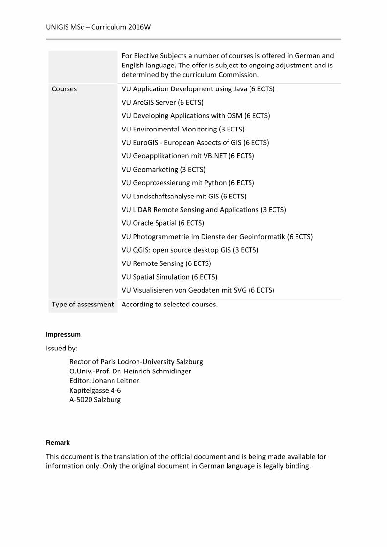
For Elective Subjects a number of courses is offered in German and English language. The offer is subject to ongoing adjustment and is determined by the curriculum Commission.
Courses VU Application Development using Java (6 ECTS)
VU ArcGIS Server (6 ECTS)
VU Developing Applications with OSM (6 ECTS)
VU Environmental Monitoring (3 ECTS)
VU EuroGIS - European Aspects of GIS (6 ECTS)
VU Geoapplikationen mit VB.NET (6 ECTS)
VU Geomarketing (3 ECTS)
VU Geoprozessierung mit Python (6 ECTS)
VU Landschaftsanalyse mit GIS (6 ECTS)
VU LiDAR Remote Sensing and Applications (3 ECTS)
VU Oracle Spatial (6 ECTS)
VU Photogrammetrie im Dienste der Geoinformatik (6 ECTS)
VU QGIS: open source desktop GIS (3 ECTS)
VU Remote Sensing (6 ECTS)
VU Spatial Simulation (6 ECTS)
VU Visualisieren von Geodaten mit SVG (6 ECTS)
Type of assessment According to selected courses.
Impressum
Issued by:
Rector of Paris Lodron-University Salzburg O.Univ.-Prof. Dr. Heinrich Schmidinger Editor: Johann Leitner Kapitelgasse 4-6 A-5020 Salzburg
Remark
This document is the translation of the official document and is being made available for information only. Only the original document in German language is legally binding.