cusworth - · pdf filecusworth to what extent can an archaeological survey of cusworth village...
TRANSCRIPT

CusworthTo what extent can an archaeological survey of Cusworth village throw
light on the layoutof the manorial estate prior to the mid 18th century?
GCE ADVANCED LEVEL A2 PROJECT 2004
DEARNE VALLEY COLLEGE
CENTRE NUMBER: 36493

Plan of procedure:
By walkover of the modern village and park, together with a study of survivingdocuments, maps, illustrations held in Doncaster Borough Archive, DoncasterReference Library and Cusworth Hall museum. Examination of planningapplications affecting properties within and adjoining the study area, inconjunction with a study of early ordnance survey maps for the area hasidentified sites seeming to preserve features from the earlier village. Myattempt to talk to local residents was unsuccessful. The following buildingsand features were chosen for further investigation by typological study, surveyand analysis:
1) Building style features on cottages within the village core and wider estate,together with typological features dating the boundary wall of the estateand cottages to the period before the building of the current hall. Theexamination of building features proved an unsuitable dating mechanism,as the style persisted for c300 years without major change.
2) The boundary wall of the walled gardens, part of which shows a brick waildated to c 1740 on the stone base of an earlier garden wall, apparently builtin the late 17th to early 18th century. This study, together with examination offeatures in the village wall, mentioned in (1) above, and the study ofrelevant maps proved successful, and forms the basis of dating within thisproject.
3) Cusworth Glebe, house dated by owner to 1583, which together with theadjoining Church Cottage (1760), are reputed to be on the site of theprevious hall. My attempts to contact the occupiers were unsuccessful.
4) The barn; a large building some 50 metres east of the existing hall, whichcontains earlier features, either in situ, or reused from an earlier building.The results of this analysis are detailed in Chapter 4.
Major landscaping works were started in the park by Doncaster Council duringthe recent winter and are ongoing. The objective is to restore the park so faras possible to its state when completed in the mid 18th century. These workshave obscured some of the features that were studied during this project, buthave made others easier to access.
This improved access seems to have confirmed my conclusions about the useof the two types of wall for dating purposes.

Index:
Introduction: p 2
Chapter 1 Dating typology p 6
Chapter 2 The village wall p15
Chapter 3 The garden wall and old hall remains? p19
Chapter 4 The Barn area p36
Conclusion p41
Appendix A List of illustrations p42
Appendix B List of places visited and dates p43
Appendix C List of people consulted p44
Appendix D Bibliography p45
Appendix E Surveying and drawing methods employed p46

Figure 1: Location map including wall typology (c 1930 ) and the village as shownc 1711
Cusworth village is situated approximately three kilometres north west ofDoncaster approximately one kilometre west of the Roman road fromDoncaster to York, currently A 638. See location map above.

The Southeast facing promontory shows signs of human habitation since atleast the Iron Age (1) Around 1560 the manor was acquired by Leonard Wrayof Adwick-le-Street from whose descendants Robert Wrightson bought theManor and Lordship of Cusworth including the existing hall in 1669 for the sumof £2,500. He had improvements carried out; the homestead barns andcottages were enlarged in 1702. Robert died in 1708; as he had disinheritedhis eldest son by his first marriage, John, the estate was left to his eldest sonby his third marriage, Thomas. Apparently Thomas carried out no alterationsor improvements to the estate, though he commissioned the cartographerJoseph Dickinson to produce maps of his estates, including those atCusworth. Thomas died in 1724, and his widow who lived until 1741 retired toa dower house, north of the hall, which still survives, William Wrightson, hisyounger brother, succeeded him. (2)
The original Cusworth Hall acquired by Robert Wrightson was situatedcentrally within the village beside the road to Sprotbrough and High Melton.Described as a five gabled building of Elizabethan appearance (3), animpression can be gained from an engraving by Samuel Buck dated 1720housed in the British Museum. (Figure 2 below)
Though the accuracy cannot be determined, Buck is regarded as a usuallyaccurate illustrator (4). The Hall is also shown, together with someoutbuildings to the west on Dickinson's plan of the estate 1719, which showsthe Hall as a single block building with archway and courtyard, contradictingBuck's Engraving.

In 1726 a dovecote was added, and all these outbuildings remained intact andin use until 1952. They formed an L shape and enclosed a rectangularforecourt known as the Estate Yard.
From 1726-1735 William enlarged the house gardens. The New HouseAccounts (5) show the purchase of thousands of bricks used in the building ofhigh walls to surround a Bowling Green, flower, greenhouse and kitchengardens, a lower garden called Low Piece and an Orchard. Subsequentlythese were known as the walled gardens. In 1726 a summerhouse wasadded, now known as the bowling pavilion.
Though he had spent a large sum on improvements to the village and hiswalled gardens and orchard, William found that extending the house wasmore difficult as it backed onto-the road through the village. He decidedtherefore to build a new larger Hall at Cusworth, on a different site.The New House Accounts show that the foundations of the present CusworthHall were dug in March 1740 on a new site. (See Figure 1 above) Sometimelater the Medieval Cusworth Hall was dismantled, and its site and possiblysome of the materials were used in the construction and alteration of severalother buildings.
This study will attempt to determine what survives of the immediatepredecessor to the modern estate, and the extent to which it may be detectedin the modern landscape.
The earliest known map featuring the village in any detail is Grover's mapdated 1711. This very large map of the area northwest of Doncaster does notshow the garden at Cusworth, though there is documentary evidence it wasalready in existence (6), and is recorded by Dickinson in a field bookcontemporary with his 1719 map (Figure 3) as being 3 Rods 14 perches inarea. It seems Grover's map was only partially detailed. (See Figure 1 above)


6
Chapter 1: Dating Typology
To correctly determine whether features were earlier or later than the existinghall I required a robust dating typology.
First I viewed estate buildings to establish whether a seriation pattern wasvisible. Two buildings had dated lintels. Both had been restored, oneparticularly badly, the only feature surviving in remotely original condition wasthe lintel, (See photos 1&2 Fig. 4 below); in the other case the lintel had alsobeen restored. Whilst both seemed in their original positions, they wererejected as dating evidence due to possible re-use.

Next I examined corbel types of house gables to establish whether a seriationpattern was present. Unfortunately the pattern was identical on them all,regardless of the period to which they belonged, the house oldest inappearance; (Keeper's Cottage) was built in the 19th century, over 100 yearslater than the oldest cottage.
This type of corbel has been used for around 300 years (See photo. 3), and isstill apparent on the limestone houses built in Cusworth village in 1982!

However, the road layout on Grover's 1711 and Dickinson's 1719 mapsclosely followed the pattern still existing in the village today, except for thediversion made around the rear of the village in order to divert traffic awayfrom the new hall. (See figures 1 & 3 pp 2&4 above) This diversion is clearlydated to a Writ and Inquisition; Ad quod Damnum application of November1744 (1.) Doncaster for the inclosure of land affecting the King's Highway inCusworth requiring the turning of the road, on behalf of the owner, Mr. WilliamWrightson and NOT to the application made in 1765 to divert the road to theTwo Mile plantation at Scawsby. This has confused other researchers, as thesketch map of the park made prior to its landscaping shows the diversionalready in effect. (2) This map (Figure 6 below) features the new house, so itmust be post 1740, but does not show the wings added by Paine c 1749-1753.Therefore the road seems to have been diverted before 1753 at the latest.
Comparison of the map accompanying the 1765 application with the relevantsection of Grover's 1711 map, from which it seems to have been taken showsthat Wrightson proposed the entrance to his new hall to be reached by adiversion along the northern boundaries of fields 13, 14, and 15, along themodern Long Plantation off Barnsley Road (A635) to a point due north of hisnew hall, (see Figures 7&8 below).


Was there any feature that could be dated exclusively to before or after thediversion of the road, and hence to before or after 1745? The stone wailsbordering the lanes and roads have two types of cap, a rounded type used onwalls which cartographic evidence shows to have existed prior to Dickinson's1719 map, and a flat stone lintel used exclusively on the new section of theroad built after the 1745 diversion. (See Fig 9 below)
This typology enabled areas of the village to be clearly dated either to beforeor after the building of the new hall at Cusworth during the 1740s.Typically these stone walls are of a random limestone rough-coursed or un-coursed build, varying between 30-40cm thick, and between 1m 20 cm and 1m60 cm in height. During my survey context sheets for these features werecompleted, and are displayed in Figures 10 & 11 below.


By reducing Dickinson's 1719 map and the location map dated 1930 to thesame scale and then superimposing them, features common to both would beeasily distinguishable. (Figure 12 below)
This process showed that the two maps broadly agree on individual features,although the eastern end of the 1719 version is twisted southwards by around10 degrees compared to its modern counterpart. I suspect this may be due to
18th century surveying techniques being less able to cope with severegradients and sudden changes in gradient. This is apparent in section B-B infigure 13 below.
The area marked * in gradient profile B is the area of steepest slope, thiscoincides with the point(#) in figure 12 where the misalignment between thetwo maps is at its maximum.
The outer boundary of the garden wall is clearly visible at the lower part of theplan. The northern boundary of the village follows the line of the new lane.These areas will be fully discussed in Chapters 2 and 3.


15
Chapter 2: The Village Wall
Locations 1 and 2 have been dealt with as the two diagnostic points in chapter1 above, and are shown on the map for reference purposes only.
The line of the new lane defines the northern boundary of the village. The wallbordering the lane is of the pre 1745 type throughout, originally some 500metres long, though subject to extensive alteration and rebuilding as a resultof 20th century housing development.

The most northerly cottage shown in the blue tracing of Dickinson's map fitsthe location of the restored cottage (Photo 2, Chapter 1 above). The street sidewall of this cottage is built as an upward continuation of the wall at this point,further confirmation of its age.At location 3 the wall resumes its pre 1745 character, (see illustration below)

This wall continues westwards along the lane until its termination at location 4,where it makes a butt joint with a wall of similar style, which is absent from the1719 map. Its flat capped top signifies its the later period. ( Figure 17 below)
The flat-topped wall continues along the remaining length of the divertedlane, broken by the 1767 main entrance to the new hall. (3) At the western endof the park the wall continues to border farmland, though in a ruinouscondition. Where the top is in situ it is flat, confirming the later date.Projecting southeastwards into the park from location 4, the wall respects thesite of the shrunken medieval village of Cusworth, situated at the northwestcorner of the extreme western field on the 1719 map, surviving only a moundin the field recorded as a grid reference SE54700404 (SAM 29943). At location5 (See Figure 18) the wall makes a butt joint connection with the older stylewall; though not shown on the 1719 map this wall forms a boundary wall to acroft presumably built between 1719 and 1745.
Here the new style wall is at its lowest 1.05 cm in height; the old style wall1m 20cm in height. A short distance on, the wall is interrupted by the archwaygate to a croft, probably Tinker Croft shown on Dickinson's 1719 map (Figure19 below). It then proceeds in a generally southerly direction into the village,returning to Location 1.
All the wall features described in this chapter, are dateable both bytypological, and/or by documentary evidence to the period preceding thebuilding of the new hall, and therefore appear contemporaneous with itspredecessor.


Chapter 3 : The garden wall and old hall remains?
This southern part of the garden wall encloses a roughly rectangular area, andhas a total length of c800 metres. The western area is shown on Dickinson's1719 map and is one of the oldest surviving parts of the site. It was extendedbetween 1726 and 1740 as a series of walled enclosures, which absorbed alarge part of Near Horse Close. (1)

Comparison of the two maps immediately above clearly shows the location ofthe listed features in both the 18th century and modern contexts, the featuresmarked on Dickinson's map being earlier than 1719.
At Location 7 the wall consists of fairly regular limestone blocks approx. 25x40cm., laid in rough courses, and bonded with lime mortar, height 1 m 20cm,thickness c20cm. The stone has a smooth finish. The wall runs straight for125 metres from the village to its south-eastern corner, broken by a lockedgateway 50 metres from the village, used in 1930, but now disused. Thewhole section is on a gradient of approx. 5% as the lane falls towards thelake. (See Figures 22 and 23 below)The wall turns 90 degrees towards the south-west, and runs 40 metres to ablocked gateway at location 8 (See Figure 24 below and 25 p21)
This former gateway appears to be part of the work carried out 1726-1740, thearea was not enclosed in 1719, and the gateway is not shown on anyordnance survey map. Its blockage took place before 1854. The posts are1 m 25cm high x20x40cm. The finish of the wall stone is smooth, bonded bymortar. The blockage is 1 m 20cm wide x 1 metre high. The posts are smooth,the blockage rough finish. They are heavily worn, and the blockage roughlykeyed into them. The hinge bearing post is badly cracked, and the remains ofa white substance secure the wrought iron brackets, probably lead. The

21
blockage is part mortared, part dry stone unsecured, with no sign of mortaring.The 1930 map indicates this was part of the orchard.

The wall then makes a right angle turn and runs 25metres back towards thelane. I felt the area too unsafe to access, as many stones were loose, and theground badly overgrown. According to all maps consulted this is the boundarywall of the orchard, which continues uphill to the village.

At location 9, which seems close to the position from which Buck's sketch wasdrawn, the wall changes type, it is now 4metres high, and built of red brickkeyed to the base of the limestone wall demolished on this 100-metre section.Buck's 1720 sketch shows a low limestone wall, and this seems to be part ofthe garden improvements commissioned by Wrightson. The 4 metre high redbrick wall was built as part of the works carried out 1726-1740. The 'Newhouse accounts' show large quantities of building materials including redbrick from Epworth were bought during the 1720's-1730's. (2)
The limestone foundation is random and rough finished; the wall constructedin Flemish garden wall bond, bonded with lime mortar; very heavy weatheringof both brick and mortar is apparent. Dimensions bricks- 24x10 x 6cm ; stone
20x20 20x40cm.(See Figure 27 below)

The south west corner, where the wall turns 90 degrees is located in a densewood and is used as the boundary for modern housing within the formergarden. Broken glass covers the top for security. Here it is 3 metres in height,its top level, the lower height due to the rising gradient. At the end of the southeast face the bricks are crudely keyed into the original stone wall. The corner

itself consists of smooth rectangular ashlar blocks, 40x60 cm. A large crack isvisible in the top of the western face next to the corner. Some lime plastersurvives on the western face.


The wall runs straight in the north westerly direction up the hill forapproximately 100 metres until location 11, the blocked gateway is reached.This gateway is shown on the 1719 map leading from the garden into the park,though it was blocked before 1930.
That this gateway had high status is indicated by the high quality nature of thewall consisting of regular squared limestone blocks, the gateposts beingbordered by large 60x40cm ashlar blocks. The posts consisting of largesingle stones 2m65cm tall x 35cm width. A linear pattern is incised on them,and a decorative cap consisting of nine visible stones tops each post. The topsurface of the wall is partially obscured by heavy ivy growth. The formergateway is 3m90cm wide.
The blockage consists of variable largely rectangular limestone and largeashlar blocks, secured by lime mortar. The surviving former gate, stored atCusworth is dated 1733, thereby securing the date of the feature. This portionof the wall includes the outer wall of buildings which were in use by the estateuntil 195243)The obverse of the left side gatepost is visible in a garden wall in CoachHouse Drive. The top has been lowered by approximately 20cm. The righthand post is invisible under dense ivy growth. (See Figures 31[1- 3] below)


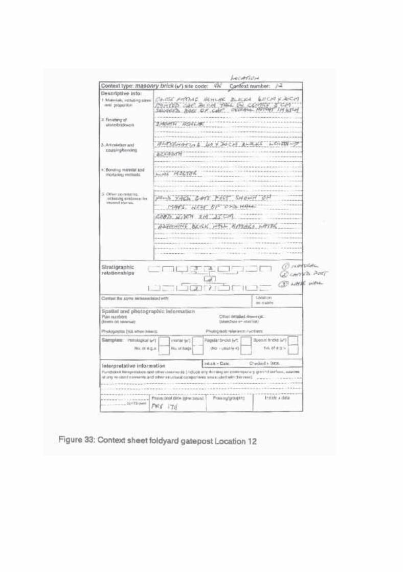
The wall continues as the boundary wall of a modern bungalow until itreaches location 12, west of Cusworth Glebe, believed to contain elements ofthe former Cusworth Hall demolished in the late 1740's. The 1711 map showsa gateway at both ends of the hall, not shown on the 1719 map. At location 12are two large limestone gateposts each 1 m65cm high, comprised of closefitting ashlar blocks 60X30 cm, surmounted by a 30cm tall rectangular pointedcap, with a 5cm deep squared base. The width of the road through thegateway is 3m25cm. These seem to be the western gateposts of the fold yardof the former hall, still in situ (Figure 32 and cover photo.) The eastern foldyard gateway has vanished, though there are two similar gateposts at theeastern entrance to the barn. (Chapter 4)

The building shown in photograph 9A is to the rear of Cusworth Glebe, takenfrom a similar position shown in Buck's sketch. The high redbrick wall is builton the foundation of the earlier limestone wall (see above pp 22-23 ) Thestream shown in the sketch has vanished, though Smith believes it waswidened in 1753 to form the Middle Lake (4 )
Cusworth Glebe occupies location l3 . Except for the single story sectionshown in the photograph it is of 18 th century appearance. It is built of limestonewith a red tiled roof. The single story part has two large (2 metre) window sillsin situ on each side of a possible former entrance roughly filled by limestoneblocks of varying sizes, and secured by lime mortar. It is inhabited, though Ihave been unable to contact the residents in an attempt to obtain furtherinformation.

To the east (out of picture) is Church Cottage, dated to 1760 with a largemodern plaque claiming to be on the site of the former hall. This seems likelyin view of the large stone window mullions in the rear garden of the building(Location 14)

This section of wall enclosing the former garden area is securely dated as afeature of the late 17"' early 1 e century village landscape, both typologically,and by several surviving cartographic and documentary sources. So little ofthe early hall remains that it is difficult to establish with any certainty what itlooked like, or what accommodation it contained. A Tudor lintel is believed tobe in Manor Cottage, another arched lintel in the house known as 'The
Mistal' (5 ), some panelling in the present hall, (5 ) but further research isneeded.

Chapter 4 The Barn Area
The barn (Bothy) is located approximately 50 metres Northeast of the presenthall. Dimensions 26.5m x 6.3m. It is shown on Dickinson's 1719 map. A slightlyearlier date of construction seems appropriate. The roof is shallow pitchedand of sandstone slabs. The outer walls are rough cut limestone, bonded bylime mortar. There are first floor ventilation slots in both long walls; six arevisible from a probable original twelve. The Northeast gable had two rows ofthree slots; a later goods door had replaced the centre lower slot. Theventilator slots are constructed using late 17 th century window mullions. Thereare slight traces of lime rendering on the outer walls.
The only entrances are on the Southeast side, the Northwest side beingobscured by a disused 1950's public lavatory. The central door has been re-used from an earlier building, it is 1m 30cm wide. It is late 16 th I early 17t
century style with composite jambs. The reverse ogee arched lintel is carriedon thin tie stones over the jambs. At the base of each jamb finely carved early18th century base blocks heighten the doorway. Though re-used the door wasan original insertion when the doorway was built. It seems to have beendesigned as a stable door. The north-east doorway has a large square cutlintel supported on alternate long and short quoined jambs on projectingsquare base blocks. (1)The reused materials may have become available through the work carriedout for Wrightson c1702 (2). (See Figures 38 &39 below)


39
Any external archaeological survey of the northeastern side of the building isat present impossible due to the 1950's style public lavatory built onto thelength of the wall. The roof of the main building is sandstone slabs, andseems original.
At the exit from the barn area onto the former lane is a gateway and twogateposts consisting of close fitting rectangular Ashlar blocks, 60 x30 cmdimensions, bonded by lime mortar, 1 m65cm high, with a capstone, verysimilar in style to those at the west end of the Glebe area. The wall, with pre1745-style cap is 1 m30cm high. The roadway is 3m 30cm wide. This gatewayis not shown on the 1719 map, though the barn and wall are. These posts maybe the missing posts from the East End of the old hall area, re-used when itwas demolished. (See Figure 42 below)

All boundary walls in the vicinity of the barn have the rounded cap of the older,pre 1745 style, and follow the line of the lane diverted after the building of thenew hall, and seemingly confirm that the buildings in this immediate areaantedate the mid 18th century hall, and belong to the period of this study.
The area has been subject to an extensive interior and exterior archaeologicalsurvey by WYAS in connection with the works scheduled for Cusworth Hall. Ifthe barn is restored then clearly archaeological surveys will be needed whenthe lavatory is demolished.

Conclusion
The map evidence shows that the major road layout of the village issubstantially unchanged in over 300 years except for the diversion away fromthe new hall after 1744-5. The boundaries of the garden area of the old hall,and its subsequent development by William Wrightson during the early to mid18"' century remain visible in the landscape.
Boundary walls can be clearly designated to before or after the building of thenew hall, and road diversion by the combination of capstone types withcartographic and documentary records. Clearly a shadow of the manorialestate can still be tracked within the village.
Substantial remains-of cottage platforms have been traced by SYAS within thearea of the crofts shown on the 1719 map, though the former hall has beenmore elusive than I had hoped.
The barn area is one major building which certainly survives from the pre 18'century manorial estate, as do the gateposts, of the former hall, two in situ, andtwo re-used.
Today Cusworth village presents a palimpsest-of a South Yorkshire countryvillage over three centuries still surviving- in the early 21 ' century.Much further work remains to be done, as the area consists of two separate
though overlapping sites, i.e. Wrightson's new hall and park, and the area ofthe village including the wailed garden; this project has barely scratched thesurface.
One area, which has survived unchanged since at least 1719 is the triangulararea at the eastern end of the village, and which is worthy of geophysicalsurvey at least.
A further puale worthy of investigation is the lack of a church in the villagebefore 1960! St. Leonard's on Barnsley Road (founded 1939) is one mile fromthe village as is Anchorage Chapel Sprotbrough, a modern foundation in anancient building. So where did the residents worship and do any tracessurvive?

Appendix A: List of Illustrations
Fig. 1 Location Map inc. 1711 map & 1930 map p 22 Buck's c 1719 engraving
p 33 Dickinson's Map 1719
p 54 Lintel typology
p 65 Three centuries' unchanged gables
p 76 Pre 1760 landscaper's sketch map
p 87 Planned 1765 road diversion
p 98 Planned 1765 road diversion (On Grover)
p 99 Wall cap types
p 1010 Location 1 context sheet
p 1111 Location 2 context sheet
p 1212 1719 -1930 combined map tracing
p 1213 Gradient profile Cusworth village
p 1414 Location Map pre &post 1745 walls
p 1515 Village wall resumes pre 1745 type (Photo)
p 1616 Ditto (Drawing) p 1617 Pre and post 1745 walls join
p 1718 Butt join old to new styles
p 1819 Archway possibly to Tinker Croft
p 1820 Location Map Garden wall area
p 1921 Village area features on 1719 map tracing
p 1922 Context sheet location 7
p 2123 Wall photo location 7
p 2124 Blocked gateway location 8
p 2025 Context sheet location 8
p 2226 Drawing 4metre red brick wall location 9
p 2327 Context sheet location 9
p 2428 Drawing SW corner of wall location 10
p 2529 Context sheet location 10
p 2630 Drawing blocked high status gateway loc.11
p 2731[1]-31[3] inc. Context sheets loci 1 pp 28-30 inc.32 Drawing Fold yard gatepost loc.12
p 3133 Context sheet Fold yard gatepost loci 2 p 3234 Modern building rear Cusworth Glebe
p 3335 Cusworth Glebe location 13 p 3436 Garden Church Cott. showing stone mullions
p 3437 Location map showing Barn area p 3638 The Barn p 3739 The Barn Door p 3740 The Barn Entrance Door Drawing p 3841 Former public lavatory North side of barn p 3942 Barn gatepost location 17 p 40

Appendix B: List of places visited and dates
1) 16.10.2003 Cusworth Hall Museum, Appointment with FrankCarpenter, Curator
2) 23.10.2003 Doncaster M B C Archive Dept, Relevant Documents onCusworth
3) 29.10.2003 South Yorkshire SMR Office, Sheffield DoDo
4) 13.11.2003 Doncaster M B C Archive Dept. With MJ Gibson(Photography)
5) 21.11.2003 Cusworth Village, 1st field trip6) 22.11.2003 Cusworth Village, 2"d field trip7) 29.11.2003 Cusworth Village, 3rd field trip8) 28.12.2003 Cusworth Village, 4th field trip

Appendix C: List of people consulted
1) Frank Carpenter, Curator. Cusworth Hall Museum2) Brian Barber, Principal Archivist, Doncaster M B C3) Dinah Saich, South Yorkshire SMR Sheffield4) Michael J Gibson, Photographer5) Willy Kitchen, Course Tutor Dearne Valley College

Appendix D: BibliographyIntroduction1) WH Gordon Smith 1990 (WHGS1990) Cusworth Hall and the BatheWrightson family Cusworth2) Cusworth Hall Museum 1998 Gazetteer of Cusworth Doncaster3) WHGS 19904) RK Morris 1999 The Archaeology of buildings5) New House Accounts Doncaster Archive Ref: DD/BW/H/316) Doncaster Archive Ref:DD/BW/R15Internet: Wrightson family web site www.wrightson.orgChapter 11) Inquisition Ad quod damnum Doncaster Archive Ref: DDIBW/UC662) 1765 Diversion Doncaster Archive Ref:DDIBWIE7/363) WHGS 1990Chapter 21) WHGS 19902) New House Accounts Doncaster Archive Ref: DDIBWIH1313) Conversation with Frank Carpenter Curator Cusworth MuseumChapter 31) WHGS 19902) David Hey 1990 The Making of South Yorkshire (SYCC Barnsley)3) WHGS 19844) WHGS 19905) WHGS 1990Chapter 41) WYAS Report 824 9.2000 & Report 825 Section 3.1.1. 20012) WHGS 19903) CJN Merrony 1991 Excavations at Sheffield Manor SYAU SheffieldAppendix EBarbara Hutton 1986 Recording Standing Buildings University of SheffieldMapsReader's Digest: Touring guide to Britain (Based on OS British Isles)Grover's Map 1711 Doncaster Archive Ref: DD/MZ/483Dickinson's Map 1719 Doncaster Archive Ref:DD/BW/E1 /4Sketch Map pre 1760 Doncaster Archive Ref:DD/BW/Ma/9Drainage Map Doncaster Library Ref: L912.4274.CUS1930 (Based onOS1:2640 1926 Edition)Tracings of 1719 and 1930 Maps Author 2004GeneralM Klemperer Phd Thesis 2003M J Gibson Esq. Overhead photography 1711 Map
Context sheets: p186 EXCAVATION S.Roskhams C.U.P. 2001

46
Appendix E: Surveying and drawing methods employed
Since the features drawn were invariably the exteriors of walls and gateways,I decided that the recording techniques applicable to the recording of standingbuildings were the most appropriate. They were drawn using a 30 metre and5-metre tape, together with vertical and horizontal levels.The exact location of each feature was marked on a copy of the 1:2640 OSMap, and it was then photographed several times to ensure so far as possibleall details were clearly visible.
The measurements from the tapes were noted, and a rough drawing madewhilst on site. The drawings were made onto squared graph paper at a scaleof 10:1, accurate to 1 cm. with the exceptions of the drawings at the south-westcorner, location 10, and the site of the large gateway, location 11, where inview of the large size of the features involved, they were drawn to a scale of20:1 with corresponding reductions in scale accuracy.
In view of the extremely restricted access to many of these features, and theovergrown nature of the surrounding wood it was not always possible tosafely make an overall photograph of them, so they were each photographedin an overlapping mosaic. The survey was made in the morning, thephotographs developed by 20 minute service, and the full drawings madelater the same day. As I had insufficient expertise to take satisfactoryphotographs of Grover's map, I arranged for a friend, Mike Gibson tophotograph it. The map is a very large document, around 3metres by 2metresin area. Due to its fragile state it is not touchable. Therefore the entire mapwas photographed in a mosaic by a digital camera, from 60cm directlyoverhead, a total of 76 frames.
A computer programme to remove distortions from their edges correctedthese, and the images were presented to me on CD.