d - 33open_jicareport.jica.go.jp/pdf/11822590_07.pdf · d - 33 chapter 3 water supply 3.1 bac water...
TRANSCRIPT

Additional Study on URRP for BAC Appendix D
D - 33
CHAPTER 3 WATER SUPPLY
3.1 BAC
Water supply of BAC is served by PDAM (Water Supply Authority) Tirta Daroy Banda Aceh. PDAM
Banda Aceh has two water treatment plants (WTP), Lambaro and Siron with each capacity reaching
37.584 and 1.728 m3/day. Total number of house connections is 14,656.
Planning and design criteria by URRP are realistic, including forecast of water demand. Preliminary
design that planned with urgent rehabilitation of Lambaro WTP was done. Water supply distribution
network rehabilitation is important to provision of potable water for the community with a quality,
quantity, and continuity that conforms to prevailing requirements. Mission, strategy, and goals must be
planned to make a good perform of water supply system.
The principal goal of water supply system is as follows:
• Provision of potable water for the community with a quality, quantity, and continuity that
conforms to prevailing requirements.
• The fulfillment of a steady water supply system, with operation and maintenance
conforming to proper procedure.
• Urban water supply system that can fulfill water demand according to the growth of the
city.
• Reducing Unaccounted for water.
• Institutional and financial empowerment of PDAM
• The delivery of first quality service
The analysis is conducted to project water demand until the year 2015, based on the following design
criteria:
Table 3.1.1 Design Criteria for Water Supply System
Description Unit 2005 2006 2007 2008 2009 PU Guideline
Connection Served population % 58 60 65 70 80
Average family size 1;5 1:(5-6)
House connection % 90 80-90
Public tap % 10 10..20
Unit Consumption House connection lpcd 150 150
Public tap lpcd 40 30-50
Non-domestic % 20 15-30
UFW % 50 45 40 35 30 30-50
Maximum Daily Demand Factor 1.1 1.1-1.5
Peak Hourly Demand Factor 1.5 1.5-2.0

Additional Study on URRP for BAC Appendix D
D - 34
Based on the design criteria, the predicted water demand is as follows:
Table 3.1.2 Forecast of Water Demand
Description unit 2005 2006 2007 2008 2009 2015
Population person 200,843 212,893 225,767 239,206 254,000 360,304
Served
Population Total person 116,489 127,736 146,749 167,444 203,200 288,243
House
Connection person 104,840 114,962 132,074 150,700 182,880 259,419
Public Tap person 11,649 12,774 14,675 16,744 20,320 28,824
Net Demand
House
Connection m3/day 15,726 17,244 19,811 22,605 27,432 38,913
Public Tap m3/day 466 511 587 670 813 1,153
Non-Domestic m3/day 3,238 3,551 4,080 4,655 5,649 8,013
Total m3/day 19,430 21,306 24,478 27,930 33,894 48,079
UFW Rate % 50 45 40 35 30 30
Amount m3/day 9,175 9,588 9,791 9,775 10,168 14,424
Gross Demand m3/day 29,146 30,894 34,269 37,705 44,062 62,503
Supply
Capacity Lambaro m3/day 37,584 37,584 37,584 37,584 37,584 37,584
Siron m3/day 1,728 1,728 1,728 1,728 1,728 1,728
Total m3/day 39,312 39,312 39,312 39,312 39,312 39,312
Balance m3/day 10,166 8,418 5,043 1,607 -4,750 -23,191 Source: Additional Study Team, 2006
Water demand for 2006 is 30,894 m3/day, water supplied by Lambaro WTP is 37,584 m3/day and Siron
WTP 1 1,728 m3/day. Total demand is 39,312 m3/day.
Starting from 2009, with a water demand level reaching at 44,062 m3/day, there will be a water supply
deficit at 4,750 m3/day. This deficit will increase on 2015 to 23,191 m3/day.
An implemented realistic program will involve:
• Water resources and water treatment
- Rehabilitation and reconstruction (include up-rating)
- Exploration of new sources.
• Rehabilitation and development of distribution system
• Management and human resources aspects
The Development Plan of Water Supply System in BAC is as follows:
1) Rehabilitation and reconstruction of Lambaro and Siron WTP.

Additional Study on URRP for BAC Appendix D
D - 35
The Swiss Government is financing the rehabilitation of main Lambaro WTP. GTZ and UNICEF
are financing the works conducted at Siron WTP.
2) Rehabilitation and reconstruction of Piped Transmission and Distribution System and its
supporting facilities, including city reservoir, both from Lambaro system as well as Siron system
with support from JICS.
3) Water supply zoning system, to facilitate the operation and maintenance, including the handling
of Unaccounted for Water, by forming a special task force.
In detail, the proposed plan is to create a Zoning System to prepare the distribution network for
future implementation of District Meter Area approach. The approach is beneficial for network
operation and maintenance (and also for reducing Unaccounted For Water). Project description,
program and construction work with preliminary project cost estimate and tentative
implementation schedule shall be prepared. PDAM is proposed to establish a Special Team for
Reduction of Unaccounted for Water (UFW).
Figure 3.1.1 Zoning of BAC Water Supply System
Source: Additional study team, 2006
4) The Up-Rating of Lambaro WTP or construction of a new WTP
It is imperative to conduct an n order to cover the increasing number of house connections, it is
crucial to do an up-rating of Lambaro WTP.

Additional Study on URRP for BAC Appendix D
D - 36
5) Water source protection. Water source for Lambaro Water Treatment (as the main provider of
potable water for Banda Aceh population) comes from Aceh River. Therefore river protection
will be prioritized. Initial protection is by delineating a clear and well-designed River Boundary
Line. As an (positive) impact, water quality and quantity will be maintained.
6) Develop Institutions. Future efforts should focus on the operations, management, efficiency and
financial sustainability of PDAM.
Training for PDAM personnel has been initiated by UNICEF, USAID-ESP, IRD, Switzerland
and SAB-SAS (Netherlands).
Figure 3.1.2 Location of Lambaro WTP
Source: Additional Study Team, 2006
3.2 SURROUNDING AREA
The outline plan for water supply system in surrounding area is as follows:
1) Glietaron system
Repair and expand transmission and distribution system
2) Jantho system
DED pipeline to Seulimeun and Indrapuri and construct new transmission pipeline
3) Siron2 system
Lambaro WTP

Additional Study on URRP for BAC Appendix D
D - 37
To involve DED and construction of intake and expansion of transmission to serve TLC in Ingin
Jaya, Baitussalam and Darussalam Districts.
4) Montasik system
5) Hydraulic study and DED for transmission pipeline
The concept of water supply provision in surrounding area is as follows:
• For immediate term, expand the distribution system in order to deliver piped water to
Temporary Living Center (TLC) and short and long term for new housing
• Rehabilitate water supply system
• Expand the distribution network of existing water system in order to serve new development
areas
Total served on 2005 is 66,000 people, and it is forecasted to be 101,000 people in 2008 and 143,000
people in 2010. A water supply network in surrounding area is illustrated in figure 3.2.2
Figure 3.2.2 Water Supply for Surrounding Area
Source: Additional Study Team, 2006
Additional Study on URRP for BAC Appendix D
D - 38
CHAPTER 4 WASTE WATER TREATMENT
(SEPTAGE TREATMENT PLANT)
4.1. BAC
Waste water treatment plant and sewerage is not deemed suitable for BAC. General planning criteria for
STP are very suitable with BAC condition. But the existing capacity cannot cope with effluent
generation.
The planned treatment is on-site sanitation, with once a year desludging schedule by a pumping truck to
be transported and treated in Septage Treatment Plant. The capacity of existing STP is 56 m3 a day
(rehabilitated by the help of JICA), while predicted waste volume in 2005 is 114 m3 a day. It can be
concluded that the capacity of Septage Treatment Plant must be increased by 58 m3 a day, and
additional transporting tanks must also be procured.
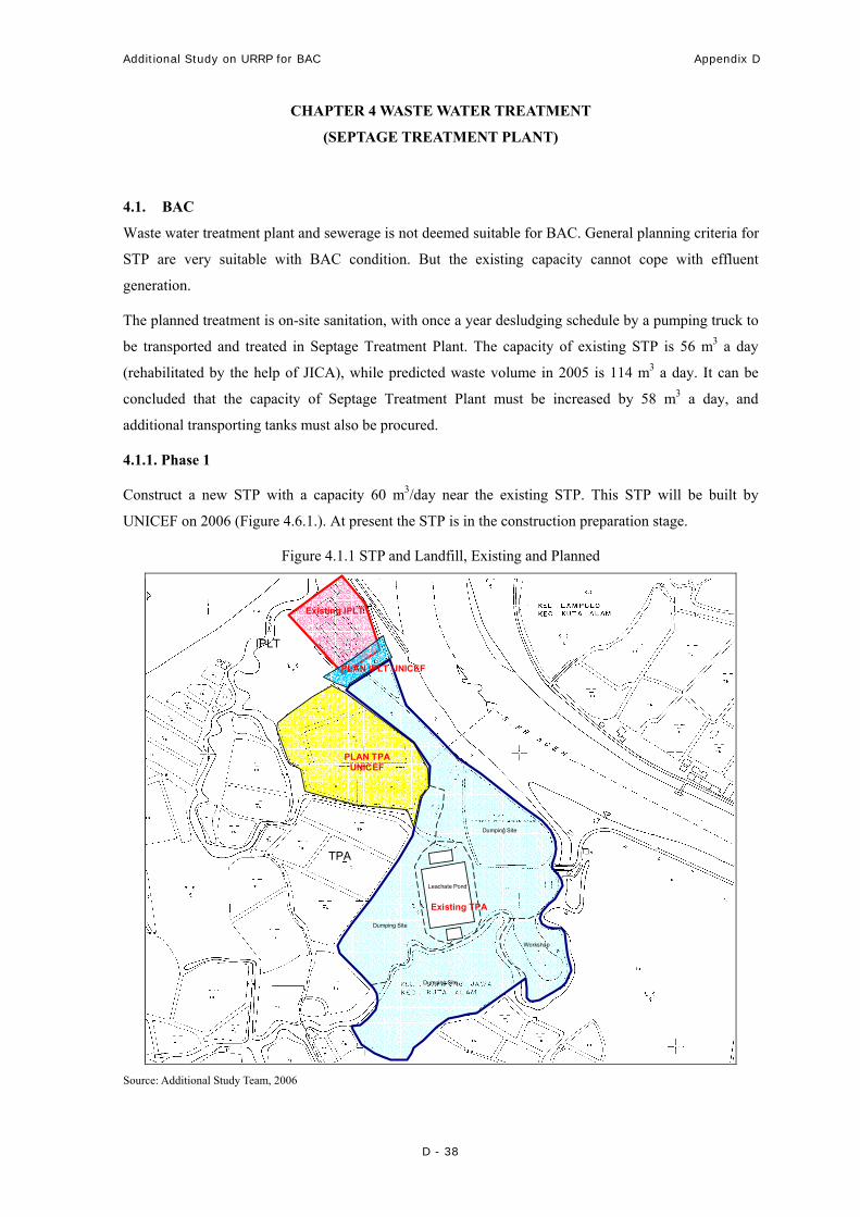
4.1.1. Phase 1
Construct a new STP with a capacity 60 m3/day near the existing STP. This STP will be built by
UNICEF on 2006 (Figure 4.6.1.). At present the STP is in the construction preparation stage.
Figure 4.1.1 STP and Landfill, Existing and Planned
Dumping Site
Dumping Site
Dumping Site
Workshop
Leachate Pond
IPLT
TPA
Existing TPA
Existing IPLT
PLAN TPA UNICEF
PLAN IPLT UNICEF
Source: Additional Study Team, 2006

Additional Study on URRP for BAC Appendix D
D - 39
4.1.2. Phase 2
The total capacity of existing and planned STP (UNICEF) is 116 m3 a day. In the year 2015 total solid
waste generation will reach at 204 m3 a day. Therefore BAC must build an STP with minimum capacity
of 88 m3 a day. There are two site alternatives of the new STP. First, it can be constructed as an
exclusive site for Septage Treatment Plant (STP), or second, as a combined STP and sanitary landfill
site.
4.2 SURROUNDING AREA
The concept of waste water management sets forth below:
• In urbanized surrounding area, septage will be collected by a pump truck to be treated at STP
• One STP serves more than one satellite cities
• STP can be combined with Landfill
Table 4.2.1 Septage Generation in Surrounding Area
No. Description Unit 2005 2009 2015 Population 1. Lhoong person 8,027 8,749 9,5372. Lhoknga person 13,238 14,429 15,7283. Indrapuri person 17,160 18,704 20,3884. Mesjid Raya person 11,884 12,954 14,1195. Darussalam person 16,848 18,364 20,0176. Baitussalam person 10,736 11,702 12,7557. Suka Makmur person 12,504 13,629 14,8568. Darul Imarah person 59,300 64,637 70,454 Total person 149,697 163,170 177,855 Assumed number of households houses 29,939 32,634 35,571 Volume of septage m3/year 0.9 0.9 0.9 Septage generation from household m3 26,945 29,371 32,014 Septage from industry and other m3 4,042 4,406 4,802 Total septage per year m3/year 30,987 33,776 36,816 Total septage per day m3/day 85 93 101
Source: Additional Study Team, 2006
The outline plan for sanitation is as follows:
• Organize a community education campaign about the importance of sanitation, disposal and
guideline for septic tank construction
• Locate suitable sites for STP (special or combined with disposal)
• Procure septic tank pump trucks and equipments
• Design, construct, and put into operation STP in surrounding area
Additional Study on URRP for BAC Appendix D
D - 40
CHAPTER 5 SOLID WASTE MANAGEMENT
5.1 BAC
The predicted solid waste generation is as follows:
Table 5.1.1 Solid Waste Generation
Description unit 2005 2006 2007 2008 2009 2010 2015
Population Pers. 200,843
212,893
225,767
239,206
254,000
307,695
360,304
Solid Waste Generation
Ltr/pers/ day 0.5 0.5 0.5 0.5 0.5 0.5 0.5
Total Solid Ltr/day 100,422
106,447
112,884
119,603
127,000
153,848
180,152
Source: Additional Study Team, 2006
The projective value of domestic solid waste generation by the year 2010 is 153,847 liters/day. It is
assumed that the per capita rate of solid waste generation is 0.5 liter/person/day, while total solid waste
generation in BAC will increase to 180,152 liters/day in 2015.
With the remaining useful life of Gampong Jawa Landfill of 2 years, a new alternative site needs to be
found.
Solid Waste Management Development consists of:
1) Solid waste containment
It is planned that each household be equipped with a capacity 40 liter bin.
2) Solid waste collection
Garbage will be collected twice a week from collecting station (packed in containers). The solid
waste collection is divided into 5 following areas:
− T. Nyak Arief, Ulee Kareng, Kuta Alam, Kp Kramat, and Laksana
− Aceh market and vicinity
− Jl. Teuku Cik Ditiro, Kp. Ateuk, Neusu, and vicinity
− Jl. Teuku Umar, Ketapang, Lamteumon, and vicinity
− Taman kota
3) Landfill and solid waste processing
Stage1: Extending Landfill in Gampong Jawa
The landfill consists of sanitary landfill in Gampong Jawa. This facility can still accommodate solid
waste disposal for the next two years.
The first alternative is to expand the existing landfill area by 3.2 Ha into neighboring area, with aid
from UNICEF and BRR.
Additional Study on URRP for BAC Appendix D
D - 41
Stage 2: New sanitary landfill site
As an alternative, a new landfill location must be found within two years, not excluding locations
outside Banda Aceh. These alternatives for landfill sites are in Koeta Teu, Kleumbang, Gapang,
Talue Sueke.
If located in Aceh Besar, the sanitary landfill may serve both BAC and Aceh Besar Regency as a
regional sanitary landfill (Figure 5.1.1.).
Table 5.1.1 Alternatives of Sanitary Landfill Sites
No. Location Geographic
Coordinate
Surface Area
(ha)
Distance to Main
Waste Source
(km)
1 Koeta Teu
(Montasik District)
772258 / 608169 15 21.5
2 Kleumbang
(Darussalam District)
772258 / 609614 15 22.2
3 Gapang
(Baitussalam District)
767636 / 620611 25 21.6
4 Taleue Seuke
(Baitussalam District)
767873 / 622393 25 17.8
Source: Progress by GTZ, August 2005

Additional Study on URRP for BAC Appendix D
D - 42
Figure 5.1.1 Alternatives of Sanitary Landfill Site
Source: Additional Study Team, 2006
5.2 Surrounding Area
The predicted solid waste generation in surrounding area is illustrated in Table 5.1.2.
Table 5.2.1 Projected Solid Waste Generation from Surrounding Area
Description
Population
unit
2006
212,893
2007
225,767
2008
239,206
2009
254,000
2010
307,695
2015
360,304
Lhoong m3/year 7,714 8,458 9,212 9,978 10,127 10,836
Lhoknga m3/year 12,262 13,022 13,792 14,574 14,793 15,829
Indrapuri m3/year 15,150 15,377 15,608 15,842 16,080 17,206
Mesjid Raya m3/year 11,123 11,921 12,731 13,553 13,756 14,719
Darussalam m3/year 15,012 15,376 15,744 16,119 16,361 17,506
Baitussalam m3/year 10,850 12,386 13,944 15,525 15,758 16,861
Suka makmur m3/year 11,039 11,204 11,373 11,543 11,716 12,536
Darul Imarah m3/year 48,287 44,946 41,554 38,112 38,683 41,391
Total m3/year 131,437 132,690 133,958 135,246 137,274 146,883Source: Additional Study Team, 2006

Additional Study on URRP for BAC Appendix D
D - 43
The plan for solid waste management in surrounding area is as follows:
1) Establish DKP (Sanitation and Park Department of Aceh Besar)
2) Collection by local neighborhood
3) Solid waste transportation and selection of TPS (temporary dumping site) shall be handled by
local government
- TPS will be made available in each satellite city
- TPS will be made available at or close to traditional markets
This is illustrated in Figure 5.2.1.
4) Landfill (TPA) will be managed by local government (as in sanitary landfill alternatives in BAC)
Figure 5.2.1 Locations of TPS in Surrounding Areas
Source: Additional Study Team, 2006

Additional Study on URRP for BAC Appendix D
D - 44
CHAPTER 6 MARITIME TRANSPORT
6.1. Maritime Transport
6.1.1 Ferry Terminal Development
Ulee Lheue ferry port will need fast and entire reconstruction as the physical condition was totally
collapsed while tsunami attacked in December 2004. The reconstruction includes wharf, passenger
terminal building, parking area, etc.
6.1.2 Preliminary Project Cost
The preliminary project cost in Table is presented for the planning program of Ferry Terminal. The
reconstruction cost is roughly estimated as shown in Table 4.6.1, on the basis of experiences of the
similar works.
Table 6.1.8 Preliminary Cost Estimate
Port Works Amount
(Billion Rupiahs)
Ulee Lheue Ferry Reconstruction of all facilities 67.59Source: JICA study team, 2005
6.1.3 Tentative Implementation Plan
The implementation schedule of air transport plan is set up as shown in Figure 4.6.2. On the figure, the
reconstruction of Ferry Terminal port is started at 2007 and finish no later than 2009.
Figure 6.1.9 Tentative Implementation Schedule for Marine Transportation Plan
Proposed Project/Program 2006 2007 2008 2009 2010-2015
Ferry Terminal/Port Source: JICA study team, 2005
6.1.4 Annual Fund Requirement
The annual fund requirement is estimated based on the project cost estimate and implementation
schedule as prior proposed.
Table 6.1.10 Annual Fund Requirement for Sea Transport Plan (Billion Rupiah)
Proposed Project/Program 2005 2006 2007 2008 2009 2010-2015 Total
Ferry Terminal 22.53 22.53 22.53 - 67.59 Source: JICA study team, 2005

Additional Study on URRP for BAC Appendix D
D - 45
CHAPTER 7 ELECTRIC POWER SUPPLY
The electric power supply development plan is directed toward the provision of electricity to fulfill the
pre-determined target of service in the end of target year.
7.1 Planning Criteria
i) General Criteria
• Target year : 2015
• Target area : BAC
• Population in 2015 : As projected under this study
ii) Design Criteria
• Average power demand per household : 900 – 1300 watt
• Electric power demand for facilities : 30% of domestic power demand
• Electric power demand for street lighting : 30% of domestic power demand
• Load Factor : 80% of total power demand
7.2 Electric Power Supply Development Plan
The calculation of future power demand is based on prevailing standard, according to design criteria.
Future power demand in BAC is described in Table 4.5.13.
Table 7.2.1 Future Electric Power Demand in BAC (2006 – 2015)
Electric Power Demand (Watt) No Description
2006 2010 2015
1 Population 267,441 420,823 741,634
2 Number of household 53,488 84,165 148,327
3 Power demand
- Domestic 69,534,660 109,413,980 192,824,840
- Public facility 20,860,398 32,824,194 57,847,452
- Street lighting 6,953,466 10,941,398 19,282,484
- Total demand 97,348,524 153,179,572 269,954,776
- Load factor 77,878,819 122,543,658 215,963,821 Source: Additional Study Team, 2006
The provision of electricity would have to be increased in order to fulfill future electricity demand.
Supply capacity will be increased by planning a new steam powered plant in Iseuem area (Krueng
Raya), by harnessing natural heat from Seulawah Mountain.

Additional Study on URRP for BAC Appendix D
D - 46
CHAPTER 8 COMMUNICATION
Communication system and network plan is directed toward the fulfillment of telephone and postal
service demand particularly in new development areas according to the target of service in the end of
target year.
8.1 Planning Criteria
i) General Criteria
• Target year : 2015
• Target area : BAC
• Population in 2015 : As projected under this study
ii) Design Criteria
• Residential, commercial,
government, public services : 17 service connections/100 people
• Industry, tourism, warehouse : 1 service connection/plot (0.5 ha)
• Telephone kiosk : 1 service connection/5000 people
• Public telephone : 1 service connection/1000 people
8.2 Telecommunication network plan
The calculation of communication demand in BAC is based on prevailing standard according to the
design criteria. The result is described in Table 8.2.1.
Table 8.2.1 Communication Demand in BAC (2006 – 2015)
Service Connection (SST) No Description
2006 2010 2015
1 Population 267,441 420,823 741,634
2 Number of household 53,488 84,165 148,327
3 Service connection demand
- Residential, commercial, services,
government, public & social facilities 45,465 71,540 126,078
- Industry, tourism, warehouse
- Telephone kiosk 53 84 148
- Public telephone 267 421 742 Source: Additional Study Team, 2006
There has been a very significant growth of cellular customers (such as Telkom Flexi users) in Banda
Aceh during post-disaster time. Based on this, besides land telephone, cellular telephone usage is
projected to increase in the future. As an anticipation of future demand, 21 Base Transceiver System

Additional Study on URRP for BAC Appendix D
D - 47
(BTS) will be built to serve Telkom Flexi customers in Banda Aceh. Other cellular providers such as
Telkomsel, Indosat, Excelcomindo, Mobil 8, etc also have plans to expand their service in the city.
Postal service will be provided by post offices built in activity centers. The location of each office is
determined according to service area and progress of service improvement achieved through the
rehabilitation and reconstruction of postal infrastructures and facilities.
The need of postal infrastructure and facility will be fulfilled by the rehabilitation of 8 post office
buildings and procurement of 3 motorcycles.

Additional Study on URRP for BAC Appendix E
A - 1
APPENDIX E
PLANNING ON THREE MODEL RECONSTRUCTION AREAS
Additional Study on URRP for BAC Appendix E
E - 1
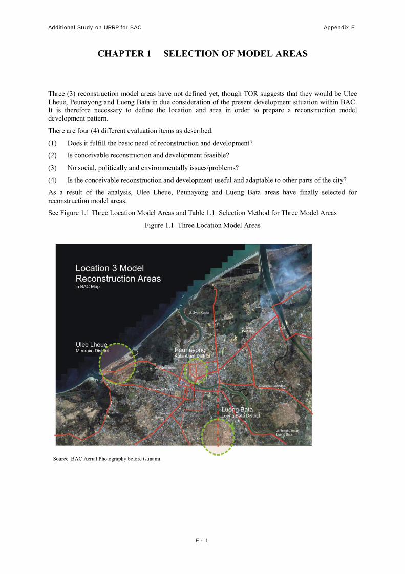
CHAPTER 1 SELECTION OF MODEL AREAS
Three (3) reconstruction model areas have not defined yet, though TOR suggests that they would be Ulee Lheue, Peunayong and Lueng Bata in due consideration of the present development situation within BAC. It is therefore necessary to define the location and area in order to prepare a reconstruction model development pattern.
There are four (4) different evaluation items as described:
(1) Does it fulfill the basic need of reconstruction and development?
(2) Is conceivable reconstruction and development feasible?
(3) No social, politically and environmentally issues/problems?
(4) Is the conceivable reconstruction and development useful and adaptable to other parts of the city?
As a result of the analysis, Ulee Lheue, Peunayong and Lueng Bata areas have finally selected for reconstruction model areas.
See Figure 1.1 Three Location Model Areas and Table 1.1 Selection Method for Three Model Areas
Figure 1.1 Three Location Model Areas
Source: BAC Aerial Photography before tsunami

Additional Study on URRP for BAC Appendix E
E - 2
Table 1.1 Selection Method for Three Model Areas
Urban Category and Nominated Model Area
Affected Areas by Tsunami
Economic
Generator
New Development
Area Criteria
Ulee
Lheue
Kuta
Raja
Kuta
Alam
Peuna-
yong
Ulee
Kareng Setuy
Keta-
pang
Banda
Raya
Lueng
Bata
1 Basic Need of Development and Reconstruction
1 / 3 1 / 1 1 / 1 3 / 3 2 / 2 2 / 2 1 / 1 1 / 1 1 / 3
2 Feasibility of development and reconstruction
3 2 2 3 2 2 2 2 3
3 Social and environmental impact 1/ 3 / 3 2 / 1 / 1 2 / 1 / 1 3 / 3 / 3 3 / 1 / 2 3 / 1 / 2
1 / 1 / 2 1 / 1 / 2
3 / 3 / 2
4 Adaptability to other parts of the city 3 2 1 3 1 2 2 1 3
Score 17 10 9 21 13 14 10 9 18
Note: Weighted = 1 up to 3 Source: Additional Study Team, 2005

Additional Study on URRP for BAC Appendix E
E - 3
CHAPTER 2 ULEE LHEUE MODEL AREA
2.1 PROPOSED LOCATION AND AREA (1) Location
The proposed Ulee Lheue area is located within Meuraxa District and encompasses four (4) villages such as Ulee Lheue, Deah Glumpang, Deah Baro, and Aloe Deah Tengoh. The boundaries of development area are as follows:
• North : Ocean/Malacca Strait.
• East : Peukan Bada District (Aceh Besar).
• South : Gampong Pie, Cot Lamkuweh, Blang Oi, Lampaseh Aceh.
• West : Lampaseh Aceh, Gampong Pande.
Ulee Lheue Area is a beachfront area, located between 0 – 750 m from the shoreline and ground elevation 0 – 1 m above sea level and is among the hardest hit areas by the 2004 disaster. Human casualties and material loss were extensive.
Ulee Lheue area is one of the most strategic area in BAC since BAC early formed until todays, this happen because of:
Pre Tsunami Conditions
• Historically, represent the first landing place for Sultan Iskandar Muda wife, Princess Pahang.
• There is a railway station in 1874 (Holland colonization era) that become the old times Landmark for Aceh. But since 1976 until now are no longer functioning.
• Ulee Lheue Harbor is the BAC gateway through the sea that connecting BAC to Pulau Nasi, Pulau Breueh, and Sabang in Pulau Weh.

Additional Study on URRP for BAC Appendix E
E - 4
Jl. Iskandar Muda
Jl. Rama
Jl. Tengku Umar
Jl. Daud Beureuh
Jl. Tengku Iskandar
Jl. Syah Kuala
Jl. Tengku Imum Lueng Bata
Location of 3 Model Reconstruction Areas in BAC Map
Ulee LheueMeuraxa District Peunayong
Kuta Alam District
Lueng BataLueng Bata
Figure 2.1.1 Three Location Model Areas

Additional Study on URRP for BAC Appendix E
E - 5
• Biggest Fish market in BAC and becoming economic center for the fisherman in Ulee Lheue area and surroundings.
• Sea/Beach tourism for BAC community.
Post Tsunami Conditions
• Baiturrahim Mosque, are the historical mosque because it is the only building that survive from the tsunami disaster.
• Mass Grave that bury around 15.000 tsunami victims, and will be one of tsunami tourism object.
(2) Topographic Condition
• Relatively flat lowland
• Topographically, Ulee Lheue is a separate island profile between harbor area and main land and connecting by Ulee Lheue Bridge and Bely Bridge.
• Ulee Lheue area is the congregation between two rivers, that is, Lamteh River and Krueng Cakra/Cangkui River. The river acts as transportation for fishing boats. Krueng Cakra/Cangkui River located between two land (Ulee Lheue Harbor and main land) shaping smooth river path and the estuary form like a lake.
• Wave Embankments dike causing the tide sea water entry far to the land and to community housing area and also to fish pond area which is one of the primary pledges for the Ulee Lheue and surroundings society.
• Tsunami causing one of the villages in Ulee Lheue area that is Ulee Lheu village lost two orchards from four orchards which sink.
(3) Land Use
• Based on RTRW Banda Aceh 2002 – 2010, it is classified into harbor area and residential area.
• Based on URRP Study-JICA, it is proposed to be very low density residential area.
• Land Use and post tsunami conditions for each village as follows:

Additional Study on URRP for BAC Appendix E
E - 6
Table 2.1.1 Land Use and Physical Condition (post tsunami)
No Name of Village Land Use
(pre tsunami)
Physical Condition
(post tsunami)
1 Ulee Lheue - High populated housing (most are fisherman housing)
- Government and private office.
- Environment and city scale for trade and services.
- City scale facilities (Ulle Lheue Harbor, Baiturrahim Mosque, Fish Auction center/TPI, and sports hall)
- Fishpond
- Beach tourism area
- All housing area are damage (house floor and foundation left)
- All office are damage (pillar and foundation left)
- All trade and services area are damage (floor and foundation left)
- All city building facilities are damage except Mosque (minor damage)
- Fishpond area are damage
- beach tourism are damage and some of them are sink
2 Deah Glumpang - Average-high density housing (most are the fisherman housing).
- Environment and district scale for trade and services.
- Village public social facilities
- Fishpond Area
- All area surfaces are damage (house floor and foundation left)
- Trade and services area are damage (building floor and foundation left)
- All public and social facilities building are damage
- All Fishpond are damage
3 Deah Baro - Average-high density housing (most are fisherman housing). - All housing area are damage (house floor and foundation left)

Additional Study on URRP for BAC Appendix E
E - 7
No Name of Village Land Use
(pre tsunami)
Physical Condition
(post tsunami)
- Environment and district scale for trade and services.
- Village public and social facilities
- Fishpond Area
- All trade and services area are damage (building floor and foundation left)
- All public and social facilities are damage
- All Fishpond are damage
4 Aloe Deah Tengoh - Average-high density housing (most are fisherman housing).
- Environment and district scale for trade and services.
- Village public and social facilities.
- Fishpond Area
- All housing area are damage (house floor and foundation left)
- All trade and services area are damage (building floor and foundation left)
- All public and social facilities are damage
- All Fishpond area are damage
Source: Additional Study Team, 2006

Additional Study on URRP for BAC Appendix E
E - 8
2.2 POPULATION
Before tsunami, Ulee Lheue area is including the most populous area in Meuraxa district. The population in five safe villages from the disaster is about 27-31% from total amount of previous community or about 29-68% from previous household. Ulee Lheue area was one of the areas that fall into total damage and gulping very big victims among areas in BAC. Present Population and Projected Population of Ulee Lheue Model Area is shown in table 6.3. and 6.4. based on Meuraxa District & Head of Community- January 2006
Table 2.2.1 Present Population of Ulee Lheue Model Area Pre-disaster Post-disaster * Survival No Village
person household person household Rate 1 Ulee Lheue 4,154 839 784 157 18.9%
2 Deah Glumpang 1,172 294 332 67 28.3%
3 Deah Baro 1,010 256 202 40 20.0%
4 Aloe Deah Tengoh 1,492 349 201 40 13.5%
TOTAL 7,828 1,738 1,519 304 19.4%
Source: JICA Study Team, 2005 and Meuraxa District & Head of Community, January 2006 *) note: post-disaster population excluding returnee
The projected population is shown in Table 2.2.2 based on URRP.
Table 2.2.2 Projected Population of Ulee Lheue Model Area
Projected Population Village 2005 2006 2007 2008 2009 2015
Ulee Lheue 784 787 790 793 796 1129 Deah Glumpang 332 330 328 326 325 461 Deah Baro 202 202 203 203 203 288 Aloe Deah Tengoh 219 220 220 220 221 313
TOTAL 1,537 1,539 1,541 1,542 1,545 2,191 Source: JICA Study Team, 2005 and Additional Study Team, 2006
2.3 PRESENT SOCIO-ECONOMIC CONDITIONS
Social economics description of Ulee Lheue district reflected the village living in city area, where the population composition is heterogenic because coming from other area outside Banda Aceh connected to their source of revenue as fisherman and trader.
Almost all village communities in Ulee Lheue area embracing Islam, therefore there are meunasah and mosque serving several villages in each village in Ulee Lheue area.
Community education levels are various started from the elementary school unfinished to university graduated, and generally the rising generation could finish their education until graduated from the senior high school.

Additional Study on URRP for BAC Appendix E
E - 9
Table 2.3.1 Source of Revenue
Community Source of Revenue No Name of
Village pre tsunami post tsunami
Description
1 Ulee Lheue
- Sea Fisherman = 40 %
- Coastal area Fisherman = 10 %
- Fishpond worker = 3 persons
- Trader = 30 %
- Breeder = -
- Entrepreneur = 15 persons
- PNS/POLRI/ABRI = 25 persons
- Sea Fisherman = 10 %
- Coastal area Fisherman = 3 persons
- Fishpond worker = -
- Trader = 5 %
- Breeder = 10 persons
- Entrepreneur = 6 persons
- PNS/POLRI/ABRI = 0
Field that can be operated this time :
- Sea Fisherman = 10 %
- Coastal area Fisherman = 3 persons
- Fishpond worker = 0%
- Trader = 5%
- Breeder = 0% (unemployed)
- Entrepreneur = 0%
- PNS/POLRI/ABRI = 0
Other fields that require aid:
- Work Equipment: Boat, Machine pedicab, etc
- Work place
- Working capital
2 Deah Field that can be operated this time :

Additional Study on URRP for BAC Appendix E
E - 10
Community Source of Revenue
Glumpang - Sea Fisherman = 40 persons
- Coastal area Fisherman = 40 persons
- Fishpond worker = 15 persons
- Trader = 30 persons
- Breeder = 10 persons
- Entrepreneur = 52 persons
- PNS/POLRI/ABRI = 0
- Sea Fisherman = 20 persons
- Coastal area Fisherman = 23 persons
- Fishpond worker = 15 persons
- Trader = 30 persons
- Breeder = 2 persons
- Entrepreneur = 27 persons
- PNS/POLRI/ABRI = 43 persons
- Sea Fisherman = 40 %
- Coastal area Fisherman = 20 %
- Fishpond worker = 0% (unemployed)
- Trader = 0% (unemployed)
- Breeder = 0% (unemployed)
- Entrepreneur = 10 – 50%
- PNS/POLRI/ABRI = 43 persons
Other fields that require aid:
- Work Equipment: Boat, Machine pedicab, etc
- Work place
- Working capital
3 Deah Baro
- Sea Fisherman = 30 %
- Coastal area Fisherman = 10 %
- Fishpond worker = 30 persons
- Sea Fisherman = 10 %
- Coastal area Fisherman = 10%
- Fishpond worker = 0 %
Field that can be operated this time :
- Sea Fisherman = 10 %
- Coastal area Fisherman = 10 %
- Fishpond worker = 0%
Additional Study on URRP for BAC Appendix E
E - 11
Community Source of Revenue
- Trader = 17 persons
- Breeder = 0
- Entrepreneur = 52 persons
- Trader = 11 persons
- Breeder = 0
- Entrepreneur = 52 persons
- PNS/POLRI/ABRI = 6 persons
- Trader = 11 persons
- Breeder = 0%
- Entrepreneur = 10 – 50%
- PNS/POLRI/ABRI = 6 persons
Other fields that require aid:
- Work Equipment: Boat, Machine pedicab, etc
- Work place
- Working capital
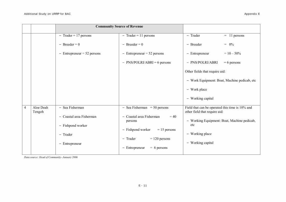
4 Aloe Deah Tengoh
- Sea Fisherman
- Coastal area Fisherman
- Fishpond worker
- Trader
- Entrepreneur
- Sea Fisherman = 50 persons
- Coastal area Fisherman = 40 persons
- Fishpond worker = 15 persons
- Trader = 120 persons
- Entrepreneur = 6 persons
Field that can be operated this time is 10% and other field that require aid:
- Working Equipment: Boat, Machine pedicab, etc
- Working place
- Working capital
Data source: Head of Community- January 2006

Additional Study on URRP for BAC Appendix E
E - 12
2.4 PLANNING AND DEVELOPMENT PROGRAM FULFILL, IN PROGRESS, AND GOING TO BE WORKED
1. Road expansion and elevating program
• Rama Setia Street
- Program : Road expansion and elevating from ROW width = 6-8 m to ROW = 12 and 25 meter.
- Executor : BAC local government.
- Funding : BRR through APBN-P 2005.
- Progress : physical execution in process
• Iskandar Muda Street
- Program : Road expansion and elevating from ROW width = 14 m to ROW = 25 - 30 meter.
- Executor : NAD Province Local Government
- Funding : ADB 2005.
- Progress : Land acquisition is in process
• Pelabuhan Ulee Lheue Street
- Program : Reconnect the broken road
- Executor : BAC local government.
- Funding : UNDP 2005.
- Progress : Physical execution in process.
2. Rehabilitation Program For Ulee Lheue Harbor and Supporting Facilities
- Executor : BAC local government.
- Funding : AUSTRALIA (around Rp.80 Billion)
- Progress : Physical execution in process.
3. Dam Development Program
• Sea wall/Breakwater Dam
- Executor : BRR and BAC local government.

Additional Study on URRP for BAC Appendix E
E - 13
- Funding : BRR.
- Area : from Peukan Bada, Ulee Lheue to Aloe Naga (length 20 Km)
- Progress :
o Aloe Naga Segment physical execution in progress
o Peukan Bada and Ulee Leheue Segment in planning
• water tide dike
- Executor : BRR and BAC local government.
- Funding : BRR.
4. Redevelop Medan-Banda Aceh railway Program
- Funding : Indonesia and France Government mutual aid, De Societe Nationale des Chemins de Fer Francies (SCNF) International.
- Fund range : Rp. 7 trillion
- Area/Route : Connecting North Sumatera – Banda Aceh that divided into 3 phase:
o Phase I : Langsa (Aceh Timur) to Langkat (Sumatera Utara)
o Phase II : Langsa ke Lhok Seumawe (Aceh Utara)
o Phase III : Lhok Seumawe to Banda Aceh
5. Mass Grave Development Program
- Executor : Islamic Relief.
- Funding : UNDP.
- Progress : Physical execution in process.
6. Fish Auction Center Development Program
- Executor : Norwegia and BRR
- Funding : Norwegia and BRR
- Progress : Physical execution in process
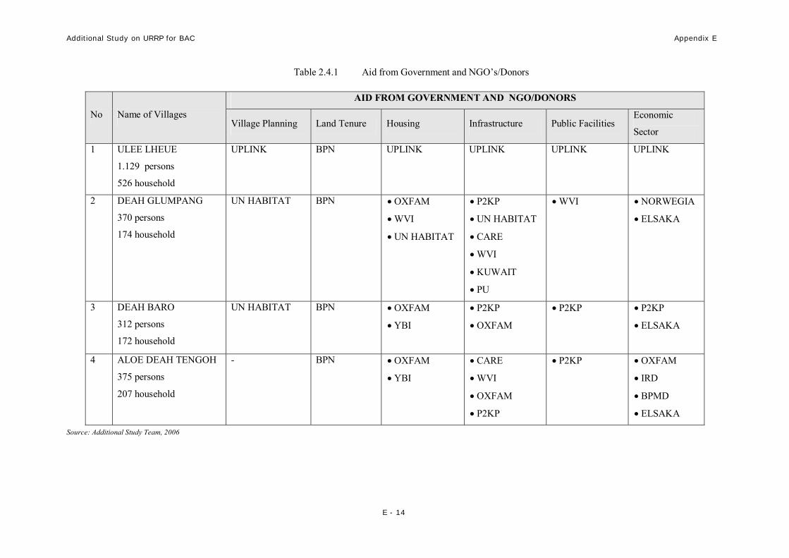
7. Planning and Physical Development Program in Five Villages
Planning and Physical Development Program in Five Villages as follows:
Additional Study on URRP for BAC Appendix E
E - 14
Table 2.4.1 Aid from Government and NGO’s/Donors
AID FROM GOVERNMENT AND NGO/DONORS
No Name of Villages Village Planning Land Tenure Housing Infrastructure Public Facilities
Economic
Sector
1 ULEE LHEUE
1.129 persons
526 household
UPLINK BPN UPLINK UPLINK UPLINK UPLINK
2 DEAH GLUMPANG
370 persons
174 household
UN HABITAT BPN • OXFAM
• WVI
• UN HABITAT
• P2KP
• UN HABITAT
• CARE
• WVI
• KUWAIT
• PU
• WVI
• NORWEGIA
• ELSAKA
3 DEAH BARO
312 persons
172 household
UN HABITAT BPN • OXFAM
• YBI
• P2KP
• OXFAM
• P2KP • P2KP
• ELSAKA
4 ALOE DEAH TENGOH
375 persons
207 household
- BPN • OXFAM
• YBI
• CARE
• WVI
• OXFAM
• P2KP
• P2KP • OXFAM
• IRD
• BPMD
• ELSAKA
Source: Additional Study Team, 2006

Additional Study on URRP for BAC Appendix E
E - 15
2.5 DEVELOPMENT NEED AND CONSTRAINT
Development Need and Constraint as follow:
Table 2.5.1 Development Need and Constraint
No Development Need Constraint
1 Housing
Housing is the basic need for community. Several villages in Ulee Lheue area have accepting permanent and semi permanent housie aid from government, NGO’s, and donor country.
Obstacle:
• Permanent house needs has not been fulfill yet because of the program execution and fund limitation from NGO’s and government
• There is no village planning which is use for spatial planning guide for village rehabilitation and reconstruction.
2 Infrastructure and Utilities
Infrastructure and utilities rehabilitations need including the village and city scale, which is:
• Road
• Drainage
• Clean water
• Sanitation
• Waste Disposal
• Electricity
• Telephone
Some of infrastructure and utilities sectors have been rehabilitated and reconstructed by NGO’s/donor and government. But there is still much area that has not been implemented by the physical execution.
Obstacle:
• Clean water, Electricity, and Telephone, connected to the city network system that has not been cure yet (facilities and basic facilities)
• There is no village planning documents that guide the village rehabilitation and reconstruction.
3 Social and Public Utilities
To restore the community activity and living, therefore the community activity could be work as previous, such as:
• The damage public and social facilities rehabilitation
• Developing new facilities suited to the community needs
Nowadays, villages in Ulee Lhueue area have accepted village facilities rehabilitation aid from government, NGO’s, and donor countries.
Obstacle:
• Has not accepted all village facilities needs, because of the fund and program limitation.
4 Local Economic Development
Restore community activity and living, therefore the village will not depending on outside aid, requirement:
• Working capital aid
• Working equipment aid (fisherman boat, workshop, etc)
• Work place rehabilitation (harbor, fishpond, etc)
Nowadays, villages in Ulee Lheue area have accepted economic enable ness from government, NGO’s, and donor countries.
Obstacle:
• Community needs for the economic enable ness has not fulfilled yet because of the aid management, fund, and program limitation.
Additional Study on URRP for BAC Appendix E
E - 16
No Development Need Constraint
• Community skillful training
5 Mitigation Aspect
• Escape Routes
Using the existing city road and village road
• Escape Building
Escape building location is suited to:
- Services Area
- Easy Accessibility
Mitigation Aspect
- Escape Routes
Existing Road conditions: destruct, very small road width therefore land acquisitions are required.
- Escape Building
Escape building location plan located in government land and community land (land acquisition are required)
Source: Additional Study Team, 2006
2.6 DEVELOPMENT CONCEPT
The scenario of Ulee Lheue Area Development is as beachfront area laden with historical (disaster) value. This area is proposed to be developed as mix use function, with low density and better protection against (future potential disaster) by the provision of mitigation facilities.
The function of the development area consists of several themes as follows:
(1) Historic Tourism Theme:
• Tsunami victim mass grave
• Historical mosque.
• Tsunami museum area
• Tsunami sculpture park
(2) Water Tourism Theme, including:
• Fishing area (leisure fishing)
• Water tourism boat area
• Floating restaurant
(3) Thematic Residential:
• Mix use of residential and commercial
• Medium – high rise (Hotel) residential
(4) Waterfront Tourism Theme:
• Waterfront park/forest
• Waterfront plaza
• Waterfront forest
Additional Study on URRP for BAC Appendix E
E - 17
(5) Harbor Theme:
• Fish auction wharf
• Ulee Lheue domestic harbor
(6) Sport Theme:
• Indoor sport
• Out door sport
(7) Escape Areas
• Escape building which multi-functions as Community Hall
• Escape building which multi-functions as waterfront tourism
The above development concept is illustrated in Figure 1.2
2.7 PROPOSED RECONSTRUCTION WORKS
The scenario of Ulee Lheue Area Development is as beachfront area laden with historical (disaster) value. This area is proposed to be developed as mix use function, with low density and better protection against (future potential disaster) by the provision of mitigation facilities
Proposed reconstruction works from this study are:
1. Escape Routes
Escape routes in Ulee Lheue area plan consist of:
a) Rama Setia Road (still in progress through APBN cost 2005)
b) Sultan Iskandar Muda Road, (still in progress through ADB fund 2005)
c) Ulee Lheue Harbor Road,
− Class of Road : Collector Road (ROW= 8 – 12 meters)
− Functions : Links to Ulee Lheue harbor
− Land Ownerships : city government and community of Ulee Lheue village
− Programs planning :
• Land Acquisition plan along the sidewalks.
• Road Enlargement and expansion Planning to be ROW = 30 meters. • Fund Source by: has not been suggested.

Additional Study on URRP for BAC Appendix E
E - 18
Figure 2.7.1 Development Concept of Ulee-Lheue
Source: Additional Study Team, 2006

Additional Study on URRP for BAC Appendix E
E - 19
D. Baro Road
− Class of Road : Collector Road (ROW= 8 – 12 meters)
− Functions : Links from Rama Setia road to Sultan Iskandar Muda Road
− Land Ownerships : community of Deah Glumpang and Lambung
− Programs planning :
• Land Acquisition plan along the sidewalks.
• Road Enlargement and expansion Planning to be ROW = 25 meters.
• Fund Source by: has not been suggested.
E. T.TH. Ares Road – TA.Salam Meuraxa Road
− Class of Road : Neighborhood Street (ROW= 2,5 – 4 meters)
− Functions : Links villages in Deah Baru to Blang Oi Villages
− Land Ownerships : community of Deah Baro and Blang Oi
− Programs planning :
• Land Acquisition plan along the sidewalks.
• Road Enlargement and expansion Planning to be ROW = 15 meters.
• Fund Source by: JICA.
F. Pintu Air Road –Main Road of Lambung Village
− Class of Road : Neighborhood Street (ROW= 3 – 6 meters)
− Functions : Links villages in Deah Glumpang and Lambung
− Land Ownerships : community of Deah Glumpang and Lambung
− In Progress Program:
• Village Planning by P2KP in Lambung Village and UN-Habitat ini Deah Glumpang
• Functions : as a village main road and Escape Route
• Road Enlargement and expansion Planning to be ROW = 8 - 12 meters.
• Fund Source by : P2KP as stimulate fund
Additional Study on URRP for BAC Appendix E
E - 20
2. Escape Building
Escape building in Ulee Lheue area are planned to be evacuation area and also functioned as public facility that can be use as Community hall, Mercusuar, etc.
Escape Building location suggestions are in:
A. Ulee Lheue Harbor Area:
− Location : in the end of Ulee Lheue road (main entrance of Ulee Lheue harbor).
− Service area : around Ulee Lheue harbor and part of Ulee Lheue Village area
− Function : as an escape area and city tower (public water tourism)
− Land Ownerships : government of BAC – Harbor Department
B. Deah Glumpang Village Area
− Location : around TPI Norwegia.
− Service Area : Ulee Lheue Village and Deah Glumpang Village.
− Function : as an escape building, community hall and city park.
− Land Ownership : community of Deah Glumpang and Lambung Village.
C. Deah Baro Village
− Location : in Deah Baro Village, around fish pond area
− Function : as an escape building, community hall and city park.
− Land Ownership : community of Deah Baro
− Service Area : Village of Deah Baro and Aloe Deah Tengoh
3. Seawall (break water dike)
Seawall, break water or water tide dike development become one of the village priorities along the beach included Ulee Lheue surrounds to prevent the sea water entering the housing area and community fish pond.
4. Fishpond Area Rehabilitation
− Location : Village of Lampaseh Aceh, Aloe Deah Tengoh, Deah Baro, Deah Glumpang, Blang Oi and Lambung.
− Program :
• Rehabilitation of surface of fish pond area

Additional Study on URRP for BAC Appendix E
E - 21
• Rehabilitation of embankment
• Rehabilitation of irrigation canal
• Fish Core
− Land Ownership : Community of Lampaseh Aceh, Aloe Deah Tengoh, Deah Baro, Deah Glumpang, Blang Oi and Lambung.
− Program donated by :
• Lampase Aceh Village donated by ELSAKA (2005 – 2006)
• Village of Aloe Deah Tengoh, Deah Baro, Deah Glumpang, Blang Oi and Lambung, donated by JICS , Japan Red Cross (2006)
5. Ulee Lheue Tsunami Water front Area
− Location : Village of Ulee Lheue, Aloe Deah Tengoh, Deah Baro and Deah Glumpang.
− Program :
(1) Historic Tourism Theme:
• Tsunami victim mass grave
• Historical mosque.
• Tsunami museum area
• Tsunami sculpture park
(2) Water Tourism Theme, including:
• Fishing area (leisure fishing)
• Water tourism boat area
• Floating restaurant
(3) Thematic Residential:
• Mix use of commercial
• Medium – high rise (Hotel) residential
(4) Waterfront Tourism Theme:
• Waterfront park/forest

Additional Study on URRP for BAC Appendix E
E - 22
• Waterfront plaza
• Waterfront forest
(5) Harbor Theme:
• Fish auction wharf
• Ulee Lheue domestic harbor
(6) Sport Theme:
• Indoor sport
• Out door sport
(7) Escape Areas
• Escape building which multi-functions as Community Hall
• Escape building which multi-functions as waterfront tourism
− Land Ownership : City government, community of Ulee Lheue, Aloe Deah Tengoh, Deah Baro and Deah Glumpang.
− Program donated by : has not been suggested

Additional Study on URRP for BAC Final Report
E - 23
2.8 ESTIMATED COST AND CONSTRUCTION PERIOD
For the estimated cost and construction period is shown in Table 2.8.1.
Table 2.8.1 Cost Estimation and Construction Period Construction Period
No Construction Programs Volume
Cost Estimation
(Rp billion)
2006 2007 2008 2009 2010 2011 2012 2013 2014 2015
I Housing 90 units 4.50 2.25 2.25 II Infrastructure and
Utilities:
Seawall 2,370 m 4.22 2.11 2.11 Water tide dike 5,852 m 35.11 8.78 8.78 8.78 8.78 Roads 7,205 m 23.15 3.86 3.86 3.86 3.86 3.86 3.86 Drainage 13,304 m 19.29 3.86 3.86 3.86 3.86 3.86 Bridges 226 m 24.03 6.01 6.01 6.01 6.01
III Public and Social Facilities
3,500 m2 4.31 0.62 0.62 0.62 0.62 0.62 0.62 0.62
IV Escape Routes 4,020 m 24 8 8 8 V Escape Building (3 units) 3 units 12.48 4.16 4.16 4.16 VI Waterfront Area 6.28 million m3 20 2 2 2 2 2 2 2 2 2 2
Source: Additional Study Team, 2006

Additional Study on URRP for BAC Appendix E
E - 24
Figure 2.8.1 Model Concept of Ulee-Lheue
Source: Additional Study Team, 2006

Additional Study on URRP for BAC Appendix E
E - 25
CHAPTER 3 PEUNAYONG MODEL AREA
3.1 PROPOSED LOCATION AND AREA
(1) Location
Peunayong area is located in central BAC, in Kuta Alam District, Peunayong Village. It functions as commercial area. Being approximately 3,000 m from the shoreline, this area was also hardly by the 2004 disaster. The boundaries of model area are as follows:
• North : Kampung Mulia.
• East : Laksana Village and Keramat Village.
• South : Kuta Alam.
• West : Krueng Aceh
Before the 2004 disaster and until right now, Peunayong is one of the most strategic area in BAC and surrounding area, this happen because Peunayong as a Central Business District which located in the river front area and Peunayong as an old town of BAC.
Peunayong area consist of two villages:
• Peunayong Village
• Lampulo Village
(2) Topographic condition
• Relatively flat lowland
• Crossed by Krueng Aceh. It is one of the biggest rivers in BAC, and also functions as boat waterway.
(3) Land use
• Based on RTRW Banda Aceh 2002 – 2010, and URRP Study-JICA the proposed area is commercial area.
Additional Study on URRP for BAC Appendix E
E - 26
3.2 POPULATION
Based on the most up-to-date data from Kuta Alam District, the population before and after the 2004 disaster is reported as shown in Table 3.2.1 below, with the percentage of safe victims are 65%, as follows:
Table 3.2.1 Population of Peunayong Model Area Population
No Village Pre-disaster Post-disaster *
Survival Rate
1 Peunayong 4,382 persons 2,858 persons 65.23% Source: JICA Study Team, 2005 and Peunayong District & Head of Community, December 2005 *) note: post-disaster population excluding returnee
Projected population for 2009 is 2,919 people based on URRP.
Table 3.2.2 Projected Population of Peunayong Model Area
Projected Population Village
2005 2006 2007 2008 2009 2015
Peunayong 2,858 2,872 2,887 2,903 2,919 4,141 Source: JICA Study Team, 2005 and Additional Study Team, 2006
3.3 PRESENT SOCIO-ECONOMIC CONDITIONS
Social economics description of Peunayong area reflected the urban area, where the population composition is heterogenic because coming from other area outside Banda Aceh connected to their source of revenue as trader.
Most the village communities in Peunayong area embracing Islam, but the religious facilities are various like church, Klenteng (Tionghoa).
Community education levels are various started from the elementary school unfinished to university graduated, and generally the rising generation could finish their education until graduated from the senior high school.
Table 3.3.1 Source of Revenue of Peunayong Model Area
Community Source of Revenue No Name of Village
Pre-disaster Post-disaster
Description
1 Peunayong Village • Trader
• PNS
• Police/army
• Helper
• Trader
• PNS
• Police/army
• Helper

Additional Study on URRP for BAC Appendix E
E - 27
2 Lampulo Village • Trader
• PNS
• Police/army
• Helper
• Trader
• PNS
• Police/army
• Helper
Source: Kuta Alam District,Report December 2005
3.4 PLANNING AND DEVELOPMENT PROGRAM FULFILL, IN PROGRESS, AND GOING TO BE WORKED
After disaster of damaged most buildings and infrastructures have been rehabilitated by NGO’s/Donors and local government and already functioning.
1. Housing Reconstruction Program
- Location : Peunayong and Lampulo Villages
- Funding : Aceh Relief = 90 units
Care = 700 units
BRR = 60 units
P2KP = 26 units
- Progress :
2. Road Rehabilitation Program
- Location :
- Funding : BRR, City Government
- Progress :
3. Drainage Rehabilitation Program
- Location :
- Funding : People of China
- Progress :
4. Solid Waste Rehabilitation Program
- Location : all Peunayong area
Additional Study on URRP for BAC Appendix E
E - 28
- Funding :
- Progress :
5. Water supply Rehabilitation Program
- Location : all Peunayong area
- Funding : PDAM
- Progress :
6. Utilities Network Rehabilitation Program
- Location : all Peunayong area
- Funding : PLN dan TELKOM
- Progress : have been done
7. Riverfront Traditional Market Rehabilitation Program
- Location : Peunayong Village
- Funding : YOKOHAMA
- Progress : Physical progress
8. Fishery Pier Rehabilitation Program
- Location : Lampulo Villages
- Funding : CHF
- Progress : Physical progress
9. Fish Auction Rehabilitation Program
- Location : Lampulo Villages
- Funding : CHF
- Progress : Physical progress
10. Water tide Reconstruction Program
- Location : Lampulo Village
- Funding : BRR.

Additional Study on URRP for BAC Appendix E
E - 29
- Progress : Physical progress
3.5 DEVELOPMENT NEED AND CONSTRAINT
Development Need and Constraint as follow:
Table 3.5.1 Development Need and Constraint
No Development Need Constraint
1 Housing
Housing is the basic need for community. Two villages in Peunayong area have accepting permanent and semi permanent housie aid from government, NGO’s, and donor country.
Obstacle:
• Permanent house needs has not been fulfill yet because of the program execution and fund limitation from NGO’s and government
• There is no village planning which is use for spatial planning guide for village rehabilitation and reconstruction.
2 Infrastructure and Utilities
Infrastructure and utilities rehabilitations need including the village and city scale, which is:
• Road
• Drainage
• Clean water
• Sanitation
• Waste Disposal
• Electricity
• Telephone
Some of infrastructure and utilities sectors have been rehabilitated and reconstructed by NGO’s/donor and government. But there is still much area that has not been implemented by the physical execution.
Obstacle:
• There is no village planning documents that guide the village rehabilitation and reconstruction.
3 Social and Public Utilities
To restore the community activity and living, therefore the community activity could be work as previous, such as:
• The damage public and social facilities rehabilitation
• Developing new facilities suited to the community needs
Nowadays, villages in Peunayong area have accepted village facilities rehabilitation aid from government, NGO’s, and donor countries.
Obstacle:
• Has not accepted all village facilities needs, because of the fund and program limitation.

Additional Study on URRP for BAC Appendix E
E - 30
No Development Need Constraint
4 Local Economic Development
Restore community activity and living, therefore the village will not depending on outside aid, requirement:
• Working capital aid
• Working equipment aid (fisherman boat, workshop, etc)
• Work place rehabilitation (harbor, fishpond, etc)
• Community skillful training
Nowadays, villages in Peunayong area have accepted economic enable ness from government, NGO’s, and donor countries.
Obstacle:
• Community needs for the economic enable ness has not fulfilled yet because of the aid management, fund, and program limitation.
5 Mitigation Aspect
• Escape Routes
Using the existing city road and village road
• Escape Building
Escape building location is suited to:
- Services Area
- Easy Accessibility
Mitigation Aspect
- Escape Routes
Existing Road conditions: destruct, very small road width therefore land acquisitions are required.
- Escape Building
Escape building location plan located in government land and community land (land acquisition are required)
Source: Additional Study Team, 2006
Additional Study on URRP for BAC Appendix E
E - 31
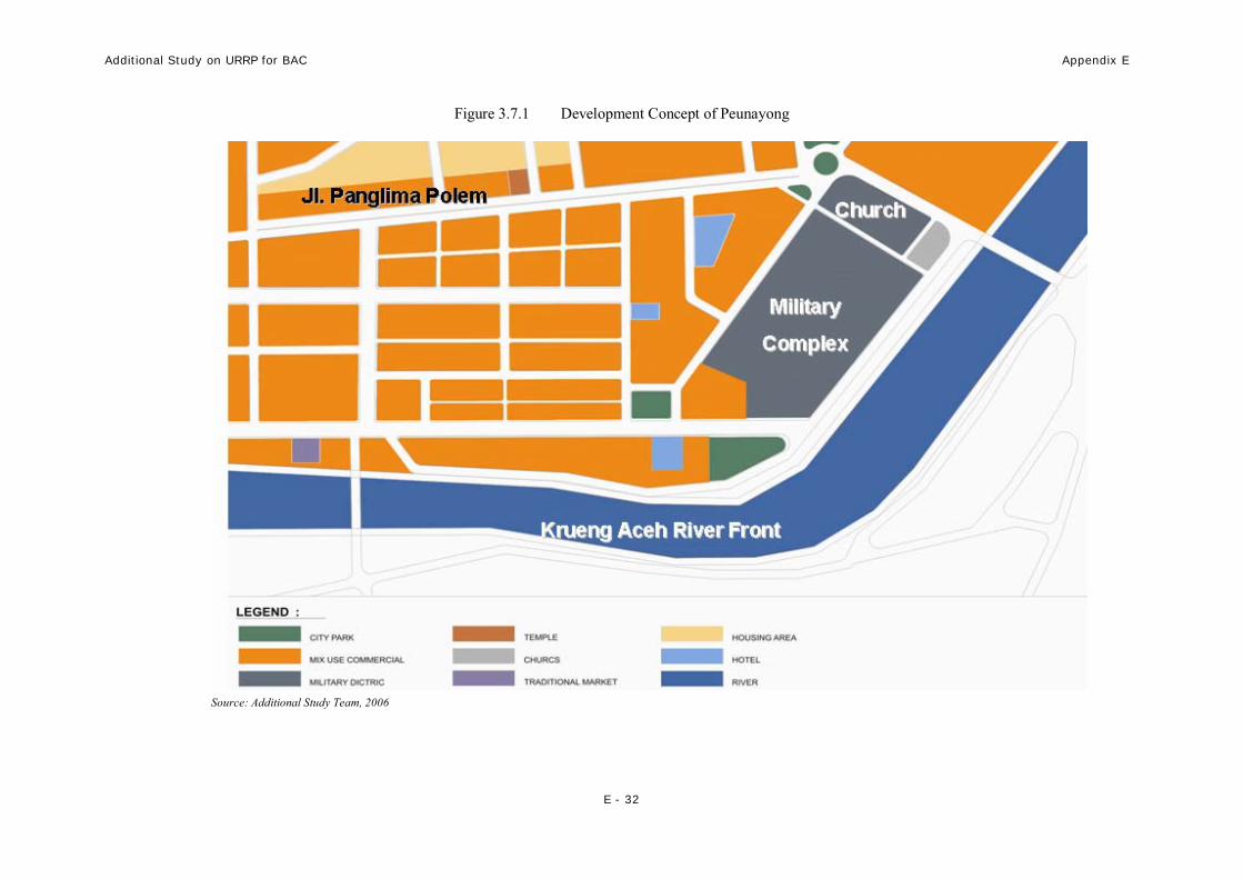
3.6 DEVELOPMENT CONCEPT
Development scenario for Peunayong Area will still be concurrent with the planning stated by RTRW and URRP studies. Such studies and plan envisage the area to be main commercial area.
This model area will be developed with several themes as follows:
(1) Riverfront area
(2) China town area
(3) Military complex
(4) Hotel area
(5) Business district (including retail and traditional commercial area)
(6) City park
The above development concept is illustrated in Figure 6.4.
3.7 PROPOSED RECONSTRUCTION WORKS
The scenario of Peunayong Area Development is as beachfront area laden with historical (disaster) value. This area is proposed to be developed as mix use function, with low density and better protection against (future potential disaster) by the provision of mitigation facilities
Proposed reconstruction works from this study are:
1. Housing Reconstruction Program
2. Road Rehabilitation Program
3. Drainage Rehabilitation Program
4. Solid Waste Rehabilitation Program
5. Water supply Rehabilitation Program
6. Landscape
Additional Study on URRP for BAC Appendix E
E - 32
Figure 3.7.1 Development Concept of Peunayong
Source: Additional Study Team, 2006

Additional Study on URRP for BAC Appendix E
E - 33
3.8 ESTIMATED COST AND CONSTRUCTION PERIOD
For the Estimated Cost and Construction Period is shown in Table 3.8.1.
Table 3.8.1 Cost Estimation and Construction Period Construction Period
No Construction Programs
Volume
Cost Estimation
(Rp Billion
2006 2007 2008 2009 2010
2011 2012 2013 2014 2015
I Housing 39 units 1.95 0.98 0.98
II Infrastructure and Utilities:
• Road 3,387 m 3.14 1.13 1.13 1.13
• Drainage 6,768 m 2.37 0.5 0.59 0.59 0.59
III Public and Social Facilities
6,500 m2 4.93 0.49 0.49 0.49 0.49 0.49 0.49 0.49 0.49 0.49 0.49
Source: Additional Study team, 2006

Additional Study on URRP for BAC Appendix E
E - 34
Figure 3.8.1 Model Concept of Peunayong
Source: Additional Study Team, 2006

Additional Study on URRP for BAC Appendix E
E - 35
CHAPTER 4 LUENG BATA MODEL AREA
4.1 PROPOSED LOCATION AND AREA
(1) Location
This model area lies across the southern border of BAC and consists of administrative areas of
Penjeurat Village and Lamdom Village in Lueng Bata District, BAC and a part of Aceh Besar Regency.
Boundaries of model area are as follows:
• North : AMD Road
• East : Cot Mesjid Village
• South : Sukarno Hatta Artery Road (ring road)
• West : River
The area is provided with good access such as:
• Sukarno Hatta Road, primary arterial road
• Tengku Imum Road, primary road of Lueng Bata City
• Sultan Malice Sale Road, urban collector road
• Planned new road (from Simpang Surabaya)
In present urban system, this area was planned as a sub-center in order to foster southward growth of BAC.The present physical condition of model area is as follows:
• Dominated by agricultural area
• There are some residential clusters
• Relatively good natural condition with many separate clusters of trees
(2) Topographic condition
• Relatively flat lowland
• A river flowing from the south to the north marks the border of BAC and Aceh Besar Regency.
(3) Land use
• Based on RTRW Banda Aceh 2002 – 2010, the area is designated as new residential area.

Additional Study on URRP for BAC Appendix E
E - 36
• Based on URRP Study-JICA, the area is allocated for development of new city area.
4.2 POPULATION
According to the officials of Lueng Bata District, the pre- and post-disaster populations are as follows:
Table 4.2.1 Population of Lueng Bata Model Area Population
No Village Pre-disaster Post-disaster*
Number of Victims/IDP
Survival Rate
1 Lamdom Village 1,082 1,625 +543 -
2 Batok Village 3,792 3,769 -23 99.3%
TOTAL 4,874 5,394 +520 Source: JICA Study Team, 2005 and Lueng Bata District Report, December 2005
Predicted population is as follows (Based on URRP):
Table 4.2.2 Projected Population of Lueng Bata Model Area
Projected Population Village
2005 2006 2007 2008 2009 2015
Lamdom 1,625 2,415 3,240 4,093 5,058 7,174 Batok 4,521 5,640 6,863 8,212 9,830 13,944
TOTAL 6,146 8,055 10,103 12,305 14,888 21,118 Source: JICA Study Team, 2005 and Additional Study Team, 2006
4.3 PRESENT SOCIO-ECONOMIC CONDITIONS
Social economics description of Lueng Bata area reflected the semi urban area, where the population composition is heterogenic because coming from other area of Banda Aceh.
Most the village communities in Lueng Bata area embracing Islam, therefore there are meunasah and mosque serving several villages in each village in Lueng Bata area.
Community education levels are various started from the elementary school unfinished to university graduated, and generally the rising generation could finish their education until graduated from the senior high school.

Additional Study on URRP for BAC Appendix E
E - 37
Table 4.3.1 Source of Revenue of Lueng Bata Model Area
Community Source of Revenue No Name of Village
Pre-disaster Post-disaster
Description
1 Lueng Bata Village • Trader
• PNS
• Police/army
• Helper
• Farmer
• Ternak
• Trader
• PNS
• Police/army
• Helper
• Farmer
• Ternak
2 Lampulo Village • Trader
• PNS
• Police/army
• Helper
• Farmer
• Ternak
• Trader
• PNS
• Police/army
• Helper
• Farmer
• Ternak
Source: Lueng Bata District & Head of Community- Desember 2005
4.4 PLANNING AND DEVELOPMENT PROGRAM FULFILL, IN PROGRESS, AND GOING TO BE WORKED
After disaster of damaged most buildings and infrastructures have been rehabilitated by NGO’s/Donors and local government and already functioning.
1. Housing Reconstruction Program
- Location : Panterik Village
- Funding : Budha Tzuchi = 500 units
- Progress : have been done

Additional Study on URRP for BAC Appendix E
E - 38
2. Construction of new road and drainage
- Location : from Simpang Surabaya to Sukarno-Hatta Arterial Road (lies across the southern part of model area)
- Funding : APBN 2005
- Progress : physical progress
3. Road and Drainage Rehabilitation and Reconstruction Program
- Location : Lueng Bata Lam Dhom
- Funding : City Government
- Progress : physical progress
4. Construction of Islamic Model Facility (pesantren)
- Location : in Sukarno-Hatta Arterial Road
- Funding : Turkey
4.5 DEVELOPMENT NEED AND CONSTRAINT
(1). Development Need:
− Pembangunan Rumah untuk area relokasi warga korban tsunami, yang mau direlokasi
− Pengembangan Lueng Bata sebagai Pusat Pertumbuhan Kota baru di area Banda Aceh
− Penciptaan lapangan pekerjaan baru di area pengembangan baru
− Pemberdayaan ekonomi (bantuan modal, alat kerja, pelatihan dll)
(2). Constraint
− Interregional coordination will be vital in the development and management of this model area, because it lies across two different administrative areas (BAC and Aceh Besar Regency).
− This model area lies surrounded by vast vacant lands. Therefore it is necessary to build a “growth magnet” in order to increase attraction and accelerate growth.
− Built environment (residential) around the area shows random pattern and tendency of unplanned growth. This may cause difficulties in integrating the spatial structure and hierarchy of existing built environment and proposed model area

Additional Study on URRP for BAC Appendix E
E - 39
4.6 DEVELOPMENT CONCEPT
Lueng Bata Model Area is proposed as a New Town in order to spread BAC urban activities, since existing urban activities are currently focused only in its northern part (such as in Kuta Raja District and Meuraxa District).
The proposed theme of the New Town is “an integration of administration center, residential and business center”.
There are several sub-themes as follow:
- Main green corridor, as the main north-south road in the area
- Forest and city park in several areas: in the central part of model area and within central business district
- Green belt, along the border of model area with existing residential areas and also as buffer zone between different neighboring functions.
- Low density residential area
- Green central business district
- Green government office and public services,
- Hotel and accommodation
- Sport center
- Riverfront area
The above development concept is illustrated in Figure 4.7.1.
4.7 PROPOSED RECONSTRUCTION WORKS
The scenario of Lueng Bata Area Development is as beachfront area laden with historical (disaster) value. This area is proposed to be developed as mix use function, with low density and better protection against (future potential disaster) by the provision of mitigation facilities
Proposed reconstruction works from this study are:
1. Housing Reconstruction Program
2. Road Rehabilitation and Reconstruction Program
3. Drainage Rehabilitation Program
4. Solid Waste Rehabilitation and Reconstruction Program
5. Water supply Rehabilitation Program
6. Utilities (electrical and telephone network)

Additional Study on URRP for BAC Appendix E
E - 40
7. Landscape (as a new green town)
8. Government Office.
9. Public and Social Facilities

Additional Study on URRP for BAC Appendix E
E - 41
Figure 4.7.1 Development Concept of Lueng Bata
Source: Additional Study Team, 2006

Additional Study on URRP for BAC Appendix E
E - 42
4.8 ESTIMATED COST AND CONSTRUCTION PERIOD
For the Estimated Cost and Construction Period is shown in Table 4.8.1.
Table 4.8.1 Cost Estimation and Construction Period
Source: Additional Study team, 2006
Construction Period
No Construction
Programs Volume Cost
Estimation
(Rp Billion) 2006 2007 2008 2009 2010 2011 2012 2013 2014 2015
I Infrastructure and Utilities:
• Road 12,229 m 59.98 9.99 9.99 9.99 9.99 9.99 9.99
• Drainage 24,454 m 35.46 5.07 5.07 5.07 5.07 5.07 5.07 5.07
II Public and Social Facilities
42,000 m2 51.74 5.15 5.15 5.15 5.15 5.15 5.15 5.15 5.15 5.15 5.15

Additional Study on URRP for BAC Appendix E
E - 43
Figure 4.8.1 Model Concept of Lueng Bata
Source: Additional Study Team, 2006