d. kallidromitou fomfis forest fire management and fire prevention system d. kallidromitou managing...
TRANSCRIPT

D. KallidromitouD. Kallidromitou
FOMFISENV4-CT96-0335
FOMFISFOMFIS
Forest Fire Management and Fire Prevention System
D. Kallidromitou
Managing Director
Epsilon International SA
Monemvasias 27, 151 25 Marousi
Athens-Greece
e-mail: [email protected]

D. KallidromitouD. Kallidromitou
FOMFISENV4-CT96-0335
PARTNERSPARTNERS
IBERINSA Coordinator ESEPSILON Contractor GRSOFTWARE AG Contractor IT IBERSAT Contractor ESSEMA GROUP Contractor ESSESFOR Contractor ESCONAG Contractor ESCPFA Contractor FRNAGREF Contractor GR

D. KallidromitouD. Kallidromitou
FOMFISENV4-CT96-0335
WHAT IS FOMFISWHAT IS FOMFIS
A Tool forA Tool for
Evaluating Fire PreventionEvaluating Fire PreventionOptimising Fighting Strategies Optimising Fighting Strategies Improve Fire Fighting PlanningImprove Fire Fighting Planning

D. KallidromitouD. Kallidromitou
FOMFISENV4-CT96-0335
RESEARCH AREASRESEARCH AREAS
Forest fuel mapping Socio-economic risk analysis Forest fire behaviour
simulation Probabilistic planning

D. KallidromitouD. Kallidromitou
FOMFISENV4-CT96-0335
TECHNOLOGICAL AREASTECHNOLOGICAL AREAS
Remote sensing & automated Remote sensing & automated cartographycartography
Geographical information systemsGeographical information systems Knowledge based systemsKnowledge based systems Fire behaviour simulationFire behaviour simulation Statistical and probabilistic analysisStatistical and probabilistic analysis Data & user interfaces software Data & user interfaces software
engineeringengineering Risk analysisRisk analysis

D. KallidromitouD. Kallidromitou
FOMFISENV4-CT96-0335
TEST AREASTEST AREAS

D. KallidromitouD. Kallidromitou
FOMFISENV4-CT96-0335
FOMFIS ARCHITECTUREFOMFIS ARCHITECTURE

D. KallidromitouD. Kallidromitou
FOMFISENV4-CT96-0335
FOMFIS MODULESFOMFIS MODULES
Socio-economic RiskSocio-economic Risk Fuel MappingFuel Mapping Integral RiskIntegral Risk Probabilistic Scenarios GenerationProbabilistic Scenarios Generation Fire Behavior ModelFire Behavior Model Efficiency Driven PlanningEfficiency Driven Planning Planning Analysis EnginePlanning Analysis Engine ReportingReporting

D. KallidromitouD. Kallidromitou
FOMFISENV4-CT96-0335
SOCIOECONOMIC RISKSOCIOECONOMIC RISK
COMPONENTS
Economic
Social
Demographic
Organisational
SRM
Number of fires

D. KallidromitouD. Kallidromitou
FOMFISENV4-CT96-0335
SOCIOECONOMIC RISKSOCIOECONOMIC RISKSocial component dataSocial component data
Tourist dataTourist dataGreeks touristsGreeks touristsForeign touristsForeign tourists
Land useLand useagricultural agricultural grazing landgrazing landurbanurbanrocky rocky wet areaswet areas
Forested Area (Ha) per Nomos and Forested Area (Ha) per Nomos and Industrial UseIndustrial Use
D. KallidromitouD. Kallidromitou
FOMFISENV4-CT96-0335
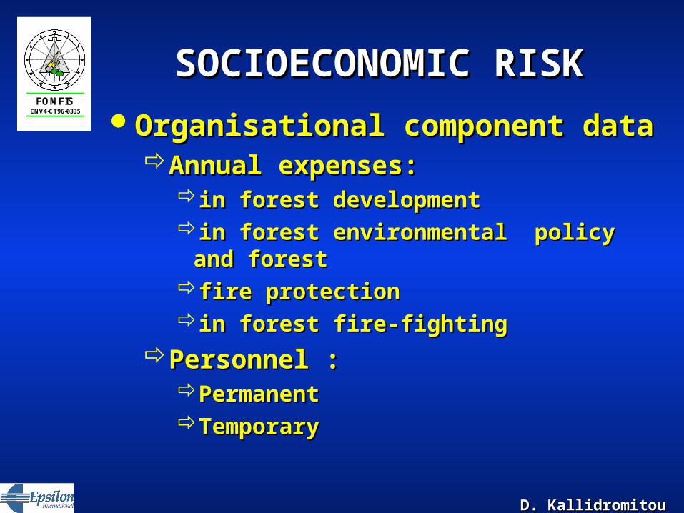
SOCIOECONOMIC RISKSOCIOECONOMIC RISK
Organisational component dataOrganisational component dataAnnual expenses:Annual expenses:
in forest development in forest development in forest environmental policy and forestin forest environmental policy and forestfire protectionfire protectionin forest fire-fightingin forest fire-fighting
Personnel :Personnel :PermanentPermanentTemporaryTemporary

D. KallidromitouD. Kallidromitou
FOMFISENV4-CT96-0335
SOCIOECONOMIC RISKSOCIOECONOMIC RISK
SRM

D. KallidromitouD. Kallidromitou
FOMFISENV4-CT96-0335
FUEL MAPPINGFUEL MAPPINGMultispectral Maximum-Likelihood Multispectral Maximum-Likelihood
Classifier of:Classifier of:Landsat-TM Image Bands and Landsat-TM Image Bands and A number of auxiliary bands A number of auxiliary bands
texture extracted from SPOT-PANtexture extracted from SPOT-PANelevationelevationslopeslope
18 test sites in the area of Limni18 test sites in the area of LimniFuel types of the site Fuel types of the site Position by GPSPosition by GPS

D. KallidromitouD. Kallidromitou
FOMFISENV4-CT96-0335
Sampling Test Sampling Test SitesSites
FUEL MAPPINGFUEL MAPPING

D. KallidromitouD. Kallidromitou
FOMFISENV4-CT96-0335
FUEL MAPPINGFUEL MAPPING
Fuel Loads derived for Evia Island
Satellite imagery & auxiliary data integration
BurnedArea

D. KallidromitouD. Kallidromitou
FOMFISENV4-CT96-0335
INTEGRAL RISK MODELINTEGRAL RISK MODEL
Input DataCompute Physical
Risk
Transformation tables
Physical Risk Map
Compute FireAppearance
Compute PotentialDamage
Compute Integral
Risk
Input Data Fire Appearance
Integral Risk Map
Potential Damage Map
Input Data
Socio-economic RiskNatural risk

D. KallidromitouD. Kallidromitou
FOMFISENV4-CT96-0335
PROBABILISTIC SCENARIOS PROBABILISTIC SCENARIOS GENERATIONGENERATION
Allows the user to generate the fires that will Allows the user to generate the fires that will appear in the simulation in two ways:appear in the simulation in two ways:Probabilistic Generation. Probabilistic Generation.
A set of fires is generatedA set of fires is generatedfor each meteorological situation in the scenariofor each meteorological situation in the scenariobased on the data extracted from the FAR (Fire based on the data extracted from the FAR (Fire
Appearance Risk) Map.Appearance Risk) Map.
Random Generation. Random Generation.
A given number of Fires are generated in a A given number of Fires are generated in a random geographical situationrandom geographical situation

D. KallidromitouD. Kallidromitou
FOMFISENV4-CT96-0335
PROBABILISTIC SCENARIOS PROBABILISTIC SCENARIOS GENERATIONGENERATION
AreaDefinition
General DataDefinition
MeteorologicalEvolutionDefinition
WindEvolutionDefinition
FiresGeneration

D. KallidromitouD. Kallidromitou
FOMFISENV4-CT96-0335
FIRE BEHAVIOR MODELFIRE BEHAVIOR MODEL General PurposeGeneral Purpose
Estimate the fire spread perimeter, area Estimate the fire spread perimeter, area and shapeand shape
ObjectivesObjectivesCalculate the fire importance.Calculate the fire importance.Give support to fire fighting dispatching.Give support to fire fighting dispatching.Calculate extinction costs.Calculate extinction costs.Estimate losses and prejudices due to fire Estimate losses and prejudices due to fire
action.action.Obtain the potential spread rate for an EGU Obtain the potential spread rate for an EGU
for integral risk calculations.for integral risk calculations.

D. KallidromitouD. Kallidromitou
FOMFISENV4-CT96-0335
FIRE BEHAVIOR MODELFIRE BEHAVIOR MODEL
Fuel Model
Mass density
B
Preignition HeatQig
Slope Factor
s
Wind Factor
w
MoistureCompactedness
SizeChemical Composition
Basic Propagation FluxIpo
Reaction IntensityIr
Surface/Volume RatioCompactedness
Wind Speed
Size
Reaction IntensityIr
Propagation Flux Ratio
CompactednessSlope
Effective HeatingNumber
Table
Table
Table
Table
Table
Table
Table
•Based on Rothermel’s equation•Depends on the fuel model•Slope and wind are considered

D. KallidromitouD. Kallidromitou
FOMFISENV4-CT96-0335
EFFICIENCY DRIVEN EFFICIENCY DRIVEN PLANNINGPLANNING
General PurposeGeneral PurposeAllow user to make resources planning Allow user to make resources planning
according their efficiency in fire vigilance and according their efficiency in fire vigilance and extinction operations.extinction operations.
ObjectivesObjectivesObtain access maps over the analysis area.Obtain access maps over the analysis area.Calculate access coverage either by airborne Calculate access coverage either by airborne
and ground fire fighting resources.and ground fire fighting resources.Estimate visual coverage for vigilance purposes Estimate visual coverage for vigilance purposes
based on the viewshed calculation.based on the viewshed calculation.Estimate the relationship between work costs Estimate the relationship between work costs
and access improvement of the road network.and access improvement of the road network.

D. KallidromitouD. Kallidromitou
FOMFISENV4-CT96-0335
EFFICIENCY DRIVEN EFFICIENCY DRIVEN PLANNINGPLANNING
Ground Total Access Cost MapGround Total Access Cost MapRASTERIZE ROADNETWORK LAYER
ASSIGNS AN AVERAGESPEED SavR ACCORDINGTHE ROAD TYPE AND
TERRAIN SLOPE
CALCULATES THETRANSPORT TIMETtR=L?60 / SavR?1000
READS THE FUEL MODELOF EACH EGU
ASSIGNS AN AVERAGESPEED SavC ACCORDING
THE FUEL TYPE ANDTERRAIN SLOPE
CALCULATES THETRANSPORT TIMETtC=L?60 / SavC?1000
OVERLAPS THE TWORESULTING MAPS
Tt=MIN(TtR, TtC)
ACTUAL VEHICLEGEOGRAPHICAL
POSITION
GROUND VEHICLESAIRBORNE VEHICLES
CALCULATE DISTANCEd FROM ACTUAL TO EGU
CALCULATE ACCESSTIME t=d / SAV
IMAP
TOTAL ACCUMULATEDACCESS TIMEAUTOMATA
CALCULATION
TCMAP
Average Speed SAV
Depending on the analysis thisposition regards the base, awater point or any other pointcoordinates.
Access of ground based forcesis calculated through theexisting road network map.
Airborne forces access isestimated depending on their average flight speed.

D. KallidromitouD. Kallidromitou
FOMFISENV4-CT96-0335
EFFICIENCY DRIVEN EFFICIENCY DRIVEN PLANNINGPLANNING
Bases & Water Points AllocationBases & Water Points Allocation
CALCULATE TCMAP FOREACH AIR BASE AND
VEHICLE TYPE.COMPUTES NAi
INTEGRATES ALL THEMAPS IN A SINGLE
AIRCRAFT ACCESS MAP.COMPUTES NA
CALCULATE TCMAP FOREACH GROUND BASEAND VEHICLE TYPE.
COMPUTES NGi
INTEGRATES ALL THEMAPS IN A SINGLE
GROUND ACCESS MAP.COMPUTES NG
INTEGRATES ALL THEMAPS IN A SINGLE
GROUND ACCESS MAP.COMPUTES N
OBTAIN EFFICIENCY FOREACH TCMAPEAi=NAiTAT / NEGi=NGiTAT / N
OBTAIN EFFICIENCY FOREACH INTEGRATED
TCMAPEA=NATAT / NEG=NGTAT / N
TAT
TAT
OBTAIN EFFICIENCY FORTHE WHOLE RESULTING
TCMAPE=NTAT / N
TAT
AIRCRAFT PARAMETERSAND DISTANCE
IMPEDANCE MAP FORGROUND VEHICLES

D. KallidromitouD. Kallidromitou
FOMFISENV4-CT96-0335
EFFICIENCY DRIVEN EFFICIENCY DRIVEN PLANNINGPLANNING
Lookouts AllocationLookouts Allocation
READS THE DIGITALTERRAIN MODEL OBTAINS LOOKOUT
POSITION AND HEIGHT
VIEWSHED COVERAGECALCULATION
VIEWSHEDSINTEGRATION.
COMPUTES LV0, LV1, LV3
EFFICIENCYCALCULATION
E=0.4 (LV1/N)+0.6 (LV3/N)
The viewshed calculation isobtained from the DTM, butfurther detailed analysis willconsider vegetation coverageheight as well.

D. KallidromitouD. Kallidromitou
FOMFISENV4-CT96-0335
PLANNING ANALYSIS PLANNING ANALYSIS ENGINEENGINE
To bring face to face a specific scenario To bring face to face a specific scenario against a proposed planning scheme against a proposed planning scheme along a period of time. along a period of time.
Main tasks accomplished are:Main tasks accomplished are:Classify and characterise fires.Classify and characterise fires.Determine number and type of Determine number and type of
required resources.required resources.Effectively assign resources.Effectively assign resources.Compute associated costs of fire Compute associated costs of fire
fighting operations.fighting operations.
D. KallidromitouD. Kallidromitou
FOMFISENV4-CT96-0335
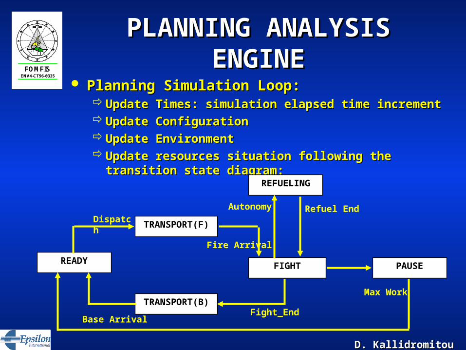
PLANNING ANALYSIS PLANNING ANALYSIS ENGINEENGINE
Planning Simulation Loop:Planning Simulation Loop: Update Times: simulation elapsed time incrementUpdate Times: simulation elapsed time increment Update ConfigurationUpdate Configuration Update EnvironmentUpdate Environment Update resources situation following the transition Update resources situation following the transition
state diagram:state diagram:
Base Arrival
Max Work
READY
TRANSPORT(B)
FIGHT
REFUELING
Dispatch
Fight_End
Fire Arrival
Autonomy
PAUSE
Refuel End
TRANSPORT(F)

D. KallidromitouD. Kallidromitou
FOMFISENV4-CT96-0335
REPORTING TOOLREPORTING TOOL Results of simulation are presented in form of Results of simulation are presented in form of
tables and graphics. They includetables and graphics. They includeweather and wind pattern evolutionweather and wind pattern evolutionfire outbreaks distribution fire outbreaks distribution fire growth average values such asfire growth average values such as
size, size, fire line intensities,fire line intensities,fire importance etc;fire importance etc;
reports are obtained regardingreports are obtained regarding
resources usage resources usage dispatching dispatching efficiencyefficiency
D. KallidromitouD. Kallidromitou
FOMFISENV4-CT96-0335
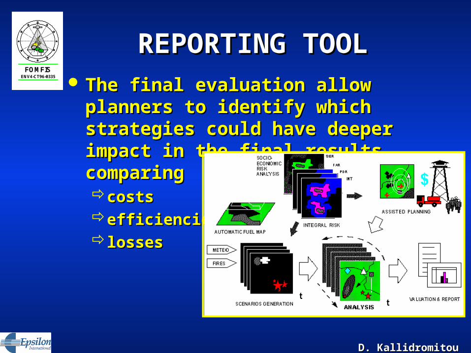
REPORTING TOOL REPORTING TOOL The final evaluation allow planners to The final evaluation allow planners to
identify which strategies could have identify which strategies could have deeper impact in the final results, deeper impact in the final results, comparing comparing costscostsefficienciesefficiencieslosseslosses

D. KallidromitouD. Kallidromitou
FOMFISENV4-CT96-0335
For Your AttentionFor Your Attention
Thank Thank YouYou