d r a f t - ci.carson.ca.us
TRANSCRIPT
DRAFT
Initial Study and Negative Declaration
Highline Truck Yard Project
Prepared for:
City of Carson 701 East Carson Street
Carson, California 90745
Contact: Manraj Bhatia, Assistant Planner
Prepared by:
27372 Calle Arroyo
San Juan Capistrano, California 92675
Contact: Collin Ramsey, Senior Project Manager
OCTOBER 2019

Printed on 30% post-consumer recycled material.
10029.08
i October 2019
Table of Contents
SECTION PAGE NO.
ACRONYMS AND ABBREVIATIONS ............................................................................................................................. III
1 INTRODUCTION ............................................................................................................................................. 1
1.1 Project Overview ..................................................................................................................................... 1
1.2 California Environmental Quality Act Compliance ................................................................................ 1
1.3 Preparation and Processing of this Initial Study ................................................................................... 2
1.4 Initial Study Checklist ............................................................................................................................. 2
1.5 Public Review Process ........................................................................................................................... 2
2 PROJECT DESCRIPTION ................................................................................................................................ 5
2.1 Project Location ...................................................................................................................................... 5
2.2 Environmental Setting ............................................................................................................................ 5
2.3 Project ..................................................................................................................................................... 6
2.4 Project Construction ............................................................................................................................... 7
2.5 Project Approvals .................................................................................................................................... 7
3 INITIAL STUDY CHECKLIST ............................................................................................................................ 9
3.1 Aesthetics ............................................................................................................................................ 14
3.2 Agriculture and Forestry Resources ................................................................................................... 16
3.3 Air Quality ............................................................................................................................................. 18
3.4 Biological Resources ........................................................................................................................... 30
3.5 Cultural Resources .............................................................................................................................. 32
3.6 Energy .................................................................................................................................................. 34
3.7 Geology and Soils ................................................................................................................................ 35
3.8 Greenhouse Gas Emissions ................................................................................................................ 39
3.9 Hazards and Hazardous Materials ..................................................................................................... 45
3.10 Hydrology and Water Quality ............................................................................................................... 48
3.11 Land Use and Planning ....................................................................................................................... 50
3.12 Mineral Resources .............................................................................................................................. 51
3.13 Noise .................................................................................................................................................... 52
3.14 Population and Housing ...................................................................................................................... 59
3.15 Public Services .................................................................................................................................... 60
3.16 Recreation ............................................................................................................................................ 61
3.17 Transportation ..................................................................................................................................... 62
3.18 Tribal Cultural Resources .................................................................................................................... 66
3.19 Utilities and Service Systems .............................................................................................................. 67
3.20 Wildfire ................................................................................................................................................. 69
3.21 Mandatory Findings of Significance ................................................................................................... 71
HIGHLINE TRUCK YARD PROJECT INITIAL STUDY AND NEGATIVE DECLARATION
10029.08
ii October 2019
4 REFERENCES AND PREPARERS.................................................................................................................. 73
4.1 References Cited ................................................................................................................................. 73
4.2 List of Preparers .................................................................................................................................. 77
APPENDICES
A Air Quality and Greenhouse Gas Calculations
B Noise
C Trip Generation Analysis Memorandum
FIGURES
1 Project Location ................................................................................................................................................ 79
2 Surrounding Land Uses .................................................................................................................................... 81
3 Site Plan ............................................................................................................................................................. 83
4 Noise Measurement Locations ........................................................................................................................ 85
5 Project Trip Distribution and Assignment (PCE Volumes) ............................................................................... 87
TABLES
1 South Coast Air Quality Management District Air Quality Significance Thresholds ...................................... 21
2 Construction Workers, Vendor Trips, and Equipment Use per Day ................................................................ 22
3 Estimated Maximum Daily Construction Criteria Air Pollutant Emissions – Unmitigated ............................ 23
4 Truck Trip Deviation and Employee Passenger Vehicle Route Summary ...................................................... 24
5 Estimated Maximum Daily Operational Criteria Air Pollutant Emissions ....................................................... 24
6 Construction Localized Significance Thresholds Analysis .............................................................................. 26
7 Estimated Annual Construction GHG Emissions ............................................................................................. 41
8 Estimated Annual Operational GHG Emissions ............................................................................................... 42
9 Measured Noise Levels .................................................................................................................................... 53
10 Noise Element Land Use Compatibility Matrix ................................................................................................ 54
11 Noise Ordinance (Municipal Code) Standards ................................................................................................ 55
12 Construction Noise Analysis Summary ............................................................................................................ 56
13 Project-Related Traffic Noise Increases ........................................................................................................... 57
10029.08
iii October 2019
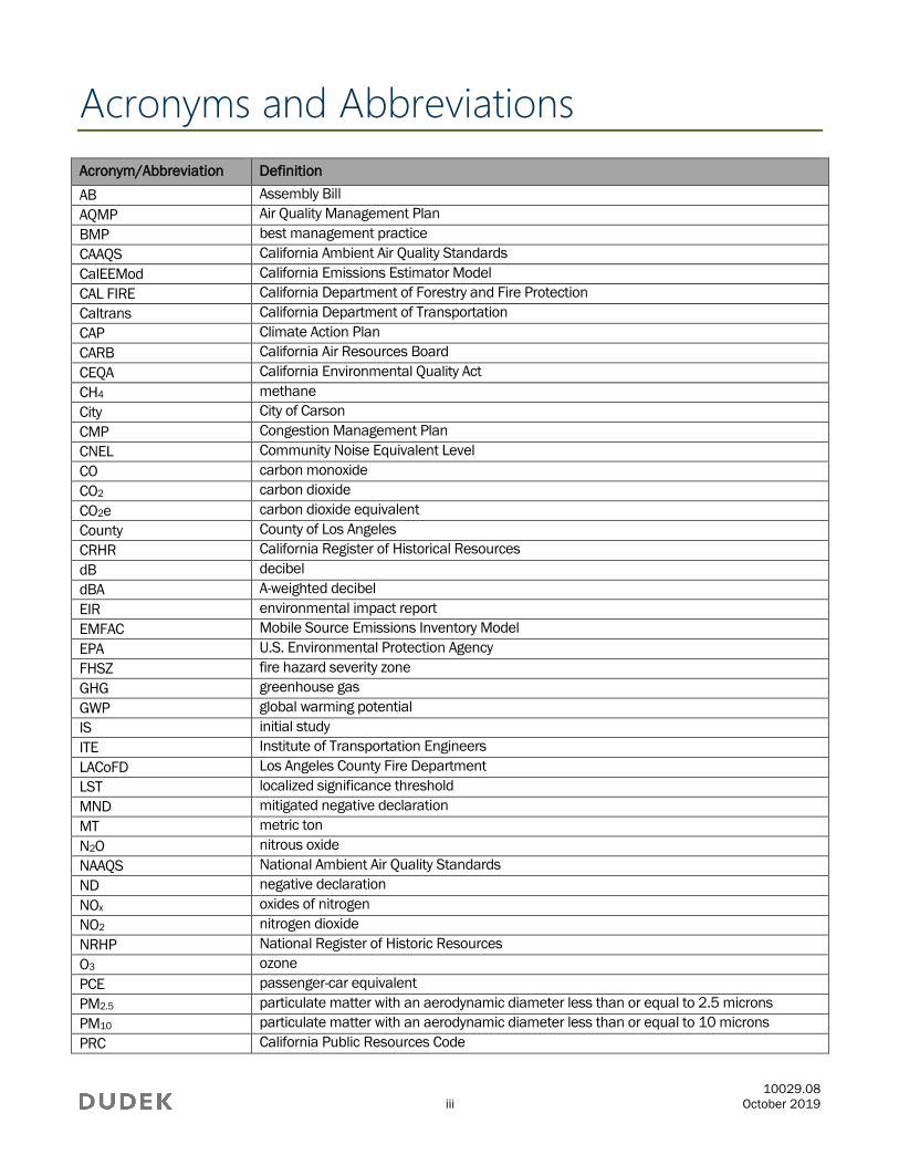
Acronyms and Abbreviations
Acronym/Abbreviation Definition
AB Assembly Bill
AQMP Air Quality Management Plan
BMP best management practice
CAAQS California Ambient Air Quality Standards
CalEEMod California Emissions Estimator Model
CAL FIRE California Department of Forestry and Fire Protection
Caltrans California Department of Transportation
CAP Climate Action Plan
CARB California Air Resources Board
CEQA California Environmental Quality Act
CH4 methane
City City of Carson
CMP Congestion Management Plan
CNEL Community Noise Equivalent Level
CO carbon monoxide
CO2 carbon dioxide
CO2e carbon dioxide equivalent
County County of Los Angeles
CRHR California Register of Historical Resources
dB decibel
dBA A-weighted decibel
EIR environmental impact report
EMFAC Mobile Source Emissions Inventory Model
EPA U.S. Environmental Protection Agency
FHSZ fire hazard severity zone
GHG greenhouse gas
GWP global warming potential
IS initial study
ITE Institute of Transportation Engineers
LACoFD Los Angeles County Fire Department
LST localized significance threshold
MND mitigated negative declaration
MT metric ton
N2O nitrous oxide
NAAQS National Ambient Air Quality Standards
ND negative declaration
NOx oxides of nitrogen
NO2 nitrogen dioxide
NRHP National Register of Historic Resources
O3 ozone
PCE passenger-car equivalent
PM2.5 particulate matter with an aerodynamic diameter less than or equal to 2.5 microns
PM10 particulate matter with an aerodynamic diameter less than or equal to 10 microns
PRC California Public Resources Code
HIGHLINE TRUCK YARD PROJECT INITIAL STUDY AND NEGATIVE DECLARATION
10029.08
iv October 2019
Acronym/Abbreviation Definition
RTP/SCS Regional Transportation Plan/Sustainable Communities Strategy
SB Senate Bill
SCAB South Coast Air Basin
SCAG Southern California Association of Governments
SCAQMD South Coast Air Quality Management District
SWPPP stormwater pollution prevention plan
TAC toxic air contaminant
VMT vehicle miles traveled
VOC volatile organic compound
10029.08
1 October 2019
1 Introduction
1.1 Project Overview
The City of Carson (City) received a development application from Jack A. and Price Family Trust (applicant) requesting
the approval of the following discretionary actions for the proposed Highline Truck Yard project (project):
Site Plan and Design Overlay Review (DOR) No. 1612-16
Conditional Use Permit (CUP) No. 1002-16
The approximately 2.8-acre project site is currently developed with a single-story, office/warehouse building;
some associated industrial structures; and highly disturbed land cover. The project involves construction and
operation of a 42-space truck yard facility and would retain/repurpose the existing office/warehouse building.
The project is subject to analysis pursuant to the California Environmental Quality Act (CEQA). In accordance with
CEQA Guidelines Section 15367, the City is the lead agency with principal responsibility for considering the
project for approval (14 CCR 15000 et seq.).
1.2 California Environmental Quality Act Compliance
CEQA, a statewide environmental law contained in California Public Resources Code (PRC) Sections 21000–
21177, applies to most public agency decisions to carry out, authorize, or approve actions that have the potential
to adversely affect the environment (PRC Section 21000 et seq.). The overarching goal of CEQA is to protect the
physical environment. To achieve that goal, CEQA requires that public agencies identify the environmental
consequences of their discretionary actions and consider alternatives and mitigation measures that could avoid
or reduce significant adverse impacts when avoidance or reduction is feasible. It also gives other public agencies
and the public an opportunity to comment on the project. If significant adverse impacts cannot be avoided,
reduced, or mitigated to below a level of significance, the public agency is required to prepare an environmental
impact report (EIR) and balance the project’s environmental concerns with other goals and benefits in a
statement of overriding considerations.
In accordance with the CEQA Guidelines, the City, as the lead agency, has prepared an initial study (IS) to evaluate
potential environmental effects and to determine whether an EIR, a negative declaration (ND), or a mitigated
negative declaration (MND) should be prepared for the project. CEQA Guidelines Section 15070(b) provides that
an MND should be prepared for a project when the IS has identified potentially significant environmental impacts
associated with the project, but: (1) revisions to the project’s plans or proposals made or agreed to by the applicant
before release of an MND for public review would avoid or mitigate environmental effects to a point where no
significant effect on the environment would occur; and (2) there is no substantial evidence in the record before the
public agency that the project, as revised, may have a significant effect on the environment. The IS determined that
implementation of the project would result in no impacts or less-than-significant impacts. Therefore, the City has
prepared an ND for the project.
HIGHLINE TRUCK YARD PROJECT INITIAL STUDY AND NEGATIVE DECLARATION
10029.08
2 October 2019
1.3 Preparation and Processing of this Initial Study
The City’s Community Development Department, Planning Division, directed and supervised preparation of this
Initial Study/Negative Declaration (IS/ND). Although prepared with assistance from the consulting firm Dudek, the
content contained and the conclusions drawn within this IS/ND reflect the independent judgment of the City.
1.4 Initial Study Checklist
Dudek, under the City’s guidance, prepared the project’s Environmental Checklist (i.e., IS) per CEQA Guidelines
Sections 15063–15065. The CEQA Guidelines include a suggested checklist to indicate whether a project would
have an adverse impact on the environment. The checklist is found in Section 3, Initial Study Checklist, of this
document. Following the Environmental Checklist, Sections 3.1 through 3.21 include an explanation and
discussion of each significance determination made in the checklist for the project.
For this IS/ND, one of the following four responses is possible for each environmental issue area:
1. Potentially Significant Impact
2. Less-Than-Significant Impact with Mitigation Incorporated
3. Less-Than-Significant Impact
4. No Impact
The checklist and accompanying explanation of checklist responses provide the information and analysis
necessary to assess relative environmental impacts of the project. In doing so, the City determined no further
environmental review was necessary for the project.
1.5 Public Review Process
As specified by the CEQA Guidelines, the project’s Notice of Intent was circulated for a 20-day public review period
(14 CCR 15082[b]) to agencies with concern or with jurisdiction over resources affected by the project. The Notice of
Intent has been provided to the Clerk of the County of Los Angeles, and interested organizations and individuals.
Reviewers of the IS/ND are given a 20-day public review period to prepare written comments on the IS/ND.
During the public review period, the IS/ND including the technical appendices are available for review at the
following locations:
City of Carson Community Development Department, 701 East Carson Street, Carson, California, 90745,
Monday through Thursday from 7:00 a.m. to 6:00 p.m.
City of Carson website: www.ci.carson.ca.us
City of Carson Public Library, 151 East Carson Street, Carson, California 90745
HIGHLINE TRUCK YARD PROJECT INITIAL STUDY AND NEGATIVE DECLARATION
10029.08
3 October 2019
In reviewing the IS/ND, affected public agencies and interested members of the public should focus on the
adequacy of the document in identifying and analyzing the potential environmental impacts. Comments on the
IS/ND and the analysis contained herein may be sent to:
Manraj Bhatia, Assistant Planner
City of Carson
Community Development Department, Planning Division
701 East Carson Street
Carson, California 90745
310.952.1761

HIGHLINE TRUCK YARD PROJECT INITIAL STUDY AND NEGATIVE DECLARATION
10029.08
4 October 2019
INTENTIONALLY LEFT BLANK
10029.08
5 October 2019
2 Project Description
2.1 Project Location
The project site is located in the eastern portion of the City, which is located in the South Bay/Harbor area of the
County of Los Angeles (County). Regionally, the City is bordered by the cities of Long Beach, Compton, Torrance,
and Los Angeles. Additionally, unincorporated County borders the City on the northwest. Major roadways
surrounding the project site include Del Amo Boulevard to the north, Alameda Street to the east, Carson Street to
the south, and Wilmington Avenue to the west (Figure 1, Project Location). Locally, the project site is located
between 209th Street to the north, Lamberton Avenue to the east, East Dominguez Street to the south, and Brant
Avenue to the west (Figure 2, Surrounding Land Uses).
The project site consists of 11 Assessor’s Parcel Numbers: 7318-017-014, 7318-017-023, 7318-017-024, 7318-017-
025, 7318-017-026, 7318-017-027, 7318-017-028, 7318-017-029, 7318-017-046, 7318-017-048, and 7318-017-
049. The address associated with the project site is 20915 South Lamberton Avenue, Carson, California 90810.
2.2 Environmental Setting
City of Carson
The City is approximately 19 square miles in the South Bay region of the County. Generally, the City is an urban
community with a broad mix of land uses, including housing, commercial, office, industrial park, open space, and
public-serving uses. The City is primarily built out and relatively flat, with most elevations ranging from 20 to 40 feet.
The northwest and southeast portions of the City are generally industrial use. Residential uses are generally located
on the southwest and northeast portions of the City. Commercial uses are concentrated along Interstate (I-) 405.
Carson is surrounded by the City of Los Angeles to the northwest, south, and southeast. The City of Compton is
adjacent to the northeast, and the City of Long Beach is adjacent to the east. The City of Carson is also close to
the Ports of Los Angeles and Long Beach, approximately 2 to 3 miles to the south. There are four freeways that
provide direct access to Carson: I-405 (San Diego Freeway), which bisects the City in an east–west direction; I-
710 (Long Beach Freeway), which forms a portion of the eastern border of Carson; State Route 91 (Redondo
Beach/Artesia Freeway) in the northern portion of the City; and I-110 (Harbor Freeway), which forms much of the
western border of the City (City of Carson 2002).
Existing Project Site
The approximately 2.8-acre, irregularly-shaped project site is bisected in a north–south direction by a 15-foot-wide
alley, which creates eastern and western halves of the project site. The eastern portion, along Lamberton Avenue,
contains a 13,053-square-foot, single-story, office/warehouse building. In addition to this building, there is also
an existing canopy, smaller structures, and unpaved trailer storage on this half of the project site, all of which is
surrounded by a concrete masonry unit wall topped with a chain-link fence. An approximately 40-foot-wide
driveway and 26-foot-wide driveway provide egress/ingress to this part of the project site via Lamberton Avenue.
This area of the project site can also be accessed through the alley.
HIGHLINE TRUCK YARD PROJECT INITIAL STUDY AND NEGATIVE DECLARATION
10029.08
6 October 2019
The western portion of the project site, fronting Brant Avenue, largely consists of an unpaved open area
surrounding by a low concrete masonry wall topped with tall fabric screening. Both cabs and trailers are stored on
this half of the project site. Access to his part of the project site is provided via the alley.
The project site is zoned MH-D (Manufacturing, Heavy) with a General Plan Land Use Designation of Heavy
Industrial (City of Carson 2019a).
Surrounding Land Uses
The project site is in an industrial area and is generally bounded by existing warehouses, light industrial, office,
and freight uses. As shown in Figure 2, to the north and west are warehouse, industrial, and office uses. To the
east of the project site is Lamberton Avenue, an industrial water treatment facility, and the Alameda Corridor
freight rail. To the south is Dominguez Street and the City’s Corporate Yard.
2.3 Project
The project involves construction and operation of a truck yard facility consisting of 42 trailer parking spaces,
repurposing of the existing single-story office/warehouse building, and associated on-site improvements. The
project site would provide for the temporary parking and storage for trucks and truck-mounted containers. Trucks
and trailers would be parked on the project site while waiting to be moved to and from the Port of Los Angeles,
Port of Long Beach, or other local locations.
On the eastern portion of the project site, the existing canopy and smaller structures to the south of the existing
office/warehouse building would be demolished and the area paved with new asphalt and striped for 15 trailer
spaces. A new 8-foot by 12-foot trash enclosure would be installed adjacent to the existing office/warehouse
building. The northeast corner of the project site, north of the existing single-story office/warehouse building,
would be paved and striped for 15 passenger vehicle parking and 10 truck cabin parking. The existing driveways
off Lamberton Avenue would remain, although improvements to the driveway aprons would occur. The existing 6-
foot-high concrete block wall will remain, and an addition of a 2-foot-high wrought iron fence on top would be
installed. Additionally, new landscaping would be installed within the project frontage along Lamberton Avenue.
On the western portion, there would be no demolition of existing building or structures. This half of the project site
would be paved with new asphalt and striped for 27 new trailer stalls. The existing driveways along Brant Avenue
would be closed, and a new 37.5-foot-wide driveway and gate would be constructed. The existing 6-foot-high
concrete block wall will remain, and an addition of a 2-foot-high wrought-iron fence on top would be installed. New
landscaping would be introduced along the project frontage. Both halves of the project site would continue to be
accessible by the existing alley that bisects the project site. The alley, which is currently 15 feet wide, will be widened
by 7-foot 6-inch dedications on either side to achieve a 30 feet width in the area adjacent to the project site. A new
gate is proposed on either portion to provide access between the east and west portions (Figure 3, Site Plan)
The unloading and reloading of contents of one trailer to another trailer would be permitted on the project site;
however, the maintenance of truck tractors and equipment would not be allowed on the project site. The
proposed parking facility would be operational from 6:00 a.m. to 10:00 p.m. Monday through Friday.
HIGHLINE TRUCK YARD PROJECT INITIAL STUDY AND NEGATIVE DECLARATION
10029.08
7 October 2019
2.4 Project Construction
The project would be constructed in a single phase starting in early 2020. Construction activities would include
demolition, site preparation, grading, and paving. For a breakdown of construction sub-phases and schedule, refer
to the California Emissions Estimator Model (CalEEMod) air quality modeling outputs provided in Appendix A.1
2.5 Project Approvals
The project would require the following approvals prior to the issuance of demolition, grading, and building permits:
Site Plan and Design Overlay Review (DOR) No. 1612-16
Conditional Use Permit (CUP) No. 1002-16
The project would require the following approvals prior to the issuance of Certificate of Occupancy:
Lot Line Adjustment/Certificate of Compliance (LLA/COC)
1 Construction phasing estimates are based on default assumptions provided in CalEEMod (Appendix A). The analysis assumes a
construction start date in or around 2020, which represents the earliest date construction would initiate. Assuming the earliest
start date for construction represents the worst-case scenario for criteria air pollutant emissions because equipment and
vehicle emission factors for later years would be slightly less due to more stringent standards for in-use off-road equipment and
heavy-duty trucks, as well as fleet turnover replacing older equipment and vehicles in later years.

HIGHLINE TRUCK YARD PROJECT INITIAL STUDY AND NEGATIVE DECLARATION
10029.08
8 October 2019
INTENTIONALLY LEFT BLANK
10029.08
9 October 2019
3 Initial Study Checklist
1. Project title:
Highline Truck Yard
2. Lead agency name and address:
City of Carson
701 East Carson Street
Carson, California 90745
3. Contact person and phone number:
Manraj Bhatia, Assistant Planner
City of Carson
Community Development Department, Planning Division
701 East Carson Street
Carson, California 90745
310.952.1761
4. Project location:
20915 South Lamberton Avenue
Carson, California 90810
5. Project sponsor’s name and address:
Jack A. and Price Family Trust
11133 Interstate 45 South, Suite 190
Conroe, Texas 77302
6. General plan designation:
Heavy Industrial
7. Zoning:
MH-D (Manufacturing, Heavy)
8. Description of project. (Describe the whole action involved, including but not limited to later phases of the
project, and any secondary, support, or off-site features necessary for its implementation. Attach
additional sheets if necessary):
The project involves construction and operation of a truck yard facility consisting of 42 trailer parking
spaces, repurposing of the existing single-story office/warehouse building, and associated on-site
HIGHLINE TRUCK YARD PROJECT INITIAL STUDY AND NEGATIVE DECLARATION
10029.08
10 October 2019
improvements. The project site would provide temporary parking and storage of trucks and truck-
mounted containers. Trucks and trailers would be parked on the project site while waiting to be moved to
and from the Port of Los Angeles, Port of Long Beach, or other local locations.
Refer to Section 2.3 for a detailed project summary.
9. Surrounding land uses and setting (Briefly describe the project’s surroundings):
The project site is in an industrial area and is generally bounded by existing warehouses, light industrial,
office, and freight uses. As shown in Figure 2, to the north and west are warehouse, industrial, and office
uses. To the east of the project site is Lamberton Avenue, an industrial water treatment facility, and the
Alameda Corridor freight rail. To the south is Dominguez Street and the City’s Corporate Yard.
10. Other public agencies whose approval is required (e.g., permits, financing approval, or participation agreement):
None.
11. Have California Native American tribes traditionally and culturally affiliated with the project area
requested consultation pursuant to Public Resources Code section 21080.3.1? If so, is there a plan
for consultation that includes, for example, the determination of significance of impacts to tribal
cultural resources, procedures regarding confidentiality, etc.?
Yes. See Section 3.18, Tribal Cultural Resources.
HIGHLINE TRUCK YARD PROJECT INITIAL STUDY AND NEGATIVE DECLARATION
10029.08
11 October 2019
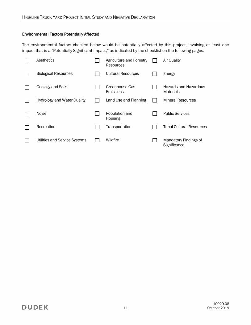
Environmental Factors Potentially Affected
The environmental factors checked below would be potentially affected by this project, involving at least one
impact that is a “Potentially Significant Impact,” as indicated by the checklist on the following pages.
Aesthetics Agriculture and Forestry
Resources
Air Quality
Biological Resources Cultural Resources Energy
Geology and Soils Greenhouse Gas
Emissions
Hazards and Hazardous
Materials
Hydrology and Water Quality Land Use and Planning Mineral Resources
Noise Population and
Housing
Public Services
Recreation Transportation Tribal Cultural Resources
Utilities and Service Systems Wildfire Mandatory Findings of
Significance

HIGHLINE TRUCK YARD PROJECT INITIAL STUDY AND NEGATIVE DECLARATION
10029.08
12 October 2019
Determination (To be completed by the Lead Agency)
On the basis of this initial evaluation:
I find that the project COULD NOT have a significant effect on the environment, and a NEGATIVE
DECLARATION will be prepared.
I find that although the project could have a significant effect on the environment, there will not be a
significant effect in this case because revisions in the project have been made by or agreed to by the
project proponent. A MITIGATED NEGATIVE DECLARATION will be prepared.
I find that the project MAY have a significant effect on the environment, and an ENVIRONMENTAL IMPACT
REPORT is required.
I find that the project MAY have a “potentially significant impact” or “potentially significant unless
mitigated” impact on the environment, but at least one effect (1) has been adequately analyzed in an
earlier document pursuant to applicable legal standards, and (2) has been addressed by mitigation
measures based on the earlier analysis as described on attached sheets. An ENVIRONMENTAL IMPACT
REPORT is required, but it must analyze only the effects that remain to be addressed.
I find that although the project could have a significant effect on the environment, because all potentially
significant effects (a) have been analyzed adequately in an earlier ENVIRONMENTAL IMPACT REPORT or
NEGATIVE DECLARATION pursuant to applicable standards, and (b) have been avoided or mitigated
pursuant to that earlier ENVIRONMENTAL IMPACT REPORT or NEGATIVE DECLARATION, including revisions
or mitigation measures that are imposed upon the project, nothing further is required.
Signature Date
HIGHLINE TRUCK YARD PROJECT INITIAL STUDY AND NEGATIVE DECLARATION
10029.08
13 October 2019
Evaluation of Environmental Impacts
1. A brief explanation is required for all answers except “No Impact” answers that are adequately supported by
the information sources a lead agency cites in the parentheses following each question. A “No Impact”
answer is adequately supported if the referenced information sources show that the impact simply does not
apply to projects like the one involved (e.g., the project falls outside a fault rupture zone). A “No Impact”
answer should be explained where it is based on project-specific factors as well as general standards (e.g.,
the project will not expose sensitive receptors to pollutants, based on a project-specific screening analysis).
2. All answers must take account of the whole action involved, including off-site as well as on-site, cumulative
as well as project-level, indirect as well as direct, and construction as well as operational impacts.
3. Once the lead agency has determined that a particular physical impact may occur, then the checklist
answers must indicate whether the impact is potentially significant, less than significant with mitigation,
or less than significant. “Potentially Significant Impact” is appropriate if there is substantial evidence that
an effect may be significant. If there are one or more “Potentially Significant Impact” entries when the
determination is made, an Environmental Impact Report (EIR) is required.
4. “Negative Declaration: Less Than Significant With Mitigation Incorporated” applies where the
incorporation of mitigation measures has reduced an effect from “Potentially Significant Impact” to a
“Less Than Significant Impact.” The lead agency must describe the mitigation measures, and briefly
explain how they reduce the effect to a less than significant level (mitigation measures from “Earlier
Analyses,” as described in (5) below, may be cross-referenced).
5. Earlier analyses may be used where, pursuant to the tiering, program EIR, or other CEQA process, an
effect has been adequately analyzed in an earlier EIR or negative declaration. Section 15063(c)(3)(D). In
this case, a brief discussion should identify the following:
a. Earlier Analysis Used. Identify and state where they are available for review.
b. Impacts Adequately Addressed. Identify which effects from the above checklist were within the scope
of and adequately analyzed in an earlier document pursuant to applicable legal standards, and state
whether such effects were addressed by mitigation measures based on the earlier analysis.
c. Mitigation Measures. For effects that are “Less Than Significant With Mitigation Measures
Incorporated,” describe the mitigation measures which were incorporated or refined from the earlier
document and the extent to which they address site-specific conditions for the project.
6. Lead agencies are encouraged to incorporate into the checklist references to information sources for potential
impacts (e.g., general plans, zoning ordinances). Reference to a previously prepared or outside document
should, where appropriate, include a reference to the page or pages where the statement is substantiated.
7. Supporting Information Sources: A source list should be attached, and other sources used or individuals
contacted should be cited in the discussion.
8. This is only a suggested form, and lead agencies are free to use different formats; however, lead agencies
should normally address the questions from this checklist that are relevant to a project’s environmental
effects in whatever format is selected.
9. The explanation of each issue should identify:
a. The significance criteria or threshold, if any, used to evaluate each question; and
b. The mitigation measure identified, if any, to reduce the impact to less than significance
HIGHLINE TRUCK YARD PROJECT INITIAL STUDY AND NEGATIVE DECLARATION
10029.08
14 October 2019
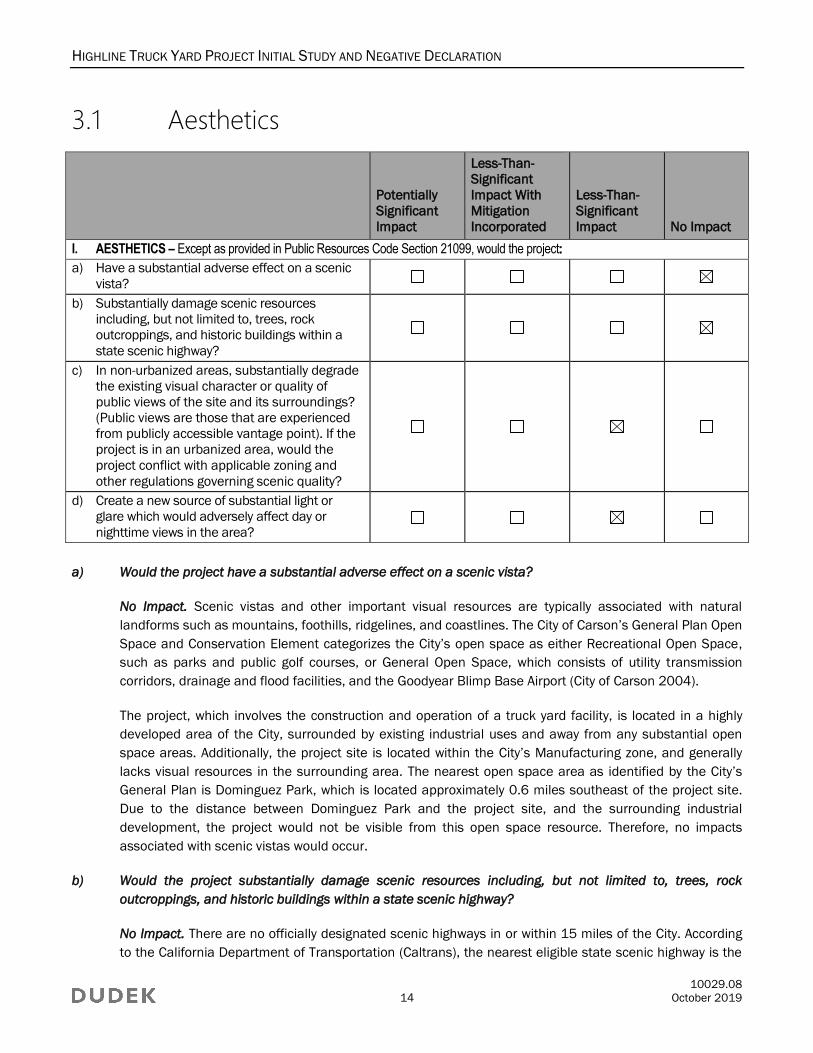
3.1 Aesthetics
Potentially
Significant
Impact
Less-Than-
Significant
Impact With
Mitigation
Incorporated
Less-Than-
Significant
Impact No Impact
I. AESTHETICS – Except as provided in Public Resources Code Section 21099, would the project:
a) Have a substantial adverse effect on a scenic
vista?
b) Substantially damage scenic resources
including, but not limited to, trees, rock
outcroppings, and historic buildings within a
state scenic highway?
c) In non-urbanized areas, substantially degrade
the existing visual character or quality of
public views of the site and its surroundings?
(Public views are those that are experienced
from publicly accessible vantage point). If the
project is in an urbanized area, would the
project conflict with applicable zoning and
other regulations governing scenic quality?
d) Create a new source of substantial light or
glare which would adversely affect day or
nighttime views in the area?
a) Would the project have a substantial adverse effect on a scenic vista?
No Impact. Scenic vistas and other important visual resources are typically associated with natural
landforms such as mountains, foothills, ridgelines, and coastlines. The City of Carson’s General Plan Open
Space and Conservation Element categorizes the City’s open space as either Recreational Open Space,
such as parks and public golf courses, or General Open Space, which consists of utility transmission
corridors, drainage and flood facilities, and the Goodyear Blimp Base Airport (City of Carson 2004).
The project, which involves the construction and operation of a truck yard facility, is located in a highly
developed area of the City, surrounded by existing industrial uses and away from any substantial open
space areas. Additionally, the project site is located within the City’s Manufacturing zone, and generally
lacks visual resources in the surrounding area. The nearest open space area as identified by the City’s
General Plan is Dominguez Park, which is located approximately 0.6 miles southeast of the project site.
Due to the distance between Dominguez Park and the project site, and the surrounding industrial
development, the project would not be visible from this open space resource. Therefore, no impacts
associated with scenic vistas would occur.
b) Would the project substantially damage scenic resources including, but not limited to, trees, rock
outcroppings, and historic buildings within a state scenic highway?
No Impact. There are no officially designated scenic highways in or within 15 miles of the City. According
to the California Department of Transportation (Caltrans), the nearest eligible state scenic highway is the
HIGHLINE TRUCK YARD PROJECT INITIAL STUDY AND NEGATIVE DECLARATION
10029.08
15 October 2019
segment of State Route 1 (Pacific Coast Highway), located more than 5 miles southeast of the project site
(Caltrans 2019). Due to the intervening urban environment and natural topography located between the
project site and this eligible state scenic highway, development of the project would occur outside of the
viewshed of this, and any other, designated scenic highway. Therefore, no impacts associated with state
scenic highways would occur.
c) In non-urbanized areas, would the project substantially degrade the existing visual character or quality of
public views of the site and its surroundings? (Public views are those that are experienced from publicly
accessible vantage point). If the project is in an urbanized area, would the project conflict with applicable
zoning and other regulations governing scenic quality?
Less-Than-Significant Impact. The project proposes construction and operation of a truck yard facility,
retaining/repurposing the existing office/warehouse building and the existing industrial character of the
project site. The project site is located in a highly urbanized, primarily industrial, area of the City.
Scenic quality of new development is governed through the General Plan policies and Zoning Ordinance
regulations, which includes special provisions for design review. Approval of the project would require Site
Plan and Design Review to ensure the project does not conflict with applicable zoning and other regulations
governing scenic quality. As further discussed in Section 3.11, Land Use and Planning, the project would
comply with applicable development standards in the City’s Zoning Ordinance, which would help ensure
visual consistency with the industrial character of the surrounding area. Therefore, impacts associated with
applicable zoning and other regulations governing scenic quality would be less than significant.
d) Would the project create a new source of substantial light or glare which would adversely affect day or
nighttime views in the area?
Less-Than-Significant Impact. There is an existing office/warehouse building on the project site that
includes nighttime safety lighting. Additionally, off-site, project-adjacent light sources include streetlights
and nighttime security lighting at neighboring industrial uses. Given the current level of nighttime lighting
on and adjacent to the project site, any new lighting needed as a result of the project would not adversely
affect nighttime views in the area. Any new lighting would be required to comply with Section 9147.1,
Exterior Lighting, of the Zoning Ordinance, which requires light sources to be shielded, oriented towards
the project site, and away from adjacent properties to avoid light trespass. Therefore, impacts associated
with a new source of substantial light or glare would be less than significant.

HIGHLINE TRUCK YARD PROJECT INITIAL STUDY AND NEGATIVE DECLARATION
10029.08
16 October 2019
3.2 Agriculture and Forestry Resources
Potentially
Significant
Impact
Less-Than-
Significant
Impact With
Mitigation
Incorporated
Less-Than-
Significant
Impact No Impact
II. AGRICULTURE AND FORESTRY RESOURCES – In determining whether impacts to agricultural resources are
significant environmental effects, lead agencies may refer to the California Agricultural Land Evaluation and Site
Assessment Model (1997) prepared by the California Department of Conservation as an optional model to use in
assessing impacts on agriculture and farmland. In determining whether impacts to forest resources, including
timberland, are significant environmental effects, lead agencies may refer to information compiled by the California
Department of Forestry and Fire Protection regarding the state’s inventory of forest land, including the Forest and
Range Assessment Project and the Forest Legacy Assessment project; and forest carbon measurement
methodology provided in Forest Protocols adopted by the California Air Resources Board. Would the project:
a) Convert Prime Farmland, Unique Farmland,
or Farmland of Statewide Importance
(Farmland), as shown on the maps prepared
pursuant to the Farmland Mapping and
Monitoring Program of the California
Resources Agency, to non-agricultural use?
b) Conflict with existing zoning for agricultural use,
or a Williamson Act contract?
c) Conflict with existing zoning for, or cause
rezoning of, forest land (as defined in Public
Resources Code section 12220(g)), timberland
(as defined by Public Resources Code section
4526), or timberland zoned Timberland
Production (as defined by Government Code
section 51104(g))?
d) Result in the loss of forest land or conversion
of forest land to non-forest use?
e) Involve other changes in the existing
environment, which, due to their location or
nature, could result in conversion of Farmland,
to non-agricultural use or conversion of forest
land to non-forest use?
a) Would the project convert Prime Farmland, Unique Farmland, or Farmland of Statewide Importance
(Farmland), as shown on the maps prepared pursuant to the Farmland Mapping and Monitoring
Program of the California Resources Agency, to non-agricultural use?
No Impact. The project site is located in a predominately developed area, surrounded by existing
industrial uses. According to the California Department of Conservation’s California Important Farmland
Finder, most of Los Angeles County is not mapped under the Farmland Mapping and Monitoring Program,
and, thus, does not contain Prime Farmland, Unique Farmland, or Farmland of State Importance
(collectively “Important Farmland”) (DOC 2016a). Therefore, no impacts associated with conversion of
Important Farmland would occur.
HIGHLINE TRUCK YARD PROJECT INITIAL STUDY AND NEGATIVE DECLARATION
10029.08
17 October 2019
b) Would the project conflict with existing zoning for agricultural use, or a Williamson Act contract?
No Impact. According the California Department of Conservation’s Williamson Act 2015/2016 Map for
Los Angeles County, the project site is not located on or adjacent to any lands under Williamson Act
contract (DOC 2016b). Additionally, neither the project site nor the surrounding area are zoned for
agricultural uses. Therefore, no impacts associated with agricultural zoning or Williamson Act contracts
would occur.
c) Would the project conflict with existing zoning for, or cause rezoning of, forest land (as defined in Public
Resources Code section 12220(g)), timberland (as defined by Public Resources Code section 4526), or
timberland zoned Timberland Production (as defined by Government Code section 51104(g))?
No Impact. The project site is located within a highly developed part of the City, surrounded by industrial
uses. According to the City’s Zoning Map, the project site is not located on or adjacent to forestland,
timberland, or timberland zoned Timberland Production (City of Carson 2004). Therefore, no impacts
associated with forestland or timberland would occur.
d) Would the project result in the loss of forest land or conversion of forest land to non-forest use?
No Impact. The project site is located in a predominantly developed area, surrounded by industrial uses.
The project site is not located on or adjacent to forestland. No private timberlands or public lands with
forests are located in the City. Therefore, no impact associated with the loss or conversion of forestland
would occur.
e) Would the project involve other changes in the existing environment, which, due to their location or
nature, could result in conversion of Farmland, to non-agricultural use or conversion of forest land to
non-forest use?
No Impact. The project site is not located on or adjacent to any parcels identified as Important Farmland
or forestland. Additionally, the project would not involve changes to the existing environment that would
result in the indirect conversion of Important Farmland or forestland located away from the project site.
Therefore, no impacts associated with the conversion of Farmland or forestland would occur.
HIGHLINE TRUCK YARD PROJECT INITIAL STUDY AND NEGATIVE DECLARATION
10029.08
18 October 2019
3.3 Air Quality
Potentially
Significant
Impact
Less-Than-
Significant
Impact With
Mitigation
Incorporated
Less-Than-
Significant
Impact No Impact
III. AIR QUALITY – Where available, the significance criteria established by the applicable air quality management
district or air pollution control district may be relied upon to make the following determinations. Would the project:
a) Conflict with or obstruct implementation of the
applicable air quality plan?
b) Result in a cumulatively considerable net
increase of any criteria pollutant for which the
project region is non-attainment under an
applicable federal or state ambient air quality
standard?
c) Expose sensitive receptors to substantial
pollutant concentrations?
d) Result in other emissions (such as those
leading to odors) adversely affecting a
substantial number of people?
a) Would the project conflict with or obstruct implementation of the applicable air quality plan?
Less-Than-Significant Impact. The project is located within the South Coast Air Basin (SCAB), which includes
the non-desert portions of Los Angeles, Riverside, and San Bernardino counties, and all of Orange County. The
SCAB is within the jurisdictional boundaries of the South Coast Air Quality Management District (SCAQMD).
The SCAQMD administers the SCAB’s Air Quality Management Plan (AQMP), which is a comprehensive
document outlining an air pollution control program for attaining the California Ambient Air Quality
Standards (CAAQS) and National Ambient Air Quality Standards (NAAQS). The most recently adopted
AQMP for the SCAB is the 2016 AQMP (SCAQMD 2017). The 2016 AQMP focuses on available, proven,
and cost-effective alternatives to traditional air quality strategies while seeking to achieve multiple goals
in partnership with other entities seeking to promote reductions in greenhouse gases (GHGs) and toxic
risk, as well as efficiencies in energy use, transportation, and goods movement (SCAQMD 2017).
HIGHLINE TRUCK YARD PROJECT INITIAL STUDY AND NEGATIVE DECLARATION
10029.08
19 October 2019
The purpose of a consistency finding with regard to the AQMP is to determine if a project is consistent
with the assumptions and objectives of the regional air quality plans, and if it would interfere with the
region’s ability to comply with federal and state air quality standards. The SCAQMD has established
criteria for determining consistency with the currently applicable AQMP in Chapter 12, Sections 12.2 and
12.3 of the SCAQMD CEQA Air Quality Handbook. These criteria are as follows (SCAQMD 1993):
Consistency Criterion No. 1: Whether the project would result in an increase in the frequency or
severity of existing air quality violations, cause or contribute to new violations, or delay timely
attainment of the ambient air quality standards or interim emission reductions in the AQMP.
Consistency Criterion No. 2: Whether the project would exceed the assumptions in the AQMP or
increments based on the year of project buildout and phase.
To address the first criterion, project-generated criteria air pollutant emissions have been estimated and
analyzed for significance and are addressed under Section 3.3(b). Detailed results of this analysis are
included in Appendix A, Air Quality and Greenhouse Gas Calculations. As presented in Section 3.3(b),
construction and operation of the project would not generate criteria air pollutant emissions that exceed
the SCAQMD’s thresholds, and it would therefore be consistent with Criterion No. 1.
The second criterion regarding the potential of the project to exceed the assumptions in the AQMP or
increments based on the year of project buildout and phase is primarily assessed by determining
consistency between the project’s land use designations and its potential to generate population growth.
In general, projects are considered consistent with, and not in conflict with or obstruct implementation of,
the AQMP if the growth they produce in socioeconomic factors is consistent with the underlying regional
plans used to develop the AQMP (SCAQMD 1993). The SCAQMD primarily uses demographic growth
forecasts for various socioeconomic categories (e.g., population, housing, and employment by industry)
developed by the Southern California Association of Governments (SCAG) for its 2016–2040 Regional
Transportation Plan/Sustainable Communities Strategy (RTP/SCS) (SCAG 2016). SCAQMD uses this
document, which is based on general plans for cities and counties in the SCAB, to develop the AQMP
emissions inventory (SCAQMD 2017).2 The SCAG RTP/SCS, and associated Regional Growth Forecast, are
generally consistent with the local plans; therefore, the 2016 AQMP is generally consistent with local
government plans.
The project site is zoned MH-D (Manufacturing, Heavy) with a General Plan Land Use Designation of
Heavy Industrial (City of Carson 2019a). The project site is in an industrial area and is generally bounded
by existing warehouse, light industrial, office, and freight uses. To the north and west are warehouse,
industrial, and office uses. To the east of the project site is Lamberton Avenue, an industrial water
treatment facility, and the Alameda Corridor freight rail. To the south is Dominguez Street and the City’s
Corporate Yard. The project site would provide 42 trailer parking spaces to provide temporary parking and
storage for trucks and truck-mounted containers. Trucks and trailers would be parked while waiting to be
moved to and from the Port of Los Angeles, Port of Long Beach, or other locations. The unloading and
2 Information necessary to produce the emissions inventory for the SCAB is obtained from the SCAQMD and other governmental
agencies, including the California Air Resources Board, Caltrans, and SCAG. Each of these agencies is responsible for collecting
data (e.g., industry growth factors, socioeconomic projections, travel activity levels, emission factors, emission speciation profile,
and emissions) and developing methodologies (e.g., model and demographic forecast improvements) required to generate a
comprehensive emissions inventory. SCAG incorporates these data into its Travel Demand Model for estimating/projecting
vehicle miles traveled and driving speeds. SCAG’s socioeconomic and transportation activities projections in their 2016–2040
Regional Transportation Plan/Sustainable Communities Strategy are integrated in the 2016 AQMP (SCAQMD 2017a).
HIGHLINE TRUCK YARD PROJECT INITIAL STUDY AND NEGATIVE DECLARATION
10029.08
20 October 2019
reloading of contents of one trailer to another trailer would be permitted on the project site. The general
maintenance of truck tractors and equipment would not be allowed. As described in Section 3.14, the
project would not provide new homes or businesses. Additionally, the project would not indirectly induce
unplanned population growth through extension of roads or other infrastructure. Based on the
consistency with the General Plan Use Designation and zoning, the project would not conflict with an
applicable land use plan, policy, or regulation of an agency with jurisdiction over the project. Since the
project is not anticipated to result in population or employment growth that would conflict with SCAG’s
projections, and would be consistent with the General Plan Use Designation and zoning for the proposed site,
it would not conflict with or exceed the assumptions in the 2016 AQMP.
In summary, based on the considerations presented for the two criteria, impacts relating to the
project’s potential to conflict with or obstruct implementation of the applicable AQMP would be less
than significant.
b) Would the project result in a cumulatively considerable net increase of any criteria pollutant for which the
project region is non-attainment under an applicable federal or state ambient air quality standard?
Less-Than-Significant Impact. A quantitative analysis was conducted to determine whether proposed
activities might result in emissions of criteria air pollutants that may cause exceedances of the NAAQS or
CAAQS, or cumulatively contribute to existing nonattainment of ambient air quality standards. Criteria air
pollutants include ozone (O3), nitrogen dioxide (NO2), carbon monoxide (CO), sulfur dioxide, particulate
matter with an aerodynamic diameter less than or equal to 10 microns (PM10; course particulate matter),
particulate matter with an aerodynamic diameter less than or equal to 2.5 microns (PM2.5; fine particulate
matter), and lead. Pollutants that are evaluated herein include volatile organic compounds (VOCs) and
oxides of nitrogen (NOx), which are important because they are precursors to O3, as well as CO, sulfur oxides
(SOx), PM10, and PM2.5.
Regarding NAAQS and CAAQS attainment status,3 the SCAB is designated as a nonattainment area for
federal and state O3 and PM2.5 standards (CARB 2017a; EPA 2018). The SCAB is also designated as a
nonattainment area for state PM10 standards; however, it is designated as an attainment area for federal
PM10 standards. The SCAB is designated as an attainment area for federal and state CO and NO2
standards, as well as for state sulfur dioxide standards. Although the SCAB has been designated as
nonattainment for the federal rolling 3-month average lead standard, it is designated attainment for the
state lead standard.4
The project would result in emissions of criteria air pollutants for which the California Air Resources Board
(CARB) and U.S. Environmental Protection Agency (EPA) have adopted ambient air quality standards (i.e.,
the NAAQS and CAAQS). Projects that emit these pollutants have the potential to cause, or contribute to,
violations of these standards. The SCAQMD CEQA Air Quality Significance Thresholds, as revised in March
2015, set forth quantitative emission significance thresholds for criteria air pollutants, which, if exceeded,
would indicate the potential for a project to contribute to violations of the NAAQS or CAAQS (SCAQMD 2015).
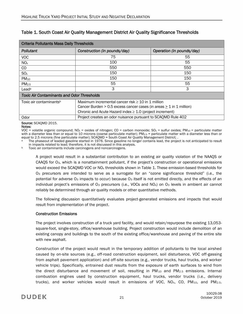
Table 1 lists the SCAQMD Air Quality Significance Thresholds.
3 An area is designated as in attainment when it is in compliance with the NAAQS and/or the CAAQS. These standards for the
maximum level of a given air pollutant that can exist in the outdoor air without unacceptable effects on human health or the
public welfare are set by the EPA and CARB, respectively. Attainment = meets the standards; attainment/maintenance =
achieves the standards after a nonattainment designation; nonattainment = does not meet the standards. 4 The phaseout of leaded gasoline started in 1976. Since gasoline no longer contains lead, the project is not anticipated to result
in impacts related to lead; therefore, it is not discussed in this analysis.
HIGHLINE TRUCK YARD PROJECT INITIAL STUDY AND NEGATIVE DECLARATION
10029.08
21 October 2019
Table 1. South Coast Air Quality Management District Air Quality Significance Thresholds
Criteria Pollutants Mass Daily Thresholds
Pollutant Construction (in pounds/day) Operation (in pounds/day)
VOC 75 55
NOx 100 55
CO 550 550
SOx 150 150
PM10 150 150
PM2.5 55 55
Leada 3 3
Toxic Air Contaminants and Odor Thresholds
Toxic air contaminantsb Maximum incremental cancer risk 10 in 1 million
Cancer Burden > 0.5 excess cancer cases (in areas > 1 in 1 million)
Chronic and Acute Hazard index 1.0 (project increment)
Odor Project creates an odor nuisance pursuant to SCAQMD Rule 402
Source: SCAQMD 2015. Notes: VOC = volatile organic compound; NOx = oxides of nitrogen; CO = carbon monoxide; SOx = sulfur oxides; PM10 = particulate matter with a diameter less than or equal to 10 microns (coarse particulate matter); PM2.5 = particulate matter with a diameter less than or equal to 2.5 microns (fine particulate matter); SCAQMD = South Coast Air Quality Management District; . a The phaseout of leaded gasoline started in 1976. Since gasoline no longer contains lead, the project is not anticipated to result
in impacts related to lead; therefore, it is not discussed in this analysis. b Toxic air contaminants include carcinogens and noncarcinogens.
A project would result in a substantial contribution to an existing air quality violation of the NAAQS or
CAAQS for O3, which is a nonattainment pollutant, if the project’s construction or operational emissions
would exceed the SCAQMD VOC or NOx thresholds shown in Table 1. These emission-based thresholds for
O3 precursors are intended to serve as a surrogate for an “ozone significance threshold” (i.e., the
potential for adverse O3 impacts to occur) because O3 itself is not emitted directly, and the effects of an
individual project’s emissions of O3 precursors (i.e., VOCs and NOx) on O3 levels in ambient air cannot
reliably be determined through air quality models or other quantitative methods.
The following discussion quantitatively evaluates project-generated emissions and impacts that would
result from implementation of the project.
Construction Emissions
The project involves construction of a truck yard facility, and would retain/repurpose the existing 13,053-
square-foot, single-story, office/warehouse building. Project construction would include demolition of an
existing canopy and buildings to the south of the existing office/warehouse and paving of the entire site
with new asphalt.
Construction of the project would result in the temporary addition of pollutants to the local airshed
caused by on-site sources (e.g., off-road construction equipment, soil disturbance, VOC off-gassing
from asphalt pavement application) and off-site sources (e.g., vendor trucks, haul trucks, and worker
vehicle trips). Specifically, entrained dust results from the exposure of earth surfaces to wind from
the direct disturbance and movement of soil, resulting in PM10 and PM2.5 emissions. Internal
combustion engines used by construction equipment, haul trucks, vendor trucks (i.e., delivery
trucks), and worker vehicles would result in emissions of VOC, NOx, CO, PM10, and PM2.5.
HIGHLINE TRUCK YARD PROJECT INITIAL STUDY AND NEGATIVE DECLARATION
10029.08
22 October 2019
Construction emissions can vary substantially from day to day depending on the level of activity; the
specific type of operation; and, for dust, the prevailing weather conditions.
The project would be required to comply with SCAQMD Rule 403 (SCAQMD 2015) to control dust
emissions generated during any dust-generating activities. Standard construction practices that would be
employed to reduce fugitive dust emissions include watering of the active dust areas up to three times
per day, depending on weather conditions.
For purposes of estimating project emissions, and based on information provided by the applicant, it is
assumed that construction of the project would commence in or around 20195 and would last
approximately two (2) months. The analysis contained herein is based on the following schedule
assumptions (duration of phases is approximate). The majority of the phases listed below would occur
concurrently and would not occur sequentially in isolation. Detailed construction equipment modeling
assumptions are provided in Appendix A.
General construction equipment modeling assumptions are provided in Table 2. Default values for
equipment mix, horsepower, and load factor provided in CalEEMod were used for all construction
equipment. It is anticipated that approximately 859 cubic yards of fill material would be imported, and 524
cubic yards of material would be exported during construction. For the analysis, it was generally assumed
that heavy-duty construction equipment would be operating at the site 5 days per week.
Table 2. Construction Workers, Vendor Trips, and Equipment Use per Day
Construction
Phase
One-Way Vehicle Trips Equipment
Average
Daily
Worker
Trips
Average
Daily
Vendor
Truck Trips
Total
Haul
Truck
Trips Equipment Type Quantity
Usage
Hours
Demolition 14 0 14 Concrete/industrial saws 1 8
Rubber-tired dozers 1 8
Tractors/loaders/backhoes 3 8
Site Preparation 10 0 66 Graders 1 8
Scrapers 1 8
Tractors/loaders/backhoes 1 7
Trencher 1 8
Grading 10 0 108 Graders 1 8
Rubber-tired dozers 1 8
Tractors/loaders/backhoes 2 7
Paving 16 0 138 Cement and mortar mixers 1 8
Pavers 1 8
Paving equipment 1 8
Rollers 2 8
Tractors/loaders/backhoes 1 8
Note: See Appendix A for additional details.
5 The analysis assumes a construction start date in or around 2019, which represents the earliest date construction would
initiate. Assuming the earliest start date for construction represents the worst-case scenario for criteria air pollutant emissions
because equipment and vehicle emission factors for later years would be slightly less due to more stringent standards for in-use
off-road equipment and heavy-duty trucks, as well as fleet turnover replacing older equipment and vehicles in later years.
HIGHLINE TRUCK YARD PROJECT INITIAL STUDY AND NEGATIVE DECLARATION
10029.08
23 October 2019
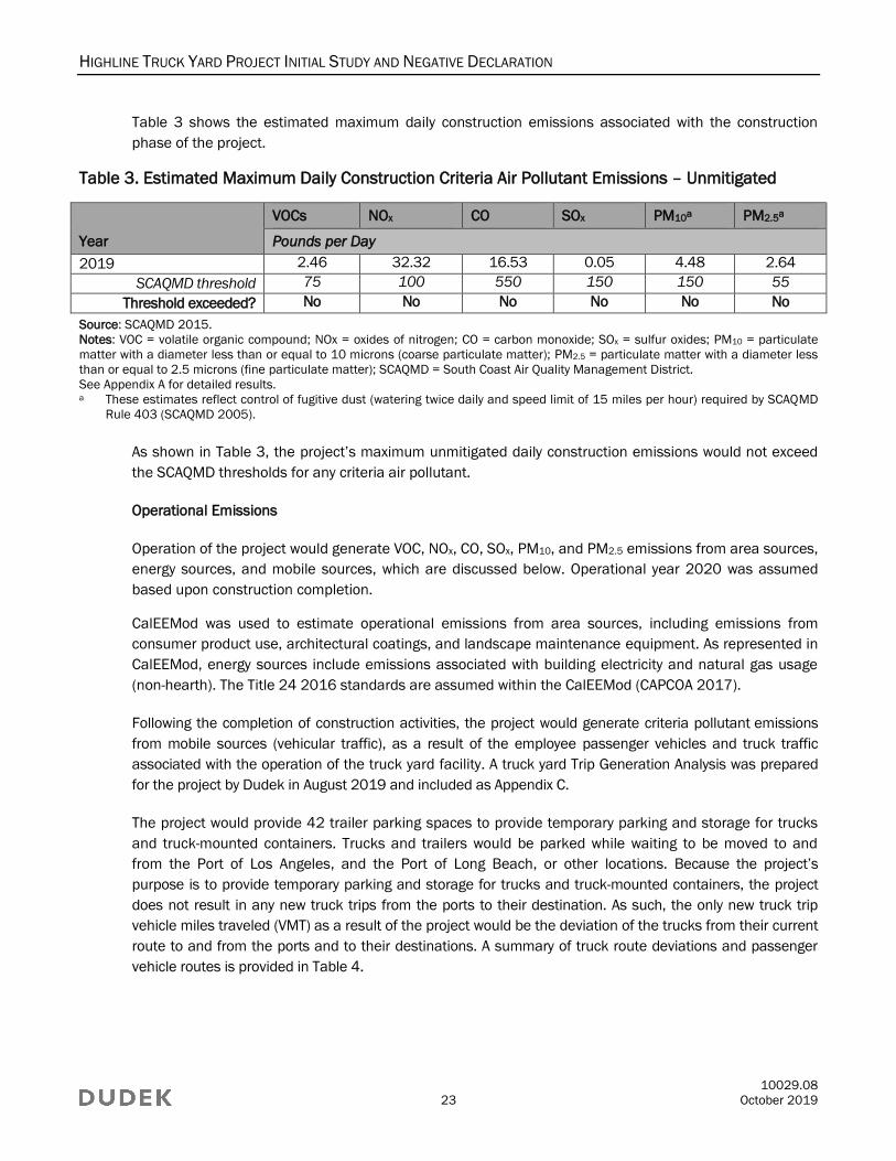
Table 3 shows the estimated maximum daily construction emissions associated with the construction
phase of the project.
Table 3. Estimated Maximum Daily Construction Criteria Air Pollutant Emissions – Unmitigated
Year
VOCs NOx CO SOx PM10a PM2.5a
Pounds per Day
2019 2.46 32.32 16.53 0.05 4.48 2.64
SCAQMD threshold 75 100 550 150 150 55
Threshold exceeded? No No No No No No
Source: SCAQMD 2015.
Notes: VOC = volatile organic compound; NOx = oxides of nitrogen; CO = carbon monoxide; SOx = sulfur oxides; PM10 = particulate
matter with a diameter less than or equal to 10 microns (coarse particulate matter); PM2.5 = particulate matter with a diameter less
than or equal to 2.5 microns (fine particulate matter); SCAQMD = South Coast Air Quality Management District.
See Appendix A for detailed results. a These estimates reflect control of fugitive dust (watering twice daily and speed limit of 15 miles per hour) required by SCAQMD
Rule 403 (SCAQMD 2005).
As shown in Table 3, the project’s maximum unmitigated daily construction emissions would not exceed
the SCAQMD thresholds for any criteria air pollutant.
Operational Emissions
Operation of the project would generate VOC, NOx, CO, SOx, PM10, and PM2.5 emissions from area sources,
energy sources, and mobile sources, which are discussed below. Operational year 2020 was assumed
based upon construction completion.
CalEEMod was used to estimate operational emissions from area sources, including emissions from
consumer product use, architectural coatings, and landscape maintenance equipment. As represented in
CalEEMod, energy sources include emissions associated with building electricity and natural gas usage
(non-hearth). The Title 24 2016 standards are assumed within the CalEEMod (CAPCOA 2017).
Following the completion of construction activities, the project would generate criteria pollutant emissions
from mobile sources (vehicular traffic), as a result of the employee passenger vehicles and truck traffic
associated with the operation of the truck yard facility. A truck yard Trip Generation Analysis was prepared
for the project by Dudek in August 2019 and included as Appendix C.
The project would provide 42 trailer parking spaces to provide temporary parking and storage for trucks
and truck-mounted containers. Trucks and trailers would be parked while waiting to be moved to and
from the Port of Los Angeles, and the Port of Long Beach, or other locations. Because the project’s
purpose is to provide temporary parking and storage for trucks and truck-mounted containers, the project
does not result in any new truck trips from the ports to their destination. As such, the only new truck trip
vehicle miles traveled (VMT) as a result of the project would be the deviation of the trucks from their current
route to and from the ports and to their destinations. A summary of truck route deviations and passenger
vehicle routes is provided in Table 4.
HIGHLINE TRUCK YARD PROJECT INITIAL STUDY AND NEGATIVE DECLARATION
10029.08
24 October 2019
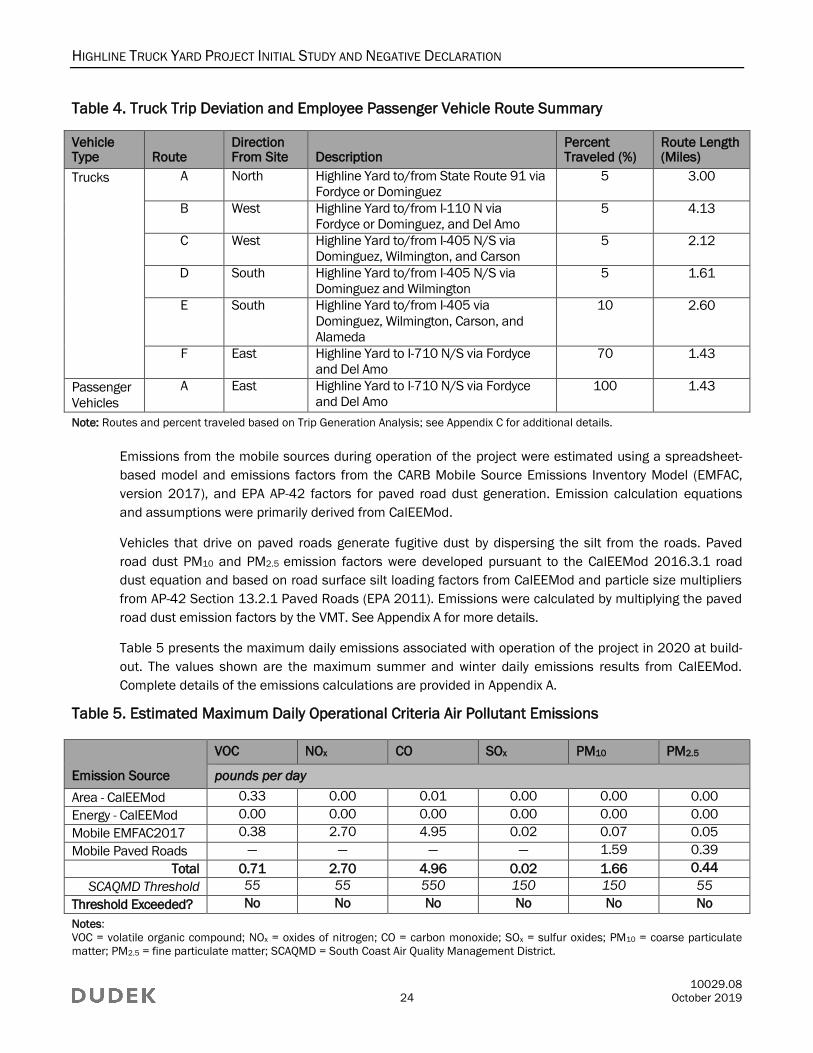
Table 4. Truck Trip Deviation and Employee Passenger Vehicle Route Summary
Vehicle Type Route
Direction From Site Description
Percent Traveled (%)
Route Length (Miles)
Trucks A North Highline Yard to/from State Route 91 via
Fordyce or Dominguez
5 3.00
B West Highline Yard to/from I-110 N via
Fordyce or Dominguez, and Del Amo
5 4.13
C West Highline Yard to/from I-405 N/S via
Dominguez, Wilmington, and Carson
5 2.12
D South Highline Yard to/from I-405 N/S via
Dominguez and Wilmington
5 1.61
E South Highline Yard to/from I-405 via
Dominguez, Wilmington, Carson, and
Alameda
10 2.60
F East Highline Yard to I-710 N/S via Fordyce
and Del Amo
70 1.43
Passenger
Vehicles
A East Highline Yard to I-710 N/S via Fordyce
and Del Amo
100 1.43
Note: Routes and percent traveled based on Trip Generation Analysis; see Appendix C for additional details.
Emissions from the mobile sources during operation of the project were estimated using a spreadsheet-
based model and emissions factors from the CARB Mobile Source Emissions Inventory Model (EMFAC,
version 2017), and EPA AP-42 factors for paved road dust generation. Emission calculation equations
and assumptions were primarily derived from CalEEMod.
Vehicles that drive on paved roads generate fugitive dust by dispersing the silt from the roads. Paved
road dust PM10 and PM2.5 emission factors were developed pursuant to the CalEEMod 2016.3.1 road
dust equation and based on road surface silt loading factors from CalEEMod and particle size multipliers
from AP-42 Section 13.2.1 Paved Roads (EPA 2011). Emissions were calculated by multiplying the paved
road dust emission factors by the VMT. See Appendix A for more details.
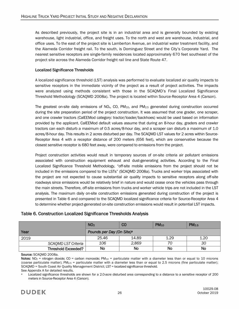
Table 5 presents the maximum daily emissions associated with operation of the project in 2020 at build-
out. The values shown are the maximum summer and winter daily emissions results from CalEEMod.
Complete details of the emissions calculations are provided in Appendix A.
Table 5. Estimated Maximum Daily Operational Criteria Air Pollutant Emissions
Emission Source
VOC NOx CO SOx PM10 PM2.5
pounds per day
Area - CalEEMod 0.33 0.00 0.01 0.00 0.00 0.00
Energy - CalEEMod 0.00 0.00 0.00 0.00 0.00 0.00
Mobile EMFAC2017 0.38 2.70 4.95 0.02 0.07 0.05
Mobile Paved Roads — — — — 1.59 0.39
Total 0.71 2.70 4.96 0.02 1.66 0.44
SCAQMD Threshold 55 55 550 150 150 55
Threshold Exceeded? No No No No No No
Notes:
VOC = volatile organic compound; NOx = oxides of nitrogen; CO = carbon monoxide; SOx = sulfur oxides; PM10 = coarse particulate
matter; PM2.5 = fine particulate matter; SCAQMD = South Coast Air Quality Management District.

HIGHLINE TRUCK YARD PROJECT INITIAL STUDY AND NEGATIVE DECLARATION
10029.08
25 October 2019
See Appendix A for complete results.
The values shown for Area and Energy sources are the maximum summer or winter daily emissions results from CalEEMod. These
emissions reflect CalEEMod “unmitigated” output and operational year 2020. Mobile source emissions were estimated using a
spreadsheet model with EMFAC2017 factors. Values of “<0.01” indicate that the estimated emissions are less than two decimals.
The total values may not add up exactly due to rounding.
As shown in Table 5, maximum daily operational emissions of VOC, NOx, CO, SOx, PM10, and PM2.5
generated by the project would not exceed the SCAQMDs significance thresholds.
Air pollution is largely a cumulative impact. The nonattainment status of regional pollutants is a result of
past and present development, and the SCAQMD develops and implements plans for future attainment of
ambient air quality standards. Based on these considerations, project-level thresholds of significance for
criteria pollutants are used in the determination of whether a project’s individual emissions would have a
cumulatively considerable contribution on air quality. If a project’s emissions would exceed the SCAQMD
significance thresholds, it would be considered to have a cumulatively considerable contribution.
Conversely, projects that do not exceed the project-specific thresholds are generally not considered to be
cumulatively significant (Goss and Kroeger 2003).
As previously discussed, the SCAB has been designated as a federal nonattainment area for O3 and
PM2.5, and a state nonattainment area for O3, PM10, and PM2.5. The nonattainment status is the result of
cumulative emissions from various sources of air pollutants and their precursors within the SCAB,
including motor vehicles, off-road equipment, and commercial and industrial facilities. Construction and
operational activities of the project would generate VOC and NOx emissions (precursors to O3) and
emissions of PM10 and PM2.5. However, as indicated in Tables 3 and 5, project-generated emissions
would not exceed the SCAQMD emission-based significance thresholds for VOCs, NOx, PM10, or PM2.5.
Cumulative localized impacts would potentially occur if a project were to occur concurrently with another off-
site project. Schedules for potential future projects near the project area are currently unknown; therefore,
potential impacts associated with two or more simultaneous projects would be considered speculative.6
However, future projects would be subject to CEQA and would require air quality analysis and, where
necessary, mitigation. Criteria air pollutant emissions associated with construction activity of future projects
would be reduced through implementation of control measures required by the SCAQMD. Cumulative PM10
and PM2.5 emissions would be reduced because all future projects would be subject to SCAQMD Rule 403
(Fugitive Dust), which sets forth general and specific requirements for all sites in the SCAQMD.
Based on the above considerations, the project would not result in a cumulatively considerable
increase in emissions of nonattainment pollutants, and impacts would be less than significant during
construction and operation.
c) Would the project expose sensitive receptors to substantial pollutant concentrations?
Less-Than-Significant-Impact. Sensitive receptors are those individuals more susceptible to the effects of air
pollution than the population at large. People most likely to be affected by air pollution include children, the
elderly, and people with cardiovascular and chronic respiratory diseases. According to the SCAQMD,
sensitive receptors include sites such as residences, schools, playgrounds, childcare centers, long-term
healthcare facilities, rehabilitation centers, convalescent centers, and retirement homes (SCAQMD 1993).
6 The CEQA Guidelines state that if a particular impact is too speculative for evaluation, the agency should note its conclusion and
terminate discussion of the impact (14 CCR 15145).
HIGHLINE TRUCK YARD PROJECT INITIAL STUDY AND NEGATIVE DECLARATION
10029.08
26 October 2019
As described previously, the project site is in an industrial area and is generally bounded by existing
warehouse, light industrial, office, and freight uses. To the north and west are warehouse, industrial, and
office uses. To the east of the project site is Lamberton Avenue, an industrial water treatment facility, and
the Alameda Corridor freight rail. To the south, is Dominguez Street and the City’s Corporate Yard. The
nearest sensitive receptors are single-family residences located approximately 670 feet southeast of the
project site across the Alameda Corridor freight rail line and State Route 47.
Localized Significance Thresholds
A localized significance threshold (LST) analysis was performed to evaluate localized air quality impacts to
sensitive receptors in the immediate vicinity of the project as a result of project activities. The impacts
were analyzed using methods consistent with those in the SCAQMD’s Final Localized Significance
Threshold Methodology (SCAQMD 2008a). The project is located within Source-Receptor Area 4 (Carson).
The greatest on-site daily emissions of NOx, CO, PM10, and PM2.5 generated during construction occurred
during the site preparation period of the project construction. It was assumed that one grader, one scraper,
and one crawler tractors (CalEEMod category: tractor/loader/backhoes) would be used based on information
provided by the applicant. CalEEMod default values assume that during an 8-hour day, graders and crawler
tractors can each disturb a maximum of 0.5 acres/8-hour day, and a scraper can disturb a maximum of 1.0
acres/8-hour day. This results in 2 acres disturbed per day. The SCAQMD LST values for 2 acres within Source-
Receptor Area 4 with a receptor distance of 200 meters (656 feet), which are conservative because the
closest sensitive receptor is 680 feet away, were compared to emissions from the project.
Project construction activities would result in temporary sources of on-site criteria air pollutant emissions
associated with construction equipment exhaust and dust-generating activities. According to the Final
Localized Significance Threshold Methodology, “off-site mobile emissions from the project should not be
included in the emissions compared to the LSTs” (SCAQMD 2008a). Trucks and worker trips associated with
the project are not expected to cause substantial air quality impacts to sensitive receptors along off-site
roadways since emissions would be relatively brief in nature and would cease once the vehicles pass through
the main streets. Therefore, off-site emissions from trucks and worker vehicle trips are not included in the LST
analysis. The maximum daily on-site construction emissions generated during construction of the project is
presented in Table 6 and compared to the SCAQMD localized significance criteria for Source-Receptor Area 4
to determine whether project-generated on-site construction emissions would result in potential LST impacts.
Table 6. Construction Localized Significance Thresholds Analysis
Year
NO2 CO PM10 PM2.5
Pounds per Day (On Site)a
2019 25.46 14.89 1.29 1.20
SCAQMD LST Criteria 106 2,869 70 30
Threshold Exceeded? No No No No
Source: SCAQMD 2008a.
Notes: NO2 = nitrogen dioxide; CO = carbon monoxide; PM10 = particulate matter with a diameter less than or equal to 10 microns
(coarse particulate matter); PM2.5 = particulate matter with a diameter less than or equal to 2.5 microns (fine particulate matter);
SCAQMD = South Coast Air Quality Management District; LST = localized significance threshold.
See Appendix A for detailed results. a Localized significance thresholds are shown for a 2.0-acre disturbed area corresponding to a distance to a sensitive receptor of 200
meters in Source-Receptor Area 4 (Carson).
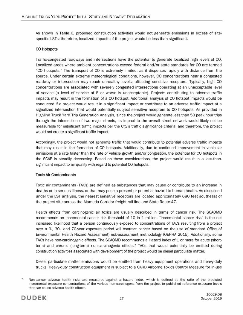
HIGHLINE TRUCK YARD PROJECT INITIAL STUDY AND NEGATIVE DECLARATION
10029.08
27 October 2019
As shown in Table 6, proposed construction activities would not generate emissions in excess of site-
specific LSTs; therefore, localized impacts of the project would be less than significant.
CO Hotspots
Traffic-congested roadways and intersections have the potential to generate localized high levels of CO.
Localized areas where ambient concentrations exceed federal and/or state standards for CO are termed
“CO hotspots.” The transport of CO is extremely limited, as it disperses rapidly with distance from the
source. Under certain extreme meteorological conditions, however, CO concentrations near a congested
roadway or intersection may reach unhealthy levels, affecting sensitive receptors. Typically, high CO
concentrations are associated with severely congested intersections operating at an unacceptable level
of service (a level of service of E or worse is unacceptable). Projects contributing to adverse traffic
impacts may result in the formation of a CO hotspot. Additional analysis of CO hotspot impacts would be
conducted if a project would result in a significant impact or contribute to an adverse traffic impact at a
signalized intersection that would potentially subject sensitive receptors to CO hotspots. As provided in
Highline Truck Yard Trip Generation Analysis, since the project would generate less than 50 peak hour trips
through the intersection of two major streets, its impact to the overall street network would likely not be
measurable for significant traffic impacts per the City’s traffic significance criteria, and therefore, the project
would not create a significant traffic impact.
Accordingly, the project would not generate traffic that would contribute to potential adverse traffic impacts
that may result in the formation of CO hotspots. Additionally, due to continued improvement in vehicular
emissions at a rate faster than the rate of vehicle growth and/or congestion, the potential for CO hotspots in
the SCAB is steadily decreasing. Based on these considerations, the project would result in a less-than-
significant impact to air quality with regard to potential CO hotspots.
Toxic Air Contaminants
Toxic air contaminants (TACs) are defined as substances that may cause or contribute to an increase in
deaths or in serious illness, or that may pose a present or potential hazard to human health. As discussed
under the LST analysis, the nearest sensitive receptors are located approximately 680 feet southeast of
the project site across the Alameda Corridor freight rail line and State Route 47.
Health effects from carcinogenic air toxics are usually described in terms of cancer risk. The SCAQMD
recommends an incremental cancer risk threshold of 10 in 1 million. “Incremental cancer risk” is the net
increased likelihood that a person continuously exposed to concentrations of TACs resulting from a project
over a 9-, 30-, and 70-year exposure period will contract cancer based on the use of standard Office of
Environmental Health Hazard Assessment) risk-assessment methodology (OEHHA 2015). Additionally, some
TACs have non-carcinogenic effects. The SCAQMD recommends a Hazard Index of 1 or more for acute (short-
term) and chronic (long-term) non-carcinogenic effects.7 TACs that would potentially be emitted during
construction activities associated with development of the project would be diesel particulate matter.
Diesel particulate matter emissions would be emitted from heavy equipment operations and heavy-duty
trucks. Heavy-duty construction equipment is subject to a CARB Airborne Toxics Control Measure for in-use
7 Non-cancer adverse health risks are measured against a hazard index, which is defined as the ratio of the predicted
incremental exposure concentrations of the various non-carcinogens from the project to published reference exposure levels
that can cause adverse health effects.
HIGHLINE TRUCK YARD PROJECT INITIAL STUDY AND NEGATIVE DECLARATION
10029.08
28 October 2019
diesel construction equipment to reduce diesel particulate emissions. As described for the LST analysis,
PM10 (representative of diesel particulate matter) exposure would be minimal. According to the Office of
Environmental Health Hazard Assessment, health risk assessments (which determine the exposure of
sensitive receptors to toxic emissions) should be based on a 30-year exposure period for the maximally
exposed individual resident. However, such assessments should also be limited to the period/duration of
activities associated with the project. The duration of the proposed construction activities would constitute a
small percentage of the total 30-year exposure period. The construction period for the project would be
approximately 2 months, after which construction-related TAC emissions would cease. Due to this relatively
short period of exposure and minimal particulate emissions on site, TACs generated during construction
would not be expected to result in concentrations causing significant health risks.
Following completion of on-site construction activities, the project would provide 42 trailer parking spaces
to provide temporary parking and storage for trucks and truck-mounted containers. Trucks and trailers
would be parked while waiting to be moved to and from the Ports of Los Angeles and Long Beach, or
other locations. Because the project’s purpose is to provide temporary parking and storage for trucks and
truck-mounted containers, the project does not result in any new truck trips from the ports to their
destination. Trucks and containers stored in the 42 trailer parking spaces will be required to shut engines
down. Minimal diesel particulate matter will result from limited idling of engines on site as trucks are
coordinated for arrival and departure of the truck yard.
Due to this relatively short period of exposure, and minimal on-site diesel particulate emissions from trucks,
TACs generated during operation would not result in concentrations causing significant health risks.
For the reasons described above, the project would not result in substantial TAC exposure to sensitive
receptors in the vicinity of the project, and impacts would be less than significant. No mitigation is required.
Health Effects of Criteria Air Pollutants
Construction of the project would generate criteria air pollutant emissions; however, the project would not
exceed the SCAQMD mass-emission thresholds.
Health effects associated with O3 include respiratory symptoms, worsening of lung disease leading to
premature death, and damage to lung tissue (CARB 2019). VOCs and NOx are precursors to O3, for which
the SCAB is designated as nonattainment with respect to the NAAQS and CAAQS. Thus, existing O3 levels
in the SCAB are at unhealthy levels during certain periods. The contribution of VOCs and NOx to regional
ambient O3 concentrations is the result of complex photochemistry. The increases in O3 concentrations in
the SCAB due to O3 precursor emissions tend to be found downwind from the source location to allow
time for the photochemical reactions to occur. However, the potential for exacerbating excessive O3
concentrations would also depend on the time of year that the VOC emissions would occur because
exceedances of the O3 NAAQS and CAAQS tend to occur between May and October when solar radiation is
highest. The holistic effect of a single project’s emissions of O3 precursors is speculative due to the lack
of quantitative methods to assess this impact. Nonetheless, because the project would not involve
construction or operational activities that would result in O3 precursor emissions (VOC or NOx) in excess of
the SCAQMD thresholds, the project is not anticipated to substantially contribute to regional O3
concentrations and the associated health impacts.
HIGHLINE TRUCK YARD PROJECT INITIAL STUDY AND NEGATIVE DECLARATION
10029.08
29 October 2019
Exposure to NO2 and NOx can irritate the lungs, cause bronchitis and pneumonia, lower resistance to
respiratory infections, and enhance allergic responses (CARB 2019). Project construction and operation
would not exceed the SCAQMD NOx threshold, and existing ambient NO2 concentrations are below the
NAAQS and CAAQS. Thus, implementation of the project is not expected to exceed the NO2 standards or
contribute to associated health effects.
Health effects associated with CO include chest pain in patients with heart disease, headache, light-
headedness, and reduced mental alertness (CARB 2019). CO tends to be a localized impact associated
with congested intersections. CO hotspots were discussed previously as a less-than-significant impact.
Thus, the project’s CO emissions would not contribute to the health effects associated with this pollutant.
Particulate matter exposure has been linked to a variety of problems, including premature death in people with
heart or lung disease, nonfatal heart attacks, irregular heartbeat, aggravated asthma, decreased lung
function, and increased respiratory symptoms such as irritation of the airways, coughing, or difficulty breathing
(EPA 2016). The SCAB is designated as nonattainment for PM10 under the CAAQS and nonattainment for
PM2.5 under the NAAQS and CAAQS. Implementation of the project would not generate emissions of PM10 or
PM2.5 that would exceed the SCAQMD’s thresholds. Accordingly, the project’s PM10 and PM2.5 emissions are
not expected to cause an increase in related regional health effects for these pollutants.
In summary, the project would not result in a potentially significant contribution to regional concentrations
of nonattainment pollutants, and would not result in a significant contribution to the adverse health
impacts associated with those pollutants. Therefore, impacts would be less than significant.
d) Would the project result in other emissions (such as those leading to odors) adversely affecting a
substantial number of people?
Less-Than-Significant Impact. The occurrence and severity of potential odor impacts depends on
numerous factors. The nature, frequency, and intensity of the source; the wind speeds and direction; and
the sensitivity of receiving location each contribute to the intensity of the impact. Although offensive odors
seldom cause physical harm, they can be annoying and cause distress among the public and generate
citizen complaints.
Odors would be potentially generated from vehicles and equipment exhaust emissions during
construction of the project. Potential odors produced during construction would be attributable to
concentrations of unburned hydrocarbons from tailpipes of construction equipment, architectural
coatings, and asphalt pavement application. Such odors would disperse rapidly from the project site and
generally occur at magnitudes that would not affect substantial numbers of people. Therefore, impacts
associated with odors during construction would be less than significant.
Land uses and industrial operations associated with odor complaints include agricultural uses,
wastewater treatment plants, food-processing plants, chemical plants, composting, refineries, landfills,
dairies, and fiberglass molding (SCAQMD 1993). The project entails operation of a truck yard, which has
not been identified by SCAQMD as a land use typically associated with odor complaints. Therefore, the
project operations would result in an odor impact that is less than significant.
HIGHLINE TRUCK YARD PROJECT INITIAL STUDY AND NEGATIVE DECLARATION
10029.08
30 October 2019
3.4 Biological Resources
Potentially
Significant
Impact
Less-Than-
Significant
Impact With
Mitigation
Incorporated
Less-Than-
Significant
Impact No Impact
IV. BIOLOGICAL RESOURCES – Would the project:
a) Have a substantial adverse effect, either
directly or through habitat modifications, on
any species identified as a candidate,
sensitive, or special status species in local or
regional plans, policies, or regulations, or by
the California Department of Fish and Game or
U.S. Fish and Wildlife Service?
b) Have a substantial adverse effect on any
riparian habitat or other sensitive natural
community identified in local or regional plans,
policies, regulations, or by the California
Department of Fish and Game or U.S. Fish and
Wildlife Service?
c) Have a substantial adverse effect on state
or federally protected wetlands (including,
but not limited to, marsh, vernal pool,
coastal, etc.) through direct removal, filling,
hydrological interruption, or other means?
d) Interfere substantially with the movement of
any native resident or migratory fish or wildlife
species or with established native resident or
migratory wildlife corridors, or impede the use
of native wildlife nursery sites?
e) Conflict with any local policies or ordinances
protecting biological resources, such as a tree
preservation policy or ordinance?
f) Conflict with the provisions of an adopted
Habitat Conservation Plan, Natural Community
Conservation Plan, or other approved local,
regional, or state habitat conservation plan?
a) Would the project have a substantial adverse effect, either directly or through habitat modifications, on any
species identified as a candidate, sensitive, or special status species in local or regional plans, policies, or
regulations, or by the California Department of Fish and Game or U.S. Fish and Wildlife Service?
No Impact. The project site is located in a largely developed area of the City, surrounded by existing industrial
uses and away from any substantial open space areas. The nearest open space area as identified by the City’s
General Plan is Dominguez Park, which is located approximately 0.6 miles southeast of the project site (City of
Carson 2004). Due to the intervening development between the project site and this natural area, there is no
direct connection between the project site and this open space area.
HIGHLINE TRUCK YARD PROJECT INITIAL STUDY AND NEGATIVE DECLARATION
10029.08
31 October 2019
No native habitat is located on the project site or in the immediately surrounding area. On-site plant
species are limited to non-native, ornamental species located along the project frontages. These non-
native, ornamental plant species form a non-cohesive plant community that is not known to support any
candidate, sensitive, or special-status plant species. Based on the developed nature of the project site
and surrounding area, wildlife species that could occur on site include common species typically found in
urbanized settings, such as house sparrow (Passer domesticus), mourning dove (Zenaida macroura), and
western fence lizard (Sceloporus occidentalis). Based on specific habitat requirements, none of these, or
any other wildlife species that can reasonably be expected to occur on the project site, are candidate,
sensitive, or special-status wildlife species.
Ornamental landscape trees are located around the frontages of the project site, however; the project
would not involve tree removal. Furthermore, because of the highly disturbed nature of the project site
and the residential activity around the site, it is unlikely that the existing trees would provide desirable
nesting opportunities for bird/raptor species, especially considering that more suitable nesting options
likely occur within the broader project area. Therefore, no impacts associated with candidate, sensitive, or
special-status species would occur.
b) Would the project have a substantial adverse effect on any riparian habitat or other sensitive natural
community identified in local or regional plans, policies, regulations, or by the California Department of
Fish and Game or U.S. Fish and Wildlife Service?
No Impact. The project site is located entirely on developed and disturbed land. Upon completion of
construction, the project site would return to similar pre-construction conditions. No natural vegetation
communities are present within the project site. Therefore, no impacts associated with riparian or
sensitive vegetation communities would occur.
c) Would the project have a substantial adverse effect on state or federally protected wetlands (including,
but not limited to, marsh, vernal pool, coastal, etc.) through direct removal, filling, hydrological
interruption, or other means?
No Impact. No federally defined waters of the United States or state occur within the project site. This
includes the absence of federally defined wetlands and other waters (e.g., streams and riparian extent)
(USFWS 2019). Therefore, no impacts to jurisdictional waters or wetlands would occur.
d) Would the project interfere substantially with the movement of any native resident or migratory fish or
wildlife species or with established native resident or migratory wildlife corridors, or impede the use of
native wildlife nursery sites?
No Impact. Wildlife corridors are linear, connected areas of natural open space that provide avenues for
migration of animals. Habitat linkages are small patches that join larger blocks of habitat and help reduce
the adverse effects of habitat fragmentation; they may be continuous habitat or discrete habitat islands
that function as stepping stones for wildlife dispersal.
Although some local movement of wildlife is expected to occur within the City, the City of Carson is
not recognized as an existing or proposed Significant Ecological Area that links migratory
populations, as designated by the County of Los Angeles (County of Los Angeles 2019a). The project
site is located within an industrialized area, which is highly disturbed, and thus, not considered a
HIGHLINE TRUCK YARD PROJECT INITIAL STUDY AND NEGATIVE DECLARATION
10029.08
32 October 2019
natural open space area or habitat linkage. As such, implementation of the project would not
interfere with the movement of any native residents, migratory fish, or wildlife species. Therefore, no
impacts associated with wildlife movement or wildlife corridors would occur.
e) Would the project conflict with any local policies or ordinances protecting biological resources, such as a
tree preservation policy or ordinance?
No Impact. The City does not have any local policies or ordinances protecting trees located on private
property. As such, implementation of the project would not conflict with local policies. Additionally, the
project does not include tree removal. Therefore, no impacts associated with local policies or ordinances
protecting biological resources would occur.
f) Would the project conflict with the provisions of an adopted Habitat Conservation Plan, Natural
Community Conservation Plan, or other approved local, regional, or state habitat conservation plan?
No Impact. The project site is not located within any habitat conservation plan; natural community
conservation plan; or other approved local, regional, or state habitat conservation plan area. Therefore,
no impacts associated with an adopted conservation plan would occur.
3.5 Cultural Resources
Potentially
Significant
Impact
Less-Than-
Significant
Impact With
Mitigation
Incorporated
Less-Than-
Significant
Impact No Impact
V. CULTURAL RESOURCES – Would the project:
a) Cause a substantial adverse change in the
significance of a historical resource
pursuant to Section 15064.5?
b) Cause a substantial adverse change in the
significance of an archaeological resource
pursuant to Section 15064.5?
c) Disturb any human remains, including those
interred outside of dedicated cemeteries?
a) Would the project cause a substantial adverse change in the significance of a historical resource
pursuant to Section 15064.5?
No Impact. As defined by the CEQA Guidelines (14 CCR 15000 et seq.), a “historical resource” is
considered to be a resource that is listed in or eligible for listing in the National Register of Historic Places
(NRHP) or California Register of Historical Resources (CRHR), has been identified as significant in a
historical resource survey, or is listed on a local register of historical resources.
HIGHLINE TRUCK YARD PROJECT INITIAL STUDY AND NEGATIVE DECLARATION
10029.08
33 October 2019
The criteria for listing resources in the CRHR were developed to be in accordance with previously
established criteria developed for listing in the NRHP. Thus, the criteria listed as follows is expressed in
accordance with the NRHP criteria. According to PRC Section 5024.1(c)(1–4), a resource is considered
historically significant if it (i) retains “substantial integrity” and (ii) meets at least one of the following criteria:
(1) Is associated with events that have made a significant contribution to the broad patterns
of California’s history and cultural heritage.
(2) Is associated with the lives of persons important in our past.
(3) Embodies the distinctive characteristics of a type, period, region, or method of
construction, or represents the work of an important creative individual, or possesses
high artistic values.
(4) Has yielded, or may be likely to yield, information important in prehistory or history.
Under CEQA, a project may have a significant effect on the environment if it may cause “a substantial
adverse change in the significance of an historical resource” (PRC Section 21084.1; 14 CCR 15064.5(b)). If a
site is listed or eligible for listing in the CRHR, or included in a local register of historic resources, or identified
as significant in a historical resources survey (meeting the requirements of PRC Section 5024.1(q)), it is a
historical resource and is presumed to be historically or culturally significant for the purposes of CEQA (PRC
Section 21084.1; 14 CCR 15064.5(a)).
For a building to be considered historic, it typically must be at least 50 years old so sufficient time has
passed to determine whether the events or characteristics of the building will have a contribution to history
(OHP 2015). The project involves the removal of the existing canopy and small structures to the south of the
existing office/warehouse building. According to historical aerials, these structures existed on site as early
as 1972 (NETR ONLINE 1972). However, given the age and/or condition of these structures, many of which
have been heavily altered over the years and have poor structural integrity, the canopy and small industrial
buildings would not be eligible for listing in the NRHP or CRHR. Additionally, a review of the NRHP digital
archive and the list of CRHR indicated there are no listed sites located on the project site (NRHP 2019; OHP
2019). Therefore, no impacts associated with historical resources would occur.
b) Would the project cause a substantial adverse change in the significance of an archaeological resource
pursuant to Section 15064.5?
Less-Than-Significant Impact. According to the City’s General Plan EIR, the Susanga village of Native Americas
was located near the southeast corner of 239th Street and Utility way, which is now developed with existing
warehouses. This site is approximately 2.8 miles southeast of the project site. No additional archaeological
sites or resources are known to exist within the City (City of Carson 2002).
The project site is located entirely on disturbed land within an industrial area of the City. The project
would involve demolition of some existing structures and minor grading associated with paving of the
project site. This grading would occur within the upper 1 to 2 feet of the project site, within soils already
disturbed by the existing on-site development. Due to the heavy disturbance that has occurred on the
project site as a result of previous development activities, it is unlikely that grading activities would
encounter intact archaeological deposits. Therefore, impacts to archaeological resources would be less
than significant.
HIGHLINE TRUCK YARD PROJECT INITIAL STUDY AND NEGATIVE DECLARATION
10029.08
34 October 2019
c) Would the project disturb any human remains, including those interred outside of dedicated cemeteries?
Less-Than-Significant Impact. Since the site has been previously disturbed, ground-disturbing activities
associated with demolition of the proposed structures are unlikely to uncover previously unknown
archaeological resources. However, if human skeletal remains are discovered during ground-disturbing
activities, California Health and Safety Code Section 7050.5 states that the County Coroner must be
immediately notified of the discovery. No further disturbance of the site or any nearby area reasonably
suspected to overlie adjacent remains can occur until the County Coroner has determined, within 2
working days of notification of the discovery, the appropriate treatment and disposition of the human
remains. If the County Coroner determines that the remains are, or are believed to be, Native American,
he or she must notify the Native American Heritage Commission in Sacramento within 24 hours. In
accordance with PRC Section 5097.98, the Native American Heritage Commission must immediately
notify those persons it believes to be the most likely descendant from the deceased Native American. The
most likely descendant must complete his or her inspection within 48 hours of being granted access to
the site. The designated Native American representative would then determine, in consultation with the
property owner, the disposition for the human remains. Therefore, impacts associated with the discovery
of human remains would be less than significant.
3.6 Energy
Potentially
Significant
Impact
Less-Than-
Significant
Impact With
Mitigation
Incorporated
Less-Than-
Significant
Impact No Impact
VI. Energy – Would the project:
a) Result in potentially significant environmental
impact due to wasteful, inefficient, or
unnecessary consumption of energy resources,
during project construction or operation?
b) Conflict with or obstruct a state or local plan for
renewable energy or energy efficiency?
a) Would the project result in potentially significant environmental impact due to wasteful, inefficient, or
unnecessary consumption of energy resources, during project construction or operation?
Short-Term Construction Impacts
Less-Than-Significant Impact. Construction of the project would require the use of electric power for as-
necessary lighting and electronic equipment. The amount of electricity used during construction would be
minimal because typical energy demand stems from the use of electrically powered equipment. This
electricity demand would be temporary and would cease upon completion of construction; therefore, the
project would not adversely impact the available electricity supply. During construction, natural gas would
typically not be consumed on the project site. The majority of the energy used during construction would
be from petroleum.
HIGHLINE TRUCK YARD PROJECT INITIAL STUDY AND NEGATIVE DECLARATION
10029.08
35 October 2019
Petroleum would be consumed throughout construction of the project. Fuel consumed by construction
equipment would be the primary energy resource expended over the course of construction. VMT associated
with the transportation of construction materials and construction worker commutes also would result in
petroleum consumption. However, the project would be required to comply with CARB’s Airborne Toxics
Control Measure, which restricts heavy-duty diesel vehicle idling time to 5 minutes. Additionally, the
construction of the project would be a temporary, short-term activity, and any petroleum used during the
construction phase would be used towards the development of the project; as such, petroleum use for
construction would be relatively nominal and would not be wasteful or inefficient. Therefore, short-term
construction impacts associated with energy consumption would be less than significant.
Long-Term Operational Impacts
No Impact. The project would require electricity, natural gas, and petroleum during operations. However,
given that the project consists of improvements that would not increase the intensification of operations
that already occur on the project site, the project is not expected to increase the on-site use of electricity,
natural gas, and petroleum compared with the existing conditions. Therefore, no long-term operational
impacts associated with energy consumption would occur.
b) Would the project conflict with or obstruct a state or local plan for renewable energy or energy efficiency?
No Impact. As discussed in Impact 3.6(a), the project would not result in wasteful, inefficient, and unnecessary
consumption of energy during construction or operation. Therefore, no impacts associated with the potential of
the project to conflict with a state or local renewable energy or energy efficiency plan would occur.
3.7 Geology and Soils
Potentially
Significant
Impact
Less-Than-
Significant
Impact With
Mitigation
Incorporated
Less-Than-
Significant
Impact No Impact
VII. GEOLOGY AND SOILS – Would the project:
a) Directly or indirectly cause potential substantial
adverse effects, including the risk of loss,
injury, or death involving:
i) Rupture of a known earthquake fault, as
delineated on the most recent Alquist-
Priolo Earthquake Fault Zoning Map issued
by the State Geologist for the area or
based on other substantial evidence of a
known fault? Refer to Division of Mines
and Geology Special Publication 42.
ii) Strong seismic ground shaking?
iii) Seismic-related ground failure, including
liquefaction?
iv) Landslides?
b) Result in substantial soil erosion or the
loss of topsoil?
HIGHLINE TRUCK YARD PROJECT INITIAL STUDY AND NEGATIVE DECLARATION
10029.08
36 October 2019
Potentially
Significant
Impact
Less-Than-
Significant
Impact With
Mitigation
Incorporated
Less-Than-
Significant
Impact No Impact
c) Be located on a geologic unit or soil that is
unstable, or that would become unstable as a
result of the project, and potentially result in
on- or off-site landslide, lateral spreading,
subsidence, liquefaction or collapse?
d) Be located on expansive soil, as defined in
Table 18-1-B of the Uniform Building Code
(1994), creating substantial direct or indirect
risks to life or property?
e) Have soils incapable of adequately supporting
the use of septic tanks or alternative waste
water disposal systems where sewers are not
available for the disposal of waste water?
f) Directly or indirectly destroy a unique
paleontological resource or site or unique
geologic feature?
a) Would the project directly or indirectly cause potential substantial adverse effects, including the risk of
loss, injury, or death involving:
i) Rupture of a known earthquake fault, as delineated on the most recent Alquist-Priolo Earthquake
Fault Zoning Map issued by the State Geologist for the area or based on other substantial
evidence of a known fault? Refer to Division of Mines and Geology Special Publication 42.
No Impact. According to the City of Carson General Plan Safety Element (City of Carson 2004),
there are no faults underlying the City or any Alquist-Priolo Earthquake Fault Zones within the City.
Because the project site is not located within an active fault zone, the likelihood of fault rupture
to occur within the project site is low. Additionally, the project would not exacerbate the potential
for fault rupture to occur, and thus, would not directly or indirectly cause substantial adverse
effects due to fault rupture. Therefore, no impacts associated with fault rupture would occur.
ii) Strong seismic ground shaking?
Less-Than-Significant Impact. Like most of the Southern California region, the project site is
located within a seismically active area. Numerous faults considered active or potentially active
have been mapped in Southern California, including in the vicinity of the City. Thus, the project
site could be exposed to strong seismic ground shaking in the event of an earthquake.
According to the City’s General Plan Safety Element (City of Carson 2004), the Newport-
Inglewood, Whittier, Santa Monica, and Palos Verdes faults are active faults most likely to cause
high ground accelerations in the City of Carson. However, the project does not involve the
construction of new habitable structures, which could expose people to risk of loss, death, or
injury resulting from strong seismic ground shaking. Additionally, the project would not
HIGHLINE TRUCK YARD PROJECT INITIAL STUDY AND NEGATIVE DECLARATION
10029.08
37 October 2019
exacerbate the potential for seismic shaking to occur, and thus, would not directly or indirectly
cause substantial adverse effects due to strong seismic ground shaking. Therefore, impacts
associated with strong seismic ground shaking due to faulting would be less than significant.
iii) Seismic-related ground failure, including liquefaction?
Less-Than-Significant Impact. According the Exhibit SAF-4 of the City’s General Plan Safety Element,
the project site is located within an area susceptible to liquefaction (City of Carson 2004). However,
the retention/repurposing of an existing office/warehouse building and removal of smaller
structures on the project site would not increase the exposure of people or structures to potential
substantial adverse effects, including the risk from seismic-related ground failure, including
liquefaction, because the project site would return to similar preconstruction conditions.
Therefore, impacts associated with seismic-related ground failure such as liquefaction would be
less than significant.
iv) Landslides?
No Impact. The project site and surrounding area are relatively flat and lack any hillsides or
topographic features typically susceptible to landslides. According the City’s General Plan EIR, the
City does not contain any known areas where landslide movement has the potential to occur (City
of Carson 2002). As such, the project would not expose people or structures to risk of landslides.
Therefore, no impacts associated with landslides would occur.
b) Would the project result in substantial soil erosion or the loss of topsoil?
Less-Than-Significant Impact. The project involves construction and operation of a truck yard facility.
Construction activities would disturb surface soils and temporarily leave exposed soil on the ground’s
surface. Common causes of soil erosion from construction sites include stormwater, wind, and soil being
tracked off site by vehicles. To help curb erosion, project construction activities must comply with all
applicable federal, state, and local regulations for erosion control.
Because the project would disturb one or more acres of soil, the project is subject to the California State
Water Resources Control Board National Pollutant Discharge Elimination System Construction General
Permit. Demolition activities would be required to incorporate various temporary best management
practices (BMPs) designed to prevent erosion and siltation during demolition and excavation activities.
Therefore, short-term demolition impacts associated with erosion would be less than significant.
Additionally, upon completion of construction, all exposed areas would be returned to conditions similar
to those prior to construction activities (i.e., hardscapes areas would be paved with new asphalt). Overall,
following completion of construction, the project would not have increased the amount of exposed soils
on the project site. Therefore, impacts associated with soil erosion would be less than significant.

HIGHLINE TRUCK YARD PROJECT INITIAL STUDY AND NEGATIVE DECLARATION
10029.08
38 October 2019
c) Would the project be located on a geologic unit or soil that is unstable, or that would become unstable as
a result of the project, and potentially result in on- or off-site landslide, lateral spreading, subsidence,
liquefaction or collapse?
Less-Than-Significant Impact. As discussed in Impact 3.7(a)(iii), the project site is located within an area
susceptible to liquefaction (City of Carson 2004). However, the project does not involve the construction of
new habitable structures, which could expose people to risk of loss, death, or injury resulting from
liquefaction or any other type of soil instability. Therefore, impacts associated with unstable geologic units
or soils would be less than significant.
d) Would the project be located on expansive soil, as defined in Table 18-1-B of the Uniform Building Code
(1994), creating substantial direct or indirect risks to life or property?
Less-Than-Significant Impact. Expansive soils are characterized by their potential shrink/swell behavior.
Shrink/swell is the cyclic change in volume (expansion and contraction) that occurs in certain fine-grained
clay sediments from the process of wetting and drying. Clay minerals are known to expand with changes
in moisture content. The higher the percentage of expansive minerals present in near surface soils, the
higher the potential for substantial expansion. The project site is composed of 45% urban land, 20% Metz
and similar soils, 15% Pico and similar soils, and 20% minor components (USDA 2019). Although clay
minerals are known to be found in Metz and Pico soils, the project would not involve the construction of
any new habitable structures, which could create substantial direct or indirect risks to life or property.
Therefore, impacts associated with the risk of expansive soil would be less than significant.
e) Would the project have soils incapable of adequately supporting the use of septic tanks or alternative
waste water disposal systems where sewers are not available for the disposal of waste water?
No Impact. The project would continue to be connected to the municipal sewer system, and no septic
tanks or alternative wastewater disposal system are proposed. Therefore, no impacts associated with
septic tanks or alternative wastewater disposal systems would occur.
f) Would the project directly or indirectly destroy a unique paleontological resource or site or unique
geologic feature?
Less-Than-Significant Impact. According to the City’s General Plan EIR, there are no paleontological resources
within the City of Carson. The City has undergone significant transition and development, and much of the area
was previously used for cattle ranching (City of Carson 2002). The project would involve demolition of some
existing structures and minor grading associated with paving of the project site. This grading would occur
within already disturbed areas. Due to the heavy disturbance that has occurred on the project site as a
result of previous development activities and given there are no paleontological resources within the City,
it is unlikely that grading activities would encounter intact archaeological deposits. Therefore, no impacts
associated with paleontological resources would occur.
HIGHLINE TRUCK YARD PROJECT INITIAL STUDY AND NEGATIVE DECLARATION
10029.08
39 October 2019
3.8 Greenhouse Gas Emissions
Potentially
Significant
Impact
Less-Than-
Significant
Impact With
Mitigation
Incorporated
Less-Than-
Significant
Impact No Impact
VIII. GREENHOUSE GAS EMISSIONS – Would the project:
a) Generate greenhouse gas emissions, either
directly or indirectly, that may have a significant
impact on the environment?
b) Conflict with an applicable plan, policy or
regulation adopted for the purpose of reducing
the emissions of greenhouse gases?
a) Would the project generate greenhouse gas emissions, either directly or indirectly, that may have a
significant impact on the environment?
Less-Than-Significant Impact. Climate change refers to any significant change in measures of climate
(e.g., temperature, precipitation, or wind patterns) lasting for an extended period of time (i.e., decades or
longer). The Earth’s temperature depends on the balance between energy entering and leaving the
planet’s system, and many factors (natural and human) can cause changes in Earth’s energy balance.
The greenhouse effect is the trapping and buildup of heat in the atmosphere near the Earth’s surface (the
troposphere). The greenhouse effect is a natural process that contributes to regulating the Earth’s
temperature, and it creates a livable environment on Earth. Human activities that emit additional GHGs to
the atmosphere increase the amount of infrared radiation that gets absorbed before escaping into space,
thus enhancing the greenhouse effect and causing the Earth’s surface temperature to rise. Global climate
change is a cumulative impact; a project contributes to this impact through its incremental contribution
combined with the cumulative increase of all other sources of GHGs. Thus, GHG impacts are recognized
exclusively as cumulative impacts (CAPCOA 2008).
A GHG is any gas that absorbs infrared radiation in the atmosphere; in other words, GHGs trap heat in the
atmosphere. As defined in California Health and Safety Code Section 38505(g) for purposes of administering
many of the state’s primary GHG emissions reduction programs, GHGs include carbon dioxide (CO2), methane
(CH4), nitrous oxide (N2O), hydrofluorocarbons, perfluorocarbons, sulfur hexafluoride, and nitrogen trifluoride (see
also CEQA Guidelines Section 15364.5).8 The three GHGs evaluated herein are CO2, CH4, and N2O because
these gases would be emitted during project construction and operations.
The Intergovernmental Panel on Climate Change developed the global warming potential (GWP) concept to
compare the ability of each GHG to trap heat in the atmosphere relative to another gas. The reference gas
used is CO2; therefore, GWP-weighted emissions are measured in metric tons (MT) of CO2 equivalent (CO2e).
Consistent with CalEEMod Version 2016.3.2, this GHG emissions analysis assumed the GWP for CH4 is 25
8 Climate-forcing substances include GHGs and other substances such as black carbon and aerosols. This discussion focuses on
the seven GHGs identified in California Health and Safety Code Section 38505; impacts associated with other climate-forcing
substances are not evaluated herein.
HIGHLINE TRUCK YARD PROJECT INITIAL STUDY AND NEGATIVE DECLARATION
10029.08
40 October 2019
(i.e., emissions of 1 MT of CH4 are equivalent to emissions of 25 MT of CO2), and the GWP for N2O is 298,
based on the Intergovernmental Panel on Climate Change’s Fourth Assessment Report (IPCC 2007).
As discussed in Section 3.3, Air Quality, the project is located within SCAQMD’s jurisdictional boundaries. In
October 2008, the SCAQMD proposed recommended numeric CEQA significance thresholds for GHG
emissions for lead agencies to use in assessing GHG impacts of residential and commercial development
projects as presented in its Draft Guidance Document—Interim CEQA Greenhouse Gas (GHG) Significance
Threshold (SCAQMD 2008b). This document, which builds on the previous guidance prepared by the California
Air Pollution Control Officers Association, explored various approaches for establishing a significance threshold
for GHG emissions. The Governing Board did not adopt or approve the draft interim CEQA thresholds guidance
document. However, in December 2008, the SCAQMD adopted an interim 10,000 MT CO2e per-year screening
level threshold for stationary source/industrial projects for which the SCAQMD is the lead agency (SCAQMD
2008c). The 10,000 MT CO2e per-year threshold, which was derived from GHG reduction targets established
in Executive Order S-3-05, was based on the conclusion that the threshold was consistent with achieving an
emissions capture rate of 90% of all new or modified stationary source projects.
The SCAQMD formed a GHG CEQA Significance Threshold Working Group to work with SCAQMD staff on
developing GHG CEQA significance thresholds until statewide significance thresholds or guidelines are
established. From December 2008 to September 2010, the SCAQMD hosted working group meetings and
revised the draft threshold proposal several times, although it did not officially provide these proposals in
a subsequent document. The SCAQMD has continued to consider adoption of significance thresholds for
residential and general land use development projects. The most recent proposal issued by SCAQMD,
issued in September 2010, uses the following tiered approach to evaluate potential GHG impacts from
various uses (SCAQMD 2010):
Tier 1. Determine if CEQA categorical exemptions are applicable. If not, move to Tier 2.
Tier 2. Consider whether or not the project is consistent with a locally adopted GHG reduction plan that
has gone through public hearing and CEQA review, that has an approved inventory, includes
monitoring, etc. If not, move to Tier 3.
Tier 3. Consider whether the project generates GHG emissions in excess of screening thresholds for
individual land uses. The 10,000 MT CO2e per-year threshold for industrial uses would be
recommended for use by all lead agencies. Under option 1, separate screening thresholds are
proposed for residential projects (3,500 MT CO2e per year), commercial projects (1,400 MT CO2e
per year), and mixed-use projects (3,000 MT CO2e per year). Under option 2, a single numerical
screening threshold of 3,000 MT CO2e per year would be used for all non-industrial projects. If
the project generates emissions in excess of the applicable screening threshold, move to Tier 4.
Tier 4. Consider whether the project generates GHG emissions in excess of applicable performance
standards for the project service population (population plus employment). The efficiency targets
were established based on the goal of Assembly Bill (AB) 32 to reduce statewide GHG emissions
to 1990 levels by 2020. The 2020 efficiency targets are 4.8 MT CO2e per-service population for
project-level analyses and 6.6 MT CO2e per-service population for plan-level analyses. If the
project generates emissions in excess of the applicable efficiency targets, move to Tier 5.

HIGHLINE TRUCK YARD PROJECT INITIAL STUDY AND NEGATIVE DECLARATION
10029.08
41 October 2019
Tier 5. Consider the implementation of CEQA mitigation (including the purchase of GHG offsets) to
reduce the project efficiency target to Tier 4 levels.
To determine the project’s potential to generate GHG emissions that would have a significant impact on
the environment, its GHG emissions were compared to the SCAQMD recommended commercial project
quantitative threshold of 1,400 MT CO2e per year.
Construction GHG Emissions
Construction of the project would result in GHG emissions, which are primarily associated with use of off-
road construction equipment, on-road vendor trucks, and worker vehicles. The SCAQMD recommends
that “construction emissions be amortized over a 30-year project lifetime, so that GHG reduction
measures will address construction GHG emissions as part of the operational GHG reduction strategies”
(SCAQMD 2008b). Thus, the total construction GHG emissions were calculated, amortized over 30 years,
and added to the total operational emissions for comparison with the GHG significance threshold of
1,400 MT CO2e per year. The determination of significance, therefore, is addressed in the operational
emissions discussion following the estimated construction emissions.
CalEEMod was used to calculate the annual GHG emissions based on the construction scenario
described in Section 3.3. Construction of the project is anticipated to commence in or around 2019
lasting a total of 2 months. On-site sources of GHG emissions include off-road equipment and off-site
sources including haul trucks, vendor trucks, and worker vehicles. Table 7 presents construction GHG
emissions for the project in 2019 from on-site and off-site emission sources.
Table 7. Estimated Annual Construction GHG Emissions
Year
CO2 CH4 N2O CO2e
Metric Tons per Year
2019 54.13 0.01 0.00 54.43
Amortized Emissions (over 30 years) 1.81
Notes:
CO2 = carbon dioxide; CH4 = methane; N2O = nitrous oxide; CO2e = carbon dioxide equivalent.
See Appendix B for complete results.
As shown in Table 7, the estimated total GHG emissions during construction of the project would be
approximately 54 MT CO2e. Estimated project-generated construction emissions amortized over 30 years
would be approximately 1.81 MT CO2e per year. As with project-generated construction air quality
pollutant emissions, GHG emissions generated during construction of the project would be short-term in
nature, lasting only for the duration of the construction period, and would not represent a long-term
source of GHG emissions. Because there is no separate GHG threshold for construction, the evaluation of
significance is discussed in the operational emissions analysis in the following text.
Operational Emissions
CalEEMod Version 2016.3.2 was used to estimate potential project-generated operational GHG
emissions from area sources (natural gas combustion and landscape maintenance), electrical generation
(including electrical generation associated with water supply and wastewater treatment), and solid waste.
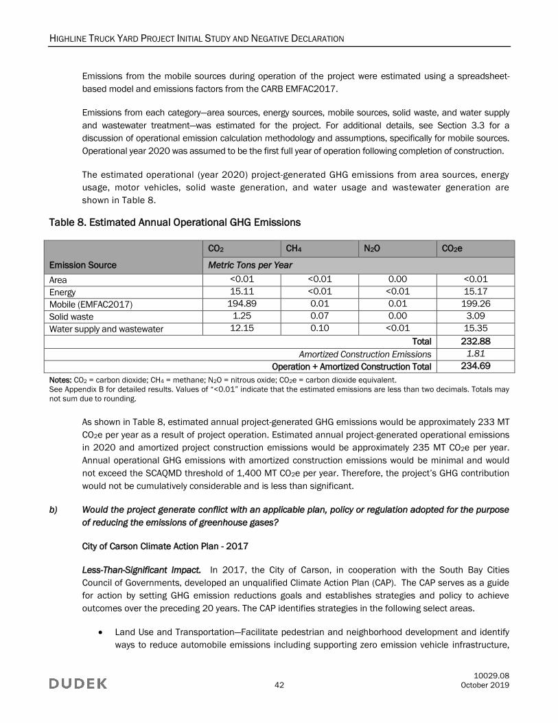
HIGHLINE TRUCK YARD PROJECT INITIAL STUDY AND NEGATIVE DECLARATION
10029.08
42 October 2019
Emissions from the mobile sources during operation of the project were estimated using a spreadsheet-
based model and emissions factors from the CARB EMFAC2017.
Emissions from each category—area sources, energy sources, mobile sources, solid waste, and water supply
and wastewater treatment—was estimated for the project. For additional details, see Section 3.3 for a
discussion of operational emission calculation methodology and assumptions, specifically for mobile sources.
Operational year 2020 was assumed to be the first full year of operation following completion of construction.
The estimated operational (year 2020) project-generated GHG emissions from area sources, energy
usage, motor vehicles, solid waste generation, and water usage and wastewater generation are
shown in Table 8.
Table 8. Estimated Annual Operational GHG Emissions
Emission Source
CO2 CH4 N2O CO2e
Metric Tons per Year
Area <0.01 <0.01 0.00 <0.01
Energy 15.11 <0.01 <0.01 15.17
Mobile (EMFAC2017) 194.89 0.01 0.01 199.26
Solid waste 1.25 0.07 0.00 3.09
Water supply and wastewater 12.15 0.10 <0.01 15.35
Total 232.88
Amortized Construction Emissions 1.81
Operation + Amortized Construction Total 234.69
Notes: CO2 = carbon dioxide; CH4 = methane; N2O = nitrous oxide; CO2e = carbon dioxide equivalent.
See Appendix B for detailed results. Values of “<0.01” indicate that the estimated emissions are less than two decimals. Totals may
not sum due to rounding.
As shown in Table 8, estimated annual project-generated GHG emissions would be approximately 233 MT
CO2e per year as a result of project operation. Estimated annual project-generated operational emissions
in 2020 and amortized project construction emissions would be approximately 235 MT CO2e per year.
Annual operational GHG emissions with amortized construction emissions would be minimal and would
not exceed the SCAQMD threshold of 1,400 MT CO2e per year. Therefore, the project’s GHG contribution
would not be cumulatively considerable and is less than significant.
b) Would the project generate conflict with an applicable plan, policy or regulation adopted for the purpose
of reducing the emissions of greenhouse gases?
City of Carson Climate Action Plan - 2017
Less-Than-Significant Impact. In 2017, the City of Carson, in cooperation with the South Bay Cities
Council of Governments, developed an unqualified Climate Action Plan (CAP). The CAP serves as a guide
for action by setting GHG emission reductions goals and establishes strategies and policy to achieve
outcomes over the preceding 20 years. The CAP identifies strategies in the following select areas.
Land Use and Transportation—Facilitate pedestrian and neighborhood development and identify
ways to reduce automobile emissions including supporting zero emission vehicle infrastructure,
HIGHLINE TRUCK YARD PROJECT INITIAL STUDY AND NEGATIVE DECLARATION
10029.08
43 October 2019
improving pedestrian and bicycle infrastructure, enhancing public transit service, and supporting
reductions in single-occupancy vehicle use.
Energy Efficiency—Emphasize energy efficiency retrofits for existing buildings, energy performance
requirements for new construction, water efficient landscaping, financing programs that will allow
home and business owners to obtain low-interest loans for implementing energy efficiency in
their buildings.
Solid Waste—Focus on increasing waste diversion and encouraging participation in recycling and
composting throughout the community.
Urban Greening—Contain measures that create “carbon sinks” as they store GHG emissions that
are otherwise emitted into the atmosphere as well as support health of the community.
Energy Generation & Storage—Demonstrate the City’s commitment to support the implementation of
clean, renewable energy while decreasing dependence on traditional, GHG emitting power sources.
As described in the CAP, the five categories identified above, have the potential to reduce approximately
256,741 MT CO2e emissions per year and accomplish the City's reduction targets of 15% below 2005 by
2020 and 49% below 2005 by 2035.
The project would provide 42 trailer parking spaces to provide temporary parking and storage for trucks
and truck-mounted containers. Trucks and trailers would be parked while waiting to be moved to and
from the Ports of Los Angeles and Long Beach, or other locations. Of the five CAP categories, Land Use
and Transportation, Energy Efficiency, and Solid Waste are relevant to the project. The project will include
water-efficient landscaping. Finally, and consistent with the CAP Solid Waste strategies, the operation of
the project would not result in the generation of solid waste. The construction and operation of the project
will not interfere with the City’s CAP strategies for Urban Greening or Energy Generation and Storage. As
such, the project would not conflict with the City’s implementation of the CAP.
Southern California Association of Governments 2016 RTP/SCS
The SCAG 2016 RTP/SCS is a regional growth-management strategy that targets per-capita GHG reduction
from passenger vehicles and light-duty trucks in the Southern California region pursuant to Senate Bill 375.
In addition to demonstrating the region’s ability to attain and exceed the GHG emission-reduction targets set
forth by CARB, the 2016 RTP/SCS outlines a series of actions and strategies for integrating the
transportation network with an overall land use pattern that responds to projected growth, housing needs,
changing demographics, and transportation demands. Thus, successful implementation of the 2016
RTP/SCS would result in more complete communities with a variety of transportation and housing choices,
while reducing automobile use. With regard to individual developments, such as the project, the strategies
and policies set forth in the 2016 RTP/SCS can be grouped into the following three categories: (1) reduction
of vehicle trips and VMT; (2) increased use of alternative fuel vehicles; and (3) improved energy efficiency.
The project’s consistency with these three strategy categories is presented below.
Consistency with VMT Reduction Strategies and Policies
The project’s consistency with this aspect of the 2016 RTP/SCS is demonstrated via the project’s land
use characteristics and consistency with the regional growth forecast assumed in the 2016 RTP/SCS for
the City. As discussed in Section 3.3, the project site is zoned MH-D (Manufacturing, Heavy) with a
General Plan Land Use Designation of Heavy Industrial (City of Carson 2019a). The project site would

HIGHLINE TRUCK YARD PROJECT INITIAL STUDY AND NEGATIVE DECLARATION
10029.08
44 October 2019
provide 42 trailer parking spaces to provide temporary parking and storage for trucks and truck-mounted
containers. As described in Section 3.14, the project would not provide new homes or businesses.
Additionally, the project would not indirectly induce unplanned population growth through extension of
roads or other infrastructure. Based on the consistency with the General Plan Use Designation and
zoning, the project would not conflict with an applicable land use plan, policy, or regulation of an agency
with jurisdiction over the project. Vehicle trip generation as a result of the project are concluded to have
been anticipated in the SCAG 2016 RTP/SCS growth projections because the project site would be
accommodated by the City’s predicted projections. As such, the project would not conflict with
implementation of the strategies identified in the 2016 RTP/SCS.
California Air Resources Board Scoping Plan and Reduction Goals
The Climate Change Scoping Plan, approved by CARB in 2008 and updated in 2014 and 2017, provides a
framework for actions to reduce California’s GHG emissions and requires CARB and other state agencies to
adopt regulations and other initiatives to reduce GHGs. The Scoping Plan is not directly applicable to specific
projects, and it is not intended to be used for project-level evaluations.9 Under the Scoping Plan, however,
there are several state regulatory measures aimed at identifying and reducing GHG emissions. CARB and other
state agencies have adopted many of the measures identified in the Scoping Plan. Most of these measures
focus on area source emissions (e.g., energy usage, and high-GWP GHGs in consumer products) and changes
to the vehicle fleet (e.g., hybrid, electric, and more fuel-efficient vehicles) and associated fuels, among others.
Regarding consistency with Senate Bill 32 (goal of reducing GHG emissions to 40% below 1990 levels by
2030) and Executive Order S-3-05 (goal of reducing GHG emissions to 80% below 1990 levels by 2050),
there are no established protocols or thresholds of significance for that future-year analysis. However,
CARB has expressed optimism with regard to both the 2030 and 2050 goals. It states in the First Update
to the Climate Change Scoping Plan: Building on the Framework that “California is on track to meet the
near-term 2020 GHG emissions limit and is well positioned to maintain and continue reductions beyond
2020 as required by AB 32” (CARB 2014). With regard to the 2050 target for reducing GHG emissions to
80% below 1990 levels, CARB (2014) states the following:
This level of reduction is achievable in California. In fact, if California realizes the expected
benefits of existing policy goals (such as 12,000 megawatts of renewable distributed
generation by 2020, net zero energy homes after 2020, existing building retrofits under
Assembly Bill 758, and others) it could reduce emissions by 2030 to levels squarely in line
with those needed in the developed world and to stay on track to reduce emissions to 80%
below 1990 levels by 2050. Additional measures, including locally driven measures and
those necessary to meet federal air quality standards in 2032, could lead to even greater
emission reductions.
9 The Final Statement of Reasons for the amendments to the CEQA Guidelines reiterates the statement in the Initial Statement of
Reasons that “[t]he Scoping Plan may not be appropriate for use in determining the significance of individual projects because it
is conceptual at this stage and relies on the future development of regulations to implement the strategies identified in the
Scoping Plan” (CNRA 2009).
HIGHLINE TRUCK YARD PROJECT INITIAL STUDY AND NEGATIVE DECLARATION
10029.08
45 October 2019
In other words, CARB believes that the state is on a trajectory to meet the 2030 and 2050 GHG reduction
targets set forth in AB 32, Senate Bill 32, and Executive Order S-3-05. This is confirmed in the 2017
Climate Change Scoping Plan Update, which states (CARB 2017b):
The Proposed Plan builds upon the successful framework established by the Initial
Scoping Plan and First Update, while also identifying new, technologically feasibility and
cost-effective strategies to ensure that California meets its GHG reduction targets in a
way that promotes and rewards innovation, continues to foster economic growth, and
delivers improvements to the environment and public health, including in disadvantaged
communities. The Proposed Plan is developed to be consistent with requirements set
forth in AB 32, SB [Senate Bill] 32, and AB 197.
The project would not interfere with implementation of GHG reduction goals for 2030 or 2050 because it
would result in minimal annual GHG emissions and would not exceed the SCAQMD’s recommended
threshold of 1,400 MT CO2e per year. Additionally, the project would not conflict the City of Carson CAP or
the SCAG RTP/SCS or with the state’s trajectory toward future GHG reductions. Therefore, the project
would not conflict with an applicable plan, policy, or regulation adopted for the purpose of reducing the
emissions of GHGs, and impacts would be less than significant.
3.9 Hazards and Hazardous Materials
Potentially
Significant
Impact
Less-Than-
Significant
Impact With
Mitigation
Incorporated
Less-Than-
Significant
Impact No Impact
IX. HAZARDS AND HAZARDOUS MATERIALS – Would the project:
a) Create a significant hazard to the public or the
environment through the routine transport,
use, or disposal of hazardous materials?
b) Create a significant hazard to the public or the
environment through reasonably foreseeable
upset and accident conditions involving the
release of hazardous materials into the
environment?
c) Emit hazardous emissions or handle
hazardous or acutely hazardous materials,
substances, or waste within one-quarter mile of
an existing or proposed school?
d) Be located on a site that is included on a list of
hazardous materials sites compiled pursuant
to Government Code Section 65962.5 and, as
a result, would it create a significant hazard to
the public or the environment?
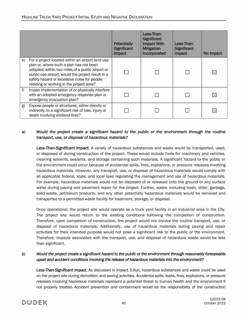
HIGHLINE TRUCK YARD PROJECT INITIAL STUDY AND NEGATIVE DECLARATION
10029.08
46 October 2019
Potentially
Significant
Impact
Less-Than-
Significant
Impact With
Mitigation
Incorporated
Less-Than-
Significant
Impact No Impact
e) For a project located within an airport land use
plan or, where such a plan has not been
adopted, within two miles of a public airport or
public use airport, would the project result in a
safety hazard or excessive noise for people
residing or working in the project area?
f) Impair implementation of or physically interfere
with an adopted emergency response plan or
emergency evacuation plan?
g) Expose people or structures, either directly or
indirectly, to a significant risk of loss, injury or
death involving wildland fires?
a) Would the project create a significant hazard to the public or the environment through the routine
transport, use, or disposal of hazardous materials?
Less-Than-Significant Impact. A variety of hazardous substances and waste would be transported, used,
or disposed of during construction of the project. These would include fuels for machinery and vehicles,
cleaning solvents, sealants, and storage containing such materials. A significant hazard to the public or
the environment could occur because of accidental spills, fires, explosions, or pressure releases involving
hazardous materials. However, any transport, use, or disposal of hazardous materials would comply with
all applicable federal, state, and local laws regulating the management and use of hazardous materials.
For example, hazardous materials would not be disposed of or released onto the ground or any surface
water during paving and pavement repair for the project. Further, waste, including trash, littler, garbage,
solid waste, petroleum products, and any other potentially hazardous materials would be removed and
transported to a permitted waste facility for treatment, storage, or disposal.
Once operational, the project site would operate as a truck yard facility in an industrial area in the City.
The project site would return to the existing conditions following the completion of construction.
Therefore, upon completion of construction, the project would not involve the routine transport, use, or
disposal of hazardous materials. Additionally, use of hazardous materials during paving and repair
activities for their intended purpose would not pose a significant risk to the public or the environment.
Therefore, impacts associated with the transport, use, and disposal of hazardous waste would be less
than significant.
b) Would the project create a significant hazard to the public or the environment through reasonably foreseeable
upset and accident conditions involving the release of hazardous materials into the environment?
Less-Than-Significant Impact. As discussed in Impact 3.9(a), hazardous substances and waste could be used
on the project site during demolition and paving activities. Accidental spills, leaks, fires, explosions, or pressure
releases involving hazardous materials represent a potential threat to human health and the environment if
not properly treated. Accident prevention and containment would be the responsibility of the construction
HIGHLINE TRUCK YARD PROJECT INITIAL STUDY AND NEGATIVE DECLARATION
10029.08
47 October 2019
contractors, and provisions to properly manage hazardous substances and wastes are typically included in
construction specifications. The most likely spills or releases of hazardous materials during construction would
involve petroleum products, such as diesel fuel, oils, and lubricants. All storage, handling, and disposal of
these materials are regulated by the Department of Toxic Substances Control, EPA, Occupational Safety and
Health Administration, and the Los Angeles City and County Fire Departments. Therefore, impacts associated
with the accidental release of hazardous materials would be less than significant.
c) Would the project emit hazardous emissions or handle hazardous or acutely hazardous materials,
substances, or waste within one-quarter mile of an existing or proposed school?
No Impact. The nearest school to the project site is Dominguez Elementary School (21250 S. Santa Fe
Avenue), located approximately 0.6 miles southeast of the project site. Additionally, the project would not
emit hazardous air emissions or handle hazardous or acutely hazardous materials. Therefore, no impacts
associated with emitting hazardous emissions or handling hazardous or acutely hazardous materials
within one-quarter mile of school would occur.
d) Would the project be located on a site that is included on a list of hazardous materials sites compiled
pursuant to Government Code Section 65962.5 and, as a result, would it create a significant hazard to
the public or the environment?
No Impact. The Hazardous Waste and Substances Sites (Cortese List) is a planning document providing
information about the location of hazardous materials release sites. California Government Code Section
65962.5 requires the California EPA to develop, at least annually, an updated Cortese List (CalEPA
2019). The Department of Toxic Substances Control is responsible for a portion of the information
contained in the Cortese List. Other state and local government agencies are required to provide
additional hazardous materials release information for the Cortese List (DTSC 2019a). The project site is
not identified on the Cortese List or any other hazardous materials sites (SWRCB 2019; DTSC 2019b).
Therefore, no impacts associated with hazardous materials sites would occur.
e) For a project located within an airport land use plan or, where such a plan has not been adopted, within
two miles of a public airport or public use airport, would the project result in a safety hazard or excessive
noise for people residing or working in the project area?
No Impact. The nearest airport to the project site is Compton/Woodley Airport, located approximately
3.4 miles north of the project site in the City of Compton. As such, the project would not be located within
2 miles of a public airport, and the project site is not within the Airport Influence Area for the airport
(County of Los Angeles 2019b). Therefore, no impacts associated with airport safety hazards would occur.
f) Would the project impair implementation of or physically interfere with an adopted emergency response
plan or emergency evacuation plan?
No Impact. Exhibit SAF-5 in the City’s General Plan Safety Element shows the location of collection points and
evacuation routes for the City (City of Carson 2004). Emergency access routes in the project vicinity include
Alameda Street, Wilmington Street, and Del Amo Boulevard. As discussed further in Section 3.17,
Transportation, the project would not adversely affect operations on the local or regional circulation system,
and as such, would not impeded the use of any nearby roadway as an emergency access routes. Therefore, no
impacts associated with an emergency response plan or emergency evacuation plan would occur.
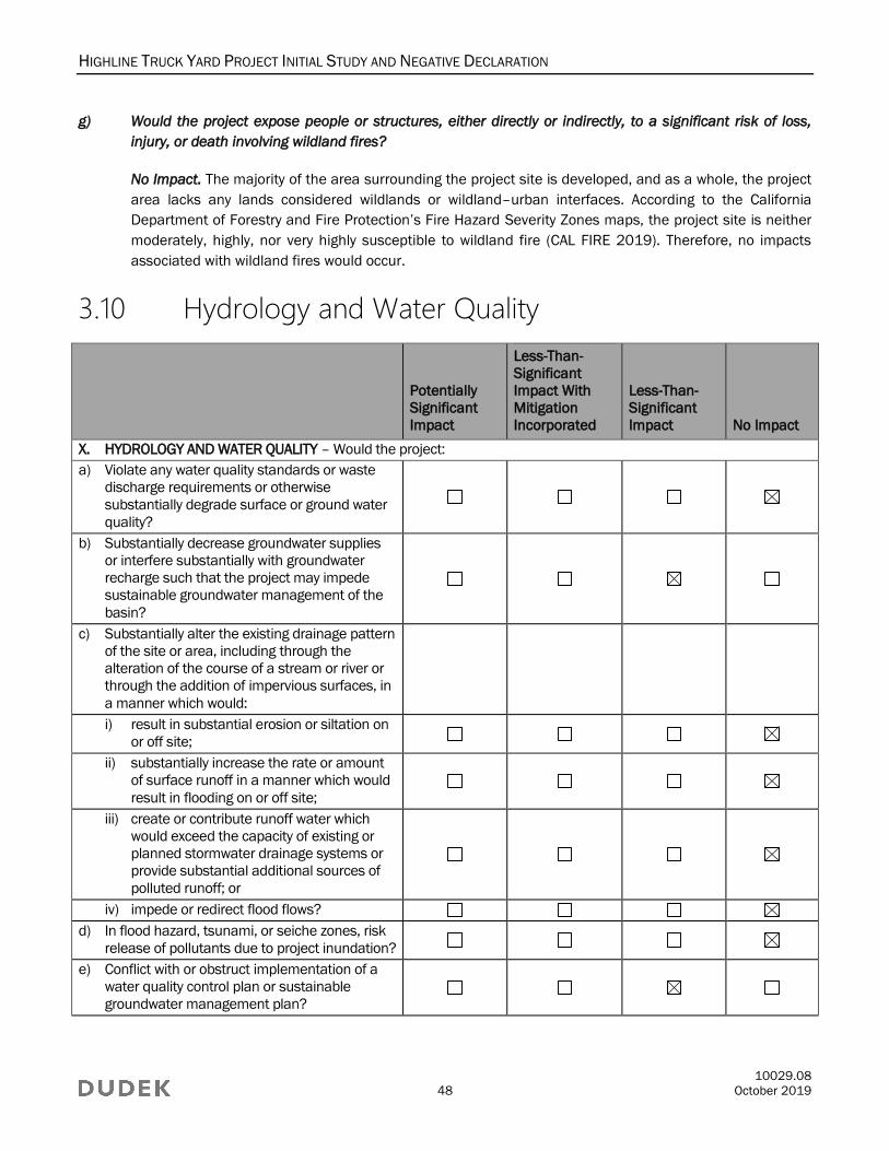
HIGHLINE TRUCK YARD PROJECT INITIAL STUDY AND NEGATIVE DECLARATION
10029.08
48 October 2019
g) Would the project expose people or structures, either directly or indirectly, to a significant risk of loss,
injury, or death involving wildland fires?
No Impact. The majority of the area surrounding the project site is developed, and as a whole, the project
area lacks any lands considered wildlands or wildland–urban interfaces. According to the California
Department of Forestry and Fire Protection’s Fire Hazard Severity Zones maps, the project site is neither
moderately, highly, nor very highly susceptible to wildland fire (CAL FIRE 2019). Therefore, no impacts
associated with wildland fires would occur.
3.10 Hydrology and Water Quality
Potentially
Significant
Impact
Less-Than-
Significant
Impact With
Mitigation
Incorporated
Less-Than-
Significant
Impact No Impact
X. HYDROLOGY AND WATER QUALITY – Would the project:
a) Violate any water quality standards or waste
discharge requirements or otherwise
substantially degrade surface or ground water
quality?
b) Substantially decrease groundwater supplies
or interfere substantially with groundwater
recharge such that the project may impede
sustainable groundwater management of the
basin?
c) Substantially alter the existing drainage pattern
of the site or area, including through the
alteration of the course of a stream or river or
through the addition of impervious surfaces, in
a manner which would:
i) result in substantial erosion or siltation on
or off site;
ii) substantially increase the rate or amount
of surface runoff in a manner which would
result in flooding on or off site;
iii) create or contribute runoff water which
would exceed the capacity of existing or
planned stormwater drainage systems or
provide substantial additional sources of
polluted runoff; or
iv) impede or redirect flood flows?
d) In flood hazard, tsunami, or seiche zones, risk
release of pollutants due to project inundation?
e) Conflict with or obstruct implementation of a
water quality control plan or sustainable
groundwater management plan?

HIGHLINE TRUCK YARD PROJECT INITIAL STUDY AND NEGATIVE DECLARATION
10029.08
49 October 2019
a) Would the project violate any water quality standards or waste discharge requirements or otherwise
substantially degrade surface or ground water quality?
No Impact. Construction associated with the project involves earthwork activities that would potentially
disturb soil. Although the project site is already disturbed and developed, soil erosion could result from such
construction activities, thereby potentially affecting the water quality of local downstream waterways.
Because the project would disturb one or more acres of soil, the project is subject to the State Water
Resources Control Board National Pollutant Discharge Elimination System Construction General Permit. A
Stormwater Pollution Prevention Plan (SWPPP) is required, as part of compliance with the NPDES Permit
to ensure that water quality standards are met and that stormwater runoff from the construction work
areas does not cause degradation of water quality in receiving water bodies. The SWPPP consists of
BMPs designed to reduce and capture soil erosion, under the guidance of a qualified SWPPP practitioner.
Sediment control BMPs may include stabilized construction entrances, sediment filters on existing inlets,
or the equivalent to reduce erosion impacts. Implementation of the SWPPP and incorporation of BMPs
would ensure proper measures are in place to prevent, to the extant feasible, stormwater runoff
conveying sediments to downstream receiving waters. Upon completion of the project, the project site
would be restored to its pre-construction project conditions, and no loss of topsoil affecting downstream
waterways would occur. Therefore, no impacts associated with water quality standards would occur.
b) Would the project substantially decrease groundwater supplies or interfere substantially with groundwater
recharge such that the project may impede sustainable groundwater management of the basin?
Less-Than-Significant Impact. Under its existing condition, the project site does not have areas that allow
for groundwater recharge because the site is disturbed and developed. Upon completion of construction
activities, the project site would return to similar pre-construction conditions; therefore, existing
groundwater recharge would not be affected.
Additionally, given that the project consist of improvements that would not increase the intensification of
operations that already occur on the project site, the project would not increase the on-site consumption
of domestic water, including water derived from groundwater sources. As such, the project would not
decrease groundwater supplies or interfere substantially with groundwater recharge such that the project
may impede sustainable groundwater management of the basin. Therefore, impacts associated with
groundwater supplies or groundwater recharge would be less than significant.
c) Would the project substantially alter the existing drainage pattern of the site or area, including through
the alteration of the course of a stream or river or through the addition of impervious surfaces, in a
manner which would:
i) result in substantial erosion or siltation on or off site;
ii) substantially increase the rate or amount of surface runoff in a manner, which would result in
flooding on or off site;
iii) create or contribute runoff water which would exceed the capacity of existing or planned
stormwater drainage systems or provide substantial additional sources of polluted runoff; or
HIGHLINE TRUCK YARD PROJECT INITIAL STUDY AND NEGATIVE DECLARATION
10029.08
50 October 2019
iv) impede or redirect flood flows?
No Impact. Upon completion of construction activities, the project site would return to similar pre-
construction conditions, and both the existing on-site and project-adjacent drainage patterns would be
unaltered. As a result of the drainage patterns remaining as-is, the project would not lead to erosion or
siltation, increase the rate or amount of surface runoff, create or contribute runoff water that would
exceed the capacity of stormwater drainage systems, or impede flood flows. Therefore, no impacts
associated with the altering of existing drainage patterns would occur.
d) In flood hazard, tsunami, or seiche zones, would the project risk release of pollutants due to
project inundation?
No Impact. Due to the project site’s inland location and the lack of nearby bodies of water, the project
would not be susceptible to tsunami or seiche. Additionally, the project site is located in a FEMA Flood
Zone categorized as Zone X, and the annual chance of flood is 0.2% (FEMA 2008). Therefore, no impacts
associated with flood hazard, tsunami, or seiche zones would occur.
e) Would the project conflict with or obstruct implementation of a water quality control plan or sustainable
groundwater management plan?
Less-Than-Significant Impact. Refer to responses provided to Impact 3.10(a) and Impact 3.10(b).
3.11 Land Use and Planning
Potentially
Significant
Impact
Less-Than-
Significant
Impact With
Mitigation
Incorporated
Less-Than-
Significant
Impact No Impact
XI. LAND USE AND PLANNING – Would the project:
a) Physically divide an established community?
b) Cause a significant environmental impact due
to a conflict with any land use plan, policy, or
regulation adopted for the purpose of avoiding
or mitigating an environmental effect?
a) Would the project physically divide an established community?
No Impact. The physical division of an established community typically refers to the construction of a
linear feature (such as a major highway or railroad tracks) or removal of a means of access (such as a
local road or bridge) that would impair mobility within an existing community or between a community and
outlying area. Under the existing condition, the project site is not used as a connection between
established communities. Instead, connectivity within the area surrounding the project site is facilitated
via local roadways. Upon completion of construction, the project site would return to similar pre-
construction conditions. Therefore, no impacts associated with physical division of an established
community would occur.
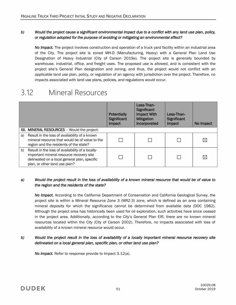
HIGHLINE TRUCK YARD PROJECT INITIAL STUDY AND NEGATIVE DECLARATION
10029.08
51 October 2019
b) Would the project cause a significant environmental impact due to a conflict with any land use plan, policy,
or regulation adopted for the purpose of avoiding or mitigating an environmental effect?
No Impact. The project involves construction and operation of a truck yard facility within an industrial area
of the City. The project site is zoned MH-D (Manufacturing, Heavy) with a General Plan Land Use
Designation of Heavy Industrial (City of Carson 2019a). The project site is generally bounded by
warehouse, industrial, office, and freight uses. The proposed use is allowed, and is consistent with the
project site’s General Plan designation and zoning, and thus, the project would not conflict with an
applicable land use plan, policy, or regulation of an agency with jurisdiction over the project. Therefore, no
impacts associated with land use plans, policies, and regulations would occur.
3.12 Mineral Resources
Potentially
Significant
Impact
Less-Than-
Significant
Impact With
Mitigation
Incorporated
Less-Than-
Significant
Impact No Impact
XII. MINERAL RESOURCES – Would the project:
a) Result in the loss of availability of a known
mineral resource that would be of value to the
region and the residents of the state?
b) Result in the loss of availability of a locally-
important mineral resource recovery site
delineated on a local general plan, specific
plan, or other land use plan?
a) Would the project result in the loss of availability of a known mineral resource that would be of value to
the region and the residents of the state?
No Impact. According to the California Department of Conservation and California Geological Survey, the
project site is within a Mineral Resource Zone 3 (MRZ-3) zone, which is defined as an area containing
mineral deposits for which the significance cannot be determined from available data (DOC 1982).
Although the project area has historically been used for oil exploration, such activities have since ceased
in the project area. Additionally, according to the City’s General Plan EIR, there are no known mineral
resources located within the City (City of Carson 2002). Therefore, no impacts associated with loss of
availability of a known mineral resource would occur.
b) Would the project result in the loss of availability of a locally important mineral resource recovery site
delineated on a local general plan, specific plan, or other land use plan?
No Impact. Refer to response provide to Impact 3.12(a).
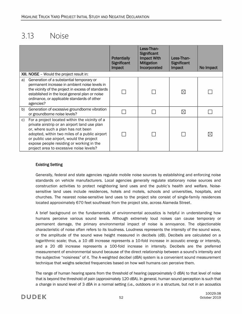
HIGHLINE TRUCK YARD PROJECT INITIAL STUDY AND NEGATIVE DECLARATION
10029.08
52 October 2019
3.13 Noise
Potentially
Significant
Impact
Less-Than-
Significant
Impact With
Mitigation
Incorporated
Less-Than-
Significant
Impact No Impact
XIII. NOISE – Would the project result in:
a) Generation of a substantial temporary or
permanent increase in ambient noise levels in
the vicinity of the project in excess of standards
established in the local general plan or noise
ordinance, or applicable standards of other
agencies?
b) Generation of excessive groundborne vibration
or groundborne noise levels?
c) For a project located within the vicinity of a
private airstrip or an airport land use plan
or, where such a plan has not been
adopted, within two miles of a public airport
or public use airport, would the project
expose people residing or working in the
project area to excessive noise levels?
Existing Setting
Generally, federal and state agencies regulate mobile noise sources by establishing and enforcing noise
standards on vehicle manufacturers. Local agencies generally regulate stationary noise sources and
construction activities to protect neighboring land uses and the public’s health and welfare. Noise-
sensitive land uses include residences, hotels and motels, schools and universities, hospitals, and
churches. The nearest noise-sensitive land uses to the project site consist of single-family residences
located approximately 670 feet southeast from the project site, across Alameda Street.
A brief background on the fundamentals of environmental acoustics is helpful in understanding how
humans perceive various sound levels. Although extremely loud noises can cause temporary or
permanent damage, the primary environmental impact of noise is annoyance. The objectionable
characteristic of noise often refers to its loudness. Loudness represents the intensity of the sound wave,
or the amplitude of the sound wave height measured in decibels (dB). Decibels are calculated on a
logarithmic scale; thus, a 10 dB increase represents a 10-fold increase in acoustic energy or intensity,
and a 20 dB increase represents a 100-fold increase in intensity. Decibels are the preferred
measurement of environmental sound because of the direct relationship between a sound’s intensity and
the subjective “noisiness” of it. The A-weighted decibel (dBA) system is a convenient sound measurement
technique that weighs selected frequencies based on how well humans can perceive them.
The range of human hearing spans from the threshold of hearing (approximately 0 dBA) to that level of noise
that is beyond the threshold of pain (approximately 120 dBA). In general, human sound perception is such that
a change in sound level of 3 dBA in a normal setting (i.e., outdoors or in a structure, but not in an acoustics
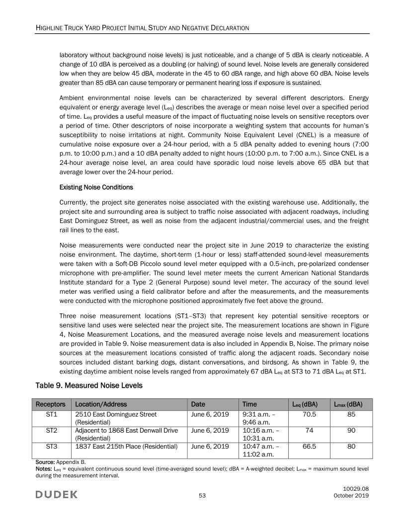
HIGHLINE TRUCK YARD PROJECT INITIAL STUDY AND NEGATIVE DECLARATION
10029.08
53 October 2019
laboratory without background noise levels) is just noticeable, and a change of 5 dBA is clearly noticeable. A
change of 10 dBA is perceived as a doubling (or halving) of sound level. Noise levels are generally considered
low when they are below 45 dBA, moderate in the 45 to 60 dBA range, and high above 60 dBA. Noise levels
greater than 85 dBA can cause temporary or permanent hearing loss if exposure is sustained.
Ambient environmental noise levels can be characterized by several different descriptors. Energy
equivalent or energy average level (Leq) describes the average or mean noise level over a specified period
of time. Leq provides a useful measure of the impact of fluctuating noise levels on sensitive receptors over
a period of time. Other descriptors of noise incorporate a weighting system that accounts for human’s
susceptibility to noise irritations at night. Community Noise Equivalent Level (CNEL) is a measure of
cumulative noise exposure over a 24-hour period, with a 5 dBA penalty added to evening hours (7:00
p.m. to 10:00 p.m.) and a 10 dBA penalty added to night hours (10:00 p.m. to 7:00 a.m.). Since CNEL is a
24-hour average noise level, an area could have sporadic loud noise levels above 65 dBA but that
average lower over the 24-hour period.
Existing Noise Conditions
Currently, the project site generates noise associated with the existing warehouse use. Additionally, the
project site and surrounding area is subject to traffic noise associated with adjacent roadways, including
East Dominguez Street, as well as noise from the adjacent industrial/commercial uses, and the freight
rail lines to the east.
Noise measurements were conducted near the project site in June 2019 to characterize the existing
noise environment. The daytime, short-term (1-hour or less) staff-attended sound-level measurements
were taken with a Soft-DB Piccolo sound level meter equipped with a 0.5-inch, pre-polarized condenser
microphone with pre-amplifier. The sound level meter meets the current American National Standards
Institute standard for a Type 2 (General Purpose) sound level meter. The accuracy of the sound level
meter was verified using a field calibrator before and after the measurements, and the measurements
were conducted with the microphone positioned approximately five feet above the ground.
Three noise measurement locations (ST1–ST3) that represent key potential sensitive receptors or
sensitive land uses were selected near the project site. The measurement locations are shown in Figure
4, Noise Measurement Locations, and the measured average noise levels and measurement locations
are provided in Table 9. Noise measurement data is also included in Appendix B, Noise. The primary noise
sources at the measurement locations consisted of traffic along the adjacent roads. Secondary noise
sources included distant barking dogs, distant conversations, and birdsong. As shown in Table 9, the
existing daytime ambient noise levels ranged from approximately 67 dBA Leq at ST3 to 71 dBA Leq at ST1.
Table 9. Measured Noise Levels
Receptors Location/Address Date Time Leq (dBA) Lmax (dBA)
ST1 2510 East Dominguez Street
(Residential)
June 6, 2019 9:31 a.m. –
9:46 a.m.
70.5 85
ST2 Adjacent to 1868 East Denwall Drive
(Residential)
June 6, 2019 10:16 a.m. –
10:31 a.m.
74 90
ST3 1837 East 215th Place (Residential) June 6, 2019 10:47 a.m. –
11:02 a.m.
66.5 80
Source: Appendix B.
Notes: Leq = equivalent continuous sound level (time-averaged sound level); dBA = A-weighted decibel; Lmax = maximum sound level
during the measurement interval.
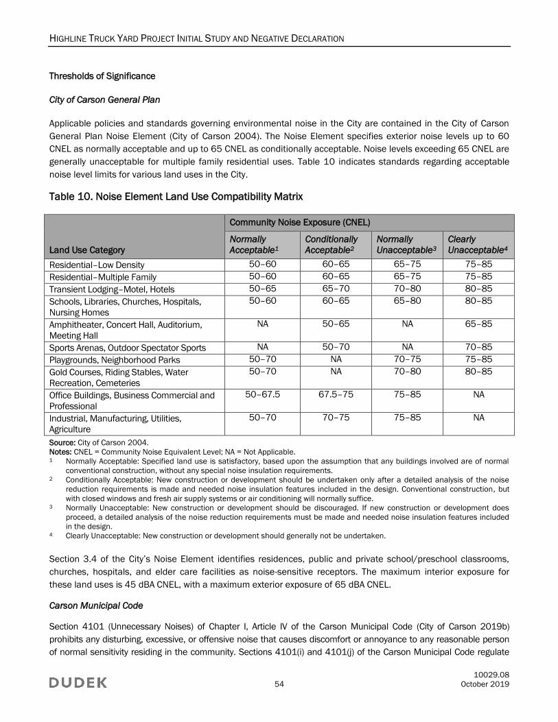
HIGHLINE TRUCK YARD PROJECT INITIAL STUDY AND NEGATIVE DECLARATION
10029.08
54 October 2019
Thresholds of Significance
City of Carson General Plan
Applicable policies and standards governing environmental noise in the City are contained in the City of Carson
General Plan Noise Element (City of Carson 2004). The Noise Element specifies exterior noise levels up to 60
CNEL as normally acceptable and up to 65 CNEL as conditionally acceptable. Noise levels exceeding 65 CNEL are
generally unacceptable for multiple family residential uses. Table 10 indicates standards regarding acceptable
noise level limits for various land uses in the City.
Table 10. Noise Element Land Use Compatibility Matrix
Land Use Category
Community Noise Exposure (CNEL)
Normally
Acceptable1
Conditionally
Acceptable2
Normally
Unacceptable3
Clearly
Unacceptable4
Residential–Low Density 50–60 60–65 65–75 75–85
Residential–Multiple Family 50–60 60–65 65–75 75–85
Transient Lodging–Motel, Hotels 50–65 65–70 70–80 80–85
Schools, Libraries, Churches, Hospitals,
Nursing Homes
50–60 60–65 65–80 80–85
Amphitheater, Concert Hall, Auditorium,
Meeting Hall
NA 50–65 NA 65–85
Sports Arenas, Outdoor Spectator Sports NA 50–70 NA 70–85
Playgrounds, Neighborhood Parks 50–70 NA 70–75 75–85
Gold Courses, Riding Stables, Water
Recreation, Cemeteries
50–70 NA 70–80 80–85
Office Buildings, Business Commercial and
Professional
50–67.5 67.5–75 75–85 NA
Industrial, Manufacturing, Utilities,
Agriculture
50–70 70–75 75–85 NA
Source: City of Carson 2004.
Notes: CNEL = Community Noise Equivalent Level; NA = Not Applicable.
1 Normally Acceptable: Specified land use is satisfactory, based upon the assumption that any buildings involved are of normal
conventional construction, without any special noise insulation requirements.
2 Conditionally Acceptable: New construction or development should be undertaken only after a detailed analysis of the noise
reduction requirements is made and needed noise insulation features included in the design. Conventional construction, but
with closed windows and fresh air supply systems or air conditioning will normally suffice.
3 Normally Unacceptable: New construction or development should be discouraged. If new construction or development does
proceed, a detailed analysis of the noise reduction requirements must be made and needed noise insulation features included
in the design.
4 Clearly Unacceptable: New construction or development should generally not be undertaken.
Section 3.4 of the City’s Noise Element identifies residences, public and private school/preschool classrooms,
churches, hospitals, and elder care facilities as noise-sensitive receptors. The maximum interior exposure for
these land uses is 45 dBA CNEL, with a maximum exterior exposure of 65 dBA CNEL.
Carson Municipal Code
Section 4101 (Unnecessary Noises) of Chapter I, Article IV of the Carson Municipal Code (City of Carson 2019b)
prohibits any disturbing, excessive, or offensive noise that causes discomfort or annoyance to any reasonable person
of normal sensitivity residing in the community. Sections 4101(i) and 4101(j) of the Carson Municipal Code regulate
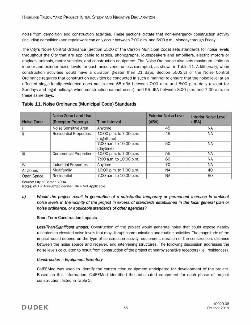
HIGHLINE TRUCK YARD PROJECT INITIAL STUDY AND NEGATIVE DECLARATION
10029.08
55 October 2019
noise from demolition and construction activities. These sections dictate that non-emergency construction activity
(including demolition) and repair work can only occur between 7:00 a.m. and 6:00 p.m., Monday through Friday.
The City’s Noise Control Ordinance (Section 5500 of the Carson Municipal Code) sets standards for noise levels
throughout the City that are applicable to radios, phonographs, loudspeakers and amplifiers, electric motors or
engines, animals, motor vehicles, and construction equipment. The Noise Ordinance also sets maximum limits on
interior and exterior noise levels for each noise zone, unless exempted, as shown in Table 11. Additionally, when
construction activities would have a duration greater than 21 days, Section 5502(c) of the Noise Control
Ordinance requires that construction activities be conducted in such a manner to ensure that the noise level at an
affected single-family residence does not exceed 65 dBA between 7:00 a.m. and 8:00 p.m. daily (except for
Sundays and legal holidays when construction cannot occur), and 55 dBA between 8:00 p.m. and 7:00 a.m. on
these same days.
Table 11. Noise Ordinance (Municipal Code) Standards
Noise Zone
Noise Zone Land Use
(Receptor Property) Time Interval
Exterior Noise Level
(dBA)
Interior Noise Level
(dBA)
I Noise Sensitive Area Anytime 45 NA
II Residential Properties 10:00 p.m. to 7:00 a.m.
(nighttime)
45 NA
7:00 a.m. to 10:00 p.m.
(daytime)
50 NA
III Commercial Properties 10:00 p.m. to 7:00 a.m. 55 NA
7:00 a.m. to 10:00 p.m. 60 NA
IV Industrial Properties Anytime 70 NA
All Zones Multifamily 10:00 p.m. to 7:00 a.m. NA 40
Open Space Residential 7:00 a.m. to 10:00 p.m. NA 50
Source: City of Carson 2004.
Notes: dBA = A-weighted decibel; NA = Not Applicable.
a) Would the project result in generation of a substantial temporary or permanent increase in ambient
noise levels in the vicinity of the project in excess of standards established in the local general plan or
noise ordinance, or applicable standards of other agencies?
Short-Term Construction Impacts
Less-Than-Significant Impact. Construction of the project would generate noise that could expose nearby
receptors to elevated noise levels that may disrupt communication and routine activities. The magnitude of the
impact would depend on the type of construction activity, equipment, duration of the construction, distance
between the noise source and receiver, and intervening structures. The following discussion addresses the
noise levels calculated to result from construction of the project at nearby sensitive receptors (i.e., residences).
Construction – Equipment Inventory
CalEEMod was used to identify the construction equipment anticipated for development of the project.
Based on this information, CalEEMod identified the anticipated equipment for each phase of project
construction, listed in Table 2.
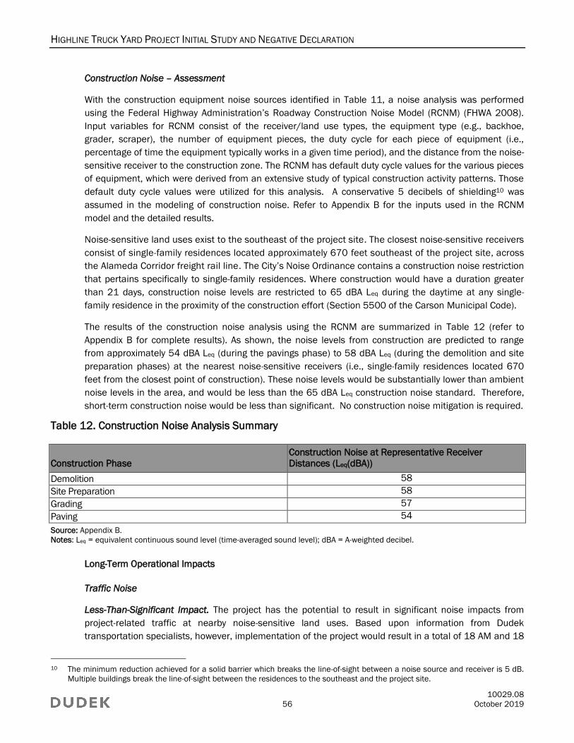
HIGHLINE TRUCK YARD PROJECT INITIAL STUDY AND NEGATIVE DECLARATION
10029.08
56 October 2019
Construction Noise – Assessment
With the construction equipment noise sources identified in Table 11, a noise analysis was performed
using the Federal Highway Administration’s Roadway Construction Noise Model (RCNM) (FHWA 2008).
Input variables for RCNM consist of the receiver/land use types, the equipment type (e.g., backhoe,
grader, scraper), the number of equipment pieces, the duty cycle for each piece of equipment (i.e.,
percentage of time the equipment typically works in a given time period), and the distance from the noise-
sensitive receiver to the construction zone. The RCNM has default duty cycle values for the various pieces
of equipment, which were derived from an extensive study of typical construction activity patterns. Those
default duty cycle values were utilized for this analysis. A conservative 5 decibels of shielding10 was
assumed in the modeling of construction noise. Refer to Appendix B for the inputs used in the RCNM
model and the detailed results.
Noise-sensitive land uses exist to the southeast of the project site. The closest noise-sensitive receivers
consist of single-family residences located approximately 670 feet southeast of the project site, across
the Alameda Corridor freight rail line. The City’s Noise Ordinance contains a construction noise restriction
that pertains specifically to single-family residences. Where construction would have a duration greater
than 21 days, construction noise levels are restricted to 65 dBA Leq during the daytime at any single-
family residence in the proximity of the construction effort (Section 5500 of the Carson Municipal Code).
The results of the construction noise analysis using the RCNM are summarized in Table 12 (refer to
Appendix B for complete results). As shown, the noise levels from construction are predicted to range
from approximately 54 dBA Leq (during the pavings phase) to 58 dBA Leq (during the demolition and site
preparation phases) at the nearest noise-sensitive receivers (i.e., single-family residences located 670
feet from the closest point of construction). These noise levels would be substantially lower than ambient
noise levels in the area, and would be less than the 65 dBA Leq construction noise standard. Therefore,
short-term construction noise would be less than significant. No construction noise mitigation is required.
Table 12. Construction Noise Analysis Summary
Construction Phase
Construction Noise at Representative Receiver
Distances (Leq(dBA))
Demolition 58
Site Preparation 58
Grading 57
Paving 54
Source: Appendix B.
Notes: Leq = equivalent continuous sound level (time-averaged sound level); dBA = A-weighted decibel.
Long-Term Operational Impacts
Traffic Noise
Less-Than-Significant Impact. The project has the potential to result in significant noise impacts from
project-related traffic at nearby noise-sensitive land uses. Based upon information from Dudek
transportation specialists, however, implementation of the project would result in a total of 18 AM and 18
10 The minimum reduction achieved for a solid barrier which breaks the line-of-sight between a noise source and receiver is 5 dB.
Multiple buildings break the line-of-sight between the residences to the southeast and the project site.
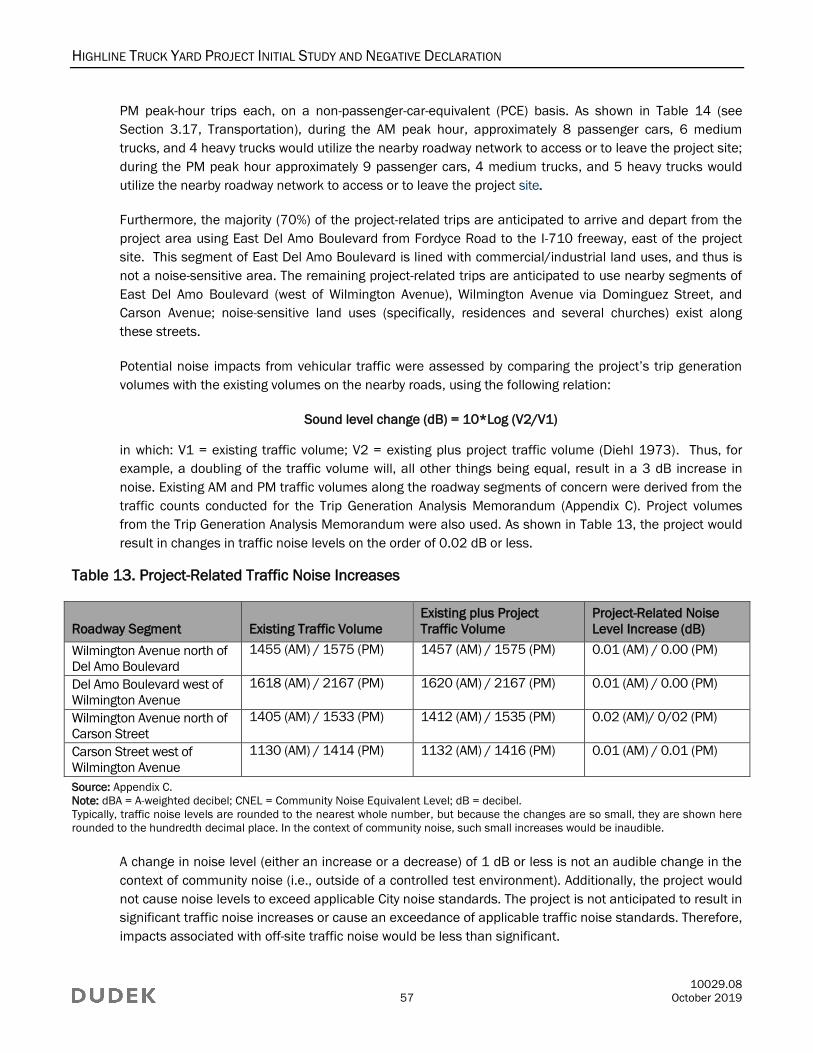
HIGHLINE TRUCK YARD PROJECT INITIAL STUDY AND NEGATIVE DECLARATION
10029.08
57 October 2019
PM peak-hour trips each, on a non-passenger-car-equivalent (PCE) basis. As shown in Table 14 (see
Section 3.17, Transportation), during the AM peak hour, approximately 8 passenger cars, 6 medium
trucks, and 4 heavy trucks would utilize the nearby roadway network to access or to leave the project site;
during the PM peak hour approximately 9 passenger cars, 4 medium trucks, and 5 heavy trucks would
utilize the nearby roadway network to access or to leave the project site.
Furthermore, the majority (70%) of the project-related trips are anticipated to arrive and depart from the
project area using East Del Amo Boulevard from Fordyce Road to the I-710 freeway, east of the project
site. This segment of East Del Amo Boulevard is lined with commercial/industrial land uses, and thus is
not a noise-sensitive area. The remaining project-related trips are anticipated to use nearby segments of
East Del Amo Boulevard (west of Wilmington Avenue), Wilmington Avenue via Dominguez Street, and
Carson Avenue; noise-sensitive land uses (specifically, residences and several churches) exist along
these streets.
Potential noise impacts from vehicular traffic were assessed by comparing the project’s trip generation
volumes with the existing volumes on the nearby roads, using the following relation:
Sound level change (dB) = 10*Log (V2/V1)
in which: V1 = existing traffic volume; V2 = existing plus project traffic volume (Diehl 1973). Thus, for
example, a doubling of the traffic volume will, all other things being equal, result in a 3 dB increase in
noise. Existing AM and PM traffic volumes along the roadway segments of concern were derived from the
traffic counts conducted for the Trip Generation Analysis Memorandum (Appendix C). Project volumes
from the Trip Generation Analysis Memorandum were also used. As shown in Table 13, the project would
result in changes in traffic noise levels on the order of 0.02 dB or less.
Table 13. Project-Related Traffic Noise Increases
Roadway Segment Existing Traffic Volume
Existing plus Project
Traffic Volume
Project-Related Noise
Level Increase (dB)
Wilmington Avenue north of
Del Amo Boulevard
1455 (AM) / 1575 (PM) 1457 (AM) / 1575 (PM) 0.01 (AM) / 0.00 (PM)
Del Amo Boulevard west of
Wilmington Avenue
1618 (AM) / 2167 (PM) 1620 (AM) / 2167 (PM) 0.01 (AM) / 0.00 (PM)
Wilmington Avenue north of
Carson Street
1405 (AM) / 1533 (PM) 1412 (AM) / 1535 (PM) 0.02 (AM)/ 0/02 (PM)
Carson Street west of
Wilmington Avenue
1130 (AM) / 1414 (PM) 1132 (AM) / 1416 (PM) 0.01 (AM) / 0.01 (PM)
Source: Appendix C.
Note: dBA = A-weighted decibel; CNEL = Community Noise Equivalent Level; dB = decibel.
Typically, traffic noise levels are rounded to the nearest whole number, but because the changes are so small, they are shown here
rounded to the hundredth decimal place. In the context of community noise, such small increases would be inaudible.
A change in noise level (either an increase or a decrease) of 1 dB or less is not an audible change in the
context of community noise (i.e., outside of a controlled test environment). Additionally, the project would
not cause noise levels to exceed applicable City noise standards. The project is not anticipated to result in
significant traffic noise increases or cause an exceedance of applicable traffic noise standards. Therefore,
impacts associated with off-site traffic noise would be less than significant.
HIGHLINE TRUCK YARD PROJECT INITIAL STUDY AND NEGATIVE DECLARATION
10029.08
58 October 2019
On-Site Operational Noise
Less-Than-Significant Impact. The project would provide 42 trailer parking spaces to provide temporary
parking and storage for trucks and truck-mounted containers. Trucks and trailers would be parked while
waiting to be moved to and from the Port of Los Angeles, Port of Long Beach, or other locations. The
unloading and reloading of contents of one trailer to another trailer would be permitted on the project
site. Thus, project-related on-site noise would consist of truck arrivals and departures, as well as truck
start-ups and maneuvering noise, and transfer of truck contents, which would likely involve forklift noise.
The general maintenance of truck tractors and equipment would not be allowed. The proposed parking
facility would be operational from 6:00 a.m. to 10:00 p.m. Monday through Friday. As shown in Table 12,
approximately 10 trucks (6 medium and 4 heavy-duty) are anticipated in the AM peak-hour, and
approximately 9 trucks (4 medium and 5 heavy-duty) are anticipated in the PM peak-hour.
Currently, there are trailers and trucks within the site, as well as an existing warehouse, which would
remain in place and in operation. The project site is zoned MH-D (Manufacturing, Heavy) with a General
Plan Land Use Designation of Heavy Industrial (City of Carson 2019a). Furthermore, the project site is in
an industrial area and is generally bounded by existing warehouse, light industrial, office, and freight
uses. Thus, the nature of the noise created by the project would be in keeping with the project site and
surroundings and would be of a relatively low magnitude because of the small numbers of trucks using
the site. The nearest noise-sensitive land uses (residential) are located approximately 670 feet away and
are separated from the project site by frequently-utilized freight rail line and numerous intervening
structures. Therefore, on-site operational noise would be less than significant.
b) Would the project result in generation of excessive groundborne vibration or groundborne noise levels?
Less than significant Impact. Construction activities that might expose persons to excessive ground-borne
vibration or ground-borne noise could cause a potentially significant impact. Ground-borne vibration
information related to construction activities (including demolition) has been collected by Caltrans
(Caltrans 2013). Information from Caltrans indicates that continuous vibrations with a peak particle
velocity of approximately 0.1 inches per second begin to annoy people. The heavier pieces of construction
equipment, such as bulldozers, would have peak particle velocities of approximately 0.089 inches per
second or less at a distance of 25 feet (DOT 2018). Ground-borne vibration is typically attenuated over
short distances. At the distance from the nearest vibration-sensitive receivers (residences located to the
southeast) to where construction activity would be occurring on the project site (approximately 670 feet),
and with the anticipated construction equipment, the peak particle velocity vibration level would be
approximately 0.0006 inches per second. At the closest sensitive receptors, vibration levels would be well
below the vibration threshold of potential annoyance of 0.1 inches/second; therefore, impacts associated
with vibration-generated annoyance would be less than significant.
The major concern with regards to construction vibration is related to building damage, which typically occurs
at vibration levels of 0.5 inches per second or greater for buildings of reinforced-concrete, steel or timber
construction. As discussed above, the highest anticipated vibration levels associated with on-site project
construction would be approximately 0.0006 inches per second, which are well below the threshold of 0.5
inches per second for building damage. Therefore, impacts associated with vibration-produced damage would
be less than significant.

HIGHLINE TRUCK YARD PROJECT INITIAL STUDY AND NEGATIVE DECLARATION
10029.08
59 October 2019
c) For a project located within the vicinity of a private airstrip or an airport land use plan or, where such a
plan has not been adopted, within two miles of a public airport or public use airport, would the project
expose people residing or working in the project area to excessive noise levels?
No Impact. The project site is not located within the vicinity of private airstrip. Additionally, the closest
public airport to the project site is the Compton/Woodley Airport Torrance Municipal Airport, which is
located approximately 3.4 miles north of the project site. According to the Los Angeles County Airport
Land Use Commission, the project is not located within the airport land use plan for this or other nearby
airports. Additionally, the Noise Contour Map provides the 65 CNEL contours of the nearby airports, which
are located more than 3 miles from the project site (ALUC 2019). Therefore, no impacts associated with
airport and aircraft noise would occur.
3.14 Population and Housing
Potentially
Significant
Impact
Less-Than-
Significant
Impact With
Mitigation
Incorporated
Less-Than-
Significant
Impact No Impact
XIV. POPULATION AND HOUSING – Would the project:
a) Induce substantial unplanned population
growth in an area, either directly (for example,
by proposing new homes and businesses) or
indirectly (for example, through extension of
roads or other infrastructure)?
b) Displace substantial numbers of existing
people or housing, necessitating the
construction of replacement housing
elsewhere?
a) Would the project induce substantial unplanned population growth in an area, either directly (for
example, by proposing new homes and businesses) or indirectly (for example, through extension of roads
or other infrastructure)?
No Impact. The project involves the construction and operation of a truck yard facility within an industrial
area of the City. It is anticipated that the limited number of construction workers needed to develop the
project would come from the local labor pool, with additional workers from outside the region not being
required. No residential uses are proposed as part of the project, and no additional employees would be
required during operations. Therefore, no impacts associated with population growth would occur.
b) Would the project displace substantial numbers of existing people or housing, necessitating the
construction of replacement housing elsewhere?
No Impact. The existing project site is developed with a single-story, office/warehouse building and some
associated industrial structures. No residential uses occur on the project site, and as such, the project
would not remove people or housing from the site. Therefore, no impact associated with the displacement
of existing people or housing would occur.
HIGHLINE TRUCK YARD PROJECT INITIAL STUDY AND NEGATIVE DECLARATION
10029.08
60 October 2019
3.15 Public Services
Potentially
Significant
Impact
Less-Than-
Significant
Impact With
Mitigation
Incorporated
Less-Than-
Significant
Impact No Impact
XV. PUBLIC SERVICES
a) Would the project result in substantial adverse physical impacts associated with the provision of new or physically
altered governmental facilities, need for new or physically altered governmental facilities, the construction of which
could cause significant environmental impacts, in order to maintain acceptable service ratios, response times, or
other performance objectives for any of the public services:
Fire protection?
Police protection?
Schools?
Parks?
Other public facilities?
a) Would the project result in substantial adverse physical impacts associated with the provision of new or
physically altered governmental facilities, need for new or physically altered governmental facilities, the
construction of which could cause significant environmental impacts, in order to maintain acceptable
service ratios, response times, or other performance objectives for any of the public services:
Fire protection?
No Impact. The Los Angeles County Fire Department (LACoFD) provides fire protection services to the City.
There are six primary fire stations that provide fire and emergency medical services to the City. Four of the
stations are located within the City’s boundaries. The nearest fire station is the LACoFD Station No. 10
(1860 E Del Amo Boulevard), located approximately 0.7 miles northwest of the project site.
Based on the proximity of the project site to the existing LACoFD facilities, and since the project site
is located in a developed part of the City that is already within the service area of LACoFD, it is
anticipated that the project could be served by LACoFD without adversely affecting personnel-to-
resident ratios, response times, or other performance objectives. Additionally, given that the project
consists of improvements that would not increase the intensification of operations that already occur on
the project site, the project would not increase calls for service to the project site. Therefore, no impacts
associated with LACoFD facilities would occur.
Police protection?
No Impact. The Los Angeles County Sheriff’s Department contracts with the City to provide police protection
services. Los Angeles County Sheriff’s Department staff has indicated that an officer-to-population ratio of 1
officer to every 1,000 residents is the desired level of service (County of Los Angeles 2014). The Carson
Sheriff’s Station is located at 21356 South Avalon Boulevard, approximately 2 miles west of the project site.
HIGHLINE TRUCK YARD PROJECT INITIAL STUDY AND NEGATIVE DECLARATION
10029.08
61 October 2019
Based on the proximity of the project site to the existing Carson Sheriff’s Station, and because the project
site is located in a developed part of the City that is within the service area of the Carson Sheriff’s Station,
it is anticipated that the project could be served without adversely affecting personnel-to-resident ratios,
response times, or other performance objectives. Further, given that the project consists of
improvements that would not increase the intensification of operations that already occur on the project
site, the project would not increase calls for service to the project site. Therefore, no impacts associated
with Los Angeles County Sheriff’s Department would occur.
Schools, Parks, and other pubic facilities?
No Impact. The project would not result in population growth, and as such, would not increase demands
on schools, park and recreation facilities, libraries, community centers, hospitals, or any other public
facility. Therefore, no impact associated with schools, parks, or other public facilities would occur.
3.16 Recreation
Potentially
Significant
Impact
Less-Than-
Significant
Impact With
Mitigation
Incorporated
Less-Than-
Significant
Impact No Impact
XVI. RECREATION
a) Would the project increase the use of existing
neighborhood and regional parks or other
recreational facilities such that substantial
physical deterioration of the facility would occur
or be accelerated?
b) Does the project include recreational facilities
or require the construction or expansion of
recreational facilities which might have an
adverse physical effect on the environment?
a) Would the project increase the use of existing neighborhood and regional parks or other recreational
facilities such that substantial physical deterioration of the facility would occur or be accelerated?
No Impact. The project would not result in population growth, and as such, would not increase demands
on park and recreation facilities. Therefore, no impact associated with recreational facilities would occur.
b) Does the project include recreational facilities or require the construction or expansion of recreational
facilities, which might have an adverse physical effect on the environment?
No Impact. Refer to response provided to Impact 3.16(a).
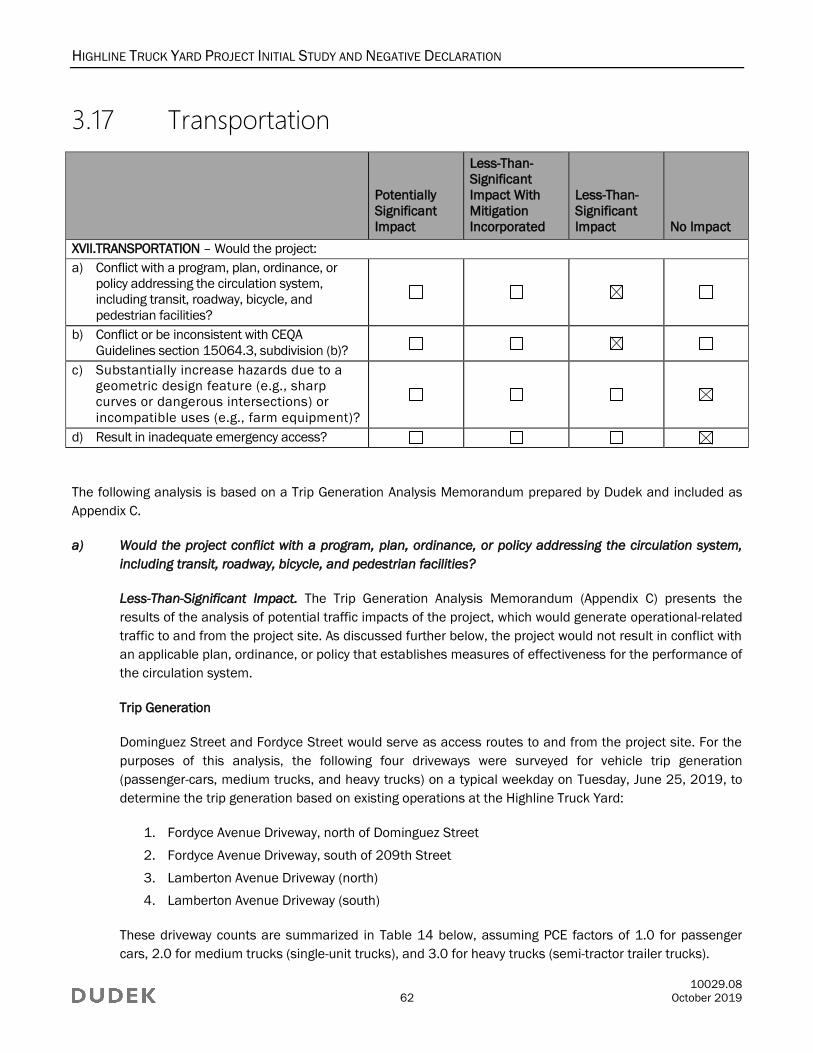
HIGHLINE TRUCK YARD PROJECT INITIAL STUDY AND NEGATIVE DECLARATION
10029.08
62 October 2019
3.17 Transportation
Potentially
Significant
Impact
Less-Than-
Significant
Impact With
Mitigation
Incorporated
Less-Than-
Significant
Impact No Impact
XVII.TRANSPORTATION – Would the project:
a) Conflict with a program, plan, ordinance, or
policy addressing the circulation system,
including transit, roadway, bicycle, and
pedestrian facilities?
b) Conflict or be inconsistent with CEQA
Guidelines section 15064.3, subdivision (b)?
c) Substantially increase hazards due to a
geometric design feature (e.g., sharp
curves or dangerous intersections) or
incompatible uses (e.g., farm equipment)?
d) Result in inadequate emergency access?
The following analysis is based on a Trip Generation Analysis Memorandum prepared by Dudek and included as
Appendix C.
a) Would the project conflict with a program, plan, ordinance, or policy addressing the circulation system,
including transit, roadway, bicycle, and pedestrian facilities?
Less-Than-Significant Impact. The Trip Generation Analysis Memorandum (Appendix C) presents the
results of the analysis of potential traffic impacts of the project, which would generate operational-related
traffic to and from the project site. As discussed further below, the project would not result in conflict with
an applicable plan, ordinance, or policy that establishes measures of effectiveness for the performance of
the circulation system.
Trip Generation
Dominguez Street and Fordyce Street would serve as access routes to and from the project site. For the
purposes of this analysis, the following four driveways were surveyed for vehicle trip generation
(passenger-cars, medium trucks, and heavy trucks) on a typical weekday on Tuesday, June 25, 2019, to
determine the trip generation based on existing operations at the Highline Truck Yard:
1. Fordyce Avenue Driveway, north of Dominguez Street
2. Fordyce Avenue Driveway, south of 209th Street
3. Lamberton Avenue Driveway (north)
4. Lamberton Avenue Driveway (south)
These driveway counts are summarized in Table 14 below, assuming PCE factors of 1.0 for passenger
cars, 2.0 for medium trucks (single-unit trucks), and 3.0 for heavy trucks (semi-tractor trailer trucks).

HIGHLINE TRUCK YARD PROJECT INITIAL STUDY AND NEGATIVE DECLARATION
10029.08
63 October 2019
Table 14. Project Trip Generation
Land Use
AM Peak Hour PM Peak Hour
In Out Total In Out Total
Project Trip Generation1
Passenger Cars 6 2 8 3 6 9
Medium Trucks 1 5 6 1 3 4
Heavy Trucks 1 3 4 3 2 5
Total 8 10 18 7 11 18
Project Trip Generation (PCE)
Passenger Cars (1.0 PCE) 6 2 8 3 6 9
Medium Trucks (2.0 PCE) 2 10 12 2 6 8
Heavy Trucks (3.0 PCE) 3 9 12 9 6 15
Total PCE 11 21 32 14 18 32
Source: Appendix C.
Notes: PCE = passenger-car equivalent 1 Estimated project trip generation and in/out spills from driveway counts conducted Tuesday, June 25, 2019.
As shown in Table 14, trip generation based on existing operations is approximately 18 AM peak-hour
trips (8 inbound and 10 outbound) and 18 PM peak hour trips (7 inbound and 11 outbound). Adjusting
for PCE, trip generation is approximately 32 AM PCE peak-hour trips (11 inbound and 21 outbound) and
32 PM PCE peak-hour trips (14 inbound and 18 outbound).
A comparison to rates provided for Warehousing (ITE Code 150) and Intermodal Truck Terminal (ITE Code
30) land uses from the Institute of Transportation Engineers (ITE) 2012, Trip Generation Handbook, 9th
edition, found that PCE-adjusted trip generation for these land uses was only slightly higher than the PCE-
adjusted trip generation estimated based on driveway counts.
Trip generation using Warehousing rates (ITE 150) is approximately 28 AM peak-hour trips (20 inbound, and 8
outbound) and 24 PM peak-hour trips (8 inbound and 16 outbound). Adjusting for PCE using the SCAQMD;s
Warehousing Truck Trip Study Data Results and Usage vehicle mix and percentage splits, trip generation for
this land use is approximately 42 AM PCE peak-hour trips (30 inbound and 12 outbound) and 36 PM PCE
peak-hour trips (13 inbound and 23 outbound). Trip generation using Intermodal Truck Terminal rates (ITE 30)
is approximately 20 AM peak-hour trips (8 inbound and 12 outbound) and 18 PM peak-hour trips (8 inbound
and 10 outbound). Adjusting for PCE using the Fontana Truck Trip Generation Study truck terminal vehicle mix
and percentage splits, trip generation for this land use is approximately 39 AM PCE pea-hour trips (16 inbound
and 23 outbound) and 35 PM PCE peak-hour trips (15 inbound and 20 outbound).
Although the ITE rates described above are slightly higher than the trip generation estimates shown in
Table 14, the surveyed trip generation from driveway counts conducted in June 2019 is within a
reasonable range given the size of the project. ITE rates are based on an average of 12-acre and 20-acre
operations, for Intermodal Truck Terminal and Warehousing land uses, respectively. Therefore, based on
the smaller size of the project (approximately 2.8 acres), the driveway counts conducted at the existing
site were determined appropriate for analysis of proposed operations.
HIGHLINE TRUCK YARD PROJECT INITIAL STUDY AND NEGATIVE DECLARATION
10029.08
64 October 2019
Trip Distribution
Trip distribution to and from the project site was estimated based on review of the driveway count data and
truck distribution patterns primarily to/from the ports via Alameda Street, and secondarily, to/from the
surrounding freeways of I-405 to the south and west, and SR-91 to the north. The majority of project traffic
(75%) was distributed along Fordyce Avenue, which provides the most direct access to Alameda Street and the
Ports; 25% of project traffic was then distributed along Dominguez Street and split to the surrounding roadway
network as shown in Figure 5. Trip assignments (showing PCE volumes) are also provided in Figure 5.
The following four intersections adjacent to the site were analyzed with the project’s trip assignment to
determine whether the project would generate 50 or more peak-hour trips through those intersections:
1. Fordyce Avenue Driveway, north of Dominguez Street
2. Fordyce Avenue Driveway, south of 209th Street
3. Lamberton Avenue Driveway (north)
4. Lamberton Avenue Driveway (south)
Based on the project trip assignment (Figure 5), the project would not generate more than 50 trips to any
of the four surrounding intersections analyzed in this analysis.
Project-Related Trip Summary
The Los Angeles County Congestion Management Program (CMP) requires evaluation of all CMP arterial
monitoring intersections where the project would add 50 or more new peak-hour trips. As shown in Table 14,
construction of the project would generate approximately 32 AM PCE peak-hour trips (11 inbound and 21
outbound) and 32 PM PCE peak-hour trips (14 inbound and 18 outbound), and therefore would not require a
CMP analysis. Additionally, operational activities required for scheduled maintenance and repair would not
generate 50 or more new peak-hour trips, as they would be minimal, intermittent, and similar to those that
occur throughout the project’s service area under existing conditions. Since the project would not result in the
generation of additional future traffic, conflicts with an applicable CMP or standards would not occur during
operation. Therefore, impacts associated with an applicable plan, ordinance, or policy establishing measures
of effectiveness for the performance of the circulation system would be less than significant.
b) Would the project conflict or be inconsistent with CEQA Guidelines section 15064.3, subdivision (b)?
Less-Than-Significant Impact. CEQA Guidelines Section 15064.3, subdivision (b), focuses on newly
adopted criteria (vehicle miles traveled or VMT) adopted pursuant to SB 743 for determining the
significance of transportation impacts. Pursuant to SB 743, the focus of transportation analysis changes
from vehicle delay to VMT. The related updates to the CEQA Guidelines required under SB 743 were
approved on December 28, 2018. As stated in CEQA Guidelines Section 15064.3(c), the provisions of
Section 15064.3 shall apply prospectively. A lead agency may elect to be governed by the provision of
Section 15064.3 immediately. The provisions must be implemented statewide by July 1, 2020.
The Office of Planning and Research’s regulatory text indicates that a public agency may immediately
commence implementation of the new transportation impact guidelines, and that the guidelines must be
implemented statewide by July 1, 2020. The traffic analysis in this section is based on the project’s trip
generation to determine the possibility of impacts to occur within the surrounding transportation network,
HIGHLINE TRUCK YARD PROJECT INITIAL STUDY AND NEGATIVE DECLARATION
10029.08
65 October 2019
since neither the City of Carson or Los Angeles County has adopted VMT significance thresholds. As
determined in threshold (a), the project would not exceed the CMP criteria of 50 or more peak hour trips
at an intersection. Therefore, no further traffic analysis would be required, and the project would not
conflict or be inconsistent with CEQA Guidelines Section 15064.3(b).
Nonetheless, the project’s VMT was estimated using CalEEMod Version 2016.3.2 (CAPCOA 2017).
CalEEMod is a statewide computer model developed in cooperation with air districts throughout the state
to quantify criteria air pollutant emissions associated with the construction and operational activities from
a variety of land use projects, such as residential, commercial, and industrial facilities. Additional
documentation is located in Appendix A. CalEEMod does not incorporate any traffic model or local data,
and is therefore a conservative estimating tool for VMT. The project would provide 42 trailer parking
spaces to provide temporary parking and storage for trucks and truck-mounted containers. Trucks and
trailers would be parked while waiting to be moved to and from the Ports of Los Angeles and Long Beach
(Ports), or other locations. Because the project purpose is to provide temporary parking and storage for
trucks and truck-mounted containers, the project does not result in any new truck trips from the ports to
their destination. As such, the only new truck trip VMT as a result of the project would be the deviation of the
trucks from their current route to and from the ports and to their destinations. A summary of truck route
deviations and passenger vehicle routes is provided in Table 4. Therefore, the project would not conflict or
be inconsistent with CEQA Guidelines Section 15064.3, subdivision (b). Impacts would be less than
significant.
c) Would the project substantially increase hazards due to a geometric design feature (e.g., sharp curves or
dangerous intersections) or incompatible uses (e.g., farm equipment)?
No Impact. The project would not include construction of any new roadways, modifications to any existing
roadway or intersection geometry, or temporary road closures during construction. Any and all
improvements required within the public right-of-way must comply with standards set forth by the City to
ensure that the project does not introduce an incompatible design feature that would impede operations
on project-adjacent roadway facilities. Therefore, no impacts associated with hazardous roadway design
features would occur.
d) Would the project result in inadequate emergency access?
No Impact. Emergency access to the project site will be provided by both existing and new driveway
entrances from Lamberton Avenue and Brant Avenue. The project driveways will be designed and
constructed according to City standards under the direction of a licensed and qualified engineer.
Similarly, the parking areas and internal drive aisles have been designed to comply with width, clearance,
and turning-radius requirements set forth by the City, which would ensure that all areas on the project site
would be accessible to emergency responders during both project construction and operation. Therefore,
no impacts associated with inadequate emergency access would occur.
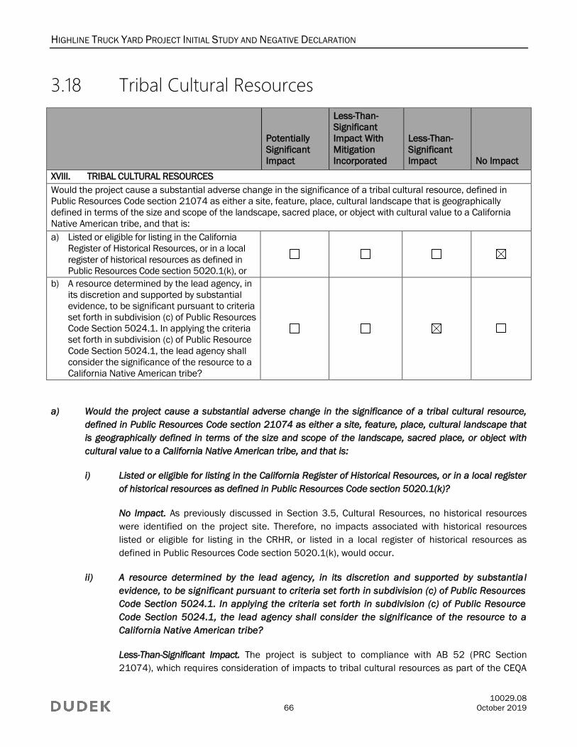
HIGHLINE TRUCK YARD PROJECT INITIAL STUDY AND NEGATIVE DECLARATION
10029.08
66 October 2019
3.18 Tribal Cultural Resources
Potentially
Significant
Impact
Less-Than-
Significant
Impact With
Mitigation
Incorporated
Less-Than-
Significant
Impact No Impact
XVIII. TRIBAL CULTURAL RESOURCES
Would the project cause a substantial adverse change in the significance of a tribal cultural resource, defined in
Public Resources Code section 21074 as either a site, feature, place, cultural landscape that is geographically
defined in terms of the size and scope of the landscape, sacred place, or object with cultural value to a California
Native American tribe, and that is:
a) Listed or eligible for listing in the California
Register of Historical Resources, or in a local
register of historical resources as defined in
Public Resources Code section 5020.1(k), or
b) A resource determined by the lead agency, in
its discretion and supported by substantial
evidence, to be significant pursuant to criteria
set forth in subdivision (c) of Public Resources
Code Section 5024.1. In applying the criteria
set forth in subdivision (c) of Public Resource
Code Section 5024.1, the lead agency shall
consider the significance of the resource to a
California Native American tribe?
a) Would the project cause a substantial adverse change in the significance of a tribal cultural resource,
defined in Public Resources Code section 21074 as either a site, feature, place, cultural landscape that
is geographically defined in terms of the size and scope of the landscape, sacred place, or object with
cultural value to a California Native American tribe, and that is:
i) Listed or eligible for listing in the California Register of Historical Resources, or in a local register
of historical resources as defined in Public Resources Code section 5020.1(k)?
No Impact. As previously discussed in Section 3.5, Cultural Resources, no historical resources
were identified on the project site. Therefore, no impacts associated with historical resources
listed or eligible for listing in the CRHR, or listed in a local register of historical resources as
defined in Public Resources Code section 5020.1(k), would occur.
ii) A resource determined by the lead agency, in its discretion and supported by substantia l
evidence, to be significant pursuant to criteria set forth in subdivision (c) of Public Resources
Code Section 5024.1. In applying the criteria set forth in subdivision (c) of Public Resource
Code Section 5024.1, the lead agency shall consider the signif icance of the resource to a
California Native American tribe?
Less-Than-Significant Impact. The project is subject to compliance with AB 52 (PRC Section
21074), which requires consideration of impacts to tribal cultural resources as part of the CEQA
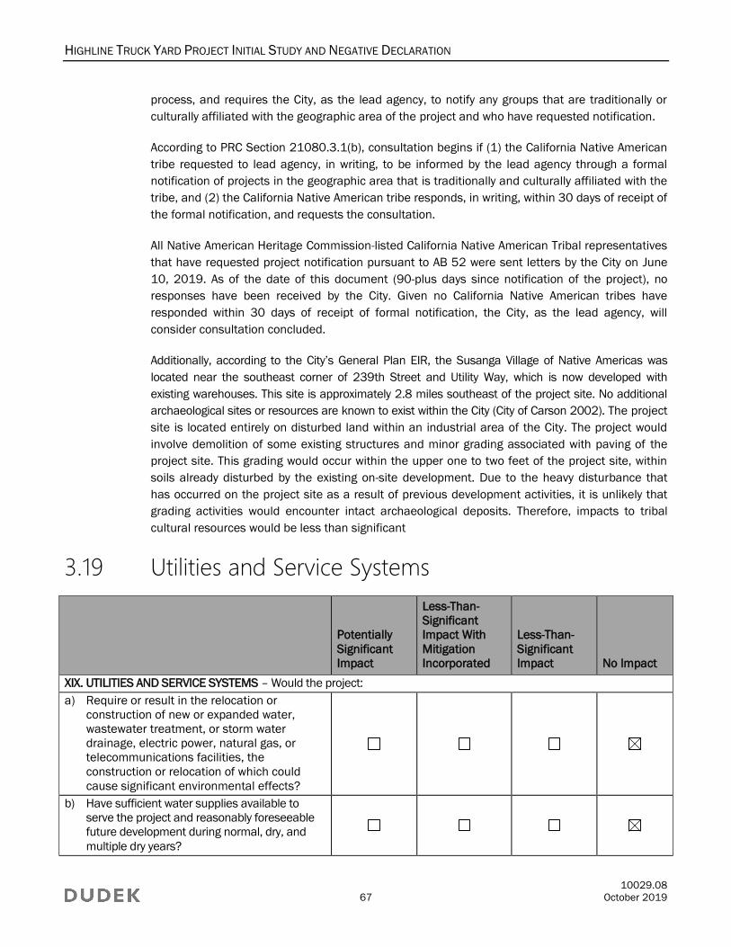
HIGHLINE TRUCK YARD PROJECT INITIAL STUDY AND NEGATIVE DECLARATION
10029.08
67 October 2019
process, and requires the City, as the lead agency, to notify any groups that are traditionally or
culturally affiliated with the geographic area of the project and who have requested notification.
According to PRC Section 21080.3.1(b), consultation begins if (1) the California Native American
tribe requested to lead agency, in writing, to be informed by the lead agency through a formal
notification of projects in the geographic area that is traditionally and culturally affiliated with the
tribe, and (2) the California Native American tribe responds, in writing, within 30 days of receipt of
the formal notification, and requests the consultation.
All Native American Heritage Commission-listed California Native American Tribal representatives
that have requested project notification pursuant to AB 52 were sent letters by the City on June
10, 2019. As of the date of this document (90-plus days since notification of the project), no
responses have been received by the City. Given no California Native American tribes have
responded within 30 days of receipt of formal notification, the City, as the lead agency, will
consider consultation concluded.
Additionally, according to the City’s General Plan EIR, the Susanga Village of Native Americas was
located near the southeast corner of 239th Street and Utility Way, which is now developed with
existing warehouses. This site is approximately 2.8 miles southeast of the project site. No additional
archaeological sites or resources are known to exist within the City (City of Carson 2002). The project
site is located entirely on disturbed land within an industrial area of the City. The project would
involve demolition of some existing structures and minor grading associated with paving of the
project site. This grading would occur within the upper one to two feet of the project site, within
soils already disturbed by the existing on-site development. Due to the heavy disturbance that
has occurred on the project site as a result of previous development activities, it is unlikely that
grading activities would encounter intact archaeological deposits. Therefore, impacts to tribal
cultural resources would be less than significant
3.19 Utilities and Service Systems
Potentially
Significant
Impact
Less-Than-
Significant
Impact With
Mitigation
Incorporated
Less-Than-
Significant
Impact No Impact
XIX. UTILITIES AND SERVICE SYSTEMS – Would the project:
a) Require or result in the relocation or
construction of new or expanded water,
wastewater treatment, or storm water
drainage, electric power, natural gas, or
telecommunications facilities, the
construction or relocation of which could
cause significant environmental effects?
b) Have sufficient water supplies available to
serve the project and reasonably foreseeable
future development during normal, dry, and
multiple dry years?
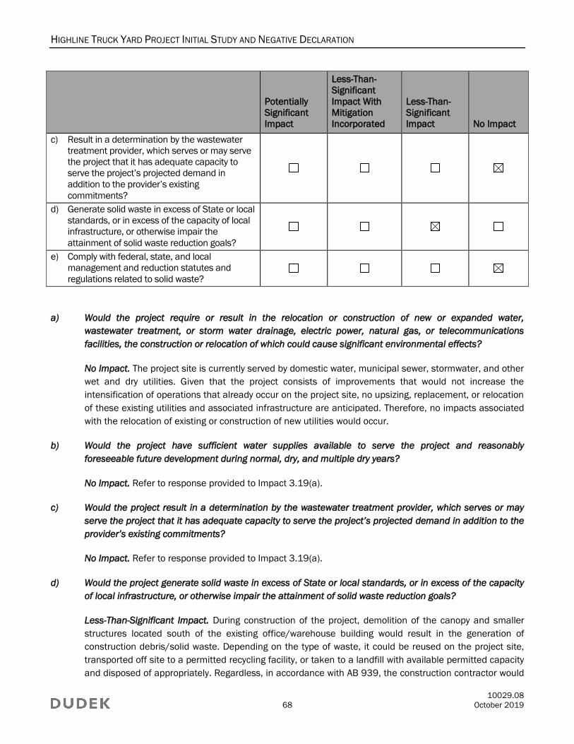
HIGHLINE TRUCK YARD PROJECT INITIAL STUDY AND NEGATIVE DECLARATION
10029.08
68 October 2019
Potentially
Significant
Impact
Less-Than-
Significant
Impact With
Mitigation
Incorporated
Less-Than-
Significant
Impact No Impact
c) Result in a determination by the wastewater
treatment provider, which serves or may serve
the project that it has adequate capacity to
serve the project’s projected demand in
addition to the provider’s existing
commitments?
d) Generate solid waste in excess of State or local
standards, or in excess of the capacity of local
infrastructure, or otherwise impair the
attainment of solid waste reduction goals?
e) Comply with federal, state, and local
management and reduction statutes and
regulations related to solid waste?
a) Would the project require or result in the relocation or construction of new or expanded water,
wastewater treatment, or storm water drainage, electric power, natural gas, or telecommunications
facilities, the construction or relocation of which could cause significant environmental effects?
No Impact. The project site is currently served by domestic water, municipal sewer, stormwater, and other
wet and dry utilities. Given that the project consists of improvements that would not increase the
intensification of operations that already occur on the project site, no upsizing, replacement, or relocation
of these existing utilities and associated infrastructure are anticipated. Therefore, no impacts associated
with the relocation of existing or construction of new utilities would occur.
b) Would the project have sufficient water supplies available to serve the project and reasonably
foreseeable future development during normal, dry, and multiple dry years?
No Impact. Refer to response provided to Impact 3.19(a).
c) Would the project result in a determination by the wastewater treatment provider, which serves or may
serve the project that it has adequate capacity to serve the project’s projected demand in addition to the
provider’s existing commitments?
No Impact. Refer to response provided to Impact 3.19(a).
d) Would the project generate solid waste in excess of State or local standards, or in excess of the capacity
of local infrastructure, or otherwise impair the attainment of solid waste reduction goals?
Less-Than-Significant Impact. During construction of the project, demolition of the canopy and smaller
structures located south of the existing office/warehouse building would result in the generation of
construction debris/solid waste. Depending on the type of waste, it could be reused on the project site,
transported off site to a permitted recycling facility, or taken to a landfill with available permitted capacity
and disposed of appropriately. Regardless, in accordance with AB 939, the construction contractor would

HIGHLINE TRUCK YARD PROJECT INITIAL STUDY AND NEGATIVE DECLARATION
10029.08
69 October 2019
ensure that source reduction techniques and recycling measures are incorporated into project
construction. Once operational, the project would not result in an increase in solid waste material
generated on the project site, given that the project consists of improvements that would not increase the
intensification of operations that already occur on site. Therefore, impacts associated with solid waste
disposal would be less than significant.
e) Would the project comply with federal, state, and local management and reduction statutes and
regulations related to solid waste?
No Impact. As discussed in Impact 3.19(d), in accordance with AB 939, the construction contractor would
ensure that source reduction techniques and recycling measures are incorporated into project
construction. Once operational, the project would not result in an increase in solid waste material
generated on the project site, given that the project consists of improvements that would not increase the
intensification of operations that already occur on-site. Therefore, no impacts associated with federal,
state, and local solid waste statutes and regulations would occur.
3.20 Wildfire
Potentially
Significant
Impact
Less-Than-
Significant
Impact With
Mitigation
Incorporated
Less-Than-
Significant
Impact No Impact
XX. WILDFIRE – If located in or near state responsibility areas or lands classified as very high fire hazard severity
zones, would the project:
a) Substantially impair an adopted emergency
response plan or emergency evacuation
plan?
b) Due to slope, prevailing winds, and other
factors, exacerbate wildfire risks, and
thereby expose project occupants to,
pollutant concentrations from a wildfire or
the uncontrolled spread of a wildfire?
c) Require the installation or maintenance of
associated infrastructure (such as roads, fuel
breaks, emergency water sources, power
lines, or other utilities) that may exacerbate
fire risk or that may result in temporary or
ongoing impacts to the environment?
d) Expose people or structures to significant
risks, including downslope or downstream
flooding or landslides, as a result of runoff,
post-fire slope instability, or drainage
changes?
HIGHLINE TRUCK YARD PROJECT INITIAL STUDY AND NEGATIVE DECLARATION
10029.08
70 October 2019
The California Department of Forestry and Fire Services (CAL FIRE) is responsible for designating fire hazard
severity zones (FHSZs) within the State Responsibility Area throughout California. FHSZs are geographical areas
with an elevated risk for wildfire hazard. The State Responsibility Area is the area for which the state assumes
financial responsibility for fire suppression and protection. CAL FIRE also creates recommended maps for very
high FHSZs within the Local Responsibility Area, which are then adopted, or modified and adopted, by local
jurisdictions. Development within a State Responsibility Area is required to abide by specific development and
design standards. A review of CAL FIRE’s FHSZ maps and data revealed that the project site is not located within
a State Responsibility Area or a very high FHSZ (CAL FIRE 2019). Further, the Los Angeles Fire Department Fire
Zone Map indicates that the project site is not located within an FHSZ as designated by the City (LAFD 2019).
Nonetheless, a response has been provided for the following threshold questions.
a) Would the project substantially impair an adopted emergency response plan or emergency evacuation plan?
No Impact. The majority of the area surrounding the project site is developed, and as a whole, the project
area lacks any lands considered wildlands or wildland–urban interfaces. According to CAL FIRE’s Fire
Hazard Severity Zones maps, the project site is neither moderately, highly, nor very highly susceptible to
wildland fire (CAL FIRE 2019). Therefore, no impacts associated with wildland fires would occur.
Therefore, no impacts associated with a wildfire would occur.
b) Due to slope, prevailing winds, and other factors, would the project exacerbate wildfire risks, and
thereby expose project occupants to, pollutant concentrations from a wildfire or the uncontrolled
spread of a wildfire?
No Impact. Refer to response provided to Impact 3.20(a).
c) Would the project require the installation or maintenance of associated infrastructure (such as roads,
fuel breaks, emergency water sources, power lines, or other utilities) that may exacerbate fire risk or that
may result in temporary or ongoing impacts to the environment?
No Impact. Refer to response provided to Impact 3.20(a).
d) Would the project expose people or structures to significant risks, including downslope or downstream
flooding or landslides, as a result of runoff, post-fire slope instability, or drainage changes?
No Impact. Refer to response provided to Impact 3.20(a).

HIGHLINE TRUCK YARD PROJECT INITIAL STUDY AND NEGATIVE DECLARATION
10029.08
71 October 2019
3.21 Mandatory Findings of Significance
Potentially
Significant
Impact
Less-Than-
Significant
Impact With
Mitigation
Incorporated
Less-Than-
Significant
Impact No Impact
XXI. MANDATORY FINDINGS OF SIGNIFICANCE
a) Does the project have the potential to
substantially degrade the quality of the
environment, substantially reduce the habitat
of a fish or wildlife species, cause a fish or
wildlife population to drop below self-sustaining
levels, threaten to eliminate a plant or animal
community, substantially reduce the number or
restrict the range of a rare or endangered plant
or animal or eliminate important examples of
the major periods of California history or
prehistory?
b) Does the project have impacts that are
individually limited, but cumulatively
considerable? (“Cumulatively considerable”
means that the incremental effects of a
project are considerable when viewed in
connection with the effects of past projects,
the effects of other current projects, and the
effects of probable future projects)?
c) Does the project have environmental effects
which will cause substantial adverse effects on
human beings, either directly or indirectly?
a) Does the project have the potential to substantially degrade the quality of the environment,
substantially reduce the habitat of a fish or wildlife species, cause a fish or wildlife population to drop
below self-sustaining levels, threaten to eliminate a plant or animal community, substantially reduce
the number or restrict the range of a rare or endangered plant or animal, or eliminate important
examples of the major periods of California history or prehistory?
Less-Than-Significant Impact. As previously discussed in detail in Section 3.4, Biological Resources, and
Section 3.5, Cultural Resources, the project would not result in significant impacts either to biological
resources or to archaeological resources, paleontological resources, and tribal cultural resources. Therefore,
the project would not degrade the quality of the environment, substantially reduce the habitat of a fish or
wildlife species, cause a fish or wildlife population to drop below self-sustaining levels, threaten to eliminate
a plant or animal community, reduce the number or restrict the range of a rare or endangered plant or
animal, or eliminate important examples of the major periods of California history or prehistory.

HIGHLINE TRUCK YARD PROJECT INITIAL STUDY AND NEGATIVE DECLARATION
10029.08
72 October 2019
b) Does the project have impacts that are individually limited, but cumulatively considerable?
(“Cumulatively considerable” means that the incremental effects of a project are considerable when
viewed in connection with the effects of past projects, the effects of other current projects, and the
effects of probable future projects)?
Less-Than-Significant Impact. As concluded throughout this IS/ND, the project would result in either no
impact or a less-than-significant impact with respect to all environmental impact areas outlined in the
CEQA Guidelines Appendix G Environmental Checklist. Cumulative impacts of several resource areas have
already been addressed in several resource sections: Section 3.3, Air Quality; Section 3.8, Greenhouse
Gas Emissions; Section 3.13, Noise; and Section 3.17, Transportation. CalEEMod was used to assess the
air quality and GHG emissions impacts resulting from the project, concluding less-than-significant
impacts. The noise analysis conducted as part of this IS/ND concluded that cumulative impacts would be
less than significant. The traffic assessment considered cumulative increases in traffic to be less than
significant. Some of the other resource areas (i.e., Section 3.1, Aesthetics; Section 3.2, Agricultural and
Forestry Resources; Section 3.10, Hydrology and Water Quality; Section 3.11, Land Use and Planning;
Section 3.12, Mineral Resources; Section 3.14, Population and Housing; Section 3.15, Public Services;
Section 3.16, Recreation; and Section 3.19, Utilities and Services Systems) were determined to have a
less-than-significant impact or no impact compared to existing conditions, and, thus, the project would
not contribute to cumulative impacts related to these environmental topics. Other issues areas (i.e.,
Section 3.5, Cultural Resources; Section 3.7, Geology and Soils; Section 3.9, Hazards and Hazardous
Materials; and Section 3.18, Tribal Cultural Resources) are by their nature site-specific, and impacts at
one location do not add to impacts at other locations or create additive impacts.
For all resource areas analyzed, the project’s individual-level impacts would be at less-than-significant levels,
which, in turn, would reduce the potential for these impacts to be considered part of any cumulative impact.
Therefore, the project would not result in individually limited but cumulatively considerable impacts.
c) Does the project have environmental effects which will cause substantial adverse effects on human
beings, either directly or indirectly?
Less-Than-Significant Impact. As evaluated throughout this document, the project would have no impact
or a less-than-significant impact with respect to all environmental impact areas. Therefore, the project
would not directly or indirectly cause substantial adverse effects on human beings.

10029.08
73 October 2019
4 References and Preparers
4.1 References Cited
14 CCR 15000–15387 and Appendices A through L. Guidelines for Implementation of the California
Environmental Quality Act, as amended.
ALUC (Airport Land Use Commission). 2019. GIS Interactive Map (A-Net). Accessed July 2, 2019.
http://planning.lacounty.gov/assets/obj/anet/Main.html.
CalEPA (California Environmental Protection Agency). 2019. “Cortese List: Section 65962.5(a).” Accessed June
16, 2019. https://calepa.ca.gov/sitecleanup/corteselist/section-65962-5a/.
CAL FIRE (California Department of Forestry and Fire Services). 2019. Fire Hazard Severity Zone Viewer. Accessed
June 16, 2019. http://egis.fire.ca.gov/FHSZ/.
California Public Resources Code, Section 21000–21177. California Environmental Quality Act, as amended.
Caltrans (California Department of Transportation). 2013. Transportation and Construction Vibration Guidance
Manual. Division of Environmental Analysis, Environmental Engineering, Hazardous Waste, Air, Noise,
Paleontology Office. September 2013.
Caltrans. 2019. California Scenic Highway Mapping System: Los Angeles County.
CAPCOA (California Air Pollution Control Officers Association). 2008. CEQA & Climate Change: Evaluating and
Addressing Greenhouse Gas Emissions from Projects Subject to the California Environmental Quality Act.
January 2008. Accessed September 2018. http://capcoa.org/wp-content/uploads/downloads/
2010/05/CAPCOA-White-Paper.pdf.
CAPCOA. 2017. CalEEMod Appendix E Technical Source Documentation. http://www.caleemod.com.
CARB (California Air Resources Board). 2014. First Update to the AB 32 Scoping Plan: Building on the Framework.
May 2014. Accessed March 2018. https://www.arb.ca.gov/cc/scopingplan/ 2013_update/first_update_
climate_change_scoping_plan.pdf.
CARB. 2017a. “Area Designation Maps/State and National.” Accessed March 2018. http://www.arb.ca.gov/
desig/adm/adm.htm.
CARB. 2017b. The 2017 Climate Change Scoping Plan Update. January 20, 2017. Accessed March 2018.
https://www.arb.ca.gov/cc/scopingplan/2030sp_pp_final.pdf.
City of Carson. 2002. City of Carson General Plan Environmental Impact Report. SCH no. 2001091120. Prepared by
RBF Consulting. October 30, 2002. http://ci.carson.ca.us/content/files/pdfs/planning/generalplan/EIR.pdf.
City of Carson. 2004. City of Carson General Plan. Adopted October 11, 2004.
http://ci.carson.ca.us/content/files/pdfs/planning/CityofCarsonGeneralPlan.pdf.
HIGHLINE TRUCK YARD PROJECT INITIAL STUDY AND NEGATIVE DECLARATION
10029.08
74 October 2019
City of Carson. 2019a. “Property Information System –Carson GIS.” Accessed May 24, 2019.
http://www.carsonproperty.info/.
City of Carson. 2019b. Carson Municipal Code. Current through March 19, 2019.
https://www.codepublishing.com/CA/Carson/.
CNRA (California Natural Resources Agency). 2009. Final Statement of Reasons for Regulatory Action:
Amendments to the State CEQA Guidelines Addressing Analysis and Mitigation of Greenhouse Gas
Emissions Pursuant to SB 97. December 2009. Accessed March 2018. http://resources.ca.gov/
ceqa/docs/Final_Statement_of_Reasons.pdf.
County of Los Angeles. 2019a. Los Angeles County Department of Regional Planning, GIS-NET3 Significant
Ecological Areas. Accessed June 12, 2019. http://rpgis.isd.lacounty.gov/GIS-NET3_Public/Viewer.html
County of Los Angeles. 2019b. “L.A. County’s Airport Land Use Commission Site.” Accessed March 6, 2019.
http://lacounty.maps.arcgis.com/apps/webappviewer/index.html?id=acf2e87194a54af9b266bf07547f240a.
Diehl, G.M. 1973. Machinery Acoustics. New York, New York: Wiley Interscience.
DOC (California Department of Conservation). 1982. “Mineral Land Classification Map Aggregate Resources Only- Long
Beach Quadrangle Special Report 143 Plate 4.21.” June 1, 1982. Accessed October 23, 2018.
ftp://ftp.consrv.ca.gov/pub/dmg/pubs/sr/SR_143/PartIV/Plate_4-21.pdf.
DOC. 2016a. California Important Farmland Finder. Accessed May 24, 2019. https://maps.conservation.ca.gov/
DLRP/CIFF/.
DOC. 2016b. “Los Angeles County Williamson ACT FY 2015/2016.” Accessed May 24, 2019. ftp://ftp.consrv.ca.gov/
pub/dlrp/wa/LA_15_16_WA.pdf.
DOT (U.S. Department of Transportation). 2018. Transit Noise and Vibration Impact Assessment Manual. DOT,
Federal Transit Administration. September 2018.
DTSC (Department of Toxic Substances Control). 2019a. “DTSC’s Hazardous Waste and Substances Site List –
Site Cleanup (Cortese List).” Accessed August 15, 2019. https://dtsc.ca.gov/dtscs-cortese-list/.
DTSC. 2019b. “Sites and Facilities.” EnviroStor Record for Fullerton College. Accessed August 15, 2019.
https://www.envirostor.dtsc.ca.gov/public/map/?myaddress=Search.
EPA (U.S. Environmental Protection Agency). 2011. Chapter 13: Miscellaneous Sources, Section 13.2.1 Paved
Roads. In Compilation of Air Pollutant Emission Factors, AP 42, 5th ed. Vol. I.
https://www3.epa.gov/ttn/chief/ap42/ch13/final/c13s0201.pdf.
EPA. 2018. “EPA Region 9 Air Quality Maps and Geographic Information.” Accessed March 2018.
http://www.epa.gov/region9/air/maps.
HIGHLINE TRUCK YARD PROJECT INITIAL STUDY AND NEGATIVE DECLARATION
10029.08
75 October 2019
FEMA (Federal Emergency Management Agency). 2008. FEMA Flood Map Service Center. Accessed May 21,
2019. https://msc.fema.gov/portal/search?AddressQuery=sun%20valley%20#searchresultsanchor.
FHWA (Federal Highway Administration). 2008. Roadway Construction Noise Model (RCNM), Software Version
1.1. U.S. Department of Transportation, Research and Innovative Technology Administration, John A.
Volpe National Transportation Systems Center, Environmental Measurement and Modeling Division.
December 8, 2008.
Goss, T. A., and A. Kroeger. 2003. White Paper on Potential Control Strategies to Address Cumulative Impacts
from Air Pollution. South Coast Air Quality Management District White Paper. August 2003. Accessed
March 2018. http://www.aqmd.gov/docs/default-source/Agendas/Environmental-Justice/cumulative-
impacts-working-group/cumulative-impacts-white-paper.pdf?sfvrsn=2.
IPCC (Intergovernmental Panel on Climate Change). 2007. IPCC Fourth Assessment Synthesis of Scientific-
Technical Information Relevant to Interpreting Article 2 of the U.N. Framework Convention on Climate
Change. Geneva, Switzerland: IPCC. Accessed October 2018. https://www.ipcc.ch/pdf/assessment-
report/ar4/syr/ar4_syr.pdf.
ITE (Institute of Transportation Engineers). 2012. Trip Generation Handbook, 9th Edition.
LAFD (Los Angeles Fire Department). 2019. Los Angeles Fire Department Fire Zone Map.
NETR ONLINE. 1972. “20915 Lamberton Avenue Carson, CA 90810.”Aerial photograph from 1972.
https://www.historicaerials.com/viewer.
NRHP (National Register of Historic Places). 2019. “Los Angeles County, Los Angeles, California.” Accessed March
19, 2019. https://npgallery.nps.gov/nrhp.
OEHHA (Office of Environmental Health Hazard Assessment). 2015. Air Toxics Hot Spots Program Risk
Assessment Guidelines: Guidance Manual for Preparation of Health Risk Assessments. February 2015.
Accessed March 2018. https://oehha.ca.gov/media/downloads/crnr/2015guidancemanual.pdf.
OHP (Office of Historic Preservation). 2015. “CEQA and the California Register Understanding the 50-year
Threshold.” CEQA Case Studies. September 2015. Accessed December 2017. http://ohp.parks.ca.gov/
pages/1071/files/VI%20Understanding%20the%2050-year%20Threshold.pdf.
OHP. 2019. “Listed California Historical Resources, Los Angeles County.” Accessed March 19, 2019.
http://www.ohp.parks.ca.gov/ListedResources/?view=county&criteria=19.
SCAG (Southern California Association of Governments). 2016. 2016–2040 Regional Transportation
Plan/Sustainable Communities Strategy: A Plan for Mobility, Accessibility, Sustainability, and a High
Quality of Life. Adopted April 2016. Accessed March 2018. http://scagrtpscs.net/Documents/
2016/final/f2016RTPSCS.pdf.
SCAQMD (South Coast Air Quality Management District). 1993. CEQA Air Quality Handbook.
SCAQMD. 2005. “Rule 403, Fugitive Dust.” Amended June 3, 2005. Accessed September 2018.
http://www.aqmd.gov/docs/default-source/rule-book/rule-iv/rule-403.pdf?sfvrsn=4.
HIGHLINE TRUCK YARD PROJECT INITIAL STUDY AND NEGATIVE DECLARATION
10029.08
76 October 2019
SCAQMD. 2008a. Final Localized Significance Threshold Methodology. Revised July 2008. Accessed September
2018. http://www.aqmd.gov/docs/default-source/ceqa/handbook/localized-significance-
thresholds/final-lst-methodology-document.pdf?sfvrsn=2.
SCAQMD. 2008b. Draft Guidance Document—Interim CEQA Greenhouse Gas (GHG) Significance Threshold.
October 2008. Accessed September 2018. http://www.aqmd.gov/docs/default-source/ceqa/
handbook/greenhouse-gases-(ghg)-ceqa-significance-thresholds/year-2008-2009/ghg-meeting-6/ghg-
meeting-6-guidance-document-discussion.pdf?sfvrsn=2.
SCAQMD. 2008c. “A Resolution of the Governing Board of the South Coast Air Quality Management District
(AQMD) approving the Interim Greenhouse Gas (GHG) Significance Threshold to Be Used by the AQMD for
Industrial Source Projects, Rules and Plans When It Is the Lead Agency for Projects Subject to the
California Environmental Quality Act (CEQA).” Resolution No. 08-35. Adopted December 5, 2008.
SCAQMD. 2010. “Greenhouse Gas CEQA Significance Threshold Stakeholder Working Group Meeting #15.”
September 28, 2010. PowerPoint slides. Accessed March 2018. http://www.aqmd.gov/
docs/default-source/ceqa/handbook/greenhouse-gases-(ghg)-ceqa-significance-thresholds/
year-2008-2009/ghg-meeting-15/ghg-meeting-15-main-presentation.pdf?sfvrsn=2.
SCAQMD. 2015. “SCAQMD Air Quality Significance Thresholds.” Originally published in CEQA Air Quality
Handbook, Table A9-11-A. Revised March 2015. Accessed March 2018. http://www.aqmd.gov/
docs/default-source/ceqa/handbook/scaqmd-air-quality-significance-thresholds.pdf?sfvrsn=2.
SCAQMD. 2017. Final 2016 Air Quality Management Plan. Accessed October 2017.
http://www.aqmd.gov/docs/default-source/clean-air-plans/air-quality-management-plans/2016-air-
quality-management-plan/final-2016-aqmp/final2016aqmp.pdf?sfvrsn=15.
SWRCB (State Water Resources Control Board). 2019. “Sites and Facilities.” GeoTracker Record for Fullerton
College. Accessed August 15, 2019. https://geotracker.waterboards.ca.gov/map/
?CMD=runreport&myaddress=Search+GeoTracker.
USDA (United States Department of Agriculture). 2019. Web Soil Survey. USDA Natural Resources Conservation Service,
Soil Survey Staff. Accessed June 19, 2019. https://websoilsurvey.sc.egov.usda.gov/App/WebSoilSurvey.aspx.
USFWS (United States Fish and Wildlife Service). 2019. National Wetlands Finder. Accessed June 12, 2019.
https://www.fws.gov/wetlands/Data/Mapper.html.
HIGHLINE TRUCK YARD PROJECT INITIAL STUDY AND NEGATIVE DECLARATION
10029.08
77 October 2019
4.2 List of Preparers
Dudek
Collin Ramsey, Project Manager
Sabrina Alonso, Environmental Analyst
Lilli Martin, Environmental Analyst
David Larocca, Air Quality Specialist
Mike Greene, Noise Specialist
Dennis Pascua, Transportation
Sabita Tewani, Transportation
Christopher Starbird, GIS Technician
Amy Seals, Senior Technical Editor
HIGHLINE TRUCK YARD PROJECT INITIAL STUDY AND NEGATIVE DECLARATION
10029.08
78 October 2019
INTENTIONALLY LEFT BLANK
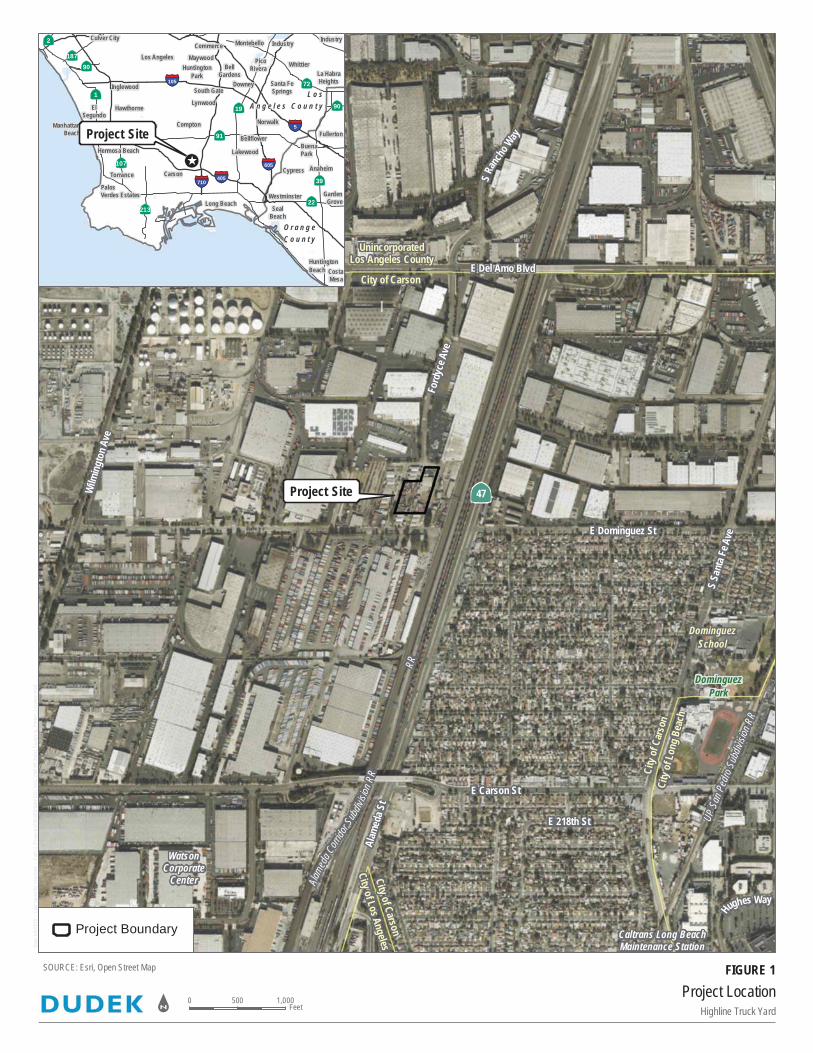
Date:
6/4/
2019
- L
ast s
aved
by:
cstar
bird
- P
ath: Z
:\Pro
jects\
j1002
908\
MAPD
OC\D
OCUM
ENT\
Initia
l_Stu
dy\F
ig_Pr
oject_
Loca
tion.m
xd
UnincorporatedLos Angeles County
UP S
an P
edro
Subd
ivisio
n RR
RR
Alame
daCo
rridor
Subd
ivisio
n RR
E Del Amo Blvd
Alam
eda S
t
S Sa
nta F
e Ave
Wilm
ingto
n Ave
SRa
ncho
Way
E Carson St
Hughes Way
Ford
yce A
ve
E 218th St
E Dominguez St
Ä47
DominguezSchool
Caltrans Long BeachMaintenance Station
WatsonCorporate
Center
DominguezPark
City
ofCa
rson
City
of Lo
ng B
each
City of Carson
City of Los Angeles
City of Carson
Project LocationHighline Truck Yard
SOURCE: Esri, Open Street Map
0 1,000500Feetn
Project Boundary
FIGURE 1
CostaMesa
HuntingtonBeach
Westminster
SealBeach
GardenGrove
Cypress Anaheim
BuenaPark
Fullerton
Lakewood
Long Beach
CarsonTorrance
ManhattanBeach
Bellflower
Gardena Compton
ElSegundo
Norwalk
HawthorneLynwood
South GateDowney Santa Fe
Springs
La HabraHeights
BellGardens
Inglewood
HuntingtonPark
MaywoodWhittier
Commerce
PicoRivera
Culver CityMontebello Industry Industry
PalosVerdes Estates
RedondoBeach
Hermosa Beach
Los Angeles
O r a n g eC o u n t y
L o sA n g e l e s C o u n t y
ÄÆ90
ÄÆ91
ÄÆ90
ÄÆ2
ÄÆ39
ÄÆ187
ÄÆ22
ÄÆ107
ÄÆ213
ÄÆ72
ÄÆ19
ÄÆ1
§̈¦5
§̈¦710
§̈¦605
§̈¦105
§̈¦405
Project Site
!(̂
Project Site

HIGHLINE TRUCK YARD PROJECT INITIAL STUDY AND NEGATIVE DECLARATION
10029.08
80 October 2019
INTENTIONALLY LEFT BLANK
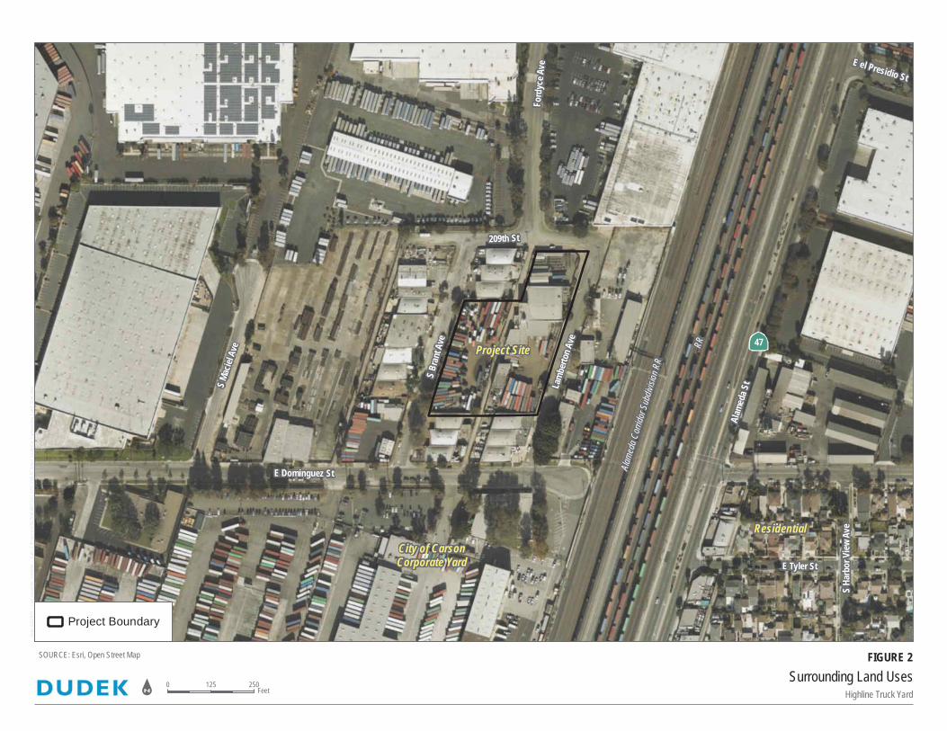
Date:
6/4/
2019
- L
ast s
aved
by:
cstar
bird
- P
ath: Z
:\Pro
jects\
j1002
908\
MAPD
OC\D
OCUM
ENT\
Initia
l_Stu
dy\F
ig_Su
rroun
ding_
Land
_Use
s.mxd
Alam
eda C
orrid
or S
ubdiv
ision
RR
RR
Alam
eda S
t
Ford
yceA
ve E el Presidio St
S Ha
rbor
View
Ave
209th St
S Ma
ciel A
ve
E Tyler StLa
mbe
rton A
ve
S Br
ant A
ve
E Dominguez St
Ä47
City of CarsonCorporate Yard
Residential
Project Site
Surrounding Land UsesHighline Truck Yard
SOURCE: Esri, Open Street Map
0 250125Feetn
Project Boundary
FIGURE 2

HIGHLINE TRUCK YARD PROJECT INITIAL STUDY AND NEGATIVE DECLARATION
10029.08
82 October 2019
INTENTIONALLY LEFT BLANK
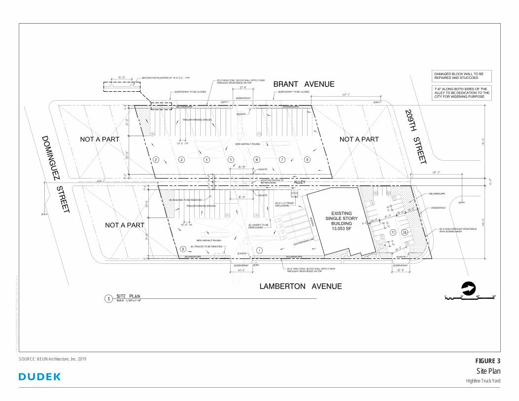
Site PlanHighline Truck Yard
FIGURE 3SOURCE: KEUN Architecture, Inc. 2019
Path:
Z:\P
rojec
ts\j10
0290
8\MAP
DOC\
DOCU
MENT
\Initia
l_Stud
y\Fig_
Site_
Plan
.ai [

HIGHLINE TRUCK YARD PROJECT INITIAL STUDY AND NEGATIVE DECLARATION
10029.08
84 October 2019
INTENTIONALLY LEFT BLANK
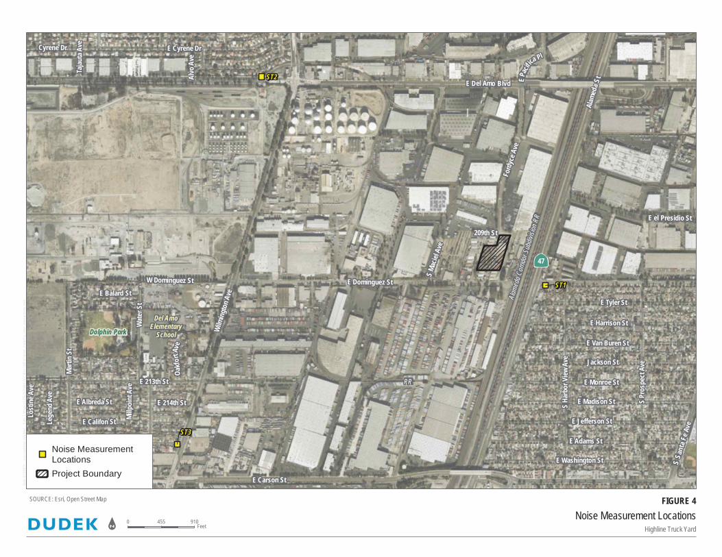
Date:
8/15
/201
9 -
Last
save
d by:
cstar
bird
- Pa
th: Z
:\Pro
jects\
j1002
908\
MAPD
OC\D
OCUM
ENT\
Initia
l_Stu
dy\F
ig_no
ise_m
easu
rmen
ts.mx
d Alam
eda C
orrid
or S
ubdiv
ision
RR
RR
E Del Amo Blvd
Alam
eda S
t
SSa
nta F
e Ave
Wilm
ingt
on A
ve
E Carson St
EPac
ific
a Pl
Ford
yce A
ve
Marti
n St
Alvo
Ave
E 214th St
209th St
Millp
oint
Ave
Oakf
ortA
ve
E Albreda St
S Ma
ciel A
ve
E Balard St
Tajau
ta A
veCyrene Dr
E Califon StLege
nd A
ve
Lost
ine A
ve
Wat
er S
t
W Dominguez St
E el Presidio St
E Tyler St
E Harrison St
E Van Buren St
Jackson St
E Monroe StE 213th St
E Adams St
E Jefferson St
E Washington St
E Madison StS Ha
rbor
View
Ave
S Pr
ospe
ct A
ve
E Cyrene Dr
E Dominguez St
Ä47
Del AmoElementary
SchoolDolphin Park
ST1
ST2
ST3
Noise Measurement LocationsHighline Truck Yard
SOURCE: Esri, Open Street Map
0 910455Feetn
Noise MeasurementLocations
Project Boundary
FIGURE 4

HIGHLINE TRUCK YARD PROJECT INITIAL STUDY AND NEGATIVE DECLARATION
10029.08
86 October 2019
INTENTIONALLY LEFT BLANK
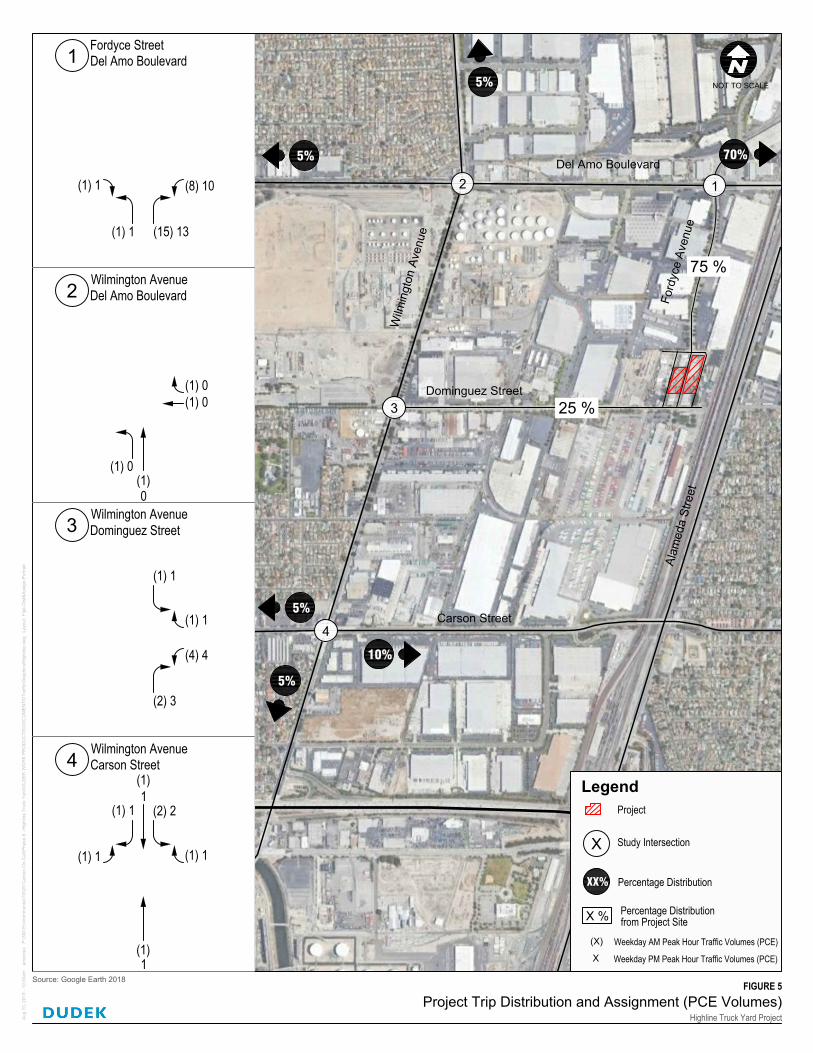
Dominguez Street
W
ilm
in
g
to
n
A
v
e
n
u
e
Del Amo Boulevard
F
o
r
d
y
c
e
A
v
e
n
u
e
Carson Street
1
4
A
la
m
e
d
a
S
tr
e
e
t
3
2
A
ug
1
3, 2
01
9 - 1
0:3
0a
m a
me
ro
ux P
:\3
00
.E
nviro
nm
en
ta
l\1
00
29
C
arso
n O
n-C
all\P
ha
se
8
- H
ig
hlin
e T
ru
ck Y
ard
\D
UD
EK
W
OR
K P
RO
DU
CT
S\D
OC
UM
EN
TS
\T
ra
ffic\G
ra
ph
ics\H
ig
hlin
e.d
wg
L
ayo
ut: F
ig
4-D
ist&
Assig
n-P
ortra
it
FIGURE 5Project Trip Distribution and Assignment (PCE Volumes)
Highline Truck Yard Project
Source: Google Earth 2018
NOT TO SCALE
Legend
Project
X
Study Intersection
75 %
25 %
Percentage Distribution X %
5%
5%
5%
5%
70%
from Project Site
Percentage DistributionXX%
10%
Fordyce StreetDel Amo Boulevard
(1) 1
(1) 1 (15) 13
(8) 10
1
(1) 1
1(1)
(1) 1
(2) 2
(1)1
(1) 1
Wilmington AvenueCarson Street4
Wilmington AvenueDominguez Street
(2) 3
(4) 4
(1) 1
(1) 1
3
Wilmington AvenueDel Amo Boulevard
(1) 0(1)
(1) 0(1) 0
2
0
(X)
X
Weekday AM Peak Hour Traffic Volumes (PCE)
Weekday PM Peak Hour Traffic Volumes (PCE)

HIGHLINE TRUCK YARD PROJECT INITIAL STUDY AND NEGATIVE DECLARATION
10029.08
88 October 2019
INTENTIONALLY LEFT BLANK