daily operations briefing - disaster centerdaily+ops+briefing+10-05-2014.pdf · typhoon 19w...
TRANSCRIPT
•Daily Operations Briefing Sunday, October 5, 2014
8:30 a.m. EDT

Significant Activity: Oct 4 - 5
Significant Events: Typhoon 19W (Vongfong)
Tropical Activity:
• Atlantic – Tropical Cyclone Activity is not expected during the next 48 hours
• Eastern Pacific – Hurricane Simon
• Central Pacific – No tropical cyclones expected through Monday night
• Western Pacific – Typhoon 19W (Vongfong)
Significant Weather:
• Scattered showers & thunderstorms –Southeast coastline to the Northeast
• Rain possible - Pacific Northwest & Great Lakes
• Hot temperatures & Santa Ana winds increasing fire danger across southern CA
• Red Flag Warnings: CA
• Space Weather: No significant activity
FEMA Readiness:
• Region IX RRCC activated to Level II
• Region IX RWC activated to enhanced watch
• NWC activated to enhanced watch

Western Pacific – Typhoon 19W (Vongfong)
Typhoon 19W (Vongfong) (Advisory 11A as of 7:00 am EDT)
• Located 160 miles E of Guam
• Moving WNW at 18 mph
• Maximum sustained winds are 105 mph (Cat 2 Typhoon)
• General motion is forecast to continue through Monday
• Vongfong will pass through the Southern Mariana Islands early Monday
morning
• Expected to intensify to a major typhoon within the next 24-36 hours
• Typhoon-force winds extend outward up to 35 miles
• Tropical storm-force winds extend outward up to 130 miles
• Typhoon Warning in effect for Guam, Rota, Tinian & Saipan
Potential Impacts:
• Rainfall amounts of 6 to 10 inches are possible
• Will produce significant runoff and produce flash floods
• Surf will become dangerous as the storm passes on Monday during high
tide - coastal inundation of 2 to 4 feet is possible
• Seas are expected to build to between 15 & 23 feet as Vongfong passes
through the islands
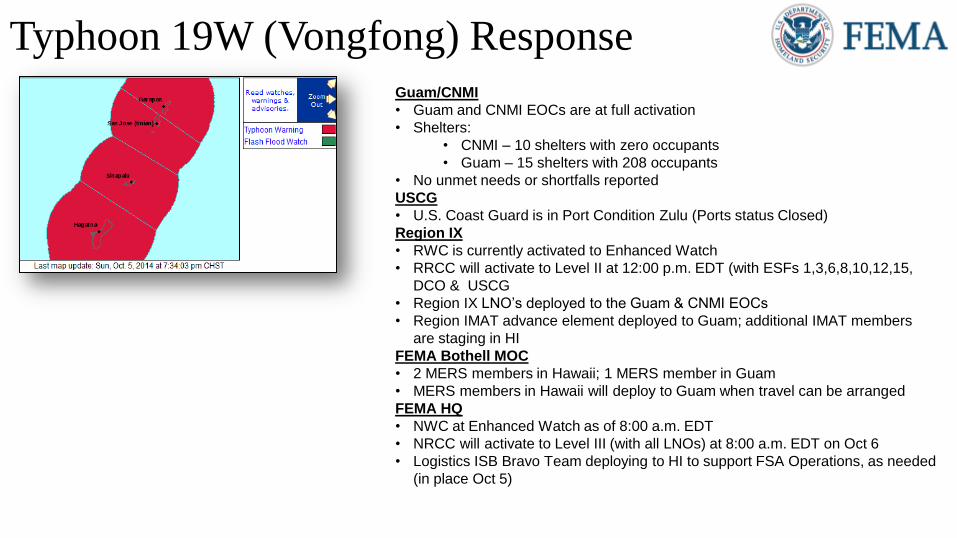
Typhoon 19W (Vongfong) Response Guam/CNMI
• Guam and CNMI EOCs are at full activation
• Shelters:
• CNMI – 10 shelters with zero occupants
• Guam – 15 shelters with 208 occupants
• No unmet needs or shortfalls reported
USCG
• U.S. Coast Guard is in Port Condition Zulu (Ports status Closed)
Region IX
• RWC is currently activated to Enhanced Watch
• RRCC will activate to Level II at 12:00 p.m. EDT (with ESFs 1,3,6,8,10,12,15,
DCO & USCG
• Region IX LNO’s deployed to the Guam & CNMI EOCs
• Region IMAT advance element deployed to Guam; additional IMAT members
are staging in HI
FEMA Bothell MOC
• 2 MERS members in Hawaii; 1 MERS member in Guam
• MERS members in Hawaii will deploy to Guam when travel can be arranged
FEMA HQ
• NWC at Enhanced Watch as of 8:00 a.m. EDT
• NRCC will activate to Level III (with all LNOs) at 8:00 a.m. EDT on Oct 6
• Logistics ISB Bravo Team deploying to HI to support FSA Operations, as needed
(in place Oct 5)

2-Day Tropical Outlook – Atlantic

2-Day Tropical Outlook – Eastern Pacific

Eastern Pacific – Hurricane Simon
Hurricane Simon (as of 5:00 a.m. EDT) (Cat 3)
• Located 435 miles west of the Southern tip of Baja California,
Mexico
• Moving WNW near 10 mph
• Maximum winds near 115 mph
• This general motion is expected to continue this morning
• A turn toward the North with a decrease in forward speed
expected tonight
• Significant weakening is forecast during the next 48 hours
• Hurricane-force winds extend outward up to 25 miles
• Tropical storm-force winds extend outward up to 90 miles
• There are no coastal watches or warnings in effect

2-Day Tropical Outlook – Central Pacific

Declaration Requests in Process Requests
APPROVED (since last report)
Requests DENIED
(since last report)
2 Date Requested 0 0
NM – DR Severe Storms and Flooding September 29, 2014
MT – DR Severe Storms and Flooding October 3, 2014
Disaster Requests & Declarations

Open Field Offices as of October 5

Joint Preliminary Damage Assessments
Region State /
Location Event IA/PA
Number of Counties Start – End
Requested Complete
VII MO Severe Storms
September 9-10, 2014 PA 20 (+3) 9 9/29 – 10/7

http://www.hpc.ncep.noaa.gov/national_forecast/natfcst.php
National Weather Forecast Day 1
Day 1 Day 1

http://www.hpc.ncep.noaa.gov/qpf/day1-3.shtml
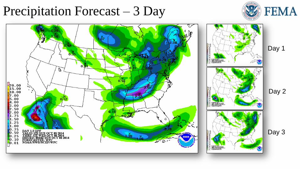
Precipitation Forecast – 3 Day
Day 1
Day 2
Day 3
http://water.weather.gov/ahps/forecasts.php
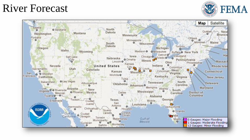
River Forecast
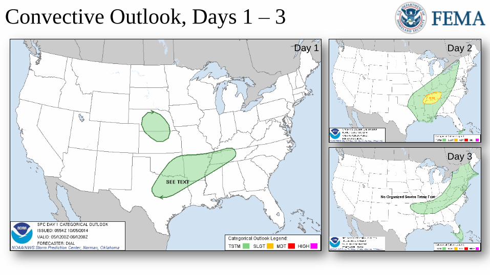
Convective Outlook, Days 1 – 3
Day 1 Day 2
Day 3
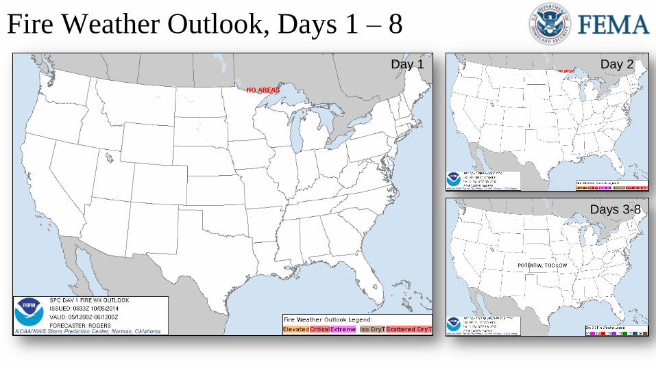
Fire Weather Outlook, Days 1 – 8
Day 1 Day 2
Days 3-8

http://www.swpc.noaa.gov/drap/global.html
NOAA Scales Activity (Range: 1/minor to 5/extreme)
Past
24 Hours Current
Next
24 Hours
Space Weather Activity: None None None
• Geomagnetic Storms None None None
• Solar Radiation Storms None None None
• Radio Blackouts None None None
Space Weather
Sunspot Activity
http://spaceweather.com/
HF Communication Impact
Updated Global D-Region Absorption Prediction
Graphic Unavailable

FEMA Readiness – Deployable Teams /Assets
Deployable Teams/Assets
Resource Status Total FMC
Available
Partially
Available
Not
Available
Detailed
Deployed
Activated
Comments Rating Criterion
FCO 40 15 38% 17 2 6 OFDC Readiness:
FCO Green Yellow Red
Type 1 3+ 2 1
Type 2 4+ 3 2
Type 3 4 3 2
FDRC 3 2 1 FDRC
10 5 50% 0 0 5
US&R
28 24 86% 1* 3 0
• NE-TF1 (Red - Exercise until Oct 10)
• MO-TF1 (Red - Exercise until Oct 10)
• NM-TF1 (Red - Personnel shortages)
• CA-TF1 (Yellow - Logistics & management
*personnel available for deployment)
• Green = Available/FMC
• Yellow = Available/PMC
• Red = Out-of-Service
• Blue = Assigned/Deployed
National IMAT
3 3 100% 0 0 0
• Green: 3 avail
• Yellow: 1-2 avail
• Red: 0 avail (Individual N-IMAT red
if 50% of Section Chiefs and/or
Team Leader is unavailable for
deployment.)
Regional IMAT
13 6 46% 2 2 3
Partially Mission Capable (PMC):
• Region III, VI
Not Mission Capable (NMC):
• Region V, IX-1
Deployed
• Region X to WA, Region IX-2 to CA; Region
IX-1 to Guam/CNMI
• Green: 7 or more avail
• Yellow: 4 - 6 teams available
• Red: > 8 teams
deployed/unavailable
R-IMAT also red if TL Ops/Log Chief
is unavailable and has no qualified
replacement.
MCOV
60 57 95% 0 3 0
• Green = 80 – 100% avail
• Yellow = 60 – 79% avail
• Red = 59% or below avail
• Readiness remains 95%

FEMA Readiness – National/Regional Teams
National/Regional Teams
Resource Status Total Available Partially
Available
Not
Available
Deployed/
Activated Comments Rating Criterion
NWC
5 5 100% 0 0 24/7 Enhanced Watch 8:00 am EDT
October 5, 2014
• Green = FMC
• Yellow = PMC
• Red = NMC
NRCC
2 344 89% 0 44 Not Activated Will transition to Level III 24/7
8:00 am EDT, October 6, 2014
HLT
1 N/A N/A 0 1 Activated
DEST
Not Activated
RRCCs
10 9 90% 0 0 1 Region IX RRCC to Level II
5:00 am PDT, October 5
RWCs/MOCs
10 10 100% 0 0 24/7 Region IX at Enhanced Watch
