dan chalmers Æ a framework for contextual mediation in ...mss/papers/puc-8-1.pdf · a framework...
TRANSCRIPT
ORIGINAL ARTICLE
Dan Chalmers Æ Naranker Dulay Æ Morris Sloman
A framework for contextual mediation in mobile and ubiquitouscomputing applied to the context-aware adaptation of maps
Received: 20 March 2003 / Accepted: 30 September 2003 / Published online: 15 January 2004� Springer-Verlag London Limited 2004
Abstract Context has many aspects, which may varywidely, such as the device, environment and user. Theperception of data in different contexts also varieswidely. We present a new, flexible approach to meetingneeds and limits arising from context: contextual medi-ation. In this paper limits are defined as goals overmanaged system resources. These can be met by theselection of data, taking into account preferences over itssemantic and syntactic properties. The specification ofthis selection is presented in detail and the supportingframework is described. We illustrate our descriptionwith examples from a context-aware map applicationand present experimental results and experiences whichdemonstrate that contextual mediation enhances theusability of the application in restrictive contexts of use.
Keywords Context awareness Æ Contextual mediation ÆMap adaptation Æ Specification of adaptation
1 Introduction
In ubiquitous computing [1] a wide variety of deviceswill be in regular use by many people. Many of thesedevices will suffer limitations which will impact theusers’ perception of the data presented: their form factoroften limits screen size in favour of portability, user in-put devices lose fine control in favour of robustness andbattery life is improved by lowering CPU power,reducing memory size and limiting network connectivity.For laptops and kiosks the limitations may not be assevere as for mobile phones and PDAs in all respects butwill still have an impact on use. Current solutions todevice limitations tend towards support for a smallrange of specific devices.
Context extends beyond the device capabilities. Thetasks to which devices are applied, e.g., tourism ormaking deliveries, affects levels of interest in types ofinformation such as museums and house numbers.Activities engaged in while using the device, e.g., drivingor talking, affects the amount of information which canbe interpreted and the user’s interest in types of infor-mation such as traffic conditions. Environmental con-ditions, e.g. background noise or lighting, affects howeasily certain media types can be understood.
A general solution to these problems, taking in thewider definition of context, seems desirable—as we dis-cussed in [2]. Managing a wide range of contexts requiresa sophisticated approach able to differentiate beyond themost restrictive situations and ideal conditions. Much ofthe data offered in response to a request is likely to be oflittle value and there will often be more data availablethan the user could interpret or the device being usedcould display, e.g., a request for a map of a given areamay return data about many features. Some of this datamay be generic, such as roads; some will be of limitedappeal, e.g., traffic levels, shop prices and house num-bers; and some will be generated dynamically to meetspecific needs, e.g. transcoding images for use on aspecific screen or translating text language.
Contextual mediation operates by selecting the mostappropriate subset of the offered data in order to satisfya request. This is a form of application-aware adapta-tion [3] and the principle was mentioned in early workon context awareness [1,4] but has received little detailedtreatment in the literature. Different users, in differentcontexts, will have differing preferences. Mediation mustbe able to differentiate between useful and unwanteddata (with many degrees in between) and use this dif-ferentiation to meet goals, such as timely delivery, screenspace availability and price limits. Contextual mediationis the process of making this selection, which is distinctfrom any transcoding being performed on the data.
The term mediation is also used in database andinformation retrieval research to describe a componentwhich performs integration of data frommultiple sources
D. Chalmers (&) Æ N. Dulay Æ M. SlomanDepartment of Computing, Imperial College London,South Kensington Campus, London SW7 2AZ, UKE-mail: [email protected]
Pers Ubiquit Comput (2004) 8: 1–18DOI 10.1007/s00779-003-0255-6
and presentation to the user. This function may also bepart of the contextual mediation framework, as selectingamongst alternative representations of data fromdifferent sources may be considered. We do not addressissues of searching, format conversion or ontologicaltranslation here.
The range of devices and the contexts in which theyare applied will constantly be expanding; therefore, it isundesirable for content providers to support multipleversions of their content, or application designers toproduce many versions of a program, each adjusted to asmall range of devices or users. A mechanism for generalspecification of requirements for mediation is nee-ded—this is the core issue addressed in this paper. Inparticular, these specifications must be able to encode asophisticated response to variation in many aspects ofthe context, including screen, network speed, a user’stask, etc.
Our approach is to provide a generic framework fordescribing how to select the most appropriate data for acontext, which maintains a separation between theapplication and mediation. We use context aspects toselect the most appropriate profiles which specify therequired mediation rather than trying to cater to allpossible context variations. This also has the benefit thatconflicting profiles will be resolved in a consistentmanner.
To summarise, we are interested in an approach tothe selection of data which improves the usability ofdata in a wide range of contexts. Our approach is gen-eral and flexible, supporting improvements in the rangeof contexts responded to and in the response which theuser requires. At the same time, the user is to be shieldedfrom the complexity of specifying this behaviour, whichwe abstract as context-enabled profiles. The selectionforms part of a framework, which includes datadescription and resource management.
1.1 Requirements for a frameworkfor contextual mediation
The requirements for our framework for contextualmediation are as follows:
– Flexible context specific profiles capable of describinga wide range of user and system level needs and lim-itations. Profile composition to enable independentprofiles, activated by different aspects of context, todescribe needs over the same data. Profile specifica-tions that are declarative and can be directly executed.
– A metadata model which captures the structure,attributes and semantics of the data. An object-ori-ented model of semantic types to support this isdesirable. Profile specifications should be orthogonalto the data model.
– Provision of resource management in order to workwithin dynamic system limits or shared resources.Resource management will enable limitations to be
reported and provide admission control functions toenable goals to be met.
– Application independent mechanisms for profilespecification, metadata and resource management arerequired to allow a general framework to be applied.The mechanism for applying mediation should beapplication-aware in order to operate within theapplication’s interaction semantics.
2 Case study
One class of applications which are clearly applicable toubiquitous computing and contextual mediation is thedisplay of maps. We use this as a case study to motivateour examples. Earlier work by us in this area is describedin [5].
Map data can be extended with many media typesbeyond the traditional 2D representation of topology, c.f.[6]. A wide range of media and classes of features ofvarying utility can be offered to describe an area. Ourtechniques are generally applicable to many other appli-cations, e.g., Web browsing and news services. The stan-dard vector map formats available provide data with arich structure typical of many emerging media standards,e.g., MPEG-4 and the many XML encodings, makingthe techniques described applicable over other media.
Consider a user with the following context: a networkof 3.6kB/s and 100ms latency, a screen of 400 · 400pixels; and a task of navigating in a car on business. Ajourney into central London is being undertaken. Alocation service will predict the area the user is likely toneed to know about for the next few minutes and willnotify the map application. The application will displaya map of that area. As the journey progresses towards itsdestination the context of use changes: the speed de-creases as the driver leaves major roads, and the areacovered by each map decreases as the navigation be-comes more detailed and immediate rather thaninvolving long distance planning.
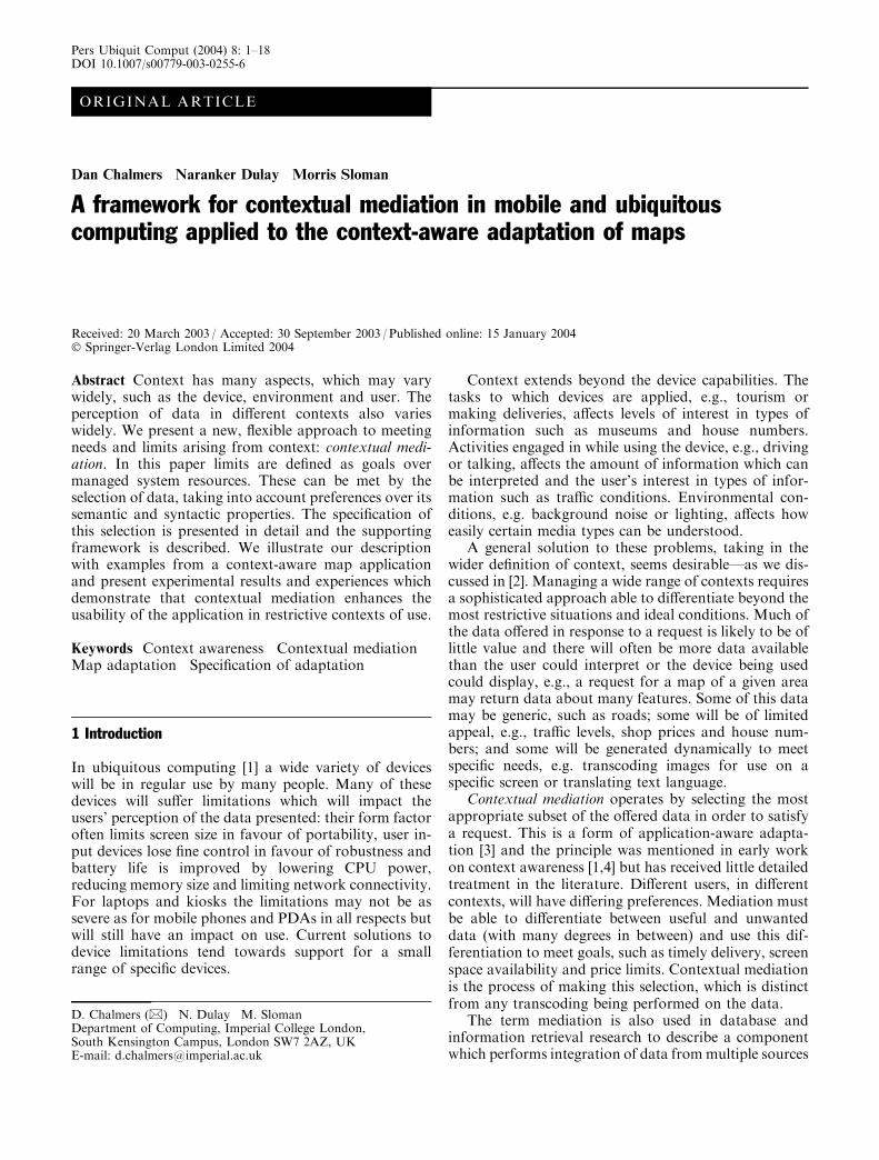
In Fig. 1 we present a sequence of maps which wouldbe presented by the application towards the end of thisjourney. On the left we show mediated maps; on theright the same map areas are shown with no mediation.It can be seen that the unmediated map is rather clut-tered in the early stages of use, and that the inclusion ofunnecessary features obscures some detail and adds tothe information to be interpreted (even if it is then ig-nored). We also see from the notes of time taken(including the metadata loading for the mediated maps)that the mediated maps take less time and a more con-sistent time; the first two unmediated maps take longerthan the given deadline to load (the first map almostdouble that time).
These maps illustrate the zooming in (row 1 to 2)required in order to allow small detail to be shownclearly. This is a similar principle to moving from a roadatlas to a town centre street map. At some point, withany rendering technique or data format, changing the
2
level of detail which is effective requires a change in thescale of the map. Changes in scale may be a deliberatechoice for the user as they have such a substantial effecton the interpretation of the map, or come from a loca-tion service.
Road names are included in the data we downloadbut are not rendered here. In maps at this scale roadnames would have to be drawn so small as to be hard toread and would add to clutter on more detailed maps.This clutter and hard-to-read text can often be seen onprinted city centre street maps. The maps our applica-tion produces are still useful for navigation as much of
this process is in the interpretation of symbols and thegraph of roads. Specific road names can be madeavailable when appropriate. For instance, on selection ofan area a small set of road names may be drawn, e.g.,describing roads at a junction. In this case, font size andlayout limitations are rather less strenuous and read-ability is substantially improved. This is preferable tozooming in for cases where a wider view of the roadnetwork and other features aids route planning. Thisapproach is similar to that in the paper world wherelarge scale maps generally do not name small features,while town plans name each road but their scale forcesthe focus onto a smaller location.
Modern in-car navigation systems provide cleardirections for a driver already. Our research is address-ing a different need: the flexible provision of maps formany purposes. While in-car systems provide usabledirections, they do not support a more open-ended‘‘browsing’’ style of map use, for instance, allowing ad-hoc detours to local attractions. When arriving at adestination a system which supports dynamic data maystart to show parking places based on cost, which are ofno interest for most of the journey. If a passenger wasnavigating using a PDA then the map can be carriedoutside the car and start to provide data relevant to apedestrian. While we may aspire to the drawing qualityof commercial map systems we are interested in whichdata are shown rather than the rendering itself.
3 An overview of the mediation process
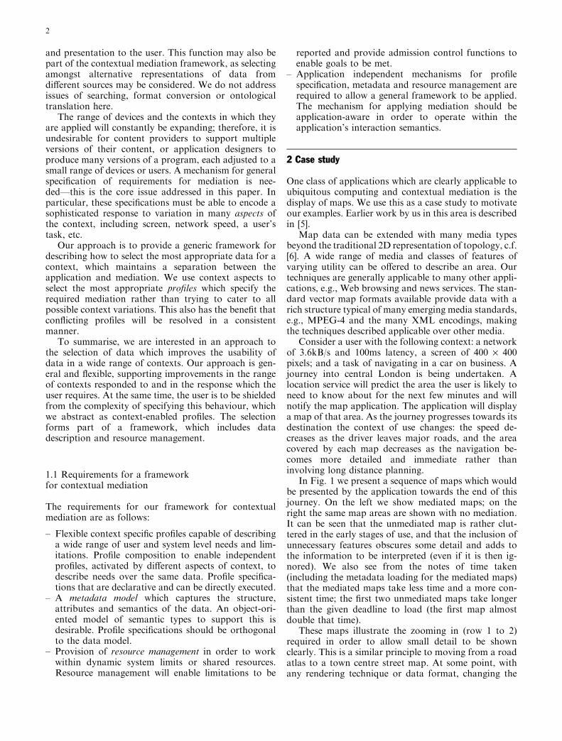
The flow of the application’s mediated request for datais illustrated in Fig. 2. A location service causes a newmap area to be requested by the application. First,metadata (see Sect. 4) describing the available data forthat area are loaded. The current context descriptionenables profiles which are used to rate the data offered(see Sect. 5). Resource management holds descriptionsof the network and screen. The rating allows the medi-ation system to make the best selection of a subset of the
Fig. 2 The flow of operations inthe mediated map application.Solid lines (1 to 6) show theapplication flow. Broken lines(a to e) show the interactionssupporting contextualmediation
Fig. 1 An example journey. Left-hand mediated, right-handunmediated. All have a 3.6kB/s network, and a 400 · 400 pixelscreen
3

data, taking resource considerations into account.The selected map data is then requested and displayed.The map data loading is monitored and used to updatethe network resource model.
3.1 An overview of profile specifications
Profiles allow the description of needs and limitationsarising from context. We shall introduce the form of thespecification of a profile although we shall address thedetails later on. Firstly, we define a specification and giveit a name, for convenience here ‘‘car_moderate_speed’’.This profile specifies needs arising from travel at a cer-tain speed.
The profile starts with a context matching function(M). The profile is enabled when the context aspect‘‘speed’’ is sensed as being between 21 and 45 mph. In allfunctions the keyword ‘‘value’’ on the right-hand siderefers to the value of the parameter on the left-hand side.We then describe limits arising from the context (G).Speed of travel limits the time available to downloadmap data. This may be due to the location predictionfunction. Here we specify that the map should be dis-played within 25 seconds of receiving the location pre-diction. In order to meet this deadline it may be thatsome map data has to be degraded or omitted. We useutility functions (U) to describe preferences amongst thedata, firstly, over elements of the map with differentsemantic content. We specify here that roads are themost important elements in the map, but that minorroads are less important. The third function takes dis-tance as a parameter and indicates that minor roadsclose to the point of interest are more important thanthose further away. Finally, we use a utility function todescribe preferences for different representations ofroads, according to their scale. It is likely that a certainlevel of detail is best for navigation in this context. Moredetail may well be lost or distracting at speed. Less detailmay not describe small turns in the road which thenavigator would find useful.
The differentiation according to both semantics anddata attributes allows a degradation of the data to bemade in a manner which is sensitive to the context. Inthis way the goals are met with minimum impact on theuser. Note that we describe the user’s perception of datarather than the technical process leading to the data.Transcoding proxies, etc., are assumed to exist in theubiquitous infrastructure and offer data which can fulfilthe user’s needs. The impact on a user is our metric ofsuccess, rather than maximising resource use. In Sect. 5we shall expand on these definitions and provide furtherexamples.
4 Describing data to mediate
A wide range of data may be offered in response to arequest for a map of an area. This may include differentfeatures, survey scales, prices, encodings, etc. In order tosupport the mediation of data, a description of the datawhich are offered is required. We describe our use ofmetadata more fully in [7] but summarise the conceptsbelow.
The response to a request we call a document. Adocument may be an area of map, a Web page, etc. Thesemantic structure of a document is described byelements. Elements are instances of a semantic type. In amap a feature would be described as an element, e.g., theriver Thames, the M1, which would take types of riverand road. Our type system allows elements to takemultiple types, e.g., a building which is both shops andhousing. The types are structured through specialisation,e.g., a ‘‘motorway’’ is a subtype of ‘‘road’’.
The data realising the document we refer to as vari-ants. A variant may provide a realisation of one or moreelements. Each separate data item which encodes arepresentation of some element(s) is called a variant,e.g., describing a given road at different scales or indifferent data formats.
In addition to typing, further description is requiredin metadata to support mediation. Both elements andvariants may have attributes describing their properties.Map elements may be described by their location.Variants have attributes which describe the data, such assize in bytes and scale.
We expect data to be structured. Elements may bestructured to reflect semantic dependency between ele-ments, such as building names requiring a definition ofthe building to be meaningful. Elements may be groupedin order to collect similar semantic data together,reducing the overhead of metadata. Variants are struc-tured to reflect dependencies in data, such as commonheader data used by many variants.
In Fig. 3 we illustrate in UML the relationship be-tween documents, elements and variants, while Fig. 4illustrates two different representations of a section ofthe river Thames. All elements have a variant corre-sponding to omission which may be selected, shown as athird variant here.
Our metadata model is based on [8]. Contextualmediation may be applied independently of metadataencodings, although the separation of elements andvariants and the use of semantic typing are important inour work. We use a simple ‘‘general type:specific type’’syntax for clarity with a common encoding of typesbetween the metadata source and mediator. Work onontologies and the semantic web [9] may replace ourtype system in the future.
We use a GZipped NTF vector map data in our pro-totype, but our approach does not depend on this in anyway, although vector map data is more amenable tomediation than raster data. Modifying encoding and
4

compression alters the data volume, CPU and memoryrequirements for processing and rendering the data. Thesechanges do not alter the need for mediation techniques.
Metadata may include descriptions of tailored dataproduced by device specific proxies and arbitrary trans-coding produced by general purpose proxies. The inten-tion is that while specific support for devices or tasksmay not always exist, it may be used when available.
5 Specifying mediation
In order to make effective selections to support contex-tual mediation, we need to be able to measure perceivedquality. We have to first define which elements are usefuland which variants of these elements would be the bestfor a specific context, while omitting unwanted elements.
In the case where the combined resource requirements ofthe best variants exceed our resource limits (derivedfrom the goals), we have to make the best selectionbased on the following criteria: which elements are mostimportant, which variants are acceptable and how muchdegradation the alternative variants cause and whetherusing them would help meet the resource limits.
An arbitrary decision is unlikely to be the most sat-isfactory and simply addressing the resource constraintcannot be expected to provide a coherent or satisfactoryselection from the user’s perspective. We now describethe profile specifications, which enable contextualmediation by allowing this differentiation betweenalternative elements and variants to be made.
5.1 Utility functions to select amongst elements
The response of users to different semantic types areencoded by associating a utility with the type, e.g., todescribe a preference for displaying information aboutroads rather than rivers. The utility is normalised be-tween zero (no interest) and one (the most interesting/important type of data). The following value assignmentdefine the default utility for any type (‘‘*’’) to be 0.4, forroads to be 0.85 and for motorways to be 0.8. Utilitiesfor the most specific subtype of the element type areapplied, e.g., a utility for ‘‘motorway’’ would be appliedrather than that for ‘‘road’’ where the element to berated is a motorway.
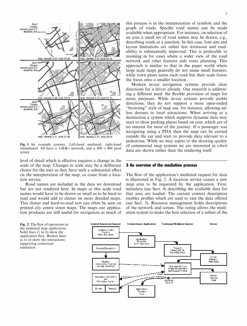
The description above illustrates the use of a staticvalue assigned to elements of a given type. In many casesthis is sufficient and clear. However, for some cases thepreferences encoded may be adjusted due to attributes ofthat element. For instance, a railway station closer to thecentre of interest may be deemed more interesting thanone farther away. In this case it is useful to be able tomodify the utility of the elements to reflect this. This isillustrated in Fig. 5, where preferences for buildings,major and minor roads at different distances are illus-trated. Here we show minor roads as rapidly becoming
Fig. 4 An example element andvariants
Fig. 3 Metadata for maps
5
less important with distance, while an indication ofbuildings remains more important. Major roads remainthe most important features at all distances, possiblyreflecting preferences arising from navigating at highspeed or at some distance from the final destination.
The effect of an element’s attribute on the perceptionof different types of element can be reflected by the use ofdifferent functions. Different attributes and semantictypesmay give rise to different utility functions, the first ofwhich we expand in-line to illustrate a discrete function:
Note that throughout, ‘‘value’’ on the right-hand sideof a function refers to the value of the parameter on theleft-hand side. For the first two functions above this isthe distance of the element from the point of interest.The application of different functions to an element iscontrolled by the ‘‘type.attribute’’ selection on the left-hand side so different functions are selected for theattribute ‘‘distance’’ for different types of element.
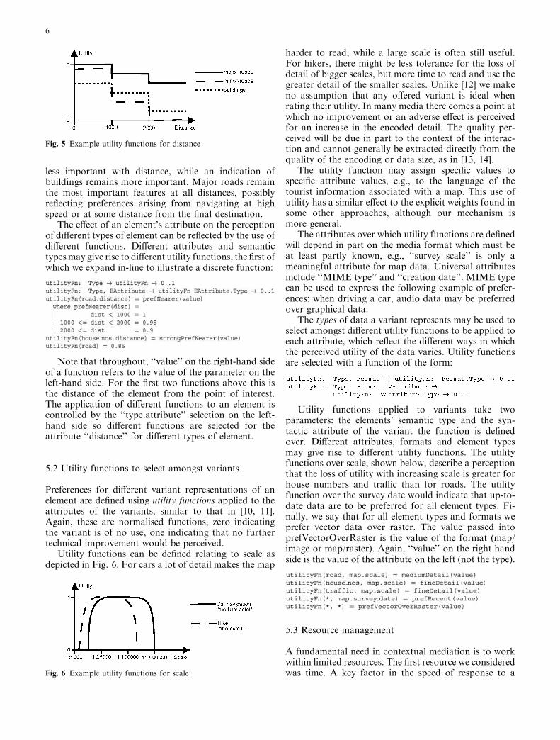
5.2 Utility functions to select amongst variants
Preferences for different variant representations of anelement are defined using utility functions applied to theattributes of the variants, similar to that in [10, 11].Again, these are normalised functions, zero indicatingthe variant is of no use, one indicating that no furthertechnical improvement would be perceived.
Utility functions can be defined relating to scale asdepicted in Fig. 6. For cars a lot of detail makes the map
harder to read, while a large scale is often still useful.For hikers, there might be less tolerance for the loss ofdetail of bigger scales, but more time to read and use thegreater detail of the smaller scales. Unlike [12] we makeno assumption that any offered variant is ideal whenrating their utility. In many media there comes a point atwhich no improvement or an adverse effect is perceivedfor an increase in the encoded detail. The quality per-ceived will be due in part to the context of the interac-tion and cannot generally be extracted directly from thequality of the encoding or data size, as in [13, 14].
The utility function may assign specific values tospecific attribute values, e.g., to the language of thetourist information associated with a map. This use ofutility has a similar effect to the explicit weights found insome other approaches, although our mechanism ismore general.
The attributes over which utility functions are definedwill depend in part on the media format which must beat least partly known, e.g., ‘‘survey scale’’ is only ameaningful attribute for map data. Universal attributesinclude ‘‘MIME type’’ and ‘‘creation date’’. MIME typecan be used to express the following example of prefer-ences: when driving a car, audio data may be preferredover graphical data.
The types of data a variant represents may be used toselect amongst different utility functions to be applied toeach attribute, which reflect the different ways in whichthe perceived utility of the data varies. Utility functionsare selected with a function of the form:
Utility functions applied to variants take twoparameters: the elements’ semantic type and the syn-tactic attribute of the variant the function is definedover. Different attributes, formats and element typesmay give rise to different utility functions. The utilityfunctions over scale, shown below, describe a perceptionthat the loss of utility with increasing scale is greater forhouse numbers and traffic than for roads. The utilityfunction over the survey date would indicate that up-to-date data are to be preferred for all element types. Fi-nally, we say that for all element types and formats weprefer vector data over raster. The value passed intoprefVectorOverRaster is the value of the format (map/image or map/raster). Again, ‘‘value’’ on the right handside is the value of the attribute on the left (not the type).
5.3 Resource management
A fundamental need in contextual mediation is to workwithin limited resources. The first resource we consideredwas time. A key factor in the speed of response to aFig. 6 Example utility functions for scale
Fig. 5 Example utility functions for distance
6

request is the network and server latency and through-put. Given an estimate of expected network and datacharacteristics the total time required to serve a set ofrequests can be estimated. The mediation process maythen be able to limit the data requested in order to (at-tempt to) meet a deadline. Our network model, which isnot described in detail, maintains a model of the roundtrip time and throughput by instrumenting data loads(rather than creating measurement traffic) [15]. It is tunedto provide stability in the face of minor changes and alsoan agile response to major changes in performance andhas similarities to that in [16, 17] but is implemented atthe application level. A time-sliced bandwidth reserva-tion system provides admission control.
We have also been working on a model of how datadisplay consumes screen space. For a given screen res-olution, different data may be appropriate in order toavoid the need to scroll to view the complete rendering.Where a screen is physically smaller or has low resolu-tion a given rendering may become harder to read. Mapsmay also include hyperlinks but the accuracy of selectionneeds to be considered—it may be desirable to limit thenumber of links under a finger-tip to an easy choice.Where the ambient light falling on the screen is bright orthe screen is vibrating the display may become harder toread. By controlling the density of data displayed on thescreen readability can be improved. We have a model ofthe estimated use of pixels in areas of the screen. Theestimated pixel use comes from metadata describingmap features, and the application describes the size ofthe drawing area available and the rendering to be used.We divide the screen into sub-areas in order to considerlocalised feature density on the screen. We refer to‘‘screen density’’ in this paper, which is a metric for theexpected use of a sub-area of the screen in renderingdata. A higher density indicates more information beingpresented in a given screen area.
5.4 Goal functions
We have goals, or constraints, on modelled resources tobe applied over the whole document retrieval, but wemake no guarantees that they will be met. We have usedgoal functions for download deadline, maximum datadensity on screen and maximum cost in the map appli-cation to date. A goal may be represented in a similarway to utility functions:
It is also possible to define goals as functions in termsof other values known during the selection process(which we treat as context aspects here). For example,we know the area of the map requested. If the goal is afunction of the map area then a selection containingdata which can be cached and reused later (e.g., afterzooming in) may be given longer to download. Similarly,
a high speed may limit the download time (by reducingany fixed deadline).
5.5 Executing specifications
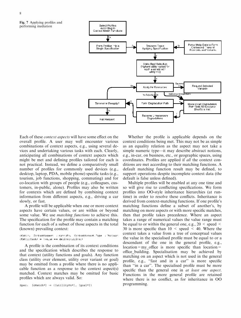
We will not discuss selection mechanisms in detail in thispaper. However, we assume that the overall flow ofinteractions is similar to that in Fig. 2. Initially, all ele-ments with a non-zero utility will have their highestutility variant selected. Where goals are defined but thereis a resource shortfall the selection process follows analgorithm which treats differing elements according totheir utilities, and selects amongst the variants of eachelement according to their utilities. The algorithmmaximises the perceived utility to the user, within theresources available given the goals. We provide anoverview of the application of a profile to form aselection in Fig. 7. Here we illustrate the profile beingapplied to the metadata and the selections being made.The degradation path will reflect the utilities of the data,such that the least important data will be offered fordegradation first. This is by selecting the lower utilityvariants of elements, including a zero utility omissionvariant. Each element is represented by exactly one se-lected variant in any data request.
An alternative to a fixed selection would be to use thedegradation path to provide an order for a sequence ofrequests. However, we did not follow this approachbecause the overheads (fromprocessing, requestmessagesand header data) increase for each request dispatched;also a model of the network would still be required inorder to calculate the last request which may be made(especially where long round trip times are experienced).Additionally, if the map is drawn incrementally (so itshows the most important elements first) it may not beclear to the user which drawings are incremental andwhich show the final data, as the map would tend to buildin patches (due to grouped features and an associationwith regional header data) as well as in layers of differingutility features.
Our selection mechanism is located on the client side,along with resource models, context state models, profilemanagement and vector map rendering. This simplifiessome issues such as proxy discovery, privacy, etc., forour prototype. In the general case the selection (or otherfunctions) may be performed on proxies in the networkwhere this is appropriate, e.g., where the client has aslow last-hop network, or is limited in processing poweror memory.
5.6 Profiles for context
As discussed in [14, 18] there is a need to deliver data at aquality which enables the user to perform his task in thegiven context. Aspects of context include: location,speed of movement, task, activity and screen size [19].
7
Each of these context aspects will have some effect on theoverall profile. A user may well encounter variouscombinations of context aspects, e.g., using several de-vices and undertaking various tasks with each. Clearly,anticipating all combinations of context aspects whichmight be met and defining profiles tailored for each isnot practical. Instead, we define a comparatively smallnumber of profiles for commonly used devices (e.g.,desktop, laptop, PDA, mobile phone) specific tasks (e.g.,tourism, job functions, shopping, commuting) and forco-location with groups of people (e.g., colleagues, cus-tomers, in-public, alone). Profiles may also be writtenfor contexts which are defined by combining contextinformation from different aspects, e.g., driving a carslowly, or fast.
A profile will be applicable when one or more contextaspects have certain values, or are within or beyondsome value. We use matching functions to achieve this.The specification for the profile may contain a matchingfunction for each of a subset of those aspects in the total(known) prevailing context:
A profile is the combination of its context conditionsand the specification which describes the response tothat context (utility functions and goals). Any functionclass (utility over element, utility over variant or goal)may be omitted from a profile where there is no appli-cable function as a response to the context aspect(s)matched. Context matches may be omitted for basicprofiles which are always valid. So:
Whether the profile is applicable depends on thecontext conditions being met. This may not be as simpleas an equality relation as the aspect may not take asimple numeric type—it may describe abstract notions,e.g., in-car, on business, etc., or geographic spaces, usingcoordinates. Profiles are applied if all the context con-ditions are met according to their matching functions. Adefault matching function result may be defined, tosupport operations despite incomplete context data (thedefault is false unless defined).
Multiple profiles will be enabled at any one time andso will give rise to conflicting specifications. We formprofiles into OO-style inheritance hierarchies (at run-time) in order to resolve these conflicts. Inheritance isderived from context-matching functions. If one profile’smatching functions define a subset of another’s, bymatching on more aspects or with more specific matches,then that profile takes precedence. Where an aspecttakes a range of numerical values the value range mustbe equal to or within the general one, e.g., 20 < speed <30 is more specific than 10 < speed < 40. Where thecontext takes a value from a tree of conceptual valuesthe value in the specialised profile must be equal to or adescendant of the one in the general profile, e.g.,location=my_office is more specific than location=office_building. Specialisation may be achieved bymatching on an aspect which is not used in the generalprofile, e.g., ‘‘fast and in a car’’ is more specificthan ‘‘in a car’’. The specialised profile must be morespecific than the general one in at least one aspect.Functions in the more general profile are retainedwhere there is no conflict, as for inheritance in OOprogramming.
Fig. 7 Applying profiles andperforming mediation
8
In the map application we apply mediation to meetdownload deadlines and screen density limits. The useof utilities allows us to control feature inclusion, whichis the main effect used in meeting goals. We do seesome variation in variants but the effect is subtle inmost cases. To illustrate the reflection of contextualneeds and limitations, consider the following profiles,which are extracts from those in use in our prototypeapplication, presented without XML mark-up.
5.6.1 Tasks
Profiles can be used to specify the preferences arisingfrom tasks. A driver making deliveries might require aprofile specifying that they are most interested in roads,then in house numbers nearby (by the combination ofutility functions over null and distance) and somewhatinterested in traffic conditions.
We have also developed a tourist task which illus-trates differing needs to those when on business. Thisincludes a strong interest in tourist features, parks, etc.,some interest in footpaths and a certain willingness topay for data. Depending on the total cost of the dataselected some may be omitted. Based on this specifica-tion footpath elements would be the first to be lost.Where different variants have different costs a degra-dation may be used rather than omission.
A profile may be specialised for sub-classes of anaspect. For instance, a driver making deliveries is aspecialisation of business, inheriting any functions itdoes not override. A general profile relating to businessmay be defined, which may form a base profile for many
different work-related tasks. This profile may specify anexpress disinterest in tourist features (no variant of theseelements will be selected even where goals do not limitthe selection) and a price threshold which is greater thanfor a tourist.
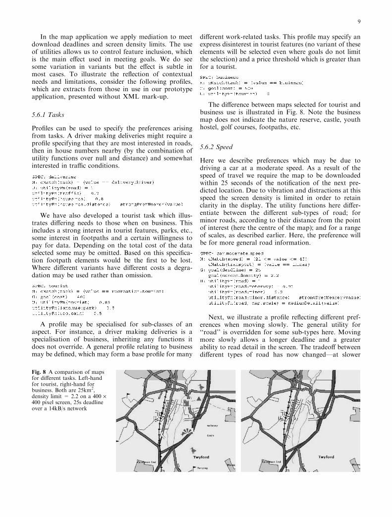
The difference between maps selected for tourist andbusiness use is illustrated in Fig. 8. Note the businessmap does not indicate the nature reserve, castle, youthhostel, golf courses, footpaths, etc.
5.6.2 Speed
Here we describe preferences which may be due todriving a car at a moderate speed. As a result of thespeed of travel we require the map to be downloadedwithin 25 seconds of the notification of the next pre-dicted location. Due to vibration and distractions at thisspeed the screen density is limited in order to retainclarity in the display. The utility functions here differ-entiate between the different sub-types of road; forminor roads, according to their distance from the pointof interest (here the centre of the map); and for a rangeof scales, as described earlier. Here, the preference willbe for more general road information.
Next, we illustrate a profile reflecting different pref-erences when moving slowly. The general utility for‘‘road’’ is overridden for some sub-types here. Movingmore slowly allows a longer deadline and a greaterability to read detail in the screen. The tradeoff betweendifferent types of road has now changed—at slower
Fig. 8 A comparison of mapsfor different tasks. Left-handfor tourist, right-hand forbusiness. Both are 25km2,density limit = 2.2 on a 400 ·400 pixel screen, 25s deadlineover a 14kB/s network
9
speeds, minor roads nearby become more importantthan motorways. Similarly, the utility function overscale for roads now reflects a need for more detail.
Figure 1 illustrates maps for use at different speeds.The effect of utility functions on minor roads is visible,and the comparison with the unmediated map shows theexclusion of elements to meet time and screen densityconstraints.
5.6.3 Activity
We do not assume that the computer is the focus of allattention in ubiquitous computing. Profiles may reflectthe impact of activities performed at the same time asusing the system. One may define activities such aspassenger or driver as specialisations of in-car naviga-tion. An extract from the on-foot profile is shown below.The longer deadline and higher screen density allow theinclusion of far more detail. We also describe a strongerinterest in paths and railway stations than when driving.
5.6.4 Screen size
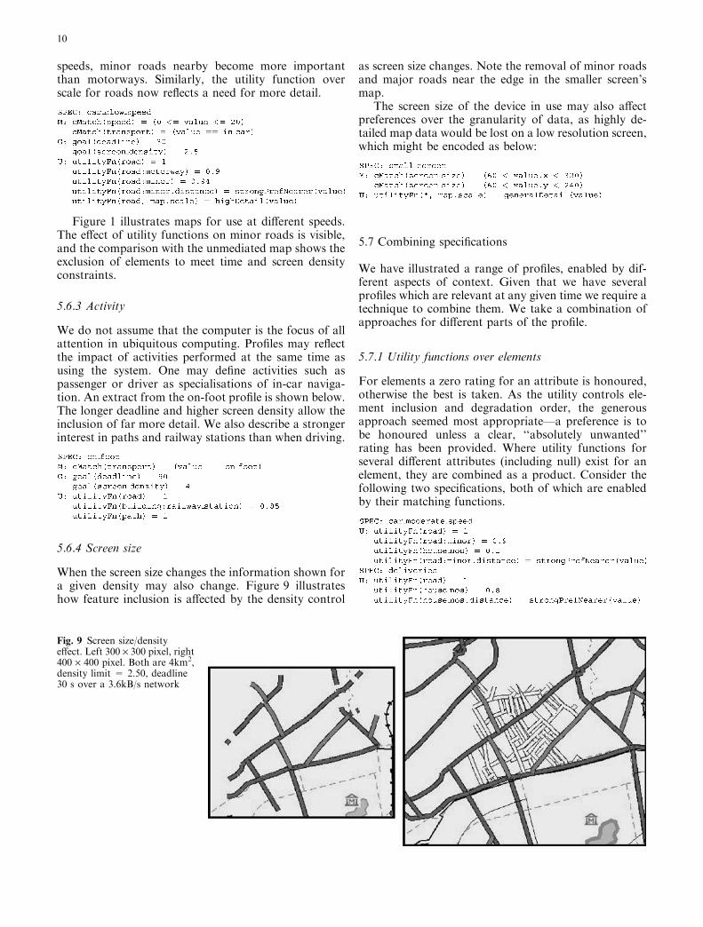
When the screen size changes the information shown fora given density may also change. Figure 9 illustrateshow feature inclusion is affected by the density control
as screen size changes. Note the removal of minor roadsand major roads near the edge in the smaller screen’smap.
The screen size of the device in use may also affectpreferences over the granularity of data, as highly de-tailed map data would be lost on a low resolution screen,which might be encoded as below:
5.7 Combining specifications
We have illustrated a range of profiles, enabled by dif-ferent aspects of context. Given that we have severalprofiles which are relevant at any given time we require atechnique to combine them. We take a combination ofapproaches for different parts of the profile.
5.7.1 Utility functions over elements
For elements a zero rating for an attribute is honoured,otherwise the best is taken. As the utility controls ele-ment inclusion and degradation order, the generousapproach seemed most appropriate—a preference is tobe honoured unless a clear, ‘‘absolutely unwanted’’rating has been provided. Where utility functions forseveral different attributes (including null) exist for anelement, they are combined as a product. Consider thefollowing two specifications, both of which are enabledby their matching functions.
Fig. 9 Screen size/densityeffect. Left 300 · 300 pixel, right400 · 400 pixel. Both are 4km2,density limit = 2.50, deadline30 s over a 3.6kB/s network
10
The combined utility functions for the types road,road:minor and house-nos are:
5.7.2 Utility functions over variants
For variants, all the applicable functions for an attributeare combined by product. Any zero utility result willclearly override all other values. The lower value that agreater number of products (of values between 0 and 1)tends to give is not a problem as the utility is used todifferentiate between variants realising one element. Allvariants will have the same functions applied to them, sothe effect will be consistent. Where the variants havediffering numbers of attributes some normalisation maybe necessary. Consider the following two specifications,both of which are enabled by their matching functions:
The combined utility functions for the parametermap.scale on types road and * (all other types) are:
5.7.3 Goal functions
For goals, we take the lowest value for each resource andparameter. This will then reflect any limitations in time,cost, screen space, etc. which are being described. Wheregoal functions with different parameters are available fora resource we sum the minimum goals for each parame-ter. We give some feedback on the goals applied, for in-stance, a timing ‘‘progress’’ bar shows progress towardsthe deadline, advancing each second rather than withdata loading. Consider the following two specifications,both of which are enabled by their matching functions:
The combined goal for the parameter deadline is:
5.8 Notes on profile design
In developing our application and specifications andperforming tests we have found various specificationswhich are not as desirable as they might initially seem.When we define utility functions taking distance from a
point of interest as a parameter we use step functions,which has the effect of grouping elements of a type inconcentric circles around the point of interest. A con-tinuous function led to almost all elements taking adifferent utility. As we treat elements of the same utilitytogether in adaptation this led to confusion over loss ofinformation. Where elements of a type are grouped theirinclusion or omission is clearer (particularly in the caseof roads). Where each is treated separately absence (inreality) and omission (due to mediation) are harder todifferentiate between in the final map, e.g., a small roadin a dense network can be removed and go unnoticeduntil it is met in reality. A similar issue occurred whenwe considered using feature size (from their boundingbox as described in metadata) to affect inclusion. Whilethis may be sensible for some types of element it can alsolead to spurious differentiation.
When using distance-related utility functions it is alsoimportant to consider the interaction between elements.Including minor and major roads at the centre of a mapbut not including major roads at the next distance outmay not be desirable. Distance functions must considerthe useful range of the type of elements, in the case ofmajor roads the distance steps should be much largerthan for minor roads.
Some features which are not immediately relevant arenonetheless useful navigation markers. Railways andrivers are useful features to knowaboutwhen driving evenif the driver has no intention of taking a train or boat.
We do not expect non-technical end users to writethese profiles. Profiles are intended to be predefined andenabled automatically in response to sensed context andcould be provided by specialists, from user studies, and auser might tune parameters. We expect that a base set ofspecifications would be devised as part of the applicationdevelopment or as standards used by multiple applica-tions addressing the same domain. As new devices,sensed contexts and tasks emerge, new specificationsmay be added to support these. Similarly, we have notconsidered profiles which respond to user feedback. Theacquisition of user reactions to maps was beyond thescope of our work and is of questionable applicabilitywhere the use of the device is not the user’s main focus ofattention. In any case, our profiles could be modified byuser feedback if this was desired.
Automatic adaptation raises the issues of expectationand surprise for the user [20, 21]. If the system decidedthat the context had changed and made dramaticchanges to the mediation specifications, as a result theuser may find that the map is unexpectedly different incharacter from one request to the next. This needs to betreated as for any other user impacting behaviour: thereis a need for predictability and/or transparency. Weaddress this in five ways:
– Where the specifications reflect user context then adramatic change in context could reasonably lead to adramatic change in specifications—cause and effectare then perceived.
11
– Rather than having a specification for fast and anotherfor slow a series of specifications reflecting smallchanges in speed would avoid dramatic changes inbehaviour. By ensuring that the specifications reflectsmall changes in context as small changes in behaviourthe impact of these small variations will be reduced.
– Some contexts or resources, such as networkthroughput, will vary slightly from request to requestwithout any reason that the average user will perceive.Specifications need to provide sufficiently fine grainedselection choices that minor resource fluctuations canbe accommodated subtly. Appropriate use of cachesmay also be of benefit here.
– User interface tools may be used to prepare the userfor changes and build expectations. For instance,changes in deadline can be indicated using a progressbar and changes in scale can be indicated by drawing ascale bar. Where the changed aspect of context is asystem level issue, such as network characteristics thenother indications (such as a coloured link quality icon)would be appropriate.
– Our application has a second window which providesinformation on the current context, enabled specifica-tions, the network model, etc. A curious user, or onewho has been surprised by an unexpected change inbehaviour, could look at this interface to betterunderstand changes in application behaviour. In somecases these interfaces also allow the user to overrideincorrectly sensed context values. The application alsohas controls for reloading data (and we plan to add onefor loading more data by repeating the downloaddeadline with existing metaddata) which should aidrecovery from poor selections by the mediation system.
5.9 Applicability to other application domains
We have performed some initial experiments with Webpages and found that contextual mediation may be ofbenefit. However, it requires that the tasks beingundertaken and semantics of the data are well under-stood. It is therefore most applicable as a tool overcertain sites or where the Web is used as an interface toan application or pages containing well-defined types ofdata. Mediation may offer a framework for standardeffects such as modifying text version and image selec-tion depending on screen visibility, etc. We describeexamples of contextual mediation of Web pages in [7,15]. Its applicability to general Web browsing requires asophisticated ontology and corresponding specificationswhich have been beyond our research scope so far.
Contextual mediation may also be applied to appli-cations such as news alert services. The flow of interac-tions would be rather different, but similar techniquesshould be applicable. The semantic content of newsstories may be used in providing utilities. Differentutilities may lead to different levels of notification. Dif-ferent representations of a news story may be applicable:
depending on the level of interest, other activities beenundertaken, the device being used, etc.
6 Experience
6.1 User studies
We performed an initial study into users’ reactions to themaps which our system generated. The map applicationdeveloped had some technical, HCI and data distribu-tion limitations which would have made an extensiveuser test with the application difficult. We chose insteadto take example maps which demonstrated the media-tion being applied and provided them printed on cardsto a small group of users (14 people). This enabled us tomake a preliminary study of the reaction to maps atthese sizes and compare reactions to mediated andunmediated maps.
The maps used in the survey were printed at 100dpi,which is approximately the pixel pitch of LCD screensused in the classes of devices represented. The card mapstherefore had dimensions similar to those of a PDAscreen. Control maps were produced where no media-tion was performed. The control maps were saved as aJPEG with a compression set such that the image filetook approximately the same size as the NTF data tookwhen GZIPPed. The intention was to simulate a proxyresponding only to system limitations: the image wasdelivered at the correct pixel size and the download timewould be within the deadline. The effect of networkdelay and benefits of predictable delay could then beignored in our test. The map data set was quite basic, forinstance, contours, house numbers and traffic restric-tions were not present.
We gave the subjects a series of three of the test maps:large and small mediated maps and a control map (eitherlarge or small). The context used in generating the mapswas in-car, as a tourist at 30 mph. For each situation,they were asked to put themselves in the context ofnavigating in a car (the scale is similar to or larger than aroad atlas, so the maps would be most appropriate for apassenger as the navigator) and to describe the routetaken between marked points. Features used to identifyplaces were to be described. The actual route taken wasnot noted, but the time taken to describe each was no-ted. A qualitative judgement of how easy the map was touse was also taken. The order varied with the controlbeing first in half the cases, the small mediated map firstin the other half. As the maps essentially took the formof road maps lack of familiarity was not considered tobe a big problem although the trend was to speed upslightly by the third map. The change of order was de-signed to counter this effect.
The first and most striking result of the timings wasthe variation in times taken to describe routes—therange of times was five to 64 seconds. All subjectswere consistently fast or slow in broad terms. To make
12
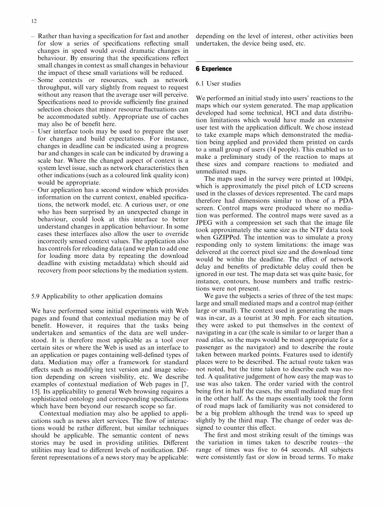
general comparisons the timings needed normalisation.We took the difference between the mediated map andthe unmediated map and divided this by the unmediatedmap time. This then gives the proportion of the timetaken by which the mediated map is faster or slower touse. We present the mean, 10th and 90th percentiles inFig. 10 on the horizontal axis. A negative value indicatesthat the mediated map was faster. The vertical axis ofFig. 10 gives a qualitative score, calculated from theresponse to the subjective questions. A higher scoreindicates a subjective preference for the mediated mapover the unmediated map.
The horizontal axis of Fig. 10 shows us that the largemediated map was faster (11%) to use on average thanthe unmediated map, while the small mediated map wasslightly slower (7%). In fact, in both cases nine of the 14subjects recorded faster times with the mediated map. Inthe case of the small map the high mean and 90th per-centile comes from three subjects who were much slower.The range of absolute times for the large map was alsosubstantially less than for the small map, reflecting ageneral preference for the larger map. In cases where themediated map was found to be slower it was slower by asmaller degree for the large map. The speed differencewas not substantial for either the small or large mediatedmap over the unmediated map. We believe that the realbenefits in speed of use would come as the unmediatedmap became more cluttered.
The subjective scores (on the vertical axis) indicatethat in general users prefer the mediated map (10thpercentile for the large map has a score of )0.4, where 0shows no preference), which at worst is similar to theunmediated one and at best is less cluttered.
In summary, for most users the mediated maps wereboth faster to use and subjectively better. We believethat if the map data offered was richer then the benefitsof mediation would be greater and felt by more of theusers.
Comments by test subjects and observations of theirresponse to the maps were recorded during tests andprovide useful feedback into the design of the applica-tion and specifications. Two subjects noted that they
took a different route for the mediated and control mapswhere minor roads were obscured by other features inthe control map. One assumed that roads would con-tinue where obscured and used these in their route. Thisis a clear demonstration of the potential benefit ofmediation—the most important data can be revealedand extra information only included where the user hassufficient interest and the context of use make its displayappropriate.
It was felt that a route plan would provide a moreaccurate representation of interest due to distance than apoint of interest, i.e., describing a path of interest andutilities radiating from this, whereas we simply used apoint at the centre of the map at this stage in proto-typing. In the larger area map some subjects still found itcluttered and would have zoomed if using the actualapplication. The drawing of the map was not ideal: lackof road names was cited as a problem by several sub-jects. While these subjects tended to mark all the mapsdown for the deficiencies in presentation these issues canbe rectified with further development of the applicationand map rendering. One subject commented on thepoorer ‘‘quality of drawing’’ in the control map. Theimage degradation was not substantial for most ofthe maps, so it is not surprising that few subjectsresponded consciously to the lower quality of thegraphics. The impact of JPEG compression wouldbe greater had the maps contained more features,particularly small text giving road names, etc.
These initial user studies showed that the mediatedmaps are generally found to be at least as good as thosewithout mediation, but the full power has yet to berealised. The application currently lacks the refinementwhich would have made a more substantial user test auseful proposition. Where the range of data which mightbe displayed is wider then the benefits are likely to be-come greater as the control map would become harderto read. Where the level of user interaction is greaterthen user control over the map displayed is possible,such as zooming and modifying goals, which we expectto enhance usability.
6.2 Meeting deadlines
In our application a model of network throughput andlatency to the various sources is maintained, and net-work throughput may be reserved. While this reserva-tion may not be end-to-end, or provide guarantees (andwill certainly only be an estimate in the case of wirelessnetworks), we have found that this provides a sufficientlimitation to meet (or nearly meet) download time goalsand reduce variance in loading time. We have verifiedthis using simulated lossy links with throughputs rele-vant to wireless networks (9.6k to 1Mb/s), includingunder a range of simulated loss rates (0 to 10%), anddeadline ranges (5 to 60s).
Figure 11 presents download times (the mean, 10thand 90th percentile) for mediated map data with a range
Fig. 10 The ratings from the user tests
13

of deadlines and compares them to the unmediated case.The application displayed a map for an area of 10.7km2
(based on a 3 · 3 km area of interest expanded to fit thewindow dimensions). The times taken would vary ifthe map area or feature density were changed, but theoverall pattern and validity remain. It can be seen thatthe network model was not perfect, and the deadlineswere not always being met. However, at lowerthroughputs the maps are loaded in a time close to thedeadline while the control case takes substantiallylonger. At higher throughputs the traces converge as thedata fails to consume all the resources available. In allcases the mediated application shows much less variationin the download time between requests than the unme-diated case, so it provides a more consistent user expe-rience. We shall not describe these tests further here, asthey reflect the quality of the network monitor (which isnot the focus of this paper) rather than contextualmediation as a tool—see [15] for a detailed presentation.
The inability of unmediated delivery to meet dead-lines is greatest when the maps are largest and so thevolume of data greatest. In these cases, the metadataoverhead of the mediated solution is greatest. However,
even where a substantial benefit in time is seen a usablemap can be provided. Fig. 1 illustrated this case for a9km2 map of an area of London loaded over a 3.6kB/snetwork, where the unmediated map took 46s (withoutmetadata) and the mediated map took 19s (includingmetadata) against a deadline of 25s. In Fig. 12 weillustrate this again, for a 100km2 area of rural southernEngland and a 20s deadline over the same network. Theunmediated map took 46s to load, while the mediatedmap took just 7.4s. In rural areas the map area requiredin order to achieve a failure to meet a deadline is muchlarger. However, the map is intended for use in navi-gating at 50 mph, so the greater area would also be apractical requirement. The mediated map remains apractical tool—and shows that the ability to meetdeadlines gives a usable map not just a theoretical result.
7 Related work
7.1 Use of context
We identify six uses of contextual information, drawingfrom [4, 15, 22, 23]:
a. Contextual sensing: where the context is sensed, andinformation describing the current context, e.g.,location and temperature, can be presented to theuser.
b. Contextual augmentation: where context is associatedwith data. For example, records of objects surveyedcan be associated with location, meeting notes can beassociated with people in the meeting and the placethe meeting was held [23].
c. Contextual resource discovery: e.g., to cause printingto be on the nearest printer.
Contextual adaptation [22] is used in the literature todescribe the following three cases. We draw a distinctionbetween these cases: where context causes an action,where it is involved in modifying an action which hasbeen caused separately, and where it is involved inadapting the presentation of an application or data.
Fig. 12 Meeting deadlines.Left-hand mediated, took 7.4s;right-hand unmediated, took46.1s. Both are 100km2, drivingat 50mph as a tourist, densitylimit = 1.60 on a 400 · 400pixel screen, deadline 20s over a3.6kB/s network
Fig. 11 A comparison of mediated and unmediated downloadtimes
14
d. Context triggered actions [4] such as loading mapdata for the next location predicted, exchangingbusiness cards, etc. [19]. In our map-based applica-tion we make use of changes in location to triggerdata loading.
e. Contextual mediation is the use of context to modifyservices provided or the data requested to best meetthe needs of the user arising from the context of theinteraction, while working within the limitations ofthe context [15].
f. Context aware presentation refers to the adaptation ofthe user interface or the presentation of data. This isclosely related to contextual mediation and the twoare expected to work together, e.g., to load the datawhich is most appropriate (mediation) for the bestrendering (presentation). We do not consider this is indetail here, but expect to address some of these issuesin the future. Some presentation adaptation tech-niques are discussed in [24, 25].
7.2 Mediation
We believe there is a need for a more flexible solution tothe problem of context-sensitive data provision than thefixed use of standard translations or restrictionsaccording to device parameters, as described in much ofthe literature, e.g., [13, 26, 27, 28, 29, 30]. Our approachhas the advantage that use is not tied to particularclasses of devices and does not require separate effort totailor maps to specific devices. Being more general, thisapproach facilitates the use of emergent devices, whileallowing tailored data to be used where the effort hasbeen made to provide it. These specialised versions maybe part of the solution, particularly for very limiteddevices. However, when using devices of the next level ofcapability (PDA to laptop, kiosks, in-car systems, etc.),the device itself ceases to be an absolute limitation. Theuser interface and network connection are often bothsufficient to support more than the most basic datapresentation, although still being limited in comparisonto desktop PCs. Maintaining context-sensitive profiles,which support any specific data generated, can bettersupport a device and user-centric adaptation of the datapresented.
Our approach of selecting data according to itsproperties has similarities to the approach in [31], wherethey describe an interplay of willingness to degrade dataagainst urgency. Their approach assumes that thequality of the data can be inferred from its size, which isnot true for all data.
As described in the Internet Engineering TaskForce (IETF) RFC 2295 [27], the hypertext transportprotocol (HTTP) supports negotiation among variantsfor a given uniform resource identifier (URI). In thissystem a negotiable URI has a list of variants, whoseattributes are described. This mechanism meets thebasic need for selection amongst variants of media.
However, there are some areas in which it does notsupport the flexibility we seek. The negotiation is on aper-element basis. Any requirement to negotiate to-wards a deadline or to ensure the full presentation fitswithin a screen size or treat other resource limitscannot be met where a negotiation over elements doesnot consider their cumulative effect, or tradeoffs be-tween elements. Secondly, the description of variantsdoes not include any information about the semanticsof the element (although issues regarding this arestarting to be captured in work by the World-Wide-Web Consortium (W3C) [9]).
The W3C Composite Capability Preferences Profile(CC/PP) [29] notes that mechanisms such as acceptheaders (in HTTP) and ‘‘ALT’’ tags (in HTML) aresomewhat limited and described the application of theresource description framework (RDF) [32] to describeuser preferences and device capabilities in a generalcontent negotiation solution. The IETF CONtentNEGotiation (CONNEG) group’s work, described inRFC 2533 [28], gives a system for describing prefer-ences for media based on attributes of the media.The CONNEG group has addressed similar issues tothe CC/PP group and there are efforts to ensure thatthe two systems can inter-operate. They includesupport for a detailed description of the hardwareplatform, software capabilities and preferences forlanguages and security. The encoding does indeedaddress the difficulties with the HTTP negotiation withregard to the richness of preferences which may bespecified. While this addresses the need for transmit-table preferences we shall have to look elsewhere fortechniques to describe the data and perform theselection. Also, there is no mechanism described forrelating these specifications to context.
A proxy-based map adaptation client designed foruse with hand-held devices is described in [33]. Maps areadapted by feature elimination due to (semantic) ele-ment type, feature size and by eliminating detail fromfeatures. These ideas are similar to the basis of thosepresented in the variants we use. The adaptations per-formed are designed to reduce network load for slowlinks and to reduce clutter on small screens. The adap-tations are performed at a proxy, according to given userpreferences for element types and a stated feature size /screen size metric. In the developed system no means forthe context or user to select preferences was given andhard-coded values were used. While a demonstration ofthe possibilities for reducing data volume by feature(GIS layer) elimination and/or coarsening of detail isgiven, the possibility of meeting deadlines is not dis-cussed and network testing is left as future work. Theadaptation due to screen size simply filters small featuresout. In many ways their approach is specific to maps andprovides a coarser specification of adaptation than oursystem. In filtering small features the treatment appliedto point features (which may be rendered as more thansingle pixels) is unclear. Consideration of feature densityon the screen is noted as possible future work.
15
From a tourism perspective Zipf [34] considers vari-ous ways in which maps may be adapted to meet dif-ferent needs, in terms of device, user task and userculture. They examine issues of layout and presentation,including the use of selective presentation to aid theuser’s focus, as well as possibilities for modifying thedata. However, little information is available beyondthe ideas of techniques which may be useful. As ageneral framework it is informative and supports ourideas, but offers little guidance from experience.
In [35] a different approach to drawing maps is dis-cussed. The problem of lack of screen space and con-fusingly cluttered displays is addressed by omitting largeamounts of data and using maps without constant scale,emphasising certain features. Their approach is aimed atmaps to describe routes for driving and so they omit allfeatures away from the route. The creation of maps to fitsmall (e.g., PDA) screens is described and user tests arelargely positive. Problems identified with this approachinclude the difficulty of recovering from errors and theneed for detail around the destination to find parkingplaces, etc. Our approach contrasts with this by using asequence of maps, adjusting to speed and position alongthe route by showing different levels of detail. Our ap-proach is also suitable for a browsing style of mapreading as well as route navigation.
The needs of pedestrians in navigation systems aregiven consideration in [36]. In this case, the accuracy ofsensed context may well be worse than in cars and thetasks engaged in may be more complex. Issues addressedinclude adaptation to varying location precision, adap-tation to changes in speed and limiting the cognitive loadarising from the directions or map given. The differentelements of their presentation are broadcast with dif-ferent frequency, which depends on their weight, build-ing presentations in stages. Apart from this adaptation isa matter of rendering. The weights are assigned to theelements rather than in response to the context andpresentations seem to require well-controlled authoring.
Negotiation to select the most appropriate PDFdocuments according to context is described in [30].Their approach centres on selecting the best documentfrom a set, rather than combining elements, according todevice capabilities and user preferences. While the modelsupports a range of adaptation the context aspects re-sponded to are limited to the device, network anduser—lacking the fine-grained response of our approachto different influences and highly structured data.
In examining techniques for route planning [37]considers a Markov decision process-based techniquewhich might also be applicable to our selection process.It considers a combination of weighted goals which maybe achieved by some series of steps, each having somecost and some benefit. The ability to plan routes whichcope with likely errors is also interesting if applied toaccommodating network problems or other suddencontext changes.
In summary, our framework supports a richdescription of both data and response to context in
selecting data, a consideration of data structure, areaction to many kinds of resource limitation and flex-ibility in the relationship between perceived quality anddata parameters which do not appear in the literature.
7.3 Media adaptation and rating
Adaptation will generally result in the loss of informa-tion from the original version, e.g., making an imagesmaller, reducing the colour depth and omitting data.Mediation should be seen as being the process of movingto the best point within a space rather than purely asdegradation, although much of the literature, such as[16, 26, 38], refers to it in these terms. A high colour,high resolution image may not offer any benefit over aversion which has lost much of this information wherethe display cannot convey the extra detail. In manycases, presenting all offered data is likely to be over-whelming and contain much irrelevant information, soomission does not constitute a degradation, from theuser’s perspective.
The adaptation techniques that may be applied caninclude [31]:
– Information abstraction, e.g., lossy image compres-sion, text summarisation.
– Modality transformation, e.g., video to still imagesequence, audio to text.
– Data transcoding, e.g., format conversion, oftencombined with abstraction.
– Selection, which may be by data prioritisation, orbinary selection.
8 Conclusions
In this paper we have given a classification of the uses ofcontext in applications. We have described and dem-onstrated a system of profiles to enable contextualmediation to support users of semantically rich data-intensive applications on a wide range of devices, using awide range of networks and engaged in a wide range oftasks and activities. Our approach is a general one whichcan make use of specific adaptations without relying onthem.
Data forming documents is described in metadata,which describes semantics, syntactic properties and thestructure of data. The selection space formed by struc-tured documents is treated through utility functions oversemantic type; other attributes of abstract media ele-ments; and over attributes of variants which realise ele-ments. The mediation is subject to limits from goalfunctions describing limits on managed resources. Thetreatment of the semantics of the data in selectingfunctions offers a granularity of response to the user’sneeds, which earlier approaches, such as uniform scalingof data, could not achieve.
Combinations of these descriptions of preferenceand need are selected according to context. Matching
16
functions over context aspects allow preferences whichreflect a narrow set of needs to be defined and selectedseparately to those reflecting other needs. As thedetected aspects of context and needs due to contextevolve, the profiles can be managed in a modular fash-ion. These context-selected profiles enable a wide rangeof differentiation in semantically-rich applications withwell-structured data. Several profiles may satisfy theircontext matches at one time. A mechanism to combinethese profiles was also described.
We have described mediation limited by downloaddeadlines and a network throughput and latencymodel. The network model is sufficiently accurate thatdeadlines are met in most cases, thus providing a morepredictable user experience. We have also implementeda screen and data density model, which limits clutteron small or otherwise hard to read screens. User testsbased on our prototype application and basic mapdata indicates that mediated maps are useful andgenerally at least as good as those presented withoutmediation.
Overall, we believe that contextual mediation offers ageneral mechanism to support many applications andcontexts, while offering a more powerful and sensitiveadaptation to context than those in the prior work.
8.1 Future work
We are continuing to refine our application, the speci-fication of profiles, context sensing and resource man-agement. The adaptation of map data described isessentially a base case. The power of mediation shouldbecome stronger as the range of data (including hyper-links and multimedia) becomes greater and the potentialfor resource overload increases. Applications of theconcepts to other applications is also being investigated.The context-aware presentation of data is also an area ofinterest, such as modifying line widths, text sizes, etc.This would complement and interact with contextualmediation, particularly with respect to screen spacemanagement. As noted during our user tests, theextension of our location model to include paths ofinterest would also be useful.
Acknowledgements This work was funded by the EPSRC grantsGR/M 26428 ‘‘LinkMe’’ and GR/R 95715 ‘‘Aedus’’. Map data wasgenerously made available by Ordnance Survey. Feedback andsuggestions from Arosha Bandara, Danius Michaelides, Les Carr,Wendy Hall, David De Roure and the reviewers are gratefullyacknowledged.
References
1. Weiser M (1993) Some computer science issues in ubiquitouscomputing. Comm ACM 36:75–85
2. Chalmers D, Sloman MS (1999) A survey of quality of servicein mobile computing environments. IEEE Comm Surv. http://www.comsoc.org/pubs/surveys/. Cited 2 February 1999
3. Katz RH (1995) Adaptation and mobility in wireless infor-mation systems. IEEE Pers Comm 1(1):6–17
4. Schilit B, Adams N and Want R (1994) Context-aware com-puting applications. In: Proceedings of the IEEE Workshop onMobile Computing Systems and Applications, Santa Cruz, CA,December 1994
5. Chalmers D, Sloman M and Dulay N (2001) Map adaptationfor users of mobile systems. In: Proceedings of the 10th Inter-national World Wide Web Conference (WWW-10), HongKong, China, May 2001
6. Cartwright W, Peterson, MP and Gartner G (1999) (eds)Multimedia cartography. Springer, Berlin Heidelberg NewYork
7. Chalmers D, Dulay N and Sloman M (2004) Metadata tosupport context aware mobile applications. In: Proceedings ofthe 5th IEEE International Conference on Mobile Data Man-agement (MDM 2004), Berkeley, CA, January 2004
8. Kerherve B, Pons A, v. Bochmann G and Hafid A (1996)Metadata modelling for quality of service management in dis-tributed multimedia systems. In: Proceedings of the 1st IEEEMetadata Conference, Silver Spring, MD, 16–18 April 1996
9. Berners-Lee T (1998) Semantic Web roadmap. http://www.w3.org/2001/sw/. Cited September 1998
10. Lee C, Lehoczky J, Rajkumar R and Siewiorek D (1999) Onquality of service optimization with discrete QoS options. In:Proceedings of the IEEE Real Time Technology and Applica-tions Symposium (RTAS’99), Vancouver, British Columbia,Canada, June 1999
11. Walpole J, Krasic C, Liu L, Maier D, Pu C, McNamee D andSteere D (1999) Quality of service semantics for multimediadatabase systems. In: Proceedings of Data Semantics (DS-8),Rotorua, New Zealand, January 1999
12. Noble BD (2000) System support for mobile, adaptive appli-cations. IEEE Pers Comm 2:44–49
13. Mohan R, Smith JR and Li C-S (1999) Adapting multimediaInternet content for universal access. IEEE Trans Multi 1:104–114
14. Watson A, Sasse MA (1997) Multimedia conferencing viamulticast: determining the quality of service required by the enduser. In: Proceedings of the International Workshop on Audio-Visual Services over Packet Networks (AVSPN ‘97), Aberdeen,UK, September 1997
15. Chalmers D (2002) Contextual mediation to support ubiqui-tous computing. PhD thesis, Imperial College London http://www.doc.lc.ac.uk/�dc/pubs.html
16. Noble BD, Satyanarayanan M, Narayanan D, Tilton JE, FlinnJ and Walker KR (1997) Agile application-aware adaptationfor mobility. In: Proceedings of the 16th Symposium onOperating System Principles (SOSP-16), Saint-Malo, France,5–8 October 1997
17. Kim M, Noble B (2001) Mobile network estimation. In: Pro-ceedings of the 7th International Conference on Mobile Com-puting and Networking (MobiCom 2001), Rome, Italy, July2001
18. Gecsei J (1997) Adaptation in distributed multimedia systems.IEEE Multi 4(2):58–66
19. Schmidt A, Aidoo KA, Takaluoma A, Tuomela U, van Lae-rhoven K and van de Velde W (1999) Advanced interaction incontext. In: Proceedings of the 1st International Symposium onHandheld and Ubiquitous Computing (HUC’99), Karlsruhe,Germany, June 1999
20. Thimbleby H (1990) User interface design. Addison-Wesley,Reading, MA
21. Hook K, Karlgren J, Waern A, Dahlback N, Jansson CG,Karlgren K and Lemaire B (1996) A glass box approach toadaptive hypermedia. J User Model User Adapt Inter 6(2-3):157-184
22. Dey AK, Abowd GD (2000) Towards a better understanding ofcontext and context-awareness. In: Proceedings of the Work-shop on the What, Who, Where, When, and How of Context-Awareness, Conference on Human Factors in ComputerSystems (CHI2000), 1–6 August, The Hague, The Netherlands
17
23. Brown PJ, Bovey JD and Chen X (1997) Context-awareapplications: from the laboratory to the marketplace. IEEEPers Comm 4(5):58–64
24. Marttila O, Vuorimaa P (2000) XML-based mobile services. In:Proceedings of the 8th International Conference in CentralEurope on Computer Graphics, Visualization and ComputerVision (WSCG 2000) Plzen-Bory, Czech Republic, February2000
25. Schmidt A (2000) Implicit human computer interactionthrough context. Pers Technol 4:191–199
26. Fox A, Gribble SD, Chawathe Y and Brewer EA (1998)Adapting to network and client variation using infrastructuralproxies: lessons and perspectives. IEEE Pers Comm 5:10–19
27. Holtman K, and Mutz A (1998) Transparent content negotia-tion in HTTP. IETF Network Working Group, RFC 2295,1998
28. Klyne G (1999) A syntax for describing media feature sets.IETF RFC 2533, 1999
29. Reynolds F, Hjelm J, Dawkins S and Singhal S (eds) (1999)Composite capability/preference profiles (CC/PP): a user sideframework for content negotiation. W3C NOTE-CCPP-19990727, July 1999
30. Lum WY, Lau FCM (2002) A context-aware decision enginefor content adaptation. IEEE Perv Comput 1(3):41–49
31. Ma W-Y, Bedner I, Chang G, Kuchinsky A and Zhang HJ(2000) A framework for adaptive content delivery in hetero-geneous network environments. In: Proceedings of the Multi-media Computing and Networking Conference (MMCN00),San Jose, California, 24–26 January 2000
32. Lassila O, Swick RR (eds) (1999) Resource descriptionframework (RDF) model and syntax specification. W3C Rec-ommendation W3C-rdf-syntax-19990222 (W3C 1999)
33. Abdelsalam WAEF (2001) Maintaining quality of service foradaptive mobile map clients. Master’s Thesis, University ofWaterloo
34. Zipf A (2002) User-adaptive maps for location-based services(LBS) for tourism. In: Proceedings of the International Con-gress on Tourism and Communications Technologies inTourism (ENTER 2002) Innsbruck, Austria. Springer, BerlinHeidelberg New York
35. Agrawala M, Stolte C (2001) Rendering effective route maps:improving usability through generalization. In: Proceedings ofACM SIGGRAPH 2001, Los Angeles, CA, 12–17 August 2001
36. Baus J, Kruger A and Wahlster W (2002) A resource-adaptivemobile navigation system. In: Proceedings of the InternationalConference on Intelligent User Interfaces (IUI02), San Fran-cisco, CA, January 2002
37. Bohnenberger T, Jameson A (2001) When policies are betterthan plans: decision-theoretic planning of recommendationsequences. In: Proceedings of the International Conference onIntelligent User Interfaces (IUI2001), Sante Fe, NM, 14–17January 2001
38. Gerfelder N, Jung H, Santos LM and Belz C (1998) Challengesto deliver 2D/3D content for multimedia applications in mobileenvironments. Demon Fut Wirel Info Infra 1:82–89
18