dar watershed code: mapulehu, molokai
TRANSCRIPT

Mapulehu, Molokaÿi
Atlas of Hawaiian Watersheds & Their Aquatic Resources 4/7/2008 215
DAR Watershed Code: 42008 Mapulehu, Molokaÿi
WATERSHED FEATURES Mapulehu watershed occurs on the island of Molokaÿi. The Hawaiian meaning of the name is “perhaps a contraction of mäpu (wafted scent) and pülehu (broil)”. The area of the watershed is 4 square mi (10.5 square km), with maximum elevation of 3488 ft (1063 m). The watershed's DAR cluster code is not yet determined. The percent of the watershed in the different land use districts is as follows: 41.1% agricultural, 51.1% conservation, 7.6% rural, and 0.3% urban.
Land Stewardship: Percentage of the land in the watershed managed or controlled by the corresponding agency or entity. Note that this is not necessarily ownership. Military Federal State OHA County Nature Conservancy Other Private 0.0 0.0 0.3 0.0 0.0 0.0 99.7

Mapulehu, Molokaÿi
Atlas of Hawaiian Watersheds & Their Aquatic Resources 4/7/2008 216
Land Management Status: Percentage of the watershed in the categories of biodiversity protection and management created by the Hawaii GAP program.
Permanent Biodiversity Managed for Multiple Protected but Protection Uses Unmanaged Unprotected 0.0 0.0 0.3 99.7 Land Use: Areas of the various categories of land use. These data are based on NOAA C- CAP remote sensing project.
Percent Square mi Square km High Intensity Developed 0.0 0.00 0.00 Low Intensity Developed 1.4 0.06 0.15 Cultivated 0.0 0.00 0.00 Grassland 7.8 0.32 0.82 Scrub/Shrub 56.2 2.27 5.89 Evergreen Forest 23.9 0.97 2.50 Palustrine Forested 0.0 0.00 0.00 Palustrine Scrub/Shrub 0.0 0.00 0.00 Palustrine Emergent 0.0 0.00 0.00 Estuarine Forested 1.1 0.04 0.11 Bare Land 0.6 0.02 0.06 Unconsolidated Shoreline 0.0 0.00 0.00 Water 1.4 0.06 0.14 Unclassified 7.7 0.31 0.80
STREAM FEATURES Mapulehu is a perennial stream. Total stream length is 12.6 mi (20.3 km). The terminal stream order is 2.
Reach Type Percentages: The percentage of the stream's channel length in each of the reach type categories. Estuary Lower Middle Upper Headwaters 0.0 10.6 34.3 51.8 3.4
The following stream(s) occur in the watershed: Kahau Kanapalu Kapuna Kuakea Mapulehu Pükoÿo Punaÿula
BIOTIC SAMPLING EFFORT Biotic samples were gathered in the following year(s): 1990 1991
Distribution of Biotic Sampling: The number of survey locations that were sampled in the various reach types. Survey type Estuary Lower Middle Upper Headwaters Damselfly Surveys 0 0 1 0 0
Mapulehu, Molokaÿi
Atlas of Hawaiian Watersheds & Their Aquatic Resources 4/7/2008 217
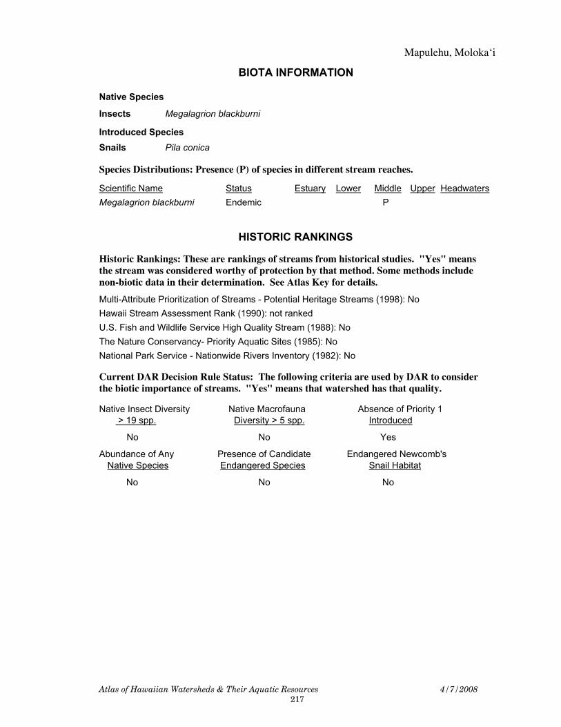
BIOTA INFORMATION
Native Species Insects Megalagrion blackburni Introduced Species Snails Pila conica
Species Distributions: Presence (P) of species in different stream reaches. Scientific Name Status Estuary Lower Middle Upper Headwaters Megalagrion blackburni Endemic P
HISTORIC RANKINGS Historic Rankings: These are rankings of streams from historical studies. "Yes" means the stream was considered worthy of protection by that method. Some methods include non-biotic data in their determination. See Atlas Key for details.
Multi-Attribute Prioritization of Streams - Potential Heritage Streams (1998): No Hawaii Stream Assessment Rank (1990): not ranked U.S. Fish and Wildlife Service High Quality Stream (1988): No The Nature Conservancy- Priority Aquatic Sites (1985): No National Park Service - Nationwide Rivers Inventory (1982): No
Current DAR Decision Rule Status: The following criteria are used by DAR to consider the biotic importance of streams. "Yes" means that watershed has that quality.
Native Insect Diversity Native Macrofauna Absence of Priority 1 > 19 spp. Diversity > 5 spp. Introduced No No Yes Abundance of Any Presence of Candidate Endangered Newcomb's Native Species Endangered Species Snail Habitat No No No

Mapulehu, Molokaÿi
Atlas of Hawaiian Watersheds & Their Aquatic Resources 4/7/2008 218

Mapulehu, Molokaÿi
Atlas of Hawaiian Watersheds & Their Aquatic Resources 4/7/2008 219
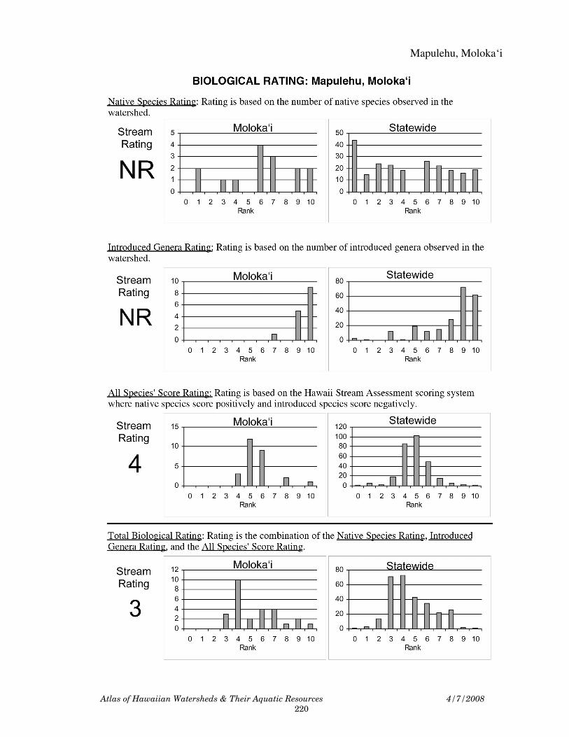
Mapulehu, Molokaÿi
Atlas of Hawaiian Watersheds & Their Aquatic Resources 4/7/2008 220
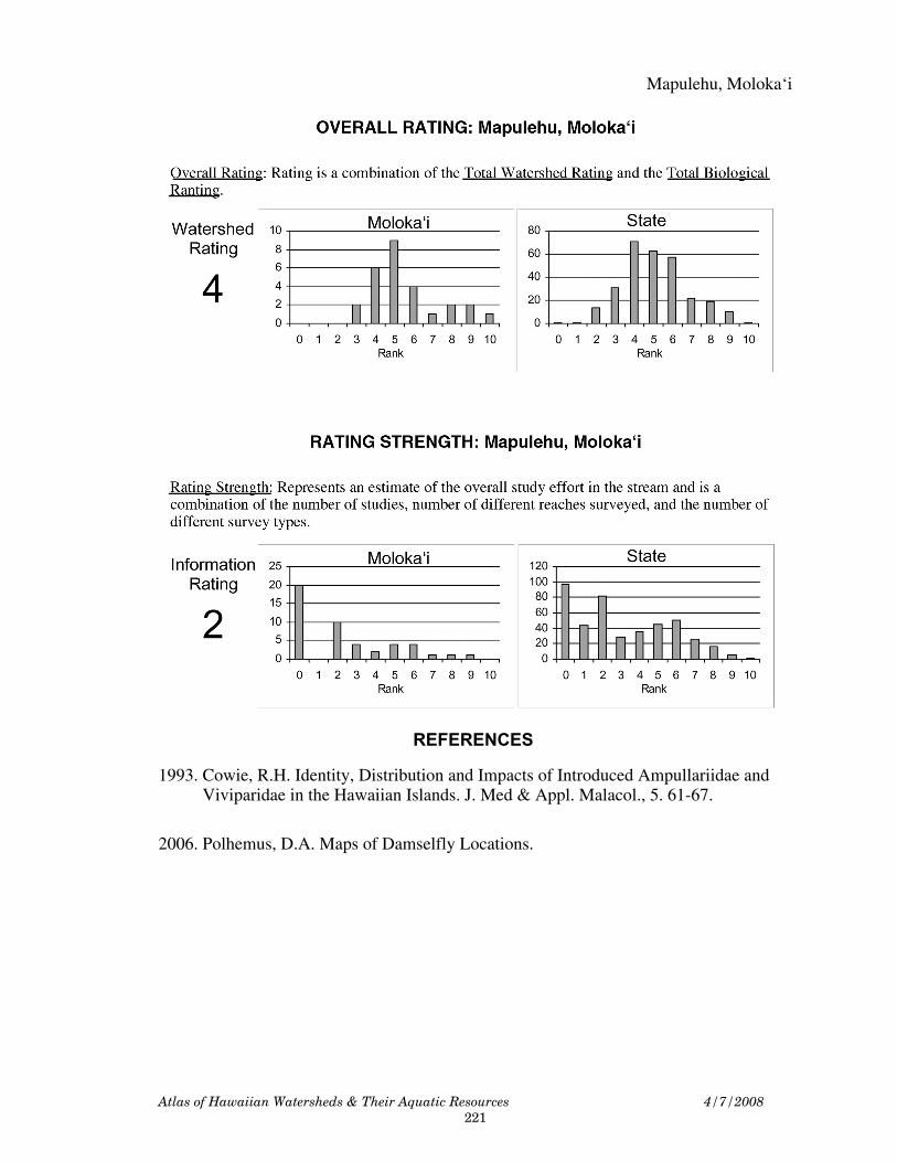
Mapulehu, Molokaÿi
Atlas of Hawaiian Watersheds & Their Aquatic Resources 4/7/2008 221
REFERENCES 1993. Cowie, R.H. Identity, Distribution and Impacts of Introduced Ampullariidae and Viviparidae in the Hawaiian Islands. J. Med & Appl. Malacol., 5. 61-67.
2006. Polhemus, D.A. Maps of Damselfly Locations.

222
Blank Page