darby township comprehensive plan - burns bertsch and harris
TRANSCRIPT
Darby Township Union County, Ohio
Comprehensive Plan
2003
Burns, Bertsch & Harris, Inc.

Darby Township Comprehensive Plan 1
Acknowledgments Steering Committee Members Harley Bodenbender, Chair Roger Nicol, Vice-Chair Marge Bailey, Secretary Pat Belisle Melvin Boerger Bill Brake Doug Dittus David Gruenbaum Tom Hackett Audrey Hall George Karrer Pete Lenhardt Richard Miller Jeff Nicol Stephen Sauner Jim Scheiderer Sherrie Schoening Ralph Seymour Dennis Stone Al Zavar Township Trustees Doug Alderman Dennis Blumenschein Roger Davenport James Butler, Zoning Inspector Judith Scheiderer, Township Clerk
Table of Contents Introduction 2 Existing Conditions 3 Land Use Limitations to Development Demographic Analysis 8 Plan Foundation 13 Planning Issues Goals and Objectives Concepts Future Land Use Plan 21 Introduction
Land Use Classifications & Summary Farmland Preservation Policies and Recommendations Open Space & Natural Resource 29 Preservation Plan Introduction Types of Open Space Funding Policies and Recommendations Thoroughfare Plan 33 Introduction Functional Classification Preserving Scenic Roads Access Management Policies and Recommendations
2 Darby Township Comprehensive Plan
Introduction The comprehensive plan is the instrument by which local government establishes long-range policies for guiding growth and development in a community in a coordinated manner. The plan can provide protection and confidence to residents and investors: protection from many of the problems of uncontrolled growth and confidence for residents that the Township will continue to be the special community that is has been for so long. This document, the Darby Township Comprehensive Plan, reflects the efforts of many Township residents, property owners, and public officials. Over the past year, a Steering Committee, comprised of volunteers representing the community’s interests, devoted much time to reviewing information and data concerning the Township. They discussed where the community is and the local effects of growth pressures occurring in central Ohio. They also examined how other communities handle growth and developed a strategy for guiding the future of the Township. The plan has been reviewed and commented upon by citizens throughout the process in several ways. A household survey was conducted, giving residents the opportunity to share their thoughts, concerns, and vision for the Township; many responded. Citizen focus groups and a public meeting were also held where residents could share their ideas. Each Steering Committee meeting was also open to the public. Citizen input was reviewed and discussed by the Steering Committee and ultimately helped shape this document.
The plan is to function as a guide to public officials, property owners, and investors in making decisions related to development over the next two decades. It is hoped that this document generates continued discussion, interest, and support among all Darby Township residents.

Darby Township Comprehensive Plan 3
Existing Conditions An existing conditions analysis is one of the first steps in the planning process. By evaluating both the current physical and environmental conditions of the study area, decision makers gain a better understanding of the land use issues in the Township. As a result, planning recommendations are based on a solid foundation of information and awareness of local issues. This section describes the current conditions of Darby Township including existing land use and physical limitations to development. Land Use Darby Township encompasses 31.1 square miles in southern Union County. The Township is primarily rural in nature; combining agriculture with open spaces, mature tree stands, and streams. Development can principally be found in the form of low-density housing, which are mostly lot splits, as few housing subdivisions exist in the Township. Table 1 indicates the percentage of land cover in the Township in various categories. Agriculture is by far the dominant land use in the Township. The Existing Land Use Map is included on the following page. 1. Darby Township Land Use/Land Cover
Land Use Percentage of Land Cover (1990’s)
Urban 1.7 % Forest 8.6 %
Wetlands 0.5 % Pasture 19.0 %
Row Crops 70.0 %
Limitations to Development Soils Prime Farmland Prime farmland includes soil regions best suited to the production of food, fiber, forage, feed, and/or seed crops. These soils produce the highest yields with minimal inputs of energy and economic resources. The Union County Soil Survey identified the types and capabilities of the soils located in the County. The Survey indicated the soil types in the region that are prime for farmland, prime for farmland if drained, and not prime for farmland. The following lists are the soils in Union County that are prime or prime for farmland if drained. Greater description of these soil types is included in the Appendix.
Prime Farmland CeA FoB KeB Ro CeB FoB2 MlB ScB Ee Gn MrB ScB2 FoA KeA MrB2 WaB Prime Farmland If Drained Ag CrB Mn Sh BoA HeA NpA SlA BoB Ho NpB So BoB2 Ka OdA Wc Bs Lc Pm We CrA
4 Darby Township Comprehensive Plan
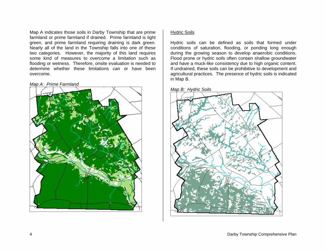
Map A indicates those soils in Darby Township that are prime farmland or prime farmland if drained. Prime farmland is light green, and prime farmland requiring draining is dark green. Nearly all of the land in the Township falls into one of these two categories. However, the majority of this land requires some kind of measures to overcome a limitation such as flooding or wetness. Therefore, onsite evaluation is needed to determine whether these limitations can or have been overcome. Map A: Prime Farmland
Hydric Soils Hydric soils can be defined as soils that formed under conditions of saturation, flooding, or ponding long enough during the growing season to develop anaerobic conditions. Flood prone or hydric soils often contain shallow groundwater and have a muck-like consistency due to high organic content. If undrained, these soils can be prohibitive to development and agricultural practices. The presence of hydric soils is indicated in Map B. Map B: Hydric Soils

Darby Township Comprehensive Plan 5
Map C: Septic Limitations
Map D: Large Development Constraints
6 Darby Township Comprehensive Plan
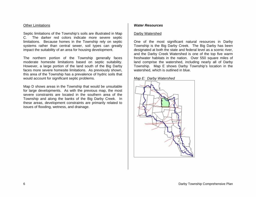
Other Limitations Septic limitations of the Township’s soils are illustrated in Map C. The darker red colors indicate more severe septic limitations. Because homes in the Township rely on septic systems rather than central sewer, soil types can greatly impact the suitability of an area for housing development. The northern portion of the Township generally faces moderate homesite limitations based on septic suitability. However, a large portion of the land south of the Big Darby faces more severe homesite limitations. As previously shown, this area of the Township has a prevalence of hydric soils that would account for significant septic problems. Map D shows areas in the Township that would be unsuitable for large developments. As with the previous map, the most severe constraints are located in the southern area of the Township and along the banks of the Big Darby Creek. In these areas, development constraints are primarily related to issues of flooding, wetness, and drainage.
Water Resources Darby Watershed One of the most significant natural resources in Darby Township is the Big Darby Creek. The Big Darby has been designated at both the state and federal level as a scenic river, and the Darby Creek Watershed is one of the top five warm freshwater habitats in the nation. Over 550 square miles of land comprise the watershed, including nearly all of Darby Township. Map E shows Darby Township’s location in the watershed, which is outlined in blue. Map E: Darby Watershed

Darby Township Comprehensive Plan 7
Wetlands Wetlands are defined as areas that are inundated and saturated by surface or groundwater at a frequency and duration that supports vegetation adapted for life in saturated soil conditions such as swamps, marshes, and similar areas. Because they provide habitats for many species of plants and animals, care should be taken to protect these areas. There are only small pockets of wetlands in Darby Township as shown in green in Map F. Map F: Wetlands
Conclusions Darby Township has moderate physical limitations to development. Overall, land in the Township has manageable slopes and excellent agricultural opportunities. However, threats to development are posed by flooding potential in the southern area of the Township and by the presence of hydric soils. Careful consideration towards development is necessary in order to protect and preserve the existing environment. The following statements summarize the most significant limitations to development:
Development near the Big Darby Creek is discouraged in order to prevent erosion and protect the integrity of the stream. Minimum buffer zones surrounding the creek should be established. The 100-year floodplain should be protected from
development as established in Union County regulations. The small areas of wetlands provide no serious
limitations to development. Watershed management and runoff controls should be
implemented where necessary. Prime farmland is a valuable asset to the Township
and should be protected from development. Septic suitability may limit housing development in the
southern area of the Township.

8 Darby Township Comprehensive Plan
Demographic Analysis Demography is the science of vital and social statistics of populations. Demographics can be used to provide a snapshot of a community, portraying the many characteristics of its population. Demographics also provide the basis for projections to determine future community patterns and predict change. This demographic analysis primarily focuses on Darby Township’s population trends and its future implications on the community. Population According to the U.S. Census, the population of Darby Township in 2000 was 1,934. This figure includes the population of Unionville Center. The Township’s population rose by 26.4 percent from 1990 when the population of the Township was 1,530. Darby Township is the fourth largest township by population in Union County following Jerome, Dover, and Liberty Townships. Table 2 indicates growth trends in Darby Township and Unionville Center since the 1960 U.S. Census. 2. Historic Population by Jurisdiction
Darby Township
Unionville Center Total
2000 1,634 300 1,934 1990 1,292 238 1,530 1980 1,297 272 1,569 1970 957 255 1,212 1960 919 305 1,224
Historically, population growth in Darby Township has been far from steady or predictable. In the past four decades, the Township has alternately faced a decade of negative growth followed by a decade of rapid growth. This growth pattern can partly be explained by shifting economic conditions and rapid growth of the Columbus metropolitan area. Chart A indicates population change in the Township since 1960. Chart A
Historic Population Trends
1,934
1,530
1,212
1,569
1,224
900
1,200
1,500
1,800
2,100
1960 1970 1980 1990 2000
The growth pattern in Darby Township is reflective of the pattern that was occurring in the greater region. As shown in Table 3, all of Union County experienced surges in growth over the past 40 years.

Darby Township Comprehensive Plan 9
3. Regional Growth Trends Darby Township Union County Pop % Change Pop % Change
2000 1,934 26.4% 40,909 28.0% 1990 1,530 -2.5% 31,969 8.2% 1980 1,569 29.5% 29,536 24.2% 1970 1,212 -1.0% 23,786 4.1% 1960 1,224 22,853
Population Forecasts Changes in population impacts land use as well as demands placed on township services and infrastructure. Therefore, population projections are important studies that help local governments anticipate and plan for the needs of their communities. There are many different ways in which population can be forecasted. Three different methods have been used in Darby Township. Two are aggregate methods, which consider the total population without looking at age, cultural, or occupational subcategories. While looking at trends from the past, aggregate methods also do not examine why these trends occurred. Examples of aggregate methods include the linear growth model and the geometric growth model. The third method is the cohort component method, which does consider the three different variables of population change.
Linear The linear growth model is the simplest and most widely used projection technique. This model assumes population grows following a straight line with constant slope indicating a constant incremental change. This
method can be flawed because newly developing regions often experience bursts of growth and increasing incremental change. This method is most appropriate for small, slow-growing regions. Geometric The geometric growth model inflates the population assuming that relative change remains the same. This method creates a geometric curve where population grows at a constant rate. However, this method does not take into account that growth will inevitably be limited by saturation of land or resource constraints, both physical and fiscal. This method can produce unrealistically high population projections for the long term. Cohort As stated, aggregate projection methods do not look at the causes of past trends or various indicators of population change. Improved projections can be calculated by looking separately with the components of population change including birth, death, and migration rates. This is a more sophisticated, and potentially more accurate, method of population forecasting as all three components are considered simultaneously.
Results Table 4 charts population projections in the Township by projection method. The cohort and linear methods result in comparable forecasts while the geometric forecast is significantly higher.

10 Darby Township Comprehensive Plan
4. Population Projections Cohort Linear Constant
2000 1,934 1,934 1,934 2005 2,053 2,136 2,401 2010 2,149 2,338 2,980 2015 2,314 2,540 3,699 2020 2,507 2,742 4,592 2025 2,685 2,944 5,700
Chart B illustrates the population fan for Darby Township through 2025. Note the similarities between the cohort and linear projections. Based upon current trends, it is more likely that growth in the Township will occur according to these forecasts rather than the geometric projection. Chart B
Population Projections
1,000
2,000
3,000
4,000
5,000
6,000
2000 2005 2010 2015 2020 2025
Cohort Linear Geometric
Methodology The 1990 and 2000 U.S. Censuses provided the base data for all population projections. Additionally, information was obtained from the Ohio Department of Health (ODH) and Ohio Department of Development (ODOD) for use in the cohort population projection.
Fertility Rates Fertility rates were obtained at the county level for Union County for women between the ages of 15 and 44. Projected fertility rates for the county were available through 2025 from ODOD in five-year age brackets. Survival Rates Mortality rates were obtained separately for males and females at the county level for Union County. The most recent data available was for 1998 from ODH. For each five-year age bracket, the mortality rate for the county was available. This rate was converted into a survival rate and became the rate for Darby Township population projections. Migration Rates Migration rates were obtained at the county level for Union County from ODOD. Projected migration rates for the county were available separately for men and women through 2025 for each five-year age bracket. This rate became the migration rate for Darby Township population projections.
Darby Township Comprehensive Plan 11
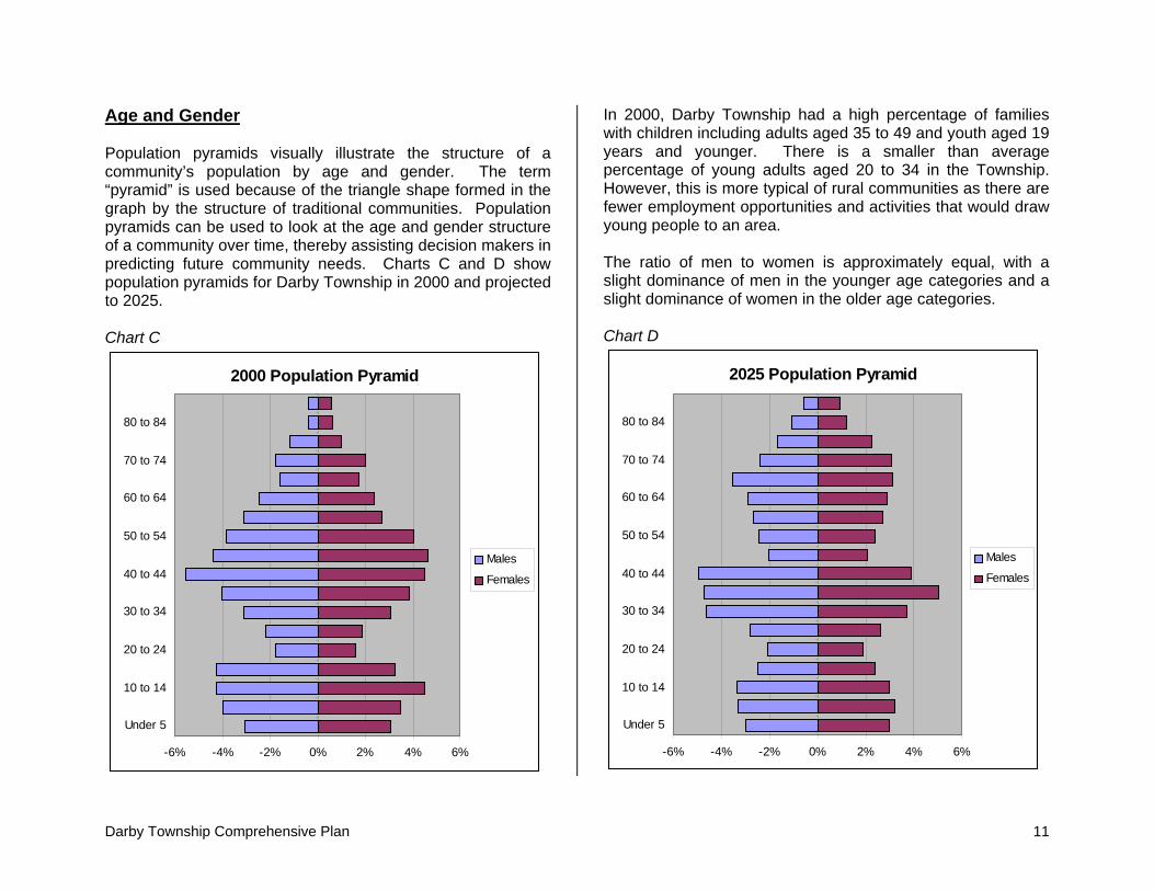
Age and Gender Population pyramids visually illustrate the structure of a community’s population by age and gender. The term “pyramid” is used because of the triangle shape formed in the graph by the structure of traditional communities. Population pyramids can be used to look at the age and gender structure of a community over time, thereby assisting decision makers in predicting future community needs. Charts C and D show population pyramids for Darby Township in 2000 and projected to 2025. Chart C
2000 Population Pyramid
-6% -4% -2% 0% 2% 4% 6%
Under 5
10 to 14
20 to 24
30 to 34
40 to 44
50 to 54
60 to 64
70 to 74
80 to 84
Males
Females
In 2000, Darby Township had a high percentage of families with children including adults aged 35 to 49 and youth aged 19 years and younger. There is a smaller than average percentage of young adults aged 20 to 34 in the Township. However, this is more typical of rural communities as there are fewer employment opportunities and activities that would draw young people to an area. The ratio of men to women is approximately equal, with a slight dominance of men in the younger age categories and a slight dominance of women in the older age categories. Chart D
2025 Population Pyramid
-6% -4% -2% 0% 2% 4% 6%
Under 5
10 to 14
20 to 24
30 to 34
40 to 44
50 to 54
60 to 64
70 to 74
80 to 84
Males
Females

12 Darby Township Comprehensive Plan
In comparison, the 2025 population pyramid indicates a declining percentage of youth under 20 years old and a notable increase in adults aged 20 to 34. Also, the 65-year and older population has grown tremendously by 2025. A growing elderly population has significant impacts on the types of services demanded by residents including convenient access to health care and housing tailored to their needs. As with the 2000 pyramid, the ratio of men to women is roughly equal, with a slightly higher percentage of men in the younger age categories and a slightly higher percentage of women in the older age categories. One significant difference is in the greater ratio of men to women in the 30 to 34 and 40 to 44 age categories.

Darby Township Comprehensive Plan 13
Plan Foundation The Darby Township Comprehensive Plan provides a roadmap for the future of the community by creating a plan for the development pattern of the Township as well as general policy statements of how to get there. It is a guide for developers, landowners, concerned citizens, and elected officials as they make decisions about land. This comprehensive planning process was designed to foster participation by Township officials as well as its citizens. In order to gain greater insight into the particular issues of the Township, a variety of public participation methods were utilized. Citizens were able to offer their input through a community survey, focus groups, and public meetings. Furthermore, a steering committee composed of citizens guided the planning process. Public participation was crucial in identifying issues and establishing plan goals. Planning Issues Several major issues arose early in the planning process as a result of input by the steering committee, community residents, and Township officials. Growth management was a central concern of the majority of residents in Darby Township. Residents did not want to see the type of sprawled development that has been recently occurring in the metropolitan area continue into the Township. Rural character and farmland preservation were recognized as major community priorities. In the community survey, rural character was cited by residents as the Township’s most important asset. Residents felt that farming should continue to be supported in the community.
Because of the Township’s valuable natural resources, including the Big Darby Creek, environmental protection was another important community issue. Residents wanted to ensure that development would not diminish the natural beauty or endanger the environmental health of the Township’s ecosystem. Services and infrastructure were cited as a concern of Township residents. It was felt that the current rate of growth may put strain on the Township’s resources or a burden on tax payers in the future. One important element of the comprehensive plan is implementation strategies describing how the ideas contained in the document will be realized through the Township’s policies and procedures. There was a desire to ensure the plan’s recommendations would be followed through modifications to the Township’s zoning, as it was felt that the Township’s current zoning resolution lacked the guidance of a comprehensive plan. These issues were discussed and used to formulate goals and supporting objectives that would guide the comprehensive plan. Goals and Objectives A. Encourage growth management practices in the Township that promote the efficient use of land.
• Discourage “leap frog” or sprawl development patterns. • Preserve the existing natural features of land as
development occurs. • Consider limited economic development activities that
would enhance the tax base of the Township.
14 Darby Township Comprehensive Plan
B. Preserve the rural character of Darby Township. • Discourage development within existing agricultural
lands to preserve significant masses of farmland. • Encourage conservation design in residential
developments. • Promote targeted economic development activities as
related to farming, agribusiness, and agricultural support services.
• Pursue participation in agriculture preservation programs and explore possible farmland preservation tools.
C. Protect the sensitive environmental areas and valuable natural resources of Darby Township.
• Protect the Big Darby Creek from incompatible uses. • Work with regional watershed protection organizations
to coordinate environmental preservation efforts. • Continue to consider water and sewer drainage issues
when locating new development. • Set aside open space areas for Township parks and
recreation areas. D. Ensure the provision of quality services and maintain an efficient infrastructure system in the Township.
• Use access management principles to ensure Township thoroughfares remain safe and uncongested.
• Ensure that levels of community services are maintained and keep pace with growth.
• Cooperate with neighboring jurisdictions to promote the efficient provision of services.
• Partner with the school system to share resources and facilities.
E. Ensure the appropriate policies and procedures are in place to guide decision making consistent with the citizen’s vision for the Township.
• Revise the Township Zoning Resolution consistent with the Comprehensive Plan.
• Devise strategies or policies for dealing with annexation and utility provision issues.
• Promote cooperation with neighboring jurisdictions on development issues that affect the region.
• Enhance fiscal stability by considering the cost of community services where development is proposed.
Concepts In the planning process, the steering committee discussed and evaluated many concepts that relate to managing growth, preserving land, protecting the environment, and more. Township residents were also surveyed as to the types of land use regulations they would support. The following general concepts were supported by the community and many are reflected later in the plan as policies and/or recommendations. Growth Management Growth management efforts, particularly for residential development, have become widespread in the past several decades across the country. In order to deal with the rapid pace of change and associated impacts on infrastructure, communities have begun to devise strategies that direct the type, location, and rate of growth. One of growth management’s major impact has been to emphasize the importance of the connection between development and the availability and cost of supporting infrastructure.

Darby Township Comprehensive Plan 15
Conservation Subdivision The conservation subdivision is an emerging tool that can be used to balance growth and conservation pressures in smaller communities and rural areas. Conservation subdivisions are developments where a certain percentage of the total land has been set-aside as permanent, protected open space. This is accomplished while maintaining the same overall density that would be allowed under conventional zoning. In a conservation subdivision, lots are creatively arranged on a portion of a site, leaving the balance of the property as open space. The developer can get the same economic return, while developing in a less land-consumptive manner. The open space is protected through a permanent conservation easement, which can be held by local government, homeowner’s association, or land trust. The open space can be used for active or passive parkland, farmland, or simply left as a natural area to preserve scenic views in and out of the site. Many conservation subdivisions incorporate a combination of these. Conventional subdivision and zoning regulations were designed to provide for the orderly transition of raw land into lots and streets. Generally, these regulations allow all but the “unbuildable” portions of the property, e.g. 100-year floodplains, wetlands, steep slopes, and storm water management areas to be developed. In contrast, conservation design takes into account the unique natural and historic features of a site and calls for their permanent preservation. Such “natural features” might include wetlands, floodplains, significant wildlife habitats, woodlands, farmland, historic sites, scenic views and aquifers/recharge areas. Conservation subdivision designs offer distinct and measurable advantages over conventional layouts. For example, economically, conservation subdivisions have a smoother review process as the developer has already taken
into account many site considerations. Additional economic advantages include lower costs of infrastructure and design, faster appreciation in value, reduced demand for new open spaces and parks, and environmentally oriented marketing and sales strategies. The environmental and ecological advantages of conservation design include the reduction of stormwater runoff, pollutant filtering, protection of natural buffers along wetlands, and maintenance of wildlife corridors. Conservation subdivisions can also be part of an overall plan to develop a greenway system across the community. In the figure, the illustration on the left shows traditional rural residential subdivision development. The right illustration shows how the same number of lots can be accommodated on the site while preserving sensitive environmental features and open space.
Land Preservation Growth management techniques are often used to help ensure that development occurs in an orderly manner. However, there is also land within communities that should be protected from any type of development due to inherent characteristics of the land or valuable environmental, historic, or other resources. The following paragraphs describe some tools and resources that allow land to be permanently preserved.

16 Darby Township Comprehensive Plan
Conservation Easements A conservation easement is a restriction placed on a piece of property to protect the resources associated with the parcel. These resources may be agricultural, historic, woodlands, or open space. An easement is a legally recorded, voluntary land protection tool that is privately initiated by a property owner. Conservation easements are designed to exclude certain land uses on the property such as commercial and residential development. Most conservation easements are permanent; however, term easements may be used to impose restrictions for a limited number of years. Land protected by conservation easements remains private property, and the property owner may choose to prohibit or permit certain public uses of the land. Easements may be held by local government agencies, land trusts, or other non-profit organizations that monitor and enforce the terms of the agreement. An easement does not free the property owner from traditional responsibilities of ownership such as property tax, maintenance, or improvements. However, landowners who donate permanent conservation easements are often entitled to tax benefits such as savings on federal income and estate taxes or state and local property tax breaks. Agricultural Easements An agricultural easement is a voluntary legal agreement by a landowner to retain the use of land predominantly in agriculture. When a landowner grants an agricultural easement, the landowner forfeits the right to develop the land for non-agricultural activities and agrees to use the land only for agricultural purposes. These easements are designed to meet the needs of the landowner, therefore, may include provisions to build farm structures such as barns or family quarters. A governmental entity or non-profit organization
holds the easement and has the legal right to require the landowner to abide by the agreement. The easement is a permanently and legally binding restriction that remains with the land as it passes from one owner to another. The Clean Ohio Fund Agricultural Easement Purchase Program (AEPP) provides matching grants to counties, townships, municipalities, and charitable organizations for the voluntary purchase of agricultural easements from farmland owners. The Office of Farmland Preservation, housed within the Ohio Department of Agriculture, administers the program with funds from the Clean Ohio Fund. The program includes an application and ranking process to select eligible farms, followed by the distribution of state matching grants to the government entity or organization that purchases the agricultural easements. Purchase of Development Rights/ Transfer of Development Rights Purchase of development rights (PDR) is a voluntary program where an agency usually linked to local government makes an offer to a landowner to buy the development rights on a parcel. The landowner is free to turn down the offer, or to try to negotiate a higher price. Once an agreement is made, a permanent deed restriction is placed on the property that restricts the type of activities that may take place on the land in perpetuity. Transfer of development rights (TDR) allows landowners to transfer the right to develop one parcel of land to a different parcel of land. Generally established through local zoning codes, TDR programs can protect farmland by shifting development from agricultural areas to areas planned for growth called “receiving areas.” Developers can increase the density of development in a designated receiving area by purchasing development rights from landowners in a protected

Darby Township Comprehensive Plan 17
“sending area.” Once the development rights are transferred from agricultural property, the land can be restricted with a permanent agricultural conservation easement. As a result, development occurs in appropriately zoned areas at a higher density than ordinarily permitted by base zoning. Ideally, TDR causes growth to occur in an efficient, less sprawled manner. TDR not only protects farmland, but also changes the way growth occurs. To be successful, this process should involve the input of all stakeholders including public officials and citizens as well as landowners and developers. Zoning and Related Tools Agricultural Zoning Agricultural zoning is zoning that protects the viability of agriculture through limiting density of development and restricting nonfarm uses of the land. Agricultural zoning can be an important preservation tool for the following reasons.
• Agricultural zoning reduces the conflicts that may occur between farmers and non-farmers due to situations such as chemical irritants spilling onto non-farm properties or the litter and vandalism of agricultural land.
• Zoning encourages orderly growth, which, in turn, enhances aesthetics and minimizes the cost of public services.
• Agricultural zoning protects the agricultural land base and productive soils and is most effective when applied to large areas of contiguous farmland.
• Agricultural zoning corresponds with conservation movements such as retaining open space, protecting environmentally sensitive wetlands, and protecting water resources and air quality.
Agricultural zoning is the land use tool most commonly used for the preservation of farmland. In addition to limiting density and nonfarm uses, it protects agricultural land by requiring houses to be built on small lots and restricting subdivision of land into parcels that are too small to farm. This zoning technique is attractive to local governments because it can quickly protect large areas of farmland, and it is flexible to the changing needs of the community. Those persons purchasing land in an agricultural zone understand up front the restrictions of the area. Furthermore, it can be less expensive to implement than other preservation tools such as purchasing development rights. Agricultural Districts Agricultural districts are voluntarily created districts where farming is the preferred land use. They have been formed in order to lessen the push to convert farmland to other uses. In an agricultural district, the landowner receives certain benefits including protection against nuisance suits, relief from utility assessments, and limits on annexation and eminent domain. In Ohio, agricultural districts are created for renewable five-year periods in which the landowner agrees to leave the land undeveloped. Farmers are able to place all parcels or a portion of their parcels into agricultural districts. To qualify for an agricultural district, the land must be in agricultural production or be enrolled in a federal conservation program. The land must also meet criteria for lot size and a minimum generated income. Agricultural Security Areas Agricultural Security Area (ASA) programs allow farmers to form special areas where agriculture is encouraged and protected. Programs are authorized by state legislatures and implemented at the local level. ASA programs, unlike zoning,

18 Darby Township Comprehensive Plan
are voluntary, incentive-based programs. ASA programs are locally driven. They help stabilize the land base at low public cost. ASAs provide multiple benefits to farmers, including tax relief, protection from local regulation, and eligibility for permanent farmland protection programs. ASAs help create a critical mass of land to keep farming viable. They are not designated to stop development. Enrollment in an ASA is voluntary, making the programs popular with farmers. The Ohio House of Representatives is currently considering enabling legislation for ASAs through House Bill 367. To be eligible for ASA designation, a farmer must be enrolled in the CAUV tax program and in an Agricultural District, as well as utilize best management practices. To receive the designation, eligible farmers owning large areas of contiguous farmland would request a resolution of support from both the township trustees and county commissioners. ASAs are designated for ten-year periods. During this period, only agricultural activities including farming and agribusiness are permitted. Local governments may also approve non-farm activities that would not impede farming, such as antique shops, bed and breakfasts, and home-based businesses. Also during this ten year period, local governments commit not to initiate, approve, or finance any non-farm development activity such as extending utilities, building new roads, housing subdivisions, or commercial/industrial facilities. Other Concepts Access Management Access management is the process that provides or manages access to land development, while simultaneously preserving the flow of traffic on the surrounding road system in terms of safety, capacity, and speed. Access management is a
technique in which a governing body works toward an efficient balance between access and mobility. Promotion of Infill/Redevelopment One way to address the cost of sprawl is to direct more development toward existing developed areas where vacant or underused sites can be redeveloped. Declining neighborhoods or commercial/industrial areas may be revitalized through programs that provide financial and other incentives to stimulate new development in those areas. Incentives may include subsidizing land costs, tax exemptions or reductions, infrastructure improvements, or assistance from business development groups. Political subdivisions can also take advantage of federal and state programs aimed at stimulating economic development. Cost of Community Services When planning for a community, it is important to look at the fiscal implications of the land use pattern. Traditionally, decision makers have believed that any type of development is the best use of vacant land for increasing tax revenues. Often residential developers sell their projects through claims that the development will “pay for itself” and lower each individual’s property tax. The preservation of farmland and open space has been viewed as a loss of tax base. However, recent cost of community studies and fiscal impact analyses have shown quite the opposite is true. Every community has a number of land uses including farming, residential, and commercial or industrial. Each land use is subject to tax payments to support the community services demanded by the community. These services include schools, roads and bridges, safety, etc. While farmland usually pays a lower tax amount than residential land use, it also demands less community services and fewer service expenditures. When an area is growing, there are usually
Darby Township Comprehensive Plan 19
increased tax revenues collected and also increased service expenditures demanded. Decisions about changes in land use are often made at the local level and need to be made with the best financial information available. One tool used to look at the fiscal impacts of development is the cost of community services study (COCS). It is conventional in COCS studies to divide land into three categories: residential, commercial/industrial, and farmland/open space. One of the most common procedures used is the calculation of a COCS ratio for each land use category. The ratio compares how many dollars worth of local government services are demanded per dollar collected. A ratio greater than 1.0 suggests that for every dollar of revenue collected from a given category of land, more than one dollar is spent in association with it. Virtually all studies show that for residential land, the COCS ratio is substantially above 1. That is, residential land is a net drain on local government budgets. The average estimate ranges from about 1.15 to 1.50, which means that for every dollar collected in taxes and non-tax revenue, between $1.15 and $1.50 gets returned in the form of services by the local government and school district. One that other hand, the COCS ratios for the other two land use categories are both substantially below 1. For commercial/industrial, the ratio usually ranges from 0.35 to 0.65, indicating that for every dollar collected, only about 35 to 65 cents worth of services are provided by the local government. For agriculture and open space, the ratios are only slightly smaller, usually ranging from 0.30 to 0.50. The largest single expenditure category for communities, according to the studies, is the public school system, accounting for 60 to 70 percent of spending. Since open
space and commercial development in themselves do not place any burden on the schools, it should not be surprising that their ratios are less than the residential category. COCS studies suggest that growing communities should be aware of the need to balance both commercial/industrial development and residential development. It suggests that communities with only residential land uses are likely to experience higher service expenses compared to revenue streams. Economic Development Agreements Joint Economic Development District (JEDD) One or more municipalities and one or more townships may enter into a contract to create a Joint Economic Development District for the purpose of facilitating economic development within the JEDD. The district cannot exceed two thousand acres in area and cannot include existing residential areas or areas zoned for residential use. The contract grants the JEDD’s board of directors the power to levy an income tax within the JEDD at a rate not exceeding the rate being levied by the municipality. Other powers provided in the contract include the ability to determine the substance and administration of zoning and other land use regulations, building codes, permanent public improvements and other regulatory and proprietary matters; the ability to limit and control annexation of unincorporated land within the JEDD; and the ability to control the granting of property tax abatements and other tax incentives within the JEDD. Cooperative Economic Development Agreement (CEDA) One or more municipalities and one or more townships may enter into a Cooperative Economic Development Agreement. The board of county commissioners may also become a party to CEDA upon the written consent of the legislative authority of participating municipalities and the board of township trustees of participating townships. Income taxes are levied only on

20 Darby Township Comprehensive Plan
parcels that have been annexed into a municipality. Typically the municipality remits to the township all real estate and personal property tax revenue it would otherwise receive upon annexation on the unincorporated parcel(s). The agreement may also provide for the provision of joint services and improvements to incorporated or unincorporated areas and the application of tax incentives in the CEDA area. Unlike JEDDs, CEDA districts may include residential land. For both JEDDs and CEDAs: Services Municipalities Typically Provide
1) Water at a rate equal to that charged in-city customers 2) Sewage treatment at a rate equal to that charged in-
city customers 3) Professional services that include engineering review
and building inspection 4) Income tax collection and administration 5) Political cooperation
Services Townships Typically Provide
1) Primary fire and EMS response 2) Road maintenance within the agreement area and on
roads leading to the area that are developed through JEDD/CEDA revenues
3) Commercial, office, or industrial zoning of areas to be included within the area (JEDD only)
4) Political cooperation

Darby Township Comprehensive Plan 21
Future Land Use Plan Introduction This Plan portrays a vision of future land use within Darby Township. The existing land use pattern that has occurred over time in the community is reflective of growing development pressures in the central Ohio region. Increasingly, the Township is facing growth that is scattered across the community in an unplanned manner. It is the desire of Township to preserve the quality of life for existing residents and to ensure future development occurs consistent with the community’s values. It is also recognized that as change occurs, continuing discussions about land use patterns and policies will be necessary. This Plan provides a guide for those discussions. The Future Land Use Map for Darby Township is general in nature. In contrast to zoning maps, which display exact zoning classifications for each parcel, this map does not necessarily recognize or follow property lines and is based upon broad use categories. As such, the Future Land Use Map does not dictate how specific parcels should be zoned in the future. Rather, the Zoning Commission and Township officials should consider the map to be only one of several tools available to assist them in making land use recommendations and decisions. The information contained on the map should always be supplemented by site specific information. The Zoning Commission may consider using a checklist to promote a systematic review of land use decisions. The checklist should be used for all rezoning requests to ensure that relevant land use issues are raised. Certain answers would not mandate a particular decision and not all of the questions are pertinent to every situation.
Sample Check List 1. Is the proposed development consistent with the
Township’s vision? 2. Would the proposed development be contrary to the future
land use plan? 3. Is the development (change) contrary to the established
land use pattern? 4. Would change create an isolated, unrelated district? 5. Will the proposed development increase the load on
public facilities beyond reasonable limits (streets, schools, etc.)?
6. Are the present development boundaries logically drawn in relation to existing conditions?
7. Will the change adversely influence living conditions in the surrounding area?
8. Will the change create or appreciably increase traffic congestion?
9. Will the development seriously impact adjacent areas? 10. Will the development seriously affect the natural character
of the land to the point of creating potential hazards? 11. Have the basic land use conditions changed? 12. Will approval be a deterrent to the improvement or
development of adjacent property in accordance with existing plans and regulations?
13. Will the proposal constitute a grant of a special privilege to an individual that will not be granted to others of at the expense of the general welfare?
14. Are there reasons why the property cannot be used as it is presently planned or zoned?
15. Is the change out of scale with the area’s needs? The Township’s needs? The region’s needs?
16. Are there alternative undeveloped sites for the proposed use(s)?
22 Darby Township Comprehensive Plan
Land Use Classifications Agricultural/Rural. Agricultural/rural areas accommodate all types of agricultural activities and agriculture-related businesses as well as open space and very low density residential development. Land in agricultural/rural areas should be prioritized for voluntary farmland preservation programs and incentives. Base density is recommended at 0.05 dwelling units per acre, or 20 acre lots. Residential. The residential classification includes primarily single-family residential housing units. Churches or schools with access to a major thoroughfare or collector would also be appropriate in this classification. Base density is recommended at 0.5 dwelling units per acre, or 2 acre lots. Mixed Use Village. Unionville Center is a focal point in Darby Township, consisting of a residential neighborhood, government facilities, and limited commercial activities. A mix of uses will continue to be promoted in Unionville Center including small-scale commercial activities aimed at serving the local community. Commercial. Commercial areas should complement the existing development patterns and should be limited to areas with access to major thoroughfares. Commercial areas may include retail and service uses. In most areas, office uses are compatible with commercial uses. Industrial. This classification includes light industrial activities such as research and development or selected enterprises engaged in low-impact, non-polluting industrial activities. Some office or commercial uses may be permitted within the industrial area. If industrial development abuts residential or other sensitive areas, extensive buffering and screening would be required.
Critical Resource Areas. Critical resource areas may include floodplain, stream buffers, woodlands, significant open space, or other sensitive environmental areas. These areas serve the useful function of protecting natural resources and wildlife habitat, as well as preserving the rural heritage of the community. This category is an overlay district that imposes additional regulations on the underlying base land use. Future Land Use Summary The table shows the breakout in acreage in the Township by future land use category. Because critical resources are an overlay, that classification is shown separately. 5. Land Use Summary Acres Percent of Total Agricultural/Rural 16,355.3 81.1 % Residential 3,383.3 16.8 % Mixed Use Village 104.0 0.5 % Commercial 152.2 0.8 % Industrial 183.7 0.9 % Total 20,178.5 100.0 % Critical Resource Overlay Pond/Streams Woodlands Floodplain
73.3
1,841.5 1,441.2
< 15 %

Darby Township Comprehensive Plan 23
Farmland Preservation Along with growth management, preserving the community’s valuable farmland was a major concern of Township residents. This concern over farmland conversion is not unique, but has become a growing state and national issue. This loss of farmland is especially significant at the rural-urban fringe, which has been affected by extensive transportation systems and expanding residential and commercial development. Ohio is particularly susceptible to farmland loss at the urban boundary. The state has 16 metropolitan statistical areas (MSAs), which consist of more urbanized land than any other state. In Ohio and in Darby Township, there is a growing conflict between farmland preservation and the forces of development. The loss of farmland to residential and commercial development has numerous negative implications for farmers. These problems include
• Rising land prices beyond the affordability level of farmers, which encourages the sale of their property
• Increasing conflicts between farmers and nonfarmers including nuisance complaints about farm odors, noises, and dust that may result in restricting farming practices
• Crop and livestock loss due to vandalism and trespassing, and soil erosion from increased stormwater runoff associated with development
• Disinvestment in farms and agricultural support businesses
• Reductions in open space and decline of rural character
State and federal governments have done little in effectively slowing the rate of development of agricultural lands. In
Holding Our Ground, Tom Daniels and Deborah Bowers discuss the cycle of farmland conversion and how it both encourages additional farmland conversion to non-agricultural use and negatively impacts remaining farms. Their model of farmland conversion is illustrated below.
Source: Holding Our Ground Farmland Preservation in Ohio In 1996, the State of Ohio formed the Ohio Farmland Preservation Task Force, recognizing the need for farmland protection and the important role of agriculture in Ohio’s economy. The mission of the Task Force was to provide recommendations for the protection of Ohio’s agricultural land and future economic development.
24 Darby Township Comprehensive Plan
The Task Force determined that a combination of voluntary incentives, regional planning efforts, and state support are necessary components of farmland preservation. Additionally, communities must be provided with the tools needed to protect agricultural land and revitalize their urban areas. The Task Force made suggestions for farmland preservation under three categories: voluntary incentives, planning and infrastructure, and economic development. The recommendations for voluntary incentives include the formation of the Ohio Farmland Preservation Program and a state Farmland Preservation Fund that would provide a catalogue of voluntary preservation options and funding for the incentive programs. Its menu of potential programs include agricultural districts, current agricultural use valuation (CAUV), agricultural security areas, purchase/lease/transfer of development rights, land use tax credit programs, local interest buy downs for farmland acquisition loans, and conservation easements. Planning and infrastructure recommendations are four-pronged. First, the Ohio Farmland Preservation Strategy should be established to coordinate state programs and policies, to avoid unnecessary farmland conversion, and to reduce or eliminate the duplication of infrastructure. Second, local governments should be encouraged to prepare comprehensive land use plans that include farmland preservation and well-planned urban development. Third, the state should improve the ability of local government to plan and manage land uses that are compatible with its goals for agriculture and urban expansion. Fourth, the state should adopt legislation that would allow counties and municipalities the ability to regulate lot sizes and land divisions within the context of their comprehensive land use plan.
Finally, the Task Force recommended actions for economic development and urban revitalization. These include promoting state and local economic development programs and initiatives for agriculture, reducing the contribution of federal and state taxes on farmland conversion, supporting continued state funding for local land banking, and more effectively using existing infrastructure in urban areas. Local Preservation Techniques As with the state, Darby Township may use a combination of voluntary incentives and various planning approaches to preserve its agricultural base. Several of these techniques were described in the concepts section of the Plan Foundation. A few of these are explored further in the following paragraphs. Agricultural Easements As previously stated, the Clean Ohio Fund Agricultural Easement Purchase Program (AEPP) is one source for funding farmland preservation in the township. The AEPP provides matching grants to counties, townships, municipalities, and charitable organizations for the voluntary purchase of agricultural easements from farmland owners. While the landowner must take the initiative to enter into the program, it is the township (or county, municipality, or non-profit organization) that becomes the applicant who is responsible for filing the application. If Darby Township decided to submit an application to the AEPP, its pre-selection duties would be as follows:
• Agree to be a co-holder of the agricultural easement • Provide a resolution supporting the application,
committing local match and agreeing to monitor, supervise, and enforce the agricultural easement

Darby Township Comprehensive Plan 25
• Complete the application • Verify the accuracy of the application and sign
Upon filing, the easement application is evaluated compared to other applications from across the state. The ODA evaluation system is a two tiered process where the farm is judged by a set of objective criteria in tier one and more subjective criteria in tier two. The criteria are described in general below. Tier One
• Soil type including soils of unique or locally important designation
• Farm location relative to other protected areas • Utilization of best management practices • Amount of development pressure • Local comprehensive planning efforts • Other factors (enrollment in agricultural district, unique
cultural characteristics, local match over 25%) Tier Two
• Agricultural infrastructure in the area • Long term investments in the operation • Potential as demonstration/showcase project • Local support for farmland preservation • Participation in business, estate and conservation
planning If an application is selected to participate in the program, the Township negotiates the agricultural easement with the landowner and the Ohio Department of Agriculture (ODA). Because the application process involves a financial commitment to a local match for funding the easement and an ongoing responsibility to monitor the agreement, the Township should ensure its resources are used most efficiently. The
Township should identify farms or landowners that would be possible candidates for participation in the easement program. The Township may wish to consider the size of the farm, agricultural productivity, future land use as designated in the comprehensive plan, or other factors. Agricultural Zoning Agricultural zoning is zoning that protects the viability of agriculture through limiting density of development and restricting nonfarm uses of the land. Large lot zoning is a common type of agricultural zoning wherein a farm cannot be broken down into parcels below a certain minimum size for farming. The goals of large lot zoning are to preserve farmland in blocks large enough to be profitable and to make lot size large as to be too expensive for residential use. This will prevent farmland from being segmented by many residential sites. Large lot zoning can be flexible. For example, nonfarm dwellings may be permitted on small lots where farming is not productive or may be allowed next to existing developed areas. It can also be modified to include density bonuses for preserving open space. All zoning can be changed over time to accommodate shifts in population or growth levels. Current Agricultural Use Value (CAUV) CAUV is a differential real estate tax assessment program that offers farmland owners the opportunity to have their land taxed according to its agricultural value rather than full market value. To qualify, land must be devoted to exclusive agricultural use and total at least ten acres. CAUV includes a penalty for the conversion of farmland into non-agricultural uses. If farmland is converted, the county collects a recoupment tax, which is equal to the tax savings from the previous three years. While CAUV in itself does not preserve farmland, reduced taxes

26 Darby Township Comprehensive Plan
have helped prevent some farmers from being pushed out of business because of increasingly higher operating costs. Agricultural Districts Agricultural districts are voluntarily created districts that provide farmers protection against nuisance suits, deferments of tax assessments for water and sewer lines, and additional protection against annexation and land being taken by eminent domain. Agricultural districts are created for renewable five-year periods in which the landowner agrees to leave the land undeveloped. Farmers are able to place all parcels or a portion of their parcels into agricultural districts. The criteria to participate in an agricultural district is the same as CAUV. The land must be in agricultural production and total at least ten acres or generate an average gross income of at least $2,500. Interested landowners can file an application with the county auditor.
Land Use Policies and Recommendations Agricultural/Rural General policies:
• Scattered or sprawl development is discouraged in agricultural areas.
• Agricultural businesses and industries will be supported in the Township. Agricultural businesses shall be protected from intruding land uses.
• The Township will support the preservation of farmland as an important community asset. Landowners will be encouraged to voluntarily participate in agricultural preservation programs.
• The Township will support the creation of state legislation that would expand the Township’s ability to protect farmland.
• All rezoning requests will be evaluated based upon the adopted land use plan.
• The Township will support the creation of a regional transfer or purchase of development rights system aimed at preserving farmland.
Recommendations:
• Establish a minimum lot size in agricultural/rural areas of 20 acres.
• Reward density bonuses to developments in rural areas incorporating the use of conservation design.
• Identify priority agricultural preservation areas in the Township. Develop a program to preserve agricultural uses in those areas.

Darby Township Comprehensive Plan 27
Residential General policies:
• All new residential development should reflect quality design and construction practices.
• New housing will be located as to minimize future expenses associated with Township services.
• The creation of isolated pockets of residential development will be avoided, which create unplanned demands upon existing public infrastructure.
• All residents will be assured adequate living space by providing lots of adequate size while taking into account soil characteristics, existing development patterns, and service demands.
• Conservation design is the preferred style of residential development in the Township.
Recommendations:
• Establish a minimum lot size in residential areas of two acres.
• Create a conservation zoning district in the Township’s zoning resolution.
• Require conservation design of any residential subdivisions encompassing land within the floodplain or other critical resource areas.
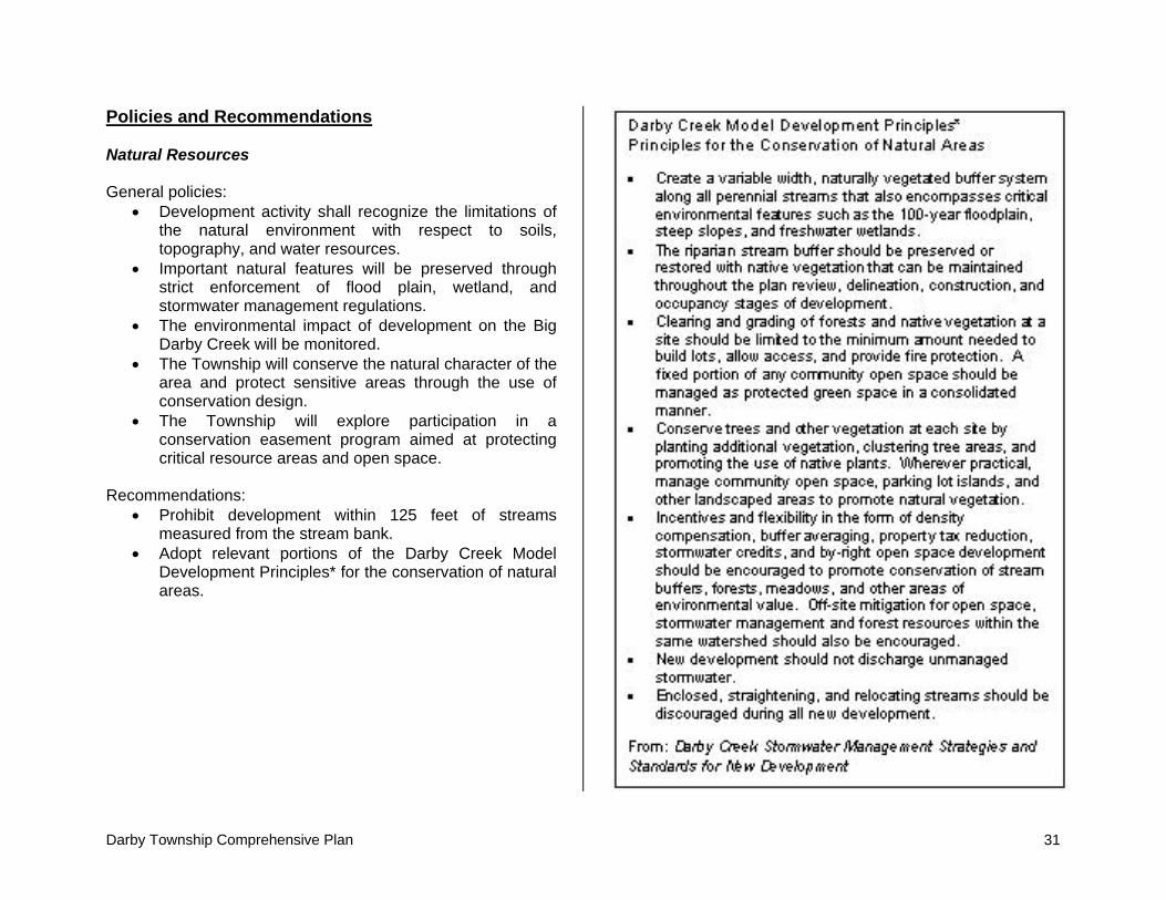
• Adopt relevant portions of the Darby Creek Model Development Principles for residential development.
Mixed Use Village General policies:
• All development in and adjacent to the village will occur in a manner sensitive to the environmental features of the area.
• Redevelopment of vacant parcels will be encouraged.
• The provision of goods and services serving the local community will be expanded.
Commercial/Industrial General policies:
• The preferred method of development for all new commercial, office, and industrial development is as a planned district.
• All rezoning requests will be evaluated based upon the adopted land use plan.
• Style and scale of commercial or industrial development will be compatible with adjacent development through requiring adequate buffer areas, appropriate setbacks, and controlling access to the site.
• The Township will assure logical access to goods and services by encouraging planned, integrated commercial areas of compatible size with surrounding uses and in proper locations to serve residents.
• Traffic congestion will be minimized by locating commercial or industrial uses near available services and/or on the edges of the Township.
• Commercial and industrial areas will be located on improved major thoroughfares to promote accessibility and minimize impact on surrounding land uses.
• Separations will be created between commercial or industrial and residential development. Require that buffering be provided at the time development occurs.
• The Township will preserve privacy for abutting and nearby properties by requiring appropriate setbacks from streets and internal property lines in keeping with quality development.
• All new commercial and industrial development should reflect quality design and construction practices.
28 Darby Township Comprehensive Plan
Recommendations: • Consider entering into economic development
agreements with adjoining municipalities where appropriate.
• Revise the Township’s zoning resolution to tighten controls on commercial and industrial development.
Darby Township Comprehensive Plan 29
Open Space and Natural Resource Preservation Plan Introduction The community survey and focus groups clearly showed the value of the Township’s rural character to residents. While agriculture is part of rural character, residents also recognized the value of the Township’s green spaces, scenic areas, wooded lands, and overall natural beauty. Open space and natural resource areas provide a number of benefits to a community. Green spaces positively contribute to residents’ physical and mental well being. Open spaces also provide recreational outlets as well as a refuge from the stresses associated with work and commuting. Open space dedication can also be used to preserve significant natural and historical resources. Open spaces not only contribute to the aesthetic and environmental qualities of a community, but also to its economic health. Historically, this type of land has not been seen as an economically viable resource. This idea is beginning to change as communities learn the economic benefits of open space. Traditionally, decision makers have believed that any type of development is the best use of vacant land for increasing tax revenues. Often residential developers sell their projects through claims that the development will “pay for itself” and lower each individual’s property tax. The preservation of farmland and open space has been viewed as a loss of tax base. However, recent cost of community studies and fiscal impact analyses have shown quite the opposite is true. While farmland pays less in taxes than residential land, it also demands far fewer community services and creates fewer service expenditures.
Types of Open Space Several different types of parkland can be found within most municipal or township boundaries. These open space areas are of varying sizes and are often designated for different purposes, from active recreational areas to nature preservation areas. Based on the needs and demographics of the community, the Township should strive to provide residents with access to a mix of parkland types.
Mini-parks are small park areas that provide a place for adults to gather as well as a place for local children to play. Mini-parks can be valuable in higher density areas where private yards are lacking. Neighborhood parks are parks to which neighborhood residents may walk or bike. These parks often provide activity and recreation programs for children and may also be located near elementary schools. They may include a recreation building, playing fields, courts, and play apparatus. Community parks are larger and serve a greater population than neighborhood parks. They have more facilities and are designed for family use including activities for all ages. Community parks may also include athletic fields, meeting space, and a swimming pool. This type of park may attract large numbers of people and may coincide with a junior high or high school. Metropolitan parks serve a regional or countywide area and provide a retreat from the noise and congestion associated with urban areas. These parks may offer

30 Darby Township Comprehensive Plan
boating, swimming, fishing, and may contain marinas, boat ramps, beaches, picnic areas, campgrounds, and hiking trails. Special activity areas are designed for a particular purpose such as golf courses, pools, or recreation centers. Greenways are corridors of open space that follow roads, rivers, canals, shorelines, and bike paths. They may connect other areas of open space and allow for pleasant methods of travel from one place to another. Nature preserves are areas where the public can enjoy nature in its untouched form. These areas support wildlife; therefore, activities should be limited to those that do not disturb the natural habitat. Suggested activities include nature study, bird watching, campsites, and bridle paths. Nature preserves are legally protected natural areas representing the finest examples of Ohio’s original landscape, based on its ecological or geological significance. The primary intent of a nature preserve is to conduct research, education, and low impact activities for the public.
The Township should take advantage of its many undeveloped and natural areas and work to set aside open space now for future needs. Once development occurs, it is difficult and much more costly to acquire open space and recreational areas. By actively preserving open space now, the Township can assure that its rural character and natural amenities will be preserved as growth occurs.
Funding There are two basic processes for land acquisition and financing: the fee simple method and the less than fee simple method. The fee simple process is the actual payment and acquisition of open space and recreation areas. Fee simple financing may include capital improvement budgeting (CIP), general fund appropriations, bond issues, bank loans, pay-as-you-go, fees and charges, special taxation, and gift and trusts.
• General fund appropriations means the use of money drawn for one general fund, instead of relying on individual government funds to finance parks.
• Bond issues enable communities to purchase land now and share the cost equally over a number of subsequent years.
• Pay-as-you-go uses previously collected funds to purchase land.
• Fees and charges require the gathering of fees by charging for the exclusive use of or construction of facilities or areas and charging fees to recover the administration, operation, and maintenance costs.
• Special taxation uses property taxes to finance the acquisition of open space.
• Gifts and trusts acquire land through a private gift, endowment, or trust fund.
The less than simple fee process does not involve the direct purchase or acquisition of land but placing limits on land use without taking ownership. Several methods of this process include floodplain/wetland regulation, easements, transfer of development rights, conservation zoning, and agricultural preservation programs. Any or all of these methods described above could be explored and used in the acquisition of open space and recreation areas.
Darby Township Comprehensive Plan 31
Policies and Recommendations Natural Resources General policies:
• Development activity shall recognize the limitations of the natural environment with respect to soils, topography, and water resources.
• Important natural features will be preserved through strict enforcement of flood plain, wetland, and stormwater management regulations.
• The environmental impact of development on the Big Darby Creek will be monitored.
• The Township will conserve the natural character of the area and protect sensitive areas through the use of conservation design.
• The Township will explore participation in a conservation easement program aimed at protecting critical resource areas and open space.
Recommendations:
• Prohibit development within 125 feet of streams measured from the stream bank.
• Adopt relevant portions of the Darby Creek Model Development Principles* for the conservation of natural areas.

32 Darby Township Comprehensive Plan
Open Space General policies:
• Develop an open space system that protects environmentally critical areas such as floodways and drainage corridors against encroachment, preserves significant vistas and views, and provides relief from expanses of development and pavement.
• Park and recreation facilities shall be efficiently provided in needed locations and at the lowest possible expense to the taxpayer.
• Continue to cooperate with neighboring jurisdictions and associations in the provision of park and recreation services to avoid duplication of efforts and encourage maximum use of available resources.
• Create opportunities for developing a system of greenways and sites for outdoor recreation including public use of the rail right-of-way.
• Create options and incentives that will encourage landowner participation in open space preservation and in the establishment of greenways and trails.
• Require developers to include interconnected paths or open space linkages in new neighborhoods.
Recommendations:
• Explore the creation of a fund for acquiring and maintaining parkland as development occurs.
• Consider creating a community land trust and/or partner with existing regional land trusts.

Darby Township Comprehensive Plan 33
Thoroughfare Plan Introduction A thoroughfare system can shape development by enhancing or interfering with accessibility between destinations and by directing growth and investment to particular locations. At the same time, transportation system needs can be anticipated by examining the Township’s current growth pattern and identifying areas that may become developed. Functional Classification According to ODOT, functional classification is the grouping of roads, streets, and highways in a hierarchy based on the type of highway service they provide. Roads have two main functions: to provide traffic mobility or land access. Functional classification is determined by ranking the proportion of each of these two functions the road serves. Roads that function primarily to move traffic are arterials while roads that provide access to particular land uses are local roads. The figure on the right illustrates this hierarchy. Functional classifications are useful as funding and management tools. For example, functional classifications determine which roads are eligible for federal funding and establish standards for maintenance as well as design criteria such as lane and shoulder width, horizontal and vertical clearances, and design speeds. The following descriptions and graphics further describe the hierarchy of roads by their function.
Source: US Dept. of Transportation Federal Highway Administration
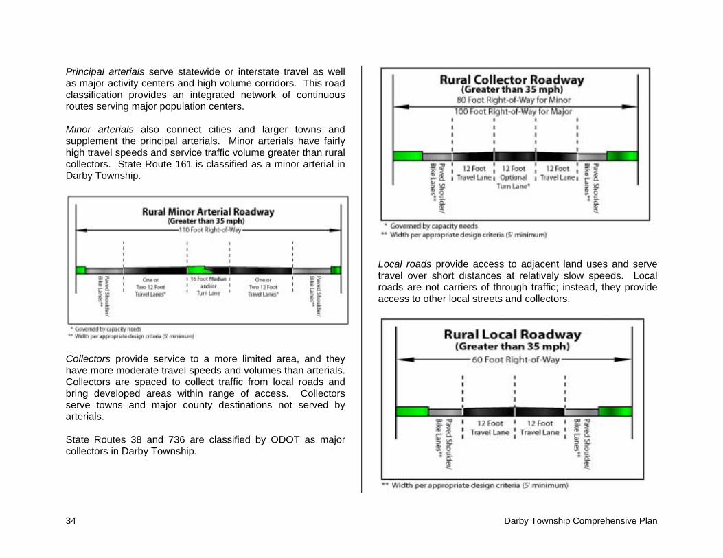
34 Darby Township Comprehensive Plan
Principal arterials serve statewide or interstate travel as well as major activity centers and high volume corridors. This road classification provides an integrated network of continuous routes serving major population centers. Minor arterials also connect cities and larger towns and supplement the principal arterials. Minor arterials have fairly high travel speeds and service traffic volume greater than rural collectors. State Route 161 is classified as a minor arterial in Darby Township.
Collectors provide service to a more limited area, and they have more moderate travel speeds and volumes than arterials. Collectors are spaced to collect traffic from local roads and bring developed areas within range of access. Collectors serve towns and major county destinations not served by arterials. State Routes 38 and 736 are classified by ODOT as major collectors in Darby Township.
Local roads provide access to adjacent land uses and serve travel over short distances at relatively slow speeds. Local roads are not carriers of through traffic; instead, they provide access to other local streets and collectors.

Darby Township Comprehensive Plan 35
Many of the Township’s roadways do not meet the design criteria of their functional classifications. However, this situation is frequent in rural areas with low traffic volume, and it does not seem to present an immediate problem. To prevent future problems, the Township should consider making the necessary improvements to roadways within its jurisdiction not meeting their functional classifications, starting with roads carrying the greatest traffic volume. Priority should be given based on functional classification in the plan. Roadways in locations where traffic growth is not desirable (i.e. agriculture/rural and critical resource areas) should not be considered for capacity improvements except necessary in some cases for safety purposes. Preserving Scenic Roads Darby Township residents greatly value the rural character of their community. For residents and others traveling through the Township, this character is heavily defined by what can be seen from the roadway. This view from the road, called the viewshed, is greatly impacted by the type and amount of development along the roadside. Because of its accessibility and because it is easy and more inexpensive to develop, land adjacent to roadways is usually the first to convert to residential and commercial uses. The utilization of conservation design is one strategy for preserving the Township’s rural roadways. Using conservation design, lots can be creatively arranged to reduce curb cuts and prevent stripping out County and Township roads. The Township may also consider a no-cut buffer of a certain depth along the rights-of-way of local roads. To limit roadside clutter, Darby Township may wish to develop a roadside management plan that would regulate construction,
land use, signage, grading, and native vegetative removal along roadways within its jurisdiction. Access management is another tool the Township can use to maintain the character and safety of its rural roads. Access Management According to ODOT, access management is a tool used to balance the competing demands on a transportation system for traffic mobility and land access. Access management strategies include standards for the frequency, location, and design of driveways, intersections, signals, medians, turn lanes, and other features based upon the functional classification of the roadway. As access management involves elements of both land use and transportation, it requires cooperation within and across government agencies responsible for transportation and development decisions. In order to promote the safety and functionality of state thoroughfares, ODOT developed the State Highway Access Management Manual, recognizing that failing to manage access leads to increased accidents and congestion, decline in operating speed, loss of traffic carrying capacity, and increased traffic delays. While the principles in the manual are aimed at managing access to and from state highways, they can and should be adapted to benefit locally maintained roads as well. Recent legislation has increased townships’ abilities to manage access in their jurisdictions. In 2002, House Bill 366 became effective which allows counties and townships in Ohio to adopt access management regulations for the purposes of promoting traffic safety and efficiency and maintaining proper traffic capacity and traffic flow. While county access management regulations apply to both county and township
36 Darby Township Comprehensive Plan
roads in unincorporated areas, township regulations apply only to township roads in unincorporated areas. Once a township adopts access management standards, it may regulate any construction, reconstruction, use, or maintenance of any point of access from public or private property onto township roads. These regulations do not apply to previously existing or approved access points, but can apply when the land use is changed in a way that impacts the volume or type of traffic from the site. The township may also adopt regulations that require the issuance of permits. Such regulations must be accompanied by standards used for the approval or denial of a permit as well as an appeals process. Finally, township access management standards must be coordinated with the existing township zoning resolution. In addition to specific access management standards, access can also be controlled through design standards and zoning regulations. In ODOT’s State Highway Access Management Manual, there are suggested guidelines for driveway location and design, driveway spacing, corner clearance, joint and cross access, and turn lane requirements. These design standards provide consistent guidelines in a format that is easy to implement. Furthermore, these standards are updated by ODOT, representing a cost and time savings to the Township. If specific additions to or modifications of ODOT’s policies are desired, the Township can specifically state these differences in its access management policies. Zoning regulations can also be implemented that support access management in the Township. One zoning recommendation may be to set minimum lot frontage requirements greater than or equal to the minimum driveway spacing requirements for the adjacent roadway. Also, minimum setback standards should be set to preserve future right-of-way requirements of the roadway. Other zoning
recommendations are the implementation of conservation zoning in high traffic corridors and the implementation of planned unit developments in commercial areas. Policies and Recommendations General policies:
• Transportation improvements in agricultural/rural and critical resource areas will be limited to maintenance and upgrading of nonstandard roads.
• New transportation improvements will be designed in a manner that limits disruption to farms, as well as important natural and scenic features.
• Sidewalks and/or pedestrian pathways will be incorporated where appropriate to encourage walking and bicycle use in the design of local and collector streets in new development.
• All public facilities will be easily accessible, particularly schools and parks.
• The Township will reduce traffic hazards and preserve investments by avoiding spot and strip commercial development and the inappropriate intrusion of commercial development into residential areas.
• The intensity of land use will be controlled to keep traffic volume on any thoroughfare from exceeding its planned capacity.
• The Township will consider private roads and easements as an alternative to dedicated public roads when developing using conservation design.
Recommendations:
• Adopt Township access management standards. • Work with the County in developing countywide access
management strategies.