data compilation report - atlanta regional...
TRANSCRIPT
i
Data Compilation Report Prepared by:
Atlanta, GA
September 2010
This plan is funded by the American Recovery and Reinvestment Act of 2009
This plan is funded by the American Recovery and Reinvestment Act of 2009
STRATEGIC REGIONAL THOROUGHFARE PLAN Data Compilation Report
Page i September 2010
Table of Contents
1.0 PURPOSE OF DATA COMPILATION AND MANAGEMENT TASK ............................................ 1
2.0 OVERVIEW OF DATA ............................................................................................................ 2
3.0 DATA CATALOG FRAMEWORK ............................................................................................. 3
4.0 DATA FOR SRTP DEFINITION AND CLASSIFICATION ............................................................. 6
5.0 IDENTIFICATION OF DATA GAPS .......................................................................................... 9
5.1 SRTP DEFINITION/DESIGNATION AND CLASSIFICATION .................................... 9
5.2 THOROUGHFARE CASE STUDIES..................................................................... 16
5.3 REGIONAL THOROUGHFARE NETWORK PERFORMANCE MONITORING .......... 17
6.0 SUMMARY OF DATA NEEDING FUTURE PROCESSING........................................................ 19
7.0 NEXT STEPS ........................................................................................................................ 22
LIST OF FIGURES
1 - EXAMPLE OF SKYCOMP DATA FOR METRO ATLANTA ARTERIAL NETWORK ............................. 19
2 - ASTROMAP PROJECT – TRUCK TRAVEL TIME LOCATIONS FOR SR 3/US 41 ................................ 21
3 - SNAPSHOT OF M.A.S.T PROGRAM STATUS UPDATE SPREADSHEET (AS OF 04/23/10) .............. 21
LIST OF TABLES
1 - COMMON THEMES FOR NETWORK DEFINITION, CLASSIFICATION, AND PERFORMANCE MEASUREMENT ................................................................................................................... 7
2 - POTENTIAL SRTP DEFINITION CRITERIA AND SUPPLEMENTAL DATA .......................................... 8
3 - DATA ASSOCIATED WITH ROADWAY CHARACTERISTICS .......................................................... 10
4 - DATA ASSOCIATED WITH CONNECTIVITY AND ACCESSIBILITY TO REGIONAL LOCATIONS ........ 13
5 - SIGNIFICANCE TO REGIONAL TRANSPORTATION DATA ............................................................ 15
6 - SUMMARY OF M.A.S.T. PROGRAM TRAFFIC DATA ................................................................... 17
7 - GRTA PERFORMANCE MONITIORING – ANNUAL MAP REPORT ................................................ 18
STRATEGIC REGIONAL THOROUGHFARE PLAN Data Compilation Report
Page ii September 2010
APPENDICES
Appendix A: Data Catalog
Appendix B: RTSP Maps
Appendix C: GDOT M.A.S.T. Program – Status Spreadsheet (April 2010)
Appendix D: ASTRoMaP Project Travel Time Run Corridors
Appendix E: 2009 CMP Update Travel Time Run Corridors
STRATEGIC REGIONAL THOROUGHFARE PLAN Data Compilation Report
Page 1 September 2010
1.0 PURPOSE OF DATA COMPILATION AND MANAGEMENT TASK
The primary purpose of Task 2 of the Strategic Regional Thoroughfare Plan (SRTP) is to explore and document the various data resources determined to be most useful towards objectively identifying the “Regional Thoroughfare Network” (RTN). The RTN will ultimately become an important component of the Regional Strategic Transportation System (RSTS), and will be used as a basis for future regional management, operations, and maintenance applications. The designated regional thoroughfares will represent high priority corridors necessary for facilitating multimodal mobility as well as accessibility. Given the intended regional significance of the RTN, careful attention shall be devoted to organization and application of existing data and/or empirical resources appropriate for establishing the RTN.
For the purposes of this effort, a thoroughfare is defined as:
“A transportation corridor that serves multiple ways of traveling, including walking, bicycling, driving and riding transit. It connects people and/or goods to importance places in Metropolitan Atlanta. It is managed by applicable special traffic control strategies and suitable land development guidelines in order to maintain travel efficiency, reliability, and safety for all thoroughfare users. In light of this special function, the thoroughfare network receives priority consideration for infrastructure investment in the Metro Atlanta region.”
The SRTP will be developed over the next year to document the policy framework and investment recommendations for this part of the region’s multimodal transportation system. The SRTP is innovative within the Metro Atlanta region for focusing on strengthening the link between transportation planning, land use planning, and traffic management and operations.
The data compilation and management task is a critical first step in the SRTP development process. Utilization of travel and operational characteristics data is an integral part in designating a regional thoroughfare network, classifying the network into distinct components, evaluating its overall performance, and developing recommendations for system improvement. Collection and management of comprehensive, multimodal data will help support the planning, analysis, and development of a hierarchy of arterial roadways throughout the 18-county Metro Atlanta region.
As part of the SRTP project, a comprehensive data catalog will be maintained throughout the course of the study, and will be used to conduct performance-based planning and evaluation of Metro Atlanta’s thoroughfare system, including:
• Assessment of existing/future conditions and thoroughfare system needs;
STRATEGIC REGIONAL THOROUGHFARE PLAN Data Compilation Report
Page 2 September 2010
• Establishment of acceptable performance targets to achieve sustainable levels of
service;
• Prioritizing implementation strategies, consistent with the current Georgia
Department of Transportation (GDOT) Project Prioritization Process (PrPP) and ARC
(regional) guidance;
• Support of the Metro Atlanta Congestion Management Process (CMP) and on-going
system performance monitoring; and
• Other related regional planning purposes. Additionally, the data catalog will also be used to develop the framework for a data clearinghouse pilot system for ARC. It should be noted that while the overall data inventory and collection efforts for the SRTP project are a combination of compiling existing data as well as collecting new field data, this Data Compilation Report describes only existing data sources. Additional field data collection may be performed in subsequent phases of the project, pending a review by ARC of identified data gaps and future project needs. The collection of new data will also need to be within the financial resources of the project. The following sections describe the data compilation and management process:
2.0 – Overview of data requested and obtained;
3.0 – Data catalog framework description;
4.0 – Data to be used for SRTP development and classification;
5.0 – Identification of data gaps; and
6.0 – Summary of data requiring future processing and next steps.
2.0 OVERVIEW OF DATA
The study area consists of the 18-county Metropolitan Planning Organization (MPO) area for transportation planning purposes, including all or portions of Barrow, Bartow, Cherokee, Clayton, Cobb, Coweta, DeKalb, Douglas, Forsyth, Henry, Fayette, Fulton, Gwinnett, Newton, Paulding, Rockdale, Spalding, and Walton Counties.
The overall direction on the SRTP data compilation activities focused on the use of existing data, wherever possible, provided they are current and reasonably consistent with the latest standards set forth in the ARC 2008-2009 Congestion Management Process Update (CMP), Regional Data Inventory, Collection Standards, and Clearinghouse Framework Technical Memo. Collection activities were to also focus on data with a geospatial reference that can be easily and seamlessly integrated, and/or that require only minor processing. Data not meeting these criteria, such as data
STRATEGIC REGIONAL THOROUGHFARE PLAN Data Compilation Report
Page 3 September 2010
requiring “major processing,” data with no geospatial reference, or data not available digitally were to be cataloged and reviewed based upon available resources, with an expectation that review would be limited. No major data clean-up activities (or “scrubbing”) associated with any datasets were to be performed; however, some minor adjustments were anticipated and were completed.
Following identification of likely data sources, the SRTP project team coordinated with ARC regarding the appropriate entities that would need to be contacted for obtaining the necessary data. Coordination involved separate meetings with ARC and GDOT staff to review existing data deficiencies and limitations. Initial data requests were made by ARC, with the project team performing follow-up meetings with individual ARC staff members representing various planning initiatives, including the following:
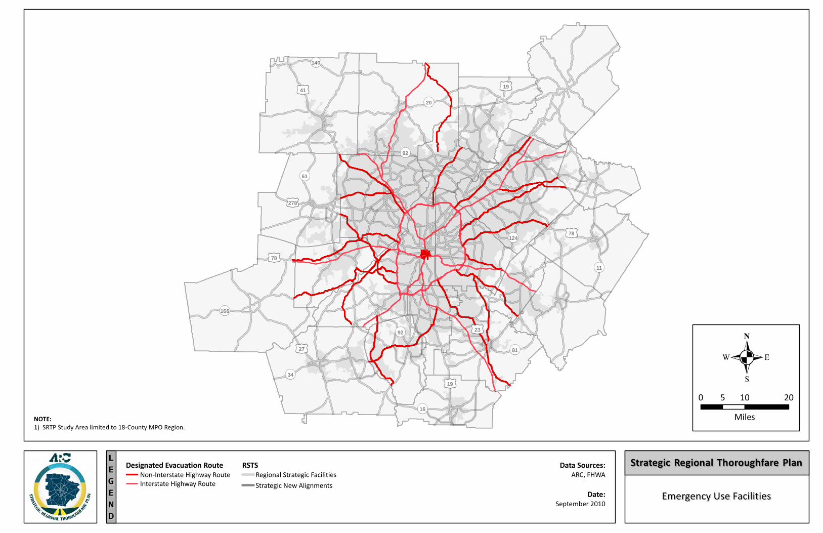
Evacuation Planning;
Freight/Truck Master Planning;
Bicycle and Pedestrian Planning;
Regional Access Management Initiative;
Transit Planning/Integration with Concept 3 (Metro Atlanta’s Regional Transit Vision); and
Regional Transportation Plan (Plan2040). Separate meetings were also conducted with staff from GDOT, including the Office of Transportation Data and the Office of Traffic Safety and Design. Representatives from GDOT’s Office of Planning also participated in the meetings. Creation of the data catalog involved reviewing existing data from ARC, GDOT, Georgia Regional Transportation Authority (GRTA), Metropolitan Atlanta Rapid Transit Authority (MARTA), SRTP team members, and the local jurisdictions within the 18-county study area. The variety of planning and applicable traffic analysis studies that have been completed and/or are underway were also cataloged and reviewed, and relevant datasets to the SRTP were identified and noted in the catalog. The current version of the data catalog is in the form of a spreadsheet which can be found in Appendix A. Section 3.0 identifies the framework and categories of data found within the data catalog.
3.0 DATA CATALOG FRAMEWORK
The purpose of the data catalog framework is to organize the data into an understandable and user-friendly format. The catalog will assist with the development of the SRTP and likely will ultimately be incorporated into a Geographic Information System (GIS)-based application. The ARC SRTP data catalog is currently divided into the following 12 categories of data types:
STRATEGIC REGIONAL THOROUGHFARE PLAN Data Compilation Report
Page 4 September 2010
Land Use
Boundaries
Roadway
Traffic
Safety
Transit
Bicycle and Pedestrian
Freight
Plans and Studies
Modeling
Environmental Resources
Community Landmarks Within these individual data categories, compiled data are presented in a variety of data formats, coverages, etc. To organize the data and aid in its use, a series of descriptive fields have been developed to describe the various data sets. These fields are listed below along with descriptions of each field and examples of their use. File Name Name of digital file or hardcopy resource. Digital file extensions denote file types. Examples: TMC_Locations.shp (GIS shapefile), ADT Master Table.xls (MS Excel spreadsheet) Data Description Brief description of dataset. Examples: GRTA Routes in Gwinnett, HPMS Facilities
Scale of data Extent of data coverage in the region. Examples: Statewide, Barrow County, 18-County
Coverage General type of spatial coverage or extent. Examples: point locations, corridors
Source / Owner Source of digital or hardcopy data.
STRATEGIC REGIONAL THOROUGHFARE PLAN Data Compilation Report
Page 5 September 2010
Examples: ARC, GDOT, Gwinnett Transit, MARTA Format Type of digital or hardcopy file. Examples: GIS – points, GIS – polygon, pdf, Excel Date Last Modified Date of last update or modification (if available). Examples: 2007, unknown, March 2006
Key Data Fields Important components of data set. For GIS files, key attributes within the shapefile. Examples: PRJ_TYPE, LOCATION, FUNC_CLASS
Latitude / Longitude Data Some of the datasets also contain latitude/longitude information. Examples: Y/N (yes/no) Gaps or Deficiencies Known holes or deficiencies in the dataset – spatial, temporal, descriptive, etc. Examples: None, lacks county X Data Processing Extent of data processing needed (if any). Describes if dataset is seamless, needs minor processing, or needs major processing. Examples: Y/N (yes/no) Notes Any additional information that is pertinent to the dataset. Examples: various
As discussed above, 12 categories of data have been collected within the data catalog. GIS shapefiles (.shp) are the primary file type; however, other file formats are identified. While ARC was the primary source for many of the datasets, GDOT, the US Census, and various counties were also sources of data. Dataset age is variable, with some datasets
STRATEGIC REGIONAL THOROUGHFARE PLAN Data Compilation Report
Page 6 September 2010
of unknown age. The majority were compiled within the 2000-2010 timeframe. Data categories with the largest number of files include roadway, traffic, transit, and freight. The current version of the data catalog can be found in Appendix A.
4.0 DATA FOR SRTP DEFINITION AND CLASSIFICATION
As part of the SRTP project, a review of peer regions was conducted to ascertain how other metropolitan regions conceptualize (i.e. define and classify) their thoroughfare networks. The project team conducted research on five (5) peer regions based upon input received from ARC, which included:
Charlotte, NC
Dallas-Ft. Worth, TX
Denver, CO
San Diego, CA
Auckland, NZ Additionally, other regions and states, including the City of Orlando, the City of Houston, the State of South Carolina, and the State of Florida were also reviewed for useful information.
Other professional literature on thoroughfare network development, classification, and performance measures was also reviewed by the study team. Two specific documents include: 1) “Performance Measure Framework for Highway Capacity Decision Making” – Strategic Highway Research Program (SHRP) 2, and 2) “Context Sensitive Solutions for Designing Major Urban Thoroughfares in Walkable Communities” – Institute of Transportation Engineers.
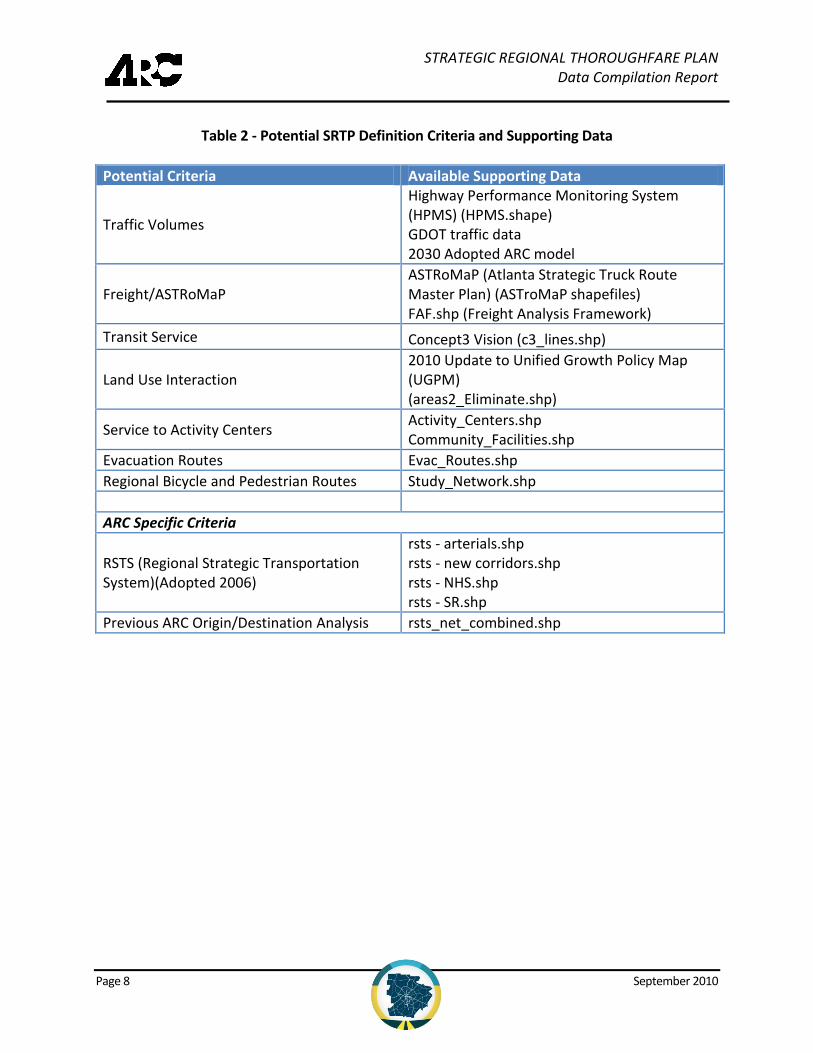
Based upon review of the peer regions and professional documents listed above, the study team developed a list of common themes and issues to consider for thoroughfare network definition, classification, and performance measurement. These common themes are presented in Table 1. Following a review of the various datasets available in the data catalog, the following criteria and data sources were deemed most useful for development of the SRTP based upon the common elements identified through the peer review assessment. Table 2 presents these potential criteria and the available supporting data collected.
Although the ARC regional travel demand model is a relevant source of data for RTN identification and classification, the focus of the review included in this report is to evaluate sources of field-collected data. In the absence of field data and with limited resources, the use of the regional travel demand model and mesoscopic models will be needed in the short-term until more resources are allocated for data collection and
STRATEGIC REGIONAL THOROUGHFARE PLAN Data Compilation Report
Page 7 September 2010
performance monitoring of the RTN. The maps depicting the 18-county study area with each potential criterion identified can be found in Appendix B.
Table 1 - Common Themes and Issues to Consider for Network Definition, Classification, and Performance Measurement
Common Elements of Network
Definition Criteria
Roadway Characteristics – Speed, Volume, Congestion, Etc.
Connectivity – Access to Regional Functions, Centers, Etc.
Special Significance to Regional Transportation o Freight Corridors o Regional Transit o Regional Bike/Pedestrian/Trail
Other Interesting Network Definition
Criteria
System Resiliency/Security
Parallel Capacity to Regional Roadways
Role in Statewide System
Regional Land Development Concepts and/or Visions
Freeway-to-Freeway Connectors
Lane-Balancing
Network Classification
Criteria
Very little available data
Gives appearance of “art” vs. “science”
Less impressive than network definition criteria
Performance Measurement
Availability of data (observed or modeled) is the driving force
Mostly highway-oriented – some peers address transit in a limited way
Weak bicycle/pedestrian perspective, except for Auckland
STRATEGIC REGIONAL THOROUGHFARE PLAN Data Compilation Report
Page 8 September 2010
Table 2 - Potential SRTP Definition Criteria and Supporting Data
Potential Criteria Available Supporting Data
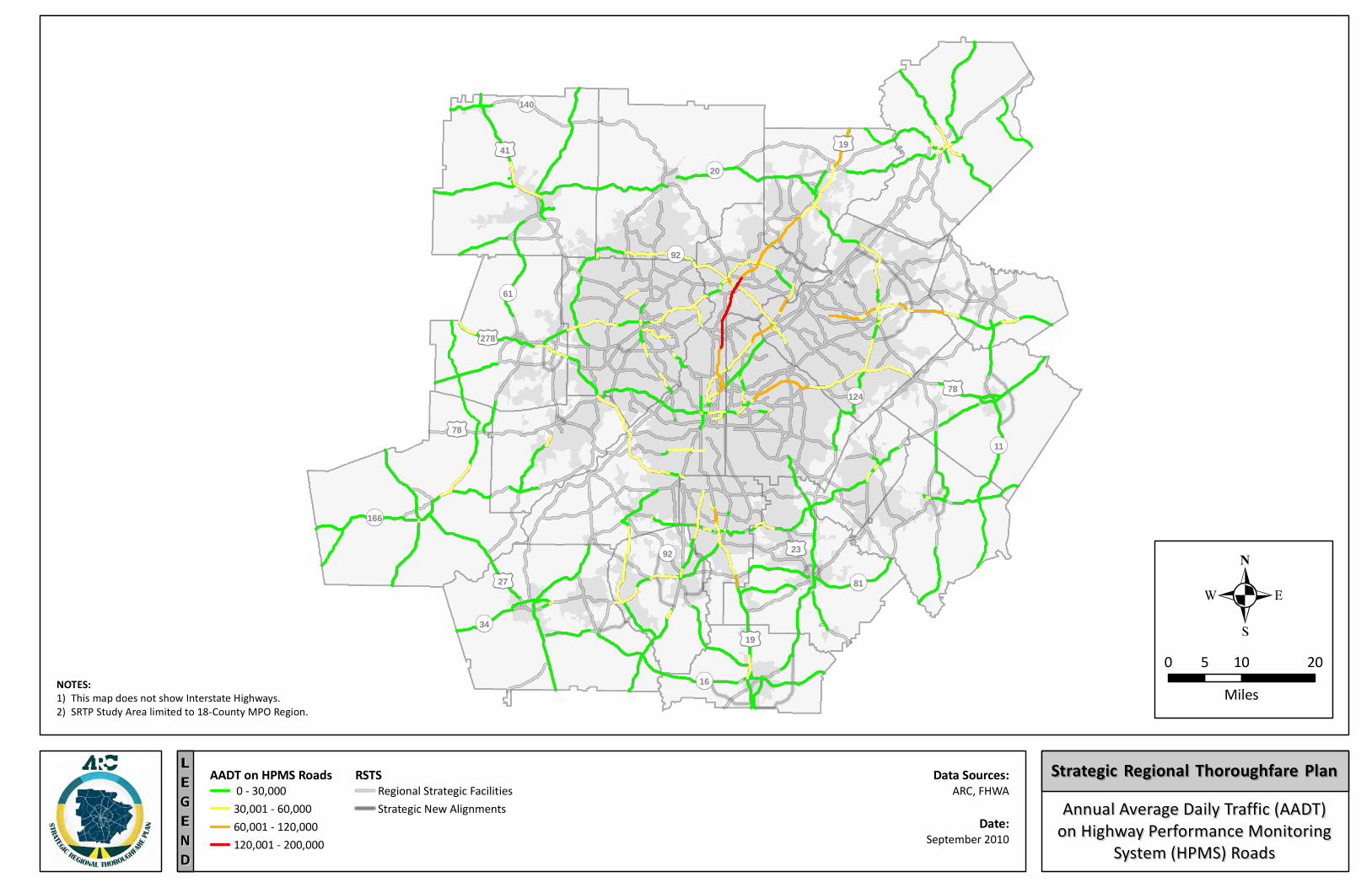
Traffic Volumes
Highway Performance Monitoring System (HPMS) (HPMS.shape) GDOT traffic data 2030 Adopted ARC model
Freight/ASTRoMaP
ASTRoMaP (Atlanta Strategic Truck Route Master Plan) (ASTroMaP shapefiles) FAF.shp (Freight Analysis Framework)
Transit Service Concept3 Vision (c3_lines.shp)
Land Use Interaction 2010 Update to Unified Growth Policy Map (UGPM) (areas2_Eliminate.shp)
Service to Activity Centers Activity_Centers.shp Community_Facilities.shp
Evacuation Routes Evac_Routes.shp
Regional Bicycle and Pedestrian Routes Study_Network.shp
ARC Specific Criteria
RSTS (Regional Strategic Transportation System)(Adopted 2006)
rsts - arterials.shp rsts - new corridors.shp rsts - NHS.shp rsts - SR.shp
Previous ARC Origin/Destination Analysis rsts_net_combined.shp
STRATEGIC REGIONAL THOROUGHFARE PLAN Data Compilation Report
Page 9 September 2010
5.0 IDENTIFICATION OF DATA GAPS
The previous sections detail the specific data available and obtained by the project team as part of the development of the SRTP. As discussed, the vast amount of data varies by type, format, date and age, extent of coverage, processing required, reliability, and geo-referencing to allow for mapping using a Geographic Information System (GIS).
This section presents an overview of the major gaps identified through the data compilation process in terms of two major SRTP task items: 1) SRTP Development/Definition and Classification, and 2) the individual case studies to be conducted as part of the SRTP development. The SRTP project team is currently working with ARC staff to develop the final list of criteria that will be used to help define the Regional Thoroughfare Network (RTN), which must be completed by the ARC Board retreat in July 2010. The RTN classification into sub-components will be completed subsequent to approval of the RTN network definition.
For these reasons, the precise list of data to support the RTN definition and classification processes cannot be finalized at this time. However, the list of RTN criteria common to peer regions has been compiled and used that to identify potential data gaps. Additionally, data gaps that may exist to successfully complete the subsequent SRTP case study work to be conducted in 2011. Any data gaps related to the case studies will be addressed in the future. Finally, priorities have been identified for filling the identified data gaps based upon the limited resources and constrained schedule for the project.
5.1 SRTP Definition/Designation and Classification
As previously mentioned, until the specific RTN definition and classification criteria are determined, the data needed to support those efforts cannot be fully developed. However, using the results of the peer region research completed and presented in Section 4.0, this section uses the following three (3) major categories to summarize the availability of regional data for use in the development (i.e. definition/designation and classification) and monitoring of the RTN:
Roadway Characteristics Data
Connectivity and Access to Regional Locations
Special Significance to Regional Transportation Roadway Characteristics Data
The data attributable to roadway characteristics within the 18-county ARC region is extensive. As such, several sub-groups have been developed to better present the available data for recommended for use in defining and classifying the RTN. Each data
STRATEGIC REGIONAL THOROUGHFARE PLAN Data Compilation Report
Page 10 September 2010
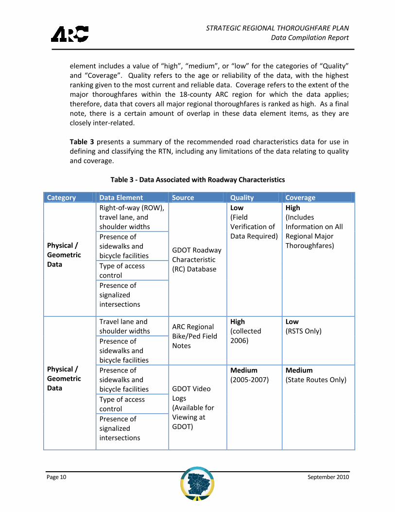
element includes a value of “high”, “medium”, or “low” for the categories of “Quality” and “Coverage”. Quality refers to the age or reliability of the data, with the highest ranking given to the most current and reliable data. Coverage refers to the extent of the major thoroughfares within the 18-county ARC region for which the data applies; therefore, data that covers all major regional thoroughfares is ranked as high. As a final note, there is a certain amount of overlap in these data element items, as they are closely inter-related. Table 3 presents a summary of the recommended road characteristics data for use in defining and classifying the RTN, including any limitations of the data relating to quality and coverage.
Table 3 - Data Associated with Roadway Characteristics
Category Data Element Source Quality Coverage
Physical / Geometric Data
Right-of-way (ROW), travel lane, and shoulder widths
GDOT Roadway Characteristic (RC) Database
Low (Field Verification of Data Required)
High (Includes Information on All Regional Major Thoroughfares)
Presence of sidewalks and bicycle facilities
Type of access control
Presence of signalized intersections
Physical / Geometric Data
Travel lane and shoulder widths
ARC Regional Bike/Ped Field Notes
High (collected 2006)
Low (RSTS Only)
Presence of sidewalks and bicycle facilities
Presence of sidewalks and bicycle facilities GDOT Video
Logs (Available for Viewing at GDOT)
Medium (2005-2007)
Medium (State Routes Only)
Type of access control
Presence of signalized intersections
STRATEGIC REGIONAL THOROUGHFARE PLAN Data Compilation Report
Page 11 September 2010
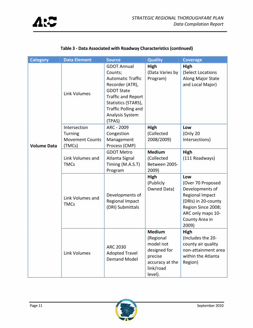
Table 3 - Data Associated with Roadway Characteristics (continued)
Category Data Element Source Quality Coverage
Volume Data
Link Volumes
GDOT Annual Counts; Automatic Traffic Recorder (ATR), GDOT State Traffic and Report Statistics (STARS), Traffic Polling and Analysis System (TPAS)
High (Data Varies by Program)
High (Select Locations Along Major State and Local Major)
Intersection Turning Movement Counts (TMCs)
ARC - 2009 Congestion Management Process (CMP)
High (Collected 2008/2009)
Low (Only 20 Intersections)
Link Volumes and TMCs
GDOT Metro Atlanta Signal Timing (M.A.S.T) Program
Medium (Collected Between 2005-2009)
High (111 Roadways)
Link Volumes and TMCs
Developments of Regional Impact (DRI) Submittals
High (Publicly Owned Data)
Low (Over 70 Proposed Developments of Regional Impact (DRIs) in 20-county Region Since 2008; ARC only maps 10-County Area in 2009)
Link Volumes ARC 2030 Adopted Travel Demand Model
Medium (Regional model not designed for precise accuracy at the link/road level).
High (Includes the 20-county air quality non-attainment area within the Atlanta Region)
STRATEGIC REGIONAL THOROUGHFARE PLAN Data Compilation Report
Page 12 September 2010
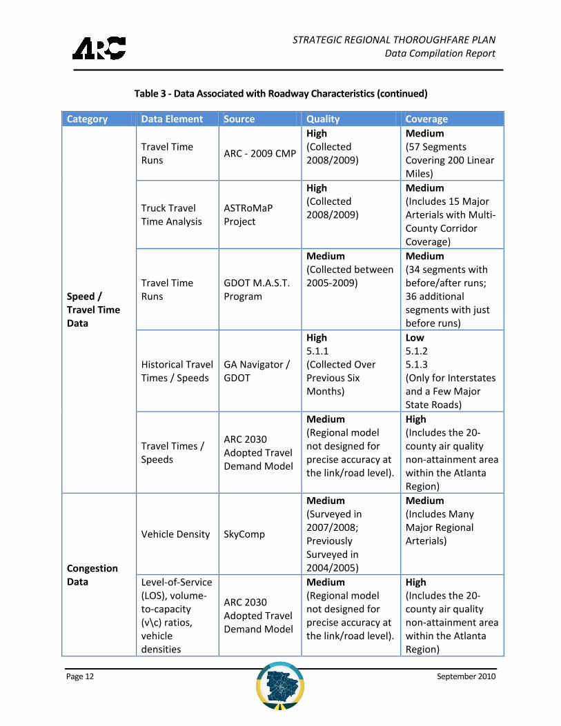
Table 3 - Data Associated with Roadway Characteristics (continued)
Category Data Element Source Quality Coverage
Speed / Travel Time Data
Travel Time Runs
ARC - 2009 CMP
High (Collected 2008/2009)
Medium (57 Segments Covering 200 Linear Miles)
Truck Travel Time Analysis
ASTRoMaP Project
High (Collected 2008/2009)
Medium (Includes 15 Major Arterials with Multi-County Corridor Coverage)
Travel Time Runs
GDOT M.A.S.T. Program
Medium (Collected between 2005-2009)
Medium (34 segments with before/after runs; 36 additional segments with just before runs)
Historical Travel Times / Speeds
GA Navigator / GDOT
High 5.1.1 (Collected Over Previous Six Months)
Low 5.1.2 5.1.3 (Only for Interstates and a Few Major State Roads)
Travel Times / Speeds
ARC 2030 Adopted Travel Demand Model
Medium (Regional model not designed for precise accuracy at the link/road level).
High (Includes the 20-county air quality non-attainment area within the Atlanta Region)
Congestion Data
Vehicle Density SkyComp
Medium (Surveyed in 2007/2008; Previously Surveyed in 2004/2005)
Medium (Includes Many Major Regional Arterials)
Level-of-Service (LOS), volume-to-capacity (v\c) ratios, vehicle densities
ARC 2030 Adopted Travel Demand Model
Medium (Regional model not designed for precise accuracy at the link/road level).
High (Includes the 20-county air quality non-attainment area within the Atlanta Region)
STRATEGIC REGIONAL THOROUGHFARE PLAN Data Compilation Report
Page 13 September 2010
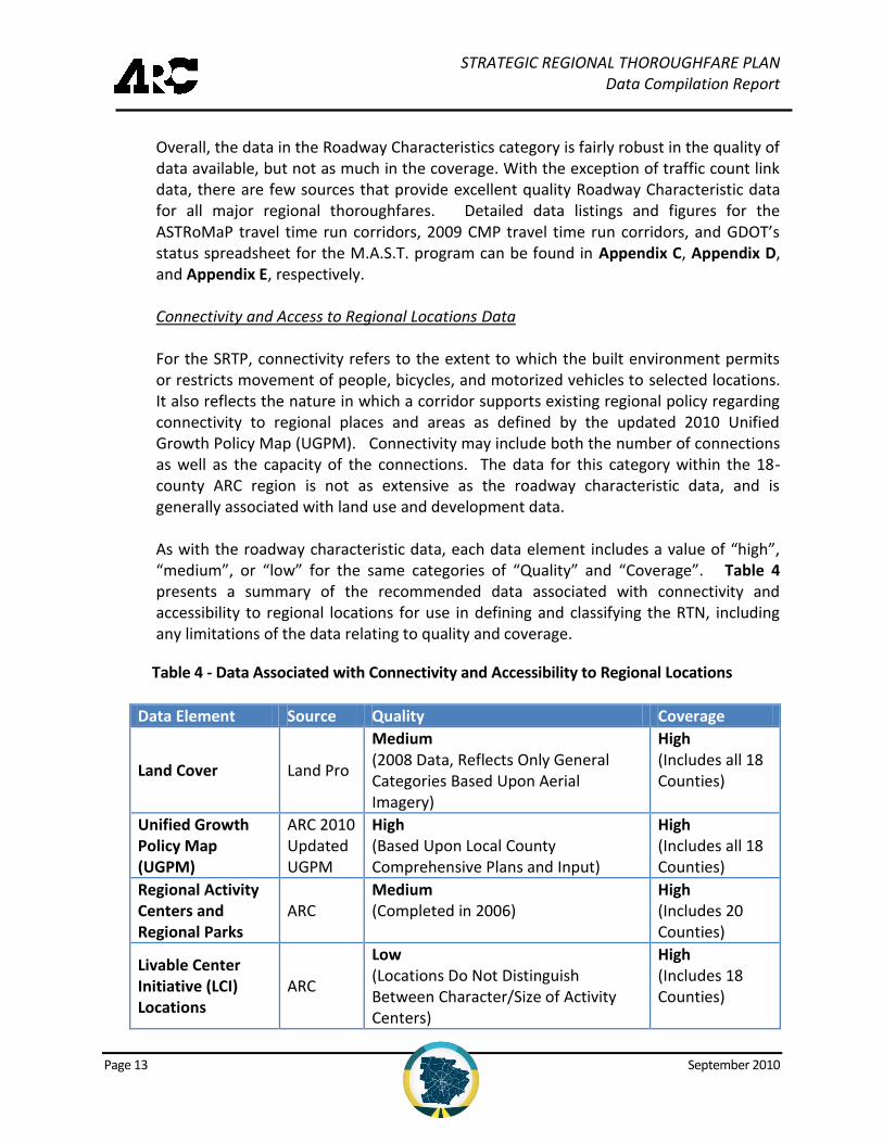
Overall, the data in the Roadway Characteristics category is fairly robust in the quality of data available, but not as much in the coverage. With the exception of traffic count link data, there are few sources that provide excellent quality Roadway Characteristic data for all major regional thoroughfares. Detailed data listings and figures for the ASTRoMaP travel time run corridors, 2009 CMP travel time run corridors, and GDOT’s status spreadsheet for the M.A.S.T. program can be found in Appendix C, Appendix D, and Appendix E, respectively. Connectivity and Access to Regional Locations Data For the SRTP, connectivity refers to the extent to which the built environment permits or restricts movement of people, bicycles, and motorized vehicles to selected locations. It also reflects the nature in which a corridor supports existing regional policy regarding connectivity to regional places and areas as defined by the updated 2010 Unified Growth Policy Map (UGPM). Connectivity may include both the number of connections as well as the capacity of the connections. The data for this category within the 18-county ARC region is not as extensive as the roadway characteristic data, and is generally associated with land use and development data. As with the roadway characteristic data, each data element includes a value of “high”, “medium”, or “low” for the same categories of “Quality” and “Coverage”. Table 4 presents a summary of the recommended data associated with connectivity and accessibility to regional locations for use in defining and classifying the RTN, including any limitations of the data relating to quality and coverage.
Table 4 - Data Associated with Connectivity and Accessibility to Regional Locations
Data Element Source Quality Coverage
Land Cover Land Pro
Medium (2008 Data, Reflects Only General Categories Based Upon Aerial Imagery)
High (Includes all 18 Counties)
Unified Growth Policy Map (UGPM)
ARC 2010 Updated UGPM
High (Based Upon Local County Comprehensive Plans and Input)
High (Includes all 18 Counties)
Regional Activity Centers and Regional Parks
ARC Medium (Completed in 2006)
High (Includes 20 Counties)
Livable Center Initiative (LCI) Locations
ARC
Low (Locations Do Not Distinguish Between Character/Size of Activity Centers)
High (Includes 18 Counties)
STRATEGIC REGIONAL THOROUGHFARE PLAN Data Compilation Report
Page 14 September 2010
Table 4 - Data Associated with Connectivity and Accessibility to Regional Locations (continued)
Data Element Source Quality Coverage
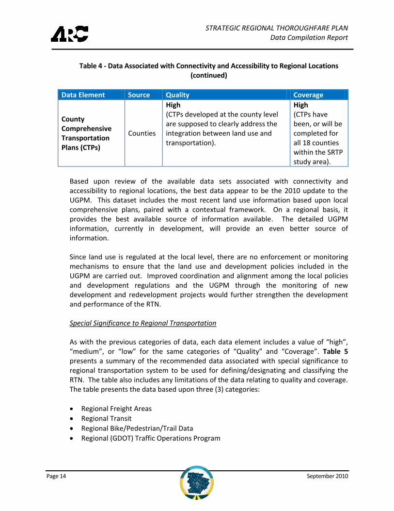
County Comprehensive Transportation Plans (CTPs)
Counties
High (CTPs developed at the county level are supposed to clearly address the integration between land use and transportation).
High (CTPs have been, or will be completed for all 18 counties within the SRTP study area).
Based upon review of the available data sets associated with connectivity and accessibility to regional locations, the best data appear to be the 2010 update to the UGPM. This dataset includes the most recent land use information based upon local comprehensive plans, paired with a contextual framework. On a regional basis, it provides the best available source of information available. The detailed UGPM information, currently in development, will provide an even better source of information. Since land use is regulated at the local level, there are no enforcement or monitoring mechanisms to ensure that the land use and development policies included in the UGPM are carried out. Improved coordination and alignment among the local policies and development regulations and the UGPM through the monitoring of new development and redevelopment projects would further strengthen the development and performance of the RTN. Special Significance to Regional Transportation As with the previous categories of data, each data element includes a value of “high”, “medium”, or “low” for the same categories of “Quality” and “Coverage”. Table 5 presents a summary of the recommended data associated with special significance to regional transportation system to be used for defining/designating and classifying the RTN. The table also includes any limitations of the data relating to quality and coverage. The table presents the data based upon three (3) categories:
Regional Freight Areas
Regional Transit
Regional Bike/Pedestrian/Trail Data
Regional (GDOT) Traffic Operations Program
STRATEGIC REGIONAL THOROUGHFARE PLAN Data Compilation Report
Page 15 September 2010
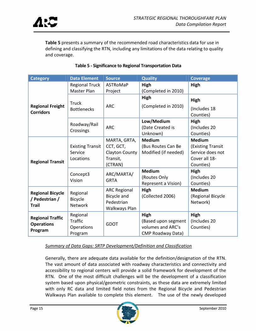
Table 5 presents a summary of the recommended road characteristics data for use in defining and classifying the RTN, including any limitations of the data relating to quality and coverage.
Table 5 - Significance to Regional Transportation Data
Category Data Element Source Quality Coverage
Regional Freight Corridors
Regional Truck Master Plan
ASTRoMaP Project
High (Completed in 2010)
High
Truck Bottlenecks
ARC
High
(Completed in 2010) High
(Includes 18 Counties)
Roadway/Rail Crossings
ARC Low/Medium (Date Created is Unknown)
High (Includes 20 Counties)
Regional Transit
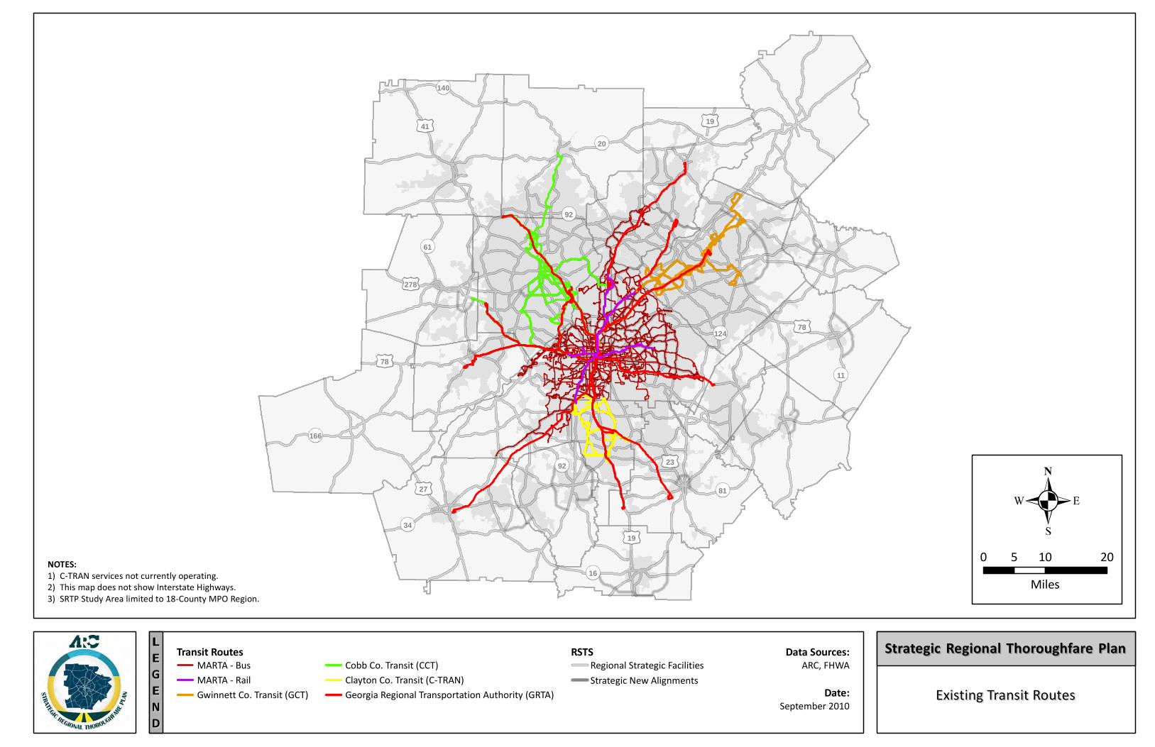
Existing Transit Service Locations
MARTA, GRTA, CCT, GCT, Clayton County Transit, (CTRAN)
Medium (Bus Routes Can Be Modified (if needed)
Medium (Existing Transit Service does not Cover all 18-Counties)
Concept3 Vision
ARC/MARTA/ GRTA
Medium (Routes Only Represent a Vision)
High (Includes 20 Counties)
Regional Bicycle / Pedestrian / Trail
Regional Bicycle Network
ARC Regional Bicycle and Pedestrian Walkways Plan
High (Collected 2006)
Medium (Regional Bicycle Network)
Regional Traffic Operations Program
Regional Traffic Operations Program
GDOT
High (Based upon segment volumes and ARC’s CMP Roadway Data)
High (Includes 20 Counties)
Summary of Data Gaps: SRTP Development/Definition and Classification Generally, there are adequate data available for the definition/designation of the RTN. The vast amount of data associated with roadway characteristics and connectivity and accessibility to regional centers will provide a solid framework for development of the RTN. One of the most difficult challenges will be the development of a classification system based upon physical/geometric constraints, as these data are extremely limited with only RC data and limited field notes from the Regional Bicycle and Pedestrian Walkways Plan available to complete this element. The use of the newly developed
STRATEGIC REGIONAL THOROUGHFARE PLAN Data Compilation Report
Page 16 September 2010
Regional Truck Master Plan (ASTRoMaP) and the Concept3 Regional Transit Vision will also be important for developing/defining the RTN. One challenge with using the Concept3 information relates to a vision versus a specific plan with implementation activities. Therefore, it may change or be modified over time as needs and/or resources fluctuate.
One of the most challenging aspects of the SRTP will be to determine which performance measures will be used to monitor the system. At this time, the SRTP project team is working with ARC staff to develop performance measures that will address both the RTP update and the SRTP monitoring. The data collection efforts for the SRTP have shown that there are scattered performance data available, but no one source that covers all major thoroughfares throughout the region. Certain performance data are available (such as SkyComp and Georgia Navigator data); however, at this time the data collection and monitoring have been focused more heavily on the interstate system. SkyComp data are more robust for arterials, but only provide a snapshot of congestion and not recurring patterns.
5.2 Thoroughfare Case Studies
As part of the SRTP project, five (5) distinct thoroughfare case studies will be selected by ARC for detailed analysis. The five (5) case study locations will be chosen such that they represent varying land use, context areas, and geographies within the 18-county SRTP study area. The case studies will provide a means to conduct more micro-level analyses to test various combinations of land use and development, access control, and multimodal transportation system improvements to determine the overall impacts on the adjoining thoroughfares.
Since the detailed analysis for the case studies will be at a smaller scale, the data needs are more robust. More detailed roadway characteristics and land use/development data are required to complete the proposed scenario testing. Roadway characteristics data (including link volumes and intersection turning movement counts [TMCs]) exist for selected roadways across the region, but are by no means available for every thoroughfare. Any additional data required for the micro-level analyses will be collected prior to the completion of the case study analyses and documented as an addendum/appendix to this report.
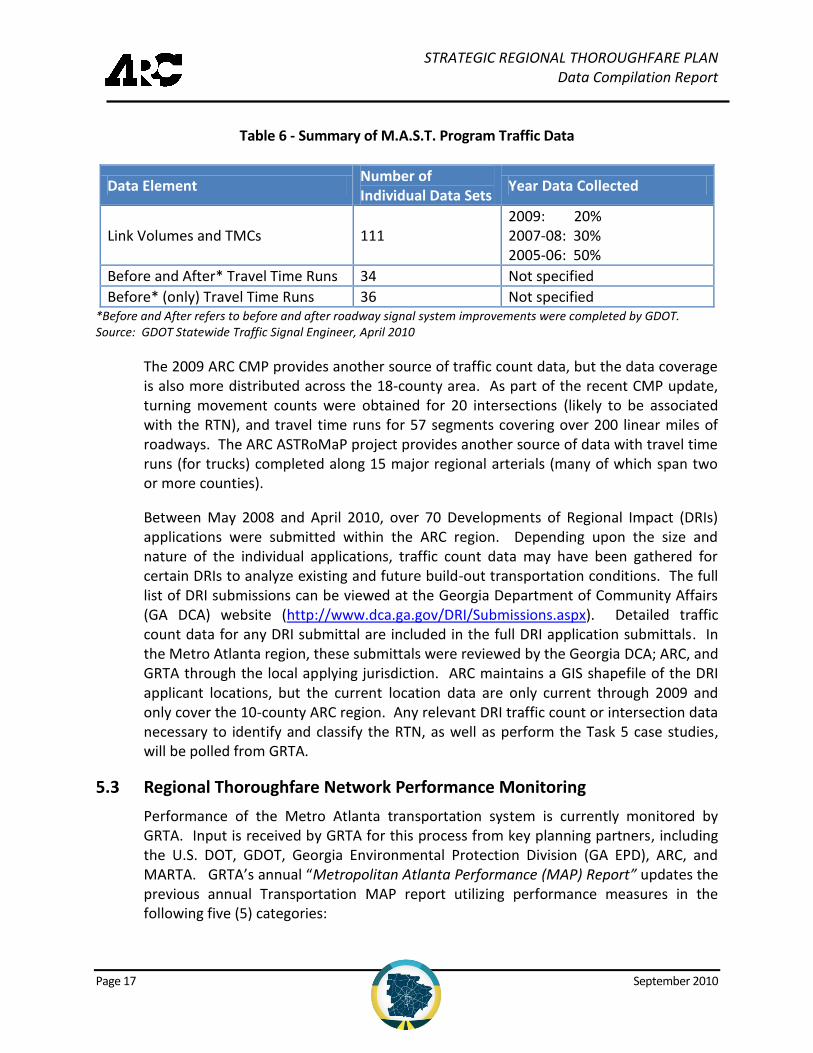
The M.A.S.T. program provides the best set of available link volumes (2004/2005), TMCs and also travel time surveys and should be consulted since the program dates back several years and some of the data is now dated (older than two-years old, which is the standard accepted age for traffic-related data). Table 6 presents a summary of the available M.A.S.T. data; Appendix A presents a more comprehensive list.
STRATEGIC REGIONAL THOROUGHFARE PLAN Data Compilation Report
Page 17 September 2010
Table 6 - Summary of M.A.S.T. Program Traffic Data
Data Element Number of Individual Data Sets
Year Data Collected
Link Volumes and TMCs 111 2009: 20% 2007-08: 30% 2005-06: 50%
Before and After* Travel Time Runs 34 Not specified
Before* (only) Travel Time Runs 36 Not specified *Before and After refers to before and after roadway signal system improvements were completed by GDOT. Source: GDOT Statewide Traffic Signal Engineer, April 2010
The 2009 ARC CMP provides another source of traffic count data, but the data coverage is also more distributed across the 18-county area. As part of the recent CMP update, turning movement counts were obtained for 20 intersections (likely to be associated with the RTN), and travel time runs for 57 segments covering over 200 linear miles of roadways. The ARC ASTRoMaP project provides another source of data with travel time runs (for trucks) completed along 15 major regional arterials (many of which span two or more counties).
Between May 2008 and April 2010, over 70 Developments of Regional Impact (DRIs) applications were submitted within the ARC region. Depending upon the size and nature of the individual applications, traffic count data may have been gathered for certain DRIs to analyze existing and future build-out transportation conditions. The full list of DRI submissions can be viewed at the Georgia Department of Community Affairs (GA DCA) website (http://www.dca.ga.gov/DRI/Submissions.aspx). Detailed traffic count data for any DRI submittal are included in the full DRI application submittals. In the Metro Atlanta region, these submittals were reviewed by the Georgia DCA; ARC, and GRTA through the local applying jurisdiction. ARC maintains a GIS shapefile of the DRI applicant locations, but the current location data are only current through 2009 and only cover the 10-county ARC region. Any relevant DRI traffic count or intersection data necessary to identify and classify the RTN, as well as perform the Task 5 case studies, will be polled from GRTA.
5.3 Regional Thoroughfare Network Performance Monitoring
Performance of the Metro Atlanta transportation system is currently monitored by GRTA. Input is received by GRTA for this process from key planning partners, including the U.S. DOT, GDOT, Georgia Environmental Protection Division (GA EPD), ARC, and MARTA. GRTA’s annual “Metropolitan Atlanta Performance (MAP) Report” updates the previous annual Transportation MAP report utilizing performance measures in the following five (5) categories:
STRATEGIC REGIONAL THOROUGHFARE PLAN Data Compilation Report
Page 18 September 2010
Mobility
Transit Accessibility
Air Quality
Safety, and
Transportation System Performance
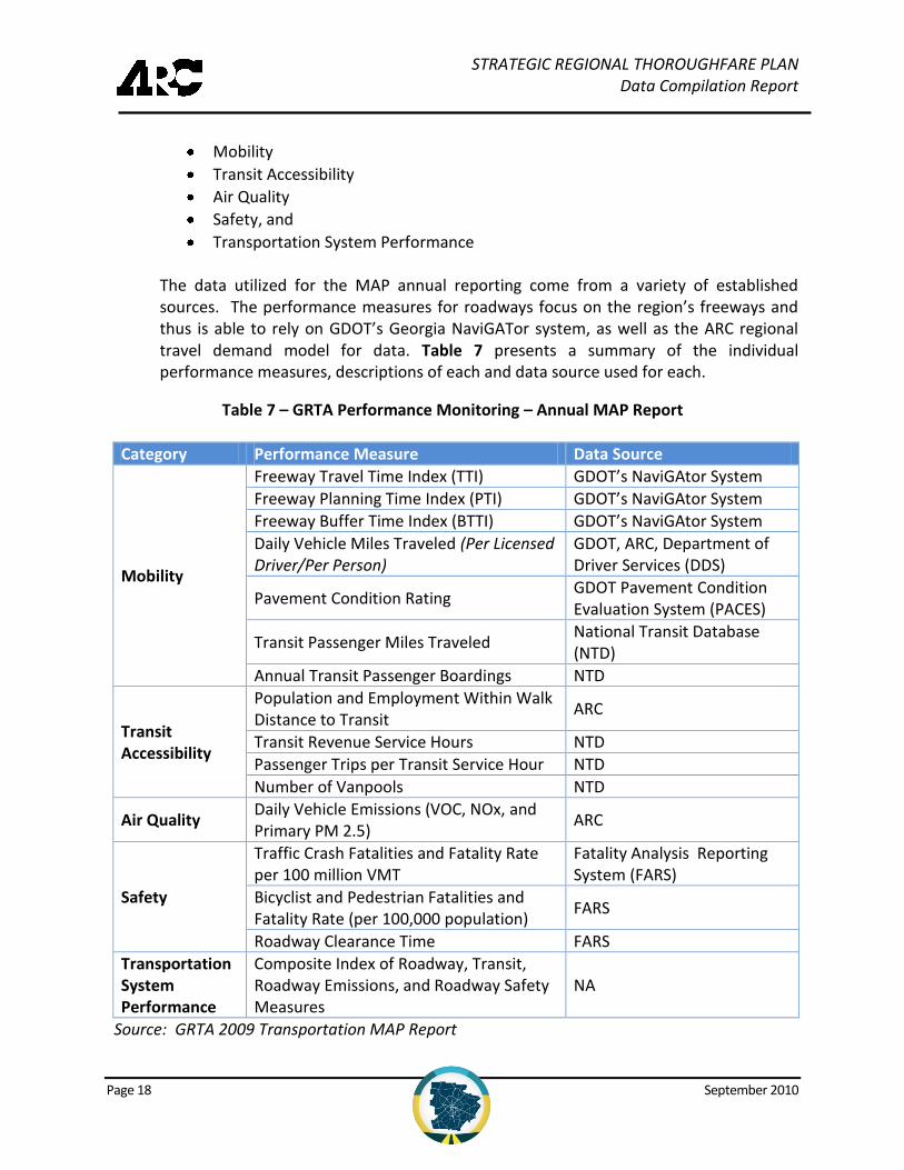
The data utilized for the MAP annual reporting come from a variety of established sources. The performance measures for roadways focus on the region’s freeways and thus is able to rely on GDOT’s Georgia NaviGATor system, as well as the ARC regional travel demand model for data. Table 7 presents a summary of the individual performance measures, descriptions of each and data source used for each.
Table 7 – GRTA Performance Monitoring – Annual MAP Report
Category Performance Measure Data Source
Mobility
Freeway Travel Time Index (TTI) GDOT’s NaviGAtor System
Freeway Planning Time Index (PTI) GDOT’s NaviGAtor System
Freeway Buffer Time Index (BTTI) GDOT’s NaviGAtor System
Daily Vehicle Miles Traveled (Per Licensed Driver/Per Person)
GDOT, ARC, Department of Driver Services (DDS)
Pavement Condition Rating GDOT Pavement Condition Evaluation System (PACES)
Transit Passenger Miles Traveled National Transit Database (NTD)
Annual Transit Passenger Boardings NTD
Transit Accessibility
Population and Employment Within Walk Distance to Transit
ARC
Transit Revenue Service Hours NTD
Passenger Trips per Transit Service Hour NTD
Number of Vanpools NTD
Air Quality Daily Vehicle Emissions (VOC, NOx, and Primary PM 2.5)
ARC
Safety
Traffic Crash Fatalities and Fatality Rate per 100 million VMT
Fatality Analysis Reporting System (FARS)
Bicyclist and Pedestrian Fatalities and Fatality Rate (per 100,000 population)
FARS
Roadway Clearance Time FARS
Transportation System Performance
Composite Index of Roadway, Transit, Roadway Emissions, and Roadway Safety Measures
NA
Source: GRTA 2009 Transportation MAP Report
STRATEGIC REGIONAL THOROUGHFARE PLAN Data Compilation Report
Page 19 September 2010
6.0 SUMMARY OF DATA NEEDING FUTURE PROCESSING
The collection of the over 60 data elements listed in the Data Catalogue (found in Appendix A) provides a vast amount of data available for use by ARC and its planning partners. These data can not only provide valuable resources to the development and monitoring of the RTN, but also the entire regional multimodal transportation system and any combination of subareas within the region.
While the sources and types of data are extensive, there are limitations. The Data Catalogue (Appendix A) provides details regarding which individual datasets require further processing. Overall, certain data elements are already available in a Geographic Information System (GIS) shapefile format, which is the preferred format. The GIS data are readily available for review and can be used in numerous types of analyses as well as in unison to other data sets. Roughly two-thirds of the data collected are already in a GIS format.
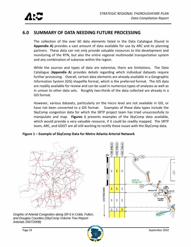
However, various datasets, particularly on the micro level are not available in GIS, or have not been converted to a GIS format. Examples of these data types include the SkyComp congestion data for which the SRTP project team has tried unsuccessfully to manipulate and map. Figures 1 presents examples of the SkyComp data available, which would provide a very valuable resource, if it could be readily mapped. The SRTP team, ARC, and GDOT are all still working to rectify these issues with the SkyComp data.
Figure 1 – Example of SkyComp Data for Metro Atlanta Arterial Network
Graphic of Arterial Congestion along SR 6 in Cobb, Fulton, and Douglas Counties (SkyComp Volume Two Report: Arterials 2007/2008)
STRATEGIC REGIONAL THOROUGHFARE PLAN Data Compilation Report
Page 20 September 2010
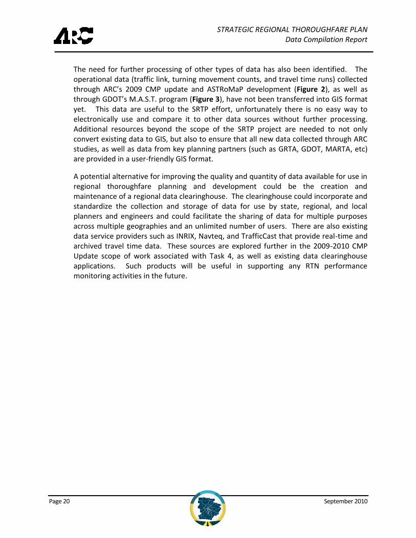
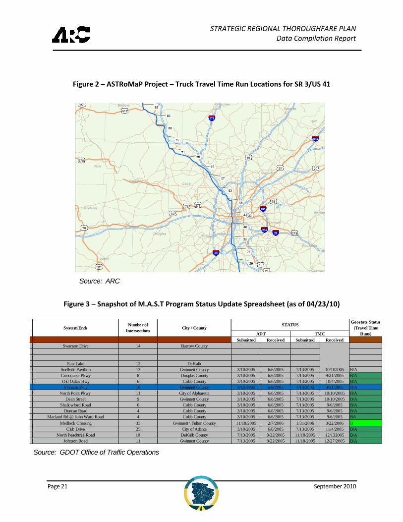
The need for further processing of other types of data has also been identified. The operational data (traffic link, turning movement counts, and travel time runs) collected through ARC’s 2009 CMP update and ASTRoMaP development (Figure 2), as well as through GDOT’s M.A.S.T. program (Figure 3), have not been transferred into GIS format yet. This data are useful to the SRTP effort, unfortunately there is no easy way to electronically use and compare it to other data sources without further processing. Additional resources beyond the scope of the SRTP project are needed to not only convert existing data to GIS, but also to ensure that all new data collected through ARC studies, as well as data from key planning partners (such as GRTA, GDOT, MARTA, etc) are provided in a user-friendly GIS format.
A potential alternative for improving the quality and quantity of data available for use in regional thoroughfare planning and development could be the creation and maintenance of a regional data clearinghouse. The clearinghouse could incorporate and standardize the collection and storage of data for use by state, regional, and local planners and engineers and could facilitate the sharing of data for multiple purposes across multiple geographies and an unlimited number of users. There are also existing data service providers such as INRIX, Navteq, and TrafficCast that provide real-time and archived travel time data. These sources are explored further in the 2009-2010 CMP Update scope of work associated with Task 4, as well as existing data clearinghouse applications. Such products will be useful in supporting any RTN performance monitoring activities in the future.
STRATEGIC REGIONAL THOROUGHFARE PLAN Data Compilation Report
Page 21 September 2010
Figure 2 – ASTRoMaP Project – Truck Travel Time Run Locations for SR 3/US 41
Figure 3 – Snapshot of M.A.S.T Program Status Update Spreadsheet (as of 04/23/10)
System Begin
Submitted Received Submitted Received
0 SR 316 Collins Hill Road Swanson Drive 14 Barrow County
0 Johnson Ferry
0 Hudson Bridge / Eagles Landing
0 Scott Boulevard Orion East Lake 12 DeKalb
1 Scenic Hwy/SR 124 Essex Drive Snellville Pavillion 13 Gwinnett County 3/10/2005 6/6/2005 7/13/2005 10/102005 B/A
2 SR 5 (Bill Arp road) Central Church Concourse Pkwy 8 Douglas County 3/10/2005 6/6/2005 7/13/2005 9/21/2005 B/A
3 SR 120 / Dallas Hwy Home Depot Old Dallas Hwy 6 Cobb County 3/10/2005 6/6/2005 7/13/2005 10/4/2005 B/A
4 Indian Trail Road Hillcrest Rd Pinnacle Way 16 Gwinnett County 3/10/2005 6/6/2005 7/13/2005 9/21/2005 B/A
5 Mansell Road Wal-Mart Drive North Point Pkwy 11 City of Alpharetta 3/10/2005 6/6/2005 7/13/2005 10/10/2005 B/A
6 Old Peachtree Road Meadowchurch Rd Dean Street 9 Gwinnett County 3/10/2005 6/6/2005 7/13/2005 10/10/2005 B/A
7 Bells Ferry Road North Booth Road Shallowford Road 6 Cobb County 3/10/2005 6/6/2005 7/13/2005 9/6/2005 B/A
8 McCollum Pkwy Old Highway 41 Duncan Road 4 Cobb County 3/10/2005 6/6/2005 7/13/2005 9/6/2005 B/A
9 SR 360 / Powder Springs Rd Cheatham Hill Rd / Callaway Pkwy Macland Rd @ John Ward Road 4 Cobb County 3/10/2005 6/6/2005 7/13/2005 9/6/2005 BA
35 P'tree Pkwy/Medlock Bridge Rd Holcomb Bridge Rd Medlock Crossing 33 Gwinnett \ Fulton County 11/18/2005 2/7/2006 1/31/2006 3/22/2006 B
10 Peachtree Road Rumson Road Club Drive 25 City of Atlanta 3/10/2005 6/6/2005 7/13/2005 11/4/2005 B/A
13 Peachtree Industrial Boulevard Peachtree Road North Peachtree Road 10 DeKalb County 7/13/2005 9/22/2005 11/18/2005 12/132005 B/A
16 US-29 (Lawrenceville Hwy) Bethesda Church School Johnson Road 11 Gwinnett County 7/13/2005 9/22/2005 11/18/2005 12/27/2005 B/A
ADT TMC
STATUSGeostats Status
(Travel Time
Runs)
System EndsPriority
Number
Number of
IntersectionsCity / CountySystem Name
Source: ARC
Source: GDOT Office of Traffic Operations
STRATEGIC REGIONAL THOROUGHFARE PLAN Data Compilation Report
Page 22 September 2010
7.0 NEXT STEPS
The data inventory and compilation activities represent the first to be completed as part of the development of the SRTP. Subsequent tasks and next steps related to the data collection and management activities are listed below.
Coordinate with ARC and other planning partners to develop an action plan for refining data that requires further processing, such that this data can be used for future monitoring of the SRTP network
Obtain additional data required for completion of the case studies, RTN characteristics inventory, and RTN performance evaluation
Coordinate with ARC and determine the practicality/feasibility of obtaining new data sets for that may be used to monitor the regional transportation system (including the SRTP) through the CMP
Concurrent to the data collection and management activities, the other major activities for the project involve the definition and classification of the SRTP. Due to the constrained timeline for the project, the SRTP definition tasks have been ongoing since the inception of the project. Subsequent tasks and next steps related to the network definition and classification activities are listed below.
Continue to develop SRTP network using currently available data
Classify SRTP network using currently available data and any future data that has been newly collected or processed.
Complete the case studies
Develop arterial management guidelines and toolkits
Develop project and policy recommendations and prioritization
STRATEGIC REGIONAL THOROUGHFARE PLAN Data Compilation Report
September 2010
APPENDICES
Appendix A: Data Catalog
Appendix B: SRTP Maps
Appendix C: GDOT M.A.S.T. Program – Status Spreadsheet (April 2010)
Appendix D: ASTRoMaP Project Travel Time Run Corridors
Appendix E: 2009 CMP Update Travel Time Run Corridors

STRATEGIC REGIONAL THOROUGHFARE PLAN Data Compilation Report
September 2010
Appendix A: Data Catalog
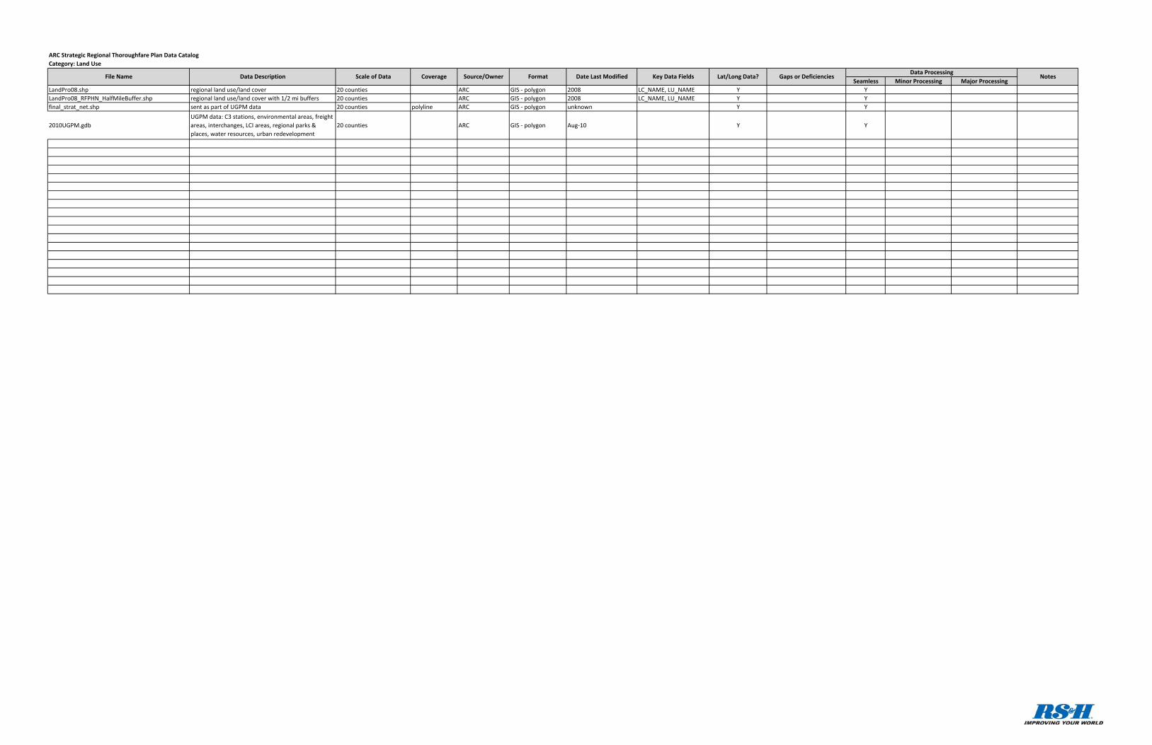
Seamless Minor Processing Major ProcessingLandPro08.shp regional land use/land cover 20 counties ARC GIS ‐ polygon 2008 LC_NAME, LU_NAME Y YLandPro08_RFPHN_HalfMileBuffer.shp regional land use/land cover with 1/2 mi buffers 20 counties ARC GIS ‐ polygon 2008 LC_NAME, LU_NAME Y Yfinal_strat_net.shp sent as part of UGPM data 20 counties polyline ARC GIS ‐ polygon unknown Y Y
2010UGPM.gdbUGPM data: C3 stations, environmental areas, freight areas, interchanges, LCI areas, regional parks & places, water resources, urban redevelopment
20 counties ARC GIS ‐ polygon Aug‐10 Y Y
Category: Land UseARC Strategic Regional Thoroughfare Plan Data Catalog
NotesFile Name Data Description Scale of Data Coverage Source/Owner Format Date Last Modified Key Data Fields Lat/Long Data? Gaps or DeficienciesData Processing
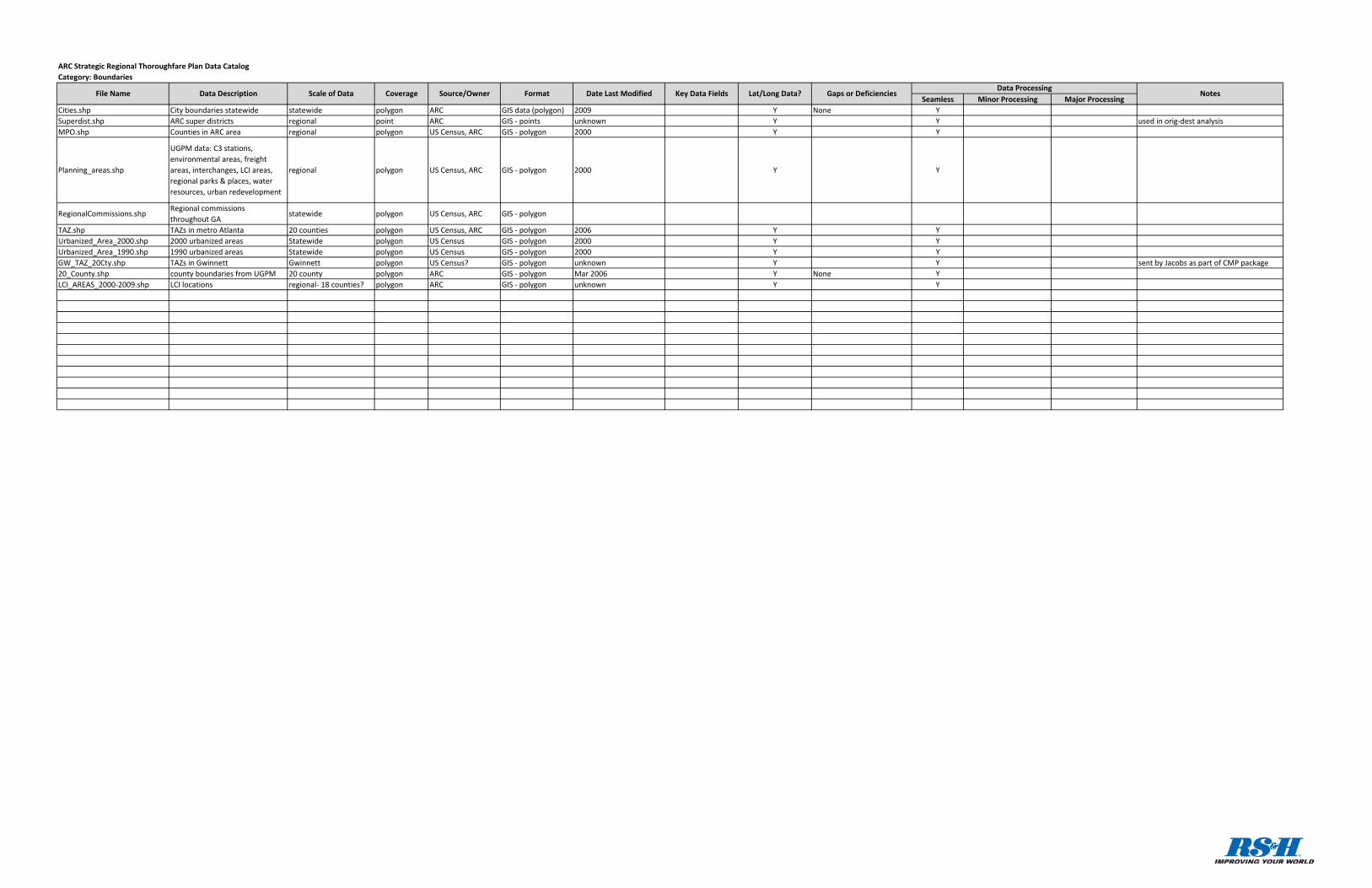
Seamless Minor Processing Major ProcessingCities.shp City boundaries statewide statewide polygon ARC GIS data (polygon) 2009 Y None YSuperdist.shp ARC super districts regional point ARC GIS ‐ points unknown Y Y used in orig‐dest analysisMPO.shp Counties in ARC area regional polygon US Census, ARC GIS ‐ polygon 2000 Y Y
Planning_areas.shp
UGPM data: C3 stations, environmental areas, freight areas, interchanges, LCI areas, regional parks & places, water resources, urban redevelopment
regional polygon US Census, ARC GIS ‐ polygon 2000 Y Y
RegionalCommissions.shpRegional commissions throughout GA
statewide polygon US Census, ARC GIS ‐ polygon
TAZ.shp TAZs in metro Atlanta 20 counties polygon US Census, ARC GIS ‐ polygon 2006 Y YUrbanized_Area_2000.shp 2000 urbanized areas Statewide polygon US Census GIS ‐ polygon 2000 Y YUrbanized_Area_1990.shp 1990 urbanized areas Statewide polygon US Census GIS ‐ polygon 2000 Y YGW_TAZ_20Cty.shp TAZs in Gwinnett Gwinnett polygon US Census? GIS ‐ polygon unknown Y Y sent by Jacobs as part of CMP package20_County.shp county boundaries from UGPM 20 county polygon ARC GIS ‐ polygon Mar 2006 Y None YLCI_AREAS_2000‐2009.shp LCI locations regional‐ 18 counties? polygon ARC GIS ‐ polygon unknown Y Y
ARC Strategic Regional Thoroughfare Plan Data CatalogCategory: Boundaries
Source/OwnerCoverageScale of DataData DescriptionFile Name Date Last ModifiedFormat Lat/Long Data?Data Processing
NotesGaps or DeficienciesKey Data Fields
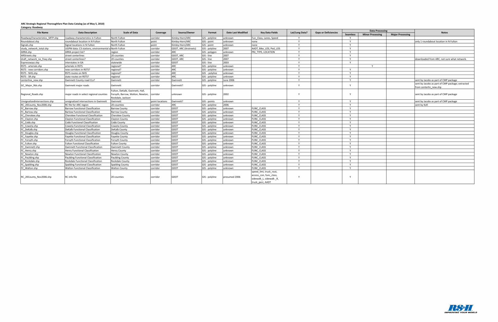
Seamless Minor Processing Major ProcessingRoadwayCharacteristics_SRTP.shp roadway characteristics in Fulton North Fulton corridor Kimley‐Horn/ARC GIS ‐ polyline unknown Fun_Class, Lanes, Speed Y YRoundabout.shp roundabout location in N Fulton North Fulton point Kimley‐Horn/ARC GIS ‐ point unknown none Y Y only 1 roundabout location in N FultonSignals.shp Signal locations in N Fulton North Fulton point Kimley‐Horn/ARC GIS ‐ point unknown none Y Ystudy_network_total.shp UGPM data: C3 stations, environmental a North Fulton corridor GDOT, ARC (Arstreets) GIS ‐ polyline 2007 AADT, Bike_LOS, Ped_LOS Y YARRA.shp ARRA project list? region corridor ARC GIS ‐ polygon unknown PRJ_TYPE, LOCATION Y YARStreets.shp street centerlines 20 counties corridor GDOT, ARC GIS ‐ line 2007 Y Ydraft_network_no_frwy.shp street centerlines? 20 counties corridor GDOT, ARC GIS ‐ line 2007 Y Y downloaded from ARC, not sure what network.Expressways.shp interstates in GA statewide corridor GDOT GIS ‐ line 2003 Y YRSTS ‐ arterials.shp arterials in RSTS regional? corridor ARC GIS ‐ polyline unknown Y YRSTS ‐ new corridors.shp new corridors in RSTS? regional? corridor ARC GIS ‐ polyline unknown Y YRSTS ‐ NHS.shp RSTS routes on NHS regional? corridor ARC GIS ‐ polyline unknown Y YRSTS ‐ SR.shp state routes on RSTS? regional corridor ARC GIS ‐ polyline unknown Y Ycenterline_new.shp Gwinnett County road CLs? Gwinnett corridor Gwinnett GIS ‐ polyline June 2006 Y Y sent by Jacobs as part of CMP package
GC_Major_Rds.shp Gwinnett major roads Gwinnett corridor Gwinnett? GIS ‐ polyline unknown Y Ysent by Jacobs as part of CMP package; extracted from centerlin_new.shp
Regional_Roads.shp major roads in select regional countiesFulton, DeKalb, Gwinnett, Hall, Forsyth, Barrow, Walton, Newton, Rockdale, Jackson
corridor unknown GIS ‐ polyline 2002 Y Y sent by Jacobs as part of CMP package
UnsignalizedIntersections.shp unsignalized intersections in Gwinnett Gwinnett point locations Gwinnett? GIS ‐ points unknown Y Y sent by Jacobs as part of CMP packageRC_20County_Nov2006.shp RC file for ARC region 20‐counties corridor ARC GIS ‐ polyline 2006 Y Y sent by KofiFC_Barrow.shp Barrow Functional Classification Barrow County corridor GDOT GIS ‐ polyline unknown FUNC_CLASS Y YFC_Bartow.shp Bartow Functional Classification Barrow County corridor GDOT GIS ‐ polyline unknown FUNC_CLASS Y YFC_Cherokee.shp Cherokee Functional Classification Cherokee County corridor GDOT GIS ‐ polyline unknown FUNC_CLASS Y YFC_Clayton.shp Clayton Functional Classification Clayton County corridor GDOT GIS ‐ polyline unknown FUNC_CLASS Y YFC_Cobb.shp Cobb Functional Classification Cobb County corridor GDOT GIS ‐ polyline unknown FUNC_CLASS Y YFC_Coweta.shp Coweta Functional Classification Coweta County corridor GDOT GIS ‐ polyline unknown FUNC_CLASS Y YFC_DeKalb.shp DeKalb Functional Classification DeKalb County corridor GDOT GIS ‐ polyline unknown FUNC_CLASS Y YFC_Douglas.shp Douglas Functional Classification Douglas County corridor GDOT GIS ‐ polyline unknown FUNC_CLASS Y YFC_Fayette.shp Fayette Functional Classification Fayette County corridor GDOT GIS ‐ polyline unknown FUNC_CLASS Y YFC_Forsyth.shp Forsyth Functional Classification Forsyth County corridor GDOT GIS ‐ polyline unknown FUNC_CLASS Y YFC_Fulton.shp Fulton Functional Classification Fulton County corridor GDOT GIS ‐ polyline unknown FUNC_CLASS Y YFC_Gwinnett.shp Gwinnett Functional Classification Gwinnett County corridor GDOT GIS ‐ polyline unknown FUNC_CLASS Y YFC_Henry.shp Henry Functional Classification Henry County corridor GDOT GIS ‐ polyline unknown FUNC_CLASS Y YFC_Newton.shp Newton Functional Classification Newton County corridor GDOT GIS ‐ polyline unknown FUNC_CLASS Y YFC_Paulding.shp Paulding Functional Classification Paulding County corridor GDOT GIS ‐ polyline unknown FUNC_CLASS Y YFC_Rockdale.shp Rockdale Functional Classification Rockdale County corridor GDOT GIS ‐ polyline unknown FUNC_CLASS Y YFC_Spalding.shp Spalding Functional Classification Spalding County corridor GDOT GIS ‐ polyline unknown FUNC_CLASS Y YFC_Walton.shp Walton Functional Classification Walton County corridor GDOT GIS ‐ polyline unknown FUNC_CLASS Y Y
RC_20County_Nov2006.shp RC info file 20 counties corridor GDOT GIS ‐ polyline presumed 2006
speed_limi, truck_rout, access_con, func_class, sidewalk_L, sidewalk _R, truck_perc, AADT
Y Y
ARC Strategic Regional Thoroughfare Plan Data Catalog (as of May 5, 2010)Category: Roadway
NotesFile Name Data Description Scale of Data Coverage Source/Owner Format Date Last Modified Key Data Fields Lat/Long Data? Gaps or DeficienciesData Processing
Seamless Minor Processing Major Processing
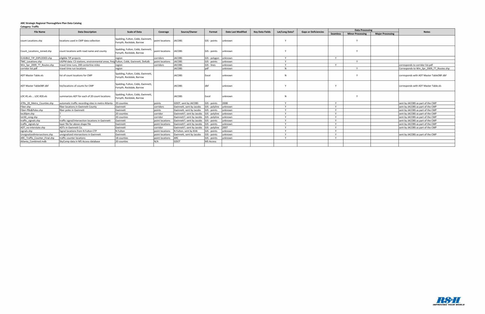
count Locations.shp locations used in CMP data collectionSpalding, Fulton, Cobb, Gwinnett, Forsyth, Rockdale, Barrow
point locations JACOBS GIS ‐ points unknown Y Y
Count_Locations_Joined.shp count locations with road name and countySpalding, Fulton, Cobb, Gwinnett, Forsyth, Rockdale, Barrow
point locations JACOBS GIS ‐ points unknown Y Y
ELIGIBLE_TIP_EXPLODED.shp eligible TIP projects region corridors JACOBS GIS ‐ polygon unknown Y YTMC_Locations.shp UGPM data: C3 stations, environmental areas, freig Fulton, Cobb, Gwinnett, DeKalb point locations JACOBS GIS ‐ points unknown Y YWin_Spr_2009_TT_Routes.shp travel time runs, 200 centerline miles region corridors JACOBS GIS ‐ lines unknown Y Y corresponds to corridor list.pdfcorridor list.pdf travel time run locations region JACOBS pdf unknown N Y Corresponds to Win_Spr_2009_TT_Routes.shp
ADT Master Table.xls list of count locations for CMPSpalding, Fulton, Cobb, Gwinnett, Forsyth, Rockdale, Barrow
JACOBS Excel unknown N Y corresponds with ADT Master TableDBF.dbf
ADT Master TableDBF.dbf list/locations of counts for CMPSpalding, Fulton, Cobb, Gwinnett, Forsyth, Rockdale, Barrow
JACOBS dbf unknown Y Y corresponds with ADT Master Table.xls
LOC #1.xls … LOC #20.xls summarizes ADT for each of 20 count locationsSpalding, Fulton, Cobb, Gwinnett, Forsyth, Rockdale, Barrow
JACOBS Excel unknown N Y
ATRs_20_Metro_Counties.shp automatic traffic recording sites in metro Atlanta 20 counties points GDOT, sent by JACOBS GIS ‐ points 2008 Y Y sent by JACOBS as part of the CMPFiber.shp fiber locations in Gwinnett County Gwinnett corridors Gwinnett, sent by Jacobs GIS ‐ polyline unknown Y Y sent by JACOBS as part of the CMPFiber‐PBs&Poles.shp fiber poles in Gwinnett Gwinnett points Gwinnett, sent by Jacobs GIS ‐ points unknown Y Y sent by JACOBS as part of the CMPlos30pm.shp ? 20 counties corridor Gwinnett?, sent by Jacobs GIS ‐ polyline unknown Y Y sent by JACOBS as part of the CMPtot30_cong.shp ? 20 counties corridor Gwinnett?, sent by Jacobs GIS ‐ polyline unknown Y Y sent by JACOBS as part of the CMPtraffic_signals.shp traffic signal/intersection locations in Gwinnett Gwinnett point locations Gwinnett?, sent by Jacobs GIS ‐ points unknown Y Y sent by JACOBS as part of the CMPtraffic_signals.lyr layer file for above shape file Gwinnett point locations Gwinnett?, sent by Jacobs GIS ‐ points unknown Y Y sent by JACOBS as part of the CMPADT_no‐interstate.shp ADTs in Gwinnett Co. Gwinnett corridor Gwinnett?, sent by Jacobs GIS ‐ polyline 2007 Y Y sent by JACOBS as part of the CMPsignals.shp Signal locations from N Fulton CTP N Fulton point locations N Fulton, sent by KHA GIS ‐ points unknown Y YUnsignalizedIntersections.shp unsignalized intersections in Gwinnett Gwinnett point locations Gwinnett, sent by Jacobs GIS ‐ points unknown Y Y sent by JACOBS as part of the CMPARC_Traffic_Counter_Final.shp traffic counter locations 18 counties point locations ARC GIS ‐ points unknown Y YAtlanta_Combined.mdb SkyComp data in MS Access database 20 counties N/A GDOT MS Access
ARC Strategic Regional Thoroughfare Plan Data CatalogCategory: Traffic
NotesFile Name Data Description Scale of Data Coverage Source/Owner Format Date Last Modified Key Data Fields Lat/Long Data? Gaps or DeficienciesData Processing
Seamless Minor Processing Major Processing
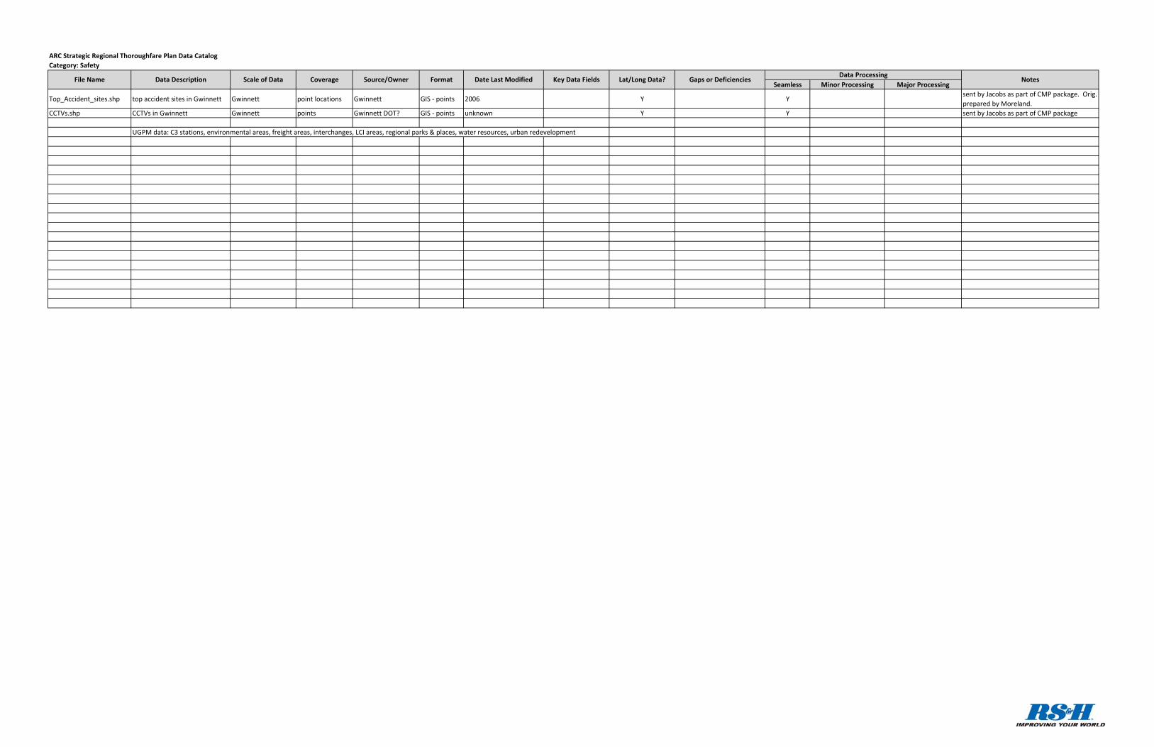
Top_Accident_sites.shp top accident sites in Gwinnett Gwinnett point locations Gwinnett GIS ‐ points 2006 Y Ysent by Jacobs as part of CMP package. Orig. prepared by Moreland.
CCTVs.shp CCTVs in Gwinnett Gwinnett points Gwinnett DOT? GIS ‐ points unknown Y Y sent by Jacobs as part of CMP package
UGPM data: C3 stations, environmental areas, freight areas, interchanges, LCI areas, regional parks & places, water resources, urban redevelopment
ARC Strategic Regional Thoroughfare Plan Data CatalogCategory: Safety
NotesFile Name Data Description Scale of Data Coverage Source/Owner Format Date Last Modified Key Data Fields Lat/Long Data? Gaps or DeficienciesData Processing
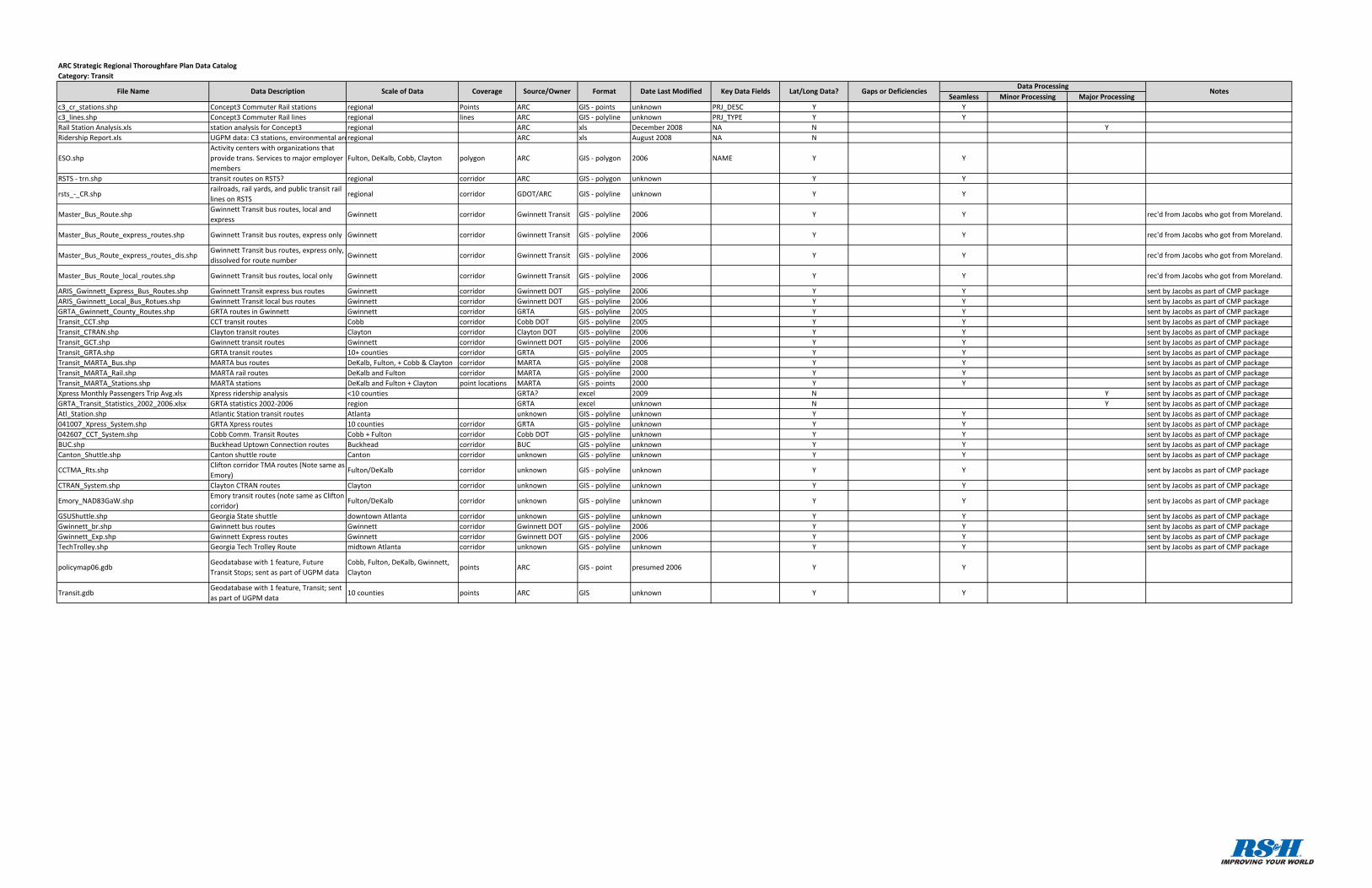
Seamless Minor Processing Major Processingc3_cr_stations.shp Concept3 Commuter Rail stations regional Points ARC GIS ‐ points unknown PRJ_DESC Y Yc3_lines.shp Concept3 Commuter Rail lines regional lines ARC GIS ‐ polyline unknown PRJ_TYPE Y YRail Station Analysis.xls station analysis for Concept3 regional ARC xls December 2008 NA N YRidership Report.xls UGPM data: C3 stations, environmental areregional ARC xls August 2008 NA N
ESO.shpActivity centers with organizations that provide trans. Services to major employer members
Fulton, DeKalb, Cobb, Clayton polygon ARC GIS ‐ polygon 2006 NAME Y Y
RSTS ‐ trn.shp transit routes on RSTS? regional corridor ARC GIS ‐ polygon unknown Y Y
rsts_‐_CR.shprailroads, rail yards, and public transit rail lines on RSTS
regional corridor GDOT/ARC GIS ‐ polyline unknown Y Y
Master_Bus_Route.shpGwinnett Transit bus routes, local and express
Gwinnett corridor Gwinnett Transit GIS ‐ polyline 2006 Y Y rec'd from Jacobs who got from Moreland.
Master_Bus_Route_express_routes.shp Gwinnett Transit bus routes, express only Gwinnett corridor Gwinnett Transit GIS ‐ polyline 2006 Y Y rec'd from Jacobs who got from Moreland.
Master_Bus_Route_express_routes_dis.shpGwinnett Transit bus routes, express only, dissolved for route number
Gwinnett corridor Gwinnett Transit GIS ‐ polyline 2006 Y Y rec'd from Jacobs who got from Moreland.
Master_Bus_Route_local_routes.shp Gwinnett Transit bus routes, local only Gwinnett corridor Gwinnett Transit GIS ‐ polyline 2006 Y Y rec'd from Jacobs who got from Moreland.
ARIS_Gwinnett_Express_Bus_Routes.shp Gwinnett Transit express bus routes Gwinnett corridor Gwinnett DOT GIS ‐ polyline 2006 Y Y sent by Jacobs as part of CMP packageARIS_Gwinnett_Local_Bus_Rotues.shp Gwinnett Transit local bus routes Gwinnett corridor Gwinnett DOT GIS ‐ polyline 2006 Y Y sent by Jacobs as part of CMP packageGRTA_Gwinnett_County_Routes.shp GRTA routes in Gwinnett Gwinnett corridor GRTA GIS ‐ polyline 2005 Y Y sent by Jacobs as part of CMP packageTransit_CCT.shp CCT transit routes Cobb corridor Cobb DOT GIS ‐ polyline 2005 Y Y sent by Jacobs as part of CMP packageTransit_CTRAN.shp Clayton transit routes Clayton corridor Clayton DOT GIS ‐ polyline 2006 Y Y sent by Jacobs as part of CMP packageTransit_GCT.shp Gwinnett transit routes Gwinnett corridor Gwinnett DOT GIS ‐ polyline 2006 Y Y sent by Jacobs as part of CMP packageTransit_GRTA.shp GRTA transit routes 10+ counties corridor GRTA GIS ‐ polyline 2005 Y Y sent by Jacobs as part of CMP packageTransit_MARTA_Bus.shp MARTA bus routes DeKalb, Fulton, + Cobb & Clayton corridor MARTA GIS ‐ polyline 2008 Y Y sent by Jacobs as part of CMP packageTransit_MARTA_Rail.shp MARTA rail routes DeKalb and Fulton corridor MARTA GIS ‐ polyline 2000 Y Y sent by Jacobs as part of CMP packageTransit_MARTA_Stations.shp MARTA stations DeKalb and Fulton + Clayton point locations MARTA GIS ‐ points 2000 Y Y sent by Jacobs as part of CMP packageXpress Monthly Passengers Trip Avg.xls Xpress ridership analysis <10 counties GRTA? excel 2009 N Y sent by Jacobs as part of CMP packageGRTA_Transit_Statistics_2002_2006.xlsx GRTA statistics 2002‐2006 region GRTA excel unknown N Y sent by Jacobs as part of CMP packageAtl_Station.shp Atlantic Station transit routes Atlanta unknown GIS ‐ polyline unknown Y Y sent by Jacobs as part of CMP package041007_Xpress_System.shp GRTA Xpress routes 10 counties corridor GRTA GIS ‐ polyline unknown Y Y sent by Jacobs as part of CMP package042607_CCT_System.shp Cobb Comm. Transit Routes Cobb + Fulton corridor Cobb DOT GIS ‐ polyline unknown Y Y sent by Jacobs as part of CMP packageBUC.shp Buckhead Uptown Connection routes Buckhead corridor BUC GIS ‐ polyline unknown Y Y sent by Jacobs as part of CMP packageCanton_Shuttle.shp Canton shuttle route Canton corridor unknown GIS ‐ polyline unknown Y Y sent by Jacobs as part of CMP package
CCTMA_Rts.shpClifton corridor TMA routes (Note same as Emory)
Fulton/DeKalb corridor unknown GIS ‐ polyline unknown Y Y sent by Jacobs as part of CMP package
CTRAN_System.shp Clayton CTRAN routes Clayton corridor unknown GIS ‐ polyline unknown Y Y sent by Jacobs as part of CMP package
Emory_NAD83GaW.shpEmory transit routes (note same as Clifton corridor)
Fulton/DeKalb corridor unknown GIS ‐ polyline unknown Y Y sent by Jacobs as part of CMP package
GSUShuttle.shp Georgia State shuttle downtown Atlanta corridor unknown GIS ‐ polyline unknown Y Y sent by Jacobs as part of CMP packageGwinnett_br.shp Gwinnett bus routes Gwinnett corridor Gwinnett DOT GIS ‐ polyline 2006 Y Y sent by Jacobs as part of CMP packageGwinnett_Exp.shp Gwinnett Express routes Gwinnett corridor Gwinnett DOT GIS ‐ polyline 2006 Y Y sent by Jacobs as part of CMP packageTechTrolley.shp Georgia Tech Trolley Route midtown Atlanta corridor unknown GIS ‐ polyline unknown Y Y sent by Jacobs as part of CMP package
policymap06.gdbGeodatabase with 1 feature, Future Transit Stops; sent as part of UGPM data
Cobb, Fulton, DeKalb, Gwinnett, Clayton
points ARC GIS ‐ point presumed 2006 Y Y
Transit.gdbGeodatabase with 1 feature, Transit; sent as part of UGPM data
10 counties points ARC GIS unknown Y Y
ARC Strategic Regional Thoroughfare Plan Data CatalogCategory: Transit
NotesFile Name Data Description Scale of Data Coverage Source/Owner Format Date Last Modified Key Data Fields Lat/Long Data? Gaps or DeficienciesData Processing
Seamless Minor Processing Major Processing
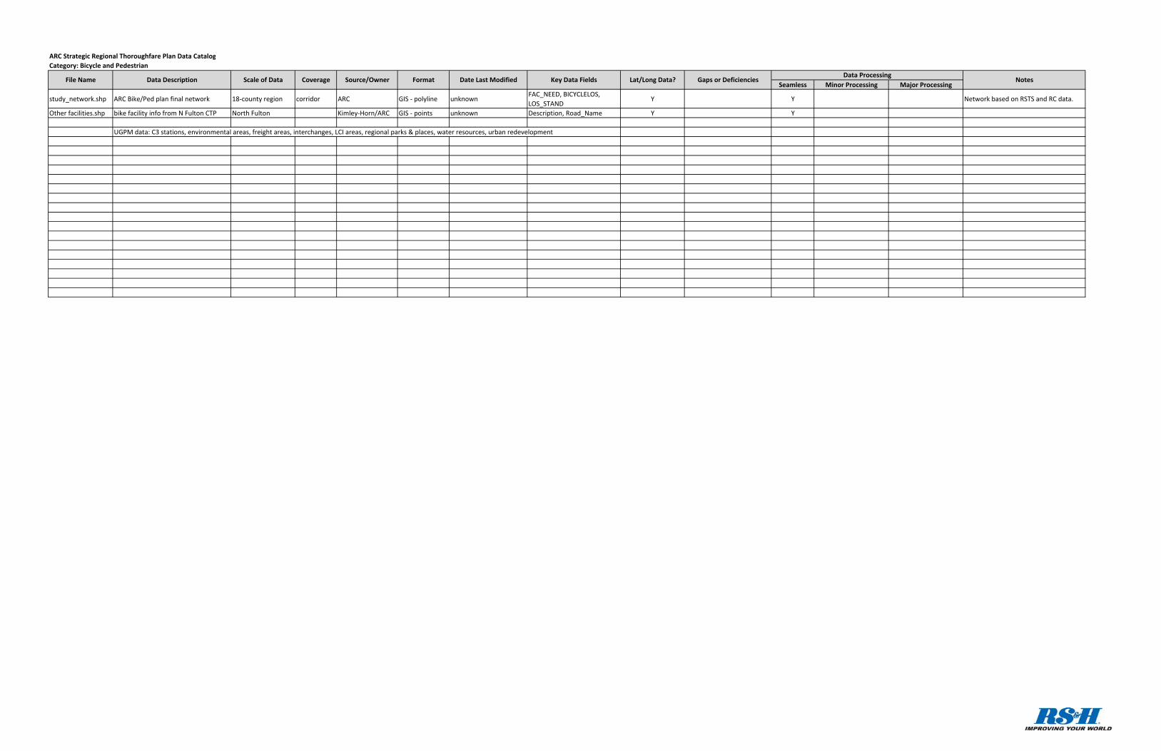
study_network.shp ARC Bike/Ped plan final network 18‐county region corridor ARC GIS ‐ polyline unknownFAC_NEED, BICYCLELOS, LOS_STAND
Y Y Network based on RSTS and RC data.
Other facilities.shp bike facility info from N Fulton CTP North Fulton Kimley‐Horn/ARC GIS ‐ points unknown Description, Road_Name Y Y
UGPM data: C3 stations, environmental areas, freight areas, interchanges, LCI areas, regional parks & places, water resources, urban redevelopment
ARC Strategic Regional Thoroughfare Plan Data CatalogCategory: Bicycle and Pedestrian
NotesFile Name Data Description Scale of Data Coverage Source/Owner Format Date Last Modified Key Data Fields Lat/Long Data? Gaps or DeficienciesData Processing
Seamless Minor Processing Major ProcessingRailroads.shp railroad alignments statewide polygon GDOT GIS ‐ polygonrail_crossings_2008_crossings_fra_NTAD09_selected_joined_A.shp
roadway/rail crossings 20 counties points ARC GIS ‐ points unknown Y Y
EW_N1.shp Freight line on draft ASTRoMaP system 18 counties corridors ARC GIS ‐ polylines Jul‐10 Y Yfreight line from ASTRoMaPgenerated from RC file.
EW_N2.shp UGPM data: C3 stations, environmental areas, freig 18 counties corridors ARC GIS ‐ polylines 2010 Y Yfreight line from ASTRoMaPgenerated from RC file.
EW_N3.shp Freight line on draft ASTRoMaP system 18 counties corridors ARC GIS ‐ polylines Jul‐10 Y Yfreight line from ASTRoMaPgenerated from RC file.
EW_N4.shp Freight line on draft ASTRoMaP system 18 counties corridors ARC GIS ‐ polylines Jul‐10 Y Yfreight line from ASTRoMaPgenerated from RC file.
EW_S1.shp Freight line on draft ASTRoMaP system 18 counties corridors ARC GIS ‐ polylines Jul‐10 Y Yfreight line from ASTRoMaPgenerated from RC file.
EW_S2.shp Freight line on draft ASTRoMaP system 18 counties corridors ARC GIS ‐ polylines Jul‐10 Y Yfreight line from ASTRoMaPgenerated from RC file.
EW_S3.shp Freight line on draft ASTRoMaP system 18 counties corridors ARC GIS ‐ polylines Jul‐10 Y Yfreight line from ASTRoMaPgenerated from RC file.
NS_E0.shp Freight line on draft ASTRoMaP system 18 counties corridors ARC GIS ‐ polylines Jul‐10 Y Yfreight line from ASTRoMaPgenerated from RC file.
NS_E1.shp Freight line on draft ASTRoMaP system 18 counties corridors ARC GIS ‐ polylines Jul‐10 Y Yfreight line from ASTRoMaPgenerated from RC file.
NS_E2.shp Freight line on draft ASTRoMaP system 18 counties corridors ARC GIS ‐ polylines Jul‐10 Y Yfreight line from ASTRoMaPgenerated from RC file.
NS_E3.shp Freight line on draft ASTRoMaP system 18 counties corridors ARC GIS ‐ polylines Jul‐10 Y Yfreight line from ASTRoMaPgenerated from RC file.
NS_E4.shp Freight line on draft ASTRoMaP system 18 counties corridors ARC GIS ‐ polylines Jul‐10 Y Yfreight line from ASTRoMaPgenerated from RC file.
NS_W1.shp Freight line on draft ASTRoMaP system 18 counties corridors ARC GIS ‐ polylines Jul‐10 Y Yfreight line from ASTRoMaPgenerated from RC file.
NS_W2.shp Freight line on draft ASTRoMaP system 18 counties corridors ARC GIS ‐ polylines Jul‐10 Y Yfreight line from ASTRoMaPgenerated from RC file.
NS_W3.shp Freight line on draft ASTRoMaP system 18 counties corridors ARC GIS ‐ polylines Jul‐10 Y Yfreight line from ASTRoMaPgenerated from RC file.
Draft Atlanta Truck Bottleneck Analysis (2).pdfFreight Performance Measures Analysis of Nine Truck Bottlenecks in the Atlanta Region
ARC pdf June 2009 N Y sent by Michael Kray
SR6.doc, SR11.doc, SR 16.doc, SR 20.doc, SR 34.doc, SR 54.doc, SR 61.doc, SR 70.doc, SR 85.doc, SR 92.doc, SR 138.doc, SR 140.doc, SR 155.doc, SR 3.odf, US 78.pdf
Route analysis for Truck Route Master Plan NA ARC Word, pdf unknown N Y sent by Michael Kray
Regional_rail.shp rail lines in Atlanta region ‐ looks incompleteFulton, DeKalb, Gwinnett, Hall
corridors ARC? GIS ‐ polylines 2002 Y Ypiece of US Nat'l Trans. Atlas Railroadssent by Jacobs as part of CMP package
ARC Strategic Regional Thoroughfare Plan Data CatalogCategory: Freight
NotesFile Name Data Description Scale of Data Coverage Source/Owner Format Date Last Modified Key Data Fields Lat/Long Data? Gaps or DeficienciesData Processing
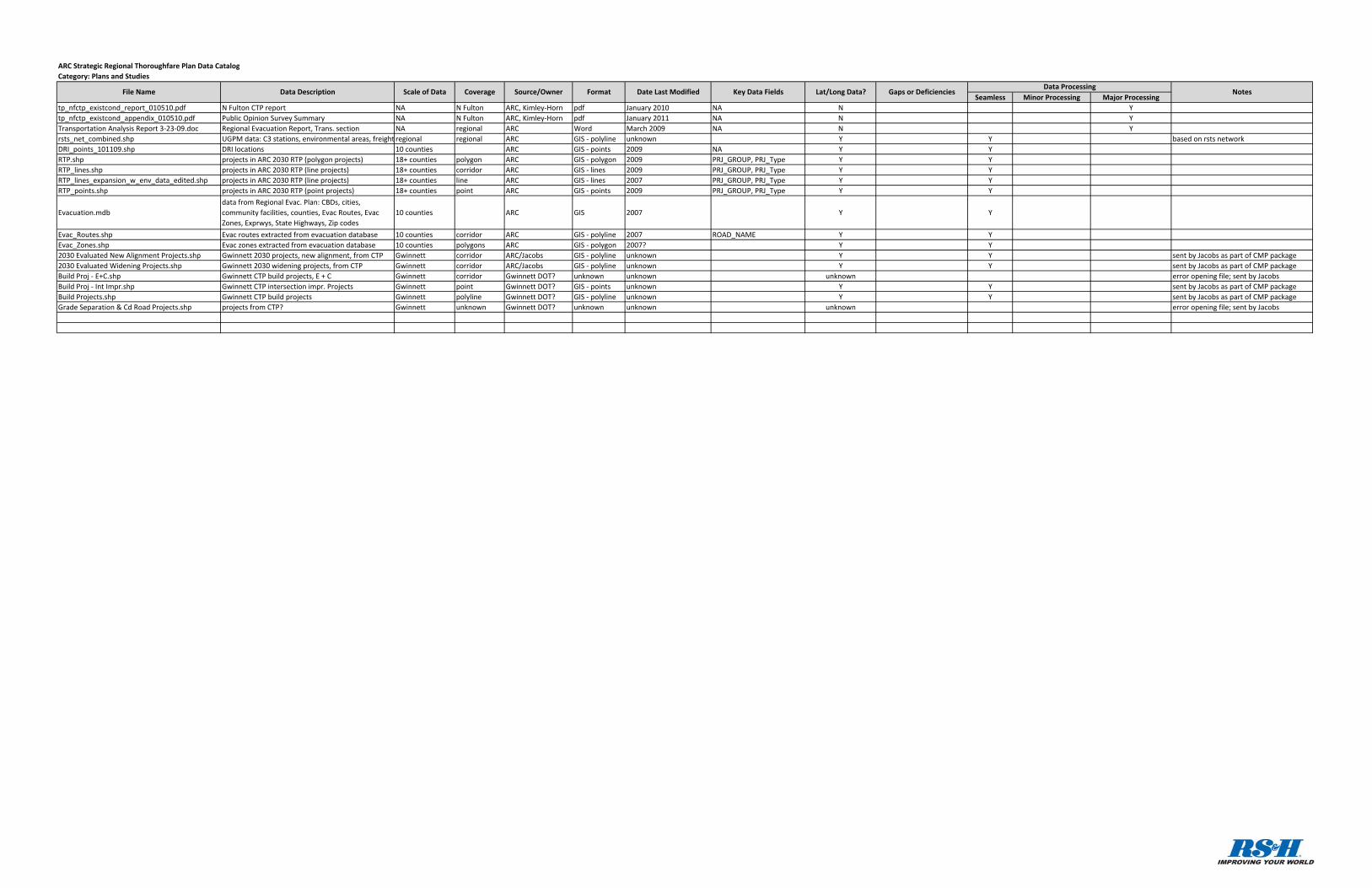
Seamless Minor Processing Major Processingtp_nfctp_existcond_report_010510.pdf N Fulton CTP report NA N Fulton ARC, Kimley‐Horn pdf January 2010 NA N Ytp_nfctp_existcond_appendix_010510.pdf Public Opinion Survey Summary NA N Fulton ARC, Kimley‐Horn pdf January 2011 NA N YTransportation Analysis Report 3‐23‐09.doc Regional Evacuation Report, Trans. section NA regional ARC Word March 2009 NA N Yrsts_net_combined.shp UGPM data: C3 stations, environmental areas, freight regional regional ARC GIS ‐ polyline unknown Y Y based on rsts networkDRI_points_101109.shp DRI locations 10 counties ARC GIS ‐ points 2009 NA Y YRTP.shp projects in ARC 2030 RTP (polygon projects) 18+ counties polygon ARC GIS ‐ polygon 2009 PRJ_GROUP, PRJ_Type Y YRTP_lines.shp projects in ARC 2030 RTP (line projects) 18+ counties corridor ARC GIS ‐ lines 2009 PRJ_GROUP, PRJ_Type Y YRTP_lines_expansion_w_env_data_edited.shp projects in ARC 2030 RTP (line projects) 18+ counties line ARC GIS ‐ lines 2007 PRJ_GROUP, PRJ_Type Y YRTP_points.shp projects in ARC 2030 RTP (point projects) 18+ counties point ARC GIS ‐ points 2009 PRJ_GROUP, PRJ_Type Y Y
Evacuation.mdbdata from Regional Evac. Plan: CBDs, cities, community facilities, counties, Evac Routes, Evac Zones, Exprwys, State Highways, Zip codes
10 counties ARC GIS 2007 Y Y
Evac_Routes.shp Evac routes extracted from evacuation database 10 counties corridor ARC GIS ‐ polyline 2007 ROAD_NAME Y YEvac_Zones.shp Evac zones extracted from evacuation database 10 counties polygons ARC GIS ‐ polygon 2007? Y Y2030 Evaluated New Alignment Projects.shp Gwinnett 2030 projects, new alignment, from CTP Gwinnett corridor ARC/Jacobs GIS ‐ polyline unknown Y Y sent by Jacobs as part of CMP package2030 Evaluated Widening Projects.shp Gwinnett 2030 widening projects, from CTP Gwinnett corridor ARC/Jacobs GIS ‐ polyline unknown Y Y sent by Jacobs as part of CMP packageBuild Proj ‐ E+C.shp Gwinnett CTP build projects, E + C Gwinnett corridor Gwinnett DOT? unknown unknown unknown error opening file; sent by JacobsBuild Proj ‐ Int Impr.shp Gwinnett CTP intersection impr. Projects Gwinnett point Gwinnett DOT? GIS ‐ points unknown Y Y sent by Jacobs as part of CMP packageBuild Projects.shp Gwinnett CTP build projects Gwinnett polyline Gwinnett DOT? GIS ‐ polyline unknown Y Y sent by Jacobs as part of CMP packageGrade Separation & Cd Road Projects.shp projects from CTP? Gwinnett unknown Gwinnett DOT? unknown unknown unknown error opening file; sent by Jacobs
ARC Strategic Regional Thoroughfare Plan Data CatalogCategory: Plans and Studies
NotesFile Name Data Description Scale of Data Coverage Source/Owner Format Date Last Modified Key Data Fields Lat/Long Data? Gaps or DeficienciesData Processing
Seamless Minor Processing Major Processing
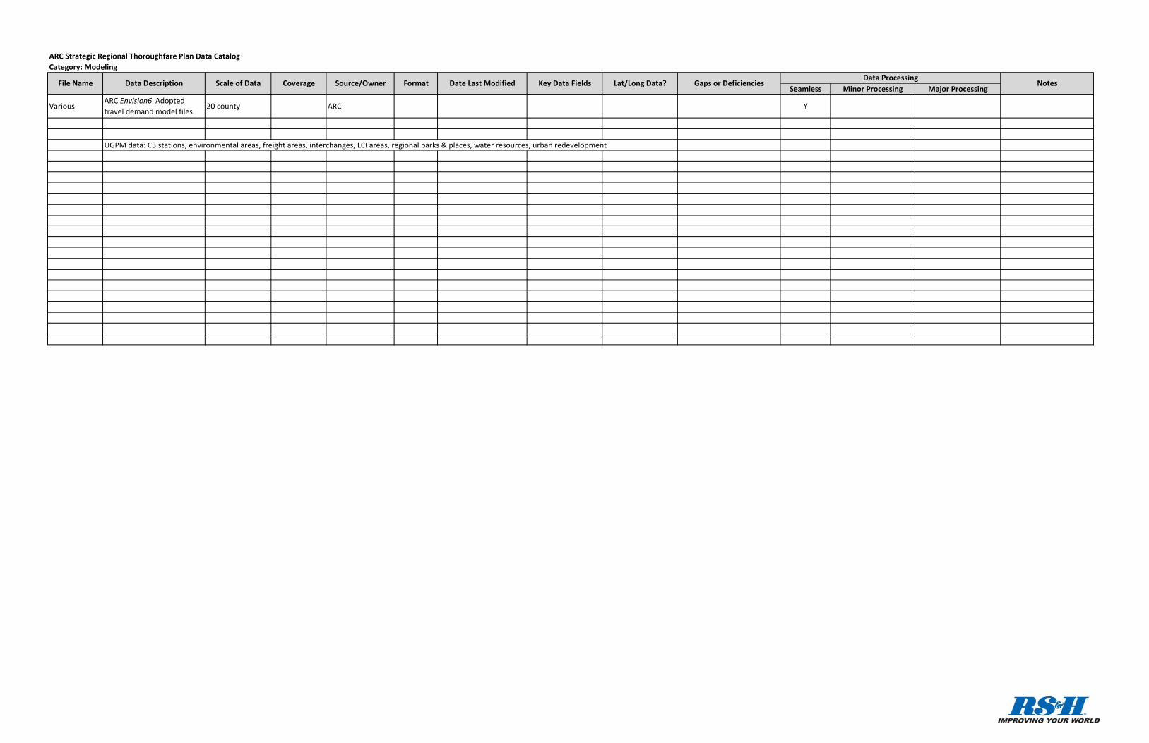
VariousARC Envision6 Adopted travel demand model files
20 county ARC Y
UGPM data: C3 stations, environmental areas, freight areas, interchanges, LCI areas, regional parks & places, water resources, urban redevelopment
ARC Strategic Regional Thoroughfare Plan Data CatalogCategory: Modeling
NotesFile Name Data Description Scale of Data Coverage Source/Owner Format Date Last Modified Key Data Fields Lat/Long Data? Gaps or DeficienciesData Processing
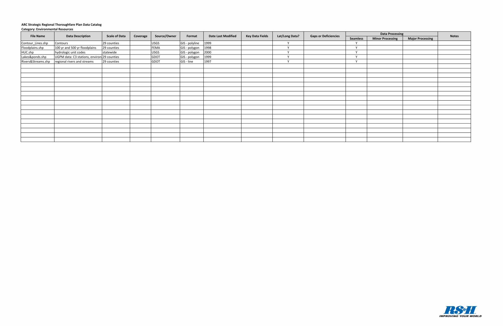
Seamless Minor Processing Major ProcessingContour_Lines.shp Contours 29 counties USGS GIS ‐ polyline 1999 Y YFloodplains.shp 100 yr and 500 yr floodplains 29 counties FEMA GIS ‐ polygon 1998 Y YHUC.shp hydrologic unit codes statewide USGS GIS ‐ polygon 2000 Y YLakes&ponds.shp UGPM data: C3 stations, environm29 counties GDOT GIS ‐ polygon 1999 Y YRivers&Streams.shp regional rivers and streams 29 counties GDOT GIS ‐ line 1997 Y Y
ARC Strategic Regional Thoroughfare Plan Data CatalogCategory: Environmental Resources
NotesFile Name Data Description Scale of Data Coverage Source/Owner Format Date Last Modified Key Data Fields Lat/Long Data? Gaps or DeficienciesData Processing
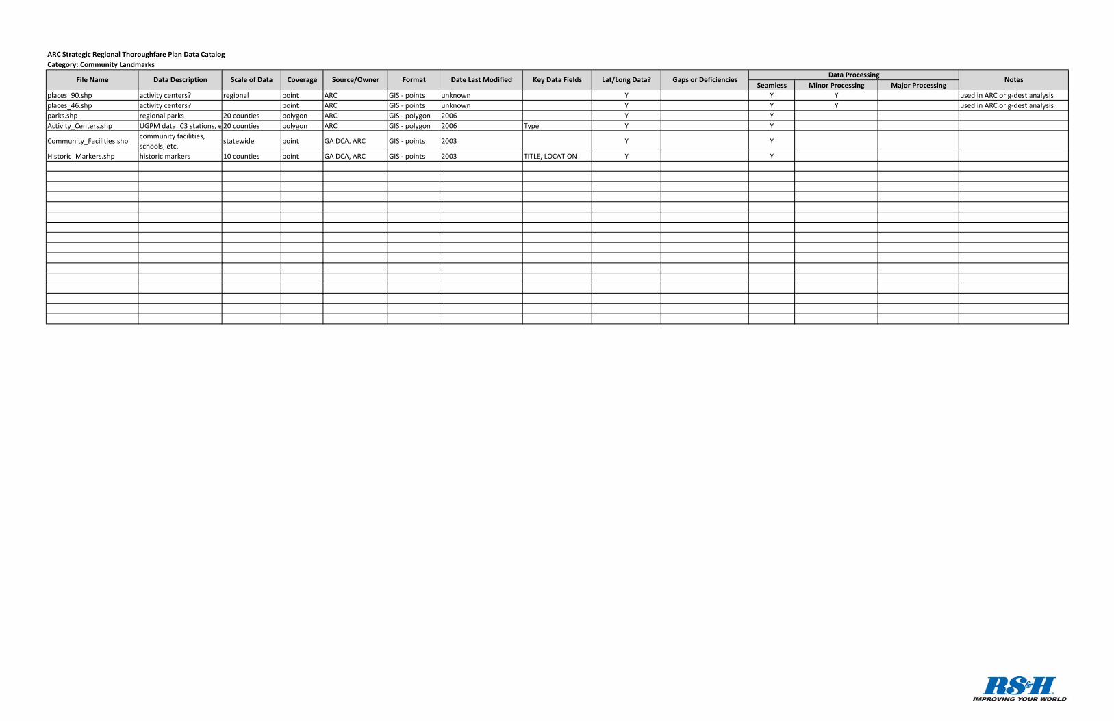
Seamless Minor Processing Major Processingplaces_90.shp activity centers? regional point ARC GIS ‐ points unknown Y Y Y used in ARC orig‐dest analysisplaces_46.shp activity centers? point ARC GIS ‐ points unknown Y Y Y used in ARC orig‐dest analysisparks.shp regional parks 20 counties polygon ARC GIS ‐ polygon 2006 Y YActivity_Centers.shp UGPM data: C3 stations, e 20 counties polygon ARC GIS ‐ polygon 2006 Type Y Y
Community_Facilities.shpcommunity facilities, schools, etc.
statewide point GA DCA, ARC GIS ‐ points 2003 Y Y
Historic_Markers.shp historic markers 10 counties point GA DCA, ARC GIS ‐ points 2003 TITLE, LOCATION Y Y
ARC Strategic Regional Thoroughfare Plan Data CatalogCategory: Community Landmarks
NotesFile Name Data Description Scale of Data Coverage Source/Owner Format Date Last Modified Key Data Fields Lat/Long Data? Gaps or DeficienciesData Processing

STRATEGIC REGIONAL THOROUGHFARE PLAN Data Compilation Report
September 2010
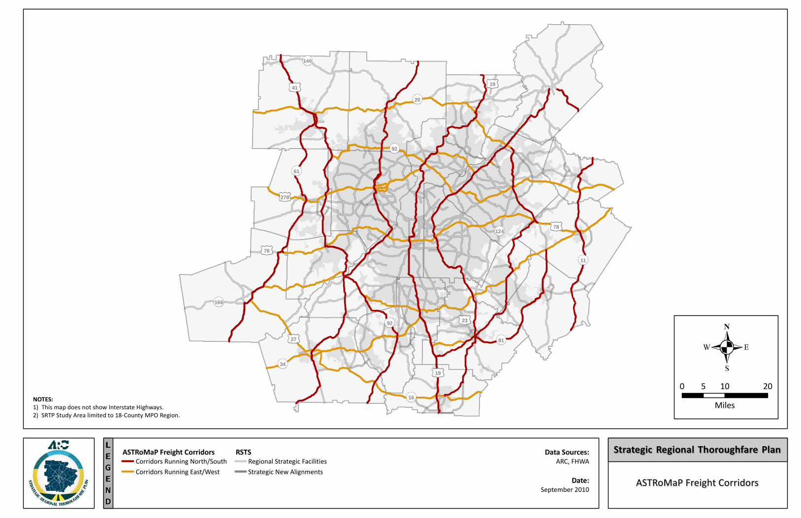
Appendix B: SRTP Maps
20
140
61
11
81
19
27
34
166
78
19
16
92 23
124 78
41
278
92
ASTRoMaP Freight CorridorsASTRoMaP Freight CorridorsEEGGLL
NNEE
DD
ASTRoMaP Freight Corridors
NOTES:1) This map does not show Interstate Highways.2) SRTP Study Area limited to 18-County MPO Region.
Data Sources:ARC, FHWA
0 10 205Miles
Strategic Regional Thoroughfare PlanStrategic Regional Thoroughfare PlanRSTSStrategic New AlignmentsRegional Strategic FacilitiesCorridors Running North/South
Corridors Running East/WestDate:
September 2010
20
140
61
11
81
19
27
34
166
78
19
16
92 23
124 78
41
278
92
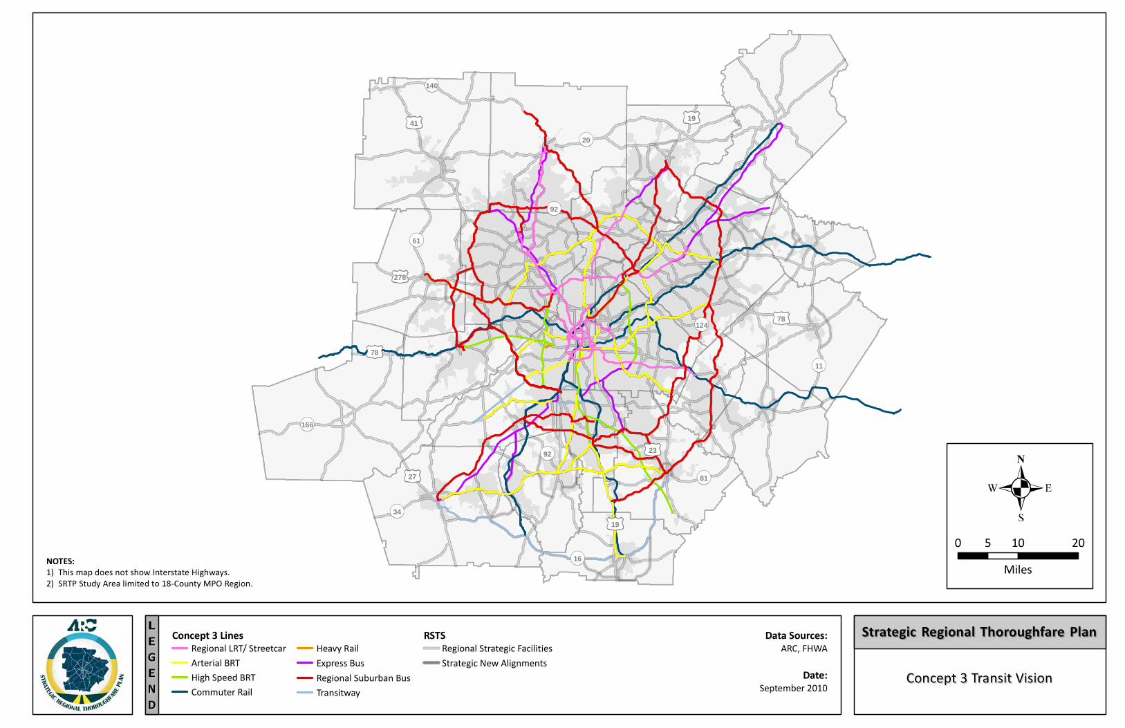
Concept 3 Transit VisionConcept 3 Transit VisionEEGGLL
NNEE
DD
NOTES:1) This map does not show Interstate Highways.2) SRTP Study Area limited to 18-County MPO Region.
Data Sources:ARC, FHWA
0 10 205Miles
Strategic Regional Thoroughfare PlanStrategic Regional Thoroughfare PlanConcept 3 LinesRegional LRT/ StreetcarArterial BRTHigh Speed BRTCommuter Rail
Heavy RailExpress BusRegional Suburban BusTransitway
RSTSStrategic New AlignmentsRegional Strategic Facilities
Date:September 2010
20
140
61
11
81
19
27
34
166
78
19
16
92 23
124 78
41
278
92
Emergency Use FacilitiesEmergency Use FacilitiesEEGGLL
NNEE
DD
NOTE:1) SRTP Study Area limited to 18-County MPO Region.
Data Sources:ARC, FHWA
0 10 205Miles
Strategic Regional Thoroughfare PlanStrategic Regional Thoroughfare PlanRSTSStrategic New AlignmentsRegional Strategic Facilities
Designated Evacuation RouteNon-Interstate Highway RouteInterstate Highway Route
Date:September 2010
20
140
61
11
81
19
27
34
166
78
19
16
92 23
124 78
41
278
92
Existing Transit RoutesExisting Transit RoutesEEGGLL
NNEE
DD
NOTES:1) C-TRAN services not currently operating.2) This map does not show Interstate Highways.3) SRTP Study Area limited to 18-County MPO Region.
Data Sources:ARC, FHWA
0 10 205Miles
Strategic Regional Thoroughfare PlanStrategic Regional Thoroughfare PlanTransit RoutesMARTA - RailGwinnett Co. Transit (GCT)
MARTA - BusRSTS
Strategic New AlignmentsRegional Strategic FacilitiesCobb Co. Transit (CCT)
Clayton Co. Transit (C-TRAN)Georgia Regional Transportation Authority (GRTA) Date:
September 2010
20
140
61
11
81
19
27
34
166
78
19
16
92 23
124 78
41
278
92
EEGGLL
NNEE
DD
NOTES:1) This map does not show Interstate Highways.2) SRTP Study Area limited to 18-County MPO Region.
Data Sources:ARC, FHWA
0 10 205Miles
Strategic Regional Thoroughfare PlanStrategic Regional Thoroughfare PlanRSTSStrategic New AlignmentsRegional Strategic Facilities
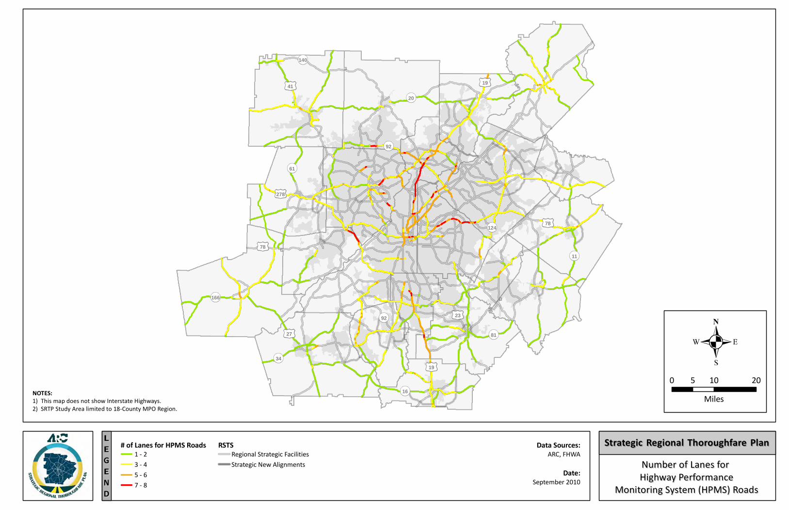
# of Lanes for HPMS Roads1 - 23 - 45 - 67 - 8
Number of Lanes for Number of Lanes for Highway PerformanceHighway Performance
Monitoring System (HPMS) RoadsMonitoring System (HPMS) RoadsDate:
September 2010
20
140
61
11
81
19
27
34
166
78
19
16
92 23
124 78
41
278
92
EEGGLL
NNEE
DD
NOTES:1) This map does not show Interstate Highways.2) SRTP Study Area limited to 18-County MPO Region.
Data Sources:ARC, FHWA
0 10 205Miles
Strategic Regional Thoroughfare PlanStrategic Regional Thoroughfare Plan
Date:September 2010
Annual Average Daily Traffic (AADT)Annual Average Daily Traffic (AADT)on Highway Performance Monitoringon Highway Performance Monitoring
System (HPMS) RoadsSystem (HPMS) Roads
RSTSStrategic New AlignmentsRegional Strategic Facilities
AADT on HPMS Roads 0 - 30,00030,001 - 60,00060,001 - 120,000120,001 - 200,000
20
140
61
11
81
19
27
34
166
78
19
16
92 23
124 78
41
278
92
Optimum Route AnalysisOptimum Route Analysisfor Intra-Regional Tripsfor Intra-Regional Trips
EEGGLL
NNEE
DD
NOTES:1) SRTP Study Area limited to 18-County MPO Region.2) Percentile is defined as a value on a scale of 100, that indicates the percent of a distribution that is equal to or below it.3) ARC completed the Origin and Destination Analysis in 2008.
Data Sources:ARC, FHWA
0 10 205Miles
Strategic Regional Thoroughfare PlanStrategic Regional Thoroughfare PlanRSTS
Strategic New AlignmentsRegional Strategic Facilities
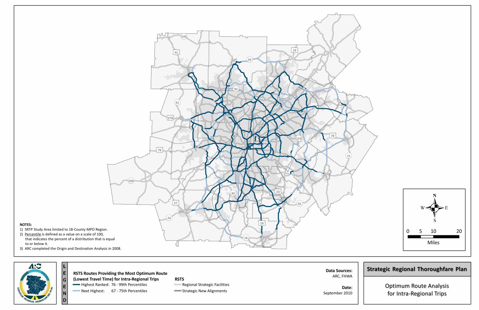
RSTS Routes Providing the Most Optimum Route(Lowest Travel Time) for Intra-Regional Trips
Highest Ranked: 76 - 99th PercentilesNext Highest: 67 - 75th Percentiles Date:
September 2010
20
140
61
11
81
19
27
34
166
78
19
16
92 23
124 78
41
278
92
Designated Regional Bicycle RoutesDesignated Regional Bicycle RoutesEEGGLL
NNEE
DD
NOTES:1) This map does not show Interstate Highways.2) SRTP Study Area limited to 18-County MPO Region.
Data Sources:ARC, FHWA
0 10 205Miles
Strategic Regional Thoroughfare PlanStrategic Regional Thoroughfare PlanBicycle Travel Facilities RSTSStrategic New AlignmentsRegional Strategic FacilitiesDesignated Regional Bicycle Route
Date:September 2010
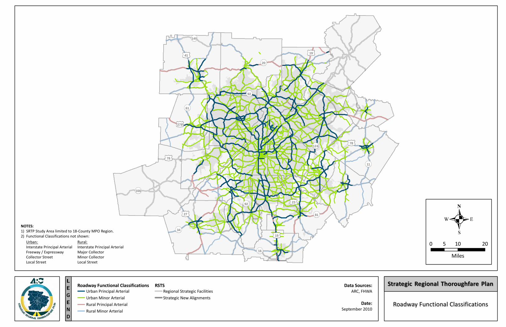
20
140
61
11
81
19
27
34
166
78
19
16
92 23
124 78
41
278
92
Roadway Functional ClassificationsRoadway Functional ClassificationsEEGGLL
NNEE
DD
Roadway Functional Classifications Data Sources:ARC, FHWA
0 10 205Miles
Strategic Regional Thoroughfare PlanStrategic Regional Thoroughfare PlanUrban Principal ArterialUrban Minor ArterialRural Principal ArterialRural Minor Arterial
RSTSStrategic New AlignmentsRegional Strategic Facilities
NOTES:1) SRTP Study Area limited to 18-County MPO Region.2) Functional Classifications not shown:
Urban:Interstate Principal ArterialFreeway / ExpresswayCollector StreetLocal Street
Rural:Interstate Principal ArterialMajor CollectorMinor CollectorLocal Street
Date:September 2010
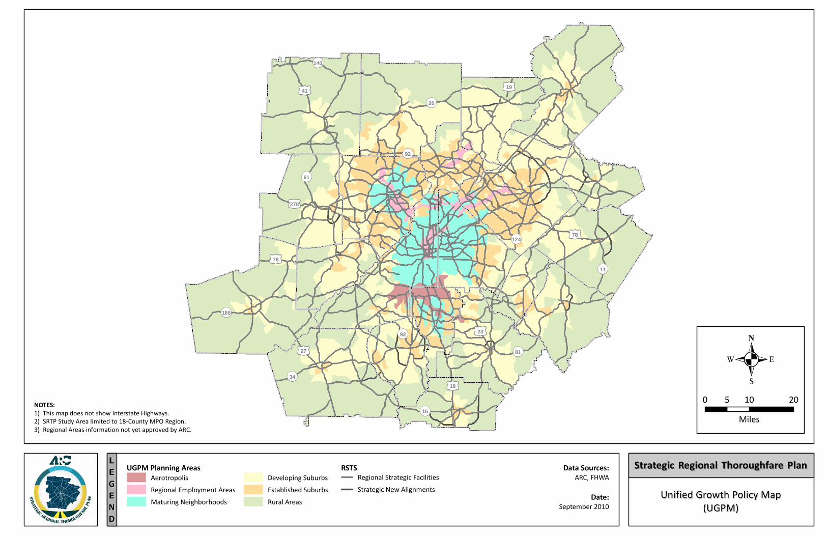
20
140
61
11
81
19
27
34
166
78
19
16
92 23
124 78
41
278
92
EEGGLL
NNEE
DD
NOTES:1) This map does not show Interstate Highways.2) SRTP Study Area limited to 18-County MPO Region.3) Regional Areas information not yet approved by ARC.
Data Sources:ARC, FHWA
0 10 205Miles
Strategic Regional Thoroughfare PlanStrategic Regional Thoroughfare Plan
Unified Growth Policy MapUnified Growth Policy Map(UGPM)(UGPM)
RSTSRegional Strategic FacilitiesStrategic New Alignments
UGPM Planning Areas
Rural AreasEstablished SuburbsDeveloping Suburbs
Maturing NeighborhoodsRegional Employment AreasAerotropolis
Date:September 2010

STRATEGIC REGIONAL THOROUGHFARE PLAN Data Compilation Report
September 2010
Appendix C: GDOT M.A.S.T. Program – Status Spreadsheet
(April 2010)
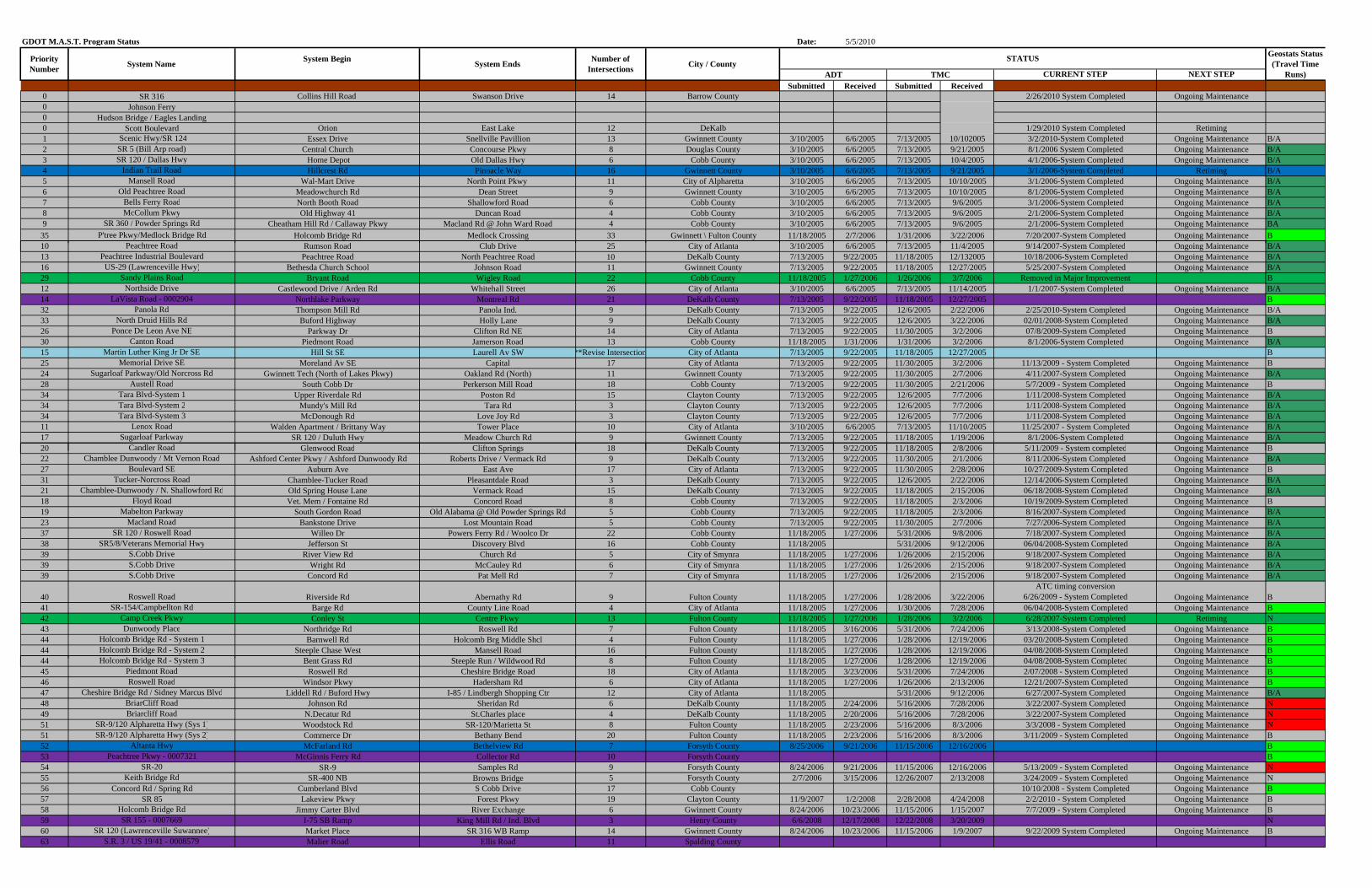
GDOT M.A.S.T. Program Status Date: 5/5/2010
System Begin
CURRENT STEP NEXT STEPSubmitted Received Submitted Received
0 SR 316 Collins Hill Road Swanson Drive 14 Barrow County 2/26/2010 System Completed Ongoing Maintenance0 Johnson Ferry0 Hudson Bridge / Eagles Landing0 Scott Boulevard Orion East Lake 12 DeKalb 1/29/2010 System Completed Retiming1 Scenic Hwy/SR 124 Essex Drive Snellville Pavillion 13 Gwinnett County 3/10/2005 6/6/2005 7/13/2005 10/102005 3/2/2010-System Completed Ongoing Maintenance B/A2 SR 5 (Bill Arp road) Central Church Concourse Pkwy 8 Douglas County 3/10/2005 6/6/2005 7/13/2005 9/21/2005 8/1/2006 System Completed Ongoing Maintenance B/A3 SR 120 / Dallas Hwy Home Depot Old Dallas Hwy 6 Cobb County 3/10/2005 6/6/2005 7/13/2005 10/4/2005 4/1/2006-System Completed Ongoing Maintenance B/A4 Indian Trail Road Hillcrest Rd Pinnacle Way 16 Gwinnett County 3/10/2005 6/6/2005 7/13/2005 9/21/2005 3/1/2006-System Completed Retiming B/A5 Mansell Road Wal-Mart Drive North Point Pkwy 11 City of Alpharetta 3/10/2005 6/6/2005 7/13/2005 10/10/2005 3/1/2006-System Completed Ongoing Maintenance B/A6 Old Peachtree Road Meadowchurch Rd Dean Street 9 Gwinnett County 3/10/2005 6/6/2005 7/13/2005 10/10/2005 8/1/2006-System Completed Ongoing Maintenance B/A7 Bells Ferry Road North Booth Road Shallowford Road 6 Cobb County 3/10/2005 6/6/2005 7/13/2005 9/6/2005 3/1/2006-System Completed Ongoing Maintenance B/A8 McCollum Pkwy Old Highway 41 Duncan Road 4 Cobb County 3/10/2005 6/6/2005 7/13/2005 9/6/2005 2/1/2006-System Completed Ongoing Maintenance B/A9 SR 360 / Powder Springs Rd Cheatham Hill Rd / Callaway Pkwy Macland Rd @ John Ward Road 4 Cobb County 3/10/2005 6/6/2005 7/13/2005 9/6/2005 2/1/2006-System Completed Ongoing Maintenance BA
35 P'tree Pkwy/Medlock Bridge Rd Holcomb Bridge Rd Medlock Crossing 33 Gwinnett \ Fulton County 11/18/2005 2/7/2006 1/31/2006 3/22/2006 7/20/2007-System Completed Ongoing Maintenance B10 P ht R d R R d Cl b D i 25 Cit f Atl t 3/10/2005 6/6/2005 7/13/2005 11/4/2005 9/14/2007 S t C l t d O i M i t B/A
Geostats Status (Travel Time
Runs) System EndsPriority
NumberNumber of
Intersections City / CountySystem NameADT TMC
STATUS
10 Peachtree Road Rumson Road Club Drive 25 City of Atlanta 3/10/2005 6/6/2005 7/13/2005 11/4/2005 9/14/2007-System Completed Ongoing Maintenance B/A13 Peachtree Industrial Boulevard Peachtree Road North Peachtree Road 10 DeKalb County 7/13/2005 9/22/2005 11/18/2005 12/132005 10/18/2006-System Completed Ongoing Maintenance B/A16 US-29 (Lawrenceville Hwy) Bethesda Church School Johnson Road 11 Gwinnett County 7/13/2005 9/22/2005 11/18/2005 12/27/2005 5/25/2007-System Completed Ongoing Maintenance B/A29 Sandy Plains Road Bryant Road Wigley Road 22 Cobb County 11/18/2005 1/27/2006 1/26/2006 3/7/2006 Removed in Major Improvement B12 Northside Drive Castlewood Drive / Arden Rd Whitehall Street 26 City of Atlanta 3/10/2005 6/6/2005 7/13/2005 11/14/2005 1/1/2007-System Completed Ongoing Maintenance B/A14 LaVista Road - 0002904 Northlake Parkway Montreal Rd 21 DeKalb County 7/13/2005 9/22/2005 11/18/2005 12/27/2005 B32 Panola Rd Thompson Mill Rd Panola Ind. 9 DeKalb County 7/13/2005 9/22/2005 12/6/2005 2/22/2006 2/25/2010-System Completed Ongoing Maintenance B/A33 North Druid Hills Rd Buford Highway Holly Lane 9 DeKalb County 7/13/2005 9/22/2005 12/6/2005 3/22/2006 02/01/2008-System Completed Ongoing Maintenance B/A26 Ponce De Leon Ave NE Parkway Dr Clifton Rd NE 14 City of Atlanta 7/13/2005 9/22/2005 11/30/2005 3/2/2006 07/8/2009-System Completed Ongoing Maintenance B30 Canton Road Piedmont Road Jamerson Road 13 Cobb County 11/18/2005 1/31/2006 1/31/2006 3/2/2006 8/1/2006-System Completed Ongoing Maintenance B/A15 Martin Luther King Jr Dr SE Hill St SE Laurell Av SW **Revise Intersection City of Atlanta 7/13/2005 9/22/2005 11/18/2005 12/27/2005 B25 Memorial Drive SE Moreland Av SE Capital 17 City of Atlanta 7/13/2005 9/22/2005 11/30/2005 3/2/2006 11/13/2009 - System Completed Ongoing Maintenance B24 Sugarloaf Parkway/Old Norcross Rd Gwinnett Tech (North of Lakes Pkwy) Oakland Rd (North) 11 Gwinnett County 7/13/2005 9/22/2005 11/30/2005 2/7/2006 4/11/2007-System Completed Ongoing Maintenance B/A28 Austell Road South Cobb Dr Perkerson Mill Road 18 Cobb County 7/13/2005 9/22/2005 11/30/2005 2/21/2006 5/7/2009 - System Completed Ongoing Maintenance B34 Tara Blvd-System 1 Upper Riverdale Rd Poston Rd 15 Clayton County 7/13/2005 9/22/2005 12/6/2005 7/7/2006 1/11/2008-System Completed Ongoing Maintenance B/A34 Tara Blvd-System 2 Mundy's Mill Rd Tara Rd 3 Clayton County 7/13/2005 9/22/2005 12/6/2005 7/7/2006 1/11/2008-System Completed Ongoing Maintenance B/A34 Tara Blvd-System 3 McDonough Rd Love Joy Rd 3 Clayton County 7/13/2005 9/22/2005 12/6/2005 7/7/2006 1/11/2008-System Completed Ongoing Maintenance B/A11 Lenox Road Walden Apartment / Brittany Way Tower Place 10 City of Atlanta 3/10/2005 6/6/2005 7/13/2005 11/10/2005 11/25/2007 - System Completed Ongoing Maintenance B/A17 Sugarloaf Parkway SR 120 / Duluth Hwy Meadow Church Rd 9 Gwinnett County 7/13/2005 9/22/2005 11/18/2005 1/19/2006 8/1/2006-System Completed Ongoing Maintenance B/A20 Candler Road Glenwood Road Clifton Springs 18 DeKalb County 7/13/2005 9/22/2005 11/18/2005 2/8/2006 5/11/2009 - System completed Ongoing Maintenance B20 Glenwood Road Clifton Springs 18 DeKalb County 7/13/2005 9/22/2005 11/18/2005 2/8/2006 5/11/2009 System completed Ongoing Maintenance B22 Chamblee Dunwoody / Mt Vernon Road Ashford Center Pkwy / Ashford Dunwoody Rd Roberts Drive / Vermack Rd 9 DeKalb County 7/13/2005 9/22/2005 11/30/2005 2/1/2006 8/11/2006-System Completed Ongoing Maintenance B/A27 Boulevard SE Auburn Ave East Ave 17 City of Atlanta 7/13/2005 9/22/2005 11/30/2005 2/28/2006 10/27/2009-System Completed Ongoing Maintenance B31 Tucker-Norcross Road Chamblee-Tucker Road Pleasantdale Road 3 DeKalb County 7/13/2005 9/22/2005 12/6/2005 2/22/2006 12/14/2006-System Completed Ongoing Maintenance B/A21 Chamblee-Dunwoody / N. Shallowford Rd Old Spring House Lane Vermack Road 15 DeKalb County 7/13/2005 9/22/2005 11/18/2005 2/15/2006 06/18/2008-System Completed Ongoing Maintenance B/A18 Floyd Road Vet. Mem / Fontaine Rd Concord Road 8 Cobb County 7/13/2005 9/22/2005 11/18/2005 2/3/2006 10/19/2009-System Completed Ongoing Maintenance B19 Mabelton Parkway South Gordon Road Old Alabama @ Old Powder Springs Rd 5 Cobb County 7/13/2005 9/22/2005 11/18/2005 2/3/2006 8/16/2007-System Completed Ongoing Maintenance B/A23 Macland Road Bankstone Drive Lost Mountain Road 5 Cobb County 7/13/2005 9/22/2005 11/30/2005 2/7/2006 7/27/2006-System Completed Ongoing Maintenance B/A37 SR 120 / Roswell Road Willeo Dr Powers Ferry Rd / Woolco Dr 22 Cobb County 11/18/2005 1/27/2006 5/31/2006 9/8/2006 7/18/2007-System Completed Ongoing Maintenance B/A38 SR5/8/Veterans Memorial Hwy Jefferson St Discovery Blvd 16 Cobb County 11/18/2005 5/31/2006 9/12/2006 06/04/2008-System Completed Ongoing Maintenance B/A39 S.Cobb Drive River View Rd Church Rd 5 City of Smynra 11/18/2005 1/27/2006 1/26/2006 2/15/2006 9/18/2007-System Completed Ongoing Maintenance B/A39 S.Cobb Drive Wright Rd McCauley Rd 6 City of Smynra 11/18/2005 1/27/2006 1/26/2006 2/15/2006 9/18/2007-System Completed Ongoing Maintenance B/A39 S.Cobb Drive Concord Rd Pat Mell Rd 7 City of Smynra 11/18/2005 1/27/2006 1/26/2006 2/15/2006 9/18/2007-System Completed Ongoing Maintenance B/A
40 Roswell Road Riverside Rd Abernathy Rd 9 Fulton County 11/18/2005 1/27/2006 1/28/2006 3/22/2006ATC timing conversion
6/26/2009 - System Completed Ongoing Maintenance B41 SR-154/Campbellton Rd Barge Rd County Line Road 4 City of Atlanta 11/18/2005 1/27/2006 1/30/2006 7/28/2006 06/04/2008-System Completed Ongoing Maintenance B42 Camp Creek Pkwy Conley St Centre Pkwy 13 Fulton County 11/18/2005 1/27/2006 1/28/2006 3/2/2006 6/28/2007-System Completed Retiming N43 Dunwoody Place Northridge Rd Roswell Rd 7 Fulton County 11/18/2005 3/16/2006 5/31/2006 7/24/2006 3/13/2008-System Completed Ongoing Maintenance B44 Holcomb Bridge Rd - System 1 Barnwell Rd Holcomb Brg Middle Shcl 4 Fulton County 11/18/2005 1/27/2006 1/28/2006 12/19/2006 03/20/2008-System Completed Ongoing Maintenance B44 Holcomb Bridge Rd - System 2 Steeple Chase West Mansell Road 16 Fulton County 11/18/2005 1/27/2006 1/28/2006 12/19/2006 04/08/2008-System Completed Ongoing Maintenance B44 Holcomb Bridge Rd System 3 B t G Rd St l R / Wild d Rd 8 F lt C t 11/18/2005 1/27/2006 1/28/2006 12/19/2006 04/08/2008 S t C l t d O i M i t B44 Holcomb Bridge Rd - System 3 Bent Grass Rd Steeple Run / Wildwood Rd 8 Fulton County 11/18/2005 1/27/2006 1/28/2006 12/19/2006 04/08/2008-System Completed Ongoing Maintenance B45 Piedmont Road Roswell Rd Cheshire Bridge Road 18 City of Atlanta 11/18/2005 3/23/2006 5/31/2006 7/24/2006 2/07/2008 - System Completed Ongoing Maintenance B46 Roswell Road Windsor Pkwy Hadersham Rd 6 City of Atlanta 11/18/2005 1/27/2006 1/26/2006 2/13/2006 12/21/2007-System Completed Ongoing Maintenance B47 Cheshire Bridge Rd / Sidney Marcus Blvd Liddell Rd / Buford Hwy I-85 / Lindbergh Shopping Ctr 12 City of Atlanta 11/18/2005 5/31/2006 9/12/2006 6/27/2007-System Completed Ongoing Maintenance B/A48 BriarCliff Road Johnson Rd Sheridan Rd 6 DeKalb County 11/18/2005 2/24/2006 5/16/2006 7/28/2006 3/22/2007-System Completed Ongoing Maintenance N49 Briarcliff Road N.Decatur Rd St.Charles place 4 DeKalb County 11/18/2005 2/20/2006 5/16/2006 7/28/2006 3/22/2007-System Completed Ongoing Maintenance N51 SR-9/120 Alpharetta Hwy (Sys 1) Woodstock Rd SR-120/Marietta St 8 Fulton County 11/18/2005 2/23/2006 5/16/2006 8/3/2006 3/3/2008 - System Completed Ongoing Maintenance N51 SR-9/120 Alpharetta Hwy (Sys 2) Commerce Dr Bethany Bend 20 Fulton County 11/18/2005 2/23/2006 5/16/2006 8/3/2006 3/11/2009 - System Completed Ongoing Maintenance B52 Altanta Hwy McFarland Rd Bethelview Rd 7 Forsyth County 8/25/2006 9/21/2006 11/15/2006 12/16/2006 B53 Peachtree Pkwy - 0007321 McGinnis Ferry Rd Collector Rd 10 Forsyth County B54 SR-20 SR-9 Samples Rd 9 Forsyth County 8/24/2006 9/21/2006 11/15/2006 12/16/2006 5/13/2009 - System Completed Ongoing Maintenance N55 Keith Bridge Rd SR-400 NB Browns Bridge 5 Forsyth County 2/7/2006 3/15/2006 12/26/2007 2/13/2008 3/24/2009 - System Completed Ongoing Maintenance N56 Concord Rd / Spring Rd Cumberland Blvd S Cobb Drive 17 Cobb County 10/10/2008 - System Completed Ongoing Maintenance B57 SR 85 Lakeview Pkwy Forest Pkwy 19 Clayton County 11/9/2007 1/2/2008 2/28/2008 4/24/2008 2/2/2010 - System Completed Ongoing Maintenance B58 Holcomb Bridge Rd Jimmy Carter Blvd River Exchange 6 Gwinnett County 8/24/2006 10/23/2006 11/15/2006 1/15/2007 7/7/2009 - System Completed Ongoing Maintenance B59 SR 155 - 0007669 I-75 SB Ramp King Mill Rd / Ind. Blvd 3 Henry County 6/6/2008 12/17/2008 12/22/2008 3/20/2009 N60 SR 120 (Lawrenceville Suwannee) Market Place SR 316 WB Ramp 14 Gwinnett County 8/24/2006 10/23/2006 11/15/2006 1/9/2007 9/22/2009 System Completed Ongoing Maintenance B63 S.R. 3 / US 19/41 - 0008579 Malier Road Ellis Road 11 Spalding County
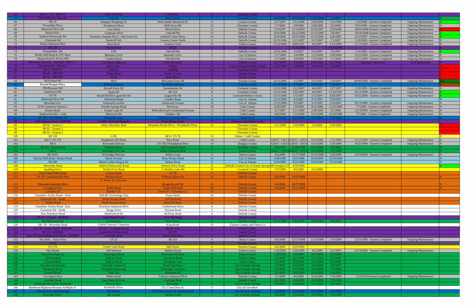
64 SR 16 / 155 - 0008579 Pine Hill Road 4th Street 19 Spalding County65 SR 378/Beaver Ruin Rd I-85 SB Burns Road 6 Gwinnett County 8/24/2006 10/19/2006 11/15/2006 1/9/2007 B66 SR-34 Eastgate Shopping Ctr Walt Sander Memorial Dr 15 Coweta County 12/7/2007 2/11/2008 2/28/2008 5/14/2008 11/4/2008 - System Completed Ongoing Maintenance B67 Townelake Pkwy Woodstock Pkwy Bells Ferry Rd 22 Cherokee County 2/7/2006 3/9/2006 2/28/2008 6/2/2008 9/15/2009 - System Completed Ongoing Maintenance N68 Memorial Drive SE Line Street Beech Drive 12 DeKalb County 11/9/2007 12/14/2007 12/26/2007 2/28/2008 08/04/2008-System Completed Ongoing Maintenance N69 Buford Hwy Corporate Blvd Oakcliff Rd 25 DeKalb County 8/24/2006 10/23/2006 12/15/2006 5/8/2007 06/26/2008-System Completed Ongoing Maintenance B70 Ashford Dunwoody Rd Perimeter Summit Pkwy / Oak Forest Dr Ashford Center Pkwy 14 DeKalb County 8/24/2006 10/23/2006 12/15/2006 4/26/2007 10/19/2007 - System Completed Ongoing Maintenance B71 Clairmont Rd Braircliff Rd Centuty Center North 6 DeKalb County 12/15/2006 2/21/2007 3/15/2007 7/2/2007 5/19/2009 - System Completed Ongoing Maintenance N72 Fulton Industrail Blvd Boat Rock Avation Circle 15 Fulton County 12/15/2006 04/03/207 4/6/2007 2/14/2008 11/13/2009 - System Completed Ongoing Maintenance B73 SR 138 Spivey Road SR 42 12 Clayton County 11/25/2008 11/25/2008 B74 Pleasantdale Rd UPS Oakcliff Rd 5 DeKalb County 12/15/2006 3/5/2007 3/15/2007 7/6/2007 11/4/2008 - System Completed Ongoing Maintenance B76 Windy Hill Road & ATL Road Belmont Circle Burbank Cirlce 3 City of Smynra 11/7/2008 1/8/2009 1/12/2009 3/20/2009 12/21/2009 - System Completed Ongoing Maintenance B78 Atlanta Road & Windy Hill Cambell Road Pat Mell Rd 7 City of Smyrna 11/7/2008 1/8/2009 1/15/2009 5/1/2009 12/21/2009 - System Completed Ongoing Maintenance N77 Memorial Drive SE - 0002405 - 0007131 Covington Highway West Mountain 31 DeKalb County 12/7/2007 2/8/2008 2/28/2008 6/10/2008 Database conversion 2070 deployment N79 Glenwood Rd - 0002415 Derril Drive Clifton 14 City of Atlanta\DeKalb County 12/12/2008 3/4/2009 3/10/2009 6/2/2009 N80 SR-6 - 0007670 pending pending 22 Paulding County N81 SR-85 - 0007668 Banks Road Grady Avenue 10 Fayette County N82 SR-54 - 0007668 SR 85 Banks Road 11 Fayette County N84 McFarland Rd SR-9 McGinnis Ferry Rd 11 Forsyth County 12/15/2006 3/5/2007 3/15/2007 7/24/2007 06/09/2008 - System Completed Ongoing Maintenance B/A85 Ronald Reagan Pkwy Buford Highway Peachtree Parkway 8 Forsyth County 12/15/2006 3/7/2007 3/15/2007 7/6/2007 B85 Ronald Reagan Pkwy Buford Highway Peachtree Parkway 8 Forsyth County 12/15/2006 3/7/2007 3/15/2007 7/6/2007 B86 PIB/Pleasant Hill Howell Ferry Rd Sweetbottom Dr 11 Gwinnett County 12/15/2006 3/22/2007 4/6/2007 12/7/2007 2/10/2009 - System Completed Ongoing Maintenance B87 Annistown Rd Spain Rd SR 124 8 Gwinnett County 12/15/2006 3/22/2007 4/6/2007 11/20/2007 10/14/2008 - System Completed Ongoing Maintenance B90 US 78 Brand Rd/Old Loganville Rd Loganville HS 6 Gwinnett\Walton County 12/15/2006 3/5/2007 3/15/2007 4/26/2007 10/22/2008 - System Completed Ongoing Maintenance B91 Memorial Drive SE Whiteford Road Candler Road 12 City of Atlanta 12/15/2006 3/5/2007 3/15/2007 5/29/2007 N92 Moreland Ave Ssaboard/Caroline Glenwood Avenue 10 City of Atlanta 12/15/2006 3/5/2007 3/15/2007 5/18/2007 10/13/2009 - System Completed Ongoing Maintenance N93 E-W Connector System 1 Powder Springs Road Driveway 18 Cobb County 4/28/2008 7/8/2008 8/13/2008 11/25/2008 7/7/2009 - System Completed Ongoing Maintenance N94 Atlanta Road Cooper Lake Dr Nifda Blvd and Cumberland System 11 Cobb County 12/7/2007 2/11/2008 2/28/2008 6/3/2008 12/14/2009 - System Completed Ongoing Maintenance N96 Shallowford Rd - Cobb Blackwell Rd Childers Rd 11 Cobb County 4/28/2008 7/22/2008 8/13/2008 12/10/2008 7/7/2009 - System Completed Ongoing Maintenance N97 SR 120 - State Bridge Rd Shopping Center Medlock Crossing Pkwy 9 Johns Creek 11/7/2008 2/24/2009 3/10/2009 5/29/2009 N98 Old Alabama Road - 0008588 GA 400 / Holcomb Brdg Rd Jones Bridge Road 17 Fulton County/Johns Creek99 SR 92 - System 1 Office Max/Pets Mart Mountain Brook Pkwy / Woodlands Pkwy 19 Cherokee County 11/7/2008 1/29/2009 2/3/2009 5/29/2009 N99 SR 92 - System 2 Cherokee County99 SR 92 - System 3 Cherokee County100 SR 139 I-285 SR 8 / US 78 13 Fulton / Cobb County B101 SR 6 / US 278 Humphries Hill Road Pace Road 16 Cobb County GDOT / GRTA GDOT / GRTA 9/23/2008 1/15/2009 11/11/2009 - System Completed Ongoing Maintenance N102 SR 6 Riverside Parkway US 78/278 Bankhead Hwy 14 Douglas County GDOT / GRTA GDOT / GRTA 9/24/2008 1/20/2009 10/26/2009 - System Completed Ongoing Maintenance N103 SR 162 / Salem Road Kirkland Road Old Covington Road 9 Rockdale County 6/6/2008 10/28/2008 11/7/2008 4/2/2009 N104 SR 6 Welcome All Conn Fulton Industrial Blvd 7 Fulton County GDOT / GRTA GDOT / GRTA 9/23/2008 1/22/2009 N105 SR 20/81 Westridge Parkway Willow Lane 6 Henry County 6/6/2008 12/17/2008 12/19/2008 3/20/2009 12/10/2009 - System Completed Ongoing Maintenance N106 Moores Mill Road / Bolton Road Parrot Avenue West Wesley Road 14 City of Atlanta 4/28/2008 8/25/2008 8/26/2008 12/19/2008 N107 SR 280 Martin Luther King Jr Dr Bolton Road 8 City of Atlanta 4/28/2008 8/25/2008 8/26/2008 12/23/2008 N108 Abernathy Road Ashford Dunwoody Road Johnson Ferry Road 22 DeKalb County/City of Sandy Springs/09 rerequest 5/5 8/18/2009 B110 Spalding Drive Nesbit Ferry Road S. Berkley Lake Rd 16 Gwinnett County 1/15/2009 4/6/2009 4/13/2009111 North Druid Hills Road Lavista Road US 78 9 DeKalb County112 US 29 / Lawrenceville Hwy Brockett Road N Royal Atlanta Dr 16 DeKalb County 6/6/2008 10/27/2008 N
113 Mountain Industrial BlvdE. Ponce de Leon Ave
Hough Howell Rd 13 DeKalb County 6/6/2008 10/27/2008 N114 Covington Hwy Redan Road Turner Hill Road 20 DeKalb County 6/6/2008 12/15/2008 N115 Columbia Dr Rainbow Dr Derril Dr / Columbia Cir 10 DeKalb County116 Chamblee Tucker Road - West DeKalb Technology Way Evans Road 16 DeKalb County117 Clairmont Rd - South North Decatur Road LaVista Road 11 DeKalb County118 Clifton Road North Decatur Road Briarcliff Road 14 DeKalb County119 Chamblee Tucker Road - East Peachtree Industrial Blvd Cumberland Drive 6 DeKalb County120 Clairmont Rd - North Bragg Street Skyland Road 3 DeKalb County121 New Peachtree Road Shallowford Rd McElroy Road 6 DeKalb County122 SR 42 - Clayton - 0008586 Lake Harbin Road I-675 NB Ramp 5 Clayton County124 Bouldercrest Road Constitution River Road 6 DeKalb County 12/12/2008 3/16/2009 3/16/2009 6/2/2009126 SR 139 - Riverdale Road Global Gateway Connector King Road 15 Clayton County and Fulton Co127 SR 140 - Houze Road - 0008580 SR 372 - Crabapple Road Houze Way 4 Fulton County127 SR 140 - Houze Road - 0008580 SR 372 - Crabapple Road Houze Way 4 Fulton County128 SR 314 - 0008585 Banks Road/White Road SR 279 7 Fayette County131 Briarcliff Road/Shallowford Road - 0008590 Briarlake Road Shallowford Plaza 8 DeKalb County132 SR 20/81 - Keys Ferry US 23 SR 155 6 Henry County 6/6/2008 12/17/2008 12/19/2008 3/19/2009 12/10/2009 - System Completed Ongoing Maintenance134 SR 92 18 Douglas County135 US 278 Turner Lake Road Mill Street 6 Newton County 4/6/2009 6/25/2009136 Flat Shoals Old National Mallory Road 13 Fulton County 1/26/2009 3/26/2009 4/3/2009 6/2/2009 10/13/2009 - System Completed Ongoing Maintenance137 Roosevelt Highway Washington Road Welcome All Road 4 Fulton County 1/28/2009 4/6/2009 4/13/2009 5/29/2009138 Old National Sullivan Road Jonesboro Road 12 Fulton County 2/6/2009 4/21/2009 4/27/2009 8/7/2009139 Chastain Road Duncan Road Townpark Lane 16 Cobb County 2/2/2009 4/9/2009 4/13/2009 8/3/2009140 Peachtree Dunwoody Glenridge Connector North Park Place 17 City of Sandy Springs 2/5/2009 4/16/2009 4/24/2009 9/9/2009141 Hammond Drive Peachtree Dunwoody Glenridge Connector 5 City of Sandy Springs 2/5/2009 4/16/2009 4/24/2009 7/10/2009142 Roswell Road Belle Isle Abernathy Rd 24 City of Sandy Springs 2/5/2009 4/16/2009 4/24/2009 9/3/2009143 Covington Hwy Miller Road Lithonia Industrial Blvd 6 DeKalb County 2/2/2009 4/6/2009 4/13/2009 7/10/2009 2/25/2010-System Completed Ongoing Maintenance144 Brockett Road East Ponce de Leon Cooledge Road 7 DeKalb County 2/2/2009 4/9/2009 4/13/2009 7/10/2009145 Northside Drive/New Northside Powers Ferry Riveredge 8 City of Sandy Springs 2/6/2009 4/16/2009 4/27/2009 10/1/2009146 Bankhead Highway/Newnan St/Maple St Northside Drive US 27 and Dixie St 17 City of Carrollton147 Johnson Ferry Rd/Glenridge Mt Vernon Old Johnson Ferry @ Johnson Ferry 23 City of Sandy Springs 2/6/2009 4/16/2009 4/27/2009 10/1/2009148 Riverside Drive Mt Vernon Old Riverside 7 City of Sandy Springs 2/6/2009 4/16/2009 4/27/2009 7/10/2009
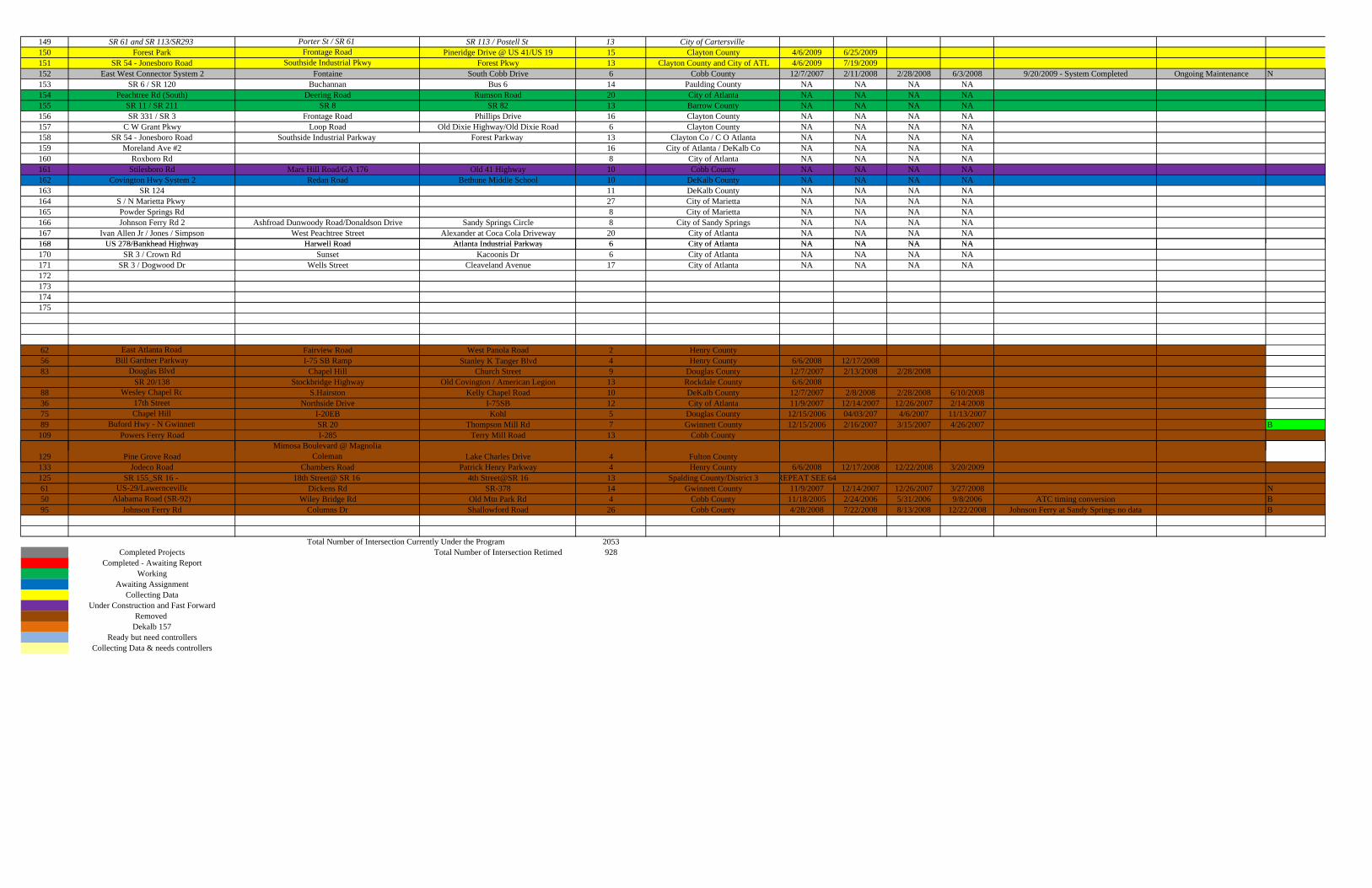
149 SR 61 and SR 113/SR293 Porter St / SR 61 SR 113 / Postell St 13 City of Cartersville150 Forest Park Frontage Road Pineridge Drive @ US 41/US 19 15 Clayton County 4/6/2009 6/25/2009151 SR 54 - Jonesboro Road Southside Industrial Pkwy Forest Pkwy 13 Clayton County and City of ATL 4/6/2009 7/19/2009152 East West Connector System 2 Fontaine South Cobb Drive 6 Cobb County 12/7/2007 2/11/2008 2/28/2008 6/3/2008 9/20/2009 - System Completed Ongoing Maintenance N153 SR 6 / SR 120 Buchannan Bus 6 14 Paulding County NA NA NA NA154 Peachtree Rd (South) Deering Road Rumson Road 20 City of Atlanta NA NA NA NA155 SR 11 / SR 211 SR 8 SR 82 13 Barrow County NA NA NA NA156 SR 331 / SR 3 Frontage Road Phillips Drive 16 Clayton County NA NA NA NA157 C W Grant Pkwy Loop Road Old Dixie Highway/Old Dixie Road 6 Clayton County NA NA NA NA158 SR 54 - Jonesboro Road Southside Industrial Parkway Forest Parkway 13 Clayton Co / C O Atlanta NA NA NA NA159 Moreland Ave #2 16 City of Atlanta / DeKalb Co NA NA NA NA160 Roxboro Rd 8 City of Atlanta NA NA NA NA161 Stilesboro Rd Mars Hill Road/GA 176 Old 41 Highway 10 Cobb County NA NA NA NA162 Covington Hwy System 2 Redan Road Bethune Middle School 10 DeKalb County NA NA NA NA163 SR 124 11 DeKalb County NA NA NA NA164 S / N Marietta Pkwy 27 City of Marietta NA NA NA NA165 Powder Springs Rd 8 City of Marietta NA NA NA NA166 Johnson Ferry Rd 2 Ashfroad Dunwoody Road/Donaldson Drive Sandy Springs Circle 8 City of Sandy Springs NA NA NA NA167 Ivan Allen Jr / Jones / Simpson West Peachtree Street Alexander at Coca Cola Driveway 20 City of Atlanta NA NA NA NA168 US 278/Bankhead Highway Harwell Road Atlanta Industrial Parkway 6 City of Atlanta NA NA NA NA168 US 278/Bankhead Highway Harwell Road Atlanta Industrial Parkway 6 City of Atlanta NA NA NA NA170 SR 3 / Crown Rd Sunset Kacoonis Dr 6 City of Atlanta NA NA NA NA171 SR 3 / Dogwood Dr Wells Street Cleaveland Avenue 17 City of Atlanta NA NA NA NA172173174175
62 East Atlanta Road Fairview Road West Panola Road 2 Henry County56 Bill Gardner Parkway I-75 SB Ramp Stanley K Tanger Blvd 4 Henry County 6/6/2008 12/17/200883 Douglas Blvd Chapel Hill Church Street 9 Douglas County 12/7/2007 2/13/2008 2/28/2008
SR 20/138 Stockbridge Highway Old Covington / American Legion 13 Rockdale County 6/6/200888 Wesley Chapel Rd S.Hairston Kelly Chapel Road 10 DeKalb County 12/7/2007 2/8/2008 2/28/2008 6/10/200836 17th Street Northside Drive I-75SB 12 City of Atlanta 11/9/2007 12/14/2007 12/26/2007 2/14/200875 Chapel Hill I-20EB Kohl 5 Douglas County 12/15/2006 04/03/207 4/6/2007 11/13/200789 Buford Hwy - N Gwinnett SR 20 Thompson Mill Rd 7 Gwinnett County 12/15/2006 2/16/2007 3/15/2007 4/26/2007 B109 Powers Ferry Road I-285 Terry Mill Road 13 Cobb County
Mimosa Boulevard @ Magnolia129 Pine Grove Road Coleman Lake Charles Drive 4 Fulton County133 Jodeco Road Chambers Road Patrick Henry Parkway 4 Henry County 6/6/2008 12/17/2008 12/22/2008 3/20/2009125 SR 155_SR 16 - 18th Street@ SR 16 4th Street@SR 16 13 Spalding County/District 3 REPEAT SEE 6461 US-29/Lawernceville Dickens Rd SR-378 14 Gwinnett County 11/9/2007 12/14/2007 12/26/2007 3/27/2008 N50 Alabama Road (SR-92) Wiley Bridge Rd Old Mtn Park Rd 4 Cobb County 11/18/2005 2/24/2006 5/31/2006 9/8/2006 ATC timing conversion B95 Johnson Ferry Rd Columns Dr Shallowford Road 26 Cobb County 4/28/2008 7/22/2008 8/13/2008 12/22/2008 Johnson Ferry at Sandy Springs no data B
2053Completed Projects Total Number of Intersection Retimed 928
Completed - Awaiting ReportWorking
Awaiting AssignmentCollecting Data
Under Construction and Fast ForwardRemoved
Dekalb 157Ready but need controllers
Collecting Data & needs controllers
Total Number of Intersection Currently Under the Program
STRATEGIC REGIONAL THOROUGHFARE PLAN Data Compilation Report
September 2010
Appendix D: ASTRoMaP Project Travel Time Run
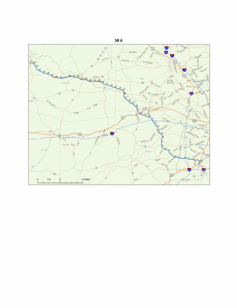
SR 6
SR 11
SR 16
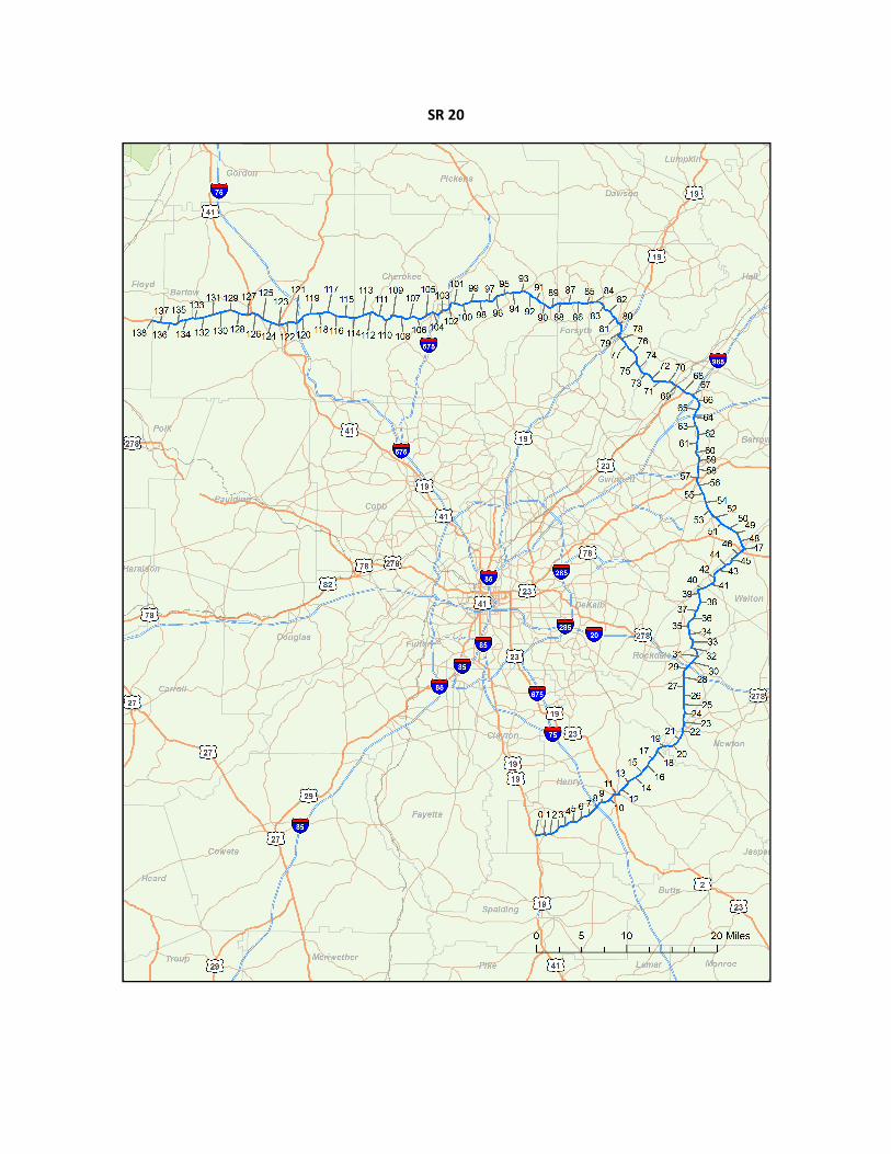
SR 20
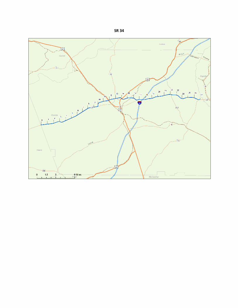
SR 34
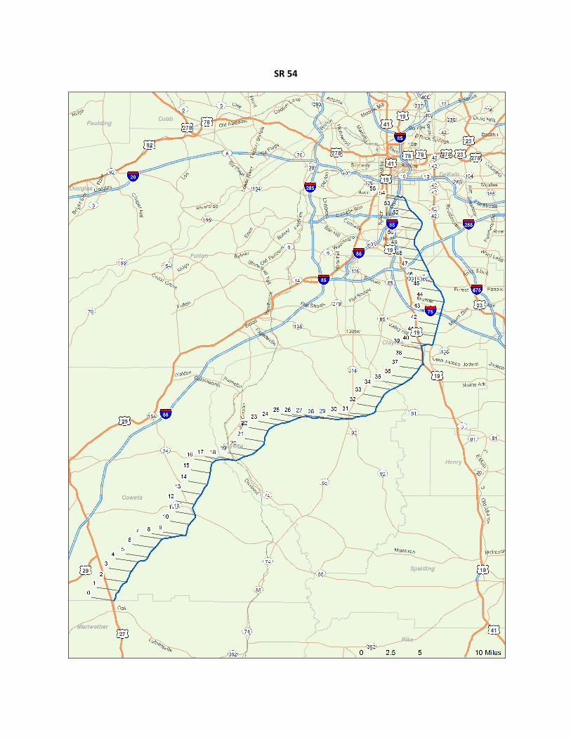
SR 54
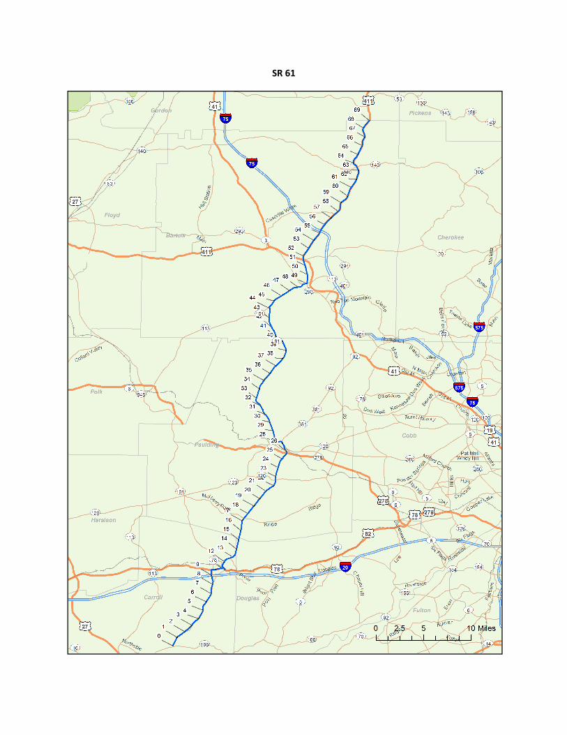
SR 61
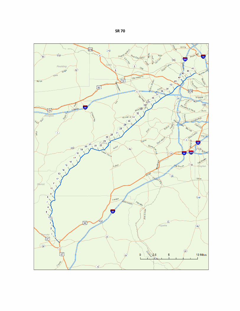
SR 70
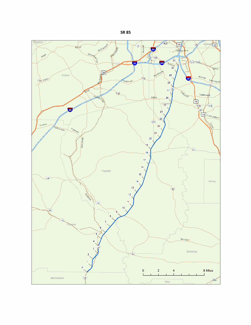
SR 85
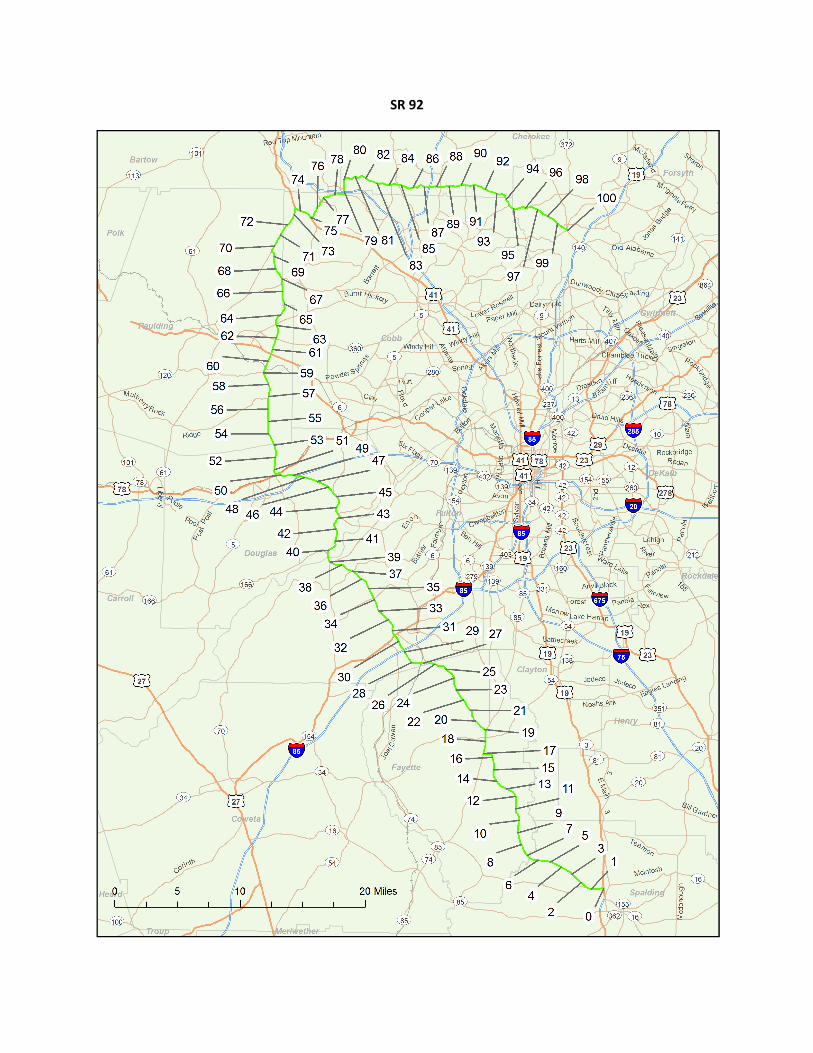
SR 92
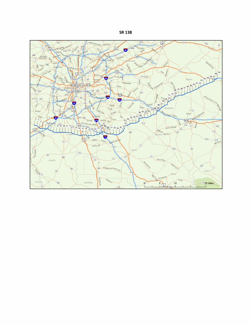
SR 138
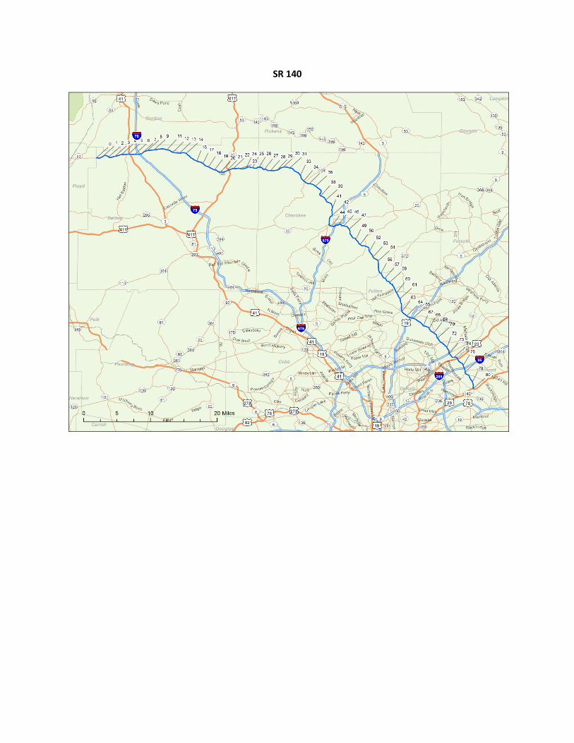
SR 140
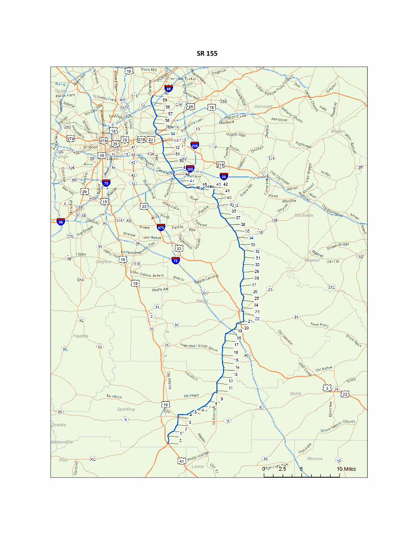
SR 155
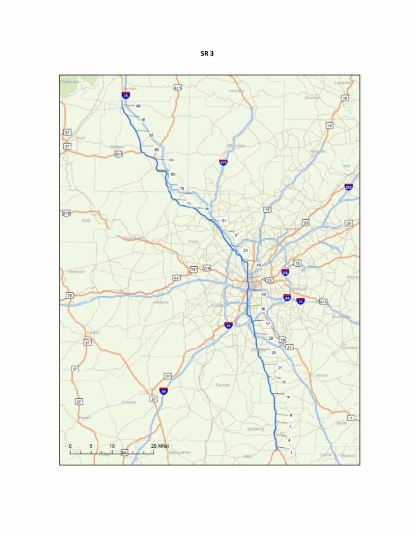
SR 3
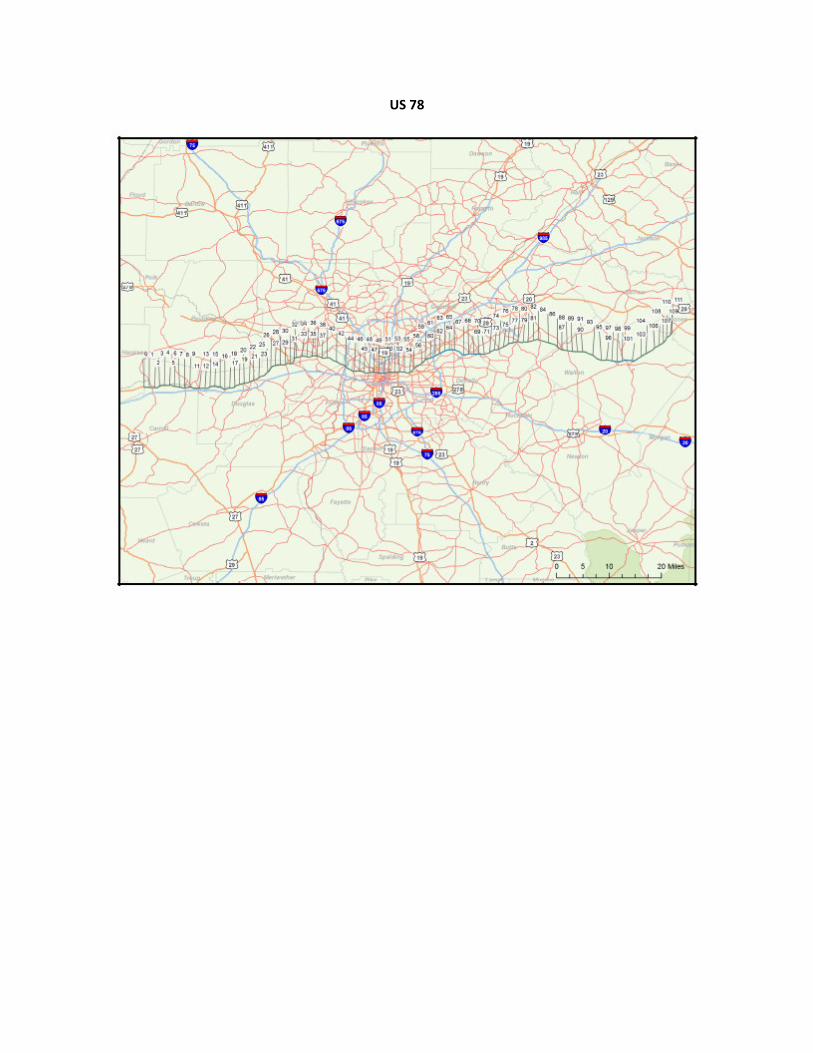
US 78
STRATEGIC REGIONAL THOROUGHFARE PLAN Data Compilation Report
September 2010
Appendix E: 2009 CMP Update Travel Time Run Corridors
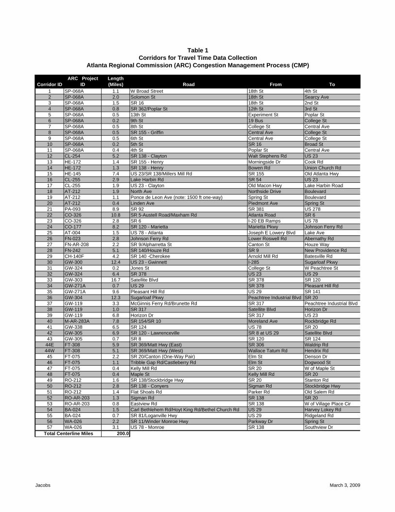
1 SP-068A 1.1 W Broad Street 18th St 4th St2 SP-068A 2.0 Solomon St 18th St Searcy Ave3 SP-068A 1.5 SR 16 18th St 2nd St4 SP-068A 0.8 SR 362/Poplar St 12th St 3rd St5 SP-068A 0.5 13th St Experiment St Poplar St6 SP-068A 0.2 9th St 19 Bus College St7 SP-068A 0.5 8th St College St Central Ave8 SP-068A 0.5 SR 155 - Griffin Central Ave College St9 SP-068A 0.5 6th St Central Ave College St10 SP-068A 0.2 5th St SR 16 Broad St11 SP-068A 0.4 4th St Poplar St Central Ave12 CL-254 5.2 SR 138 - Clayton Walt Stephens Rd US 2313 HE-172 1.4 SR 155 - Henry Morningside Dr Cook Rd14 HE-172 1.3 SR 138 - Henry Bowen Rd Union Church Rd15 HE-145 7.4 US 23/SR 138/Millers Mill Rd SR 155 Old Atlanta Hwy16 CL-255 2.9 Lake Harbin Rd SR 54 US 2317 CL-255 1.9 US 23 - Clayton Old Macon Hwy Lake Harbin Road18 AT-212 1.9 North Ave Northside Drive Boulevard19 AT-212 1.1 Ponce de Leon Ave (note: 1500 ft one-way) Spring St Boulevard20 AT-212 0.4 Linden Ave Piedmont Ave Spring St21 PA-093 8.9 SR 92 SR 381 US 27822 CO-326 10.8 SR 5-Austell Road/Maxham Rd Atlanta Road SR 623 CO-326 2.8 SR 6 I-20 EB Ramps US 7824 CO-177 8.2 SR 120 - Marietta Marietta Pkwy Johnson Ferry Rd25 AT-004 1.5 US 78 - Atlanta Joseph E Lowery Blvd Lake Ave26 FN-023 2.8 Johnson Ferry Rd Lower Roswell Rd Abernathy Rd27 FN-AR-208 2.2 SR 9/Alpharretta St Canton St Houze Way28 FN-242 5.1 SR 140/Houze Rd SR 9 New Providence Rd29 CH-140F 4.2 SR 140 -Cherokee Arnold Mill Rd Batesville Rd30 GW-300 12.4 US 23 - Gwinnett I-285 Sugarloaf Pkwy31 GW-324 0.2 Jones St College St W Peachtree St32 GW-324 6.4 SR 378 US 23 US 2933 GW-303 16.7 Satellite Blvd SR 378 SR 12034 GW-271A 0.7 US 29 SR 378 Pleasant Hill Rd35 GW-271A 9.6 Pleasant Hill Rd US 29 SR 14136 GW-304 12.3 Sugarloaf Pkwy Peachtree Industrial Blvd SR 2037 GW-119 3.3 McGinnis Ferry Rd/Brunette Rd SR 317 Peachtree Industrial Blvd38 GW-119 1.0 SR 317 Satellite Blvd Horizon Dr39 GW-119 6.8 Horizon Dr SR 317 US 2340 M-AR-283A 7.8 SR 154/SR 10 Moreland Ave Rockbridge Rd41 GW-338 6.5 SR 124 US 78 SR 2042 GW-305 6.9 SR 120 - Lawrenceville SR 8 at US 29 Satellite Blvd43 GW-305 0.7 SR 8 SR 120 SR 124
44E FT-308 5.9 SR 369/Matt Hwy (East) SR 306 Waldrip Rd44W FT-308 5.1 SR 369/Matt Hwy (West) Wallace Tatum Rd Hendrix Rd45 FT-075 2.2 SR 20/Canton (One-Way Pair) Elm St Denson Dr46 FT-075 1.1 Tribble Gap Rd/Castleberry Rd Elm St Dogwood St47 FT-075 0.4 Kelly Mill Rd SR 20 W of Maple St48 FT-075 0.4 Maple St Kelly Mill Rd SR 2049 RO-212 1.6 SR 138/Stockbridge Hwy SR 20 Stanton Rd50 RO-212 2.8 SR 138 - Conyers Sigman Rd Stockbridge Hwy51 RO-212 1.4 Flat Shoals Rd Parker Rd Old Salem Rd52 RO-AR-203 1.3 Sigman Rd SR 138 SR 2053 RO-AR-203 0.8 Eastview Rd SR 138 W of Village Place Cir54 BA-024 1.5 Carl Bethlehem Rd/Hoyt King Rd/Bethel Church Rd US 29 Harvey Lokey Rd55 BA-024 0.7 SR 81/Loganville Hwy US 29 Ridgeland Rd56 WA-026 2.2 SR 11/Winder Monroe Hwy Parkway Dr Spring St57 WA-026 3.1 US 78 - Monroe SR 138 Southview Dr
200.0
Table 1
ToFromRoadLength (Miles)
ARC Project IDCorridor ID
Atlanta Regional Commission (ARC) Congestion Management Process (CMP)Corridors for Travel Time Data Collection
Total Centerline Miles
Jacobs March 3, 2009