data mining and analysis in arcgis online - joseph … kerski – webinar 1 data mining and analysis...
TRANSCRIPT

Joseph Kerski – Webinar 1
Data Mining and Analysis in
ArcGIS Online
Joseph Kerski
Education Manager
Esri
Twitter @josephkerski
303-449-7779 x 18237

Joseph Kerski – Webinar 2
Goals for this workshop
1. Understanding how to use data portals and to
use ArcGIS Online for data mining.
2. Loading data into ArcGIS Online.
3. Analyzing data for solving problems in ArcGIS
Online.

Joseph Kerski – Webinar 3
Finding and Using Spatial Data
Old Paradigm
--Download data Unzip Format
ProjectTabular Manipulation Use.
New Paradigm
--Access data in cloud Use.
We are not quite to the point of fully using the new
paradigm … yet.

Joseph Kerski – Webinar 4
Thus, best practice today is still the hybrid model:
1. Start with ArcGIS Online to search for data.
2. Search local, state, national, international data
depositories and portals.
Examples:
Local: Boulder County CO, Los Angeles County CA
State: www.tnris.org (Texas), CASIL (California), RIGIS (RI)
National: USGS, NASA, Census Bureau, NOAA, EPA, US
DOT, USFWS, BLM, USFS, FAA, National Atlas,
LINZ (New Zealand), IBGE (Brazil), OS (UK)
International: WRI, WWF, UNEP, World Bank, Natural Earth
Data

Joseph Kerski – Webinar 5
What kinds of data can you add to ArcGIS Online?
Data Type Open in ArcGIS
Online
Open in ArcGIS
Desktop
Map Notes X
Tables (CSV) X X
Zipped Shapefiles X X Unzip first
Zipped other data X after unzipping
and serving
X after unzipping
Images (JPG,
PNG, TIF)
X X
Feature services X X
Layer package,
map package
X

Joseph Kerski – Webinar 6
Data Types and Sources
1) Vector: Shapefiles, geodatabases, feature
services, other vector formats.
2) Raster: ArcGrids, GeoTiffs and other images,
Tiled image services.
3) Tabular: Excel tables, CSVs, TXT files, other
formats.
4) Ground images: Wikipedia and other creative
commons sources.
Joseph Kerski – Webinar 7
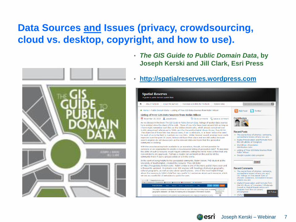
Data Sources and Issues (privacy, crowdsourcing,
cloud vs. desktop, copyright, and how to use).
• The GIS Guide to Public Domain Data, by
Joseph Kerski and Jill Clark, Esri Press
• http://spatialreserves.wordpress.com
Joseph Kerski – Webinar 8
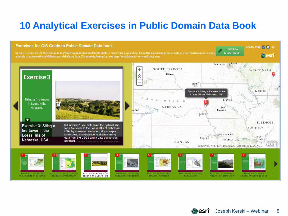
10 Analytical Exercises in Public Domain Data Book

Joseph Kerski – Webinar 9
Live Demos
Finding and using data on ArcGIS Online --Often helpful to narrow the search, such as:
quotes “riparian zones”
--Keywords:
<search string> owner:jjkerski or tags: “bike
lanes”
--Use Boolean operators:
“recent fires” OR fires
owner:esri AND tags:streets
--search in your specific map extent or in your
organization
More tips on: Using Search – Fields:
http://resources.arcgis.com/en/help/arcgisonline/index.html#/
/010q0000000n000000
Accessing and using data portals
Joseph Kerski – Webinar 10
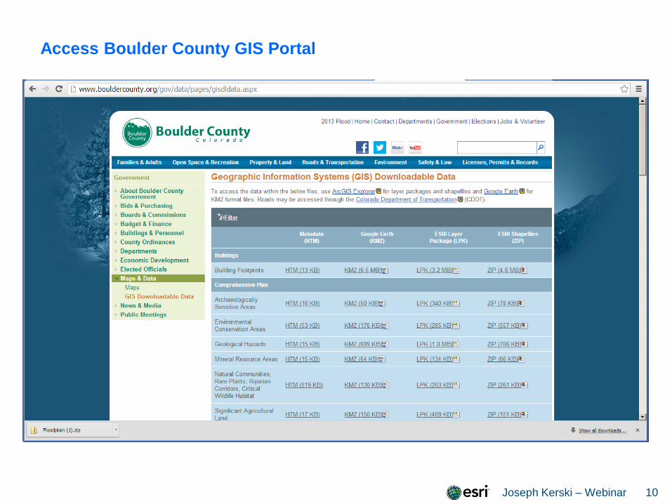
Access Boulder County GIS Portal
Joseph Kerski – Webinar 11
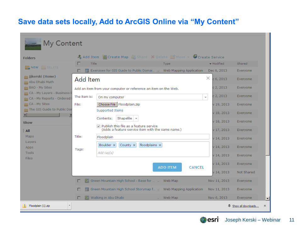
Save data sets locally, Add to ArcGIS Online via “My Content”
Joseph Kerski – Webinar 12
Uploading Your Data into ArcGIS Online
Why upload? For data that you have either created
(Joseph’s ocean currents example) or obtained and it is not
already on ArcGIS Online {OR} you wish to have more
control over the data (Joseph’s tornado example.)
You can publish data to ArcGIS Online from ArcGIS
Server, from within ArcGIS Desktop, or directly from “My
Content” in ArcGIS Online.

Joseph Kerski – Webinar 13
Using ArcGIS Online Analytical Tools ArcGIS Online is a cloud-based GIS, not just an online set
of web maps. Hence, you can use it for conducting spatial
analysis.
The spatial analysis capabilities of ArcGIS Desktop still
far exceed that of ArcGIS Online, given its 30 year head
start, but more analytical capabilities are being added
quarterly to ArcGIS Online.
The spatial analytical tools in ArcGIS Online are easy to
use. They are accessed from the arrows to the right of
specific layers. Whether you see the analytical tools
depends on (1) if you are using an ArcGIS Online
organizational subscription, and (2) how the data are served
in ArcGIS Online (i.e. ideally, as services)
Joseph Kerski – Webinar 14
Live Demo Using Analytical capabilities in ArcGIS Online
Problem Statement: Because of recent devastating
floods that occurred in September 2013, the Boulder County
Office of Emergency Preparedness, hearing of your
excellent GIS skills, has asked you to prepare an
assessment of the most vulnerable lands in the county to
future flooding and the people on those lands.
You will consider floodplains, geologic hazards, land cover,
soils, and demographics in your assessment.

Joseph Kerski – Webinar 15
Analysis Workflow
1. Filter Floodplains layer to only consider the true
floodplains. Filter geologic hazards layer to only consider
Major Hazards.
2. Proximity Buffer floodplains by 200 meters.
3. Dissolve the buffer’s internal polygons.
4. Manage Data Overlay Intersect the dissolved
floodplain buffers with Major Geologic Hazards.
5. Sort on Analysis Area and only consider the largest
polygons.
6. Data Enrichment, with Tapestry, Landcover, and Soils.
Sort on % wetlands and Top 1 Median Age.

Joseph Kerski – Webinar 16
Analysis Results

Joseph Kerski – Webinar 17
Next Steps
How to teach with the ArcGIS Platform. Includes video on
spatial analysis tools:
http://www.esri.com/landing-pages/industries/education/higher-
education/teach-with-arcgis-platform
Deeper Dive with ArcGIS Online:
See playlist of videos on:
http://www.youtube.com/geographyuberalles

Joseph Kerski – Webinar 18
Data Mining and Analysis in
ArcGIS Online
Joseph Kerski
Education Manager
Esri
Twitter @josephkerski
303-449-7779 x 18237