data paper { high resolution vegetation cover data …data paper { high resolution vegetation cover...
TRANSCRIPT
Data Paper – High Resolution Vegetation Cover Data
for the Southern Western Ghats of India.
(IFP ECODATA VEGETATION)
Quentin Renard, B. R. Ramesh, G. Muthusankar, Raphael Pelissier
To cite this version:
Quentin Renard, B. R. Ramesh, G. Muthusankar, Raphael Pelissier. Data Paper– High Resolution Vegetation Cover Data for the Southern Western Ghats of In-dia. (IFP ECODATA VEGETATION). Head of Ecology Department, Institut Francais dePondichery, e-mail: [email protected]. Institut Francais de Pondichery, 12 p., 2010, PondyPapers in Ecology no. 9. <hal-00481614>
HAL Id: hal-00481614
https://hal.archives-ouvertes.fr/hal-00481614
Submitted on 7 May 2010
HAL is a multi-disciplinary open accessarchive for the deposit and dissemination of sci-entific research documents, whether they are pub-lished or not. The documents may come fromteaching and research institutions in France orabroad, or from public or private research centers.
L’archive ouverte pluridisciplinaire HAL, estdestinee au depot et a la diffusion de documentsscientifiques de niveau recherche, publies ou non,emanant des etablissements d’enseignement et derecherche francais ou etrangers, des laboratoirespublics ou prives.

INSTITUTS FRANÇAIS DE RECHERCHE EN INDE FRENCH RESEARCH INSTITUTES IN INDIA
PONDY PAPERS IN ECOLOGY
DATA PAPER – HIGH-RESOLUTION VEGETATION COVER
DATA FOR THE SOUTHERN WESTERN GHATS OF INDIA
(IFP_ECODATA_VEGETATION)
Quentin Renard
B.R. Ramesh
G. Muthusankar
Raphaël Pélissier
INST1TUT FRANÇAIS DE PONDICHÉRY FRENCH INSTITUTE PONDICHERRY
9
PONDY PAPERS IN ECOLOGY No. 9
Data Paper – High Resolution Vegetation Cover Data for the Southern Western Ghats of India
(IFP_ECODATA_VEGETATION)
Quentin Renard
B.R. Ramesh
G. Muthusankar
Raphaël Pélissier
INSTITUT FRANÇAIS DE PONDICHÉRY
The Institut français de Pondichéry (IFP) or French Institute of Pondicherry, is a financially autonomous research institution under the dual tutelage of the French Ministry of Foreign and European Affairs (MAEE) and the French National Centre for Scientific Research (CNRS). It was established in 1955 under the terms agreed to in the Treaty of Cession between the Indian and French governments. It has three basic missions: research, expertise and training in human and social sciences and ecology in South and South-East Asia. More specifically, its domains of interest include Indian cultural knowledge and heritage (Sanskrit language and literature, history of religions, Tamil studies, ..), contemporary social dynamics (in the areas of health, economics and environment) and the natural ecosystems of South India (sustainable management of biodiversity).
French Institute of Pondicherry, UMIFRE 21 CNRS-MAEE, 11, St. Louis Street, P.B. 33, Pondicherry 605001, INDIA
Tel: 91-413-2334168; Fax: 91-413-2339534
Email: [email protected]
Website: http://www.ifpindia.org
Authors
Quentin Renard, B.R. Ramesh, G. Muthusankar and Raphaël Pelissier are from the French Institute of Pondicherry, UMIFRE 21 CNRS-MAE, 11, Saint Louis Street, Pondicherry 605001.
This data paper has been prepared following the Ecological Metadata format proposed by Michener et
al. (1997). It is accompanied with data archives downloadable from the IFP Biodiversity Portal at http://www.ifpindia.org/biodiversityportal/.
© Institut français de Pondichéry, 2010
Typeset by Mr. G. Jayapalan
Summary The Western Ghats form a 1,600 km long escarpment that runs parallel to the southwestern coast of Peninsular India. This relief barrier, which orographically exacerbates the summer monsoon rains, is responsible for steep bioclimatic gradients that have long been recognized as one of the major ecological determinants for the forest vegetation of the region. We report here girded vegetation data at 30' lat/long (ca. 1 km) resolution that cover an area of about 70,000 km2 of the southern Western Ghats, between 74 to 78° E and 8 to 16° N. These data have been extracted from: the 1:250,000 scale forest maps of South India published by the French Institute of Pondicherry (FIP), which have been digitized and simplified; the 2004 MODIS (Moderate Resolution Imaging Spectroradiometer) database, for the IGBP (International Biosphere Geosphere Programme) global vegetation Land Cover Type and Normalized Difference Vegetation Index (NDVI) of March 2004.
Key-words: Forest map, IGBP global vegetation, India, Land Cover Type , MODIS, NDVI,
Western Ghats.
TABLE OF CONTENTS
I. DATA SET DESCRIPTORS............................................................................................... 1
A. Data set identity.............................................................................................................. 1
B. Data set identification code ............................................................................................ 1
C. Data set descriptors. ....................................................................................................... 1
D. Key words....................................................................................................................... 1
II. RESEARCH ORIGIN DESCRIPTORS. ............................................................................. 1
A. Site description. .............................................................................................................. 1
B. Sampling design. ............................................................................................................ 3
C. Research methods........................................................................................................... 3
D. Project personnel. ........................................................................................................... 5
III. DATA SET STATUS AND ACCESSIBILITY. ................................................................. 6
A. Status. ............................................................................................................................. 6
B. Accessibility. .................................................................................................................. 6
IV. DATA STRUCTURAL DESCRIPTORS............................................................................ 7
A. Identity. .......................................................................................................................... 7
B. Size ................................................................................................................................. 7
C. Format type and storage mode ....................................................................................... 7
D. Header information......................................................................................................... 7
E. Special characters. -9999 is the code used for missing values, also used to delineate the
study region within the square matrices of 801 rows by 401 columns. ................................. 8
F. Authentication procedures. Sums of all numeric values (including the error code -
9999) in each data file are given below:................................................................................. 8
V. SUPPLEMENTAL DESCRIPTORS................................................................................... 8
A. Data acquisition.............................................................................................................. 8
B. Publications and results .................................................................................................. 8
VI. LITERATURE CITED. ....................................................................................................... 8
VII. APPENDIX .................................................................................................................. 10
I. DATA SET DESCRIPTORS.
A. Data set identity. High-resolution vegetation cover data for the Southern Western Ghats
of India.
B. Data set identification code. IFP_ECODATA_VEGETATION
C. Data set descriptors.
1. Originator. Ecology Department, French Institute of Pondicherry, 11 St Louis Street,
605001 Pondicherry, India ([email protected]).
2. Abstract. The Western Ghats form a 1,600 km long escarpment that runs parallel to the
southwestern coast of Peninsular India. This relief barrier, which orographically exacerbates
the summer monsoon rains, is responsible for steep bioclimatic gradients that have long been
recognized as one of the major ecological determinants for the forest vegetation of the region.
We report here gridded vegetation data at 30' lat/lon (ca. 1 km) resolution that cover an area
of about 70,000 km2 of the southern Western Ghats, between 74 to 78° E and 8 to 16° N.
These data have been extracted from: the 1:250,000 scale forest maps of South India
published by the French Institute of Pondicherry (FIP), which have been digitized and
simplified; the 2004 MODIS (Moderate Resolution Imaging Spectroradiometer) database, for
the IGBP (International Biosphere Geosphere Programme) global vegetation Land Cover
Type and Normalized Difference Vegetation Index (NDVI) of March 2004.
D. Key words. Forest map, IGBP global vegetation, India, Land Cover Type , MODIS,
NDVI, Western Ghats.
II. RESEARCH ORIGIN DESCRIPTORS.
A. Site description.
1. Site type. The Western Ghats (WG) form a mountain range that extends along the western
coast of Arabian Sea and that, along with the island of Sri Lanka, is classified as one of the
world biodiversity hotspots (Myers et al. 2000).
1
2. Geography. The WG cover an area of 160,000 km2 and stretch for 1,600 km along the west
coast of India, 40 km away on average from the shore line, from the Tapti river (21° N, state
of Maharastra) to Kanyakumari, the southernmost tip of the Indian peninsula (8° N, state of
Tamil Nadu). We consider here only the southern part of the WG, i.e. an area ca. 70,000 km2
between 74 to 78° E and 8 to 16° N.
3. Habitat. The southern WG shelter a wide array of non-equatorial tropical vegetation, from
fragments of wet evergreen to dry deciduous forest habitats in various stages of degradation to
mountain forests and grasslands, alternating with zones converted into agroforests,
monoculture plantations and agriculture. About 4,000 species of flowering plants including
1,600 species (40%) endemic to this region have been reported (Manokaran et al. 1997).
4. Geology, landform. In the southern part of the Western Ghats, bedrock is composed of
metamorphic rocks from the Precambrian shield, with a prevalence of volcano-sedimentary
material north of 14° N, and gneisses with intrusive granites in the south. The more recent
sediments deposits are confined to the coastal plain. The soils are ferralitic (laterites) to
fersialitic (red soils), with a massive development of kaolinite as a product of rock weathering
where the annual soil water balance is consistently positive (i.e. above 1,200 mm rainfall;
Bourgeon 1989, Gunnel & Bourgeon 1997).
5. Watersheds, hydrology. Dozens of rivers originate in the WG, including the peninsula’s
three major eastward-flowing rivers (Godavari, Krishna and Kaveri), which are important
sources of drinking water, irrigation, and power.
6. Climate. The windward side of the WG receives heavy rains as the monsoon progresses
from south to north. In the coastal plain the annual rainfall exceeds 2,000 mm, commonly
reaching more than 5,000 mm near the crest of the Ghats, with local peaks even much beyond
this value, like in Agumbe with regular records above 8,000 mm. To the interior region a
rapid diminishing of rainfall from 2,000 mm to 900 mm is observed within a distance of 10 –
50 km. Convective rains prior to and following the monsoon, augment the total rainfall
received at the transitional zone. Between the coastline and the crest of the Ghats, at
elevations above 800 m, mean coldest month temperature is 23°C, while in the hilly terrains
at medium elevations (800 – 1,400 m) it varies between 16 and 23°C. Correlating with the
sharp decrease in rainfall beyond the crest of the Ghats, the length of the dry season rapidly
increases in the west-east direction. However, the monsoon onset in the south, which moves
2
northwards up to the Himalayas and then retreats in the reverse, creates a differential seasonal
pattern with latitude, which does not correlate with rainfall. Consequently, the dry season
length increases also from south to north.
B. Sampling design.
The study area was gridded into 801 by 401 0.01-DD/WGS84 cells (i.e. 30s' lat/lon or
1.11 km square), starting from the south-westernmost corner at 73.995 E and 7.995 N in
Decimal Degrees (DD). It consequently covers a rectangle from approximately 74 to 78° E
and 8 to 16° N. The study region was delineated from this matrix as a subset of cells bearing
positive values for the vegetation variables, while the error code -9999 was attached to all
cells outside the study region.
C. Research methods.
1. Laboratory/field methods.
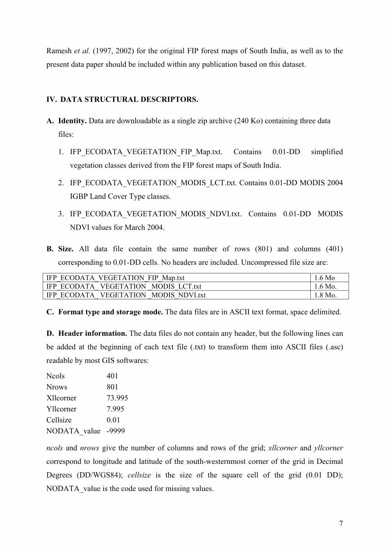
• Simplified forest map of South India
For the purpose of a regional analysis, we created from a series of detailed forest maps of
South India published by the French Institute of Pondicherry at 1:250.000 scale (Pascal et al.
1982a, 1982b, 1984, 1992; Ramesh et al. 1997, 2002), a simplified 1-km resolution
vegetation cover map for the entire Western Ghats. Initially, the natural vegetation was
classified along bioclimatic and disturbance gradients into more than 150 different types using
the concept of climatic climax and dynamics of succession through criteria like phenology,
physiognomy and floristic composition (Pascal 1986, Ramesh & Pascal 1996). From a
complete georeferenced set of maps we regrouped these classes into 13 broader categories
more suitable for a regional analysis. We first considered wet and dry zones formations
separately, from a mean annual rainfall isoline of 2,000 mm, which is the general limit of the
potential area of wet evergreen forests (Pascal 1984). In each zone, we then classified the
vegetation based on retrogressive degradation stages ranging from dense primary forests to
secondary or disturbed and degraded formations (scrub woodland to thickets). In the wet
zone, these formations become progressively dominated by deciduous species, shrubby and
scrubby undergrowths (sometimes as weeds). In the dry zone, we distinguished moist and dry
deciduous as well as dry evergreen forests, primary and degraded stages together, keeping tree
savannas and grasslands formations in a separate category. Finally, mountain forests and
grasslands (> 1,800 m) were classified separately since they are present in both dry and wet
3
zones. We also kept highly human impacted areas, like plantations and agricultural lands, in
separate categories. These simplified vegetation types are coded as indicated in Table 1 (see
also Appendix A).
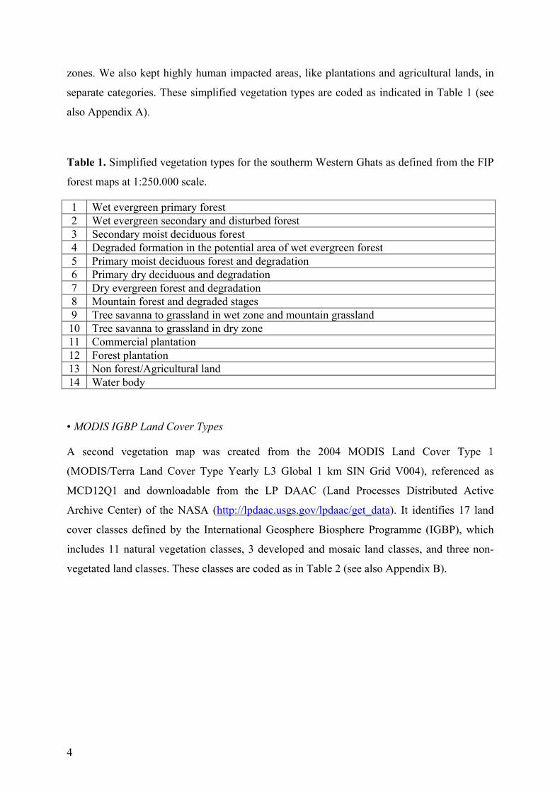
Table 1. Simplified vegetation types for the southerm Western Ghats as defined from the FIP
forest maps at 1:250.000 scale.
1 Wet evergreen primary forest 2 Wet evergreen secondary and disturbed forest 3 Secondary moist deciduous forest 4 Degraded formation in the potential area of wet evergreen forest 5 Primary moist deciduous forest and degradation 6 Primary dry deciduous and degradation 7 Dry evergreen forest and degradation 8 Mountain forest and degraded stages 9 Tree savanna to grassland in wet zone and mountain grassland
10 Tree savanna to grassland in dry zone 11 Commercial plantation 12 Forest plantation 13 Non forest/Agricultural land 14 Water body
• MODIS IGBP Land Cover Types
A second vegetation map was created from the 2004 MODIS Land Cover Type 1
(MODIS/Terra Land Cover Type Yearly L3 Global 1 km SIN Grid V004), referenced as
MCD12Q1 and downloadable from the LP DAAC (Land Processes Distributed Active
Archive Center) of the NASA (http://lpdaac.usgs.gov/lpdaac/get_data). It identifies 17 land
cover classes defined by the International Geosphere Biosphere Programme (IGBP), which
includes 11 natural vegetation classes, 3 developed and mosaic land classes, and three non-
vegetated land classes. These classes are coded as in Table 2 (see also Appendix B).
4
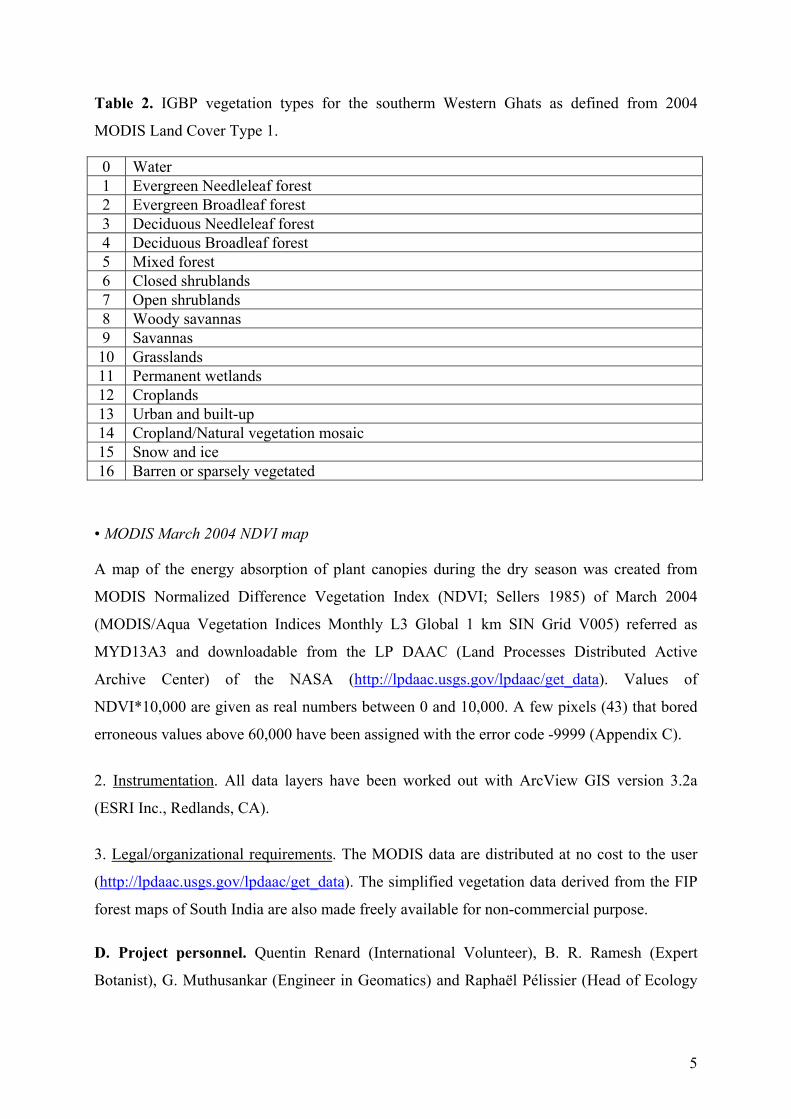
Table 2. IGBP vegetation types for the southerm Western Ghats as defined from 2004
MODIS Land Cover Type 1.
0 Water 1 Evergreen Needleleaf forest 2 Evergreen Broadleaf forest 3 Deciduous Needleleaf forest 4 Deciduous Broadleaf forest 5 Mixed forest 6 Closed shrublands 7 Open shrublands 8 Woody savannas 9 Savannas
10 Grasslands 11 Permanent wetlands 12 Croplands 13 Urban and built-up 14 Cropland/Natural vegetation mosaic 15 Snow and ice 16 Barren or sparsely vegetated
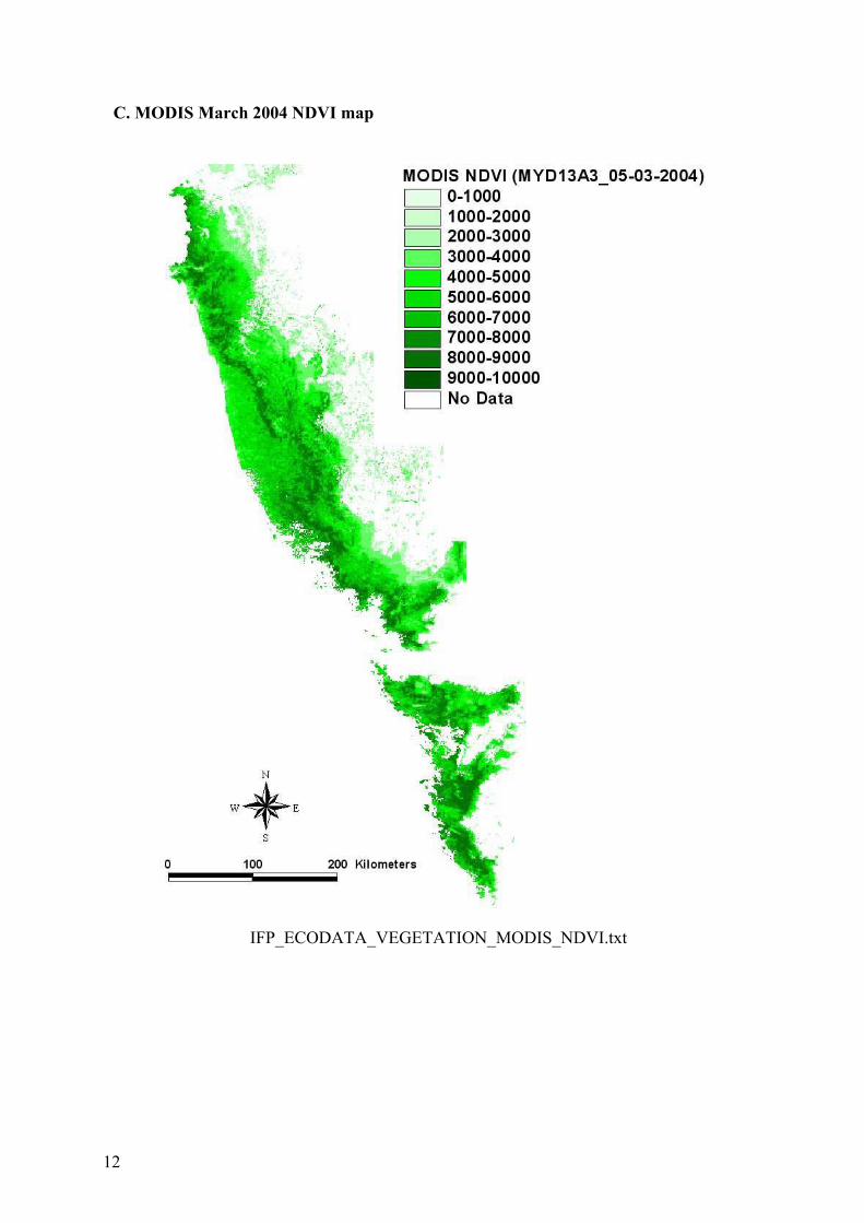
• MODIS March 2004 NDVI map
A map of the energy absorption of plant canopies during the dry season was created from
MODIS Normalized Difference Vegetation Index (NDVI; Sellers 1985) of March 2004
(MODIS/Aqua Vegetation Indices Monthly L3 Global 1 km SIN Grid V005) referred as
MYD13A3 and downloadable from the LP DAAC (Land Processes Distributed Active
Archive Center) of the NASA (http://lpdaac.usgs.gov/lpdaac/get_data). Values of
NDVI*10,000 are given as real numbers between 0 and 10,000. A few pixels (43) that bored
erroneous values above 60,000 have been assigned with the error code -9999 (Appendix C).
2. Instrumentation. All data layers have been worked out with ArcView GIS version 3.2a
(ESRI Inc., Redlands, CA).
3. Legal/organizational requirements. The MODIS data are distributed at no cost to the user
(http://lpdaac.usgs.gov/lpdaac/get_data). The simplified vegetation data derived from the FIP
forest maps of South India are also made freely available for non-commercial purpose.
D. Project personnel. Quentin Renard (International Volunteer), B. R. Ramesh (Expert
Botanist), G. Muthusankar (Engineer in Geomatics) and Raphaël Pélissier (Head of Ecology
5
Department) are all affiliated to the French Institute of Pondicherry. Authors of original forest
maps of South-India were also affiliated to the FIP.
III. DATA SET STATUS AND ACCESSIBILITY.
A. Status.
1. Latest update. The data set was prepared during year 2009.
2. Latest archive date. April 2010.
3. Metadata status. Up to date till April 2010.
4. Data verification. The data were verified by careful examination and crosschecking of
coloured level maps generated from the data using ArcView. These maps are given in an
appendix to this document.
B. Accessibility.
1. Storage location and medium. Ecological data archives of the French Institute of
Pondicherry (http://www.ifpindia.org/). Paper and digitized versions of the forest maps of
South India (Pascal et al. 1982a,b, 1984, 1992; Ramesh et al. 1997, 2002) are stored at the
Geomatics and Applied Informatics Laboratory (LIAG) of the French Institute of
Pondicherry. They are also available as a webmapping application from the FIP Forest
Biodiversity Portal (http://www.ifpindia.org/biodiversityportal/) and as scanned images with
their explanatory notice from the HAL repository (http://hal.archives-ouvertes.fr/). Original
MODIS Land Cover Type and NDVI data are stored at
http://lpdaac.usgs.gov/lpdaac/get_data.
2. Contact person(s). Head of Ecology Department ([email protected]) and Head of
Geomatics and Applied Informatics Laboratory, French Institute of Pondicherry, 11 St. Louis
Street, 605001 Pondicherry, India, tel. +91 413 2334 168, fax +91 413 2339 534.
3. Copyright restrictions. None.
4. Proprietary restrictions. Due citations to University of Maryland (see
http://www.landcover.org/data/) for MODIS products, to Pascal et al. (1982a,b, 1984) and
6
Ramesh et al. (1997, 2002) for the original FIP forest maps of South India, as well as to the
present data paper should be included within any publication based on this dataset.
IV. DATA STRUCTURAL DESCRIPTORS.
A. Identity. Data are downloadable as a single zip archive (240 Ko) containing three data
files:
1. IFP_ECODATA_VEGETATION_FIP_Map.txt. Contains 0.01-DD simplified
vegetation classes derived from the FIP forest maps of South India.
2. IFP_ECODATA_VEGETATION_MODIS_LCT.txt. Contains 0.01-DD MODIS 2004
IGBP Land Cover Type classes.
3. IFP_ECODATA_VEGETATION_MODIS_NDVI.txt. Contains 0.01-DD MODIS
NDVI values for March 2004.
B. Size. All data file contain the same number of rows (801) and columns (401)
corresponding to 0.01-DD cells. No headers are included. Uncompressed file size are:
IFP_ECODATA_VEGETATION_FIP_Map.txt 1.6 Mo IFP_ECODATA_ VEGETATION _MODIS_LCT.txt 1.6 Mo. IFP_ECODATA_ VEGETATION _MODIS_NDVI.txt 1.8 Mo.
C. Format type and storage mode. The data files are in ASCII text format, space delimited.
D. Header information. The data files do not contain any header, but the following lines can
be added at the beginning of each text file (.txt) to transform them into ASCII files (.asc)
readable by most GIS softwares:
Ncols 401
Nrows 801
Xllcorner 73.995
Yllcorner 7.995
Cellsize 0.01
NODATA_value -9999
ncols and nrows give the number of columns and rows of the grid; xllcorner and yllcorner
correspond to longitude and latitude of the south-westernmost corner of the grid in Decimal
Degrees (DD/WGS84); cellsize is the size of the square cell of the grid (0.01 DD);
NODATA_value is the code used for missing values.
7
E. Special characters. -9999 is the code used for missing values, also used to delineate the
study region within the square matrices of 801 rows by 401 columns.
F. Authentication procedures. Sums of all numeric values (including the error code -9999)
in each data file are given below:
IFP_ECODATA_VEGETATION_FIP.txt -2628592563 IFP_ECODATA_VEGETATION_LCT.txt -2627026631 IFP_ECODATA_VEGETATION_NDVI.txt -2309292916
V. SUPPLEMENTAL DESCRIPTORS.
A. Data acquisition. See the respective primary references: Pascal et al. (1982a,b, 1984,
1992) and Ramesh et al. (1997, 2002) for the FIP forest maps of South India ; Strahler et
al. (1999) and Huete et al. (1999) for MODIS land cover and NDVI data, respectively.
B. Publications and results. This dataset has been generated in the framework of a study on
forest fire occurrences in the Western Ghats by Renard (2008).
VI. LITERATURE CITED.
Bourgeon, G. 1989. Explanatory booklet on the reconnaissance soil map of forest area -
Western Karnataka and Goa. Institut Français de Pondichéry, India. 204 pp.
Gunnell, Y. and Bourgeon, G. 1997. Soils and climatic geomorphology on the Karnataka
Plateau, peninsular India. Catena 29: 239-262.
Huete, A. Justice, C. & van Leeuwen, W. 1999. MODIS vegetation index (mod 13) algorithm
theoretical basis document Version 3. 129 pp.
http://modis.gsfc.nasa.gov/data/atbd/land_atbd.php
Manokaran, N., Uniyal, V. K. & Kumar, C. S. 1997. The biodiversity wealth and its
conservation in Kerala. Pp. 103-124 In P. Pushpangadan, K. Ravi and V. Santosh (Eds.).
Conservation and economic evaluation of biodiversity. Oxford University Press & India
Book House, New Dehli, India.
Michener, W. K., Brunt, J. W., Helly, J. J., Kirchner, T. B. & Stafford, S. G. 1997.
Nongeospatial metadata for ecological sciences. Ecological Applications 7: 330-342.
Myers, N., Mittermeier, R., Mittermeier, C., Da Fonseca, G. & Kent, J. 2000. Biodiversity
hot-spots for conservation priorities. Nature 403: 853-858.
8

Pascal, J.-P. 1984. Les forêts denses humides sempervirentes des Ghâts occidentaux de
l'Inde : écologie, structure, floristique, succession. Institut Français de Pondichéry, Inde.
318 pp.
Pascal, J.-P. 1986. Explanatory booklet of vegetation maps 1, 2 and 3. Institut Français de
Pondichéry, India. 88 pp. http://hal.archives-ouvertes.fr/hal-00444285
Pascal, J.-P. and Ramesh B. R. 1996. Notes on vegetation maps 4. Institut Français de
Pondichéry, India. 66 pp. http://http://hal.archives-ouvertes.fr/hal-00476204/fr/
Pascal, J.-P., Ramesh, B. R. & Kichenassamy, K. 1992. Vegetation Map of South India –
Map 4: Bangalore – Salem. Institut Français de Pondichéry, India. 1 sheet.
http://http://hal.archives-ouvertes.fr/hal-00476204/fr/
Pascal, J.-P., Shyam Sunder & Meher-Homji, V. M. 1982a. Vegetation Map of South India –
Map 3: Mercara - Mysore. Institut Français de Pondichéry, India. 1 sheet.
http://hal.archives-ouvertes.fr/hal-00444285
Pascal, J.-P., Shyam Sunder & Meher-Homji, V. M. 1982b. Vegetation Map of South India –
Map 2: Shimoga. Institut Français de Pondichéry, India. 1 sheet. http://hal.archives-
ouvertes.fr/hal-00444285
Pascal, J.-P., Shyam Sunder & Meher-Homji, V. M. 1984. Vegetation Map of South India –
Map 1: Belgaum – Darwar –Panaji. Institut Français de Pondichéry, India. 1 sheet.
http://hal.archives-ouvertes.fr/hal-00444285
Ramesh, B. R., de Franceschi, D. & Pascal, J.-P. 1997. Vegetation Map of South India –
Map 6: Thiruvananthapuram – Tirunelveli. Institut Français de Pondichéry, India. 1 sheet.
Ramesh, B. R., de Franceschi, D. & Pascal, J.-P. 2002. Vegetation Map of South India –
Map 5: Coimbatore – Thrissur. Institut Français de Pondichéry, India. 1 sheet.
Renard, Q. 2008. Modelling fires occurrences in the Western Ghats from MODIS images.
Internal study report, Institut Français de Pondichéry, India. 51 pp.
Sellers, P. J. 1985. Canopy reflectance, photosynthesis, and transpiration. International
Journal of Remote Sensing, 6: 1335-1372.
Strahler, A., Muchoney, D., Borak, J., Friedl, M., Gopal, S., Lambin, E. & Moody, A. 1999. MODIS
Land Cover Product - Algorithm Theoretical Basis Document (ATBD) Version 5.0 - MODIS Land
Cover and Land-Cover Change. Center for Remote Sensing, Department of Geography, Boston
University, Boston, MA. 72 pp. http://modis.gsfc.nasa.gov/data/atbd/land_atbd.php
9
VII. APPENDIX.
A. Simplified forest map of South India
IFP_ECODATA_VEGETATION_FIP_Map.txt
10
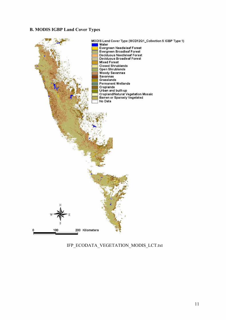
B. MODIS IGBP Land Cover Types
IFP_ECODATA_VEGETATION_MODIS_LCT.txt
11
C. MODIS March 2004 NDVI map
IFP_ECODATA_VEGETATION_MODIS_NDVI.txt
12
Pondy Papers in Ecology
1. CLAIRE ELOUARD, FRANÇOIS HOULLIER, JEAN-PIERRE PASCAL, RAPHAEL PÉLISSIER, B.R. RAMESH. Dynamics of the dense moist evergreen forests. Long Term Monitoring of an Experimental Station in Kodagu District (Karnataka, India), 1997, n ° l , 23 p. http://hal.archives-ouvertes.fr/hal-00373536/fr/
2. FRANÇOIS HOULLIER, YVES CARAGLIO, MURIEL DURAND. Modelling Tree Architecture and Forest Dynamics. A Research Project in the dense moist evergreen forests of the Western Ghats (South India), 1997, n°2, 37 p. http://hal.archives-ouvertes.fr/hal-00373538/fr/
3. MURIEL DURAND. Architecture and growth strategy of two evergreen species of the Western Ghats (South India), Knema attenuata (J. Hk. & Thw.) Warb. (Myristicacece) and
Vateria indica L. (Dipterocarpacece) 1997, n° 3, 39 p. http://hal.archives-ouvertes.fr/hal-00373540/fr/
4. FRANÇOIS HOULLIER, RANI M. KRISHNAN, CLAIRE ELOUARD. Assessment of Forest Biological Diversity. A FAO training course. 1. Lecture Notes 1998, n° 4, 102 p. http://hal.archives-ouvertes.fr/hal-00373545/fr/
5. CLAIRE ELOUARD, RANI M. KRISHNAN. Assessment of Forest Biological Diversity. A FAO training course. 2. Case study in India, 1999, n° 5, 75 p. http://hal.archives-ouvertes.fr/hal-00373548/fr/
6. B. R. RAMESH, MOHAN SEETHARAM, M. C. GUERO, R. MICHON. Assessment and Conservation of Forest Biodiversity in the Western Ghats of Karnataka, India. 1. General Introduction and Forest Land Cover and Land Use Changes (1977-1997), 2009, n° 6, pp. 1-64. http://hal.archives-ouvertes.fr/hal-00408263/fr/
7. B. R. RAMESH, M. H. SWAMINATH, SANTHOSHAGOUDA PATIL, S. ARAVAJY, CLAIRE ELOUARD. Assessment and Conservation of Forest Biodiversity in the Western Ghats of Karnataka, India. 2. Assessment of Tree Biodiversity, Logging Impact and General Discussion. 2009, n° 7, pp. 65-121. http://hal.archives-ouvertes.fr/hal-00408305/fr/
8. QUENTIN RENARD, G. MUTHUSANKAR, RAPHAEL PÉLISSIER. Data Paper: High-resolution topographical and bioclimatic data for the Southern Western Ghats of India (IFP_ECODATA_BIOCLIM). 2009, n° 8, 21p. http://hal.archives-ouvertes.fr/hal-00411120/fr/
9. QUENTIN RENARD, B. R. RAMESH, G. MUTHUSANKAR, RAPHAEL PÉLISSIER Data Paper: High resolution vegetation cover data for the Southern Western Ghats of India (IFP_ECODATA_VEGETATION). 2010, n° 9, 12p.