dauphin island east end beach and barrier island...
TRANSCRIPT

Dauphin Island East End Beach and Barrier Island Restoration Project
Beau BuhringSouth Coast Engineers

Funding
Funded with qualified outer continental shelf oil and gas revenues by the Coastal Impact Assistance Program (AL-28: Dauphin Island Shoreline Stabilization Project), Fish and Wildlife Service, U.S. Department of the Interior

Overview
Physical BackgroundProject Description
Sand Search InvestigationRegulatory Hurdles
Design ConsiderationsConstruction PhaseBeach Monitoring

Background – Project Location
MOBILEBAY
GULF OF MEXICO
MOBILECOUNTY
BALDWINCOUNTY
PROJECTLOCATION
PERDIDOBEACHRESORT

Background – Coastal Processes
Erosion Areas
Accretion Areas

Background – Site Conditions

Background – Site Conditions

Project Description – Goals
Reduce saltwater intrusion risk to valuable freshwater lake and maritime forest habitat Restore erosional foraging and nesting
habitat for birds and sea turtles Introduce beach sands into the littoral drift
of the Gulf barrier island Increase longevity of new sand by
concurrent use of rock breakwaters

Project Description – Benefits
Wide beaches provide protection from waves and storm surge to upland properties during tropical events Wide beaches contribute economically,
thanks to visitor spending and taxes

Project Description – Beach
Dredging and placement of ~320,000 cubic yards of beach sand Beach template
widths to vary from ~100 feet to ~350 feet
Beach nourishment: The placement of large
quantities of good quality sand directly
on the beach to widen the beach.

Project Description – Structures
Eight existing, shore-perpendicular, rock groins to be disassembled Three new, shore-parallel breakwaters to
be built from old rocks and new stone Structures intended to better retain sand
at the eastern end of the project

Sand Search – Overview
Extensive sand search investigation undertaken in 2010 to identify potential sources of borrow sand
Borrow Area Concerns and Priorities
Grain size compatibility Free of contaminants
Proximal to site Sufficient sand quantity
Avoid cultural resources and infrastructure

Sand Search – Sampling

Sand Search – Sampling

Sand Search – Compatibility

Sand Search – Compatibility
Material Source
Mean Grain Size Sorting Silt Dry Color
(mm) (phi) (phi) (%) MunsellValue
Borrow Area I 0.26 1.95 0.63 1.3 7
Borrow Area II 0.23 2.13 0.54 1.4 7
East End Native 0.28 1.86 0.69 3.6 7
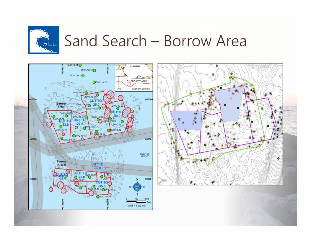
Sand Search – Borrow Area

Final Borrow Sub-area

Regulatory – Cultural Resources
Investigation areas filled with historic shipwrecks Magnetometer and
side scan sonar surveying Sub-area identified
to minimize cultural impacts
“Damn the torpedoes! Full speed ahead!”
- Admiral David Farragut, 1864 (paraphrased)

Regulatory – Tribal Concern
Island has ancient Native American burial mounds Project reviewed by
tribal consultant with the U.S. Corps of Engineers
“…j’ay resté a l’isle, queje nomme du Massacre…”
- Pierre Le Moyne d’Iberville, 1699

Regulatory – Wildlife Concerns
Alabama beaches are nesting areas for endangered shore birds and sea turtles Construction activities
avoided nesting seasons Lighting surveys after
constructionPhoto: alabamaseaturtles.com

Regulatory – Monitoring
During construction: dredge position, onsite bird and turtle activity, and turbidity changes due to fill Post-construction: beach profile surveys,
aerial photography, compaction testing, and escarpment surveys
During Construction
Post-Construction Year 1 Year 2 Year 3

Regulatory – Mean High Tide
Alabama state law requires the municipality to establish a mean high tide line before construction Filled waterbottoms seaward of the mean
high tide line are held in trust by the state Identified by survey in a public hearing

Regulatory – Property Concerns
Alabama state law requires the municipality to obtain by conveyance certain rights necessary to fill areas upland of the new MHT line Property owners included quasi-public
entities (Dauphin Island Park & Beach Board and Dauphin Island Sea Lab) and the federal government (U.S. Coast Guard)

Design – Beach Fill
Estimated and permitted ~320,000 cubic yards of new sand to restore the beaches

Design – Beach Fill Profile

Design – Breakwater Layout

Design – Breakwater Profile

Construction – Groin Reclamation

Construction – Breakwater Core

Construction – Breakwater Armor

Construction – Dredge & Pipe

Construction – Beach Fill
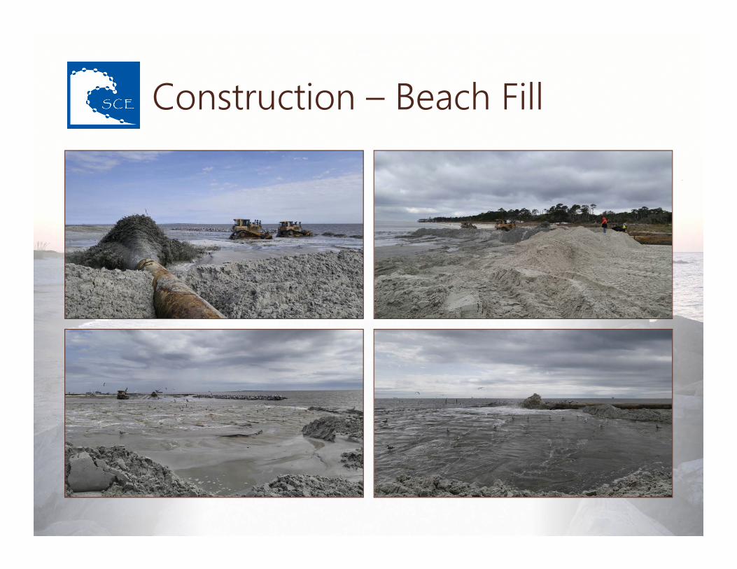
Construction – Beach Fill

Construction – Beach Fill

Construction – Beach Fill

Construction – Beach Fill

Monitoring – Imagery

Before & After
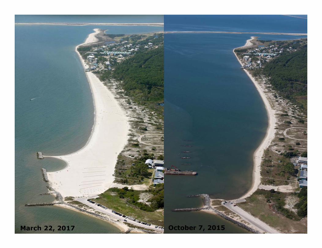
Before & After

Before & After

Monitoring – Beach Profiles

Monitoring – Beach Surveys

Monitoring – Beach Surveys

Monitoring – Beach Surveys

Monitoring – Shoreline

Monitoring – Compaction
Biological opinion required cone penetrometer testing to ensure that the new beach is appropriate for nesting turtles Test results showed that the beach was not
too compacted for turtles

Monitoring – Escarpments
Biological Opinion required post-construction escarpment surveys to ensure that sea turtles can access the beach First post-construction survey conducted,
no major escarpments found

Award – Best Restored Beaches

Questions