david j. smith’s is published by
TRANSCRIPT


David J. Smith’s Mapping the World by Heart™ is published by
AuthorDavid J. Smith
Design and ProductionPeter H. Reynolds, Kaylyn Klatt, Jared Roberts, Julia Young
Editorial TeamPeter H. Reynolds, Nancy Bogosian,
Pauline Chin, Annette Donnelly, Naomi Halpern, Karen Kane, James Murphy, Julia Young
Illustrations and Cover Art byPeter H. Reynolds
Publisher FableVision Learning
Creative Service DirectorJulia Young
Maps Illustrated byAndrew J. Daley, Robert Donovan, Kaylyn Klatt, Jared Roberts
Marketing Team Peter H. Reynolds, Becky Conners, Bill Norris, Sarah Reynolds, Julia Young
Thanks to Eytan Bernet, Annette Cate, David Dockterman Ed. D., Bruce Green, Bob Keough,
Andrew Lizotte, Baldassarre Lolacono, André Lyman, Greg Mardirosian, David O’Neil, Bonnie Snyder, Bob Thibeault
Extra Special Thanks toNancy Bogosian
Copyright NoticeThis document may not be reproduced in any form,
with the exception of pages labeled “Student Handout” and the maps and grids included with this curriculum,
which may be reproduced for classroom use only. Copyright © 1992–2010 David J. Smith. All rights reserved.
9th EditionFableVision Learning is a registered trademark of FableVision Learning, LLC.
For more information about FableVision Learning or for a catalog, please call us at
888-240-3734 or visit us at: www.FableVisionLearning.com

.........2
Mapping the World by Heart
AcknowledgmentsThe efforts, ideas, and support of many people were required to get this curriculum from classroom to publication. I particularly want to mention and acknowledge the following: Everett Smith, who first taught “Memory Maps” at Shady Hill School as part of a yearlong study of exploration and discovery; Sarah Bayne, who first suggested that I write an article about the curriculum for the Shady Hill Faculty Journal; Rod Nordell, who encouraged me to publish the article in World Monitor; Joe Segar and Jonathan Slater, who supported me at every turning; Elgin Heinz, who read an early version and understood what was needed; Randolph Lindel, who spent hundreds of hours publishing early versions; Jill Kneerim and Ike Williams; the folks at Tom Snyder Productions who first made this happen, and all the people at FableVision Learning who made this new edition a reality; and Suzanne, who never stopped believing.
David J. SmithVancouver, BC
About the AuthorDavid J. Smith has 26 years of experience teaching geography, history, and English in public and private schools. The U.S. Department of Education honored him in 1992 with their “Breaking the Mold” Award for this curriculum; and that, along with feature stories on The Today Show, and in TIME Magazine, the Boston Globe, the New York Times, The International Educator, and other media, propelled him out of the classroom and into a full-time consulting practice. Since 1992 he has given workshops, seminars, and addresses in more than 50 countries and in 48 states, on the Mapping the World by Heart curriculum and on his other books on geography and geographic literacy — If the World Were a Village, If America Were a Village, and This Child, Every Child — focusing on what he refers to as “world-mindedness across the curriculum”. For questions about the curriculum, visit David’s website: http://www.mapping.com

......... 3
Mapping the World by Heart
Table of Contents
Getting StartedIntroduction ................................................................................. 5 Learning Objectives ..................................................................... 7Content Goals .............................................................................. 8How Much Time Will It Take? ..................................................... 10The National Geography Standards ............................................. 11All About Maps ............................................................................ 13The “Menu of Lessons” Approach ............................................... 15A Sample Yearlong Agenda .......................................................... 16
A Menu of Lessons Appetizers ................................................................ 17 Blank Grid Lesson ........................................................................ 18Grapefruit Lesson ......................................................................... 20Latitude and Longitude Lesson .................................................... 22Playground Maps .......................................................................... 26Contour Map Lesson .................................................................... 27Thematic Maps Lesson ................................................................. 38Local Geography .......................................................................... 40
Entrees ..................................................................... 41Selected World Features Map: Checklist ..................................... 42 Mapping the USA: Checklist ........................................................ 43Mapping Canada: Checklist ......................................................... 45 Mapping Central America, Mexico, West Indies: Checklist......... 47 Mapping South America: Checklist ............................................. 49 Mapping Europe: Checklist ......................................................... 50 Mapping Eastern Europe and Northern Asia: Checklist ............. 53Mapping Africa: Checklist ........................................................... 55 Mapping Southwest, South, Southeast Asia: Checklist ............... 57Mapping Australia and Pacific Region: Checklist ........................ 59World Tests ................................................................................... 60
Seasonings ............................................................... 63The World Experts Lesson ........................................................... 64Mnemonics ................................................................................... 73Game: Geography Baseball ........................................................... 75Game: Around the World ............................................................. 77

.........4
Mapping the World by Heart
Dessert .................................................................... 81Materials for Making Final Maps ................................................ 82Steps for Making Final Maps ...................................................... 83Mapping the World: Sample Checklist ....................................... 86Geographic Features ................................................................... 89
ResourcesSpringboards to Further Study ................................................... 92Resources for Geography in the Classroom ............................... 96Standard Time ............................................................................ 97U.S. State Department — Independent States in the World ...... 98Embassies in Washington, DC ................................................... 104Top Languages ............................................................................ 104World Monitor Article: Making Maps from Memory .................. 105Answer Key for World Test #1 ................................................... 108Answer Key for World Test #2 ................................................... 109
AppendicesAppendix A: Mapping the U.S. by Heart .................................... A1Appendix B: Mapping Canada by Heart ..................................... B1Appendix C: Mapping Mexico by Heart .................................... C1
ReproduciblesMaps & Grids ....................................................................... included

......... 5
Mapping the World by Heart
A Letter from David J. Smith
Dear Teacher,
The curriculum that you are now examining was an integral part of my classroom teaching for about 15 years. Since I began making it available to others, it has been used successfully all over the world — in elementary and high school classrooms as well as in home schools. In talking with other teachers about their experiences with the material, I have learned a great many important lessons and ideas, and I want to share some of those with you.
First, and most important, this is not designed to be a “Do it this way, follow these steps exactly, and you will be successful; and if you don’t you will surely fail” kind of curriculum. It is meant, rather, to be a little bit like a menu in a restaurant. Choose what you want, use it as you wish, add to it, change it, or combine it with other items and make a meal that suits your own particular tastes and your students’ needs.
Naturally, you can also do it exactly the way I do it and expect the same results as I have. If you want to follow my specific geography curriculum through a whole school year, then begin by reading the article reprinted from World Monitor (in the Resources section of this guide), and plunge in. You can have the same success as a teacher in California who has been using the lessons exactly as presented here — her students are producing maps so remarkable and detailed that her local newspaper did a feature on the curriculum and her results.
But you may not have the time, the numbers, or the access to material that a full-year course might require. You may need to make some modifications. You can do that, and also be very successful. Frankly, I think that’s the whole point of this material: a thoughtful, imaginative teacher, prepared to have fun and learn and be flexible with his/her students, can set any goal or definition of success. He or she can then use and adapt these lessons in any number of ways and end up successful.
The last exercises in the curriculum, the “memory map” and the steps leading up to it, might seem to suggest to students that the ability to visualize places and their geographic relationships is an
Introduction

.........6
Mapping the World by Heart
end in itself. Instead, I hope you will help your students see this ability for what it is: an essential tool and a foundation for analyzing and solving real problems, making real-world inferences, and understanding real-world issues and decisions. There is much more to geography than location; however, location is the essential center of the webwork of place, movement, culture, environment, history, and regional economy.
Whatever you decide to do, whichever lessons you use and however you apply them, please experiment and be creative. There is no one right way to teach world geography, and there is no wrong way at all. As long as your students are making order out of chaos and having fun, you are doing it right. I hope this material helps you find your particular way.
P.S.: The world is still changing and rearranging itself at an incredibly rapid rate. The place names here are all based on the best information available at press time — but more changes are probably right around the corner. Please keep in mind that you may need to make some adjustments.
P.P.S.: To this new edition, I have added three supplements that have previously been available separately. Teachers who wish to focus on mapping the U.S., Canada, or Mexico can turn right to these sections and jump right in, but will still need to refer to the contents of the early sections of the guide.

......... 7
Mapping the World by Heart
By the end of the year students should:
• Be able to identify bodies of land and water, countries, and various physical features throughout the world.
• Be able to deal comfortably with any map, regardless of differences in scale, symbols, projection, etc.
• Be able to decode the information on any map.
• Be able to use atlas indices to find locations and other geographical information.
• Understand latitude and longitude, use it to describe and locate various places and features, and draw it in several projections.
• Be able to describe relationships depicted on maps (e.g., trade routes, distances, coastal vs. inland features, weather, etc.).
• Be able to use a globe to explain seasons, rotation of the Earth, tropics, etc.
• Use correct names for parts of the Earth and parts of a map.
• Produce from memory a map that shows as much as possible of their understanding of the outlines of all continents, plus the world’s countries, major cities, larger islands, rivers, and bodies of water.
• Become aware of the relationship of geography to cultures, to global issues, and to themselves.
Learning Objectives

.........8
Mapping the World by Heart
Here is a list of some of the key geographical concepts and map skills your students will learn with this program.
Location: How to Find Places• Grids and coordinates
• Latitude and longitude: North, South, East, West
• Relative location in terms of coast, climate, elevation, neighbors, and land use
Symbols• Pictorial symbols (tree=woods)
• Abstract symbols (colors, etc.) for thematic maps
Distance• Map scales
Direction and Direction Aids on Maps• Orienting a map for use
• Rivers always flow downstream
Map Content• Lines can mean rivers, boundaries, contours, etc.
• Vocabulary: continent, country, city, etc.
Projections and How They Affect What You See• Shape; area; distance; direction
• Globe as a model of the Earth
Rotation• Daily — polar axis
• Annual — solar
• Seasonal variation; solstices; equinoxes; tropics
Dimensions of the Earth• Land area of Earth = 57,470,000 sq. miles
• Water area of Earth = 139,480,000 sq. miles
• Curvature of surface of Earth = 8.4 inches in 1 mile
• Distance around world at equator = 24,902 miles
• Distance around world pole-to-pole = 24,860 miles
• Distance around world at 89° 30' = 218 miles
Content Goals

......... 9
Mapping the World by Heart
• Miles per degree
between degrees of latitude: always 69 miles +/- between degrees of longitude: at equator = 69 miles +/- at 85° = 6 miles at 89° 30' = .61 miles
The Five ThemesIn 1985, a joint committee on geographic education of the National Council for Geographic Education and the Association of American Geographers developed five themes which they call the major themes of geographic education. The hope was that educators would use these themes to test their present programs and to develop new ones. Copies of the full report, K-6 Geography: Themes, Key Ideas, and Learning Opportunities, may be available in your school or public library, or through various online sources.
1. Location: Position on the Earth’s Surface• Relative position (10 miles upstream; west from the dump)• Position in a grid system (M-13; 33° 35' N & 84° 05' W)• Reasons why places are located where they are
2. Place: Physical and Human Characteristics• Places have physical characteristics (mountains)
• Places have human characteristics (villages, roads)
3. Relationships within a place: Humans and Environments• How people depend on the environment (farming, etc.)
• How people adapt to the environment (houses, clothes)
• The impact of people on the environment (ecological issues)4. Movement: Humans Interacting with Each Other on the Earth
• Interdependence (farms feed cities)
• Linkages between places (highways, airways)
• People, ideas, and products (they all move)5. Regions: How Regions Form and Change
• A way to organize information (what IS a region)
• A region has common characteristics (neighborhoods, malls, etc.)
• Regions change (over time, by definition)

.........10
Mapping the World by Heart
One variation you may have to make is in the area of time: you may not have all year. There are teachers who have done this curriculum successfully in a ten-week “mini-unit,” doing one area of the world per week, and eliminating the mechanical drawing of the grid at the end of the unit.
I generally use one or two class periods and one or two homework assignments per week, through the year, to make the program work; but you may not be able to use that many class periods, or you may not be able to assign homework.
If time constraints are a problem, you could try setting your sights differently, perhaps ending the year with a map of the Americas. Alternatively, you could do a memory map at the end of each area of the world, creating and adding to the “final” map all year long.
Creative Variations from the FieldYou don’t actually have to use a flat projection at all for the final map. I recently met with some teachers in Vermont who bought themselves a good deal of class time by deciding to make the final maps a cooperative effort involving social studies, art, and math. They had their students create globes, 24 inches in diameter, doing the calculations in math; then building the framework and applying papier-mâché during art class; and finally, in social studies, drawing the lines of latitude and longitude and completing their maps.
One creative approach I heard about came from a group of teachers in Kentucky who had their students draw a single enormous grid on the parking lot; then each student put onto the map only one part of the world. Not everyone had to memorize every part of the world for this map, but everyone was involved. Everyone mastered a great deal of world geography, and important lessons were also taught about cooperative learning and group effort. And, as an added bonus, the entire project became a tool for the whole school to use.
How Much Time Will It Take?

......... 11
Mapping the World by Heart
The StemThe well-educated person views the world spatially. The National Geography Standards, published as Geography for Life, describe a geographically informed person as one who sees meaning in the arrangement of phenomena in space and who applies the spatial perspective in life situations.
Seeing the World in Spatial TermsThe geographically informed person...• knows and understands how to use maps, globes, and other
graphic tools and technologies to acquire, process, and report information from a spatial perspective.
• uses mental maps of Earth to put people, places, and environments in their spatial context.
• knows and understands how to analyze the spatial organization of Earth’s surface.
Elements: Places and RegionsThe geographically informed person...• knows and understands the physical and human characteristics
of place.
• knows and understands that people define regions and that they use them to interpret Earth’s changing complexity.
• knows and understands that culture and experience influence people’s perception of places and regions.
Physical SystemsThe geographically informed person...• knows and understands the physical processes that shape
patterns on Earth’s surface.
• knows and understands the characteristics and distribution of ecosystems on Earth’s surface.
The National Geography Standards

.........12
Mapping the World by Heart
Human SystemsThe geographically informed person...• knows and understands the characteristics, distribution, and
migration of human populations on Earth’s surface.
• knows and understands the nature and complexity of Earth’s cultural mosaics.
• knows and understands patterns and networks of economic interdependence on Earth’s surface.
• knows and understands the processes, patterns, and functions of human settlements.
• knows and understands the forces of cooperation and conflict that shape the divisions of Earth’s surface.
Environment and SocietyThe geographically informed person...• knows and understands how Earth’s physical and human systems
are connected and interact.
• knows and understands the consequences of the interaction between human and physical systems.
• knows and understands the changes in the meaning, distribution, and importance of resources.
The Power of GeographyThe geographically informed person...• knows and understands how to apply geography to interpret
the past.
• knows and understands how to apply geography to interpret the present and plan for the future.
For additional information on the National Geography Standards, contact:
National Council for Geographic Education1710 Sixteenth St. NWWashington, DC 20009-3198Phone: (202) 360-4237http://www.ncge.org

......... 13
Mapping the World by Heart
Ordering MapsOnce you have decided which areas of the world you’re going to cover, you will need copies of the regional maps for your students to use for practice and mapmaking. Take the maps that come with this program to any copy center and reproduce them for your own classroom use, or order additional maps from FableVision Learning at: http://www.FableVisionLearning.com
Which Projection Should You Use?You will also want to decide on a projection to use for your blank grids, your practice grids, and your final “memory maps”. Included with this guide are reproducible samples of three different blank projections: Mercator, Robinson, and Equirectangular.
MercatorThe Mercator, the oldest and most familiar of the projections, has some advantages and some disadvantages. Among the advantages: it is rectilinear, which is very helpful when students have to produce their own large-scale blank grids. Compass directions are all perfectly accurate — northeast on a Mercator grid is northeast in the real world. Finally, it is familiar. Its main disadvantage is that it hopelessly distorts the size of land masses, with the distortion increasing the further you move north or south from the equator. Greenland, Russia, Canada, etc., all appear much bigger than they actually are when viewed on a Mercator grid, relative to countries near the equator. Many teachers I know prefer this grid, despite its disadvantages, because it is familiar and comfortable. If you decide to use it, it would probably be a good idea to make sure that you at least expose your classes to the other grids, and make sure they are familiar with the compromises that the Mercator requires.
All About Maps
.........14
Mapping the World by Heart
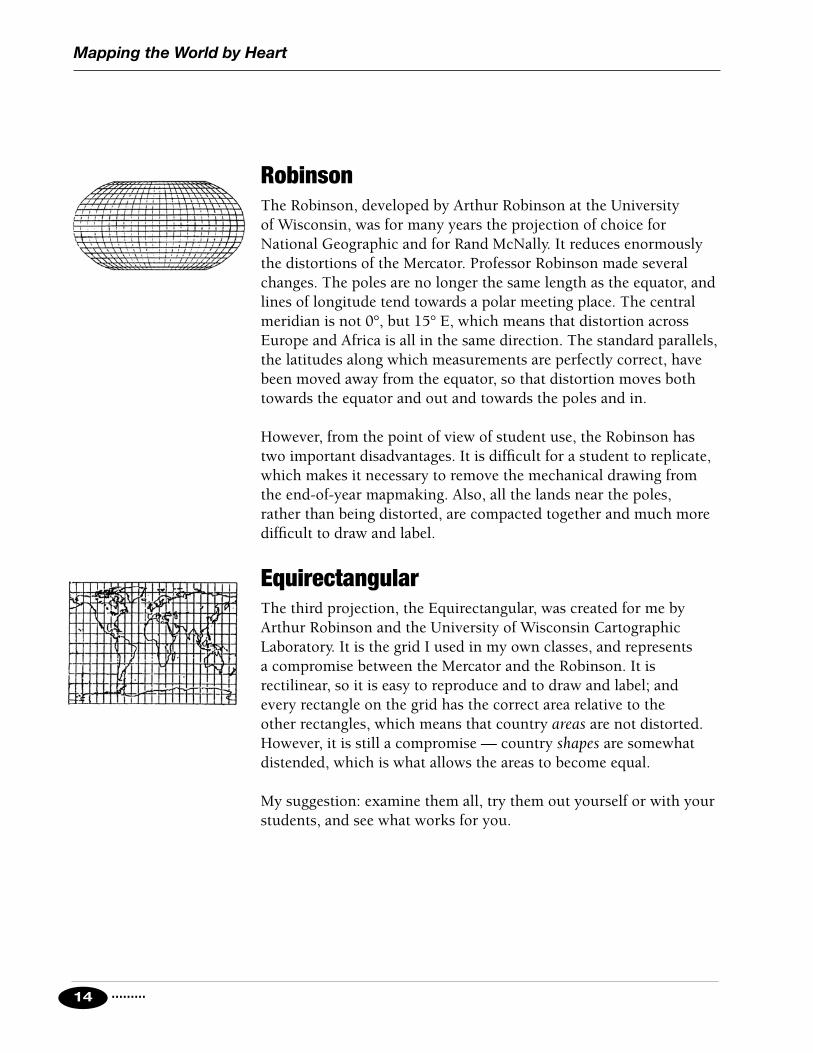
RobinsonThe Robinson, developed by Arthur Robinson at the University of Wisconsin, was for many years the projection of choice for National Geographic and for Rand McNally. It reduces enormously the distortions of the Mercator. Professor Robinson made several changes. The poles are no longer the same length as the equator, and lines of longitude tend towards a polar meeting place. The central meridian is not 0°, but 15° E, which means that distortion across Europe and Africa is all in the same direction. The standard parallels, the latitudes along which measurements are perfectly correct, have been moved away from the equator, so that distortion moves both towards the equator and out and towards the poles and in.
However, from the point of view of student use, the Robinson has two important disadvantages. It is difficult for a student to replicate, which makes it necessary to remove the mechanical drawing from the end-of-year mapmaking. Also, all the lands near the poles, rather than being distorted, are compacted together and much more difficult to draw and label.
EquirectangularThe third projection, the Equirectangular, was created for me by Arthur Robinson and the University of Wisconsin Cartographic Laboratory. It is the grid I used in my own classes, and represents a compromise between the Mercator and the Robinson. It is rectilinear, so it is easy to reproduce and to draw and label; and every rectangle on the grid has the correct area relative to the other rectangles, which means that country areas are not distorted. However, it is still a compromise — country shapes are somewhat distended, which is what allows the areas to become equal.
My suggestion: examine them all, try them out yourself or with your students, and see what works for you.

......... 15
Mapping the World by Heart
Appetizers ............................................ 17 Blank Grid Lesson ....................................................... 18Grapefruit Lesson ....................................................... 20Latitude and Longitude Lesson ................................... 22Playground Maps ........................................................ 26Contour Map Lesson ................................................... 27Thematic Maps Lesson ............................................... 38Local Geography ......................................................... 40
Entrees ................................................ 41Selected World Features Map: Checklist ....................... 42 Mapping the USA: Checklist ......................................... 43Mapping Canada: Checklist .......................................... 45 Mapping Central America, Mexico, and West Indies: Checklist .................................................. 47 Mapping South America: Checklist ............................... 49 Mapping Europe: Checklist ........................................... 50 Mapping Eastern Europe and Northern Asia: Checklist .. 53Mapping Africa: Checklist ............................................. 55 Mapping Southwest, South, and Southeast Asia: Checklist ............................................ 57Mapping Australia and Pacific Region: Checklist .......... 59World Tests ................................................................. 60
Seasonings ........................................... 63The World Experts Lesson ............................................ 64Mnemonics .................................................................. 73Games ......................................................................... 75
Dessert ................................................ 81Materials for Making Final Maps .................................. 82Steps for Making Final Maps ....................................... 83Mapping the World: Sample Checklist .......................... 86
Appendices ............................................ A1Appendix A: Mapping the U.S. by Heart ......................... A1Appendix B: Mapping Canada by Heart ......................... B1Appendix C: Mapping Mexico by Heart .......................... C1
The “Menu of Lessons” ApproachMapping the World by Heart is not meant to be a “follow these steps exactly or you will fail” kind of curriculum. It is meant to be used more like a restaurant menu. Choose what you want, use it as you wish, add to it, or combine it with other items and make a “meal” that suits your own needs and those of your students.

.........16
Mapping the World by Heart
A Sample Yearlong Agenda, Using the Menu Approach
Sequence Lesson Time Required Time
Appetizers Lessons to familiarize your students with map nomenclature and map reading, and to make sure everybody is speaking the same language.
1. Blank grid to fill in 1 class period 1 day2. Grapefruit Lesson 1 class period 1 day3. Latitude and Longitude Lesson 1 class period 1 day4. Contour Maps 2 classes/2 homeworks 1 week5. Thematic Maps & Reports 3 classes/2 homeworks 1 week6. Local Geography 2 classes/2 homeworks 1 week
Entrees The backbone of the location and place segments of the curriculum, seasoned with World Experts and other “seasonings” for relationships, movement, and regions.
7. Selected World Features Map 2 classes/2 homeworks 1 week8. USA Map & Review 4 classes/4 homeworks 2 weeks9. Canada Map & Review 4 classes/4 homeworks 2 weeks
10. Central America Map & Review 4 classes/4 homeworks 2 weeks11. South America Map & Review 4 classes/4 homeworks 2 weeks12. Review all the Americas 2 classes/2 homeworks 1 week13. World Experts 4 classes/8 homeworks 2 weeks14. Europe Map & Review 4 classes/4 homeworks 2 weeks15. E. Europe/N. Asia Map & Review 4 classes/4 homeworks 2 weeks16. Africa Map & Review 4 classes/4 homeworks 2 weeks17. Asia Map & Review 4 classes/4 homeworks 2 weeks18. Australia & Oceania 4 classes/4 homeworks 2 weeks19. World Review & World Tests 4 classes/4 homeworks 2 weeks
Dessert The final activities, summing up and synthesizing the year’s work, ending with some kind of final, formal product.
20. Daily Practice Maps 12 classes/12 homeworks 4 weeks21. Final Formal Maps 12-15 class periods 3 weeks

Mapping the World by Heart
.........
A Menu of Lessons: Appetizers
A Menu of Lessons
17
These lessons have two purposes: to give you a realistic picture of your students’ knowledge of geography as the year begins, and to establish a foundation of geographic terminology and understanding upon which the structure of the year’s work can be built. The lessons require little preparation time or classroom/homework time, and can be done either as a group at the very beginning of the year, or one by one at any time during the year that the particular skills and knowledge seem appropriate.
Appetizers

.........18
Mapping the World by HeartA Menu of Lessons: Appetizers
OverviewStudents demonstrate their present knowledge by filling in a blank grid, which is saved and used for comparison at the end of the year.
ObjectivesStudents should: • Have a relaxed, fun time coming to grips with how hard it is to
actually make a world map that looks like the world.
• Create a document that will be usable for comparison at year’s end.
MaterialsOne blank grid per student; one pencil or dark, erasable pen.
Methods and Discussion1. Hand out pencils.
What you are about to do will not be graded or evaluated; it will only be used to help us see the progress you make this year, so please do not worry or be alarmed. I am going to hand out blank grids, but please write nothing on them until I give you instructions.
2. Hand out grids.
On these grids, I want you to fill in everything that you remember that you know about the world. There is no right or wrong answer; it’s only what you remember you know, today, about world geography. Try to put in and label any places or features you can, such as continents, countries, cities, rivers, oceans, lakes, mountains, islands, etc. Do not look at anyone else’s map; there’s no point in including stuff that somebody else remembers. Do the best, neatest job you can in the time allowed.
3. Allow as much time as you can. Those who finish early can read, begin homework, etc. 20 to 25 minutes is usually enough for 95% of the class.
Blank Grid Lesson

......... 19
Mapping the World by Heart A Menu of Lessons: Appetizers
4. Discussion as needed. Was it hard? Why? How did it make you feel? Did you learn anything just by doing this exercise? What places were easy to remember, and what places were hard? This is a good time to make the point that places that are real to us are the places that are easiest to remember (such as where we live, where we’ve traveled, or places we’ve studied). The geography course this year is going to attempt to make a lot of new places real.
Variations• Can be done in a few minutes a day, with teacher collecting grids
each day.
• Instead of a blank grid, a blank world map can be used — the assignment being to fill in as much as possible in the time allowed.
• Blank world map can be used on a subsequent day as an additional pre-test.

.........20
Mapping the World by HeartA Menu of Lessons: Appetizers
OverviewStudents learn the need for map projections by attempting to cut the skin off of a grapefruit and making it flat enough to use as a readable map.
ObjectivesStudents should: • Understand why flat maps cannot be made without some kind
of distortion.
• Be able to state various compromises that mapmakers use.
MaterialsOne grapefruit per student; one thin, permanent black marker per grapefruit; one serrated plastic knife per grapefruit; sponge and paper towels for clean-up; wall or desk maps with a variety of projections — polar, conic, mercator, etc. — kept out of sight until latter part of lesson.
Methods and Discussion1. Distribute grapefruits, knives, markers, towels.
2. On each grapefruit students draw a North and South Pole, plus the equator, prime meridian, international date line, and a few real or make-believe countries.
3. With knife, students attempt to remove skin in such a way that the peel is in one piece (or at least in large pieces) and could be used as a map. Allow 10-15 minutes.
4. Examine results, let students describe their particular ordeals, then get out samples of different projections for examination and discussion.
5. Discussion includes some analysis of the kinds of problems students encountered (“I couldn’t get it flat,” “These two places that are supposed to be next to each other ended up far apart,”
Grapefruit Lesson

......... 21
Mapping the World by Heart A Menu of Lessons: Appetizers
and so on), followed by the teacher’s presentation of the different projections, and a look at the compromises inherent in each projection — what is gained and what is lost in each one.
6. Students can be invited to eat grapefruits at the end of class.
VariationsExercise can be done in pairs or small groups to save on fruit and to enhance student discussion and group problem-solving skills. If small groups are used, it’s always useful to ask a question or two at the end about the problem-solving difficulties that the groups faced and how they were resolved.
• Teacher can do one grapefruit in front of the class, with students helping, offering suggestions, and so on.
• It can be done in reverse. Find a desk map with an equator about the same length as your grapefruit’s circumference; then try to fit the map to the grapefruit using scissors and scotch tape.
• Use a balloon. Inflate it and tie it off with a rubber band; then draw a globe on the balloon and add the poles, equator, a few lines of longitude, and the continents. Then deflate the balloon. Make a single cut with scissors from South Pole to North. While trying to make you balloon “map” rectangular, pin it onto the bulletin board with pushpins.

.........22
Mapping the World by HeartA Menu of Lessons: Appetizers
Overview Teacher-centered discussion during which students are presented the concepts of latitude and longitude and practice using these tools with a variety of exercises.
ObjectivesStudents should:• Understand and be able to define latitude and longitude.
• Understand units of measurement: degrees, minutes, seconds.
• Be able to state the longitude and latitude of various places by looking at a map.
• Be able to locate places given their latitude and longitude.
MaterialsGather whatever you have in the way of maps, globes, etc. — each student will need at least one world map. This can be a desk outline map, a map from an atlas, or any kind of world map.
Methods and DiscussionThe lecture/discussion can go in a variety of ways, depending on teacher preferences. What follows are ideas for ways to present the material. None of these is etched in stone; feel free to use, adapt, change, or ignore. They are only ideas that have worked. During the discussion, have lots of maps around, use a globe to demonstrate what you’re talking about, and encourage questions.
• If there were only one kind of map in the world, and I wanted to describe a place on it, “that little doohickey over there” or “the city in the corner of square A7” would work fine. However, there are too many different maps. And geographers, explorers, and so on, had to be sure they were talking about the same place, so a consistent system had to be developed.
• The first agreement: draw a line around the Earth, halfway between the poles, and call it the equator.
• Now, the distance from the equator to either pole is a quarter of a circle. Since a circle has 360 degrees, the distance from the equator
Latitude and Longitude Lesson

......... 23
Mapping the World by Heart A Menu of Lessons: Appetizers
to a pole is 90 degrees. At each of these degrees, we can draw an imaginary line around the Earth. Near the equator they are long lines, near the poles they are short lines. But they all have two things in common: they go all the way around the Earth, and they are parallel to the equator.
• Using these lines, called lines of latitude, I can tell my location relative to the equator. Each degree represents approximately 69 miles. If I’m at the lowest latitude, 0 degrees, I’m at the equator. If I’m at the highest latitude, 90 degrees, I’m at the pole. But WHICH pole? It’s necessary to add N or S so that it’s clear whether you are north of the equator moving toward the North Pole, or south of the equator moving toward the South Pole.
Let’s try a few locations:
• If I’m at 10o N, how many miles am I from the equator, and in which direction?
• If I’m at 89o N, where am I?
• If I’m at 90o S?
• The problem with LATITUDE alone is that I can tell how far from the equator I am, but I can’t tell where I am on that latitude. I could be at 45o N and be in the Atlantic or the Pacific; in Europe, Asia, or North America.
• Something vertical was needed that would intersect lines of latitude and tell me where I am. However, there were no neat poles to start from. So geographers decided on an arbitrary point — the Royal Observatory in Greenwich, England — and decided that a line drawn from North Pole to South Pole through that observatory would be called ZERO DEGREES of LONGITUDE. Longitude lines are also called MERIDIANS; hence the line of ZERO DEGREES is sometimes called the PRIME MERIDIAN. Meridian means “mid-day”; at mid-day in Greenwich, England, the sun is over the prime meridian.
• With that line in place, the rest was easy. The Earth was divided up by 360 evenly spaced lines running from pole to pole. These were called DEGREES OF LONGITUDE.
• If I start at ZERO and go one degree EAST, I am at ONE DEGREE EAST LONGITUDE. If I go 90 degrees to the west, or one fourth of

.........24
Mapping the World by HeartA Menu of Lessons: Appetizers
the way around the world, I am at NINETY DEGREES WEST LONGITUDE.
• So now, to identify my location, I simply have to give a longitude and a latitude. If I am 20 degrees north of the equator, and 20 degrees east of Greenwich, I describe my location as TWENTY DEGREES NORTH LATITUDE, TWENTY DEGREES EAST LONGITUDE, or simply as 20˚ N, 20˚ E.
Some interesting things:
1. If I go halfway around the world from the prime meridian, I get to a line identified as 180 degrees of longitude. It is BOTH 180 east AND 180 west. The highest line of longitude, therefore, is 180. (The highest line of latitude is 90.) This line of 180 degrees is also known as the International Date Line; it marks a time zone change and also a date change.
2. For convenience in telling time, the Earth was divided into 24 time zones. Wherever the sun is directly overhead, it is noon; and it is some other time in every other time zone. If it is noon in California, it is 1:00 PM in the Rocky Mountains, 2:00 PM in the central U.S., and 3:00 PM in the eastern U.S. It’s also 8:00 PM in London, 10:00 PM in Cairo, 2:00 AM in India, 4:00 AM in Japan and Australia, and 9:00 AM in Hawai’i. However, some convention was needed so that possible confusion about WHICH DAY IT IS would be avoided. This solution was the International Date Line. If I go EAST across this line, the time goes from 7 o’clock to 8 o’clock — the same as with any time zone — but it goes from 7 o’clock Thursday to 8 o’clock Wednesday. In other words, I don’t go forward an hour, I go back 23.
3. Lines of latitude are always the same distance from the equator, and the same distance from every other line of latitude, no matter where you are on the line. Longitude, however, is different: the lines all MEET at the poles, and they are approximately 69 miles apart at the equator. If I am at 10o N, 10o E, and my friend is at 10o N, 11o E, we are about 69 miles apart; if I am at 89o N, 10o E, and my friend is at 89o N, 11o E, we are only a mile or two apart. (This may seem confusing, but study a globe for a few minutes and you’ll understand.)
• So, while I can’t always use latitude and longitude to tell how far apart two places are, I can always tell exactly where on the Earth something is by identifying its latitude and its longitude.

......... 25
Mapping the World by Heart A Menu of Lessons: Appetizers
Let’s practice a little.
• What city is at 35° N, 120° W?
• Show me the location of 10° N, 170° W; of 80° S, 170° E.
• Where are we right now, in terms of latitude and longitude?
• It’s hard to be precise given only degrees, because they can be pretty far apart. So it’s important also to be able to refer to parts of degrees. Degrees are divided up into units called MINUTES; there are 60 minutes in each degree. Five-and-a-half degrees, therefore, is referred to as 5 degrees, 30 minutes. Minutes are divided up into units called SECONDS; there are 60 seconds in a minute. So 5 degrees, 30-and-a-half minutes is referred to as 5 degrees, 30 minutes, 30 seconds.
• Each SECOND of latitude is approximately 1/60 of a mile from the next second of latitude, so you can get pretty precise. Your house and your friend’s house across the street will have exactly the same latitude and longitude in DEGREES and in MINUTES, but will differ by one or two SECONDS. Remember, these minutes and seconds have nothing to do with time; they describe location.
• It’s time for a few practice locations. I’ll tell you a location, and you find it on the map.
• OK, now let’s use the maps we have and try to determine the location of a few cities.
• Finally, just for fun and without looking at any map, I’ll tell you the latitude and longitude of a few important places. See if you can work out, in your head, what places I’m locating for you.

.........26
Mapping the World by HeartA Menu of Lessons: Appetizers
1. Pick the desk map that you wish to enlarge on your playground or classroom floor.
2. Divide it into 5 equal sections horizontally, and 5 equal sections vertically. Draw this grid — it’s actually 6 lines in each dimension, making a 5 x 5 grid. Lightly number each rectangle in the grid. Photocopy one of these gridded maps for each student. Assign each student one rectangle (or two) to be responsible for.
3. On your floor or playground, divide the horizontal and vertical dimensions into 5 equal sections. Use a chalk line (borrowed from the school custodian or bought for a few dollars at a hardware store) to lay out your 5 x 5 grid on the floor. The final map must have its horizontal and vertical dimensions in the same ratio as the horizontal and vertical dimensions on the desk map (i.e., if the desk map is 6" by 8", the floor map could be 6' by 8', 3' by 4', etc.) This ratio must be the same on both maps if the large map is to look the same as the desk map.
4. Number each rectangle on the floor grid. Give out chalk. Students copy the coastlines and borders in their assigned rectangle from the desk map to the floor map. Gradually, all the chalk lines will meet and begin to look like a huge version of the desk map. Step back and enjoy the process. Many people find that this is a great moment to make a video for later class enjoyment.
5. If you want a permanent map, go over the coastlines and borders in parking lot paint with a very small roller. (These are hardware store items; the paint is about $20 per gallon, the rollers vary in price. Your school custodian probably has plenty of the paint.) DO NOT GO OVER THE GRID LINES IN PAINT. You want the chalk grid lines to gradually wear away so that all you are left with is the basic map.
6. It is usually best not to label. Use the final map as a huge blank map for a variety of review and fun activities.
Playground Maps

......... 27
Mapping the World by Heart A Menu of Lessons: Appetizers
OverviewStudents become familiar with the terminology, reading, and interpretation of contour maps. Then they practice making some of their own, working individually as well as in teacher-centered large groups.
ObjectivesStudents should:• Be able to describe the meaning of contour lines, contour
shading, and other aspects of contour maps.
• Understand how to use a contour map, and demonstrate this understanding by correctly interpreting the slope, size, and shape of features on a map.
• Be able to draw contour maps.
MaterialsMulti-page handout; pencils; sample contour maps for the bulletin board, such as U.S. Government Survey maps of your local area, FAA Air Navigation charts, NOAA Ocean Navigation charts, etc. Also useful: a sand table, sandbox, or convenient mound of dirt.
Methods and Discussion1. Begin by showing students a sand or dirt pile. Ask them to
pretend that the dirt is an island, 1000 feet high. Ask a student to draw a line on the island that connects all points 100 feet above sea level; ask another student to do the 200 foot line, etc. Finally, ask students what these lines would look like if viewed from above (concentric circles or irregular shapes), how a steep slope would differ from a flat area (lines would be closer together the steeper the slope), what would happen near rivers and ponds (rivers cross lines, ponds never do), and so on.
2. Back in the classroom, draw a side view of an imaginary island and demonstrate how to draw a contour map of that island. Remind students that this is imaginary and only for practice. Also point out that since nobody could know what the other side of your imaginary island looks like, no two contour maps of this island will look the same.
Contour Map Lesson

.........28
Mapping the World by HeartA Menu of Lessons: Appetizers
3. Similarly, draw a contour map of an imaginary island and demonstrate to students how to draw a side view of this island.
4. Finally, let students begin work on the exercises, referring to the first pages if they get confused. This can be classroom work for one or two periods, or it could be homework for the next geography class.
Variations• Students can work in pairs or small groups to construct their
own island out of sand or clay. Then they, or other students, can map it. Ask the art studio to work with you on the construction of islands.
• If a parent who knows surveying is available, the school grounds can be surveyed and mapped.

......... 29
Mapping the World by Heart Student Handout
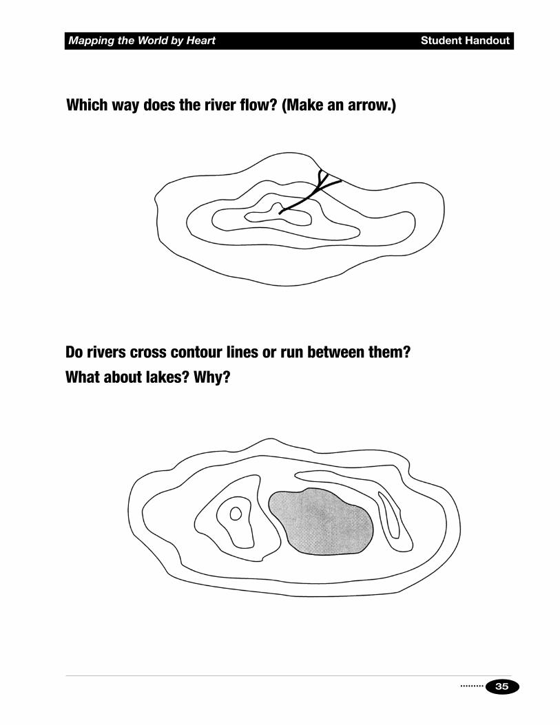
Absolute Rules for Contour Maps
• Contour lines are closed like a circle.
• Every point on a contour line is the same number of feet above sea level.
• Rivers flow downhill (across lines).
• The sea is at sea level (altitude of 0 feet).
• Lakes are flat (they never cross lines).
• Contour lines must be close enough to show contours, but far enough apart to avoid crowding.
Contour Maps

.........30
Student Handout Mapping the World by Heart
Drawing a side view:
1. Notesizeandshape.Topofislandisabove100feet,butlessthan120feet.
2. Marktheextentofeachcontour.Theislandcannotextendbeyondthesemarksateachlevel.
3. Transferthesepointstoyourdrawing.
4. Marklevels,putdotswherepointsfromabovecrosslevels,andconnectthedots.

......... 31
Mapping the World by Heart Student Handout
To map this island:
1. Pickagoodcontourinterval.5feetistoomanylines,100feetistoofew.20feetmightbejustaboutright.Mark20footintervals.
2. Drawhorizontallinesacrossislandateachinterval.
3. Notewhereislandandlinescross.Transferthesepointsdowntoyourmapofthecontours.
4. Yourcontourlinesmustextendasfarasthesepoints,andnofurther.

.........32
Student Handout Mapping the World by Heart
Draw this island’s contours:

......... 33
Mapping the World by Heart Student Handout
Draw the island whose contours are:

.........34
Student Handout Mapping the World by Heart
Which map is most useful to you if you want to find a harbor?
Why?
A.
B.
......... 35
Mapping the World by Heart Student Handout
Which way does the river flow? (Make an arrow.)
Do rivers cross contour lines or run between them?
What about lakes? Why?

.........36
Student Handout Mapping the World by Heart
If you draw this island’s outline as it would appear if you were standing at point A, what important feature will be missing?
If you draw it from point B, what feature will you have to omit?
B
A

......... 37
Mapping the World by Heart Student Handout
Make a side view and a contour map of an imaginary island.
Side View:
Contour Map:

.........38
Mapping the World by HeartA Menu of Lessons: Appetizers
Thematic Maps Lesson
OverviewStudents practice making thematic maps, using as models maps they find in atlases, newspapers, bulletin boards in the classroom, etc. After they have made the maps, they report to the rest of the class about their map: what it represents, what interesting conclusions they were able to draw, and how their map relates to other maps that have been presented.
ObjectivesStudents should:• Understand the kind of information that might be depicted on
a thematic map such as birth or death rates, key products or industries, etc.
• Be able to explain the information on the map that they made.
MaterialsDesk outline maps for each student; colored pencils; sources of thematic maps. Have students bring maps in for several days as they find them in newspapers or magazines, or use the thematic map sections in classroom atlases.
Methods and DiscussionBefore doing this assignment, it’s important to spend some time looking at a variety of thematic maps with the class, either in class discussion or in homework assignments with directed questions. Students need to be familiar with the idea of these maps, particularly with their use of symbols and colors.
Allow time — probably one or two class meetings plus one or two homework assignments — for the map to be made correctly.
1. Have students copy the information from their model maps. Alternatively, they can devise a theme of their own based on information they derive from thematic maps, from newspaper stories, or from their own research.
2. Remind students of the importance of a map key to help the viewer understand the meaning of the map.

......... 39
Mapping the World by Heart A Menu of Lessons: Appetizers
3. After maps are made, each student should give a 5-minute report to the class about the content of the map, what the student learned while making the map, questions that the student found interesting, etc. At the beginning of the report, students must provide a statement about what information they are trying to convey to the class. It may be valuable in some classes for the teacher to give the first report, to set a standard and style for other reports.
4. Immediately after the report is given, have the student who gave the report administer a 5-question objective test about the report. Have the student grade it to see:
• if the report taught the things the student thought it would teach; and
• what questions remain that need to be discussed more fully.
5. Finally, post the maps all around the room for general viewing and discussion.
Variations• Students can work on these in pairs.
• Students do not actually have to make their own map to get value from the lesson. They can study a map, and then report on the important issues presented in the map. However, I have found that there is great value in the exercise of actually repeating the mapmaker’s steps, looking closely at areas of the world, decoding what different aspects of a map mean on a human scale, and more.

.........40
Mapping the World by HeartA Menu of Lessons: Appetizers
Local GeographyInstead of giving you my particular lessons in local geography, which will probably not be very helpful to you, I will describe some of the theoretical underpinnings of this unit and then list a number of alternatives you may wish to try.
The unit on local geography serves a very basic need — it reinforces for students where “here” is, relative to other important places in their world. Additionally, it accomplishes some other tasks — it teaches you a lot about what the students already do and don’t know; it gives you a familiar and therefore not-too-scary first mapmaking experience together; and it allows you to set the year’s high standards and start off with a successful maps experience.
Here are some alternatives for working with your classes around the topic of “local geography”.
• Map your classroom to scale, with a key to identify different types of materials, different areas, or whatever is appropriate.
• Map your school, labeling different rooms, corridors, etc. If there is more than one floor, do the higher floors on tracing paper so that all the sheets can be examined together; this can be done in groups, with each group working on a different floor or area.
• Measure your school’s grounds and calculate its area in acres.
• Build a model of your school building or some other familiar structure.
• Draw your route from home to school. Each student gets the same size paper to do this on, and has to fill the paper. Those who live close have to make the scale quite large, while those who live far away have to make the scale quite small.
• Draw a map of your neighborhood, or the school’s neighborhood, and then compare it to a professionally made map (get one from city hall). Where are the maps similar and where are they different? What does this teach you about how maps are made, and how accurate we can assume maps to be?

Mapping the World by Heart
.........
A Menu of Lessons: Entrees
A Menu of Lessons
41
This section presents a group of map worksheets. With each one, the procedures are approximately the same.
First, distribute a worksheet and a blank desk outline map to each student. Students then use their atlases, or maps that are posted in the room, to shade and label their blank maps. After all the maps are finished, I have students check each others’ maps for accuracy (the first step in review). Then I collect the maps and check them myself.
After the maps have been checked for accuracy, review activities can begin. These include games from the “Seasonings” menu, and tests.
When I give a test on place and location, I usually build it around a blank map. I select several countries and features, mark them with numbers, and ask students to identify the marked locations on a separate worksheet. Another type of test I like to use is a “fill in the blank” type of test — with such questions as “The last country that the Nile flows through is___________,” or “The country immediately south of Rwanda is___________.”
While we are working on a particular area of the world, I cover the bulletin boards with maps, photos, and articles about that part of the world; and I ask students to check newspapers, television, and magazines for articles that pertain to the area.
You’ll notice that the first lesson is a master “world features” map. This map is a gentle warm-up activity. Many of the names are already familiar and will appear frequently during the year; and so this map gives me an opportunity to help students with some new mapmaking concepts and techniques, such as key colors, horizontal labeling, and so on.
Entrees

.........42
Student Handout Mapping the World by Heart
Mountains & Other FeaturesAlps Atlas Mountains PyreneesAndes Caucasus Rocky MountainsAppalachians Gobi Desert Sahara DesertApennines Himalayas Urals
Oceans, Seas, and GulfsAdriatic Sea Caspian Sea Mediterranean SeaArabian Sea East China Sea North SeaAral Sea East Siberian Sea Pacific (N,S) OceanArctic Ocean Gulf of Aden Persian GulfAtlantic (N,S) Ocean Gulf of Bothnia Red SeaBaffin Bay Gulf of California Sea of JapanBaltic Sea Gulf of Mexico Sea of OkhotskBarents Sea Gulf of Oman South China SeaBay of Bengal Gulf of St. Lawrence Tasman SeaBay of Biscay Hudson Bay Tyrrhenian SeaBering Sea Indian Ocean White SeaBlack Sea Kara Sea Yellow SeaCaribbean Sea Laptev Sea
RiversAmazon River Mississippi River Tigris RiverAmur River Missouri River Ural RiverBrahmaputra River Nelson River Uruguay RiverCongo River Niger River Volga RiverDanube River Nile River Yangtze RiverEuphrates River Ob River Yellow RiverGanges River Orange River Yenisey RiverIndus River Orinoco River Yukon RiverLena River Paraná River Zambezi RiverMackenzie River Rio Grande RiverMekong River St. Lawrence River
Selected World Features Map: Checklist(To be done on your choice of Blackline World Outline Maps)

......... 43
Mapping the World by Heart Student Handout
BordersShade the borders of the U.S., Canada, and Mexico.
StatesVery lightly shade each of the 50 states. If you are careful, you should need no more than four or five colors.
In each state, write in blue pen the correct two-letter abbreviation. Do not use periods with these abbreviations. Do not try to write in the whole name of the state.
AL Alabama LA Louisiana OH OhioAK Alaska ME Maine OK OklahomaAZ Arizona MD Maryland OR OregonAR Arkansas MA Massachusetts PA PennsylvaniaCA California MI Michigan RI Rhode IslandCO Colorado MN Minnesota SC South CarolinaCT Connecticut MS Mississippi SD South DakotaDE Delaware MO Missouri TN TennesseeFL Florida MT Montana TX TexasGA Georgia NE Nebraska UT UtahHI Hawai’i NV Nevada VT VermontID Idaho NH New Hampshire VA VirginiaIL Illinois NJ New Jersey WA WashingtonIN Indiana NM New Mexico WV West VirginiaIA Iowa NY New York WI WisconsinKS Kansas NC North Carolina WY WyomingKY Kentucky ND North Dakota
CitiesIn each state, make a clear dot for the capital city and label it. Use pencil or a different color of pen. If you can do so, keep the lettering within the borders of the state. If there is not enough room, make a straight line to a clear place on the map and write the city’s name there.
Don’t forget Washington, DC, the national capital.
Mapping the USA: Checklist
See Appendix A for a much more detailed
“mapping the U.S.” experience.

.........44
Student Handout Mapping the World by Heart
RiversLabel the following rivers in a new color.
Alabama River James River Roanoke RiverAllegheny River Kennebec River Sacramento RiverAltamaha River Mississippi River San Joaquin RiverArkansas River Missouri River Santee RiverBrazos River Mohawk River Savannah RiverCape Fear River Monongahela River Snake RiverChattahoochee River Ohio River St. Lawrence RiverColorado River Pecos River Susquehanna RiverColumbia River Pee Dee River Tennessee RiverConnecticut River Penobscot River Tombigbee RiverDelaware River Platte River Wabash RiverGila River Potomac River Yellowstone RiverHudson River Red River (TX, OK, LA) Yukon RiverIllinois River Rio Grande River
FeaturesLabel the following additional features in a new color.
Appalachian Range Lake Erie Lake OntarioCascades Lake Huron Lake SuperiorCoastal Range Lake Michigan Rocky MountainsGreat Salt Lake Lake Okeechobee Sierra Nevada

......... 45
Mapping the World by Heart Student Handout
BordersShade the U.S. side of the U.S./Canada border.
Countries and TerritoriesLabel the following countries and territories. United States Greenland (Territory of DENMARK) — (Note: Now more correctly called
Kalaallit Nunaat; its capital is Nuuk)
St. Pierre and Miquelon (Territory of FRANCE)
Provinces/Territories and CitiesShade and neatly label each province. Label in a second color the cities listed for each one.*Ottawa is the Federal Capital of Canada; provincial capitals are capitalized.
Alberta (EDMONTON, Calgary)British Columbia (VICTORIA, Vancouver)Manitoba (WINNIPEG)New Brunswick (FREDERICTON)Newfoundland (ST. JOHN’S); LabradorNova Scotia (HALIFAX)Ontario (TORONTO, Ottawa*)Prince Edward Island or P.E.I. (CHARLOTTETOWN)Québec (QUÉBEC, Montreal)Saskatchewan (REGINA, Saskatoon)Northwest Territories (YELLOWKNIFE)Yukon (WHITEHORSE)Nunavut (IQALUIT) — a new territory, effective April 1, 1999, carved out of
Canada’s central and eastern Arctic. Divide the Northwest Territories into
eastern and western portions, and the eastern portion, including Hudson’s
Bay and Baffin Island, is Nunavut. In the Inuit language of Inuktitut, Nunavut
means “Our Land”; this new territory, about 350,000 square miles or 1/5 the
area of Canada, has been established as a homeland for Canada’s First Peoples.
Mapping Canada: Checklist
See Appendix B for a much more detailed
“mapping Canada” experience.

.........46
Student Handout Mapping the World by Heart
Bodies of WaterLabel these bodies of water in a third color.
Baffin Bay Great Slave LakeBay of Fundy Gulf of St. LawrenceBeaufort Sea Hudson BayDavis Strait Hudson StraitFoxe Basin James BayFrobisher Bay Lake WinnipegGreat Bear Lake
Other FeaturesLabel these features in a new color.
Baffin Island Rocky MountainsChurchill River Sault Ste. Marie (canal and town)Fraser River St. Lawrence RiverMackenzie River Vancouver IslandNelson River Victoria IslandOttawa River

......... 47
Mapping the World by Heart Student Handout
Mapping Central America, Mexico, West Indies: Checklist
Countries and CitiesShade contiguous borders of these countries. Then label them in one color. Mark cities with a clear dot, and label the cities in a second color.
Antigua (Saint John’s) Honduras (Tegucigalpa)Bahamas (Nassau) Jamaica (Kingston)Barbados (Bridgetown) Martinique (Fort-de-France) (Fr.)Belize (Belmopan) Mexico (Mexico D.F.)Bermuda (Hamilton) (U.K.) See page 48 for a list of states.Brazil (Brasília) Netherlands Antilles:Colombia (Bogotá) ArubaCosta Rica (San Jose) Curaçao (Willemstad)Cuba (Havana) BonaireDominica (Roseau) Nicaragua (Managua)El Salvador (San Salvador) Panama (Panama)Grand Cayman (Georgetown) (U.K.) Puerto Rico (San Juan)Grenada (Saint George’s) Saint Kitts (Basseterre)Guadeloupe (Basse-Terre) (Fr.) Saint Lucia (Castries)Guatemala (Guatemala) Saint Vincent (Kingstown)Guyana (Georgetown) Trinidad & Tobago (Port of Spain)Hispaniola: USA Haiti (Port-au-Prince) Venezuela (Caracas) Dominican Republic (Santo Domingo)
FeaturesLabel in a third color.
Atlantic Ocean Gulf of MexicoBahía de Campeche Lago de NicaraguaCaribbean Sea Pacific OceanGolfo de Panama Panama Canal
See Appendix C for a much more detailed
“mapping Mexico” experience.
.........48
Student Handout Mapping the World by Heart
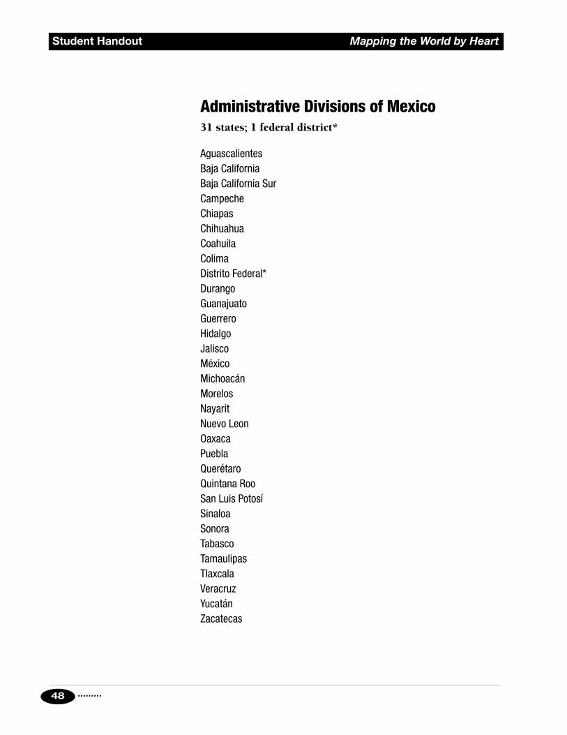
Administrative Divisions of Mexico31 states; 1 federal district*
AguascalientesBaja CaliforniaBaja California SurCampecheChiapasChihuahuaCoahuilaColimaDistrito Federal*DurangoGuanajuatoGuerreroHidalgoJaliscoMéxicoMichoacánMorelosNayaritNuevo LeonOaxacaPueblaQuerétaroQuintana RooSan Luis PotosíSinaloaSonoraTabascoTamaulipasTlaxcalaVeracruzYucatánZacatecas

......... 49
Mapping the World by Heart Student Handout
Countries and CitiesShade contiguous borders and label in one color. Mark cities with a clear dot, and label them in a second color.
Argentina (Buenos Aires) Guyana (Georgetown)Bolivia (La Paz and Sucre) Panama (Panama)Brazil (BRASÍLIA, Recife, Paraguay (Asuncion) Sao Paulo, Rio de Janeiro) Peru (Lima)Chile (Santiago) Suriname (Paramaribo)Colombia (Bogotá) Trinidad & Tobago (Port of Spain)Ecuador (Quito) Uruguay (Montevideo)Falkland Islands (Stanley) Venezuela (CARACAS, Maracaibo)French Guiana (Cayenne) (Fr.)
Rivers and FeaturesLabel clearly in a third color.
Amazon River Panama CanalAndes Mountains Paraguay RiverAtlantic Ocean Parana RiverCaribbean Sea Sao Francisco RiverDrake Passage Strait of MagellanGalapagos Islands Tierra del FuegoOrinoco River Uruguay RiverPacific Ocean
Mapping South America: Checklist

.........50
Student Handout Mapping the World by Heart
Countries/Independent States and CitiesShade contiguous borders, then label in one color. (*identifies island territories; use same color as mother country, and label island in COUNTRY color.) Mark cities with a clear dot, and label in a second color.
Albania (Tirana) Liechtenstein (Vaduz)Andorra (Andorra la Vella) Lithuania (Vilnius)Austria (Vienna) Luxembourg (Luxembourg)Belgium (Brussels) Malta (Valletta)Bulgaria (Sofia) MonacoCyprus (Nicosia) Norway (Oslo)Czech Republic (Prague) Poland (Warsaw)Denmark (Copenhagen) Portugal (Lisbon)Estonia (Tallinn) Republic of Ireland (Dublin)Finland (Helsinki) Romania (Bucharest)France (Paris) (* Corsica) San MarinoHolland (AMSTERDAM, The Hague) Slovak Republic (Bratislava)Hungary (Budapest) Spain (Madrid) (*Balearic Is.)Germany (Berlin) Sweden (Stockholm)Greece (Athens) (* Crete) Switzerland (Bern)Iceland (Reykjavik) Turkey (Ankara)Italy (Rome) (* Sicily; * Sardinia) United Kingdom:Latvia (Riga) England (London)
Wales (Cardiff) Scotland (Edinburgh) N. Ireland (Belfast)
Mapping Europe: Checklist

......... 51
Mapping the World by Heart Student Handout
Also (Label those that appear on your map.)Algeria (Algiers)Iran (Tehran)Iraq (Baghdad)Morocco (Rabat)Syria (Damascus)Tunisia (Tunis)
The Former Soviet UnionArmenia (Yerevan)Azerbaijan (Baku)Belarus (pron: Bel-a-roos) (Minsk)Georgia (T’bilisi)Kazakhstan (Astana)Kyrgyz Republic (Bishkek)Moldova (Kishinau)Russian Federation (MOSCOW, St. Petersburg, Nizhni Novgorod,
Irkutsk, Vladivostok) Kaliningrad (Konigsberg) — Note: An area of land separate from Russia but part
of the Russian Federation.
Tajikistan (Dushanbe)Turkmenistan (Ashgabat)Ukraine (KYIV, Odessa)Uzbekistan (TASHKENT, Samarkand)
Republics of Former Yugoslavia: All are now independent. Serbia and
Montenegro were loosely joined until mid-year 2006; in June, 2006, the union was
declared ended.
Bosnia and Herzegovina (Sarajevo)Croatia (Zagreb)FYROM (Skopje) — Note: This country is known as FYROM because the U.S. and
U.N. recognize this country as The Former Yugoslav Republic of Macedonia to
avoid confusion with the province of Greece called Macedonia. People from Skopje
may refer to themselves as Macedonian, or as Fyromese.
Kosovo (Pristina) (self-declared independence not universally recognized)
Montenegro (Podgorica)Serbia (Belgrade)Slovenia (Ljubljana)

.........52
Student Handout Mapping the World by Heart
Bodies of WaterLabel clearly in a third color.
Adriatic Sea Caspian Sea Mediterranean SeaAegean Sea Dardanelles North SeaArctic Ocean English Channel Norwegian SeaAtlantic Ocean Gulf of Bothnia Sea of AzovBalearic Sea Gulf of Finland Sea of MarmaraBaltic Sea Gulf of Riga Strait of GibraltarBay of Biscay Ionian Sea Tyrrhenian SeaBlack Sea Irish SeaBosphorus Lingurian Sea
RiversLabel in a fourth color.
Danube River Rhone RiverDon River Seine RiverElbe River Ural RiverLoire River Volga RiverPo River Wisla RiverRhine River (called the Vistula River in English)
MountainsLabel in a fifth color.
Alps Carpathian AlpsApennines PyreneesAtlas Mountains Ural Mountains
......... 53
Mapping the World by Heart Student Handout
Countries and CitiesShade contiguous borders, then label in one color. Mark cities with a clear dot, and label in a different color.
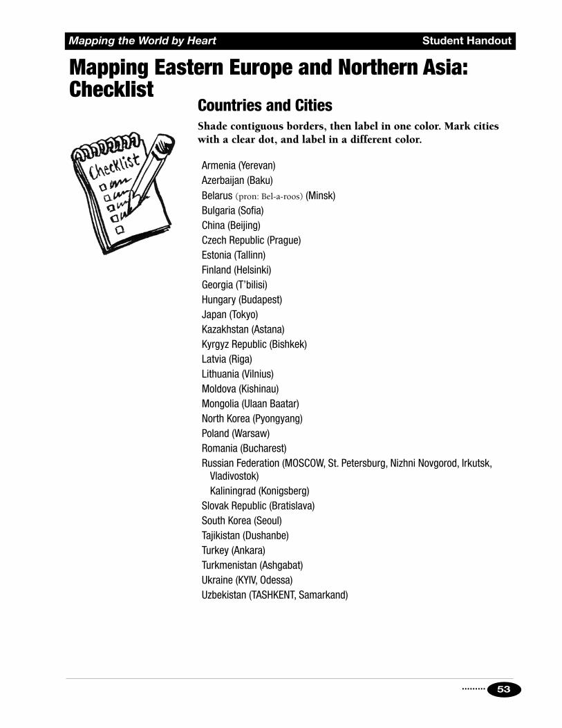
Armenia (Yerevan)Azerbaijan (Baku)Belarus (pron: Bel-a-roos) (Minsk)Bulgaria (Sofia)China (Beijing)Czech Republic (Prague)Estonia (Tallinn)Finland (Helsinki)Georgia (T’bilisi)Hungary (Budapest)Japan (Tokyo)Kazakhstan (Astana)Kyrgyz Republic (Bishkek)Latvia (Riga)Lithuania (Vilnius)Moldova (Kishinau)Mongolia (Ulaan Baatar)North Korea (Pyongyang)Poland (Warsaw)Romania (Bucharest)Russian Federation (MOSCOW, St. Petersburg, Nizhni Novgorod, Irkutsk,
Vladivostok) Kaliningrad (Konigsberg)Slovak Republic (Bratislava)South Korea (Seoul)Tajikistan (Dushanbe)Turkey (Ankara)Turkmenistan (Ashgabat)Ukraine (KYIV, Odessa)Uzbekistan (TASHKENT, Samarkand)
Mapping Eastern Europe and Northern Asia: Checklist
.........54
Student Handout Mapping the World by Heart
Bodies of WaterLabel in a new color.
Aral Sea Lake BaikalArctic Ocean Laptev SeaBarents Sea Sea of AzovBering Sea Sea of JapanBlack Sea Sea of OkhotskCaspian Sea White SeaEast Siberian Sea Yellow SeaKara Sea
RiversLabel in a new color.
Amur River Ob RiverDnieper River Ural RiverDon River Volga RiverLena River Yenisey River

......... 55
Mapping the World by Heart Student Handout
Countries and CitiesShade contiguous borders. Label countries in one color.Mark cities with a clear dot and label them in a second color.
Algeria (Algiers) Mali (Bamako)Angola (Luanda) Mauritania (Nouakchott)Benin (Porto-Novo) Morocco (Rabat)Botswana (Gaborone) Western Sahara (El Aaiun)Burkina Faso (Ouagadougou) (claimed by Morocco)Burundi (Bujumbura) Mozambique (Maputo)Cabinda (belongs to Angola) Namibia (Windhoek)Cameroon (Yaoundé) Niger (Niamey)Canary Islands (Las Palmas) Nigeria (ABUJA, Lagos)Cape Verde (Praia) Rwanda (Kigali)Central African Republic (Bangui) Sao Tome & Principe (Sao Tome)Chad (N’Djamena) Senegal (Dakar)Comoros Islands (Moroni) Sierra Leone (Freetown)Congo, Republic of (Brazzaville) Somalia (Mogadishu)Congo, Democratic Republic of (Kinshasa) South AfricaCôte d’Ivoire (Abidjan, YAMOUSSOUKRO) (Pretoria — administrative capital—Djibouti (Djibouti) also called Tshwane)Egypt (Cairo) (Cape Town — legislative capital)Equatorial Guinea (Malabo) (Bloemfontein — judicial capital)Eritrea (Asmara) Sudan (Khartoum)Ethiopia (Addis Ababa) SwazilandGabon (Libreville) (M’babane — administrative)The Gambia (Banjul) (Lobamba — legislative)Ghana (Accra) TanzaniaGuinea (Conakry) (Dar es Salaam — administrative)Guinea-Bissau (Bissau) (Dodoma — legislative)Kenya (Nairobi) Togo (Lomé)Lesotho (Maseru) Tunisia (Tunis)Liberia (Monrovia) Uganda (KampalaLibya (Tripoli) Zambia (Lusaka)Madagascar (Antananarivo) Zimbabwe (Harare)Malawi (Lilongwe)
Mapping Africa: Checklist

.........56
Student Handout Mapping the World by Heart
FeaturesLabel in a third color.
Atlantic OceanAtlas MountainsCongo RiverGulf of AdenIndian OceanLake ChadLake Victoria
Mediterranean SeaNiger RiverNile RiverOrange RiverRed SeaZambezi River

......... 57
Mapping the World by Heart Student Handout
Countries and CitiesShade contiguous borders. Label countries in one color. Mark cities with a clear dot and label them in a second color.
Afghanistan (Kabul) Mauritius (Port Louis)Bahrain (Manama) Mongolia (Ulaanbaatar)Bangladesh (Dhaka) (also spelled Ulan Bator)Bhutan (Thimphu) Myanmar (Yangon)Brunei Darussalam also called Burma (Rangoon) (Bandar Seri Begawan) Nepal (Kathmandu)Cambodia (Phnom Penh) North Korea (Pyongyang)China (BEIJING, Shanghai, Guangzhou) Oman (Muscat) Hong Kong (S.A.R.) Pakistan (ISLAMABAD, Karachi) Macao (S.A.R.) Philippines (Manila) Tibet (Lhasa) Qatar (Doha)India (NEW DELHI, Kolkata [formerly Saudi Arabia (Riyadh) Calcutta], Mumbai [formerly Bombay]) Seychelles (Victoria)Iran (Tehran) Singapore (Singapore)Iraq (Baghdad) South Korea (Seoul)Israel (Jerusalem) Sri Lanka (Colombo)
Palestine — Note: Current status disputed. Syria (Damascus)Japan (Tokyo) Taiwan (Taipei)Jordan (Amman) Thailand (Bangkok)Kuwait (Kuwait) Turkey (Ankara)Laos (Vianchang, alt. sp. Vientiane) United Arab Emirates (Abu Dhabi)Lebanon (Beirut) Vietnam (HANOI, Ho Chi Minh City)Malaysia (Kuala Lumpur) Yemen (Sanaa)Maldives (Male)
Hong Kong and Macao are now semi-autonomous and exist pursuant to international agreement, maintaining their own governments apart from the People’s Republic of China. Approved names are Hong Kong, Hong Kong Special Administrative Region, or Hong Kong (S.A.R.); and Macao, Macao Special Administrative Region, or Macao (S.A.R.).
Mapping Asia: Southwest, South, Southeast Checklist

.........58
Student Handout Mapping the World by Heart
SeasLabel clearly in a third color.
Arabian Sea East China Sea Red SeaAral Sea Gulf of Aden Sea of JapanBay of Bengal Gulf of Oman Sea of OkhotskBering Sea Indian Ocean South China SeaCaspian Sea Persian Gulf Yellow Sea
RiversLabel clearly in a fourth color.
Amur River Indus River Ural RiverBrahmaputra River Irawaddy River Volga RiverDnieper River Lena River Yangtze RiverDon River Mekong River Yellow RiverEuphrates River Ob River Yenisey RiverGanges River Tigris River
FeaturesLabel clearly in a fifth color.
Caucasus MountainsGobi DesertHimalaya MountainsUral Mountains

......... 59
Mapping the World by Heart Student Handout
Countries and CitiesShade contiguous borders and label countries neatly in one color. Mark cities with a clear dot and label them in a second color.
American Samoa (Pago Pago) (U.S.) Palau (Koror)Australia (Canberra) Papua New Guinea (Port Moresby)Timor-Leste (also known as East Timor) (Dili) Philippines (Manila)Federated States of Micronesia Samoa (Apia) (PALIKIR, Kolonia) Society Islands; Tahiti (Papeete)Republic of the Fiji Islands (Suva) Solomon Islands (Honiara)Indonesia (Jakarta) Tonga (Nuku’alofa)Kiribati (Tarawa) Tuvalu (Funafuti)Malaysia (Kuala Lumpur) Vanuatu (Port-Vila)Nauru (Yaren District — no capital city)New Caledonia (Noumea) (Fr.; French name Nouvelle-Calédonie)New Zealand (WELLINGTON, Christchurch, Auckland)
(Label North Island and South Island of New Zealand)
Australian StatesShade the following states in 4 colors and label in country color above. Mark cities with a clear dot and label them in city color.
New South Wales (Sydney) Tasmania (Hobart)Northern Territory (Darwin, Alice Springs) Victoria (Melbourne)Queensland (Brisbane) Western Australia (Perth)South Australia (Adelaide)
IslandsLabel the following islands, which are part of other countries.
Bali (Indonesia) Guam (USA)Java (Indonesia) Hawai’i (U.S. State)Sumatra (Indonesia) Bougainville (Papua New Guinea)Timor (Indonesia) (ongoing war for independence)
New Britain (Papua New Guinea)
Bodies of WaterLabel the following bodies of water.
Andaman Sea East China Sea Philippine SeaArafura Sea Gulf of Thailand South China SeaCelebes Sea Indian Ocean Sulu SeaCoral Sea Java Sea Timor Sea
Mapping Australia and Pacific Region: Checklist

.........60
Student Handout Mapping the World by Heart
World Test #11. How long does it take the Earth to complete its orbit around
the sun?
2. How long does it take the Earth to rotate on its axis?
3. Approximately how far is it around the Earth at the equator (in miles)?
4. How many degrees is it from the equator to the North Pole?
5. The equator is also known as 0 degrees of which: (circle one)
latitude / longitude
6. What is Europe?
7. Name the island nation just southeast of India.
8. Name the 2 countries just north of the Czech Republic.
9. Name the 8 countries that touch Austria.
10. Name the 2 countries that touch Holland.
11. What is another name for Holland?
12. Name the 5 African countries that touch the Mediterranean.
13. Name the 3 small countries that lie east of Venezuela.
14. Name the 2 landlocked countries in South America.
15. Name the 7 Central American countries between Mexico and Colombia.
16. Name 2 major rivers that flow east through China.
17. Name the 8 countries that touch Saudi Arabia.
18. Name the 3 countries that touch Vietnam.
19. Name the 14 landlocked countries in Africa.
20. What sea separates Australia from New Zealand?
21. Name the 15 independent states of the former Soviet Union.
22. Name the 10 provinces and 3 territories of Canada.
Answers on page 108
......... 61
Mapping the World by Heart Student Handout
Use a world map and the spaces below to complete the following instructions:
1. Mark with P1, P2, and P3 three countries which have Portuguese as their major official language. List the countries here.
P1
P2
P3
2. Mark with E1 through E6 six countries where English is the major language. List the countries here.
E1 E4
E2 E5
E3 E6
3. Label with I1 through I4 four countries where Islam is a major religion. List the countries here.
I1 I3
I2 I4
4. Identify with C1 through C4 places that are colonies. We will define a “colony” as a place that is the property of another country, and is at least 1000 miles away from its “mother” country. List the colonies here.
C1 C3
C2 C4
5. Label with D1 through D4 countries that have large deserts. List their names here.
D1 D3
D2 D4
6. Draw an arrow across the North Pacific to indicate the general direction in which weather moves between North Asia and North America.
7. Draw an arrow across the North Atlantic to indicate the general direction in which weather moves between North America and Northern Europe.
World Test #2 Answers on page 109

.........62
Student Handout Mapping the World by Heart
8. Assume that it is now 3:00 PM in Boston, New York, Washington, Atlanta, and Miami. Label with the correct time, in a circle, at least five cities where it is not 3:00 PM. List here the cities you labeled, and the time in each.
City 1: ___________________ TIME: ___________
City 2: ___________________ TIME: ___________
City 3: ___________________ TIME: ___________
City 4: ___________________ TIME: ___________
City 5: ___________________ TIME: ___________
9. Label with the legend RF1 to RF4 four countries where there are rain forests. List the countries here.
RF1 RF3
RF2 RF4
10. Label with L1 to L4 four countries with high birth rates, high death rates, and low life expectancy. List here the countries you labeled.
L1 L3
L2 L4
11. Label with H1 to H4 four countries with low birth rates, low death rates, and high life expectancy. List here the countries you labeled.
H1 H3
H2 H4
12. Put a compass rose on your map indicating north, south, east, west; and the four intermediate directions, NE, SE, SW, and NW.
13. In an unoccupied space, draw an arrow labeled “rotation” to indicate the direction in which the Earth rotates.
14. Write the word AUTO and numbers 1 to 4 across four countries which are major manufacturers of automobiles. List here the countries you labeled.
AUTO1 AUTO3
AUTO2 AUTO4
15. Write the word OIL and numbers 1 through 4 across four countries which are major exporters of petroleum. List here the four countries you labeled.
OIL1 OIL3
OIL2 OIL4

Mapping the World by Heart
.........
A Menu of Lessons: Seasonings
A Menu of Lessons
63
SeasoningsThese activities are for review and enrichment. The games can be used with each new map, or at any time of the year for review. The mnemonic devices come in most handy at the end of the year, but students will develop their own mnemonics throughout the year; therefore it’s a good idea to collect their phrases with each new map. World Experts, a cultural research project, can be used whenever it is needed. I usually have three World’s Fairs each year.

.........64
Mapping the World by HeartA Menu of Lessons: Seasonings
OverviewStudents become informed about specific countries over a period of time. They then report to the class orally, and post clippings and other information for class perusal and study. This project can be done more than once during the year.
ObjectivesStudents should:• Become more aware of the geography, the cultures, and the
issues in a country or area they know little about — that is, make the place real.
• Practice and improve their reading and generalizing skills.
• Help the teacher build a file of country information.
• Become aware of the relationships between geography and culture.
MaterialsStudents need access to newspapers and magazines from which they can cut or photocopy clippings. National Geographic, Time, Newsweek, travel magazines, etc., are all rich sources.
Methods1. Photocopy and distribute the 7-page World Experts Project
handout (or use what you need from it and create your own World Experts handout).
2. Select countries. Letting students pick their own countries will generally result in better motivation. Try to control the distribution in any way that seems sensible.
3. Countries that we get lots of news about, such as Canada or the Commonwealth of Independent States, can be assigned in smaller pieces: provinces or republics, for example.
4. Allow enough time (two weeks or more) before the first reports. Then, as you get to different areas of the world in your map studies, ask the students who are “experts” on that area to post their clippings and give their reports.
The World Experts Lesson

......... 65
Mapping the World by Heart A Menu of Lessons: Seasonings
Lesson Tips• The hardest problem is motivation over the long run. To keep
students looking for clippings and information during a period of 6 or 8 weeks can be challenging. It helps if you keep bringing in magazines and newspapers. Ask parents for help in this endeavor. Point out news to specific students, and keep offering encouragement. On a class roster which I post, I keep track of how many clippings a student brings in. That way, if a student gets off to a slow start, or doesn’t produce much after the first day or two, I know about it and can help.
• The oral report is important because it’s an opportunity to share information about the people and events in real places we don’t know too much about. Students need guidelines, rehearsal, and validation.
• The visual material (posted on the bulletin board for a while) has an even longer, more extensive impact. That’s because you’re going to keep it in your file until next year, so another student can begin with some information already gathered. Emphasize the long life that the material will have. For interest’s sake, photos and maps are better than long articles. If a student brings in a long article, I usually ask him or her to post a summary with it or highlight the main points.
Variations• This can easily and successfully be done in pairs.
• The whole class can become experts about different countries for a week at a time.

.........66
Student Handout Mapping the World by Heart
World Experts Project: World’s FairYOUR NAME:
YOUR COUNTRY:
I. Draw a physical features map.This may be traced from an atlas or commercial map, or it may be freehand. It should show:1. Your country as the major feature, in the middle.2. All the contiguous countries.3. Enough lines of latitude and longitude to place the map clearly.4. Important features.5. Important cities, with the capital in all upper-case letters.
II. Figure out what you want to know.Make up a list of information you want to get, including at least the following:1. Names
The proper name of your country, in English AND in the national language; other names it may have had, etc.
2. GovernmentForm of government; names of current ruler or head of state, etc.
3. PopulationArea; population; population density. For each, specify the units you are using.
4. CitiesCapital; largest cities, with population.
5. MoneyMonetary unit; per capita income.
6. EducationLanguages; literacy rate.
7. ReligionWhat religions; what percentages; role of religion in society.
8. ProduceMajor agricultural and industrial products.
9. TradeMajor exports and imports; major trading partners.
10. Ethnic GroupsPopulations; current issues.
11. Other TopicsAdd them as you find new topics during your reading and research.
......... 67
Mapping the World by Heart Student Handout
III. Take notes in a neat and orderly way.1. For each statement, phrase, or topic you list, use a separate
sheet of paper. Put the statement, phrase, or topic at the top of the page.
2. Read as widely as you can about your subject in the time available. Read in encyclopedias, travel books, newspapers, magazines; in books from the school or community library, or from home. Check http://www.mapping.com for links to online resources.
3. As you read, you will find information that will fit under one or more of the headings. Write that information under the heading it goes with. (Also write down a source reference for future researchers.)
4. You will surely add new headings as you read, as new ideas, questions, topics, and more come up. Make a new page with each new heading, and add pertinent notes there.
5. Take your notes in short, readable sentences so you’ll be sure to understand them later. Don’t copy every word.
6. Give each note a new number.
7. Skip a line before each new note.
8. Write your notes neatly, as it will do you no good to take notes that you can't read later on.
9. On a separate sheet of paper, keep track of all necessary information for making a bibliography. Include author, title, and date of publication for every resource.
10. Keep all your pages of notes clipped together. When you have more than one page on a single topic, staple page 2 on top of page 1, add page 3 on top of that, etc., to save wear and tear on the paper.

.........68
Student Handout Mapping the World by Heart
IV. Prepare an outline from your notes.When you have finished taking notes, you will have a large amount of disorganized material on your country. An outline is a useful way of getting your material, and yourself, organized. Once you have finished your note-taking, make an outline for yourself which you will use in preparing your “World’s Fair” presentation, and which will be the written report for this project.
Here are the steps you should follow:
1. Begin with the main headings at the top of each page of notes. These will be the main topics in your outline, denoted by Roman numerals.
2. Read through the notes you have taken about each of the main headings, and select the most important words, ideas, and topics. These will be subtopics in your outline, denoted by capital letters.
EXAMPLE (for Japan) III. Ethnic Groups A. Ainu B. Koreans etc. . . .
3. Now, the items or facts that tell about each of the subtopics are placed under them and denoted by Arabic numerals. These items or facts provide additional information about the subtopics.
EXAMPLE III. Ethnic Groups A. Ainu 1. small population (less than 2%) 2. live mostly on Hokkaido 3. subsist on tourism and welfare etc. . . .
4. Because this is only an outline for organizational purposes, you do not need to fill in more detail than this because your notes will provide you with plenty of readily available information.

......... 69
Mapping the World by Heart Student Handout
V. Prepare the visual displays.1. Effective visual material should be prepared on as many
important points as possible.
2. Visual material you present needs to be of a size that can easily be viewed from a short distance.
3. Select materials that highlight your points and make them clear to the listener.
4. Important names, places, ideas, dates, etc., can be written out on cards.
5. Include maps that highlight topics of interest, but do try to keep maps relatively simple. It would be good to have at least two maps — one to show your country’s physical geography, another to show something else of interest.
6. DO NOT copy graphs or charts directly from books. Make your own.
7. Pictures you use should be carefully mounted or labeled. If you can’t find any pictures except in bound books, you may use those pictures as long as they are carefully marked in the book and you have written an annotation to go with the picture.
8. A good way to start is to go through your outline and make a list of all the places where visual material would help.
9. Because a lot of your visual materials will be prepared at home, make sure you have suitable materials at home to work with.

.........70
Student Handout Mapping the World by Heart
VI. Your World’s Fair booth1. Prepare an oral presentation based on your outline that explains
important points about your country, describes the visuals you have prepared, and gives people a real sense about what’s important IN your country and ABOUT your country.
2. Prepare a handout with important facts. This must be ready at least two days prior to your report so that I can duplicate it.
3. You may wish to consider including in your presentation any of the following, which will help people understand more about what life might be like in your country. None of these is required.
Music: Record a little on a computer or cassette tape.
Food: Prepare or buy something that people will enjoy sampling. Choose food that will help them learn about your country.
Costume: Make or borrow some sample of ethnic or typical clothing; dress yourself or a doll.
Language: Prepare a little lesson or worksheet with a few elementary phrases in one of the native languages of your country.
TIME LIMIT: minutesThere will be several people reporting and displaying at the same time. Please plan your presentation with this time limit in mind so that everyone will get a chance to see everything.

......... 71
Mapping the World by Heart Student Handout
VII. World’s Fair requirements1. The fair will be from to on .
2. You may invite your parents to see the fair if you wish, particularly on the day that you do your report. I will invite other classes. Please tell me about anyone you know is coming.
3. During the hour, you will do your report twice. In the remaining time, you may visit other displays, talk to people who wish to ask questions about your display, and so on. I will prepare a schedule for each hour so that everybody has time to report twice without too much competition.
4. The handout needs to contain certain required factual information that a person needs to know about your country.• The name of the country, in English and in any national
languages. • The form of government and the current heads of state, etc.• Facts about ethnic groups, populations, total population,
religion, education, etc. — as much as you decide is truly valuable and interesting.
• Facts about trade and major products of your country.• A few general statements about the country. What is it like?
What is the quality of life of a person who lives there likely to be? How does the geography of the country affect the life of the people (climate? mountains? bodies of water?)? What I’m after here is that you demonstrate to me that you have learned something of value about your country — about the life of the people, the nature of the land, the climate, etc., and how these things shape and affect the people and their lives.
5. The handout needs to be IN MY HANDS at least two school days before your report.
6. The report. Besides distributing your handout, and briefly explaining it to your audience, you will have time to give your viewer some sense of the culture and life of the country. DO NOT simply explain a few facts — give a real sense of the place.

.........72
Student Handout Mapping the World by Heart
Show pictures, talk about what you have learned, let people hear about (or taste) the food, hear music, hear some of the language or local customs of the people, etc. This is also a good time to describe current events a little bit, particularly those events that help the viewer understand the country better. You are free to do whatever you think is best here, but the basic underlying rule is that you need to think of yourself as an employee of your country, giving interested people a clear mental picture of what your country is truly like. It needs to be fun and interesting, both for you and for others.
7. Evaluation. You will evaluate your own report and everybody else’s. I will also evaluate your work, but I will be taking into consideration your note-taking process, your progress in collecting materials, your outline, your handout, AND your report.

......... 73
Mapping the World by Heart A Menu of Lessons: Seasonings
One of the biggest helps in preparing to create a memory map of the world is to have quick access to a number of memory aids. For the most part, people discover their own during the weeks of preparation and practice mapmaking.
What follows is a list of some mnemonics that you may find useful. I offer them only as samples. As you and your students work on learning the world, you’ll surely come up with many of your own.
• 0°, 0° locates the corner of Africa.
• 30° N, 30° E locates the mouth of the Nile.
• Central America:
Either:Place El Salvador and Costa Rica, and the rest of the countries are alphabetical B, G, H, N, P. (Belize, Guatemala, Honduras, Nicaragua, Panama)
OR:Place the countries in this order: “Beware of Hot Gorillas Eating Nitrates Casually, Pop”. (Belize, Honduras, Guatemala, El Salvador, Nicaragua, Costa Rica, Panama)
• All of South America is east of Florida.
• Romania is “over,” Bulgaria “under,” check the second letter.
• ELALI BUM GARAZ: the nine former republics of the Soviet Union that touch Europe (Estonia, Latvia, Lithuania, Belarus, Ukraine, Moldova, Georgia, Armenia, Azerbaijan).
• All the great rivers of India and South Asia start very near each other. Indus, Ganges, Brahmaputra, Irawaddy, Mekong, Yangtze, and Yellow all begin in the Himalayas.
• The northern border of Russia is a triangle. The Arctic Circle makes the base, from 40° E to 170° W; the peak is at 75° N, 105° E. Put that on your map in light pencil, and you have the basic shape to which to add the inlets and peninsulas.
Mnemonics

.........74
Mapping the World by HeartA Menu of Lessons: Seasonings
• “WBKL in East Siberia”: the seas north of Russia, in order from west to east, are White, Barents, Kara, Laptev, and E. Siberian. Note the B-K-L is alphabetical.
• The northernmost point of Queensland, Australia points at the border between Papua New Guinea and Indonesia.
• Niger and Nigeria are in alphabetical order north to south.
• Ecuador is on the equator.
• “A MALE from Tunisia”: Morocco, Algeria, Libya, Egypt, from west to east, plus Tunisia wedged in the middle.
• “That Venezuelan GUY is SURely FRENCH”: Venezuela, Guyana, Suriname, and French Guiana, from west to east.

......... 75
Mapping the World by Heart A Menu of Lessons: Seasonings
PreparationYou will need a list of 100 or more questions about the area being studied; students can make these up and hand them in on 3 x 5 cards. You will also need a class roster. This can be divided into two relatively equal teams before class, or done randomly at the beginning of class.
To BeginOn the board, list the members of each team. List one team to the left of the board, the other just to the right of the middle. This is the batting order. Next to each name you will indicate the outcome of the person’s “at bat”. Teams do not have to sit together; this depends on your judgment and your furniture. You may wish to put a diagram of a baseball field on the board so that you can mark where the players who hit successfully are.
To Play1. One team is up at a time. The other team listens and remembers
questions and answers because they may get the same questions on their turn.
2. Players are up in turn. As you call students’ names, they have to tell you whether they are trying for a single, a double, a triple, or a home run. If they want a single, you ask them one question from the list; if they get it wrong, they may be out (see rule 5), but if they get it right, they go to first base.
3. If the student asks for a double, ask two questions. Both answers must be correct for the student to go to second base. If either answer is incorrect, the student may be out. A triple and a home run work similarly. Thus, a successful home run consists of four questions answered correctly; if any of the four is answered incorrectly, the student may be out.
An alternative here is to rate questions according to difficulty. A single might be “name the capital of Utah”; a double might be “what are the two major rivers of Iraq”; a triple might be “name three places outside of Europe where Portuguese is the principal language”; and a home run might be “there are 14 landlocked countries in Africa, name 4 of them”.
4. If a “runner” is already on base, any hit by another student forces the runner along, even if it isn’t a real force in real baseball. If a
Game: Geography Baseball

.........76
Mapping the World by HeartA Menu of Lessons: Seasonings
student is on second base and first base is empty, a single by the next batter forces the runner to third, etc.
5. If a student answers a question incorrectly, he/she is not out unless a random student chosen from the other team can answer the same question correctly.
6. Play continues until a team has three outs; then the other team is up. A good alternative is to play until everyone on one team has been up one time, and then switch to the other team, regardless of how many outs may have been made.
7. An inning is complete after both sides have had their turn. I usually keep a running score on the blackboard, and sometimes save the score over two or three days as play continues. In a class of 24, I can usually get two complete innings in during a 40-minute period.
Possible Problems• The questions are too hard or too easy. This requires quick
adjustment during the game itself. I’ve even called a delay of the game until the next day.
• One team’s score gets way ahead of the other, which can lead to bad feelings, lack of attention to the process, etc. It’s imperative that the teams be roughly equal, if it’s at all possible to arrange that. If one team gets too far ahead, try adjusting the questions as you go along. You don’t HAVE to do them in order. The best possible outcome is a tie score, or a score that’s close with a changing lead.
Sample Questions (Items in parentheses: Vary these according to your area of study.) What is the capital of (Nevada)? What river separates (Texas and Oklahoma)? What states does the (Connecticut) River touch? What country is (west) of (Sweden)? Name the (two) landlocked countries in (South America). Name the (Canadian) (Provinces) between (Québec and Alberta). What sea separates (New Zealand and Australia)? What (5 states) in the (U.S.) touch the (Pacific Ocean)? Name the three former Republics of the USSR that touch the (Baltic Sea). What is the principal language of Brazil? Mexico? Australia? (etc.)

......... 77
Mapping the World by Heart A Menu of Lessons: Seasonings
The GameAn exercise in listening as well as remembering geography; involves all members of the class in review. Not a game in the usual sense of winning or losing, but very much a class interaction that feels like a game.
PreparationCopy the following two pages and cut them up. Or, copy similar statements of your own choice onto 3 x 5 cards. Each statement begins with an answer, and then asks a question that is in some way related to that answer. Class members have to listen to each question and answer to know when they are required to speak. While 39 questions are printed below, it is an easy matter to add or subtract questions, to make the game as big or small as your needs require. It works best if each participant has at least two cards.
To P layTeacher saves one card for starting the game. When everyone is ready, teacher reads that card — for example, “I have Berlin. Who has the next country immediately east of my country?” The student with the card that begins with the answer to that question (“I have Poland...”) answers by reading the card, and the play continues. Game ends when all cards have been used and the play has returned to the teacher.
To Make Your OwnThe only rule is that the chain of questions and answers you create must eventually lead back to where it began. For example, note that in the game included here, the place named in the first card (Paraguay) is also the answer to the question on the last card. In that context, anything works. It is fun to set this up as small group work, too. Let students, in small groups, make up similar round-the-world question-and-answer quizzes for their classmates.
VariationsThis game is not limited to geography. For example, it works great with math. (“I have 16. Who has my square root?”)
Game: Around the World
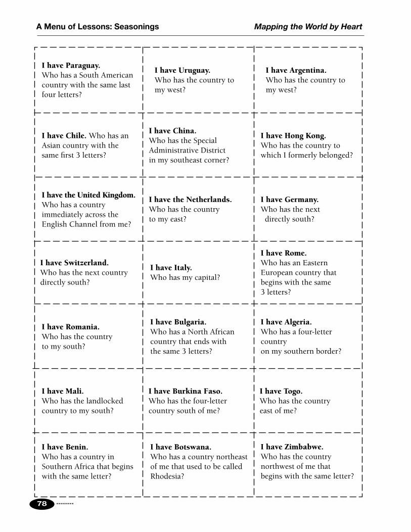
.........78
Mapping the World by HeartA Menu of Lessons: Seasonings
I have Paraguay. Who has a South American country with the same last four letters?
I have Chile. Who has an Asian country with the same first 3 letters?
I have the United Kingdom. Who has a country immediately across the English Channel from me?
I have Switzerland. Who has the next country directly south?
I have Romania. Who has the country to my south?
I have Mali. Who has the landlocked country to my south?
I have Uruguay.Who has the country to my west?
I have Argentina.Who has the country to my west?
I have China.Who has the Special Administrative District in my southeast corner?
I have Hong Kong.Who has the country to which I formerly belonged?
I have the Netherlands.Who has the country to my east?
I have Germany.Who has the next directly south?
I have Italy.Who has my capital?
I have Rome.Who has an Eastern European country that begins with the same 3 letters?
I have Bulgaria.Who has a North African country that ends with the same 3 letters?
I have Algeria.Who has a four-letter country on my southern border?
I have Burkina Faso.Who has the four-letter country south of me?
I have Togo.Who has the country east of me?
I have Benin. Who has a country in Southern Africa that begins with the same letter?
I have Botswana.Who has a country northeast of me that used to be called Rhodesia?
I have Zimbabwe.Who has the country northwest of me that begins with the same letter?

......... 79
Mapping the World by Heart A Menu of Lessons: Seasonings
I have Zambia. Who has my main river?
I have the Zambezi.If you follow me to my mouth, what country will you be in?
I have Mozambique.Who has the country on my northern border?
I have Tanzania. Who has the country northeast of me?
I have Kenya.Who has the only country that borders me to the east?
I have Somalia.Who has the country directly across the Gulf of Aden?
I have Yemen. Who has the large country that borders me on my north?
I have Saudi Arabia.Who has the country directly across the Persian Gulf from me?
I have Iran.Who has my capital?
I have Tehran. Who has the next capital city I get to going west?
I have Baghdad.Who has the country of which I am the capital?
I have Iraq.Who has the country north of me?
I have Turkey. Who has a former Republic of the USSR that touches me on my eastern boarder?
I have Georgia.Who has another former Republic of the USSR?
I have Estonia.Who has the country west across the Baltic Sea?
I have Sweden. Who has the formerly divided city south of me across the Baltic Sea?
I have Berlin. Who has the next country immediately east of my country?
I have Poland.Who has the country in South America that begins with the same first letter?


Mapping the World by Heart
.........
A Menu of Lessons: Dessert
A Menu of Lessons
81
DessertWhatever you decide to do as a summary/synthesis activity goes here. Instructions are included for your students to create memory maps of the world — to “map the world by heart”.
I usually spend about 4 weeks to get students ready to make these maps. I begin by copying blank grids and giving several to each student. We work as a class on the outlines of the continents, starting with the west coast of Africa, near 0o, 0o. We practice a few minutes in class on a new bit of coastline each day. At home, students review countries, capitals, etc., and go over the outlines learned up to that point.
It takes time and practice, but if you plan to start the review about 6 or 7 weeks before school ends, you’ll be ready to start the maps 2 or 3 weeks before closing. The final maps are made over a period of 15 days or so, one period per day.
While making the final maps, the students are allowed to review at home, but no maps, atlases, or other reference materials are allowed in the classroom. I permit conversation while they work (not about maps), but no moving around the room. I usually play some quiet music on a CD or computer.
The “Mapping the World Checklist” that appears at the end of this section is a partial listing of the countries, cities, and features that students may want to include in their final maps. It is meant to serve as a guide; that is, I don’t expect children to include everything that appears on the list. (They will undoubtedly surprise you with the places they do put on their maps!)
A note about materials: I have students use drawing board to make their final maps — for example, Bristol board or architect’s board. You can get this at most art supply stores. It comes in sheets that measure 30" x 20", and I have the store cut them down to 27" x 17" size. (I save the 3" wide strips for students to use as straight edges in making their maps.)

.........82
Student Handout Mapping the World by Heart
Materials for Making Final MapsYou do not have to provide any of the following; however, you will probably find it more useful and convenient if you have your own equipment than if you are always waiting for your turn to use the classroom equipment.
• One or two hard pencils: #4 is best, but 2H, 3H, 5H, or even 6H are OK.
• One or two black razor-point pens: any pen that makes small, thin, fine lines in black ink.
• Razor-point pens in other colors for labeling (suggested: red, blue, green).
• An excellent eraser — ArtGum or similar — that leaves no residue.
• A set of colored pencils.
• White-out.

......... 83
Mapping the World by Heart Student Handout
Important Reminders• Make every line very light until you are sure.• Mark everything with your name in some clear,
noticeable way.
Making the GridStart with a piece of paper or board that measures 27" x 17". First you will make a 21" x 13" rectangle that is centered on your board, as follows:
1. Near the bottom of the paper, measure in from the RIGHT 3" and make a mark. Near the top, do the same. Connect the dots. The line should go LIGHTLY from top to bottom.
2. Near the bottom of the paper, measure in from the LEFT 3" and make a mark. Near the top, do the same. Connect the dots. The line should go LIGHTLY from top to bottom.
3. Near the left side, measure up from the bottom 2" and make a mark. Near the right side, do the same. Connect the dots.
4. Near the left side, measure down from the top 2" and make a mark. Near the right side, do the same. Connect the dots.
5. You now have the basic rectangular pattern for the grid. Double check every measurement. Make sure that your rectangle is 21" x 13", and erase any lines outside of the basic rectangle. Measure the diagonals –– if they are not the same, something is tilted.
6. When you are completely satisfied, go over your light pencil lines with a black razor-point pen.
The Lines of Longitude (very hard!)Across the bottom of your rectangle, start at the RIGHT and measure and mark on your bottom grid line units of 7/8 of an inch. As you measure across you should end up with 24 sections, each exactly 7/8 of an inch. If the last section isn’t exact, don’t panic. Just go back and find the error, or ask for help.
Steps for Making Final Maps
I. Creating a Mercator Grid (very challenging!)

.........84
Student Handout Mapping the World by Heart
Across the top, again start at the RIGHT and measure and mark the same units of 7/8". Again, you should have 24 sections, each exactly 7/8". If not, fix it now. Connect the dots, slowly, carefully, and accurately. The center line is 0°. Each of the furthest sides is 180°, and each line is 15° from its neighbor.
The Lines of Latitude (not quite as hard but difficult)1. Measure up from the bottom, on both sides, a distance of
1 1/2". Mark on both sides.2. The next line is 1 1/8" above that line.3. The next is 15/16" up.4. The next is 13.5/16" up (this is a hard one to measure).
Continuing up, the measurements repeat, but backward:5. 13.5/16"6. 15/16"7. 1 1/8"8. 1 1/2"9. Finally, measure 2 1/2" up.
After you have measured these distances on both sides, make sure that the remaining space between the top mark and the top of the grid is the SAME ON BOTH SIDES. If not, find the error and fix it. Then connect the dots. The lowest line on the grid is 60° S, then 45° S, then 30° S, then 15° S, then 0° (the equator); then come 15° N, 30° N, 45° N, 60° N, and 75° N.
The tropics are the same distance north OR south of the equator. That distance is 21.5/16" (one and a half sixteenths greater than an inch and a quarter).
The Arctic Circle is 13/16" north of 60° N.
Creating an Equirectangular Grid (not so challenging)To make an equirectangular grid, make the outside of the grid 15" x 21", and use the same lines of longitude. Latitude lines will be evenly spaced, 1 1/4" apart, giving you 12 sections each of which represents 15°.

......... 85
Mapping the World by Heart Student Handout
II. Making the MapOnce you have laid out the grid and are satisfied (please ask for help several times along the way), you are ready to begin.
Here are the steps. You MUST do 1, then 2, then 3 — in that order. After that, you may do what you can in any order you find convenient.
1. In light pencil outline the continents. Include islands you know. Make the lines very light so that corrections are painless.
2. Trace along the outlines you just drew, using black razor-point pen. Errors are more serious here, so be very careful. Correct carefully, using small amounts of white-out.
3. Shade along the water side of these lines using a blue colored pencil; go out from the continent edges no more than 1/8".
4. Mark country borders; shade country borders; label countries.
5. Label oceans, seas, and gulfs.
6. Mark and label rivers, mountains, and other features.
7. Be sure to label the tropics, the Arctic Circle, and some of the lines of latitude and longitude.
8. Include a compass rose.
9. Include a title/key box with the following information:
• Title
• Your name
• Date
• The words MERCATOR PROJECTION (or whichever projection you are using)
• Any color key your particular shading/labeling needs
10. Decorate as you wish, both on the map face and in the margins (with boats, fish, etc.).
Steps for Making Final Maps

.........86
Student Handout Mapping the World by Heart
The AmericasArgentina Dominican Republic MexicoBahamas Ecuador NicaraguaBelize El Salvador PanamaBolivia Falkland Islands ParaguayBrazil French Guiana PeruCanada* Guatemala SurinameChile Guyana Trinidad & TobagoColombia Haiti United StatesCosta Rica Honduras UruguayCuba Jamaica Venezuela
*Provinces and Territories of CanadaAlberta Northwest Territories Prince Edward IslandBritish Columbia Nova Scotia QuébecManitoba Nunavut SaskatchewanNew Brunswick Ontario YukonNewfoundland
EuropeAlbania Greece NorwayAndorra Greenland PolandAustria Holland PortugalBelgium Hungary RomaniaBosnia/Herzegovina Iceland San MarinoBulgaria Ireland SerbiaCroatia Italy Slovak Rep.Cyprus Latvia SloveniaCzech Republic Liechtenstein SpainDenmark Lithuania SwedenEstonia Luxembourg SwitzerlandFinland Monaco United KingdomFrance Macedonia (FYROM)Germany Montenegro
Mapping the World: Sample ChecklistUse this or devise your own.
A partial list of countries, features, and cities. For complete listings see individual checklists.

......... 87
Mapping the World by Heart Student Handout
Former Soviet UnionArmenia Kazakhstan TajikistanAzerbaijan Kyrgyz Republic TurkmenistanBelarus Moldova UkraineGeorgia Russia Uzbekistan
AfricaAlgeria Gabon NigeriaAngola The Gambia RwandaBenin Ghana Sao Tome & PrincipeBotswana Guinea SenegalBurkina Faso Guinea-Bissau Sierra LeoneBurundi Ivory Coast SomaliaCabinda Kenya South AfricaCameroon Lesotho SudanCanary Islands Liberia SwazilandCentral African Republic Libya TanzaniaChad Madagascar TogoComoros Islands Malawi TunisiaCongo Mali UgandaCongo, Democratic Republic of Mauritania Western SaharaDjibouti Morocco ZambiaEgypt Mozambique ZimbabweEquatorial Guinea NamibiaEthiopia Niger
Southwest AsiaIran Lebanon TurkeyIraq Oman United Arab EmiratesIsrael Qatar YemenJordan Saudi ArabiaKuwait Syria

.........88
Student Handout Mapping the World by Heart
Asia & OceaniaAfghanistan India PakistanBangladesh Japan PhilippinesBhutan Laos SingaporeBrunei Malaysia South KoreaCambodia Mongolia Sri LankaChina Myanmar (Burma) Taiwan Hong Kong (S.A.R.) Nepal Thailand Macao (S.A.R.) North Korea Vietnam
Australia* New Caledonia Papua New GuineaFiji New Hebrides SamoaIndonesia New Zealand Solomon Islands
*Australian StatesNew South Wales South Australia VictoriaNorthern Territory Tasmania Western AustraliaQueensland

......... 89
Mapping the World by Heart Student Handout
Mountains & Other FeaturesAlps Atlas Mountains PyreneesAndes Caucasus Rocky MountainsAppalachians Gobi Desert Sahara DesertApennines Himalayas Urals
Oceans, Seas, & GulfsAdriatic Sea Caspian Sea Mediterranean SeaArabian Sea E. China Sea North SeaAral Sea E. Siberian Sea Pacific (N,S) OceanArctic Ocean Gulf of Aden Persian GulfAtlantic (N,S) Ocean Gulf of Bothnia Red SeaBaffin Bay Gulf of California Sea of JapanBaltic Sea Gulf of Mexico Sea of OkhotskBarents Sea Gulf of Oman So. China SeaBay of Bengal Gulf of St. Lawrence Tasman SeaBay of Biscay Hudson Bay Tyrrhenian SeaBering Sea Indian Ocean White SeaBlack Sea Kara Sea Yellow SeaCaribbean Sea Laptev Sea
RiversAmazon River Mississippi River Tigris RiverAmur River Missouri River Ural RiverBrahmaputra River Nelson River Uruguay RiverCongo River Niger River Volga RiverDanube River Nile River Yangtze RiverEuphrates River Ob River Yellow RiverGanges River Orange River Yenisey RiverIndus River Orinoco River Yukon RiverLena River Parana River Zambezi RiverMackenzie River Rio Grande RiverMekong River St. Lawrence River
Geographic Features

.........90
Student Handout Mapping the World by Heart
Some cities of the worldA selection of important cities. You may, of course, include as many more as you wish in your review and on your memory map.
Addis Ababa Hanoi Phnom PenhAnkara Harare Port-au-PrinceAthens Havana PragueBaghdad Islamabad PyongyangBangkok Jerusalem QuitoBeijing Kabul RabatBelgrade Kampala RangoonBerlin Karachi Rio de JaneiroBern Kathmandu RomeBogotá Khartoum SantiagoBonn Kinshasa SeoulBucharest Kuala Lumpur SofiaBudapest Lagos StockholmBuenos Aires Lisbon TaipeiCairo London TehranCanberra Madrid TiranaCape Town Manila TokyoCaracas Mexico City TripoliCayenne Mogadishu TunisColombo Monrovia ViangchanCopenhagen Moscow ViennaDacca Nairobi WarsawDakar New Delhi Washington, DCDar es Salaam Oslo WellingtonDublin OttawaGaborone Paris

Mapping the World by Heart
.........
Further Study: Resources
91
Further Study
Resources

.........92
Mapping the World by HeartFurther Study: Resources
A random list of thoughts to encourage further explorationThis “brainstormed” list may help trigger some ideas about how to nudge your students further into the study of geography. Choose the items that interest you and then do some brainstorming of your own!• What is geography?
- etymology
- samples of maps, from “you are here” to Peters World Map
- what we use maps for
• How we get maps
- a globe is the best map, but ...
- the grapefruit lesson and projections
• What maps tell us
- types of maps
• Make your own map collection
- go on a map hunt
• Old maps vs. new maps
- Terra Australis Incognita = Australia
- Which way is up?
• What’s wrong with this picture?
- Deliberate mistakes to fool plagiarists
- Map with errors (e.g., “find 50 errors in this US map...”)
• Map puzzles
- Sir Walter Raleigh/Roanoke/Cro Croatoan
- Captain Kidd’s Treasure
• Where on Earth are you?
- You’re lost, you have a map — how can you figure out your location?
- You have a map, but you don’t know what it’s a map OF...
• Rivers flow downhill (and other truths of geography)
- Making a river
- East and west (and north and south)
• E pluribus unum: regions are made up of parts
- 50 states, 12 provinces, 12 independent states
Springboards to Further Study

......... 93
Mapping the World by Heart Further Study: Resources
• Different ways of looking at the same map: maps have lots of information
- borders; highways; airports; shopping centers
• Unusual maps
- photomosaics from space
- DNA and genetic mapping
• Upside down/right side up: there’s no “right” way
- “upside down” world map
- identify states, etc., upside down
• Rotation and revolution
- The Earth rotates; we get day and night
- The Moon revolves around the Earth; we get months, tides, eclipses
- The Earth revolves around the Sun; we get seasons, years, length of days
• Making a sundial
• Lost and found
- Samples of “lost” stories
- Collect some “getting lost & getting found” stories
- If you are lost, what are your options?
• Grids
- Battleship (game using paper grids or graph paper)
- Math (X, Y) coordinates
- Latitude & longitude
• Antipodes: dig right through the center of the Earth and where are you?
• Mapmaking do’s and don’ts
• Taking care of a map collection
• Geography in daily life
- Where does your water come from?
- Where does your weather come from?
• How many colors do I need?
- 4-color challenge on U.S. map
• Scales & sizes
• Keys & other markings

.........94
Mapping the World by HeartFurther Study: Resources
• Distance
- How far is it from here to there?
- How long will it take?
• Making a map you can use
- Baseball teams (NBA teams, NHL teams, etc.) map
- Empires map
- Map colleges I’m interested in
- Places I’ve been (places I want to go...)
- Treasure Map
- Neighborhood Map
- Rearranging your room, classroom, or other place
• How features affect life
- Mountain ranges (life in Himalayas vs. lowlands of Nepal)
- Deserts (life in Sahara, in Sahel, in Sub-Saharan Africa)
- Islands (life on Isle of Shoals vs. life in Portsmouth)
• What time is it?
- Time zones
- International Date Line
- What time should I call my friend in Europe? Australia?
• How do places get named?
• Thematic maps
- Population
- Religion
- Language
- Birth & Death Rates, Literacy, GNP, etc.
• Borders
- Who makes them
- Why they are located where they are
• Landlocked countries and other special situations
• Direction
- The names of the cardinal directions and how to use them
- Following directions
- Giving directions

......... 95
Mapping the World by Heart Further Study: Resources
• Mnemonics
- “George Eaton’s Old Grandpa Rode A Pale Horse Yesterday”
- “That Venezuelan Guy is Surely French”
- “WBKL in East Siberia”
• Tongue twisters in different languages
- Red leather, yellow leather
- Red lorry, yellow lorry
- Kvistfritt kvastskaft (Swedish: Knot-free broom-handle)
- Packe pappas kappsack (Swedish: Pack Pappa’s suitcase)
• Contour maps
- How to read elevation
- What does the land look like?
• Erroneous beliefs, past and present
• Decorations on maps, traditional, creative, etc.
• Curvature and the horizon
- Long swimming or reflecting pools must take this into account or the water level is uneven
• Migration: people, birds, etc.
• Movement: shipping, air travel, roads, etc.

.........96
Mapping the World by HeartFurther Study: Resources
Resources for Geography in the ClassroomThe Mapping the World by Heart Website:
Instead of listing dozens of resources here, we list just one: David Smith’s Mapping the World by Heart website. It is continually updated:
• http://www.mapping.com
In the navigation bar on the website, click on “Educators” for educational and geographic links; “World Facts” for country lists and information; and “Mapping the World by Heart” for samples of final maps.

......... 97
Mapping the World by Heart Further Study: Resources
Standard TimeBefore 1884, time was “true”. Noon occurred in each town at the exact moment that the sun reached the point directly overhead. Trains — particularly long-distance and transcontinental trains — changed that. In the era before time zones, passengers on coast-to-coast trips might well have had to change their watches dozens of times to correspond with the “correct” time in each of the places they were traveling through. Schedules were similarly scrambled and confusing.
According to the history books, a single event caused the monumental decision to be made that corrected this problem. The event occurred in England in 1880. A judge ruled against a man who arrived two minutes late for a court case involving a land dispute. In his appeal, the man argued that he was on time according to the station clock in his home town, and the case was retried. This case led to a Parliamentary Order requiring the entire country to set its clocks by Greenwich Mean Time.
In 1884, an international conference finally resolved the problem worldwide by decreeing a unified system of standardized time zones, each representing approximately 15 degrees of longitude, with variations for local geography and with each country free to alter or vary its local time to meet local needs. Thus, some large countries, such as China, have only one time zone; and there are many countries whose local time is 30 minutes off of the “correct” standard time zone. Greenwich Mean Time (or “GMT”), the standard time at the Naval Observatory in Greenwich, England, is now called “Coordinated Universal Time,” and is abbreviated “UCT”.
As you cross from one time zone to the next, you normally move your clock one hour: one hour back if you’re going west, one hour forward if you’re going east. The International Date Line represents the agreed-upon point where, instead of going ahead one hour as you cross it from west to east, you go back 23 hours (and forward 23 hours if you are going from east to west). Thus, passengers on the 12-hour flight from Los Angeles to Sydney, leaving late at night on Tuesday, would completely miss Wednesday and arrive Thursday morning. (They make this up going back to LA. Leave Sydney Tuesday morning at noon, and arrive in LA Tuesday morning at 9:00 AM!) For minimum confusion, the best way to think about the Date Line and times around it is to completely ignore it. If you’re in Hong Kong, and you want to know the time and day in New York, it’s easier to subtract 13 hours from your clock than to “add 11 hours, and subtract 24”. From LA to Tokyo, it’s clearer if you remember to add 17 hours than to remember “they’re 7 hours behind us tomorrow”.

.........98
Mapping the World by HeartFurther Study: Resources
Countries politically organized into a state with a definite territory, recognized as independent by the U.S.
Total count of states: 194
* Diplomatic relations with the United States
+ Member of United Nations
As you scan this list, remember that the Vatican (Holy See) is not a UN member, but has observer status. Taiwan is a non-member without observer status. Also, the following small island nations are non-members: Cook Islands, Kiribati, Nauru, Niue, Tonga, and Tuvalu.
U.S. State Department — Independent States in the World (2010)
Short-Form Name Long-Form Name CapitalAfghanistan *+ Islamic State of Afghanistan KabulAlbania *+ Republic of Albania TiranaAlgeria *+ People’s Democratic Republic of Algeria AlgiersAndorra *+ Principality of Andorra Andorra la VellaAngola *+ Republic of Angola LuandaAntigua and Barbuda *+ (no long-form name) Saint John’sArgentina *+ Argentine Republic Buenos AiresArmenia *+ Republic of Armenia YerevanAustralia *+ Commonwealth of Australia CanberraAustria *+ Republic of Austria ViennaAzerbaijan *+ Republic of Azerbaijan BakuBahamas, The *+ Commonwealth of The Bahamas NassauBahrain *+ Kingdom of Bahrain ManamaBangladesh *+ People’s Republic of Bangladesh DhakaBarbados *+ (no long-form name) BridgetownBelarus *+ Republic of Belarus MinskBelgium *+ Kingdom of Belgium BrusselsBelize *+ (no long-form name) BelmopanBenin *+ Republic of Benin Porto-NovoBhutan + Kingdom of Bhutan ThimphuBolivia *+ Plurinational State of Bolivia La Paz (administrative)
Sucre (legislative/judiciary)

......... 99
Mapping the World by Heart Further Study: Resources
Short-Form Name Long-Form Name CapitalBosnia and Herzegovina *+ (no long-form name) SarajevoBotswana *+ Republic of Botswana GaboroneBrazil *+ Federative Republic of Brazil BrasíliaBrunei *+ Brunei Darussalam Bandar Seri BegawanBulgaria *+ Republic of Bulgaria SofiaBurkina Faso *+ Burkina Faso OuagadougouBurma *+ Union of Burma Rangoon
Nay Pyi Taw (administrative)Burundi *+ Republic of Burundi BujumburaCambodia *+ Kingdom of Cambodia Phnom PenhCameroon *+ Republic of Cameroon YaoundéCanada *+ (no long-form name) OttawaCape Verde *+ Republic of Cape Verde PraiaCentral African Republic *+ Central African Republic BanguiChad *+ Republic of Chad N’DjamenaChile *+ Republic of Chile SantiagoChina *+ People’s Republic of China BeijingColombia *+ Republic of Colombia BogotáComoros *+ Union of the Comoros MoroniCongo (Brazzaville) *+ Republic of the Congo BrazzavilleCongo (Kinshasa) *+ Democratic Republic of the Congo KinshasaCosta Rica *+ Republic of Costa Rica San JoséCôte d’Ivoire *+ Republic of Côte d’Ivoire YamoussoukroCroatia *+ Republic of Croatia ZagrebCuba + Republic of Cuba HavanaCyprus *+ Republic of Cyprus NicosiaCzech Republic *+ Czech Republic PragueDenmark *+ Kingdom of Denmark CopenhagenDjibouti *+ Republic of Djibouti DjiboutiDominica *+ Commonwealth of Dominica RoseauDominican Republic *+ Dominican Republic Santo DomingoEcuador *+ Republic of Ecuador QuitoEgypt *+ Arab Republic of Egypt CairoEl Salvador *+ Republic of El Salvador San SalvadorEquatorial Guinea *+ Republic of Equatorial Guinea MalaboEritrea *+ State of Eritrea AsmaraEstonia *+ Republic of Estonia TallinnEthiopia *+ Federal Democratic Republic of Ethiopia Addis AbabaFiji *+ Republic of the Fiji Islands SuvaFinland *+ Republic of Finland Helsinki

.........100
Mapping the World by HeartFurther Study: Resources
Short-Form Name Long-Form Name CapitalFrance *+ French Republic ParisGabon *+ Gabonese Republic LibrevilleGambia, The *+ Republic of The Gambia BanjulGeorgia *+ Georgia T’bilisiGermany *+ Federal Republic of Germany BerlinGhana *+ Republic of Ghana AccraGreece *+ Hellenic Republic AthensGrenada *+ (no long-form name) Saint George’sGuatemala *+ Republic of Guatemala GuatemalaGuinea *+ Republic of Guinea ConakryGuinea-Bissau *+ Republic of Guinea-Bissau BissauGuyana *+ Co-operative Republic of Guyana GeorgetownHaiti *+ Republic of Haiti Port-au-PrinceHoly See * Holy See Vatican CityHonduras *+ Republic of Honduras TegucigalpaHungary *+ Republic of Hungary BudapestIceland *+ Republic of Iceland ReykjavíkIndia *+ Republic of India New DelhiIndonesia *+ Republic of Indonesia JakartaIran + Islamic Republic of Iran TehranIraq *+ Republic of Iraq BaghdadIreland *+ (no long-form name) DublinIsrael *+ State of Israel JerusalemItaly *+ Italian Republic RomeJamaica *+ (no long-form name) KingstonJapan *+ (no long-form name) TokyoJordan *+ Hashemite Kingdom of Jordan AmmanKazakhstan *+ Republic of Kazakhstan AstanaKenya *+ Republic of Kenya NairobiKiribati *+ Republic of Kiribati TarawaKorea, North + Democratic People’s Republic of Korea PyongyangKorea, South *+ Republic of Korea SeoulKosovo * Republic of Kosovo PristinaKuwait *+ State of Kuwait KuwaitKyrgyzstan *+ Kyrgyz Republic BishkekLaos *+ Lao People’s Democratic Republic VientianeLatvia *+ Republic of Latvia RigaLebanon *+ Lebanese Republic BeirutLesotho *+ Kingdom of Lesotho Maseru

......... 101
Mapping the World by Heart Further Study: Resources
Short-Form Name Long-Form Name CapitalLiberia *+ Republic of Liberia MonroviaLibya *+ Great Socialist People’s Libyan Arab
Jamahiriya Tripoli
Liechtenstein *+ Principality of Liechtenstein VaduzLithuania *+ Republic of Lithuania VilniusLuxembourg *+ Grand Duchy of Luxembourg LuxembourgMacedonia (FYROM) *+ The Former Yugoslav Republic of Macedonia SkopjeMadagascar *+ Republic of Madagascar AntananarivoMalawi *+ Republic of Malawi LilongweMalaysia *+ (no long-form name) Kuala LumpurMaldives *+ Republic of Maldives MaleMali *+ Republic of Mali BamakoMalta *+ Republic of Malta VallettaMarshall Islands *+ Republic of the Marshall Islands MajuroMauritania *+ Islamic Republic of Mauritania NouakchottMauritius *+ Republic of Mauritius Port LouisMexico *+ United Mexican States MexicoMicronesia, Federated States of *+
Federated States of Micronesia Palikir
Moldova *+ Republic of Moldova ChisinauMonaco *+ Principality of Monaco MonacoMongolia *+ (no long-form name) UlaanbaatarMontenegro *+ Montenegro PodgoricaMorocco *+ Kingdom of Morocco RabatMozambique *+ Republic of Mozambique MaputoNamibia *+ Republic of Namibia WindhoekNauru *+ Republic of Nauru Yaren District (no capital city)Nepal *+ Federal Democratic Republic of Nepal KathmanduNetherlands *+ Kingdom of the Netherlands Amsterdam, The Hague:
(seat of government)New Zealand *+ (no long-form name) WellingtonNicaragua *+ Republic of Nicaragua ManaguaNiger *+ Republic of Niger NiameyNigeria *+ Federal Republic of Nigeria AbujaNorway *+ Kingdom of Norway OsloOman *+ Sultanate of Oman MuscatPakistan *+ Islamic Republic of Pakistan IslamabadPalau *+ Republic of Palau MelekeokPanama *+ Republic of Panama PanamaPapua New Guinea *+ Independent State of Papua New Guinea Port Moresby

.........102
Mapping the World by HeartFurther Study: Resources
Short-Form Name Long-Form Name CapitalParaguay *+ Republic of Paraguay AsunciónPeru *+ Republic of Peru LimaPhilippines *+ Republic of the Philippines ManilaPoland *+ Republic of Poland WarsawPortugal *+ Portuguese Republic Lisbon
Qatar *+ State of Qatar DohaRomania *+ (no long-form name) BucharestRussia *+ Russian Federation MoscowRwanda *+ Republic of Rwanda KigaliSaint Kitts and Nevis *+ Federation of Saint Kitts and Nevis BasseterreSaint Lucia *+ (no long-form name) CastriesSaint Vincent and the Grenadines *+
(no long-form name) Kingstown
Samoa *+ Independent State of Samoa ApiaSan Marino *+ Republic of San Marino San MarinoSao Tome and Principe *+ Democratic Republic of Sao Tome and
Principe São Tomé
Saudi Arabia *+ Kingdom of Saudi Arabia RiyadhSenegal *+ Republic of Senegal DakarSerbia*+ Republic of Serbia BelgradeSeychelles *+ Republic of Seychelles VictoriaSierra Leone *+ Republic of Sierra Leone FreetownSingapore *+ Republic of Singapore SingaporeSlovakia *+ Slovak Republic BratislavaSlovenia *+ Republic of Slovenia LjubljanaSolomon Islands *+ (no long-form name) HoniaraSomalia *+ (no long-form name) MogadishuSouth Africa *+ Republic of South Africa Pretoria (administrative)
Cape Town (legislative)Bloemfontein (judicial)
Spain *+ Kingdom of Spain MadridSri Lanka *+ Democratic Socialist Republic of Sri Lanka Colombo
Sri Jayewardenepura Kotte (legislative)
Sudan *+ Republic of the Sudan KhartoumSuriname *+ Republic of Suriname ParamariboSwaziland *+ Kingdom of Swaziland Mbabane (administrative)
Lobamba (legislative)Sweden *+ Kingdom of Sweden StockholmSwitzerland *+ Swiss Confederation Bern

......... 103
Mapping the World by Heart Further Study: Resources
Short-Form Name Long-Form Name CapitalSyria *+ Syrian Arab Republic DamascusTajikistan *+ Republic of Tajikistan DushanbeTanzania *+ United Republic of Tanzania Dar es Salaam
Dodoma (legislative)Thailand *+ Kingdom of Thailand BangkokTimor-Leste *+ Democratic Republic of Timor-Leste DiliTogo *+ Togolese Republic LoméTonga *+ Kingdom of Tonga Nuku’alofaTrinidad and Tobago *+ Republic of Trinidad and Tobago Port-of-SpainTunisia *+ Tunisian Republic TunisTurkey *+ Republic of Turkey AnkaraTurkmenistan *+ (no long-form name) AshgabatTuvalu *+ (no long-form name) FunafutiUganda *+ Republic of Uganda KampalaUkraine *+ (no long-form name) KyivUnited Arab Emirates *+ United Arab Emirates Abu DhabiUnited Kingdom *+ United Kingdom
of Great Britain and Northern Ireland London
United States + United States of America Washington, DCUruguay *+ Oriental Republic of Uruguay MontevideoUzbekistan *+ Republic of Uzbekistan TashkentVanuatu *+ Republic of Vanuatu Port-VilaVenezuela *+ Bolivarian Republic of Venezuela CaracasVietnam *+ Socialist Republic of Vietnam HanoiYemen *+ Republic of Yemen SanaaZambia *+ Republic of Zambia LusakaZimbabwe *+ Republic of Zimbabwe Harare
Exception:Taiwan (no long-form name) Taipei Recognized by the U.S. as part of People's Republic of China

.........104
Mapping the World by HeartFurther Study: Resources
Embassies in Washington, DCEmbassies are a great resource for maps, country and cultural information, and more. Visit this website for contact information for embassies in Washington, DC: http://www.embassy.org/embassies
Top LanguagesThere are nearly 6,000 languages in the world today. However, if you can say “hello”, “goodbye”, and “thank you” in just these 13 languages, you can be polite to about 70 percent of the world’s population.
*Bahassa is the name of the family of languages spoken in Indonesia, Malaysia, and Brunei. Taken together as a single family, Bahassa would be number 4 on the list. The phrases here are from Bahassa Indonesia.
Language Hello Goodbye Thank youChinese Ni Hao Zai jian Xie xieEnglish Hello Goodbye Thank youHindi Namaste Namaste Djan-ja-vaadSpanish Hola Adios GraciasArabic Salaam Aleykum
(or Ahlan)Ma’asalaama Shukran
Bengali Namashkar Khoda Hafez Djan-ja-badPortuguese Bom Dia
(or Hola)Adeus (or Ciao) Obrigado (male speaker)
Obrigada (female speaker)Russian Privyets
(or Zdrazvooitye)Doh Sveedonya Spah-see-bah
Bahassa* Hai Pur-mee-see Treema KahseeFrench Bonjour Au revoir MerciJapanese Konnichi-wa Sayonara ArigatoGerman Guten Tag Auf Wiedersehen DankeUrdu Salaam Aleykum Khuda Hafiz Shukriya


.........108
Mapping the World by HeartFurther Study: Resources
1. 365.25 days (actually 365 days, 6 hours, 9 minutes, and 9.5 seconds).
2. 24 hours (actually 23 hours, 56 minutes, 4.091 seconds).3. 24,901.55 miles around the equator.4. 90 degrees.5. latitude.6. A continent; or, more precisely, the westernmost part of the large
continent called Eurasia, beginning at the Ural Mountains.7. Sri Lanka (cap. Colombo).8. Germany & Poland.9. Liechtenstein, Switzerland, Italy, Slovenia, Hungary, Slovak
Republic, Czech Republic, and Germany.10. Germany & Belgium.11. The Netherlands.12. Morocco, Algeria, Tunisia, Libya, Egypt.13. Guyana, Suriname, French Guiana.14. Bolivia & Paraguay.15. Belize, Honduras, Guatemala, El Salvador, Nicaragua, Costa
Rica, Panama.16. Yellow (or Huang Ho) & Yangtze.17. Yemen, Oman, UAE, Qatar, Kuwait, Iraq, Jordan, Egypt.18. Cambodia, Laos, China.19. Mali, Niger, Chad, Burkina Faso, Central African Republic,
Uganda, Rwanda, Burundi, Zambia, Zimbabwe, Botswana, Lesotho, Swaziland. In addition, Ethiopia is now landlocked because its former province of Eritrea is now an independent nation.
20. Tasman Sea.21. Belarus, Ukraine, Moldova, Georgia, Armenia, Azerbaijan,
Kazakhstan, Uzbekhistan, Turkmenistan, Kyrgyzstan, Tajikistan, Russia, Estonia, Latvia, and Lithuania.
22. The provinces are: Newfoundland, Prince Edward Island, Nova Scotia, New Brunswick, Québec, Ontario, Manitoba, Saskatchewan, Alberta, British Columbia. The three territories are: Yukon, Northwest Territories, and Nunavut.
Answer Key for World Test #1

......... 109
Mapping the World by Heart Further Study: Resources
1. Countries where Portuguese is a major language: Angola, Brazil, Cape Verde, Guinea Bissau, Mozambique, Portugal, Macao, Sao Tome & Principe.
2. Countries where English is a major language, one per continent: North America: USA, Canada; South America: Trinidad & Tobago, Falkland Islands, Guyana; Europe: U.K.; Africa: South Africa, Kenya, other former British colonies; Asia: India, Hong Kong, Philippines; Oceania: Australia, New Zealand.
3. There are at least 50 countries where Islam is a major religion: Among the biggest are Algeria, Bangladesh, Brunei, Egypt, Ethiopia, Indonesia, Iran, Iraq, Kuwait, Lebanon, Libya, Malaysia, Morocco, Niger, Nigeria, Pakistan, Sudan, Syria, Turkey.
4. Places that are colonies: Greenland (Denmark); French Guiana, Guadeloupe, Martinique, and other French overseas departments and territories; Curacao, Aruba, Bonaire, St. Maarten (Netherlands); Falkland Islands, Tristan da Cunha, Pitcairn Island, and several other dependencies (United Kingdom); Guam, American Samoa, Northern Marianas (U.S.).
5. Countries with a desert, one per continent: North America: USA (Painted Desert, Arizona); South America: Chile (Atacama); Africa: South Africa (Kalahari); Asia: Mongolia (Gobi); Australia: Australia (Great Australian); Europe: no deserts in Europe.
6. West to east.7. West to east.8. There are endless possible answers. Here are some samples: In
Los Angeles it is 12:00 noon; Denver=1:00 p.m.; Chicago=2:00 p.m.; Caracas=4:00 p.m.; Rio de Janeiro=5:00 p.m.; London=8:00 p.m.; Rome=9:00 p.m.; Athens=10:00 p.m.; Moscow=11:00 p.m.; Bangkok=3:00 a.m. next day; Hong Kong=4:00 a.m. next day; Tokyo=5:00 a.m. next day; Sydney=6:00 a.m. next day.
9. Rain forests: Brazil; Honduras, Nicaragua, Costa Rica, Panama; Nigeria, Cameroon, C.A.R., Congo (Kinshasa), Congo (Brazzaville); Madagascar; India, Bangladesh, Myanmar, Thailand, Vietnam; Malaysia; Indonesia; Philippines.
10. High birth rates, high death rates, and low life expectancy: Afghanistan, Sierra Leone, Ethiopia, Guinea, Somalia, Niger, Angola, Mali, C.A.R., Chad, Senegal, Benin, Malawi, Mozambique, Mauritania, Burkina Faso.
11. Low birth rates, low death rates, and high life expectancy: Japan, Sweden, Netherlands, Canada, Switzerland, Norway, Spain, Denmark, Greece, U.S.A., France, Italy, U.K., Australia.
Answer Key for World Test #2

.........110
Mapping the World by HeartFurther Study: Resources
12. Infinite possible “right” answers.13. West to east.14. Major automobile manufacturers: France, Germany, Italy, Japan,
Korea, Sweden, U.K., USA.15. Petroleum producers, by continent: Africa: Algeria, Nigeria,
Libya; Asia: Indonesia, Saudi Arabia, Iraq, Kuwait, Qatar, U.A.E., China; South America: Venezuela, Argentina, Brazil; North America: Canada, Mexico, USA; Europe: U.K., Norway, Russia; Oceania: Australia.


Mapping the U.S. by Heart
......... A1
Appendix AMapping the U.S. by Heart
Table of ContentsIntroduction .......................................................................... A3 Planning the Year .................................................................. A4Tips for Teachers .................................................................. A5Mnemonics ............................................................................ A6Some Things for Which States are Known ............................ A7Mapping the U.S. by Heart Checklists .................................. A8
General Considerations ...................................................... A8
Master Checklist of U.S. Locations and Features ............... A9
Checklist 1: Washington, Oregon, and Idaho ................... A11
Checklist 2: Montana and Wyoming .................................. A12
Checklist 3: Nevada and California .................................... A13
Checklist 4: Utah, Colorado, Arizona, and New Mexico ..................................................................... A14
Checklist 5: North Dakota, South Dakota, Nebraska, Kansas, and Oklahoma .................................................... A16
Checklist 6: Texas ............................................................... A18
Checklist 7: MIMAL: Minnesota, Iowa, Missouri, Arkansas, and Louisiana .................................................. A19
Checklist 8: MAGS: Mississippi, Alabama, Georgia, and South Carolina .......................................................... A21
Checklist 9: Florida, Tennessee, North Carolina ................ A22
Checklist 10: Wisconsin, Illinois, Michigan, Indiana, and Ohio ....................................................................... A23
Checklist 11: Kentucky, West Virginia, Virginia, and Washington, DC ....................................................... A25
Checklist 12: Pennsylvania, New York, New Jersey, Maryland, and Delaware .................................................. A26
Checklist 13: Maine, New Hampshire, and Vermont .................................................................... A28
Checklist 14: Massachusetts, Rhode Island, and Connecticut .............................................................. A29
Checklist 15: Hawai’i, and Alaska ...................................... A30
Extension Activities ............................................................ A31


......... 3......... A3
Mapping the U.S. by Heart
This appendix was designed to enrich and extend the “United States” section of Mapping the World by Heart to help teachers who wish to have their students map the U.S. “by heart”. It was created by David J. Smith and by Jim Dowd, a fourth-grade teacher in St. Louis whose students have mapped the U.S. by heart for many years.
Possibly, you’ve decided that Mapping the World by Heart is too hard, and mapping the U.S. would be less rigorous; well, you’re right AND wrong. It is somewhat easier to get a class ready to map the U.S., with its 50 political divisions (rather than 185+), but it really isn’t any easier to draw. When you add in labeling of states — plus cities, features, decorating, and the other steps necessary to complete the map — you’ll find it is still a major project requiring serious focus, preparation, and attention.
There are some schools where the U.S. is mapped in one grade, and the world a year or two later. Teachers in these schools acknowledge that they spend the same amount of time on their programs; and that U.S. states, because they are bigger on the final map, require more careful drawing, labeling, and coloring.
If you’re new to the Mapping the World by Heart idea, you might find it less daunting to try the program with just the U.S. the first year and then move on to the world (or get a teacher in the next grade interested).
In any case, as with Mapping the World by Heart, if you decide to try “Mapping the U.S. by Heart,” do it exactly the way your teacherly judgement dictates –– there is no right or wrong way to do this. It is a question of finding what fits best with your teaching style and your students’ abilities. Are they ready for a complex and detailed mapping experience? Would they be better served by focusing on the states and their names, without adding hundreds of cities and features? Do you want to focus on a particular region (e.g., The 13 Colonies, The Pacific Basin)?
Any of these approaches will serve you well; the decision is yours. Whatever you do, you will find tools to help you in these pages, and your students will benefit immensely.
Questions on “Mapping the U.S. by Heart”? Feel free to email: [email protected]
Introduction

.........4 .........A4
Mapping the U.S. by Heart
Here’s a broad outline to help you fit “Mapping the U.S. by Heart” into your school year. Adjust these guidelines to fit your time constraints and the particular content you have chosen.
A. Do the first six lessons from Mapping the World by Heart (the “Appetizer” section). Although these are world-oriented, they will help your students understand how maps work, how to read and draw maps, what latitude and longitude are, and more. Here are those six lessons; if you’ve already done them for Mapping the World by Heart, there’s no need to do them again.
1. Blank Grid Lesson (substitute blank U.S. grid for the world grid if you wish)
2. Grapefruit Lesson (a must for understanding projections)3. Latitude and Longitude Lesson (again, substitute U.S. locations as
you wish)4. Contour Maps (with young students, use a sand table to build and
map hills)5. Thematic Maps (use U.S. maps and U.S. themes where possible)6. Local Geography
B. Fill in regions on blank outline maps, one region at a time. (Note that your students can easily work through one of these regions in a week. If you allow two weeks per region, you can cover the U.S. in a year at a very relaxed pace.)
Master Checklist of U.S. Locations and FeaturesChecklist1:Washington,Oregon,IdahoChecklist2:Montana,WyomingChecklist3:Nevada,CaliforniaChecklist4:FourCorners–Utah,Colorado,Arizona,NewMexicoChecklist5:NorthDakota,SouthDakota,Nebraska,Kansas,OklahomaChecklist6:TexasChecklist7:MIMAL–Minnesota,Iowa,Missouri,Arkansas,LouisianaChecklist8:MAGS–Mississippi,Alabama,Georgia,SouthCarolinaChecklist9:Florida,Tennessee,NorthCarolinaChecklist10:Wisconsin,Illinois,Michigan,Indiana,OhioChecklist11:Kentucky,WestVirginia,Virginia,Washington,DCChecklist12:Pennsylvania,NewYork,NewJersey,Maryland,DelawareChecklist13:Maine,NewHampshire,VermontChecklist14:Massachusetts,RhodeIsland,ConnecticutChecklist15:Hawai’i,Alaska
C. Follow the steps for the “final activities” and the final formal map that you will find at the end of Mapping the World by Heart; substitute U.S. maps and grids.
Planning the Year

......... 5......... A5
Mapping the U.S. by Heart
In teaching how to draw each region, the amount of teacher involvement will vary from grade level to grade level, as well as from region to region within one grade. Different teachers will find different ways to interact with their classes about the material, how to draw the regions, and so on. There is a page of mnemonics in this guide; your students may find it useful, but also encourage them to develop their own strategies and to share them with you and their classmates.
Probably the most important time in the “getting ready to make the final map” period is what David refers to as “coping questions” — students can ask for help about particular locations or borders or shapes that they find hard, and other students can share their discoveries of how to map those items.
For your students who have fine-motor issues or difficulties with spatial relationships, a little extra handholding may be needed as they get ready to map. This can also be true of your “perfectionists”. In our experience, you may find one or two students a year who may need some kind of special adaptation of the program — the ability to have a list of the states in front of them, for example. We encourage you to be very strict about this and not give in to the temptation of “helping” anybody, unless there is really no other choice and it is clear that NOT helping will prevent the student from completing, and enjoying, the project. Our best and most satisfying results have often come from our students who have mastered in May what they thought in September would be totally impossible.
Tips for Teachers

.........6 .........A6
Mapping the U.S. by Heart
Some U.S. Map Mnemonics (Drawing Hints and Memory Aids) from Students:
Have your students create and share their own.
• Idaho has a smokestack.• Montana’s western border is a face.• Montana and Wyoming share a common eastern border.• Nevada’s eastern border is twice as long as the western border.• Nevada’s western border is on 120o W longitude.• ND, SD, NE, KS, and OK are in a column.• Kansas and Nebraska’s common border is at 40o N latitude.• Oklahoma looks like a cooking pan or pot.• The middle of the Oklahoma pot leaks and drips down to the southernmost point
in Texas.• "MIMAL the Elf" (see page A19) has a big belly and skinny legs.• Missouri has a lower section in the southeast called the “Boot Heel”.• Missouri borders 8 states.• Mississippi and Alabama look like the profile of two heads back to back.• Georgia looks like Missouri with the “boot heel” cut off.• Northern border of MS, AL, and GA, and the southern border of TN, is 35o N latitude.• The Florida Keys cut through 25o N latitude.• Tennessee borders 8 states — tied with Missouri for bordering the most states.• Kentucky and Virginia look like two whales (or waves) following each other.• Kentucky borders 7 states.• MIMAL’s “eyes” shoot a laser beam, which forms the northern border of Illinois.• Wisconsin looks like a right-handed clenched fist.• Michigan looks like a left-handed mitten.• Don’t forget Michigan’s upper peninsula!• West Virginia looks like a goldfish swimming southwest OR a chicken walking east.• Pennsylvania looks like a house with a short chimney in the northwest.• New Jersey looks like a peanut.• New York looks like a sideways bell.• Cape Cod in Massachusetts looks like someone flexing their biceps muscle.• Vermont is a V.• Maine looks like the tail fin of a plane.• Maine is the only state in the continental U.S. that borders only one other state.• Northern borders of New York/Vermont and Wyoming are the same — 45o N latitude.• The northern tip of Maine is actually SOUTH of Canada’s border with WA, ID, MT,
and ND.
Mnemonics

......... 7......... A7
Mapping the U.S. by Heart
The size and scale of a memory map of the U.S. has one distinct advantage over a world map: on a U.S. map the space is large enough, and the border roomy enough, for lots of interesting decoration. Students often use state flags, birds, or other themes to decorate the margin. Here is a list of some themes students like to use; your students will undoubtedly think of others.
• “official” flag, seal, fruit, bird, insect, muffin, song, animal
• monuments and museums
• state and national parks
• high points
• products
• weather
• temperatures
• music
• forts
• historic sites and events, trails, etc.
• minerals
• tourist attractions
• sports
• sports teams
• Native American dwellings, sites, etc.
• “biggest” or “tallest” (etc.)
• state slogan
• events and festivals
Some Things for Which States are Known

.........8 .........A8
Mapping the U.S. by Heart
General ConsiderationsNone of these checklists is intended to be a complete list of important cities and features for any state.
Several cities are shown for each state; the capital is always shown, and other cities are shown as much for geography as for importance. There may be bigger or more important cities. Each teacher and mapmaker is encouraged to locate and label any cities that are relevant to their understanding of the state’s cultures, history, population, trade, etc.
Similarly, you’ll find several features shown for each state. These always include the highest point (marked HP), plus some major rivers, some large or important lakes, and various other features. Again, people are encouraged to delete these features and/or insert their own choices for these lists.
There is some duplication from one state to its neighbors when there is shared contact with a river, bay, or other feature. It’s only necessary to label each item one time.
For each group of states, pointers are given when possible to aid in the creation of a memory map. You will probably devise mnemonics of your own; if you do, please email them to [email protected] for inclusion in the next edition of this curriculum.
Mapping the U.S. by Heart Checklists

......... A9
Mapping the U.S. by Heart Student Handout
States and CapitalsAlabama (AL) Montgomery* Montana (MT) Helena*Alaska (AK) Juneau* Nebraska (NE) Lincoln*Arizona (AZ) Phoenix* Nevada (NV) Carson City*Arkansas (AR) Little Rock* New Hampshire (NH) Concord*California (CA) Sacramento* New Jersey (NJ) Trenton*Colorado (CO) Denver* New Mexico (NM) Santa Fe*Connecticut (CT) Hartford* New York (NY) Albany*Delaware (DE) Dover* North Carolina (NC) Raleigh*Florida (FL) Tallahassee* North Dakota (ND) Bismarck*Georgia (GA) Atlanta* Ohio (OH) Columbus*Hawai’i (HI) Honolulu* Oklahoma (OK) Oklahoma City*Idaho (ID) Boise* Oregon (OR) Salem*Illinois (IL) Springfield* Pennsylvania (PA) Harrisburg*Indiana (IN) Indianapolis* Rhode Island (RI) Providence*Iowa (IA) Des Moines* South Carolina (SC) Columbia*Kansas (KS) Topeka* South Dakota (SD) Pierre*Kentucky (KY) Frankfort* Tennessee (TN) Nashville*Louisiana (LA) Baton Rouge* Texas (TX) Austin*Maine (ME) Augusta* Utah (UT) Salt Lake City*Maryland (MD) Annapolis* Vermont (VT) Montpelier*Massachusetts (MA) Boston* Virginia (VA) Richmond*Michigan (MI) Lansing* Washington (WA) Olympia*Minnesota (MN) St. Paul* West Virginia (WV) Charleston*Mississippi (MS) Jackson* Wisconsin (WI) Madison*Missouri (MO) Jefferson City* Wyoming (WY) Cheyenne*
National Capital: Washington, DC
Master Checklist of U.S. Locations and Features

.....A10
Student Handout Mapping the U.S. by Heart
MountainsAdirondack Mountains Mount Mansfield Mount WhitneyAllegheny Mountains Mount McKinley Rocky MountainsCatskill Mountains Mount Rainier Sierra NevadaMauna Kea Mount Shasta Teton MountainsMount Baker Mount St. HelensMount Katahdin Mount Washington
RiversAlabama River Kennebec River Salmon RiverAllegheny River Merrimack River San Joaquin RiverArkansas River Mississippi River Santee RiverBrazos River Missouri River Savannah RiverCanadian River Mohawk River Schuylkill RiverCape Fear River Monongahela River Snake RiverColorado River Ohio River St. Croix RiverColumbia River Pecos River St. John’s RiverConnecticut River Pee Dee River St. Mary’s RiverDelaware River Penobscot River Susquehanna RiverGuadalupe River Platte River Tennessee RiverHudson River Potomac River Tombigbee RiverIllinois River Red River Yellowstone RiverKanawha River Rio Grande Yukon RiverKansas River Sabine River
LakesGreat Salt Lake Lake Michigan Lake SuperiorLake Champlain Lake Okeechobee Lake TahoeLake Erie Lake Ontario Lake WinnepesaukeeLake Huron Lake Pontchartrain Moosehead LakeLake Mead Lake St. Clair
Bodies of WaterAlbemarle Sound Chesapeake Bay Mobile BayBeaufort Sea Delaware Bay Narragansett BayBering Sea Long Island Sound Puget Sound
Other FeaturesCape Cod Grand Canyon The Aleutian IslandsContinental Divide Grand Coulee Dam The Florida KeysDeath Valley Sault Ste. Marie

......... A11
Mapping the U.S. by Heart Student Handout
Your first line for drawing the U.S. by heart will be from the northwest corner of Washington all the way to the “arrowhead” of Minnesota.
Below that line, on the west, draw Washington, and Oregon right below it. They are about the same size. Then, to the east of these two states, draw Idaho — Idaho and Oregon have a common southern border, and Idaho and Washington have a common northern border. Where Montana meets Idaho, lots of people see a face.
Washington (WA)Cities State FeaturesBellingham HP: Mount RainierOlympia * Mount St. Helens, Mount BakerSeattle Olympic Mountains, Coastal Range, Cascade RangeSpokane Olympic PeninsulaTacoma Columbia RiverWalla Walla Grand Coulee Dam, Lake Chelan, Lake RooseveltYakima Puget Sound
Oregon (OR)Cities State FeaturesAstoria HP: Mount HoodBend Mount Jefferson, The Three SistersCorvallis Columbia RiverEugene Coastal Range, Cascade RangeKlamath Falls Willamette RiverMedford Crater LakePortlandSalem *
Idaho (ID)Cities State FeaturesBoise * HP: Borah PeakCoeur d’Alene Castle Peak, Mount Greylock, Gospel PeakLewiston Snake River, Salmon RiverIdaho Falls National Forests: Coeur d’Alene, Clearwater,Pocatello Nez Perce, Payette, Salmon, Boise
Checklist 1: Washington, Oregon, and Idaho
.....A12
Student Handout Mapping the U.S. by Heart
Checklist 2: Montana and Wyoming
Montana and Idaho have a northern border in common. The eastern border of Montana/Wyoming is a single straight line. Wyoming is a rectangle, and its southwest corner cuts into the northeast corner of Utah and keeps that state from being rectangular.
Montana (MT)Cities State FeaturesBillings HP: Granite PeakBozeman Flathead Lake, Fort Peck LakeButte Yellowstone RiverGreat Falls Missouri RiverHelena * Rocky MountainsKalispell Continental DivideMissoula
Wyoming (WY)Cities State FeaturesCasper HP: Gannett PeakCheyenne * Rocky Mountains, Teton MountainsCody Continental DivideGillette Yellowstone National ParkLaramie Medicine Bow National ForestRock Springs Flaming GorgeSheridan North Platte RiverThermopolis

......... A13
Mapping the U.S. by Heart Student Handout
Checklist 3: Nevada and California
Northern border of both these states is the straight-line southern border of Oregon/Idaho.
The eastern border of Nevada starts in the middle of Idaho’s southern border.
Upper half of Nevada is a rectangle; halfway down, the western border goes to a 45-degree angle and meets the eastern border near Las Vegas.
From there south, a slightly straight line marks the southeastern border where California meets Arizona.
Draw Nevada first, then California next to it.
Nevada (NV)Cities State FeaturesCarson City * HP: Boundary PeakElko Wheeler PeakEly Pyramid Lake, Lake Tahoe, Lake MeadLas Vegas Colorado River, Humboldt RiverReno Toiyabe Mountain RangeTonopah Amargosa Desert, Smoke Creek DesertWinnemucca Toiyabe National Forest
California (CA)Cities State FeaturesBakersfield HP: Mount WhitneyFresno Mount ShastaLos Angeles Sacramento River, San Joaquin RiverMonterey Death ValleyRedding Yosemite National ParkSacramento * Sequoia National Park & ForestSan Diego Sierra Nevada, Coast RangeSan Francisco Lake Tahoe, Salton SeaSanta Barbara

.....A14
Student Handout Mapping the U.S. by Heart
The four corners states meet at a single point. Halfway down the Nevada/California eastern border, draw a straight line to the east, ending where the northern border line ends. The northern border line ends at Minnesota; the southern one ends at Missouri. Then draw a vertical line. The top of the line is on the southern border of Wyoming, about 1/3 of the way from the southwest corner; the bottom of the line is a little bit south of the lowest point in California. The mnemonic “story” is that you walk the southern border of California, “slide” down to the middle of Arizona’s southern border, walk straight east to New Mexico, and then take two steps up to Texas.
Utah (UT)Cities State FeaturesLogan HP: Kings PeakMoab Uinta MountainsOgden National Parks: Zion, Arches, CanyonlandsProvo Colorado RiverSalt Lake City * Glen CanyonSt. George Great Salt Lake, Lake Powell
Colorado (CO)Cities State FeaturesBoulder HP: Mount ElbertColorado Springs Rocky, San Juan, Sangre de Cristo MountainsDenver * Continental DivideFort Collins South Platte RiverGrand Junction National Parks: Rocky Mountain, Mesa VerdePueblo Dinosaur National Monument (partly in Utah)
Checklist 4:Utah, Colorado, Arizona, and New Mexico

......... A15
Mapping the U.S. by Heart Student Handout
Arizona (AZ)Cities State FeaturesFlagstaff HP: Humphrey’s PeakKingman Hopi, Navajo Indian ReservationsPhoenix * Petrified Forest National ParkTucson Colorado RiverYuma Grand Canyon/Grand Canyon National Park
New Mexico (NM)Cities State FeaturesAlamogordo HP: Wheeler PeakAlbuquerque Continental Divide, Sangre de Cristo RangeCarlsbad Carlsbad Caverns National ParkGallup Rio Grande, Pecos River, Canadian RiverLas CrucesSanta Fe *

.....A16
Student Handout Mapping the U.S. by Heart
Halfway down the eastern border of Wyoming, draw the southern border of South Dakota. Above this line, North Dakota and South Dakota are about the same size; below, Nebraska and Kansas are about the same size. These states are fairly rectangular — Nebraska juts out westward, and so does Oklahoma. Oklahoma is south of the line you drew from Nevada to what will be Missouri. The eastern border of these states is pretty vertical until you get to Nebraska; it then slopes southeastward following the Missouri River, before turning vertical again.
North Dakota (ND)Cities State FeaturesBismarck * HP: White ButteDickinson Red River (eastern border)Fargo Missouri RiverGrand Forks Theodore Roosevelt National ParkMinot Lake Sakakawea, Lake Oahe
South Dakota (SD)Cities State FeaturesAberdeen HP: Harney PeakMitchell Lake OahePierre * Missouri RiverRapid City Black Hills National ForestSioux Falls Badlands National Park; Wind Cave National Park
Nebraska (NE)(“panhandle” jutting out westward)
Cities State FeaturesGrand Island HP: Panorama Point (most SW corner)Lincoln * North Platte River, South Platte River, Platte RiverNorth Platte Missouri RiverOmaha
Checklist 5:North Dakota, South Dakota, Nebraska, Kansas, Oklahoma
......... A17
Mapping the U.S. by Heart Student Handout
Kansas (KS)Cities State FeaturesDodge City HP: Mount SunflowerKansas City (Colorado border, 1/3 way south)Leavenworth Kansas River, Missouri River, Arkansas RiverTopeka * Geographic Center of the Conterminous United StatesWichita (along Nebraska border northwest of Salina)
Oklahoma (OK)(also has a “panhandle”, but much thinner than NE)
Cities State FeaturesBartlesville HP: Black Mesa (NW corner, on Texas border)Tulsa Arkansas River, Canadian River, Red RiverLawton Robert S. Kerr Lake, Eufala Lake, Lake TexomaOklahoma City *

.....A18
Student Handout Mapping the U.S. by Heart
Texas’s “panhandle” goes northward and meets Oklahoma’s.
Texas is the hardest state to draw so that it looks and feels correct; the more you practice, the more you’ll feel comfortable with it.
The eastern border of North Dakota, extended all the way down, marks the center of the main part of Oklahoma and the southernmost tip of Texas.
At the back of the second “step” of New Mexico, the Texas border extends southwest following the Rio Grande. It then bends northeast at Big Bend National Park, and bends back southwest right afterwards.
Texas (TX)Cities State FeaturesAbilene HP: Guadalupe PeakAmarillo (on New Mexico border near El Paso)Austin * National Parks: Guadalupe Mountains, Big BendBeaumont Reservoirs: Toledo Bend, Sam Rayburn Brownsville Canadian River, Red River, Rio Grande, Trinity River,Corpus Christi Brazos River, Sabine River (eastern border), Dallas Pecos River, Guadalupe RiverEl PasoFort WorthHouston/GalvestonLaredoLubbockSan AntonioTexarkanaWaco
Checklist 6:Texas

......... A19
Mapping the U.S. by Heart Student Handout
You may find it helpful to think of “MIMAL the Elf”. Minnesota is the hat; Iowa the head; Missouri the shirt, with protruding belly; Arkansas the pants; and Louisiana the boots. Draw Missouri FIRST. It touches a little bit of Nebraska, all of Kansas, and a little bit of Oklahoma.
Minnesota (MN)Cities State FeaturesDuluth HP: Eagle MountainMinneapolis (in the “arrowhead” along Lake Superior)St. Paul * The Northwest Angle (north central projection into Canada)Rochester Mississippi River, St. Croix RiverBemidji Lake of the Woods, Lake SuperiorInternational Falls Upper & Lower Red Lake
Iowa (IA)Cities State FeaturesBurlington HP: Hawkeye Point (in NW corner of state)Cedar Rapids Mississippi River, Missouri River, Des Moines RiverCouncil BluffsDes Moines *Sioux City
Missouri (MO)Cities State FeaturesCape Girardeau HP: Taum Sauk Mountain (SE corner)Kansas City Mississippi River, Missouri RiverSt. Joseph The OzarksSt. Louis Lake of the OzarksJefferson City *Joplin
Checklist 7:MIMAL: Minnesota, Iowa, Missouri, Arkansas, Louisiana

.....A20
Student Handout Mapping the U.S. by Heart
Arkansas (AR)Cities State FeaturesFort Smith HP: Magazine MountainLittle Rock * (NW of Little Rock, on the Arkansas River)Texarkana Arkansas River, Mississippi RiverJonesboro Lake Ouachita
The Ozarks
Louisiana (LA)Cities State FeaturesNew Orleans HP: Driskill MountainBaton Rouge * (NW corner, near Shreveport)Shreveport Lake Pontchartrain, Toledo Bend ReservoirLake Charles Sabine River, Mississippi River (Mississippi Delta)
The Bayous

......... A21
Mapping the U.S. by Heart Student Handout
Mississippi and Alabama are mirror images (the notch in Mississippi adjoins Louisiana, the notch in Alabama adjoins Florida). Georgia looks like Missouri without the “boot heel”. South Carolina is small.
Mississippi (MS)Cities State FeaturesBiloxi HP: Woodall MountainJackson * (NE corner by Tennessee River)Tupelo Mississippi River, Tennessee River, Tombigbee RiverMeridian Ten-Tom Waterway (joins Tennessee and Tombigbee)Hattiesburg The Natchez TraceNatchez
Alabama (AL)Cities State FeaturesHuntsville HP: Cheaha MountainBirmingham (E of Birmingham, near Georgia)Montgomery * Tennessee River, Tombigbee River, Alabama River,Mobile Chattahoochee RiverDothan Mobile BayTuscaloosa
Georgia (GA)Cities State FeaturesAtlanta * HP: Brasstown BaldAugusta (north-central GA, near TN/NC border)Columbus Savannah River, Chattahoochee River,Macon Altamaha River, St. Mary’s RiverSavannah Okefenokee SwampValdosta
South Carolina (SC)Cities FeaturesGreenville HP: Sassafras Mountain (NW corner of state)Columbia * Savannah River, Pee Dee River, Santee RiverCharleston Ashley and Cooper Rivers, Catawba RiverBeaufort Lake MarionMyrtle Beach “The Grand Strand”
Checklist 8: MAGS: Mississippi, Alabama, Georgia, South Carolina

.....A22
Student Handout Mapping the U.S. by Heart
Florida (FL)(goes as far south as Texas — 25 degrees north)
Cities State FeaturesPensacola HP: Britton Hill (NW corner on Alabama border)Tallahassee * St. Mary’s River, St. John’s RiverJacksonville Lake OkeechobeeOrlando The Florida KeysTampa The EvergladesMiami Cape CanaveralKey West
Tennessee (TN)(actually borders 8 states)
Cities State FeaturesMemphis HP: Clingman’s Dome (middle of NC border)Nashville * Great Smoky Mountains (and National Park)Knoxville Mississippi River, Cumberland River, Tennessee RiverJohnson CityChattanooga
North Carolina (NC)Cities State FeaturesAsheville HP: Mount Mitchell (near Asheville)Charlotte Great Smoky Mountains (and National Park)Winston-Salem Pee Dee River, Cape Fear River, Catawba River, Raleigh * Neuse RiverWilmington Albemarle Sound, Pamlico SoundCape Hatteras The Outer Banks
Checklist 9:Florida, Tennessee, and North Carolina

......... A23
Mapping the U.S. by Heart Student Handout
Along the Great Lakes. Lakes Superior, Michigan, and Huron meet at Sault Ste. Marie and are somewhat similar in size and shape (for the sake of memory-mapping). Erie and Ontario have similar shapes — Erie to the south and west, Ontario to the north and east.
Wisconsin (WI)Cities State FeaturesEau Claire HP: Timms Hill (north-central Wisconsin)Green Bay Lake Superior, Lake Michigan, Lake WinnebagoLa Crosse Wisconsin River, Mississippi RiverMadison * Green BayMilwaukee Apostle Islands (National Lakeshore)
Michigan (MI)Cities State FeaturesDetroit HP: Mount Arvon (NW part of the Upper Peninsula)Kalamazoo Lake Superior, Lake Michigan, Lake Huron,
Lansing * Lake Erie, St. ClairMuskegon Straits of MackinacSaginaw Saginaw Bay, Whitefish BaySault Ste. Marie Muskegon River, Detroit River, St. Clair River
Sleeping Bear Dunes National Lakeshore
Illinois (IL)Cities State FeaturesChicago HP: Charles Mound (NW corner of state)Moline Lake Michigan
Peoria Wabash River, Ohio River, Illinois River, Springfield * Mississippi River, Des Plaines River, Chicago River
Checklist 10:Wisconsin, Illinois, Michigan, Indiana, and Ohio

.....A24
Student Handout Mapping the U.S. by Heart
Indiana (IN)Cities State FeaturesFort Wayne HP: Hoosier Hill PointGary (E of Indianapolis on Ohio border)
Indianapolis * Lake MichiganEvansville Ohio River, Wabash River, Kankakee RiverTerre Haute
Ohio (OH)Cities State FeaturesCincinnati HP: Campbell Hill (100 mi. NW of Columbus)Columbus * Lake Erie
Cleveland Maumee River, Ohio River, Cuyahoga River, Dayton Muskingum River, Scioto River, Miami RiverAkron

......... A25
Mapping the U.S. by Heart Student Handout
Kentucky and Virginia share a common southern border; students sometimes see two whales, with the smaller (baby) whale following the larger (parent) whale. West Virginia sits between and points off in several directions.
Kentucky (KY)Cities State FeaturesAshland HP: Black Mountain (SE edge, middle of VA border)Bowling Green Cumberland River, Tennessee River, Ohio RiverFrankfort * Lake Cumberland, Kentucky LakeLexingtonLouisvillePaducah
West Virginia (WV)Cities State FeaturesBeckley HP: Spruce Knob (east-central WV, on VA border)Charleston * Ohio River, Monongahela River, Kanawha River, Huntington Potomac RiverMorgantown Allegheny Mountains, Shenandoah MountainsParkersburgWheeling
Virginia (VA)Cities State FeaturesAlexandria HP: Mount Rogers (SW Virginia, near TN/NC borders)Charlottesville Potomac River, Rappahannock River, York River, Norfolk James River, Roanoke RiverRichmond * Great Dismal SwampRoanoke Allegheny Mountains, Shenandoah MountainsWinchester Chesapeake Bay
Washington, DC
Checklist 11:Kentucky, West Virginia, Virginia, Washington, DC

.....A26
Student Handout Mapping the U.S. by Heart
New York (NY)(shaped a little like a bell; Hudson River, the clapper, is straight north/south)
Cities State FeaturesAlbany * HP: Mount Marcy (200 miles N of Albany)Binghamton Lake Erie, Lake Ontario, Lake Champlain, Buffalo Oneida Lake, The Finger LakesNew York City Niagara Falls, Erie Canal
Rochester Niagara River, Mohawk River, Hudson River, Syracuse Susquehanna River
Adirondack Mountains, Catskill Mountains
Pennsylvania (PA)(a house with a chimney)
Cities State FeaturesAllentown HP: Mount Davis (SE of Pittsburgh on MD border)Erie Lake ErieHarrisburg * Ohio River, Allegheny River, Monongahela River, Philadelphia Susquehanna River, Delaware River, Schuylkill River
Pittsburgh Tuscarora MountainsScranton
New Jersey (NJ)(shaped a little bit like a peanut)
Cities State FeaturesAtlantic City HP: High Point (very northernmost point of state)Camden Lake HopatcongCape May Delaware River, Raritan River, Maurice RiverNew Brunswick Raritan Bay, Barnegat Bay, Delaware Bay
Newark Sandy HookTrenton * Kittatinny Mountains
Checklist 12:Pennsylvania, New York, New Jersey, Maryland, Delaware

......... A27
Mapping the U.S. by Heart Student Handout
Maryland (MD)Cities State FeaturesAberdeen HP: Backbone MountainAnnapolis * (western edge of state, south corner)Baltimore Potomac River, Patuxent River, Nanticoke River, Cumberland Pocomoke RiverFrederick Chesapeake Bay, Chincoteague Bay
Salisbury Chesapeake & Delaware CanalAssateague Island
Delaware (DE)Cities State FeaturesDover * HP: Ebright AzimuthGeorgetown (north of Wilmington, on PA border)Lewes Delaware River, Brandywine CreekNewark Delaware Bay
Wilmington Chesapeake & Delaware Canal

.....A28
Student Handout Mapping the U.S. by Heart
Maine (ME)(the tail of the U.S. “airplane”)
Cities State FeaturesAugusta * HP: Mount KatahdinBangor Piscataqua River, Kennebec River, Penobscot River, Bar Harbor St. Croix RiverEastport Moosehead Lake, Sebago Lake
Portland Casco Bay, Penobscot BayPresque Isle
New Hampshire (NH)(a finger pointing north)
Cities State FeaturesBerlin HP: Mount WashingtonConcord * Connecticut River, Merrimack River, Piscataqua River,Keene Androscoggin RiverLebanon Lake WinnepesaukeeLittleton White MountainsManchesterPortsmouth
Vermont (VT)(shaped like a “V”)
Cities State FeaturesBrattleboro HP: Mount MansfieldBurlington Connecticut River, White River, Winooski RiverMontpelier * Lake ChamplainNewport Green MountainsRutlandSt. JohnsburyWhite River Junction
Checklist 13:Maine, New Hampshire, Vermont

......... A29
Mapping the U.S. by Heart Student Handout
Massachusetts (MA)(Cape Cod is Massachusetts flexing its muscle)
Cities State FeaturesBoston * HP: Mount GreylockGloucester Connecticut River, Merrimack River, Charles RiverNew Bedford Quabbin ReservoirPittsfield Cape Cod, Cape Ann
Plymouth Buzzards Bay, Cape Cod BaySpringfield Berkshire HillsWorcester
Rhode Island (RI)(nearly square)
Cities State FeaturesBlock Island HP: Jerimoth Hill (W of Providence on CT border)Little Compton Pawtuxet River, Providence River, Sakonnet RiverNewport Narragansett BayProvidence * Block Island Sound
WarwickWoonsocket
Connecticut (CT)(rectangular)
Cities State FeaturesBridgeport HP: Mount Frissell (extreme NW corner)Danbury Housatonic River, Connecticut River, Thames River, Hartford * Pawcatuck RiverNew Haven Candlewood Lake
New London Long Island SoundPutnamTorringtonWaterbury
Checklist 14:Massachusetts, Rhode Island, Connecticut

.....A30
Student Handout Mapping the U.S. by Heart
Hawai’i (HI)Cities State FeaturesHilo HP: Mauna KeaHonolulu * Mauna Loa, Haleakala, Diamond HeadKahului Niihau, Kauai, Oahu, Molokai, Lanai,Kailua Kona Kahoolawe, Maui, Hawai’i
Kaunakakai Pearl HarborLahaina Hawai’i Volcanoes National Park, Lihue Haleakala National Park
Alaska (AK)Cities State FeaturesAnchorage HP: Mount McKinley (highest point in U.S.)Barrow National Parks: Gates of the Arctic, Kobuk Valley,Fairbanks Denali, Wrangell, Glacier Bay, KatmaiJuneau * Yukon River
Ketchikan The Aleutian IslandsNome Gulf of Alaska, Norton Sound, Beaufort Sea, Sitka Bering Strait, Bering Sea, Bristol BayUnalaska
Checklist 15:Hawai’i and Alaska

......... 31......... A31
Mapping the U.S. by Heart
Activity One:Whiteboard Mapping GameEntire class is involved or watching10-15 minutes minimum, up to a full period
The class is divided into small groups or teams of 3 to 6 students. The whiteboard is then divided into equal sections and each group is assigned one section of the whiteboard. One student from each group goes to the board at the same time. The teacher then calls out a state or a group of states; the students draw those states. The first student to finish scores a point for his or her group (assuming the state is somewhat recognizable). One point may also be awarded for “most accurate” or “most beautiful” drawing of the state. Use a one-minute time limit for each drawing round.
After that round, the second student from each group comes to the board for the next turn.
Variations include instructing the students to add something different to the drawings of their states. “Draw Pennsylvania with a Hershey Bar inside of it.” “Please draw Abraham Lincoln standing on Illinois.” “Draw the four corners states with our principal touching all four states.”
Extension Activities

.........32 .........A32
Mapping the U.S. by Heart
Activity Two:Spring Fever Mapping20 minutes (or more) needed
Sidewalk chalk on a sunny spring day is a great way to break the monotony of indoor mapping practice. Escort your class to the sidewalk or playground, hand out a piece of sidewalk chalk to each student, and ask them to practice drawing the states that they have learned. This is a great activity that sparks schoolwide interest (and amazement)in memory mapping, and shows other teachers and parents what the students have been learning.
Note: See the “Playground Maps” section of Mapping the World by Heart. Instructions there can easily be used to make a large permanent playground map of the U.S.
Other Activities:Be sure to see activities in the Mapping the World by Heart curriculum; these can be adapted to “Mapping the U.S. by Heart”.

Mapping Canada by Heart
......... B1
Table of ContentsIntroduction .......................................................................... B3 Planning the Year .................................................................. B4Tips for Teachers ................................................................... B5Mnemonics ............................................................................ B6Some Things for Which Provinces are Known ...................... B7Mapping Canada by Heart Checklists ................................... B8
General Considerations ....................................................... B8
Master Checklist of Canadian Locations and Features ..................................................................... B9
Provinces and Capitals .......................................... B9 Canada’s Neighbors .............................................. B9 Mountains ............................................................ B10 Major Rivers ......................................................... B12 Major Lakes .......................................................... B13 Oceans, Seas, and Bays ......................................... B14 Large Sea Islands .................................................. B14
Checklist 1: Atlantic Canada .............................................. B15
Checklist 2: The North ....................................................... B16
Checklist 3: The East .......................................................... B17
Checklist 4: The Plains ....................................................... B18
Checklist 5: The West ......................................................... B19
Extension Activities ............................................................ B20
Appendix BMapping Canada by Heart


......... 3......... B3
Mapping Canada by Heart
This appendix was designed to enrich and extend the “Canada” section of Mapping the World by Heart to help teachers who wish to have their students map Canada “by heart”. It was created by David J. Smith with the help of several British Columbia teachers and homeschoolers.
The introductory section is nearly the same as that for “Mapping the U.S. by Heart”; if you’ve already read that section, or mapped the U.S., you may want to move right along to the mnemonics and checklists.
Possibly, you’ve decided that Mapping the World by Heart is too hard, and mapping Canada would be less rigorous; well, you’re right AND wrong. It is somewhat easier to get a class ready to map Canada, with its small number of political divisions, but it really isn’t any easier to draw. When you add in labeling of provinces — plus cities, features, decorating, and the other steps necessary to complete the map — you’ll find it is still a major project requiring serious focus, preparation, and attention.
There are some schools where Canada is mapped in one grade, and the world a year or two later. Teachers in these schools acknowledge that they spend the same amount of time on their programs; and that Canadian provinces, because they are bigger on the final map, require more careful drawing, labeling, and coloring.
If you’re new to the Mapping the World by Heart idea, you might find it less daunting to try the program with just Canada the first year and then move on to the world (or get a teacher in the next grade interested).
In any case, as with Mapping the World by Heart, if you decide to try “Mapping Canada by Heart,” do it exactly the way your teacherly judgement dictates — there is no right or wrong way to do this. It is a question of finding what fits best with your teaching style and your students’ abilities. Are they ready for a complex and detailed mapping experience? Would they be better served by focusing on the provinces and capitals, without adding hundreds of cities and features? Do you want to focus on a particular region (e.g., The North, Atlantic Canada)?
Any of these approaches will serve you well; the decision is yours. Whatever you do, you will find tools to help you in these pages, and your students will benefit immensely.
Questions on “Mapping Canada by Heart”? Feel free to email: [email protected]
Introduction

.........4 .........B4
Mapping Canada by Heart
Here’s a broad outline to help you fit “Mapping Canada by Heart” into your school year. Adjust these guidelines to fit your time constraints and the particular content you have chosen.
A. Do the first six lessons from Mapping the World by Heart (the “Appetizer” section). Although these are world-oriented, they will help your students understand how maps work, how to read and draw maps, what latitude and longitude are, and more. Here are those six lessons; if you’ve already done them for Mapping the World by Heart, there’s no need to do them again.
1. Blank Grid Lesson (substitute blank Canada grid for the world grid)2. Grapefruit Lesson (a must for understanding projections)3. Latitude and Longitude lesson (again, substitute Canada locations
as you wish)4. Contour Maps (with young students, use a sand table to build and
map hills)5. Thematic Maps (use Canada maps and Canadian themes
where possible)6. Local Geography
B. Fill in regions on blank outline maps, one region at a time. (Note that your students can easily work through one of these regions in a week. If you allow three or four weeks per region, you can cover the year and all of Canada at a very relaxed pace.)
Master Checklist of Canadian Locations and FeaturesChecklist1:AtlanticCanada(NewBrunswick,Newfoundland, NovaScotia,PrinceEdwardIsland)Checklist2:TheNorth(NorthwestTerritories,Nunavut,Yukon)Checklist3:TheEast(Ontario,Québec)Checklist4:ThePlains(Manitoba,Saskatchewan)Checklist5:TheWest(Alberta,BritishColumbia)
C. Follow the steps for the “final activities” and the final formal map that you will find at the end of Mapping the World by Heart; substitute Canada maps and grids.
Planning the Year

......... 5......... B5
Mapping Canada by Heart
In teaching how to draw each region, the amount of teacher involvement will vary from grade level to grade level, as well as from region to region within one grade. Different teachers will find different ways to interact with their classes about the material, how to draw the regions, and so forth. There is a short list of mnemonics in this guide; your students may find it useful, but encourage them to develop their own strategies and to share them with you and their classmates.
Probably the most important time in the “getting ready to make the final map” period is what David refers to as “coping questions” — students can ask for help about particular locations or borders or shapes that they find hard, and other students can share their discoveries of how to map those items.
For your students who have fine-motor issues or difficulties with spatial relationships, a little extra handholding may be needed as they get ready to map. This can also be true of your “perfectionists”. In our experience, you may find one or two students a year who may need some kind of special adaptation of the program — the ability to have a list of the provinces in front of them, for example. We encourage you to be very strict about this and not give in to the temptation of “helping” anybody, unless there is really no other choice and it is clear that NOT helping will prevent the student from completing, and enjoying, the project. Our best and most satisfying results have often come from our “resource room” students, those who have mastered in May what they thought in September would be totally impossible.
Tips for Teachers

.........6 .........B6
Mapping Canada by Heart
Some Canada Map Mnemonics (Drawing Hints and Memory Aids) from Students:
Have your students create and share their own.
• British Columbia (BC) looks like a boot kicking Alberta.
• The “loop” to help you pull up the BC “boot” is over the panhandle of Alaska.
• The only province that touches the Great Lakes is Ontario.
• The southern border of BC, Alberta, Saskatchewan, and Manitoba is parallel to the northern border; and the distance between is 21 degrees of latitude.
• Saskatchewan is fairly rectangular; so is Alberta, except for a notch in the southwest for BC’s “toe”.
• Several provinces have two or more significant parts:
Newfoundland (Newfoundland Island plus Labrador)Nova Scotia (Mainland plus Cape Breton Island)Northwest Territories and Nunavut (Mainland plus Arctic Islands)
• Borders that run north/south are mostly long and straight, except when they follow mountains.
• Newfoundland Island looks like a fist, with the “pointer” finger pointing northeast.
• Québec is on both sides of the St. Lawrence River.
• Nunavut includes all islands within the bays and straits of northern Canada and Hudson Bay.
Exception: The western half of Victoria Island is included in the Northwest Territories.
Mnemonics

......... 7......... B7
Mapping Canada by Heart
Some Things for Which Provinces are KnownThe size and scale of a memory map of Canada has one distinct advantage over a world map: on a Canada map the space is large enough, and the border roomy enough, for lots of interesting decoration. Students often use provincial flags, birds, or other themes to decorate the margin. Here is a list of some themes students like to use; your students will undoubtedly think of others.
• “official” flag, seal, fruit, bird, insect, muffin, song, animal
• monuments and museums
• provincial and national parks
• high points
• products
• weather
• temperatures
• music
• forts
• historic sites and events, trails, etc.
• minerals
• tourist attractions
• sports
• sports teams
• indigenous peoples — dwellings, sites, etc.
• “biggest” or “tallest” (etc.)
• provincial slogans
• events and festivals

.........8 .........B8
Mapping Canada by Heart
General ConsiderationsNone of these checklists is intended to be comprehensive.
Several cities are shown for each province; the capital is always shown, and other cities are shown as much for geography as for importance. There may be bigger or more important cities. Each teacher and mapmaker is encouraged to locate and label any cities that are relevant to their understanding of the province’s cultures, history, population, trade, etc.
Similarly, you’ll find several features shown for each province. These always include the highest point (marked HP), plus some major rivers, large or important lakes, and various other features. Again, you are encouraged to delete these features and/or insert your own choices for these lists.
There is some duplication from one province to its neighbors, when there is shared contact with a river, bay, or other feature. It’s only necessary to label each item one time.
You and your students will probably devise mnemonics of your own as you work through these checklists and maps. If you do, please email them to [email protected] for inclusion in the next edition of this curriculum.
Mapping Canada by Heart Checklists

......... B9
Mapping Canada by Heart Student Handout
Provinces and CapitalsNew Brunswick Fredericton *Newfoundland St. John’s *Nova Scotia Halifax *Prince Edward Island Charlottetown *Northwest Territories Yellowknife *Nunavut Iqaluit *Yukon Whitehorse *Ontario Toronto *
National Capital Ottawa *Québec Québec *Manitoba Winnipeg *Saskatchewan Regina *Alberta Edmonton *British Columbia Victoria *
Canada’s NeighborsGreenland/Kalaallit Nunaat — DenmarkSt. Pierre et Miquelon — FranceUnited States (two borders, south & west)
Master Checklist of Canadian Locations and Features
.........B10
Student Handout Mapping Canada by Heart
NewfoundlandHP: Mount Caubvick* Mount Eliot Blow Me Down MountainCirque Mountain Mount Tetragona Bishop's MitreMount Cladonia Quartzite Mountain Gros Morne
Nova ScotiaHP: Cape Breton Highlands Franey Mountain
Prince Edward IslandHP: 142 ft.
New BrunswickMount Carleton HP
QuébecHP: Mont D’Iberville* Mont Richardson Mont TremblantMont Jacques-Cartier Mont Megantic Mont RoyalMont Gosford
OntarioHP: Ishpatina Ridge Ogidaki Mountain
ManitobaBaldy Mountain
SaskatchewanHP: Cypress Hills Wood Mountain
AlbertaHP: Mount Columbia Mount Forbes Snow DomeNorth Twin South Twin Mount LyellMount Alberta Mount Temple Hungabee MountainMount Assiniboine Mount Brazeau Mount Athabasca
*Mount Caubvick and Mont D’Iberville are two names for the same mountain.
Mountains
......... B11
Mapping Canada by Heart Student Handout
British ColumbiaHP: Fairweather Mountain Mount Root Asperity MountainMount Quincy Adams Mount Tiedemann Mount ClemenceauMount Waddington Combatant Mountain Mount AssiniboineMount Robson Mount Columbia
Yukon TerritoryMount Logan Mount MacAuley Mount KennedyMount St. Elias Mount Slaggard Avalanche PeakMount Lucania Mount Hubbard Mount StricklandKing Peak Mount Walsh Mount NewtonMount Steele Mount Alverstone Mount CookMount Wood McArthur Peak Mount CraigMount Vancouver Mount Augusta
Northwest Territories/NunavutMount Odin (Baffin Island) Devon Island Ice CapMount Sir James MacBrien Cap MountainHP in NU: Barbeau Peak Mount ClarkHP in NT: Unnamed peak at 62° N, 128° WOutlook Peak (Axel Heiberg Island)
.........B12
Student Handout Mapping Canada by Heart
Major Rivers
Rivers into the PacificYukon River Slocan River Thompson RiverStewart River Okanagan River Skeena RiverColumbia River Fraser River Stikine River
Rivers into the ArcticMackenzie River Smoky River Athabasca RiverPeace River Finlay River
Rivers into Hudson BayNelson River Assiniboine River Churchill RiverBow River Winnipeg River
Rivers to the Gulf of MexicoMilk River Battle River Lodge CreekFrenchman River
Rivers into the AtlanticSt. Lawrence River Mississagi River Madawaska RiverNipigon River Saugeen River Petawawa RiverMagpie River Thames River Saguenay RiverSpanish River Ottawa River Rivière RichelieuFrench River Rivière Gatineau

......... B13
Mapping Canada by Heart Student Handout
NewfoundlandSmallwood Reservoir Ashuanipi Lake Lac JosephLake Melville Grand Lake
Nova ScotiaBras d’Or Lake
QuébecLac Mistassini Lac à l’Eau Claire Lac Saint-JeanRéservoir Gouin Lac Bienville
OntarioLake Superior Lake Erie Lake of the WoodsLake Huron and Lake Ontario Lac Seul Georgian Bay Lake Nipigon Lake St. Clair
ManitobaLake Winnipeg Lake Manitoba Cedar LakeLake Winnipegosis Southern Indian Lake
SaskatchewanLake Athabasca Wollaston Lake Lac La RongeReindeer Lake Cree Lake Peter Pond
British ColumbiaWilliston Lake Babine Lake Ootsa LakeAtlin Lake Kootenay Lake
Yukon TerritoryKluane Lake
Northwest Territories/NunavutGreat Bear Lake Nettilling Lake Amadjuak LakeGreat Slave Lake Dubawnt Lake Nueltin Lake
Major Lakes

.........B14
Student Handout Mapping Canada by Heart
Oceans, Seas, and BaysBeaufort Sea Gulf of Boothia James BayArctic Ocean Foxe Basin Ungava BayAmundsen Gulf Baffin Bay Labrador SeaCoronation Gulf Davis Strait Gulf of St. LawrenceDease Strait Foxe Channel Bay of FundyQueen Maud Gulf Hudson Bay Atlantic OceanVictoria Strait Hudson Strait
Large Sea IslandsBaffin Island King William Island King IslandEllesmere Island Melbourne Island Saltspring IslandDevon Island Southampton Island Island of NewfoundlandAxel Heiberg Island Resolution Island Anticosti IslandMelville Island Vancouver Island Prince Edward IslandBathurst Island Graham Island Cape Breton IslandVictoria Island Moresby Island Boularderie IslandBanks Island Princess Royal Island Île LamèquePrince of Wales Island Pitt Island Grand Manan IslandSomerset Island Banks Island
Other Features

......... B15
Mapping Canada by Heart Student Handout
New BrunswickCities Province FeaturesChatham HP: Mount CarletonEdmundston Île Lamèque, Grand Manan IslandFredericton * National Parks: Fundy, KouchibouguacMonctonSt. John
NewfoundlandCities Province FeaturesDeer Lake HP: Mount Caubvick (Mont D’Iberville)Gander LabradorGoose Bay South Aulatsivik IslandSt. John’s * Smallwood Reservoir, Lake MelvilleWabush National Parks: Terra Nova, Gros MorneNainChurchill Falls
Nova ScotiaCities Province FeaturesAmherst HP: Cape Breton HighlandsBridgewater Cape Breton IslandDigby Bras d’Or LakeHalifax * National Parks: Cape Breton Highlands, KejimkujikNew GlasgowSydneyTruroYarmouth
Prince Edward IslandCities Province FeaturesCharlottetown * HP: 46˚20' N, 63˚25' WSummerside Prince Edward Island National Park
Checklist 1: Atlantic Canada

.........B16
Student Handout Mapping Canada by Heart
Northwest Territories Cities Province FeaturesYellowknife * HP: Unnamed, at 62° N, 128° W, near source ofInuvik Mackenzie River
Banks Island, Victoria IslandGreat Bear Lake, Great Slave Lake, Nettilling Lake, Dubawnt Lake, Amadjuak LakeMackenzie RiverNational Parks: Wood Buffalo, Nahanni, Aulavik, Tuktut Nogait
Nunavut Cities Province FeaturesAlert HP: Barbeau PeakResolute North Magnetic PoleGjoa Haven Islands of the NorthBaker Lake (Northwest Territories and Nunavut) Iqaluit * Ellesmere Island, Victoria Island, Baffin Island,
Devon Island, Axel Heiberg Island, Melville Island, Bathurst Island, Banks Island, Somerset Island, Prince of Wales Island, Southampton IslandNational Parks: Auyuittuq, Ellesmere Island
Yukon Cities Province FeaturesBurwash Landing HP: Mount Logan (Highest point in Canada)Carmacks Mount St. Elias, Mount Lucania, King Peak,Dawson Mount SteeleFaro National Parks: Kluane, Ivvavik, VuntutMayoOld CrowRoss RiverSnagTeslinWhitehorse *
Checklist 2: The North

......... B17
Mapping Canada by Heart Student Handout
OntarioCities Province FeaturesKingston HP: Ishpatina RidgeLondon Georgian Bay, Lake of the WoodsNiagara Falls Lake Nipigon, Lac Seul, Lake St. ClairNorth Bay Lakes Superior, Huron, Erie, OntarioOttawa ** National Parks: St. Lawrence Islands, Point Pelee,Sandy Lake Georgian Bay Islands, Pukaskwa,Sault Ste. Marie Bruce Peninsula, Fathom FiveThunder BayToronto *Windsor
** national capital
QuébecCities Province FeaturesChicoutimi HP: Mont D’Iberville (Mount Caubvick) Îles de la Madeleine La Grande RivièreKuujjuaq Lac Mistassini, Lac à l’Eau Clair, Lake BienvilleMont-Laurier Réservoir GouinMontreal Mont Jacques-Cartier, Mont TremblantQuébec * National Parks: Forillon, La Mauricie,Saint-Jovite Saguenay-St. LawrenceSept-ÎlesSherbrookeTrois-Rivières
Checklist 3: The East

.........B18
Student Handout Mapping Canada by Heart
Manitoba Cities Province FeaturesBrandon HP: Baldy MountainChurchill Lake Manitoba, Southern Indian Lake,Dauphin Lake Winnipeg, Lake WinnipegosisIsland Lake National Parks: Riding Mountain, WapuskPortage la PrairieSteinbachThompsonWinnipeg *
Saskatchewan Cities Province FeaturesMoose Jaw HP: Cypress HillsPrince Albert Wollaston Lake, Lac La Ronge,Regina * Lake Athabasca, Reindeer Lake, Cree LakeSaskatoon National Parks: Prince Albert, Grasslands
Checklist 4: The Plains

......... B19
Mapping Canada by Heart Student Handout
AlbertaCities Province FeaturesBanff HP: Mount ColumbiaCalgary Lake Claire, Lesser Slave LakeEdmonton * Mount Assiniboine, Mount Alberta, North TwinFort McMurray National Parks: Banff, Waterton Lakes, Jasper,Grande Prairie Elk IslandHigh Level JasperMedicine HatPeace RiverRed DeerSlave Lake
British ColumbiaCities Province FeaturesCastlegar HP: Fairweather Mountain (on Alaska border) Comox Mount Robson, Mount Columbia, Dawson Creek Mount Clemenceau, Mount Quincy Adams,Fort Nelson Mount Goodsir, Mount WaddingtonKamloops Fraser RiverKelowna Vancouver Island, Graham Island, Moresby Island,Nanaimo Princess Royal Island, Banks Island, Pitt IslandPrince George Williston Lake, Atlin LakePrince Rupert National Parks: Yoho, Glacier, Mount Revelstoke,Vancouver Kootenay, Pacific Rim, Gwaii HaanasVictoria *
Checklist 5: The West

.........20 .........B20
Mapping Canada by Heart
Activity One:Whiteboard Mapping GameEntire class is involved or watching10-15 minutes minimum, up to a full period
The class is divided into small groups or teams of 3 to 6 students. The whiteboard is then divided into equal sections and each group is assigned one section of the whiteboard. One student from each group goes to the board at the same time. The teacher then calls out a province or a group of provinces; the students draw those provinces. The first student to finish scores a point for his or her group (assuming the province is somewhat recognizable). One point may also be awarded for “most accurate” or “most beautiful” drawing of the province. Use a one-minute time limit for each drawing round.
After that round, the second student from each group comes to the board for the next turn.
Variations include instructing the students to add something different to the drawings of their provinces. “Draw Newfoundland with a cod in it.” “Draw Québec with Champlain exploring it.” “Draw the prairie provinces with our principal touching all of them.”
Extension Activities

......... 21......... B21
Mapping Canada by Heart
Activity Two:Spring Fever Mapping20 minutes (or more) needed
Sidewalk chalk on a sunny spring day is a great way to break the monotony of indoor mapping practice. Escort your class to the sidewalk or playground, hand out a piece of sidewalk chalk to each student, and ask them to practice drawing the provinces that they have learned. This is a great activity that sparks schoolwide interest (and amazement) in memory mapping, and shows other teachers and parents what the students have been learning.
Note: See the “Playground Maps” section of Mapping the World by Heart. Instructions there can easily be used to make a large permanent playground map of Canada.
Other Activities:Be sure to see activities in the Mapping the World by Heart curriculum; these can be adapted to “Mapping Canada by Heart”.


Mapping Mexico by Heart
......... C1
Table of ContentsIntroduction .......................................................................... C3 Planning the Year ................................................................... C4Tips for Teachers ................................................................... C5Mnemonics ............................................................................ C6Some Things for Which Mexican States are Known .............. C7Mapping Mexico by Heart Checklists .................................... C8
General Considerations ....................................................... C8
Master Checklist of Mexican Locations and Features ...................................................................... C9
States and Capitals ................................................ C9 Mexico’s Neighbors ............................................... C9 Mountains .......................................................... C10 Selected Rivers .................................................... C10 Selected Lakes ..................................................... C11 Oceans, Seas, and Bays ........................................ C11 Islands ................................................................. C11
Checklist 1: The States Around the Sea of Cortez (Gulf of California) ........................................................... C12
Checklist 2: The U.S. Border ............................................ C13
Checklist 3: North Central Mexico .................................. C14
Checklist 4: The Southwest .............................................. C15
Checklist 5: Central Mexico ............................................. C16
Checklist 6: The Southeast ............................................... C18
Extension Activities .......................................................... C20
Appendix CMapping Mexico by Heart


......... C3
Mapping Mexico by Heart
This appendix was designed to enrich and extend the “Mexico” section of Mapping the World by Heart to help teachers who wish to have their students map Mexico “by heart”. It was created by David J. Smith with the help of Lean Sweeney, a former student who mapped the world “by heart” and lived for many years in Mexico.
The introductory section is nearly the same as that for “Mapping the U.S. by Heart” and “Mapping Canada by Heart”; if you’ve already read those sections, or mapped the U.S. or Canada, you may want to move right along to the mnemonics and checklists.
Possibly, you’ve decided that Mapping the World by Heart is too hard, and mapping Mexico would be less rigorous; well, you’re right AND wrong. It is somewhat easier to get a class ready to map Mexico, with its small number of political divisions, but it really isn’t any easier to draw. When you add in labeling of states — plus cities, features, decorating, and the other steps necessary to complete the map — you’ll find it is still a major project requiring serious focus, preparation, and attention.
There are some schools where the U.S., Canada, or Mexico is mapped in one grade, and the world a year or two later. Teachers in these schools acknowledge that they spend the same amount of time on their programs; and that Mexican states, because they are bigger on the final map, require more careful drawing, labeling, and coloring.
If you’re new to the Mapping the World by Heart idea, you might find it less daunting to try the program with just Mexico the first year and then move on to the world (or get a teacher in the next grade interested).
In any case, as with Mapping the World by Heart, if you decide to try “Mapping Mexico by Heart,” do it exactly the way your teacherly judgement dictates — there is no right or wrong way to do this. It is a question of finding what fits best with your teaching style and your students’ abilities. Are they ready for a complex and detailed mapping experience? Would they be better served by focusing on the states and capitals, without adding a host of cities and features? Do you want to focus on a particular region (e.g., Central Mexico, The Southwest)?
Any of these approaches will serve you well; the decision is yours. Whatever you do, you will find tools to help you in these pages, and your students will benefit immensely.
Questions on “Mapping Mexico by Heart"? Feel free to email: [email protected]
Introduction

.........C4
Mapping Mexico by Heart
Planning the YearHere’s a broad outline to help you fit Mapping Mexico by Heart into your school year. Adjust these guidelines to fit your time constraints and the particular content you have chosen.
A. Do the first six lessons from Mapping the World by Heart (the “Appetizer” section). Although these are world-oriented, they will help your students understand how maps work, how to read and draw maps, what latitude and longitude are, and more. Here are those six lessons; if you’ve already done them for Mapping the World by Heart, there’s no need to do them again.
1. Blank Grid Lesson (substitute blank Mexico grid for the world grid)2. Grapefruit Lesson (a must for understanding projections)3. Latitude and Longitude Lesson (again, substitute Mexico locations as
you wish)4. Contour Maps (with young students, use a sand table to build and
map hills)5. Thematic Maps (use Mexico maps and Mexican themes
where possible)6. Local Geography
B. Fill in regions on blank outline maps, one region at a time. (Note that your students can easily work through one of these regions in a week. If you allow three or four weeks per region, you can cover the year and all of Mexico at a very relaxed pace.)
Master Checklist of Mexican Locations and FeaturesChecklist1:TheStatesAroundtheSeaofCortez(BajaCalifornia, BajaCaliforniaSur,Sinaloa,Sonora)Checklist2:TheU.S.Border(Chihuahua,Coahuila, NuevoLeón,Tamaulipas)Checklist3:NorthCentralMexico(Aguascalientes,Durango,Guanajuato,Hidalgo,Querétaro,SanLuisPotosí,Zacatecas)Checklist4:TheSouthwest(Jalisco,Nayarit,Colima,Michoacán,Guerrero)Checklist5:CentralMexico(Tlaxcala,Morelos,Puebla,DistritoFederal,México,Veracruz)Checklist6:TheSoutheast(Oaxaca,Tabasco,Chiapas,Campeche, Yucatán,QuintanaRoo)
C. Follow the steps for the “final activities” and the final formal map that you will find at the end of Mapping the World by Heart; substitute Mexico maps and grids.

......... C5
Mapping Mexico by Heart
In teaching how to draw each region, the amount of teacher involvement will vary from grade level to grade level, as well as from region to region within one grade. Different teachers will find different ways to interact with their classes about the material, how to draw the regions, and so on. There is a short list of mnemonics in this guide; your students may find it useful, but encourage them to develop their own strategies and to share them with you and their classmates.
Probably the most important time in the “getting ready to make the final map” period is what David refers to as “coping questions” — students can ask for help about particular locations or borders or shapes that they find hard, and other students can share their discoveries of how to map those items.
For your students who have fine-motor issues or difficulties with spatial relationships, a little extra handholding may be needed as they get ready to map. This can also be true of your “perfectionists”. In our experience, you may find one or two students a year who may need some kind of special adaptation of the program — the ability to have a list of the states in front of them, for example. We encourage you to be very strict about this, and not give in to the temptation of “helping” anybody, unless there is really no other choice and it is clear that NOT helping will prevent the student from completing, and enjoying, the project. Our best and most satisfying results have often come from our “resource room” students, those who have mastered in May what they thought in September would be totally impossible.
Tips for Teachers

.........C6
Mapping Mexico by Heart
Some Mexican Map Mnemonics (Drawing Hints and Memory Aids) from Students:
Have your students create and share their own.
• Mexico looks like a drinking cup, with Baja as the handle.
• México Distrito Federal is surrounded on three sides by México State.
• The Yucatán Peninsula has a “Y” in the middle that divides three states.
• The Baja Peninsula extends south to about the same latitude as the northern edge of the Yucatán.
• Coahuila and Chihuahua form two bumps, about the same size, projecting into the U.S.
• The narrowest part of Mexico, the Isthmus of Tehuantepec, is formed by Oaxaca and Veracruz, with Tabasco in the northeast.
• The Gulf of Mexico forms the Letter “G”.
• Guanajuato, Querétaro, and Hidalgo on the north form a “sandwich” with Guerrero on the south; the filling is the Distrito Federal, México State, and Morelos.
Mnemonics

......... C7
Mapping Mexico by Heart
Some Things for Which Mexican States are Known
The size and scale of a memory map of Mexico has one distinct advantage over a world map: on a Mexico map the space is large enough, and the border roomy enough, for lots of interesting decoration. Students often use state flags, birds, or other themes to decorate the margin. Here is a list of some themes students like to use; your students will undoubtedly think of others. Not every state has every one of these, but with some careful research, students will find some interesting themes for mapping and decorating.
• “official” flag, seal, fruit, bird, insect, food, song, animal
• monuments and museums
• national parks, state parks
• high points
• products
• weather
• temperatures
• music
• forts
• historic sites and events, trails, etc.
• minerals
• tourist attractions
• sports
• sports teams
• indigenous peoples — dwellings, sites, etc.
• “biggest” or “tallest” (etc.)
• slogans
• events and festivals

.........C8
Mapping Mexico by Heart
General ConsiderationsNone of these checklists is intended to be comprehensive.
Several cities are shown for each state; the capital is always shown, and other cities are shown as much for geography as for importance. There may be bigger or more important cities. Each teacher and mapmaker is encouraged to locate and label any cities that are relevant to their understanding of the state’s cultures, history, population, trade, etc.
Similarly, you’ll find several features shown for each state. These include the highest points in Mexico (marked HP), plus some rivers, lakes, and various other features. Again, you are encouraged to delete these features and/or insert your own choices for these lists.
There is some duplication from one state to its neighbors when there is shared contact with a river, bay, or other feature. It’s only necessary to label each item one time.
You and your students will probably devise mnemonics of your own as you work through these checklists and maps. If you do, please email them to [email protected] for inclusion in the next edition of this curriculum.
Mapping Mexico by Heart Checklists

......... C9
Mapping Mexico by Heart Student Handout
States and CapitalsAguascalientes Aguascalientes *Baja California Mexicali *Baja California Sur La Paz *Campeche Campeche *Chiapas Tuxtla Gutiérrez *Chihuahua Chihuahua *Coahuila Saltillo *Colima Colima *Distrito Federal [D.F.] (the location of Mexico City – like Washington, DC)Durango Durango *Guanajuato Guanajuato *Guerrero Chilpancingo *Hidalgo Pachuca *Jalisco Guadalajara *México Toluca *Michoacán Morelia *Morelos Cuernavaca *Nayarit Tepic *Nuevo León Monterrey *Oaxaca Oaxaca *Puebla Puebla *Querétaro Santiago de Querétaro *Quintana Roo Chetumal *San Luis Potosí San Luis Potosí *Sinaloa Culiacán *Sonora Hermosillo *Tabasco Villahermosa *Tamaulipas Ciudad Victoria *Tlaxcala Tlaxcala *Veracruz Jalapa *Yucatán Mérida *Zacatecas Zacatecas *
Mexico’s Neighbors• United States (California, Arizona, New Mexico, Texas)• Guatemala • Belize
Master Checklist of Mexican Locations and Features

.........C10
Student Handout Mapping Mexico by Heart
MountainsPico del Águila (México) Nevado de Colima (Colima)El Coahuilón (Coahuila) Nevado de Toluca (México)Cofre de Perote (Veracruz) Pico de Orizaba (HP in Mexico) (Veracruz)Peña Nevada (Colima) Paso de Cortés (pass between PopocatépetlIztaccíhuatl (México/Puebla) and Iztaccíhuatl) (Puebla/México)Sierra Juárez (Baja California) Peninsular Ranges (Baja Peninsula)Sierra Madre Occidental (Western Range) Popocatépetl (México/Puebla)Sierra Madre Oriental (Eastern Range) Cerro Potosí (Nuevo León)Sierra Madre del Sur (Southern Range) Sierra de la Laguna (Baja California Sur)Matlalcueitl (also La Malinche) (Tlaxcala) Sierra de los Tuxtlas (Veracruz)Sierra Negra (Peak) (Puebla) Sierra de la Giganta (Baja California Sur)Sierra Negra (Range) (Puebla) Cerro de la Silla (Nuevo León)
Selected Rivers
Rivers into the PacificColorado River (Baja/Sonora Border — Sea of Cortez, Mar de Cortés)Balsas River (through Puebla and Guerrero)Culiacán River (Tamazula River and Humaya River meet in Culiacán)Río Fuerte (Sinaloa)Río Nuevo (Baja California into the U.S.)Río Grande de Santiago (from Lake Chapala into the Pacific Ocean)Tijuana River (flows from Baja California into the U.S. near San Diego)Usumacinta River (border between Chiapas and Guatemala)Yaqui River (Sonora; flows into Sea of Cortez)
Rivers to Gulf of Mexico and the AtlanticRío Bravo del Norte – known as the Río Grande in the U.S. (U.S./Mexico border)Río Conchos (flows into the Río Grande in Chihuahua)Río Hondo (México/Belize border)Río Papaloapan (Veracruz into Gulf of Mexico)Río Pánuco (Veracruz)

......... C11
Mapping Mexico by Heart Student Handout
Other RiversRío Grijalva (Chiapas/Tabasco) Río Verde (San Luis Potosí)Río Coatzacoalcos (Veracruz) Río Jamapa (Veracruz)Río Candelaria (Campeche) Río Antigua (Veracruz)Río Tecolutla (Veracruz) Río Ameca (Jalisco)Río Tonalá (Tabasco/Veracruz) Río Suchiate (Chiapas/Guatemala)Río Tuxpan (Veracruz) Río Sinaloa (Sinaloa)Río San Pedro Mezquital (Nayarit) Río Nautla (Veracruz)
Selected LakesLago Catemaco (Veracruz)Lago Chapala (border between Jalisco and Michoacán)Lago de Cuitzeo (Michoacán)Lago Ouiachic (fed and drained by the Yaqui River)Lago de Pátzcuaro (Michoacán)
Oceans, Seas, and BaysAtlantic Ocean Bahía de Campeche (Campeche)Pacific Ocean Golfo de Tehuantepec (Chiapas)Caribbean Sea Bahía Sebastián Vizcaíno (Baja California)Gulf of California (Sea of Cortez) Bahía de Banderas (Jalisco)Gulf of Mexico
IslandsIsla Ángel de la Guarda (east of Baja California) Islas San Benito (3 small islands 40 milesCancún (Yucatán) west of Baja California)Cedros (west of Baja California) Isla del Cármen (Gulf of Mexico, off Campeche)Cozumel (near Cancún) Isla Mujeres (NE of Yucatán)Espíritu Santo (Sea of Cortez) Natividad (near Isla Cedros)Guadalupe Island (west of Baja California) Revillagigedo (island group south of BajaMagdalena Island (west of Baja California) California Sur)Isla Santa Margarita (south of Isla Magdalena) Tiburón (Sea of Cortez, off Sonora)Islas Marías (island group 100 KM west of Nayarit)

.........C12
Student Handout Mapping Mexico by Heart
Baja CaliforniaCities State FeaturesMexicali * Río Colorado Sierra de San Pedro MártirTijuana Isla Cedros Isla Ángel de la GuardaPlayas de Rosarito Isla Espiritú Santo Sierra Juárez
Isla Guadalupe New River/Río NuevoIsla Magdalena Tijuana RiverIslas San BenitosIsla NatividadIsla Santa Margarita
Baja California SurCities State FeaturesLa Paz * Sierra de la GigantaSan José del Cabo Sierra la LagunaCabo San Lucas Islas Revillagigedo
SinaloaCities State FeaturesCuliacán * Río SinaloaMazatlán Río CuliacánLos Mochis Río Tamazula
Río HumayaMiguel HidalgoRío Fuerte
SonoraCities State FeaturesHermosillo * Isla TiburónCiudad Obregón Río ColoradoAlamos Río MagdalenaGuaymas Río Moctezuma
Río YaquiLago Ouiachic
Checklist 1: The States Around the Sea of Cortez (Gulf of California)

......... C13
Mapping Mexico by Heart Student Handout
ChihuahuaCities State FeaturesChihuahua * Sierra Madre OccidentalCiudad Juárez Barranca del Cobre (Copper Canyon)Hidalgo del Parral Río Bravo del NorteCuauhtémoc Río Conchos
North Central Plateau
CoahuilaCities State FeaturesSaltillo * Sierra de la EncantadaTorreón Sierra de TlahualilloPiedras Negras Río Bravo International ParkMonclova Los Novillos National Park
Presa de La AmistadEl CoahuilónRío SaladoSierra del Huacha
Nuevo LeónCities State FeaturesMonterrey * Cerro PotosíCerralvo Cerro de la Silla
Cerro Desmoronado
TamaulipasCities State FeaturesCiudad Victoria * Laguna MadreTampico Río San FernandoCiudad Madero Río TamesiMatamorosReynosa
Checklist 2: The U.S. Border

.........C14
Student Handout Mapping Mexico by Heart
AguascalientesCities State FeaturesAguascalientes * Rincón de RomosJesús María
DurangoCities State FeaturesDurango * Río Nazas Cerro ChorrerasGómez Palacio Río El Presidio Valle de Guadiana
Río San PedroSierra San Juan de Minas
GuanajuatoCities Cities State FeaturesGuanajuato * Dolores Hidalgo Sierra de GuanajuatoLeón Irapuato Río Santa MaríaSan Miguel de Allende
HidalgoCities State FeaturesPachuca * Tula Ruins
QuerétaroCities State FeaturesSantiago de Querétaro * Río Santa MaríaSan Juan del RíoTequisquiapan
San Luis PotosíCities State FeaturesSan Luis Potosí * Río Santa MaríaValles Río VerdeMatehuala
ZacatecasCities State FeaturesZacatecas * (Mount) YerbabuenaFresnillo La Quemada Ruins
Checklist 3: North Central Mexico

......... C15
Mapping Mexico by Heart Student Handout
JaliscoCities State FeaturesGuadalajara * Río Grande de SantiagoPuerto Vallarta Río AmecaTequila Lago Chapala
Valle de Bravo
NayaritCities State FeaturesTepic * Río San Pedro MezquitalSan Blas Río Huaynamota
Islas MaríasRío Grande de Santiago
ColimaCities State FeaturesColima * Nevado de ColimaManzanillo Peña Nevada
MichoacánCities State FeaturesMorelia * Lago ChapalaUruapan Lago de CuitzeoPátzcuaro Presa del InfiernilloLázaro Cárdenas Paricutín Volcano
Tzintzuntzan RuinsLago Pátzcuaro
GuerreroCities State FeaturesChilpancingo (de los Bravo) *Acapulco Sierra Madre del SurTaxco Río BalsasIxtapaZihuatanejo
Checklist 4: The Southwest

.........C16
Student Handout Mapping Mexico by Heart
Distrito FederalCities State FeaturesMéxico (Federal Capital) Cuicuilco Ruins
Tenochtitlán Ruins
MéxicoCities State FeaturesToluca * Lagunas de Zempoala National ParkTexcoco IztaccíhuatlTepotzotlán Popocatépetl
Nevado de TolucaPaso de CortésValle de BravoTeotihuacán RuinsPico del Águila
TlaxcalaCities State FeaturesTlaxcala * Cacaxtla RuinsApizaco Matlalcueitl (also called La Malinche)
MorelosCities State FeaturesCuernavaca * Cacahuamilpa CaveCuautla Tepozteco RuinsTepoztlán Xochicalco Ruins
Checklist 5: Central Mexico
......... C17
Mapping Mexico by Heart Student Handout
PueblaCities State FeaturesPuebla * Río BalsasTehuacán Cholula RuinsCholula Paso de Cortés
Pico de Orizaba (HP in Mexico) Popocatépetl (2nd highest point in Mexico) Iztaccíhuatl (3rd highest point in Mexico) Sierra Negra (4th highest point, and also a small range of mountains)
VeracruzCities State FeaturesJalapa * Pico de Orizaba (HP in Mexico) Veracruz Río PapaloapanCórdoba Río PánucoTuxpan Río CoatzacoalcosSan Andrés Tuxtla Río TecolutlaPapantla Río TonaláPoza Rica Río TuxpanCoatzacoalcos Río Jamapa
Río AntiguaRío NautlaRío LanaCofre de PeroteEl Tajín RuinsSierra de los TuxtlasLago Catemaco

.........C18
Student Handout Mapping Mexico by Heart
OaxacaCities State FeaturesOaxaca * Lagunas de Chacahua National ParkHuatulco Río LanaPuerto Escondido Río VerdeTehuantepec Lago Miguel AlemánCoatzacoalcos Monte Albán Ruins
Mitla RuinsSierra Madre del Sur
TabascoCities State FeaturesVillahermosa * Río TonaláTeapa La Venta Ruins
Comalcalco RuinsRío San Pedro
ChiapasCities State FeaturesTuxtla Gutiérrez * Río UsumacintaSan Cristóbal de las Casas Río GrijalvaTapachula Río SuchiateComitán Bonampak Ruins
Yaxchilán RuinsPalenque RuinsPresa de la AngosturaPresa Nezahualcóyotl
Checklist 6: The Southeast

......... C19
Mapping Mexico by Heart Student Handout
CampecheCities State FeaturesCampeche * Río CandelariaEscárcega Edzná RuinsCiudad del Carmen Calakmul Ruins
Becán RuinsLaguna de Términos
YucatánCities State FeaturesMérida * Chichén Itzá RuinsIzamal Uxmal RuinsProgreso Dzibilchaltún RuinsSisalValladolid
Quintana RooCities State FeaturesChetumal * Río HondoCancún Tulum RuinsCozumel Cobá RuinsPlaya del Carmen Kohunlich Ruins

.........C20
Mapping Mexico by Heart
Extension Activities
Activity One:Whiteboard Mapping GameEntire class is involved or watching10-15 minutes minimum, up to a full period
The class is divided into small groups or teams of 3 to 6 students. The whiteboard is then divided into equal sections, and each group is assigned one section of the whiteboard. One student from each group goes to the board at the same time. The teacher then calls out a state or a group of states; the students draw those states. The first student to finish scores a point for his or her group (assuming the state is somewhat recognizable). One point may also be awarded for “most accurate” or “most beautiful” drawing of the state. Use a one-minute time limit for each drawing round.
After that round, the second student from each group comes to the board for the next turn.
Variations include instructing the students to add something different to the drawings of their states. “Draw Yucatán with a fish in it.” “Draw Distrito Federal with Spanish and Aztecs meeting.” “Draw the Gulf of Cortez states with our school principal touching all of them.”

......... C21
Mapping Mexico by Heart
Activity Two:Spring Fever Mapping20 minutes (or more) needed
Sidewalk chalk on a sunny spring day is a great way to break the monotony of indoor mapping practice. Escort your class to the sidewalk or playground, hand out a piece of sidewalk chalk to each student, and ask them to practice drawing the states that they have learned. This is a great activity that sparks schoolwide interest (and amazement) in memory mapping, and shows other teachers and parents what the students have been learning.
Note: See the “Playground Maps” section of Mapping the World by Heart. Instructions there can easily be used to make a large permanent playground map of Mexico.
Other Activities:Be sure to see activities in the Mapping the World by Heart curriculum; these can be adapted to “Mapping Mexico by Heart”.

6 Allen Lane • Dedham, MA 02026, USA Phone 888-240-3734 • Fax 781-742-0309
www.FableVisionLearning.com