ddb628 (revised) range judging handbook - north … (revised) range judging handbook for north...
TRANSCRIPT

DDB628 (Revised)
Range Judging Handbook for North Dakota
Rangeland Judging for Livestock and WildlifeFFA and 4-H Members Guide
Rangeland Judging for Livestock and Wildlife
North Dakota State University Fargo, North Dakota
JULY 2015
5th Edition
Kevin Sedivec, Extension Rangeland Management Specialist North Dakota State University
Erica Elemes, Range TechnicianNorth Dakota State University

2
IntroductionNorth Dakota once was covered with a vast
array of rangeland, interrupted occasionally by
wood- lands along river and stream systems.
Natural vegetation included grasses, sedges,
forbs and shrubs, varying in type and amount by
plant communities. The major plant communities
found in the state included the tall-grass prairie
in the extreme east, mixed-grass prairie in the
west and a transition drift prairie in the central
region. These rangelands provide habitat for
many native plants and animals, and today play
a major role in North Dakota’s livestock industry.
The majority of present-day North Dakota
rangeland lies in the western two-thirds of the
state, with remnant populations found in the
southeastern and northeastern regions. The
acreage of rangeland increases from east to
west within the state. As soils, climate and
topography change westward, plant communities
also change. North Dakota has a wide diversity
of plant species, each responding differently to
climate and management. Plant communities of
North Dakota contain more than 1,200 species.
This biological diversity is a result of thousands
of years of interaction among precipitation,
temperature, topography, soils, grazing, fire
and Native Americans. As Europeans settled
the state, a significant altering of the historic
landscape has occurred and biological diversity
forever changed.
ContentsIntroduction . . . . . . . . . . . . . . . . . . . . . . . . . . . . . 2
History of North Dakota Contest . . . . . . . . . . . . . 3
Objectives of Range Judging . . . . . . . . . . . . . . . 3
Contest Layout and Design . . . . . . . . . . . . . . . . . 4
Contest Rules and Scoring . . . . . . . . . . . . . . . . . 6
Ecological Sites . . . . . . . . . . . . . . . . . . . . . . . . . . 7
Similarity Index . . . . . . . . . . . . . . . . . . . . . . . . . 10
Beef Cattle Range Evaluation . . . . . . . . . . . . . . 24
Guide to Range Management Practices Beef Cattle . . . . . . . . . . . . . . . . . . . . . . . . . . . 30
Sharp-tailed Grouse Habitat Evaluation . . . . . . 31
Guide to Habitat Management Practices Sharp-tailed Grouse . . . . . . . . . . . . . . . . . . . 33
Contest Examples . . . . . . . . . . . . . . . . . . . . . . . 34
Plant List . . . . . . . . . . . . . . . . . . . . . . . . . . . . . . 38
Situation Maps . . . . . . . . . . . . . . . . . . . . . . . . . . 45
Guide to Range Improvement Practices – Situation Map . . . . . . . . . . . . . . . . . . . . . . . . . 49
Range Judging Cards . . . . . . . . . . . . . . . . . . . . 55
Sources of Information . . . . . . . . . . . . . . . . . . . 60
The North Dakota Range Judging Contest ManualJudging Rangeland for Livestock and Wildlife
Contest CommitteeKevin SedivecAaron AndersonDean Aakre
Copies of the contest manual, “Range Judging Handbook for North Dakota,” can be purchased by contacting: North Dakota State University Distribution Center, NDSU Dept. 7070 P.O. Box 6050 Fargo, ND 58108-6050 (701) 231-7883

3
History of North Dakota ContestNorth Dakota became one of five north-central states to start a state and regional range judging contest in 1976. This contest was called the “Old West Regional Range Judging Contest.” North Dakota held its first official state range judging con- test and South Dakota the first Old West Regional range judging contest. The state contest evolved from the North Dakota Youth Range Camp activity started in 1975 by the North Dakota chapter of the Society for Range Management. The North Dakota chapter has sponsored both events every year, celebrating the 25th anniversary of the North Dakota Range Youth Camp in 1999. The year 2000 marked the 25th anniversary of the Old West Regional Contest hosted by North Dakota. The contest has grown from about 40 participants in 1976 to more than 150 FFA and 4-H youth judges annually. Traditionally, the contest was designed to consider the management of livestock on range and pastureland. This manual initiates a more contemporary approach to the rangeland ecosystems, evaluating the resource for livestock production, wildlife habitat and site integrity.
Objectives of Range JudgingRange judging is learning to “read” the range to make proper management decisions. As humans place greater pressure on our limited natural resources, stewardship of the land must not be overlooked. Contestants learn to recognize the components of the range resource, evaluate the ecosystem’s current condition, develop management practices to improve the ecosystem and develop better understanding of the plant communities.
Although range judging is designed in a contest setting, a greater value is applying the information and principles to an actual rangeland unit. Since the demise and/or reduction of bison, prairie dogs, elk and antelope, and the suppression of natural fires, some natural ecosystems have declined in health (biological diversity). We can begin to restore rangeland ecosystems to their former bio- logical diversity by grazing/browsing animals and applying fire to fill missing natural functions.
Learning to judge range provides effective tools that are used to manage the range resource. The objective of the contest is to teach participants some basic principles of range ecology, including soil-plant interaction, plant-animal interaction and plant succession. We have chosen beef cattle and sharp-tailed grouse to demonstrate the concept of range evaluation and management.
Cattle are North Dakota’s most important livestock class economically and ecologically, while sharp-tailed grouse, the most common native upland game bird, are used as an indicator of range health.

4
Contest Layout and Design
Contest Design:Rangeland judging involves a five-part program. Contestants are asked to:
1. Determine the ecological site and similarity index
2. Evaluate the value of the ecological site for beef cattle
3. Evaluate the value of the ecological site for sharp-tailed grouse
4. Make improvement practice recommendations based on the current resource values and management goals
5. Make improvement practice recommendations based on a given situation on a map (team event).
Contest Rules:Other information needed for a contest include:
a. Allow 25 minutes at each of five locations
b. Allow five minutes at the end of the contest to finish card and verify score sheet
c. Divide contestants into five groups prior to start of contest, one group per site
d. Evaluate the same location for beef cattle and sharp-tailed grouse to facilitate learning an integrated management approach
e. Use beef cattle improvement practices for beef cattle, sharp-tailed grouse improvement practices for sharp-tailed grouse
f. Determine major land resource area (MLRA) and provide proper similarity index guide to contestants
g. Degree of use by examination will be conducted from a marked grass plant. An individual plant will be used for sharp-tailed grouse.
h. Contestants will be given distance to water on site key
i. Contestants are provided number and class of livestock, months grazed and carrying capacity of pasture on site key
j. Provide a soil judging pit outside ecological site boundary
k. Set up three practice sites, with contestants, coaches and others having the opportunity to judge the practice sites and discuss them with instructors
l. Provide all contestants with an ecological site key
m. Provide a situation map with judging card to team to judge prior to or after the field portion of the judging contest
5
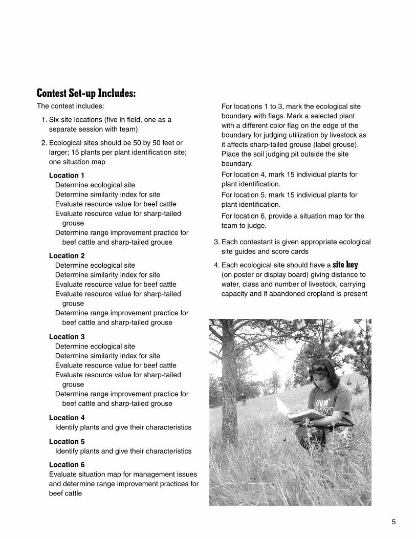
Contest Set-up Includes:The contest includes:
1. Six site locations (five in field, one as a separate session with team)
2. Ecological sites should be 50 by 50 feet or larger; 15 plants per plant identification site; one situation map
Location 1 Determine ecological site
Determine similarity index for site Evaluate resource value for beef cattle Evaluate resource value for sharp-tailed
grouse Determine range improvement practice for
beef cattle and sharp-tailed grouse
Location 2 Determine ecological site
Determine similarity index for site Evaluate resource value for beef cattle Evaluate resource value for sharp-tailed grouse Determine range improvement practice for
beef cattle and sharp-tailed grouse
Location 3 Determine ecological site
Determine similarity index for site Evaluate resource value for beef cattle Evaluate resource value for sharp-tailed grouse Determine range improvement practice for
beef cattle and sharp-tailed grouse
Location 4 Identify plants and give their characteristics
Location 5 Identify plants and give their characteristics
Location 6Evaluate situation map for management issues and determine range improvement practices for beef cattle
For locations 1 to 3, mark the ecological site boundary with flags. Mark a selected plant with a different color flag on the edge of the boundary for judging utilization by livestock as it affects sharp-tailed grouse (label grouse). Place the soil judging pit outside the site boundary.
For location 4, mark 15 individual plants for plant identification.
For location 5, mark 15 individual plants for plant identification.
For location 6, provide a situation map for the team to judge.
3. Each contestant is given appropriate ecological site guides and score cards
4. Each ecological site should have a site key (on poster or display board) giving distance to water, class and number of livestock, carrying capacity and if abandoned cropland is present
6
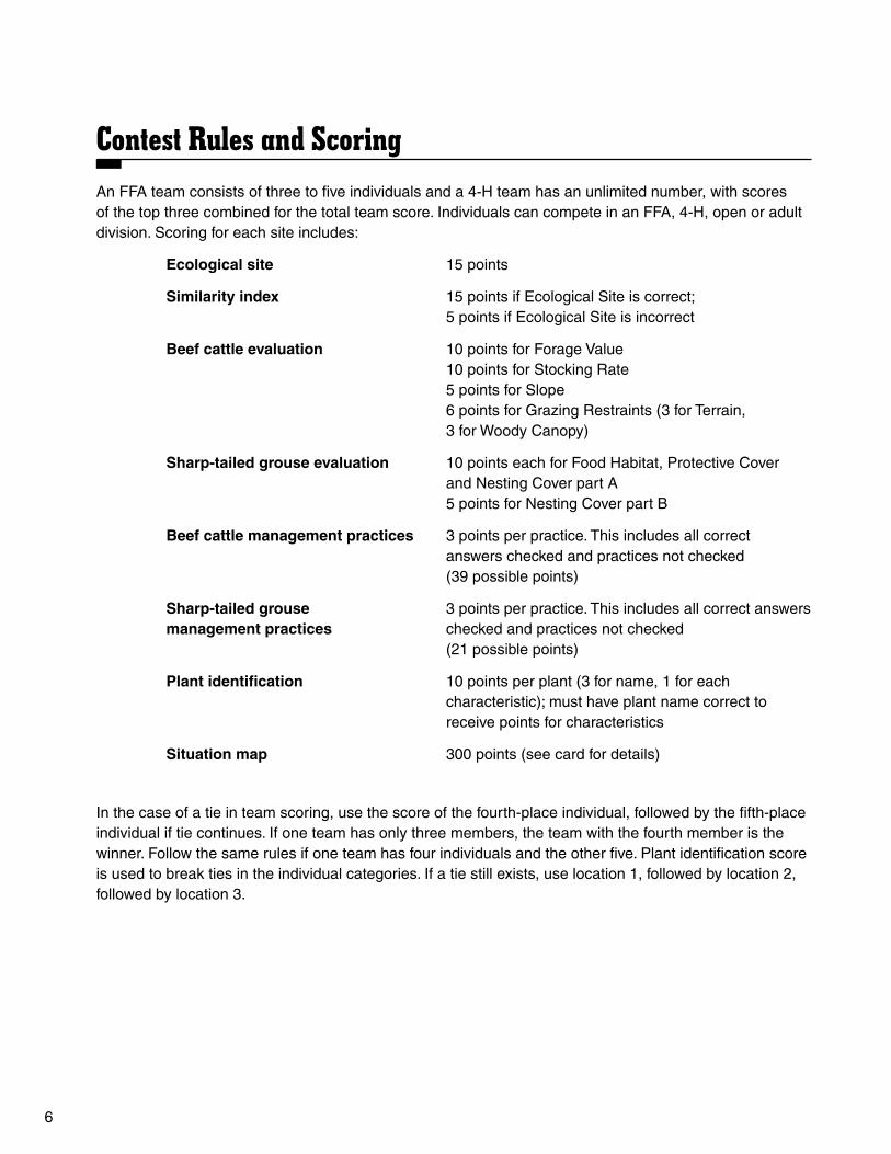
Contest Rules and ScoringAn FFA team consists of three to five individuals and a 4-H team has an unlimited number, with scores of the top three combined for the total team score. Individuals can compete in an FFA, 4-H, open or adult division. Scoring for each site includes:
Ecological site 15 points
Similarity index 15 points if Ecological Site is correct; 5 points if Ecological Site is incorrect
Beef cattle evaluation 10 points for Forage Value 10 points for Stocking Rate
5 points for Slope 6 points for Grazing Restraints (3 for Terrain, 3 for Woody Canopy)
Sharp-tailed grouse evaluation 10 points each for Food Habitat, Protective Cover and Nesting Cover part A
5 points for Nesting Cover part B
Beef cattle management practices 3 points per practice. This includes all correct answers checked and practices not checked (39 possible points)
Sharp-tailed grouse 3 points per practice. This includes all correct answersmanagement practices checked and practices not checked
(21 possible points)
Plant identification 10 points per plant (3 for name, 1 for each characteristic); must have plant name correct to receive points for characteristics
Situation map 300 points (see card for details)
In the case of a tie in team scoring, use the score of the fourth-place individual, followed by the fifth-place individual if tie continues. If one team has only three members, the team with the fourth member is the winner. Follow the same rules if one team has four individuals and the other five. Plant identification score is used to break ties in the individual categories. If a tie still exists, use location 1, followed by location 2, followed by location 3.

7
Different kinds of rangeland are called ecological sites or range sites. Rangeland is a kind of land that is made up of combinations of many individual plant communities. These subunits are the basic framework for decision making in range management.
The ecological site is the product of all the environmental factors responsible for its development. Differences in kind, proportion and production of plants are, in large measure, the result of differences in environmental factors. For example, sandy soils produce different kinds and amounts of vegetation than clay soils. Vegetation also changes with amount and distribution of rainfall. Native vegetation in eastern North Dakota is much different than in the western portion due to decreased precipitation going from east to west.
An ecological site is an area with similar soil, climate and topography capable of producing certain kinds and amounts of vegetation. The The major factors influencing the characteristic vegetation of ecological sites include: 1) surface soil depth, 2) soil texture, 3) available soil moisture, 4) land slope and exposure, 5) precipitation and 6) biological factors.
More than 20 major ecological sites with similar soil/plant relationships are identified in North Dakota. Nine of these ecological sites will be described and comprise potential sites used for range judging in North Dakota. These sites and their description include:
ShallowThis site occurs on gently rolling to steeply
sloping uplands with slopes from 3 to 70 percent. The soils are shallow with bedrock within 0 to 20 inches of the soil surface. Bedrock may be solid rock or unconsolidated (smaller fragments such as gravel, small rocks, etc.) as with scoria, gravel or rock. Root growth is restricted, with most (not all) downward movement unable to penetrate the
layer. Potential vegetation on this site includes blue grama, plains muhly, side-oats grama, needle-and-thread, western wheatgrass and upland sedges. If the soil texture is sandy, prairie sandreed may be present. Little bluestem may be present if calcium carbonate is found in the upper soil profile.
ClaypanThis site occurs on nearly level to gently
sloping uplands and occasionally on nearly level bottomlands. These sites have moderately fine to moderately coarse-textured top soils that are underlain by a dense, slowly permeable restrictive subsoil due to high sodium content at a depth of 0 to 20 inches below the soil surface. This hard claypan has round-topped columnar or prismatic structures often referred to as “biscuit tops.” Potential vegetation on this site includes western wheatgrass, prairie Junegrass and blue grama. Green needlegrass and inland saltgrass may be found on some sites.
SandsThis site occurs on nearly level to strongly
rolling uplands and stream terraces or flood plains. Soils are deep, loose, excessively drained fine, loamy sands or sand. Potential vegetation on this site includes needle-and-thread, sand dropseed and western wheatgrass. Blue grama and sand bluestem may occur in lesser amounts.
SandyThis site occurs on nearly level to rolling
uplands. Slopes may be from 1 to 15 percent. Soils are deep and well-drained with a sandy loam or fine, sandy loam surface texture and may be found over a sand subsoil. Potential vegetation on this site includes prairie sandreed, needle-and- thread and blue grama. Upland sedges and sand bluestem may occur in lesser amounts.
Ecological SitesKevin Sedivec and Jeff Printz

8
LoamyThis site occurs on nearly level to rolling
uplands. Slopes may be from 1 to 15 percent. Soils are deep, moderately well-drained to moderately fine-textured and feel like flour when dry. Predominant vegetation on this site includes western wheatgrass and green needlegrass. Prairie Junegrass, blue grama and upland sedges are common understory grasses and sedge. Needle-and-thread may be present but not abundant.
ClayeyThis site occurs on nearly level to undulating
uplands. Soils are deep and have silt loam to clay surfaces with a silty clay to clay subsoil. Soils are fine to moderately fine textured and feel greasy when wet. Predominant vegetation on this site is western wheatgrass. Green needlegrass, blue grama and prairie Junegrass are prominent on this site. Buffalograss and upland sedges also are common, especially in southwestern North Dakota.
Thin LoamyThis site occurs mostly on steep uplands and
on hillsides. Soils are weakly developed, with soil textures ranging from sandy loam to clay loam. Unweathered parent material is near the soil surface, but it is soft with no restrictive layer. Slopes generally range from 15 to 25 percent. Potential vegetation on this site includes needle-and-thread, plains muhly, western wheatgrass, side-oats grama and blue grama. This site is found only in MLRA 53, 55a, 55b and 56.
OverflowThis site occurs on nearly level to gently
sloping lands that receive additional water from overflowing rivers or streams, or runoff from higher sloping lands. Soils are deep, sandy loam to clay textured. The water table is generally 5 feet or more below the surface. Potential vegetation on this site includes green needlegrass, western wheat- grass and big bluestem in wetter climates. Slender wheatgrass, bearded wheatgrass, Canada wildrye, switchgrass, porcupine grass and midsized sedges are major grasses and sedges. Western snowberry (buckbrush) is common on this site in much of North Dakota.
Limy BackslopeThis site occurs mostly on steep uplands and
on hillsides. Soils are weakly developed, with soil textures ranging from sandy loam to clay loam. Unweathered parent material is near the soil surface, but it is soft with no restrictive layer. Slopes generally range from 15 to 25 percent. Potential vegetation on this site includes little bluestem, needle-and-thread, plains muhly, western wheatgrass, side-oats grama and blue grama. This site is found only in MLRA 54 and 58.
Saline LowlandThis site occurs on low terraces and bottom-
lands along larger streams, lakes or wetlands. Additional water is received by run-in, overflow or seepage. Slopes are commonly less than 1 percent. Soils are saline and/or alkaline, with salts evident on the surface when dry. These soils are deep, poorly drained and medium to fine-textured. Some sites may have a water table between 3 and 5 feet from the surface. Potential vegetation on this site includes nuttall alkaligrass, inland saltgrass and western wheatgrass. Foxtail barley may become dominant under poor management.
North Dakota Ecological Site KeyA way to simplify ecological site identification
is to use the ecological site key. Using the above information, individual sites can be identified using this key, which follows.

9
North Dakota Ecological Site Key
I. Restrictive to Root Growth These sites have a limiting layer within 20 inches of the surface of rock, gravel, stone or restrictive clay (hard pan), which restricts most root growth beyond this layer. (If no restriction, go to II).
A. Limiting layer is rock, scoria, gravel, or stone ...................................................... Shallow ❏ B. Limiting layer is restrictive clay ............................................................................Claypan ❏
II. Nonrestrictive to Root Growth These sites do not have a restrictive layer within 20 inches of the soil surface.
C. Lowlands — These sites receive additional moisture from occasional stream overflow or run-in from adjacent slopes, or during major flooding events. (If no additional moisture occurs, go to D).
1. No water table within 5 feet from surface; typically found in swales; no salt deposits on soil surface .........................................................................................................Overflow ❏
2. Water table within 5 feet from surface
a. This site will have salts evident on the surface when dry (Note: Look for key plant species) ...................................................Saline lowland ❏
D. Uplands —These sites do not receive additional moisture from occasional stream overflow or run-in from adjacent slopes, or during major flooding events.
1. These sites occur on slopes usually less than 15 percent
a. Soils will not form a firm ball when wet; coarse ..............................................Sands ❏ b. Soils will form a firm ball and produce a short ribbon less than 1 inch; feel gritty .............................................................................................Sandy ❏ c. Soils will form a ribbon up to 2 inches and not feel gritty; like flour when dry ........................................................................................................ Loamy ❏ d. Soils form a ribbon greater than 2 inches, support their own weight; feel greasy when wet ..................................................................................... Clayey ❏
2. These sites occur on side hills with slopes usually greater than 15 percent
a. This site is found on glaciated soils east of the Missouri River; thin top soil ..............................................................................................Thin loamy ❏ b. This site is found on non-glaciated soils west of the Missouri River; thin top soil ............................................................................Limy backslope ❏

10
The similarity index, formally known as range condition evaluation, is an evaluation or index of an ecological site. Herbivory by mammals and invertebrates above and below ground, wildfires and drought were major disturbances to the land before early settlement by European immigrants.The kind of plants that are present on an ecological site, and subsequent similarity indexes, will vary due to present and past activities by mammals, invertebrates and humans.
The similarity index varies among sites due to the presence of different kinds of plants. For example, if cattle have grazed at a heavy stocking rate for an extended period of time, some plants not preferred by cattle will increase through time. These plants are classified as increasers. Plants that decrease through time with heavy grazing pressure are termed decreasers. Any disturbance of the ecological site affects the species composition and similarity index. Remember, disturbances are a natural occurrence on all sites.
Before European settlement, ecological sites occurred in their natural condition. The plant communities evolved with natural disturbances of grazing (free-roaming herds), wildfires and drought. Remnants of the original plant communities still are found in North Dakota. The original plant communities describe the ecological sites (composition maximums). The similar index compares present plant communities with historic plant communities on an ecological site.
The present and historic plant species compositions are presented by weight at the end of growing season in an ungrazed condition as described by the Natural Resources Conservation Service (NRCS). The composition maximum is the percent of air dry weight of each plant species in the original plant community. Ungrazed plants at the end of the growing season and many years of data were used to determine the average air dry weights.
For example, if we were judging the similarity index of a loamy site in 58 MLRA, we would determine the plant composition by weight at the end of the growing season and compared with the Ecological Site Guide. You can count no more than the percent allowable on the Ecological Site Guide or total of the amount present for an individual plant species of group of plant species. Simply count the smaller of the two values (maximum site composition and observed composition).
The similarity index is expressed as a percentage from 0 to 100 percent. All native plants found on a site that are not specifically listed in a category are counted as “other.” Invader and introduced plants do not count in the percent composition toward the similarity index. In example 1, when we compare the observed values with the site composition maximum, we achieved a similarity index of 73 percent and checked on the judging card “GOOD CONDITION (51 to 75 percent).” In example 2, we achieved a similarity index of 60 percent and checked on the judging card “GOOD CONDITION (51 to 75 percent).”
Similarity IndexKevin Sedivec and Dennis Froemke

11
Ecological Site Major Land Resource Areas Index
The Natural Resource Conservation Service (NRCS) has determined the historic plant community for each ecological site by major land resource areas (MLRA) in the U.S. The historic plant community has been determined based on plant species composition prior to European settlement, with natural disturbances by wildlife, wildfires and drought. This plant community is labeled “site composition maximum” and is the projected dry weight of vegetation at end of the growing season.
Because the U.S. has variability in precipitation and temperature from west to east and north to south, these MLRA were developed for native
rangeland to compensate for the variability in species composition. North Dakota has six differing MLRAs. These MLRA are 53, 54, 55A, 55B, 56 and 58, which are illustrated in Figure 1.
Once you select the MLRA you are judging in, the ecological site being judged is determined and an estimate is made of the percentage (by weight) of each plant species or group of species. Using the provided ecological site guides (site composition maximum) for the MLRA, the percentage acceptable for each species or group of species is calculated to arrive at a similarity index (see examples 1 and 2). The ecological site vegetation index for each zone is found on Pages 14-23.
Figure 1. Major Land Resource Areas (MLRA) of North Dakota.

12
Example 1 - Similarity index of a loamy ecological site in 58 MLRA Site Composition Observed Amount Vegetation Maximum1 Composition2 Allowable3
Grasses 80 Green needlegrass Porcupine grass 5 3 3
Western wheatgrass Slender wheatgrass 35 15 15
Needle-and-thread 15 5 5
Prairie sandreed
Blue grama 10 25 10
Little bluestem Sideoats grama
Big bluestem Switchgrass Sand bluestem
Nuttall’s alkaligrass Inland saltgrass
Prairie Junegrass Plains muhly Sand dropseed Blue bunch wheatgrass 15 10 10 Red threeawn Sandberg bluegrass Other native grass
Invaders (Kentucky bluegrass) 5 0
Sedges 5 Upland sedge 5 10 5 Midland sedge
Forbs and legumes 10 Natives 10 10 10 Invaders (Leafy spurge) 7 0 Woodies 5 Natives 5 10 5 Invaders 0 100% 100% 63%
Similarity Index: 0 to 25 = Poor 26 to 50 = Fair 51 to 75 = Good 76 to 100 = Excellent
Index Good 1Modified from NRCS Technical Guide2Visual estimation made by judger3The smaller value from two previous columns
13
Example 2 - Similarity Index of a shallow ecological site in 58 MLRA Site Composition Observed Amount Vegetation Maximum1 Composition2 Allowable3
Grasses 73 Green needlegrass Porcupine grass 8 1 1
Western wheatgrass Slender wheatgrass 25 10 5
Needle-and-thread 15 10 5
Prairie sandreed 5 1 1
Blue grama 10 15 0
Little bluestem Side-oats grama 5 5
Big bluestem Switchgrass Sand bluestem
Nuttall’s alkaligrass Inland saltgrass
Prairie Junegrass Plains muhly Sand dropseed Blue bunch wheatgrass 10 8 8 Red threeawn Sandberg bluegrass Other native grass
Invaders (Crested wheatgrass) 15 0
Sedges 10 Upland sedge 10 15 10 Midland sedge
Forbs and legumes 5 Natives 5 10 5 Invaders (Sweetclover) 5 0 Woodies 10 Natives 10 5 5 Invaders 0 100% 100% 45%
Similarity Index: 0 to 25 = Poor 26 to 50 = Fair 51 to 75 = Good 76 to 100 = Excellent
Index Fair 1Modified from NRCS Technical Guide2Visual estimation made by judger3The smaller value from two previous columns
14
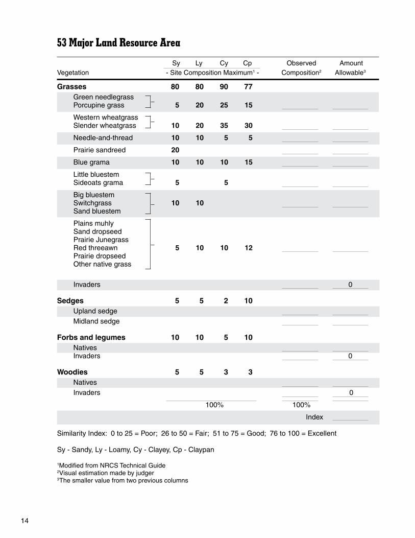
53 Major Land Resource Area
Sy Ly Cy Cp Observed AmountVegetation - Site Composition Maximum1 - Composition2 Allowable3
Grasses 80 80 90 77 Green needlegrass Porcupine grass 5 20 25 15
Western wheatgrass Slender wheatgrass 10 20 35 30
Needle-and-thread 10 10 5 5
Prairie sandreed 20
Blue grama 10 10 10 15
Little bluestem Sideoats grama 5 5
Big bluestem Switchgrass 10 10 Sand bluestem
Plains muhly Sand dropseed Prairie Junegrass Red threeawn 5 10 10 12 Prairie dropseed Other native grass
Invaders 0
Sedges 5 5 2 10 Upland sedge Midland sedge
Forbs and legumes 10 10 5 10 Natives Invaders 0 Woodies 5 5 3 3 Natives Invaders 0
100% 100%
Index
Similarity Index: 0 to 25 = Poor; 26 to 50 = Fair; 51 to 75 = Good; 76 to 100 = Excellent
Sy - Sandy, Ly - Loamy, Cy - Clayey, Cp - Claypan
1Modified from NRCS Technical Guide2Visual estimation made by judger3The smaller value from two previous columns

15
53 Major Land Resource Area
Ov SL Sw TL Sa Observed AmountVegetation - Site Composition Maximum1 - Composition2 Allowable3
Grasses 84 86 81 90 75 Green needlegrass Porcupine grass 15 20 15
Western wheatgrass Slender wheatgrass 12 25 10 20 5
Needle-and-thread 4 10 15
Prairie sandreed 30
Blue grama 6 10
Little bluestem Sideoats grama 5 20 15 10
Big bluestem Switchgrass 35 15 10 Sand bluestem
Nuttall’s alkaligrass 25
Prairie cordgrass Inland saltgrass 20
Plains muhly Sand dropseed Prairie Junegrass 13 15 10 5 15 Red threeawn Prairie dropseed Other native grass
Invaders 0
Sedges 7 5 5 5 10 Upland sedge Midland sedge
Forbs and legumes 7 5 10 8 10 Natives Invaders 0 Woodies 2 5 4 2 5 Natives Invaders 0
100% 100%
Index
Similarity Index: 0 to 25 = Poor; 26 to 50 = Fair; 51 to 75 = Good; 76 to 100 = Excellent
Ov - Overflow, SL - Saline Lowland, Sw - Shallow, TL - Thin Loamy, Sa - Sands
1Modified from NRCS Technical Guide2Visual estimation made by judger3The smaller value from two previous columns

16
54 Major Land Resource Area
Sy Ly Cy LB Observed AmountVegetation - Site Composition Maximum1 - Composition2 Allowable3
Grasses 77 85 90 80 Green needlegrass Porcupine grass 5 25 30 15
Western wheatgrass Slender wheatgrass 30 40 15
Needle-and-thread 9 10 10
Prairie sandreed 20
Blue grama 8 10 10 5
Little bluestem Sideoats grama 5 15
Big bluestem Switchgrass 15 Sand bluestem
Northern reedgrass
Prairie cordgrass
Plains muhly Sand dropseed Prairie Junegrass 15 10 10 20 Red threeawn Prairie dropseed Other native grass
Invaders 0
Sedges 8 5 2 5 Upland sedge Midland sedge
Forbs and legumes 10 10 5 10 Natives Invaders 0 Woodies 5 5 3 5 Natives Invaders 0
100% 100%
Index
Similarity Index: 0 to 25 = Poor; 26 to 50 = Fair; 51 to 75 = Good; 76 to 100 = Excellent
Sy - Sandy, Ly - Loamy, Cy - Clayey, LB - Limy Backslope
1Modified from NRCS Technical Guide2Visual estimation made by judger3The smaller value from two previous columns

17
54 Major Land Resource Area
Ov SL Sw Cp Sa Observed AmountVegetation - Site Composition Maximum1 - Composition2 Allowable3
Grasses 80 85 80 75 75 Green needlegrass Porcupine grass 20 10 10
Western wheatgrass Slender wheatgrass 15 35 15 30
Needle-and-thread 10 15 15
Prairie sandreed 20
Blue grama 5 10 5
Little bluestem Sideoats grama 5 25 10
Big bluestem Switchgrass 35 15 Sand bluegrass
Northern reedgrass
Prairie cordgrass 15
Nuttall’s alkaligrass 15
Plains muhly Sand dropseed Prairie Junegrass Red threeawn 5 20 15 10 10 Prairie dropseed Other native grass
Invaders 0
Sedges 5 5 5 8 10 Upland sedge Midland sedge
Forbs and legumes 10 5 10 12 10 Natives Invaders 0 Woodies 5 5 5 5 5 Natives Invaders
100% 100%
Index
Similarity Index: 0 to 25 = Poor; 26 to 50 = Fair; 51 to 75 = Good; 76 to 100 = Excellent
Ov - Overflow, SL - Saline Lowland, Sw - Shallow, TL - Thin Loamy, Sa - Sands
1Modified from NRCS Technical Guide2Visual estimation made by judger3The smaller value from two previous columns

18
55 Major Land Resource Area
Sy Ly Cy TL Observed AmountVegetation - Site Composition Maximum1 - Composition2 Allowable3
Grasses 78 85 90 80 Green needlegrass Porcupine grass 4 20 30 15
Western wheatgrass Slender wheatgrass 30 40 15
Needle-and-thread 9 10 10
Prairie sandreed 20
Blue grama 8 10 10 5
Little bluestem Sideoats grama 5 15
Big bluestem Switchgrass 20 Sand bluegrass
Plains muhly Sand dropseed Prairie Junegrass 12 10 10 20 Red threeawn Prairie dropseed Other native grass
Invaders 0
Sedges 7 5 2 5 Upland sedge Midland sedge
Forbs and legumes 10 10 5 10 Natives Invaders 0 Woodies 5 5 3 5 Natives Invaders
100% 100%
Index
Similarity Index: 0 to 25 = Poor; 26 to 50 = Fair; 51 to 75 = Good; 76 to 100 = Excellent
Sy - Sandy, Ly - Loamy, Cy - Clayey, TL - Thin Loamy
1Modified from NRCS Technical Guide2Visual estimation made by judger3The smaller value from two previous columns

19
55 Major Land Resource Area
Ov SL Sw Cp Sa Observed AmountVegetation - Site Composition Maximum1 - Composition2 Allowable3
Grasses 75 90 75 80 75 Green needlegrass Porcupine grass 15 20 25
Western wheatgrass Slender wheatgrass 10 30 5 30
Needle-and-thread 5 10 10
Prairie sandreed 25
Blue grama 15 5
Little bluestem Sideoats grama 5 35 5
Big bluestem Switchgrass 40 20 Sand bluegrass
Prairie cordgrass 25
Nuttall’s alkaligrass 20
Plains muhly Sand dropseed Prairie Junegrass Red threeawn 5 15 10 5 5 Prairie dropseed Other native grass
Invaders 0
Sedges 5 5 5 5 10 Upland sedge Midland sedge
Forbs and legumes 10 5 10 10 10 Natives Invaders 0 Woodies 10 – 10 5 5 Natives Invaders
100% 100%
Index
Similarity Index: 0 to 25 = Poor; 26 to 50 = Fair; 51 to 75 = Good; 76 to 100 = Excellent
Ov - Overflow, SL - Saline Lowland, Sw - Shallow, TL - Thin Loamy, Sa - Sands
1Modified from NRCS Technical Guide2Visual estimation made by judger3The smaller value from two previous columns

20
58 Major Land Resource Area
Ov SL Sw Cp Sa Observed AmountVegetation - Site Composition Maximum1 - Composition2 Allowable3
Grasses 75 80 73 75 80 Green needlegrass Porcupine grass 10 8
Western wheatgrass Slender wheatgrass 30 35 25 35
Needle-and-thread 10 15 15 25
Prairie sandreed 5 35
Blue grama 5 10 15 5
Little bluestem Sideoats grama 5
Big bluestem Switchgrass 20 5 Sand bluestem
Prairie cordgrass 15
Nuttall’s alkaligrass 20
Plains muhly Sand dropseed Prairie Junegrass 5 10 5 10 10 Red threeawn Prairie dropseed Bluebunch wheatgrass Other native grass
Invaders 0
Sedges 5 3 5 10 5 Upland sedge Midland sedge
Forbs and legumes 10 5 10 5 10 Natives Invaders 0 Woodies 10 12 12 10 5 Natives Invaders
100 % 100 %
Index
Similarity Index: 0 to 25 = Poor; 26 to 50 = Fair; 51 to 75 = Good; 76 to 100 = Excellent
Ov - Overflow, SL - Saline Lowland, Sw – Shallow, TL - Thin Loamy, Sa - Sands
1Modified from NRCS Technical Guide2Visual estimation made by judger3The smaller value from two previous columns

21
58 Major Land Resource Area
Sy Ly Cy LB Observed AmountVegetation - Site Composition Maximum1 - Composition2 Allowable3
Grasses 75 80 80 75 Green needlegrass Porcupine grass 5 5 5
Western wheatgrass Slender wheatgrass 5 35 45 20
Needle-and-thread 20 15 20
Prairie sandreed 25
Blue grama 5 10 10 10
Little bluestem Sideoats grama 5 10 15
Big bluestem Switchgrass 5 Sand bluegrass
Plains muhly Sand dropseed Prairie Junegrass Red threeawn 15 10 10 5 Prairie dropseed Other native grass
Invaders 0
Sedges 10 5 5 10 Upland sedge Midland sedge
Forbs and legumes 10 10 10 5 Natives Invaders 0 Woodies 5 5 5 10 Natives Invaders
100 % 100 %
Index
Similarity Index: 0 to 25 = Poor; 26 to 50 = Fair; 51 to 75 = Good; 76 to 100 = Excellent
Sy - Sandy, Ly - Loamy, Cy - Clayey, LB - Limy Backslope
1Modified from NRCS Technical Guide2Visual estimation made by judger3The smaller value from two previous columns

22
Forage ValueThe beef cattle diet consists of grasses and
sedges, legumes and some forbs and shrubs. Cattle will select plants based on palatability (taste), availability and nutritional status. Determine the percent of composition (by weight) of desirable food-producing plants. This percentage will be between 0 and 100 percent and classified as poor (0 to 25 percent), fair (26 to 50 percent), good (51 to 75 percent) and excellent (76 to 100 percent). Although invaders and introduced plants cannot be counted for the similarity index, if the plant is desirable for cattle grazing, it will count for forage value.
Example 3 shows the forage value for the loamy ecological site in 58 MLRA in Example 1, and Example 4 shows the forage value for the loamy ecological site in 58 MLRA in Example 2. In these examples, we used the similarity index guide filled out to determine observed composition, and we developed a column for forage value (this column is not part of the guide; however, you can make your own column when judging). You base your forage value on the amount of plants that are desirable for cattle grazing, including native, introduced and invader plants. In the example, a “D” was used to denote desirable and “Un” denoted undesirable. In Example 3, we determined all forbs and shrubs were undesirable; however, not all forbs and shrubs are undesirable (for example, leadplant). In Example 3, 68 percent were desirable and 32 percent were undesirable. The forage value would be “good.” In Example 4, 86 percent were desirable and 14 percent were undesirable. The forage value would be “excellent.”
Note: The similarity index and stocking rate are not related. A low similarity index score may result in a relatively high stocking rate due to invasion of non-native grasses that are considered “desirable” forage.
Cattle are classified as grazers, preferring grasses and sedges. Cattle diets in North Dakota comprise about 75 percent grasses and sedges, 15 percent forbs (herbaceous plants) and 10 percent shrubs (woody), depending on preference, availability and nutritional status. Cattle grazing on native rangeland is a management technique to maintain the plant species composition when conducted in a proper manner. Proper grazing management includes matching the needs of the plant community with the needs of the livestock, minimizing or eliminating grazing more than 50 percent of the plant production. Maintaining the stocking rate at or below the carrying capacity will achieve proper management when combined with proper timing of grazing (for example, not grazing too early or prior to range readiness).
This evaluation guide to judging range is a systematic habitat evaluation for an ecological site’s value to cattle. The evaluation section will assist in the development of an inventory and analyze the existing range condition to determine range improvement practices to improve the value for cattle grazing. This evaluation will allow the range judge to determine the existing condition and identify weak or missing elements that are limiting cattle numbers or performance.
Beef Cattle Range EvaluationKevin Sedivec and Doug Vannurden

23
Example 3 - Forage value as determined from the similarity index of a loamy ecological site in 58 MLRA (D=Desirable, Un=Undesirable)
Site Composition Observed Amount Vegetation Maximum1 Composition2 Allowable3
Grasses 80 Green needlegrass Porcupine grass 5 3 3 D
Western wheatgrass Slender wheatgrass 35 15 15 D
Needle-and-thread 15 5 5 D
Prairie sandreed
Blue grama 10 25 25 D
Little bluestem Sideoats grama 5
Big bluestem Switchgrass Sand bluestem
Plains muhly Sand dropseed Prairie Junegrass Red threeawn 10 10 5 D, 5 Un Prairie dropseed Other native grass
Invaders 5 5 D
Sedges 5 Upland sedge 10 10 D Midland sedge
Forbs and legumes 10 Natives 10 10 Un Invaders 7 7 Un Woodies 5 Natives 10 10 Un Invaders 100% 68% D
Index Good
Similarity Index: 0 to 25 = Poor; 26 to 50 = Fair; 51 to 75 = Good; 76 to 100 = Excellent
Sy - Sandy, Ly - Loamy, Cy - Clayey, LB - Limy Backslope
1Modified from NRCS Technical Guide2Visual estimation made by judger

24
Example 4 - Forage value as determined from the similarity index of a shallow ecological site in 58 MLRA (D=Desirable, Un=Undesirable)
Site Composition Observed Amount Vegetation Maximum1 Composition2 Allowable3
Grasses 73 Green needlegrass Porcupine grass 8 1 1 D
Western wheatgrass Slender wheatgrass 25 10 10 D
Needle-and-thread 15 10 10 D
Prairie sandreed 5 1 1 D
Blue grama 10 15 15 D
Little bluestem Sideoats grama 5 5 D
Big bluestem Switchgrass 5 Sand bluestem
Plains muhly Sand dropseed Prairie Junegrass 5 8 5 D, 3 Un Red threeawn Prairie dropseed Other native grass
Invaders 15 15 D
Sedges 5 Upland sedge 15 15 D Midland sedge
Forbs and legumes 10 Natives 10 4 D, 6 Un Invaders 5 5 D Woodies 12 Natives 5 5 Un Invaders 100% 100% 86% D
Index Excellent
Similarity Index: 0 to 25 = Poor; 26 to 50 = Fair; 51 to 75 = Good; 76 to 100 = Excellent
Ov - Overflow, SL - Saline Lowland, Sw - Shallow, TL- Thin Loamy, Sa - Sands
1Modified from NRCS Technical Guide2Visual estimation made by judger

25
Forage UtilizationOverutilization of forage plants reduces the
competitiveness of the plant against increasing and invading plants. Moderate to full-use grazing followed by rest allows regrowth, creating a higher nutritional quality plant, compared with ungrazed plants. To maintain the proper plant species composition with high-quality, moderate to full-use grazing is recommended for desirable cattle pastures. To determine livestock use, the stocking rate will be determined and compared with the carrying capacity of the land.
Stocking RateStocking rate is the number and kind of animals
grazed on an area of range for a specific length of time. Stocking rates should be determined by the available forage of the total range area, taking into consideration the kinds of sites, condition and amount of usable forage available for grazing.
To determine the number of animal unit months (AUMs) of grazing required by livestock, simply multiply the number of animals times their animal unit equivalent (AUE) (See Table 1) and then multiply times the number of months grazing is required.
Table 1. Animal Unit Equivalents (AUE) by class of livestock.
ANIMAL AUE
Cow/calf pairs 1.00Yearling cattle 0.75Dairy cows 1.30Bulls 1.25Mature sheep with or without lambs 0.20Mature goats with or without kids 0.15Deer 0.15Mature horse 1.25Mature buffalo with or without calves 1.00
EXAMPLE 1 - Determine the AUMs required to graze 60 cows, three bulls and 10 yearlings for six months.
Cows 60 x 1 AUE = 60.00Bulls 3 x 1.25 AUE = 3.75Yearlings 10 x 0.75 AUE = 7.50 71.25 Animal Units (AU) x 6 months 427.5 AUMs = Stocking rate
EXAMPLE 2 - Determine the AUMs required to graze 200 sheep for five months and 10 horses for seven months.
Sheep 200 x 0.20 AUE = 40 Animal Units x 5 months 200 AUMs for sheep
Horse 10 x 1.25 AUE = 12.50 Animal Units x 7 months 87.5 AUMs for horses
Total AUMs = 200 AUMs for sheep + 87.5 AUMs for horses: 287.5 AUMs = Stocking rate

26
Carrying CapacityCarrying capacity is the amount of forage avail-
able from a given piece of land to support a given herd size for a specific time period (months). The stocking rate (AUMs) should equal the carrying capacity (in AUMs) in terms of AUMs needed for the grazing animals with AUMs available from the pasture.
Two factors must be considered to determine the AUMs available from a range area. These are ecological sites and similarity index. Ecological sites differ in their potential to produce native vegetation due to climate, soil and the kind of plants they support. The similarity index is determined by the amount and kinds of plants produced on the ecological site.
To determine the carrying capacity (AUMs) available from a range area, you first must evaluate the range and determine the percentage of makeup in difference kinds of ecological sites. Then simply multiply the number of acres of each site times the initial stocking rate for the index class for your zone, then total.
EXAMPLE: You have 500 acres of range- land in 54 MLRA of North Dakota. Fifty percent is classified as loamy ecological site, 35 percent is sandy and 15 percent is shallow. How many AUMs (carrying capacity) of grazing will this area support?
Ecological Total Site Acreage AUMs AUMs
50% loamy 250 X 0.7 = 175.035% sandy 175 X 0.7 = 122.515% shallow 75 X 0.4 = 30.0
327.5 AUMs
Comparison of Stocking Rate and Carrying Capacity
If the stocking rate and carrying capacity are the same, you would keep the stocking rate the same. If the stocking rate is greater than the carrying capacity, decrease the stocking rate. If the stocking rate is lower than the carrying capacity, increase the stocking rate.
EXAMPLE: In the stocking rate and carrying capacity examples, the stocking rate of example 1 was 427.5 AUM, while the carrying capacity was 327 AUMs. You would decrease the stocking rate when comparing these examples.
EXAMPLE: In the stocking rate and carrying capacity examples, the stocking rate of example 2 was 275.0 AUM, while the carrying capacity was 327 AUMs. You would increase the stocking rate when comparing these examples.

27
Distribution FactorsBeef cattle graze in a pasture based on forage
accessibility, distance from watering source and topography. The rougher the land and steeper the slopes, the less distance they will travel, especially from water. If the land is smooth to gently rolling, cattle freely roam throughout the pasture in search of forage. If the land is rough, with steep, deep canyons, bare rock or woody canopy, grazing distribution of the land will be limited.
Forage AccessibilityBeef cattle prefer to graze on level ground.
As the slope increases, grazing use declines and the distance they graze from water is reduced. If the slope is less than 5 percent, water can be one to 1½ miles away. If the slope is 5 to 10 percent, water can be up to one mile away. If the slope is 11 to 15 percent, water can be up to 0.75 (three-fourths) mile away. If the slope is greater than 15 percent, water must be within 0.5 mile away.
Forage accessibility on the ecological site will be based on slope and categorized as a percent- age at 5 percent intervals. Slope will be used to determine if the water available is adequate or
needs to be developed. The four slope categories are:
< 5% - smooth 5-10% - gently rolling 11-15% - rolling to steep > 15% - very steep
Grazing RestraintBeef cattle prefer to graze open grasslands
with limited amounts of woody cover to restrict their movement. If woody canopy cover increases or dominates, cattle will have to spend more time searching for food, increasing energy use and re-ducing performance. You will categorize the ecologi-cal site as three classes: smooth, rough and woody canopy cover. When judging the ecological site, you will decide if the area is smooth or rough. To be classified as rough, bare rock, scoria or heaving from water pressure should be common. You then will classify the woody canopy cover as greater or less than 30 percent. If the woody canopy makes up greater than 30 percent, cattle will have a difficult time grazing the area and woody plant control will be needed. The restraint classes to judge include:
Table 2. Initial stocking rate guide for excellent-condition native range in animal unit months per acre (AUM/acre) by ecological site and Major Land Resource Areas. (adapted from NRCS Technical Guide 1997)
Animal Unit Month (AUM)/Acre
Major Land Resource Area
53 54 55A&B 56 58
Clayey 0.6 0.6 0.7 0.8 0.5Claypan 0.5 0.4 0.6 0.6 0.4Limy backslope 0.5 0.5 0.6 0.7 0.4Loamy 0.7 0.7 0.7 0.9 0.6Overflow 1 0.9 1 1.2 0.8Saline lowland 1 0.7 1 1.1 0.7Sands 0.7 0.7 0.7 0.8 0.5Sandy 0.7 0.7 0.8 0.9 0.6Shallow 0.6 0.4 0.6 - 0.4Thin loamy 0.5 0.5 0.6 0.7 0.4
1) Terrain ❏ Smooth ❏ Rough
2) Woody canopy cover ❏ < 30% or ❏ > 30%

28
Guide to Range Management Practices — Beef Cattle
1. Continue present management — Use when forage factor is good to excellent, slope less than 11 percent, terrain smooth, woody canopy cover less than 30 percent, water adequate and stocking rate not increased or decreased.
2. Develop water — If slope is less than 5 percent, water can be 1½ miles away; if slope is 5 to 10 percent, water can be one mile away; if slope is 11 to 15 percent, water can be .75 mile away; or if slope is greater than 15 percent, water must be within 0.5 mile. When water location does not meet these requirements, development of water is needed.
3. Decrease stocking rate — Use when stocking rate is greater than carrying capacity.
4. Increase stocking rate — Use when stocking rate is less than carrying capacity.
5. Apply woody plant control — Use when woody canopy cover is greater than (>) 30 percent.
6. Apply undesirable grass and forb control — Use when forage factor is poor or fair due to undesirable forbs or grasses.
7. Change kind of livestock — Use when 1) all of the following occur: terrain is rough, woody canopy cover is greater than 30 percent, slope greater than 15 percent, or 2) if leafy spurge is greater than 40 percent of the vegetation by weight.
8. Burn or mow old growth — Use when old growth dominates (greater than 70 percent by cover) the contest site.
9. Defer one growing season — Use whenever you decrease stocking rate to increase health of spring growth or whenever you burn or mow old grass to eliminate grazing of new plant growth.
10. Defer one or more grazing seasons — Use whenever you seed adapted forage species.
11. Seed adapted forage species — Use when forage factor is poor because of lack of desirable plants or when abandoned cropland occurs.
12. Control noxious weeds — Use whenever a noxious weed is present in the site. The noxious weeds on North Dakota’s rangeland include leafy spurge, absinth wormwood, spotted knapweed, Canada thistle and Russian knapweed.
13. Begin a planned grazing system — Use whenever your site is evaluated to have one or more of these problems: lacks proper water, forage value is poor or fair, terrain rough, increased or decreased stocking rate, and/or old grass (greater than 70 percent by cover) dominates.
Note: Distance to water, the presence of abandoned cropland, and number and class of livestock grazing, months grazed and carrying capacity will be given.

29
The sharp-tailed grouse is the most common upland game bird native to North Dakota’s rangeland. Sharp-tailed grouse are found throughout North Dakota, particularly in parts of the state where rangeland remains a dominant resource in the landscape. Populations of sharp- tailed grouse are directly related to land use and management practices, increasing or decreasing with changes in habitat quality and quantity.
As with many upland game birds, farming has the greatest main effect on landscape and subsequent sharp-tailed grouse habitat. Cultivated lands prove to have the greatest negative impact on sharp-tailed grouse nesting and brood-rearing habitat. However, cultivated lands are important areas for food habitat.
The major influences on rangeland that alter sharp-tailed grouse habitat are grazing and fire. Sharp-tailed grouse have evolved with the grazing of wild ungulates (Ex., bison, antelope, deer) and fire. Grazing with domestic livestock (Ex., cattle) can be beneficial when managed properly and overgrazing is eliminated. For the most part, light to moderate stocking rates are beneficial to sharp-tailed grouse habitat and, in many areas, necessary to maintain high-quality nesting and protective habitats. North Dakota’s rangelands currently provide habitat for sharp-tailed grouse varying from poor to excellent, depending on land use and site factors. Always remember, weather and predators also influence sharp-tailed grouse populations and can be the primary factor for reductions or increases in populations.
The purpose of this habitat evaluation guide is to provide a tool for a systematic evaluation of a tract of land for sharp-tailed grouse suitability. The evaluation is designed to inventory and analyze existing habitat condition and determine the limiting
factors to improve the habitat when needed. This evaluation will allow a determination of the overall quality of the range in its existing condition and identify the weak or missing elements that are limiting grouse numbers so that management improvements can be developed.
Sharp-tailed grouse restrict their activities to a home range that varies in size, depending on the kind, amount, condition and interspersion of the required habitat components. All the requirements for the birds’ livelihood must be found within this home range. In reality, the actual size and shape of the home range is determined by the inherent limits of how far the birds can travel and quality of various habitat elements within the home range.
Although actual home ranges are not marked by permanent boundaries (boundaries change from season to season and year to year), a conceptual home range boundary is designed for the contest. The ordinary limits of movement for a species are assumed in the boundary area, with all potential habitats available to provide a convenient area for planning within which habitat elements are measured.
Nesting CoverSharp-tailed grouse hens nest within a one-
to two-mile radius of the male dancing ground. The sharp-tailed grouse engages in the most energetic display of all grouse during the breeding and nesting season. The males gather to perform before dawn and dance for several hours while courting females. The hens will locate a nest within this one- to two-mile radius of the ground in cover suitable for hiding from predators and protective from the environment.
Sharp-tailed Grouse Range EvaluationKevin Sedivec and Doug Vannurden

30
Hens select a nesting site in cover that is tall and dense, usually 8 to 16 inches high. They al- most exclusively nest in permanent cover, such as rangeland. Tall to midsized bunch grass and upright sod-formers provide the best grass cover while dense shrubs greater than 1 foot tall provide safe habitat for nesting. Of the 40 grasses and grass- like plants, 16 provide tall enough cover for nesting hens. The wet meadow and saline lowland plants are classified as undesirable due to the potential of flooding destroying nests. Sweetclover is the only forb from the plant list that achieves sufficient height and cover for nesting. All shrubs except creeping juniper, broom snakeweed, prairie rose, yucca and winterfat provide good nesting cover. Trees are classified as undesirable because they limit low-growing cover.
Desirable Nesting PlantsDesired nesting plants should be common
throughout the home range of sharp-tailed grouse. These plants should cover 30 percent by aerial cover of the home range to provide adequate cover for nesting hens. If less than 30 percent by aerial cover of the contest site is desired nesting plants, improved nesting cover must be added to the recommended management practices. For contest purposes, judge the site for desirable nesting plants as:
> 30% aerial cover 10 to 30% aerial cover < 10% aerial cover
Nesting Cover HeightSharp-tailed grouse hens tend to nest in cover
8 to 16 inches tall and greater. Nesting cover less than 4 inches tall lacks hiding cover from predators and is classified as poor. For contest purposes, if the height of the “specially marked plant” is less than 4 inches, decreasing the stocking rate is recommended. If the height of the marked plant is greater than 16 inches, increasing stocking rate or burning is recommended. Judge the contest site as:
> 16 inches 4 to 16 inches < 4 inches
Food HabitatSharp-tailed grouse feed extensively on range-
land unless adjacent cereal crops are present. Laboratory tests have shown that 90 percent of the grouse diet is composed of vegetation (seeds, fruit, leaves) and the remaining 10 percent chiefly of insects (grasshoppers, beetles, caterpillars, etc.). Of the vegetative matter, 31 percent consists of leaves, flowers and buds; 27 percent fruit; 20 percent grain (grass seeds and cereal crops); 7 percent weed seeds; and the balance is miscellaneous plant material. The sharp-tailed grouse’s favorite foods include wheat, clover leaves, dandelion, prairie rose, sunflower seeds, chokecherry, buffaloberry, willows, poplar (cottonwood, quacking aspen) and alfalfa.
Plants tend to be selected as a food source for sharp-tailed grouse if they produce a hard seed and fleshy fruit. Grouse also prefer the plant tissue of a select group of plants. Of the 116 plants listed in the North Dakota Range Judging Manual, six of the 40 grasses and sedges are desirable plants as food for sharp-tailed grouse. Of the 53 forbs, 30 are desirable food, seven of the 13 shrubs are desirable and seven of the eight trees are desirable food.
Desirable Food PlantsFood plants should be common throughout the
home range of sharp-tailed grouse. These plants should consist of 30 percent by weight of the home range to provide adequate food for the grouse.
If less than 30 percent by weight of the contest site is desired food plants, improved food habitat must be added to the recommended management practices. For contest purposes, judge the site for desirable food plants as:
> 30% by weight 10 to 30% by weight < 10% by weight

31
Protective CoverDuring the spring and summer months, sharp-
tailed grouse spend all their time on the ground searching for food, nesting and loafing (sleeping, resting). Protective cover is important for grouse for loafing and is necessary for escaping predators. Low-growing woody plants and upright forbs and grass are used for this type of cover because they provide dense overhead screening and protective cover from environmental conditions.
Percent Woody CanopyFor contest purposes, protective cover
will be categorized as woody canopy, such as western snowberry, willows, big sagebrush, silver sagebrush and other low-growing trees that grow in clumps and shrubs. Desirable levels of woody canopy cover in a sharp-tailed grouse’s home range should be 10 to 30 percent by aerial cover. Less than 10 percent by aerial cover would be insufficient, while greater than 30 percent excessive, reducing the amount of food habitat and potential nesting cover. For contest purposes, judge the site for percent woody cover as:
> 30% aerial cover 10 to 30% aerial cover < 10% aerial cover
Guide to Habitat Management Practices —Sharp-tailed Grouse
1. Continue present management — Use when desirable nesting plants are greater than 30 percent aerial cover and 4 to 16 inches in height, desirable food plants are greater than 30 percent by weight and woody canopy cover 10 to 30 percent by aerial cover of site.
2. Improve nesting cover — Use when desirable nesting plants are less than 30 percent by aerial cover and/or marked plant less than 4 inches tall.
3. Decrease stocking rate — Use when marked plant is less than 4 inches tall.
4. Add more livestock grazing or burn — Use when marked plant is greater than 16 inches.
5. Improve food habitat — Use when desirable food plants are less than 30 percent by weight.
6. Improve protective cover — Use when woody canopy cover is less than 10 percent by aerial cover.
7. Apply woody plant control — Use when woody canopy cover is greater than 30 percent by aerial cover.

32
CONTEST EXAMPLE
Ecological Site — Sandy; Major Land Resource Area — 54
Site Key: Distance to water — 0.8 miles Livestock class and number — 100 cow/calf pairs (AUE = 1) Grazing season — 6 months Carrying capacity — 550 AUMs
Species composition include: Grasses — 5% green needlegrass, 5% western wheatgrass,
30% needle-and-thread, 20% blue grama, and 10% Kentucky bluegrassSedges — 10% upland sedgeForbs — 5% sweetclover, 5% leafy spurge, 2% silverleaf scurfpea,
3% fringed sagewortShrubs — 5% prairie rose
Degree of Use (marked grass plant): Sharp-tailed grouse — 5 inches
Slope — 7%; Terrain — smooth; Woody canopy — see species composition
ANSWER KEY: Ecological Site: . . . . . . . . . . . . . . . . . . Sandy Similarity Index: . . . . . . . . . . . . . . . . . . Fair (40%) Beef Cattle Site Evaluation Forage Value: . . . . . . . . . . . . . . . . Excellent (85%) Distribution Factors Slope: . . . . . . . . . . . . . . . . . . 5 to 10% Grazing Restraints Terrain: . . . . . . . . . . . . . Smooth Woody canopy: . . . . . . < 30% (5%) Stocking rate: . . . . . . . . . . . . Decrease Sharp-tailed Grouse Site Evaluation Nesting Cover Desirable nesting plants: . . > 30% (45%) Nesting cover height: . . . . . 4 to 16 inches Food habitat: . . . . . . . . . . . . . . . . 10 to 30% (17%) Protective cover: . . . . . . . . . . . . . < 10% (5%)
Recommended management practices — Beef: decrease stocking rate, defer part of grazing season, control noxious weeds, begin a planned grazing system
Recommended management practices — Grouse: improve food habitat, improve protective cover

33
CONTEST EXAMPLE
Ecological Site — Loamy; Major Land Resource Area — 55B
Site Key: Distance to water — 1.6 miles Livestock class and number — 200 sheep (AUE = 0.20), 25 cow/calf pairs (AUE = 1) Grazing season — 5 months Carrying capacity — 295 AUMs
Species composition include: Grasses — 5% green needlegrass, 5% western wheatgrass, 10% needle-and-thread,
15% blue grama, 5% Prairie Junegrass and 10% Kentucky bluegrassSedges — 10% upland sedgeForbs — 2% purple prairie clover, 3% milkvetches, 2% silverleaf scurfpea,
5% fringed sagewortShrubs — 8% western snowberry, 5% prairie rose
Degree of Use (marked grass plant): Sharp-tailed grouse — 6 inches
Slope — 8%; Terrain — smooth; Woody canopy — see species composition
ANSWER KEY: Ecological Site: . . . . . . . . . . . . . . . . . . Loamy Similarity Index: . . . . . . . . . . . . . . . . . . Good (55%) Beef Cattle Site Evaluation Forage Value: . . . . . . . . . . . . . . . . Excellent (77%) Distribution Factors Slope: . . . . . . . . . . . . . . . . . . 5 to 10% Grazing Restraints Terrain: . . . . . . . . . . . . . Smooth Woody canopy: . . . . . . < 30% (13%) Stocking rate: . . . . . . . . . . . . Keep the same Sharp-tailed Grouse Site Evaluation Nesting Cover Desirable nesting plants: . . > 30% (33%) Nesting cover height: . . . . . 4 to 16 inches Food habitat: . . . . . . . . . . . . . . . . 10 to 30% (25%) Protective cover: . . . . . . . . . . . . . 10 to 30% (13%)
Recommended management practices — Beef: develop water, decrease stocking rate and begin a planned grazing system
Recommended management practices — Grouse: improve food habitat

34
CONTEST EXAMPLE
Ecological Site — Shallow; Vegetative Zone — 58
Site Key: Distance to water — 0.4 miles Livestock class and number — 50 cow/calf pairs (AUE=1.0) , 2 bulls (AUE=1.25) Grazing season — 6.5 months for cow/calf pairs, 2 months for bulls Carrying Capacity — 400 AUMs
Species composition include: Grasses — 10% western wheatgrass, 15% needle-and-thread, 10% blue grama,
20% little bluestem, 5% sideoats grama, 5% plains muhly, 5% sandberg bluegrass
Sedges — 10% upland sedgeForbs — 2% purple prairie clover, 1% black samson, 2% silverleaf scurfpea,
3% fringed sagewortShrubs — 5% lead plant, 7% western snowberry
Degree of Use (marked grass plant): Sharp-tailed grouse — 18 inches
80% Old Grass; Slope — 4%; Terrain — rough (exposed rock); Woody canopy — see species composition
ANSWER KEY: Ecological Site: . . . . . . . . . . . . . . . . . . Shallow Similarity Index: . . . . . . . . . . . . . . . . . . Excellent (81%) Beef Cattle Site Evaluation Forage Value: . . . . . . . . . . . . . . . . Excellent (88%) Distribution Factors Slope: . . . . . . . . . . . . . . . . . . < 5% Grazing Restraints Terrain: . . . . . . . . . . . . . Rough Woody Canopy: . . . . . . < 30% (12%) Stocking Rate: . . . . . . . . . . . Increase Sharp-tailed Grouse Site Evaluation Nesting Cover Desirable Nesting Plants: . . > 30% (50%) Nesting Cover Height: . . . . . > 16 inches Food Habitat: . . . . . . . . . . . . . . . . 10 to 30% (27%) Protective Cover: . . . . . . . . . . . . . 10 to 30% (12%)
Recommended Management Practices — Beef: increase stocking rate
Recommended Management Practices — Grouse: add more livestock grazing or burn, and improve food habitat
35
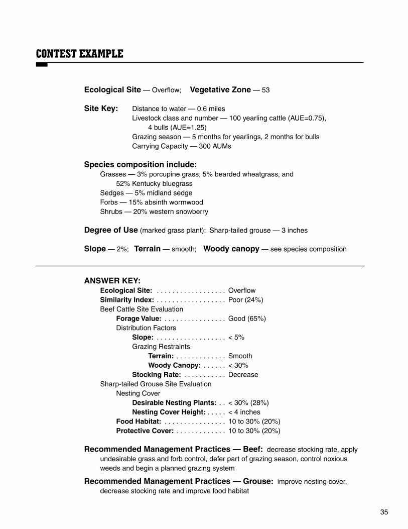
CONTEST EXAMPLE
Ecological Site — Overflow; Vegetative Zone — 53
Site Key: Distance to water — 0.6 miles Livestock class and number — 100 yearling cattle (AUE=0.75), 4 bulls (AUE=1.25) Grazing season — 5 months for yearlings, 2 months for bulls Carrying Capacity — 300 AUMs
Species composition include: Grasses — 3% porcupine grass, 5% bearded wheatgrass, and
52% Kentucky bluegrassSedges — 5% midland sedgeForbs — 15% absinth wormwoodShrubs — 20% western snowberry
Degree of Use (marked grass plant): Sharp-tailed grouse — 3 inches
Slope — 2%; Terrain — smooth; Woody canopy — see species composition
ANSWER KEY: Ecological Site: . . . . . . . . . . . . . . . . . . Overflow Similarity Index: . . . . . . . . . . . . . . . . . . Poor (24%) Beef Cattle Site Evaluation Forage Value: . . . . . . . . . . . . . . . . Good (65%) Distribution Factors Slope: . . . . . . . . . . . . . . . . . . < 5% Grazing Restraints Terrain: . . . . . . . . . . . . . Smooth Woody Canopy: . . . . . . < 30% Stocking Rate: . . . . . . . . . . . Decrease Sharp-tailed Grouse Site Evaluation Nesting Cover Desirable Nesting Plants: . . < 30% (28%) Nesting Cover Height: . . . . . < 4 inches Food Habitat: . . . . . . . . . . . . . . . . 10 to 30% (20%) Protective Cover: . . . . . . . . . . . . . 10 to 30% (20%)
Recommended Management Practices — Beef: decrease stocking rate, apply undesirable grass and forb control, defer part of grazing season, control noxious weeds and begin a planned grazing system
Recommended Management Practices — Grouse: improve nesting cover, decrease stocking rate and improve food habitat

36
Plant ListErica Elemse and Kevin Sedivec
The plants selected for the contest are common plants found on the 10 selected ecological sites in North Dakota. Plant characteristics and their ratings for sharp-tailed grouse and beef cattle are based on ecological criteria and value to the particular bird or animal. Native plants classified as invaders are those that did not occur historically on the ecological site under influences of grazing, fire and drought. Introduced plants that escape or move from where they are planted are classified as invaders.
The starting point for most range management decisions is knowing range plants by name and knowing their growth habits, response to grazing, span of life and other characteristics. A total 116 plants make up the plant list. Scientific names are included because confusion can exist when a particular plant has several common names. However, common names will be used for range judging contest purposes.
Correct plant identification is very important because plants can be desirable, as well as undesirable. In the Sources of Information section, you can find a list of publications and plant material sources that will aid you in identifying and classifying range plants.
Types of Range PlantsPlants on the range are so numerous and different in their forms and growth habits that they should be grouped for convenience and ease of identification. The following groupings and definitions will help you learn important characteristics of range plants.
GrassesThese are plants with joint stems that usually
are hollow. The leaves are in two rows on the stem, and leaf veins parallel. Grasses are the most common of all range plants and most important forage-producing plants in North Dakota.
Sedges and RushesThese plants are grasslike, resembling true
grasses, but have a solid stem and no joints. The stems are triangular with the sedges or round with the rushes. Leaves on rushes are in three rows on the stem. Veins in the leaf are parallel.
CryptogamsThese are plants without flowers or seeds,
often reproducing by free spores. These spores can be found on the lower side of ordinary leaves or on special leaves, or parts of leaves or stems.
ForbsThese are herbaceous, broadleaf, nongrass-
like plants with tops that die back each year. Most forbs have net veining in the leaf and exhibit showy flowers. Many different plants are represented in this large range plant group.
Shrubs and Half-ShrubsThese plants have persistent woody stems that
live through the winter and regenerate new leaves each year. The stems branch from near the base of the plant and do not have a definite trunk (trees). These plants have a relatively low growth habit. Stems will have annual growth rings and leaves net veining.
TreesThey are a taller, woody plant distinguished
from a shrub by having greater height and a single trunk, rather than several woody stems.

37
Origin of Range PlantsRange plants originated in North America or
were brought from another continent by human activity. These plants are classified as having a native or introduced origin.
NativeNative plant species are those that were
present here prior to settlement of the continent. An example is western wheatgrass. An “N” will represent native plants.
IntroducedIntroduced species are those that were brought
into North America after European settlement. Two examples are crested wheatgrass and alfalfa. An “I” will represent introduced plants.
Life Span of Range PlantsRange plants may be short-lived or long-lived
plants. Those that are short-lived are classified as annual and biennial, while long-lived plants are considered perennial. Most plants on native rangeland are long-lived, with a select few short-lived.
AnnualPlants that complete their life cycle in one year
or less are classified as annuals. They reproduce by seed and do not regrow a second year from the root or crown. An example would be cheatgrass. An “A” will represent an annual plant.
BiennialPlants that live for two years, producing
vegetative growth the first year and usually flowering and fruiting the second year, then dying, are classified as biennials. They reproduce only by seed. Two examples are sweetclover and curlycup gumweed. A “B” will represent a biennial plant.
PerennialA plant that has a life cycle of three years or
more is classified as a perennial. They reproduce primarily by root or crown tissue but can reproduce by seed as well. An example is black samson. A “P” will represent a perennial plant.
Season of GrowthAll range plants have a growth period
characterized as a cool-season or warm-season growth pattern.
Cool SeasonThese plants make their principle growth
during the cool weather seasons of spring and fall. They typically set their seed in May or June and become mature during the hot growing period of midsummer. An example is green needlegrass. A “C” will represent a cool-season plant.
Warm SeasonThese plants begin growing in late spring and
grow during the warmer months of June, July and August. Some plants begin setting seed in late June, with most setting seed in July and August. An example is little bluestem. A “W” will represent a warm-season plant.
Range Plant Response to GrazingAll plants respond differently to grazing, with
some plants increasing from grazing pressure, while others decrease as grazing becomes heavy at critical time periods. Range plants can be classified as increasers, decreasers or invaders.
IncreaserPlants that have a low growing point or a
growth characteristic (Ex., does not taste good or contains plant parts that hurt the mouth) that limits animals from grazing tend to increase with grazing pressure. Some of these plants have poor grazing value, while others are important to grazing animals. These plants should be found on all ecological sites but not dominant. To note, some of these plants eventually will decrease with grazing pressure during a long period of time. An example is blue grama. An “Ic” will represent an increaser plant.

38
DecreaserPlants that have a high growing point, have
no physiological characteristics to reduce grazing pressure and taste good (palatable) to animals tend to decrease with grazing pressure. Some native plants, such as Indian breadroot, that are not palatable to animals also decrease when the ecological integrity (health) of the site is reduced. Fewer of these plants will be found on a site as the similarity index is reduced. An example is big bluestem. A “D” will represent a decreaser plant.
InvadersPlant species that historically were not part of
the presettlement vegetation (introduced plants) and short-lived plants (annuals and biennials) are classified as invader plants. They may invade a site following a disturbance (overgrazing, burn, cultivation) or a lack of disturbance (long-term nonuse). These plants can be both desirable or undesirable to grazing animals, depending on species of plants and class of animal. Examples include smooth bromegrass (introduced) and daisy fleabane (annual). An “Iv” will represent an invader plant.
Forage Value for CattleRange plants are either palatable or
unpalatable to cattle and will have a forage value based on their taste. These plants are classified as desirable or undesirable.
DesirablePlants that are desirable to cattle include
forage plants that are palatable during all or part of their grazing season, nutritious and lack growth characteristics that reduce the grazing or browsing activity. Examples include Kentucky bluegrass and leadplant. A “De” will represent a desirable plant.
UndesirablePlants that do not taste good (unpalatable) or
have a growth characteristic that keeps cattle from grazing are classified as having an undesirable forage value for cattle. Examples include pasque flower (unpalatable) and prairie rose (thorns on stems). An “Un” will represent an undesirable plant.
Food Value for Sharp-tailed GrouseSharp-tailed grouse prefer specific range plants
for food, while others have little to no food value. These plants will be classified as desirable and undesirable for food.
DesirablePlants that are desirable food to sharp-tailed
grouse include plants that have fleshy fruit, tasty leaves and/or hard seeds. Examples include prairie rose (fleshy fruit), switchgrass (hard seed) and American vetch (tasty leaves). A “De” will represent a desirable plant.
UndesirablePlants that do not taste good or have plant
parts that are unpalatable are classified as undesirable feed for sharp-tailed grouse. Examples include leafy spurge (unpalatable) and little bluestem (fluffy seed). An “Un” will represent an undesirable plant.
Cover Value for Sharp-tailed GrouseDesirable
Plants that provide a dense cover and mid to tall height, and stand erect, are considered desirable cover for sharp-tailed grouse. Examples include big bluestem (dense and tall) and western snowberry (dense, tall and erect). A “De” will represent a desirable plant.
UndesirablePlants that are short, single-stalked or
stemmed, or tall with no understory growth, are classified as undesirable cover for sharp-tailed grouse. Examples include buffalo grass (short) and green ash (tall with no understory growth). An “Un” will represent an undesirable plant.

39
Plant List for North Dakota Range Judging Key to symbols:Perennial = P Cool-season = C Decreaser = D Native = N Desirable = DeBiennial = B Warm-season = W Increaser = Ic Introduced = I Undesirable = UnAnnual = A Invader = Iv
Wildlife Value Forage Sharp-tailed Value GRASSES Grouse Cattle
Season Plant Life of Grazing Nesting Number Plant Name Span Growth Response Origin Food Cover Food
1 Bearded wheatgrass (Elymus caninus) P C D N Un De De 2 Big bluestem (Andropogon gerardii) P W D N Un De De 3 Bluebunch wheatgrass(Pseudoroegneria spicata) P C D N Un De De 4 Blue grama (Bouteloua gracilis) P W Ic N Un Un De 5 Buffalograss (Bouteloua dactyloides) P W Ic N Un Un De 6 Canada wildrye (Elymus canadensis) P C D N Un De De 7 Cattail (Typha spp.) P W D N Un Un Un 8 Crested wheatgrass (Agropyron cristatum) P C Iv I De De De 9 Cheatgrass (Bromus tectorum) A C Iv I Un Un Un 10 Foxtail barley (Hordeum jubatum) P C Ic N Un Un Un 11 Green needlegrass (Nassella viridula) P C D N Un De De 12 Indian ricegrass (Achnatherum hymenoides) P C D N De De De 13 Indiangrass (Sorghastrum nutans) P W D N Un De De 14 Inland saltgrass (Distichlis spicata) P W Ic N Un Un Un 15 Kentucky bluegrass (Poa pratensis) P C Iv I Un Un De 16 Little bluestem (Schizachyrium scoparium) P W D N Un De De 17 Needle-and-thread (Hesperostipa comata) P C Ic N Un De De 18 Northern reedgrass (Calamagrostis stricta) P C D N Un Un De 19 Nuttall’s alkaligrass (Puccinellia nuttalliana) P C D N Un Un De 20 Plains muhly (Muhlenbergia cuspidata) P W D N Un Un De 21 Porcupine grass (Hesperostipa spartea) P C D N Un De De 22 Prairie cordgrass (Spartina pectinata) P W D N Un Un De 23 Prairie dropseed (Sporobolus heterolepis) P W Ic N De Un De 24 Prairie Junegrass (Koeleria macrantha) P C Ic N Un Un De 25 Prairie sandreed (Calamovilfa longifolia) P W D N Un De De 26 Red threeawn (Aristida purpurea) P C Ic N Un Un Un 27 Reed canarygrass (Phalaris arundinacea) P C D N Un Un De 28 Sand bluestem (Andropogon hallii) P W D N Un De De 29 Sand dropseed (Sporobolus cryptandrus) P W Ic N De Un De 30 Sandberg bluegrass (Poa secunda) P C Ic N Un Un Un 31 Sixweeks fescue (Vulpia octoflora) A C Ic N Un Un Un 32 Sideoats grama (Bouteloua curtipendula) P W D N Un Un De 33 Smooth bromegrass (Bromus inermis) P C Iv I Un De De 34 Switchgrass (Panicum virgatum) P W D N De De De 35 Tumblegrass (Schedonnardus paniculatus) P W Ic N Un Un Un 36 Western wheatgrass (Pascopyrum smithii) P C D N De De De 37 Wilcox panicum (Dichanthelium wilcoxianum) P W D N Un Un Un
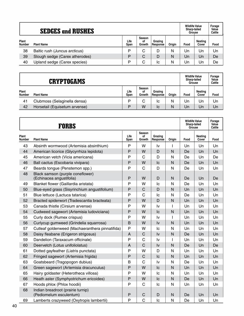
40
Wildlife Value Forage Sharp-tailed Value SEDGES and RUSHES Grouse Cattle
Season Plant Life of Grazing Nesting Number Plant Name Span Growth Response Origin Food Cover Food
38 Baltic rush (Juncus arcticus) P C D N Un Un Un 39 Slough sedge (Carex atherodes) P C D N Un Un De 40 Upland sedge (Carex species) P C Ic N Un Un De
Wildlife Value Forage Sharp-tailed Value CRYPTOGAMS Grouse Cattle
Season Plant Life of Grazing Nesting Number Plant Name Span Growth Response Origin Food Cover Food
41 Clubmoss (Selaginella densa) P C Ic N Un Un Un 42 Horsetail (Equisetum arvense) P W Ic N Un Un Un
Wildlife Value Forage Sharp-tailed Value FORBS Grouse Cattle
Season Plant Life of Grazing Nesting Number Plant Name Span Growth Response Origin Food Cover Food
43 Absinth wormwood (Artemisia absinthium) P W Iv I Un Un Un 44 American licorice (Glycyrrhiza lepidota) P W D N De Un Un 45 American vetch (Vicia americana) P C D N De Un De 46 Ball cactus (Escobaria vivipara) P W Ic N De Un Un 47 Beards tongue (Penstemon spp.) P C D N De Un Un 48 Black samson (purple coneflower) (Echinacea angustifolia) P W D N De Un De
49 Blanket flower (Gaillardia aristata) P W Ic N De Un Un
50 Blue-eyed grass (Sisyrinchium angustifolium) P C D N Un Un Un
51 Blue lettuce (Lactuca tatarica) P C Ic N De Un Un
52 Bracted spiderwort (Tradescantia bracteata) P W D N Un Un Un
53 Canada thistle (Cirsium arvense) P W Iv I Un Un Un
54 Cudweed sagewort (Artemisia ludoviciana) P W Ic N Un Un Un
55 Curly dock (Rumex crispus) P W Iv I Un Un Un
56 Curlycup gumweed (Grindelia squarrosa) B W Iv N Un Un Un
57 Cutleaf goldenweed (Machaeranthera pinnatifida) P W Ic N Un Un Un
58 Daisy fleabane (Erigeron strigosus) A C Iv N De Un Un
59 Dandelion (Taraxacum officinale) P C Iv I Un Un Un
60 Deervetch (Lotus unifoliolatus) A C Iv N De Un De
61 Dotted gayfeather (Liatris punctata) P W D N Un Un Un
62 Fringed sagewort (Artemisia frigida) P C Ic N Un Un Un
63 Goatsbeard (Tragopogon dubius) B C Iv N De Un Un
64 Green sagewort (Artemisia dracunculus) P W Ic N Un Un Un
65 Hairy goldaster (Heterotheca villosa) P W Ic N Un Un Un
66 Heath aster (Symphyotrichum ericoides) P W Ic N De Un Un
67 Hoods phlox (Phlox hoodii) P C Ic N Un Un Un
68 Indian breadroot (prairie turnip) (Pediomelum esculentum) P C D N De Un Un
69 Lamberts crazyweed (Oxytropis lambertii) P C Ic N De Un Un

41
Wildlife Value Forage Sharp-tailed Value FORBS (cont.) Grouse Cattle
Season Plant Life of Grazing Nesting Number Plant Name Span Growth Response Origin Food Cover Food
70 Leafy spurge (Euphorbia esula) P C Iv I Un Un Un 71 Mariposa lily (Calochortus gunnisonii) P C D N De Un Un 72 Milkvetches (Astragalus spp.) P C D N De Un Un 73 Missouri goldenrod (Solidago missouriensis) P W Ic N De Un Un 74 Pasque flower (crocus) (Pulsatilla patens) P C D N De Un Un 75 Plains pricklypear (Opuntia polyacantha) P W Ic N De Un Un 76 Prairie coneflower (Ratibida columnifera) P W Ic N De Un Un 77 Prairie thistle (Cirsium spp.) P W Ic N De Un Un 78 Prairie smoke (torch flower) (Geum triflorum) P C Ic N Un Un Un 79 Purple prairieclover (Dalea purpurea) P W D N De Un De 80 Pussytoes (Antennaria neglecta) P C Ic N Un Un Un 81 Scarlet globemallow (Sphaeralcea coccinea) P C Ic N Un Un Un 82 Scarlet gura (Gaura coccinea) P C Ic N Un Un Un 83 Silverleaf scurfpea (Pediomelum argophyllum) P C Ic N De Un Un 84 Skeletonweed (Lygodesmia juncea) P W Ic N Un Un Un 85 Soft goldenrod (Solidago mollis) P W Ic N De Un Un 86 Stiff goldenrod (Oligoneuron rigidum) P W Ic N De Un Un 87 Sunflower species (Helianthus spp.) P W D N De Un De 88 Sweetclover (Melilotus spp.) B C Iv I De De De 89 Western wallflower (Erysimum asperum) B C Iv N De Un Un 90 Western yarrow (Achillea millefolium) P C Ic N Un Un Un 91 White milkwort (Polygala alba) P C Ic N Un Un Un 92 White prairieclover (Dalea candida) P W D N De Un De 93 Wild flax (Linum lewisii) P C D N De Un Un 94 Wild onion (Allium spp.) P C Ic N Un Un Un 95 Woolly plantain (Plantago patagonica) A C Iv N De Un Un
Wildlife Value Forage Sharp-tailed Value SHRUBS amd HALF-SHRUBS Grouse Cattle
Season Plant Life of Grazing Nesting Number Plant Name Span Growth Response Origin Food Cover Food
96 Big sagebrush (Artemisia tridentata) P W Ic N Un De Un 97 Broom snakeweed (Gutierrezia sarothrae) P W Ic N Un Un Un 98 Creeping juniper (Juniperus horizontalis) P W D N De Un Un 99 Leadplant (Amorpha canescens) P W D N De De De 100 Nuttall saltbush (Atriplex nutallii) P W D N De De De 101 Prairie rose (Rosa arkansana) P C Ic N De Un Un 102 Rabbitbrush (Ericameria nauseosa) P W Ic N Un De Un 103 Shrubby cinquefoil (Dasiphora fruticosa) P W Ic N Un De Un 104 Silver sagebrush (Artemisia cana) P W Ic N Un De Un 105 Skunkbrush sumac (Rhus trilobata) P W Ic N De De Un 106 Yucca (Yucca glauca) P C Ic N De Un Un 107 Western snowberry (Buckbrush) (Symphoricarpos occidentalis) P C Ic N De De Un
108 Winterfat (Krascheninnikovia lanata) P C D N Un Un De

42
Wildlife Value Forage Sharp-tailed Value TREES Grouse Cattle
Season Plant Life of Grazing Nesting Number Plant Name Span Growth Response Origin Food Cover Food
109 Buffaloberry (Shepherdia argentea) P W Ic N De Un Un 110 Bur oak (Quercus macrocarpa) P W D N Un Un Un 111 Chokecherry (Prunus virginiana) P W D N De Un Un 112 Cottonwood (Populus deltoides) P W D N De Un Un 113 Green ash (Fraxinus pennsylvanica) P W D N De Un Un 114 Rocky Mountain juniper (Juniperus scopulorum) P W D N De Un Un 115 Juneberry (Amelanchier alnifolia) P W D N De Un Un 116 Silverberry (Elaeagnus commutata) P W Ic N De Un Un

43
Situation MapsAmanda Gearhart and Kevin Sedivec
One of the most important parts of range management is having a grazing plan. This plan need not be complex. Using a ranch “situation” map allows ranchers to evaluate the conditions of their ranch and use that information to plan range improvements to maximize production and range health.
In range judging, the situation map is used to recommend some of the most common of these range improvements. For contest purposes, teams will be required to evaluate the current situation and stocking rate for a range situation map. They also will be required to suggest practices that can be used to improve the rangeland based on their observations. Situations encountered could range from undeveloped ranches to complex planned rotational grazing systems. In the contest, the situation map utilizes all of the information learned about rangeland through ecological sites and plant identification. Much of the information in this section is likely a review of these concepts.
Part 1: Range EvaluationBefore any management can be done on rangeland, the rancher first must know what conditions exist on his/her land. The two most important pieces of information are the ecological site and similarity index (SI) combination. In the range judging contest, this information will be indicated on the situation map, as will the acreage of each ecological site/similarity index combination.
EXAMPLE:
Silty45 acres good condition (Ly = 53%)30 acres fair condition (Ly = 38%)
Sandy15 acres excellent condition (Sy = 78%)50 acres fair condition (Sy = 42%)
Carrying CapacityEcological sites play a major role in the
production of the plant community that grows on them. The soil properties can help or hinder production of herbage (green plant tissue). The similarity index of rangeland is also a factor in determining how much herbage will be produced. The final factor that influences herbage production is the Major Land Resource Area (Page 11) where the pasture is located.
The combination of an ecological site and similarity index, in a particular Major Land Resource Area, will produce a base amount of forage for grazing livestock. This information has been collected by professional agencies and will be made available to judges during the contest (Table 2, Page 27). This total production will support a given number of animals, which will be discussed later.

44
The carrying capacity of the rangeland can be determined by using the initial stocking rate guide (Table 2, Page 27) for each ecological site. Locate the correct Major Land Resource Area in Table 2 (Page 27). Choose the appropriate ecological site for that vegetative zone and multiply by the similarity index value.
EXAMPLE:
45 acres in the loamy ecological site with a similarity index rating of good condition (60%) in 54 Major Land Resource Area.
45 acres X 0.70 AUMs/acre (from Table 2) X 0.60 (SI) = 18.9 AUMs
45 acres of loamy rangeland in good condition (60%) can support 18.9 AUMs.
Stocking RateDifferent types of livestock and wildlife differ
in their monthly consumption of forage because of differences in size and physiology. Therefore, knowledge of how much a class of animal consumes is important to minimize overgrazing. Animal Unit Equivalents (AUEs) are assigned to each animal species depending on forage intake.This information is presented in Table 1 (Page 25).
The stocking rate is calculated the same way for the range situation map as it is for the field judging activity. Multiply the number of animals for each class by the appropriate AUE. Then multiply this value by the number of months grazed.
EXAMPLE:
100 cow/calf pairs grazed from May 1 through Oct. 1
1 cow/calf pair = 1 1 AUE (Table 1, Page 27)
100 pairs x 1 AUE x 5 months = 500AUMs
The stocking rate should be as close to the carrying capacity as possible for maximum livestock use. Overuse and underuse can result in deterioration of rangeland. For this reason, if the stocking rate exceeds the carrying capacity, the stocking rate should be decreased and defer part of the grazing season. If the stocking rate is less than the carrying capacity, the rate should be increased. Always round your final stocking rate to the nearest number to eliminate decimal points (for example, 178.8 AUMs would be 179 AUMs).
Part 2: Range ImprovementsThe goal of range improvements is to use all grazing land to its optimum potential for vegetation and forage production. By using range improvement practices, a rancher can distribute grazing evenly across the land. This will minimize overuse and underuse of the rangelands. Range improvements will result in healthier, more productive rangelands. Several practices will be used in the contest situation.
Develop WaterWater should be provided in plentiful quantity
and good quality with accessibility in all pastures. While lakes and streams/rivers provide natural water sources, livestock can cause damage to shorelines and banks. Experts recommend that additional water supplies, such as stock tanks, dams, dugouts or other water sources, be avail- able, especially in large pastures. Water always should be within 1.5 miles on level to gently rolling terrain, and within one-half mile on rough or hilly
Table 3. Minimum distance to water based on slope.
Slope Distance to Water
Less than 5% Up to 1.5 miles5% to 10% Up to 1.0 mile11% to 15% Up to 0.75 mileGreater than 15% Up to 0.5 mile

45
terrain (Table 3). In large pastures (greater than 640 acres), having only one water source can lead to overuse around the site. Areas farthest from the tank will have less use. Additional water sources should be added in this case.
Fence DevelopmentFencing is one of the most effective tools to
control grazing distribution. Cross-fences should be used to divide areas of different production potential (different ecological sites and different similarity indexes). Producers with pastures less than 10 acres in size need not worry about additional fencing in normal situations. Cross- fences also are used to establish a rotational grazing system.
1. Fencing is required when pastures have poor livestock distribution patterns. An example would be a pasture with patches of overgrazed and undergrazed vegetation.
2. Fencing also is required when pastures have very uneven similarity indexes (poor to excellent) and/or complex combinations of ecological sites.
3. When a pasture has a mix of native and planted tame-grass locations, fencing is required to separate the tame grass from the native vegetation.
Whenever fencing is installed, a planned grazing system must be implemented.
Burn and Mow Old GrowthBurning or mowing old growth is required when
pastures are left idle or are undergrazed for long periods of time to restore rangeland health. Burning or mowing also is required when the pasture is dominated by undesirable plant species. Burning or mowing is required when old growth or undesirable species are greater than 70 percent by cover of any pasture or cell within a grazing system.
Livestock will be attracted to these burned or mowed areas due to an increase in the amount of fresh, green herbage. Part of the growing season should be deferred to prevent damage to mowed or burned areas.
Move Salt and MineralPlacement of salt and mineral may be the
easiest and cheapest practice to improve poor distribution.
1. This practice should be done regularly (at least once a year, although more often is preferred). Without movement, these areas can become overused much like water locations.
2. Salt and mineral should be placed away from water, in areas that are more lightly used. New locations of salt and minerals should be within sight of the old location so livestock do not have to search for them.
While placing salt licks on the ground is common practice, it is not recommended because salt can be incorporated into the soil, leading livestock back to old salt locations. Unless specified, changing salt and mineral locations always is recommended.
Reseed (full seed) Specific AreasLand that is in cultivation or disturbed by mining
or similar activities within any pasture or cell within a grazing system is required to be reseeded into native or specific introduced grass species. This practice can eliminate many undesirable plants and improves production on these areas. Because of the establishment time and severe disturbance of the soil required for this practice, deferring two or more growing seasons is required.
Interseed Specific AreasRangelands with a similarity index of poor
condition (0 to 25 percent SI) can benefit from interseeding desirable species into the existing vegetation. Legumes and decreaser plants often are selected for interseeding. This practice will improve the similarity index and forage value of the land.
If greater than 30 percent of any pasture or cell within a grazing system has a similarity index rating of poor condition (0 to 25 percent SI), interseeding those specific areas is required. Deferment of one growing season is required for establishment when interseeding a specific area.
46
Control Blowouts and GulliesCoarse surface soils with poor plant cover are
subject to severe wind and water erosion. These blowouts or gullies always should be controlled. Mulching and reseeding or similar sod-replacing techniques should be used to control blowouts when present. If greater than 10 percent of any pasture or cell within a grazing system has a blowout or gully, deferment of one growing season is required to allow plants to re-establish and stabilize the topsoil.
Contour Furrowing or PittingMechanical treatments can be used to slow
runoff and aid in water infiltration. The practices of contour furrowing and pitting can be used to accomplish this goal. They are best used on fine-textured soils with nearly level to moderate slopes. Because of the mechanical disturbance, deferment of one growing season is necessary.
Apply Woody Plant ControlWhen greater than 30 percent of the canopy
cover of a pasture consists of woody species, they must be controlled. When the similarity index is fair or poor, experts recommend control of these plants when woody species create the low similarity index.
Control Noxious WeedsNoxious weeds are a major problem facing
rangelands. Without control, these species can overtake a site and reduce forage quality and rangeland health. Controlling noxious weeds is required whenever any of them are present.
Noxious weeds in North Dakota include absinth wormwood, Canada thistle, diffuse knapweed, leafy spurge, musk thistle, purple loosestrife, Russian knapweed, spotted knapweed, yellow toadflax, Dalmatian toadflax and saltcedar.
Change Season of UseGrazing rangeland at the same time every year
is not recommended because it will lead to a shift in the plant community. Native rangeland should contain a mixture of cool- and warm-season plants
If a pasture becomes dominated by cool- or warm season plants, efficient use of the pasture may become limited to a partial grazing season. When a native rangeland pasture is dominated by cool- or warm-season plants, or the pasture is grazed at the same time every year, changing the season of use is required.
Pastures seeded to cool-season, tame grasses are designed for early spring and/or late-fall grazing. These types of pastures provide poor forage during summer months (July to August). The season of use must be changed if a cool-season, tame-grass pasture is being grazed in July or August.
Begin a Planned Grazing SystemGrazing lands in North Dakota and many other
Great Plains states developed under periodic grazing from wildlife herds. Weather patterns differ from year to year, causing differences in potential forage production (and consequently, differences in carrying capacity). For these reasons, implementing a planned grazing system always is required to maximize forage production on native rangelands. This practice need not be used on cool-season, tame-grass pastures or if a properly managed rotation system is used.
DefermentsAs has been noted in several of the practices,
deferment of part of a growing season, or one and two or more growing seasons, is at times recommended to maximize the effect of the improvement practice. In contest situations, only the longest time period required for deferment needs to be checked.
EXAMPLE:
If reseeding is used (defer two or more grazing seasons) and mowing also is needed (defer part of a grazing season) within the same pasture, then only the box for “defer two or more growing seasons” needs to be checked.

47
ConclusionA key is provided with each map to help decipher map symbols. All information necessary for deter- mining stocking rates, carrying capacities and any practices is included with the map. Some example situation maps follow this section.
Guide to Range Improvements – Situation Map 1. Continue present management — If no
range improvement practices are needed and stocking rate is kept the same.
2. Develop water — If slope is less than 5 percent, water can be 1.5 miles away; if slope is 5 to 10 percent, water can be one mile away; if slope is 11 to 15 percent, water can be .75 mile away; or if slope is greater than 15 percent, water must be within 0.5 mile. When the water location does not meet these requirements, development of water is needed.
3. Fence development — Use when pastures have poor livestock distribution patterns, very uneven similarity indexes (for example poor and excellent) and/or complex combinations of ecological sites or mixture of native and planted tame-grass locations.
4. Burn or mow old growth — Use when old growth is greater than 70 percent by cover of any pasture or cell within a grazing system.
5. Move salt and mineral — Unless specified, changing salt and mineral locations always is recommended.
6. Reseed specific areas — Use when land is cultivated or disturbed by mining or similar activities.
7. Interseed specific areas — Use when greater than 30 percent of any pasture or cell within a grazing system has a similarity index rating of poor condition (0 to 25 percent SI).
8. Control blowouts and gullies — When present, controlling blowouts and gullies always is required.
9. Apply woody plant control — Use when the woody plant canopy cover is greater than 30 percent or when the similarity index is fair or poor because of woody plant species.
10. Control noxious weeds — When present, controlling noxious weeds always is required.
11. Change season of use — Use when a native rangeland pasture is dominated by cool- or warm-season plants or the pasture is grazed at the same time every year. The season of use also must be changed if a cool-season, tame- grass pasture is being grazed in July or August.
12. Begin a planned grazing system — Always use this practice except when a pasture is a cool-season, tame-grass pasture or if a properly managed rotation system is used.
13. Defer part of grazing season — Use whenever you decrease the stocking rate or burn or mow old growth.
14. Defer one growing season — Use whenever you interseed specific areas or when you control blowouts and gullies that make up greater than 10 percent of any pasture or cell within a grazing system.
15. Defer two or more growing seasons — Use whenever you reseed specific areas.

48
Situation 1
Stocking rate:• 100 cow/calf pairs grazing from May 15 to
Sept. 15
Water source:• One dugout fed by a natural perennial spring
in roughly the middle of the pasture, slope averages 7 percent.
Concerns:• Gully running south to pasture fence from
dugout totaling 7 acres.• Blowout in northeast corner of pasture
approximately 1 to 2 acres in size.• Buckbrush growing in dense stands at three
(northwestern, southwestern, southeastern) corners of pasture. The patches are 50, 60, and 95 acres in size.
640-acre pasture, no cross-fences, in the Missouri Slope vegetation zone (Table 2).
• 100 aces of overflow in fair condition (45% similarity index)
• 100 acres of silty in good condition (60% similarity index)
• 300 acres of silty in fair condition (40% similarity index)
• 100 acres of silty in poor condition (22% similarity index)
• 40 acres of shallow in good condition (65% similarity index)

49
640 acres, 1 cross-fence (2 pastures, 320 acres each), in 58 Major Land Resource Area (Table 2).
Pasture 1:50 acres of overflow: fair condition (45%)75 acres of overflow: poor condition (18%)75 acres of sandy: fair condition (30%)50 acres of sandy: poor condition (20%)70 acres of shallow: fair condition (35%)
Pasture 2:50 acres of overflow: fair condition (30%)85 acres of overflow: poor condition (15%)60 acres of loamy: good condition (55%)100 acres of loamy: fair condition (40%)25 acres of saline lowland: poor condition
(20%)
Stocking rate:• 40 cow calf pairs, 2 bulls• Pasture 1: May 15 to July 15• Pasture 2: July15 to Sept. 15
Water sources:• One dugout in each pasture• Dugout in Pasture 1 goes dry by Aug. 1 each year
Concerns:• Mineral in middle of two pastures and has a
significant amount of bare ground surrounding it.• Dense stands of buckbrush in northeastern
corner of Pasture 1 and southwestern corner of Pasture 2 totaling 24% of both pastures.
• 10 acres of cudweed (5 acres in each pasture) in the southeastern corner of Pasture 1 and northeastern corner of Pasture 2.
• Old growth is 72% of Pasture 1.
Situation 2
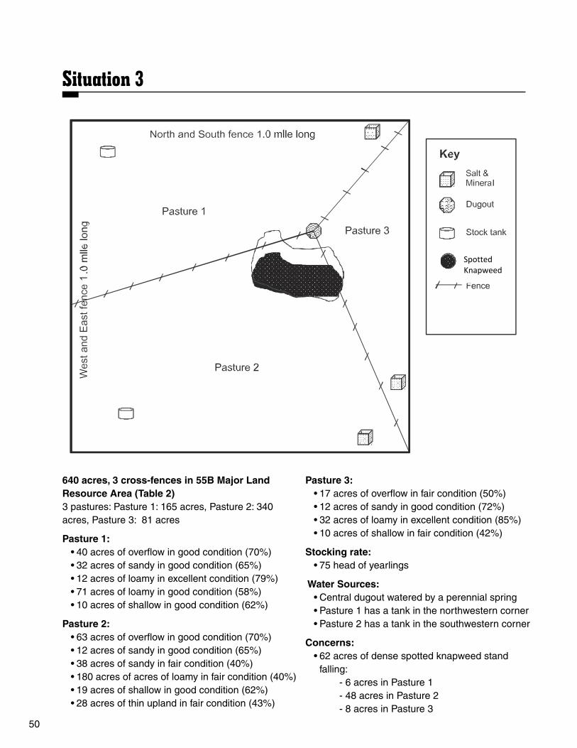
50
640 acres, 3 cross-fences in 55B Major Land Resource Area (Table 2)3 pastures: Pasture 1: 165 acres, Pasture 2: 340 acres, Pasture 3: 81 acres
Pasture 1:• 40 acres of overflow in good condition (70%)• 32 acres of sandy in good condition (65%)• 12 acres of loamy in excellent condition (79%)• 71 acres of loamy in good condition (58%)• 10 acres of shallow in good condition (62%)
Pasture 2:• 63 acres of overflow in good condition (70%)• 12 acres of sandy in good condition (65%)• 38 acres of sandy in fair condition (40%)• 180 acres of acres of loamy in fair condition (40%)• 19 acres of shallow in good condition (62%)• 28 acres of thin upland in fair condition (43%)
Pasture 3:• 17 acres of overflow in fair condition (50%)• 12 acres of sandy in good condition (72%)• 32 acres of loamy in excellent condition (85%)• 10 acres of shallow in fair condition (42%)
Stocking rate:• 75 head of yearlings
Water Sources:• Central dugout watered by a perennial spring• Pasture 1 has a tank in the northwestern corner• Pasture 2 has a tank in the southwestern corner
Concerns:• 62 acres of dense spotted knapweed stand
falling: - 6 acres in Pasture 1 - 48 acres in Pasture 2 - 8 acres in Pasture 3
Situation 3Situation 3
50
640 acres, 3 cross-fences in 55B Major Land Resource Area (Table 2) 3 pastures: Pasture 1: 165 acres, Pasture 2: 340 acres, Pasture 3: 81 acres
Pasture 1:
• 40 acres of overflow in good condition (70%) • 32 acres of sandy in good condition (65%) • 12 acres of loamy in excellent condition
(79%) • 71 acres of loamy in good condition (58%) • 10 acres of shallow in good condition (62%)
Pasture 2:
• 63 acres of overflow in good condition (70%) • 12 acres of sandy in good condition (65%) • 38 acres of sandy in fair condition (40%) • 180 acres of loamy in fair condition (40%) • 19 acres of shallow in good condition (62%) • 28 acres of thin loamy in fair condition (43%)
Pasture 3: • 19 acres of overflow in fair condition (50%) • 22 acres of sandy in good condition (72%) • 32 acres of loamy in excellent condition (85%) • 13 acres of shallow in fair condition (42%)
Stocking rate:
• 75 head of yearlings
Water Sources: • Central dugout watered by a perennial spring • Pasture 1 has a tank in the northwestern corner • Pasture 2 has a tank in the southwestern corner
Concerns:
• 62 acres of dense spotted knapweed stand falling:
- 6 acres in Pasture 1 - 48 acres in Pasture 2 - 8 acres in Pasture 3
Spotted Knapweed

51
Slope:
• Pasture 1: - 10 percent of Pasture 1 has a slope of 5% to 10%
• Pasture 2: - 25 percent of Pasture 2 has a slope of 5% to 10% - 20 percent of Pasture 2 has a slope of 10% to 15% - 5 percent of Pasture 2 has a slope of 15% to 20%
• Pasture 3: - 30 percent of Pasture 3 has a slope of 5% to 10% - 15 percent of Pasture 3 has a slope of 10% to 15% - 5 percent of Pasture 3 has a slope of 15% to 20%
Pasture rotation schedule:
Pasture 1 Pasture 2 Pasture 3
Year 1 June 1 - July 1 July 1 - Aug. 15 Aug. 15 - Aug. 30Year 2 Aug. 1 - Aug. 30 June 1 - July 15 July 15 - Aug. 1Year 3 June 15 - July 15 July 15 - Aug. 30 June 1 - July 15

52
n Situation 1 Answers:Carrying Capacity:
Fair overflow: 100 x 0.9 AUM/ac x 0.45 = 40.5 AUMsGood loamy: 100 x 0.7 AUM/ac x 0.60 = 42 AUMsFair loamy: 300 x 0.7 AUM/ac x 0.40 = 84 AUMsPoor loamy: 100 x 0.7 AUM/ac x 0.22 = 15.4 AUMsGood shallow: 40 x 0.4 AUM/ac x 0.65 = 10.4 AUMs
Total: 192.3 AUMs
Stocking Rate: 400 AUMs
Management Practices:• Decrease stocking rate• Defer part of grazing season• Fence development• Control blowouts and gullies• Apply woody plant control• Move salt and mineral• Begin a planned grazing system
n Situation 2 Answers: Carrying Capacity:
Pasture 1: Fair overflow: 50 x 0.8 AUM/ac x 0.45 = 18Poor overflow: 75 x 0.8 AUM/ac x 0.18 = 10.8Fair sandy: 75 x 0.6 AUM/ac x 0.30 = 13.5Poor sandy: 50 x 0.6 AUM/ac x 0.20 = 6Fair shallow: 70 x 0.40 AUM/ac x 0.35 = 9.8
Total for Pasture 1: 58.1 AUMs
Pasture 2: Fair overflow: 50 x 0.8 AUM/ac x 0.30 = 12Poor overflow: 85 x 0.8 AUM/ac x 0.15 = 10.2Good loamy: 60 x 0.6 AUM/ac x 0.55 = 19.8Fair loamy: 100 x 0.6 AUM/ac x 0.40 = 24Poor saline lowland: 25 x 0.7 AUM/ac x 0.2 = 3.5
Total for Pasture 2: 69.5 AUMs
Stocking Rate: Pasture 1: 85 AUMs Pasture 2: 85 AUMs
Total AUMs: 170 AUMs
Management Practices:• Decrease stocking rate• Burn or mow old growth• Move salt and mineral• Develop water• Interseed specific area• Change season of use• Defer one growing season• Begin a planned grazing system
n Situation 3 Answers:Carrying Capacity:
Pasture 1:Good overflow: 40 x 1.0 AUM/ac x 0.70 = 28Good sandy: 32 x 0.8 AUM/ac x 0.65 = 16.64Excellent loamy: 12 x 0.7 AUM/ac x 0.79 = 6.64Good loamy: 71 x 0.7 AUM/ac x 0.58 = 28.83Good shallow: 10 x 0.6 AUM/ac x 0.62 = 3.72Total for Pasture 1: 83.83 AUMs
Pasture 2:Good overflow: 63 x 1.0 AUM/ac x 0.70 = 44.1Good sandy: 12 x 0.8 AUM/ac x 0.65 = 6.24 Fair sandy: 38 x 0.8 AUM/ac x 0.40 = 12.16Fair loamy: 180 x 0.7 AUM/ac x 0.40 = 50.4Good shallow: 19 x 0.6 AUM/ac x 0.62 = 7.1Fair thin loamy: 28 x 0.6 AUM/ac x 0.43 = 7.23Total for Pasture 2: 127.23 AUMs
Pasture 3:Fair overflow: 21 x 1.0 AUM/ac x 0.5 = 10.5Good sandy: 22 x 0.8 AUM/ac x 0.72 = 12.67Excellent loamy: 32 x 0.7 AUM/ac x 0.85 =19.84 Fair shallow: 13 x 0.6 AUM/ac x 0.42 = 3.28Total for Pasture 3: 46.29 AUMs
Total AUMs: 257.35 AUMS
Stocking Rate: Pasture 1: 56.3 AUMs Pasture 2: 84.4 AUMs Pasture 3: 28.1 AUMs
Total AUMs: 168.2 AUMs
Management Practices:• Increase stocking rate• Control noxious weeds• Move salt and mineral• Begin a planned grazing system

53
DDB627
Contestant Name/# _________________________ County/Chapter ___________ Site # ________
North Dakota Range Judging Card
Plant IdentificationInstructions: Clearly print the plant ID number from the key (back side of card) in the appropriate blank. Place an X in the appropriate column(s) describing characteristics and ecological factors
Ecological and Resource Rating Desirable = De Undesirable = Un
Plant Season of Grazing Plant Sharp-tailed Grouse Cattle Identification Life Span Growth Response Origin Food Cover Food Number P A B C W D Ic Iv N I De Un De Un De Un SCORE
1
2
3
4
5
6
7
8
9
10
11
12
13
14
15
Key to symbols:P = Perennial C = Cool-season D = Decreaser N = NativeB = Biennial W = Warm-season Ic = Increaser I = IntroducedA = Annual Iv = Invader

54
Plant Key
GRASSES 1. Bearded wheatgrass 2. Big bluestem 3. Blue bunch wheatgrass 4. Blue grama 5. Buffalograss 6. Canada wildrye 7. Cattail species 8. Crested wheatgrass 9. Cheatgrass10. Foxtail barley11. Green needlegrass12. Indian ricegrass13. Indiangrass14. Inland saltgrass15. Kentucky bluegrass16. Little bluestem17. Needle-and-thread18. Northern reedgrass19. Nuttall’s alkaligrass20. Plains muhly21. Porcupine grass22. Prairie cordgrass23. Prairie dropseed24. Prairie Junegrass25. Prairie sandreed26. Red threeawn27. Reed canarygrass28. Sand bluestem29. Sand dropseed30. Sandberg bluegrass31. Sixweeks fescue32. Sideoats grama33. Smooth bromegrass34. Switchgrass35. Tumblegrass36. Western wheatgrass37. Wilcox panicum
SEDGES and RUSHES38. Baltic rush39. Slough sedge40. Upland sedge
County commissions, North Dakota State University and U.S. Department of Agriculture cooperating. North Dakota State University does not discriminate on the basis of age, color, disability, gender expression/identity, genetic information, marital status, national origin, public assistance status, race, religion, sex, sexual orientation, or status as a U.S. veteran. Direct inquiries to the Vice President for Equity, Diversity and Global Outreach, 102 Putnam, (701) 231-7708. This publication will be made available in alternative formats for people with disabilities upon request, (701) 231-7881.
CRYPTOGAMS41. Clubmoss42. Horsetail
FORBS43. Absinth wormwood44. American licorice45. American vetch46. Ball cactus47. Beards tongue48. Black samson49. Blanket flower50. Blue lettuce51. Blue-eyed grass52. Bracted spiderwort53. Canada thistle54. Cudweed sagewort55. Curly dock56. Curlycup gumweed57. Cutleaf goldenweed58. Daisy fleabane59. Dandelion60. Deervetch61. Dotted gayfeather62. Fringed sagewort63. Goatsbeard64. Green sagewort65. Hairy goldaster66. Heath aster67. Hoods phlox68. Indian breadroot69. Lamberts crazyweed70. Leafy spurge71. Mariposa lily72. Milkvetch species73. Missouri goldenrod74. Pasque flower75. Plains pricklypear76. Prairie coneflower77. Prairie thistle78. Prairie smoke79. Purple prairie clover
FORBS (continued)80. Pussytoes 81. Scarlet globemallow82. Scarlet gura83. Silverleaf scurfpea84. Skeletonweed85. Soft goldenrod86. Stiff goldenrod87. Sunflower species88. Sweetclover89. Western wallflower90. Western yarrow91. White milkwort92. White prairie clover93. Wild flax94. Wild onion95. Wooly plantain
SHRUBS and HALF-SHRUBS 96. Big sagebrush 97. Broom snakeweed 98. Creeping juniper 99. Leadplant100. Nuttall saltbush101. Prairie rose102. Rabbit brush103. Shrubby cinquefoil104. Silver sagebrush105. Skunk brush sumac106. Yucca107. Western snowberry108. Winterfat
TREES109. Buffaloberry110. Bur oak111. Chokecherry112. Cottonwood113. Green ash114. Rocky Mountain juniper115. Juneberry116. Silverberry

55
DDB629
Contestant Name/# _________________________ County/Chapter ___________ Site # ________
North Dakota Range Judging Card
Ecological SiteNorth Dakota Ecological Site Key (Choose one)
I. Restrictive to Root Growth: These sites have a limiting layer within 20 inches of the surface of rock, gravel, stone or restrictive clay (hard pan), which restricts most root growth beyond this layer. (If no restriction, go to II)..
A. Limiting layer is rock, scoria, gravel, or stone ...................................................... Shallow ❏ B. Limiting layer is restrictive clay ............................................................................Claypan ❏
II. Non-Restrictive to Root Growth: These sites do not have a restrictive layer within 20 inches of the soil surface.
C. Lowlands — These sites receive additional moisture from occasional stream overflow, run-in from adjacent slopes or during major flooding events. (If no additional moisture occurs, go to D).
1. No water table within 5 feet from surface, typically found in swales, no salt deposits on soil surface .........................................................................................................Overflow ❏
2. Water table within 5 feet from surface
This site will have salts evident on the surface when dry ....................Saline Lowland ❏
D. Uplands —These sites do not receive additional moisture from occasional stream overflow, run-in from adjacent slopes, or during major flooding events.
1. These sites occur on slopes usually less than 15%
a. Soils will not form a firm ball when wet, coarse ..............................................Sands ❏ b. Soils will form a firm ball and produce a short ribbon less than 1 inch, feel gritty .............................................................................................Sandy ❏ c. Soils will form a ribbon up to 2 inches and not feel gritty, like flour when dry ........................................................................................................ Loamy ❏ d. Soils form a ribbon greater than 2 inches, support their own weight and feel greasy when wet .............................................................................. Clayey ❏
2. These sites occur on sidehills with slopes usually greater than 15%
a. This site is found on glaciated soils east of the Missouri River, thin top soil ............................................................................................Thin Loamy ❏ b. This site is found on nonglaciated soils west of the Missouri River, thin top soil .................................................................................... Limy Backslope ❏

56
County commissions, North Dakota State University and U.S. Department of Agriculture cooperating. North Dakota State University does not discriminate on the basis of age, color, disability, gender expression/identity, genetic information, marital status, national origin, public assistance status, race, religion, sex, sexual orientation, or status as a U.S. veteran. Direct inquiries to the Vice President for Equity, Diversity and Global Outreach, 102 Putnam, (701) 231-7708. This publica-tion will be made available in alternative formats for people with disabilities upon request, (701) 231-7881.
Beef Cattle Site EvaluationForage Value (desirable plants) Excellent (76 to 100%) . . . . . . . . . . . . ❏ Good (51 to 75%) . . . . . . . . . . . . . . . . ❏ Fair (26 to 50%) . . . . . . . . . . . . . . . . . ❏ Poor (0 to 25%) . . . . . . . . . . . . . . . . . . ❏
Stocking Rate (Given on Site Key) Increase . . . . . . . . . . . . . . . . . . . . . . . ❏ Decrease . . . . . . . . . . . . . . . . . . . . . . ❏ Keep the same . . . . . . . . . . . . . . . . . . ❏
Distribution Factors A) Slope < 5% . . . . . . . . . . . . . . . . . . . . . . . . . . ❏ 5 to 10% . . . . . . . . . . . . . . . . . . . . . . . ❏ 11 to 15% . . . . . . . . . . . . . . . . . . . . . . ❏ > 15% . . . . . . . . . . . . . . . . . . . . . . . . . ❏ B) Grazing Restraints 1) Terrain: Rough . . . . . . . . ❏ Smooth . . . . . . . . ❏ 2) Woody canopy: > 30% . . . . . . . . ❏ < 30% . . . . . . . . . ❏
Recommended Management PracticesBeef Continue present management . . . . . . . . . . ❏Develop water . . . . . . . . . . . . . . . . . . . . . . . ❏Decrease stocking rate . . . . . . . . . . . . . . . . ❏Increase stocking rate . . . . . . . . . . . . . . . . . ❏Change kind of livestock . . . . . . . . . . . . . . . ❏Apply woody canopy control . . . . . . . . . . . . ❏Apply undesirable grass and forb control . . ❏Burn or mow old grass . . . . . . . . . . . . . . . . ❏Defer part of grazing season . . . . . . . . . . . . ❏Defer one or more grazing seasons . . . . . . ❏Plant adapted forage species . . . . . . . . . . . ❏Control noxious weeds . . . . . . . . . . . . . . . . ❏Begin a plan grazing system . . . . . . . . . . . . ❏
Sharp-tailed Grouse Site EvaluationNesting Cover A) Desirable Nesting Plants > 30% aerial cover . . . . . . . . . . . . . ❏ 10 to 30% aerial cover . . . . . . . . . . ❏ < 10% aerial cover . . . . . . . . . . . . . ❏ B) Nesting Cover Height (marked plant) > 16 inches . . . . . . . . . . . . . . . . . . . ❏ 4 to 16 inches . . . . . . . . . . . . . . . . . ❏ < 4 inches . . . . . . . . . . . . . . . . . . . . ❏
Food habitat (desirable plants) > 30% by weight . . . . . . . . . . . . . . . ❏ 10 to 30% by weight . . . . . . . . . . . . ❏ < 10% by weight . . . . . . . . . . . . . . . ❏
Protective Cover (% woody cover) > 30% aerial cover . . . . . . . . . . . . . ❏ 10 to 30% aerial cover . . . . . . . . . . ❏ < 10% aerial cover . . . . . . . . . . . . . ❏
Recommended Management PracticesSharp-tailed GrouseContinue present management . . . . . . . . . . ❏Improve nesting cover . . . . . . . . . . . . . . . . . ❏Decrease stocking rate . . . . . . . . . . . . . . . . ❏Add more livestock grazing or burn . . . . . . . ❏Improve food habitat . . . . . . . . . . . . . . . . . . ❏Improve protective cover . . . . . . . . . . . . . . . ❏Apply woody plant control . . . . . . . . . . . . . . ❏
Similarity Index (Choose one)
Excellent (76 to 100%) ❏ Good (51 to 75%) ❏ Fair (26 to 50%) ❏ Poor (0 to 25%) ❏

57
DDB630
Contestant Name/# _________________________ County/Chapter ___________ Site # ________
North Dakota Range Judging Card
Situation MapCarrying Capacity (Total AUMs +/- 5): _________________________
Stocking Rate (Compare Stocking Rate of animals grazed to calculated Carrying Capacity above.) (Check one box.)
Increase .................................................................................................... ❏ Decrease ................................................................................................... ❏ Keep the same .......................................................................................... ❏
Recommended Management Practices: Continue present management ................................................................ ❏ Develop water ............................................................................................ ❏ Develop fence ............................................................................................ ❏ Burn or mow old growth ........................................................................... ❏ Move salt and mineral ............................................................................... ❏ Reseed (full seed) specific areas .............................................................. ❏ Interseed specific areas ............................................................................ ❏ Control blowouts and gullies ..................................................................... ❏ Apply woody canopy control ...................................................................... ❏ Control noxious weeds ............................................................................. ❏ Change season of use ............................................................................. ❏ Defer part of grazing season ..................................................................... ❏
Defer one growing seasons ...................................................................... ❏ Defer two or more growing seasons .......................................................... ❏ Begin a planned grazing system ............................................................... ❏
Total Points: 300
- Carrying Capacity: 100 points- Stocking Rate: 50 points- Recommended Management Practices: 150 points - Each practice worth 10 points
County commissions, North Dakota State University and U.S. Department of Agriculture cooperat-ing. North Dakota State University does not discriminate on the basis of age, color, disability, gender expression/identity, genetic information, marital status, national origin, public assistance status, race, religion, sex, sexual orientation, or status as a U.S. veteran. Direct inquiries to the Vice President for Equity, Diversity and Global Outreach, 102 Putnam, (701) 231-7708. This publication will be made available in alternative formats for people with disabilities upon request, (701) 231-7881.


Sources of Information1. Common Grasses and Sedges in
North Dakota. 1995. Kevin Sedivec and Duane Dodds. Publication R658.North Dakota State University Extension Service, NDSU, Fargo, N.D.
2. Ecological Sites of North Dakota. 2012. Kevin Sedivec and Jeff Printz. Publication R1556. North Dakota State University Extension Service, NDSU, Fargo, N.D.
3. Grassland Plants of South Dakota and the Northern Great Plains. 1999. James R. Johnson and Gary E. Larson. South Dakota State University, Brookings.
4. Plants of the Black Hills and Bear Lodge Mountains. 1999. Gary E. Larson and James R. Johnson. South Dakota State University, Brookings.
County commissions, North Dakota State University and U.S. Department of Agriculture cooperating. North Dakota State University does not discriminate on the basis of age, color, disability, gender expression/identity, genetic information, marital status, national origin, public assistance status, race, religion, sex, sexual orientation, or status as a U.S. veteran. Direct inquiries to the Vice President for Equity, Diversity and Global Outreach, 102 Putnam, (701) 231-7708. This publication will be made available in alternative formats for people with disabilities upon request, (701) 231-7881. 300-8-07, 750-8-08, 250-8-10, 50-6-12, 100-8-12, 25-5-13, 750-7-15