december 2018 quarterly report - investi.com.au · asx announcement | 31 january 2019 5 lake way...
TRANSCRIPT

31 January 2019
ASX ANNOUNCEMENT
DECEMBER 2018 QUARTERLY REPORT
The Board of Salt Lake Potash Limited (the Company or Salt Lake Potash) is pleased to present its Quarterly Report for the period ending 31 December 2018.
The Company is focussed on rapidly progressing the development of its Lake Way Project, intended to be the first salt-lake brine Sulphate of Potash (SOP) production operation in Australia.
Highlights for the quarter and subsequently include:
Native Title Land Access and Exploration Agreement Executed for Lake Way
Salt Lake Potash and Tarlka Matuwa Piarku (Aboriginal Corporation) RNTBC (TMPAC) have
entered into a Native Title Land Access and Exploration Agreement for Lake Way
TMPAC consent has been received for the on-lake construction of the pond system for the
dewatering of the Williamson Pit at Lake Way (Williamson Ponds)
Key Approval Obtained and Construction of Williamson Ponds Imminent
Mining Proposal and Project Management Plans for the Williamson Ponds approved by the
Department of Mines, Industry Regulation and Safety (DMIRS)
Initial fleet of construction equipment mobilised to Lake Way and site preparation works being
undertaken in preparation for imminent construction of the Williamson Ponds
Detailed design of Williamson Ponds completed
‘Whole of Lake’ Resource Program for Lake Way Advancing
Work well advanced to enable the Company to report:
o a Mineral Resource Estimate for the lake bed brine and the paleochannel aquifer for the
100% owned Salt Lake tenements
o upgraded Mineral Resource Estimate for the Blackham tenements
‘Whole of Lake’ Mineral Resource Estimate will enable the Company to examine larger
production scenarios
Field Trials at Lake Way Confirm Salt Production Process
Comprehensive field evaporation trials at Lake Way are successfully producing substantial
volumes of potassium Harvest Salts validating the modelled salt production process.
Field evaporation trials have produced over 2 tonnes of high grade Harvest Salts at Lake Way.
Over 100,000l of brine from both high grade Lake Way playa brine and the super high-grade
Williamson Pit brine have been extracted for the field trial and evaporated separately. Both
brines have rapidly produced quality harvest salts amenable for conversion to Sulphate of
Potash (SOP).
Potassium Harvest Salts produced from the field trial will be processed at Saskatchewan
Research Council (SRC), where a pilot plant will duplicate and refine the Lake Way process flow
sheet, as well as producing further product samples for offtake partners.

ASX ANNOUNCEMENT | 31 January 2019
2
Key Appointments Enhance Senior Project Development Team
Highly regarded mining executive Tony Swiericzuk commenced as Managing Director and Chief
Executive Officer of Salt Lake Potash effective 5 November 2018
Three proven mining executives join Salt Lake Potash as leaders in the project development
team:
o Peter Cardillo as Project Director – Processing and NPI
o Lloyd Edmunds as Project Director – Civil
o Stephen Cathcart as Project Director – Technical
These appointments, along with other recent additions to the project execution team, bring
diversified technical/studies, approvals, construction, operations, process infrastructure
experience to the Company as it moves into rapid project development phase
Completion of A$13.0 Million Placement to Fund Activities at Lake Way
The Company completed placement of 31.0 million new shares to raise gross proceeds of $13.0
million
The Placement included 950,000 shares subscribed for by CEO, Mr Tony Swiericzuk, and
750,000 shares subscribed for by the Company’s Chairman, Mr Ian Middlemas
The proceeds have enabled the Company to accelerate planned development activities at Lake
Way, including mobilisation of construction equipment for the imminent construction of the
Williamson Ponds and dewatering of the Williamson Pit
Enquiries: Tony Swiericzuk (Perth)
Telephone: +61 (8) 9322 6322 Jo Battershill (London) Telephone: +44 207 478 3900

ASX ANNOUNCEMENT | 31 January 2019
3
Overview
Salt Lake Potash is the owner of nine large salt lakes in the Northern Goldfields Region of Western Australia. This outstanding portfolio of assets has a number of important, favourable characteristics:
Over 3,300km2 of playa surface, with in-situ clays suitable for low cost on-lake pond construction;
Very large paleochannel hosted brine aquifers, with chemistry amenable to evaporation of salts for SOP production, extractable from both low-cost trenches and deeper bores;
Excellent evaporation conditions;
Excellent access to transport, energy and other infrastructure in the Goldfields mining district;
Clear opportunity to reduce transport costs by developing lakes closer to infrastructure and by capturing economies of scale; and
Potential for multi-lake production offers optionality and significant scale potential, operational flexibility, cost advantages and risk mitigation from localised weather events.
Salt Lake Potash’s immediate focus is on the rapid development of the Lake Way Project, intended to be the first salt-lake brine Sulphate of Potash (SOP) production operation in Australia. Lake Way’s location and logistical advantages make it the ideal location for the Company’s first SOP operation.
The Company’s long term plan is to develop an integrated SOP operation, producing from a number (or all) of the lakes. Salt Lake Potash will progressively explore each of the lakes with a view to estimating resources for each Lake, and determining the development potential. Exploration of the lakes will be prioritised based on likely transport costs, scale, permitting pathway and brine chemistry.
Figure 1: Location of Salt Lake Potash’s Portfolio of Assets

ASX ANNOUNCEMENT | 31 January 2019
4
LAKE WAY PROJECT
Lake Way is located in the Northern Goldfields Region of Western Australia, less than 15km south of Wiluna. The surface area of the Lake is over 270km2.
Salt Lake Potash holds five Exploration Licences (one granted and four under application) covering most of Lake Way and select areas off-lake, including the paleochannel defined by previous exploration. The northern end of the Lake is largely covered by a number of Mining Leases, held by Blackham Resources Limited (Blackham), the owner of the Wiluna Gold Mine.
The Company’s Memorandum of Understanding with Blackham (see ASX Announcement dated 12 March 2018) allows for an expedited path to development at Lake Way.
Figure 2: Lake Way Tenement Holdings

ASX ANNOUNCEMENT | 31 January 2019
5
Lake Way has a number of compelling advantages which make it an ideal site for Salt Lake Potash’s initial SOP operation, including:
Utilisation of Blackham’s existing infrastructure (including camps, power and maintenance) to accelerate development.
The site has excellent freight solutions, being adjacent to the Goldfields Highway, which is permitted for heavy haulage, quad trailer road trains to the railhead at Leonora and then direct rail access to both Esperance and Fremantle Ports, or via other heavy haulage roads to Geraldton Port.
The Goldfields Gas Pipeline is adjacent to Salt Lake Potash’s tenements, running past the eastern side of the Lake.
Access to Blackham’s existing Mining Leases provides advanced permitting pathway for early development activity, including the construction of the Williamson Ponds.
Salt Lake Potash will construct the Williamson Ponds and dewater the existing Williamson Pit on Lake Way. The pit contains an estimated 1.2GL of brine at the exceptional grade of 25kg/m3 of SOP. This brine is the ideal starter feed for evaporation ponds, having already evaporated from the normal Lake Way brine grade, which averages over 14kg/m3
.
The high grade brines at Lake Way will result in lower capital and operating costs due to lower extraction and evaporation requirements.
The presence of clays in the upper levels of the lake which are amenable to low cost, on-lake evaporation pond construction.
The Company is concurrently progressing the imminent construction of the Williamson Ponds, whilst also rapidly advancing a ‘whole of lake’ scenario, including mineral resource estimates, permitting and approvals, pilot plant process testwork and assessment of infrastructure and logistical options. A number of key appointments have been made during the Quarter that support the rapid development of the Lake Way Project, bringing diversified technical, construction, operations, process infrastructure experience to the Company, including:
Peter Cardillo as Project Director – Processing and NPI
Lloyd Edmunds as Project Director – Civil
Stephen Cathcart as Project Director – Technical Salt Lake Potash has also engaged industry leading consultants to work alongside the Company’s internal experts for works related to the larger ‘whole of lake’ development of the Lake Way Project, including:
WOOD – technical studies for a full scale commercial project
Pendragon – environmental consultant
Ad-Infinitum – pond process design
Knight Piesold – Williamson Pond detailed design
Cardno – on playa trench hydraulics
SRC – process testwork and pilot plant
Global groundwater – bore test pumping
Hydrogeoenviro – bore water licensing Having completed a placement to raise $13.0 million during the quarter and built a team with capability and track record of successfully developing and constructing numerous resource projects, the Company is well placed to take advantage of the benefits of the Lake Way Project and its broader portfolio of nine salt lakes. Discussions are also ongoing with a number of offtake partners and the testwork currently underway at SRC will provide high-grade SOP product samples for testing by these partners.

ASX ANNOUNCEMENT | 31 January 2019
6
Native Title Land Access and Exploration Agreement
In December 2018, the Company signed a Native Title Land Access and Brine Minerals Exploration Agreement (the Agreement) with Tarlka Matuwa Piarku (Aboriginal Corporation) RNTBC (TMPAC) covering the Lake Way Project area.
Figure 3: Salt Lake Potash CEO, Tony Swiericzuk and TMPAC Chairman, Robbie Wongawol
TMPAC entered into the Agreement with Salt Lake Potash on behalf of the Wiluna People who are the recognised Native Title Holders of the land covering the Lake Way Project area. TMPAC also provided consent for the total area required for the construction and operation of the Williamson Ponds.
The signing of the Agreement with TMPAC and receipt of TMPAC’s consent for the Williamson Ponds is a major milestone in the development of the Lake Way Project and positions Salt Lake Potash to accelerate the works program for the Williamson Ponds.
Approvals Advancing
The Company’s Mining Proposal and Project Management Plans for the Williamson Ponds were approved by Department of Mines, Industry Regulation and Safety (DMIRS) during the quarter, and a Works Approval licence was also submitted to the Department of Water and Environmental Regulation (DWER). These works include the construction of operational scale evaporation ponds and associated infrastructure including pond trenching to provide brine conditioning to manage the brine extracted from the Williamson Pit.
Salt Lake Potash has previously received environmental approval from the DMIRS to construct ponds totalling up to 133Ha (the Williamson Ponds), as well as ancillary infrastructure.
The Williamson Ponds will be the first operational scale SOP evaporation ponds built on a salt lake in Australia – an important part of the staged de-risking and development at Lake Way and across the Company’s portfolio of salt lakes in the Northern Goldfields Region.
A series of studies commenced during the quarter in support of the ongoing environmental approvals. These include flora and fauna surveys, climatology and hydrologic assessment, flood modelling and geotechnical investigations.

ASX ANNOUNCEMENT | 31 January 2019
7
Mineral Resource Program
The Company has previously reported a Mineral Resource Estimate for Lake Way (Blackham tenements only). Work progressed during the quarter to enable the Company to estimate a ‘whole of lake’ Mineral Resource Estimate, including the remaining playa surface covered by Salt Lake Potash’s tenements and the paleochannel aquifer, which were not considered as part of the initial Mineral Resource estimate and provide significant short term upside to increase resources at Lake Way.
Estimation of a ‘whole of lake’ resources will enable the Company to consider larger production scenarios for Lake Way.
A program of 19 auger holes (Figure 4), test pits, trench testing, recovery testing, brine sampling and laboratory determination of hydraulic parameters has commenced and is expected to be completed in the current quarter. Results of these activities will provide inputs to the Mineral Resource Estimate for the playa surface.
Figure 4: Location of Auger Holes and Geophysical Survey lines at Lake Way

ASX ANNOUNCEMENT | 31 January 2019
8
Planning and initial works also commenced on defining the paleochannel resource under Lake Way.
By taking advantage of previous works in the area, the Company was able to identify and inspect three existing production bores drilled into the paleochannel. Each of the holes was inspected by downhole camera which showed that all three remain intact and, with some minor cleaning and redevelopment, are expected to be suitable for test pumping. Rehabilitation and test pumping is planned for the current quarter, and the results of this activity are expected to confirm the hydraulic parameters of the productive zone of the paleochannel and the brine grade. The data produced from the test pumping will be used as an input to the Mineral Resource Estimate for the paleochannel.
A gravity and passive seismic geophysical survey consisting of 22 lines and a total coverage of greater than 110 km was commissioned to define the location and form of the Lake Way paleochannel within the Salt Lake Potash and Blackham tenements (refer Figures 4 and 5). The work consists of a number of cross sections which are then combined to provide a 3D representation of the paleochannel. This work will be completed in the current quarter. When combined with the geological logs from previous work it is expected to be possible to define the extent of the brine hosting sediments and develop a volumetric understanding of the paleochannel, which in turn will inform the resource model.
Figure 5: Passive seismic survey showing paleochannel at Lake Way (Line 4)

ASX ANNOUNCEMENT | 31 January 2019
9
Civil Construction – On-Lake Infrastructure
During the quarter, the Company progressed the first phase of on-lake development with completion of the detailed design of the Williamson Ponds to dewater the high grade Williamson Pit brine. This early works program will allow the fast-tracking of harvest salts in readiness for process plant commissioning.
Detailed engineering works during the quarter for the Williamson Ponds included further analysis of strength and permeability characteristics of lakebed sediments, and geotechnical parameters for final pond analysis and design. Other geotechnical design work undertaken included Cone Penetration Test (CPT) data analysis, trafficability assessment, access road analysis, seepage models, borrow pit assessments and development of the pond construction methodology. The geotechnical investigation and engineering works will expand in the current quarter for the larger ‘whole of lake’ scenario at Lake Way.
Surveying contractor, AAM Group set out the Williamson Pond design in readiness for construction commencement in the current quarter, and also commenced the Light Detection and Ranging (LiDAR) topographical survey flyover for the larger ‘whole of lake’ scenario.
Figure 6: AAM Group flying LiDAR topographical survey over Lake Way
Given the unique design and site conditions, the Company is now engaging with the specialist civil contracting market to select our contracting partners to build the on lake Williamson Ponds and dewater the Williamson Pit. In late December 2018, the Company mobilised initial construction equipment to Lake Way, with site preparation works being undertaken in preparation of the imminent construction of the Williamson Ponds.
The Company has also sort Expressions of Interest (EOI) from key civil contractors to participate in an Early Contractor Involvement (ECI) process for the larger ‘whole of lake’ development. To date, the Company has received positive feedback and acceptance from a number of major civil contractors.
ASX ANNOUNCEMENT | 31 January 2019
10
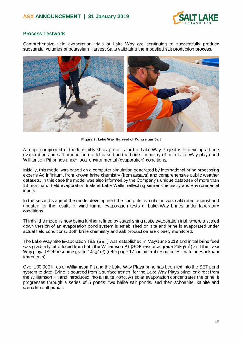
Process Testwork
Comprehensive field evaporation trials at Lake Way are continuing to successfully produce substantial volumes of potassium Harvest Salts validating the modelled salt production process.
Figure 7: Lake Way Harvest of Potassium Salt
A major component of the feasibility study process for the Lake Way Project is to develop a brine evaporation and salt production model based on the brine chemistry of both Lake Way playa and Williamson Pit brines under local environmental (evaporation) conditions.
Initially, this model was based on a computer simulation generated by international brine processing experts Ad Infinitum, from known brine chemistry (from assays) and comprehensive public weather datasets. In this case the model was also informed by the Company’s unique database of more than 18 months of field evaporation trials at Lake Wells, reflecting similar chemistry and environmental inputs.
In the second stage of the model development the computer simulation was calibrated against and updated for the results of wind tunnel evaporation tests of Lake Way brines under laboratory conditions.
Thirdly, the model is now being further refined by establishing a site evaporation trial, where a scaled down version of an evaporation pond system is established on site and brine is evaporated under actual field conditions. Both brine chemistry and salt production are closely monitored.
The Lake Way Site Evaporation Trial (SET) was established in May/June 2018 and initial brine feed was gradually introduced from both the Williamson Pit (SOP resource grade 25kg/m3) and the Lake Way playa (SOP resource grade 14kg/m3) (refer page 17 for mineral resource estimate on Blackham tenements).
Over 100,000 litres of Williamson Pit and the Lake Way Playa brine has been fed into the SET pond system to date. Brine is sourced from a surface trench, for the Lake Way Playa brine, or direct from the Williamson Pit and introduced into a Halite Pond. As solar evaporation concentrates the brine, it progresses through a series of 5 ponds: two halite salt ponds, and then schoenite, kainite and carnallite salt ponds.

ASX ANNOUNCEMENT | 31 January 2019
11
Figure 8: Lake Way SET
Harvested salt and brine samples are analysed at regular intervals through the evaporation process to gather data for model correlation. To date over 400 samples have been extracted and assayed at Bureau Veritas in Perth.
Figure 9 below set out the results from the Lake Way SET to date, which have an excellent correlation to the salt production model.
This provides the Company with a very strong basis to continue development of the mass balance model and process flow sheet for the Lake Way Project.
Figure 9: Comparison of brine modelling to (a) Lake Way Playa, and (b) Williamson Pit
It was found that halite salts begin to form almost immediately upon initial evaporation (refer Figure 9(b)). This will shorten the overall salt production timeframe for the Williamson Pit brine. It may also offer the opportunity for faster construction of harvest pond infrastructure, utilising harvested halite salts for pavement.

ASX ANNOUNCEMENT | 31 January 2019
12
The Lake Way SET has already produced over 2 tonnes of Potassium Harvest Salts (1.8 tonnes Lake Way Playa and 0.4 tonnes of Williamson Pit) and a further 5 tonnes are forecast to be harvested during ongoing evaporation trials.
From the test work to date, the Williamson Pit and the Lake Way Playa brines have produced excellent high grade Harvest Potassium Salts with an exceptional K grade of up to 10% and an overall high average K grade of 6.8%. This aligns very well with the grades that were observed during the Lake Wells SET’s.
This provides the Company with confidence that the Lake Way production model, process flowsheet and Harvest Salt product will produce a final high grade SOP product in line with the world leading SOP product of 53% K2O produced at Lake Wells.
The Company has engaged the world’s leading potash processing laboratory, Saskatchewan Research Council (SRC), to establish a pilot plant based on the process flow sheet for the Lake Way Project. The initial batch of harvest salts from Lake Way has been delivered to SRC and testwork is underway.
The pilot plant will validate and refine the Lake Way process flowsheet and also produce high-grade SOP product samples for offtake partners.

ASX ANNOUNCEMENT | 31 January 2019
13
LAKE BALLARD
The Lake Ballard Project is located about 15 km north of Menzies. The playa is a significant regional landform with a surface area of 698km2. The geology of Lake Ballard is similar to that encountered at other lakes in the Company’s portfolio.
Surface Aquifer Exploration Program
Final elements of fieldwork undertaken to enable the estimation of a resource were completed at Lake Ballard during the quarter.
The Company commenced an auger drilling program in September 2018 to obtain insitu samples for geological logging, porosity measurement, specific yield testing and brine sampling. The holes were drilled using a track mounted auger rig, capable of drilling to between 15 - 20m depth depending on ground conditions.
Figure 10: Lake Ballard Surface Aquifer Exploration Programme
Drilling was completed, with a total of 15 auger holes, from which 47 insitu samples from depths varying from 1m to 15m.
The core samples were collected and sent to Core Laboratories WA for analysis of hydraulic conductivity, total porosity and drainable porosity (Specific yield).
The Company also test pumped two trenches for 15 days (Figure 11) and analysed data from the test pumping of 44 trial pits.
Results of the auger program and insitu sampling are in accordance with expectation and reported in full in Appendix 2.

ASX ANNOUNCEMENT | 31 January 2019
14
Figure 11: Lake Ballard trench and pump setup
The test pumping and trial pit data were analysed using known methodologies with the AQTESOLV analysis programme. This data will ultimately feed into a mineral resource estimate for the majority of the lake.

ASX ANNOUNCEMENT | 31 January 2019
15
LAKE MINIGWAL
The Lake Minigwal Project is located in the Northern Goldfields Region of Western Australia approximately 80km south east of Laverton.
During the quarter extensive gravity geophysics was run over the various branches of Lake Minigwal as a preliminary investigation into the depth to basement and location of the paleochannel.
The purpose of the gravity survey was twofold, to identify the depth to basement across the lake and to identify the thalweg of the paleochannel as a precurser to the development of a drilling programme.
Whilst there is confidence that the main trunk drainage of the paleochannel passes beneath the Company’s tenements and that a large paleo-tributary that enters from the north and merges with the main trunk drainage beneath the eastern third of Lake Minigwal, the exact location is currently unknown.
The results are currently being processed, however preliminary analysis has identified the Thalweg of the paleochannel as can be seen in Figure 12 below. Further modelling will be undertaken to refine the data response and to identify future areas for greater density of surveys.
Figure 12: Lake Minigwal Gravity Geophysics (Regional basemap and targeted survey)
Thalweg of the paleochannel

ASX ANNOUNCEMENT | 31 January 2019
16
SOP SAMPLE PRODUCTION
During the quarter, the Company completed confirmatory testwork at Fremantle Metallurgy’s mineral processing laboratory. The testwork, conducted by the Company’s process engineers, began the process of converting several tonnes of harvest salts collected from the Lake Wells SET into SOP samples. The process and equipment used was based upon the flowsheet previously tested by SRC.
The in-house work successfully tested some of the discrete unit operations in the flowsheet and generated a small amount of lake-derived SOP product for assessment of quality. The testwork has provided valuable inputs into the process flowsheet development and equipment selection for the Lake Way harvest salt testwork now underway at SRC. Importantly, the operation also provided the Company’s process team valuable hands-on experience in dealing with the subtle complexities in the operation of a saturated salt-brine process.
CORPORATE
During the quarter, the Company completed a placement to existing and new institutional and sophisticated investors in Australia and overseas for 31.0 million new ordinary shares of the Company, to raise gross proceeds of $13,000,000 (Placement). There was very strong demand for the Placement, an endorsement of the recent appointment of Tony Swiericzuk as CEO and also of the Company’s world class Sulphate of Potash project. The cornerstone investor for the Placement was a significant international investment fund. Directors and senior management subscribed for a total of 2.4 million shares in the Placement, including 950,000 shares by the CEO, Mr Tony Swiericzuk, and 750,000 shares by the Company’s Chairman, Mr Ian Middlemas, which were issued in January 2019 following shareholder approval. Proceeds from the Placement are being used to fund construction of the Williamson Ponds and dewatering of the Williamson Pit, as well as ongoing development of on-lake infrastructure, exploration and feasibility studies, and general working capital. Having successfully raised the funds for project development at Lake Way, the Company significantly accelerated its activity and expenditure during the December quarter.

ASX ANNOUNCEMENT | 31 January 2019
17
Note 1: Lake Way Mineral Resource Estimate (Blackham tenements only)
Sediment Hosted Brine – Indicated (94%)
Playa Area
Lakebed Sediment Volume
Brine Concentration Mineral Tonnage Calculated from
Total Porosity Mineral Tonnage Calculated from
Drainable Porosity
K Mg SO4 Total
Porosity Brine
Volume SOP
Tonnage Drainable Porosity
Brine Volume
SOP Tonnage
(km2) (Mm3) (kg/m3) (kg/m3) (Kg/m3) (Mm3) (kt) (Mm3) (kt)
55.4 290 6.9 7.6 28.3 0.43 125 1,900 0.11 31.9 490
Williamson Pit Brine – Measured (6%)
Brine Volume (Mm3)
Potassium Conc. (kg/m3)
Magnesium Conc. (kg/m3)
Sulphate Conc. (kg/m3)
SOP Tonnage (kt)
1.26 11.4 14.47 48 32
Work is currently underway to enable the Company to report a Mineral Resource Estimate for the lake bed brine and the paleochannel aquifer for the ‘whole of lake’, which will enable the Company to examine larger production scenarios.
Competent Persons Statement
The information in this announcement that relates to Exploration Results for Lake Ballard is based on information compiled by Mr Ben Jeuken, who is a member Australian Institute of Mining and Metallurgy and a member of the International Association of Hydrogeologists. Mr Jeuken is employed by Groundwater Science Pty Ltd, an independent consulting company. Mr Jeuken has sufficient experience, which is relevant to the style of mineralisation and type of deposit under consideration and to the activity, which he is undertaking to qualify as a Competent Person as defined in the 2012 Edition of the ‘Australasian Code for Reporting of Exploration Results, Mineral Resources and Ore Reserves’. Mr Jeuken consents to the inclusion in the report of the matters based on his information in the form and context in which it appears.
The information in this announcement that relates to Process Testwork Results is extracted from the report entitled ‘Field
Trials at Lake Way Confirm Salt Production Process’ dated 29 January 2019. This announcement is available to view on
www.saltlakepotash.com.au. The information in the original ASX Announcement that related to Process Testwork Results
was based on, and fairly represents, information compiled by Mr Bryn Jones, BAppSc (Chem), MEng (Mining) who is a
Fellow of the AusIMM. Mr Jones is a Director of Salt Lake Potash Limited. Mr Jones has sufficient experience, which is
relevant to the style of mineralisation and type of deposit under consideration and to the activity which he is undertaking,
to qualify as a Competent Person as defined in the 2012 Edition of the 'Australasian Code for Reporting of Exploration
Results, Mineral Resources and Ore Reserves'. Salt Lake Potash Limited confirms that it is not aware of any new
information or data that materially affects the information included in the original market announcement. Salt Lake Potash
Limited confirms that the form and context in which the Competent Person’s findings are presented have not been
materially modified from the original market announcement.
The information in this Announcement that relates to Mineral Resources is extracted from the report entitled ‘Scoping Study
for Low Capex, High Margin Demonstration Plant at Lake Way’ dated 31 July 2018. This announcement is available to
view on www.saltlakepotash.com.au. The information in the original ASX Announcement that related to Mineral Resources
was based on, and fairly represents, information compiled by Mr Ben Jeuken, who is a member Australian Institute of
Mining and Metallurgy and a member of the International Association of Hydrogeologists. Mr Jeuken is employed by
Groundwater Science Pty Ltd, an independent consulting company. Mr Jeuken has sufficient experience, which is relevant
to the style of mineralisation and type of deposit under consideration and to the activity, which he is undertaking to qualify
as a Competent Person as defined in the 2012 Edition of the ‘Australasian Code for Reporting of Exploration Results,
Mineral Resources and Ore Reserves’. Salt Lake Potash Limited confirms that it is not aware of any new information or
data that materially affects the information included in the original market announcement and, in the case of estimates of
Mineral Resources, that all material assumptions and technical parameters underpinning the estimates in the relevant
market announcement continue to apply and have not materially changed. Salt Lake Potash Limited confirms that the form
and context in which the Competent Person’s findings are presented have not been materially modified from the original
market announcement.

ASX ANNOUNCEMENT | 31 January 2019
18
Appendix 1 - Summary of Exploration and Mining Tenements
As at 31 December 2018, the Company holds interests in the following tenements:
Project Status Type of Change License Number Interest (%)
1-Oct-18 Interest (%) 31-Dec-18
Western Australia
Lake Way
Central Granted - E53/1878 100% 100%
East Application Application E53/2057 - 100%
South Application - E53/1897 100% 100%
South Application Application E53/2059 - 100%
South Application Application E53/2060 - 100%
Lake Wells
Central Granted - E38/2710 100% 100%
South Granted - E38/2821 100% 100%
North Granted - E38/2824 100% 100%
Outer East Granted - E38/3055 100% 100%
Single Block Granted - E38/3056 100% 100%
Outer West Granted - E38/3057 100% 100%
North West Granted - E38/3124 100% 100%
West Granted - L38/262 100% 100%
East Granted - L38/263 100% 100%
South West Granted - L38/264 100% 100%
South Granted - L38/287 100% 100%
South Western Granted - E38/3247 100% 100%
South Granted - M38/1278 100% 100%
Lake Ballard
West Granted - E29/912 100% 100%
East Granted - E29/913 100% 100%
North Granted - E29/948 100% 100%
South Granted - E29/958 100% 100%
South East Granted - E29/1011 100% 100%
South East Granted - E29/1020 100% 100%
South East Granted - E29/1021 100% 100%
South East Granted - E29/1022 100% 100%
Lake Irwin
West Granted - E37/1233 100% 100%
Central Granted - E39/1892 100% 100%
East Granted - E38/3087 100% 100%
North Granted - E37/1261 100% 100% Central East Granted - E38/3113 100% 100% South Granted - E39/1955 100% 100% North West Granted - E37/1260 100% 100%
South West Granted - E39/1956 100% 100% Lake Minigwal
West Granted - E39/1893 100% 100%
East Granted - E39/1894 100% 100%
Central Granted - E39/1962 100% 100%
Central East Granted - E39/1963 100% 100%
South Granted - E39/1964 100% 100%
South West Granted - E39/1965 100% 100%
Lake Marmion
North Granted - E29/1000 100% 100%
Central Granted - E29/1001 100% 100%
South Granted - E29/1002 100% 100%
West Granted - E29/1005 100% 100%
Lake Noondie
North Granted - E57/1062 100% 100%
Central Granted - E57/1063 100% 100%
South Granted - E57/1064 100% 100%
West Granted - E57/1065 100% 100%
East Granted - E36/932 100% 100%
Lake Barlee
North Granted - E30/495 100% 100%
Central Granted - E30/496 100% 100%
South Granted - E77/2441 100% 100%
Lake Raeside
North Granted - E37/1305 100% 100%
Lake Austin
North Application - E21/205 100% 100%
West Application - E21/206 100% 100%
East Application - E58/529 100% 100%
South Application - E58/530 100% 100%
South West Application - E58/531 100% 100%
Lake Moore Granted Granted E59/2344 - 100%
Northern Territory
Lake Lewis
South Granted - EL 29787 100% 100%
North Granted - EL 29903 100% 100%

ASX ANNOUNCEMENT | 31 January 2019
19
Appendix 2 – Lake Ballard Auger and Test Pit Results
Table 1: Auger Hole and Shelby Tube Porosity and Effective Porosity Results
HoleID Sample From Sample To
Auger Core Total Porosity
(% v/v)
Shelby Tube Total Porosity
(% v/v)
Auger Core Drainable Porosity (%
v/v)
Shelby Tube Drainable Porosity (%
v/v)
LBAG001 1 2 44.2 10
LBAG001 3 4 49.8 12
LBAG001 6 7 44 9
LBAG001 11 12
LBAG002 1 2 46.6 8
LBAG002 2 3 49.7 11
LBAG002 5 6 57.4 15
LBAG002 7 8
LBAG002 9.5 10 35 8
LBAG003 1 52.6 12
LBAG003 2 3 53.4 14
LBAG003 4 5 51.8 11
LBAG003 8 9 37.8 8
LBAG003 11 12 52.4 13
LBAG003 12 13 42.2 11
LBAG004 1 2 48.6 14
LBAG004 4 5 51.4 11
LBAG004 7 8 47.7 12
LBAG004 9 10 43.4 10
LBAG004 12 13 48.3 11
LBAG005 2.2 2.5 64.5 17
LBAG005 4 5 43.1 11
LBAG005 7 8 49.3 9
LBAG005 9 10 48.2 9
LBAG005 12 13 51.2 11
LBAG006A 1 2 33.7 8
LBAG006A 3 4 26.7 12
LBAG006B 2 3 42.1 15
LBAG006B 8 9 41.9 8
LBAG007A 2 3 33.3 11
LBAG007B 2 3 59.1 17
LBAG007C 2 3 42.9 14
LBAG008 1 2 57.6 13
LBAG008 4 5 64.4 14
LBAG008 7 8 32.7 11
LBAG008 9 10 43.3 9
LBAG009A 2 3 26 13
LBAG009B 1 2 32.6 18
LBAG010 2 2.5 47.3 14
LBAG010 6 7 36 9
LBAG010 10 11 30 9
LBAG011 2 3 36.5 14
LBAG011 4 5 52.6 11
LBAG011 6 7 64.9 11
LBAG011 9 10 41.1 11
LBAG011 11 12 47.4 11
LBAG011 12 13 45.9 11
LBTT121 - 1 52.5 13
LBTT121 - 2 60.1 15
LBTT121 - 3 35.2 7
LBTT121 - 4 43.1 12
LBTT144 0.5 1 55.8 12
LBTT144 1.5 2 58.2 13
LBTT144 2.5 3 45.4 5
LBTT155 0.5 1 59.9 11
LBTT155 1.5 2 38.5 4
LBTT155 2.5 3 26.7 6
LBTT192 0.5 1 37.0 19
LBTT192 1 1.5 28.0 13
LBTT192 2 2.5 42.9 19
LBTT192 3 3.5 34.6 18
LBTT189 0 2 45.5 14

ASX ANNOUNCEMENT | 31 January 2019
20
Table 2: Location Details for Auger Holes
Hole ID Easting Northing Depth (m)
LBAG001 319177 6731097 12.7
LBAG002 318517 6731243 10.8
LBAG003 315539 6733652 13.0
LBAG004 311947 6733975 13.5
LBAG005 307467 6735256 14.5
LBAG006A 303547 6733253 5.0
LBAG006B 304066 6733890 9.0
LBAG007A 301092 6737570 4.5
LBAG007B 300749 6937786 4.0
LBAG007C 300443 6737940 3.0
LBAG008 303139 6739647 10.0
LBAG009A 299465 6741072 4.0
LBAG009A 299174 6741053 4.5
LBAG010 294859 6741331 11.0
LBAG011 290355 6741953 15.0
Note: All holes are vertical, with an RL of approximately 370m. Depth indicates end of hole.

ASX ANNOUNCEMENT | 31 January 2019
21
Table 3: Location Details for Test Pits
HoleID Easting Northing HoleID Easting Northing HoleID Easting Northing
LBTT011 324848 6734075 LBTT075 318810 6731492 LBTT143 312850 6735049
LBTT014 324869 6734673 LBTT076 318936 6731596 LBTT144 312822 6734850
LBTT015 324875 6734875 LBTT077 319077 6731719 LBTT145 312797 6734660
LBTT016 324648 6734154 LBTT078 319224 6731844 LBTT149 313340 6733847
LBTT017 324447 6734155 LBTT079 319344 6731947 LBTT150 313323 6733652
LBTT018 324250 6734155 LBTT080 319491 6732075 LBTT156 313143 6732468
LBTT019 324047 6734155 LBTT081 319626 6732190 LBTT161 311165 6737839
LBTT020 323847 6734155 LBTT082 319787 6732309 LBTT162 311016 6735825
LBTT021 323650 6734155 LBTT083 319908 6732429 LBTT164 311995 6734079
LBTT022 323447 6734155 LBTT084 320056 6732555 LBTT165 308329 6738318
LBTT023 323249 6734154 LBTT087 320625 6733158 LBTT166 307463 6735246
LBTT024 323047 6734155 LBTT099 316105 6731412 LBTT169 307397 6731029
LBTT025 323838 6734261 LBTT100 316051 6731653 LBTT170 304632 6730314
LBTT026 323839 6734212 LBTT101 315997 6731866 LBTT171 300652 6730490
LBTT027 323845 6734107 LBTT103 315997 6731866 LBTT172 303546 6733252
LBTT028 323847 6734054 LBTT105 315815 6732626 LBTT173 306038 6733728
LBTT030 322735 6730202 LBTT106 315764 6732827 LBTT174 305593 6736408
LBTT031 322531 6730201 LBTT107 315704 6733021 LBTT175 306265 6737846
LBTT038 321137 6730178 LBTT109 315603 6733390 LBTT176 300602 6734536
LBTT043 320136 6730166 LBTT110 315538 6733588 LBTT177 298528 6738100
LBTT045 319738 6730151 LBTT112 315395 6733959 LBTT179 295300 6743180
LBTT046 320132 6730100 LBTT113 315314 6734154 LBTT180 290882 6743418
LBTT047 320136 6730206 LBTT114 315240 6734314 LBTT181 298362 6736492
LBTT050 318601 6728705 LBTT115 316375 6734039 LBTR004 318513 6731366
LBTT053 319201 6728663 LBTT116 316521 6734168 LBTR007 315240 6734314
LBTT054 319406 6728628 LBTT119 316962 6734577
LBTT055 319603 6728608 LBTT123 317399 6734975
LBTT056 319804 6728588 LBTT124 317694 6732520
LBTT057 320003 6728568 LBTT125 317839 6735385
LBTT058 320209 6728546 LBTT126 317986 6735519
LBTT059 320404 6728525 LBTT127 318137 6735660
LBTT060 320604 6728506 LBTT128 318282 6735794
LBTT061 320800 6728486 LBTT129 318428 6735928
LBTT063 321301 6728433 LBTT131 313153 6737408
LBTT064 321502 6728412 LBTT132 313132 6737224
LBTT065 321703 6728389 LBTT133 313105 6737027
LBTT068 319222 6730192 LBTT134 313082 6736829
LBTT071 318604 6730200 LBTT135 313051 6736634
LBTT072 318364 6731106 LBTT136 313029 6736432
LBTT073 318513 6731235 LBTT137 313004 6736240
LBTT074 318664 6731366 LBTT142 312874 6735244
ASX ANNOUNCEMENT | 31 January 2019
22
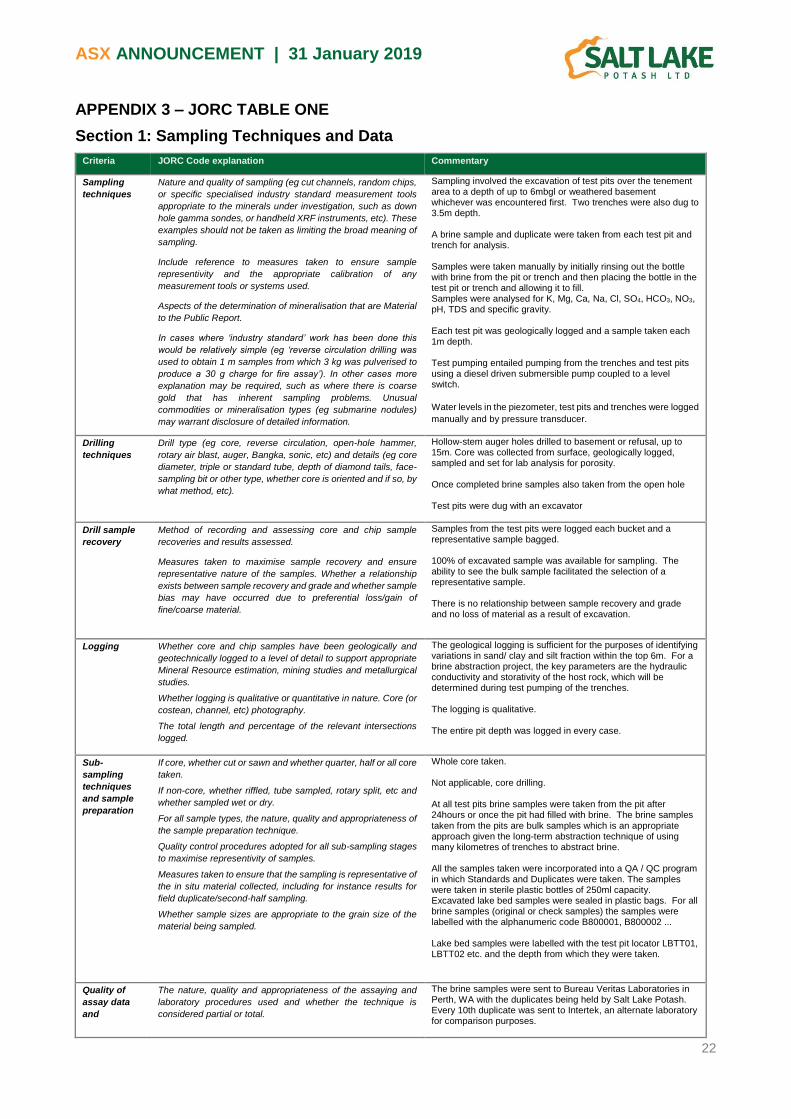
APPENDIX 3 – JORC TABLE ONE
Section 1: Sampling Techniques and Data
Criteria JORC Code explanation Commentary
Sampling
techniques
Nature and quality of sampling (eg cut channels, random chips,
or specific specialised industry standard measurement tools
appropriate to the minerals under investigation, such as down
hole gamma sondes, or handheld XRF instruments, etc). These
examples should not be taken as limiting the broad meaning of
sampling.
Include reference to measures taken to ensure sample
representivity and the appropriate calibration of any
measurement tools or systems used.
Aspects of the determination of mineralisation that are Material
to the Public Report.
In cases where ‘industry standard’ work has been done this
would be relatively simple (eg ‘reverse circulation drilling was
used to obtain 1 m samples from which 3 kg was pulverised to
produce a 30 g charge for fire assay’). In other cases more
explanation may be required, such as where there is coarse
gold that has inherent sampling problems. Unusual
commodities or mineralisation types (eg submarine nodules)
may warrant disclosure of detailed information.
Sampling involved the excavation of test pits over the tenement area to a depth of up to 6mbgl or weathered basement whichever was encountered first. Two trenches were also dug to 3.5m depth. A brine sample and duplicate were taken from each test pit and trench for analysis. Samples were taken manually by initially rinsing out the bottle with brine from the pit or trench and then placing the bottle in the test pit or trench and allowing it to fill. Samples were analysed for K, Mg, Ca, Na, Cl, SO4, HCO3, NO3, pH, TDS and specific gravity. Each test pit was geologically logged and a sample taken each 1m depth. Test pumping entailed pumping from the trenches and test pits using a diesel driven submersible pump coupled to a level switch.
Water levels in the piezometer, test pits and trenches were logged
manually and by pressure transducer.
Drilling
techniques
Drill type (eg core, reverse circulation, open-hole hammer,
rotary air blast, auger, Bangka, sonic, etc) and details (eg core
diameter, triple or standard tube, depth of diamond tails, face-
sampling bit or other type, whether core is oriented and if so, by
what method, etc).
Hollow-stem auger holes drilled to basement or refusal, up to 15m. Core was collected from surface, geologically logged, sampled and set for lab analysis for porosity. Once completed brine samples also taken from the open hole Test pits were dug with an excavator
Drill sample
recovery
Method of recording and assessing core and chip sample
recoveries and results assessed.
Measures taken to maximise sample recovery and ensure
representative nature of the samples. Whether a relationship
exists between sample recovery and grade and whether sample
bias may have occurred due to preferential loss/gain of
fine/coarse material.
Samples from the test pits were logged each bucket and a representative sample bagged. 100% of excavated sample was available for sampling. The ability to see the bulk sample facilitated the selection of a representative sample. There is no relationship between sample recovery and grade and no loss of material as a result of excavation.
Logging Whether core and chip samples have been geologically and
geotechnically logged to a level of detail to support appropriate
Mineral Resource estimation, mining studies and metallurgical
studies.
Whether logging is qualitative or quantitative in nature. Core (or
costean, channel, etc) photography.
The total length and percentage of the relevant intersections
logged.
The geological logging is sufficient for the purposes of identifying variations in sand/ clay and silt fraction within the top 6m. For a brine abstraction project, the key parameters are the hydraulic conductivity and storativity of the host rock, which will be determined during test pumping of the trenches. The logging is qualitative. The entire pit depth was logged in every case.
Sub-
sampling
techniques
and sample
preparation
If core, whether cut or sawn and whether quarter, half or all core
taken.
If non-core, whether riffled, tube sampled, rotary split, etc and
whether sampled wet or dry.
For all sample types, the nature, quality and appropriateness of
the sample preparation technique.
Quality control procedures adopted for all sub-sampling stages
to maximise representivity of samples.
Measures taken to ensure that the sampling is representative of
the in situ material collected, including for instance results for
field duplicate/second-half sampling.
Whether sample sizes are appropriate to the grain size of the
material being sampled.
Whole core taken. Not applicable, core drilling. At all test pits brine samples were taken from the pit after 24hours or once the pit had filled with brine. The brine samples taken from the pits are bulk samples which is an appropriate approach given the long-term abstraction technique of using many kilometres of trenches to abstract brine. All the samples taken were incorporated into a QA / QC program in which Standards and Duplicates were taken. The samples were taken in sterile plastic bottles of 250ml capacity. Excavated lake bed samples were sealed in plastic bags. For all brine samples (original or check samples) the samples were labelled with the alphanumeric code B800001, B800002 ... Lake bed samples were labelled with the test pit locator LBTT01, LBTT02 etc. and the depth from which they were taken.
Quality of
assay data
and
The nature, quality and appropriateness of the assaying and
laboratory procedures used and whether the technique is
considered partial or total.
The brine samples were sent to Bureau Veritas Laboratories in Perth, WA with the duplicates being held by Salt Lake Potash. Every 10th duplicate was sent to Intertek, an alternate laboratory for comparison purposes.

ASX ANNOUNCEMENT | 31 January 2019
23
Criteria JORC Code explanation Commentary
laboratory
tests
For geophysical tools, spectrometers, handheld XRF
instruments, etc, the parameters used in determining the
analysis including instrument make and model, reading times,
calibrations factors applied and their derivation, etc.
Nature of quality control procedures adopted (eg standards,
blanks, duplicates, external laboratory checks) and whether
acceptable levels of accuracy (ie lack of bias) and precision
have been established.
No laboratory analysis was undertaken with geophysical tools. Soil samples and laboratory derived hydraulic conductivity, total porosity and drainable porosity samples were analysed by Core Laboratories in Perth WA. All laboratories used are NATA certified.
Verification
of sampling
and assaying
The verification of significant intersections by either
independent or alternative company personnel.
The use of twinned holes.
Documentation of primary data, data entry procedures, data
verification, data storage (physical and electronic) protocols.
Discuss any adjustment to assay data.
Not applicable, no significant intersections, no verification required. No twin holes were drilled. All sampling and assaying is well documented and contained on Salt Lake Potash’s internal database
No adjustments have been made to assay data
Location of
data points
Accuracy and quality of surveys used to locate drill holes (collar
and down-hole surveys), trenches, mine workings and other
locations used in Mineral Resource estimation.
Specification of the grid system used.
Quality and adequacy of topographic control.
All coordinates were collected by handheld GPS. The grid system is the Australian National Grid Zone MGA 51 (GDA 94) The is no specific topographic control as the lake surface can essentially be considered flat.
Data spacing
and
distribution
Data spacing for reporting of Exploration Results.
Whether the data spacing and distribution is sufficient to
establish the degree of geological and grade continuity
appropriate for the Mineral Resource and Ore Reserve
estimation procedure(s) and classifications applied.
Whether sample compositing has been applied.
The lake area contained within the Ballard tenements was calculated by digitising the lake surface and removing the area covered by the islands, the approximate area for the eastern portion of the lake is 359 km2, 205 km2 for the western portion. 181 test pits, 15 auger holes and 2 trenches were excavated over the eastern portion of the lake surface resulting in 1 excavation per 1.8 km2 providing a high density of investigation over this portion of the tenement. However, western portion of the lake has had little to no work completed and is considered to have a low density of investigation suitable for determining an exploration target. Sample compositing not applicable.
Orientation of
data in
relation to
geological
structure
Whether the orientation of sampling achieves unbiased
sampling of possible structures and the extent to which this is
known, considering the deposit type.
If the relationship between the drilling orientation and the
orientation of key mineralised structures is considered to have
introduced a sampling bias, this should be assessed and
reported if material.
There are no structural or geological controls with respect to sampling the lake bed sediments. The variation in depth to basement does control the potential depth of future trench systems. Geological influence on the brine is limited to the aquifer parameters of the host rock, namely the hydraulic conductivity, and porosity.
Sample
security
The measures taken to ensure sample security. Salt Lake Potash’s field geologists were responsible for bagging and tagging samples prior to shipping to the BV lab in Perth and the Salt Lake Potash offices. The security measures for the material and type of sampling at hand was appropriate
Audits or
reviews
The results of any audits or reviews of sampling techniques and
data.
Data review included an assessment of the quality of assay data and laboratory tests and verification of sampling and assaying. No audits of sampling techniques and data have been undertaken.
Section 2: Reporting of Exploration Results
Criteria JORC Code explanation Commentary
Mineral
tenement and
land tenure
status
Type, reference name/number, location and ownership
including agreements or material issues with third parties such
as joint ventures, partnerships, overriding royalties, native title
interests, historical sites, wilderness or national park and
environmental settings.
The security of the tenure held at the time of reporting along with
any known impediments to obtaining a licence to operate in the
area.
The tenements covering Lake Ballard are all exploration licenses, held solely by Salt Lake Potash, are; E29/912, E29/913, E29/948, E29/958, E29/1011, E29/1021 and E29/1022
Exploration
done by other
parties
Acknowledgment and appraisal of exploration by other parties. A large amount of historical exploration work has been undertaken surrounding Lake Ballard focusing on gold, nickel and uranium. There has been limited exploration on the lake surface with most exploration associated with uranium

ASX ANNOUNCEMENT | 31 January 2019
24
Criteria JORC Code explanation Commentary
exploration in the upper 10 m. Soil sampling was undertaken on the lake, as well as a number of geophysical surveys and shallow drilling activities. The Company has reviewed multiple publicly available documents to provide an understanding of the geology and hydrogeology in the Lake Ballard paleodrainage.
Geology Deposit type, geological setting and style of mineralisation. The deposit is a salt-lake brine deposit. The lake setting is typical of a Western Australian palaeovalley environment. Ancient hydrological systems have incised palaeovalleys into Archaean basement rocks, which were then infilled by Tertiary-aged sediments typically comprising a coarse-grained fluvial basal sand overlaid by palaeovalley clay with some coarser grained interbeds. The clay is overlaid by recent Cainozoic material including lacustrine sediment, calcrete, evaporite and aeolian deposits.
Drill hole
Information
A summary of all information material to the understanding of
the exploration results including a tabulation of the following
information for all Material drill holes:
o easting and northing of the drill hole collar
o elevation or RL (Reduced Level – elevation above sea
level in metres) of the drill hole collar
o dip and azimuth of the hole
o down hole length and interception depth
o hole length.
If the exclusion of this information is justified on the basis that
the information is not Material and this exclusion does not
detract from the understanding of the report, the Competent
Person should clearly explain why this is the case.
Hollow-stem auger holes were completed along with test pits and trenches were excavated on the lake surface. All test pit and trench details and locations of all data points are presented in the report.
Data
aggregation
methods
In reporting Exploration Results, weighting averaging
techniques, maximum and/or minimum grade truncations (eg
cutting of high grades) and cut-off grades are usually Material
and should be stated.
Where aggregate intercepts incorporate short lengths of high
grade results and longer lengths of low grade results, the
procedure used for such aggregation should be stated and
some typical examples of such aggregations should be shown
in detail.
The assumptions used for any reporting of metal equivalent
values should be clearly stated.
Within the salt-lake extent no low-grade cut-off or high-grade capping has been implemented due to the consistent nature of the brine assay data. Test pit and trench data aggregation comprised calculation of a hydraulic conductivity, transmissivity and drainable porosity for the whole sequence.
Relationship
between
mineralisation
widths and
intercept
lengths
These relationships are particularly important in the reporting of
Exploration Results.
If the geometry of the mineralisation with respect to the drill hole
angle is known, its nature should be reported.
If it is not known and only the down hole lengths are reported,
there should be a clear statement to this effect (eg ‘down hole
length, true width not known’).
The chemical analysis from each of the test pits and auger holes has shown the that the brine resource is consistent and continuous through the full thickness of the Lake Playa sediments unit. The unit is flat lying all auger holes were excavated into the lake sediments to a depth of 15m or basement, the intersected depth is equivalent to the vertical depth and the thickness of mineralisation.
Diagrams Appropriate maps and sections (with scales) and tabulations of
intercepts should be included for any significant discovery being
reported These should include, but not be limited to a plan view
of drill hole collar locations and appropriate sectional views.
All location maps and sections are contained within the body of the report.
Balanced
reporting
Where comprehensive reporting of all Exploration Results is not
practicable, representative reporting of both low and high
grades and/or widths should be practiced to avoid misleading
reporting of Exploration Results.
All results have been included in the body of the report.
Other
substantive
exploration
data
Other exploration data, if meaningful and material, should be
reported including (but not limited to): geological observations;
geophysical survey results; geochemical survey results; bulk
samples – size and method of treatment; metallurgical test
results; bulk density, groundwater, geotechnical and rock
characteristics; potential deleterious or contaminating
substances.
All material exploration data has been reported.
Further work The nature and scale of planned further work (eg tests for lateral
extensions or depth extensions or large-scale step-out drilling).
Diagrams clearly highlighting the areas of possible extensions,
including the main geological interpretations and future drilling
areas, provided this information is not commercially sensitive.
Further work is planned at the western end of the lake bed in 2019 and a maiden mineral resource estimate will be prepared for Lake Ballard.

Appendix 5B Mining exploration entity and oil and gas exploration entity quarterly report
+ See chapter 19 for defined terms 1 September 2016 Page 1
+Rule 5.5
Appendix 5B
Mining exploration entity and oil and gas exploration entity quarterly report
Introduced 01/07/96 Origin Appendix 8 Amended 01/07/97, 01/07/98, 30/09/01, 01/06/10, 17/12/10, 01/05/13, 01/09/16
Name of entity
Salt Lake Potash Limited
ABN Quarter ended (“current quarter”)
98 117 085 748 31 December 2018
Consolidated statement of cash flows Current quarter $A’000
Year to date (6 months)
$A’000
1. Cash flows from operating activities
1.1 Receipts from customers
1.2 Payments for
(1,664) (3,298) (a) exploration & evaluation
(b) development - -
(c) production - -
(d) staff costs (864) (1,474)
(e) administration and corporate costs (280) (461)
1.3 Dividends received (see note 3) - -
1.4 Interest received 19 53
1.5 Interest and other costs of finance paid - -
1.6 Income taxes paid - -
1.7 Research and development refunds - -
1.8 Other (provide details if material) - Business Development
(302)
(526)
1.9 Net cash from / (used in) operating activities
(3,091) (5,706)
2. Cash flows from investing activities
(138) (260)
2.1 Payments to acquire:
(a) property, plant and equipment
(b) tenements (see item 10) - -
(c) investments - -
(d) other non-current assets - -

Appendix 5B Mining exploration entity and oil and gas exploration entity quarterly report
+ See chapter 19 for defined terms 1 September 2016 Page 2
Consolidated statement of cash flows Current quarter $A’000
Year to date (6 months)
$A’000
2.2 Proceeds from the disposal of:
- - (a) property, plant and equipment
(b) tenements (see item 10) - -
(c) investments - -
(d) other non-current assets - -
2.3 Cash flows from loans to other entities - -
2.4 Dividends received (see note 3) - -
2.5 Other (provide details if material) - -
2.6 Net cash from / (used in) investing activities
(138) (260)
3. Cash flows from financing activities
13,000 13,000 3.1 Proceeds from issues of shares
3.2 Proceeds from issue of convertible notes - -
3.3 Proceeds from exercise of share options - -
3.4 Transaction costs related to issues of shares, convertible notes or options
(715) (715)
3.5 Proceeds from borrowings - -
3.6 Repayment of borrowings - -
3.7 Transaction costs related to loans and borrowings
- -
3.8 Dividends paid - -
3.9 Other (provide details if material) - -
3.10 Net cash from / (used in) financing activities
12,285 12,285
4. Net increase / (decrease) in cash and cash equivalents for the period
2,972 5,709 4.1 Cash and cash equivalents at beginning of
period
4.2 Net cash from / (used in) operating activities (item 1.9 above)
(3,091) (5,706)
4.3 Net cash from / (used in) investing activities (item 2.6 above)
(138) (260)
4.4 Net cash from / (used in) financing activities (item 3.10 above)
12,285 12,285
4.5 Effect of movement in exchange rates on cash held
- -
4.6 Cash and cash equivalents at end of period
12,028 12,028

Appendix 5B Mining exploration entity and oil and gas exploration entity quarterly report
+ See chapter 19 for defined terms 1 September 2016 Page 3
5. Reconciliation of cash and cash equivalents
at the end of the quarter (as shown in the consolidated statement of cash flows) to the related items in the accounts
Current quarter $A’000
Previous quarter $A’000
5.1 Bank balances 2,901 1,259
5.2 Call deposits 9,127 1,713
5.3 Bank overdrafts - -
5.4 Other (provide details) - -
5.5 Cash and cash equivalents at end of quarter (should equal item 4.6 above)
12,028 2,972
6. Payments to directors of the entity and their associates Current quarter $A'000
6.1 Aggregate amount of payments to these parties included in item 1.2 (175)
6.2 Aggregate amount of cash flow from loans to these parties included in item 2.3
-
6.3 Include below any explanation necessary to understand the transactions included in items 6.1 and 6.2
Payments include salaries, director and consulting fees, superannuation and provision of corporate, administration services, and a fully serviced office.
7. Payments to related entities of the entity and their associates
Current quarter $A'000
7.1 Aggregate amount of payments to these parties included in item 1.2 -
7.2 Aggregate amount of cash flow from loans to these parties included in item 2.3
-
7.3 Include below any explanation necessary to understand the transactions included in items 7.1 and 7.2
Not applicable.

Appendix 5B Mining exploration entity and oil and gas exploration entity quarterly report
+ See chapter 19 for defined terms 1 September 2016 Page 4
8. Financing facilities available Add notes as necessary for an understanding of the position
Total facility amount at quarter end
$A’000
Amount drawn at quarter end
$A’000
8.1 Loan facilities - -
8.2 Credit standby arrangements - -
8.3 Other (please specify) - -
8.4 Include below a description of each facility above, including the lender, interest rate and whether it is secured or unsecured. If any additional facilities have been entered into or are proposed to be entered into after quarter end, include details of those facilities as well.
Not applicable
9. Estimated cash outflows for next quarter $A’000
9.1 Exploration and evaluation 2,400
9.2 Development 1,500
9.3 Production -
9.4 Staff costs 1,100
9.5 Administration and corporate costs 350
9.6 Other (provide details if material) - Business Development
100
9.7 Total estimated cash outflows 5,450
10. Changes in tenements (items 2.1(b) and 2.2(b) above)
Tenement reference and location
Nature of interest Interest at beginning of quarter
Interest at end of quarter
10.1 Interests in mining tenements and petroleum tenements lapsed, relinquished or reduced
Refer to Appendix 1
10.2 Interests in mining tenements and petroleum tenements acquired or increased

Appendix 5B Mining exploration entity and oil and gas exploration entity quarterly report
+ See chapter 19 for defined terms 1 September 2016 Page 5
Compliance statement
1 This statement has been prepared in accordance with accounting standards and policies which
comply with Listing Rule 19.11A.
2 This statement gives a true and fair view of the matters disclosed.
Sign here: ............................................................ Date: 31 January 2019 (Director/Company secretary)
Print name: Clint McGhie
Notes
1. The quarterly report provides a basis for informing the market how the entity’s activities have been financed for the past quarter and the effect on its cash position. An entity that wishes to disclose additional information is encouraged to do so, in a note or notes included in or attached to this report.
2. If this quarterly report has been prepared in accordance with Australian Accounting Standards, the definitions in, and provisions of, AASB 6: Exploration for and Evaluation of Mineral Resources and AASB 107: Statement of Cash Flows apply to this report. If this quarterly report has been prepared in accordance with other accounting standards agreed by ASX pursuant to Listing Rule 19.11A, the corresponding equivalent standards apply to this report.
3. Dividends received may be classified either as cash flows from operating activities or cash flows from investing activities, depending on the accounting policy of the entity.