decision-making guidelines for vegetation management
TRANSCRIPT
County of San Mateo Environmental Services Agency
Parks and Recreation Department
Decision-Making Guidelines for
Vegetation Management, San Mateo County Parks
June 30, 2006
Page i Final Decision-Making Guidelines for Vegetation Management June 2006 San Mateo County Parks and Recreation Dept.
TABLE OF CONTENTS
CHAPTER 0. EXECUTIVE SUMMARY _______________________ 1
CHAPTER 1. INTRODUCTION _____________________________ 3 1.1 PURPOSE AND NEED ___________________________________________________ 3 1.2 PROJECT GOALS _______________________________________________________ 3 1.3 VEGETATION MANAGEMENT OBJECTIVES _____________________________ 4 1.4 DOCUMENTS AND STUDIES REVIEWED FOR THIS DOCUMENT__________ 7 1.5 PARTICIPANTS AND STAKEHOLDERS ___________________________________ 7
CHAPTER 2. VEGETATION MANAGEMENT CONTEXT _____ 10 2.1 PARK USAGE__________________________________________________________ 10 2.2 CURRENT MAINTENANCE ISSUES AND CONCERNS ____________________ 10 2.3 RELEVANT PLANS AND POLICIES _____________________________________ 15
CHAPTER 3. EXISTING CONDITIONS _____________________ 24 3.1 OVERVIEW OF THE SAN MATEO COUNTY PARKS SYSTEM ______________ 24 3.2 CRYSTAL SPRINGS REGIONAL TRAIL __________________________________ 24 3.3 COYOTE POINT RECREATION AREA___________________________________ 28 3.4 EDGEWOOD PARK AND PRESERVE ____________________________________ 31 3.5 FITZGERALD MARINE RESERVE_______________________________________ 35 3.6 FLOOD PARK__________________________________________________________ 39 3.7 HUDDART PARK ______________________________________________________ 42 3.8 JUNIPERO SERRA PARK _______________________________________________ 46 3.9 MEMORIAL ___________________________________________________________ 50 3.10 MIRADA SURF EAST AND WEST _______________________________________ 53 3.11 PESCADERO PARK ____________________________________________________ 56 3.12 SAM MCDONALD _____________________________________________________ 59 3.13 SAN BRUNO MOUNTAIN _____________________________________________ 63 3.14 SAN PEDRO VALLEY__________________________________________________ 72 3.15 SANCHEZ ADOBE ____________________________________________________ 76 3.16 WOODSIDE STORE ___________________________________________________ 78 3.17 WUNDERLICH _______________________________________________________ 78

Page ii Final Decision-Making Guidelines for Vegetation Management June 2006 San Mateo County Parks and Recreation Dept.
CHAPTER 4. PROJECT PRIORITIZATION __________________ 83 4.1 LIST OF PLANNED AND ACTIVE VEGETATION MANAGEMENT PROJECTS AND ACTIONS ___________________________________________________________ 83 4.2 SUGGESTED METHODS FOR PRIORITIZING AND RANKING VEGETATION MANAGEMENT PROJECTS________________________________________________ 91 4.3 SELECTING PRIORITY PROJECTS ______________________________________ 94
CHAPTER 5. VEGETATION MANAGEMENT TECHNIQUES AND APPROACHES ______________________________________ 97 5.1 ADAPTIVE MANAGEMENT_____________________________________________ 99 5.2 WATERSHED PROTECTION MAINTENANCE STANDARDS / NON-POINT SOURCE POLLUTION CONTROL_________________________________________ 100 5.3 EROSION AND SEDIMENT CONTROL_________________________________ 101 5.4 PUBLIC HEALTH AND SAFETY________________________________________ 103 5.5 FOREST HEALTH ____________________________________________________ 104 5.6 FUEL LOAD AND FIRE MANAGEMENT ________________________________ 107 5.7 MOWING ____________________________________________________________ 112 5.8 SENSITIVE RESOURCE MANAGEMENT _______________________________ 118 5.9 RECYCLING GREEN WASTE AND VEGETATION BIOMASS______________ 126 5.10 UNAUTHORIZED TRAILS ____________________________________________ 128 5.11 HABITAT RESTORATION ____________________________________________ 129 5.12 INVASIVE PLANT CONTROL _________________________________________ 131 5.13 PLANT PEST AND DISEASE DETECTION AND CONTROL______________ 141 5.14 SHORELINE VEGETATION MANAGEMENT __________________________ 144 5.15 VOLUNTEER OPPORTUNITIES, PUBLIC INVOLVEMENT______________ 145 5.16 GRAZING PROGRAMS FOR WILDLAND SETTINGS_____________________ 147 5.17 PROJECT MONITORING _____________________________________________ 149
CHAPTER 6. SUMMARY OF LONG-TERM MAINTENANCE NEEDS _________________________________________________ 150 6.1 STEWARDSHIP OF HABITAT RESTORATION AREAS____________________ 150 6.2 TRAIL MAINTENANCE, UNAUTHORIZED TRAIL REMOVAL, AND HUMAN USE ____________________________________________________________________ 150 6.3 FOREST HEALTH MAINTENANCE AND FIRE CONTROL MANAGEMENT 151 6.4 INVASIVE PLANT MAINTENANCE ____________________________________ 152 6.5 GRAZING PROGRAM MANAGEMENT__________________________________ 152
Page iii Final Decision-Making Guidelines for Vegetation Management June 2006 San Mateo County Parks and Recreation Dept.
CHAPER 7 REFERENCES ________________________________ 153 7.1 PRINTED REFERENCES ______________________________________________ 153 7.2 PERSONAL COMMUNICATION _______________________________________ 155
APPENDICES
APPENDIX A. STANDARD OPERATING PROCEDURES APPENDIX B. FORMS APPENDIX C. EDUCATIONAL PAMPHLETS AND BROCHURES APPENDIX D. HELPFUL RESOURCES APPENDIX E. EXTENDED BIBLIOGRAPHY APPENDIX F. MAP

Page iv Final Decision-Making Guidelines for Vegetation Management June 2006 San Mateo County Parks and Recreation Dept.
This report was funded through a generous grant from the
San Mateo County Parks and Recreation Foundation.
This report was prepared by: May & Associates, Inc.
730 Clementina Street, San Francisco, CA 94103
(415) 391-1000 www.mayandassociatesinc.com

Chapter 0 Executive Summary
Page 1 Final Decision-Making Guidelines for Vegetation Management June 2006 San Mateo County Parks and Recreation Dept.
CHAPTER 0. EXECUTIVE SUMMARY The San Mateo County Parks and Recreation Division of the Environmental Services Agency (County) is seeking to improve its efforts to organize, prioritize, schedule, and efficiently implement vegetation management projects throughout the County Parks System. This document is intended to help San Mateo County Park staff in making informed decisions about future vegetation management priorities and actions. This report is not a plan of action, but simply a series of guidelines to help guide future decisions about vegetation management. In addition, this document is intended to provide user-friendly “how to” advice to park rangers, volunteers, and others to help select vegetation management actions that are more efficient and effective. The County Park staff will need to conduct the following actions in order to prioritize future projects and move forward to implementation:
1) Finalize the list of projects presented in Section 4.1 (update regularly as more projects are added).
2) Prioritize the list of Projects by numerically scoring, then comparing the projects
using the methods and selection scoring criteria presented in Section 4.2 and 4.3.
3) Once the top priority projects are selected, seek funding, staff time, and volunteer support necessary to implement the projects.
4) Use the procedures presented in this report to guide implementation in order to
ensure effectiveness and standardization of results.
5) Repeat project prioritization regularly, typically every year or 5 years and update the list of priority projects as needed.
This report is organized as follows:
• Chapter 1 Presents the Purpose and Need for the Document, and establishes overall goals and objectives for vegetation management in the San Mateo Parks system. It also details the participants and stakeholders who participated in the development of this document.
• Chapter 2 Presents the Vegetation Management Context, including a description of
parks users and user priorities; a review of what the current park vegetation management practices are; a description from park staff of what they believe are the issues and concerns; and a regulatory framework for park projects.
• Chapter 3 Describes the Existing Conditions at each Park, including a general park
overview of park resources (Rana 2002); a list of park-specific goals, policies, and management objectives (derived from a variety of existing planning documents); and a summary of current and ongoing activities (provided by oral interviews with park staff).
• Chapter 4 Lists All Park Projects, including those that are planned, or underway, and
provides a method for assessing, prioritizing, and ranking park projects.

Chapter 0 Executive Summary
Page 2 Final Decision-Making Guidelines for Vegetation Management June 2006 San Mateo County Parks and Recreation Dept.
• Chapter 5 Provides Details on Vegetation Management Techniques, organized by
subject matter, and ties the vegetation management actions back to the goals and objectives presented in Chapter 1.
• Chapter 6 Describes Long-Term Maintenance Needs for the entire park system. • Chapter 7 Provides References, both written and personal communications, used in
development of this document. These chapters are supported by information presented in the Appendices, including:
• Appendix A. Technical “How To” Information on Vegetation Management Techniques;
• Appendix B. Forms (provides reproducible standard forms for office and field use); • Appendix C. Informational Brochures and Handouts; • Appendix D. List of Helpful Resources to contact for more information; • Appendix E. Expanded Bibliography intended to expedite finding information in
original source documents; and • Appendix F. Relevant Project Maps.

Chapter 1 Introduction
Page 3 Final Decision-Making Guidelines for Vegetation Management June 2006 San Mateo County Parks and Recreation Dept.
CHAPTER 1. INTRODUCTION The San Mateo County Parks and Recreation (County Parks) Division’s mission is to preserve the County’s natural and cultural treasures, and provide safe, accessible parks, recreation, and learning opportunities to enhance the community’s quality of life. County Parks operates 16 separate parks, three regional trails, and numerous other county and local trails encompassing approximately 15,680 acres and serving the 707,000 population of San Mateo County (2000 census data). The Vegetation Management Guidelines (“the Guidelines”) presented in this report are intended to assist County Parks with identifying vegetation management projects critical to satisfying their mission, and then prioritizing, scheduling, and efficiently implementing the selected projects throughout the County Parks System (Parks). This report was funded through a special grant from the Roberti-Z’Berg-Harris Urban Open Space and Recreation Program (authorized under Proposition 12), and a grant from the San Mateo County Parks and Recreation Foundation. 1.1 PURPOSE AND NEED The Guidelines are intended to provide a field-based decision-making framework to guide implementation of County Park's mission through ongoing annual maintenance activities, as well as describe methods to prioritize special one-time projects that will increase the resource and recreational values of the Parks system over a ten year management timeframe. Over time, shifting resource issues, funding, planning and management priorities, and varying levels of visitor use, have made it challenging for parks staff to identify and prioritize vegetation management activities within individual parks and throughout the entire park system. In large parks, issues such as recreational uses, visitor safety, resource conservation, and park facility and resource maintenance are intertwined. This document focuses primarily on means to protect and enhance the vegetative resources of the entire Park System. This document is intended to help San Mateo County Park staff in making informed decisions about future vegetation management priorities and actions. It is important to note that this document does not provide a plan of action, but is simply a series of guidelines to help guide future decisions about vegetation management. In addition, this document is intended to provide user-friendly “how to” advice to park rangers, volunteers, and others to help select vegetation management actions that are more efficient and effective. 1.2 PROJECT GOALS Vegetation Management Guidelines are intended to assist County Parks staff and park users with developing clear and consistent guidelines and procedures for conducting ongoing vegetation management activities and to provide tools for selecting and prioritizing future vegetation management projects.

Chapter 1 Introduction
Page 4 Final Decision-Making Guidelines for Vegetation Management June 2006 San Mateo County Parks and Recreation Dept.
The goals of the Guidelines are: Goal 1: Identify Vegetation Management Issues within each Park Some of the vegetation management issues are: fuel load reduction, sensitive species habitat restoration, non-point source pollution, invasive plant eradication, pests and plant disease, green waste management, forest management, grazing opportunities, and managing lands for recreational activities. Goal 2: Develop Methods to Select and Prioritize Vegetation Management Activities The evaluation system is intended to be a practical decision-making tool for use by County Parks staff to assess and re-assess vegetation management needs given an understanding of available staff and volunteer resources, and based on clearly defined, consensus-based priorities. Goal 3: Prepare Monitoring Strategies to Evaluate Success of Vegetation Management Projects The monitoring strategies will include defined success criteria to allow for periodic re-evaluation of priorities. In order to build efficiency into the system, monitoring for each project will include field-based decision making and adaptive management. Documenting monitoring efforts will allow the lessons learned in each project to be transferred to other members of County Parks and the conservation community as a whole.
Goal 4: Identify Opportunities for Partnering with Agencies and Community Organizations This goal fulfills the Parks mission by providing learning opportunities and enhancing the quality of life through community involvement. Partnering with local stakeholders also helps stretch limited budgets and staffing while accomplishing ecological benefits that might not otherwise be achieved. Goal 5: Develop Best Management Practices (BMPs) for Sensitive Species Habitats Development of BMPs could allow for the Guidelines to be used by the County to obtain project approvals necessary under the California Environmental Quality Act (CEQA). 1.3 VEGETATION MANAGEMENT OBJECTIVES The following are typical vegetation management objectives for recreational uses in wildland settings. Similar lists were developed by the National Park Service, State Lands, Department of Fish and Game, and other large landowners in California, and have been modified to fit the needs of San Mateo County Parks. This list should not be considered an adopted policy of the County of San Mateo, but rather should be treated as a suggested list of vegetation management priorities that apply in most park settings. This list should be updated annually as necessary to reflect changing park management objectives.
Objective 1: Maintain Sensitive Species and Habitats • Manage parks for overall habitat diversity; • Implement federal and state Endangered Species Act compliance measures (e.g.
San Bruno Mountain Habitat Conservation plan, any Biological Opinions related to sensitive species on park lands);
• Monitor and update records of sensitive species occurrences; and • Implement special projects to improve sensitive species and their habitat (as
funding allows), including:

Chapter 1 Introduction
Page 5 Final Decision-Making Guidelines for Vegetation Management June 2006 San Mateo County Parks and Recreation Dept.
o Invasive plant control projects related to sensitive species (Example - gorse control at San Bruno Mountain);
o Creek and other wetland improvements (Example - Colma Creek habitat restoration project);
o Other special projects (Example - Fitzgerald Marine Preserve visitor use actions).
Objective 2: Maintain Multiple Recreational Uses
• Encourage multiple recreational uses within each park; • Manage vegetation and trails for multiple uses; • Where problems arise between different recreational user groups, develop
solutions with stakeholders that are sensitive to the various user group; and • Include interpretive and educational components in vegetation projects as
funding allows. Some examples are signs, kiosks, docent programs, school study and work programs.
Objective 3: Maintain Visitor Use and Safety
• Inspect and maintain trails annually by cutting overhanging brush, repairing erosion, and clearing culverts;
• Over time, reconfigure problem trails to reduce maintenance costs; • Actively landscape and maintain high visitor use areas with native plants where
possible); and • Detect and remove unauthorized trails regularly, and improve overall park
access and circulation patterns over time; • Manage poison oak along trails; and • Address homeless encampments, trespass onto park lands and other undesirable
human uses.
Objective 4: Manage For “Sustained Control” of Invasive Plants over Time • Develop and maintain a list of priority invasive plants (based on the ranking
system developed by the California Invasive Plant Council (Cal-IPC); • Coordinate with local Agricultural Commissioner, Weed Management Area and
Cal-IPC to update priority invasive plant list over time, determine most effective treatments, and obtain assistance with control activities. Monitor parks annually for new introductions and treat targeted priority invasive plants;
• Manage non-target invasive plants where their presence conflicts with other management priorities; and
• Develop and maintain a GIS database of invasive plant infestations and treatments.
Objective 5: Maintain Healthy Native Plant Communities to Discourage Invasive Plant Establishment
• Minimize soil disturbance wherever possible; • Maintain a dense cover of native plants (particularly shrubs) to discourage
invasive establishment; • Monitor parks annually for threats to native plant communities; • Reduce park-to-park transmission of weeds by washing equipment after leaving
infested areas; and

Chapter 1 Introduction
Page 6 Final Decision-Making Guidelines for Vegetation Management June 2006 San Mateo County Parks and Recreation Dept.
• Use seed-free rice straw for erosion control to prevent introduction of weeds.
Objective 6: Encourage Park Stewardship • Develop long-term strategies to effectively utilize volunteer groups,
neighborhood groups and individual concerned citizens; • Encourage “Friends of” groups and include them in decision making; • Conduct outreach via letters, handouts, and signs encouraging park users to
help with park stewardship (e.g. work days, fundraising, sensitive species and weed monitoring, trail maintenance, etc.);
• Encourage good neighbor relations by developing personal relationships with park neighbors; and
• Address park boundary issues such as invasive plant encroachment from backyard gardens, fire management, domestic pet problems, trespass, and law enforcement issues as they arise.
Objective 7: Plant Site-Appropriate Native Species, Emphasizing Local Diversity
• As appropriate, use native plants for landscaping; • When developing restoration projects, emphasize the long-term development of
multi-age, multi-species habitats that mimic natural local habitat conditions; and • Emphasize low-maintenance, low-water use plantings; • Use native plants that have been located in the park; and • When possible, use seeds or cuttings conducted within the park or watershed.
Objective 8: Maintain Revegetation Sites until Plantings are Established
• Establish quantitative success criteria; • Monitor sites regularly; • Mulch; • Provide adequate water to plantings; • Provide weed monitoring and removal; and • Replace plantings as necessary to achieve successful establishment.
Objective 9: Actively Manage Forests to Reduce Fire Fuels and Increase Forest Health
• Census forests to determine hazardous fuel areas; • Develop a GIS database of hazardous tree locations (in forested and other
areas) and update it regularly; • Thin underbrush; • Educate adjacent landowners about the need to maintain defensible space
between their properties and parklands; • Inspect and remove hazard trees; • Detect and treat diseased plants, contain spread of disease; and • Manage fire breaks to decrease erosion and the spread of invasive plants.
Objective 10: Protect Watersheds from Erosion and Non-Point Source Pollutants
• Improve drainage systems, trails, and other development to reduce further degradation of erosion hazards along shorelines;
• Design trails and infrastructure to reduce erosion;

Chapter 1 Introduction
Page 7 Final Decision-Making Guidelines for Vegetation Management June 2006 San Mateo County Parks and Recreation Dept.
• Include Integrated Pest Management Practices into park activities; • Control non-point source pollution and erosion control through BMP’s; and • Inspect and “storm proof” parks throughout the season, in particular prior to
winter rains.
Objective 11: Implement Integrated Pest Management • Minimize use of herbicides; and • Use an integrated approach to managing all invasive species, plant pests and
diseases.
Objective 12: Manage Habitat Conversion in Sensitive Species Habitat • Control natural sucessional changes from grassland to shrubland at Edgewood
Preserve and San Bruno Mountain to maintain sufficient butterfly habitat onsite over time (e.g. remove shrubs, encourage grassland establishment, and/or graze sites).
• Control natural sucessional changes in forests supporting marbeled murrulet at the Pescadero Park Complex.
1.4 DOCUMENTS AND STUDIES REVIEWED FOR THIS DOCUMENT The Guidelines extracted information from a variety of planning studies and resource documents and developed related objectives based on the condition of the vegetation resource, historical context, ecological trends, and the potential contribution of community and Parks staff. It is important to note that no attempt was made in this document to assess these documents for relative importance or applicability in the context of the current Park Management system. For the purpose of developing the comprehensive list of Park projects, all of the documents were treated as equally important. This approach was used as a starting point for discussions amongst Park staff and others as to which of the projects and policies listed in the over 90 planning documents are currently being implemented, or should be implemented under the current Park management. Refer to Appendix E for an expanded Bibliography presented by Park and resource. 1.5 PARTICIPANTS AND STAKEHOLDERS The Guidelines were developed in close coordination with County Park staff who operate, manage, and oversee 16 parks, three regional trails, and numerous other county and local trails encompassing approximately 15,680 acres. Because of limited staffing and funding, these dedicated staff have had to do more with less, often having to make tough management decisions related to vegetation management and park use. Volunteer groups have often stepped in to help, especially at Edgewood, San Bruno, and Fitzgerald, some of the most used Parks in the system. Other agencies have also provided assistance, both sharing technical knowledge, and sharing resources, including the U.S. Fish and Wildlife Service, California Department of Fish and Game, California Department of Forestry, local fire departments, San Mateo County Planning Department, local Supervisors, San Mateo County Agricultural Commissioner’s Office, San Mateo Weed Management Area and others.

Chapter 1 Introduction
Page 8 Final Decision-Making Guidelines for Vegetation Management June 2006 San Mateo County Parks and Recreation Dept.
The following is a list of staff, and other participants and stakeholders who have contributed during development of this plan:
• Dave Holland, Director • Dave Moore, Superintendent • Gary Lockman, Superintendent • Sam Herzberg, Senior Planner • Jesse Gilley, Park Ranger IV • Matt Del Carlo, Park Ranger IV • Pam Noyer, Park Ranger IV • Priscilla Alvarez, Park Ranger IV • Ty Kang, Park Ranger IV • Albert Zuker, Park Ranger III • John Trewin, Park Ranger III • Steve Durkin, Park Ranger III • Doug Heisinger, Park Ranger II • Bill Crawford, Lead Gardener • Ron Pummer, Weed Abatement District, County Ag Commissioner • Autumn Meisel, Thomas Reid & Associates, Inc. • Jen Zarnoch, May & Associates, Inc. • Joe Cannon, Heart of the Mountain • Mark Heath, Shelterbelt Builders, Inc.
1.5.1 Interested Organizations San Mateo County Parks enjoys the support of several dedicated and active volunteer groups that provide a wide variety of support services, including (but not limited to):
• Invasive species control; • Trail maintenance and litter pick up; • Sensitive species surveys (including fisheries assessments); • Water quality monitoring; • Park planning and grant applications; • Docent walks and education; and • Report writing, data collection, data entry.
Interested organizations that are particularly active in San Mateo County Parks include:
• Audubon Society • California Native Plant Society • Friends of Edgewood Park • Friends of Fitzgerald Marine Reserve • Friends of Huddart and Wunderlich • Friends of San Bruno Mountain • Friends of San Pedro Valley County Park • NOAA, LIMPETS program • San Bruno Heart of the Mountain • San Bruno Mountain Watch

Chapter 1 Introduction
Page 9 Final Decision-Making Guidelines for Vegetation Management June 2006 San Mateo County Parks and Recreation Dept.
• San Francisquito Creek Watershed Coalition • San Pedro Creek Watershed Coalition • Volunteer Horse Patrol
1.5.2 Public Process and Citizen Concerns The Guidelines were developed with both formal and informal public participation. Volunteers have contributed directly to individual Park’s planning, providing substantial research and writing as well as hours of field help collecting data. Intimate knowledge of individual parks, as shared by individual rangers and other park staff, volunteers, and contractors has proven especially valuable.
The project team conducted several information gathering sessions, including group meetings, and email exchanges with numerous County staff, knowledgeable vegetation management specialists, community members, and others interested and involved in the project. The group meetings included the following:
• A start-up meeting and informal discussion session about the results of the literature review and the goals and objectives for the report on October 12, 2005.
• Telephone interviews with key park staff in January & February 2006. • Informational meeting with staff from January to April 2006 to discuss
outstanding issues and concerns related to plan development. • Formal presentation of the Review Draft document to Parks Staff on April 6,
2006; • A presentation of the Draft document to the public in May 2006; • A working group session related to how to prioritize projects in November
2006; and • A final presentation of the Guidelines to the Board in December 2006.
Chapter 2 Vegetation Management Context
Page 10 Final Decision-Making Guidelines for Vegetation Management June 2006 San Mateo County Parks and Recreation Dept.
CHAPTER 2. VEGETATION MANAGEMENT CONTEXT In order to plan for consistent vegetation management, it is important to have a clear picture of the existing management context. This chapter includes a summary of park usage, current vegetation management staffing and routine projects, and ends with a compilation of policies that direct parks vegetation management actions. 2.1 PARK USAGE Based on the results from a 2001 survey of San Mateo County residents conducted by San Mateo County Parks and Recreation, park usage is high, with 9 out of 10 residents visiting one or more of the County Parks in 2001. The overwhelming preference of park users is passive recreational facilities (hiking and walking trails, environmental programs). Park usage studies indicate that both the Pescadero Creek/Memorial/Sam McDonald Park complex and the Fitzgerald Marine Reserve are tied for the highest visitor use. An estimated 56% of County residents polled during the 2001 survey reportedly use these Parks every year. The top ranked spending priority indicated by residents is natural resources management (e.g. protecting wildlife, watersheds, and open spaces). (Research and Consulting for Strategic Planning 2001). These 2001 survey results give weight and importance to vegetation management activities that focus on maintaining natural resource values and trail systems. 2.2 CURRENT MAINTENANCE ISSUES AND CONCERNS 2.2.1 Current Park Department Field Staff Practices At present, San Mateo Park Department Field Staff are divided into five units:
• Area 1 – North County Parks (bay side of Skyline); • Area 2 – South County Parks(bay side of Skyline); • Area 3 – Coast Parks(ocean side of Skyline); • Area 4 – Maintenance Unit(located at Coyote Point); and • Area 5 – Marina.
For Unit 1, 2, 3, and 5, there is one head ranger (a Ranger IV designation), with a maximum of eleven supporting rangers (Ranger designations of III, II or I). In addition to the Rangers, Coyote Point Marina also has one specialized position, the Assistant Harbor Master. Area 4, also referred to as the Maintenance Unit, is supervised by a Ranger IV with a support staff made up of rangers and specialized positions such as the gardening crew, electrician, equipment mechanic, and equipment operator. The maintenance functions of this Unit are described below in Section 2.2.2. Ranger duties encompass a wide range of responsibilities. A general list of duties follows (not meant to be all inclusive):
• Coordination & Cooperation with interested parties (neighbors, volunteer groups, advocacy groups)
• Data collection • Endangered Species Act, USFWS, CDFG, NOAA adherence • Enforcement • Erosion & sediment control

Chapter 2 Vegetation Management Context
Page 11 Final Decision-Making Guidelines for Vegetation Management June 2006 San Mateo County Parks and Recreation Dept.
• Litter pickup • Hazardous tree maintenance • Landscaping • Invasive vegetation maintenance • Oversight of mowing staff, equipment operators, contractors • Project planning and permitting • Poison oak maintenance • San Mateo County ordinance enforcement • Sensitive species (plants, wildlife, habitat) protection • Trail maintenance • Utility maintenance • Visitor education/interpretation • Volunteer coordination • Visitor safety • Wildlife control
2.2.2 Maintenance Unit Practices The Maintenance Unit (Area 4) works on Department-wide major projects and utilizes specialized skills to assist Park Rangers in all areas in order to maintain the parks. The gardening crew with one Lead Gardener and three gardeners, is assigned to the County Parks’ Maintenance Section- Area 4. Their primary responsibilities are mowing, herbicide application, and maintenance and repair of irrigation systems, pruning, mechanical and manual removal of exotic species. In addition, the Maintenance Unit, including the equipment operator and equipment mechanic assists with other system-wide projects as staffing, funding and scheduling allows. They operate the larger equipment for annual mowing, mechanical brush mowing, and tree removal. An organizational reassignment was completed in December 2002 that re-assigned the gardening crew staff responsibilities to a Division-wide scope, rather than focusing on one park unit. The Gardening Crew is located in Coyote Point. The Gardening Crew is responsible for the following types of specialty park-wide activities:
• Mowing of most irrigated turf (lawns); • Maintenance, repair, and scheduling of most (but not all) irrigation systems; and • Application and monitoring of herbicides, using approved IPMP practices.
In addition, the Gardening Crew performs the following support functions in other areas: AREA 1 – Coyote Point, Junipero Serra, San Bruno Mountain
• Mowing – 100% • Irrigation – 100% • Herbicide 100%
AREA 2 – Huddart, Flood, Edgewood, Woodside Store, Wunderlich
• Mowing – 85% • Irrigation – 0% • Herbicide - 100%
Chapter 2 Vegetation Management Context
Page 12 Final Decision-Making Guidelines for Vegetation Management June 2006 San Mateo County Parks and Recreation Dept.
AREA 3 – San Pedro Valley, Sanchez Adobe • Mowing – 100% • Irrigation - 100% • Herbicide - 0% (Not allowed)
AREA 5 – Coyote Point Marina
• Mowing – 100% • Irrigation – 100% • Herbicide 100%
2.2.3 General Park Practices The Park staff as a whole (i.e. all Park Units) conducts the following types of activities:
Mowing. Park staff utilize a centralized mowing program for irrigated turf areas that uses gardening staff members with oversight from Park Rangers. They use on-site mowers and mowers transported by trailer. Park staff currently maintains irrigated turf areas such as ball fields and picnic areas at the following units:
• Coyote Point Park and Marina; • Flood Park; • Huddart Park; • Edgewood Park; • Junipero Serra Park; • San Bruno Mountain • San Pedro Valley; • Sanchez Adobe; • Wunderlich; and • Regional trails such as Sand Hill, Crystal Springs, and Canada Road.
Other Types of Vegetation Removal. Park staff conduct knife cutting, weed-eating, andbrushcutting, in addition to localized mowing. Park staff conducts these activities at all parks to maintain non-irrigated grassy areas, trail edges, and as needed to control shrubs and other undesirable vegetation. The Equipment Operator and Mechanic/Operator also conduct mechanical vegetation removal. There is also a small “off-road vehicle crew” that use hand tools and small equipment to control vegetation in less accessible areas. Herbicide Application. The Gardening Crew are the only ones responsible for herbicide application, except for hired contractors. The gardening crew’s herbicide application is conducted using the Integrated Pest Management Guidelines developed by the Stormwater Pollution Prevention Committee, of which the Lead Gardener is a member. The Lead Gardener is required to maintain a valid Qualified Applicators License (QAL) from the State of California Department of Pesticide Regulation. The gardening crew is required to have annual training on the safe and proper use of pesticides, including herbicides. In addition, all garden staff members are required to undergo annual medical evaluations for the pesticide being used. The emphasis of the pesticide program is the use of pre-emergent (Pendulum Aqua Cap®) and post–emergent (Roundup®) herbicides to control weed growth. Only herbicides with Category 3 “CAUTION” labels are used. Pest Control Recommendations have been obtained from a licensed Pest Control Advisor for Coyote Point Park and Marina, Flood Park, Huddart Park, Junipero Serra, Wunderlich, and
Chapter 2 Vegetation Management Context
Page 13 Final Decision-Making Guidelines for Vegetation Management June 2006 San Mateo County Parks and Recreation Dept.
Woodside Store. Due to a variety of legal restrictions, other park units do not receive herbicide applications from the gardening crew. The following is a brief overview of herbicide usage:
1. The Lead Gardener possesses a Qualified Applicator Certificate from the California State Department of Pesticide Regulators and maintains this certificate with continuing education hours.
2. Herbicide applicators must obtain from the County’s Agricultural
Department an Operator and Site Identification Number (required to purchase, store, and use herbicides).
3. The Lead Gardener sets up and conducts an annual site inspection by
the County’s Agricultural Department’s representative.
4. The Lead Gardener conducts annual safety training for all employees involved in herbicide application.
5. The Lead Gardener reviews work requests for herbicide application at
specific Management Units and obtain/prescribe Pest Control Recommendations for each site annually.
6. Herbicide Applicators follow the Pest Control Recommendations for
each site.
7. Herbicide application sites are monitored for effectiveness and follow-up activities are prescribed when necessary.
Pesticide spraying is carried out with either a one hundred-gallon spray rig requiring two person operation, or a three-gallon backpack sprayer for spot treatment. All members of the gardening crew are involved. In 2004, the gardening crew applied 4,300 gallons (dilute) Roundup® and 3,700 gallons (dilute) Pendulum® at these units:
• Coyote Point Recreation Area: General landscape, roadways, parking lots, and poison oak control;
• Flood Park: General landscape defined areas in baseball fields, roadways and parking lots, picnic areas;
• Huddart Park: High use public areas, fences, parking lots exotic plant control, and poison oak;
• Junipero Serra: Picnic areas, shelter buildings, parking lots, fire control areas, poison oak, exotic ivy and broom species, and trails.
• Woodside Store: High use areas; and • Wunderlich Park: Stump treatment, weed management.
Maintenance and Repair of Irrigation Systems. The Maintenance Unit (Area 4) is the only one responsible for repair and maintenance of irrigation systems, with the exception of Flood Park and Huddart Park, Edgewood, where the local Park staff maintain their own irrigation systems. Coyote Point Park has an extensive and complicated system that requires constant maintenance. Junipero Serra, San Bruno Mountain, and San Pedro Valley Parks irrigation systems have been retrofitted and updated by the Park staff over the last two years.

Chapter 2 Vegetation Management Context
Page 14 Final Decision-Making Guidelines for Vegetation Management June 2006 San Mateo County Parks and Recreation Dept.
Landscape Maintenance, Pruning, Control of Invasive Plants. The gardening crews completes pruning and removal of dead and invasive plants as time allows. The Equipment Operator, in the Maintenance Unit, completes tractor mowing of fields and trail margins at all the parks noted previously. The gardeners also tractor mow fields located at Coyote Point Park and Crystal Springs Trail. The gardening crew, as part of the maintenance section, also assists with other maintenance projects and work requests in a limited number of parks, as time allows.
2.2.3. Issues and Concerns The following information was gathered during interviews with San Mateo County Park Staff. The biggest hurdle for San Mateo County Rangers is to successfully manage all necessary aspects of their required duties is lack of staffing and lack of allotted funds. Due to the budget cutbacks in recent years, resulting in a 30% reduction of county staff, park rangers have been forced to dramatically cut back on their work, yet park management needs remain the same. Simply maintaining current park conditions (i.e. ‘status quo management’) takes up most staff and monetary resources. Regarding vegetation management, actively controlling invasive species infestations or possibly eradicating them is not at present a high priority. Park staff efforts are currently focused on controlling new infestations. Habitat restoration efforts are also a low priority due to lack of revegetation plans, funding for purchase of native plants, and lack of funding for major invasive plant removal (i.e. eucalyptus tree removal). Rangers are currently forced to currently focus their resources on duties that may immediately threaten visitor safety (i.e. hazardous tree removal, poison oak control) and necessary fire hazard reduction (mowing of grasslands, creating buffers along urban interfaces). Important responsibilities and projects that are given less staffing and funding resources (or none at all) include:
• Road/trail maintenance (increasing access to park staff); • Increased fire fuel reduction; • Erosion control; • Invasive species control; • Sensitive species protection; • Sensitive species identification & monitoring; • Disease control (Oak Mortality Disease, root rot fungus); • Visitor education/interpretation; • Habitat restoration; • Utility upgrade & maintenance; • Master Plan implementation; • New plan development; and • Research and experimentation of new invasive control measures, etc.
As expected, parks and park staff that have active volunteer groups and other interested parties, (sometimes a result of sensitive species presence) are able to manage more projects (e.g., San Bruno Mountain, Edgewood, etc) than parks with minimal outside resources. Despite the best efforts of staff and dedicated volunteers, the sense among staff and the public is that the parks maintenance is not adequate to keep up with the visitor use and management needs of a modern urban park system. Many trails require ongoing maintenance to allow proper visitor circulation. Likewise, many parks require ongoing fire management and fuel reduction. Invasive species are continuing to spread, degrading the overall resource values of many of the parks.

Chapter 2 Vegetation Management Context
Page 15 Final Decision-Making Guidelines for Vegetation Management June 2006 San Mateo County Parks and Recreation Dept.
Other staffing concerns are related to regulatory permitting and compliance- specifically, for parks where complicated or time consuming wetland or endangered species permitting or compliance is required, staff typically do not undertake the work, or select methods (such as pulling invasives by hand) that will not require permitting. One possible way to alleviate this situation is to seek programmatic permits and agreements for routine activities such as invasive plant control near wetlands, road and trail maintenance, and work in endangered species habitats and in coastal areas. 2.3 RELEVANT PLANS AND POLICIES This section describes the existing plans and policies that may affect vegetation management activities. Over 90 documents were summarized and synthesized to help streamline vegetation and natural resource management decision-making processes. However, there is no substitute for reviewing and understanding the original source documents. The goals and policies developed for each individual Park are presented in Chapter 3.
2.3.1 General Vegetation Goals
San Mateo County General Plan (1986) The County’s General Plan Policies generally describe policies with regard to future development actions. However, some goals and policies pertain to the treatment of vegetation, although they are very general in nature and do not provide prescriptive information regarding vegetation management. The General Plan is available online at: http://www.co.sanmateo.ca.us/smc/department/esa/home/0,2151,5557771_9420293,00.html Goal 1.1. Conserve, enhance, protect, maintain, and manage vegetative, water, fish and wildlife resources. Goal 1.3. Protection and productive use of economically valuable vegetative, water, fish and wildlife resources: Protect the availability and encourage the productive use of the County’s economically valuable vegetative, water, fish and wildlife resources in a manner that minimizes adverse environmental impacts. Goal 1.4. Access to vegetative, water, fish and wildlife resources: Protect and promote existing rights of public access to vegetative, water, fish and wildlife resources for purposes of study and recreation consistent with the need to protect public rights, rights of private property owners and protection and preservation of such resources. Policy 1.21. Importance of economically valuable vegetative, water, fish and wildlife resources: Consider vegetative, water, fish and wildlife resources that are economically valuable as a priority resource to be enhanced, utilized, managed and maintained for the needs of present and future generations.
San Mateo County Significant and Heritage Tree Ordinances The County’s Heritage Tree Ordinance (Section 11000) acknowledges that the County’s outstanding heritage tree population has been and continues to be an invaluable asset in contributing to the economic, environmental, and aesthetic stability of the County and the welfare of its people and of future generations and, therefore, that the removal of such trees should be regulated.

Chapter 2 Vegetation Management Context
Page 16 Final Decision-Making Guidelines for Vegetation Management June 2006 San Mateo County Parks and Recreation Dept.
The County’s Significant Tree Ordinance (Section 12000) acknowledges that the County’s existing and future trees and tree communities are a valuable and distinctive natural resource and, therefore, that the cutting, preservation, and replacement of such trees and tree communities should be controlled and supervised. Both ordinances state that the Board of Supervisors has already passed legislation to regulate the commercial harvesting of forest products in this County and that these ordinances do not affect those past ordinances regarding forest harvesting. As a general rule, a map of Significant Trees proposed for removal is submitted by the Park Rangers to the Park Planners. The map shows the location and size (in circumference or Diameter at Breast Height (DBH)) of trees to be removed. If approved for removal, trees are posted for a 10-day comment period, then removed following the 10 day waiting period if no comments are received. If comments are received, the Park staff waits an additional 10 days during which they respond to comments received before proceeding with removal or cancelling removal, as appropriate. Hazard and dead trees do not require posting. Trees are typically replaced at a ratio of 1 tree for each tree removed. Replacement trees are native trees of the same or similar species. Heritage trees are typically treated in a slightly different manner, based on species, as described in the tree ordinance, and as prescribed by Park staff. San Mateo County Weed Management Area Memorandum of Understanding This Memorandum of Understanding (MOU) between the San Mateo County Weed Management Area and other agencies specifies actions and guidelines for each participating agency to abide by. According to the MOU, the County Parks must identify high-risk pathways of invasive weed introduction onto park lands, coordinate the control of invasive weed infestations on park lands with the San Mateo County Agricultural Commissioner's Office, and promote and implement elements of integrated weed management to prevent the establishment and spread of invasive weeds in San Mateo County.
Local Coastal Program (LCP) Policies (1998) This document only applies to those County Parks in the Coastal Zone, including Fitzgerald Marine Reserve and Mirada Surf. The LCP includes a substantial amount of detailed information regarding allowed uses with regard to natural resources, although most of the policies relate to development activities.
7.9 Permitted Uses in Riparian Corridors:
• Within corridors, permit only the following uses: (1) education and research, (2) consumptive uses as provided for in the Fish and Game Code and title 14 of the California Administrative Code, (3) fish and wildlife management activities, (4) trails and scenic overlooks on public land(s), and (5) necessary water supply projects.
• When no feasible or practicable alternative exists, permit the following uses: (1) stream dependent aquaculture… (2) flood control projects…(3) bridges…(4) pipelines, (5) repair or maintenance of roadways or road crossings, (6) logging operations which are limited to temporary skid trails, stream crossings…(7) agricultural uses, provided no existing riparian vegetation is removed and no soil is allowed to enter stream channels.
Chapter 2 Vegetation Management Context
Page 17 Final Decision-Making Guidelines for Vegetation Management June 2006 San Mateo County Parks and Recreation Dept.
7.11 Establishment of Buffer Zones for Riparian Corridors: • On both sides of riparian corridors, from the “limit of riparian vegetation”
extend buffer zones 50 feet outward for perennial streams and 30 feet outward for intermittent streams.
• Where no riparian vegetation exists along both sides of riparian corridors, extend buffer zones 50 feet from the predictable high water point for perennial streams and 30 feet from the midpoint of intermittent streams.
• Along lakes, ponds, and other wet areas, extend buffer zones 100 feet from the high water point except for manmade ponds and reservoirs used for agricultural purposes for which no buffer zone is designated.
7.12 Permitted Uses in Buffer Zones for Riparian Corridors: (same as for riparian corridors, with limitation on development, agriculture, etc.). 7.16 Permitted Uses in Wetlands:
• Nature education and research. • Fishing. • Fish and wildlife management. • Mosquito abatement. • Diking, dredging and filling only if for restoration or enhancement of biological
productivity. 7.18 Establishment of Buffer Zones for Wetlands: Minimum 100 feet landward from the outermost line of wetland vegetation. 7.19 Permitted Uses in Buffer Zones for Wetlands: Same as those allowed for within wetlands, but also allows public trails, scenic overlooks. 7.52 Public Agency Requirements: Require public agencies, to the point feasible, to remove the undesirable pampas grass and French, Scotch, and other invasive brooms from their lands. Local Coastal Program Policies (1998) 7.33 Permitted Uses (within habitats of rare species):
• Permit only the following uses: o Education and research; o Hunting, fishing, pedestrian and equestrian trails that have no adverse
impact on the species or its habitat; and o Fish and wildlife management to restore damaged habitats and to protect
and encourage the survival of rare and endangered species. • If critical habitat has been identified by FWS, permit only those uses deemed
compatible by FWS. Under the Local Coastal Policy (LCP), the County requires, and issues, a Coastal Development Permit for all development in the Coastal Zone subject to certain exemptions. As stated in Section 30106 of the Coastal Act, “development” is defined as:
“On land, in or under water, the placement or erection of any solid material or structure; discharge or disposal of any dredged material or any gaseous, liquid, solid, or thermal waste; grading, removing, dredging, mining, or extraction of any materials; change in the density or intensity of use of land, including, but not limited to, subdivision pursuant to the Subdivision Map Act (commencing with Section 66410 of

Chapter 2 Vegetation Management Context
Page 18 Final Decision-Making Guidelines for Vegetation Management June 2006 San Mateo County Parks and Recreation Dept.
the Government Code), and any other division of land, including lot splits, except where the land division is brought about in connection with the purchase of such land by a public agency for public recreational use; change in the intensity of use of water, or of access thereto; construction, reconstruction, demolition, or alteration of the size of any structure, including any facility of any private, public, or municipal utility; and the removal or harvesting of major vegetation other than for agricultural purposes, kelp harvesting, and timber operations which are in accordance with a timber harvesting plan submitted pursuant to the provisions of the Z'berg-Nejedly Forest Practice Act of 1973 (commencing with Section 4511). As used in this section, "structure" includes, but is not limited to, any buildings, road, pipe, flume, conduit, siphon, aqueduct, telephone line, and electrical power transmission and distribution line.”
The LCP includes Permitted Uses for sensitive habitats, riparian corridors, wetlands, marine and estuarine habitats, sand dunes, sea cliffs, rare and endangered species, and unique species. Permitted uses are those that are considered “resource dependent”, and generally include (but are not limited to) uses such as education and research, fish and wildlife management, and trails. In addition, the LCP requires the County to encourage landowners, agencies, and farmers to actively remove weedy, undesirable plants such as pampas grass, broom, eucalyptus, and weedy thistles. The LCP’s definition of development is vague enough such that many vegetation management actions (such as activities involving grading or vegetation removal) within San Mateo County Parks located in the Coastal Zone may require a Coastal Development Permit. Therefore, any proposed activities that may meet the broad definition of “Development” as stated above, even if they are considered “permitted uses” or are required activities under the LCP, may require a Coastal Development Permit from the County (C. Kern, Pers. comm.). We suggest that Parks within the Coastal Zone that are anticipating ongoing vegetation management action (e.g., Mirada Surf, Fitzgerald Marine) prepare a programmatic permit application. The programmatic permit application should include descriptions of the types of vegetation management activities anticipated, their extent and location, and the methods to be used in their implementation. According to the Coastal Commission, this type of programmatic permit may be granted for an extended time period (possibly for 5 years or more) with provisions for periodic renewal (C. Kern, Pers. comm.).
2.3.2 Wildlife Habitat Goals
San Mateo County General Plan (1986) The County’s General Plan Policies do not differentiate between vegetation and wildlife habitat; therefore, the goals and policies presented in Section 2.3.1 above would also apply to Wildlife Habitat Goals.
2.3.3 Forestry Goals
San Mateo County General Plan (1986) The County’s General Plan Policies do not differentiate between vegetation and forest areas; therefore, the goals and policies presented in Section 2.3.1 above would also apply to Forestry Goals. San Mateo County Significant and Heritage Tree Ordinances See discussion above in Section 2.3.1.
Chapter 2 Vegetation Management Context
Page 19 Final Decision-Making Guidelines for Vegetation Management June 2006 San Mateo County Parks and Recreation Dept.
2.3.4 Sensitive Species/Habitat Goals
San Mateo County General Plan (1986) The County’s General Plan Policies generally describe policies with regard to future development actions. However, some goals and policies pertain to the treatment of sensitive species and/or habitats, although they are very general in nature and do not provide prescriptive information regarding management. Goal 1.2. Protect sensitive habitats: Protect sensitive habitats from reduction in size or degradation of the conditions necessary for their maintenance. Policy 1.20. Importance of sensitive habitats: Consider areas designated as sensitive habitats as a priority resource requiring protection.
2.3.5 Trails
San Mateo County Trails Plan (2001) This document provides a large amount of information regarding trail planning, design and management for trails within San Mateo County. Many of the policies contained in this document expand upon those given in the General Plan regarding parks and recreation, but are much more detailed. In addition, trail design and management guidelines are given; although most of these pertain to the construction of new trails, some are relevant to ongoing or long-term management activities for existing trails. Only those policies and guidelines pertaining to vegetation and/or natural resource management are given below. Policies: 6.4.1 – Locate, design and develop trail routes with sensitivity to their potential environmental, recreational and other impacts on adjacent lands, private property, and utilities. If the location of a trail is proposed in a sensitive habitat or wetland and trail use is not allowed by the San Mateo County Local Coastal Program or State Coastal Act, than an alternative trail route must be considered. 6.4.2 – Levels-of-use and types-of-use on trails shall be controlled to avoid unsafe use conditions or risk severe environmental degradation. 6.4.7 – Locate trails to recognize the resources and hazards of the areas they traverse, and to be protective of sensitive habitat areas such as estuaries, wetlands, riparian corridors, erodable soils and other areas where sensitive species may be adversely affected. 6.4.8 – Develop design guidelines to ensure that sensitive species and the habitats they rely on shall be protected, and where possible, enhanced by trail development and trail use. 6.29.4 – Develop a monitoring program for use by the lead agency in evaluating current conditions and determining whether or not new trails or trail management programs (including maintenance, reconstruction, education, and use regulations) are effective in addressing user conflicts, safety issues, and environmental impacts; recommend changes if necessary.

Chapter 2 Vegetation Management Context
Page 20 Final Decision-Making Guidelines for Vegetation Management June 2006 San Mateo County Parks and Recreation Dept.
6.32.1 – Trails shall be temporarily closed when conditions become unsafe or environmental resources are severely impacted. Such conditions could include soil erosion, flooding, fire hazard, environmental damage, or failure to follow the specific trail management plan. 6.32.2 – Based upon trail monitoring, develop guidelines for procedures to temporarily close trails and implement steps necessary to correct problems requiring closure. Design and Management Guidelines: D.G 1.10.2.2 Trail Use. In special status species habitat areas, trail use levels shall be limited as appropriate to ensure protection of resources. Techniques for limiting use may include, but are not limited to:
• Physical access controls; • Seasonal or intermittent closures; and • Exclusion of domestic pets.
M.G.1.4.1 Reasons for Trail Closure. Reasons for trail closure include, but are not limited to (annotated list):
• During seasonal periods critical to special status species; • During high fire season; • When a hazardous condition exists (e.g. landslide or washout); and • Where overuse threatens resource values.
M.G. 3.1 Maintenance Inventory. A yearly inventory of all trail maintenance, including drainage, vegetation clearing, signing, surfacing, need for graffiti removal and repair of structures, gates, fences and barriers shall be done in early spring, prior to the heavy summer use period. Based on maintenance reports done yearly at the end of summer for winterizing trails, trails shall be subject to seasonal closures or repair as warranted. M.G. 3.3 Vegetation Management. Vegetation growth should be cleared and obstacles should be removed where necessary. Good pruning practices along trails should be followed. Ground cover plants and low shrubs should not be cleared beyond the original construction stand. The construction stand shall be defined as the trail tread width plus 1-2 feet from each side of edge of the trail tread. Invasive plants should be controlled along the trail in a timely manner. M.G. 3.4 Vegetation Removal. Within the trail clearing limit, understory grasses and herbaceous annuals should be controlled. Mechanical removal of undesirable vegetation from the trail path shall be employed whenever possible. Mechanical removal can include hand removal or grazing. If herbicides must be used, they shall be applied, handled, and disposed of according to applicable regulation and manufacturing instructions. These chemicals shall be applied by an individual who is properly trained in their application.

Chapter 2 Vegetation Management Context
Page 21 Final Decision-Making Guidelines for Vegetation Management June 2006 San Mateo County Parks and Recreation Dept.
M.G. 3.5 Erosion Control and Damage Repair. Corrective work for drainage or erosion problems shall be performed within a reasonable period of time. Trails shall be closed if corrective work cannot be accomplished within a reasonable time frame. If monitoring reveals that undesirable soil compaction is occurring in sensitive habitats adjacent to trails, erection of barriers or other appropriate measures (such as trail rerouting) will be employed as needed to discourage off-trail use. M.G. 3.8 Monitoring. Periodic monitoring of known sensitive habitats near trails will be conducted to determine if unacceptable soil compaction is occurring. M.G. 3.9 Maintenance. Maintain trails in a manner that meets defensible space and fuel modification standards. The level of maintenance should be commensurate with the level of surrounding fuel loads/topography and adjacent values at risk and meet relevant standards in effect for the specific locale.
2.3.6 Streams and Watershed Protection
San Mateo County Watershed Protection Program. (2004) This document provides a large amount of information regarding Best Management Practices to employ throughout the County during maintenance activities to prevent water quality impairment within watersheds. The outcomes (goals) are given below for each of the maintenance activities prescribed in the document which relate to vegetation and/or natural resources. Maintenance Activity 8.15: Stream Crossings.
• Preserve surface and sub-surface drainage characteristics. • Minimize culvert and road-related sedimentation. • Preserve or enable fish passage. • Reduce sedimentation to watercourses. • Reduce stormwater pollution. • Reduce potential for flooding of roadways, thereby reducing potential for
vehicle accidents and water pollution. Maintenance Activity 8.17: Watercourses and Streams.
• Protect habitat and vegetation. • Minimize damage to stream banks and adjacent facilities. • Reduce potential sedimentation to watercourses. • Preserve or improve habitat for aquatic species. • Reduce potential for flooding of roadways, thereby reducing potential for
vehicle accidents and water pollution. Maintenance Activity 8.21: Vegetation Management.
• Minimize the introduction of organic material to water bodies. • Recycle/reuse vegetative matter where practicable. • Reduce fire hazard. • Protect endangered and sensitive plant species. • Protect water quality by preserving native vegetation, thereby reducing
erosion/sedimentation.
Chapter 2 Vegetation Management Context
Page 22 Final Decision-Making Guidelines for Vegetation Management June 2006 San Mateo County Parks and Recreation Dept.
• Contribute to restoration of sensitive habitats by reducing erosion/sedimentation and revegetating disturbed areas.
• Preserve and/or enhance visual resources. • Preserve and/or enhance traffic safety by improving sight distances.
2.3.7 CEQA Categorical Exemptions Related to Vegetation Management The following section describes California Environmental Quality Act (CEQA) Categorical Exemptions that may apply to common vegetation management activities in the County Parks. Actions listed under the exemptions would not require separate review under CEQA.
Section 15301. Existing Facilities Class 1 exemptions apply to the operation, repair, maintenance, permitting, leasing, licensing, or minor alteration of existing public or private structures, facilities, mechanical equipment, or topographical features, involving negligible or no expansion of use beyond that existing at the time of the lead agency's determination. The types of "existing facilities" itemized below are not intended to be all-inclusive of the types of projects which might fall within Class 1. The key consideration is whether the project involves negligible or no expansion of an existing use. Examples include but are not limited to:
(c) Existing highways and streets, sidewalks, gutters, bicycle and pedestrian trails, and similar facilities (this includes road grading for the purpose of public safety). (h) Maintenance of existing landscaping, native growth, and water supply reservoirs (excluding the use of pesticides , as defined in Section 12753, Division 7, Chapter 2, Food and Agricultural Code).
Section 15304. Minor Alterations to Land
Class 4 exemptions apply to minor public or private alterations in the condition of land, water, and/or vegetation which do not involve removal of healthy, mature, scenic trees except for forestry or agricultural purposes.
Examples include, but are not limited to:
(b) New gardening or landscaping, including the replacement of existing conventional landscaping with water efficient or fire resistant landscaping. (i) Fuel management activities within 30 feet of structures to reduce the volume of flammable vegetation, provided that the activities will not result in the taking of endangered, rare, or threatened plant or animal species or significant erosion and sedimentation of surface waters. This exemption shall apply to fuel management activities within 100 feet of a structure if the public agency having fire protection responsibility for the area has determined that 100 feet of fuel clearance is required due to extra hazardous fire conditions.
Section 15307. Actions by Regulatory Agencies for Protection of Natural Resources
Class 7 exemptions apply to actions taken by regulatory agencies as authorized by state law or local ordinance to assure the maintenance, restoration, or enhancement

Chapter 2 Vegetation Management Context
Page 23 Final Decision-Making Guidelines for Vegetation Management June 2006 San Mateo County Parks and Recreation Dept.
of a natural resource where the regulatory process involves procedures for protection of the environment. Examples include but are not limited to wildlife preservation activities of the State Department of Fish and Game. Construction activities are not included in this exemption.
Section 15308. Actions by Regulatory Agencies for Protection of the Environment
Class 8 exemptions apply to actions taken by regulatory agencies, as authorized by state or local ordinance, to assure the maintenance, restoration, enhancement, or protection of the environment where the regulatory process involves procedures for protection of the environment. Construction activities and relaxation of standards allowing environmental degradation are not included in this exemption.
Section 15333. Small Habitat Restoration Projects Class 33 exemptions apply to projects not to exceed five acres in size designed to assure the maintenance, restoration, enhancement, or protection of habitat for fish, plants, or wildlife provided that:
(a) There would be no significant adverse impact on endangered, rare or threatened species or their habitat pursuant to Section 15065. (b) There are no hazardous materials at or around the project site that may be disturbed or removed. (c) The project will not result in impacts that are significant when viewed in connection with the effects of past projects, the effects of other current projects, and the effects of probable future projects.
(d) Examples of small restoration projects may include, but are not limited to:
(1) revegetation of disturbed areas with native plant species; (2) wetland restoration, the primary purpose of which is to improve conditions for waterfowl or other species that rely on wetland habitat; (3) stream or river bank revegetation, the primary purpose of which is to improve habitat for amphibians or native fish; (4) projects to restore or enhance habitat that are carried out principally with hand labor and not mechanized equipment. (5) stream or river bank stabilization with native vegetation or other bioengineering techniques, the primary purpose of which is to reduce or eliminate erosion and sedimentation; and (6) culvert replacement conducted in accordance with published guidelines of the Department of Fish and Game or NOAA Fisheries, the primary purpose of which is to improve habitat or reduce sedimentation.

Chapter 3 Existing Conditions
Page 24 Final Decision-Making Guidelines for Vegetation Management June 2006 San Mateo County Parks and Recreation Dept.
CHAPTER 3. EXISTING CONDITIONS
3.1 OVERVIEW OF THE SAN MATEO COUNTY PARKS SYSTEM This chapter provides a brief qualitative overview of the conditions in San Mateo County Parks. Information is drawn from multiple sources, including planning documents; general site information presented in park brochures and the County of San Mateo web site; interviews with park rangers and other key staff; and information presented in the San Mateo County Parks Vegetation Resources report (Rana, 2002). 3.1.1 Locations of San Mateo County Parks County Parks operates 16 separate parks, three regional trails, and numerous other county and local trails encompassing approximately 15,680 acres. Refer to Figure 3.1 in Appendix F for the locations of parks covered in this report. 3.2 CRYSTAL SPRINGS REGIONAL TRAIL Visited by approximately 300,000 people a year, Crystal Springs Regional Trail (also referred to as Sawyer Camp Trail, one section of the larger trail) is one of the most popular trails in San Mateo County. This trail is made up of a variety of sections:
• San Andreas (paved multi-use); • San Andreas hiking and riding (unpaved); • Sawyer Camp Trail, one section of the larger trail (paved); • southern extension (paved); southern hiking and riding (unpaved);
Located in the scenic Crystal Springs Watershed, the Park includes existing trails that are proposed for expansion and is envisioned to provide an uninterrupted, non-motorized, multi-use route from the City of San Bruno to the Town of Woodside. Today's visitors to Crystal Springs Regional Trail (Sawyer Camp Trail) find scenery expected only in far more remote rural settings. The trail parallels picturesque Crystal Springs Lake and the San Andreas Lake.
3.2.1 General Site Conditions Over 180 different species of birds have been identified at Crystal Springs Regional Trail. Deer, squirrels, bobcats, coyotes and rattlesnakes are often spotted. Recent sightings of mountain lions have also occurred. This pristine watershed area surrounding the trail is recognized by the California Department of Fish and Game as a Fish Wildlife Refuge and is considered a Biosphere Reserve. Crystal Springs Regional Trail supports a variety of sensitive and common plant communities, as well as numerous sensitive plant and wildlife species (Rana, 2002). Refer to Table 3.2.1 below for the sensitive species that pertain to the development of The Vegetation Management Guidelines. The information provided in the following table was taken from Rana (2002) and May 2006 information from the Department of Fish and Game’s online California Natural Diversity Database, at www. nrdb.org.

Chapter 3 Existing Conditions
Page 25 Final Decision-Making Guidelines for Vegetation Management June 2006 San Mateo County Parks and Recreation Dept.
Table 3.2.1 Summary of Park Biological Resources- Crystal Springs Regional Trail Plant Communities Coast live oak woodland* Needlegrass grassland (non-serpentine)* Mixed evergreen forest Serpentine needlegrass grassland* Mixed exotic forest Arroyo willow riparian woodland* Mixed exotic forest/coast live oak woodland Mixed willow riparian woodland* Coyote brush scrub Freshwater marsh* Non-native grassland Seasonal freshwater marsh* Non-native grassland with some natives Sensitive Plants Known to Occur on Park Lands Western leatherwood (Dirca occidentalis)* White-rayed pentachaeta (Pentachaeta bellidiflora)* Crystal Springs lessingia (Lessingia arachnoidea)* Crystal Springs flax (Hesperolinon spergulinum)* Other Species of Local Interest Gumplant (Grindelia camporum) Chia (Salvia columbariae) Psoralea (Hoita orbicularis) Silk tassel (Garrya elliptica) Fremont cottonwood (Populus fremontii) Pacific ninebark (Physocarpus capitatus) Box elder (Acer negundo) Sensitive Plants Reported Near the Park Fragrant fritillary (Fritillaria liliaceae) Marin dwarf flax (Hesperolinon congestum) Fountain thistle (Cirsium fontinale) San Mateo wooly sunflower (Eriophyllum latilobum) Sensitive-Wildlife Species Known to Occur on Park Lands Edgewood blind harvestman (Calcina minor)* Purple martin (Progne subis)* San Francisco garter snake (Thamnophis sirtalis tetrataenia)*
Loggerhead shrike (Lanius ludovicianus)* Sharp-shinned hawk (Accipiter striatus)*
Western pond turtle (Clemmys marmorata)* Olive-sided flycatcher (Contopus copperi)* Mission blue butterfly (Icaricia icarioides missionensis)* White-tailed kite (Elanus leucurus)*
Sensitive Wildlife Species reported nearby or with potential to occur in the Park California tiger salamander (Ambystoma tigrinum californiense)* Cooper’s hawk (Accipiter cooperii)* California red-legged frog (Rana aura draytoni)* Invasive Plants ** Acacias (Acacia sp.) Harding grass (Phalaris aquatica) Blackwood acacia (Acacia melanoxylon) Iceplant/hottentot fig (Carpobrotus edulis) Bull thistle (Cirsium vulgare) Italian thistle (Carduus pycnocephalus) Bailey’s acacia (Acacia baileyana) Leptospermum/Australian tea (Leptospermum laevigatum) Cape ivy/German ivy (Delairea odorata /Senicio mikanioides)
Monterey cypress (Cupressus macrocarpa) Blue gum Eucalyptus (Eucalyptus globulus)
Cotoneaster (Cotoneaster sp.) Monterey pine (Pinus radiata) English ivy (Hedera helix) Fennel (Foeniculum vulgare
Pampas grass (Cortaderia selloana) or jubata grass (Cortaderia jubata)
French broom (Genista monspessulana Poison hemlock (Conium maculatum) Fuller’s teasel (Dipsacus sativus) Periwinkle (Vinca major) Scotch broom (Cytisus scoparius) Yellow star-thistle (Centaurea solstitialis)
* Indicates a biological resource that is considered sensitive, locally rare, or protected under the state or federal Endangered Species Act. ** There may be more invasive species present in the park since the last weed inventory (Rana 2002).
The following information was developed based on interviews with San Mateo County Park staff and information excerpted from the County of San Mateo Park’s Department website. This Park includes the Sawyer Camp and San Andreas trails that are approximately 8 miles long located next to the Crystal Springs and San Andreas Lakes. These trails are for non-motorized use only. The trails are surrounded by the San Francisco Public Utilities Commission’s Crystal Springs watershed that is recognized by the CDFG as an important Wildlife use area.

Chapter 3 Existing Conditions
Page 26 Final Decision-Making Guidelines for Vegetation Management June 2006 San Mateo County Parks and Recreation Dept.
All management activities along the trail, including updating culverts, landslide cleanup, etc. must be closely coordinated with the SFPUC. Also, due to the nearby reservoir, any projects that may potentially impact the reservoir, must either have the appropriate wetland permits or must be in conjunction with SFPUC existing permits. The Jepson Laurel is one of the most famous landmarks along Sawyer Camp Trail. It is now the oldest and largest known laurel in California, estimated at over 600 years old. In 1923, this tree was named in honor of Willis Linn Jepson, one of California's most noted botanists. The San Francisco Water Department, on whose property it is located, assumed the tree's preservation and protection. In 1981, the San Mateo County Parks and Recreation Division, on permit from the Water Department, opened the area near the tree and constructed a new picnic area (Source: San Mateo County website at: http://www.eparks.net California Oak Mortality disease, formerly known as Sudden Oak Death disease, was found on at least one tree within the Park. More information on this disease can be found in Section 5 and Appendix A. 3.2.2 Park-Specific Policies, Goals, Management Objectives. Based on an examination of the available documents pertaining to this Park, the vegetation and natural resource management policies, goals, and management objectives that were found pertaining specifically to this Park are presented below in Table 3.2.3; general policies and goals for the County Parks system as a whole are discussed in Chapter 2.
Table 3.2.2 Summary of Park-Specific Policies, Goals and Management Objectives - Crystal Springs Regional Trail Source document Policy, Goal, or Objective San Mateo County Parks Vegetation Resources (2002)
Control California Oak mortality disease (formerly sudden oak death) reported from park.
SFPUC Crystal Springs Vegetation Management Guidelines
Coordinate vegetation management actions with SFPUC. Comply with SFPUC Crystal Springs Vegetation Management Guidelines.
CDF – Guidance on Fire Break Perimeter 100 foot clearance area
Requires a 100-foot fire break area to be established and maintained between wildlands and urban interface areas.
3.2.3 Summary of Park-Specific Vegetation Management Actions. There are several sensitive plants known to occur in the Crystal Springs Regional Trail, some occurring not far off of the main trail. Because the areas along the trail are mowed annually to keep vegetation growth off of the trail and to reduce fire hazards, rangers must be extremely diligent in avoiding impact to sensitive plants. Park rangers also must direct their mowing operations to control invasive species and poison oak. Mowing is usually accomplished in June using a tractor; however hand mowing along the dirt trails is also done where necessary. Refer to Section 5 and Appendix A for more information on mowing procedures. Identifying and removing hazardous trees is another priority for park staff and is done on an annual basis. Due to the presence of California Oak Mortality Disease in the Park, all vegetation is cut, chipped, and left onsite to prevent spreading the disease to other parks. (P. Noyer, Ranger IV, pers. comm.). Refer to Section 5 and Appendix A for more information on hazard tree detection and tree disease detection and removal procedures.

Chapter 3 Existing Conditions
Page 27 Final Decision-Making Guidelines for Vegetation Management June 2006 San Mateo County Parks and Recreation Dept.
Table 3.2.3 below presents current and ongoing vegetation management at Crystal Springs Regional Trail. Table 3.2.3. Current and Ongoing Vegetation Management Activities, Crystal Springs Regional Trail
Vegetation Management Actions* Implementation Rational/
Requirement Schedule Special Considerations
Control spread of California Oak Mortality Disease (formerly known as Sudden Oak Death). At least one oak has been found to have California Oak Mortality Disease in the park (52)
See Section 5 and Appendix A for Park protocol.
Prevent spread of Oak Mortality Disease to uninfected oaks.
Year round as needed.
Caution must be taken when controlling disease to not inadvertently spread it to other oaks and parks. Infected woody debris should be left onsite. Boots and equipment should be cleaned before moving from or to an infected area to prevent spread.
Mowing Tractors, hand mowers (June). See Section 5 and Appendix A and for recommended changes to Park protocol.
Landscaping, invasive plant control, fuel reduction, visitor safety (poison oak, rattlesnakes)
Refer to suggestions in Chapter 5 & Appendix A.
Caution should be taken to prevent special status plants & wildlife from being mowed. Implement timing and mowing height restrictions recommended in Section 5. Recommend installation of “NO MOWING” signs near western leatherwood along trail.
Hazardous trees detection and assessment, pruning, and removal along trail and road.
Access trails and roads are assessed on a daily basis, trees are visually inspected at the same time. See Section 5 and Appendix A and for Park protocol.
Visitor safety and prevention of access interruptions.
Rangers access trails daily for restroom & Litter maintenance Refer to Appendix A & D on “How to ID & Assess Hazardous Trees”
Caution should be taken to prevent special status plants/shrubs (i.e. western leatherwood) to be pruned mistakenly; or that hazardous trees are felled on/in special status species/habitat. Recommend installation of “NO MOWING” signs near western leatherwood along trail.
Trail and road inspection (including culverts prior to rainy season).
Visual inspection of trails, roads, and culverts for safety hazards and potential clogging before the rainy season.
Visitor safety and to prevent flooding, erosion, and drainage issues.
Quarterly. All activities must comply with SFPUC requirements and require a wetland permits.

Chapter 3 Existing Conditions
Page 28 Final Decision-Making Guidelines for Vegetation Management June 2006 San Mateo County Parks and Recreation Dept.
Vegetation Management Actions* Implementation Rational/
Requirement Schedule Special Considerations
Fuel load/fire reduction in areas bordering the watershed.
County Parks conducts annual mowing and when SFPUC expresses concern in fuel load. See Section 5 and Appendix A for Park protocol.
To prevent fire and ensure visitor and neighborhood safety.
Annually and when requested by the SFPUC.
Land bordered by the San Francisco Public Utilities Commission.
Maintain fuel reduction area along 100 foot property perimeter for fire protection.
Ongoing. Cut back brush Refer to Section 5 and Appendix A for more information.
CDF requirement for fire safety zone between wildlands and urban interface
Annual
* Numbers in ( ) refer to the reference document that the action was taken from. See Extended Bibliography in Appendix E for more information on Action Item.
3.3 COYOTE POINT RECREATION AREA The following information was developed based on interviews with San Mateo County Park staff and information excerpted from the County of San Mateo Park’s Department website. Coyote point offers many forms of recreation for its visitors including windsurfing, kite surfing, swimming, kayaking, picnicking, play grounds, and walking along the Bay trail. Facilities include a marina, firing range, environmental science museum, and an animal center, along with several other visitor amenities. In the 1800's the marsh between the main land and the island was filled in. Also, Eucalyptus, Monterey cypress and Monterey pine were planted, but most have been stunted due to the wind and poor soil. The most prominent feature of the Park today is the large stand of Eucalyptus trees located on the Point. Also, remnants of the salt marsh still exist at the southeastern corner of the Park near the Marina. All of the plant and animal species are protected in the Coyote Point Recreation Area. 3.3.1 General Site Conditions Coyote Point Recreation Area supports a variety of common and sensitive biological resources. There are several areas of ecological importance at this Park, including wetlands and arroyo willows. The following section summarizes Park resources of interest to Vegetation Management guideline development (Rana, 2002). Refer to Table 3.3.1. The information provided in the following table was taken from Rana (2002) and May 2006 information from the Department of Fish and Game’s online California Natural Diversity Database, at www. nrdb.org.
Table 3.3.1. Summary of Park Resources- Coyote Point Recreation Area Plant Communities Coastal Salt Marsh* Eucalyptus Seasonal Wetland* Landscaped Areas Arroyo Willow Riparian Woodland* Developed Areas Freshwater Marsh * Sand Beach Non-native Grassland

Chapter 3 Existing Conditions
Page 29 Final Decision-Making Guidelines for Vegetation Management June 2006 San Mateo County Parks and Recreation Dept.
Table 3.3.1. Summary of Park Resources- Coyote Point Recreation Area Sensitive Plants Known to Occur on Park Lands Monterey Manzanita (Arctostaphylos montereyensis)* Sensitive Wildlife Species Known to Occur on Park Lands San Francisco garter snake (Thamnophis sirtalis tetrataenia) Monarch butterfly (Danaus plexippus) Harbor seal (Phoca vitulina) Sensitive Wildlife Species reported nearby or with potential to occur in the Park California black rail (Laterallus jamaicensis coturniculus) Salt-marsh harvest mouse (Reithrodontomys raviventris) California clapper rail (Rallus longitostris obsoletus) Invasive Plants ** Smooth cordgrass (Spartina alterniflora) French broom (Genista monspessulana) Aacacias (Acacia sp.) Iceplant/hottentot fig (Carpobrotus edulis) ***Australian tea tree (Leptospermum laevigatum) Mustard (Brassica nigra) Blue gum Eucalyptus (Eucalyptus globulus) ***Myoporum (Myoporum laetum)
Bull thistle (Cirsium vulgare) Pampas grass (reported by Rana 2002 as Cortaderia maculatum, probably C. selloana or C. jubata)
Cape ivy (Delairea odorata) Radish (Raphanus sativus)
Fennel (Foeniculum vulgare) Smooth cord grass hybrid (Spartina alterniflora x S. foliosa)
Vinca (Vinca major) Yellow star-thistle (Centaurea solstitialis) Cotoneaster (Cotoneaster sp.) *Indicates a biological resource that is considered sensitive, locally rare, or protected under the state or federal Endangered Species Act. ** There may be more invasive species present in the park since the last weed inventory (Rana 2002). *** Australian tea tree and myoporum are planted landscaping features at this park. They are only considered invasive if and when they spread from the planted areas into the wild land areas of the park. Planted specimens are to remain.
Because Coyote Point is directly adjacent to the Bay, it supports coastal salt marsh, a plant community that is sensitive and of local, state, and federal concern. Coastal salt marsh habitat is typically dominated by a suite of plants that are adapted to brackish water conditions, including saltgrass (Spartina spp.) and pickleweed (Salicornia spp.). This community is home to several sensitive plant and wildlife species, including state and federally listed species. An invasive plant, smooth cordgrass (Spartina alterniflora) has recently invaded coastal salt marsh habitat throughout the greater Bay Area, and is rapidly displacing and interbreeding with native cordgrass. Smooth cordgrass is considered a major threat to the salt marsh in this Park (Rana 2002). This invasive plant is currently being treated by the Spartina Project. 3.3.2 Park-Specific Policies, Goals, Management Objectives. Based on an examination of the available documents pertaining to this Park, the vegetation and natural resource management policies, goals, and management objectives that were found pertaining specifically to this Park are presented below in Table 3.3.2. General policies and goals for the County Parks system as a whole are discussed in Chapter 2.
Table 3.3.2. Summary of Park-Specific Policies, Goals and Management Objectives - Coyote Point Recreation Area Source document Policy, Goal, or Objective
Continue to implement a tree restoration program on the Knoll (removing Eucalyptus and replacing with redwoods and oaks). Coyote Point Recreation Area Master
Plan (2002) Restore native habitats in the marsh shoreline habitat area.
San Mateo County Parks Vegetation Resources (2002)
Control smooth cord grass, Spartina alterniflora to protect sensitive salt marsh habitat.
CDF – Guidance on Fire Break Perimeter 100 foot clearance area
Requires a 100-foot fire break area to be established and maintained between wildlands and urban interface areas.

Chapter 3 Existing Conditions
Page 30 Final Decision-Making Guidelines for Vegetation Management June 2006 San Mateo County Parks and Recreation Dept.
3.3.3 Summary of Park-Specific Vegetation Management Actions The following information was developed based on interviews with San Mateo County Park staff. There are no sensitive plant species known from the Park and most of the vegetated areas are landscaped, disturbed, or invasive (i.e. Eucalyptus groves). Ideally, park staff would like to convert certain lawn areas into native habitats, which require less maintenance. An invasive shrub, cotoneaster (Cotoneaster spp.), is overgrown and taking over the area behind the rifle range and Captain’s house, creating a fire hazard. There is currently no plan in place to manage the cotoneaster; however park staff would like to convert the area into native oak woodland habitat. Lawns are mowed on a weekly basis as necessary and herbicides are used around landscaped areas, roadways, parking lots, and for bristly ox tongue and poison oak control. (pers. com. P. Noyer, Ranger IV, and B. Crawford, Lead Gardener). The invasive smooth cordgrass (Spartina alterniflora), mentioned previously, is actively being controlled by the Spartina Project, a non-profit organization working throughout the Bay Area. Approximately nine acres of Spartina alterniflora was sprayed with herbicide in 2005, in cooperation with the San Mateo Mosquito Abatement District. Follow up procedures are scheduled for 2006. Depending on the efficacy of the treatment, follow up will continue as needed and monitoring for resprouts and new populations will continue annually. (E. Grijalva, pers. comm). Table 3.3.3 Current and Ongoing Vegetation Management Activities – Coyote Point Vegetation Management
Action Implementation Reason Schedule Special Considerations
Incorporate plants into landscaping that help hold soils to minimize erosion, prevent invasive weeds from encroaching into the activity areas, and emphasize the use of natives. (74)
Currently inactive. When/if planting occurs, this action will be considered
Minimize wind and water erosion and restore natural areas to native state.
On as needed basis.
Cotoneaster populations that require control.
Ongoing invasive Spartina control (in partnership with the Spartina Project). (52)
. Reduce the spread of the invasive spartina in marsh habitat
2005 & 2006 herbicide treatment. Annual ongoing monitoring.
Spartina is a threat to salt marsh habitat. (Rana 2002)
Remove asphalt trail near Castaway Restaurant.
Remove asphalt & replace with compacted earth.
Enhance natural area.
Current project (2006).
Manage for invasives, including cotoneaster, acacia, and others. Control poison oak.
Currently Active Habitat restoration, fuel load reduction, health and safety.
Annually None.
Maintain fuel reduction area along 100 foot property perimeter for fire protection.
Ongoing. Cut back brush Refer to Section 5 and Appendix A for more information.
CDF requirement for fire safety zone between wildlands and urban interface
Annual
* Numbers in () refer to the reference document that the action was taken from. See Extended Bibliography in Appendix E for more information on Action Item.

Chapter 3 Existing Conditions
Page 31 Final Decision-Making Guidelines for Vegetation Management June 2006 San Mateo County Parks and Recreation Dept.
3.4 EDGEWOOD PARK AND PRESERVE Edgewood is a 467 acre nature preserve consisting of woodlands and grasslands that are relatively undeveloped, as well as picnic areas, group use areas, and a ranger residence. An interpretive center is planned in the near future. The serpentine grasslands in the Park are known for their wildflowers in the spring and support several sensitive plant communities and special status plants. Visitors can utilize the Parks trails, day-camping, picnicking, nature observation, and docent-led tours (Edgewood Nature Preserve Master Plan, 1997). 3.4.1 General Site Conditions The following section summarizes Park resources of interest to Vegetation Management Guideline development (Rana, 2002). Refer to Table 3.4.1 below. The information provided in the following table was taken from Rana (2002) and May 2006 information from the Department of Fish and Game’s online California Natural Diversity Database, at www. nrdb.org
Table 3.4.1. Summary of Park Resources- Edgewood Park and Preserve Plant Communities Serpentine chaparral* Non-native grassland Chamise chaparral Non-native grassland, with natives, Coastal scrub Native grassland* Coyote bush scrub Eucalyptus tree groves Coastal sagebrush scrub Redwood tree grove* French broom scrub California bay forest Coast live oak woodland Wet meadow/seasonal wetland* Mixed oak woodland Willow riparian woodland* Serpentine bunchgrass grassland* Sensitive Plants known to Occur on Park Lands San Mateo thornmint (Acanthomintha duttonii)* Wooly headed lessingia (Lessingia hololeuca)* Serpentine linanthus ( Linanthus ambiguus) King’s mountain manzanita (Arctostaphylos regismontana)* Marin dwarf flax (Hesperolinom congestum)* Arcuatebush mallow (Malacothamnus arcuatus)* White-rayed pentachaeta ( Pentachaeta bellidiflora)* Western leatherwood (Dirca occidentalis)*
Fragrant fritillary (Fritillaria liliacea)* Fountain thistle (Cirsium fontinale)* (Not found recently in park)
San Francisco onion (Allium peninsulare var. franciscanum)* San Francisco collinsia (Collinsia multicolor)* California black walnut (Juglans californica var. hindsii)* Robust coyote mint (Monardella villosa ssp. globosa)* Sensitive Plants With Potential to Occur Blasdale’s bentgrass (Agrostis blasdalei)* Gairdner’s yampah (Perideridia gairdneri ssp. gairdneri)* Coast lily (Lilium maritimum)* San Francisco campion (Silene verecunda ssp. verecunda)* San Francisco popcorn flower (Plagiobothyrys diffusus)* San Francisco owl’s clover (Tryphysaria floribunda)*
Kellogg’s horkelia (Horkelia cuneata ssp. sericea)* Artist's popcorn flower (Plagiobothyrs chorisianus var. chorisianus)*
Marin checkerbloom (Sidalcea hickmanii ssp. viridis)* Fountain thistle (Cirsium fontinale)* (previously present in park)
Pt. Reyes horkelia (Horkelia marinensis)* Sensitive Wildlife Species Known to Occur on Park Lands Bay checkerspot butterfly (Euphydryas editha bayensis)* MAY NO LONGER BE PRESENT Cooper’s Hawk (Accipiter cooperii)* Edgewood blind harvestman spider (Calicina minor)* Sharp-shinned hawk (Accipiter striatus)* Edgewood Park micro-blind harvestman (Microcina edgewoodensis)* White-tailed kite (Elanus caeruleus)* Northern harrier (Circus cyaneus)*

Chapter 3 Existing Conditions
Page 32 Final Decision-Making Guidelines for Vegetation Management June 2006 San Mateo County Parks and Recreation Dept.
Table 3.4.1. Summary of Park Resources- Edgewood Park and Preserve Invasive Plants ** Yellow star-thistle (Centaurea solstitialis) Bull thistle (Cirsium vulgare) Italian thistle (Carduus pycnocephalus) Pampas grass (C. Selloana or C. Jubata) Blue gum Eucalyptus(Eucalyptus globulus) French broom (Genista monspessulana) Vinca (Vinca major) Other thistles (Bristly ox tongue and teasel)
*Indicates a biological resource that is considered sensitive, locally rare, or protected under the state or federal Endangered Species Act. ** There may be more invasive species present in the park since the last weed inventory (Rana 2002). California Oak Mortality disease may be potentially a factor within the oak woodland of the preserve. The opportunity to inform preserve managers and visitors on proper prevention and control measures of this disease may be necessary (Rana, 2002). Refer to Section 5 and Appendices B and C for detection and treatment options. Wetland, grassland, oak woodland, and chaparral plant communities offer varied habitats for a wide variety of wildlife. Deer, coyote, bobcat, raccoon, and other small animals are frequently sighted. The cool, wooded gullies of the eastern slope of the Park are rich in ferns and mosses, and a thick layer of woody and herbaceous plants. The central portion of the Park is dominated by a prominent ridge about 800 feet in elevation, affording outstanding views of Skyline Ridge, Huddart Park, the San Andreas Gulf Zone, the Crystal Springs Lakes and the San Francisco Bay. This ridge typically supports chaparral on its warm western slope, and oak woodland on its less exposed cool eastern slopes. Because of the presence of serpentine-derived soil, the Park is home to many sensitive plant and wildlife species that are listed under federal and state protection. Ten rare or endangered plant species have been identified in the Park, including the San Mateo thornmint, a species that once graced the hills of the San Francisco Bay Area before development destroyed most of its habitat. The California Native Plant Society's Flora of Edgewood Park (Corelli, T. 1993 (rev 1996)) lists the remarkable diversity of plant species found here. Sensitive serpentine habitats in the preserve also support a variety of sensitive animal species including the bay checkerspot butterfly (Euphydryas editha bayensis), a species that has not been seen at the Park recently, but historically was reported as present. The San Mateo County Parks Department is awaiting a Memorandum of Understanding from the U.S. Fish and Wildlife Service to reintroduce the bay checkerspot in the Park, and therefore has not done so yet. All of these sensitive plant and animal species are protected in the Park and Preserve. 3.4.2 Park-Specific Policies, Goals, Management Objectives. Based on an examination of the available documents pertaining to this Park, the vegetation and natural resource management policies, goals, and management objectives that were found pertaining specifically to this Park are presented below in Table 3.4.2; general policies and goals for the County Parks system as a whole are discussed in Chapter 2.

Chapter 3 Existing Conditions
Page 33 Final Decision-Making Guidelines for Vegetation Management June 2006 San Mateo County Parks and Recreation Dept.
Table 3.4.2. Summary of Park-Specific Policies, Goals and Management Objectives - Edgewood Park and Preserve Source document Policy, Goal, or Objective
Compile comprehensive inventory of all resources at Park including soils, plants, and animal species. Edgewood Natural Preserve Master
Plan (1997) Maximize resource protection operations as outlined in master plan including increase of signage and erecting barriers. Reintroduction of bay checkerspot butterfly. Long-term monitoring activity of butterfly and habitat. Seed farming and seeding of natives.
Final report for NFWS grant for habitat restoration (2002)
Continue existing experiments to evaluate effectiveness of mowing and grazing.
Draft negative declaration (2004) Restore Cordilleras Creek including removal of invasives and planting natives. ( Scheduled for implementation in 2006) Establish a weed management area and decide the terms and conditions under which the San Mateo County Weed Management Area will cooperate and coordinate activities necessary to prevent and remove weeds (MOU in place). Survey of western grove of Eucalyptus trees then removal of these trees. Remove vinca near west kiosk of Park.
Memorandum of Understanding, Weed Management Area
Restore wetland including invasives removal and monitoring of area. CDF – Guidance on Fire Break Perimeter 100 foot clearance area
Requires a 100-foot fire break area to be established and maintained between wildlands and urban interface areas.
3.4.3 Summary of Park-Specific Vegetation Management Actions The following information was developed based on interviews with San Mateo County Park staff. As mentioned above, Edgewood Park visitors come to enjoy the many wildflowers (several are sensitive species), serpentine habitats and views of the area. Also, the Audubon society provides nesting boxes for the western bluebird (Sialia mexicana). Challenges for park rangers include keeping visitors on designated trails, protecting the special status species and habitats, protecting nesting birds, reducing fire hazards, and maintaining visitor safety. (P. Alvarez, Ranger IV, pers. comm.). Mowing the grassland area provides one of the biggest challenges for park staff. On an annual basis, rangers mow a buffer of grassland area along the main trails and a 1.5 acre area adjacent to existing service buildings. The nesting western bluebirds require a special mowing procedure (i.e. birds feed on areas where grasses are only a few inches tall) in order to find food for their young. Western bluebird eggs are laid in April, therefore mowing must be timed to allow a few inches of new growth when the eggs hatch (approximately in May). However, this mowing must also be timed to avoid sensitive annual plants before they have bloomed and set seed. In conflict with the above mowing schedules, is the fact that rangers must reduce the occurrence of rattlesnakes on the trails to protect visitors, and mowing a buffer along the trail is the most effective way to discourage rattlesnakes from lingering on the trail. (P. Alvarez, Ranger IV, pers. comm.). Refer to Section 5 and Appendix A for procedures to address mowing in sensitive species areas. The invasive plant, yellow star-thistle (Centaurea solstitialis) is a problem at Edgewood Park and control of the species is a priority. Park staff introduced the Yellow star-thistle hairy weevil (Eustenopus villosus), Yellow star-thistle peacock fly (Chaetorellia australis), and the yellow star-thistle false peacock fly (Chaetorellia succinea) to help biologically control the plant. Currently the yellow star-thistle false peacock fly has been the most successful in controlling yellow star-thistle.

Chapter 3 Existing Conditions
Page 34 Final Decision-Making Guidelines for Vegetation Management June 2006 San Mateo County Parks and Recreation Dept.
Edgewood Park has a well established volunteer group, the Friends of Edgewood, as well as consistent volunteer weed removal from the California Native Plant Society (CNPS). The Friends of Edgewood works in close coordination with park rangers while the CNPS volunteer works more autonomously. (P. Alvarez, Ranger IV, & J. Trewin, Ranger III, pers. comm.). Table 3.4.3 Current and Ongoing Vegetation Management Activities – Edgewood
Vegetation Management Action Implementation Rational/
Requirement Schedule Special
Considerations Continue long-term monitoring of Bay checkerspot butterfly and its habitat. (77)
Monitoring scheduled to resume May 2006. Species may no longer be present in Park.
Federally endangered species.
Continue to perform existing experiments to evaluate effectiveness of mowing and grazing. (77)
Monitoring scheduled to resume May 2006. Refer to App B and C for Park procedures
Ongoing Presence of sensitive species
Reconsider the practical and political aspects of using fire as a habitat management technique and possibly implement new policies and techniques. (77)
Currently inactive.
Continue to rely on other agencies to provide fire suppression. (77)
Currently inactive.
Use seed farming and seeding of natives to improve bay checkerspot butterfly habitat. (77)
Currently inactive.
Support volunteer resource protection programs. (26)
Active Ongoing.
Continue weed eradication efforts Active Ongoing
Develop a scheduled trail maintenance program for trimming of plants and trees after blooming of flowers and plants (late summer to fall).
See Mowing schedule in Appendix A & Chapter 4
Ongoing.
Implement Cordilleras Creek restoration including invasives removal and planting of native species in conjunction with the construction of an interpretive center. (75)
Initiated in fall 2005. This is a 3 year program
Fall 2005
Maintain a fuel reduction area along 100 foot of property perimeter for fire protection.
Ongoing. Cut back brush Refer to Section 5 and Appendix A for more information.
CDF requirement for fire safety zone between wildlands and urban interface
Annual Caution should be taken to prevent special status plants & wildlife from being mowed.
* Numbers in ( ) refer to the reference document that the action was taken from. See Extended Bibliography in Appendix E for more information on Action Item.
Chapter 3 Existing Conditions
Page 35 Final Decision-Making Guidelines for Vegetation Management June 2006 San Mateo County Parks and Recreation Dept.
3.5 FITZGERALD MARINE RESERVE The Fitzgerald Marine Reserve includes 35 acres of terrestrial area along the coastline and 370 acres of inter-tidal areas. It provides for passive recreational uses including inter-tidal exploration, picnicking, surf access, and hiking. It hosts a variety of inter-tidal communities that make it popular with community and school groups for its educational value. The majority of the reserve is undeveloped. As stated in the Fitzgerald Marine Reserve Master Plan (Brady/LSA, 2002), the mission of the Reserve is to preserve, protect, and interpret the resources within the Reserve for the people of the State of California. The reserve is a state designated “State Marine Park” below high tide and has been designated by the state as an “Area of Special Biological Significance”. The San Mateo County Parks system is responsible for park management above mean high tide. The state of California Department of Fish and Game is responsible for site management below mean high tide, and the federal government regulates all aquatic areas. This Reserve is also part of the “Gulf of the Farallons National Marine Sanctuary”. This Marine Reserve includes a large area of tidal reefs. This provides the opportunity for a variety of educational features at this Park that are unique. At present, access to the tidal areas is unrestricted for groups under 20, and on low tides that occur on weekends, more than 2000 visitors per day may visit the reefs. 3.5.1 General Site Conditions The following section summarizes Park resources of interest to Vegetation Management Guideline development (Rana, 2002). Refer to Table 3.5.1 below. The information provided in the following table was taken from Rana (2002) and May 2006 information from the Department of Fish and Game’s online California Natural Diversity Database, at www. nrdb.org Table 3.5.1 Summary of Park Resources- Fitzgerald Marine Reserve Plant Communities Mixed riparian woodland* Coastal bluff scrub Landscape tree groves Coastal salt marsh* Coastal scrub Freshwater marsh* Sensitive Plants known to Occur on Park Lands* Coast yellow linanthus (Linanthus croceus) Sensitive Plants With Potential to Occur on Park Lands* Blasdale’s bentgrass (Agrostis blasdalei) Pt. Reyes horkelia (Horkelia marinensis) Coast lily (Lilium maritimum) Gairdner's yampah (Perideridia gairdneri ssp. Gairdneri) Coast wallflower (Erysimum ammophilium) San Francisco gumplant (Grindelia hirsutula var. Maritima) San Francisco popcorn flower (Plagiobothrys diffusus) San Francisco campion (Silene verecunda ssp. Verecunda) Fragrant fritillary (Fritillaria liliacea) San Francisco owl’s clover (Triphysaria floribunda) Hickman’s cinquefoil (Potentilla hickmanii) Santa Cruz clover (Trifolium buckwestiorum) Marin checkerbloom (Sidalcea hickmanii ssp. Viridis) Santa Cruz microseris (Stebbinososeris decipiens) Sensitive Wildlife Species Known to Occur on Park Lands* Double-crested cormorant (Phalacrocorax autitus) California horned lark (Eremophila alpestris actia) American bittern (Botaurus lentiginosus) Common yellowthroat (Geothlypis trichas sinuosa) California gull (Larus californicus) Yellow warbler (Dendroica petechia) Elegant tern (Thalasseus elegans) Bank swallow (Riparia riparia) Golden eagle (Aquila chrysaetoes) Black swift (Cypseloides niger) Osprey (Pandion haliaetus) Vaux’s swift (Chaetura vauxi) American peregrine falcon (Falco peregrinus anatum) White-throated swift (Aeronautes saxatalis) Cooper’s hawk (Accipiter cooperii) Purple martin (Progne subis) Sharp-shinned hawk (Accipiter striatus) Rufous hummingbird (Selasphorus rufus)
Chapter 3 Existing Conditions
Page 36 Final Decision-Making Guidelines for Vegetation Management June 2006 San Mateo County Parks and Recreation Dept.
Table 3.5.1 Summary of Park Resources- Fitzgerald Marine Reserve White-tailed kite (Elanus caeruleus) Loggerhead shrike (Lanius ludovicianus) Northern harrier (Circus cyaneus) California sea lion (Zalophus californianus) Short-eared owl (Asio flammeus) California red-legged frog (Rana aura draytoni) Tri-colored blackbird (Agelaius tricolor) San Francisco garter snake (Thamnophis sirtalis tetrataenia) Olive-sided flycatcher (Nuttallornis borealis) Southern sea otter (Enhydra lutris) Harbor seal (Phoca vitulina) Steller’s sea lion (Eumetopias jubatus) Northern elephant seal (Mirounga angustirostris) Monarch butterfly (Danaus plexippus) (roosting site) Sensitive Wildlife With Potential to Occur * Myrtle’s silverspot butterfly (Speyeria zerene myrtleae) Merlin (Falco columbarius) Mission blue butterfly (Icaricia icarioides missionensis) Long-eared owl (Asio otus) Western pond turtle (Clemmys marmorata) Willow flycatcher (Empidonax traillii)
California black rail (Laterallus jamaicensis coturniculus) Townsend’s western big-eared bat (Corynorhinus (=Plecotus) townsendii townsendii)
California clapper rail (Rallus longirostris obsoletus) Salt-marsh harvest mouse (Reithrodontomys raviventris)
Western snowy plover (Charadrius alexandrinus nivosus) San Francisco dusky-footed woodrat (Neotoma fuscipes annectens)
Invasive Plants ** Poison hemlock (Conium maculatum) Harding grass (Phalaris aquatica) Cape ivy (Delairea odorata) Velvet grass (Holcus lanatus) Periwinkle (Vinca major) Garden nasturtium (Nasturtium sp.) Yellow star-thistle (Centaurea solstitialis) Monterey cypress (Cupressus macrocarpa) Pampas grass (Cortaderia selloana, C. Jubata)
*Indicates a biological resource that is considered sensitive, locally rare, or protected under the state or federal Endangered Species Act. ** There may be more invasive species present in the park since the last weed inventory (Rana 2002). The majority of the upland part of the Reserve is comprised of non-native vegetation including Monterey cypress grove(s), invasive species (i.e., German ivy, pampas grass or jubata grass), weedy species, ornamental plantings, and garden escapes. However, three sensitive plant communities are also present: northern coastal bluff scrub, central coast arroyo willow riparian forest, and freshwater marsh. The adjacent coastal bluffs are mostly devoid of vegetation due to soil erosion and human use. There are 129 different algae species alone that live in the Park. 3.5.2 Park-Specific Policies, Goals, Management Objectives. Based on an examination of the available documents pertaining to this Park, the vegetation and natural resource management policies, goals, and management objectives that were found pertaining specifically to this Park are presented below in Table 3.5.2; general policies and goals for the County Parks system as a whole are discussed in Chapter 2.
Chapter 3 Existing Conditions
Page 37 Final Decision-Making Guidelines for Vegetation Management June 2006 San Mateo County Parks and Recreation Dept.
Table 3.5.2 Summary of Park-Specific Policies, Goals and Management Objectives - Fitzgerald Marine Reserve Source document Policy, Goal, or Objective
7.9 Permitted Uses in Riparian Corridors: a. Within corridors, permit only the following uses: (1) education and research, (2)
consumptive uses as provided for in the Fish and Game Code and title 14 of the California Administrative Code, (3) fish and wildlife management activities, (4) trails and scenic overlooks on public land(s), and (5) necessary water supply projects.
b. When no feasible or practicable alternative exists, permit the following uses: (1) stream dependent aquaculture…(2) flood control projects…(3) bridges…(4) pipelines, (5) repair or maintenance of roadways or road crossings, (6) logging operations which are limited to temporary skid trails, stream crossings…(7) agricultural uses, provided no existing riparian vegetation is removed and no soil is allowed to enter stream channels.
7.12 Establishment of Buffer Zones for Riparian Corridors: a. On both sides of riparian corridors, from the “limit of riparian vegetation” extend
buffer zones 50 feet outward for perennial streams and 30 feet outward for intermittent streams.
b. Where no riparian vegetation exists along both sides of riparian corridors, extend buffer zones 50 feet from the predictable high water point for perennial streams and 30 feet from the midpoint of intermittent streams.
c. Along lakes, ponds, and other wet areas, extend buffer zones 100 feet from the high water point except for manmade ponds and reservoirs used for agricultural purposes for which no buffer zone is designated.
7.12 Permitted Uses in Buffer Zones for Riparian Corridors: (same as for riparian corridors, with limitation on development, agriculture, etc.). 7.16 Permitted Uses in Wetlands: • Nature education and research; • Fishing; • Fish and wildlife management; • Mosquito abatement; and • Diking, dredging and filling only if for restoration or enhancement of biological
productivity. 7.18 Establishment of Buffer Zones for Wetlands: Minimum 100 feet landward from the outermost line of wetland vegetation. 7.19 Permitted Uses in Buffer Zones for Wetlands: Same as those allowed for within wetlands, but also allows public trails, scenic overlooks. 7.23 Permitted Uses in Marine and Estuarine Habitats: In marine and estuarine habitats, permit only the following uses: (1) nature education and research, (2) consumptive uses as provided for in the Fish and Game Code and Title 14 of the California Administrative Code, (3) fishing and (4) fish and wildlife management. 7.30 Permitted Uses – Sea Cliffs: a. where nesting or roosting exists, permit only education and research activities. b. Where nesting or roosting does not exist, permit only the following uses: (1) education
and research, (2) limited foot paths.
Local Coastal Program (1998)
7.52 Public Agency Requirements: Require public agencies, to the point feasible, to remove the undesirable pampas grass (or jubata grass) and French, Scotch, and other invasive brooms from their lands. Water quality improvements in San Vicente Creek and Pillar Point Marsh will be undertaken. Prepare water quality plan to improve water quality in drainages and reduce erosion.
Fitzgerald Marine Preserve Master Plan (2002)
The Moss beach reef and the Frenchman's reef will be monitored over a minimum 10 year period to develop base line information including effectiveness of master plan policies limiting visitor usage.

Chapter 3 Existing Conditions
Page 38 Final Decision-Making Guidelines for Vegetation Management June 2006 San Mateo County Parks and Recreation Dept.
Table 3.5.2 Summary of Park-Specific Policies, Goals and Management Objectives - Fitzgerald Marine Reserve
Portions of the Moss beach reef may be closed to visitors as due to environmental conditions, research, and monitoring. Feasibility of restoring tidal action to freshwater marsh will be determined. Develop vegetation management program to restore and protect native plant communities.Seek marine life reserve status. Prepare San Vicente Creek Restoration Plan. Implement a marsh restoration study. Special status wildlife and plant species will be protected and habitat management plans will be created including red-legged frog. Evaluate how fishing, gathering, and visitation are impacting resources and develop management plans to lessen these impacts. Many new policies will be enforced including no hunting, no picnicking on beach, dog-walking, etc.
CDF – Guidance on Fuel Reduction Area 100 foot clearance area
Requires a 100-foot fuel reduction area to be established and maintained between wildlands and urban interface areas.
Weed Abatement Standards for Coastal Development Permit for City of Half Moon Bay (2006)*
Specific Guidelines for weed abatement (in order to comply with City of Half Moon Bay permit): • Shall not be performed by discing or blading the ground surface. • Shall be performed by mowing only. • Shall be performed no closer than 4’’ from the ground. • Shall be performed by a “flail” mower or a “rotary” mower – where mounted on and
operated by a medium sized tractor. • Shall not be performed in low-lying areas of parcels where ponding of water may occur
during the rainy season For parcels over one (1) acre in size: • Should consist on mowing a swath 25 to 40 feet wide, along the perimeter boundary
line of parcels. • Mowing should be done as close to the fence lines as possible. • Equipment operation and turn around should be confined to the 25 to 40 feet wide
swath where weed abatement is being performed. * This management objective is a result of a Coastal Development Permit that was issued for properties within the City of Half Moon Bay Fire Protection District, and is applicable to all properties within the District. For more information, contact the Half Moon Bay Planning Department Atten Don Dakins, (650) 726-8250. 3.5.3 Summary of Park-Specific Vegetation Management Actions. The following information was developed based on interviews with San Mateo County Park staff. As mentioned above, most Park visitors come to Fitzgerald Marine Reserve for the tide pools and extensive reef system. The biggest management issue for park rangers is minimizing visitor impact to the natural resources while maximizing the visitor educational experience. Vegetation issues include erosion of the bluffs above the reserve, iceplant, and weed infestation of San Vicente Creek with pampas grass (or jubata grass), broom, cape ivy, bristly ox-tongue, hemlock, English ivy, and Eucalyptus. Coastal instability and associated upkeep of nearby facilities is also a key issue. Because of wetland permitting issues, San Vicente Creek is not actively managed for invasive weed species that require herbicide application for removal (i.e. cape ivy). However, removal of English ivy is underway. Hand-pulling of radish, hemlock, and pampas grass (or jubata grass) is also ongoing. (M. Del Carlo, Ranger IV and S. Durkin, Ranger III, Pers. comm.).

Chapter 3 Existing Conditions
Page 39 Final Decision-Making Guidelines for Vegetation Management June 2006 San Mateo County Parks and Recreation Dept.
Table 3.5.3 Current and Ongoing Vegetation Management Activities – Fitzgerald Marine Reserve
Vegetation Management Actions Implementation Rational/
Requirement Schedule Special Considerations
Invasive species removal near San Vicente Creek
Removing English ivy, pampas grass (or jubata grass), broom, cape ivy, bristly ox-tongue, radish, hemlock.
Restore for steelhead and native plants.
Ongoing No herbicide can be used and wetlands permits must be acquired if action has potential to impact wetlands.
Manage access to user groups of 10 or more.
Require reservations of groups (underway)
Protection of marine life and habitat.
Ongoing Coastal erosion, damage to tide pools.
Maintain a fuel reduction area along 100 foot of property perimeter for fire protection.
Ongoing. Cut back brush Refer to Section 5 and Appendix A for more information.
CDF requirement for fire safety zone between wildlands and urban interface
Annual Caution should be taken to prevent special status plants & wildlife from being mowed.
* Numbers in ( ) refer to the reference document that the action was taken from. See Extended Bibliography in Appendix E for more information on Action Item.
3.6 FLOOD PARK Flood Park is one of the smaller Parks in the system at 21-acres. The Park contains a baseball field, softball field, and play area (lawn), tennis courts which add to the other recreational activities at this Park including picnicking, volleyball, and horseshoes. It is located in an urban area with many recreational facilities that make it a resource for the community. Most of this Park is developed or landscaped, however there are large native heritage coast live oaks, valley oaks, and California bays. 3.6.1 General Site Conditions The following section summarizes Park resources of interest to Vegetation Management Guideline development (Rana, 2002). Refer to Table 3.6.1 below. The information provided in the following table was taken from Rana (2002) and May 2006 information from the Department of Fish and Game’s online California Natural Diversity Database, at www. nrdb.org Table 3.6.1 Summary of Park Resources- Flood Park Plant Communities
Coast live oak/or valley oak Monterey pine woodland Mixed valley oak/coast live oak/California bay Redwood woodland Mixed California bay and redwood Landscaped/developed Mostly landscaped/scattered oaks and California bays Restoration area Sensitive Plants Known to Occur on Park Lands*
California black walnut (Juglans californica var. hindsii)* Engelmann/Mesa Oak (Quercus engelmannii) Sensitive Wildlife Species Known to Occur on Park Lands*
There are no special status wildlife known from within the Park. Invasive plants**
Glossy privet (Ligustrum japonica) Cotoneaster (Cotoneaster spp.) Heavenly bamboo (Nandina domestica) Himalayan blackberry (Rubus discolor) English ivy (Hedera helix) Mustard (Brassica sp.) Acacia (Acacia retinodes)

Chapter 3 Existing Conditions
Page 40 Final Decision-Making Guidelines for Vegetation Management June 2006 San Mateo County Parks and Recreation Dept.
*Indicates a biological resource that is considered sensitive, locally rare, or protected under the state or federal Endangered Species Act. ** There may be more invasive species present in the park since the last weed inventory (Rana 2002). The following was excerpted from the County of San Mateo’s web site: www.eparks.net The Park is relatively flat with only an eight-foot variation in elevation. The most significant natural features in the Park are the heritage oaks (Quercus lobata and Quercus agrifolia) and the bay trees (Umbellularia californica). A number of these have reached significant proportions and are outstanding examples of these species. The Park has undergone heavy use over the years and a large number of exotic (non-native) species have been planted. 3.6.2 Park-Specific Policies, Goals, Management Objectives Based on an examination of the available documents pertaining to this Park, the vegetation and natural resource management policies, goals, and management objectives that were found pertaining specifically to this Park are presented below in Table 3.6.2; general policies and goals for the County Parks system as a whole are discussed in Chapter 2.
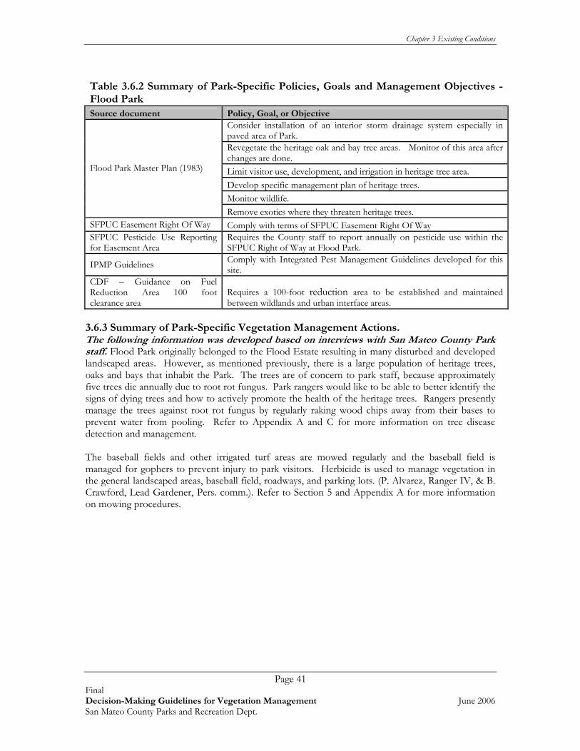
Chapter 3 Existing Conditions
Page 41 Final Decision-Making Guidelines for Vegetation Management June 2006 San Mateo County Parks and Recreation Dept.
Table 3.6.2 Summary of Park-Specific Policies, Goals and Management Objectives - Flood Park Source document Policy, Goal, or Objective
Consider installation of an interior storm drainage system especially in paved area of Park. Revegetate the heritage oak and bay tree areas. Monitor of this area after changes are done. Limit visitor use, development, and irrigation in heritage tree area. Develop specific management plan of heritage trees. Monitor wildlife.
Flood Park Master Plan (1983)
Remove exotics where they threaten heritage trees. SFPUC Easement Right Of Way Comply with terms of SFPUC Easement Right Of Way SFPUC Pesticide Use Reporting for Easement Area
Requires the County staff to report annually on pesticide use within the SFPUC Right of Way at Flood Park.
IPMP Guidelines Comply with Integrated Pest Management Guidelines developed for this site.
CDF – Guidance on Fuel Reduction Area 100 foot clearance area
Requires a 100-foot reduction area to be established and maintained between wildlands and urban interface areas.
3.6.3 Summary of Park-Specific Vegetation Management Actions. The following information was developed based on interviews with San Mateo County Park staff. Flood Park originally belonged to the Flood Estate resulting in many disturbed and developed landscaped areas. However, as mentioned previously, there is a large population of heritage trees, oaks and bays that inhabit the Park. The trees are of concern to park staff, because approximately five trees die annually due to root rot fungus. Park rangers would like to be able to better identify the signs of dying trees and how to actively promote the health of the heritage trees. Rangers presently manage the trees against root rot fungus by regularly raking wood chips away from their bases to prevent water from pooling. Refer to Appendix A and C for more information on tree disease detection and management. The baseball fields and other irrigated turf areas are mowed regularly and the baseball field is managed for gophers to prevent injury to park visitors. Herbicide is used to manage vegetation in the general landscaped areas, baseball field, roadways, and parking lots. (P. Alvarez, Ranger IV, & B. Crawford, Lead Gardener, Pers. comm.). Refer to Section 5 and Appendix A for more information on mowing procedures.

Chapter 3 Existing Conditions
Page 42 Final Decision-Making Guidelines for Vegetation Management June 2006 San Mateo County Parks and Recreation Dept.
Table 3.6.3 Current and Ongoing Vegetation Management Activities – Flood Park
Vegetation Management Actions
Implementation Rational/
Requirement Schedule Special Considerations
Remove exotics where they threaten heritage trees.
Spread wood chips to cover weeds, but not around base of tree. Refer to Appendix A and C for more information.
Ongoing
Assessment of all Heritage trees for hazardous conditions - Trim or remove as necessary.
Ongoing. Refer to Section 5 and Appendices B and C for more information.
Annual All picnic areas are located among the heritage trees, It is a high priority to reduce danger to visitors and reduce spread of the root rot fungus.
Maintain fuel reduction area along 100 foot property perimeter for fire protection.
Ongoing. Cut back brush Refer to Section 5 and Appendix A for more information.
CDF requirement for fire safety zone between wildlands and urban interface
Annual Neighbors to the north and south do not want trees to be removed.
* Numbers in ( ) refer to the reference document that the action was taken from. See Extended Bibliography in Appendix E for more information on Action Item. 3.7 HUDDART PARK Huddart Park is a 974-acre park with diverse native plant communities including a redwood forest, oak woodlands, mixed evergreen forest, and chaparral areas. It provides many recreational facilities for picnics, horseback riding, and hiking. It is also linked to the Crystal Springs Riding and Hiking Trail as well as Wunderlich Park via the Skyline trail. 3.7.1 General Site Conditions The following section summarizes Park resources of interest to Vegetation Management Guideline development (Rana, 2002). Refer to Table 3.7.1 below. The information provided in the following table was taken from Rana (2002) and May 2006 information from the Department of Fish and Game’s online California Natural Diversity Database, at www. nrdb.org = Table 3.7.1 Summary of Park Resources-Huddart Plant Communities Live oak woodland Chaparral Mixed evergreen forest Landscaped/developed Redwood forest Sensitive Plants known to Occur on Park Lands* There are no special status plants known from within the Park. Sensitive Plants With Potential to Occur* Western leatherwood (Dirca occidentalis) White-flowered rein orchid (Piperia candida) California bottle-brush grass (Elymus californicus) Michael’s rein orchid (Piperia michaelii) Diablo helianthella (Helianthella castanea) Santa Cruz manzanita (Arctostaphylos andersonii) Dudley’s lousewort (Pedicularis dudleyi) Wooly headed lessingia (Lessingia hololeuca)*

Chapter 3 Existing Conditions
Page 43 Final Decision-Making Guidelines for Vegetation Management June 2006 San Mateo County Parks and Recreation Dept.
Table 3.7.1 Summary of Park Resources-Huddart Sensitive Wildlife Species Known to Occur on Park Lands* Steelhead-Central CA Coast ESU (Oncorhynchus mykiss) Breeding Sensitive Wildlife With Potential to Occur* California tiger salamander (Ambystoma tigrinum californiense) Sharp-shinned hawk (Accipiter striatus) California red-legged frog (Rana aura draytoni) Rufous hummingbird (Selasphorus rufus) San Francisco garter snake (Thamnophis sirtalis tetrataenia) Loggerhead shrike (Lanius ludovicianus) Cooper’s hawk (Accipiter cooperii) Lawrence’s goldfinch (Carduelis lawrencei) Invasive Plants ** Monterey pine (Pinus radiata) Yellow star-thistle (Centaurea solstitialis)
French broom (Genista monspessulana) Pampas grass (Cortaderia selloana) or jubata grass (Cortaderia jubata)
Thistle (Carduus pycnocephalus or Cirsium vulgare) *Indicates a biological resource that is considered sensitive, locally rare, or protected under the state or federal Endangered Species Act. ** There may be more invasive species present in the park since the last weed inventory (Rana 2002). The following was excerpted from the County of San Mateo’s web site at: www.eparks.net Several different plant communities offer a varied habitat for the creatures found in the Park. Along the streams and in gullies, the majestic coast redwoods provide a cool, well-shaded environment. Here sword fern and redwood sorrel provide luxuriant cover for large, yellow banana slugs that inch slowly on their way. In contrast, the chaparral areas are hot and dry. Few trees exist here. Shrubs, such as manzanita, chamise, chaparral pea, and yerba santa form a thick, almost impenetrable mass of brush. Here the visitor can see jackrabbits, brush bunnies, chipmunks, and lizards scurrying through the underbrush. Birds that are often seen and heard are quail, scrub jays, and wrentits. Bordering the chaparral and the redwood forest is the mixed evergreen forest, which covers most of the Park. Here trees, such as tanbark oak, madrones, California laurel, coast live oak, and Douglas fir are dominant. Beneath the trees are many shrubs, including sticky monkey flower, wild lilac, toyon, wood rose, and poison oak. Brilliant wildflowers, such as western hound's tongue, Indian warrior, and Fremont’s star lily (zygadene lily) are found along with the graceful wood fern. Black-tailed deer, raccoons, black squirrels and, less commonly, bobcats, coyotes and grey foxes may be seen. Common birds include acorn woodpeckers, chickadees, towhees, and stellar jays. Integrating with the other plant communities in the extreme lower part of the Park is the foothill woodland characterized by large white (valley) oaks, black oaks and bay trees. The Park contains remnants of old growth redwood forest. 3.7.2 Park-Specific Policies, Goals, Management Objectives Based on an examination of the available documents pertaining to this Park, the vegetation and natural resource management policies, goals, and management objectives that were found pertaining specifically to this Park are presented below in Table 3.7.2; general policies and goals for the County Parks system as a whole are discussed in Chapter 2.

Chapter 3 Existing Conditions
Page 44 Final Decision-Making Guidelines for Vegetation Management June 2006 San Mateo County Parks and Recreation Dept.
Table 3.7.2 Summary of Park-Specific Policies, Goals and Management Objectives – Huddart Source document Policy, Goal, or Objective
Reduce sedimentation arising from various sources including road and trail erosion, creek bank erosion due to horse crossing, human use, and natural sources. Many detailed instructions to reduce fire load including mechanical removal, landscaping and revegetation, grazing and education. Independent watershed assessment to locate all sediment sources.
Huddart and Wunderlich Parks Master Plan (2005)
Improvements to steelhead habitat including new bridges, culverts and erosion control of creek habitat.
CDF – Guidance on Fule Reduction 100 foot clearance area
Requires a 100-foot fuel reduction area to be established and maintained between wildlands and urban interface areas.
3.7.3 Summary of Park-Specific Vegetation Management Actions The following information was developed based on interviews with San Mateo County Park staff. Huddart Park is unique in that only 80 of the 974 acres that make up the Park are developed. The rest of the Park is kept in a natural state, including the trail system. It has redwood trees, two creeks, and provides the feeling of being out in the wilderness. Huddart’s primary vegetation management challenge is staying on top of invasive weed infestations including, yellow-star thistle, bull thistle, Italian thistle, acacia, and Scotch and French broom. There is an active volunteer group, the Friends of Huddart and Wunderlich, which works once or twice a week pulling Scotch and French broom. Fire hazard reduction is managed by cutting away tree branches over established picnic areas. Lawns are mowed on a weekly basis and other grassland areas are mowed once annually. Herbicide is used in high public use areas, along fences, parking lots, and for exotic plant and poison oak control. (P. Alvarez, Ranger IV, & B. Crawford, Lead Gardener, Pers. comm.). Table 3.7.3 Current and Ongoing Vegetation Management Activities – Huddart Park
Vegetation Management Actions Implementation Rationale/
Requirement Schedule Special Considerations
Reduce sedimentation arising from various sources including road and trail erosion, creek bank erosion due to horse crossing, human use, and natural sources.
Installing split rail fence to prevent short cuts on trail and prevent erosion.
STOPP Program
Unknown Watershed improvement/fisheries habitat improvements.
Maintain access roads, fire roads, equestrian trails and pedestrian trails on an annual basis. In addition, inspect major access roads and fire trails after every major storm event during the winter and spring months.
Mowing within 12 inches of trails. Refer to Section 5 and App B.
Visitor safety & Fire hazard reduction.
Unknown Avoid sensitive species when mowing. Refer to App B and Section 5.

Chapter 3 Existing Conditions
Page 45 Final Decision-Making Guidelines for Vegetation Management June 2006 San Mateo County Parks and Recreation Dept.
Vegetation Management Actions Implementation Rationale/
Requirement Schedule Special Considerations
Work with PG&E to maintain the right-of-way throughout the parks and develop guidelines for trailside trimming procedures that preserve habitat and aesthetics as well as fire safety.
Trimming or removing woody vegetation
Ongoing
Continue to employ current methods and practices to reduce the risk of ignition.
Removing branches over BBQ grills, mowing grassland.
Visitor safety & Fire hazard Reduction.
Summer season.
Continue to work with volunteers to remove French broom, scotch broom, bull thistle.
Friends of Huddart & Wunderlich.
Maintain & restore native habitats for wildlife & visitor experience.
3 times per month
Neighbors that border Park boundary have infestations of broom that do not get removed.
Ensure key onsite personnel, including Park Rangers, maintenance staff, are trained in basic fire prevention.
Rangers trained by CDF. Ranger staff would be used for information more than fire suppression.
Include information regarding fire ecology and prevention at entrance and trail staging area kiosks, and in interpretive and educational materials.
Smokey The Bear sign at park entrance stating fire danger (i.e. Low, High, or Extreme). On high fire danger, trails are closed and posted.
Meet with neighboring homeowner associations to collaborate on fire safety projects.

Chapter 3 Existing Conditions
Page 46 Final Decision-Making Guidelines for Vegetation Management June 2006 San Mateo County Parks and Recreation Dept.
Vegetation Management Actions Implementation Rationale/
Requirement Schedule Special Considerations
Survey annually for tree hazards and poison oak in use areas (campgrounds/ picnic areas).
Park staff visually inspects for hazardous trees and removes branches in close proximity to BBQ grills. Refer to Section 5 and Appendix A.
Visitor safety & Fire hazard reduction.
May - August
Recent report of Sudden Oak Death syndrome at Huddart (S. Herzberg, pers. comm.). If present, follow guidelines in Section 5 and Appendices B and C. Do not move woody debris from site.
Maintain a fuel reduction area along 100 foot of property perimeter for fire protection.
Ongoing. Cut back brush Refer to Section 5 and Appendix A for more information.
CDF requirement for fire safety zone between wildlands and urban interface.
Annual Caution should be taken to prevent special status plants & wildlife from being mowed.
3.8 JUNIPERO SERRA PARK Junipero Serra Park is a foothill park that provides for many recreational activities including picnicking, playgrounds, hiking, nature trails, youth day camping, and a panoramic view of the Bay Area. The Park is 108 acres which includes a 58-acre coast live oak woodland and the El Zanjon Creek which together provide a valuable wildlife corridor (Rana, 2002). The Park is bounded on its eastern side by the Serra Fault, while the much larger San Andreas Fault lies ¼ mile to west. 3.8.1 General Site Conditions The following section summarizes Park resources of interest to Vegetation Management Guideline development (Rana, 2002). Refer to Table 3.8.1 below. The information provided in the following table was taken from Rana (2002) and May 2006 information from the Department of Fish and Game’s online California Natural Diversity Database, at www. nrdb.org Table 3.8.1. Summary of Park Resources - Junipero Serra Park
Plant Communities Coast live oak woodland Redwood Coast live oak woodland with some Monterey pine Coyote brush scrub Arroyo willow riparian woodland Non-native grassland
Eucalyptus Non-native grassland with elements of coastal prairie
Monterey pine Exotic landscaping species Eucalyptus/Monterey pine Landscaped/developed Sensitive Plants known to Occur on Park Lands*
There are no special status plants that occur on Park lands.

Chapter 3 Existing Conditions
Page 47 Final Decision-Making Guidelines for Vegetation Management June 2006 San Mateo County Parks and Recreation Dept.
Table 3.8.1. Summary of Park Resources - Junipero Serra Park Sensitive Plants With Potential to Occur*
Western leatherwood (Dirca occidentalis) White-flowered rein orchid (Piperia candida) California bottle-brush grass (Elymus californicus) Michael’s rein orchid (Piperia michaelii) Diablo helianthella (Helianthella castanea) Santa Cruz manzanita (Arctostaphylos andersonii) Dudley’s lousewort (Pedicularis dudleyi) Bolander’s horkelia (Horkelia bolanderi)* San Mateo tree lupine (Lupinus eximius) Sensitive Wildlife Species Known to Occur on Park Lands*
There are no special status wildlife species that occur on Park lands. Sensitive Wildlife With Potential to Occur* California Tiger Salamander (Ambystoma tigrinum californiense) Sharp-shinned Hawk (Accipiter striatus) California Red-legged Frog (Rana aura draytoni) Rufous Hummingbird (Selasphorus rufus) San Francisco Garter Snake (Thamnophis sirtalis tetrataenia) Loggerhead Shrike (Lanius ludovicianus) Cooper’s Hawk (Accipiter cooperii) Lawrence’s Goldfinch (Carduelis lawrencei) Invasive Plants **
Acacia species (Acacia spp.) Harding grass (Phalaris aquatica) Blue gum Eucalyptus (Eucalyptus globulus) Italian thistle (Carduus pycnocephalus) Bull thistle (Cirsium vulgare) Monterey cypress (Cupressus macrocarpa) Cape ivy/German ivy (Delairea odorata /Senecio mikanioides) Monterey pine (Pinus radiata)
English ivy (Hedera helix) Pampas grass (Cortaderia selloana) or jubata grass (Cortaderia jubata)
Fennel (Foeniculum vulgare) Scotch broom (Cytisus scoparius) French broom (Genista monspessulana) Yellow star-thistle (Centaurea solstitialis)
*Indicates a biological resource that is considered sensitive, locally rare, or protected under the state or federal Endangered Species Act. ** There may be more invasive species present in the park since the last weed inventory (Rana 2002). The following was excerpted from the County of San Mateo’s web site: http://www.eparks.net Junipero Serra Park contains valuable remnants of the foothill plant communities that existed in the Bay Area before the coming of the European explorers and settlers. These communities are well suited to the climate, soils and topography of the area. Common trees found in the Park are the coast live oak, arroyo willow, California bay laurel, madrone, California buckeye, Eucalyptus, Monterey cypress, and Monterey pine. Animals seen in abundance are scrub jays, towhees, banana slugs, raccoons, red-tailed hawks and turkey vultures. An abundance of spring wildflowers are found throughout the Park, both on the grassy hillsides and in the wooded areas. The flowers include Douglas iris, miner’s lettuce, hounds tongue, California buttercup, soap plant, and owl clover. Poison oak grows abundantly throughout the Park. All of the plant and animal species are protected in the Park. Many of the pines have pitch canker, a disease caused by the fungus Fusarium circinatum. This fungus may increase the potential of a fire in the oak woodland by killing pines. (Source: UC Berkeley Department of Forestry, Pine pitch canker treatment guidelines available online at: forestry.berkeley.edu/comp_proj/pnpitchcanker.pdf.

Chapter 3 Existing Conditions
Page 48 Final Decision-Making Guidelines for Vegetation Management June 2006 San Mateo County Parks and Recreation Dept.
3.8.2 Park-Specific Policies, Goals, Management Objectives Based on an examination of the available documents pertaining to this Park, the vegetation and natural resource management policies, goals, and management objectives that were found pertaining specifically to this Park are presented below in Table 3.8.2; general policies and goals for the County Parks system as a whole are discussed in Chapter 2. Table 3.8.2 Summary of Park-Specific Policies, Goals and Management Objectives – Junipero Serra Park Source document Policy, Goal, or Objective
Stabilize erosion of Crystal Springs Drive. By constructing two check dams and willow plantings.
Remove all invasive trees and shrubs from grassland including invasive native shrubbery.
Junipero Serra Natural Resources Master Plan (1979)
Replacement of stream course in riparian areas and erosion control in this area. Stabilize erosion processes including El Zanjon Creek. Re-establish native plant associations. Redesign El Zanjon Creek Channel. Encourage diversity of wildlife, including quail.
Junipero Serra County Recreation Area Master Plan (1981)
Gradually remove invasive plants especially the Monterey pine and Eucalyptus, first removing Eucalyptus near private residences on area boundary as they pose a liability problem.
CDF – Guidance on Fuel Reduction 100 foot clearance area
Requires a 100-foot fuel reduction area to be established and maintained between wildlands and urban interface areas.
3.8.3 Summary of Park-Specific Vegetation Management Actions The following information was developed based on interviews with San Mateo County Park staff. Junipero Serra Park is a heavily disturbed park dominated by Eucalyptus trees and non-native grassland, with one perennial creek and few natural areas. The Park is bordered by houses, an interstate freeway, and a city park, and fuel load management is a concern. Management of fire and fuel load consists of dead trees being removed and chipped on site. Eucalyptus trees are currently only being managed and not removed from the Park. Park staff resources are primarily spent on cleaning up Eucalyptus duff on the trails. The lawn area is mowed on a regular basis and the non-native grassland, mostly composed of rattle-snake grass, is mowed twice a year. Certain Park sites are highly erodable and containing slumps and slides. Herbicide is used to control vegetation in picnic areas, shelter buildings, parking lots, fire control areas, trails, and used to control poison oak, and invasive ivy and broom. (P. Noyer, Ranger IV, Pers. com.).

Chapter 3 Existing Conditions
Page 49 Final Decision-Making Guidelines for Vegetation Management June 2006 San Mateo County Parks and Recreation Dept.
Table 3.8.3 Current and Ongoing Vegetation Management Activities – Junipero Serra
Vegetation Management Actions
ImplementationRationale/
RequirementSchedule
Special Considerations
Gradually remove invasive plants especially the Monterey pine and blue gum Eucalyptus. Remove Eucalyptus near private residences on area boundary first, as they pose a liability problem. (35)
Hazardous trees are trees are removed, all other invasive plants are only managed.
Public safety.
As needed.
Mow or green chop grasslands annually during the months of May-July for fire suppression. (35)
Fields are mowed by maintenance crew.
Fire suppression & control of non-native grassland.
Twice a year. Mow before rattlesnake grass sets it seed.
Maintain a fuel reduction area along 100 foot of property perimeter for fire protection.
Ongoing. Cut back brush Refer to Section 5 and Appendix A for more information.
CDF requirement for fire safety zone between wildlands and urban interface.
Annual Caution should be taken to prevent special status plants & wildlife from being mowed.
Reseed/restore native plants Ongoing Following removal of vegetation.
As needed
Control invasive plants and problem species such as poison oak and Scotch broom. (35)
Mow fields. Refer to Section 5 and Appendix A for mowing procedures.
Enhance native habitat.
As time allows
Remove all invasive trees and shrubs from grassland including invasive native shrubbery (34). To be done every five years (35).
Removal is done as volunteer groups come in, no organized schedule.
Maintain grassland habitat.
As resources become available (i.e. volunteer groups).
* Numbers in ( ) refer to the reference document that the action was taken from. See Extended Bibliography in Appendix E for more information on Action Item.

Chapter 3 Existing Conditions
Page 50 Final Decision-Making Guidelines for Vegetation Management June 2006 San Mateo County Parks and Recreation Dept.
3.9 MEMORIAL Memorial Park is part of the Pescadero Park Complex that includes Memorial, Sam McDonald, and Pescadero Park as well as the Heritage Grove area. All together the Pescadero Complex consists of 8,020 acres, of which Memorial is 499 acres. Recreational activities in this Park include hiking, equestrian trails, bike trails, and camping. It is connected to Pescadero Creek Park. In addition, the Pompino Trail connects Memorial to Portola State Park. One of Memorial’s unique features are its old-growth redwoods. The oldest tree in this grove is over 1,600 years old. Pescadero Creek flows through this area and is a major spawning stream for steelhead and salmon. 3.9.1 General Site Conditions The following section summarizes Park resources of interest to Vegetation Management Guideline development (Rana, 2002). Refer to Table 3.9.1 below. The information provided in the following table was taken from Rana (2002) and May 2006 information from the Department of Fish and Game’s online California Natural Diversity Database, at www. nrdb.org
Table 3.9.1 Summary of Park Resources-Pescadero Park Complex (including Memorial) Plant Communities Live oak woodland Alder/willow riparian Mixed evergreen forest Coyote brush scrub Redwood forest Coastal prairie Santa Cruz cypress (one in native garden) Non-native grassland with elements of coastal prairie developed Sensitive Plants With Potential to Occur* Santa Cruz manzanita (Arctostaphylos andersonii) White-flowered rein orchid (Piperia candida) Diablo helianthella (Helianthella castanea) Michael’s rein orchid (Piperia michaelii) Western leatherwood (Dirca occidentalis) Dudley’s lousewort (Pedicularis dudleyi) California bottle-brush grass (Elymus californicus) White-rayed pentachaeta (Pentachaeta bellidiflora) Sensitive Wildlife Species Known to Occur on Park Lands* Steelhead-Central CA Coast ESU (Oncorhynchus mykiss) Breeding Ferruginous Hawk (Buteo regalis) Coho Salmon-Central CA Coast ESU (Oncorhynchus kisutch) Breeding Marbled Murrelet (Brachyramphus marmoratum) Breeding. California Red-legged Frog (Rana aura draytoni) Olive-sided Flycatcher(Contopus cooperi) Foothill Yellow-legged Frog (Rana boylei) Loggerhead Shrike (Lanius ludovicianus) Northern Harrier (Circus cyaneus) California Horned Lark (Eremophila alpestris actia) Cooper’s Hawk (Accipiter cooperii) Purple Martin (Progne subis) Sharp-shinned Hawk (Accipiter striatus) Yellow Warbler (Dendroica petechia) Sensitive Wildlife Species with Potential to Occur* California Tiger Salamander ( Ambystoma tigrinum californiense) Western Pond Turtle (Clemmys marmorata) San Francisco Garter Snake (Thamnophis sirtalis tetrataenia) Golden Eagle (Aquila chrysaetos) Long-eared owl (Asio otus) California Spotted Owl (Strix occidentalis occidentalis) Vaux’s Swift (Chaetura vauxi) Rufous Hummingbird (Selasphorus rufus) Lawrence’s Goldfinch (Carduelis lawrencei) Invasive Plants** Cape ivy/German ivy (Delairea odorata/Senecio mikanioides)
Bull thistle (Cirsium vulgare) Pampas grass (Cortaderia selloana) or jubata grass (Cortaderia

Chapter 3 Existing Conditions
Page 51 Final Decision-Making Guidelines for Vegetation Management June 2006 San Mateo County Parks and Recreation Dept.
Table 3.9.1 Summary of Park Resources-Pescadero Park Complex (including Memorial) Himalayan blackberry (Rubus discolor) jubata) French broom (Genista monspessulana) Harding grass (Phalaris aquatica) Poison hemlock (Conium maculatum) Periwinkle (Vinca major) Italian thistle (Carduus pycnocephalus) Fennel (Foeniculum vulgare) Yellow star-thistle (Centaurea solstitialis)
*Indicates a biological resource that is considered sensitive, locally rare, or protected under the state or federal Endangered Species Act. ** There may be more invasive species present in the park since the last weed inventory (Rana 2002). The following information was developed based on interviews with San Mateo County Park staff and information excerpted from the County of San Mateo Park’s Department website. Common plants found here are huckleberry, poison oak, ferns, redwood sorrel, azalea, and horsetail. Animals seen in abundance are Steller’s jays, acorn woodpeckers, western grey squirrels, raccoons, skunks, and banana slugs. The summer temperature is pleasant and occasionally a cool fog drifts in from the ocean. In winter, the air is crisp and the ground and plants are moist. The yearly rainfall averages 40 inches and frosts are frequent. All of the plant and animal species are protected in the Park. Pescadero Creek is a winter home for steelhead trout as they migrate upstream to spawn and then move back to the sea in the spring. This stream is viewed as a very significant part of the local watershed and riparian corridor system. Bloomquist, Hoffman, McCormick, and Peterson Creeks join Pescadero Creek within the Park boundaries. The Park’s old growth redwood trees provide nesting habitat for the federally threatened marbled murrelet (Brachyramphus marmoratus). Memorial Park presently has a grant to reduce corvid populations in the Park in order to protect marbled murrelet nests from predation. New dumpsters and trash cans will be placed onsite in order to restrict access to food waste, ideally resulting in fewer corvids. (M. Del Carlo, Ranger IV, pers. comm.). 3.9.2 Park-Specific Policies, Goals, Management Objectives Based on an examination of the available documents pertaining to this Park, the vegetation and natural resource management policies, goals, and management objectives that were found pertaining specifically to this Park are presented below in Table 3.9.2; general policies and goals for the County Parks system as a whole are discussed in Chapter 2. Table 3.9.2. Summary of Park-Specific Policies, Goals and Management Objectives – Memorial Source document Policy, Goal, or Objective
Sediment assessment for Pescadero Park complex (2003)
To reduce sediment delivery into the watersheds stream systems. This document lists specifically which areas need erosion control, prioritizes these sites and lists best methods and costs for implementing the improvements. Important to keep in mind that this document only lists those area that will directly affect stream habitat.
Water supply alternatives, fish passage and use, and streambed conditions at Memorial Park (2003)
Grant was prepared for the removal of dam to improve flow in creek for improved salmonid habitat.
CDF – Guidance on Fuel Reduction 100 foot clearance area
Requires a 100-foot fuel reduction area to be established and maintained between wildlands and urban interface areas.

Chapter 3 Existing Conditions
Page 52 Final Decision-Making Guidelines for Vegetation Management June 2006 San Mateo County Parks and Recreation Dept.
3.9.3 Summary of Park-Specific Vegetation Management Actions The following information was developed based on interviews with San Mateo County Park staff. Memorial Park has 156 family campsites and visitors to the Park are primarily comprised of campers and hikers. Some of the Park’s trails are in poor condition, limiting site access to certain areas in the Park. Extreme weather in recent years (possibly resulting from El Niño weather patterns) washed out one main trail. This trail has not been reconstructed due to staff and funding limitations, and permitting issues. Due to the proximity of Pescadero Creek in certain areas, most construction and invasive plant control projects may require wetland permits, a limiting factor in conducting work at this Park. In addition to access and permitting issues, invasive broom species and hazardous trees near campgrounds are vegetation management challenges that Park staff face. Fire prevention efforts are accomplished by annual mowing and brushing trails, meadows and roads. Fire control by use of controlled burns is no longer permitted due to permit constraints (M. Del Carlo, Ranger IV, Pers. comm.). Table 3.9.3 Current and Ongoing Vegetation Management Activities – Memorial
Vegetation Management Actions
ImplementationRationale/
RequirementSchedule
Special Considerations
Provide a hazardous tree inspection in campgrounds, picnic areas, and trails.
Park staff visually inspects public use areas. Refer to Section 5 and Appendices B and C.
Visitor safety.
Annually and when park staff accesses campground areas.
Marbled murrelet nests in redwood trees.
Remove invasive plants. French & Scotch broom are hand pulled.
Maintain native habitats.
As resources become available.
No herbicide is used to protect Pescadero watershed.
Develop a scheduled mowing cycle for grass areas.
Grass areas accessible to Park vehicles are mowed. Refer to Section 5 and Appendix A for mowing information.
Maintain meadows and vistas.
Annually. See timing restrictions in Section 5 and Appendix A.
Maintain a fuel reduction area along 100 foot of property perimeter for fire protection.
Ongoing. Cut back brush Refer to Section 5 and Appendix A for more information.
CDF requirement for fire safety zone between wildlands and urban interface.
Annual Caution should be taken to prevent special status plants & wildlife from being mowed.

Chapter 3 Existing Conditions
Page 53 Final Decision-Making Guidelines for Vegetation Management June 2006 San Mateo County Parks and Recreation Dept.
Vegetation Management Actions
ImplementationRationale/
RequirementSchedule
Special Considerations
Implement the erosion control projects that were recommended and prioritized for the Pescadero/ Memorial/ Sam McDonald County Park Complex. These projects will reduce the amount of sedimentation reaching the Pescadero Creek Watershed system. (79)
Initiated in 2006. Partial funding provided, Bridges have been installed.
Water quality and habitat for steelhead and salmon as well as their prey.
Complete as funding becomes available.
* Numbers in ( ) refer to the reference document that the action was taken from. See Extended Bibliography in Appendix E for more information on Action Item. 3.10 MIRADA SURF EAST AND WEST Mirada Surf is comprised of two parcels, east and west of Highway 1. This park has been previously identified as open space on the Local Coastal Plan, but only recently was added to the County Park system. In 2002, San Mateo County acquired the eastern of the two parcels of Mirada Surf. 3.10.1 General Site Conditions Mirada surf west (15 acres) encompasses grasslands to the coast of Highway 1. This park also has a large infestation of French broom and bristly ox tongue that is being treated. Mirada surf east (34 acres) encompasses a large eucalyptus forest on a slope, and a native riparian area. Residents and visitors alike have enjoyed walking along the bluffs, and viewing the ocean as they drive by. Mirada Surf is a relatively new Park, therefore there is little known about the vegetation resources as the Park was not included in the previous vegetation survey of all Park lands (Rana, 2002; S. Herzberg pers. comm.). 3.10.2 Park-Specific Policies, Goals, Management Objectives Based on an examination of the available documents pertaining to this Park, the vegetation and natural resource management policies, goals, and management objectives that were found pertaining specifically to this Park are presented below in Table 3.10.3; general policies and goals for the County Parks system as a whole are discussed in Chapter 2.
Table 3.10.2 Summary of Park-Specific Policies, Goals and Management Objectives – Mirada Surf Source document Policy, Goal, or Objective Mirada surf west coastal trail extension (2005)
Control bristly ox-tongue infestations through mowing, hoeing, weed whipping, solarization, and herbicides. Obtain streambed alteration agreement from CDFG and revegetation area. Implement 5-year maintenance and monitoring program for willow riparian woodland revegetation with yearly monitoring report submitted to CDFG. Follow construction recommendations for work done in creek area and other sensitive habitats.
Bio impact form for Mirada surf trail project (2005)
Permanent installation of fencing to restrict off-trail use and interpretive signs for seasonally wet grasslands.
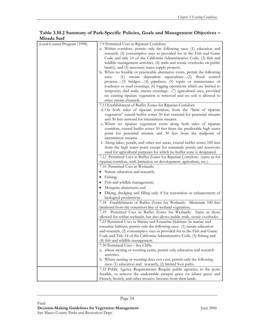
Chapter 3 Existing Conditions
Page 54 Final Decision-Making Guidelines for Vegetation Management June 2006 San Mateo County Parks and Recreation Dept.
Table 3.10.2 Summary of Park-Specific Policies, Goals and Management Objectives – Mirada Surf Local Coastal Program (1998) 7.9 Permitted Uses in Riparian Corridors:
a. Within corridors, permit only the following uses: (1) education and research, (2) consumptive uses as provided for in the Fish and Game Code and title 14 of the California Administrative Code, (3) fish and wildlife management activities, (4) trails and scenic overlooks on public land(s), and (5) necessary water supply projects.
b. When no feasible or practicable alternative exists, permit the following uses: (1) stream dependent aquaculture…(2) flood control projects…(3) bridges…(4) pipelines, (5) repair or maintenance of roadways or road crossings, (6) logging operations which are limited to temporary skid trails, stream crossings…(7) agricultural uses, provided no existing riparian vegetation is removed and no soil is allowed to enter stream channels.
7.13 Establishment of Buffer Zones for Riparian Corridors: d. On both sides of riparian corridors, from the “limit of riparian
vegetation” extend buffer zones 50 feet outward for perennial streams and 30 feet outward for intermittent streams.
e. Where no riparian vegetation exists along both sides of riparian corridors, extend buffer zones 50 feet from the predictable high water point for perennial streams and 30 feet from the midpoint of intermittent streams.
f. Along lakes, ponds, and other wet areas, extend buffer zones 100 feet from the high water point except for manmade ponds and reservoirs used for agricultural purposes for which no buffer zone is designated.
7.12 Permitted Uses in Buffer Zones for Riparian Corridors: (same as for riparian corridors, with limitation on development, agriculture, etc.).
7.16 Permitted Uses in Wetlands: • Nature education and research; • Fishing; • Fish and wildlife management; • Mosquito abatement; and • Diking, dredging and filling only if for restoration or enhancement of
biological productivity.
7.18 Establishment of Buffer Zones for Wetlands: Minimum 100 feet landward from the outermost line of wetland vegetation.
7.19 Permitted Uses in Buffer Zones for Wetlands: Same as those allowed for within wetlands, but also allows public trails, scenic overlooks.
7.23 Permitted Uses in Marine and Estuarine Habitats: In marine and estuarine habitats, permit only the following uses: (1) nature education and research, (2) consumptive uses as provided for in the Fish and Game Code and Title 14 of the California Administrative Code, (3) fishing and (4) fish and wildlife management.
7.30 Permitted Uses – Sea Cliffs: a. where nesting or roosting exists, permit only education and research
activities. b. Where nesting or roosting does not exist, permit only the following
uses: (1) education and research, (2) limited foot paths.
7.52 Public Agency Requirements: Require public agencies, to the point feasible, to remove the undesirable pampas grass (or jubata grass) and French, Scotch, and other invasive brooms from their lands.
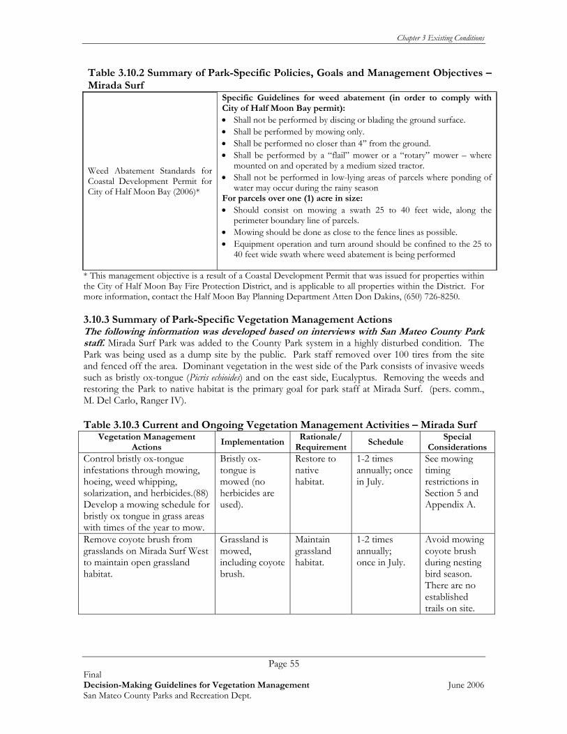
Chapter 3 Existing Conditions
Page 55 Final Decision-Making Guidelines for Vegetation Management June 2006 San Mateo County Parks and Recreation Dept.
Table 3.10.2 Summary of Park-Specific Policies, Goals and Management Objectives – Mirada Surf
Weed Abatement Standards for Coastal Development Permit for City of Half Moon Bay (2006)*
Specific Guidelines for weed abatement (in order to comply with City of Half Moon Bay permit): • Shall not be performed by discing or blading the ground surface. • Shall be performed by mowing only. • Shall be performed no closer than 4’’ from the ground. • Shall be performed by a “flail” mower or a “rotary” mower – where
mounted on and operated by a medium sized tractor. • Shall not be performed in low-lying areas of parcels where ponding of
water may occur during the rainy season For parcels over one (1) acre in size: • Should consist on mowing a swath 25 to 40 feet wide, along the
perimeter boundary line of parcels. • Mowing should be done as close to the fence lines as possible. • Equipment operation and turn around should be confined to the 25 to
40 feet wide swath where weed abatement is being performed
* This management objective is a result of a Coastal Development Permit that was issued for properties within the City of Half Moon Bay Fire Protection District, and is applicable to all properties within the District. For more information, contact the Half Moon Bay Planning Department Atten Don Dakins, (650) 726-8250. 3.10.3 Summary of Park-Specific Vegetation Management Actions The following information was developed based on interviews with San Mateo County Park staff. Mirada Surf Park was added to the County Park system in a highly disturbed condition. The Park was being used as a dump site by the public. Park staff removed over 100 tires from the site and fenced off the area. Dominant vegetation in the west side of the Park consists of invasive weeds such as bristly ox-tongue (Picris echioides) and on the east side, Eucalyptus. Removing the weeds and restoring the Park to native habitat is the primary goal for park staff at Mirada Surf. (pers. comm., M. Del Carlo, Ranger IV). Table 3.10.3 Current and Ongoing Vegetation Management Activities – Mirada Surf
Vegetation Management Actions
ImplementationRationale/
RequirementSchedule
Special Considerations
Control bristly ox-tongue infestations through mowing, hoeing, weed whipping, solarization, and herbicides.(88) Develop a mowing schedule for bristly ox tongue in grass areas with times of the year to mow.
Bristly ox-tongue is mowed (no herbicides are used).
Restore to native habitat.
1-2 times annually; once in July.
See mowing timing restrictions in Section 5 and Appendix A.
Remove coyote brush from grasslands on Mirada Surf West to maintain open grassland habitat.
Grassland is mowed, including coyote brush.
Maintain grassland habitat.
1-2 times annually; once in July.
Avoid mowing coyote brush during nesting bird season. There are no established trails on site.

Chapter 3 Existing Conditions
Page 56 Final Decision-Making Guidelines for Vegetation Management June 2006 San Mateo County Parks and Recreation Dept.
Vegetation Management Actions
ImplementationRationale/
RequirementSchedule
Special Considerations
Maintain a fuel reduction area along 100 foot of property perimeter for fire protection.
Ongoing. Cut back brush Refer to Section 5 and Appendix A for more information.
CDF requirement for fire safety zone between wildlands and urban interface.
Annual Caution should be taken to prevent special status plants & wildlife from being mowed.
Continue to follow construction recommendations for work done in creek area and other sensitive habitats. (89).
Restore to native habitat.
Annually.
* Numbers in ( ) refer to the reference document that the action was taken from. See Extended Bibliography in Appendix E for more information on Action Item. 3.11 PESCADERO PARK The Pescadero Creek Park Complex includes Pescadero Creek, Sam McDonald, and Memorial Parks as well as the Heritage Grove area. All together this Park consists of 8,020 acres. Pescadero Creek flows year-round through this area, and is a major spawning stream for steelhead and salmon. Recreational activities in this Park include hiking, equestrian trails, and camping. Pescadero Creek is situated in the coastal fog zone and is dominated by redwood forest which was logged from the late 1850’s until and 1970’s. At present, the forest resources of the site are largely unmanaged, resulting in high regeneration of redwood, and heavy development of brush and trees which pose a significant fire hazard. Access to the interior of the Park Complex is limited, and park staffing minimal. 3.11.1 General Site Conditions The following section summarizes Park resources of interest to Vegetation Management Guideline development (Rana, 2002). Refer to Table 3.11.1 below. The information provided in the following table was taken from Rana (2002) and May 2006 information from the Department of Fish and Game’s online California Natural Diversity Database, at www. nrdb.org Table 3.11.1. Summary of Park Resources- Pescadero Complex (including Pescadero Park) Plant Communities Live oak woodland Alder/willow riparian Mixed evergreen forest Coyote brush scrub Redwood forest Coastal prairie Santa Cruz cypress grove Non-native grassland with elements of coastal prairie Knobcone pine forest Developed Sensitive Plants known to Occur on Park Lands* Santa Cruz cypress (Cupressus abramsiana) Sensitive Plants With Potential to Occur* Santa Cruz manzanita (Arctostaphylos andersonii) White-flowered rein orchid (Piperia candida) Diablo helianthella (Helianthella castanea) Michael’s rein orchid (Piperia michaelii) Western leatherwood (Dirca occidentalis) Dudley’s lousewort (Pedicularis dudleyi) California bottle-brush grass (Elymus californicus) White-rayed pentachaeta (Pentachaeta bellidiflora)

Chapter 3 Existing Conditions
Page 57 Final Decision-Making Guidelines for Vegetation Management June 2006 San Mateo County Parks and Recreation Dept.
Table 3.11.1. Summary of Park Resources- Pescadero Complex (including Pescadero Park) Sensitive Wildlife Species Known to Occur on Park Lands* Steelhead-Central CA Coast ESU (Oncorhynchus mykiss) Breeding Ferruginous Hawk (Buteo regalis) Coho Salmon-Central CA Coast ESU (Oncorhynchus kisutch) Breeding Marbled Murrelet (Brachyramphus marmoratum) Breeding. California Red-legged Frog (Rana aura draytoni) Olive-sided Flycatcher(Contopus cooperi) Foothill Yellow-legged Frog (Rana boylei) Loggerhead Shrike (Lanius ludovicianus) Northern Harrier (Circus cyaneus) California Horned Lark (Eremophila alpestris actia) Cooper’s Hawk (Accipiter cooperii) Purple Martin (Progne subis) Sharp-shinned Hawk (Accipiter striatus) Yellow Warbler (Dendroica petechia) Sensitive Wildlife Species with Potential to Occur* California Tiger Salamander (Ambystoma tigrinum californiense) Western Pond Turtle (Clemmys marmorata) San Francisco Garter Snake (Thamnophis sirtalis tetrataenia) Golden Eagle (Aquila chrysaetos) Long-eared owl (Asio otus) California Spotted Owl (Strix occidentalis occidentalis) Vaux’s Swift (Chaetura vauxi) Rufous Hummingbird (Selasphorus rufus) Lawrence’s Goldfinch (Carduelis lawrencei) Invasive Plants** Cape ivy/German ivy (Delairea odorata/Senecio mikanioides)
Pampas grass (Cortaderia selloana) or jubata grass (Cortaderia jubata)
Himalayan blackberry (Rubus discolor) Bull thistle (Cirsium vulgare) French broom (Genista monspessulana) Harding grass (Phalaris aquatica) Poison hemlock (Conium maculatum) Periwinkle (Vinca major) Italian thistle (Carduus pycnocephalus) Fennel (Foeniculum vulgare) Yellow star-thistle (Centaurea solstitialis)
*Indicates a biological resource that is considered sensitive, locally rare, or protected under the state or federal Endangered Species Act. ** There may be more invasive species present in the park since the last weed inventory (Rana 2002). The following was excerpted from the County of San Mateo’s web site: http://www.eparks.net The Park contains a significant amount of forest and watershed related resources. In addition to coast redwoods and Douglas fir, there is a fairly large grove of endangered Santa Cruz cypress (Cupressus abramsinana) along Butano Ridge. Other major tree species include California wax myrtle, tan oak (once commercially harvested for tan bark), madrone, California bay laurel, big leaf maple, canyon live oak, coast live oak, and knobcone pine. As mentioned above, the forest resources of the site were logged from the 1850’s until the 1970’s but are presently largely unmanaged, resulting in regeneration of redwood, and heavy development of brush and trees which pose a significant fire hazard. Access to the interior of the Park complex is limited. Pescadero Creek and Alpine Creek both contain steelhead trout (Salmo gairdneri). Pescadero Creek also has a small and variable run of silver salmon (Oncorhynchus kitsutch). The steelhead (a sea run rainbow trout) is by far the most significant of these species. Both are listed as endangered by the state and federal agencies. The Park also provides nesting for the endangered marbled murrelet. Feral pigs are becoming a significant pest, causing erosion damage. 3.11.2 Park-Specific Policies, Goals, Management Objectives Based on an examination of the available documents pertaining to this Park, the vegetation and natural resource management policies, goals, and management objectives that were found pertaining

Chapter 3 Existing Conditions
Page 58 Final Decision-Making Guidelines for Vegetation Management June 2006 San Mateo County Parks and Recreation Dept.
specifically to this Park are presented below in Table 3.11.2; general policies and goals for the County Parks system as a whole are discussed in Chapter 2.
Table 3.11.2. Summary of Park-Specific Policies, Goals and Management Objectives – Pescadero Source document Policy, Goal, or Objective
Encourage riparian growth to stabilize banks. Reduce hazard through controlled burns and hand and mechanical clearing. Accelerate return of forest to natural condition leading to an increase in redwoods and a decrease in Douglas fir. To encourage new growth of forest conifers to reduce dominance of hardwoods and brush. Implement vegetation monitoring program.. Implement monitoring program to measure ecological changes. Implement wildlife monitoring program. Implement a program to monitor sediment in the creek and numbers of steelhead using the creek. A one time survey of each tributary stream named on the base map within the study area and map the extent of steelhead upstream migration. Install stream gage. Annual spring gravel permeability tests. Annual juvenile steelhead population estimates. Water-quality monitoring. Implement watershed monitoring program
Natural Resources Management Program for Pescadero Creek County Park (1983)
Remove weeds and restore grasslands. Recovery plan for the Santa Cruz cypress (1998)
Develop and implement Best Management Practices for Santa Cruz Cypress. Erosion control to reduce non-point sources of sedimentation reaching Pescadero Creek and its tributaries. Reduction of fire hazards within the resource management area. Consider creating an ordinance that sets aside all funds from forest products within Memorial/Pescadero Parks be put into trust fund for ongoing management. Implement selective harvest and forest rehabilitation plan, and restoration, and monitor the results. Restoration of redwood forest to a state approximating that of an old-growth appearance at the earliest time possible.
Natural Resources management program; Implementation Concept Plan: Pescadero Creek County Park (1995)
Enhancement of steelhead trout and Coho salmon habitat through watershed improvement and in-stream habitat projects.
Sediment Assessment for Pescadero Park Complex (2003)
To reduce sediment delivery into the watersheds stream systems. This document lists specifically which areas need erosion control, prioritizes these sites and lists best methods and costs for implementing the improvements. Important to keep in mind that this document only lists those area that will directly affect stream habitat.
CDF – Guidance on Fuel Reduction100 foot clearance area
Requires a 100-foot fuel reduction area to be established and maintained between wildlands and urban interface areas.
3.11.3 Summary of Park-Specific Vegetation Management Actions The following information was developed based on interviews with San Mateo County Park staff. Pescadero is the largest Park in the County Park system but many trails are single track trails that are currently used for vehicle access. In order to maintain vehicle access on these trails, ongoing maintenance is required. The main access road between Pescadero and Sam MacDonald Park is

Chapter 3 Existing Conditions
Page 59 Final Decision-Making Guidelines for Vegetation Management June 2006 San Mateo County Parks and Recreation Dept.
closed part of the year due to steepness and trail conditions. One area of the Park, the Butano Ridge Trail, is only accessible through the private property neighboring the Park, owned by a lumber company. Many of the old logging roads are unmarked and the forests are overly dense with secondary growth (particularly in the southern portion of the Park). Park staff and Equipment Operators mow accessible grasslands (i.e. Worley Flat, Tarwater, Jack Brook Horse Camp, and Town Ridge areas) annually to help control invasive weeds and for fire protection. French broom is a problematic weed in the Park, and due to the sensitive Pescadero watershed, no pesticides or herbicides may be applied in the Complex. (M. Del Carlo, Ranger IV, pers. comm.) Table 3.11.3 Current and Ongoing Vegetation Management Activities – Pescadero Creek
Vegetation Management Actions
ImplementationRationale/
RequirementSchedule
Special Considerations
Stabilize banks by encouraging riparian growth. (55)
Using native seed and erosion control measures.
Reduce erosion and sediment load.
As needed
Utilize burns and hand and mechanical clearing to reduce fire hazards. (55)
Vegetation along fire road is cleared.
Increase access, reduce fire hazard.
Annual
Implement watershed monitoring program. (55)
Scheduled to begin in 2006, additional funding needed to complete.
Water quality and habitat for native species.
Scheduled to begin in 2006
Remove weeds and restore the grasslands. (55)
Grasslands are mowed.
Restore/ maintain native habitat.
Annual
Maintain a fuel reduction area along 100 foot of property perimeter for fire protection.
Ongoing. Cut back brush Refer to Section 5 and Appendix A for more information.
CDF requirement for fire safety zone between wildlands and urban interface
Annual Caution should be taken to prevent special status plants & wildlife from being mowed.
* Numbers in ( ) refer to the reference document that the action was taken from. See Extended Bibliography in Appendix E for more information on Action Item. 3.12 SAM MCDONALD Sam McDonald Park comprises 850 acres of the Pescadero Park Complex. It is also connected to Portola State Park and Memorial Park through a network of trails. Recreational facilities include camps for organized youth, Sierra Club Hikers, the Jack Brook Horse Camp, and the Sierra Club Hiker’s Hut.

Chapter 3 Existing Conditions
Page 60 Final Decision-Making Guidelines for Vegetation Management June 2006 San Mateo County Parks and Recreation Dept.
3.12.1 General Site Conditions The following section summarizes Park resources of interest to Vegetation Management Guideline development (Rana, 2002). Refer to Table 3.12.1 below. The information provided in the following table was taken from Rana (2002) and May 2006 information from the Department of Fish and Game’s online California Natural Diversity Database, at www. nrdb.org
Table 3.12.1 Summary of Park Resources- Pescadero Complex (including Sam McDonald) Plant Communities Live oak woodland Alder/willow riparian Mixed evergreen forest Coyote brush scrub Redwood forest Coastal prairie Knobcone pine forest Non-native grassland with elements of coastal prairie Developed Sensitive Plants With Potential to Occur* White-flowered rein orchid (Piperia candida) Diablo helianthella (Helianthella castanea) Michael’s rein orchid (Piperia michaelii) Western leatherwood (Dirca occidentalis) Dudley’s lousewort (Pedicularis dudleyi) California bottle-brush grass (Elymus californicus) White-rayed pentachaeta (Pentachaeta bellidiflora) Sensitive Wildlife Species Known to Occur on Park Lands* Steelhead-Central CA Coast ESU (Oncorhynchus mykiss) Breeding Ferruginous Hawk (Buteo regalis) Coho Salmon-Central CA Coast ESU (Oncorhynchus kisutch) Breeding Marbled Murrelet (Brachyramphus marmoratum) Breeding. California Red-legged Frog (Rana aura draytoni) Olive-sided Flycatcher(Contopus cooperi) Foothill Yellow-legged Frog (Rana boylei) Loggerhead Shrike (Lanius ludovicianus) Northern Harrier (Circus cyaneus) California Horned Lark (Eremophila alpestris actia) Cooper’s Hawk (Accipiter cooperii) Purple Martin (Progne subis) Sharp-shinned Hawk (Accipiter striatus) Yellow Warbler (Dendroica petechia) Sensitive Wildlife Species with Potential to Occur* California Tiger Salamander ( Ambystoma tigrinum californiense) Western Pond Turtle (Clemmys marmorata) San Francisco Garter Snake (Thamnophis sirtalis tetrataenia) Golden Eagle (Aquila chrysaetos) Long-eared owl (Asio otus) California Spotted Owl (Strix occidentalis occidentalis) Vaux’s Swift (Chaetura vauxi) Rufous Hummingbird (Selasphorus rufus) Lawrence’s Goldfinch (Carduelis lawrencei) Invasive Plants** Cape ivy/German ivy (Delairea odorata/Senecio mikanioides) Bull thistle (Cirsium vulgare)
Himalayan blackberry (Rubus discolor) Pampas grass (Cortaderia selloana) or jubata grass (Cortaderia jubata)
French broom (Genista monspessulana) Harding grass (Phalaris aquatica) Poison hemlock (Conium maculatum) Periwinkle (Vinca major) Italian thistle (Carduus pycnocephalus) Fennel (Foeniculum vulgare) Yellow star-thistle (Centaurea solstitialis)
*Indicates a biological resource that is considered sensitive, locally rare, or protected under the state or federal Endangered Species Act. ** There may be more invasive species present in the park since the last weed inventory (Rana 2002). The following was excerpted from the County of San Mateo’s web site: http://www.eparks.net

Chapter 3 Existing Conditions
Page 61 Final Decision-Making Guidelines for Vegetation Management June 2006 San Mateo County Parks and Recreation Dept.
Much of the Park is very steep, running from 400 ft. along Alpine Creek to over 1300 ft. in elevation at the highest point on Towne Ridge. This wide range of elevation accounts for some rather interesting natural features. In the lower elevations along moist ravines, many fern varieties are found, including the graceful five finger fern, sword fern, lady fern, gold back fern, polypody, and woodwardia ferns. Also to be found along the moister slopes in great abundance are trillium, redwood violet, red claytonia and wild strawberry. In the more shady areas, carpets of redwood sorrel cover the redwood floor, and during the spring rainy season, beautiful mosses and mushroom shapes appear throughout the Park in glorious array. Trees common to the redwood forest include the coastal redwood, Douglas fir, various varieties of oak and California bay trees. Trees found on the edge of the redwood forest in drier areas include madrone, California buckeye, and big leaf maple. The drier open areas abound in the springtime with a colorful display of beautiful wildflowers. Some of the prevalent types include sticky monkey flower, wood rose, sun cup and of course California poppy. 3.12.2 Park-Specific Policies, Goals, Management Objectives Based on an examination of the available documents pertaining to this Park, the vegetation and natural resource management policies, goals, and management objectives that were found pertaining specifically to this Park are presented below in Table 3.12.2; general policies and goals for the County Parks system as a whole are discussed in Chapter 2. Table 3.12.2 Summary of Park-Specific Policies, Goals and Management Objectives – Sam McDonald Source document Policy, Goal, or Objective
Sediment assessment for Pescadero Park Complex (2003)
To reduce sediment delivery into the watersheds stream systems. This document lists specifically which areas need erosion control, prioritizes these sites and lists best methods and costs for implementing the improvements. Important to keep in mind that this document only lists those area that will directly affect stream habitat.
CDF – Guidance on Fuel reduction 100 foot clearance area
Requires a 100-foot fuel reduction area to be established and maintained between wildlands and urban interface areas.
3.12.3 Summary of Park-Specific Vegetation Management Actions The following information was developed based on interviews with San Mateo County Park staff. Sam McDonald borders Pescadero Park to the north and is similar to Pescadero in many ways. Some trails are unnamed and vandals have been known to remove trail signs. Also, many trails are single-track and inaccessible to Park vehicles. Vegetation management has been reduced significantly in recent years due to the loss of the Honor Camp workforce (volunteer county prisoners). The Honor Camp in the past maintained vegetation 30 feet on either side of the main access road and would cut hazardous trees (that were then sold to campers as firewood, generating income for the Park). There are a few large grassland areas (over 200 acres) that are mowed once or twice a year depending on time availability. Some shrubs are mowed in order to maintain the meadow habitat and discourage scrub habitat from taking over.

Chapter 3 Existing Conditions
Page 62 Final Decision-Making Guidelines for Vegetation Management June 2006 San Mateo County Parks and Recreation Dept.
Table 3.12.3 Current and Ongoing Vegetation Management Activities – Sam McDonald
Vegetation Management Actions
Implementation Rationale/ Requireme
nt Schedule
Special Considera
tions Provide a hazardous tree inspection in campgrounds and picnic areas
Visual inspection for hazardous trees. Refer to Section 5 and Appendices B and C.
Staff and public safety.
Annually and when staff accesses area.
Remove invasive plants Hand pulling Maintain native habitats.
As resources allow.
No herbicide is used to protect Pescadero watershed.
Develop a scheduled mowing cycle for grass areas
Mow invasive grasses before they set seed. Refer to Section 5 and Appendix A for mowing restrictions.
Reduce invasive grasses.
Annual
Maintain a fuel reduction area along 100 foot of property perimeter for fire protection.
Ongoing. Cut back brush Refer to Section 5 and Appendix A for more information.
CDF requirement for fire safety zone between wildlands and urban interface.
Annual Caution should be taken to prevent special status plants & wildlife from being mowed.
Implement the erosion control projects that were recommended and prioritized for the Pescadero/Memorial/Sam McDonald County Park Complex. (79)
Recommended treatments for road-related & trail-related sites underway include: critical dips, install/replace/clean, corrugated metal, pipes (CMPs), excavate soil, down spouts, wet crossings, install bridges, outslope road and remove ditch, install rolling dips, rock road drains, rock road surfaces
These projects will reduce the amount of sedimentation reaching the Pescadero Creek Watershed system.
Ongoing
Control feral pig population Reduces erosion and recruitment of invasive plants.
Regularly as needed to control population.
* Numbers in ( ) refer to the reference document that the action was taken from. See Extended Bibliography in Appendix E for more information on Action Item.

Chapter 3 Existing Conditions
Page 63 Final Decision-Making Guidelines for Vegetation Management June 2006 San Mateo County Parks and Recreation Dept.
3.13 SAN BRUNO MOUNTAIN San Bruno Mountain is a State and County Park that contains 2,326 acres. With over 11 miles of trails present, hiking is one of the major recreational activities on San Bruno Mountain, along with biking, and picnicking. Many visitors to the Park come to see its rare and endangered species including the endemic San Bruno Mountain manzanita; and to enjoy the spectacular views of the Bay Area. Additionally, local school groups utilize a ropes course on the Mountain for teambuilding activities. Some of the threats to this park include habitat conversion (both natural sucessional changes and changes induced by invasive plants)(see Table 3.13.1 & list below).
3.13.1 General Site Conditions The following section summarizes Park resources of interest to Vegetation Management Guideline development (Rana, 2002). Refer to Table 3.13.1 below. The information provided in the following table was taken from Rana (2002) and May 2006 information from the Department of Fish and Game’s online California Natural Diversity Database, at www. nrdb.org
Table 3.13.1 Summary of Park Resources- San Bruno Mountain Plant Communities Coast live oak woodland Gorse infested areas Eucalyptus Coastal prairie Mixed exotic forest Needlegrass grassland Northern coastal scrub Non-native grassland Blue blossom chaparral Non-native grassland with elements of coastal prairie Northern maritime chaparral Non-native grassland with some needlegrass Central coast riparian scrub Freshwater marsh Central dune scrub Seasonal wetland Sensitive Plants known to Occur on Park Lands* Coast rock cress (Arabis blepharophylla) San Francisco wallflower (Erysimum franciscanum) San Bruno Mountain manzanita (Arctostaphylos imbricata) San Francisco gum plant (Grindelia hirsutula var. Maritima) Montara manzanita (Arctostaphylos montarensis) Diablo helianthella (Helianthella castanea) San Francisco Bay spineflower (Chorizanthe var. Cuspidata)
Choris’s popcorn flower (Plagiobothrys chorisianus var. Chorisianus)
San Francisco collinsia (Collinsia multicolor) San Francisco campion (Silene verecunda ssp. Verecunda)
San Francisco lessingia (Lessingia germanorum) San Francisco owl’s clover (Triphysaria floribunda)- not seen since 1960’s
Larval Host Plants/Nectar Plants for Endangered Butterflies Lupine (Lupinus albifrons, L. formosus, & L. variicolor) California plantain (Plantago erecta) Stonecrop (Sedum spathulifolium) Owl’s clover (Castilleja densiflora) Johnny jump-up (Viola pedunculata) Sensitive Plants With Potential to Occur* None. Sensitive Wildlife Species Known to Occur on Park Lands* Northern Harrier (Circus cyaneus) Breeding Coast Range Newt (Taricha torosa torosa) Burrowing Owl (Athene cunicularia) California Red-legged Frog (Rana aura draytoni) Rufous hummingbird(Selasphorus rufus) Mission Blue Butterfly (Icaricia icarioides missionensis) Olive-sided flycatcher (Contopus copperi) Breeding San Bruno Elfin Butterfly (Incisalia mossii bayensis) Loggerhead Shrike (Lanius ludovicianus) Callippe Silverspot butterfly (Speyeria callippe callippe) California Horned Lark (Eremophila alpestris actia)

Chapter 3 Existing Conditions
Page 64 Final Decision-Making Guidelines for Vegetation Management June 2006 San Mateo County Parks and Recreation Dept.
Table 3.13.1 Summary of Park Resources- San Bruno Mountain Sensitive Wildlife With Potential to Occur* San Francisco Garter Snake (Thamnophis sirtalis tetrataenia)
Bay Checkerspot Butterfly (Euphydryas editha bayensis) Reported in 1982, but not seen in Park since this date
Invasive Plants** Acacia (Acacia spp.) Single-seed hawthorn (Crataegus monogyna) Bull thistle (Cirsium vulgare) Himalayan blackberry (Rubus discolor) Cape ivy (Delairea odorata) Ice plant (Carpobrotus edulis) Cotoneaster (Cotoneaster sp.) Italian thistle (Carduus pycnocephalus) Ehrharta (Ehrharta erecta) Monterey cypress (Cupressus macrocarpa) English ivy (Hedera helix) Mustard (Brassica rapa) Blue gum Eucalyptus (Eucalyptus globulus) Ox-eye daisy (Leucanthemum vulgare) French broom (Genista monspessulana) Oxalis/Bermuda buttercup (Oxalis pes-caprae)
Fennel (Foeniculum vulgare) Pampas grass (Cortaderia selloana) or jubata grass (Cortaderia jubata)
Australian fireweed (Erechtites minima) Poison hemlock (Conium maculatum) Gorse (Ulex europaeus) Purple loosestrife (Lythrum salicaria) *Indicates a biological resource that is considered sensitive, locally rare, or protected under the state or federal Endangered Species Act. ** There may be more invasive species present in the park since the last weed inventory (Rana 2002). In addition to the invasive species that Rana reported (Table 3.13.1), land managers working on the mountain have also been controlling the following species (M. Heath, M. Forbert, pers. Comm.): • Bristly ox-tongue (Picris
echioides) • Common cat’s ear
(Hypochaeris radicata) • Curly dock (Rubus crispus) • Fox-glove (Digitalis sp.) • Harding grass (Phalaris
stenoptera) • Italian wild rye (Lolium
multiflorum) • Lamb’s quarter
(Chenopodium album) • Licorice plant (Helichrysum
petiolare) • Lobularia (Lobularia
maritima) • Milk thistle (Silybum
marianum) • Monterey pine (Pinus
radiata)
• Mustard (Brassica nigra) • Mustard (Hirschfeldia
incana) • Myoporum (Myoporum
laetum) • Napa thistle (Centaurea
melitensis) • New Zealand fireweed
(Erechtites arguta) • Nightshade (Solanum sp.) • Pincushion flower (Scabiosa
atropurpurea) • Portuguese broom (Cytisus
striatus) • Bristly lettuce (Lactuca
serriola) • Purple star thistle (Centaurea
calcitrapa) • Purple velvet grass (Holcus
lanatus)
• Pyrocantha (Pyrocantha crenato-serrata)
• Rattlesnake grass (Briza maxima)
• Red valerian (Centranthus ruber)
• Redstem filaree (Erodium cicutarium)
• Sheep sorrel (Rumex acetosella)
• Soft chess (Bromus hordeaceus) • Wild lettuce (Lactuca virosa) • Wild oat (Avena spp.) • Wild radish (Raphanus sativus,
R. raphinastrum)
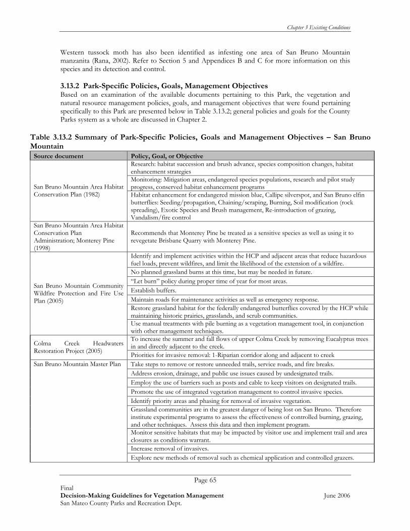
Chapter 3 Existing Conditions
Page 65 Final Decision-Making Guidelines for Vegetation Management June 2006 San Mateo County Parks and Recreation Dept.
Western tussock moth has also been identified as infesting one area of San Bruno Mountain manzanita (Rana, 2002). Refer to Section 5 and Appendices B and C for more information on this species and its detection and control. 3.13.2 Park-Specific Policies, Goals, Management Objectives Based on an examination of the available documents pertaining to this Park, the vegetation and natural resource management policies, goals, and management objectives that were found pertaining specifically to this Park are presented below in Table 3.13.2; general policies and goals for the County Parks system as a whole are discussed in Chapter 2.
Table 3.13.2 Summary of Park-Specific Policies, Goals and Management Objectives – San Bruno Mountain
Source document Policy, Goal, or Objective Research: habitat succession and brush advance, species composition changes, habitat enhancement strategies Monitoring: Mitigation areas, endangered species populations, research and pilot study progress, conserved habitat enhancement programs San Bruno Mountain Area Habitat
Conservation Plan (1982) Habitat enhancement for endangered mission blue, Callipe silverspot, and San Bruno elfin butterflies: Seeding/propagation, Chaining/scraping, Burning, Soil modification (rock spreading), Exotic Species and Brush management, Re-introduction of grazing, Vandalism/fire control
San Bruno Mountain Area Habitat Conservation Plan Administration; Monterey Pine (1998)
Recommends that Monterey Pine be treated as a sensitive species as well as using it to revegetate Brisbane Quarry with Monterey Pine.
Identify and implement activities within the HCP and adjacent areas that reduce hazardous fuel loads, prevent wildfires, and limit the likelihood of the extension of a wildfire. No planned grassland burns at this time, but may be needed in future. “Let burn” policy during proper time of year for most areas. Establish buffers. Maintain roads for maintenance activities as well as emergency response. Restore grassland habitat for the federally endangered butterflies covered by the HCP while maintaining historic prairies, grasslands, and scrub communities.
San Bruno Mountain Community Wildfire Protection and Fire Use Plan (2005)
Use manual treatments with pile burning as a vegetation management tool, in conjunction with other management techniques. To increase the summer and fall flows of upper Colma Creek by removing Eucalyptus trees in and directly adjacent to the creek. Colma Creek Headwaters
Restoration Project (2005) Priorities for invasive removal: 1-Riparian corridor along and adjacent to creek Take steps to remove or restore unneeded trails, service roads, and fire breaks. Address erosion, drainage, and public use issues caused by undesignated trails. Employ the use of barriers such as posts and cable to keep visitors on designated trails. Promote the use of integrated vegetation management to control invasive species. Identify priority areas and phasing for removal of invasive vegetation. Grassland communities are in the greatest danger of being lost on San Bruno. Therefore institute experimental programs to assess the effectiveness of controlled burning, grazing, and other techniques. Assess this data and then implement program. Monitor sensitive habitats that may be impacted by visitor use and implement trail and area closures as conditions warrant. Increase removal of invasives.
San Bruno Mountain Master Plan
Explore new methods of removal such as chemical application and controlled grazers.

Chapter 3 Existing Conditions
Page 66 Final Decision-Making Guidelines for Vegetation Management June 2006 San Mateo County Parks and Recreation Dept.
Table 3.13.2 Summary of Park-Specific Policies, Goals and Management Objectives – San Bruno Mountain
Source document Policy, Goal, or Objective Preserve certain stands of Eucalyptus that have significance and continue to remove other stands. Restore and create habitat for the endangered mission blue, Callipe silverspot, and San Bruno elfin butterflies. Post-burn restoration plan for
wax myrtle ravine (2004) Control exotic species infestations of gorse, Eucalyptus, and others utilizing the following techniques herbicide, hand work, reseeding, planting, and burning/grazing. Expand HCP to include fire as management tool. Fire and fire suppression policy
report: Southeast Ridge unplanned burn (2005) Further restoration of areas that were burned in Sept. 2002.
CDF – Guidance on Fuel Reduction 100 foot clearance area
Requires a 100-foot fuel reduction area to be established and maintained between wildlands and urban interface areas.
3.13.3 Summary of Park-Specific Vegetation Management Actions The following information was developed based on interviews with San Mateo County Park staff. As mentioned previously, San Bruno Mountain is home to several sensitive species, as well as several invasive species that threaten the sensitive habitat. Habitat restoration, protection, and invasive species removal are ongoing (see Table 3.13.3.a below for a list of ongoing actions). There are several projects ongoing at San Bruno Mountain, incorporating not just San Mateo County Park staff, but other contractors as well. San Bruno Mountain has a Habitat Conservation Plan (HCP) that is managed by Thomas Reid & Associates (TRA). Actions carried out under the HCP by TRA are contracted out to qualified firms including Shelterbelt Builders, Inc., West Coast Wildlands, and May & Associates, Inc. Because so many entities are actively working at San Bruno Mountain, one of the challenges for park staff is keeping in touch with the various projects taking place. Park staff must coordinate closely with TRA before and after projects on the mountain in order to follow HCP guidelines. All reporting is submitted to TRA. (P. Noyer, Ranger IV, pers. comm.). San Bruno Mountain also has an active volunteer stewardship base. There are three volunteer stewardship programs on the mountain – Heart of the Mountain, Friends of San Bruno Mountain, and San Bruno Mountain Watch, in addition to the San Mateo County Volunteer Coordinator’s efforts, all of which bring volunteers to assist with planting, monitoring, and invasive species removal. Because numerous habitat restoration projects are underway at San Bruno Mountain, the requests for collection of seed and vegetation materials from this park are challenging. Refer to Section 5 and Appendix A for guidelines on procedures to follow for seed (and other vegetation collection), and for suggested limits on collection activities to help safeguard source populations.

Chapter 3 Existing Conditions
Page 67 Final Decision-Making Guidelines for Vegetation Management June 2006 San Mateo County Parks and Recreation Dept.
Table 3.13.3.a Current and Ongoing Vegetation Management Activities – San Bruno Mountain
Vegetation Management Actions
Implementation Rationale/
RequirementSchedule Special Considerations
Actions managed by San Mateo County Parks Control exotic species infestations of gorse, Eucalyptus, and others. (81)
A pilot gorse project is underway.
A pilot gorse project is underway. 2004-2007.
Must be carefully timed to protect several sensitive species, including: bird nesting periods, rare plant population locations/ bloom times, endangered butterfly host plant locations/flight times, etc. See table 3.13.3.b below.
Monitor sensitive habitats that may be impacted by visitor use and then implement trail and area closures as conditions warrant.
Areas are closed during high fire season.
Annually See table 3.13.3.b below.
Promote the use of integrated vegetation management to control non-native species. (78)
Must be carefully timed to protect several sensitive species, including: bird nesting periods, rare plant population locations/ bloom times, endangered butterfly host plant locations/flight times, etc. See table 3.13.3.b below.
Monitor and prevent over –collection of seed and plant cuttings by implementing Scientific Collector’s permit Program.
Ongoing Prevent over-collection. Vegetation materials are in demand at this park.
Ongoing Follow instructions in Seed Collection Permit application. Limit number of collectors in each year. Limit areas that each collector can access. Limit amount of vegetation/seeds collected in any one area to no more than 10% of each population.
Remove or restore unneeded trails, service roads, and fire breaks by re-grading and revegetating with native species (if necessary). Conduct a detailed study of all existing trails, service roads, and fire breaks and make recommendations. Assess these areas for endangered species habitat before rebuilding any trails. (78)
Ongoing Must be carefully timed to protect several sensitive species, including: bird nesting periods, rare plant population locations/ bloom times, endangered butterfly host plant locations/flight times, etc. See table 3.13.3.b below.
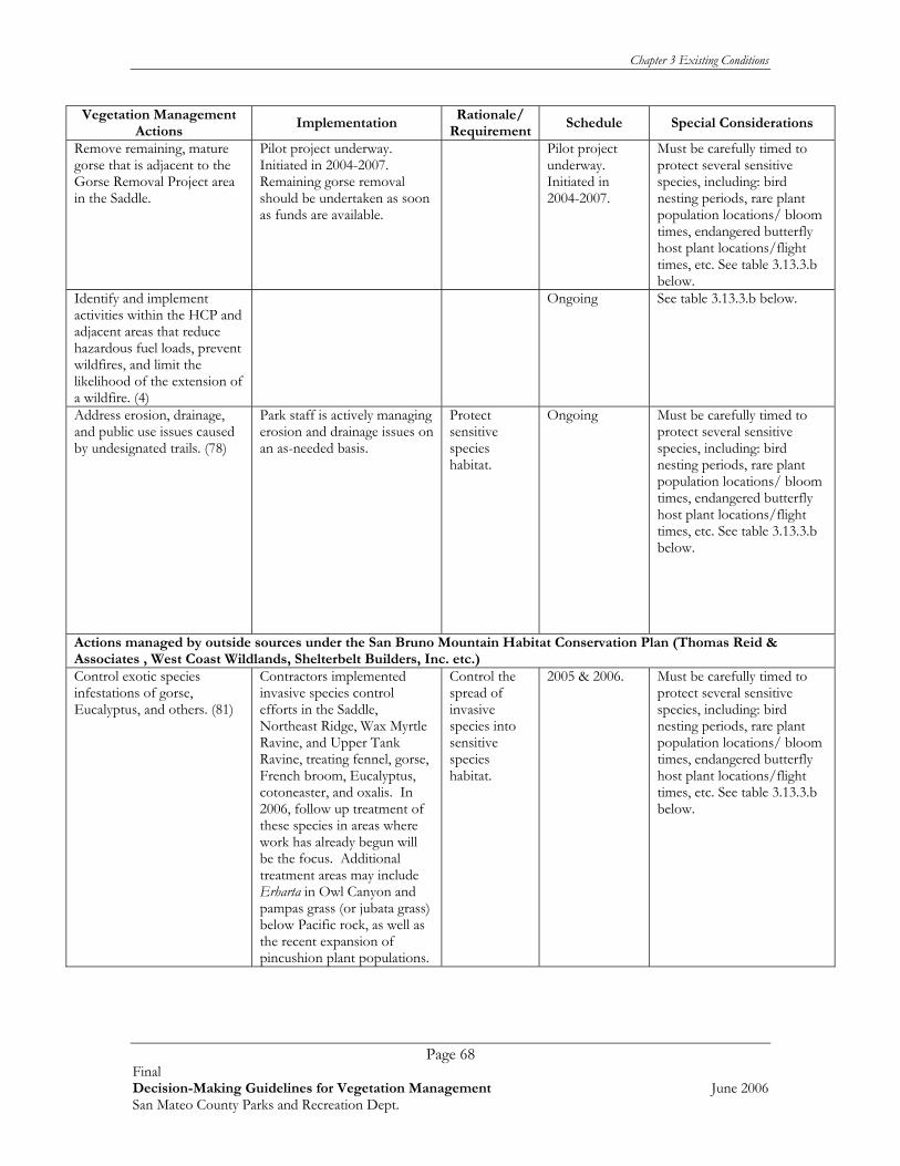
Chapter 3 Existing Conditions
Page 68 Final Decision-Making Guidelines for Vegetation Management June 2006 San Mateo County Parks and Recreation Dept.
Vegetation Management Actions
Implementation Rationale/
RequirementSchedule Special Considerations
Remove remaining, mature gorse that is adjacent to the Gorse Removal Project area in the Saddle.
Pilot project underway. Initiated in 2004-2007. Remaining gorse removal should be undertaken as soon as funds are available.
Pilot project underway. Initiated in 2004-2007.
Must be carefully timed to protect several sensitive species, including: bird nesting periods, rare plant population locations/ bloom times, endangered butterfly host plant locations/flight times, etc. See table 3.13.3.b below.
Identify and implement activities within the HCP and adjacent areas that reduce hazardous fuel loads, prevent wildfires, and limit the likelihood of the extension of a wildfire. (4)
Ongoing See table 3.13.3.b below.
Address erosion, drainage, and public use issues caused by undesignated trails. (78)
Park staff is actively managing erosion and drainage issues on an as-needed basis.
Protect sensitive species habitat.
Ongoing Must be carefully timed to protect several sensitive species, including: bird nesting periods, rare plant population locations/ bloom times, endangered butterfly host plant locations/flight times, etc. See table 3.13.3.b below.
Actions managed by outside sources under the San Bruno Mountain Habitat Conservation Plan (Thomas Reid & Associates , West Coast Wildlands, Shelterbelt Builders, Inc. etc.) Control exotic species infestations of gorse, Eucalyptus, and others. (81)
Contractors implemented invasive species control efforts in the Saddle, Northeast Ridge, Wax Myrtle Ravine, and Upper Tank Ravine, treating fennel, gorse, French broom, Eucalyptus, cotoneaster, and oxalis. In 2006, follow up treatment of these species in areas where work has already begun will be the focus. Additional treatment areas may include Erharta in Owl Canyon and pampas grass (or jubata grass) below Pacific rock, as well as the recent expansion of pincushion plant populations.
Control the spread of invasive species into sensitive species habitat.
2005 & 2006. Must be carefully timed to protect several sensitive species, including: bird nesting periods, rare plant population locations/ bloom times, endangered butterfly host plant locations/flight times, etc. See table 3.13.3.b below.
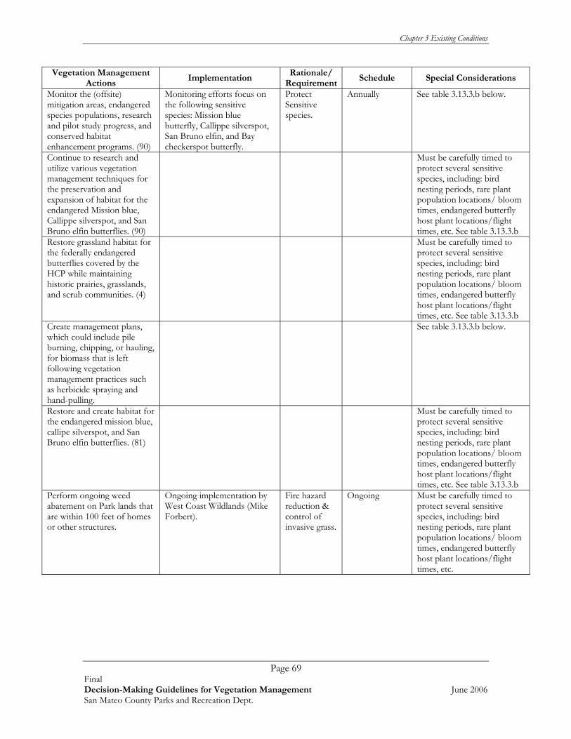
Chapter 3 Existing Conditions
Page 69 Final Decision-Making Guidelines for Vegetation Management June 2006 San Mateo County Parks and Recreation Dept.
Vegetation Management Actions
Implementation Rationale/
RequirementSchedule Special Considerations
Monitor the (offsite) mitigation areas, endangered species populations, research and pilot study progress, and conserved habitat enhancement programs. (90)
Monitoring efforts focus on the following sensitive species: Mission blue butterfly, Callippe silverspot, San Bruno elfin, and Bay checkerspot butterfly.
Protect Sensitive species.
Annually See table 3.13.3.b below.
Continue to research and utilize various vegetation management techniques for the preservation and expansion of habitat for the endangered Mission blue, Callippe silverspot, and San Bruno elfin butterflies. (90)
Must be carefully timed to protect several sensitive species, including: bird nesting periods, rare plant population locations/ bloom times, endangered butterfly host plant locations/flight times, etc. See table 3.13.3.b
Restore grassland habitat for the federally endangered butterflies covered by the HCP while maintaining historic prairies, grasslands, and scrub communities. (4)
Must be carefully timed to protect several sensitive species, including: bird nesting periods, rare plant population locations/ bloom times, endangered butterfly host plant locations/flight times, etc. See table 3.13.3.b
Create management plans, which could include pile burning, chipping, or hauling, for biomass that is left following vegetation management practices such as herbicide spraying and hand-pulling.
See table 3.13.3.b below.
Restore and create habitat for the endangered mission blue, callipe silverspot, and San Bruno elfin butterflies. (81)
Must be carefully timed to protect several sensitive species, including: bird nesting periods, rare plant population locations/ bloom times, endangered butterfly host plant locations/flight times, etc. See table 3.13.3.b
Perform ongoing weed abatement on Park lands that are within 100 feet of homes or other structures.
Ongoing implementation by West Coast Wildlands (Mike Forbert).
Fire hazard reduction & control of invasive grass.
Ongoing Must be carefully timed to protect several sensitive species, including: bird nesting periods, rare plant population locations/ bloom times, endangered butterfly host plant locations/flight times, etc.

Chapter 3 Existing Conditions
Page 70 Final Decision-Making Guidelines for Vegetation Management June 2006 San Mateo County Parks and Recreation Dept.
Vegetation Management Actions
Implementation Rationale/
RequirementSchedule Special Considerations
Continue to restore areas that were burned in September 2002. (12) Create infrastructure that would allow for the introduction of rotational cattle grazing on the mountain. A potential area for this would be within the saddle, to help control velvet grass (Holcus lanatus) that is proliferating following gorse removal.
Ongoing implementation by West Coast Wildlands (Mike Forbert).
Control invasive grass.
Ongoing Must be carefully timed to protect several sensitive species, including: bird nesting periods, rare plant population locations/ bloom times, endangered butterfly host plant locations/flight times, etc. See table 3.13.3.b below.
Maintain a fuel reduction area along 100 foot of property perimeter for fire protection.
Ongoing. Cut back brush Refer to Section 5 and Appendix A for more information.
CDF requirement for fire safety zone between wildlands/ urban areas.
Annual Caution should be taken to prevent special status plants & wildlife from being mowed.
Current Restoration Projects Colma Creek Headwaters Restoration Project
Remove Eucalyptus trees, control invasive species and plant native plants. Approximately 2 acres of exotic vegetation in the upland sections of the creek have been cleared by CDF Fire Safe Crews and are now being treated with herbicides by TRA
increase the flows of the creek and restore area to native conditions.
2005-06: Tree Removal/Chipping, Chipping/Debris Cleanup Wood chip dispersion Seed Collection Other Invasive Plant Removal. 2006-2007: Outplanting, Hand weed control, Herbicide Weed Control, Seed Collection, Blackberry removal, Other Invasive Plant Removal 2007: Outplanting, Hand weed control, herbicide weed control, Seed Collection, Blackberry removal, Other Invasive Plants
See table 3.13.3.b below.
San Bruno Mountain Gorse Control and Revegetation Project
Removal of 31 acres of gorse (Ulex europaeus), and controlling resprouts and seedlings following initial removal. Following gorse removal, a small pilot revegetation project will be initiated.
Increase the health and size of native vegetation that provides essential habitat for several endangered butterfly species.
2006: Retreatment of gorse removal areas, Invasive species control at revegetation site, Seed collection and propagation for revegetation site, Monitoring of gorse sites. 2007: Retreatment of gorse removal areas, Invasive species control at revegetation site, Installation of native species at revegetation site, Monitoring revegetation site & gorse control sites. 2008: Retreatment of gorse removal areas, Invasive species control at revegetation site, Monitoring revegetation site & gorse control sites, Infill planting at revegetation site (if necessary).
See table 3.13.3.b below.
* Numbers in ( ) refer to the reference document that the action was taken from. See Extended Bibliography in Appendix E for more information on Action Item.

Chapter 3 Existing Conditions
Page 71 Final Decision-Making Guidelines for Vegetation Management June 2006 San Mateo County Parks and Recreation Dept.
All vegetation management activities on San Bruno Mountain must be closely times with sensitive resources on the Mountain. The following table outline sensitive resources, timeframes, and associated best management practices (Table 3.13.3.b). Table 3.13.3.b Sensitive Resources on San Bruno Mountain and Associated Management Considerations
Sensitive Wildlife Resource Timeframe Associated BMP
Raptor Nesting Season
Raptor nesting period is January 1st To August 15th
No trees shall be cut during raptor nesting period. If tree removal occurs, monitoring for active raptor nests will be conducted prior to activity.
Bird Nesting Season March 15th – August 15th
Restrict mowing and brush removal along trails during bird nesting season (March 1-August 15th). If vegetation must be removed during this timeframe, mow before March 1st. For follow-up mowing, vegetation should be cut to 4”, then inspected for nesting birds before remainder is mowed and/or cut. If vegetation must be removed during this time period, pre-construction nesting bird surveys will be conducted. If any nests are found, work will not ensue.
Mission Blue Butterfly (Icaricia icarioides missionensis) Flight Period March – July
Limit activities during flight period (March-July) Restrict vehicles, and speed limits to less than 5mph. Prevent impacts to, and removal of all host and nectar plants year-round.
Callippe Silverspot butterfly (Speyeria callippe callippe) Flight Season
Mid-May to late-July
Limit activities during flight period (May-July) Restrict vehicles, and speed limits to less than 5mph. Prevent impacts to, and removal of all host and nectar plants year-round.
Coast Range Newt (Taricha torosa torosa) Restrict activities within 100 feet of suitable wetland habitats.
California Red-legged Frog (Rana aura draytoni) Restrict activities within 100 feet of suitable wetland habitats.
San Bruno Elfin Butterfly (Incisalia mossii bayensis) Flight Period
Late February – mid April
Limit activities during flight period (Feb-April) Restrict vehicles, and speed limits to less than 5mph. Prevent impacts to, and removal of all host and nectar plants year-round.
Larval Host Plants/Nectar Plants for Endangered Butterflies
Blooming Period
Notes
Lupine (Lupinus albifrons, L. formosus, & L. variicolor) March – June
Plants should not be disturbed at any time of the year (i.e. Not just during bloom), as disturbance could affect eggs or pupae living on the plant.
Stonecrop (Sedum spathulifolium) May – August
Plants should not be disturbed at any time of the year (i.e. Not just during bloom), as disturbance could affect eggs or pupae living on the plant.
Johnny jump-up (Viola pedunculata) February – April
Plants should not be disturbed at any time of the year (i.e. Not just during bloom), as disturbance could affect eggs or pupae living on the plant.
California plantain (Plantago erecta) March – June
Plants should not be disturbed at any time of the year (i.e. Not just during bloom), as disturbance could affect eggs or pupae living on the plant.

Chapter 3 Existing Conditions
Page 72 Final Decision-Making Guidelines for Vegetation Management June 2006 San Mateo County Parks and Recreation Dept.
Sensitive Wildlife Resource Timeframe Associated BMP
Owl’s clover (Castilleja densiflora) March – MayPlants should not be disturbed at any time of the year (i.e. not just during bloom), as disturbance could affect eggs or pupae living on the plant.
Rare Plant Species Blooming Period
Coast rock cress (Arabis blepharophylla) February – May San Bruno Mountain manzanita (Arctostaphylos imbricata) February – May Montara manzanita (Arctostaphylos montarensis) January – March San Francisco Bay spineflower (Chorizanthe cuspidata var. cuspidata) April – August San Francisco collinsia (Collinsia multicolor) March – May San Francisco lessingia (Lessingia germanorum) June – November San Francisco wallflower (Erysimum franciscanum) March – June San Francisco gum plant (Grindelia hirsutula var. maritima) June – September Diablo helianthella (Helianthella castanea) March – June Choris’s popcorn flower (Plagiobothrys chorisianus var. chorisianus) March – June San Francisco campion (Silene verecunda ssp. verecunda) March – August San Francisco owl’s clover (Triphysaria floribunda)- not seen since 1960’s April – June
3.14 SAN PEDRO VALLEY
3.14.1 General Site Conditions San Pedro Valley Park encompasses 1,150 acres that include the middle and south forks of the San Pedro Creek and is nestled amongst the Santa Cruz Mountain range and the foothills of Pacifica. This creek provides spawning habitat for steelhead. Approximately 433 acres of the south valley and south fork of San Pedro Creek are leased from the North Coast County Water District. The Park is also closely situated to several other open spaces including Sweeney Ridge owned by the Golden Gate National Recreation Area and McNee Ranch State Park Owned by the California State Parks Department. The following section summarizes Park resources of interest to Vegetation Management Guideline development (Rana 2002). Refer to Table 3.14.1 below. The information provided in the following table was taken from Rana (2002) and May 2006 information from the Department of Fish and Game’s online California Natural Diversity Database, at www. nrdb.org Table 3.14.1 Summary of Park Resources – San Pedro Valley Plant Communities Mixed riparian woodland Non-native grassland Alder/willow riparian woodland scrub Eucalyptus tree groves Maritime chaparral Coastal scrub Coast live oak woodland Coyote bush scrub Coastal terrace prairie Sensitive Plants known to Occur on Park Lands* Montara manzanita (Arctostaphylos montaraensis) Western leatherwood (Dirca occidentalis) Heart-leaved manzanita (Arctostaphylos andersonii) San Francisco Wallflower (Erysimum franciscanum) San Mateo tree lupine (Lupinus eximius) Sensitive Plants With Potential to Occur* Blasdale’s bentgrass (Agrostis blasdalei) Gairdner's yampah (Perideridia gairdneri ssp. Gairdneri)

Chapter 3 Existing Conditions
Page 73 Final Decision-Making Guidelines for Vegetation Management June 2006 San Mateo County Parks and Recreation Dept.
Table 3.14.1 Summary of Park Resources – San Pedro Valley Coast lily (Lilium maritimum) Pt. Reyes meadowfoam (Limnanthes douglasii sulphurea) San Francisco popcorn flower (Plagiobothrys diffusus) San Francisco campion (Silene verecunda ssp. Verecunda) Fragrant fritillary (Fritillaria liliacea) San Francisco owl’s clover (Triphysaria floribunda)
Kellogg's horkelia (Horkelia cuneata ssp. Sericea) Artists popcornflower (Plagiobothyrs chorisianus var. Chorisianus)
Marin checkerbloom (Sidalcea hickmanii ssp. Viridis) Pt. Reyes horkelia (Horkelia marinensis) Sensitive Wildlife Species Known to Occur on Park Lands* Steelhead-Central CA Coast ESU (Oncorhynchus mykiss) Sensitive Wildlife Species with Potential to Occur * California Tiger Salamander (Ambystoma tigrinum californiense) Sharp-shinned Hawk (Accipiter striatus) California Red-legged Frog (Rana aura draytoni) Vaux’s Swift (Chaetura vauxi) Western Pond Turtle (Clemmys marmorata) Rufous Hummingbird (Selasphorus rufus) San Francisco Garter Snake (Thamnophis sirtalis tetrataenia) Loggerhead Shrike (Lanius ludovicianus) Northern Harrier (Circus cyaneus) Yellow Warbler (Dendroica petechia) Cooper’s Hawk (Accipiter cooperii) Lawrence’s Goldfinch (Carduelis lawrencei) Invasive Plants** Blue gum Eucalyptus (Eucalyptus globulus) English ivy(Hedera helix) Pampas grass (Cortaderia selloana) or jubata grass (Cortaderia jubata) Cape ivy(Delairea odorata) French broom (Genista monspessulana) Poison hemlock(Conium maculatum) Periwinkle (Vinca major) Harding grass (Phalaris aquatica) Italian thistle(Carduus pycnocephalus) Monterey cypress (Cupressus macrocarpa) Wandering Jew (Tradescantia fluminensis) Monterey pine (Pinus radiata) Yellow star-thistle (Centaurea solstitialis)
*Indicates a biological resource that is considered sensitive, locally rare, or protected under the state or federal Endangered Species Act. ** There may be more invasive species present in the park since the last weed inventory (Rana 2002). The following was excerpted from the County of San Mateo’s web site: http://www.eparks.net This 1,150-acre Park has three fresh-water creeks, which flow year round through lush valleys, the south and middle forks of the San Pedro Creek and Brooks Creek. They are of particular significance because they provide some of the few remaining spawning areas for migratory steelhead in the county. It is the only stream with a steelhead population along a 30 mile reach of coastline between the Golden Gate Bridge and Half Moon Bay (San Pedro Watershed Coalition, 1999). The steelhead spawning season is normally from December to February. During the rainy, winter months, a special attraction is the beautiful Brooks Falls, which has a drop of 175 feet in three tiers. Among this sensitive streamside habitat common plants such as coast and giant trillium, creek dogwood, arroyo willow, watercress, and several species of ferns thrive. In the springtime, the meadows of the Middle Valley show off an array of wildflowers: California poppies, suncups, buttercups, wild radish and wild mustard. The thick coastal scrub protects some rare plants: giant golden chinaquapin, Montana manzanita, fetid adders-tongue, and California hazelnut.
Wildlife is abundant at San Pedro Valley. Park inhabitants often seen are red-tailed hawks, turkey vultures, quail, scrub jays, and garter snakes. Those observed less frequently include deer, bobcats, grey foxes, raccoons, rabbits and gopher snakes.

Chapter 3 Existing Conditions
Page 74 Final Decision-Making Guidelines for Vegetation Management June 2006 San Mateo County Parks and Recreation Dept.
3.14.2 Park-Specific Policies, Goals, Management Objectives Based on an examination of the available documents pertaining to this Park, the vegetation and natural resource management policies, goals, and management objectives that were found pertaining specifically to this Park are presented below in Table 3.14.2; general policies and goals for the County Parks system as a whole are discussed in Chapter 2. Table 3.14.2 Summary of Park-Specific Policies, Goals and Management Objectives – San Pedro Valley Source document Policy, Goal, or Objective
Erosion control utilizing diversion ditch, seeding, and planting. Creation of habitat barrier. San Pedro Valley County Park
Master Plan (1975) Poison oak control. Monitor and maintain existing areas of coastal scrub. Plant more redwoods in non-riparian area where Eucalyptus is growing. Remove competing Eucalyptus. Replace Eucalyptus with Douglas fir in Douglas fir forest. Plant and maintain native hardwoods. Maintain naturalized grasslands as open fields following the historical grassland boundaries by preventing invasion of woody plants. Maintain existing stands of Manzanita. Continue erosion control of streambeds for steelhead habitat.
San Pedro Valley Natural Resources Management Plan (1979)
Continue to monitor for unsanctioned access and elicit removal of fish by checking for unauthorized trails, trash, etc. Establish long term water quality monitoring program. Work with Army Corps to develop restoration plans. Possible bird surveys. Continue GIS and map development. Establish water quality alert network. Continue invasive species control with other alliances continue to identify status of these species.
San Pedro Creek Watershed Assessment and Enhancement Plan (2002)
For andromodous fish, remove impediments to migration and enhance habitat for spawning and rearing. These projects include culverts, construction of large woody debris structures, and feasibility studies.
CDF – Guidance on Fuel Reduction 100 foot clearance area
Requires a 100 foot fuel reduction area to be established and maintained between wildlands and urban interface areas.
3.14.3 Summary of Park-Specific Vegetation Management Actions The following information was developed based on interviews with San Mateo County Park staff. San Pedro Valley Park is host to Montara manzanita, western leatherwood, and heart-leaved manzanita, all sensitive species. It also has significant stands of invasive blue gum Eucalyptus trees and thistles that crowd out native habitats. Several Eucalyptus trees were logged in 1996 and the area was allowed to re-vegetate. An extensive cape ivy removal effort was conducted in 1999. The San Pedro Creek Watershed Coalition works closely with Parks staff to remove invasive non-native plants and to plant natives along creeks and streams. Hazardous trees are assessed and removed annually and fuel reduction efforts are focused in the Park that border Rosita and Park Pacifica Roads. San Pedro Valley Park’s primary vegetation management issue is removing Eucalyptus trees, and restoring native habitats while keeping sediment out of the sensitive creeks that provide spawning habitat for steelhead. Currently, a volunteer group, the Friends of San Pedro Valley, in coordination with rangers, carries out trail work once a month.

Chapter 3 Existing Conditions
Page 75 Final Decision-Making Guidelines for Vegetation Management June 2006 San Mateo County Parks and Recreation Dept.
Grassland areas are mowed twice yearly. (M. Del Carlo, Ranger IV, and D. Heisinger, Ranger II, pers. comm.). Table 3.14.3 Current and Ongoing Vegetation Management Activities – San Pedro Valley
Vegetation Management Actions
ImplementationRationale/
RequirementSchedule
Special Considerations
Control poison oak. (7) Along Trails & Roads.
Staff and public safety
As needed.
Monitor and maintain existing areas of coastal scrub. (8)
Contain Eucalyptus to existing stands to prevent them from spreading into scrub habitat.
Maintain existing native habitats
As needed.
Maintain naturalized grasslands as open fields following the historical grassland boundaries and prevent the invasion of woody plants. (8)
Mow grasslands to prevent growth of woody plants.
Maintain grassland habitat.
Twice a year. Avoid mowing scrub habitat during bird nesting season.
Maintain existing stands of manzanita. (8)
Manzanita is avoided when trees and shrubs are cut back along trails. Friends of San Pedro does trail work.
Protect sensitive species.
Trail work is carried out once a month.
Sensitive manzanitas include: Montara manzanita (Arctostaphylos montaraensis) & heart-leaved manzanita (Arctostaphylos andersonii).
Continue to implement erosion control of streambeds for enhanced steelhead habitat. (8)
Streambeds are monitored and vegetation is cut to enhance streambed.
Enhance steelhead habitat.
As needed.
Monitor and patrol for unsanctioned access and elicit removal of fish by checking for unauthorized trails, trash, etc. (8)
Where applicable, however, most poaching occurs outside of Park due to dense growth in Park.
Protection of sensitive steelhead habitat.
Ongoing.
Conduct invasive species control with other alliances and continue to identify the status of these invasive species. (53)
Hand pulling with volunteers.
Control spread of invasive species.
Ongoing.

Chapter 3 Existing Conditions
Page 76 Final Decision-Making Guidelines for Vegetation Management June 2006 San Mateo County Parks and Recreation Dept.
Vegetation Management Actions
ImplementationRationale/
RequirementSchedule
Special Considerations
Utilize diversion ditch, seeding, and planting for erosion control. (7)
Where applicable.
Protect habitat.
Ongoing.
Maintain fuel reduction at interface of property lines.
Trees and brush are cut back along Rosita and Park Pacifica Roads.
Fire hazard reduction.
Ongoing
Develop a hazardous trees inspection program.
No formal program, but hazardous trees are removed as necessary.
Visitor Safety.
Annual
Maintain a fuel reduction area along 100 foot of property perimeter for fire protection.
Ongoing. Cut back brush Refer to Section 5 and Appendix A for more information.
CDF requirement for fire safety zone between wildlands and urban interface.
Annual Caution should be taken to prevent special status plants & wildlife from being mowed.
Remove Eucalyptus that is competing in the non-riparian areas and replant area with redwoods. (8)
Eucalyptus removed in various areas, however there was no replanting.
Restore native habitats.
As resources are available.
* Numbers in ( ) refer to the reference document that the action was taken from. See Extended Bibliography in Appendix E for more information on Action Item. 3.15 SANCHEZ ADOBE Sanchez Adobe Park contains two main attractions. The first is a restored adobe residence from 1848 that is furnished with period pieces. The second attraction is archaeological evidence of the Mission Dolores Outpost. 3.15.1 General Site Conditions The following was excerpted from the County of San Mateo’s web site: http://www.eparks.net The Sanchez Adobe is located well back in the San Pedro Valley on a flat five-acre parcel adjacent to Linda Mar Boulevard. The site was originally used as a mission outpost in the late 1700's and archeological remains from this outpost are found on the site. A number of mature trees, including cypress, pines and Eucalyptus trees, are found on the site, but years of intense use have destroyed almost all of the native vegetation. The existing vegetation attracts many birds including starlings, sparrows and humming birds.

Chapter 3 Existing Conditions
Page 77 Final Decision-Making Guidelines for Vegetation Management June 2006 San Mateo County Parks and Recreation Dept.
A segment of San Pedro Creek exists in the rear (south) part of the site. This stream is important since it is part of a steelhead spawning area. The riparian corridor around the creek contains red alder, big leaf maple, and several species of willow and thimbleberry. 3.15.2 Park-Specific Policies, Goals, Management Objectives Based on an examination of the available documents pertaining to this Park, the vegetation and natural resource management policies, goals, and management objectives that were found pertaining specifically to this Park are presented below in Table 3.15.2; general policies and goals for the County Parks system as a whole are discussed in Chapter 2. Table 3.15.2. Summary of Park-Specific Policies, Goals and Management Objectives – Sanchez Adobe
Source document Policy, Goal, or Objective
Create and implement creek restoration plan Sanchez Adobe Draft Master Plan (2005)
Update landscape elements including native garden, creek overlook, etc.
CDF – Guidance on Fuel Reduction 100 foot clearance area
Requires a 100 foot fuel reduction area to be established and maintained between wildlands and urban interface areas.
3.15.3 Summary of Park-Specific Vegetation Management Actions The following information was developed based on interviews with San Mateo County Park staff. As mentioned, Sanchez Adobe Park is a developed Park with only a few natural areas. There is a small native plant garden and San Pedro Creek runs through the Park. Most of the Park’s vegetation is non-irrigated grassy areas that are mowed on a regular basis. Vegetation is cut away from neighboring fences and apartment buildings, and Park staff actively coordinates with property owners regarding trees and brush. (D. Heisinger, Ranger II, pers. comm.). Table 3.15.3 Current and Ongoing Vegetation Management Activities – Sanchez Adobe
Vegetation Management Actions
ImplementationRationale/
RequirementSchedule
Special Considerations
Mow grass areas on schedule to reduce weeds
Park staff mows. Reduce weeds & for visitor safety.
Weekly basis, as needed.
None
Maintain native plant landscaping once installed
Volunteers and docents maintain garden.
Visual display for visitors/ native seed bank.
As needed. Used as an aid for school groups and other patrons.
Cut vegetation away from fences & overhanging branches near apartment building. Interact with property owners at common boundary.
Park Staff cuts back hazardous vegetation.
Reduce fire hazard & increase public safety.
As needed basis.
None

Chapter 3 Existing Conditions
Page 78 Final Decision-Making Guidelines for Vegetation Management June 2006 San Mateo County Parks and Recreation Dept.
Vegetation Management Actions
ImplementationRationale/
RequirementSchedule
Special Considerations
Maintain a fuel reduction area along 100 foot of property perimeter for fire protection.
Ongoing. Cut back brush Refer to Section 5 and Appendix A for more information.
CDF requirement for fire safety zone between wildlands and urban interface.
Annual Caution should be taken to prevent special status plants & wildlife from being mowed.
* Numbers in ( ) refer to the reference document that the action was taken from. See Extended Bibliography in Appendix E for more information on Action Item. 3.16 WOODSIDE STORE The Woodside store is a fully restored wooden building once used by Dr. Tripp as a general store, post office and dental office during the era of the Redwood Lumber industry in Woodside. The store is now a house museum displaying artifacts and fashion form that time period. 3.16.1 General Site Conditions The following was excerpted from the County of San Mateo’s web site: http://www.eparks.net The Woodside Store is situated on a level one-acre parcel adjacent to Kings Mountain and Tripp Road where it was originally built. It is surrounded on two sides with native oaks and Redwoods. Years of use have created open field or dirt areas around the Store with a few native trees nearby. 3.16.2 Park-Specific Policies, Goals, Management Objectives Based on an examination of the available documents pertaining to this Park, no vegetation and natural resource management policies, goals, and management objectives were found pertaining specifically to this Park; general policies and goals for the County Parks system as a whole are discussed in Chapter 2. 3.16.3 Summary of Park-Specific Vegetation Management Actions The following information was developed based on interviews with San Mateo County Park staff. As mentioned above, the Woodside Store has minimal vegetation management needs due to its small size encompassing dirt paths and oak trees. Herbicide is used in high use areas to prevent weed growth. (B. Crawford, Lead Gardener) 3.17 WUNDERLICH Wunderlich Park, a hillside area of redwood forest, open meadows, and beautiful oaks and madrones, was once the Hazelwood Farm and was donated to the County by Martin Wunderlich. The Park is largely open space, with a system of scenic trails. The Parks recreational activities include hiking and equestrian trails.
3.17.1 General Site Conditions The following section summarizes Park resources of interest to Vegetation Management Guideline development (Rana, 2002). Refer to Table 3.17.1. The information provided in the following table was taken from Rana (2002) and May 2006 information from the Department of Fish and Game’s online California Natural Diversity Database, at www. nrdb.org

Chapter 3 Existing Conditions
Page 79 Final Decision-Making Guidelines for Vegetation Management June 2006 San Mateo County Parks and Recreation Dept.
Table 3.17.1 Summary of Park Resources-Wunderlich Plant Communities Coyote crush scrub Mixed evergreen forest (disturbed)
Developed Non-native grassland with elements of coastal prairie
Eucalyptus Oak woodland Mixed evergreen forest Redwood forest Sensitive Plants known to Occur on Park Lands* Santa Cruz manzanita (Arctostaphylos andersonii) Sensitive Plants With Potential to Occur* California bottle-brush grass (Elymus californicus) Kellogg's horkelia (Horkelia cuneata ssp. Sericea) Diablo helianthella (Helianthella castanea) Michael’s rein orchid (Piperia michaelii) Dudley’s lousewort (Pedicularis dudleyi) Western leatherwood (Dirca occidentalis) Franciscan onion (Allium peninsulare var. Franciscanum). White-flowered rein orchid (Piperia candida) Sensitive Wildlife Species Known from the Park* There are no known special status wildlife species that exist within the Park. Sensitive Wildlife With Potential to Occur* California Tiger Salamander (Ambystoma tigrinum californiense) Cooper’s Hawk (Accipiter cooperii) California Red-legged Frog (Rana aura draytoni) Sharp-shinned Hawk (Accipiter striatus) San Francisco Garter Snake (Thamnophis sirtalis tetrataenia) Lawrence’s Goldfinch (Carduelis lawrencei) Invasive Plants** Blue gum Eucalyptus (Eucalyptus globulus) French broom (Genista monspessulana) Acacia (Acacia decurrens) Yellow star-thistle (Centaura solstitialis) Spanish broom (Cytisus multiflorus) *Indicates a biological resource that is considered sensitive, locally rare, or protected under the state or federal Endangered Species Act. ** There may be more invasive species present in the park since the last weed inventory (Rana 2002).
The following information was excerpted from the County of San Mateo’s’ web site: http://www.co.sanmateo.ca.us/smc/department/home/0,,5556687_12313324_12368249,00.html Wunderlich Park comprises 942 acres of steep mixed forest and meadowland. It consists of four general areas: a lower area of boarding stables, riding facilities, and a horse ring that was the Folger Ranch complex; an open meadow midway up the slope of the Park; and open space with trails extending along canyons, running stream and numerous springs through dense second growth redwood groves, an upper meadow area at a general elevation of 2,000 ft. Exceptional vistas are found in all directions. Several different plant communities offer a varied habitat for native plants and wildlife found in the Park. Along the streams and in gullies, the majestic coast redwoods provide a cool, well-shaded environment. In contrast, the chaparral areas are hot and dry. Shrubs, such as manzanita, chamise, chaparral pea, and yerba santa form a thick, almost impenetrable mass of brush. Here the visitor can see jackrabbits, brush bunnies, chipmunks, and lizards scurrying through the underbrush. Birds that are often seen and heard are quail, scrub jays, and wrentits. Bordering the chaparral and the redwood forest is the mixed evergreen forest, which covers most of the Park. Here trees, such as tanbark oak, madrones, California laurel, coast live oak, and Douglas fir are dominant. Beneath the trees are many shrubs, including sticky monkey flower, wild lilac, toyon, wood rose, and poison oak. Brilliant wildflowers, such as western hound's tongue, Indian warrior, and Fremont's star lily (zygadene lily) are found along with the graceful wood fern.

Chapter 3 Existing Conditions
Page 80 Final Decision-Making Guidelines for Vegetation Management June 2006 San Mateo County Parks and Recreation Dept.
Black-tailed deer, raccoons, black squirrels and, less commonly, bobcats, coyotes and grey foxes may be seen. Common birds include acorn woodpeckers, chickadees, towhees, and stellar jays. Integrating with the other plant communities in the extreme lower part of the Park is the foothill woodland characterized by large white (valley) oaks, black oaks and bay laurel trees. 3.17.2 Park-Specific Policies, Goals, Management Objectives Based on an examination of the available documents pertaining to this Park, the vegetation and natural resource management policies, goals, and management objectives that were found pertaining specifically to this Park are presented below in Table 3.17.2. Table 3.17.2 Summary of Park-Specific Policies, Goals and Management Objectives - Wunderlich Source document Policy, Goal, or Objective Huddart and Wunderlich Parks Master Plan (2005) Complete loop trail fuel reduction program.
CDF – Guidance on Fuel Reduction100 foot clearance area
Requires a 100-foot fuel reduction area to be established and maintained between wildlands and urban interface areas.
3.17.3 Summary of Park-Specific Vegetation Management Actions The following information was developed based on interviews with San Mateo County Park staff. Wunderlich’s priority vegetation management issue is fire fuel reduction. Eucalyptus trees were planted when the property was a private estate and the trees and associated debris have since become a fire hazard. Park staff currently manages fuel reduction once annually. Protocol have been written up and initiated by park staff specific to fuel reduction in Wunderlich Park. Many roads throughout Wunderlich are not accessible (i.e. too narrow) for traditional fire trucks, and during the rainy season, access can be restricted altogether. Fixing roads to increase access in the Park is a main priority. The Park is bordered by a strong contingent of neighbors, the Bear Gulch Road Association, who are concerned about the potential of fire. They work closely with the San Mateo County rangers to assist in fuel reduction and invasive weed removal. County Parks staff have been conducting fuel reduction by cutting and chipping brush and trees and installing fuel reduction areas along service roads and trails. Weed species, particularly broom and thistle, are of specific concern. Volunteers and staff also focus on maintaining and restoring open meadow habitat by pulling French broom and cutting back coyote brush. Herbicide is used to prevent Eucalyptus stump resprouting for fire control. (P. Alvarez, Ranger IV, & B. Crawford, pers. comm.). Table 3.17.3 Current and Ongoing Vegetation Management Activities – Wunderlich
Vegetation Management Actions ImplementationRationale/
RequirementSchedule
Special Considerations
Utilize hand or mechanical removal of exotic species, no controlled burning, and other methods to maintain the grasslands in the central meadow of the Park.
Ongoing As time allows
Control acacia and French broom invasive plant populations at Wunderlich.
Ongoing Necessary to keep invasive plants in check.
As time allows
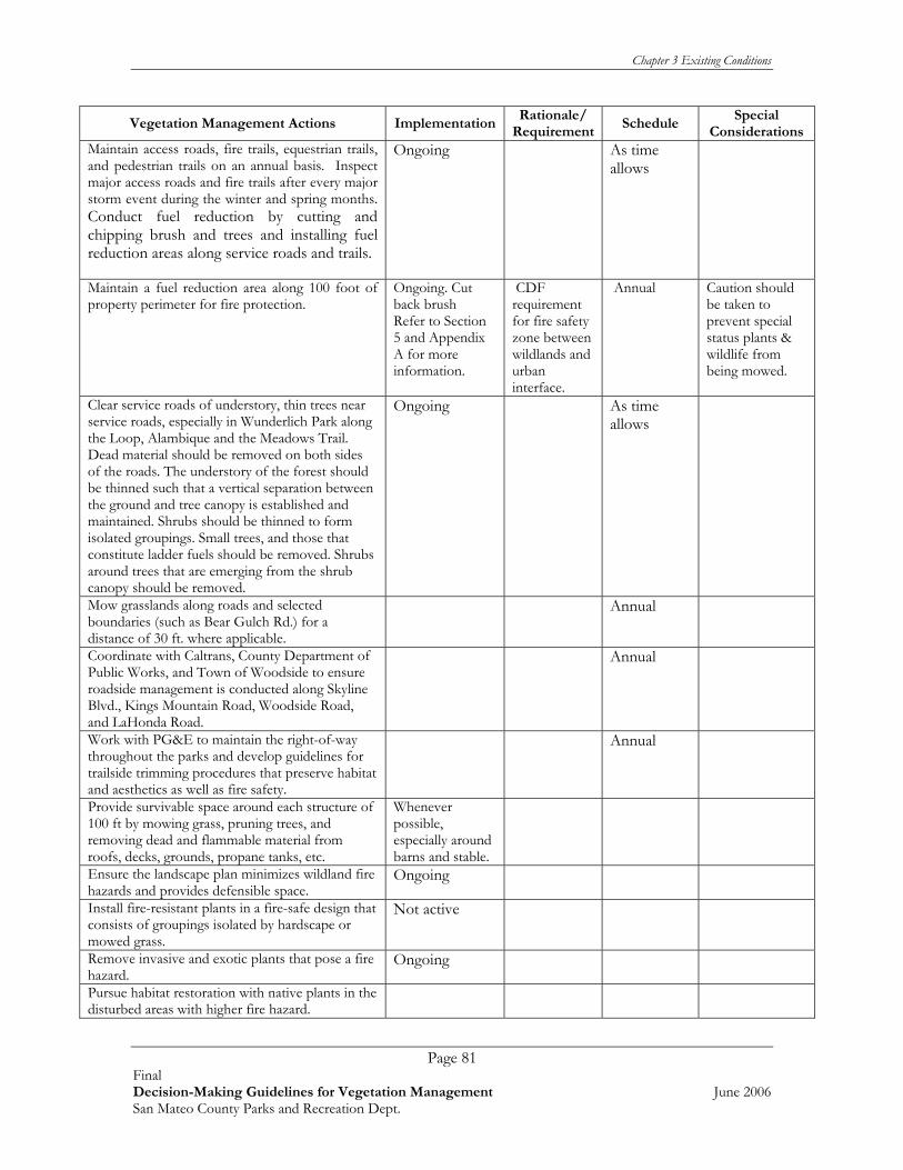
Chapter 3 Existing Conditions
Page 81 Final Decision-Making Guidelines for Vegetation Management June 2006 San Mateo County Parks and Recreation Dept.
Vegetation Management Actions ImplementationRationale/
RequirementSchedule
Special Considerations
Maintain access roads, fire trails, equestrian trails, and pedestrian trails on an annual basis. Inspect major access roads and fire trails after every major storm event during the winter and spring months. Conduct fuel reduction by cutting and chipping brush and trees and installing fuel reduction areas along service roads and trails.
Ongoing As time allows
Maintain a fuel reduction area along 100 foot of property perimeter for fire protection.
Ongoing. Cut back brush Refer to Section 5 and Appendix A for more information.
CDF requirement for fire safety zone between wildlands and urban interface.
Annual Caution should be taken to prevent special status plants & wildlife from being mowed.
Clear service roads of understory, thin trees near service roads, especially in Wunderlich Park along the Loop, Alambique and the Meadows Trail. Dead material should be removed on both sides of the roads. The understory of the forest should be thinned such that a vertical separation between the ground and tree canopy is established and maintained. Shrubs should be thinned to form isolated groupings. Small trees, and those that constitute ladder fuels should be removed. Shrubs around trees that are emerging from the shrub canopy should be removed.
Ongoing As time allows
Mow grasslands along roads and selected boundaries (such as Bear Gulch Rd.) for a distance of 30 ft. where applicable.
Annual
Coordinate with Caltrans, County Department of Public Works, and Town of Woodside to ensure roadside management is conducted along Skyline Blvd., Kings Mountain Road, Woodside Road, and LaHonda Road.
Annual
Work with PG&E to maintain the right-of-way throughout the parks and develop guidelines for trailside trimming procedures that preserve habitat and aesthetics as well as fire safety.
Annual
Provide survivable space around each structure of 100 ft by mowing grass, pruning trees, and removing dead and flammable material from roofs, decks, grounds, propane tanks, etc.
Whenever possible, especially around barns and stable.
Ensure the landscape plan minimizes wildland fire hazards and provides defensible space.
Ongoing
Install fire-resistant plants in a fire-safe design that consists of groupings isolated by hardscape or mowed grass.
Not active
Remove invasive and exotic plants that pose a fire hazard.
Ongoing
Pursue habitat restoration with native plants in the disturbed areas with higher fire hazard.

Chapter 3 Existing Conditions
Page 82 Final Decision-Making Guidelines for Vegetation Management June 2006 San Mateo County Parks and Recreation Dept.
Vegetation Management Actions ImplementationRationale/
RequirementSchedule
Special Considerations
Continue horse grazing in Wunderlich Park near stable when possible.
When possible
* Numbers in ( ) refer to the reference document that the action was taken from. See Extended Bibliography in Appendix E for more information on Action Item.
Chapter 4 Project Prioritization
Page 83 Final Decision-Making Guidelines for Vegetation Management June 2006 San Mateo County Parks and Recreation Dept.
CHAPTER 4 PROJECT PRIORITIZATION 4.1 LIST OF PLANNED AND ACTIVE VEGETATION MANAGEMENT PROJECTS AND ACTIONS This section provides a comprehensive list of the planned and active vegetation management actions for the San Mateo County Parks system. Over 100 separate actions and plans were identified during the review of over 90 planning and other documents, as well as input from staff and interested parties. This list includes projects that are currently underway; projects that were planned, but were never implemented; projects that are no longer relevant and should not be undertaken; and projects that should be undertaken, but were not included in past planning. It is important to note that this list was derived from a review of the documents without assessment of importance or relevance. Parks staff during the next step of this effort must review this list and determine which projects and actions are current and relevant. At best, the following list can only be considered a “snapshot in time”, because projects will constantly be added, deleted, and completed over time. The purpose of developing this list is to provide County Parks with a tool to begin the difficult process of reviewing, ranking and prioritizing, and ultimately selecting the projects that are most important to undertake. The County Park staff will need to conduct the following actions in order to prioritize future projects and move forward to implementation:
1) Finalize the list of projects listed in Table 4.1 (update regularly as more projects are added).
2) Prioritize the list of Projects presented in Table 4.1 by numerically scoring, then
comparing the projects using the methods and selection scoring criteria presented in Section 4.2 and 4.3. A blank scoring form is provided in Appendix B.
3) Once the top priority projects are selected, seek funding, staff time, and volunteer
support necessary to implement the projects. 4) Use the procedures presented in this report to guide implementation in order to
ensure effectiveness and standardization of results. 5) Repeat project prioritization regularly, typically every year to 5 years. Update the list
of priority projects as needed. Refer to Table 4.1 for a comprehensive list of projects and actions developed in this report.

Chapter 4 Project Prioritization
Page 84 Final Decision-Making Guidelines for Vegetation Management June 2006 San Mateo County Parks and Recreation Dept.
Table 4.1 Park Projects and Actions Presented by Individual Park
Action No. Location
ALL PARKS 1 Maintain fuel reduction area along 100 foot property perimeter for fire protection.
2 Continue to reduce sedimentation and non-point source pollutants in all watersheds. Inspect culverts, road crossings, waterways. Restore streambanks with native vegetation.
3 Continue invasive control efforts. 4 Continue to manage forests for forest health and fuel load reduction. 5 Monitor hazard trees, tree diseases. Treat accordingly (remove, contain, trim etc). 6 Set mowing schedule based on sensitive biological resource constraints.
7
Continue to protect sensitive species, track populations and use adaptive management to improve habitat values. Monitor rates of habitat conversion and use active management to control (example grassland conversion to shrubland).
8 Maintain roads and trails, remove unauthorized trails. 9 Continue work with Volunteer groups, expand opportunities for site stewardship.
Other projects (Add here)
10 Obtain Park System-wide permits for routine maintenance activities to allow herbicide application, work in wetlands and streams, etc.
Crystal Springs
11 Control spread of California Oak Mortality Disease (formerly known as Sudden Oak Death). (52)
12 Continue Mowing. 13 Hazardous trees detection and assessment, pruning, and removal along trail and road. 14 Trail and road inspection (including culverts prior to rainy season). 15 Fuel load/fire reduction in areas bordering the watershed.
Other projects (Add here)

Chapter 4 Project Prioritization
Page 85 Final Decision-Making Guidelines for Vegetation Management June 2006 San Mateo County Parks and Recreation Dept.
Coyote Point
16
Incorporate plants into landscaping that help hold soils to minimize erosion, prevent invasive weeds from encroaching into the activity areas, and emphasize the use of natives. (74)
17 Ongoing invasive Spartina control (in partnership with the Spartina Project). (52)
18 Manage for invasives, including cotoneaster, acacia, and others. Control poison oak.
Other projects (Add here)
Edgewood 19 Continue long-term monitoring of Bay checkerspot butterfly and its habitat. (77)
20 Continue to perform existing experiments to evaluate effectiveness of mowing and grazing. (77)
21 Reconsider the practical and political aspects of using fire as a habitat management technique and possibly implement new policies and techniques. (77)
22 Continue to rely on other agencies to provide fire suppression. (77)
23 Use seed farming and seeding of natives to improve bay checkerspot butterfly habitat. (77)
24 Support volunteer resource protection programs. (26) 25 Continue weed eradication efforts.
26 Develop a scheduled trail maintenance program for trimming of plants and trees after blooming of flowers and plants.
27
Implement Cordilleras Creek restoration including invasives removal and planting of native species in conjunction with the construction of an interpretive center. (75)
28 Maintain a fuel reduction area along 100 foot perimeter of property for fire protection.
Other projects (Add here)

Chapter 4 Project Prioritization
Page 86 Final Decision-Making Guidelines for Vegetation Management June 2006 San Mateo County Parks and Recreation Dept.
Fitzgerald 29 Continue invasive species removal near San Vicente Creek. 30 Manage access to user groups of 10 or more.
Other projects (Add here)
31 Restore creeks, remove invasive species, control erosion by planting natives, stabilize trail at creek crossings.
32 Work with Airport, surrounding landowners to reduce non-point source pollutants.
33 Fuel management in cypress forest and house site- remove non-natives.
Flood 34 Remove exotics where they threaten heritage trees.
35 Assessment of all Heritage trees for hazardous conditions - Trim or remove as necessary.
36 Maintain fuel reduction along 100 foot property perimeter for fire protection.
Other projects (Add here)
Huddart
37 Reduce sedimentation arising from various sources including road and trail erosion and creek bank erosion.
38
Maintain access roads, fire trails, equestrian trails and pedestrian trails on an annual basis. In addition, inspect major access roads and fire trails after every major storm event during the winter and spring months.
39
Work with PG&E to maintain the right-of-way throughout the parks and develop guidelines for trailside trimming procedures that preserve habitat and aesthetics as well as fire safety.
40 Continue to employ current methods and practices to reduce the risk of ignition of fire.
41 Continue to work with volunteers to remove French broom, scotch broom, bull thistle.
42 Ensure key onsite personnel, including park rangers, maintenance staff, caretakers and non-profit organization staffs are trained in basic fire prevention.
43 Include information regarding fire ecology and prevention at entrance and trail staging area kiosks, and in interpretive and educational materials.
44 Meet with neighboring homeowner associations to collaborate on fire safety projects.
45 Survey annually for tree hazards and poison oak in high use areas (campgrounds/ picnic areas).
Other projects (Add here)

Chapter 4 Project Prioritization
Page 87 Final Decision-Making Guidelines for Vegetation Management June 2006 San Mateo County Parks and Recreation Dept.
Junipero Serra
46
Gradually remove invasive plants especially the Monterey pine and blue gum Eucalyptus. Remove Eucalyptus near private residences on area boundary first, as they pose a liability problem. (35)
47 Mow or green chop grasslands annually during the months of May-July for fire suppression. (35)
48 Control invasive plants and problem species such as poison oak and Scotch broom. (35)
49 Remove all invasive trees and shrubs from grassland including invasive native shrubbery (34). To be done every five years (35).
Other projects (Add here)
Memorial 50 Provide a hazardous tree inspection in campgrounds, picnic areas, and trails. 51 Remove invasive plants. 52 Develop a scheduled mowing cycle for grass areas.
53 Implement the erosion control projects that were recommended and prioritized for the Pescadero/ Memorial/ Sam McDonald County Park Complex. (79)
Other projects (Add here)
Mirada Surf
54 Control bristly ox-tongue infestations.(88) Develop a mowing schedule for bristly ox tongue in grass areas with times of the year to mow.
55 Remove coyote brush from grasslands on Mirada Surf West to maintain open grassland habitat.
56 Continue to follow construction recommendations for work done in creek area and other sensitive habitats. (89).
Other projects (Add here)
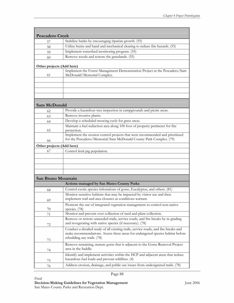
Chapter 4 Project Prioritization
Page 88 Final Decision-Making Guidelines for Vegetation Management June 2006 San Mateo County Parks and Recreation Dept.
Pescadero Creek 57 Stabilize banks by encouraging riparian growth. (55) 58 Utilize burns and hand and mechanical clearing to reduce fire hazards. (55) 59 Implement watershed monitoring program. (55) 60 Remove weeds and restore the grasslands. (55)
Other projects (Add here)
61 Implement the Forest Management Demonstration Project at the Pescadero/Sam McDonald/Memorial Complex.
Sam McDonald 62 Provide a hazardous tree inspection in campgrounds and picnic areas. 63 Remove invasive plants. 64 Develop a scheduled mowing cycle for grass areas.
65 Maintain a fuel reduction area along 100 foot of property perimeter for fire protection.
66 Implement the erosion control projects that were recommended and prioritized for the Pescadero/Memorial/Sam McDonald County Park Complex. (79)
Other projects (Add here) 67 Control feral pig population.
San Bruno Mountain Actions managed by San Mateo County Parks
68 Control exotic species infestations of gorse, Eucalyptus, and others. (81)
69 Monitor sensitive habitats that may be impacted by visitor use and then implement trail and area closures as conditions warrant.
70 Promote the use of integrated vegetation management to control non-native species. (78)
71 Monitor and prevent over collection of seed and plant collection.
72 Remove or restore unneeded trails, service roads, and fire breaks by re-grading and revegetating with native species (if necessary). (78)
73
Conduct a detailed study of all existing trails, service roads, and fire breaks and make recommendations. Assess these areas for endangered species habitat before rebuilding any trails. (78)
74 Remove remaining, mature gorse that is adjacent to the Gorse Removal Project area in the Saddle.
75 Identify and implement activities within the HCP and adjacent areas that reduce hazardous fuel loads and prevent wildfires. (4)
76 Address erosion, drainage, and public use issues from undesignated trails. (78)
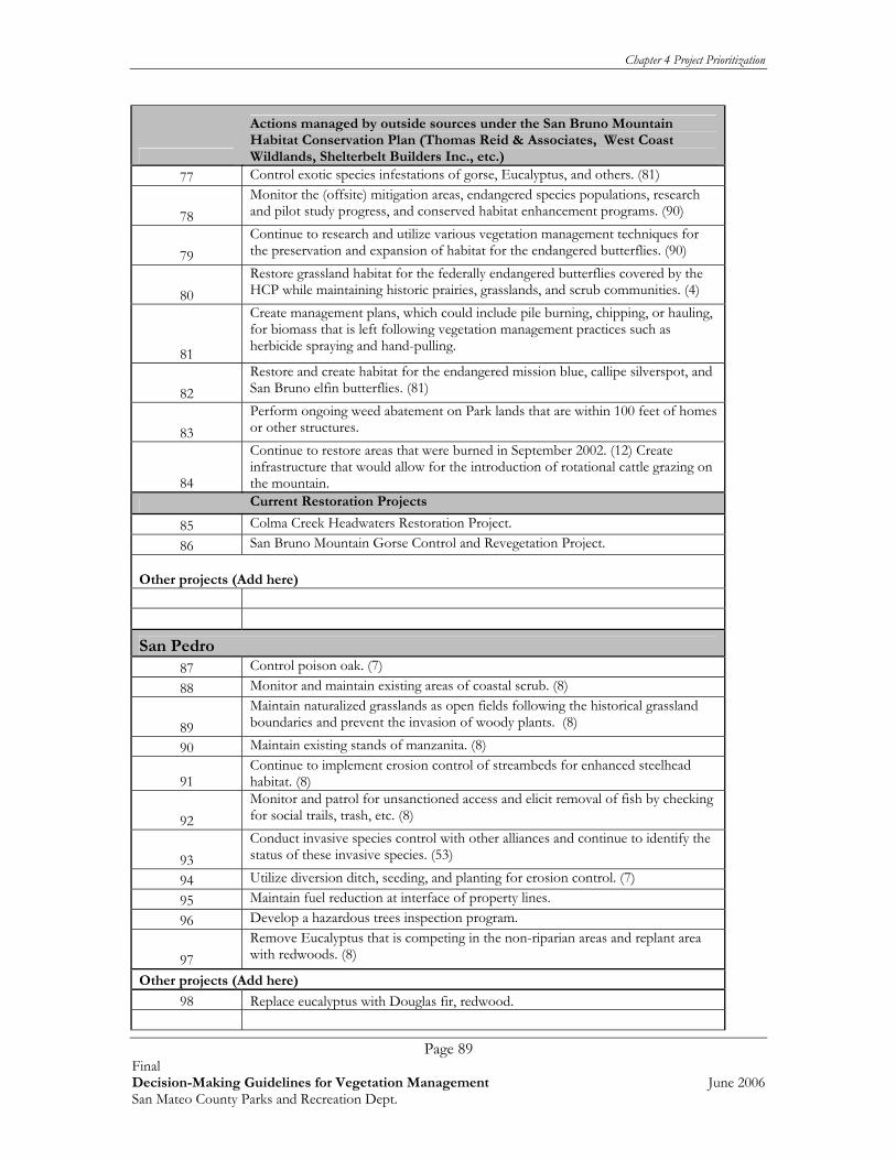
Chapter 4 Project Prioritization
Page 89 Final Decision-Making Guidelines for Vegetation Management June 2006 San Mateo County Parks and Recreation Dept.
Actions managed by outside sources under the San Bruno Mountain Habitat Conservation Plan (Thomas Reid & Associates, West Coast Wildlands, Shelterbelt Builders Inc., etc.)
77 Control exotic species infestations of gorse, Eucalyptus, and others. (81)
78 Monitor the (offsite) mitigation areas, endangered species populations, research and pilot study progress, and conserved habitat enhancement programs. (90)
79 Continue to research and utilize various vegetation management techniques for the preservation and expansion of habitat for the endangered butterflies. (90)
80 Restore grassland habitat for the federally endangered butterflies covered by the HCP while maintaining historic prairies, grasslands, and scrub communities. (4)
81
Create management plans, which could include pile burning, chipping, or hauling, for biomass that is left following vegetation management practices such as herbicide spraying and hand-pulling.
82 Restore and create habitat for the endangered mission blue, callipe silverspot, and San Bruno elfin butterflies. (81)
83 Perform ongoing weed abatement on Park lands that are within 100 feet of homes or other structures.
84
Continue to restore areas that were burned in September 2002. (12) Create infrastructure that would allow for the introduction of rotational cattle grazing on the mountain.
Current Restoration Projects
85 Colma Creek Headwaters Restoration Project. 86 San Bruno Mountain Gorse Control and Revegetation Project.
Other projects (Add here)
San Pedro 87 Control poison oak. (7) 88 Monitor and maintain existing areas of coastal scrub. (8)
89 Maintain naturalized grasslands as open fields following the historical grassland boundaries and prevent the invasion of woody plants. (8)
90 Maintain existing stands of manzanita. (8)
91 Continue to implement erosion control of streambeds for enhanced steelhead habitat. (8)
92 Monitor and patrol for unsanctioned access and elicit removal of fish by checking for social trails, trash, etc. (8)
93 Conduct invasive species control with other alliances and continue to identify the status of these invasive species. (53)
94 Utilize diversion ditch, seeding, and planting for erosion control. (7) 95 Maintain fuel reduction at interface of property lines. 96 Develop a hazardous trees inspection program.
97 Remove Eucalyptus that is competing in the non-riparian areas and replant area with redwoods. (8)
Other projects (Add here)
98 Replace eucalyptus with Douglas fir, redwood.

Chapter 4 Project Prioritization
Page 90 Final Decision-Making Guidelines for Vegetation Management June 2006 San Mateo County Parks and Recreation Dept.
Sanchez-Adobe 99 Mow grass areas on schedule to reduce weeds. 100 Maintain native plant landscaping once installed.
101 Cut vegetation away from fences & overhanging branches near apartment building. Interact with property owners at common boundary.
Other projects (Add here)
102 Create and implement a creek restoration project. 103 Update landscape elements including native garden, creek overlook, etc.
Wunderlich
104 Utilize hand or mechanical removal of exotic species, and other methods to maintain the grasslands in the central meadow.
105 Control acacia and French broom invasive plant populations at Wunderlich.
106
Maintain access roads, fire trails, equestrian trails, and pedestrian trails on an annual basis. Inspect major access roads and fire trails after every major storm event during the winter and spring months. Conduct fuel reduction by cutting and chipping brush and trees and installing fuel reduction areas along service roads and trails.
107 Clear service roads of understory, thin trees near service roads, especially in Wunderlich Park along the Loop, Alambique and the Meadows Trail.
108 Mow grasslands along roads and selected boundaries (such as Bear Gulch Rd.) for a distance of 30 ft. where applicable.
109
Coordinate with Caltrans, County Department of Public Works, and Town of Woodside to ensure roadside management is conducted along Skyline Blvd., Kings Mountain Road, Woodside Road, and LaHonda Road.
110
Work with PG&E to maintain the right-of-way throughout the parks and develop guidelines for trailside trimming procedures that preserve habitat and aesthetics as well as fire safety.
111
Provide survivable space around each structure of 100 ft by mowing grass, pruning trees, and removing dead and flammable material from roofs, decks, grounds, propane tanks.
112 Ensure the landscape plan minimizes wildland fire hazards and provides defensible space.
113 Install fire-resistant plants in a fire-safe design that consists of groupings isolated by hardscape or mowed grass.
114 Remove invasive and exotic plants that pose a fire hazard.
115 Pursue habitat restoration with native plants in the disturbed areas with higher fire hazard.
116 Continue horse grazing in Wunderlich Park near stable where possible.
117 Maintain a fuel reduction interface at property lines. Other projects (Add here)

Chapter 4 Project Prioritization
Page 91 Final Decision-Making Guidelines for Vegetation Management June 2006 San Mateo County Parks and Recreation Dept.
4.2 SUGGESTED METHODS FOR PRIORITIZING AND RANKING VEGETATION MANAGEMENT PROJECTS The next step is to prioritize and rank the list of projects to determine which are priority for immediate action/funding. Many methods exist to prioritize and rank projects. Prioritization systems usually fall into one of two categories: numerical ranking systems, or flow-chart-type sieving systems. There is no ideal method for a given project, and every system has shortfalls and biases. We recommend a system developed by the National Park Service, an organization that must deal with diverse resources, interest groups, and stakeholder groups, and would therefore apply to the San Mateo County Parks system. The prioritization process described below, referred to as a Modified Delphi Technique, would allow stakeholders and experts to collectively discuss, refine, and produce a prioritization list for vegetation management projects in County Parks. The Delphi technique was developed by the RAND Corporation in the late 1960s as a forecasting tool. Later, the U.S. government enhanced it as a group decision-making tool in which a group of experts could come to some consensus of opinion when the decisive factors were subjective, and not knowledge-based. The Delphi technique is particularly appropriate when decision-making is required in the context of a political or emotional environment, and works formally or informally, in large or small contexts. It reaps the benefits of group decision making while insulating the process from the limitations of group decision-making such as over-dominant group members, skewing results towards one interest, or lobbying. This approach has the added advantage that it works as an informal, subjective model when the decisions are based on opinion, and can be directly converted to a formal model, when the data is more knowledge-based. For the purposes of assessing San Mateo Vegetation Management priorities, this methodology can be combined with a data-driven (i.e. numerical project scoring system) to allow for the inclusion of both subjective and objective information. Using the Delphi method, a group of knowledgeable individuals who know park resources intimately and who have differing backgrounds are recruited to participate in the process. For example, participants could be a gardening crew member, park historian, fisheries expert, recreationist, or park naturalist. Once the group is selected, the group would develop an inclusive list of park projects to consider. Refer to Chapter 4 above for a list of park projects that can be used as a starting place for this process. The group should be allowed to conduct planning sessions whereby the objectives, importance, and possible results of a project are freely discussed. Maps and aerial photography are important tools when discussing the location and the size and scope of a project. Having such a broad base of experts can help flush out critical issues, and also can help the group reach consensus on issues of concern before a project moves towards implementation.
Modified Delphi Prioritization Procedure 1. Select Facilitation Leader.
Select a facilitator for the meetings that is NOT a stakeholder, and therefore can participate objectively.

Chapter 4 Project Prioritization
Page 92 Final Decision-Making Guidelines for Vegetation Management June 2006 San Mateo County Parks and Recreation Dept.
2. Create a Panel Representing Stakeholders and Experts. The stakeholders and experts should be selected to represent various aspects of County Parks, the individual park, and the stakeholders. Participants should be selected because of their intimate knowledge of the San Mateo County Park system, planning process, individual park, and/or familiarity with technical subject matter that is considered important to the projects (e.g., trail planning, landscape architecture, hydrology, wildlife biology, historical and archaeological studies). Member selection should be based largely on the participant’s “real-world” experience that will enable them to prioritize the project actions effectively.
3. Synthesize Existing Resource Data Into a Visual Format. Relevant natural, cultural and visitor use data should be synthesized and compiled into a visual format that can be readily manipulated. We recommend a GIS database as an excellent format for this planning exercise, but printed aerial photographs, vegetation maps, with clear overlays can also be used. A series of mapping layers representing similar resources or subject matter should be created as clear acetate overlays for a common base map. The participants will use the various resource layers to identify where there are overlapping areas of concern (e.g. weeds on a cultural resource site, bird nests near hazard trees to be removed) or areas of high resource values and restoration opportunities (e.g. areas with wetland resources, important wildlife areas, major trails).
4. Identify an Initial List of Selection Criteria. During a brainstorming session, the participants should develop a list of criteria that all participants agree are important to the project goals and objectives. Sample goals and objectives are presented below, but should be developed to be specific to the project.
i. Projects that stabilize the existing trail system and reduce overall maintenance costs;
ii. Projects that increase visitor safety (e.g., hazard tree removal, reduced fire risk, improved trail conditions, reducing inaccessible areas, problem areas);
iii. Projects that improve the visitor experience (e.g., creating viewsheds, interpretive opportunities, trail and circulation improvements, better signage);
iv. Projects that maintain the rugged and wild character of the park(s); v. Projects that restore native habitats and increased wildlife and wetland habitat
values; vi. Projects that control target invasive plant species; and provide sustainable
restoration opportunities; vii. Projects that reduce fuel load or improve the health of the forest; viii. Projects that offer opportunities for increased community involvement; ix. Projects that can easily be sequenced with other planned project activities; and x. Projects that create wildlife corridors and enhanced wildlife habitat values.
Additional criteria should be added as applicable to prioritize and sequence the list of projects.
5. Conduct Planning Session to Discuss Possible Selection Criteria for Projects.
Once the initial list of criteria is developed, the panel then should conduct a free- form discussion of what projects might meet the suggested criteria. The visual aids (maps) should be available for reference throughout the discussion so that all resource issues can be accurately considered.

Chapter 4 Project Prioritization
Page 93 Final Decision-Making Guidelines for Vegetation Management June 2006 San Mateo County Parks and Recreation Dept.
The group should then reach full or partial consensus on both the selection criteria and on the types of projects that the group thought should be considered. The following types of projects may be found by the group to be important:
xi. Projects that stabilize the existing trail system and reduce overall maintenance
costs; xii. Projects that increase visitor safety (e.g., hazard tree removal, reduced fire risk,
improved trail conditions, reducing inaccessible areas, problem areas); xiii. Projects that improve the visitor experience (e.g., creating viewsheds,
interpretive opportunities, trail and circulation improvements, better signage); xiv. Projects that maintain the rugged and wild character of the park(s); xv. Projects that restore native habitats and increased wildlife and wetland habitat
values; xvi. Projects that control target invasive plant species and provide sustainable
restoration opportunities; xvii. Projects that reduce fuel load or improve the health of the forest; xviii. Projects that offer opportunities for increased community involvement; xix. Projects that can easily be sequenced with other planned project activities; and xx. Projects that create wildlife corridors and enhance wildlife habitat values.
6. Prepare Revised List of Selection Criteria, Initial List of Project Priorities.
Following the free-form discussion, the panel should reach consensus on some, but not all ranking criteria and projects. The intent of the first meeting is not to reach complete agreement on all issues and projects, but rather to “flush out” those projects and issues that will or will not be acceptable to all participants. This allows the group to focus on those projects and issues that require more consideration and discussion to reach consensus. Based on the results of the first meeting, the list of initial selection criteria should be refined, and a list of possible project priorities developed that reflect the revised selection criteria. This list should then be circulated to the panel in advance of a second planning session meeting.
7. Conduct Second Planning Session.
At the second planning session, the participants should discuss the project priorities that were generated from applying the revised selection criteria. The project boundaries, objectives, and timing of each of the various proposed projects should be considered, as well as new projects and modified projects. As a result of the second planning session, the participants should come to agreement on most of the major issues, and reach agreement on most, but not all of the project priorities.
8. Assess Capacity, Capabilities, and Planning Timeframe, Adjust Projects
Accordingly. The projects that are selected as a result of the second planning session should then be
screened to see if they could be accomplished within the specified timeframe, and if Parks and other stakeholder groups have sufficient oversight staff, and other capacities to successfully implement the selected project with available staff, contractors, or both. A smaller group of senior managers with extensive experience implementing projects should be involved with this assessment. As a result of input from these senior managers, the list of projects under consideration will be reduced to those that are considered reasonable to implement within the planning timeframe.

Chapter 4 Project Prioritization
Page 94 Final Decision-Making Guidelines for Vegetation Management June 2006 San Mateo County Parks and Recreation Dept.
9. Gather Any Remaining Technical Data Necessary to Finalize Decisions.
As the proposed project actions are further refined, technical questions will surface that require additional data collection and assessment efforts. Additional information gathering should be conducted to help develop a greater understanding about the feasibility and appropriateness of the proposed projects.
10. Prepare List of Project Priorities.
Based on the initial list of projects, the capabilities and timeframe assessment, and the additional technical data, a list of “final” project priorities should be developed and circulated to the participants for review and comment. The group should be encouraged to view the projects in the field, and then submit any final comments, suggestions, changes, or approvals.
11. Finalize List of Projects.
After receiving final input from participants, a final list of projects will be developed that meet project selection criteria. These will be the projects that are considered by the group to be technically sound, feasible to undertake, and possible to coordinate within the planned project timeframe.
4.3 SELECTING PRIORITY PROJECTS Once the prioritization process described above is complete, the projects should be ranked (in this case, numerically scored) in order of importance. This process is typically conducted once, and updated annually. Monitoring data is used to determine success, and adaptive management results usually feed into selecting or modifying selection criteria. The data sheet below provides a suggested numerical ranking system.

Chapter 4 Project Prioritization
Page 95 Final Decision-Making Guidelines for Vegetation Management June 2006 San Mateo County Parks and Recreation Dept.
Suggested Ranking Criteria Rankings within each criteria category should be between 3 and 0 with 3 being the highest possible ranking.
3 - this project meets all the applicable criteria for this category 2 - this project meets most of the applicable criteria for this category 1 - this project meets a few of the applicable criteria for this category 0 - this project does not meet any of the criteria for this category n/a - this project does not have any relevance to this criteria category (e.g. a polygon that includes invasive plant removal only, would receive an n/a for the trails criteria).
Proposed Project Ranking (0,1,2,3, N/A)
TOTAL
Protects And Enhances The Park's Most Sensitive Natural Areas
a. Sensitive species, locally rare species
b. Wetlands
c. Special Ecological Area, rare or sensitive vegetation communities, and/or unique geologic feature
Sum
Controls And Reduces Threats To Natural Resources And/Or Cultural Resources And/Or Restores Natural Processes a. Controls and/or removes targeted invasive plant material b. Controls non-natural erosion & restores natural hydrology/drainage
Sum
Trail and Visitor Use Improvements
a. Trail and Visitor Use Improvements b. Project reduces need for trail maintenance c. Improves the integrity and circulation of the trail system
i. Clear logical main trail ii. “Rib” connectors to destinations and communities iii. Trail heads and loops etc.
d. Removes non-designated unauthorized trails e. Reduces sedimentation, erosion and resource trampling disturbance f. Enhances visitor experience (destinations, circulation, linkages) g. Improves Public Safety
Sum
Public Engagement and Support
a. Provides interpretive opportunities b. Provides for increased volunteer/stewardship opportunities c. Demonstrated or potential to garner significant public interest and support d. Improves intrinsic visitor and recreational experiences e. Increases understanding and support for natural resource values of park
Sum
Potential for Funding
a. Funding available (in part) through other programs/projects b. Funding potential c. Future leverage “quotient”

Chapter 4 Project Prioritization
Page 96 Final Decision-Making Guidelines for Vegetation Management June 2006 San Mateo County Parks and Recreation Dept.
Proposed Project Ranking (0,1,2,3, N/A)
TOTAL
Sum
Potential for Implementation Success, Project Feasibility
a. Project can be accomplished within projected timeline Including permitting and CEQA (“project readiness”)
b. High level of outcome for resources expended Sum
Integrates With Existing Projects
Sum
Consistency with Internal Programs and Staff Capacity
a. Adds support to existing park programs b. San Mateo County Park staff capacity/in line with park values c. Reduces maintenance crises d. Compatible with internal organizational priorities
Sum
TOTAL RANKING FOR PROPOSED PROJECT

Chapter 5 Vegetation Management Techniques and Approaches
Page 97 Final Decision-Making Guidelines for Vegetation Management June 2006 San Mateo County Parks and Recreation Dept.
CHAPTER 5 VEGETATION MANAGEMENT TECHNIQUES AND APPROACHES This Chapter provides a summary of current vegetation management techniques and approaches, and identifies processes required to achieve these desired conditions (i.e. the what, where, and why’s of vegetation management). Practical “How To” guidance is provided for vegetation management practitioners in Appendix A. Related “Brochures and Handouts” are provided in Appendix C, and a list of resources that can be contacted for more information is provided in Appendix D.
Vegetation management requires coordination on many fronts, including determining if work should be conducted by staff, volunteers, and/or contractors; identifying current and future funding sources; developing and maintaining volunteer resources to support park projects; balancing ongoing park maintenance needs with special projects; and proactively addressing other park needs that are not strictly related to vegetation (e.g., homeless encampments and other trespasses, ensuing fire protection along park perimeters, balancing recreation needs of various user groups, etc.). This section is intended to provide options to park staff when they are determining the best course of action to pursue to achieve successful vegetation management.
This section is closely tied to the vegetation management goals and objectives that are described in Chapter 1. The vegetation management objectives (not presented in order of importance) described in Chapter 1 are:
• Objective 1: Maintain Sensitive Species Habitat. • Objective 2: Maintain Diverse Recreational Uses of Park Natural Areas. • Objective 3: Maintain Trails for Visitor Use and Safety. • Objective 4: Manage for ‘Sustained Control’ of Invasive Plants Over Time. • Objective 5: Maintain Healthy Native Plant Communities to Discourage Invasive
Plant Establishment. • Objective 6: Encourage Park Stewardship. • Objective 7: Plant Site-Appropriate Native Species, Emphasizing Local Diversity. • Objective 8: Maintain Revegetation Sites Until Plantings are Established. • Objective 9: Actively Manage Forests to Reduce Fire Fuels and Increase Forest
Health. • Objective 10: Protect Watersheds from Erosion and Non-Point Source Pollution. • Objective 11: Use Integrated Pest Management. • Objective 12. Manage Habitat Conversion in Sensitive Species Habitat
The following table provides a summary of the link between vegetation management guidelines and vegetation management actions currently being implemented at County Parks (not presented in order of importance).
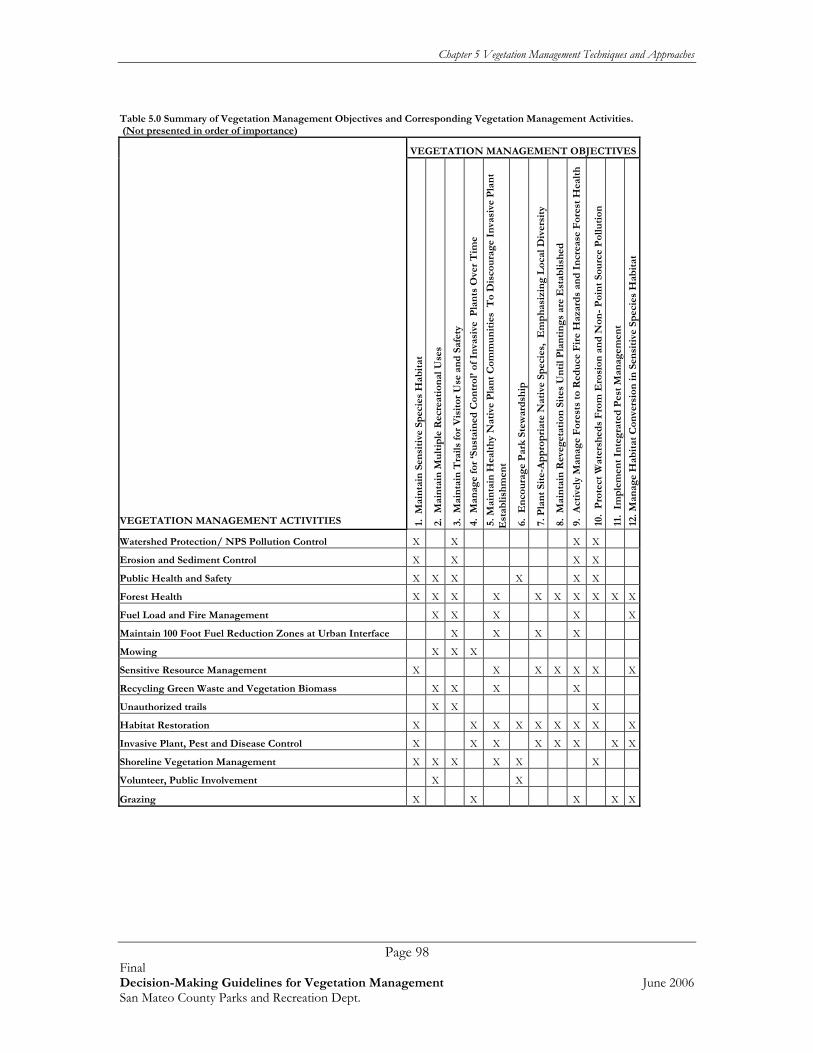
Chapter 5 Vegetation Management Techniques and Approaches
Page 98 Final Decision-Making Guidelines for Vegetation Management June 2006 San Mateo County Parks and Recreation Dept.
Table 5.0 Summary of Vegetation Management Objectives and Corresponding Vegetation Management Activities. (Not presented in order of importance)
VEGETATION MANAGEMENT OBJECTIVES
VEGETATION MANAGEMENT ACTIVITIES 1
. M
ain
tain
Sen
siti
ve S
pec
ies
Hab
itat
2.
Mai
nta
in M
ult
iple
Rec
reat
ion
al U
ses
3.
Mai
nta
in T
rail
s fo
r V
isit
or U
se a
nd
Saf
ety
4.
Man
age
for
‘Su
stai
ned
Con
trol
’ of
Inva
sive
Pla
nts
Ove
r T
ime
5. M
ain
tain
Hea
lth
y N
ativ
e P
lan
t C
omm
un
itie
s T
o D
isco
ura
ge I
nva
sive
Pla
nt
Est
abli
shm
ent
6.
En
cou
rage
Par
k St
ewar
dsh
ip
7. P
lan
t Si
te-A
pp
rop
riat
e N
ativ
e Sp
ecie
s, E
mp
has
izin
g L
ocal
Div
ersi
ty
8.
Mai
nta
in R
eveg
etat
ion
Sit
es U
nti
l Pla
nti
ng
s ar
e E
stab
lish
ed
9.
Act
ivel
y M
anag
e F
ores
ts t
o R
edu
ce F
ire
Haz
ard
s an
d I
ncr
ease
For
est
Hea
lth
10.
Pro
tect
Wat
ersh
eds
Fro
m E
rosi
on a
nd
Non
- P
oin
t So
urc
e P
ollu
tion
11.
Im
ple
men
t In
tegr
ated
Pes
t M
anag
emen
t
12.
Man
age
Hab
itat
Con
vers
ion
in S
ensi
tive
Sp
ecie
s H
abit
at
Watershed Protection/ NPS Pollution Control X X X X
Erosion and Sediment Control X X X X
Public Health and Safety X X X X X X
Forest Health X X X X X X X X X X
Fuel Load and Fire Management X X X X X
Maintain 100 Foot Fuel Reduction Zones at Urban Interface X X X X
Mowing X X X
Sensitive Resource Management X X X X X X X
Recycling Green Waste and Vegetation Biomass X X X X
Unauthorized trails X X X
Habitat Restoration X X X X X X X X X
Invasive Plant, Pest and Disease Control X X X X X X X X
Shoreline Vegetation Management X X X X X X
Volunteer, Public Involvement X X
Grazing X X X X X

Chapter 5 Vegetation Management Techniques and Approaches
Page 99 Final Decision-Making Guidelines for Vegetation Management June 2006 San Mateo County Parks and Recreation Dept.
5.1 ADAPTIVE MANAGEMENT Adaptive management incorporates research into conservation action. Specifically, it is the integration of design, management, and monitoring to systematically test assumptions in order to adapt and learn. Adaptive management is useful in all aspects of vegetation management, and especially invasive plant control and habitat restoration projects (described in more detail below). Using adaptive management requires the following:
• Know what is working and what isn’t (through monitoring); • Identify how the current processes and procedures could be changed to better
address the issue (i.e. evaluate the situation); • Alter the way work is performed based on the analysis (i.e. adapt); and • Share findings among the various San Mateo County Parks (i.e. knowledge
transfer).
Years of experience of controlling invasive weeds and restoring sensitive habitats have made it clear that the best form of control is the use of multiple methods. Coordinating the use of multiple vegetation management methods requires knowing when strategies are effective and when they aren’t. Monitoring and adjusting methods to make them more effective are critical to a project’s overall success. The transfer of knowledge and institutionalizing the process among parks is also critical to saving time and making efficient use of limited resources. Transferring ideas and communicating what is or isn’t working can be accomplished through regularly scheduled meetings, newsletters, or similar formats. Refer to the following Figure for a graphic depiction of how adaptive management works.
Adaptive Management Flowchart (adapted from Schwartz and Randall (1995) in
Luken and Thieret (1997)).
Establish management goals (Success Criteria,
Performance Goals) (Chapters 1, 2, and 3)Review management goals,
project priorities, and techniques, adapt and
improve based on monitoring results.
Monitor and assess impacts of management actions
(Appendix B)
Develop and implement restoration projects.
(Appendix B)
Assess and select management
techniques (Chapter 5)
Identify and prioritize projects (Chapter 4)

Chapter 5 Vegetation Management Techniques and Approaches
Page 100 Final Decision-Making Guidelines for Vegetation Management June 2006 San Mateo County Parks and Recreation Dept.
As illustrated in the chart above, the cycle begins with establishing goals and objectives (Chapter 1). These goals and objectives are usually an outcome of the vegetation management context (i.e. visitor use and recreational patterns; the current management issues and concerns, the relevant plans and policies that pertain to work in the parks) (Chapter 2). Based on what is present at each park (Chapter 3), a park manager can then use the vegetation management techniques and approaches (Chapter 5) to make informed decisions about what course of action to choose to solve a particular problem. Implementation begins with a written plan that clearly communicates success criteria, as presented in Appendix A. After a project is completed, Monitoring (Chapter 5 and Appendix A) is used to assess how well the project met the original success criteria. The project plan and monitoring reports can then be compared to evaluate the results of the project. If a project does not meet the success criteria, remedial actions can be taken, if necessary to get a project back on track, including modifying the original treatment methods, changing treatment methods, or increasing or decreasing other factors (e.g. watering, weeding, replanting, using different species etc). 5.2 WATERSHED PROTECTION MAINTENANCE STANDARDS / NON-POINT SOURCE POLLUTION CONTROL Meets Vegetation Management Objectives 1, 3, 9, and 10. In 2004, the County of San Mateo prepared a report entitled “Watershed Protection Program- Volume 1- Maintenance Standards” (County of San Mateo 2004) intended to document standard, Best Management Practices, and describe anticipated Conservation Outcomes for all activities routinely undertaken by the Department of Public Works Road Maintenance Division and the Parks Department Maintenance Division. It includes county-wide approved Stormwater Pollution Prevention Program (SWPPP) standard procedures to minimize impacts to water quality and fish and wildlife habitat throughout unincorporated areas of the County. Volume 1 was intended to address maintenance standards, and subsequent volumes will address engineering design, construction management and inspection, and facility maintenance issues. The final draft (April 2004) version of the San Mateo County Watershed Protection Program Maintenance Standards is now available on line at: http://www.co.sanmateo.ca.us In addition, San Mateo County has an active and well-organized Stormwater Pollution Prevention Program (STOPPP) program. The San Mateo County STOPPP is a program that aims to partner with the county's residents and businesses to prevent pollution of local water bodies such as creeks, the San Francisco Bay and the Pacific Ocean. San Mateo County STOPP has developed Best Management Practices (BMPs) for residents, businesses, and the community and Integrated Pest Management recommendations that are available online at: http://www.flowstobay.org/. The following section synthesizes several reports and common land management practices to provide a broad overview of typical non-point source pollution control activities as they relate to vegetation management only. There is no substitute for reading and following the original report. Refer to the original report (County of San Mateo 2004) for all other maintenance issues such as road resurfacing and road closures.
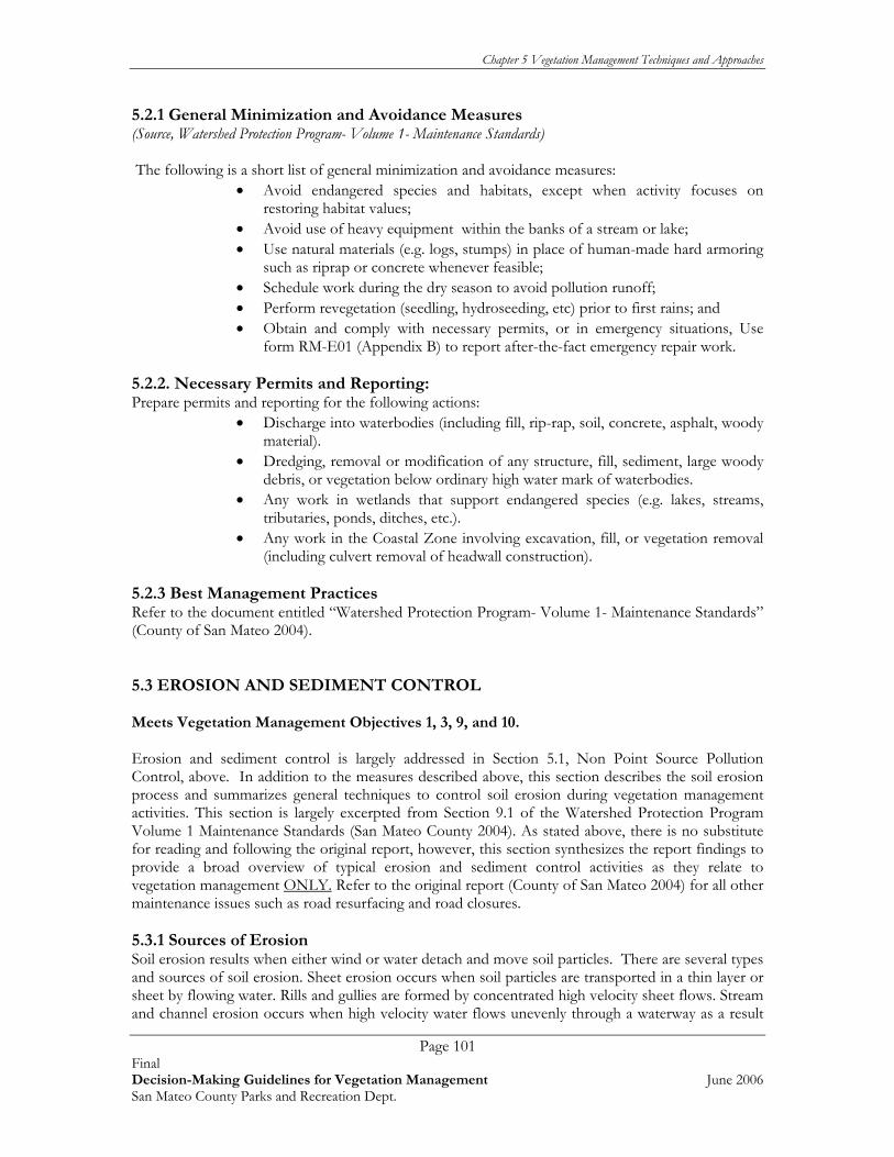
Chapter 5 Vegetation Management Techniques and Approaches
Page 101 Final Decision-Making Guidelines for Vegetation Management June 2006 San Mateo County Parks and Recreation Dept.
5.2.1 General Minimization and Avoidance Measures (Source, Watershed Protection Program- Volume 1- Maintenance Standards) The following is a short list of general minimization and avoidance measures:
• Avoid endangered species and habitats, except when activity focuses on restoring habitat values;
• Avoid use of heavy equipment within the banks of a stream or lake; • Use natural materials (e.g. logs, stumps) in place of human-made hard armoring
such as riprap or concrete whenever feasible; • Schedule work during the dry season to avoid pollution runoff; • Perform revegetation (seedling, hydroseeding, etc) prior to first rains; and • Obtain and comply with necessary permits, or in emergency situations, Use
form RM-E01 (Appendix B) to report after-the-fact emergency repair work. 5.2.2. Necessary Permits and Reporting: Prepare permits and reporting for the following actions:
• Discharge into waterbodies (including fill, rip-rap, soil, concrete, asphalt, woody material).
• Dredging, removal or modification of any structure, fill, sediment, large woody debris, or vegetation below ordinary high water mark of waterbodies.
• Any work in wetlands that support endangered species (e.g. lakes, streams, tributaries, ponds, ditches, etc.).
• Any work in the Coastal Zone involving excavation, fill, or vegetation removal (including culvert removal of headwall construction).
5.2.3 Best Management Practices Refer to the document entitled “Watershed Protection Program- Volume 1- Maintenance Standards” (County of San Mateo 2004). 5.3 EROSION AND SEDIMENT CONTROL Meets Vegetation Management Objectives 1, 3, 9, and 10. Erosion and sediment control is largely addressed in Section 5.1, Non Point Source Pollution Control, above. In addition to the measures described above, this section describes the soil erosion process and summarizes general techniques to control soil erosion during vegetation management activities. This section is largely excerpted from Section 9.1 of the Watershed Protection Program Volume 1 Maintenance Standards (San Mateo County 2004). As stated above, there is no substitute for reading and following the original report, however, this section synthesizes the report findings to provide a broad overview of typical erosion and sediment control activities as they relate to vegetation management ONLY. Refer to the original report (County of San Mateo 2004) for all other maintenance issues such as road resurfacing and road closures. 5.3.1 Sources of Erosion Soil erosion results when either wind or water detach and move soil particles. There are several types and sources of soil erosion. Sheet erosion occurs when soil particles are transported in a thin layer or sheet by flowing water. Rills and gullies are formed by concentrated high velocity sheet flows. Stream and channel erosion occurs when high velocity water flows unevenly through a waterway as a result

Chapter 5 Vegetation Management Techniques and Approaches
Page 102 Final Decision-Making Guidelines for Vegetation Management June 2006 San Mateo County Parks and Recreation Dept.
of changes in rates of velocity or steepness of slope. Wind erosion typically occurs when soils are dry, and wind velocity is sufficient to move soil particles. A comprehensive sediment assessment was conducted for approximately 73.8 miles of roads and trails within the Pescadero Park Complex (i.e., Pescadero, Memorial, and Sam McDonald County Parks) in 2003 (Pacific Watershed Assessment, 2003). This report identified the following major contributing factors to excess sediment input to stream channels:
• Stream crossings with undersized culverts; • Plugged culverts; • Stream crossings with a diversion potential; and • Stream crossings with a gully erosion at the culvert outlet.
These erosional sites at 71 of the 73 stream crossings studied were estimated to yield approximately 15,230 cubic yards (88%) of the total sediment entering the stream system. 5.3.2 Overview of Erosion and Sediment Control Strategies The sediment assessment report for the Pescadero Park Complex (i.e., Pescadero, Memorial, and Sam McDonald County Parks) recommended the following remediation to control the majority of sediment entering the stream system (Pacific Watershed Assessment, 2003). Similar erosion and sediment control strategies can be implemented at other parks:
• “Storm proofing” the stream crossings by installing larger culverts; • Adding debris plates at culverts to prevent plugging; • “Armoring” outfall points, as specified in the Watershed Maintenance Standards; • Re-grading trails and roads to include rolling dips that divert water off the trail or
road; and • Where appropriate, upgrading or decommissioning some trails and roads, and
converting some roads to trails. Beginning in 2005, $600,000 worth of priority sediment control actions were initiated (S. Herzberg, pers. com.). As additional funds become available, the remainder of the report recommendations should be implemented. For other park sites, similar actions can be undertaken during the regular course of maintenance activities (as staffing and funding allows). At all parks, storm drains should be checked prior to major storm events for proper sizing, obstructions, and any signs of siltation or overflow. It may be necessary to:
• Replace some culverts with larger sized culverts that can accommodate flow during major storm events;
• “Armor” the outfall sites at culver crossings; • Add debris plates at culverts that become routinely plugged with debris; and • Re-grade or recontour eroded roadbeds and trails, adding water bars or rolling
dips to keep water from concentrating on the road and causing erosion and sedimentation.
General recommendations to control erosion and sediment include the following. To control soil erosion, the soil surface must be protected from the erosive forces of wind, rain, and water runoff, and a system to collect the sediments and reduce offsite migration of sediments is necessary. Actions to be taken include one or more of the following:
• Minimize the extent and duration of exposure;

Chapter 5 Vegetation Management Techniques and Approaches
Page 103 Final Decision-Making Guidelines for Vegetation Management June 2006 San Mateo County Parks and Recreation Dept.
• Protect areas from disturbance; • Stabilize disturbed areas; • Minimize runoff velocities; • Retain sediments onsite; and/or • Inspect and maintain sediment control measures over time (Pacific Watershed
Associates, 2003). There are a wide variety of Best Management Practices that can be used to control sedimentation and erosion. Refer to Section 9.1 of the Watershed Protection Program Volume 1 Maintenance Standards (San Mateo County 2004) for a detailed description of erosion control methods that can be employed to control sedimentation and soil erosion, including brush packing, water bars, brush layering, cofferdams, coir fabricating, sediment barriers, diversion berms, energy dissipater structures, erosion control blankets, mats, netting, and wattles, slope protection devices, and other more detailed structural solutions to soil erosion and sedimentation. 5.4 PUBLIC HEALTH AND SAFETY Meets Vegetation Management Objectives 1, 2, 3, 6, 9, and 10. The health and safety of park visitors is a high priority when determining vegetation management actions and priorities. Some health and safety issues that are related to vegetation management include:
• Landslides, slumps, and other natural erosion; • Flooding, culvert malfunctions, drainage failures; • Poison oak; • Invasive plant infestations and noxious/undesirable plant control; • Lyme disease, tick bites, snake bites; • Other hazardous animals (mountain lions, coyotes); and • Hazard trees (described below in Section 5.5).
In general, park managers address hazardous conditions as they arise. For example, a landslide across a roadway would be assessed by the park manager, then caution signs, tape, or detour signs would be installed until the slide could be physically removed. Likewise, a blocked culvert that caused flooding would be assessed, signed, and then repaired as soon as possible. Poison oak, Lyme disease, ticks, mountain lions, coyotes, and snakes are all naturally occurring hazards that are part of the natural environment in San Mateo County Parks. Park managers should develop and post information about these hazards at each park and online. When a particular natural hazard becomes problematic (e.g., poison oak branches begin to engulf a trail, mountain lion activities become dangerous), then the park manager may have to take additional actions to help ensure the safety of the park visitors.

Chapter 5 Vegetation Management Techniques and Approaches
Page 104 Final Decision-Making Guidelines for Vegetation Management June 2006 San Mateo County Parks and Recreation Dept.
5.5 FOREST HEALTH Meets Vegetation Management Objectives 1, 2, 3, 6, 9, 10, and 12. The San Mateo County Parks contain many mature woodland and forest communities. Naturally, some of these trees are in a state of decline, either from natural causes (aging, disease, structural damage from natural causes) or human-induced reasons (structural damage from human use, irrigation, or soil compaction effects). Mature trees, as well as dead and dying trees (also known as “snags”) provide important wildlife habitat value and play an integral role in forest dynamics. The challenge for park managers is to balance the need for structural diversity in a forest (e.g. keeping a diverse forest full of trees of every life stage including retention of snags, downed wood, and brush piles) with the need to provide safe and accessible trail systems for park visitors. 5.5.1 Assessing Hazardous Trees One of the issues brought up by several park managers is the need to assess parks for hazard trees. To help park staff understand this issue, the following section provides an overview of the topic. Refer to Appendix A for specific “How To” suggestions, and to the Brochure provided in Appendix C for a pictorial guide to conducting hazardous tree assessments. A good rule of thumb is to assess hazardous trees annually in relation to land use and visitor frequency. In areas where human uses are expected to be low (e.g. in the interior of a forest community far away from main trails), mature and damaged trees should be left to complete their natural life cycle. In high human use areas, such as major trials, trail heads, parking lots, playgrounds, picnic facilities and sports areas, camping facilities, and in areas with developed facilities (concrete paths, buildings, restrooms etc) trees should be regularly assessed (annually) for their potential to fulfill their lifecycles. It is recommended that an annual hazardous tree assessment be conducted at every park. Hazard trees should be assessed and their relative level of hazard ranked using the following hazard ranking criteria:
• High probability of failure; • Observed poor health; • Evidence of significant die-back; • Problematic tree structure; • Root damage; • Visible cankers and/or rot; • Observed or suspected disease or pest infestations (Refer to information on
California Oak Mortality disease, Pitch Canker, and other tree diseases below); and • Probability of striking a target (human or structure).
Because of the prevalence and importance of forest resources on park lands, the County of San Mateo should consider the set up and maintenance of a centralized GIS database to track the location and condition of hazard trees, as well as other forest health issues (e.g. locations of Sudden Oak Death Syndrome outbreaks, invasive tree infestations, fuel reduction priorities) over time. Similar GIS database systems have been developed by a number of resource management agencies, including the National Park Service, National Forest Services, Bureau of Land Management, and other Counties (e.g., Napa County, Solano County, and Sacramento County). These GIS database systems have become standard tools for vegetation management. GIS databases provide an

Chapter 5 Vegetation Management Techniques and Approaches
Page 105 Final Decision-Making Guidelines for Vegetation Management June 2006 San Mateo County Parks and Recreation Dept.
invaluable and cost effective system to track changes over time, and to prioritize vegetation management actions. For example, a GIS database could be used to track potential hazard trees, forest disease outbreaks and other forest health issues, such as understory buildup and infestation by invasive trees and shrubs. In the absence of the GIS database system, we recommend that each park set up a paper mapping system to identify the location of potential hazard trees, assess hazard trees annually, and prioritize removal based on risk and funding limitations. Depending on the severity of the hazards and the limitations of staff funding, hazard trees could be tracked, treatment prioritized, and the trees removed as time and funding are available. Interim actions could also be tracked and implemented to ensure the safety of the public (e.g. cordoning off areas around hazard trees, or closing trails near diseased forest stands). 5.5.2. Forest Structure Forest structure refers to both the vertical structure of the vegetation (e.g., variations in tree, shrub, and understory heights, presence of snags, downed wood and brush piles) and also the variations in horizontal structure and species diversity across a landscape (e.g., patch size, tree density, mixture of open areas and closed tree canopy areas, and microclimate variations such as moist and cool shaded areas, and hot dry un-shaded areas). Numerous studies have shown a direct correlation between forest structure diversity and wildlife diversity (Maser et al, 1979, University of New Hampshire Cooperative Extension 1995)- in simple terms, the more types of microhabitats, food plants, types of shelter in a forested system, the more the area is able to support many different species of birds, insects, mammals, and plants. The challenge for park managers is to maintain forest diversity while controlling fuel load, visitor access and safety, and tree hazards. To help ensure the health of park forests over time and to help maintain the diversity of the wildlife species that the forests support, park managers should seek to achieve a multi-age, multi-storied forest structure. In practical terms, this may be as simple as actively managing forests near trails and other high use visitor areas, including managing brush, maintaining fire breaks and implementing fuel reduction programs (i.e. brush removal), removing downed wood and other obstacles, and (as necessary) selectively thinning and or planting trees and shrubs. In low use areas such as inaccessible forest interiors, a policy of annual monitoring and limited active management (e.g. leaving snags and downed wood, not cutting unnecessary fire breaks, not actively planting trees and shrubs) may help the park staff maintain a diverse forest structure. The annual hazard tree assessment and mapping efforts can also include an assessment of forest health, structure, and diversity to help focus resources on the most important forest management actions required to maintain a diverse structure. The forests of the San Mateo County Park system are relatively mature, including some old growth redwood forest, mature oak woodland, and mixed conifer oak forest. These forests have been managed for their park value only, for the most part left unmanaged since the forests were incorporated into the Park system. There have been several forest management studies conducted at individual parks, including:
• Forest Resources of San Mateo County (Forest Resources Study Committee 1971); • Natural Resources Management Program for Pescadero Creek County Park
(WESCO 1983); and • Natural Resources Management Program, Implementation Concept Plan, Pescadero
Creek County Park (County of San Mateo Parks and Recreation Division 1995).
Chapter 5 Vegetation Management Techniques and Approaches
Page 106 Final Decision-Making Guidelines for Vegetation Management June 2006 San Mateo County Parks and Recreation Dept.
These forest plans were prepared by professional forest ecologists, and provide several options for management and restoration of the forest resources within the Pescadero Creek Park Complex. Seven management options considered in the Natural Resources Management Program for Pescadero Creek County Park (WESCO, 1983) report were:
• Hands off (Do Nothing); • Safety Management Only; • Maximum Resource Management; • Resource and Recreational Management; • Maximum Recreation, Repair Resource Damage; • Timber Production and Recreation; and • Timber Production Only.
The San Mateo County Parks and Recreation Division embarked on the Safety Management Only option (County of San Mateo Parks and Recreation Division 1995), however, due to staff and funding shortages, this course of action was abandoned, and current management is mostly the “Hands Off” option. All of the reports referenced above indicate that the forest health and fire hazard level in these parks is seriously compromised. In addition, old logging roads (some of which now function as access roads and trails) are the source of substantial sedimentation into streams, including salmonid streams (Pacific Watershed Associates 2003). As stated above in Section 5.3, some of the erosion control actions will be implemented beginning in 2006. It appears prudent that a comprehensive trail and road improvement plan be combined with a forest management plan for the Pescadero Park Complex. The major factors that have prevented forest improvements in the past appear to be:
• Staffing limitations; • Lack of funding; and • Public perception of thinning for habitat restoration and fire hazard reduction in
park settings. To overcome these obstacles, we recommend the following approach:
• Adopt one of the options in the 1983 report (WESCO 1983). The “Resource and Recreation Management” option was the one recommended in the 1995 Implementation Concept Plan (County of San Mateo Parks and Recreation Division 1995), however, if found to be too controversial; a modified option that balances forest health with recreation should be developed. Review the plan and modify based on updated resource management practices.
• As recommended in the Implementation Concept Plan (County of San Mateo Parks and Recreation Division 1995), set up a trust fund/nonprofit to obtain and administer planning grants and project implementation, and manage any profits yielded from selective forest thinning and management. Ensure that any and all funds from the selective thinning and management are to be directed ONLY back into forest health improvements, sediment and erosion improvements, and recreational improvement at the Pescadero Park Complex.
• Conduct community outreach, and in close coordination with the public and a registered professional forest ecologist, conduct a demonstration project to show how an ecologically sensitive forest management plan can benefit the Parks.

Chapter 5 Vegetation Management Techniques and Approaches
Page 107 Final Decision-Making Guidelines for Vegetation Management June 2006 San Mateo County Parks and Recreation Dept.
• Review the results of the demonstration project, and revise techniques before beginning a multiple year, staged forest management plan.
• Implement a long-term, staged forest management plan, and monitor results. Use adaptive management to help ensure desired outcomes.
5.6 FUEL LOAD AND FIRE MANAGEMENT Meets Vegetation Management Objectives 2, 3, 5, 9, and 12. San Mateo County, like many other parts of California, has environmental characteristics which increase the potential for fires in wildland areas. These characteristics include highly flammable vegetation; long, dry summers; rugged topography; poor access for fire vehicles; increasing recreational use of remote lands; and continuing popularity of rural residential development. Refer to Chapter 15 “Natural Hazards” of the County General Plan for more information on this subject. 5.6.1 Fire Management at County Parks
In addition to ongoing forest health improvements, managing fuel load and fire hazard is one of the priority topics mentioned by park staff. In the past, much of the fuel reduction programs in County Parks were completed using prisoner work programs, Americorps, and California Conservation Corps (CCC) work programs such as the Ben Lomond Conservation Camp Crew. However as funding for these other programs has been eliminated or severely cut, the availability of much-needed labor to implement fuel reduction has been significantly reduced. Parks staff is struggling with effective ways to detect and manage hazardous fuel loads and fire danger. At present the County staff is considering a Fire Safe Coordinator position that, when filled, would assist with the coordination and management of fire crews. For planning purposes the 2006 rough cost for use of work crews is approximately $200 per day for a crew, with an additional 30$ charge for administration by the fire safe management. The fire safe crews are equipped with basic hand tools and chainsaws, but additional tools such as chippers and brush mowers are to be provided by the County.
At present, there is no comprehensive fire management plan for County Parks. There are however several park-specific documents that discuss fire management actions for various parks, including San Bruno Mountain, Huddart and Wunderlich Parks. Further, there is ongoing coordination with all of the other county fire agencies through participation in the Fire Safe Council (S. Herzberg, pers. comm.). While this chapter cannot address how to develop long-term budget strategies and labor forces to meet fuel reduction needs, it can provide guidance on how to detect problem areas (described below), and how to implement effective fire and fuel load management (Appendix A). Assessing the degree of fire hazard is dependent upon at least three factors. These include the degree of human use and occupancy of the wildland area, the level and ability of public services to respond to fires, and the natural setting of the wildland areas. While the first two components are fairly self explanatory, the third is described below. 5.6.2 Assessing Fire Hazard In addition to weather factors and slope characteristics, one of the key components in measuring fire hazard severity is the type and quantity of flammable vegetation within a given unit of land area. This

Chapter 5 Vegetation Management Techniques and Approaches
Page 108 Final Decision-Making Guidelines for Vegetation Management June 2006 San Mateo County Parks and Recreation Dept.
factor, known as “fuel loading characteristics” is combined with weather and slope information to determine fire hazard.
• “Heavy” Fuel Loading Vegetation is comprised of woodland and mixed woodland and brush areas with vegetation more than six feet tall, including conifers, mixed evergreen timberlands, and chaparral. Fuel ‘ladders’ (i.e. multilayered vegetation that effectively connects fires from the forest floor via shrubs, small trees, and vines to the top of the forest canopy) are especially dangerous during fires.
• “Medium” Fuel Loading Vegetation includes scrub vegetation less than six feet in
height, such as California sagebrush, coyote brush, and manzanita.
• “Light” Fuel Loading Areas are primarily treeless. Vegetation types include grasslands, herbaceous rangelands, and irrigated pasture lands.
There are several computer programs that model fuel load and help predict fire behavior in wildland settings. While such modeling is above and beyond the scope of this report, we recommend that the Park partner with the California Department of Forestry and Fire Protection (CDF) to develop a fire risk assessment for some of the larger forested County Parks such as the Pescadero Park Complex and, as staffing and budgets allow, develop and implement this type of modeling. Information on free, public domain fire modeling software is available at http://www.fire.org and at the following website under “software”: http://farsite.org/index.php?option=content&task=section&id=2&Itemid=25. Much of this free software runs on Microsoft Windows™ software. Necessary fuel load assessment could be dovetailed with the annual assessment of hazard trees and forest health. We recommend that the County of San Mateo develop and maintain a GIS database of forest resources, and update this data layer with locations of potential hazard trees, forest health assessment data, and fuel and fire risk data (perhaps generated form the free software mentioned above). Following the annual assessment of fire risk, park staff can use results to focus fuel load management on the most important areas within the Park system. Typically, the primary burden for wildland-urban interface fire protection falls to property owners and state and local governments. Rural and volunteer fire departments provide the front line of defense, or initial attack, on up to 90 percent of these high-risk and costly fires. While they have a good record in rapidly suppressing traditional wildland fires, these local resources often struggle to effectively address the complex demands of fighting fire at the wildland-urban interface. A 100-foot buffer along the urban/wildlands interface is recommended by CDF. 5.6.3 Fuel Management Fuel management is important for fire hazard reduction, but it is equally important as a habitat restoration tool to manage the health of Park forests. The General Accounting Office (General Accounting Office report to the Clinton Administration of Federal Wildfire Activities, 1999) emphasized the need for fuels management, concluding that…
“the most extensive and serious problem related to the health of forests in the interior West is the over-accumulation of vegetation, which has caused an increasing number of large, intense, uncontrollable, and catastrophically destructive wildfires.”

Chapter 5 Vegetation Management Techniques and Approaches
Page 109 Final Decision-Making Guidelines for Vegetation Management June 2006 San Mateo County Parks and Recreation Dept.
There are numerous options for managing fuel loads and maintaining healthy forest ecosystems, including:
• Controlled burns or flaming; • Physical removal of undergrowth and secondary tree growth; and • Prevention and eradication of invasive plants (General Accounting Office report to the
Clinton Administration of Federal Wildfire Activities 1999). Refer to Appendix C for an overview of these options and a summary of how to use fire to manage invasive plants, improve forest health, and reduce overall fuel load. These options are briefly discussed below.
Controlled Burns. Despite its risks, the prudent use of fire, either alone or in combination with other habitat restoration and fuel control methods is one of the most effective means of reducing hazardous fuel (General Accounting Office report to the Clinton Administration of Federal Wildfire Activities 1999). Unfortunately, controlled burns may not be a viable option for consistent management of park lands due to increasingly strict air quality standards and regulations that severely restrict them. Further, the perceived threat of out of control wildfires damaging nearby residences and businesses has become a ‘hot button’ issue amongst many park neighbors. While this perception should not necessarily discourage or prevent Park staff from planning to use fire, it does highlight the importance of public notification and public outreach when fire is to be used on park lands. Finally, some of the park lands have a combination of environmental factors (i.e. fairly constant winds, flammable vegetation, fuel ladders, and proximity to high value homes) that makes using fire as a management tool less practical. Parks staff should team with CDF and local fire departments more fully address this issue and to jointly develop a comprehensive plan to control fuel loads on park lands. When implementing controlled burns, CDF staff or local fire department staff are recommended. Pile Burns. Park staff have in the past been assisted by CDF work crews and other work crews who can, as low-cost paid assistants, conduct fuel reduction (understory removal) and pile burns to eliminate biomass. Park staff should continue to use these valuable and low cost alternatives whenever possible. For planning purposes, the 2006 approximate cost for using work crews is approximately $200 per day, with an additional 30$ charge for administration. The fire safe crews are equipped with basic hand tools and chainsaws, but additional tools such as chippers and brush mowers are to be provided by the County. Flaming. An alternative to controlled burns is ‘flaming’ whereby a propane torch is used to ‘boil’ plants, effectively killing the cambium layer of the plant and consequently killing it. Flaming has been used with great success throughout California for invasive plant control, forest health improvements, and to reduce fuel loads. Locally, it has been used in the Santa Cruz Mountains, in Marin County, and on Golden Gate National Recreation Area (GGNRA) lands in the Marin Headlands. The most effective application is for habitat restoration, specifically the control of invasive plant seedlings and resprouts of most grasses and non-woody forbs, and for some woody shrubs (e.g. French broom, other broom species, and gorse). To reduce potential for wildfire, ‘flaming’ is typically only undertaken when vegetation is very wet- either during or immediately after a rain event, or when vegetation is damp from fog and on low wind days (less than 5 mph is preferable). Winter is the preferred time for implementing this method, and it should only be undertaken by

Chapter 5 Vegetation Management Techniques and Approaches
Page 110 Final Decision-Making Guidelines for Vegetation Management June 2006 San Mateo County Parks and Recreation Dept.
trained practitioners, under the approval and supervision of a local fire department or CDF staff. Flaming does not typically require a burn permit because there is only limited flame (from the torch), and almost no smoke (mostly steam), however, local fire departments should be notified just in case flaming activities results in a wildfire. Again, its effectiveness is limited to small diameter woody vegetation (1 inch in diameter or less), seedlings, and non-woody grasses and forbs. Selective Tree Thinning. Selective thinning is the removal of some trees to create openings for more desirable species to be established, and/or removal of some trees (such as resprouting saplings) to create a more desirable tree density. Selective thinning is an important tool in maintaining forest health, and is recommended for even aged forests (such as logged areas) to, over time; create a multiple-aged forest structure. In some areas, such as the Pescadero Creek Park, past clear cutting and other historic forestry practices have resulted in forests that are dominated by hardwoods such as tanoak rather than redwoods and other conifers. In other areas, dense tree stands resulting from resprouting saplings from the base of cut trees have replaced more natural tree formations. Selective tree thinning in this area is recommended as a habitat restoration action to help correct past management actions. A forest ecologist should help determine which trees and how many should be thinned from each forest to achieve desired results. Undergrowth and Invasive Species Removal. In addition, early research has demonstrated that selective removal of undergrowth and invasive plant species from forested areas can improve overall forest health and reduce fire risks. In a report published in Proceedings from the Joint Fire Science Conference and Workshop (1991) fourteen researchers studied four large wildfires in Montana, Washington, California, and Arizona to determine if previous fuel treatment and thinning activities had any impact on fire severity. The sites selected for study underwent treatment within ten years prior to being burned in wildland fires. The findings indicated that fuel treatments are effective in reducing fire severity. These studies concluded that …“Although topography and weather may play a more important role in fuels in governing fire behavior, topography and weather cannot be realistically manipulated to reduce fire severity. Fuels are the leg of the fire environment triangle that land managers can change to achieve desired post-fire condition.” (General Accounting Office report to the Clinton Administration of Federal Wildfire Activities 1999). There are several ways to physically remove undergrowth and invasive species in forested areas for habitat restoration and fuel load reduction purposes. These methods are described in more detail elsewhere in this report, so are only summarized below:
• Chemical control (use of herbicides); • Physical removal using work crews, including contract, volunteer, staff, or
other labor (e.g. correctional facility, AmeriCorps or California Conservation Corps work crews); and
• Physical removal using grazing (typically goats). 5.6.4 Fuel and Fire Breaks, Fire Resistant Landscaping Three basic methods are commonly used to manage the spread of wildfires: firebreaks, fuel reduction areas and ornamental landscaping. A firebreak eliminates all vegetation and combustible growth to prevent fires from spreading. A fuel reduction areas reduces the fuel mass of flammable vegetation and combustible growth, thereby limiting the intensity of fire and slowing its rate of spread. Landscaping with fire resistant plants provides a third option for slowing the spread of wildfires, although this option has limited applications in park settings.

Chapter 5 Vegetation Management Techniques and Approaches
Page 111 Final Decision-Making Guidelines for Vegetation Management June 2006 San Mateo County Parks and Recreation Dept.
Fuel and fire breaks are already an important component of most of the parks. Parks are required to maintain a 100-foot buffer between urban areas and wildlands. Annual inspection and maintenance of existing fire breaks, strengthening ‘good neighbor’ relationships (e.g. seeking to reduce the threats of wildfires spreading from the park perimeters into the parks by undertaking fire management restrictions on adjacent lands), and establishment of new fire breaks are all recommended as pat of this effort. For the most part, new fire and fuel reduction areas are established using traditional methods of mowing or disking a swath of habitat that is wide enough to stop a wildfire from moving across or into an area. Fire and fuel reduction areas can cause environmental damage, including segmenting native habitats, disrupting wildlife movement corridors, causing mortality of sensitive species, and increasing and spreading invasive plant populations. New fire breaks should be carefully planned to avoid such impacts by relocating the fire breaks to less sensitive areas, or reduce impact potential (e.g. seasonal restrictions on mowing or disking). Refer to information presented in the ‘Mowing” section of this document and Appendix A for information on suggested seasonal restrictions for mowing (and disking) activities. There are several research efforts currently underway in California to study alternative methods to establish fire breaks, including planting of fire resistant vegetation. One excellent free publication is available online from the East Bay Municipal Utilities District (EBMUD) entitled “Firescape Landscaping to Reduce Fire Hazard (EBMUD, 2003) available online at: http://www.ebmud.com/conserving_&_recycling/conservation_publications/firescape_booklet.pd. Although the results of many of these studies are not yet published, parks managers should be aware, and consult with CDF and others to keep abreast of new fire break methodologies as they are developed. 5.6.5. Related Fire Plans Golden Gate National Recreation Area. The GGNRA recently published a draft Environmental Impact Statement (EIS) for Fire Management in San Francisco, Marin, and San Mateo National Parks lands (GGNRA 2005). Although this document is not specific to San Mateo County Park lands, it may provide useful information on the types of fire management practices that can be effectively implemented in wildland situations near urban areas, and fuel reduction programs conducted in sensitive species habitats. Information provided below is excerpted from the draft GGNRA fire management plan EIS.
Naturally occurring fire is an important ecological process necessary for maintaining the native plant communities of the park, but wildfire poses a hazard to life and property in the park's urban- wildland interface and developed sites within the park. GGNRA practice has been to aggressively suppress all wildland fire in the park whether naturally occurring or human-caused. The Planning Area for the GGRRA fire plan is contains lands in Marin, San Francisco and San Mateo counties--three of the nine counties that make up the San Francisco Bay Area. Several of the smaller national park sites are within the City of San Francisco itself; remaining areas are in southern and southwestern Marin County, northwestern San Mateo County and the Phleger Estate, in southeastern San Mateo County near the Town of Woodside. The fire management plan alternatives under consideration include:
• Prescribed fire; • Mechanical fuel reduction (e.g., mowing, cutting to remove invasive shrubs and
trees, and selective thinning in forested stands);

Chapter 5 Vegetation Management Techniques and Approaches
Page 112 Final Decision-Making Guidelines for Vegetation Management June 2006 San Mateo County Parks and Recreation Dept.
• Continued implementation of the Wildland Urban Interface Initiative; • Maintenance of the park's fire roads and trails; • Vegetation clearing around park buildings; • Suppression of unplanned ignitions; • Public information and education; • Construction of a new fire cache for equipment storage; and • Continuation of the current fire monitoring program.
California Department of Forestry and Fire Protection Fire Management Plan for the San Mateo/Santa Cruz Unit. The California Department of Forestry And Fire Protection Fire Management Plan San Mateo/Santa Cruz Unit, California Northern Region published a Fire Management Plan in July 2002. The overall goal of this plan is to reduce total wildfire costs and losses from wildland fire by protecting assets at risk through focused vegetation management projects and aggressive “Fire Safe Defense Awareness” Programs throughout the San Mateo & Santa Cruz Unit. This document is a dynamic working plan that will be reviewed and updated periodically yet is flexible enough to meet the needs of the Unit. The intent is to keep it simple, easy to understand and, above all, a “guide”. The major components of the plan (excerpted from the document) include:
• Creation of local forums to determine what the fire problem is through input from citizens, community groups, local agencies and other stakeholders.
• Identification of assets at risk, enabling the stakeholder forums and the Unit to set priorities for vegetation management project work. These assets include citizen and firefighter safety, structures, watersheds, wildlife and habitat, timber or unique areas of cultural or historic significance, and air quality.
• Development of wildfire protection zones through vegetation management projects that reduce the risks of large damaging wildland fires.
• Development and implementation of vegetation management projects cooperatively with stakeholder forums. Projects may include a combination of mechanical clearing or prescribed fire.
5.7 MOWING Meets Vegetation Management Objectives 2, 3 4, and 12. Mowing is an effective and relatively low cost vegetation management tool that is utilized extensively in San Mateo Parks for a variety of reasons, including
• Invasive plant control; • Fire breaks and fuel load reduction; • Trail maintenance; and • Maintenance of high use recreation sites.
As mentioned in Section 2.3 (Current Management Practices) above, there is a centralized mowing program utilizing all staff members which employs onsite mowers and mowers transported by trailer. The garden crew currently maintains turf at the following units:
• Coyote Point Park and Marina; • Flood Park; • Huddart Park; • Edgewood Park;

Chapter 5 Vegetation Management Techniques and Approaches
Page 113 Final Decision-Making Guidelines for Vegetation Management June 2006 San Mateo County Parks and Recreation Dept.
• Junipero Serra Park; • San Bruno Mountain; • San Pedro Valley; and • Sanchez Adobe.
Some issues and concerns related to mowing include:
• Inadvertent damage to sensitive species and ground nesting birds (multiple parks); • Timing of mowing to maximize weed control effectiveness, especially control of
rattlesnake grass and bristly ox tongue (Coyote Point and other parks); • Timing of mowing to provide foraging areas for western bluebird (Edgewood Park); • Need to mow in late spring and early summer for rattlesnake detection along trails
(Edgewood Park); and • Reducing potential for transport of invasive plants, plant diseases to other areas and
other parks. Refer to Table 5.6 for an overview of suggested mowing timing restrictions listed by individual park. These issues, and suggested “How to” solutions, are presented in Appendix A.
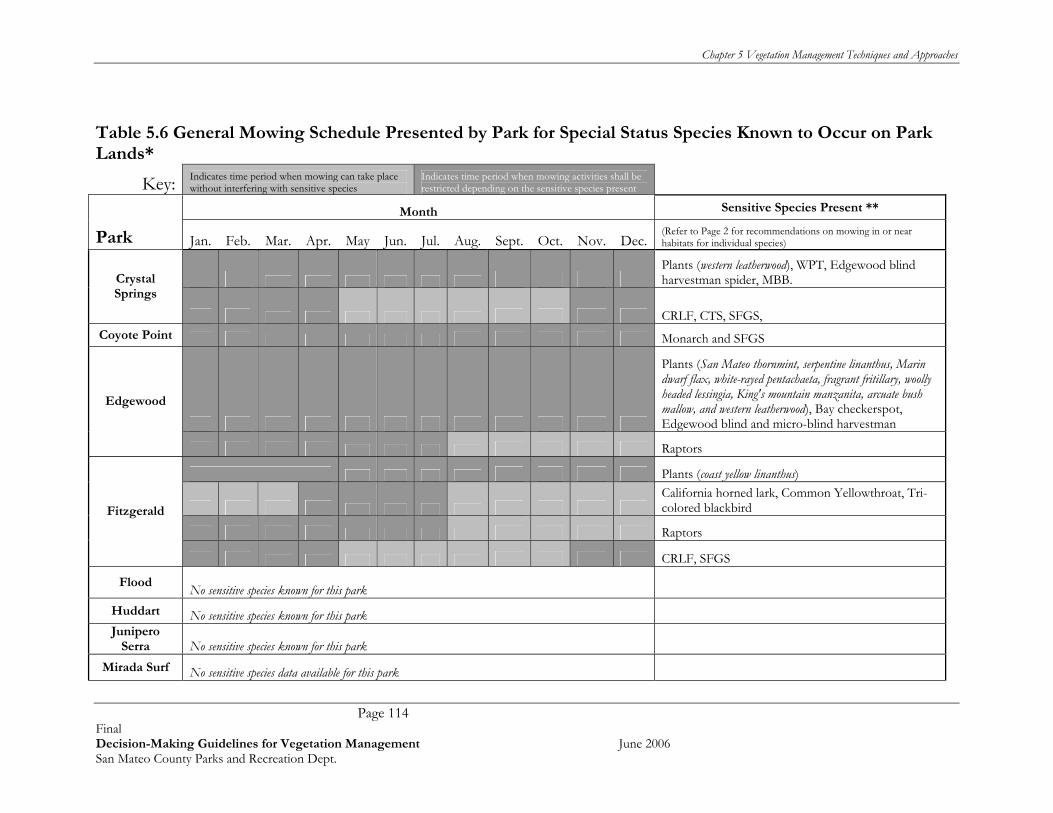
Chapter 5 Vegetation Management Techniques and Approaches
Page 114 Final Decision-Making Guidelines for Vegetation Management June 2006 San Mateo County Parks and Recreation Dept.
Table 5.6 General Mowing Schedule Presented by Park for Special Status Species Known to Occur on Park Lands*
Key: Indicates time period when mowing can take place without interfering with sensitive species
Indicates time period when mowing activities shall be restricted depending on the sensitive species present
Month Sensitive Species Present **
Park Jan. Feb. Mar. Apr. May Jun. Jul. Aug. Sept. Oct. Nov. Dec. (Refer to Page 2 for recommendations on mowing in or near habitats for individual species)
Plants (western leatherwood), WPT, Edgewood blind harvestman spider, MBB. Crystal
Springs
CRLF, CTS, SFGS, Coyote Point Monarch and SFGS
Plants (San Mateo thornmint, serpentine linanthus, Marin dwarf flax, white-rayed pentachaeta, fragrant fritillary, woolly headed lessingia, King's mountain manzanita, arcuate bush mallow, and western leatherwood), Bay checkerspot, Edgewood blind and micro-blind harvestman
Edgewood
Raptors
Plants (coast yellow linanthus)
California horned lark, Common Yellowthroat, Tri-colored blackbird
Raptors
Fitzgerald
CRLF, SFGS
Flood No sensitive species known for this park Huddart No sensitive species known for this park Junipero
Serra No sensitive species known for this park Mirada Surf No sensitive species data available for this park
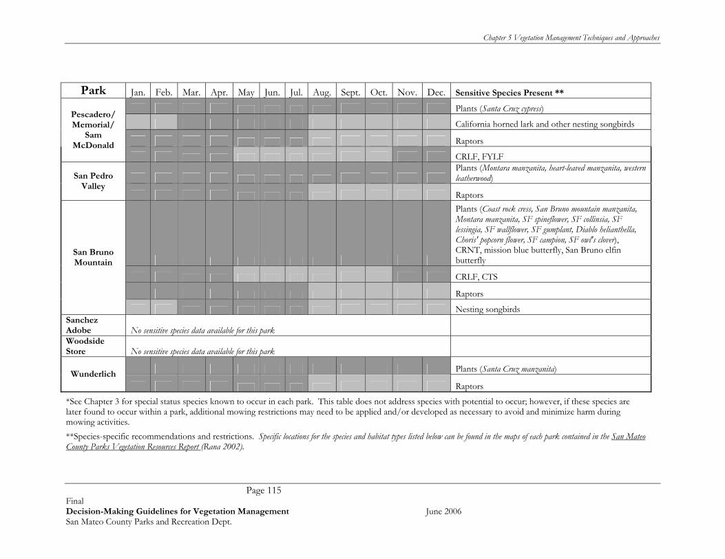
Chapter 5 Vegetation Management Techniques and Approaches
Page 115 Final Decision-Making Guidelines for Vegetation Management June 2006 San Mateo County Parks and Recreation Dept.
Park Jan. Feb. Mar. Apr. May Jun. Jul. Aug. Sept. Oct. Nov. Dec. Sensitive Species Present **
Plants (Santa Cruz cypress)
California horned lark and other nesting songbirds
Raptors
Pescadero/ Memorial/
Sam McDonald
CRLF, FYLF
Plants (Montara manzanita, heart-leaved manzanita, western leatherwood) San Pedro
Valley Raptors
Plants (Coast rock cress, San Bruno mountain manzanita, Montara manzanita, SF spineflower, SF collinsia, SF lessingia, SF wallflower, SF gumplant, Diablo helianthella, Choris' popcorn flower, SF campion, SF owl's clover), CRNT, mission blue butterfly, San Bruno elfin butterfly
CRLF, CTS
Raptors
San Bruno Mountain
Nesting songbirds Sanchez Adobe No sensitive species data available for this park Woodside Store No sensitive species data available for this park
Plants (Santa Cruz manzanita) Wunderlich
Raptors
*See Chapter 3 for special status species known to occur in each park. This table does not address species with potential to occur; however, if these species are later found to occur within a park, additional mowing restrictions may need to be applied and/or developed as necessary to avoid and minimize harm during mowing activities. **Species-specific recommendations and restrictions. Specific locations for the species and habitat types listed below can be found in the maps of each park contained in the San Mateo County Parks Vegetation Resources Report (Rana 2002).

Chapter 5 Vegetation Management Techniques and Approaches
Page 116 Final Decision-Making Guidelines for Vegetation Management June 2006 San Mateo County Parks and Recreation Dept.
Species Time Period for Restricted Activities
Restricted Areas Required Actions
Plants All year Areas where plants are known to occur (see maps per park) and a 20 foot buffer around those plants or populations
Do not mow in restricted areas. Western leatherwood along trails (particularly at Crystal Springs) should be avoided by establishing a 'no mow' zone around the tree(s) and installing signs.
During breeding season (November 15-April 15)
Do not mow in restricted areas. CRLF = California red legged frog.
Summer Months
Areas within a 100 ft. around ponds, wetlands, and riparian (creek) habitats. In restricted areas (likely only along trails), vegetation should
be cleared to a height of 4 inches by hand then checked for CRLF. If none are found then mowing can proceed.
During breeding season (November 15-April 15)
Do not mow in restricted areas. FYLF = Foothill yellow-legged frog.
Summer Months
Shallow, slow, gravelly streams and rivers with sunny banks, in forests, chaparral, woodlands along trails. A small buffer around waters where this frog is known to occur should be maintained.
In restricted areas (likely only along trails), vegetation should be cleared to a height of 4 inches by hand then checked for FYLF. If none are found then mowing can proceed.
During breeding season (November 15-April 15)
Do not mow in restricted areas. CTS = California tiger salamander.
Summer Months
Ponds, and grasslands and open woodlands within 100 feet of ponds. In restricted areas (likely only along trails), vegetation should
be cleared to a height of 4 inches by hand then checked for CTS. If none are found then mowing can proceed.
CRNT=Coast range newt. All year Wet forests, oak forests, chaparral, and rolling grasslands
In restricted areas (likely only along trails), vegetation should be cleared to a height of 4 inches by hand then checked for CRNT. If none are found then mowing can proceed.

Chapter 5 Vegetation Management Techniques and Approaches
Page 117 Final Decision-Making Guidelines for Vegetation Management June 2006 San Mateo County Parks and Recreation Dept.
Species Time Period for Restricted Activities
Restricted Areas Required Actions
November - March (when residing in upland winter burrows)
Do not mow in restricted areas. SFGS = San Francisco garter snake.
Summer Months
Areas within a 100 ft. around ponds, wetlands, and riparian (creek) habitats.
In restricted areas (likely only along trails), vegetation should be cleared to a height of 4 inches by hand then checked for SFGS. If none are found then mowing can proceed.
WPT = Western pond turtle. All year Within 20 feet of ponds, lakes, slow moving
waterways. Do not mow in restricted areas.
Butterflies and spiders All year
Areas that are mapped as habitat for special status invertebrates, including the mission blue butterfly, San Bruno elfin, Edgewood blind harvestman (spider), monarch butterfly, and bay checkerspot butterfly (see maps per park)
Do not mow in restricted areas.
Raptors Nesting season, January 1 to July 31
Areas within a 100 ft. around known nesting sites (including trees). Includes
Do not mow in restricted areas. For ground-nesting raptors, vegetation in restricted areas should be removed to a height less than 8 inches in height before nesting season and maintained for the remainder of the nesting season to prevent nests from being built in these areas.
Nesting Songbirds Nesting season, March 1 to July 31
Grasslands; these birds either nest on the ground or in tall grasses. Includes California horned lark and Common Yellowthroat.
Do not mow in restricted areas. Vegetation in restricted areas should be removed to a height less than 8 inches in height before nesting season and maintained for the remainder of the nesting season to prevent nests from being built in these areas.
Tri-colored blackbirds. Nesting season, March 1 to July 31
Ponds with wetland vegetation such as tules and cattails
Do not mow in restricted areas. Vegetation in restricted areas should be removed to a height less than 8 inches in height before nesting season and maintained for the remainder of the nesting season to prevent nests from being built in these areas.

Chapter 5 Vegetation Management Techniques and Approaches
Page 118 Final Decision-Making Guidelines for Vegetation Management June 2006 San Mateo County Parks and Recreation Dept.
5.8 SENSITIVE RESOURCE MANAGEMENT Meets Vegetation Management Objectives 1, 5, 7, 8, 9, 10, and 12. Natural resources exist in a dynamic, ever-changing state that is affected as much by environmental conditions (rainfall, temperature, vegetation succession) and random events (wildfires, landslides, diseases etc) as by management activities. Therefore, effective management of sensitive resources must recognize and account for the ever-changing nature of the sites, and shift focus to maintaining the long term health and viability of the natural communities that sensitive resources depend on. In practical terms, this means management decisions require (1) baseline knowledge of the individual sensitive species’ ecological needs, and (2) periodic assessment of the sensitive resource populations and their related natural habitats at each park. Refer to the Adaptive Management and Monitoring Sections of this report for more information on monitoring and detecting trends in natural resources at County Parks. 5.8.1 Detecting Trends in Sensitive Species Populations Knowing the number and distribution of target sensitive species is an important component to determining effective management strategies. As an example, the population size of mission blue butterfly, a federally endangered species known from San Bruno Mountain, is known to fluctuate greatly from year to year. This species is also believed to have a relatively small home range, only traveling short distances from its habitat and host plant. In this example, it would be important to a land manager to know how many butterflies are present annually, and where they are being found. Over time if this data is collected, a manager could detect trends in population decline, and also where such declines are taking place, important clues to determining where and how best to spend management efforts on protecting the species. The San Bruno Mountain Habitat Conservation Plan is currently conducting annual species monitoring, the results of which are helping to guide management decisions such as replanting host plants between butterfly population centers, determining where invasive plant control can be undertaken to best help the species, and providing overall information about the status of the butterfly at the Park. A similar approach can be applied to other sensitive species and other parks. An invaluable resource for park staff are local experts -- representatives from Audubon Society, California Native Plant Society, and local “Friends of” groups -- have a wealth of knowledge about the ecological requirements and population status of the sensitive species in San Mateo County Parks. These organizations and individuals will usually provide accurate and low cost or free information which is usually more up-to date than traditional sources such as the California Department of Fish and Game’s Natural Diversity Database. A list of valuable references with regards to sensitive resources is provided in Appendix D. We recommend developing and maintaining a GIS database of target sensitive species by park. This would greatly increase effective management of all species. Even if financial limitations do not allow for annual updates, data on species occurrence and population size can be periodically collected as funding allows, or collected by park volunteers, or during various studies, and added to the centralized database.

Chapter 5 Vegetation Management Techniques and Approaches
Page 119 Final Decision-Making Guidelines for Vegetation Management June 2006 San Mateo County Parks and Recreation Dept.
5.8.2 Detect Changes in Habitat Required by Sensitive Species Knowing the distribution and abundance of the natural habitats associates with sensitive species is important in determining effective management strategies. For example, some of the rare butterflies known from San Bruno Mountain are closely associated with a small suite of plants upon which the butterflies feed, lay eggs, and develop into butterflies. Management of these butterflies requires not only efforts to prevent harm to individual butterflies and their individual host plants (i.e. fencing signing, limiting work in and near the habitats), but also making sure that enough suitable habitat (i.e. host plants) is present over time. In this example, it would be important to a land manager to know where the host plants (‘suitable habitat’ for the species) are located, and in what condition the habitat is during any management year. If, for instance, host plants near the butterflies were found to be declining, management could focus on reducing grasses and invasive plants (such as gorse, French broom, velvet grass) that are displacing host plants and therefore limiting the butterfly population. 5.8.3 Maintain a Diversity of Natural Habitats for Sensitive Species at Each Park One of the simplest and most effective ways to help ensure that sensitive species are present in the future is to preserve the variety and health of the natural habitats that are currently present at each park. While the concept is simple, detecting changes can be difficult. For example, climatic changes such as cycles of drought and heavy rain can shift the abundance and distribution of shrublands, grasslands and even forests over time. Likewise, some evidence suggests that global warming is altering the distribution of both common and sensitive species and habitats, shifting species along elevation (and related temperature) gradients. While we do not suggest trying to manage for a static (unchanging) condition on County Park lands, it is valuable for managers to be able to track vegetation changes over time. We strongly recommend developing a GIS database of vegetation that includes current aerial photographs, as well as scanned historic aerial photographs to facilitate comparison of site conditions over long periods of time. Historic aerial photography can also be invaluable in determining what type of restoration is most appropriate for various sites. Comparing aerial photographs of the same site over decades can provide indicators of vegetation trends, including loss or expansion of grasslands, shrublands, and forested lands. In some instances, active management may be required to artificially correct shifts in vegetation types over time. For example, it is very likely that grassland habitats that support mission blue butterfly habitats on San Bruno Mountain may be shifting towards becoming coastal shrubland. Likewise, serpentine grasslands at Edgewood Park that support a suite of sensitive plants and insects may be shifting towards being dominated by shrubs such as Coyote bush. In these examples, actively removing shrubs in specific locations may help maintain habitat ‘mosaics’ that could allow grasslands that support sensitive species to persist at these parks. Similar management decisions can be reached on a park by park basis through a relatively fast and inexpensive comparison of past and present aerial photographs. 5.8.4 Maintain Wildlife Corridors Wildlife corridors—large connected areas of habitat— are recognized as important to maintaining wildlife species diversity and abundance (Noss, 1987; Gilbert et al., 1998; Perault and Lomolino, 2000). Such corridors allow wildlife (and plant) species to move between habitat patches, allowing re-colonization of patches in which a local extinction event has occurred, and providing increased foraging area and escape areas for a wide variety of species. Further work has suggested that a network of small patches in close proximity to one another (habitat “stepping stones”) can also increase wildlife population sizes and persistence (Webb and Thomas, 1994; Schultz, 1998).

Chapter 5 Vegetation Management Techniques and Approaches
Page 120 Final Decision-Making Guidelines for Vegetation Management June 2006 San Mateo County Parks and Recreation Dept.
As San Mateo County becomes increasingly developed and lands surrounding the parks are urbanized, the natural areas in County Park lands become increasingly important as wildlife movement corridors. The general rule of thumb for maintaining wildlife corridors is ‘bigger is better’ – i.e. the larger and more contiguous the area, the more likely that it will act as a wildlife corridor. Land managers should consider the effects of placing trails, buildings, access points, fire breaks, and other features on these larger contiguous tracts of habitat, and if possible, place such features on the edges or in clusters to help keep the corridors as ‘intact’ as possible. 5.8.5 Minimize ‘Edge Effect’ Another simple way to help preserve sensitive resources at all parks is to minimize edge effects. This simple concept means that resources in the center of a park are less subject to effects than resources located on the edges. The shape of the park becomes important, as square and round parks have less edge than long thin or rectangular parks. In practical terms, park managers should check park perimeters periodically for ‘edge effects,’ including but not limited to:
• Invasion of invasive plants from neighborhood backyards. This is thought to be one of the main pathways that invasive plants enter into wildlands. Backyard garden plants that become problematic in park wildlands include calla lily, periwinkle, several species of ivies, several species of brooms, Pampas grass (or jubata grass), fountain grass, and other cultivated ornamental garden plants.
• Neighborhood trespass onto park land, including the following types of private uses on park lands - dog kennels, gardens, volleyball, tennis courts and other private recreational uses, tree forts, barbeque sites etc.
• Inadvertent introduction of irrigation water and backyard chemicals (oil dump sites, herbicide and pesticide runoff from urban landscaping).
• Fuel and fire breaks next to neighborhood fence lines (mostly thought of as a positive edge effect).
• Domestic pets that escape into park lands and hunt and kill native wildlife and songbirds. In most cases, developing good relationships with park neighbors will help ensure minimal edge effects on sensitive natural resources. In some instances, active management may be required to correct problems, such as fixing fences to exclude pet trespass, fixing irrigation problems, cooperatively maintaining adequate fuel reduction areas etc. 5.8.6. Actively Manage for Sensitive Species Some species within the parks system are very rare, some of which are listed under the federal and/or state Endangered Species Acts. In instances where the general sensitive species management described above is not sufficient to protect and maintain these species, additional, species-specific actions may be required. For example, there is a separate Habitat Management Plan (HCP) in place at San Bruno Mountain for the federally listed mission blue butterfly, as well as several other endangered species. This HCP manages, monitors, and implements site-specific management actions to help ensure the continued existence, and in some instances recovery of these rare butterfly species. Active management includes removal of gorse and other invasive plants; active revegetation of host plants/expansion of habitat onsite, public outreach and education, and several other restoration activities (e.g., Colma Creek habitat restoration project). Likewise, the Santa Cruz cypress (Cupressus abramsiana) is a federally listed endangered species that occurs at Pescadero Creek Park. According to a Recovery Plan for the Santa Cruz cypress, one

Chapter 5 Vegetation Management Techniques and Approaches
Page 121 Final Decision-Making Guidelines for Vegetation Management June 2006 San Mateo County Parks and Recreation Dept.
population, located on Butano Ridge at Pescadero Creek Park was the subject of a Coordinated Resource Management Plan (CRMP) that was being developed in 1992, but was delayed due to lack of funding (U.S. Fish and Wildlife Service, 1998). This species is still present, and presumably would benefit from focused management actions. Management decisions related to sensitive species will be guided by the following:
• Is the species listed under the federal or state endangered species act? If so, some consultation (formal or informal) may be required with state and federal resource agencies before implementing management activities for the species.
• Is the species in decline with the County Park or regionally? If so, active management may be required. As mentioned throughout this document, the County Parks would greatly benefit from a GIS system intended to track changes in sensitive species populations over time. Such tracking, if updated regularly, would provide important data to detect population trends, and adjust management accordingly.
• What is limiting the species? In some instances, the condition of the park may be limiting the amount of suitable habitat available for the species. For example, gorse, an invasive plant species is displacing host and nectar plants, and also reducing the amount of low grassland habitats favored by the mission blue butterfly and other sensitive butterfly species. Steelhead, a federally listed species, may be limited by erosion and sedimentation into spawning streams.
• What are other (nearby) Land Managers doing to maintain the health of the species? Where possible, San Mateo County Parks should seek to add to existing program or use similar management approaches as other nearby land managers. An example of this would be the GGNRA who is actively managing the Mori Point Parks site for both San Francisco garter snake and California red-legged frog. The GGNRA, in association with the U.S. Fish and Wildlife Service has developed land management actions intended to maintain the recreation uses of this site while managing snake and frog populations and enhancing habitat values of the site. In this example, it would be useful for park staff at nearby Fitzgerald and other County Parks to coordinate with GGNRA and USFWS to implement similar management strategies at parks that support San Francisco garter snake and California red-legged frog.
Once these factors and issues are identified, appropriate active management actions can be identified. Some of the active management actions that may be considered by park staff include:
• Controlling invasive plants if they are displacing native habitats required by that sensitive species;
• Creating or restoring habitats to create larger, interconnected habitat areas; and • Modifying Recreational and Park Maintenance Practices to help reduce
potential for mortality or harm. For example, if a particular wetland is known to support California red legged frog, it may be important to restrict recreational access by re-routing trails, or to post interpretive signs. Another example would be to reduce speed limits on roads that pass through San Francisco garter snake habitat.
Table 5.8.6 provides a summary of management plans and management activities underway for sensitive species known from San Mateo County Parks.

Chapter 5 Vegetation Management Techniques and Approaches
Page 122 Final Decision-Making Guidelines for Vegetation Management June 2006 San Mateo County Parks and Recreation Dept.
Table 5.8.6. Known Sensitive Species and Related Management Plans and Actions
Known Species
Coy
ote
Pt
Cry
stal
Sp
rin
gs
Ed
gew
ood
Fit
zger
ald
Flo
od P
ark
Hu
dd
art
Jun
iper
o Se
rra
Mem
oria
l
Pes
cad
ero
Sam
McD
onal
d
San
Ped
ro
San
Bru
no
Mtn
Wu
nd
erlic
h Management
Plans, Management
Activities
Plants arcuatebush mallow (Malacothamnus arcuatus)*
None Active
Bolander’s horkelia (Horkelia bolanderi)
California black walnut (Juglans californica var. hindsii)
Choris’s popcorn flower (Plagiobothrys chorisianus var. chorisianus)
None Active coast rock cress (Arabis blepharophylla)
None Active
coast yellow linanthus (Linanthus croceus)
None Active
Crystal Springs flax (Hesperolinon spergulinum)*
None Active
Diablo helianthella (Helianthella castanea)
Natural Resources Management Plan Pescadero Creek
Engelmann/Mesa Oak (Quercus engelmannii) Fragrant fritillary (Fritillaria liliacea)*
None Active
heart-leaved manzanita (Arctostaphylos andersonii)
None Active
King’s mountain manzanita (Arctostaphlos regismontana)*
None Active Marin dwarf flax (Hesperolinom congestum)*
Edgewood Park Master Plan1984
Montara manzanita (Arctostaphylos montaraensis)
None Active
Monterey mansanita (Arctostaphylos montereyensis)*
Pacific ninebark (Physocarpus capitatus) None Active Robust coyote mint (Monardella villosa ssp. globosa)
San Bruno Mountain manzanita (Arctostaphylos imbricata)
None Active San Francisco Bay spineflower (Chorizanthe cuspidata var. cuspidata)
San Bruno Mtn HCP
San Francisco campion (Silene verecunda ssp. verecunda)
Edgewood Park Master Plan1984
San Francisco collinsia (Collinsia multicolor)
None Active
San Francisco lessingia (Lessingia germanorum)
San Bruno Mtn HCP
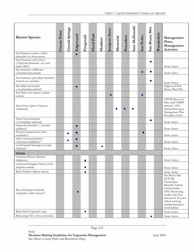
Chapter 5 Vegetation Management Techniques and Approaches
Page 123 Final Decision-Making Guidelines for Vegetation Management June 2006 San Mateo County Parks and Recreation Dept.
Known Species
Coy
ote
Poi
nt
Cry
stal
Sp
rin
gs
Ed
gew
ood
Fit
zger
ald
Flo
od P
ark
Hu
dd
art
Jun
iper
o Se
rra
Mem
oria
l
Pes
cad
ero
Sam
McD
onal
d
San
Ped
ro
San
Bru
no
Mtn
Wu
nd
erlic
h
Management Plans, Management Activities
San Francisco onion (Allium peninsulare var. franciscanum)
San Francisco owl’s clover (Triphysaria floribunda)- not seen since 1960’s
None Active San Francisco wallflower (Erysimum franciscanum)
None Active
San Francisco gum plant (Grindelia hirsutula var. maritima)
None Active San Mateo thornmint (Acanthomintha duttonii)*
Edgewood Park Master Plan1984
San Mateo tree lupine (Lupinus eximius)
Santa Cruz cypress (Cupressus abramsiana)
USFWS Recovery Plan, draft CRMP initiated 1992, Natural Resources Management Plan Pescadero Creek
Santa Cruz manzanita (Arctostaphylos andersonii)
None Active
serpentine linanthus ( Linanthus ambiguous)
None Active
Western leatherwood (Dirca occidentalis)*
None Active
white-rayed pentachaeta (Pentachaeta bellidiflora)*
None Active
wooly headed lessingia (Lessingia hololeuca)*
None Active
Wildlife American Bittern (Botaurus lentiginosus)
None Active American Peregrine Falcon (Falco peregrinus anatum)
None Active Bank Swallow (Riparia riparia) None Active
Bay checkerspot butterfly (Euphydryas editha bayensis)*
San Bruno Mtn HCP, Bay Checkerspot Butterfly Federal Listing Studies 1994. Monitoring studies only-Not detected in 20 years. Adjust mowing, grazing burning to avoid habitat
Black Swift (Cypseloides niger) None Active Burrowing Owl (Athene cunicularia) None Active
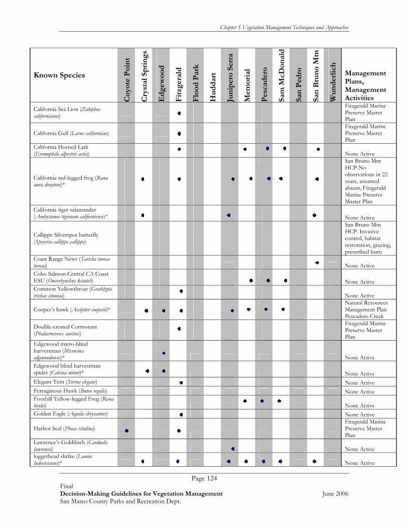
Chapter 5 Vegetation Management Techniques and Approaches
Page 124 Final Decision-Making Guidelines for Vegetation Management June 2006 San Mateo County Parks and Recreation Dept.
Known Species
Coy
ote
Poi
nt
Cry
stal
Sp
rin
gs
Ed
gew
ood
Fit
zger
ald
Flo
od P
ark
Hu
dd
art
Jun
iper
o Se
rra
Mem
oria
l
Pes
cad
ero
Sam
McD
onal
d
San
Ped
ro
San
Bru
no
Mtn
Wu
nd
erlic
h
Management Plans, Management Activities
California Sea Lion (Zalophus californianus)
Fitzgerald Marine Preserve Master Plan
California Gull (Larus californicus)
Fitzgerald Marine Preserve Master Plan
California Horned Lark (Eremophila alpestris actia)
None Active
California red-legged frog (Rana aura draytoni)*
San Bruno Mtn HCP-No observations in 22 years, assumed absent, Fitzgerald Marine Preserve Master Plan
California tiger salamander (Ambystoma tigrinum californiense)*
None Active
Callippe Silverspot butterfly (Speyeria callippe callippe)
San Bruno Mtn HCP. Invasive control, habitat restoration, grazing, prescribed burn
Coast Range Newt (Taricha torosa torosa)
None Active
Coho Salmon-Central CA Coast ESU (Oncorhynchus kisutch)
None Active Common Yellowthroat (Geothlypis trichas sinuosa)
None Active
Cooper’s hawk (Accipiter cooperii)*
Natural Resources Management Plan Pescadero Creek
Double-crested Cormorant (Phalacrocorax auritus)
Fitzgerald Marine Preserve Master Plan
Edgewood micro-blind harvestman (Microcina edgewoodensis)*
None Active Edgewood blind harvestman spider (Calcina minor)*
None Active
Elegant Tern (Sterna elegans) None Active Ferruginous Hawk (Buteo regalis) None Active Foothill Yellow-legged Frog (Rana boylei)
None Active
Golden Eagle (Aquila chrysaetoes) None Active
Harbor Seal (Phoca vitulina)
Fitzgerald Marine Preserve Master Plan
Lawrence’s Goldfinch (Carduelis lawrencei)
None Active
loggerhead shrike (Lanius ludovicianus)*
None Active

Chapter 5 Vegetation Management Techniques and Approaches
Page 125 Final Decision-Making Guidelines for Vegetation Management June 2006 San Mateo County Parks and Recreation Dept.
Known Species
Coy
ote
Poi
nt
Cry
stal
Sp
rin
gs
Ed
gew
ood
Fit
zger
ald
Flo
od P
ark
Hu
dd
art
Jun
iper
o Se
rra
Mem
oria
l
Pes
cad
ero
Sam
McD
onal
d
San
Ped
ro
San
Bru
no
Mtn
Wu
nd
erlic
h
Management Plans, Management Activities
Marbled Murrelet (Brachyramphus marmoratum) Breeding.
Natural Resources Management Plan Pescadero Creek
mission blue butterfly (Icaricia icarioides missionensis)*
San Bruno Mtn HCP. Invasive control, habitat restoration, grazing, prescribed burn
Monarch butterfly (Danaus plexippus)
Fitzgerald Marine Preserve Master Plan
Northern Elephant Seal (Mirounga angustirostris)
Fitzgerald Marine Preserve Master Plan
northern harrier (Circus cyaneus)* None Active olive-sided flycatcher (Contopus copperi)*
None Active
Osprey (Pandion haliaetus) None Active purple martin (Progne subis)* None Active Rufous Hummingbird (Selasphorus rufus)
None Active
San Bruno Elfin Butterfly (Incisalia mossii bayensis)
San Bruno Mtn HCP
San Francisco garter snake (Thamnohis sirtalis tetrataenia)*
San Bruno Mtn HCP. No observations in 22 years, assumed absent
sharp-shinned hawk (Accipiter striatus)*
None Active
Short-eared Owl (Asio flammeus) None Active
Southern Sea Otter (Enhydra lutris)
Fitzgerald Marine Preserve Master Plan
Steelhead-Central CA Coast ESU (Oncorhynchus mykiss)
Natural Resources Management Plan Pescadero Creek
Steller’s Sea Lion (Eumetopias jubatus)
Fitzgerald Marine Preserve Master Plan
Tri-colored Blackbird (Agelaius tricolor)
Fitzgerald Marine Preserve Master Plan
Vaux’s Swift (Chaetura vauxi) None Active western pond turtle (Clemmys marmorata)*
None Active
white-tailed kite (Elanus leucurus)* None Active White-throated Swift (Aeronautes saxatalis)
None Active
Yellow Warbler (Dendroica petechia) None Active

Chapter 5 Vegetation Management Techniques and Approaches
Page 126 Final Decision-Making Guidelines for Vegetation Management June 2006 San Mateo County Parks and Recreation Dept.
Refer to Appendix A for more information on how to monitor sensitive species, and how to implement habitat restoration activities. 5.9 RECYCLING GREEN WASTE AND VEGETATION BIOMASS Meets Vegetation Management Objectives 2, 3, 5 and 9. One of the guidelines for Vegetation Management outlined in the County of San Mateo Watershed Protection Program Maintenance Standards document (April 2004) is to “recycle/reuse vegetative matter where practicable.”
This sentiment is echoed by the County’s RecycleWorks program, which assists San Mateo County Parks. According to “highest use” principles, plants that are able to be chipped, composted, or used in some manner onsite at a County Park should not be disposed of in a landfill. This section describes current County practices relating to green waste management, and options for processing vegetation biomass generated during vegetation management activities. 5.9.1 Current County Practices Vegetation biomass generated by County Parks includes trees and shrubs cut for fuel reduction and fire management, invasive trees and shrubs removed for habitat restoration (for example, Eucalyptus trees at Colma Creek as part of the Colma Creek restoration program), lawn clippings and other green waste from mowing programs, invasive plant removal biomass, and other large-scale vegetation removal projects. At present, the majority of vegetation biomass is left onsite. The biomass is either piled “as is” in inaccessible locations (e.g., brushpiles, logs, downed wood), or cut, chipped, or composted, then spread at the Parks. This practice is consistent with other land managers in the state, including the National Parks Service, the State Parks system, and other counties. Due to the cost of transportation and the large amount of biomass generated by a park, many times the only feasible alternative is onsite treatment. Vegetation biomass that is not left onsite is typically disposed of in debris boxes that are transported to County dump facilities. RecycleWorks is a County program that assists the parks with disposal of green waste and other debris, but does not do the actual hauling. The amount of waste that can be transported by a debris box company or waste and recycling hauler depends on:
• What’s being picked up and where; • How much needs to be transported; and • Whether it’s regular or specially-scheduled pick up service.
At present, County Parks does approximately 80% of its own processing of green waste and off hauling. Processing is done using 3 chippers; however, these three chippers are reaching the end of their productivity, and should be replaced soon. Replacement equipment under consideration are 2 to 3 larger-capacity “Brush Bandits” at a cost of approximately $37,000 per unit. The new equipment would allow County Parks to reduce its offsite disposal needs by as much as 50% (Dave Moore, pers. comm.). RecycleWorks suggests the following for park management consideration:
• Ensure each park has enough waste containers or adequate space for composting facilities.

Chapter 5 Vegetation Management Techniques and Approaches
Page 127 Final Decision-Making Guidelines for Vegetation Management June 2006 San Mateo County Parks and Recreation Dept.
• Each park should designate and approve a green waste disposal area (intended to reduce fuel loading that results from leaving materials in wildlands).
• Ensure any green waste that is to be disposed of offsite is "clean" and not mixed with trash.
• Invasive weeds and infested trees mush be separated and disposed of differently than native plants.
5.9.2 Options for Processing Green Waste Since RecycleWorks assists the Parks with disposal, there is some consensus that they should have some authority over the handling of green waste, however a comprehensive green waste program has not been developed for County Parks. RecycleWorks is most interested in finding the highest use for vegetation biomass (Boone pers. comm.). The following alternatives for processing green waste are provided by RecycleWorks:
• Dispose of onsite (suitable for brush and downed wood. Cut into sections and store in designated disposal locations. Allow to break down naturally. Suitable for disease-free trees and shrubs).
• Compost or chip onsite (suitable for native plants, leaf litter, mowing and mulching grass cuttings, and chipping ground cover). These materials can be used for compost or mulch.
• Compost at an off-site green waste facility (large amounts of biomass, some invasive weeds). There are currently no sites in San Mateo County. Available sites that accept green waste include Z Best in Gilroy, Jepson Prairie in Davis, and Newby Island in San Jose.
• Alternative Daily Cover (ADC). Clean loads of green waste can be used as cover for landfill, and are not considered disposal (Costs less and is more environmentally friendly).
• Landfill disposal of green yard waste (typically hauled to Ox Mountain landfill and co-mingled with garbage)(Higher cost).
• Local transfer station and/or curbside pick up of clean green waste. (Green waste will be transferred to offsite composing facility, biomass facility, or for ADC).
• Special disposal methods for biomass in areas with potential for plant diseases such as Sudden Oak Death syndrome (i.e. Crystal Springs Regional Trail, Huddart/Wunderlich).
The following suggestions are provided to assist park managers in making decisions regarding green waste management. 1) Estimate the Amount of Vegetation Biomass that could be generated By a Project. For
example, the Colma Creek restoration project will result in the need to dispose of 50 small trees and 50 large trees, therefore disposal methods should be determined that can handle this volume of material. Refer to Appendix A for methods to estimate biomass in tons per acre.
2) Assess the Type of Vegetation Biomass Being Generated and Determine the Most
Appropriate Disposal Method. This will require park staff to make a judgment based on the type of vegetation, how fast it can be expected to break down or mulch, and the potential for the biomass to contain viable seeds and roots that could cause inadvertent spread to other areas. As stated above, trees and invasive plants should be disposed of differently than lawn clippings.
Chapter 5 Vegetation Management Techniques and Approaches
Page 128 Final Decision-Making Guidelines for Vegetation Management June 2006 San Mateo County Parks and Recreation Dept.
Refer to Appendix A for details on methods to process and dispose of various types of vegetation biomass.
3) Find an Appropriate Disposal Site. Possible sites include the original removal/treatment site; a nearby designated green waste disposal site (to be designated in each park). (Note: some land management organizations stash small tree branches and cut logs under dense shrubs, however, this will increase fuel loading in San Mateo Parks, and is therefore not encouraged); a centralized compost pile, storage bin, maintenance yard, or convenient onsite storage location developed for an individual project; or offsite disposal. Refer to RecycleWorks for proper vegetation biomass preparation for transport and transportation procedures.
4) Monitor all Onsite Disposal Sites. The job is not over until the vegetation material is
completely composted! As needed to properly compost vegetation (may require monthly or bimonthly management for up to 1 year) and control the spread of invasives, monitor your disposal sites periodically to detect problems (annual assessment and spot treatment for several years).
A list of valuable references with regards to disposing and treating green waste is provided in Appendix D. 5.10 UNAUTHORIZED TRAILS Meets Vegetation Management Objectives 2, 3 and 10. Unauthorized trails are defined as trails that are created by human trespass into areas that lack designated park-approved trails. Unauthorized trails can be a significant source of soil erosion and habitat degradation, and are often the source of invasive plant infestations. Unauthorized trails can also be important indicators of management issues or other problems that need to be addressed. For example, multiple unauthorized trails that lead from an existing trail to an off-trail destination may indicate that the overall trail circulation pattern is not effectively addressing visitor use. This can be corrected in a number of ways, including:
• Adding curbing or better demarcation of the main trail, along with trail closed signs on the social trail. Studies have indicated that most people will stay on a well marked trail!
• Posting trail locator maps at the social trail diversion from the main trail showing the visitor how to get where they want to go on the designated trail system, and providing estimated distances to their destination.
• Creating new spur trail(s) to the destination to eliminate multiple unauthorized trails.
• Installing physical or visual barriers to discourage trespass from the main trail (e.g., installing brush piles, barrier fencing, dirt piles, or planting dense vegetation screening (shrubs, trees).
• Revegetating the old unauthorized trails to erase the trail trace so that subsequent visitors do not follow unauthorized trails.
Another source of unauthorized trails is unusual or illicit human behavior. In these instances, eliminating dense cover may be the key to changing social trail use: for example, ‘limbing up’ trees

Chapter 5 Vegetation Management Techniques and Approaches
Page 129 Final Decision-Making Guidelines for Vegetation Management June 2006 San Mateo County Parks and Recreation Dept.
and removing understory layers to create a park-like open area often is effective at eliminating illegal encampments, and other human groupings, thereby eliminating the social trail use as well. Unauthorized trails can also indicate a structural problem with the main trail. For example, if the main trail crosses a wetland or seep and the trail does not drain, visitors will often ‘go around’, avoiding the wet areas. In this example, the key to eliminating unauthorized trails is to ‘fix’ the main trail by installing a culvert or boardwalk/bridge, then revegetating the unauthorized trails. It is important to note that in most cases, unauthorized trails are created by human activity (e.g. hiking, offroad vehicle use, offroad biking), then the trail scar is typically widened and deepened through a combination of continued use (human and/or wildlife) and related soil erosion. Unauthorized trails can be exacerbated by surface drainage patterns that follow the down-cut of the social trail pathway. Therefore, it is important to first create sustainable circulation patterns that provide visitors safe and well-marked access to popular destination points, then close and restore the social trail. The success of reducing or eliminating unauthorized trails is related to:
• Providing well-marked safe trails that lead to desired visitor destination points; • Erasing the “hydrologic memory” of the old social trail; • Removing the “scar” of unauthorized trails and providing adequate time for
plant establishment; and • Providing signage indicating routes, distances, destinations, hazards, trail
closures, etc. to encourage visitors to use designated trails. Refer to Appendix A for additional information on how to restore unauthorized trails. 5.11 HABITAT RESTORATION Meets Vegetation Management Objectives 1, 4, 5, 6, 7, 8, 9, 10, and 12. This section is intended to provide a brief overview of management considerations related to habitat restoration. Much more detailed information on how to plan and implement habitat restoration projects is provided in Appendix A and C. Useful resources that can help park staff plan habitat restoration activities are provided in Appendix D. Habitat restoration should be largely based on the following fundamental concepts:
• Restoring natural processes to the greatest degree feasible and appropriate; • Protecting rare and sensitive plant and wildlife habitat, and enhancing and
expanding these habitat values wherever possible; • Increasing overall biological diversity of native species; • Expanding existing native habitats areas through a combination of both passive
(e.g. removing forest canopy overstory, invasive plants) and active restoration (large-scale invasive control, grading, and planting) activities;
• Enlarging and linking smaller isolated wetlands and riparian woodlands into larger habitat restoration corridors, to promote genetic diversity in wildlife populations;
• Creating and/or maintaining a diverse “mosaic” pattern of native habitat types (e.g., grassland, scrub, woodland) and structures for a variety of wildlife species. [Special attention will be given to restoring riparian woodland habitat adjacent

Chapter 5 Vegetation Management Techniques and Approaches
Page 130 Final Decision-Making Guidelines for Vegetation Management June 2006 San Mateo County Parks and Recreation Dept.
to wetland and scrub habitat with the goal of creating large contiguous blocks of high quality songbird habitat];
• Controlling targeted invasive plant species; • Reducing non-natural erosion sources; • Creating sustainable park stewardship and sufficiently resourced maintenance
programs (especially for sites with problematic invasive plant species issues); • Offering diverse and coordinate opportunities for engaging the community in
park stewardship; • Linking habitat restoration efforts with trail management efforts wherever
possible to ensure holistic landscape management and synergistic results; and • Providing interpretive and educational opportunities wherever appropriate.
Refer to Appendix A for a detailed account of how to plan and implement habitat restoration. 5.11.1 Effects of Global Warming on Vegetation Communities and Sensitive Species Global warming is a worldwide phenomenon that is well documented, however its effects on vegetation resources are not well understood. It is clear that there is an overall trend towards more extreme weather patterns, including more frequent and severe El Nino events, flooding events and drought cycles. These types of weather patterns effect vegetation in a number of ways that are important in the context of vegetation management. First, coastal areas (including such as Fitzgerald Marine Reserve, Mirada Surf, and Coyote Point may be subjected to increased wave action and flooding events. Such events may accelerate the rate of coastline erosion, leaving near-ocean sea bluffs and coastal marsh increasingly vulnerable to loss or damage. Facilities such as roads and buildings that are near the coast interface may be subject to damage from increased wave action, coastal erosion, and more severe flooding events. Changes in weather patterns (for the most part, interpreted as longer and hotter summers, possibly longer and more severe storm events) can cause shifts in vegetation communities over time. One possible shift that may be attributed to changing weather is a shift from grassland to shrub-dominated communities (during wetter weather cycles) and from shrubland to grassland (during dry or drought cycles). These trends may have vegetation management implications. For example, as buildings and roads suffer increased damage, they may need to be more frequently repaired, relocated to more stable areas, or abandoned. Park managers should consider placing new facilities in areas away from the coastal interface area, or (if facilities are necessary) using more durable materials or requiring planning for more frequent maintenance. Vegetation shifts may also necessitate changes in vegetation management, especially for those species that are closely tied to a certain type of vegetation. For example, if shrubs become more dominant in mission blue butterfly habitat, park managers may have to increase shrub eradication, mowing or grazing programs, or possibly controlled burns to keep sufficient grassland habitats available to support the butterfly. Several species sensitive species are associates associated with wetlands, and; changes in weather patterns may affect the duration and quantity of water in these habitats. Therefore, park managers may have to increase or decrease the amount of wetland habitat or water available to compensate for changes in wetland habitats resulting from weather patterns global change. Invasive plant species populations may also shift distribution, and those adapted to the new climate conditions would be more likely to spread.

Chapter 5 Vegetation Management Techniques and Approaches
Page 131 Final Decision-Making Guidelines for Vegetation Management June 2006 San Mateo County Parks and Recreation Dept.
There is no good method to track and detect changes resulting from global warming. We suggest that over time, historic records such as aerial photographs may be a good way to detect subtle changes in vegetation patterns over time. For coastline damage, more frequent monitoring of coastal areas is recommended to help detect and correct problems early.
5.12 INVASIVE PLANT CONTROL Meets Vegetation Management Objectives 1, 4, 5, 7, 8, 9, 11, and 12. The overall goal of an invasive plant control program is sustained control, leading to elimination of target invasive plants, a goal that will require a large time commitment. There is no single effective method to control invasive plants (also referred to in this report as weeds). Most land managers that have successfully completed invasive plant control programs indicate that what works best is to adaptively implement several control techniques. One consistent element of failed invasive plant control programs is reported to be underestimating the time and the resources (staff, costs) that will be necessary to control weeds. Our advice is to pick your weed “battles”, and not to start something that you cannot finish (Source, numerous conversations with weed management professionals, information presented at the CalIPPC and SERCAL conferences, November 2004, and 2005). The information provided below is intended to be a tool to help guide decisions about weed control efforts. Refer to Appendix A for specific invasive control treatments for individual weed species. Any invasive plant project should consider and follow Integrated Pest Management procedures to help ensure the most effective and least environmentally damaging alternative is selected. Because weed control techniques are ever evolving, we strongly suggest checking with the local Agricultural Commissioner’s office, Weed Management Area and other weed resources (e.g., California Invasive Plant Council [CalIPC], The Nature Conservancy’s weed websites) listed in Appendix D before finalizing an approach to weed control. All applications of pesticides or herbicides, when needed, should follow Agricultural Commissioner’s recommendations, Environmental Protection Agency guidelines, state and federal law, and product labeling guidance. Herbicides should be prescribed and applied under the directions of a qualified herbicide applicator with a valid Qualified Applicator’s License (QAL) license and experience in applying herbicides in wildland settings. Park representatives should oversee contractor work on site. Best Management Practices should be employed during invasive plant control to minimize soil disturbance, and to help ensure that biomass is removed from the site, or sufficiently composted and stored out of sight. Removal of large infestations of weeds can result in the increased potential for erosion on slopes and stream banks. Therefore, an erosion control strategy must be in place before large-scale removal efforts are undertaken. In areas where invasive plants occur on steep and unstable coastal cliffs and bluffs, special control methods should be employed (e.g. contractor rappel and spray, broadcast spray and decompose onsite). The following section provides a very simple review of invasive removal options. Refer to Appendix A for treatment options provided for each of the most important target weed species currently known from the park system.

Chapter 5 Vegetation Management Techniques and Approaches
Page 132 Final Decision-Making Guidelines for Vegetation Management June 2006 San Mateo County Parks and Recreation Dept.
• Hand removal o Hand pull (Weed wrench). o Cut above ground vegetation (loppers, brushcutters, scythe). o Dig out entire plants, including roots (Hula hoe, rake, shovel).
• Machine removal o Light plow (bobcat, ATV). o Masticate above-ground vegetation (weedeater, brushhog). o Large-scale mastication, dense brush (‘brontosaurus’, caterpillar, tractor). o Pluck (Truck with winch and cable).
• Tree removal o Chainsaw into sections. o Use of cables to remove in sections. o Helicopter logging. o Brontosaurus, chip in place.
• Herbicide Application o Foliar application. o Basal bark application. o Spot application - cut and paint. o Spot application – wick. o Remove biomass, allow plant to regrow, then foliar spray new growth. o Rappel, then foliar spray.
Controlling invasive plants will be an ongoing maintenance action in developed landscapes as well as natural areas within the San Mateo County Parks. Invasive species of primary concern, and methods for their control/removal, are found in “How to Control Invasive Plants” in Appendix A. Listed below in Table 5.12 are species frequently found in San Mateo County Parks, according to Rana (2002).
Table 5.12. Known Invasive Species to Occur Within Each Park
Known Species* Coyo
te P
t
Crys
tal S
prin
gs
Edg
ewoo
d
Fitz
gera
ld
Floo
d Pa
rk
Hud
dart
Juni
pers
Ser
ra
Mem
orial
/ Pe
scad
ero/
Sam
M
cDon
ald
San
Pedr
o
San
Brun
o M
tn
Wun
derli
ch
Acacias (Acacia sp.) Australian fireweed (Erechtites minima) Australian tea tree (Leptospermum laevigatum) Blackwood acacia (Acacia melanoxylon) Blue gum Eucalyptus (Eucalyptus globulus) Bull thistle (Cirsium vulgare) Bailey’s acacia (Acacia baileyana) Cape ivy/German ivy (Delairea odorata /Senicio mikanioides)
Cotoneaster (Cotoneaster sp.) English ivy (Hedera helix) Ehrharta (Ehrharta erecta)

Chapter 5 Vegetation Management Techniques and Approaches
Page 133 Final Decision-Making Guidelines for Vegetation Management June 2006 San Mateo County Parks and Recreation Dept.
Known Species* Coyo
te P
oint
Crys
tal S
prin
gs
Edg
ewoo
d
Fitz
gera
ld
Floo
d Pa
rk
Hud
dart
Juni
pero
Ser
ra
Mem
orial
/
Pesc
ader
o/
Sam
McD
onald
San
Pedr
o
San
Brun
o M
tn
Wun
derli
ch
Fennel (Foeniculum vulgare) French broom (Genista monspessulana) Fuller’s teasel (Dipsacus sativus) Garden nasturtium Glossy privey (Ligustrum japonica) Gorse (Ulex europaeus) Harding grass (Phalaris aquatica) Heavenly bamboo (Nandina domestica) Himalayan blackberry (Rubus discolor) Iceplant/hottentot fig (Carpobrotus edulis) Italian thistle (Carduus pycnocphalus) Monterey cypress (Cupressus macrocarpa) Monterey pine (Pinus radiata) Mustard (Brassica nigra) Myoporum (Myoporum laetum) Ox-eye daisy (Leucanthemum vulgare) Oxalis/Bermuda buttercup (Oxalis pres-caprae) Pampas grass (Cortaderia jubata) or jubata grass (C. Jubata)
Periwinkle (Vinca major) Pine species (Pinus sp.) Poison hemlock (Conium maculatum) Purple loosestrife (Lythrum salicaria) Radish (Raphanus sativus) Rattlesnake grass (Briza maxima) Scotch broom (Cytisus scoparius) Single-seed hawthorn (Crataegus monogyna) Smooth cordgrass ( Spartina alterniflora) Smooth cord grass hybrid (Spartina alterniflora x S. Foliosa)
Spanish broom (Spartium junceum) Yellow star-thistle (Centaurea solstitialis) Velvet grass (Holcus lanatus) Wandering Jew (Tradescantia fluminensis)
* Source, Rana (2002). There may currently be more invasive plants at these park. More information on restoration is found in “How to Plan a Restoration Project” in Appendix A.

Chapter 5 Vegetation Management Techniques and Approaches
Page 134 Final Decision-Making Guidelines for Vegetation Management June 2006 San Mateo County Parks and Recreation Dept.
Managers should adopt the following practices in their efforts to control invasive plant species in the San Mateo County Parks:
Invasive species control includes the following steps.
1. Collect Baseline Information on Invasive Plant Locations The logical starting point for any invasive plant management project is a map of the weed locations. Maps can be hand drawn or GIS based, and should contain as much information as possible on the species present, density, age, and presence or absence of sensitive species. However, the absence of detailed GIS mapping of every invasive plant should not stop weed management activities as the maps can be developed to first document ongoing activities and then can be expanded to include species of particular concern. A list of invasive species present in each park is already available, and in conjunction with the prioritization methods listed below the most high priority weeds can be mapped first.
2. Prioritize Control Efforts Once baseline maps are available for a park, a prioritization process will help determine where control efforts should be focused. It should be possible to decide which species should be eradicated, contained or monitored for future spread. The decision can be based on the feasibility of control of the species itself as well as the location of the weed in relation to other park resources. A rough prioritization method for each species is available in the form of the Cal-IPC Invasive Plant Inventory. This list uses available scientific data and expert knowledge to rank the plants considered most highly invasive in California. The ranking categories are: High, Moderate, Limited and Evaluated by Not Listed. Park managers can simply list the invasive plants in the park with their respective Cal-IPC ranking to determine which pose the most immediate threat to park resources. Flow Chart 1 below can be used to help managers determine whether or not a plant should be considered a serious threat.

Chapter 5 Vegetation Management Techniques and Approaches
Page 135 Final Decision-Making Guidelines for Vegetation Management June 2006 San Mateo County Parks and Recreation Dept.
Decision-Making Flow Chart 1: Identifying Plants that are Serious Threats
3. Assess the Potential for Successful Control or Eradication Assessing whether or not a project will successfully control (or preferably eradicate) an invasive plant is a good “acid test” as to whether you should proceed. If the project is too big, too ambitious, or the treatment area is likely to be re-infested from nearby sources, it may not be a good candidate project. Flow Chart 2 (below) may help with the decision-making process.
Does plant cover 30% or more of the area?
Is it displacing important native plants?
Is the plant still coming back after initial control
efforts?
YES
YES
YES
Initiate early detection and
treatment
NO
NO
YES
NO NO
Plant may be a serious threat.
Does manual control solve the problem?

Chapter 5 Vegetation Management Techniques and Approaches
Page 136 Final Decision-Making Guidelines for Vegetation Management June 2006 San Mateo County Parks and Recreation Dept.
Decision-Making Flow Chart 2: Identifying Plants that are Candidates for Eradication
Does the plant exist in low enough numbers/locations to be successfully removed?
Does the park have the resources to mount a successful initial plant removal operation?
Is there a high probability of re-invasion from a large seed bank?
Does the invasive species occur in high numbers on an adjacent property that could re-seed the park population?
Does the park have the resources to continue removal operations of re-sprouts over a several year time period?
Do not attempt eradication. Rather, use
control/containment strategies.
YES
YES
NO
NO
NO
NO
YES
YES
YES
Consider eradication

Chapter 5 Vegetation Management Techniques and Approaches
Page 137 Final Decision-Making Guidelines for Vegetation Management June 2006 San Mateo County Parks and Recreation Dept.
For invasive plants that pose a serious threat but can not realistically be eradicated (because they are just too widespread, or the probability of re-invasion is high), park managers can focus on sustained control, or containment of the invasive plant population.
4. Initiate an Early Detection and Rapid Response Plan for New Weeds Detecting new weed infestations and responding to them quickly is as important as controlling the weeds that you already have in the park. Containing a new weed, like containing an epidemic, depends on identifying it as soon as possible and initiating a rapid, coordinated response. The main need is for park users, volunteers, and staff to be attentive. Some agencies such as the National Park Service, State Parks, and “Friends of” groups working in various parts of the state have instituted “invasive plant patrols” made up of volunteers who systematically search trails and other likely places for weed populations. The report findings to Park Management, who, in consultation with the Agricultural Commissioner’s office and Weed Management Area representative, decide what to do about the new weed. Not all new weeds turn into invasive plants that threaten native habitats! Some simply die out. Other weeds, if they are problematic elsewhere in the state, should be considered as a potential problem in San Mateo County. Small infestations should be immediately controlled, larger ones, given priority for control before they spread. All this work is worth it. As two veteran weed workers put it, “preventing or stopping just one new invasive weed would be of greater conservation benefit in the long run than far more costly and difficult efforts to control an already widespread pest.”
5. Eradicate Infestations Where Feasible Eradication means destroying every single plant in the population, not just most of them. Typically, even if caught in the early phases, eradication will require more than one treatment, often extended treatment periods of, 5, or even 10 years. The key is diligence. If the site is weeded thoroughly enough and often enough, the remaining seed bank (i.e. seeds left dormant in the soil) can be exhausted, and the eradication will be successful. Because eradication is labor intensive and requires a focused effort over time, it is important to pick your battles. Identify only the most problematic weeds, and among those, only attempt to eradicate the species and sites that can be completely removed within the available staffing, budget, and volunteer support base. Projects that are not followed through to completion will be a wasting of time and money, because any remaining seed will eventually lead to a new infestation. Also, make sure the whole population can be removed and new populations can’t seed in from outside sources.
The key to eradication is:
• Detecting Early. • Responding Quickly. • Monitoring Carefully. • Repeating as Necessary until all Plants and Seedlings are Gone!
Eradication efforts should only be undertaken under the following conditions:
• The plant is truly a threat. It spreads rapidly out of control with no limitation, biological control or seasonal control, and it displaces important native plants.
• The whole population can be successfully removed and new populations can’t seed in from outside sources.

Chapter 5 Vegetation Management Techniques and Approaches
Page 138 Final Decision-Making Guidelines for Vegetation Management June 2006 San Mateo County Parks and Recreation Dept.
6. Where Eradication is Not Feasible, Contain and Control. If it is not possible to eradicate an invasive plant infestation, don’t give up! Change the project goals to sustained control or containment of the invasive plant population. Sustained control and containment will keep the invasive plant in check and prevent it from flowering and setting seed, and spreading to nearby areas. For some species such as French broom or cape ivy that grow near endangered species habitats, containment is a very effective management strategy to keep the invasive plant from adversely affecting sensitive resources. When a particular weed has become widespread—like gorse and yellow star-thistle—eradication is no longer a sensible strategy. Instead, the most effective action is to contain and control the spread of the plant. To contain the spread, focus on “outlier” populations—small patches in areas otherwise weed-free. At the same time, prevent additional seed from being dispersed by cutting back fruit-bearing plant parts. In the case of English ivy, cut the parts growing up into trees and bearing fruit. Following this strategy will limit the spread of the local population to the area it currently occupies. For other species-specific control methods, see “How to Control Invasive Plants” in Appendix A.
Containment alone works best with plants that expand outward from the edge of their colony (such as ivy or broom species). When dealing with such plants, focus on containing the large infestations and eliminating all the outlier populations, rather than spending energy trying to eradicate the main population. It’s easy to feel compelled to throw all your effort into working on the dense weed patches, but doing so is like sending fire fighters into the middle of a huge wildfire while ignoring its perimeter. The fire keeps spreading, as if you hadn’t done a thing. If necessary, delineate a containment line or zone. This can be done by dividing the park into areas defined by a trail system, stream, fenceline or other linear feature. Fruit and seed producing plants and plants which disperse seed over long distances are not effectively controlled using containment alone. The fruiting source must also be reduced. This should be done by: 1) Take out all mature plants and never allow remaining plants to flower or set seed again.
An example of this approach would be ongoing Pampas grass (or jubata grass) control along the north coast where volunteers remove and bag all of the feathery seed “plumes” each year to prevent the wind from spreading seeds along the coast. Carefully timed mowing or weed eating can be an effective way to ‘cut off’ the flowering or seeding heads before they mature.
2) Pull seedlings and continue to mow re-sprouting (treat with herbicides as necessary). 3) Replace invasives with native plants, or cover treated areas with tarps, mulch, or other
barriers to shade the remaining seed bank and help prevent germination and prevent resprouting.
To effectively eliminate invasives, not only the mature plant material needs to be removed. Re-sprouting rhizomes, roots, and seedlings need to be pulled on a regular basis. Once you’ve decided to remove a population, a key to success is to retreat the site every year in spring until no more resprouting or seed germination is occurring. Regular site monitoring will identify areas of regrowth before they re-establish.

Chapter 5 Vegetation Management Techniques and Approaches
Page 139 Final Decision-Making Guidelines for Vegetation Management June 2006 San Mateo County Parks and Recreation Dept.
7. Use Integrated Pest Management and Adaptive Management for Controlling Priority Infestations Integrated Pest Management (IPM) is an effective and environmentally sensitive approach to pest management that relies on a combination of common-sense practices. IPM programs use current, comprehensive information on the life cycles of pests and their interaction with the environment. This information, in combination with available pest control methods, is used to manage pest damage by the most economical means, and with the least possible hazard to people, property, and the environment. The IPM approach can be applied to both agricultural and non-agricultural settings, such as the home, garden, and workplace. IPM takes advantage of all appropriate pest management options including, but not limited to, the judicious use of pesticides. In contrast, organic food production applies many of the same concepts as IPM but limits the use of pesticides to those that are produced from natural sources, as opposed to synthetic chemicals. IPM is not a single pest control method but, rather, a series of pest management evaluations, decisions and controls. In practicing IPM, park managers who are aware of the potential for pest infestation follow a four-tiered approach. The four steps include:
• Set Action Thresholds. Before taking any pest control action, IPM first sets an action threshold, a point at which pest populations or environmental conditions indicate that pest control action must be taken. Sighting a single pest does not always mean control is needed. The level at which pests will either become an economic threat is critical to guide future pest control decisions.
• Monitor and Identify Pests. Not all insects, weeds, and other living organisms
require control. Many organisms are innocuous, and some are even beneficial. A typical IPM programs monitors pests and identify them accurately, so that appropriate control decisions can be made in conjunction with action thresholds. This monitoring and identification removes the possibility that pesticides will be used when they are not really needed or that the wrong kind of pesticide will be used.
• Prevention. As a first line of pest control, IPM programs work to manage the
crop, lawn, or wildland to prevent pests from becoming a threat. In a park setting, this may mean using cultural methods, such as selecting pest-resistant landscaping stock, and planting pest-free rootstock. These control methods can be very effective and cost-efficient and present little to no risk to people or the environment.
• Control. Once monitoring, identification, and action thresholds indicate that
pest control is required, and preventive methods are no longer effective or available, IPM programs then evaluate the proper control method both for effectiveness and risk. Effective, less risky pest controls are chosen first, including highly targeted chemicals, such as pheromones to disrupt pest mating, or mechanical control, such as trapping or weeding. If further monitoring, identifications and action thresholds indicate that less risky controls are not working, then additional pest control methods would be employed, such as

Chapter 5 Vegetation Management Techniques and Approaches
Page 140 Final Decision-Making Guidelines for Vegetation Management June 2006 San Mateo County Parks and Recreation Dept.
targeted spraying of pesticides. Broadcast spraying of non-specific pesticides is a last resort.
8. Adaptive Management Adaptive management is an important component of invasive plant control projects. Refer to Section 5.1 above for information on Adaptive management procedures. 9. Document Invasive Species Treatments and Effectiveness Keep track of on-going work with written documentation and a map. Maps and good record-keeping are extremely important. Except in small parks, it is nearly impossible to keep track of all the sites where weeds have been removed unless written records are kept. Since every site needs to be revisited, good record keeping will be synonymous with success. The aim of control is not to eradicate weeds, but to reduce weed density and abundance below an acceptable threshold.
10. Prevent the Spread of Invasives Preventing the spread of invasives into new areas is one of the best ways of eliminating invasive problems. In general, invasive plants are brought into a new area by human activities, bird and wildlife foraging or natural processes such as fire and erosion. Human activities such as hiking can track undesirable seed from one space to another when we walk or bike through an area and pick up seed on shoes or bike tire treads. Some agencies provide a boot brush and a low-concentration bleach solution near trail heads, and ask visitors to clean their boots and tires before entering the trail system to help reduce weed seed spread.
Weed spread also occurs during vegetation management, and construction, as weed seeds are carried from site to site on vehicles and equipment (including shovels, chain saws, weed-eaters, and other tools). Weeds can also enter a site in fill dirt, erosion control, or in hay bales used for slope stabilization. All Park Bid specifications should include a requirement for contractors to wash all vehicles and equipment before entering parks, and to wash equipment before transporting vehicles between sites within a park.
Bird and wildlife foraging also contributes to the spread of invasive plants. Many plants need their seed to pass through the gut of an animal or bird before it can germinate. Typically these sorts of plants have attractive and delicious fruit. Birds and wildlife eat the fruits and later drop the activated seed. An example of this is cotoneaster, a plant with attractive red berries that are ingested and spread by birds. In order to effectively reduce invasive plant spread, it is necessary to replace this food source with native plant fruit.
Providing basic educational materials to staff, volunteers, and the general public will go a long way towards contributing to weed control efforts. Information for park staff (especially for those involved in weed removal efforts) will be more comprehensive, but in general, educational materials should contain the following key elements:
• General boot and equipment cleaning instructions for before and after entering the parks.
• Photos of the most noxious weeds and a request for new sightings of invasive weeds to be reported to park staff.
• Appropriate behavioral “dos” and “don’ts” around weeds to prevent further seed dispersal.
• How to handle green waste once the weeds are removed.

Chapter 5 Vegetation Management Techniques and Approaches
Page 141 Final Decision-Making Guidelines for Vegetation Management June 2006 San Mateo County Parks and Recreation Dept.
Refer to Appendix A and Appendix C for supporting information materials.
11. Monitoring Monitoring of invasive species control programs is essential to determining their effectiveness. Monitoring as it relates to vegetation management in general is discussed extensively in Appendix A and many of these concepts apply to invasive species management.
12. Use Volunteer Groups Wherever Feasible Given limited park staffing, volunteers are an invaluable resource for tracking invasive plant infestations, removing invasive plants, and monitoring the results of invasive plant projects. Local citizens who use the parks frequently and are trained to identify target weeds can be an invaluable source of information and, with staff direction, may be able to support or independently conduct invasive plant control projects.
5.13 PLANT PEST AND DISEASE DETECTION AND CONTROL As with invasive plants, pests and plant disease management should focus on detection, containment, and treatment as necessary to control damage. New diseases and pests are likely to invade the park system over time; therefore we recommend park managers keep up to speed on new threats by partnering with the Agricultural Commissioner’s office and other pest and disease organizations. A helpful list of resources is provided in Appendix D. The following describes the pests and plant diseases that have been detected on San Mateo County Park lands to date (Rana 2002).
5.13.1 California Oak Mortality Disease California Oak Mortality disease, formerly called Sudden Oak Death, is caused by the plant pathogen Phytophthora ramorum. This pathogen has caused widespread diebacks (tens of thousands of trees) of tanoak and several oak species (coast live oak, California black oak, Shreve's oak, and canyon live oak) in California's central and northern coastal counties. The disease spreads from tree to tree and persists in wet and damp places. It can accumulates on other tree species such as California bay laurel which often traps moisture on its broad leaves, then spreads via wind or leaves or is transported by animals or humans to other trees such as oaks where it causes infection. The pathogen also infects the leaves and twigs of common ornamental nursery plants, such as rhododendrons and camellias, which can serve as vectors for pathogen dispersal. P. ramorum thrives in cool, wet climates. In California, infestations in natural settings have been found in 14 central and northern coastal counties, including San Mateo. Within the San Mateo County Parks system, one tree within Crystal Springs Regional Trail was found to be infected. Additional new infestations are just recently being investigated at Wunderlich and Huddard (S. Herzberg pers. comm.). In addition to California, the pathogen has been found in Curry County, Oregon, where efforts to eradicate the disease are underway. It has also been identified on nursery plants and forest trees in Europe. Groups currently working to fight the spread of this pathogen include the California Oak Mortality Task Force (COMTF). COMTF has established a number of committees to diversify its control efforts. These include biomass utilization, education, management, monitoring, nursery, regulation, and research committees.
Chapter 5 Vegetation Management Techniques and Approaches
Page 142 Final Decision-Making Guidelines for Vegetation Management June 2006 San Mateo County Parks and Recreation Dept.
Some practical tips for park managers include the following suggestions from local arborists and forest ecologists:
• The disease spreads from tree to tree and persists in wet and damp places. It can accumulates on other tree species such as California Bay laurel which often traps moisture on its broad leaves, then spreads via wind or leaves or is transported by animals or humans to other trees such as oaks where it causes infection.
• Be aware of management and land use practices that might be spreading the disease. Wash equipment, vehicles, and shoes (a mild bleach solution is recommended) before leaving infected areas. Limit public access (e.g. temporarily close trails or cordon off areas) as needed to reduce potential spread by humans.
• Contact the Agricultural Commissioner’s office and the California Oak Mortality Task Force to get up-to date information. (A helpful list of resources that can be contacted is provided in Appendix D).
• Contact a professional arborist or forest ecologist if treatment is required. As with other tree diseases there is no reliable cure for the infected tree, therefore treatment of outbreaks focuses on containment, then preventative treatment of nearby trees. Often, because it is cost prohibitive and possibly ineffective to treat a large area of possible infection around one diseased tree, the best treatment is containment of the diseased tree (i.e. cut and leave in place), and monitoring of surrounding trees until the disease has run its course in the area. Treatment is typically spraying the nearby trees with a fungicide, and perhaps treating acidification of soils under affected stands (although the effectiveness of this treatment is unknown).
• Do not transport leaf litter, soil woody debris, firewood, or cut limbs from infestation areas.
Best Management Practices for Controlling California Oak Mortality are found in Appendix A. A pictorial guide to detecting the disease is included in Appendix C.
5.13.2 Pitch Canker Pitch canker, a disease of conifers (pines and Douglas fir) caused by the fungus Fusarium circinatum (= F. subglutinans f.sp. pini) was discovered in California in 1986 (McCain et al. 1987). An initial survey conducted in 1987 located the disease in five counties, primarily infecting ornamental Monterey pine (Pinus radiata), centered in the area from Santa Cruz County to south Alameda County (Interagency Working Group 1987). Monterey pine and Bishop pine, as well as other conifers are highly susceptible to pitch canker disease. Trees of all ages can be infected and eventually killed. In Junipero Serra Park, many of the pines have pitch canker. The potential for the spread of the pitch canker fungus is significant considering the susceptibility of most pine species. For this disease to occur a suitable wounding agent is required. In the western United States, this is typically an insect. There are a wide variety of insects that can spread it to other nearby trees. Not all susceptible trees will be damaged by pitch canker, even if the pathogen is present, therefore infected trees should be monitored before a decision is made to cut them down.

Chapter 5 Vegetation Management Techniques and Approaches
Page 143 Final Decision-Making Guidelines for Vegetation Management June 2006 San Mateo County Parks and Recreation Dept.
Some practical tips for park managers include the following suggestions from local arborists and forest ecologists:
• The disease typically kills the infected tree, but some trees recover after being infested. Insects typically transport the disease from tree to tree; however because of the large number of vectors that can transport the disease, treatment (i.e. pesticide application) on the affected tree is not effective in controlling the spread of the disease.
• Pruning infected limbs does not seem to reduce mortality of infected trees and is mostly cosmetic.
• As with other tree diseases there is no reliable cure for the infected tree, therefore treatment of outbreaks focuses on containment, then preventative treatment of nearby trees.
• Be aware of management and land use practices that might be spreading the disease or vectors (insects). Wash equipment, vehicles, and shoes (a mild bleach solution is recommended) before leaving infected areas. Limit public access (e.g. temporarily close trails or cordon off areas) as needed to reduce potential spread by humans.
• Contact the Agricultural Commissioner’s office and the Pitch Canker Task Force to get up-to date information. (A helpful list of resources that can be contacted is provided in Appendix D.
• Contact a professional arborist or forest ecologist if treatment is required. Treatment is typically felling the dead tree in place, then monitoring and spraying the nearby conifer trees with a fungicide to help prevent spread. Chemical controls might be exploited under nursery conditions to prevent seedling disease caused by Fusarium circinatum, but, for larger trees, maintaining a sufficiently high concentration of the fungicide on all susceptible surfaces would be problematic, even if cost were not a consideration.
• Do not transport leaf litter, soil woody debris, firewood, or cut limbs from infestation areas.
A Pitch Canker Task Force has been created to limit the spread of pine pitch canker in California through management, research, consideration of regulatory actions, and education (Web site: http://www.cnr.berkeley.edu/forestry/comp_proj/pitchdocs.html). In addition, research is underway to find disease-resistant varieties of Monterey pine and other conifers. Methods for detecting and treating pitch canker are found in Appendix A. A pictorial guide to detecting the disease is included in Appendix C.
5.13.3 Western Tussock Moth (Orgyia vetusta) The western tussock moth (Orgyia vetusta), a native of California, feeds on leaves, decreasing or eliminating a tree’s photosynthetic capability and therefore limiting its growth. In an extreme outbreak, complete defoliation and tree mortality can result in a single season. According to the San Mateo County Vegetation Resources document (Rana 2002), western tussock moth was identified as infesting a manzanita in one area of San Bruno Mountain. Methods for identifying and treating western tussock moth outbreaks are found in Appendix A and C. Additional information from U.C. Davis Integrated Pest Management is available online at: http://www.ipm.ucdavis.edu/PMG/r5300611.html

Chapter 5 Vegetation Management Techniques and Approaches
Page 144 Final Decision-Making Guidelines for Vegetation Management June 2006 San Mateo County Parks and Recreation Dept.
5.13.4. Root Rot Fungus (Armillaria mellea) The following information was excerpted from the Integrated Hardwood Range Management’s web site: http://www.ipm.ucdavis.edu/PMG/r583100211.html. Refer to Appendix C for information on detection and treatment. Common root rot fungus (Armillaria mellea) is a common soil-borne fungus that lives on a wide range of woody and herbaceous plants. Also known as oak root fungus, mushroom root rot, honey fungus and shoestring fungus, it is found in the soil of temperate regions throughout the world and is native to many areas including California. When trees become stressed, the fungus can rot the tree’s roots, resulting in death of branches or the entire tree. Infected plants may have no symptoms, or may have yellowing foliage, small and few leaves. Infection may be localized to only one or so roots at first. In advanced stages it may develop into the wood. Infected wood is firm at first, eventually decaying to a soft, watery consistency with the characteristic mushroom smell. Some infected plants deteriorate slowly over a period of years while others may wilt and die abruptly. The disease can be detected by the presence of fungal threads that grow closely together forming the characteristic flat, fan-shaped, whitish, leathery plaques. Also, the mycelium (thread-like plant structure) of the fungus can be found growing between the wood and bark, near ground level and below. Routine inspection will help find the A. mellea fungus before it becomes lethal. If it is found on a tree, or in the vicinity, the following treatments will reduce the rate of the disease loss by helping the host tree to become stronger. Refer to Appendix A and Appendix C for information on disease detection and treatment.
5.14 SHORELINE VEGETATION MANAGEMENT Meets Vegetation Management Objectives 1, 2, 3, 5, 6, and 10. Shoreline vegetation management includes activities that are necessary to control public access and use levels, control coastal erosion (both natural and human-induced) and maintain the natural resource values of the coastal interface areas, mostly beach strand, coastal bluff, saltwater marsh, estuary and intertidal areas (i.e. areas where freshwater streams enter the ocean). Shoreline management activities described below would apply to Fitzgerald Marine Reserve, Coyote Point, and Mirada Surf Parks (east and west parcels). In general, shoreline areas are particularly sensitive to human effects. This is due in part to the presence of sandy substrates, and the effects of wind wave action and flooding effects on these substrates. In areas that receive high visitor use such as Fitzgerald, controlling human use levels and also access points is important to maintaining the integrity of the area. The Fitzgerald Marine Reserve Master Plan (Brady/LSA 2002) identified several human effects that will require active management:
• Heavy use by visitors possibly adversely impacting the tidal area and coastal bluffs; • Erosion and instability along the northern coastal bluffs caused by past human
activity, and erosion at the San Vincente Creek bridge site; and • Water quality issues at San Vincente Creek and Pillar Point Marsh from surrounding
lands.

Chapter 5 Vegetation Management Techniques and Approaches
Page 145 Final Decision-Making Guidelines for Vegetation Management June 2006 San Mateo County Parks and Recreation Dept.
These types of effects are also likely at Coyote Point and Mirada Surf (west of Highway 1), although currently these two parks receive much less use than Fitzgerald. Similar activities apply to all shoreline vegetation areas within the San Mateo County Park system. Management actions that may alleviate these effects include:
• Carefully defining, and restricting access by using well-defined parking lots and trail systems. If necessary, also install exclusionary fencing, interpretive signage, and conduct site monitoring (e.g., docents, rangers, law enforcement patrols).
• Re-location of facilities into areas that are less likely to be affected by coastal erosion, wave action, or flooding (example, moving the San Vincente footbridge to an upslope, much less erodible location). Restricting or prohibiting new facilities in unstable areas.
• Monitoring and immediate remediation of erosion. In many coastal areas, instability along the beach strand and coastal bluff is the result of upslope erosion (unauthorized trails, bike use, offroad vehicle use) that expedites the rate of coastal loss. Erosion control may include earthwork/regarding and compaction, use of erosion control devises, and revegetation. Any trails placed in coastal areas should use rolling dip construction and actively seek to keep visitors on the designated trails to help reduce potential for erosion.
• Working with adjacent landowners to control non-point source pollutants. As an example, at Fitzgerald, it will be important to work with the Half Moon Bay Airport and local landowners to reduce potential for runoff into the reserve.
• Restoration of creeks, riparian, freshwater marsh, and saltwater marsh vegetation. This vegetation acts as a natural buffer to reduce sediments and pollutants from entering the ocean. Any activities that maintain or increase the functioning of these natural systems will be important to maintain he overall health of the shoreline area. For example, at Coyote Point Park, detection and control of spartina is an important part of maintaining the ecological health of the shoreline vegetation. At Fitzgerald, removing invasive plants at San Vincente Creek, restoring willow riparian habitat, and maintaining the marsh vegetation at both San Vincente Creek and Pillar Point Marsh are important to maintaining the overall health and functioning of the site.
5.15 VOLUNTEER OPPORTUNITIES, PUBLIC INVOLVEMENT Meets Vegetation Management Objectives 2 and 6. San Mateo County Parks already has the support of numerous very dedicated volunteers who provide both technical and field services to Park staff. Public involvement and public support is essential to the financial stability and functioning of any park system. Volunteers can be especially useful in the preservation and maintenance of parks and park land areas, especially native and other fragile habitats. In essence, the residents (taxpayers) of San Mateo County are the users who support the park system. Public participation provides opportunities for outreach and education activities; reduces public concerns; builds community awareness and support; and directly addresses the environmental needs of a County Park.. In addition to involving the public and attaining public support for park activities, plans, and policies, the park system provide other avenues for public involvement. Volunteering is an often-overlooked recreational use of San Mateo and other County Park systems. In simple terms, more and more

Chapter 5 Vegetation Management Techniques and Approaches
Page 146 Final Decision-Making Guidelines for Vegetation Management June 2006 San Mateo County Parks and Recreation Dept.
people are seeking out opportunities to volunteer their time in the outdoors, and specifically at parks and open spaces near their homes. This is especially true in the Bay Area, a region that traditionally supports outdoor activities and environmentalism. Existing volunteer groups are very active, and are committed to assisting the Parks System. County Parks is commited to inviting public participation of people of all ages and abilities to assist the County Park System. Some of the types of vegetation management activities that are already being implemented, or have been successfully conducted with volunteers in San Mateo County Parks and elsewhere include:
• Baseline monitoring (invasive plants, sensitive plants and animals); • Trail patrols, litter pick up, “Adopt-a Mile” type programs; • Invasive plant “early detection’ programs; • Invasive plant control programs using non-chemical and limited mechanical
equipment (e.g., ‘Broom-Bashing” events); • Stream monitoring, water quality monitoring, fisheries stream assessments; • Habitat restoration (e.g., “Creek Week” and Earth day events, individual
restoration projects)and especially native plant installation; • Park planning and technical studies; • Plant collection, propagation, and installation; and • Visitor education/interpretation; and • Specialty services (e.g., watershed studies, trail studies, cultural resource studies).
Parks staff routinely coordinates with all of the various volunteer groups and actively direct and support their activites. San Mateo County currently has an active volunteer coordinator who organizes work events and works with several volunteer organizations. San Mateo County Parks already enjoys the support and participation including several “Friends of” type volunteer organizations, many of which have been around for years and are quite active. Refer to Chapter 3 for a review of ongoing stewardship groups and activities. In addition there are many more interested individuals, park neighbors, and others who would likely be willing to dedicate their time and professional skills to the betterment of San Mateo County Parks, if they were aware of the opportunity to assist. We strongly recommend that County Parks acknowledge and strengthen ties with existing volunteer groups, and continue to develop existing and new stewardship program capabilities. We also recommend that County Parks include vegetation management opportunities in its stewardship program. County Parks should continue to build on the strong foundation of volunteer organizations that already exist. Especially when staff and funding are limiting necessary Park activities, a well-developed and coordinated stewardship program, including vegetation management can and does effectively ‘take up the slack’ when existing staff and funding resources are inadequate to accomplish necessary vegetation management. To amplify and strengthen existing efforts, we recommend the following:
• Develop a Comprehensive Vegetation Management Component of the Stewardship Program.
• Develop Annual Vegetation-Management Related Volunteer Work Plans By Park.
• Prepare a Volunteer Docent Training Manual for Vegetation Management Tasks.

Chapter 5 Vegetation Management Techniques and Approaches
Page 147 Final Decision-Making Guidelines for Vegetation Management June 2006 San Mateo County Parks and Recreation Dept.
• Provide Opportunities for Volunteer Training for Vegetation Management Activities.
• Contine to develop opportunities for people of all ages, abilities, and backgrounds to become engaged in the support of the native flora and founa in their County Parks.
5.16 GRAZING PROGRAMS FOR WILDLAND SETTINGS Meets Vegetation Management Objectives 1, 4, 9 and 11. San Mateo County Parks is considering use of livestock grazing as one more management tool to help accomplish fuel load reduction, habitat restoration, and invasive plant management. Parks does not intend to allow commercial grazing or other large-scale grazing purposes on Park lands. Livestock can however be a useful tool in managing invasive weeds and habitat restoration in Park settings within the following parameters:
• Target plants (invasive plants, other nonnative plants) must be acceptable as forage;
• Grazing should be timed during a vulnerable time of the invasive plant’s life cycle; and
• Livestock must be controlled (rotated, provided with supplemental feed etc) to minimize damage to favorable plants and other ecosystem component.
Selecting the correct livestock, and determining appropriate grazing levels for an individual habitat restoration or invasive plant control project may require the input of a professional livestock manager. We suggest contacting the Society for Range Management, the California Cattlemen’s Association, or the California Native Grassland Association to get input on developing an appropriate grazing program for individual restoration projects. Refer to Appendix D for a list of useful resources. Different types of livestock can have substantially differing effects on wildlands, depending on their diet and grazing habits. For example, sheep and cattle eat primarily grass, but sheep will not disturb wetlands, while cattle are known to wallow in wetlands, possible causing erosion and vegetation damage, as well as causing sedimentation of the water and possibly nitrification from fecal material entering water. Generally, cattle require a large and productive grassland area to survive and are therefore not useful in controlling small spot infestations of invasive plants. Cattle also require substantial infrastructure (fencing and water) to be effective in stewardship grazing programs. Goats on the other hand eat both grasses and shrubs, but their height limits the height of browse effect. Horses eat primarily grass, are selective grazers, and are very susceptible to naturally occurring plant toxins in such common invasive plants as yellow star-thistle therefore, are a poor choice for invasive plant control. Sheep are used in a manner similar to that of goats, in high animal number herds grazing at a site for brief periods of time. Sheep favor herbaceous and grassland vegetation will only lightly browse shrubs and other woody vegetation. Sheep are sometimes used by goat grazing businesses to augment grazing effectiveness. For fuel reduction, invasive plant control, and overall brush control, goats are the overwhelming choice of landowners and land managers. Browse makes up approximately 60 percent of a goat's diet but only about 10 to 15 percent of a cow's. Another advantage of goats is that, unlike a bulldozer, goats control brush and woody plants without disturbing the existing grassy vegetation. However,

Chapter 5 Vegetation Management Techniques and Approaches
Page 148 Final Decision-Making Guidelines for Vegetation Management June 2006 San Mateo County Parks and Recreation Dept.
goats require active management – they must be fenced into a relatively small treatment area or they will not achieve the desired level of brush control. The goats are typically cared for and herded by shepherds using dogs, and are kept in place using electric fences on a 24 hour, seven day a week basis. The goats are typically trained to graze in dense herds, and are moved across a site through a series of temporary paddocks to direct grazing on the target invasive plant or woody vegetation that is targeted for removal. Typically, for invasive plant control or fire hazard reduction, many animals (e.g. between 400 and 700 goats per treatment area) are used to clear vegetation in the late spring and early summer. There are several companies that rent goat herds for brush reduction, invasive plant control, and overall habitat restoration. Goats will eat most of the target invasive plants as well as native plants found in San Mateo County, but are especially effective at controlling:
• gorse; • French, Spanish, Scotch broom; • Himalayan blackberry; and • yellow star-thistle.
Goats are known to reduce the cover and vigor of other unpalatable plants such as coyote brush, Himalayan blackberry, cape ivy, English ivy, fennel, horseweed, poison hemlock, etc. Intensive grazing, almost down to bare soil, is necessary for goats to have an effect on shrub species (e.g., coyote brush, French broom). To effectively control tall shrubs and canopy species (for fuel reduction programs), additional costs are needed to cut and reduce brush to a size that is accessible to the goats. For planning purposes, the 2006 approximate cost of grazing goats is estimated at approximately $750 to $1000 per acre (Amme, 2002). 5.16.1 Grazing Program at San Bruno Mountain. A pilot grazing and habitat management plan was prepared for San Bruno Mountain (Amme, 2002), but has not yet been fully implemented. We recommend that this grazing study be undertaken, and the results used to adapt management at the site where favorable results are detected. The pilot study is intended to investigate the efficacy of controlled livestock grazing as a tool to enhance and restore the health, diversity, and productivity of native grassland plant communities, thereby enhancing habitat for the endangered mission blue butterfly. The goal of the 3-year grazing program is “to enhance the native species composition of selected grassland areas”. The San Bruno Mountain grazing plan identified five priority areas of San Bruno Mountain to be grazed for a period of three years: Dairy Ravine, The Saddle, Northeast Ridge, Tank Ravine, and the Brisbane/Army Road Interface along Brisbane’s western boundary. Utilizing goats and sheep together is intended to impact both grassland and low-lying shrubs. The initial (First Year) recommended number and combination of animals is 120-150 animals comprised of 60% goats and 40% sheep. Temporary grazing areas or cells will vary between one to two acres per day. The grazing program will determine and adjust the size of the grazing cells. The livestock will graze small areas for the shortest duration possible. A shepherd will provide 24 hour supervision. The animals will be controlled and moved with the use of movable electric fences. Prescribed grazing treatments will be periodic: either once in the late fall (October-November) or the early spring (March-April) growing season, or both. The grazing treatments will be applied to approximately 35-40 acres of selected grassland areas each year. Monitoring plots will be established and recorded prior to, during, and after the grazing treatments over the three-year project. The cost of the three year project is estimated at $150,000. (Amme 2002). East Bay Municipal Utilities District and East Bay Regional Parks also both have very active and successful grazing programs for habitat restoration and fuel load management that could be adapted

Chapter 5 Vegetation Management Techniques and Approaches
Page 149 Final Decision-Making Guidelines for Vegetation Management June 2006 San Mateo County Parks and Recreation Dept.
to San Mateo County Park lands if desired. Contact these agencies directly to get information in their grazing programs. Refer to Appendix D for a list of helpful grazing resources. 5.17 PROJECT MONITORING The following section discusses what to monitor, how to develop a monitoring plan, how to conduct monitoring for each type of monitoring situation, and what to do if projects do not meet success criteria. Several types of monitoring are recommended (and referenced) in this plan. These include:
• Forest condition monitoring (Hazard tree assessment, fuel load assessment, disease detection, overall forest condition changes over time);
• Invasive plant monitoring (to identify and eliminate as soon as possible); • Restoration project monitoring (part of Establishment Care); • Performance monitoring for grazing management areas/grazing lease
compliance; • Ongoing Sensitive Resource Monitoring (e.g. detection of trends in populations
of target sensitive species, changes in condition, amount, or distribution of sensitive habitats over time);
• Trail Condition Monitoring (vegetation encroachment and erosion problems); • Water Quality Monitoring/“Stormproofing” (e.g., monitoring of culverts, stream
crossings, bridges, detection of undersized culverts, debris, clogged roadside ditches, undercutting or erosion problems); and
• Park Hazard Detection (e.g., poison oak monitoring in highest-use areas, detection of other park hazards).

Chapter 6 Summary of Long-Term Maintenance Needs
Page 150 Final Decision-Making Guidelines for Vegetation Management June 2006 San Mateo County Parks and Recreation Dept.
CHAPTER 6 SUMMARY OF LONG-TERM MAINTENANCE NEEDS Park lands require ongoing management and maintenance. This cannot be overemphasized because many land management agencies have in the past underestimated and under-funded ongoing maintenance, often with adverse effects. As a rule of thumb, approximately 10-20% of the total cost of each project should be assigned to ongoing maintenance and management. The cost and time required for maintenance should be included in the project description. This section describes the ongoing maintenance needs that are related to vegetation management. This section is intended for park staff to factor in maintenance staffing and costs into the project planning process. 6.1 STEWARDSHIP OF HABITAT RESTORATION AREAS Habitat restoration areas will require ongoing maintenance and inspection following completion of the restoration site work. Follow-up weed control treatment and monitoring can be conducted by a combination of volunteers, staff members or independent contractors. In steep, inaccessible areas, sustained staff or contractor support will be critical to maintaining weed control efforts. Volunteer stewards can play an important role in performing a number of restoration actions within accessible areas, specifically in areas where the majority of habitat restoration and weed infestation control efforts have been completed, and only ‘small stuff’ remains to be treated. Stewardship of habitat restoration sites is recommended for 3-5 years, (10 years for large and insipient invasive plant populations and forested areas) following the initial restoration activities. Follow-up maintenance activities including the following:
• Monitoring of plantings, Recording mortality, health and vigor (evidence of new growth, reproduction) of planting materials;
• Annual site maintenance, (e.g. weeding around planting sites, installing replacement plantings if plant mortality exceeds success criteria, installing herbivore protection structures as necessary, repair of any detected erosion problems, follow-up invasive plant control, installing any additional fencing, signs needed to protect planting sites); and
• Photo-monitoring and reporting, including recommendations for future actions that might be required to successfully restore the site.
Refer to Appendix A for more detailed information about how to conduct ongoing site maintenance, and to Appendix B for sample maintenance and monitoring evaluation forms. 6.2 TRAIL MAINTENANCE, UNAUTHORIZED TRAIL REMOVAL, AND HUMAN USE Several types of trail maintenance will be required following completion of new trails and closure (decommissioning and rehabilitation) of unauthorized trails. These activities can be performed by a combination of Park staff and contractors, possibly with assistance from volunteers (e.g. “Adopt-A-Trail” Programs or similar):

Chapter 6 Summary of Long-Term Maintenance Needs
Page 151 Final Decision-Making Guidelines for Vegetation Management June 2006 San Mateo County Parks and Recreation Dept.
• Initial monitoring of closed and revegetated unauthorized trails to ensure that
revegetation is successful (2 years following revegetation); • Ongoing monitoring and maintenance of the main trail systems to detect
normal use problems (erosion, wear and tear, localized failure or damage etc); • Annual control of poison oak, brush control, and other trail maintenance
activities; • Ongoing monitoring of the formation of new unauthorized trails in undesirable
locations; and • Ongoing unauthorized trail closure and revegetation as needed to control visitor
use and maintain integrity of the trail system. The following section provides an overview of possible actions that could be required to stabilize and maintain the trail system into the future:
• Inspect and repair damage (e.g., erosion, culverts, restore rolling dips or water bars);
• Install additional brush piles, signs, and scattered brush to keep visitors off restored unauthorized trails;
• Install additional plants, especially large shrubs and shrubs with thorns that will discourage visitors from trespassing into restored areas;
• Inspect and maintain erosion and siltation control devised, install additional devised as necessary (e.g. silt fences, straw wattles, water bars, seed-free straw);
• Inspect and maintain fill areas that are settling or eroding. If additional fill is necessary, using only fill that is certified weed free, is compatible with local hydrologic and ecological conditions, and is appropriate for the enhancement of listed species and restoration activities;
• Avoid over-compacting fill soils (except on trail areas); • Inspect sites for secondary invasive plants, control (hand pull, spray, volunteer
work events) as necessary; and • Inspect signs, especially directional signs and trail closure signs.
6.3 FOREST HEALTH MAINTENANCE AND FIRE CONTROL MANAGEMENT Ongoing forest health maintenance (including hazard tree detection and removal) and monitoring of overall fire risk is an ongoing responsibility of park staff. Ongoing maintenance activities will be required for the following:
Hazardous Tree Removal/ Tree Disease Control. Over time, trees will naturally age and may be damaged by wind, pests, disease, and mechanical damage. Trees that are located adjacent to trails and facilities should be routinely inspected by an experienced forest ecologist or arborist. Newly detected hazard trees should be removed as necessary to maintain the health of the forest. Likewise, an annual park-wide forest assessment should be conducted to detect tree diseases, and key trees removed, treated, or otherwise contained to reduce spread of the disease. Refer to Appendix A and D for information on how to assess a hazardous tree.

Chapter 6 Summary of Long-Term Maintenance Needs
Page 152 Final Decision-Making Guidelines for Vegetation Management June 2006 San Mateo County Parks and Recreation Dept.
Small Tree and Understory Removal and Thinning. Forested sites that are restored or managed (e.g. fuel reduction programs, forest thinning projects, forest habitat conversion projects, and age-stand management projects) will require follow-up treatment of small trees and understory brush. Follow-up maintenance includes detection and treatment of saplings, seedlings, and re-sprouts, especially for stump-sprouting trees and shrubs such as eucalyptus and cotoneaster, and for species that produce copious amounts of seed such as French broom and acacia species that are difficult to control. If annual maintenance is done in spring, many of the new seedlings and re-sprouts can be hand-pulled using contract or volunteer labor. For stubborn infestations, chain-sawing or brush-cutting, followed by immediate herbicide application may be required. Covering the area with black tarps to solarize vegetation may also help control localized problem areas.
6.4 INVASIVE PLANT MAINTENANCE Invasive plant control projects will require active management for many years following completion of initial removal activities. Sites should be monitored 2-3 times per year for the first 3-5 years, tapering off to annual monitoring over time. In addition, all park lands should be patrolled annual to detect new invasive plants, and to detect re-infestations of target invasive plants that were previously treated and controlled. Park managers should regularly contact the Weed Management Area and the Agricultural Commissioner’s office to see if new invasive plants are becoming problematic in San Mateo County or elsewhere in California. 6.5 GRAZING PROGRAM MANAGEMENT If grazing is selected as a management tool, ongoing grazing management in County Parks for restoration, fire hazard reduction, and sensitive habitat enhancement will require a long-term management and funding commitment that includes upkeep of fencing, maintenance (and possibly periodic upkeep, development, and/or movement of water facilities), and monitoring of the grazing sites. Grazing leases and grazing allotments that are implemented for vegetation management purposes will also have to be updated and checked to ensure that contractors or lessees who operate the livestock grazing programs on park lands are meeting the goals and objectives of the grazing program. Annual vegetation monitoring of grazed restoration or invasive plant control areas should conducted to detect problems with grazing (e.g., unsuccessful of control of target invasives, harm to sensitive resources) so that the sites can be adaptively managed for natural resources. Refer to Appendix A for more information on how to monitor grazed areas.

Chapter 7 References
Page 153 Final Decision-Making Guidelines for Vegetation Management June 2006 San Mateo County Parks and Recreation Dept.
CHAPER 7 REFERENCES 7.1 PRINTED REFERENCES Amme, David. 2002. San Bruno Mountain stewardship grazing plan. Prepared for Thomas Reid
Associates. Albany, CA. Anderson, Hal. 1982. Aids to determining fuel models for estimating fire behavior. USDA Forest
Service. Intermountain Forest and Range Experiment Station, Ogden, UT. General Technical Report INT-122. 28 pp.
Brady/LSA. 2002. Fitzgerald Marine Reserve master plan. Prepared for the County of San Mateo,
Environmental Services Agency, Parks & Recreation Division, Redwood City, CA. 162 pp. Brown, J.K. 1974. Handbook for inventorying downed woody material. GTR-INT-16. USDA Forest
Service, Ogden, UT. Colorado Natural Areas Program. 2000. Creating an integrated weed management plan: A handbook
for owners and managers of lands with natural values. Colorado Department of Agriculture, Colorado.
Corelli, Toni. 1993 (rev 1996). The flora of Edgewood Park, San Mateo County, California. Prepared
for the Santa Clara Valley Chapter of the California Native Plant Society. Sacramento, CA. 16 pp.
County of San Mateo Parks and Recreation Division. 1995. Natural resources management program,
implementation concept plan, Pescadero Creek County Park. Redwood City, CA. County of San Mateo. 2004. Watershed protection program- volume 1- maintenance standards
Redwood City, CA County of San Mateo. 1997. Edgewood Nature Preserve master plan. Prepared for County of San
Mateo, parks and Recreation Division. Redwood City, CA. DiTomaso, J., E. Healy, C. Bell, J. Drewitz, and A. Tschohl. 1999. Pampas jubata grass threaten
California coastal habitats. Leaflet #99-1, CalEPPC. http://wric.ucdavis.edu/information/pampasgrass.html#controlled.
East Bay Municipal Utility District. 2003. Firescape landscaping to reduce fire hazard. Walnut Creek,
CA. Forest Resources Study Committee. 1971. Forest resources of San Mateo County, Redwood City,
CA. 125 pp. General Accounting Office. 1999. Federal wildfire activities, report to the Clinton Administration,
Aug. 1999. Washington D.C. GAO Report GAO/RCED 65-99 pp. Gilbert, O.L. & Anderson, P.A. 1998. Habitat creation and repair. Oxford University Press: Oxford.

Chapter 7 References
Page 154 Final Decision-Making Guidelines for Vegetation Management June 2006 San Mateo County Parks and Recreation Dept.
Golden Gate National Recreation Area. 2005. Draft environmental impact statement; Fire management plan; Golden Gate National Recreation Area; Marin, San Francisco and San Mateo Counties, California. Federal Register: FR 70:53 March 21, 2005. Pages 13538-13540.
Harris, C.W. and N.T. Dines. 1998. Time-saver standards for landscape architecture: design and
construction data. Second edition. McGraw-Hill. New York, NY. Holland, Robert F. 1986. Preliminary descriptions of the terrestrial vegetation of California.
California Department of Fish and Game, Sacramento, CA. Kotanen, P. M. 1997. Effects of experimental soil disturbance on revegetation by natives and exotics
in coastal Californian meadows. Journal of Applied Ecology 34:631- 644. Kozloff, E. N., and L. H. Beidleman. 1994. Plants of the San Francisco Bay Region – Mendocino to
Monterey. Sagen Press, Pacific Grove, CA. Luken, James O.; Thieret, John W. 1997. Assessment and management of plant invasions. New
York, NY: Springer- Verlag. 456 p. Maser, C., R.G. Anderson, K. Cromack, Jr., J.T. Williams, and R.E. Martin. 1979. Dead and down
woody material. Pp 79-95 in: Thomas, J.W. (tech. ed.). Wildlife habitats in managed forests: the Blue Mountains of Oregon and Washington. USDA Forest Service Agriculture Handbook 553. Washington DC.
Matheny, Nelda R., and James R. Clark. 1994. Evaluation of hazard trees in urban areas, 2nd Edition.
International Society of Arboriculture. Champaign, IL. Myers, Rian D. 1993. Slope stabilization and erosion control using vegetation. A manual of practices
for coastal property owners, Publication 93-30. Washington State Department of Natural Resources, Olympia, WA.
Noss, R.F. 1983. A regional landscape approach to maintain diversity. BioScience 33:700-706. Noss, R.F. 1987. Protecting natural areas in fragmented landscapes. Natural Areas Journal 7:2-13. Parikh, A. and N. Gale. 1998. Coast live oak revegetation on the central coast of California. Madroño
45:301-309. Perault, D. R. and M. V. Lomolino. 2000. Corridors and mammal community structure across a
fragmented, old-growth forest landscape. Ecological Monographs 70:401-422. Polet, J. and P. Omi. 1999. The effects of thinning and prescribed burning on wildland fire severity in
Ponderosa Pine Forests. Report in: Federal Wildfire Activities, report to the Clinton Administration, Aug. 1999. Washington D.C.
Rana Creek Habitat Restoration. 2002. San Mateo County Parks vegetation resources report.
Prepared for the County of San Mateo, Environmental Services Agency, Parks & Recreation Division, Redwood City, CA. 231 pp.

Chapter 7 References
Page 155 Final Decision-Making Guidelines for Vegetation Management June 2006 San Mateo County Parks and Recreation Dept.
Research and Consulting for Strategic Planning, 2001. Need analysis and financing options study.
Prepared for San Mateo County Parks and Recreation, Redwood City, CA. San Pedro Watershed Coalition, 1999. San Pedro Creek description (early draft of a) management
plan. Prepared for California Department of Fish and Game. 55 pp. Sawyer, J. O. and T. Keeler-Wolf. 1995. A manual of California vegetation. California Native Plant
Society, Sacramento, CA. Schultz, C.B. 1998. Dispersal Behavior and its implications of reserve design in a rare Oregon
Butterfly. Conservation Biology 12:284-292. Thomas Reid Associates, 2006. HCP Monitoring report for 2005 activites at San Bruno Mountain.
Palo Alto, CA.. U.S. Department of Agriculture and U.S. Department of the Interior. 1995. Federal wildland fire
management policy & program review (wildland fire policy). Washington, D.C. U.S. Environmental Protection Agency 1999. Organic materials management strategies publication
No. EPA530-R-99-016. Washington D.C. July 1999. U.S. Fish and Wildlife Service, 1998. Recovery plan for the Santa Cruz Cypress (Cupressus abramsiana).
U.S. Fish and Wildlife Service. Portland, OR. University of New Hampshire Cooperative Extension, 1995. Wildlife habitat improvements;
woodlands and wildlife. Newport, New Hampshire. Veverka, C. 1998. Revegetating following logging on decomposed granite. Restoration and
Management Notes 16:182-188. WESCO, 1983. Natural resources management program for Pescadero Creek County Park. Novato,
CA. 7.2 PERSONAL COMMUNICATION Alvarez, Priscilla. San Mateo County. Telephone conversations & emails. January & February 2006.
(650) 851-1210.
Autumn Meisel, Thomas Reid Associates. Email conversation. February 2006.
Crawford, Bill. Lead Gardener. San Mateo County. Unpublished memo “Maintenance Section Gardening Crew”. November 17, 2005.
Del Carlo, Matt. San Mateo County. Telephone conversation. January 2006. (650) 879-0601.
Durkin, Steve. San Mateo County. Telephone conversation. January 2006. (650) 879-0601.

Chapter 7 References
Page 156 Final Decision-Making Guidelines for Vegetation Management June 2006 San Mateo County Parks and Recreation Dept.
Farrell, Sharon. Project Manager, Golden Gate National Parks Conservancy. Various emails and telephone conversations regarding building and maintain volunteer programs. 2002-2006. (415) 710-0557.
Forbert, Mike. West Coast Wildlands. Email conversation. February 2006.
Grijalva, Eric. Project Manager, The Spartina Project. Telephone conversation, February 2006. (510) 548-2359.
Heath, Mark. Shelterbelt Builders, Inc. Email conversation. February 2006.
Heisinger, Doug. San Mateo County. Telephone conversation. January 2006. (650) 355-8289.
Herzberg, Sam, Senior Planner, San Mateo County. Various telephone conversations, emails, and meetings from May 2005 to March 2006.650) 363-1823.
Kang, Ty. San Mateo County. Telephone conversation. January & February, 2006. (650) 573-
2591.
Kent Reeves, Range Ecologist and Wildlife Biologist, East Bay Municipal Water District. Telephone conversations in 2005 and 2006 related to ecological grazing and livestock for vegetation management. (209) 365-1096.
Kern, Chris. District Manager, California Coastal Commission. Telephone conversation on 2-28-06. (415) 904-5200.
Moore, David, Supervisor, San Mateo County. Telephone conversation, October 2005 and March 2006. (650)363-1906.
Noyer, Pam. Ranger IV, San Mateo County. Telephone conversation, January 2006. (650) 573-2592.
Trewin, John. San Mateo County. Email conversation, February 26, 2006.
Zucker, Albert. San Mateo County. Telephone conversation. January 30, 2006. (650) 589-4294.