declaration of richard d. harnois
TRANSCRIPT

DECLARATION OF
RICHARD D.
HARNOIS
Standing Rock Sioux Tribe v. United States Army Corps of Engineers
Case No. 1:16-cv-01534 (JEB)
United States Army Corps of Engineers' Opposition to Plaintiff's Motion for Preliminary Injunction
Case 1:16-cv-01534-JEB Document 21-19 Filed 08/18/16 Page 1 of 50

UNITED STATES DISTRICT COURT FOR THE DISTRICT OF COLUMBIA
____________________________________ ) STANDING ROCK SIOUX TRIBE, ) ) Case No. 1:16-cv-1534-JEB Plaintiff, ) v. ) ) U.S. ARMY CORPS OF ENGINEERS, ) ) Defendant. ) ____________________________________)
DECLARATION OF RICHARD D. HARNOIS
In accordance with the provisions of 28 U.S.C. 1746, I, Richard D. Harnois, declare that
the following statements are true and correct to the best of my knowledge, information, and
belief and are based upon my personal knowledge and/or my review of information contained in
the records of the United States Army Corps of Engineers (“Corps”) or supplied by current
employees:
1. I am currently employed as the Senior Field Archaeologist for the United States Army
Corps of Engineers (USACE), Omaha District, Oahe Project. I have served in this
capacity since 1996. Prior to this assignment, I was a staff archaeologist stationed in the
district office in Omaha, NE.
2. I graduated from the College of William & Mary in Williamsburg, VA with a Master of
Arts degree in Anthropology with a specialization in Historical Archaeology.
3. As part of my normal duties as a Senior Archaeologist, I am responsible for conducting
project reviews for Section 106 of the National Historic Preservation Act (NHPA), within
my area of responsibility, essentially all of the Oahe Project lands in both North and South
Dakota. I also assist the USACE South Dakota Regulatory office with cultural resource
Case 1:16-cv-01534-JEB Document 21-19 Filed 08/18/16 Page 2 of 50

reviews on selected regulatory permit actions in the South Dakota area. As part of these
duties, I regularly consult with numerous tribal, federal and state agencies to gather input
regarding potential impacts to cultural properties.
4. I am assigned to the cultural resource staff for the Dakota Access Pipeline (DAPL) project.
As part of my duties for the DAPL project, I was responsible for compliance with Section
106 of the NHPA for that portion of the pipeline that is planned to cross Oahe Project lands
in Morton and Emmons Counties in North Dakota (Oahe Crossing).
5. I was introduced to this project on September 11, 2014 via an email clearance request from
the Oahe Project Manager Eric Stasch, regarding a planned series of geotechnical borings
within the proposed alignment of the DAPL pipeline crossing on Oahe. This action was
generated by a request from Dakota Access, LLC in a letter to Mr. Stasch dated September
10, 2014. Shortly thereafter, I processed this request by reviewing our cultural resources
files for the location along with information supplied by Dakota Access.
6. I initiated Section 106 consultation in accordance with the Programmatic Agreement for
the Operation and Management of the Missouri River Main Stem System for Compliance
with the National Historic Preservation Act, dated March 19, 2004. In accordance with
the Section 106 consultation process, I mailed an informational letter and associated
documentation (general and detailed project maps illustrating location of project and
recorded cultural resources in relation to project activities) to all tribes on the PA list,
including the Cheyenne River Sioux Tribe (CRST) and the Standing Rock Sioux Tribe
(SRST), on the 24th of October, 2014. Exhibit 1. In this letter, I solicited comments from
the tribes and requested that they notify me of their desire to consult prior to the end of the
established 30 day comment period (from day of receipt). In this case, that date would be
Case 1:16-cv-01534-JEB Document 21-19 Filed 08/18/16 Page 3 of 50

approximately 24 November, 2014, given a 2 day mailing time. That is the response date
given in the letter.
7. In response to the October 24 informational letter, I received a letter dated November 3,
2014 from the North Dakota State Historic Preservation Officer (NDSHPO)
recommending a Class III cultural survey of the APE “as previously requested under the
North Dakota Public Service Commission application from Dakota Access.”
8. On November 3, 2014, I received an email from Yankton Sioux Tribal Historic
Preservation Officer (THPO) Lana Gravatt, deferring comment on the Bore testing to the
“Cheyenne River and Standing Rock Tribes. Please contact them for any ground
disturbance/monitoring.”
9. I received a “no concerns” comment letter from the Northern Arapaho THPO dated
November 24, 2014.
10. On December 3, 2014, I called Susan Quinnell, Review and Compliance Coordinator for
NDSHPO. During this call, Ms. Quinnell stated that the NDSHPO policy requires 100%
survey coverage on all projects.
11. Specifically hoping for comments from SRST, I granted over three weeks extra time for
comment submission. On December 18, 2014, I continued the 106 consultation on the bore
testing with a Determination of Effect letter to the NDSHPO with a copy to all tribes on
the PA list. A determination of effect of “No Historic Properties Affected” was made for
the project as a whole and a clarification of a previous “Not Eligible” determination was
made for site 32EM0019 (not impacted, regardless). Exhibit 2.
12. In response to the December 18, 2014 determination letter, I received an email dated
December 26, 2014, from Ms. Susan Quinnell, NDSHPO, which stressed again the
Case 1:16-cv-01534-JEB Document 21-19 Filed 08/18/16 Page 4 of 50

NDSHPO’s desire to see a cultural survey of the entire pipeline route. In a follow-up email
on December 29, 2014, I explained that the proposed action was only for a few soil borings
to determine the feasibility of the area for a pipeline crossing and that the pipeline itself
was not part of this action. The email also discussed some of eligibility determinations and
site updates on sites in the vicinity, but outside of any bore test areas. I received no other
formal comments from NDSHPO regarding this action.
13. As of February 12, 2015, I had not received any comments from the SRST or CRST. On
February 12, 2015, I emailed Ms. Waste’ Win Young, SRST THPO, to make sure they had
no comments prior to issuing the Notice to Proceed for the bore testing.
14. On February 18, 2015, one month past the closing of the comment period, I sent email
notice to proceed to the Corps Project Manager assigned to the DAPL project, Brent
Cossette, and Oahe Project Lake Manager, Phil Sheffield. The Lake Manager, as head of
Natural Resources for the project, is the primary point of contact for all permits/lease
actions that are processed for Oahe Project lands. He coordinated all of the various aspects
of this action internally. Mr. Cossette took my review information and relayed that
clearance information/NTP directly to the applicant.
15. On March 2, 2015, I received comments from Ms. Young, SRST THPO, by letter dated
February 18, 2015. The letter is attached to SRST’s Motion for Preliminary Injunction,
ECF 6-12. In this letter, the SRST THPO expressed concerns over sites on the Emmons
County side and opposed any bore testing until “mitigation is completed for site
32MO0001 (North Cannonball Site). Site 32MO0001 is well outside the bore test
alignment, approximately 2100’ or .4 miles to the closest APE boundary. The SRST THPO
Case 1:16-cv-01534-JEB Document 21-19 Filed 08/18/16 Page 5 of 50

also requested class III and TCP surveys and tribal monitoring, before and during pipeline
construction.
16. On July 22, 2015, Eric Stasch, Oahe Operations Project Manager, sent a letter containing
Dakota Access pipeline HDD crossing information to all tribes on our PA mailing list. The
information letter included current and previous survey information, general and detailed
project maps illustrating the location and nature of the project and recorded cultural
resources in relation to project activities. Exhibit 3.
17. On August 17, 2015, I had a phone conversation with CRST THPO Steve Vance regarding
the importance of getting comments to us on the crossing project. Mr. Vance stated his
intent to coordinate a response with SRST.
18. On August 27, 2015, one day before the comment period closed, Oahe staff archaeologist
Megan Maier contacted Ms. Susan Quinnell, NDSHPO compliance coordinator, by phone
to discuss the fact that the NDSHPO had not submitted comments on the pipeline crossing.
During this call, Ms. Maier initiated planning of an on-site visit with NDSHPO office and
the tribes.
19. On August 20, 2015, I received an email from the CRST THPO, Steve Vance, apologizing
for the lateness of the CRST comments and that he felt the SRST THPO comments “would
have brought forth enough concern to the effects of this project.” To this letter, Mr. Vance
attached a comment letter dated August 17, 2015, which basically supported previous
comments made by SRST THPO and noted an alleged lack of tribal participation in
previous survey efforts.
20. On August 24, 2015, Eric Stasch, Oahe Operations Project Manager, received a comment
letter from the SRST THPO, Waste’ Win Young, dated August 21, 2015 in response to the
Case 1:16-cv-01534-JEB Document 21-19 Filed 08/18/16 Page 6 of 50

July 22, 2015 information letter. The letter is attached to SRST’s Motion for Preliminary
Injunction, ECF 6-15. The SRST THPO expressed concerns with sites in the vicinity of
the proposed pipeline and a lack of response to previous comments they had made
regarding the soil bore testing portion of the project. The SRST THPO also requested
consultation.
21. In a letter dated August 28, 2015 in response to the July 22, 2015 information letter, the
NDSHPO expressed concerns with sites (unspecified other than “in the APE as mapped”)
and the need for further discussion.
22. By letter dated September 16, 2015 to the SRST THPO, Eric Stasch acknowledged receipt
of the comments provided in the August 21, 2015 letter. In this letter, Mr. Stasch expressed
the Corps’ willingness and desire to answer many concerns during the upcoming onsite
visit.
23. By email dated September 16, 2015, I emailed Ms. Kelly Morgan, SRST Archaeologist,
introducing an attached copy of the Stasch letter and inviting their participation in a
working level, on-the-ground site visit of the proposed DAPL Oahe Crossing APE. A
series of emails were sent between Ms. Morgan and I on September 17, 2015 discussing
visit logistics and dates.
24. A series of emails were sent between September 17, 2015 and September 23, 2015
regarding the logistics of the Oahe Crossing field visit with Mr. Paul Picha of the NDSHPO
office and verifying that the NDSHPO still wanted to attend in light of the SRST
cancellation.
25. By email dated September 18, 2015, Kelly Morgan, SRST Archaeologist, withdrew SRST
participation in the upcoming onsite visit. The email contained an attachment with a letter
Case 1:16-cv-01534-JEB Document 21-19 Filed 08/18/16 Page 7 of 50

conveying the same message, along with copies of letters to Colonel Cross and ASA(CW)
Darcy requesting FOIA. Exhibit 4.
26. On September 28, 2015, the Corps hosted an on-site visit of the east and west sides of the
Missouri River with staff from NDSHPO. There was no tribal participation for this visit.
During this site visit, NDSHPO concerns regarding the nature of the project and Area of
Potential Effect were addressed (where it is situated, where the recorded sites were in
relation and if or what the potential for impacts were). Basically, there is no substitute for
seeing something like this in person and this visit was instrumental in assisting the
NDSHPO with their decision to concur with our findings.
27. On January 22, 2016, I attended a meeting in Ft. Yates with Eric Stasch, SRST personnel,
and other Omaha District personnel. This was a face-to-face meeting arranged by the
Omaha District office with SRST regarding the DAPL project. My purpose there was to
help answer any potential questions that might come up regarding cultural resources. Some
of the SRST personnel I recall to be present were: Chairman Dave Archambault, THPO
Ron His Horse is Thunder, Archaeologist Kelly Morgan and Section 106 Coordinator,
LaDonna Brave Bull Allard.
28. On February 26, 2016 I attended a meeting with SRST in Ft. Yates, ND, arranged by the
Omaha District with Col. Henderson and other District staff, Oahe OPM, Eric Stasch,
Chairman Archambault, THPO Jon Brown and other SRST tribal personnel. The purpose
of this meeting was for the Col. and the Chairman to meet regarding DAPL. As part of the
meeting, we did an onsite visit of the west side of the crossing location where the Chairman
pointed out areas of concern and explained the tribe’s issues with the pipeline project.
Again, my purpose was to be available to answer cultural resource related questions.
Case 1:16-cv-01534-JEB Document 21-19 Filed 08/18/16 Page 8 of 50

During the onsite, the Col. and the Chairman agreed to have their respective cultural
resource personnel get together and do their own onsite inspections.
29. As a result of the agreement made by Col. Henderson and Chairman Archambault, I
arranged for and conducted an on-site meeting with SRST THPO personnel on March 8,
2016. Among the SRST personnel present were THPO Jon Brown, Archaeologist Kelly
Morgan, and Section 106 Coordinator LaDonna Brave Bull Allard. Our site visit took place
along the project ROW on the West side of the Missouri River in Morton County, ND. In
an email After Action Report dated March 10, 2016 (Exhibit 5), I noted that we had a
general discussion of the historic richness of the Cannonball area and the need to do
additional work, in particular with the nearby cemetery which is well outside the APE
(approximately 6400’ or 1.2 mi. from the HDD bore pit and approximately 3300’ or .6 mi.
from the stringing area). I also reported that the SRST THPO and I walked in the area of
site 32MO0001, Cannonball Village site, which is also well outside the APE
(approximately 1800’ or .35 mi. to the closest APE point) and previously stabilized by
USACE in 2004 at an approximate cost of $400,000. During our inspection of the site,
artifacts were noted in rodent disturbances as would be expected on the surface of a village
site of this nature.
30. On March 9, 2016, Ms. Kelly Morgan, SRST archaeologist, emailed regarding her
concerns and questions generated by our on-site visit the previous day. Most of these
concerns were with sites either outside of the APE, and therefore outside of Corps
jurisdiction, or were not going to be impacted by the project as described. She also raised
questions regarding how sites were mapped in relation to the planned APE. We
subsequently worked with Dakota Access personnel to clarify the maps.
Case 1:16-cv-01534-JEB Document 21-19 Filed 08/18/16 Page 9 of 50

31. In email exchanges dated March 11, March 14, and March 15, Ms. Kelly Morgan and I
discussed questions she had about survey reports and coordinating the next on-site visit.
32. On March 22, 2016, I conducted an on-site meeting with the SRST THPO personnel along
the East side of the Missouri River in Emmons County, ND. During the site visit, the SRST
Archaeologist, Ms. Kelly Morgan, asked questions about maps and previous testing done
as part of the Northern Border Pipeline project (which passes through the site area). The
map problems were passed on to DAPL personnel attending (Ms. Michelle Dippel and
Archaeologist Matt Landt). Ms. Morgan also questioned the value of previous testing and
evaluation of the sites there and I committed to resolving that question. In my subsequent
review of the site documentation for the Northern Border Pipeline, I resolved the question.
I had initially considered requiring additional testing but based on research I conducted on
the NBP data, I found it to be sufficient and determined additional testing was not required.
33. On April 22, 2016, I mailed a letter to the NDSHPO and copied the PA mailing list
explaining the determination of effect for the Lake Oahe crossing. The letter is attached to
SRST’s Motion for Preliminary Injunction, ECF 6-43. Information contained in the letter
included the proposed project description, location and site data explained in detail,
supporting a determination of “Not Eligible” for site 32MOx0570 and “No Historic
Properties Subject to Effect” for the project as a whole.
34. On April 26, 2016, I received a concurrence letter via email from NDSHPO. A hardcopy
of the same letter was received on April 29, 2016.
Case 1:16-cv-01534-JEB Document 21-19 Filed 08/18/16 Page 10 of 50

35. On April 26, 2016, I sent an email notification to Ms. Kelly Morgan, SRST Archaeologist,
with electronic copies of the Corps determination letter and the enclosures mentioned in
paragraph #30. I also provided her with a scanned copy of the recently received NDSHPO
concurrence letter.
In accordance with 28 U.S.C. § 1746, I declare under penalty of perjury that the foregoing is true
and correct.
Executed on _______________________________.
__________________________________, in Pierre, South Dakota.
Richard Harnois
August 17, 2016
HARNOIS.RICHARD.DA.1220683946
Digitally signed by HARNOIS.RICHARD.DA.1220683946 DN: c=US, o=U.S. Government, ou=DoD, ou=PKI, ou=USA, cn=HARNOIS.RICHARD.DA.1220683946 Date: 2016.08.17 22:10:02 -05'00'
Case 1:16-cv-01534-JEB Document 21-19 Filed 08/18/16 Page 11 of 50

EXHIBIT 1
Harnois 0001
Case 1:16-cv-01534-JEB Document 21-19 Filed 08/18/16 Page 12 of 50

Harnois 0002
I
I."-t..-
II'
I~ ~ ...
I
~- .. "' .. ~: .... _ :
1. t
~-~:
REPLY TO ATIENTION OF:
«Title» «Organization>> «Address 1 » «City», «State» «Zip»
CORPS OF ENGINEERS, OMAHA DISTRICT OAHE PROJECT
28563 POWERHOUSE ROAD PIERRE SD 57501-6174
October 24, 2014
Dear «Salutation» «Last Name»:
The U.S. Army Corps of Engineers, Oahe Project Office, has received a request from Dakota Access LLC to conduct soil borings related to the Dakota Access Pipeline (DAPL) project. The proposed soil borings will take place in Section 10 and 11, Township 134 N, Range 79 West, Morton and Emmons Counties, Nm;th Dakota.
The proposed activity will involve drilling seven (7) 4" diameter holes approximately 130-165' below the ground surface. The purpose of the soil bores is to evaluate subsurface stratigraphy in order to determine feasibility for a potential horizontal directional drill under the
:- :_ .. ." Missouri River related to the DAPL project. Once the bores are complete they will be backfilled
Ji. I ; ...
~-:- with a mixture of cement-bentonite grout. The upper 2-3 feet will be backfilled with native soil. ~: J~·':. • • The area of disturbance anticipated for each bore hole is 10' in diameter.
i:';: ::i-;!' The equipment used for this project will include a truck-mounted and all-terrain-mounted ~r• .3"-t, _ . .. drilling rig. This equipment will be operated from a barge at the underwater locations. Access ~ to the onshore bore locations will be along existing roads and two-track trails (see attached map).
~ .1 ·~ .. ._ I • ._ ... i:.. ~ .. • ..
I
.-1· I .. . r-. . . '• . I
l-~ ,:.,
The Area of Potential Effect (APE) for this action will include the six bore tests located within the USACE boundary and the access routes leading to the onshore bore locations See attached map) .
A search of USA CE cultural files indicates three recorded cultural sites within the project APE. .. . .. Site Number
4 Site Type NRStatus .
32EM0019 Historic Farmstead Unevaluated
32EMX0072 Isolated Find/Flake Not Eligible
32EMX0071 Isolated Find/Flake Not Eligible
Case 1:16-cv-01534-JEB Document 21-19 Filed 08/18/16 Page 13 of 50

Harnois 0003
r~·-r.
f.
The following sites area located OUTSIDE the project area but within a one-mile radius.
Site Number Site Name Site TyJ:!e NRStatus
32EM0094 Artifact Scatter Unevaluated
32EM0021 Artifact Scatter Unevaluated
32EM0093 Historic Farmstead Unevaluated
32EM0172 Historic Foundation Unevaluated
32M00130 Artifact Scatter Unevaluated
32M00001 North Cannonball Site Earthlodge Village i : i-:Eligible ,,
32M00054 Donahue Farmstead Historic Farmstead c ,. Unevaluated
32M01081 Historic Artifact Scatter Unevaluated
32M00200 Railroad Grade/Turntable Unevaluated
If you have any comments or concerns regarding this project and wish,to consult on this matter, please respond in writing no later than 11/24114. Please reference .:~DAPL test bores" in O)j correspondence. If you have any questions please contact Richard Harnois at (605) 945-3406 or via email at [email protected]
Richard D. Harnois Sr. Field Archaeologist Oahe Project
Case 1:16-cv-01534-JEB Document 21-19 Filed 08/18/16 Page 14 of 50
Harnois 0004
I • -. •,
,
. r-.f I '
...
I
I -L ~
... ,, ... i:. i I
~--· I
I_
References Cited
Larson, Thomas, Kiurt Schweigert and Keith H. Dueholm Et Al., 1986 A Cultural Resource Inventory of the Left Bank of Lake Oahe: Burleigh and Emmons
Counties, North Dakota. Larson-Tibesar Associates Laramie, WY.
Larson, Thomas, Kurt Schweigert and Keith H. Dueholm Et Al., 1987 A Cultural Resource_ Inventory of the Right Bank of Lake Oahe in Morton and Sioux
Counties North Dakota. Larson-Tibesar Associates Laramie, WY.
Slessman, Scott, Vanesa Zietz, Zonna Barnes Et Al., 2010 A Cultural Resources Inventory of US. Army Corps of Engineers Managed Lands on
Lake Oahe, Burleigh, Morton, Emmons and Sioux Counties, North Dakota. SWCA Consultants
Root, Matthew J. and Cynthia Kordecki 1983 The Cannonball Region. In Archaeology of the Northern Border Pipeline, North Dakota;
Survey and Background Information. University of North Dakota, Grand Forks .
Case 1:16-cv-01534-JEB Document 21-19 Filed 08/18/16 Page 15 of 50

Harnois 0005
Legend ® boring locations
Access Route
D Cultural Resources
- Approx. COE Boundary
N
A Soil BoringTest Locations
DAPL pipeline
0.25 0 0.25 0.5
Miles - ------Dlad•lmer: lhe United Stlit• government end USA CE furnishes this data •nd the recipient sccepl• •nd uses II with the exprea understanding lh•I the
govsmment m•ke• no Wllrrllnlles, expre9Ud, or Implied, concerning the 8CC\Jracy, completenHs, relllb!llty, uubUlty, or sullllblllty for any psrtlct1lar purpose of th a lnfonn•llon and dllla furnished. The Unllsd ststes stisll be under no llablllty Wh.tsover lo •ny person by re•son of any I.IA made thereof.
O•ta dis played on lhla m11p •e •pproxlm.tlans de riv.cl from GIS layera and lhould not be uaed In pl.ce of survey dsta or leg•! land dncrlpllona. 2012 NAIP lm•gel)'
Field Archaeologist
Produced By: Meg.n Meler
Prod udkmDlllo: 140ct14
Rcvl:icd By:
Rcvlolon O;itc:
Fllo loction:
CENWO-OO-OA
US Army Corps of Engineers ® Omaha District
F:IGPS ProJecta~he"1orth O.ko!Jl\PlpeDne\DAPL.mxd
Case 1:16-cv-01534-JEB Document 21-19 Filed 08/18/16 Page 16 of 50

Harnois 0006
General Project Location
Lake Oahe -- Sheet I.ndex Map
HAAKON
Operations/Regulatory GIS Unit
13URLEIGH _L-9 SteeleoToppon
a Dawson
KIDDER
Soil Boring Test Locations DAPL
SU.LLY /
HUGHES
HYDE
2003 Lake Oahe Boating and Recreation Guide. U.S. Army Corps of Engineers, Omaha District, Omaha.
Case 1:16-cv-01534-JEB Document 21-19 Filed 08/18/16 Page 17 of 50

Harnois 0007
Public HifjJ/i{/ !1/11111// Recreation ~ u~~~~~ • ~'*:!~@ ~ ~~~!? ~~ ,;s~R>~ !v
Facilities ~'e~~ ~~~ ~~~cf~ "~~~ MANAGING <§>f~ ~$~~ $,,@q:~ (i1$ ~ ..s>'l~f~~ ~~ AGENCY
• DOWNSTREAM • •• •• • • • • • • •• •• •• •• • STATE OF SD .... TAILRACE • • CORPS OF ENGINEERS
EAST SHORE • • STATE OF SD I· PEORIA FLATS • • • STATE OF SD
LIGHTHOUSE POINT •• STATE OF SD SPRING CREEK • •• • • • •• • • •• • STATE OF SD
K COW CREEK •• • • STATE OF SD : OKOBOJO POINT •• ••• STATE OF SD
GARRIGAN'S LANDING • STATE OF SD 1 PIKEHAVEN • STATE OF SD
LITILEBEND •• • STATE OF SD BUSH'S LANDING • • STATE OF SD SUTIONBAY • • STATE OF SD 212 BRIDGE ACCESS • • STATE OF SD SOUTH WHITLOCK • • STATE OF SD EAST WHITLOCK •• • • STATE OF SD WEST WHITLOCK • •• •• •• •• •• • • • •• STATE OF SD
: DODGE DRAW • • STATE OF SD : LE BEAU • STATE OF SD 1 SWANCREEK • • •• •• •• • • •• • STATE OF SD
BOWDLE BEACH • STATE OF SD WALTH BAY •• • • • • • STATE OF SD THOMAS BAY • • • • STATE OF SD BLUE BLANKET • • STATE OF SD INDIAN CREEK • • • •• •• •• • •• •• •• •• STATE OF SD
: REVHEIM PARK •• •• •• • STATE OF SD SHAW CREEK •• • STATE OF SD
: WEST POLLOCK •• • • • STATE OF SD POLLOCK • •• • ••• • STATE OF SD
1 STATE LINE • EMMONS COUNTY LANGELIER BAY •• • • EMMONS COUNTY CATIAILBAY •• • • CORPS OF ENGINEERS BEAVER CREEK • •• •• •• •• • • • •• •• CORPS OF ENGINEERS BADGER BAY • • CORPS OF ENGINEERS
·!.! HAZELTON •• • • • CORPS OF ENGINEERS MAC LEAN BOTIOM •• • STATE OF ND KIMBAW. BOTIOM •• • BURLEIGH COUNTY
: SIBLEY NATURE PARK • CITY OF BISMARCK • GENERAL SIBLEY PARK • •• •• •• •• • •• CITY OF BISMARCK
® UTILE HEART •• • MORTON COUNTY
rn GRANER PARK I SUGARLOAF •• • • • • MORTON COUNTY .. ~ FORTRICE •• • • • MORTON COUNTY
·~ WALKER BOTIOM • • SRST -"1, FORT YATES • • SRST
GRAND RIVER ••• SRST · • INDIAN MEMORIAL • •• •• •• •• • • • •• •• • SRST
FOREST CITY • • CRST · : ROUSSEAU CREEK •• ••• CRST · • FOSTER BAY •• • • • STATE OF SD
1 MINNECONJOU •• • • • STATE OF SD CHANTIER CREEK • • • STATE OF SD WEST SHORE • • • STATE OF SD
Case 1:16-cv-01534-JEB Document 21-19 Filed 08/18/16 Page 18 of 50

Harnois 0008
PROGRAMMATIC AGREEMENT FOR THE OPERATIONS AND MANAGEMENT OF THE MISSOUR RIVER MAINSTEM SYSTEM GENERAL DISTRIBUTION LIST
Updated 9 May 2014
P/CF SINS Oruaniza ti on Last Name First Name Title
p s Advisorv Council for Historic Preservation Nelson Reid Director, Office of Federal Agency Programs
p s Assiniboine and Sioux Tribes of Fort Peck Stafne AT "Rusty" Chairman
CF s Assiniboine and Sioux Tribes of Fort Peck Youpee Curley Director, Cultural Resources Department
p NS Blackfeet Tribe Sharp Willie Chairman
CF NS Blackfeet Tribe Murray John Tribal Historic Preservation Officer
p s Bureau of Indian Affairs Loudermilk Weldon Regional Director
CF s Bureau of Indian Affairs Murdy Carson Regional Archaeologist, DESCRM
p s Cheyenne River Sioux Tribe Vance Steven Tribal Historic Preservation Officer
p s Cheyenne River Sioux Tribe Petersen Donna Rae Cultural Preservation Office
CF s Chevenne River Sioux Tribe Keckler Kevin Chairman
CF s Cheyenne River Sioux Tribe Walters Robert Member, District 5
Chippewa Cree Tribe of the Rocky Boys' p NS Reservation Morsette Richard Chairman
Chippewa Cree Tribe of the Rocky Boys' CF NS Reservation Windy Boy Alvin Tribal Historic Preservation Officer
p s Crow Creek Sioux Tribe Wells Wanda Tribal Historic Preservation Officer
CF s Crow Creek Sioux Tribe Sazue Roxanne Chairperson
CF s Crow Creek Sioux Tribe Pease Leonard Vice Chairman
p NS Crow Nation Old Coyote Darin Chairman
CF NS Crow Nation Bull Chief Emmerson Tribal Historic Preservation Officer
p s Eastern Shoshone Tribe St. Claire, Jr. Darwin Chairman
p s Flandreau Santee Sioux Tribe Reider Anthony President
CF s Flandreau Santee Sioux Tribe Robertson Carol Tribal Historic Preservation Officer
Fort Belknap Indian Community p NS Gros Ventre and Assiniboine Tribes Azure MarkF. President
p s Lower Brule Sioux Tribe Jandreau Michael Chairman
p s Lower Brule Sioux Tribe Jones Scott Cultural Preservation Office
CF s Lower Brule Sioux Tribe Green ClairS. Public Relations/Cultural Preservatation Office
p s Mandan, Hidatsa & Arikarn Nation Crows Breast Elgin Tribal Historic Preservation Officer
CF s Mandan, Hidatsa & Arikara Nation Hall Tex Chairman
p s Montana State Historic Preservation Office Wilmoth Stan State Archeologist
CF s Montana State Historic Preservation Office Baumler MarkF. State Historic Preservation Officer
p s National Trust for Historic Preservation Pahl Barbara Director, Mountains/Plains Office
p s Nebraska State Historical Society Steinacher Terry State Archeologist
CF s Nebraska State Historical Society Smith MichaelJ. State Historic Preservation Officer
p s North Dakota Historical Society Swenson Fern Deputy State Historic Preservation Officer
CF s North Dakota Historical Society Paavernd MerlanE. State Historic Preservation Officer
p s Northern Arapaho Tribe O'Neal Darrell Chairman
CF s Nor thern Arapaho Tribe White Jo Ann Tribal Historic Preservation Officer
p s Northern Cheyenne Tribe Fisher Conrad Tribal Historic Preservation Officer
CF s Northern Cheyenne Tribe Fisher Llevando President
Case 1:16-cv-01534-JEB Document 21-19 Filed 08/18/16 Page 19 of 50

Harnois 0009
PROGRAMMATIC AGREEMENT FOR THE OPERATIONS AND MANAGEMENT OF THE MISSOUR RIVER MAINSTEM SYSTEM GENERAL DISTRIBUTION LIST
P/CF s p NS
p NS
p s CF s p s CF s p NS
CF NS
p s p NS
p s CF s p s CF s
p s
p s
CF s
p s CF s p NS
p NS
p NS
p s p s p s CF s p NS
p NS
CF NS
Updated 9 May 2014
Organization Last Name
Oglala Sioux Tribe Brewer
Oglala Sioux Tribe Mesteth
Omaha Tribe of Nebraska Parker
Omaha Tribe of Nebraska Wolfe
Ponca Tribe of Nebraska Teboe
Ponca Tribe of Nebraska Wright
Rosebud Sioux Tribe Scott
Rosebud Sioux Tribe Eagle Bear
Sac and Fox Nation of Missouri in Kansas and Nebraska Robidoux
Sac and Fox Nation of Oklahoma Massey
Santee Sioux Nation Thomas
Santee Sioux Nation, Trudell
Sisseton-Wahpeton Siou." Tribe Shepherd
Sisseton-Wahpeton Sionx Tribe Desrosiers
South Dakota Department of Game, Fish and Parks Coughlin
South Dakota Department of Game, Fish and Parks Williams
South Dakota Department of Game, Fish and Park-; Vonk
South Dakota State Historical Society Hoskinson-Olson
South Dakota State Historical Society Vogt
Spirit Lake Sioux Tribe McDonald
Standing Rock Sioux Tribe Archambault II
Standing Rock Sioux Tribe Young
Turtle Mountain Band of Chippewa McCloud
Turtle Mountain Band of Chippewa Nadeau
Winnebago Tribe of Nebraska Blackhawk
Winnebago Tribe of Nebraska Snyder
Yankton Sioux Tribe Flying Hawk
Yankton Sioux Tribe Miller
Yankton Sioux Tribe Archambeau
Shading designates the Primary point of contact for all PA actions. Copy furnished of the letter sent to Primary point of contact for same Tribe/Agency. Denotes Signatory (S) or Non-Signatory (NS)
First/Middle Name
Bryan
Wilmer
Thomas
Clifford
Randy
Jeremy
Cyril
Russell
Bridgette
Sandra
Rick
Roger
Robert
Dianne
Paul
Dennis
Jeffrey R.
Paige
JayD.
Leander "Russ"
Dave
Waste' Win
Richard
Bruce
John
Danvin
Robert
Lyle
Jean
Title
President
Tribal Historic Preservation Officer
Tribal Historic Preservation Officer
Chairman
Director of Cultural Affairs
Vice Chairman
President
Tribal Historic Preservation Officer
Chairperson
Historic Preservation Officer
Tribal Historic Preservation Officer
Chairman
Chairman
Tribal Historic Preservation Officer
Habitat Management Program Administrator, Wildlife Division
Environmental and Cultural Resources Specialist
Secretary
Historical Archaeologist Review and Compliance Coordinator
State Historic Preservation Officer
Chairman
Chairman
Tribal Historic Preservation Officer
Chairman
Tribal Historic Preservation Officer
Chairman
Tribal Council Member
Chairman
Tribal Historic Preservation Officer
Vice Chainvoman
Case 1:16-cv-01534-JEB Document 21-19 Filed 08/18/16 Page 20 of 50

EXHIBIT 2
Harnois 0010
Case 1:16-cv-01534-JEB Document 21-19 Filed 08/18/16 Page 21 of 50

Harnois 0011
r: .... I ,I
r ~· :_:'
•· I ... . .
Ms. Fem Swenson
DEPARTMENT OF THE ARMY CORPS OF ENGINEERS, OMAHA DISTRICT
OAHE PROJECT 28563 POWERHOUSE ROAD
PIERRE SD 57501-6174
December 18, 2014
Deputy State Historic Preservation Officer North Dakota Historical Society Heritage Center 612 East Boulevard A venue Bismarck, North Dakota 58505-0830
Dear Ms. Swenson:
~he U.S. Army Corps of Engineers, Oahe Project Office, has received a request from Dakota Access LLC to conduct soil borings related to the Dakota Access Pipeline (DAPL) project. The proposed soil borings will take place in Section 10 and 11, Township 134 N, Range 79 West, Morton and Emmons Counties, North Dakota.
As stated in the informational letter (dated 10/24/14), the proposed activity will involve drilling seven (7) 4" diameter holes approximately 130-165' below the ground surface . .The purpose of the soil bores is to evaluate subsurface stratigraphy in order to determine feasibility for a potential horizontal directional drill under the Missouri River related to the DAPL project. Once the bore tests are complete they will be backfilled with a mixture of cement-bentonite grout. The upper 2-3 feet will be backfilled with native soil. The area of disturbance anticipated for each bore hole is 1 O' in diameter.
The equipment used for this project will include a truck-mounted and C1:ll-terrain-vehicle mounted drilling rigs. Drill equipment will also be operated from a barge at the underwater locations. Access to the onshore bore locations will be along existing roads and two-track trails (see enclosed map).
The Area of Potential Effect (APE) for this action will include the six bore tests located within the USA CE boundary and the access routes leading to the onshore bore locations (see enclosed map) .
IDENTIFICATION EFFORTS:
A search ofUSACE cultural files indicates three recorded cultural sites within the project APE.
Site Number Site Name Site Type NR Status
32EM0019 Artifact Scatter Unevaluated
Case 1:16-cv-01534-JEB Document 21-19 Filed 08/18/16 Page 22 of 50

Harnois 0012
.. I .-
•
. -;-.. r~ r
. . -
' ..
'· .
1-= :.:i
•
.. .:: ... . . .. ..
• 'I
I I . \ .. • -:
• I ..
.. ·~ . . .- t
~ ·, ~ ... I .. ,_
r
-2-
Site Number Site Type NRStatus
32EMX0072 Isolated Find/Flake Not Eligible
32EMX0071 Isolated Find/Flake Not Eligible
The following sites area located OUTSIDE the project area but within a one-mile radius.
Site Number Site Name Site Type NR Status
32EM0094 Artifact Scatter Unevaluated
32EM0021 Artifact Scatter Unevaluated
32EM0093 Historic Farmstead Unevaluated
32EM0172 Historic Foundation Unevaluated
32M00130 Artifact Scatter Unevaluated
32M00001 North Cannonball Site Earthlodge Village Eligible
32M00054 Donahue Farmstead Historic Farmstead Unevaluated
32M01081 Historic Artifact Scatter Unevaluated
32M00200 Railroad Grade/Turntable Unevaluated
USACE lands in the project area were most recently surveyed by SWCA Environmental Consultants in 2009 (Slessman 2010) .
The most recent' survey information available to this office regarding the access route, area crossing private land on the west side of the river, dates to the Northern Border Pipeline survey conducted by the University of North Dakota (UND) in 1980 (Root 1983). This survey recorded a prehistoric scatter, site 32M00259, in the pipeline right-of-way. 32M00259 is located outside of the proposed access route (see enclosed map).
The portion of the access route on the east side of the river crosses the recorded site boundary of site 32EM0019. This site was also recorded by UND in the1980 pipeline survey (Root 1983). It was identified as a low density, prehistoric artifact scatter (Larson 1986). The UND crew collected the identified artifacts from the slopes and terrace edge and C'.Onducted 5 shovel tests in the site area (Larson 1986). All shovel tests were negative for the presence of cultural material (Larson 1986). It was noted, at this time, that no subsurface deposits were present and that the integrity of the site was poor. UND recommended that the site be considered not eligible for listing on the National Register (Root 1983). ·
Case 1:16-cv-01534-JEB Document 21-19 Filed 08/18/16 Page 23 of 50

Harnois 0013
..
11
•
..
t I
-3-
32EM0019 was visited again by Larson-Tibesar Associates (LTA) in 1983. LTA observed one additional artifact, a biface fragment, which was collected (Larson 1986). No subsurface testing was conducted at this time. However, LTA stated they did not believe that any, "great amount of subsurface material was present" and that the integrity of the site was poor (Larson 1986). LTA concurred with UNDs earlier recommendation of"not eligible".
SWCA failed to relocate 32EM0019 during their 2009 survey, but did list the site as "not eligible" in their report documentation (Slessman 2010).
Despite the fact that the survey information for the private land on the west side of the river is somewhat dated, our office feels that additional identification efforts are unwarranted. Given the fact that impacts in this area will be limited to vehicle access which will be transitory and minimal in nature, any potential undiscovered, undisturbed cultural resources that may exist will ' experience little to no impact. In addition, the portions of the access routes which do cross areas outside of USA CE lands (which have current, 100% survey) are mostly short sections of existing two-track trails, driveways and previously cultivated fields (see enclosed map).
CONSULTATION COMMENTS: During the informational comment period, the Oahe project office received a comment from
the Yankton Sioux Tribal Historic Preservation Officer (THPO) deferring comment to the Standing Rock Sioux Tribe and the Cheyenne River Sioux Tribe (email dated 11/3/14). A "no concerns" comment was received from the Northern Arapaho THPO (letter dated 11/24/14). A letter from the North Dakota State Historic Preservation Officer was also received which recommended a "Class III (pedestrian) survey of the Area of Potential Affect" (letter dated 11/3/14).
ELIGIBILITY DETERMINATIONS: Our agency concurs with the "Not Eligible" recommendations made by UND and LTA
regarding site 32EM0019. The documented lack of undisturbed subsurface deposits and diminishing appearance of surface artifacts found by subsequent investigations support this conclusion. In addition, the failure of SWCA to relocate this site seems to indicate a lack of extant cultural resources.
EFFECT DETERMINATION: Given the information above, we anticipate your concurrence with our "No Historic
Properties Affected" determination for this DAPL soil bore testing project.
If you have any questions please contact Richard Harnois at (605) 945-3406 or via email at [email protected]
Case 1:16-cv-01534-JEB Document 21-19 Filed 08/18/16 Page 24 of 50

Harnois 0014
!;/
.,
1· • •
't
r I .. . •,
I• [ ..
... I
~ .
~
' .. I I •. >. ~ I ... .-•• I •
I •. ·" ..-- ... :".>
~-~,
l ~ _.1tr
~·~ • • I ... ~
..
-4-
References Cited
"chard D. Harnois Sr. Field Archaeologist U.S. Army Corps of Engineers Oahe Project
Larson, Thomas, Kurt Schweigert and Keith H. Dueholm Et Al., 1986 A Cultural Resource Inventory of the Left Bank of Lake Oahe: Burleigh and Emmons
Counties, North Dakota. Larson-Tibesar Associates Laramie, WY.
Larson, Thomas, Kurt Schweigert and Keith H. Dueholm Et Al., 1987 A Cultural Resource Inventory of the Right Bank of Lake Oahe in Morton and Sioux
Counties North Dakota. Larson-Tibesar Associates Laramie, WY.
Slessman, Scott, Vanesa Zietz, Zonna Barnes Et Al., 2010 A Cultural Resources Inventory of US. Army Corps of Engineers Managed Lands on
Lake Oahe, Burleigh, Morton, Emmons and Sioux Counties, North Dakota. SWCA Environmental Consultants
Root, Matthew J. and Michael Gregg 1983a Archaeology of the Northern Border Pipeline, North Dakota. Survey and background
information. University of North Dakota conducted for the State Historica1 Society of North Dakota .
1983b Archaeology of the Northern Border Pipeline, North Dakota: Test Excavations. University of North Dakota conducted for the State Historical Society of North Dakota.
Enclosed:
General location map Project area in relation to nearby sites Programmatic Agreement (PA) distribution list
Case 1:16-cv-01534-JEB Document 21-19 Filed 08/18/16 Page 25 of 50

Harnois 0015
j -•
.•
l • I
r
~ :._,
r .. • r.-= • I "
.. i ... I r ... ,
. ,,._ . .. _. ......
-5-
Copies furnished via hard copy:
PA distribution list
Copies furnished via electronic distribution without enclosures:
CENWO-OD-BB (Jackie Bultsma) CENWO-OD-BB (Jennifer Winter) CENWO-OD-OA (Rick Harnois) CENWO-OD-OA (Megan Maier) CENWO-OD-OA (Phil Sheffield) CENWO-OD-OA (Eric Stasch) CENWO-OD-GA (Todd Lindquist) CENWO-OD-GA (Casey Buechler) CENWO-OD-GA (Dave Cain) CENWO-OD-GA (Rick Rodgers) CENWO-OD-LP (John Daggett) CENWO-OD-LP (Darin McMurry) CENWO-PM-AE (Julie Price) CENWO-PM-AE (Sandra Barnum) CENWO-PM-AE (Amy McClean) Dan Schaffer - State of South Dakota
Case 1:16-cv-01534-JEB Document 21-19 Filed 08/18/16 Page 26 of 50

Har
nois
001
6
Legend ® boring locations
Access Route
D Cultural Resources
Approx. COE Boundary
N
A Soil BoringTest Locations
DAPL pipeline
0.25 0 0.25 0.5 - Miles -- - ----
Dlsdalmer: The United States government and USACE rurnlshes this cbt::I nnd the recipient accepts and uuea II with Iha exprau. understondlng that Iha government mokoa no warrDnUoa, expmm:ed, or !mp!led, cancamlng the nccumcy, complctoneu, relioblllty, uaebUlty, or aulbblllty for any particular purposo of the
!nformotlcn and dnta fumlahcd. The Unltod SUllH el'lall be under no llllb!Uty whatsover to any Pfll'&Cm by rco110n of any use mode thoniof. Data dlcplayed on Ihle map me 11pproxtmallon& derived lrom GIS layel'li and Should not bci u&ed In place ofaorvey data or legal land desalptlona.
2012 NAIP Imagery
Field Archaeologist
P1cduccd6r M11gnnMnler
Prod udlon D'l1 {? 140ct14
F; {'vi,.i:: d Sv
Rf.vl:-Jor 0 .1M
FtlC LCC:lhon·
CENWO·OO.OA
m US Army Corps of Engineers ·E Omaha District
F:\GPS Projectl\Oahelnorth dokota\Plpollno\OAPL.mxd
Case 1:16-cv-01534-JEB Document 21-19 Filed 08/18/16 Page 27 of 50

Harnois 0017
', General Project Location
Lake Oah_e -- Sheet Index Map
Soil Boring test location DAPL
l 1-JAAJ<ON
Operations/Regulatory GIS Unit
Miles
POTTER
2 1.!
- -er"'~ ' G"1 lt)~bt1t9 \
/
SULLY
HUGHES
HYDE
2003 Lake Oahe Boating and Recreation Guide. U.S. Anny Corps of Engineers, Omaha District, Omaha.
Case 1:16-cv-01534-JEB Document 21-19 Filed 08/18/16 Page 28 of 50

Harnois 0018
Public Recreation Facilities :~I DOWNSJREAM f, TAILRACE ·~· 'EAST SHOREi ... <i> 1: PEORIA FLATS
·LIGHTHOUSE PblNl .{. SPRING CREEK /1 COWCREEK
OKOBOJO POINT I \ 'GARRIGAN'S lANDlNG r n PIKE HAVEN ff LITTL_E flEND lg BUSH'S LANDING
If! 212 BRIDGE ACCESS ';!£ ' SOUTH WHITLOCK/' (1';1 EAST WHITLOCK ~'Vi WESTWHITLOCK I ; DODGE DRAW
?~! SWAN CREEK ·r, BOWDLE BEA:cH <;
(¥1 WALTH flAY Yi} THbMA.S BAY •.····· !-l'! BLUE BLANKE'! , tt~ INDl~N CREEK lf. REVHEIM PARK
Yfi WEST POLLOCK
:(i; STATE LINE W LANGELIER 8AY t1 CATTAIL BAY <[,' . BEAVERG.REEK fil, 1 SADGER BAY
C:IB MAC LEAN BOHOM ·,y, KIMBALL B9TT9M "' ::):: SISLEY NATURE PARK ;<11, GENERAL SIBLEY PARK {!11 LITTLE HEART
1;f. FORTRICE
(~' FORTYATES '.\;.' .G.fMNO RIVER .· f:IT: INOIAN MEMORIAL rJ; FQREST CITY. ·... · ~ I~ ROUSBEAU CREEK lf:h FOSTER BAY \;\! MINNECONJOU £·11 CHANTIER CREEK ~y~ WEST SHORE
.( • e • • .• , .• e • e 4D • f • • e e • • • e STATE Of,SO ' • <' • •· ·· . CORPS OF ENGINEERS e . ' • • ·.·· · , STATE OF- SD e ... 0 • ' STATE OF SD
.. . • • ., • ' ~· I i>TATE OF SD. ' ,> • • • • • D • • • • • • • • ., STATEOrso
·> • • > • • , : , , . ... STATE OF SD .\;/
• • ·> • • • < ·, STATE OF SD
. • . .... / ' . . ' STAIE Of.SD . ' ;., . STATE OF SD u •• I•" ·' • ,, > 1 • • ,' :· . STATE bF so .'X
• ''· • ·' ' STATE OF SD
• , ... • ,• . < ., i .. : STATE OF SD ' . ·:··
• . ' ' I> • .· STATE OF SD ., ; ..
•• "'' • , ... • . STATE Of, Sb
• • •• • STATE OF SO < .. ............ • • • • • STATE OF SD ;· ·
• • • 1·: I\ STATE OF SD . . ' . ·.
''·'' ., SW~OFSO .· -
• • •••••• • ,. • • • • •·,· STATE OF.SD
.·'' • ; < STATE Of SD · Y
• .e.'" • .. . • • • STATE OF SD
• ;,,; I:> ,, . : .... • ; STATE Or Sb . ; :: • • i•' STATE OF SD
•••••••••• •• •• •• •• STATEOFSD .,·
•• • •••• STATE OF SO
• • I> • ! -"· ·! >c ; :STATE' OF SD • :· k • :, STATE OF SD
• • • •Y • • • . • . , .... '.STATE OF SD \:/, •
• ,,. •, '·, ... .. EMMONS COUNTY ·· .. ' .. · I : ;; . ;. EMMONS COUNTY '."
• • v • • .. ., . CORPS OF ENGINEERS
• • • •• • • • • • • • • •• •• CORPS Qf ENGINEERS
• • , ;· CORPS OF ENGINEERS
• • . . ·• . • · • CORPS OF ENGINEERS
•• . ..... : : h ' STATE OF ND
•• . ' ,. •.. ,..,.. · .... '. " I'. BURLEIGH COUNTY : ·· I •:: .: . • CITY OF BISMARCK
•. ! •J •••••.••• ·.· .. : . . :: ' , ..... . e e CITY OF BISMARCK . . ,, . I·. , MORTON COUNTY
• • • • .. MORTON COUNTY
• • • • • MORTON COUNTY
• • ' SRSl >,, • . SRST . • ••• SRST. ·.·
• ~ ... ·-· .. • ••••••• SRST ·.·· . CRST
•• ' ' CRST ••• • • • • ·•· J 1:. ' • ' STATE OF SD ,
•• • • • STATE OFSO
• • ,~ :
' • ' STATE OF SD'..'''
• • • STATE OF SD
Case 1:16-cv-01534-JEB Document 21-19 Filed 08/18/16 Page 29 of 50

Harnois 0019
PROGRAMMATIC AGREEMENT FOR THE OPERATIONS AND MANAGEMENT OF THE MISSOUR RIVER
MAINSTEM SYSTEM GENERAL DISTRIBUTION LIST
P/CF
p
p
p
CF
p
CF
p
CF
p
p
p
CF
p
CF
p
p
CF
p
CF
p
p
p
p
p
p
CF
p
p
CF
p
CF SINS
s
NS
NS
s
s
s
s
NS
NS
s
NS
s
s
s
s
s
s
s
s
s
NS
NS
NS
s
s
s
s
NS
NS
NS
Updated 9 May 2014
Organization Last Name
Oglala Sioux Tribe Brewer
Oglala Sioux Tribe Mesteth
Omaha Tribe of Nebraska Parker
Omaha Tribe of Nebraska Wolfe
Ponca Tribe of Nebraska Teboe
Ponca Tribe of Nebraska Wright
Rosebud Sioux Tribe Scott
Rosebud Sioux Tribe Eagle Bear
Sac and Fox Nation of Missouri in Kansas and Nebraska Robidoux
Sac and Fox Nation of Oklahoma Massey
Santee Sioux Nation Thomas
Santee Sioux Nation, Trudell
Sisseton-Wahpeton Sioux Tribe Shepherd
Sisseton-Wahpeton Sioux Tribe Desrosiers
South Dakota Department of Game, Fish and Parks Coughlin
South Dakota Department of Game, Fish and Parks Williams
South Dakota Department of Game, Fish and Parks Vonk
South Dakota State Historical Society Hoskinson-Olson
South Dakota State Historical Societv Vogt
Spirit Lake Sioux Tribe McDonald
Standing Rock Sioux Tribe Archambault 0
Standing Rock Sioux Tribe Young
Turtle Mountain Band of Chippewa McCloud
Turtle Mountain Band of Chippewa Nadeau
Winnebago Tribe of Nebraska Blackhawk
Winnebago Tribe of Nebraska Snyder
Yankton Sioux Tribe Flyine.Hawk
Yankton Sioux Tribe Miller
Yankton Sioux Tribe Archambeau
Shading designates the Primary point of contact for all PA actions. Copy furnished of the letter sent to Primary point of contact for same Tribe/Agency. Denotes Signatoiy (S) or Non-Signatoiy (NS)
--FirsUMiddle Name
Brvan
Wilmer
Thomas
Clifford
Randy
Jeremy
Cvril
Russell
Bridgette
Sandra
Rick
Roger
Robert
Dianne
Paul
Dennis
Jeffrey R.
Paige
Jay D.
Leander 11 Russ 11
Dave
Waste' Win
Richard
Bruce
John
Darwin
Robert
Lyle
Jean
Title
President
Tribal Historic Preservation Officer
Tribal Historic Preservation Officer
Chairman
Director of Cultural Affairs
Vice Chairman
President
Tribal Historic Preservation Officer
Chairperson
Historic Preservation Officer
Tribal Historic Preservation Officer
Cb airman
Chairman
Tribal Historic Preservation Officer
Habitat Management Program Administrator, Wildlife Division
Environmental and Cultural Resources Specialist
Secretary
Historical Archaeologist Review and Compliance Coordinator
Stale Historic Preservation Officer
Chairman
Chairman
Tribal Historic Preservation Officer
Chairman
Tribal Historic Preservation Officer
Chairman
Tribal Council Member
Chairman
Tribal Historic Preservation Officer
Vice Chairwoman
Case 1:16-cv-01534-JEB Document 21-19 Filed 08/18/16 Page 30 of 50

Harnois 0020
PROGRAMMATIC AGREEMENT FOR THE OPERATIONS AND MANAGEMENT OF THE MISSOUR RIVER
MAINSTEM SYSTEM GENERAL DISTRIBUTION LIST Updated 9 May 2014
-· -P/CF SINS Onrnuizatiou - Last Name FlrsfName Title --
p s Advisory Council for Historic Preservation Nelson Reid Director, Office of Federal Agency Programs
p s Assiniboine and Sioux Tribes of Fort Peck Stafne AT "Rusty" Chairman
CF s Assiniboine and Sioux Tribes of Fort Peck You pee Curley Director, Cultural Resources Department
p NS Blackfeet Tribe Sharp Willie Chairman
CF NS Blackfeet Tribe Murrnv John Tribal Historic Preservation Officer
p s Bureau oflndian Affairs Loudermilk Weldon Regional Dlrecto1·
CF s Bureau oflndian Affairs Murdy Carson Re~ional Archaeologist, DESCRM
p s Cheyenne River Sioux Tribe Vance Steven Tribal Historic Preservation Officer
p s Cheyenne River Sioux Tribe Petersen Donna Rae Cultural Preservation Office
CF s Cheyenne River Sioux Tribe Keckler Kevin Chairman
CF s Cheyenne River Sioux Tribe Walters Robert Member, District 5
Chippewa Cree Tribe of the Rocky Boys' p NS Reservation Morsette Richard Chairman
Chippewa Cree Tribe of the Rocky Boys' CF NS Reservation Windy Boy Alvin Tribal Historic Preservation Officer
p s Crow Creek Sioux Tribe Wells Wanda Tribal Historic Preservation Officer
CF s Crow Creek Sioux Tribe Sazue Roxanne Chairperson
CF s Crow Creek Sioux Tribe Pease Leonard Vice Chairman
p NS Crow Nation OldCovote Darin Chairman
CF NS Crow Nation Bull Chief Emmerson Tribal Historic Preservation Officer
p s Eastern Shoshone Tribe St. Claire, Jr. Darwin Chairman
p s Flandreau Santee Sioux Tribe Reider Anthony President
CF s Flandreau Santee Sioux Tribe Robertson Carol Tribal Historic Preservation Officer
Fort Belknap Indian Community p NS Gros Ventre and Asslnlbolne Tribes Azure MarkF. President
p s Lower Brule Sioux Tribe Jandreau Michael Chairman
p s Lower Brule Sioux Tribe Jones Scott Cultural Preservation Office
CF s Lower Brule Sioux Tribe Green Clair S. Public Relations/Cultural Preservatation Office
p s Mandan, Hidatsa & Arikara Nation Crows Breast Elgin Tribal Historic Preservation Officer
CF s Mandan, Hidatsa & Arikara Nation Hall Tex Chairman
p s Montana State Historic Preservation Office Wilmoth Stan State Archeologist
CF s Montana State Historic Preservation Office Baumler MarkF. State Historic Preservation Officer
p s National Trust for Historic Preservation Pahl Barbara Director, Mountains/Plains Office
p s Nebraska State Historical Society Steinacher Terry State Arcbeologist
CF s Nebraska State Historical Society Smith Michael J , State Historic Preservation Officer
p s North Dakota Historical Society Swenson Fern Denutv State Historic Preservation Officer
CF s North Dakota Historical Society Paaverud Merlan E. State Historic Preservation Officer
p s Northern Arapaho Tribe O'Neal Darrell Chairman
CF s Northern Arapaho Tribe White Jo Ann Tribal Historic Preservation Officer
p s Northern Cheyenne Tribe Fisher Conrad Tribal Historic Preservation Officer
CF s Northern Cheyenne Tribe Fisher Llevando President
Case 1:16-cv-01534-JEB Document 21-19 Filed 08/18/16 Page 31 of 50

EXHIBIT 3
Harnois 0021
Case 1:16-cv-01534-JEB Document 21-19 Filed 08/18/16 Page 32 of 50

Harnois 0022
•
....._ -
REPLY TO ATIENTION OF:
Field Archeologists
DEPARTMENT OF THE ARMY CORPS OF ENGINEERS, OMAHA DISTRICT
OAHE PROJECT 28563 POWERHOUSE ROAD
PIERRE SD 57501-6174
July 22, 2015
«Prefix» «FirstMiddle Name» «Last Name» «Title» «Organization» «Address 1 » «City», «State» «Zip»
Dear «Salutation>> «Last Name»:
The U.S. Army Corps of Engineers (USACE), OaheYroject Office, has received a request from Dakota Access LLC to construct a pipeline crossing of the Missouri River in association with the proposed Dakota Access Pipeline (DAPL) project. The proposed crossing is located in ownship 134 N, Range 79 West, Section 10, Morton County and Section 11, Emmons County, No1th Dakota.
Project Description
The proposed activity will involve horizm)tal directional drill (HDD) constrnction which will pass a 30" diameter pipeline under the Missouri River at two separate locations; one in Williams and McKenzie County, North Dakota and a second on Lake Oahe in Motion and Enunons County, Nmth Dakota (see enclosed figure 1 ). The proposed crossing location at Williams and McKenzie County, North Dakota will not pass under Corps managed, federal lands and, as such, will not be subject to the terms of the Programmatic Agreement or Section l 06 process for these pipeline crossings. The Williams/McKenzie crossing may involve other federal pemutting actions wluch are outside the scope of this information letter and will be handled separately. As such, this letter will add ess only the Lake Oahe crossing in Mo1ton/Emmons Gounty, North Dakota.
HDD conshuction for the Lake Oahe crossing will consist of a bore approximately 7500' in length, at a depth of 90' or more, under the lowest point of Lake Oahe at this location. The bore will require the excavation of two bore pits; one entry (Enunons County) and one exit (M01ton County). The bore pit locations will involve a 250' by 250' workspace/area of disturbance.
Prior to installation, pipe will be strung on the ground surface behind the bore exit (stringing area) for a distance of 8000'. Once bhe bore is completed, pipe on the stringing area will be pulled through the bore under the lake. Workspace corridors will vary in width from 400', in the vicinity of the bore pits and pipeline corridor, to l 00' for the stringing area. All staging and access for the HDD work will take place on these corridors (see figure 2 and 3).
Area of Potential Effect (APE)
HDD construction at the Lake Oahe crossing will be confined to privately owned lands outside of federal property managed by the USACE, Oahe Project. No construction activities will take place on federal lands as part of this crossing. However, since the action of placing a pipeline under federal lands is a pernuHed activity, the HDD construction is considered a federal undertaking and thus subject to the tenns
Case 1:16-cv-01534-JEB Document 21-19 Filed 08/18/16 Page 33 of 50
Harnois 0023
of the Missouri River Programmatic Agreement and Section 106 ofNHPA. Any construction activity related to the HDD installation is considered as part of this undertaking, regardless of land owners!J!p. Hence, all bore pits, stringing areas, staging areas and access routes, even though located outside the cmps boundary, are subject to review as pa ti of this action.
The APE for this project will not include any portion of the pipeline aligmnent that extends past the bore pit locations (with the exception of those portions of the alignment identified as access routes or/staging areas). With respect to the remaining 1100 miles ofDAPL1 the Omaha District Regulatory Branch will act as the lead Co1ps District and will address only those portions of the route that require authorization under Section 10 of the Rivers and Harbors Act (33 U.S.C. 401 et seq.) and Section 404 of the Clean Water Act (33 U.S.C. 1344). Consultation/coordination for those po1iibns of the alignment in which USACE has regulatory authority will be take place under separate correspondence.
Cultural Resource Identification
Cultural resource investigations of the proposed pipeline aligm11ent were initiated by Merjent, Inc. in 2014. As a result, a report covering the APE of the Oahe crossing was produced in April of 2015 (this rep01i also included information regarding the Williams/McKenzie County, ND crossing) (Picka, et al.). The Merjent survey identified one new cuJtural site, 32MOx00570 within the proposed stringing area for the Oahe crossing (see figure 2).
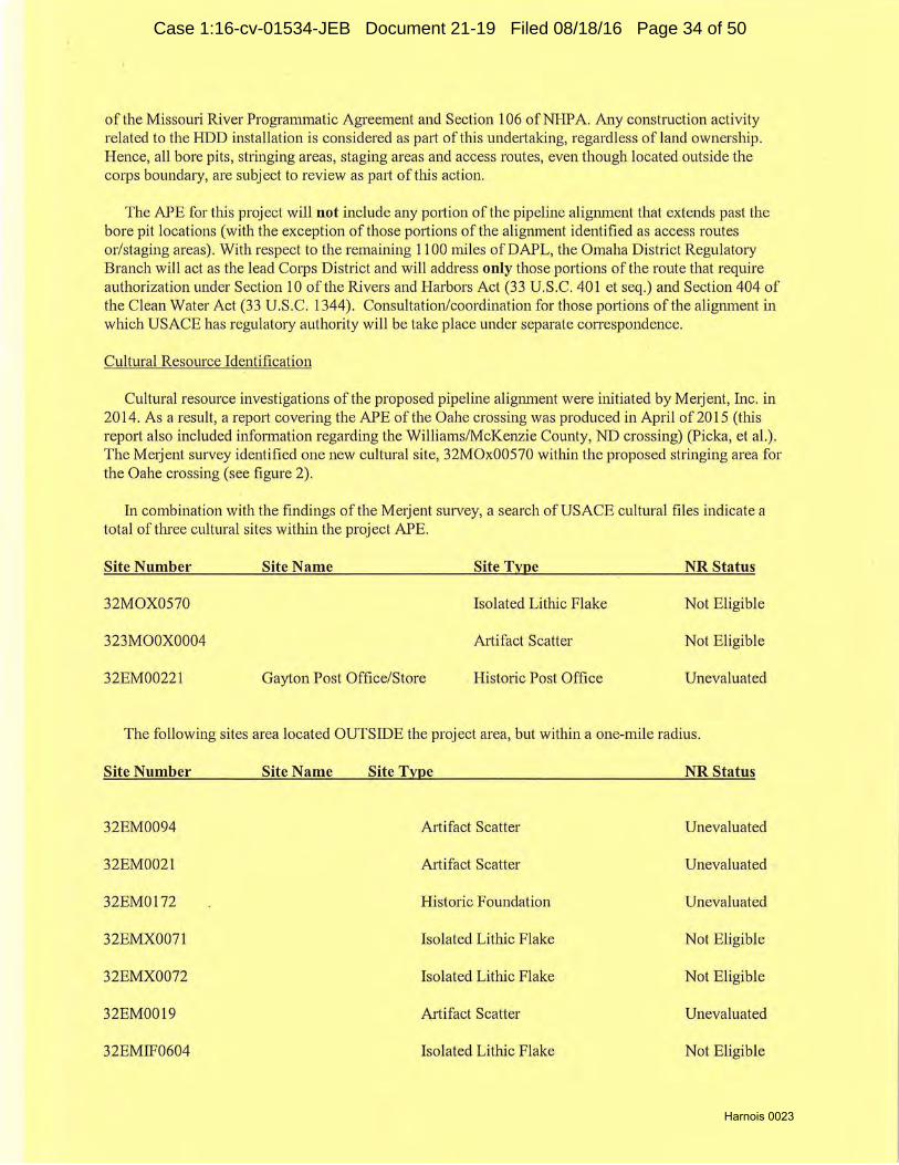
In combination with the findings of the Metjent survey, a search ofUSACE cultural files indicate a total of three cultural sites within the project APE.
Site Number Site Name Site Type NR Status
32MOX0570 Isolated Lithic Flake Not Eligible
323MOOX0004 Artifact Scatter Not Eligible
32EM00221 Gayton Post Office/Store . Historic Post Office Unevaluated
The following sites area located OUTSIDE the project area, but within a one-mile radius.
Site Number Site Name Site Type NR Status
32EM0094 Artifact Scatter Unevaluated
32EM0021 Artifact Scatter Unevaluated
32EM0172 Historic Foundation Unevaluated
32EMX0071 Isolated Lithic Flake Not Eligible
32EMX0072 Isolated Lithic Flake Not Eligible
32EM0019 Artifact Scatter Unevaluated
32EMIF0604 Isolated Lithic Flake No~ Eligible
Case 1:16-cv-01534-JEB Document 21-19 Filed 08/18/16 Page 34 of 50
Harnois 0024
32EMIF0603 Isolated Lithic Flake Not Eligible
32EM0020 Artifact Scatter Unevaluated
32EM00205 Stone Circle Unevaluated
32M00259 Artifact Scatter Unevaluated
32M00130 Artifact Scatter Unevaluated
32M00001 North Cannonball Site Eaithlodge Village Eligible
32M00054 Donahue Fannstead Historic Farmstead Unevaluated
32M00060 Historic Farmstead Unevaluated
32M00061 Attifact Scatter Unevaluated
32M01081 Historic Artifact Scatter Unevaluated
32M00200 Railroad Grade( (urntable Unevaluated
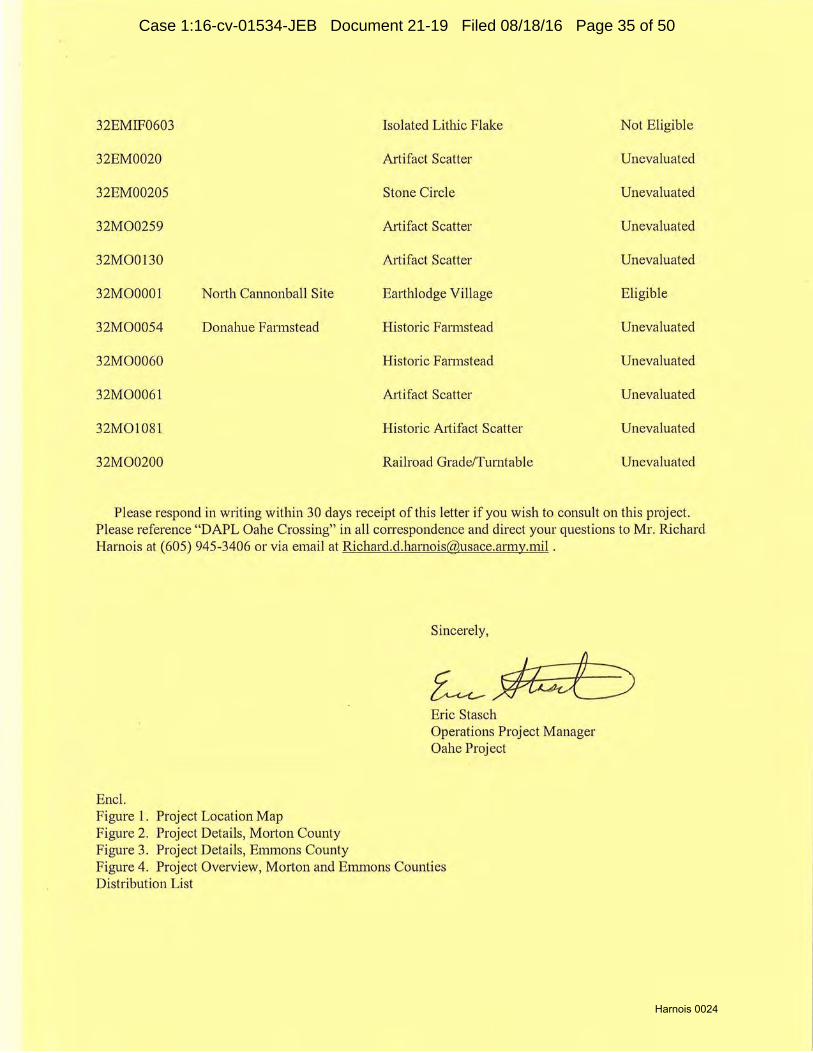
Please respond in writing within 30 days receipt of this letter if you wish to consult on this project. Please reference "DA.PL Oahe Crossing" in all correspondence and direct your questions to Mr. Richard Harnois at (605) 945-3406 or via email at [email protected] .
Encl. Figure 1. Project Location Map Figure 2. Project Details, Mmton County Figure 3. Project Details, Emmons County
Sincerely,
Eric Stasch Operations Project Manager Oahe Project
Figure 4. Project Overview, Morton and Emmons Counties Distribution L ist
Case 1:16-cv-01534-JEB Document 21-19 Filed 08/18/16 Page 35 of 50

Harnois 0025
References Cited
Larson, Thomas, Kmt Schweigert and Keith H. Dueholm Et Al., 1986 A Cultural Resource Invent my of the Left Bank o,f Lake Oahe: Burleigh and Emmons Counties,
North Dakota. Larson-Tibesar Associates Laramie, WY.
Larson, Thomas, Kurt Schweige1t and Keith H. Dueholm Et Al., 1987 A Cultural Resource Invent01y o,f the Right Bank of Lake Oahe in Morton and Sioux Counties
North Dakota. Larson-Tibesar Associates Laramie, WY.
Picka, Craig, Allison Lange Mueller, Dean Sather and Matthew Terry 2015 Class II/III Cultural Resources Invent01y of the Crossings of Flowage Easements and Federal
Lands. Merjent, Inc., Minneapolis, MN. Prepared for Dakota Access, LLC
Root, Matthew J. and Cynthia Kordecki 1983 The Cannonball Region. In Archaeology of the Northern Border Pipeline, North Dakota; Survey
and Background Information. University of North Dakota, Grand Forks.
Slessman, Scott, Vanesa Zietz, Zonna Barnes Et Al., 2010 A Cultural Resources Invento1y of US. Army C01ps of Engineers Managed Lands on Lake Oahe,
Burleigh, Morton, Emmons and Sioux Counties, North Dakota. SWCA Consultants
Case 1:16-cv-01534-JEB Document 21-19 Filed 08/18/16 Page 36 of 50

Harnois 0026
Dakota Access Pipeline Project
~ \ \ \ I ,
~~- l I l :\ I ~ . \
I Mc~ · - ~ l j _\ I ~ r I 1 Minnesota
Montana 1 North Dakota ~_____. \ l l[J L I \ i i
I I I ~ 1 \ I
I on ~ . I I
I 1 Yrs [ . I r- I I ="' I I I 1
1 r~~ [ [ I l 1 r South-Dakota \: I ----......,_,.___
Minnesoty ,(/ I -- Proposed DAPL Centerline
f~~ t .... wisconsin ""r
' , I
40 0 w •Miles w
Path: P:\GIS\Cl~nt'.ETC_EnergyTransfet'.OaJa:11AAccess_DAPL\MapslENV\NO_FlowEasements\01_NO_ProjedloCAl:IOt1J.and.mxd
Source: ArcGJS Onlloe M.'.lpplng
Figure I.Project Location Map
e
---- DAKOTA ACCESS, UC
Dakota Access Pipeline Project Figure 1
Project Location Federal Lands and Flowage Easements
1 :2,534;400
UTM83-14F Date: April. 2015
Page4
Case 1:16-cv-01534-JEB Document 21-19 Filed 08/18/16 Page 37 of 50

Harnois 0027
DAPL Morton County Missouri River Crossing
Figure 2
Legend
-- USAGE Fee Title Lands
D Cultural Resources
D west bore pit location
- Purposed pipeline route
stringing/access area
D Standing Rock Sioux Tribal Lands
N
! 0.09 0 0.09 0.18 ----- Miles
Dbdalmor: Tho Un-od St11to' govornmont ond USACE fumbhn th.1 11 dabo:indtharoclpiont11ccoptG11ndu:1.o:i.!twlththoo1Cpro$$
undor:sbndlngthatthogovorrimontrn11ko11now:i1T11.ntlos,Hprou od, Or lmp!Jod,concernlngthooccur;acy,compla tono~.rol11bill!y,U$11billty,or
s.ultablity 101 any pi:utlcubr purpoM of tho ~form 11tlon ond c!D l:I fUmJM!od. Tho Un!tod St:ltos WI bo undor no ll11oblllty "'1'1atsovor to 11ny
porwn by tOO$Ol'I of :any ieo modo t:horoof. 011b dl11ployod on th.ls map 11ro ca pprcl)dmaUof"d dor1vod from GIS byor:s 11nd
s hould notbousod ln phu;oof:1u rvoy d11taorloi11l landdi»crlptlons.
field archaeologist CENWO-OO-OA
PtoduCl'dBy. m moi;µr.nm:ilor
P1oouctlon O:it ~ .
22Jul 15
Ro lfl.:.oc! By: US Army Corps of Engineers ..,
R9'lll>nm0otu, Omaha District
A/'IG?s$1:11>jo~\Oaho orth d11k11t11\l"lpa llno'OAPL mxd
Sourco:i : 2009 NAIP lm:igory
Case 1:16-cv-01534-JEB Document 21-19 Filed 08/18/16 Page 38 of 50

Harnois 0028
DAPL Emmons County Missouri River Crossing
Figure 3
Legend
-- USACE Fee Title Lands
D Cultural Resources
D East bore pit location
- Purposed pipeline route
- East bore pit access route
N
~ 0.07 0 0.07 0.14 -- ---- Miles
Dbdalmor: Tho Unltod Stutn govommont and USACE fumbho3 thl'5dobondth<iroclplontoecoptGond u:.o:.itwlththooxpro:o:.
undorztondlngttn1tthogovommontmoko:.nowt1.trantln.oxpro:."°d· or lmpllod, coneornlng tho 11eeu1aey, complotonou, rob.billty, u-~billty, or
~ibbllitylornnyp111ticul:arpurpo'4ofthelnlorm 11tlonand d11b l\Jmllohod. Tho Unitod Sbtos Miol bo undor no llDbllity wtl11tsowr lo any
po~n by roinon of ::rny tao m11 do lhoroof. O:ib dbphayod on ttil:i. m11.p ore 11pproidm 11tlon:i dor\vodfrom GIS b yor:i 11nd
:ihould notbo u:iod ln plt1cool :i.urvoy dataorlog11l landdo:ir:rlptlon:i.
field archaeologist CENVll'O-OO-OA
P1cCucl'ld8y: m moirinm:i.ior
P1oductlonOJ \P. 22 Jul 15
Rovlood By: US Army Corps of Engineers ®
RovbnmOot ... Omaha District
AllG?s:Riojllc:ts'Oaho ortl\ do kot11\Plpollno lDAPLmxd
Soufl::oo: 2009 NAIP lm11gory
Case 1:16-cv-01534-JEB Document 21-19 Filed 08/18/16 Page 39 of 50

Harnois 0029
DAPL Morton and Emmons County Missouri River Crossing
Figure 4
-- USACE Fee Title Lands
stringing/access area
- East bore pit access route
D Standing Rock Sioux Tribal Lands
N
i 0.15 0 0.15 0.3 -- ---- Miles
Dh cl11lmor: Tho Unhd Stnto:i go11ornmont ond USACE fuml:lho:i thl$dab 11 ndlhoroelplonto.ccop1:111nd u'o:;~wlththooxpron
undon.tcmdlng that tl'KI go11ornmont m11ko' no warrontln, axprnud, or lmpllod. «incvrnlng tho ciccu11u;y. eomplotoM». rob.bU/ty, ~blllty, or
sultllbl~foronypartlcula.r purposeoftholnlormotlon and dol:I l\Jtnlshod. Tho Unltod Stltos shd bo undor no ll:iblllty Whllt$oVOf to 11ny
porwn by roa,on of:l ny u:r.o mo do thoroof. 011b dlsp.layod on thl:i m11p 11ro 11pproldm11tlor.:1 dorivodlrom GIS b yor.; and
:1hou ld not bou:i.od ln ph1coof :1urvoyd11t:1.or logoll:lnd do:ieriptlon:i.
field archaeologist
Prcducr-d6y: mog:i.n m11lo1
ProductlonO;.i\<''. 22Jul 15
R1w1~aay:
P:ov~1or-011t.i.
Rl'!GP.S1'1Vj11 ct:\011ho
CENVl/O-OO-OA
US Army Corps of Engineers "' Omaha District
orth d::ikot111P!polli\o'OA PLmxd
Soutto$: 2009 NA.IP Imo gory
Case 1:16-cv-01534-JEB Document 21-19 Filed 08/18/16 Page 40 of 50

Harnois 0030
PROGRAMMATIC AGREEMENT FOR THE OPERATIONS AND MANAGEMENT OF THE MISSOUR RIVER MAINSTEM SYSTEM
Excel sheet updated June 25, 2015 (Price) First/Middle
Count p s Last Name Organization Prefix Name Title
I p Nelson Advisorv Council for Historic Preservation Mr. Reid Director Office of Federal Agencv Programs
2 p Lusher Advisorv Council for Historic Preservation Mr. Brian Program Analvst
3 p Stafne Assinibo ine and Sioux Tribes of Fort Peck Mr. AT "Rustv" Cha innau 4 s Youpee Assiniboine and Sioux Tribes of Fort Peck Mr. C urley Director. Cultural Resources Deoartment
5 p Barnes Blackfeet Tribe Mr. Harrv Chainnan
6 s Murrav Blackfeet Tribe Mr. Jolm Tribal Historic Preservat ion Officer
7 p La Pointe Bureau of Indian Affairs Mr. Timothv Regional Director
8 s Murdy Bureau of Indian Affairs Dr. Carson Regional Archaeologist
9 p Vance Chevenne River Sioux Tribe Mr. Steven Tribal Historic Preservation Officer
10 p Petersen Chevenne River Sioux Tribe Ms. Donna Rae Cultura l Preservat ion Office
II p Uses the Knife Chevenne River SiotLX Tribe Mr. Raymond Triba l Council
12 s Frazier Cheyenne River Sioux Tribe Mr. Harold Chainnan
13 p Whitford Chiooewa Cree Tribe of the Rockv Bovs' Reservation Mr. Ted Acting Chainnan
14 p Zeohie r Crow Creek Sioux Tribe Mr. Darre ll Tribal Historic Prese.rvation Officer
15 s Sazue Crow C reek S ioux T ribe Ms. Roxanne Chairperson
16 s Pease Crow Creek S ioux Tribe Mr. Leonard Vice Chainnan
17 p Old Covote Crow Nation Mr. Darin Chainnan
18 s Bull C hief Crow Nation Mr. Emmerson Triba l Historic Preservation O ftlc er
19 p St. Claire, Jr. Eas tern Shoshone Tribe Mr. Darwin Chainnan
20 p Reider Flandreau Santee Sioux Tribe Mr. Antl1onv President
2 1 s Montova Flandreau Santee Sioux Tribe Mr. Elise Tribal Historic Preservation Officer Fort Belknap Indian Community
22 p Azure Gros VentTe and Assiniboine Tribes Mr. Mark F. President
23 p Wright Lower Brule Sioux Tribe Mr. Kevin Chainnan
24 p Jones Lower Brule Sioux Tribe Mr. Scott Cultura l Preservation O[fice
25 s Green Lower Bnde Sioux Tribe Ms. C lairS. Public Relations/Cultural Preservatation Office
26 p Crows Breast Mandan. Hidatsa & Arikara Nation Mr. Elgin Tribal Historic Preservation Officer
27 s Fox Mandan, Hidatsa & Arikarn Nttt ion Mr. Mark Chainnan 28 p Wilmotl1 Montana S tate Historic Preservation Office Dr. Stan State Archeolo1dst 29 s Baumler Montana State Historic Preservation Office Dr. Mark F. Stale Historic Preservation Officer 30 p Pahl National Trust for Historic Preservation M s. Barbara Director Mountains/Plains Office 3 1 p Geib Nebraska State Historical Society Mr. Phil State Archeologist 32 s Smith Nebraska State Historical Societv Mr. Michael J. State Historic Preservation Officer
33 p Swenson North Dakota Historical Societv Ms. Fem Deoutv State Historic Preservation Officer
34 s Berl! North Dakota Historica l Societv Ms. C laudia Sta te Historic Preservation Officer
35 p Goggles Northern Araoaho Tribe Mr. Dean Chairnrnn
36 s Soldier Wol f Northern Arapaho Tribe Ms. Yufna Tribal Historic Preservation Officer 37 p Walks Along Northern Chevenne Tribe Mr. James Tribal Historic Preservation Officer
38 s Fisher Northern Chevenne Tribe Mr. Levando President
39 p Yellowbird Steele Oglala Sioux Tribe Mr. John President
40 p Yellow ll1under Ogla la Sioux Tribe Mr. Dennis Tribal Historic Preservat ion Officer 4 1 p Parker Omaha Tribe of Nebraska Mr. ll1omas Tribal Historic Presen•ation Officer
42 s Wolfe, Jr. Omaha Tribe of Nebraska Mr. C lifford Chainnan 43 p Teboe Ponca Tribe of Nebraska Mr. Randv Tribal Historic Preservation Officer 44 s Wright Ponca Tribe of Nebraska Mr. Larrv Chainnan
45 p Kindle Rosebud Sioux Tribe Mr. William President
46 s Eagle Bear Rosebud Sioux Tribe Mr. Russell Tribal Historic Preserva tion Officer
47 p Robidoux Sac and Fox Nation of Missouri in Kansas and Nebraska Ms. Bridge tte Chairperson
48 p Massey Sac and Fox Nation of Oklahoma Ms. Sandra Historic Preservation Officer 49 p Thomas Santee Sioux Nation Mr. Rick Tribal Historic Preservation Officer
Case 1:16-cv-01534-JEB Document 21-19 Filed 08/18/16 Page 41 of 50

EXHIBIT 4
Harnois 0031
Case 1:16-cv-01534-JEB Document 21-19 Filed 08/18/16 Page 42 of 50

Harnois 0032
Rick Harnois 28563 Powerhouse Road Pierre, South Dakota 57501
Hi Rick,
T.BAL HISTORIC PRESERVATION OFFICE _r~j STANDING ROCK SIOUX TRIBE
Admin lstrat i ve Service Center North Standing Rock Avenue
Fort Yates, N.D. 58538 Tel: (701) 854-2120 Fax: (701) 854-2138
THPO 15-210
After careful consideration the SRST THPO has determined that it is in the best interest of the THPO to decline participation in the site visits and walking the project corridor APE at this time until government-to-government consultation has occurred for this project per Section 106 requirements as requested by the Standing Rock Sioux Tribe.
I have attached copies of the letters requesting the Colonel to meet with the SRST as well as the time sensitive FOIA request.
We appreciate your efforts and look forward to working with you on this project as well as other future projects. If you have any questions please don't hesitate to contact our office.
Sincerely, STANDING ROCK SIOUX TRIBE
·£:~ #nt~ ~eTi~ -~organ/ Tribal Archaeologist
Case 1:16-cv-01534-JEB Document 21-19 Filed 08/18/16 Page 43 of 50

Harnois 0033
TRIBAL COUNCIL (AT LARGE)
Jesse "Jay" Taken Alive
Ronald C. Brownotter
Avis Little Eagle
Paul Archambault
Phyllis Young
Randal J. White Sr.
Jesse McLaughlin
Vice Chnim1a11
Dave Archambault II
Chairman
August 19, 2015
Adele M. White
Secretary
Cody TwoBears Cannonball District
foe Dunn Long Soldier District
Duane Claymore Wakpala District
Frank A. White Bull Kenel District
Joe White Mountain Jr. Bear Soldier District
Milton Brown Otter Rock Creek Distrid
Colonel Joel R. Cross Commander and District Engineer U.S. Army Corps of Engineers Omaha District
Robert Taken Alive Running Antelope District
Samuel B. Harrison Porcupine District
1616 Capitol Avenue Suite 3300 Omaha, Nebraska 68102
RE: Request for Meeting on Dakota Access Pipeline
Dear Colonel Cross:
I write to request a meeting with you on the status of the proposed Dakota Access Pipeline. The Standing Rock Sioux Tribe expects the required government-togovernment consultation and environmental and cultural resource review processes to be followed with respect to Dakota Access. However, as of the present time, I have not been contacted by your office on this matter.
I would like to discuss the status of the following required regulatory actions:
• The status of the permit that will be required under section 404 of the Clean Water Act for the proposed crossing of the Missouri River.
• The status of the environmental impact statement required to be prepared by the Corps of Engineers under the National Environmental Policy Act.
• The status of the National Historic Preservation Act section 106 process for this federal undertclking.
• The consultation process that is required for the protection of Native American human remains that may be impacted by Dakota Access Pipeline under the Native American Graves Protection and Repatriation Act.
• The status of the permit that will be required to cross Lake Oahe under section 10 of the Rivers and Harbors Act.
BLDG I NORTH STANDING ROCK AVE. P.O.BOX D •FORT YATES, NORTH DAKOTA 58538 PHONE: 701-854-7201or701-854-8500 •FAX 701 -854-7299
Case 1:16-cv-01534-JEB Document 21-19 Filed 08/18/16 Page 44 of 50
Harnois 0034
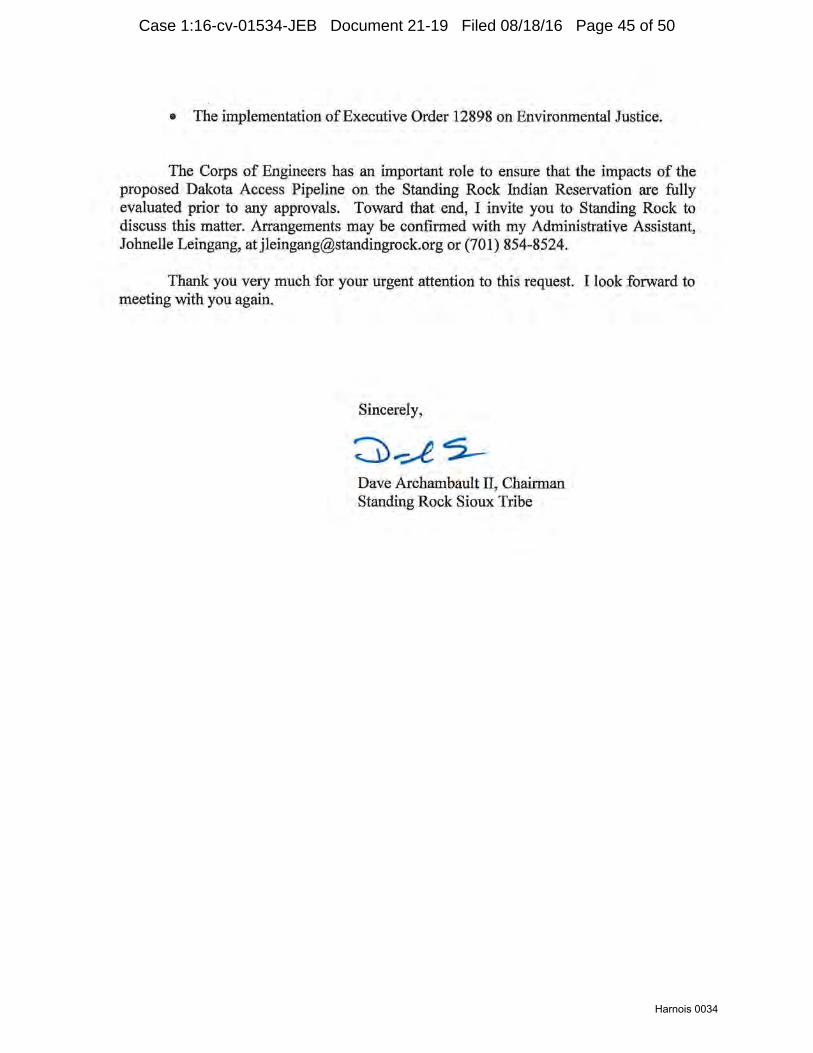
• The implementation of Executive Order 12898 on Environmental Justice.
The Corps of Engineers has an important role to ensure that the impacts of the proposed Dakota Access Pipeline on the Standing Rock Indian Reservation are fully evaluated prior to any approvals. Toward that end, I invite you to Standing Rock to discuss this matter. Arrangements may be confirmed with my Administrative Assistant, Johnelle Leingang, [email protected] or (701) 854-8524.
Thank you very much for your urgent attention to this request. I look forward to meeting with you again.
Sincerely,
Dave Archambault II, Chairman Standing Rock Sioux Tribe
Case 1:16-cv-01534-JEB Document 21-19 Filed 08/18/16 Page 45 of 50

Harnois 0035
TRIBAL COUNCIL (AT LARGE)
Jesse "Jay" Taken Alive
Ronald C. Brownotter
Avis Little Eagle
Paul Archambault
Phyllis Young
Randal J. White Sr.
Jesse Mclaughlin
\lice Clr11imrn11
Dave Archambault II
C/111im11111
August 19, 2015
Adele M. White
Secretary
Cody TwoBears Cannonball District
Joe Dunn Long Soldier District
Duane Claymore Wakpala District
Frank A. White Bull Kenel District
Joe White Mountain Jr. Bear Soldier District
Milton Brown Otter Rock Creek District
Honorable Jo-Ellen Darcy Assistant Secretary - Civil Works U.S. Department of the Army
Robert Taken AUve Running Antelope District
Samuel B. Harrison Porcupine District
I 08 Army Pentagon Washington D.C. 20310-0108
RE: Freedom of Information Act Request
Dear Assistant Secretary Darcy:
This letter is a request for records and documents under the Freedom of Information Act. 5 U.S.C. §552. I write to request that the Department of the Army provide to the Standing Rock Sioux Tribe copies of all records and documents, including correspondence and emails, relating to:
• Permits for the proposed Dakota Access Pipeline under section 10 of the Rivers and Harbors Act, section 404 of the Clean Water Act, and any other statute or regulation of the Corps requiring a permit for the proposea crossing of the Missouri River of the Dakota Access Pipeline.
• The National Historic Preservation Act (NHPA) section I 06 process for the proposed Dakota Access Pipeline, including but not limited to the applicability for the Programmatic Agreement (PA) for Missouri River operations to DAPL.
• The National Environmental Policy Act (NEPA) process for the proposed Dakota Access Pipeline.
This request includes all documents or records that may be in the possession of the Department of the Army as described above, whether on paper or in electronic form. Please advise whether any costs or charges are to be imposed in response to this request.
BLDG l NORTI-1 STANDING ROCK AVE. P.0.BOX D •FORT YATES, NORTH DAKOTA 58538 PHONE: 701-854-720 1 or 701 -854-8500 •FAX 701 -854-7299
Case 1:16-cv-01534-JEB Document 21-19 Filed 08/18/16 Page 46 of 50

Harnois 0036
The Tribal contact person for this request is Doug Crow Ghost, Standing Rock Sioux Tribe Department of Water Resources, [email protected], (701) 854-8534.
Thank you very much for your urgent attention to this matter. I look forward to a timely response as required under the Freedom of Information Act and its implementing regulations.
Sincerely,
Dave Archambault II, Chairman Standing Rock Sioux Tribe
cc: Colonel Joel R. Cross, Omaha District Commander
Case 1:16-cv-01534-JEB Document 21-19 Filed 08/18/16 Page 47 of 50
EXHIBIT 5
Harnois 0037
Case 1:16-cv-01534-JEB Document 21-19 Filed 08/18/16 Page 48 of 50

Harnois 0038
Harnois, Richard D NWO
From: Sent: To:
Cc:
Subject: Attachments:
ALCON:
Harnois, Richard D NWO Thursday, March 10, 2016 1 :40 PM Stasch, Eric D NWO; Price, Julie A NWO; Janis, Larry D NWO; Ames, Joel 0 NWO; Cossette, Brent NWO; Shelman, Johnathan A NWO; Harlan, William D Ill NWO; Grow, Catherine E NWO; Laux, Eric A NWO Chieply, Martha S NWO; Renschler, Jason J NWO; Breckenridge, Jeff L NWO; Mcqueary, Patricia L NWO; Naylor, Steven E NWO; McCullor, Matthew; Feiock, Patrick D NWO; Cain, David I NWO; Oehlerking, M J NWO; Rogers, Richard R NWO AAR; DAPL Oahe Crossing Field Visit with SRST, 3/7/16 Kellys~comments_3-7westside_sitevisit.pdf
- Oahe Project personnel conducted an onsite meeting with Standing Rock Sioux Tribe cultural resources personnel, concerning the proposed Dakota Access Pipe Line crossing of the Missouri River, in Morton County, North Dakota on Monday, March 7th, 2016.
BLUF: As far as the project ROW on the west side is concerned, no additional information regarding potential cultural resource impacts were discovered or shared with us by Tribal personnel. We are following up closely with the SRST THPO to insure this is the case.
- Attending for the USACE were Ranger Pat Feiock, Field Archaeologist Megan Maier and Senior Field Archaeologist Richard Harnois. - Attending for SRST were THPO John Eagle, Spiritual Advisor Curtis McKay, Archaeologist Kelly Morgan, NHPA Coordinator LaDonna Allard and Water Resources Director, Doug Crow Ghost.
- After gathering at the appointed rendezvous site {the Tribal Casino) we proceeded to the Cannonball Ranch. Along the route through the ranch we stopped and discussed the stringing area ape from various vantage points. The entire group was able to drive all the way to the location 'of the Northern Border Natural Gas Pipeline valve pad where we disembarked. After a cursory review of project maps and location details, Mr. Eagle took the time to express the tribes pleasure that this opportunity was provided for them to teach us a little about their culture, instead of the other way around, like it usually is. He also reiterated concerns over impacts to the large number of eagles that nest and breed in the Cannonball river bottom (more than a few eagles were present that morning). Mr. McKay then conducted a smudge ceremony for us.
- The group then proceeded on foot and by UTV (kindly provided by the SRST Preservation Office and operated by Mr. McKay) to inspect previously recorded cultural site locations in/near the project APE. Some concerns over the proximity of the proposed pipe line to that of the existing gas pipe line were expressed and some confusion of whether or not the lines would cross were discussed. Ms. Allard shared a great deal of her knowledge of the local history of the area and also guided us to the old Galpin Cemetery which was relocated by USACE in the early 1960's. It should be noted that Ms. Allard came out to help us despite a funeral taking place for her Aunt Josephine and family arriving from far away for the occasion. Her assistance and knowledge of local history was very helpful and enjoyable.
- In addition to the Galpin Cemetery, site locations for the following were inspected: 32M00060, 32M00061, 32M00054, 32M01081 and 32M00001, the Cannonball Village site. During the inspection of site 32 M00001, we also attempted to verify local reports of an exposed burial in the cutbank of the site. Although no remains were found, Ms. Allard committed to following up with her source for more information and later action. Pool levels being somewhat low for this time of year, we were able to see remnants of the old railroad bed for the "Galloping Goose" which crossed the Cannonball River at that location and also found artifacts associated with the same feature.
1
Case 1:16-cv-01534-JEB Document 21-19 Filed 08/18/16 Page 49 of 50

Harnois 0039
General takeaways:
- It was my sense that our visit was very helpful in clarifying what is and is not in the ROW for this project. Questions remain to be resolved for SRST, but the questions we have now are quite a bit more focused than many we have received to this point. - Unrelated to the project at hand, but important never-the-less, our visit of the area made clear a need to spend additional time with the SRST Preservation office in efforts to more fully document what appears to be a very rich local history.
- Due Outs:
USACE: 1. Review and provide additional informatic;m on the Northern Border easement and the level of disturbance that took place in relation to recorded site 32M00061. 2. Investigate the possibility of staking impact areas (bore pits, etc.) to help visualize proximity of project activities to areas of concern (discussed with Steve Rowe via phone, 3/9/16; awaiting further info after discussed with landowner). 3. Clarify position of existing gas line with new line; do they cross? (concern passed on to Steve Rowe via phone, 3/9/16; awaiting clarification) 4. Provide site forms for the 3 sites located within the APE on USACE lands. (emailed to Kelly 3/8/16) 5. Provide digital copies 1938 and 1945 orthographic imagery of area. 6. Complete and provide map of data collected (via GPS) during site visit. (emailed to Kelly 3/9/16) 8. Provide shapefiles of sites 32M00061, 32M00060, 32M00054, and Galpin Cemetery to SRST THPO. (emailed to Kelly 3/10/16) 9. Record Gaplin Cemetery; produce and submit ND SHPO site form and obtain Smithsonian Trinomial Identifier from NDSHPO. 10. Provide copies of photos taken during visit. (emailed to Kelly 3/8/16) 11. Contact THPO and set time/date for site visit to east side of project. (in process - anticipate next week for visit)
SRST: 1. Provide list of concerns based on site visit. (provided by Kelly via email 3/9/16; see attached file) 2. Provide map of sensitive/important areas/sites in the vicinity of the project. NOTE: This information was given with the express direction that it not be circulated outside of USACE cultural personnel. This information is mainly for our records and future use. It may, or may not affect or apply to the current project. If it does, SRST will have to indicate that to us.( provided by Kelly via email 3/9/16) 3. Follow up on information regarding possible exposure of human remains in the vicinity of 32M00001.
Please contact me with any comments or questions.
Richard D. Harnois Senior Field Archaeologist US Army Corps of Engineers Oahe Project
Office: 605-945-3406 Cell: 605-222-2216
2
Case 1:16-cv-01534-JEB Document 21-19 Filed 08/18/16 Page 50 of 50