deepwater tano cape three points (dwt ctp)...deepwater tano cape three points (dwt ctp) 03...
TRANSCRIPT
Deepwater Tano Cape Three Points (DWT CTP)
03 15.05.2019 Issued for review by EPA
A.K. Armah, ESL Consulting,
Ole Aspholm Aker Energy AS
Maree Early Per Christian
Øyan
02 11.02.2019 Issued for review by EPA A.K. Armah,
ESL Consulting Ole Aspholm Unn Arnesen
01 30.01.2019 Issued for review by EPA A.K. Armah,
ESL Consulting Ole Aspholm Unn Arnesen
Rev. Date Reason for Issue Prep. Checked Accepted
Environmental and Social Impact Assessment Scoping Study
System Area Document number Revision
NA NA DWTCTP-ESL-S-TB-0001 03
Project No. Originator Discipline Document type Sequence No. Contract No. NA
No. of pages 152
DOC.NO. DWTCTP-ESL-S-TB-0001 Environmental and Social Impact Assessment Scoping Study
REV. 02 DATE 11.02.2019 PAGE 2 of 152
ESL CONSULTING AKER ENERGY GHANA LTD
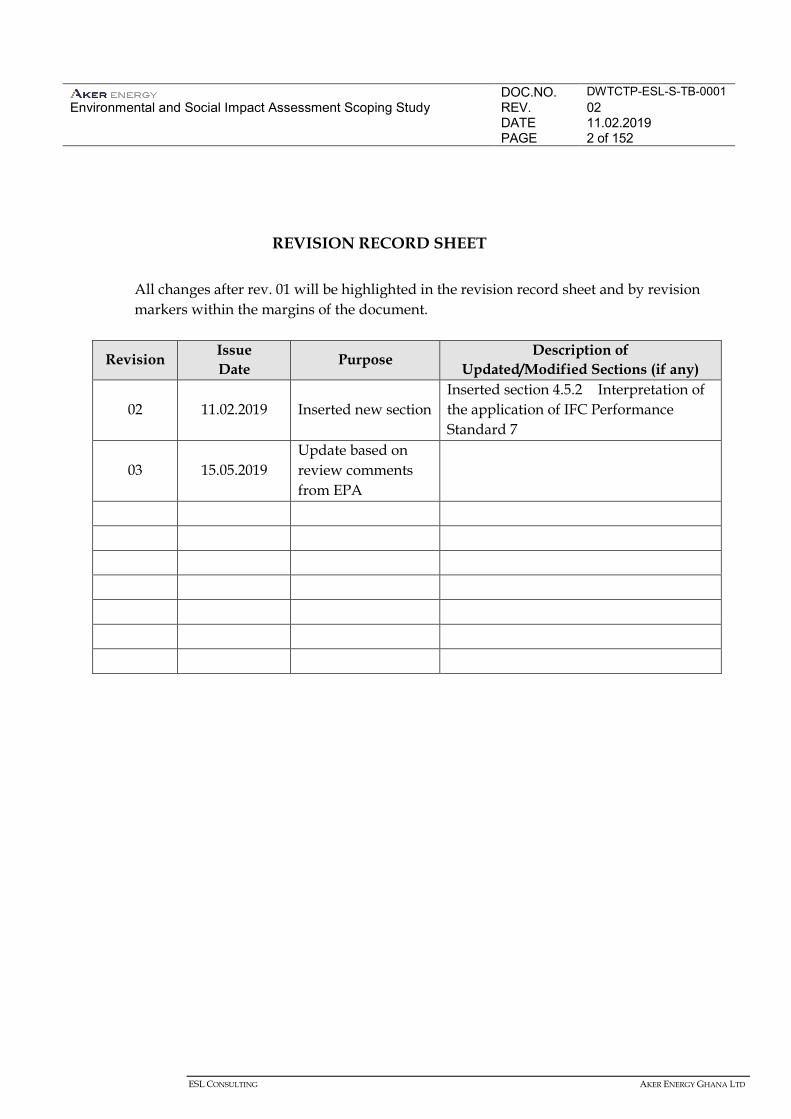
REVISION RECORD SHEET
All changes after rev. 01 will be highlighted in the revision record sheet and by revision markers within the margins of the document.
Revision Issue Date Purpose Description of
Updated/Modified Sections (if any)
02 11.02.2019 Inserted new section Inserted section 4.5.2 Interpretation of the application of IFC Performance Standard 7
03 15.05.2019 Update based on review comments from EPA
DOC.NO. DWTCTP-ESL-S-TB-0001 Environmental and Social Impact Assessment Scoping Study
REV. 03 DATE 15.05.2019 PAGE 3 of 152
ESL CONSULTING AKER ENERGY GHANA LTD.
3
CONTENTS
1 INTRODUCTION 10
1.1 PROJECT BACKGROUND 10 1.2 ENVIRONMENTAL AND SOCIAL IMPACT ASSESSMENT (EIA) 11 1.3 STRUCTURE OF THIS REPORT 16 1.4 CONTACT DETAILS 16
2 LEGAL AND POLICY FRAMEWORK 17
2.1 INTRODUCTION 17 2.2 THE PETROLEUM AGREEMENT 17 2.3 NATIONAL LAWS AND REGULATIONS 18 2.4 INTERNATIONAL AGREEMENTS AND CONVENTIONS 28 2.5 TRANSBOUNDARY REQUIREMENT 32 2.6 GOOD INTERNATIONAL INDUSTRY PRACTICE (GIIP) 34 2.7 SUSTAINABILITY REPORTING STANDARDS 34 2.8 FINANCIAL INSTITUTION STANDARDS 35 2.9 COMPANY POLICIES AND STANDARDS 36
3 PROJECT DESCRIPTION 39
3.1 PROJECT OVERVIEW 39 3.2 PROJECT ALTERNATIVES 41 3.3 PROJECT LOCATION 44 3.4 PROJECT SCHEDULE 45 3.5 FACILITIES AND EQUIPMENT 46 3.6 PROJECT ACTIVITIES 50 3.7 EMISSIONS, DISCHARGES, AND WASTE 55 3.8 PERSONNEL REQUIREMENTS 57
4 ENVIRONMENTAL AND SOCIAL BASELINE 58
4.1 INTRODUCTION 58 4.2 DATA SOURCES 59 4.3 PHYSICAL ENVIRONMENT 61 4.4 BIOLOGICAL ENVIRONMENT 68 4.5 SOCIAL BASELINE 81
5 IDENTIFICATION OF POTENTIAL IMPACTS 109
DOC.NO. DWTCTP-ESL-S-TB-0001 Environmental and Social Impact Assessment Scoping Study
REV. 03 DATE 15.05.2019 PAGE 4 of 152
ESL CONSULTING AKER ENERGY GHANA LTD.
4
5.1 INTRODUCTION 109 5.2 ENVIRONMENTAL AND SOCIAL RESOURCES AND RECEPTORS 109 5.3 IDENTIFICATION OF POTENTIAL INTERACTIONS AND IMPACTS 109
6 SCOPING STAKEHOLDER ENGAGEMENT 117
6.1 OBJECTIVES AND APPROACH 117 6.2 STAKEHOLDER ENGAGEMENT PRINCIPLES AND ACTIVITIES 117
7 THE DWT/CTP SCOPING PROCESS AND OUTCOME 120
7.1 STAKEHOLDER IDENTIFICATION (MAPPING) 120 7.2 NOTIFICATION OF KEY STAKEHOLDERS 120 7.3 CONSULTATION MEETINGS 121 7.4 MANAGING STAKEHOLDER FEEDBACK 122 7.5 SUMMARY OF COMMENTS 123 7.6 GRIEVANCE PROCEDURE 128 7.7 FUTURE STAKEHOLDER ENGAGEMENTS 128 7.8 GENERAL CONCLUSION FROM CATEGORIES OF SCOPING COMMENTS. 129 7.9 DISCLOSURE AND CONSULTATION 129
8 TERMS OF REFERENCE FOR EIA 131
8.1 INTRODUCTION 131 8.2 STEPS TO COMPLETE THE EIA 131 8.3 SCOPE OF EIA 132 8.4 LEGAL FRAMEWORK 132 8.5 PROPOSED BASELINE STUDIES 132 8.6 IMPACT ASSESSMENT METHODOLOGY 140 8.7 STAKEHOLDER ENGAGEMENT 142 8.8 STRUCTURE OF THE EIA 143 8.9 PROVISIONAL SCHEDULE FOR THE EIA PROCESS 144
9 PROPOSED TABLE OF CONTENT FOR EIA 145
REFERENCE LIST 147
APPENDICES 152
DOC.NO. DWTCTP-ESL-S-TB-0001 Environmental and Social Impact Assessment Scoping Study
REV. 03 DATE 15.05.2019 PAGE 5 of 152
ESL CONSULTING AKER ENERGY GHANA LTD.
5
LIST OF TABLES Table 2.1 International Convention and Agreements Signed by Ghana 29 Table 2.2 Relevant MARPOL 1973/1978 Provisions 30 Table 4.1 Climate and Meteorology in the Western Region of Ghana 62 Table 4.2 IUCN Red Listed Species That Could Occur in the Project’s AOI 74 Table 4.3 Whales and Dolphins of Ghana, IUCN Conservation Status 76 Table 4.4 Summary of Reported Number of Sea Turtles Nesting in Ghana 77 Table 4.5 Sea Turtles of Conservation Importance Present in the Project Area 77 Table 4.6 Coastal Ramsar Sites in Ghana 79 Table 4.7 Ghana Fisheries Subsectors 86 Table 4.8 Status of Performance against Millennium Development Goals 96 Table 4.9 Coastal Political Administration in the Western Region 96 Table 4.10 Population of Coastal Districts 98 Table 4.11 Education Levels (six years old and older) 99 Table 4.12 Health Facilities in the Western Region by Ownership and Type 100 Table 7.1 Data Gap Assessment 133 Table7.2 Quantitative Studies 139
DOC.NO. DWTCTP-ESL-S-TB-0001 Environmental and Social Impact Assessment Scoping Study
REV. 03 DATE 15.05.2019 PAGE 6 of 152
ESL CONSULTING AKER ENERGY GHANA LTD.
6
LIST OF FIGURES Figure 1-1 DWT CTP Contract Area Location 11 Figure 3-1 Schematic of FPSO for the Phase 1 Project Development 40 Figure 3-2 Project Alternatives 43 Figure 3-3 DWT CTP Contract Area With Discoveries 44 Figure 3-4 Project Schedule for Pecan Development 46 Figure 3-5 Schematic of Ship-Shaped FPSO 47 Figure 4-1 West Africa Monsoon 62 Figure 4-2 Wind Speed by Direction in the Project Area 64 Figure 4-3 Surface Current Speed in the Guinea Current 66 Figure 4-4 Ghana Local Government Structure 82 Figure 4-5 Shipping Traffic in the Gulf of Guinea 91 Figure 4-6 Health Care System in Ghana 94 Figure 4-7 Main Causes of Mortality in Ghana for Children <5 Years of Age 95 Figure 4-8 Typical School Facility in the coastal community in Western Region 99 Figure 4-9 Typical Secondary Hospital in the Western Region 100 Figure 4-10 Typical Open Waste Dump in the Western Region 103 Figure 4-11 Typical Canoe and Fishing Nets 105 Figure 4-12 Typical Artisanal Fishing Activities 107 Figure 4-13 Tourist Sites in the Coastal Districts of the Western Region 108 Figure 7-1 Evaluation of Significance 141 Figure 7-2 Required Contents of an EIA 144
DOC.NO. DWTCTP-ESL-S-TB-0001 Environmental and Social Impact Assessment Scoping Study
REV. 03 DATE 15.05.2019 PAGE 7 of 152
ESL CONSULTING AKER ENERGY GHANA LTD.
7
ACRONYMS
ALARP Reasonably Practicable CALM Catenary Anchor Leg Mooring CBD Convention on Biological Diversity CC Convention on the International Regulations for Preventing Collisions at Sea Cd Cadmium DP Dynamic Positioning DWT CTP Deep Water Tano Cape Three Points
EA Environmental Assessment EE Energy Efficiency EHS Environmental, Health and Safety EHS & SR Environmental, Health and Safety and Social Responsibility
EIA Environmental Impact Assessment – In the context of Ghana regulation EIA covers Environmental, Health and Social Impact Assessment
EIS Environmental Impact Statement EMPs Environmental Management Plans ENVID Environmental Issues Identification EP Environmental Permit EPA Environmental Protection Agency EPLT Exploration and Production Leadership Team ERM Environmental Resources Management South Africa ESMP Environmental and Social Management Plan EZZ Exclusive Economic Zone FAO Food and Agriculture Organization FEED Front End Engineering Design FPSO Floating Production, Storage and Offloading FWS Full Well Stream GCLME Guinea Current Large Marine Ecosystem Project GHG Green House Gas GIIP Good International Industry Practice GMA Ghana Maritime Authority GNPC Ghana National Petroleum Corporation Hg Mercury HVAC Heating, ventilation and air conditioning IBAT Integrated Biodiversity Assessment Tool
IFC International Finance Corporation ILO International Labour Organisation ILS In-Line Sled IMO International Maritime Organisation IPI International petroleum Industry Environmental Conservation Association ISPS International Ship and Port Facility Code ITCZ Intertropical Convergence Zone
DOC.NO. DWTCTP-ESL-S-TB-0001 Environmental and Social Impact Assessment Scoping Study
REV. 03 DATE 15.05.2019 PAGE 8 of 152
ESL CONSULTING AKER ENERGY GHANA LTD.
8
IUCN International Union for Conservation of Nature JNCC Joint Nature Conservation Committee LLMC Limitation of Liability for Maritime Claims LNG Liquefied Natural Gas MARPOL International Convention for the Prevention of Pollution from Ships, 1973, as modified in 1978 META Mahogany East, Teak and Akasa mg/kg Milligram per Kilogram mmscfd Million standard cubic feet per day MODUs Mobile Offshore Drilling Units NADF Non-Aqueous Drilling Fluid NORM Naturally Occurring Radioactive Material NPA National Petroleum Authority NRWMC National Radioactive Waste Management Centre OBF Oil Based Fluid OCNS Offshore Chemical Notification System OCNS Offshore Chemical Notification System OGP Oil and Gas Producers OOC Oil on Cuttings OPF Organic Phase Fluid OPRC Oil Preparedness, Response and Co-operation PEAs Preliminary Environmental Assessments PFD Process Flow Diagram PLET Pipeline End Terminal PER Preliminary Environmental Report POB Person on Board PoD Plan of Development ppm Parts Per Million PS Performance Standards ROC retained on cuttings SBM Synthetic Based Mud SCR Steel catenary risers SOLAS Safety of Life at Sea SOPEP Shipboard Oil Pollution Emergency Plan STCW Standards of Training, Certification, and Watch keeping for Seafarers SURF Subsea Umbilicals Risers Flowlines TBC To be confirmed TEN Tweneboa-Enyenra-Ntomme TENORM Technologically Enhanced Naturally Occurring Radioactive Material ToR Terms of Reference UK United Kingdom UKCS United Kingdom Continental Shelf UNCLOS nited Nations Convention on the Law of the Sea UNEP United Nations Environment Programme UNFCCC United Nations Framework Convention on Climate Change
DOC.NO. DWTCTP-ESL-S-TB-0001 Environmental and Social Impact Assessment Scoping Study
REV. 03 DATE 15.05.2019 PAGE 9 of 152
ESL CONSULTING AKER ENERGY GHANA LTD.
9
VLCC Very Large Crude Carrier VSP Vertical Seismic Profile WBF Water Based Fluid WBM Water Based Mud
DOC.NO. DWTCTP-ESL-S-TB-0001 Environmental and Social Impact Assessment Scoping Study
REV. 03 DATE 15.05.2019 PAGE 10 of 152
ESL CONSULTING AKER ENERGY GHANA LTD.
10
1 INTRODUCTION
1.1 PROJECT BACKGROUND
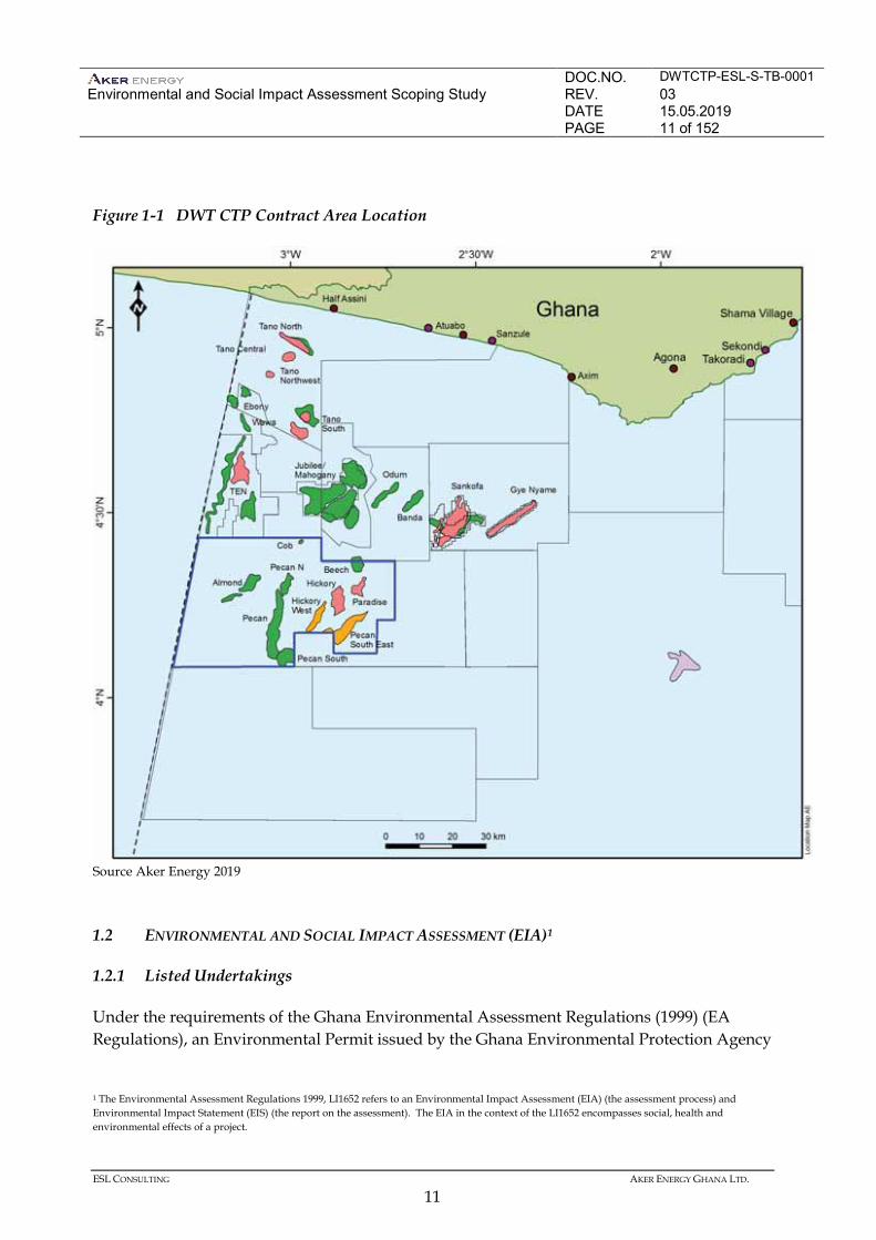
Aker Energy Ghana Limited (Aker Energy), Lukoil Overseas Ghana Tano Limited (Lukoil), Ghana National Petroleum Corporation (GNPC) and Fueltrade Limited (Fueltrade), the Contractor Group, own participating interests in the Deep Water Tano Cape Three Points (DWT CTP) Contract Area (Contract Area), with Aker Energy holding 50%, Lukoil 38%, GNPC 10% and Fueltrade 2%. The owners are considering developing the DWT/CTP Contract Area with a one Floating Production, Storage and Offloading (FPSO) hub in the Deepwater Tano Cape Three Point (DWT CTP) Contract Area (hereafter the “Project”). The Contract Area is located off the Western Region of Ghana, about 70 km from the coast at the nearest point (Figure 1-1). The Contract Area is about 60 km across covering about 200,000 ha. Water depths across the Contract Area range from 1,600 m to 2,500 m. A programme of exploration and appraisal has been undertaken over the Contract Area involving seismic surveys and well drilling to define oil and gas resources. Aker Energy is now proposing to develop the resources and would be the Operator. The Project would include: • Installation of 26 oil and gas production and injection wells; • Installation of one ship-shaped FPSO and mooring system; and • Installation of subsea infrastructure. First oil production is planned for 35 months after Final Investment Decision (FID), which is subsequent to the approval of the Plan of Development (PoD).
DOC.NO. DWTCTP-ESL-S-TB-0001 Environmental and Social Impact Assessment Scoping Study
REV. 03 DATE 15.05.2019 PAGE 11 of 152
ESL CONSULTING AKER ENERGY GHANA LTD.
11
Figure 1-1 DWT CTP Contract Area Location
Source Aker Energy 2019 1.2 ENVIRONMENTAL AND SOCIAL IMPACT ASSESSMENT (EIA)1
1.2.1 Listed Undertakings
Under the requirements of the Ghana Environmental Assessment Regulations (1999) (EA Regulations), an Environmental Permit issued by the Ghana Environmental Protection Agency
1 The Environmental Assessment Regulations 1999, LI1652 refers to an Environmental Impact Assessment (EIA) (the assessment process) and Environmental Impact Statement (EIS) (the report on the assessment). The EIA in the context of the LI1652 encompasses social, health and environmental effects of a project.
DOC.NO. DWTCTP-ESL-S-TB-0001 Environmental and Social Impact Assessment Scoping Study
REV. 03 DATE 15.05.2019 PAGE 12 of 152
ESL CONSULTING AKER ENERGY GHANA LTD.
12
is required before the Project can commence. Further, because the Project would involve an undertaking specified in Schedule 2 of the Regulations (item 12 Petroleum, (a) Oil and Gas Development), an Environmental Impact Assessment (EIA) in accordance with the EA Regulations must be submitted to Ghana EPA as a prerequisite of the Environmental Permit. 1.2.2 EIA Process
EIA is a systematic process to identify and evaluate potential impacts and risks that an activity may have on the physical, biological, chemical, social and human health environment. The EIA process is used to develop mitigation measures and management actions to avoid, minimise, restore, or offset impacts. The EIA will be conducted in accordance with the requirements of the EA Regulations. The regulated process involves a number of steps: • Registration; • Screening; • Scoping; • EIA; and • Submission of the EIA. This section outlines steps that have been completed as part of the EIA screening and scoping phases. Activities that are proposed for the next phases of the EIA are outlined in Terms of Reference in Chapter 7. 1.2.3 Registration
Undertakings likely to have significant impacts on the environment (eg, those listed in Schedule 2 of the Environmental Assessment Regulations) must register with the EPA and obtain an environmental permit before commencement of construction and operations. The proposed Project was registered with the EPA on 20 April 2015 with registration number EPA-2378/01/49. 1.2.4 Screening
As per the EA Regulations, following registration, the EPA will make a determination of the level of assessment required. The determination is to be made within 25 days of application. The EPA has determined that the development falls into the category of undertakings (Regulation 3) for which full EIA is required.
DOC.NO. DWTCTP-ESL-S-TB-0001 Environmental and Social Impact Assessment Scoping Study
REV. 03 DATE 15.05.2019 PAGE 13 of 152
ESL CONSULTING AKER ENERGY GHANA LTD.
13
1.2.5 Scoping
A principal objective of the scoping phase is to identify environmental, social, and health sensitivities and Project activities with the potential to contribute to, or cause, impacts to environmental or social receptors. At the scoping stage, the key issues are identified and understood to a level that allows the remainder of the impact assessment to be planned. This enables the resources for the EIA to be focused on collecting required information and identifying significant impacts and carrying out stakeholder engagement activities in an effective and efficient manner. The objectives of the scoping phase are to: • develop an understanding of the legislative, environmental, socio-economic, and health
context for the Project; • identify stakeholders and plan or initiate communication with these stakeholders; • identify potential significant impacts; and • develop the Terms of Reference (ToR) for the EIA. The Scoping Study has involved the following steps. • Desktop review. • Initial stakeholder engagement. • Environmental and social impact identification and scoping. • Preparation of a Scoping Report. Desktop Review
This comprised the following steps. • Identification and preliminary review of relevant laws, regulations, and policies. • Identify and review primary environmental data collected and social experience during
Exploration and Appraisal Campaigns. • Identification and review of secondary environmental and social data. • Development of a description of the Project and Project activities. • Development of a plan for stakeholder engagement (refer to Chapter 6) and consultations on
the scope of the EIA (refer to Chapter 7).
DOC.NO. DWTCTP-ESL-S-TB-0001 Environmental and Social Impact Assessment Scoping Study
REV. 03 DATE 15.05.2019 PAGE 14 of 152
ESL CONSULTING AKER ENERGY GHANA LTD.
14
Initial Legislative Review
Chapter 2 of this Scoping Report provides a review of legislation and industry guidance relevant to the EIA for the proposed Project.
Identification and Review of Secondary Data
Existing baseline information on the environmental and socio-economic context of the Project Area (as defined in Section 4.1) has been collected and reviewed and sources of other existing information identified. The EIA team has undertaken an initial review of existing information sources that contributed to an understanding of the environmental and socio-economic context of the Project (refer to Chapter 4). Available data sources have been identified for the following subjects. • Physical environment: oceanography, climate, geology, topography, bathymetry,
sediment/water quality. • Biological environment: benthos, fish, birds, marine mammals, turtles, significant natural
sites, terrestrial ecology, fauna and flora and protected areas. • Socio-economic environment: fisheries, demographics, livelihoods and cultural heritage. This desktop review also focussed on identifying where gaps in information exist and informed the data gathering requirements and the Terms of Reference for the remainder of the EIA. Outline Project Description
The Project Description in Chapter 3 of this EIA Scoping Report provides an overview of the various Project components and activities to a level that allows those activities with the potential to cause environmental, social and health impacts to be identified (eg, physical presence, noise, emissions, wastes and discharges). Project planning, decision making and refinement of the Project description continue throughout the assessment process. Environmental Issues and Identification Workshop The main environmental and social issues associated with the Project were identified through an Environmental Issues Identification (ENVID) process by the previous license contractor (Hess) in July 2015 in Houston. The objectives of the ENVID Workshop were as follows. • To identify and preliminarily assess/rank the potential environmental
DOC.NO. DWTCTP-ESL-S-TB-0001 Environmental and Social Impact Assessment Scoping Study
REV. 03 DATE 15.05.2019 PAGE 15 of 152
ESL CONSULTING AKER ENERGY GHANA LTD.
15
Impacts /issues associated with the project at a high level and, in so doing, identify ways in which these can be avoided or mitigated.
• To review the current engineering design and ensure that it meets the applicable requirements as well as good industry practice.
• To enable the transfer of all predicted environmental aspects and impacts identified to the Risk Register so that they can be reviewed coincident with the project development.
The ENVID workshop assessed the impacts of both routine and non-routine (ie, accidental or emergency events) and identified ways these impacts could be avoided or mitigated. A preliminary assessment of potential impact is described in Chapter 5. The ENVID will be reviewed and re-assessed as part of the EIA process. Stakeholder Engagement
Project stakeholder engagement started during seismic and exploratory drilling (as part of Preliminary Environmental Reports undertaken to support the drilling permit). A round of engagement with statutory consultees was undertaken to inform this Scoping Report. Further consultations with these bodies, potentially affected communities and other stakeholders will be undertaken during the main EIA phase to ensure that applicable requirements are met, stakeholder concerns are addressed. The proposed process for engaging stakeholders is outlined in Chapter 6. Analysis and Scoping The information gathered through desktop research and through stakeholder engagement was analysed through a systematic process to identify the key issues (refer to Chapter 7). Through this process, a preliminary list of potential impacts and risk was created. This list provides the focus areas for the EIA. Scoping Report
The result of the Scoping Study is this Scoping Report and ToR for the EIA. The Scoping Report has been prepared in accordance with Section Regulation 11 of the EIA Regulations. The Scoping Report is submitted to the EPA for consideration. As per the EIA Regulation, the EPA will determine whether the Scoping Report is acceptable within 25 days.
DOC.NO. DWTCTP-ESL-S-TB-0001 Environmental and Social Impact Assessment Scoping Study
REV. 03 DATE 15.05.2019 PAGE 16 of 152
ESL CONSULTING AKER ENERGY GHANA LTD.
16
1.3 STRUCTURE OF THIS REPORT
The structure of the remainder of this report is follows: Chapter 2 Legal and Policy Framework Chapter 3 Project Description Chapter 4 Environmental and Social Baseline Chapter 5 Identification of Potential Impacts Chapter 6 Stakeholder Engagement Chapter 7 Scoping Process and Outcome Chapter 8 Terms of Reference for EIA References Chapter 9 Proposed table of content for EIA The main report is supported by the following appendices: Appendix A Background Information Document (BID) and Feedback Comment Form Appendix B Aker Energy Scoping Formal Presentation (Company Profile and Scoping
Process) Appendix C Minutes of Consultation Meetings Appendix D Attendance Record Sheet Appendix E Tabulated Extracts of Written Comments Appendix F Key Comments - Friends of the Nation (FoN), Takoradi and Ghana Maritime
Authority (GMA), Accra. Appendix G Picture Gallery (Photographs taken during and after the meetings) 1.4 CONTACT DETAILS
Questions or comments on the Scoping Report should be directed to the following: Aker Energy Ghana Limited ESL Consulting Limited Jan Helge Skogen Mr. AK Armah Country Manager ESL Consulting 7th Floor Marina Mall PO Box LG 239 Plot 11/13 Airport City Legon Accra Accra +233 302 744 145 +233 244 771707 [email protected] [email protected]
DOC.NO. DWTCTP-ESL-S-TB-0001 Environmental and Social Impact Assessment Scoping Study
REV. 03 DATE 15.05.2019 PAGE 17 of 152
ESL CONSULTING AKER ENERGY GHANA LTD.
17
2 LEGAL AND POLICY FRAMEWORK
2.1 INTRODUCTION
This chapter describes relevant Ghana laws and regulations that may be applicable to the Project. This includes international treaties to which Ghana is a signatory or otherwise adopted. It also describes the policies, standards, and good international industry practices with which the Project would comply. The legal and policy requirements will be further evaluated in the EIA and the following provides a summary of an initial review. 2.2 THE PETROLEUM AGREEMENT
The Deepwater Tano/Cape Three Points Petroleum Agreement was ratified by Parliament on 19 July 2006 (Effective Date). Under Article 7.1(a), Contractor must, among other things, ‘conduct Petroleum Operations with utmost diligence, efficiency and economy, in accordance with accepted international Petroleum industry practices, observing sound technical and engineering practices using appropriate advanced technology and effective equipment, machinery, materials and methods.’ Contractor also has the right to bring to Ghana any foreign national employees necessary for its operations, and also to engage such subcontractors, whether expatriate or Ghanaian national, and to bring them and their personnel to Ghana as necessary ‘to carry out the Petroleum Operations in a skilful, economic, safe and expeditions manner’ (Arts. 7.2(d); 7.2(h)). Further, under article 20.1, Contractor must ‘give preference to materials, services and products produced in Ghana’ but only if they ‘can be supplied at prices, grades, quantities, delivery dates and on other commercial terms equivalent to or more favourable than those at which such materials, services and products can be supplied from outside Ghana.’ The Petroleum Agreement grants Contractor the right to flare Natural Gas under certain circumstances (Article 14.2). Under Article 17.2, Contractor must also ‘take all necessary steps, in accordance with accepted international Petroleum industry practice, to perform activities pursuant to the [Petroleum Agreement] in a safe manner’ and in compliance with labour, health, safety, and environmental laws and regulations issued by the Environmental Protection Agency of Ghana. Under article 26.2, the State (including its departments and agencies) “shall take no action which prevents or impedes the due exercise and performance of rights and obligations of the
DOC.NO. DWTCTP-ESL-S-TB-0001 Environmental and Social Impact Assessment Scoping Study
REV. 03 DATE 15.05.2019 PAGE 18 of 152
ESL CONSULTING AKER ENERGY GHANA LTD.
18
Parties [to the Petroleum Agreement] . . . [and] guarantees Contractor the stability . . . of the terms and conditions of the [Petroleum Agreement] . . . on the Effective Date specifically including those terms and conditions and that framework that are based upon or subject to the provisions of the laws and regulations of Ghana (and any interpretations thereof) including, without limitation, the . . . [1984] Petroleum Law . . . .” Accordingly, although this Scoping Report takes into account various legal authorities that came into effect after the Effective Date, to the extent of a conflict between a later-passed law, regulation, or rule and the Petroleum Agreement, the latter prevails. 2.3 NATIONAL LAWS AND REGULATIONS
2.3.1 Environment
Ghana Constitution
The Constitution of Ghana (Article 41(k) in Chapter 6) requires that all citizens (employees and employers) protect and safeguard the natural environment of the Republic of Ghana and its territorial waters. The Constitution is the fundamental law of Ghana and provides the framework on which all other laws stand. Environmental Protection Agency Act (Act 490 of 1994)
The Act establishes impact assessment as a legal requirement and designates the Environmental Protection Agency (EPA) as executive authority. Part I of the Act mandates the EPA with the advisory role for formulation of environmental policy, issuing of environmental permits and pollution abatement notices and prescribing standards and guidelines. The Act defines the requirement for and responsibilities of the Environmental Protection Inspectors and empowers the EPA to request that an EIA process be undertaken. Environmental Assessment Regulations (1999)
The EIA process is legislated through the Environmental Assessment Regulations (LI1-652, 1999), the principal enactment within the Environmental Protection Act (Act 490 of 1994). The Environmental Assessment (EA) Regulations require that all activities likely to have an adverse effect on the environment must be subject to impact assessment and issuance of a permit before commencement of the activity. The EA Regulations set out the requirements for the following: • Preliminary Environmental Assessment (PEA) and Report (PER); • Environmental Impact Assessments (EIA); • Environmental Impact Statement (EIS);
DOC.NO. DWTCTP-ESL-S-TB-0001 Environmental and Social Impact Assessment Scoping Study
REV. 03 DATE 15.05.2019 PAGE 19 of 152
ESL CONSULTING AKER ENERGY GHANA LTD.
19
• Environmental Management Plan (EMP); • Environmental Certificates; and • Environmental Permit (EP).
EPA Environmental Guidelines
The EPA has developed several documents providing guidance on regulatory requirements for environmental protection and, in particular, the EIA process. In particular, the EPA provides guidance and outlines procedures to be followed by the operator during the EIA process within the document Environmental Assessment in Ghana, a Guide to Environmental Impact Assessment Procedures (EPA, 1996). Other guidelines issued by the EPA and relevant for the Project are listed below: • Environmental Quality Guidelines for Ambient Air & Noise; • Guidelines for Environmental Assessment and Management in the Offshore Oil and Gas
Development (2011); • Sector Specific Effluent Quality Guidelines for Discharges into Natural Water Bodies; and • General Environmental Quality Standards for Industrial or Facility Effluents, Air Quality
and Noise Levels. Water Resources Commission Act (Act 522 of 1996) and Water Use Regulations (LI 1692 of 2001)
The Act establishes a commission to regulate and manage national water resources. The commission is tasked with establishing comprehensive plans for the use, conservation, protection, development, and improvement of Ghana’s water resources and is able to grant rights for the exploitation of water resources. The Water Use Regulations 2001 requires all persons to obtain Water Use Permits from the Water Resources Commission for commercial water use. The Commission is also mandated to request for evidence that an EIA or EMP has been approved by the EPA before issuance of the Water Use Permit, where required. Wild Animals Preservation Act (Act 43 of 1961) and Wetland Management (Ramsar Sites) Regulations, 1999
The Wild Animals Preservation Act makes provisions for the preservation of birds and fish, as well as other wild animals. The Wetland Management Regulations ratify the 1971 Wetlands Convention and provide for the establishment of Ramsar sites within Ghana. There are five designated Ramsar wetland sites along the coast of Ghana.
DOC.NO. DWTCTP-ESL-S-TB-0001 Environmental and Social Impact Assessment Scoping Study
REV. 03 DATE 15.05.2019 PAGE 20 of 152
ESL CONSULTING AKER ENERGY GHANA LTD.
20
Articles 6 and 7 of the Regulations establish the activities that are not permitted or restricted in the designated sites such as pollution of water, removal of vegetation, disposal of waste, hunting wild animals and grazing livestock, fishing using certain gear and in certain seasons, and other activities that may have an adverse effect on the environment.
The Act requires that potential impacts on coastal wetlands and marine fauna should be fully assessed and appropriate mitigation measures should be put in place to prevent, reduce and remedy any such effects. Fisheries Act (Act 625 of 2002)
The Fisheries Act (Act 625 of 2002) repeals the Fisheries Commission Act (Act 457 of 1993) to consolidate and amend the law on fisheries. The Act provides for the regulation, management, and development of fisheries and promotes the sustainable exploitation of fishery resources. Section 93 of the Fisheries Act stipulates that, if a proponent plans to undertake an activity that is likely to have a substantial impact on the fisheries resources, the Fisheries Commission should be informed of such an activity prior to commencement. The Commission may require information from the proponent on the likely impact of the activity on the fishery resources and possible means of preventing or minimising adverse impacts. The Act requires that fisheries impact assessment be conducted by the proponent. The Act establishes penalties for water pollution and adverse effects on aquatic resources (Section 92). Hazardous and Electronic Waste Control and Management Act 2016 (Act 917). The Act provides for the control, management and disposal of hazardous waste, electrical and electronic waste. It prohibits the importation, exportation, transportation, selling, purchasing or dealing in or depositing of hazardous waste or other waste on any land in the country or in the territorial waters of Ghana. It aims to ensure that hazardous and other waste products are contained and processed safely to preserve critical ecological components such as the soil, groundwater, flora and fauna. It addresses Ghana’s obligations under the Basel Convention on the Control of Transboundary Movement of hazardous Waste and their disposal. Hazardous, Electronic and Other Wastes (Classification), Control and Management Regulations, 2016 (LI 2250) The purpose of these Hazardous, Electronic and Other Wastes (Classification), Control and Management Regulations, 2016 (LI 2250) is to:
• regulate the classification, control and management of waste; • establish a mechanism and procedure for the listing of waste management activities that
do not require a Waste Management Permit; • prescribe requirements for the establishment of take-back systems;
DOC.NO. DWTCTP-ESL-S-TB-0001 Environmental and Social Impact Assessment Scoping Study
REV. 03 DATE 15.05.2019 PAGE 21 of 152
ESL CONSULTING AKER ENERGY GHANA LTD.
21
• prescribe requirements and timeframes for the management of wastes listed in the First Schedule of the regulation;
• prescribe general duties of waste generators, waste transporters and waste managers; and
• prescribe requirements for the disposal of wastes. The regulations apply to waste generators, waste transporters and waste managers. The following regulations have been evaluated as being relevant for the development and operation of the DWT CTP block:
• Waste Classification • Safety data sheet • Waste Management • Record Keeping and Waste Manifest System • Control and Management of Hazardous Wastes or Other Wastes • Decommissioning and Closure Plan
Nuclear Regulatory Authority Act (Act 895 of 2015), Ghana Atomic Energy Act (Act 204 of 1963, amended as 588 of 2000), Radiation Protection Instrument (LI 1559 of 1993) and Ghana Radioactive Waste Management Regulations (1996)
Nuclear Regulatory Authority Act, 2015 (Act 895) has replaced the Radiation Protection Board of the Ghana Atomic Energy Commission. Nuclear Regulatory Authority (NRA) is responsible to regulate and manage activities and practices for the peaceful use of nuclear material or energy, radioactive material or radiation, to provide for the protection of persons and the environment against the harmful effects of radiation hazards. These regulations provide the legal basis for regulatory control of radioactive waste management in Ghana. The Board is the sole regulatory authority mandated to establish an inventory of radiation sources in the country and evolve protection and safety strategies for the control of the radiation sources and safe disposal of radioactive waste. Any operations involving the use of irradiating devices and radioactive materials must be carried out without risk to the public health and safety and the installations and facilities are designed, installed, calibrated, and operated in accordance with prescribed standards. No person, body or institution may generate or manage waste without a valid license from the Board. The Radioactive Waste Management Regulations established the National Radioactive Waste Management Centre (NRWMC), which currently serves as a location for collection, segregation, treatment and storage of waste from generators.
DOC.NO. DWTCTP-ESL-S-TB-0001 Environmental and Social Impact Assessment Scoping Study
REV. 03 DATE 15.05.2019 PAGE 22 of 152
ESL CONSULTING AKER ENERGY GHANA LTD.
22
If Naturally Occurring Radioactive Material (NORM1) is found during well drilling or production, it can be disposed through (i) canister disposal during well abandonment; (ii) injection into the annular space of a well; (iii) shipment to shore for disposal in a landfill within sealed containers; or, depending on the type of NORM, (iv) discharge to sea with the drainage effluent. NORM-containing sludge, scale, or equipment should be treated, processed, isolated and/or disposed of according to guidelines from the International Atomic Energy Agency (IAEA) 2013 “Management of NORM Residues”. 2.3.2 Social Legislation
Labour Act (Act 651 2003)
The Labour Act consolidates and updates various pieces of former legislation, and introduces provisions to reflect International Labour Organisation (ILO) Conventions ratified by Ghana. The Act has 179 articles grouped in 20 parts. Conditions of employments, including hours of work and leave, are described in Part 3. Specific provisions for persons with disabilities, women and young persons are described in Parts 4 to 6. Occupational health and safety conditions are discussed in Part 15 and include general health and safety conditions, exposure to hazards, employer occupational accidents, and diseases reporting. The provisions from this Act are applicable to all employers and employees except those in the armed forces, police service, prisons service, or the security intelligence agencies. Article 122 regulates the inspection of work places to guarantee the enforcement of the Act’s provisions. 2.3.3 Maritime
Ghana Maritime Authority (Amendment) Act (Act 825 of 2011)
The Ghana Maritime Authority Act (2002) established the Ghana Maritime Authority (GMA) as responsible for the regulation and coordination of activities in the maritime industry and for the implementation of the provisions of enactments on shipping. The amendment empowers the Authority to apply standard global practice to impose fees and charges for services and or levies on operators in the maritime industry.
1 The geologic formations that contain oil and gas deposits may also contain naturally-occurring radionuclides, which are referred to as NORM. Because the extraction process concentrates the naturally occurring radionuclides and exposes them to the surface environment and human contact, these wastes are classified as TENORM.
DOC.NO. DWTCTP-ESL-S-TB-0001 Environmental and Social Impact Assessment Scoping Study
REV. 03 DATE 15.05.2019 PAGE 23 of 152
ESL CONSULTING AKER ENERGY GHANA LTD.
23
The Act requires clearance for Project vessels (eg, drilling rig, FPSO) travelling into the territorial waters (eg, to and from the onshore base) to be obtained from the Ghana Maritime Authority (GMA). Notification should also be made to the Ghana Navy. Maritime Pollution Act, 2016 (932)
This act addresses the prevention of pollution caused by oil, toxic liquid substances in bulk, harmful substances carried by the sea, sewage, and garbage and air pollution from ships. It ratifies the London Convention (IMO MARPOL) which aims to promote the effective control of all sources of marine pollution and to take all practicable steps to prevent pollution of the sea by dumping of wastes and other matter. The Act is relevant to discharges of sewage water, food waste and bilge water. As well as accidental spills. The Act also gives contracting parties the mandate to inspect ships including tankers and other supply vessels to ensure that their operations are safe and will not pollute the marine environment. Ghana Shipping (Amendment) Act (Act 826 of 2011)
The Shipping Act (Act 645 of 2003) regulating trade in Ghanaian waters was amended by the Ghana Shipping Amendment Act, 2011 (Act 826). The amendment was intended to inject local content into the oil and gas development by encouraging Ghanaians to participate in the shipping activities relating to offshore business. The Ghana Shipping Act, 2003 (Act 645) imposed restrictions on the trading of foreign registered ships in Ghanaian waters by preserving local trade in Ghanaian waters to Ghanaian ships. However, the current definition of Ghanaian waters is limited to the 12 nautical mile territorial sea. This amendment extends the definition of Ghanaian waters to include the waters within the 500 m safety zone generated automatically under the United Nations Convention on the Law of the Sea (UNCLOS) around installations in the exclusive economic zone beyond the territorial sea. Specifically, it extends the scope of ‘trade’ to include waters within the 500 metre safety zone of offshore installations, regardless of whether they are inside or outside the 12 nautical mile territorial sea boundary. The amendment also makes provision for the grant of permit to foreign vessels to trade in Ghanaian waters in instances where there are no Ghanaian vessels available or capable of providing those services so as not to create operational bottlenecks.
DOC.NO. DWTCTP-ESL-S-TB-0001 Environmental and Social Impact Assessment Scoping Study
REV. 03 DATE 15.05.2019 PAGE 24 of 152
ESL CONSULTING AKER ENERGY GHANA LTD.
24
This Act requires the registration of vessels, seaworthiness certifications, assurance of appropriate communication and signalling devices, and welfare of seafarers, in particular with respect to crew agreements, wages and occupational safety and health. Ghana Maritime Security (Amendment) Act (Act 824 of 2011)
The Maritime Security Act, 2011 (Act 824), amendment of the previous Act 675 of 2004 gives effect to Chapter XI-2 of the International Convention for the Safety of Life at Sea (SOLAS, 1974). The amendment intends to extend the previous application of the Ghana Maritime Security Act to offshore installations. The Act aims to enhance maritime safety and security; to create a legal framework for effective compliance with the International Ship and Port Facility Code (ISPS), defined under the International Convention; and to provide for related matters. In addition to the legislation mentioned above, other potentially relevant maritime legal instruments include: • Ghana Shipping (Protection of Offshore Operations and Assets) Regulations 2011. • Ghana Maritime Authority (Maritime Safety Fees and Charges) Regulations 2012 (L.I 2009). Requirements specified in these regulations include the development of a Ship Security Plan, a security alert system, vessel inspections and competency checks of personnel on board in terms of their abilities for shipboard security procedures. Ghana Shipping (Protection of Offshore Operations and Assets) Regulations (LI 2010 of 2012)
Offshore platforms and pipelines can present a risk to the safety of vessels navigating in the vicinity of structures and installations, especially when such structures are located in close proximity with major shipping lanes and productive fishing grounds. The 2011 Shipping Regulations, under the Ghana Shipping Act, have the following main provisions. • They provide for the creation and enforcement by the Ghana Maritime Authority and
patrol by the Ghana Navy of temporary exclusion zones around pipelines and subsea cables of not more than 100 and 50 m respectively on either side of a pipeline or cable, and an exclusion zone not exceeding 500 m from each point of the outer edge of offshore installations.
• They prohibit vessels entering the exclusion zones without prior authorisation, unless the
vessel is engaged in repair or maintenance activities of pipelines and subsea cables (Art. 2). • They prohibit anchoring and fishing activities in the pipelines and subsea cables exclusion
zones (Art. 7).

DOC.NO. DWTCTP-ESL-S-TB-0001 Environmental and Social Impact Assessment Scoping Study
REV. 03 DATE 15.05.2019 PAGE 25 of 152
ESL CONSULTING AKER ENERGY GHANA LTD.
25
• They specify the circumstances under which vessels may enter these zones (eg, to lay, maintain, renew, or remove a cable or pipeline or provide logistical support to the installation) under the authorization from the Ghana Maritime Authority.
• They include specific provisions (Articles 8 and 9) for the use of Mobile Offshore Drilling
Units (MODUs).
The Maritime Zones (Delimitation) Law (PNDCL 159 of 1986)
The extent of the territorial sea and Exclusive Economic Zone (EEZ) in Ghana is defined by the Maritime Zones (delimitation) Law (PNDCL 159), of 1986. According to the PNDCL 159, the territorial sea corresponds to the 12 nautical miles (approximately 24 km) of the low waterline of the sea, whereas the EEZ is defined by the area beyond and adjacent to the territorial sea, less than 200 nautical miles (approximately 396 km) from the low waterline of the sea. The Act also grants the rights, to the extent permitted by international law, to the government of Ghana for the purposes of: ‘exploring and exploiting, conserving and managing the natural resources, whether living or non-living, of the waters adjacent to the sea-bed and of the sea-bed and its subsoil, and with regard to any other activities for the economic exploration and exploitation of the zone, such as the production of energy from the water, currents and winds…’ (Section 5, Issue I, V-3752). 2.3.4 Petroleum Sector
The Ghana National Petroleum Corporation Law (Act 64 of 1983)
The Ghana National Petroleum Corporation Law (Act 64 of 1983) established the Ghana National Petroleum Corporation (GNPC) as mandated, to promote exploration and planned development of the petroleum resources of the Republic of Ghana. Apart from allowing the GNPC to engage in petroleum operations and associated research, the law empowers the GNPC to advise the (now) Minister of Petroleum on matters related to petroleum operations. The Petroleum Commission was established in 2011 by an Act of Parliament, Act 821, which is discussed further below, to regulate and manage the exploitation of petroleum resources and to co-ordinate the policies. The Commission took over regulation of the sector from the Minister of Energy, who until then regulated the sector with the assistance of GNPC. Act 821 specifically requires GNPC to cease to exercise any advisory function in relation to the regulation and management of the utilisation of petroleum resources and the coordination of policies in relation to them six months after the passage of Act 821. This took effect on 16 January 2012.
DOC.NO. DWTCTP-ESL-S-TB-0001 Environmental and Social Impact Assessment Scoping Study
REV. 03 DATE 15.05.2019 PAGE 26 of 152
ESL CONSULTING AKER ENERGY GHANA LTD.
26
Regulation of downstream operations is a shared responsibility between the Energy Commission, the National Petroleum Authority, and the Petroleum Commission. The Energy Commission and the National Petroleum Authority have been designed to play parallel roles in the allocation of licences for the transportation of crude oil and crude oil products. Consequently, an individual or corporate entity that wishes to engage in a business or commercial activity in the downstream industry is required to obtain the required licences from both bodies. Petroleum (Exploration and Production) Act, 2016 Act 919
This Act covers all petroleum exploration and production activities onshore and offshore on territorial land, inland waters, territorial sea, exclusive economic zone and its continental shelf. It aims to ensure safe, secure, sustainable and efficient petroleum activities to achieve long-term benefit for the people of Ghana. The Act provides for the defining and opening of licence blocks for exploration and production activities through Production Sharing Agreements. The Act also requires the Minister to undertake a strategic assessment of the impact of the petroleum activities on local communities; the impact of petroleum activities on the environment, trade, agriculture, fisheries, shipping, maritime and other industries and risk of pollution; and the potential economic and social impact of the petroleum activities. . Petroleum Commission Act (Act 821 of 2011)
The Petroleum Commission Act established the Petroleum Commission with the aim to manage Ghana’s petroleum resources. The Act establishes the Commission’s responsibilities, functioning and governance, as well as the interaction of the Commission with other government bodies in relation to petroleum resources. The Petroleum Commission seeks to implement Local Content and Local Participation through the following. • Promote local content and local participation programmes as stipulated in the Local
Content Regulation. • Liaise with external stakeholders on local content development. The Commission in this
regard has participated in several conferences and seminars to discuss the opportunities in the sector for local companies and the way forward in the sector.
DOC.NO. DWTCTP-ESL-S-TB-0001 Environmental and Social Impact Assessment Scoping Study
REV. 03 DATE 15.05.2019 PAGE 27 of 152
ESL CONSULTING AKER ENERGY GHANA LTD.
27
• Ensure that as much as practicable, the use of Ghanaian Human Resources, materials, services, and businesses for the systematic development of national capacity.
• Coordinate the flow of information amongst all relevant agencies with regard to local
content and local capacity administration. • Ensure compliance with local content targets set in the Local Content Regulations. • Promote effective coordination, management and supervision of corporate, governmental
and community interactions to support positive social development outcomes and enhance revenue generation in the sector.
Petroleum (Local Content and Local Participation) Regulations, Legislative Instrument (LI) 2204 (2013)
The stated purpose of these regulations are to promote the maximisation of value-addition and job creation through the use of local expertise, goods and services, businesses and financing in the petroleum industry value chain and their retention in the country. Local Content refers to the quantum/percentage of locally produced materials, personnel, financing, goods and services rendered to the oil industry and which can be measured in monetary terms. Local Participation on the other hand refers to the level of Ghanaian Equity Ownership in the oil and gas industry. To qualify as a Ghanaian / indigenous company, the company must have at least 51% of its equity owned by a Ghanaian with 80% management and senior positions occupied by Ghanaians. The minimum Local Content for any petroleum activity in Ghana is specified under Schedule 1. Provisions are made regarding goods and services, technical capabilities, materials and procurement, well drilling services, among others. Petroleum (Exploration and Production) (Health, Safety and Environment) Regulations, 2017
The Petroleum (Exploration and Production) (Health, Safety and Environment) Regulations, 2017 (L.I. 2258) are intended to prevent adverse effects on, and promote high standards for, health, safety and the environment from petroleum activities. The regulations require that operators and contractors in the petroleum sector have in place a HSE management system, a health and safety plan and facility Safety Case which are required to be submitted to the Petroleum Commission. The regulations cover a wide range of HSE issues including the design of production facilities in a manner that chemical and energy consumption is reduced and there is minimal pollution of the external environment. The regulations also contain various requirements relating to emissions and discharges, including reporting of flaring
DOC.NO. DWTCTP-ESL-S-TB-0001 Environmental and Social Impact Assessment Scoping Study
REV. 03 DATE 15.05.2019 PAGE 28 of 152
ESL CONSULTING AKER ENERGY GHANA LTD.
28
events, oil in water measurement, formation testing and well clean up, and use and discharge of chemicals. 2.4 INTERNATIONAL AGREEMENTS AND CONVENTIONS
2.4.1 Overview
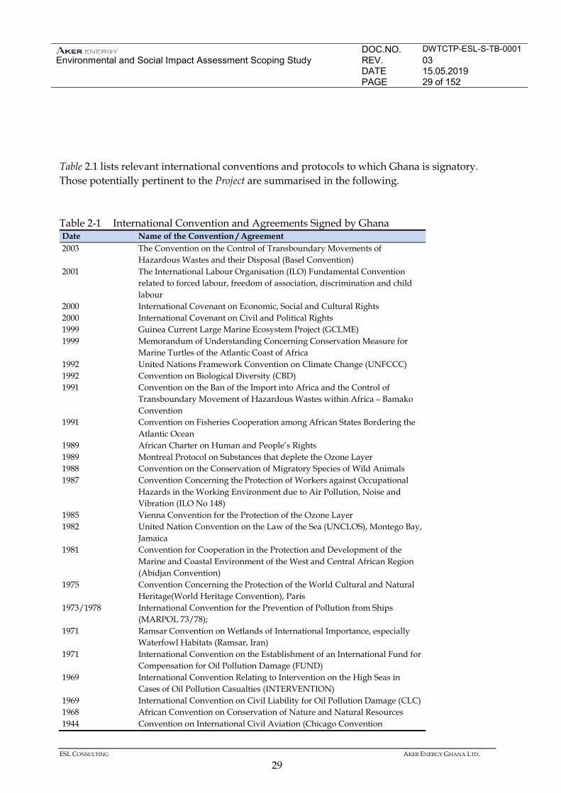
The Republic of Ghana is signatory to a number of international conventions and agreements relating to industry, development, and environmental management. In certain cases, conventions and agreements have influenced policy, guidelines and regulations and therefore are worth considering in connection with the Project.
DOC.NO. DWTCTP-ESL-S-TB-0001 Environmental and Social Impact Assessment Scoping Study
REV. 03 DATE 15.05.2019 PAGE 29 of 152
ESL CONSULTING AKER ENERGY GHANA LTD.
29
Table 2.1 lists relevant international conventions and protocols to which Ghana is signatory. Those potentially pertinent to the Project are summarised in the following. Table 2-1 International Convention and Agreements Signed by Ghana Date Name of the Convention / Agreement 2003 The Convention on the Control of Transboundary Movements of
Hazardous Wastes and their Disposal (Basel Convention) 2001 The International Labour Organisation (ILO) Fundamental Convention
related to forced labour, freedom of association, discrimination and child labour
2000 International Covenant on Economic, Social and Cultural Rights 2000 International Covenant on Civil and Political Rights 1999 Guinea Current Large Marine Ecosystem Project (GCLME) 1999 Memorandum of Understanding Concerning Conservation Measure for
Marine Turtles of the Atlantic Coast of Africa 1992 United Nations Framework Convention on Climate Change (UNFCCC) 1992 Convention on Biological Diversity (CBD) 1991 Convention on the Ban of the Import into Africa and the Control of
Transboundary Movement of Hazardous Wastes within Africa – Bamako Convention
1991 Convention on Fisheries Cooperation among African States Bordering the Atlantic Ocean
1989 African Charter on Human and People’s Rights 1989 Montreal Protocol on Substances that deplete the Ozone Layer 1988 Convention on the Conservation of Migratory Species of Wild Animals 1987
Convention Concerning the Protection of Workers against Occupational Hazards in the Working Environment due to Air Pollution, Noise and Vibration (ILO No 148)
1985 Vienna Convention for the Protection of the Ozone Layer 1982 United Nation Convention on the Law of the Sea (UNCLOS), Montego Bay,
Jamaica 1981 Convention for Cooperation in the Protection and Development of the
Marine and Coastal Environment of the West and Central African Region (Abidjan Convention)
1975
Convention Concerning the Protection of the World Cultural and Natural Heritage(World Heritage Convention), Paris
1973/1978
International Convention for the Prevention of Pollution from Ships (MARPOL 73/78);
1971 Ramsar Convention on Wetlands of International Importance, especially Waterfowl Habitats (Ramsar, Iran)
1971 International Convention on the Establishment of an International Fund for Compensation for Oil Pollution Damage (FUND)
1969 International Convention Relating to Intervention on the High Seas in Cases of Oil Pollution Casualties (INTERVENTION)
1969 International Convention on Civil Liability for Oil Pollution Damage (CLC) 1968 African Convention on Conservation of Nature and Natural Resources 1944 Convention on International Civil Aviation (Chicago Convention
DOC.NO. DWTCTP-ESL-S-TB-0001 Environmental and Social Impact Assessment Scoping Study
REV. 03 DATE 15.05.2019 PAGE 30 of 152
ESL CONSULTING AKER ENERGY GHANA LTD.
30
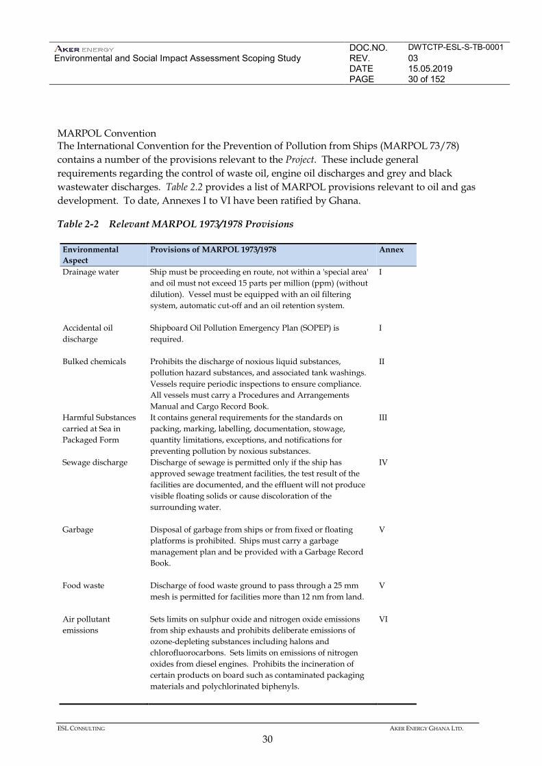
MARPOL Convention The International Convention for the Prevention of Pollution from Ships (MARPOL 73/78) contains a number of the provisions relevant to the Project. These include general requirements regarding the control of waste oil, engine oil discharges and grey and black wastewater discharges. Table 2.2 provides a list of MARPOL provisions relevant to oil and gas development. To date, Annexes I to VI have been ratified by Ghana.
Table 2-2 Relevant MARPOL 1973/1978 Provisions
Environmental Aspect
Provisions of MARPOL 1973/1978 Annex
Drainage water
Ship must be proceeding en route, not within a 'special area' and oil must not exceed 15 parts per million (ppm) (without dilution). Vessel must be equipped with an oil filtering system, automatic cut-off and an oil retention system.
I
Accidental oil discharge
Shipboard Oil Pollution Emergency Plan (SOPEP) is required.
I
Bulked chemicals
Prohibits the discharge of noxious liquid substances, pollution hazard substances, and associated tank washings. Vessels require periodic inspections to ensure compliance. All vessels must carry a Procedures and Arrangements Manual and Cargo Record Book.
II
Harmful Substances carried at Sea in Packaged Form
It contains general requirements for the standards on packing, marking, labelling, documentation, stowage, quantity limitations, exceptions, and notifications for preventing pollution by noxious substances.
III
Sewage discharge
Discharge of sewage is permitted only if the ship has approved sewage treatment facilities, the test result of the facilities are documented, and the effluent will not produce visible floating solids or cause discoloration of the surrounding water.
IV
Garbage
Disposal of garbage from ships or from fixed or floating platforms is prohibited. Ships must carry a garbage management plan and be provided with a Garbage Record Book.
V
Food waste
Discharge of food waste ground to pass through a 25 mm mesh is permitted for facilities more than 12 nm from land.
V
Air pollutant emissions
Sets limits on sulphur oxide and nitrogen oxide emissions from ship exhausts and prohibits deliberate emissions of ozone-depleting substances including halons and chlorofluorocarbons. Sets limits on emissions of nitrogen oxides from diesel engines. Prohibits the incineration of certain products on board such as contaminated packaging materials and polychlorinated biphenyls.
VI
DOC.NO. DWTCTP-ESL-S-TB-0001 Environmental and Social Impact Assessment Scoping Study
REV. 03 DATE 15.05.2019 PAGE 31 of 152
ESL CONSULTING AKER ENERGY GHANA LTD.
31
2.4.2 United Nation Convention on the Law of the Sea (UNCLOS)
The 1982 United Nations Convention on the Law of the Sea (UNCLOS) sets out the general framework for all marine and maritime activities, including jurisdiction over maritime areas and specific provisions regarding pollution from offshore activities and transboundary pollution (Article 194[c]). Article 80 on artificial islands, installations and structures on the continental shelf gives the right to establish an up to 500 metre wide safety zone around installations on the continental shelf. With respect to pollution from offshore activities, Article 194 provides that ‘States shall take all measures necessary to prevent, reduce and control pollution of the marine environment from any source’, including measures ‘designed to minimise to the fullest possible extent’ pollution from installations and devices used in exploration or exploitation of the natural resources of the seabed and subsoil, in particular ‘measures for preventing accidents and dealing with emergencies’. Although UNCLOS highlights the importance of preparedness (or preventative measures) and contingency planning in the context of offshore installations and devices used in exploration it does not detail the specific steps that States must take in this context. This responsibility falls to States to ‘adopt laws and regulations to prevent, reduce and control pollution of the marine environment’ in connection with marine activities subject to their jurisdiction. It also provides that States ‘shall establish global and regional rules, standards and recommended practices and procedures to that effect (1). However, international attempts to negotiate a global instrument have been unsuccessful. Ghanaian implementation of this Convention requires vessels travelling into Ghanaian territorial waters to obtain clearance from the Ghana Maritime Authority (GMA) and to notify the Ghana Navy. 2.4.3 Convention on Oil Pollution Preparedness, Response and Cooperation (1990)
On a global level, the 1990 Convention on Oil Pollution Preparedness, Response and Cooperation (OPRC) identifies the legal duties necessary to ensure adequate preparedness, contingency planning and response to a spill. In this context, OPRC provides for the following specific obligations on the parties.
(1) Ibid, Article 208(5)
DOC.NO. DWTCTP-ESL-S-TB-0001 Environmental and Social Impact Assessment Scoping Study
REV. 03 DATE 15.05.2019 PAGE 32 of 152
ESL CONSULTING AKER ENERGY GHANA LTD.
32
• Undertaking (individually or jointly) all appropriate measures to prepare for and respond to an oil pollution incident.
• Requiring that operators of offshore installations have oil pollution emergency plans in
place (co-ordinated with the national system in place and approved by the Ghana Maritime Authority.
• Establishing a national system for responding promptly and effectively to oil pollution
incidents, including a national contingency plan for preparedness and response. • Establishing (either unilaterally or through bilateral or multilateral co-operation) a
minimum level of pre-positioned oil spill combating equipment, commensurate with the risk involved, programmes for its use, programmes of exercises and training, detailed plans and communication capabilities and coordinated arrangements.
Implementation of this Convention in Ghana requires the establishment of a contingency plan to combat accidental pollution to be coordinated with the National Oil Spill Contingency Plan. It also requires approval by the EPA. 2.5 TRANSBOUNDARY REQUIREMENT
The Project Area is located in the same gulf as several other West African nations. Given the location, there is the possibility that Project activities could affect resources and receptors across national borders. A comprehensive review of the legal and policy requirements related to transboundary issues will occur during the EIA following consultation with stakeholders during scoping. 2.5.1 National Requirements
Part 12(o) of the EA Regulations requires that the EIA ToR include an indication of whether any area outside Ghana is likely to be affected by the activities of the undertaking. 2.5.2 International Requirements
Requirements related to transboundary issues are contained in UNCLOS
Provisions in UNCLOS that are applicable in the context of transboundary pollution, irrespective of whether it occurred from offshore activities, include the following.
• Notification of imminent or actual damage (Article 198).
DOC.NO. DWTCTP-ESL-S-TB-0001 Environmental and Social Impact Assessment Scoping Study
REV. 03 DATE 15.05.2019 PAGE 33 of 152
ESL CONSULTING AKER ENERGY GHANA LTD.
33
• Co-operating on activities that may cause transboundary pollution and jointly developing
and promoting contingency plans for responding to pollution incidents (Article 199). • Monitoring of the risks or effects of pollution (Article 205). • Publication of the reports presenting the results of the monitoring studies (Article 205). • Assessing potential effects of activities (Article 206).
Oil Preparedness, Response and Co-operation (OPRC)
OPRC provides for the specific obligations on the parties relative to transboundary issues. With respect to contingency plans, OPRC acknowledges the importance of mutual assistance and international cooperation, including exchange of information, respecting the capabilities of States to respond to oil incidents and the preparation of oil pollution contingency plans. OPRC also expresses the need to promote international cooperation to enhance existing national, regional and global capabilities concerning oil pollution preparedness and response, taking into account the special needs of developing countries.
DOC.NO. DWTCTP-ESL-S-TB-0001 Environmental and Social Impact Assessment Scoping Study
REV. 03 DATE 15.05.2019 PAGE 34 of 152
ESL CONSULTING AKER ENERGY GHANA LTD.
34
2.6 GOOD INTERNATIONAL INDUSTRY PRACTICE (GIIP)
The following guidelines and best practices standards provided by the International Association of Oil and Gas Producers (OGP), IPIECA and others are relevant to the Project. • Environmental, Social Health Risk and Impact Management Process, 2007. • Environmental Management in Oil and Gas Exploration and Production, 1997. • HSE Management Guidelines for Working Together in a Contact Environment, 2010. • Waste Management Guidelines, 1993.
• Guidelines for waste management with special focus on areas with limited infrastructure
Report No. 413, rev1.1 IOGP 2009. • Alien invasive species and the oil and gas industry, 2010. • Guidance on Improving Social and Environmental performance: Good Practice Guidelines
for the Oil and Gas Industry, 2011.
• Good Practice Guidelines Series on Oil Spill Preparedness and Response, by IPIECA and IOGP (http://www.oilspillresponseproject.org/).
• IPIECA’s Biodiversity and ecosystem services fundamentals. Guidance document for the
oil and gas sector, 2016. • IPIECA & IOGP. Preparing effective flare management plans: Guidance document for the
oil and gas industry 2011.
• IPIECA-OGP online guideline for energy and GHG efficient technologies and practices (http://www.ipieca.org/resources/energy-efficiency-solutions/).
2.7 SUSTAINABILITY REPORTING STANDARDS
A sustainability report is a report about the economic, environmental and social impacts caused by the Projects everyday activities and demonstrates the link between the Projects strategy and its commitment to a sustainable global economy. The Project will evaluate whether to follow The Global Reporting Initiative for Sustainability Reporting Standard or the IPIECA guideline on voluntary sustainability reporting.
DOC.NO. DWTCTP-ESL-S-TB-0001 Environmental and Social Impact Assessment Scoping Study
REV. 03 DATE 15.05.2019 PAGE 35 of 152
ESL CONSULTING AKER ENERGY GHANA LTD.
35
The Oil and gas industry guidance on voluntary sustainability reporting is IPIECA’s key tool to help companies shape the structure and content of their sustainability reporting. Published in conjunction with the American Petroleum Institute (API) and the International Association of Oil & Gas Producers (IOGP). 2.8 FINANCIAL INSTITUTION STANDARDS
The standards of financial institution are generally applied in the case where a Project is financed and in such an event, the environmental and social requirements of the particular financial institution are applied. Where the specific financial institutions that may fund the project are not known at an early stage in the project, the standards provided in the IFC Performance Standards for Environmental and Social Sustainability (IFC Performance Standards) and the Equator Principles, as well as UN’s Guiding Principles on Business and Human Rights are commonly applied. These standards are used by Development Finance Institutions (DFI) and Equator Principal Finance Institutions (EPFI) globally. 2.8.1 IFC Performance Standards
Seven of the eight IFC Performance Standards may be relevant to the Project: • Performance Standard 1: Assessment and Management of Environmental and Social Risks
and Impacts; • Performance Standard 2: Labour and Working Conditions; • Performance Standard 3: Resource Efficiency and Pollution Prevention; • Performance Standard 4: Community Health, Safety and Security; • Performance Standard 5: Land Acquisition and Involuntary, in case of acquiring of new
land area for development of land base facilities;
• Performance Standard 6: Biodiversity Conservation and Sustainable Management of Living Natural Resources; and
• Performance Standard 8: Cultural Heritage, might be relevant if evidence of marine
archaeology were to be identified in the Project Area of Influence, or in case of acquiring of new land area for development of land base facilities. This would be further investigated in the EIA.
DOC.NO. DWTCTP-ESL-S-TB-0001 Environmental and Social Impact Assessment Scoping Study
REV. 03 DATE 15.05.2019 PAGE 36 of 152
ESL CONSULTING AKER ENERGY GHANA LTD.
36
• Performance Standard 7: Indigenous People, as defined in the Performance Standard, there are no indigenous people in the Project Area of Influence, see Section 4.5.2 for closer discussion.
2.8.2 Environmental, Health, and Safety (EHS) Guidelines
The EHS Guidelines are designed to provide relevant industry background and technical information that would help avoid, minimise, and control EHS impacts during construction, operation, and decommissioning of an offshore oil and gas project. The EHS Guidelines serve as a technical reference source to support the implementation of the IFC Performance Standards, particularly in those aspects related to Performance Standard 3: Resource Efficiency and Pollution Prevention, as well as certain aspects of occupational and community health and safety. During the EIA, the legal review would determine where the Ghana regulations differ from the levels and measures presented in the EHS Guidelines. The Project is expected to achieve whichever is more stringent. However, if less stringent levels or measures are appropriate in view of specific project circumstances, a full justification for proposed alternatives would be provided. The general EHS Guidelines contain information on cross-cutting environmental, health, and safety issues potentially applicable to all industry sectors and would be used together with the relevant IFC industry sector guidelines. For the Project, the relevant EHS Guidelines that would be applied: • EHS General Guidelines (2007); and • EHS Guidelines for Offshore Oil and Gas Development (2015). 2.9 COMPANY POLICIES AND STANDARDS
The Project would comply with the environmental and social policies and standards of the Operator or as otherwise approved by the Contactor Group. All Project activities would be conducted in compliance with applicable laws, act and regulations, Aker Energy requirements and procedures and recognized industry standards, design codes and practices. The Aker Energy’s HSE Policy Statement and the Corporate Social Responsibility Policy including Human Rights Principles will be implemented through the FPSO sub-contractors Management System. The Management system comprises, but is not limited to, a Health,
DOC.NO. DWTCTP-ESL-S-TB-0001 Environmental and Social Impact Assessment Scoping Study
REV. 03 DATE 15.05.2019 PAGE 37 of 152
ESL CONSULTING AKER ENERGY GHANA LTD.
37
Safety and Environment (HSE) Management System and a Corporate Social Responsibility (CSR) Management System. The Policies set out the top-level goals and commitments and the framework under which the proposed Project would be designed and operated. These commitments will be fully aligned with Ghana requirements and good international industry practice. Corporate responsibility shall be reflected in Aker Energy’s core values and in the entire range of activities. Aker Energy commits to undertaking the following. • Operate its business with integrity and respect laws, different cultures and human dignity
and human rights.
• Operate its business in accordance with fundamental human rights as enshrined in the UN Human Rights Declaration and follow the standards of the International Labour Organization.
• Show consideration for the local community and emphasize spin-off effects of the
company’s activities. • In its role as partner contribute to learning and distribution of knowledge. • Establish long-term working relationships and utilize the supplier industry’s expertise for
the further development of the industry. Safeguarding Health, Safety and Environment in all activities is an important goal for Aker Energy and to provide this Aker Energy commits to the following: • In planning of activities and operations, Aker Energy shall strive to reduce risk as much as
reasonably practicable.
• Aker Energy shall be a safe workplace, where the goal is to prevent any kind of harm. All who work for us – our employees, hired personnel and contractors – shall be able to perform their work in an environment where the emphasis is on the safety of all individuals in the workplace. Our facilities shall be in good condition, and they shall be planned, designed and maintained in a manner ensuring their technical integrity.
• Aker Energy shall avoid harm to the environment by reducing the risk of any adverse
effects on the environment as much as possible.
• Aker Energy shall achieve this goal by means of good risk management and by ensuring that health, safety and environment (HSE) is an integrated part of all our activities.
DOC.NO. DWTCTP-ESL-S-TB-0001 Environmental and Social Impact Assessment Scoping Study
REV. 03 DATE 15.05.2019 PAGE 38 of 152
ESL CONSULTING AKER ENERGY GHANA LTD.
38
The structure of Aker Energy Management System Framework is modelled on a continual improvement cycle of five phases: commit, plan, perform, measure, review and improve. These are the fundamental management system phases behind the elements of the HSE and CSR Management System Framework and represent the key steps towards improving corporate performance. Project sub-contractors are required to have their own HSE management systems in place, which, at a minimum, meet Ghana laws and regulations. A Project Management System Interface Document would be prepared that describes the bridging of control between the Aker Energy and the contractor for key activities and/or HSE and CSR sensitivities. Such documents outline the systems and procedures developed to ensure that the proposed operations carried out by the sub-contractor on behalf of the Contractor Group are managed safely and to high standards with due regard for the environment and people.
DOC.NO. DWTCTP-ESL-S-TB-0001 Environmental and Social Impact Assessment Scoping Study
REV. 03 DATE 15.05.2019 PAGE 39 of 152
ESL CONSULTING AKER ENERGY GHANA LTD.
39
3 PROJECT DESCRIPTION
3.1 PROJECT OVERVIEW
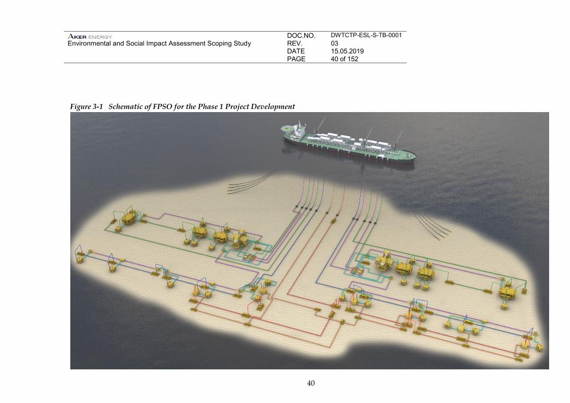
The current Phase 1 field scenario Project concept would involve the following activities: • Installation of 14 oil and gas production wells; • Installation of 12 Water Alternating Gas (WAG) injection wells; • Installation of 4 drill centres; • Installation of one ship-shaped FPSO and mooring system; and • Installation of subsea infrastructure, including multi-phase lifting pumps. Phase 1 is selected developed with a stand-alone FPSO because of the distance between the various reservoir discoveries, additional FPSO’s can potentially be developed in later phases. Schematic overviews of the FPSO development are shown in Figure 3-1. Figure 3-4 shows the DWT CTP Contract area with the present discoveries. More exploration in the block is expected and plans for extension of later phase field developments are still being reviewed. This chapter provides a description of the Project facilities and equipment, main project activities, and associated emissions and discharges. Information on project personnel is also provided. The Project engineering FEED studies are under evaluation and the design details are expected to be refined concurrently with the EIA development and approval process. An EIA would present the detailed design concept assessed in the EIA.
DOC.NO. DWTCTP-ESL-S-TB-0001 Environmental and Social Impact Assessment Scoping Study
REV. 03 DATE 15.05.2019 PAGE 40 of 152
40
Figure 3-1 Schematic of FPSO for the Phase 1 Project Development
DOC.NO. DWTCTP-ESL-S-TB-0001 Environmental and Social Impact Assessment Scoping Study
REV. 03 DATE 15.05.2019 PAGE 41 of 152
ESL CONSULTING AKER ENERGY GHANA LTD.
41
3.2 PROJECT ALTERNATIVES
This section describes the work undertaken for selecting the design concept and the process that will be followed for refining the Project design. 3.2.1 Base Design
The Project development location was defined based on the geophysical data and subsequent exploration and appraisal well drilling. Results of well testing indicated accumulations of oil and gas within the DWT CTP Contract Area. The potential development and production concept is based on the results of the exploratory and appraisal drilling and is designed to optimise the extraction of hydrocarbons in the most efficient and cost effective manner. The location of the FPSO also considered the location of the proposed oil and gas production wells with the design intended to minimise the distance between wells and the production facilities, and to optimize potential for later phase developments with tie-back to the FPSO. The technical, operational, and economic factors associated with various development approaches were evaluated. Oil industry experiences in similar fields, including developments offshore Ghana, were used to define the approach. Based on an evaluation of production operational risks, project cost, environmental and social factors, and schedule risks associated with installation and risks arising from major accidental hazards, the option involving one ship-shaped FPSO was determined to have the lowest risk for both project installation and operational phases. Similar to decision making for the option with one FPSO, several factors were considered to determine the best approach for subsea infrastructure design, including location, water depth, reservoir depth, and aerial extent of the fields. The Project base design goal would be to use proven subsea production and control systems tied back to the FPSO, utilizing proven processing equipment. The proposed approach has been used successfully at the Jubilee Field, TEN Field, Sankofa Field and elsewhere in West Africa and other deep-water locations around the world. 3.2.2 Engineering Design Alternatives
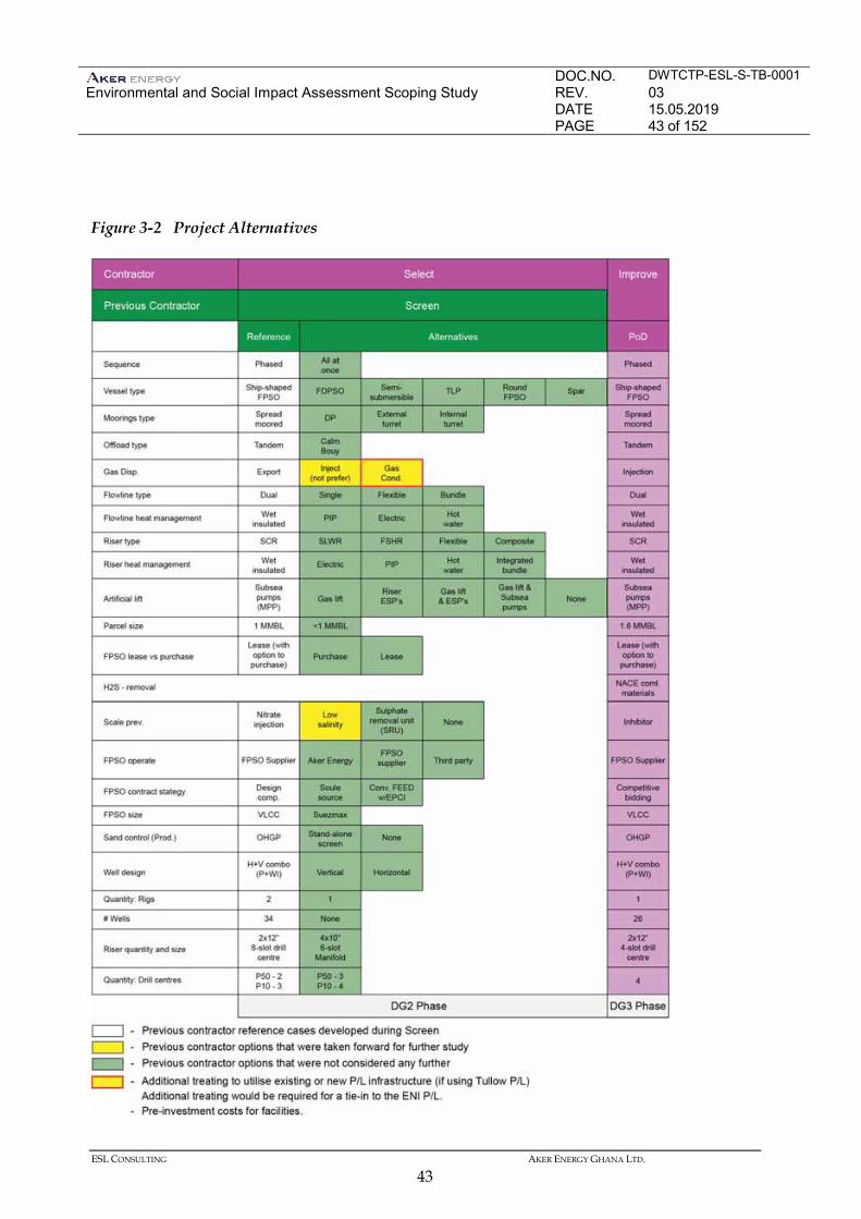
Aker Energy will continue to evaluate detailed design alternatives, based on safety, engineering, technical, financial, environmental, and social considerations, in order to determine the optimum field development design. Figure 3-3 shows the multiple design alternatives that have been considered through the ongoing design optimization.
DOC.NO. DWTCTP-ESL-S-TB-0001 Environmental and Social Impact Assessment Scoping Study
REV. 03 DATE 15.05.2019 PAGE 42 of 152
ESL CONSULTING AKER ENERGY GHANA LTD.
42
The FPSO has been selected for the Pecan field centre based on the following merits: • Suitable for ultra-deep waters with favourable motion characteristics • Local oil storage and offloading • Flexibility for potential future topside expansions and tiebacks • High availability of production and utility systems in combination with water and gas
injection to maximize Pecan field recovery • Track records in other African offshore field The EIA will provide a detailed description of the consideration of alternatives, including an outline of design or criteria for selecting preferred alternatives.
DOC.NO. DWTCTP-ESL-S-TB-0001 Environmental and Social Impact Assessment Scoping Study
REV. 03 DATE 15.05.2019 PAGE 43 of 152
ESL CONSULTING AKER ENERGY GHANA LTD.
43
Figure 3-2 Project Alternatives
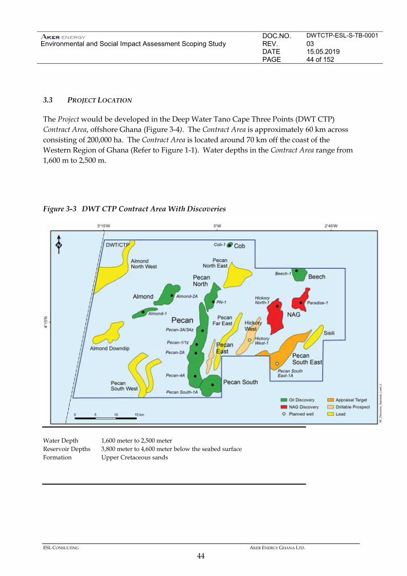
DOC.NO. DWTCTP-ESL-S-TB-0001 Environmental and Social Impact Assessment Scoping Study
REV. 03 DATE 15.05.2019 PAGE 44 of 152
ESL CONSULTING AKER ENERGY GHANA LTD.
44
3.3 PROJECT LOCATION
The Project would be developed in the Deep Water Tano Cape Three Points (DWT CTP) Contract Area, offshore Ghana (Figure 3-4). The Contract Area is approximately 60 km across consisting of 200,000 ha. The Contract Area is located around 70 km off the coast of the Western Region of Ghana (Refer to Figure 1-1). Water depths in the Contract Area range from 1,600 m to 2,500 m.
Figure 3-3 DWT CTP Contract Area With Discoveries
Water Depth 1,600 meter to 2,500 meter Reservoir Depths 3,800 meter to 4,600 meter below the seabed surface Formation Upper Cretaceous sands
DOC.NO. DWTCTP-ESL-S-TB-0001 Environmental and Social Impact Assessment Scoping Study
REV. 03 DATE 15.05.2019 PAGE 45 of 152
ESL CONSULTING AKER ENERGY GHANA LTD.
45
3.4 PROJECT SCHEDULE
The Project would be developed in phases allowing the collection of data in early drilling and production periods to inform continued project optimisation. Figure 3-4 gives the project schedule for the Pecan development from Final Investment Decision (FID), which is subsequent to the approval of the Plan of Development (PoD). First oil from Pecan field is estimated to be produced 35 months after the DWT/CTP Parties have made the final investment decision (FID) for the Pecan development project. Construction of the FPSO, with hull conversion, topside fabrication and integration is planned started five months after FID and is expected to last for 22 months. Sailaway from the yard towards Ghana is planned for 27 months after FID. The drilling and completions are planned to commence 21 months after FID and last for five years. Subsea equipment installation for the would occur approximately 20 months after FID and last for 10 months. Hook-up of the FPSO with risers and umbilicals on the field, and pre-commissioning is expected to start 30 - 32 months after FID and last for 3 months until ready for first oil. Establishment of shore base in Ghana will start one month after FID and is planned to last for 20 months.
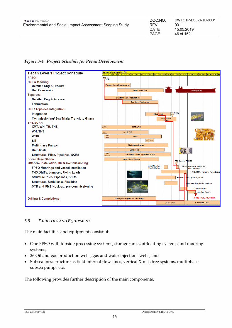
DOC.NO. DWTCTP-ESL-S-TB-0001 Environmental and Social Impact Assessment Scoping Study
REV. 03 DATE 15.05.2019 PAGE 46 of 152
ESL CONSULTING AKER ENERGY GHANA LTD.
46
Figure 3-4 Project Schedule for Pecan Development
3.5 FACILITIES AND EQUIPMENT
The main facilities and equipment consist of: • One FPSO with topside processing systems, storage tanks, offloading systems and mooring
systems; • 26 Oil and gas production wells, gas and water injections wells; and • Subsea infrastructure as field internal flow-lines, vertical X-mas tree systems, multiphase
subsea pumps etc. The following provides further description of the main components.
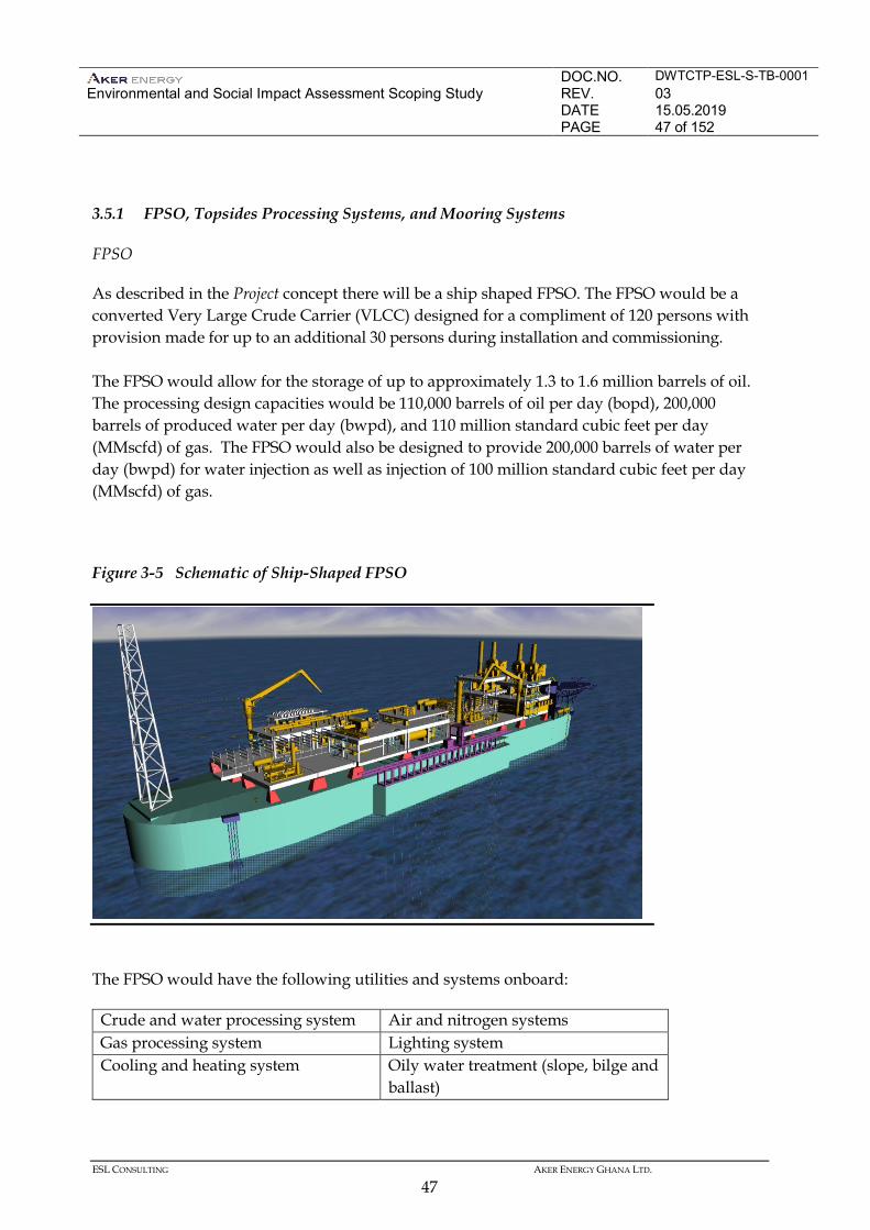
DOC.NO. DWTCTP-ESL-S-TB-0001 Environmental and Social Impact Assessment Scoping Study
REV. 03 DATE 15.05.2019 PAGE 47 of 152
ESL CONSULTING AKER ENERGY GHANA LTD.
47
3.5.1 FPSO, Topsides Processing Systems, and Mooring Systems
FPSO
As described in the Project concept there will be a ship shaped FPSO. The FPSO would be a converted Very Large Crude Carrier (VLCC) designed for a compliment of 120 persons with provision made for up to an additional 30 persons during installation and commissioning. The FPSO would allow for the storage of up to approximately 1.3 to 1.6 million barrels of oil. The processing design capacities would be 110,000 barrels of oil per day (bopd), 200,000 barrels of produced water per day (bwpd), and 110 million standard cubic feet per day (MMscfd) of gas. The FPSO would also be designed to provide 200,000 barrels of water per day (bwpd) for water injection as well as injection of 100 million standard cubic feet per day (MMscfd) of gas.
Figure 3-5 Schematic of Ship-Shaped FPSO
The FPSO would have the following utilities and systems onboard:
Crude and water processing system Air and nitrogen systems Gas processing system Lighting system Cooling and heating system Oily water treatment (slope, bilge and
ballast)
DOC.NO. DWTCTP-ESL-S-TB-0001 Environmental and Social Impact Assessment Scoping Study
REV. 03 DATE 15.05.2019 PAGE 48 of 152
ESL CONSULTING AKER ENERGY GHANA LTD.
48
Fuel gas system Power generation (main, essential and emergency)
ICSS (including fire and gas, ESD) Water Injection system Diesel system Fire-fighting systems Drain system Material handling Seawater intake system Accommodation Inert gas system Sewage treatment system Fresh and Potable water system Helideck with fuelling Heating, ventilation and air conditioning (HVAC) systems
Flare and vent system
Produced water treatment system Evacuation system Seawater injection system Gas injection system
Mooring System
The FPSO would be anchored in place with a spread mooring system with sufficient capacity to allow for up to two mooring lines to fail without impact on safety or operation. The mooring lines would consist of polyester rope with chain segments at both ends. The chains would be attached as low as possible to the keel level of the FPSO to enhance stability and to avoid impact of supply boats and offloading tankers. 3.5.2 Oil and Gas Production and Injections Wells
The Project base case calls for tentatively 14 production wells to be drilled from four off drill centres at the Pecan field. Each drill centre would have a multi-well production manifold. Tentatively 12 injection wells for alternating water and gas injection (WAG) would also be drilled. Further oil and gas production wells, water injection wells, and gas injection wells may be developed in subsequent phases. 3.5.3 Subsea Infrastructure
This section describes the present layout of the subsea infrastructure connected to the FPSO- at the Pecan area. The FPSO related subsea system will consist of 2 off individual production flow systems, the northern loop (DC1 and DC4) and the southern loop (DC2 and DC3), ref figure 3.1 above. Each production flow system consists of 2 off drill centres, a thermal insulated production pipeline and connected to a service line forming a loop and allowing for roundtrip pigging from the FPSO. All production lines (2 off) and service lines (2 off) are tied back and connected to the FPSO by steel catenary risers (SCR). Water injector system consist of two flow systems (northern and southern loop). The water injection trees are lined up and connected as satellite wells to the flowline system by In-Line Structures. In parallel with the water injection system there is a dedicated gas injection flow system which will provide dedicated wells the required gas amount to allow water and gas alternating (WAG) injection
DOC.NO. DWTCTP-ESL-S-TB-0001 Environmental and Social Impact Assessment Scoping Study
REV. 03 DATE 15.05.2019 PAGE 49 of 152
ESL CONSULTING AKER ENERGY GHANA LTD.
49
for increased oil recovery. In addition the WAG system request a dedicated monoethylene glycol (MEG) supply line to WAG wells to safeguard operations. Separate dynamic umbilical’s (total 4 off) will provide the required controls to subsea wells. At the production drill centres subsea production system will include manifolds, vertical X-mas Tree (VXT) systems, electrical/hydraulic distribution unit, jumpers and associated tie-in connections. Subsea boosting will be provided using multiphase pumping stations located downstream DC1 and DC2. Hydro-electric subsea umbilical’s with fibre optics will deliver chemical, hydraulic power, electrical power and communications to all four drill centres and 2x2 multiphase pumps. A subsea distributed, chemical system will be used with measurement and flow control at each subsea injection point. The pre-drilled production wells will be cleaned up to the drilling vessel/ship before started up later to the FPSO. The remaining production wells will be cleaned up to the FPSO prior to start-up of the wells. Well tests shall be conducted using multiphase flow meters located on each production tree The production pipeline system includes use of rigid jumpers while water injection system comprises both flexible and rigid jumpers tied into pipeline structures to reach the injection trees. The production would be transported via 12 inch flowlines, and Subsea Multiphase pumps (MPP) would be located downstream DC1 and DC2to provide additional lift for the production fluid to the host. The 10-inch water injection flowline terminate from the PLETs, manifold to the trees with either rigid or flexible jumpers. The subsea controls would be provided using an electro-hydraulic umbilical. During normal operating conditions, production data from the wells and the subsea structures would be transmitted through the umbilical to the FPSO and the control/operating room. All information, data, and monitoring would be managed and supervised in the control room.
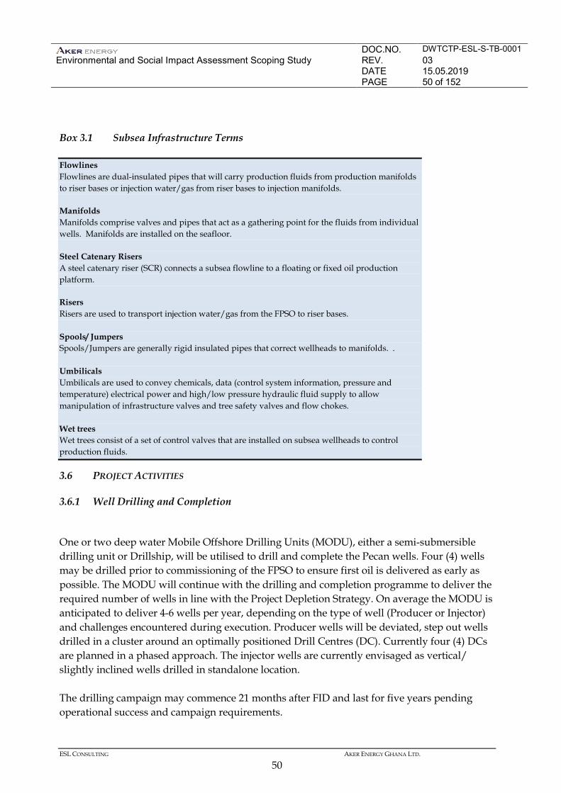
DOC.NO. DWTCTP-ESL-S-TB-0001 Environmental and Social Impact Assessment Scoping Study
REV. 03 DATE 15.05.2019 PAGE 50 of 152
ESL CONSULTING AKER ENERGY GHANA LTD.
50
Box 3.1 Subsea Infrastructure Terms
3.6 PROJECT ACTIVITIES
3.6.1 Well Drilling and Completion
One or two deep water Mobile Offshore Drilling Units (MODU), either a semi-submersible drilling unit or Drillship, will be utilised to drill and complete the Pecan wells. Four (4) wells may be drilled prior to commissioning of the FPSO to ensure first oil is delivered as early as possible. The MODU will continue with the drilling and completion programme to deliver the required number of wells in line with the Project Depletion Strategy. On average the MODU is anticipated to deliver 4-6 wells per year, depending on the type of well (Producer or Injector) and challenges encountered during execution. Producer wells will be deviated, step out wells drilled in a cluster around an optimally positioned Drill Centres (DC). Currently four (4) DCs are planned in a phased approach. The injector wells are currently envisaged as vertical/ slightly inclined wells drilled in standalone location. The drilling campaign may commence 21 months after FID and last for five years pending operational success and campaign requirements.
Flowlines Flowlines are dual-insulated pipes that will carry production fluids from production manifolds to riser bases or injection water/gas from riser bases to injection manifolds. Manifolds Manifolds comprise valves and pipes that act as a gathering point for the fluids from individual wells. Manifolds are installed on the seafloor. Steel Catenary Risers A steel catenary riser (SCR) connects a subsea flowline to a floating or fixed oil production platform. Risers Risers are used to transport injection water/gas from the FPSO to riser bases. Spools/ Jumpers Spools/Jumpers are generally rigid insulated pipes that correct wellheads to manifolds. . Umbilicals Umbilicals are used to convey chemicals, data (control system information, pressure and temperature) electrical power and high/low pressure hydraulic fluid supply to allow manipulation of infrastructure valves and tree safety valves and flow chokes. Wet trees Wet trees consist of a set of control valves that are installed on subsea wellheads to control production fluids.
DOC.NO. DWTCTP-ESL-S-TB-0001 Environmental and Social Impact Assessment Scoping Study
REV. 03 DATE 15.05.2019 PAGE 51 of 152
ESL CONSULTING AKER ENERGY GHANA LTD.
51
For each well the MODU will be positioned at the well location using Dynamic Positioning (DP) and have an exclusion zone of 500 m. Drilling fluids (also called muds) are pumped down the drill string during drilling to maintain a positive pressure in the well, cool and lubricate the drill bit, protect and support the exposed formations in the well and lift the cuttings from the bottom of the hole to the surface. Drilling fluids are slurries of various solids and additives (used to control the fluids functional properties such as density). There are two broad categories of drilling fluid: Water Based Fluids (WBFs) and Non-Aqueous Drilling Fluids (NADFs)1. For both types of drilling fluid a variety of chemicals are added to the water or non-aqueous liquid to modify the properties of the fluids. Additives include clays and barite to control density and viscosity and polymers such as starch and cellulose to control filtration. The type of drilling fluid used for a particular well or drilling program depends largely on the technical requirements of the well, local availability of the products, and the contracted drilling fluid supplier. Often, both WBFs and NADFs are used in drilling the same well. WBFs are used to drill some sections (particularly the top sections) of the well and then NADFs are substituted for the deeper sections to the bottom of the well. Prior to release, cuttings would be passed through the solids control equipment to remove the majority of drilling fluids prior to being discharged. The drilling rig would be equipped with solids control equipment called shale shakers. Shale shakers remove drilled solids from mud by passing material through a wire-cloth screen that vibrates while drilling fluid flows on top of it. Larger solids are retained on the screen, passed through the cuttings dryer and discharged. The liquid phase of mud and solids smaller than the wire mesh pass through the screen and are sent to a centrifuge. Solids from the centrifuges would be discharged and clean drilling fluid reused. In addition to assessing the environmental impact from drill cuttings discharges, the Project would conduct an assessment of the best technique with regards to environment, safety and feasibility, for drilling fluids and cuttings handling. The drilling operations will use as environmental friendly drilling fluids as possible, while protecting well and project deliverability. Further information on the composition and treatment of drilling fluid would be provided in the EIA, upon completion of the Drilling & Completions Basis of Design.
1 The Ghana Oil and Gas Regulations also refer to Organic-Phase Fluid (OPF) and Oil-Based Fluid (OBF). OPF is defined as: ‘an organic-phase drilling fluid, which is an emulsion of water and other additives in which the continuous phase is a water-immiscible organic fluid of animal, vegetable or mineral origin.’ OBF is defined as: ‘low aromatic and paraffinic oils and those mineral oil-based fluids that are neither synthetic fluids nor fluids of a class whose use is otherwise prohibited.’ EPA, 2015 :Offshore Environmental Regulations. Proposed by the Petroleum Department.
DOC.NO. DWTCTP-ESL-S-TB-0001 Environmental and Social Impact Assessment Scoping Study
REV. 03 DATE 15.05.2019 PAGE 52 of 152
ESL CONSULTING AKER ENERGY GHANA LTD.
52
After the wells have been drilled a process known as ‘well completion’ is undertaken to prepare the well for its operational function (ie, producing well or injector well) and to install a number of safety and operational controls. Completion fluids such as weighted brines or acids, methanol, glycols and proppants are circulated/ injected in to the well to clean the wellbore, stimulate the flow of hydrocarbons, or to maintain downhole pressure. Prior to bringing the well on full production the completion fluids are back flowed to surface to clean and protect the well and the reservoir interface. Prior to commission the FPSO, this backflow operation will be completed to the MODU. Once the FPSO is onstream, clean-up will be conducted to the FPSO. 3.6.2 Infrastructure Installation
Installation of the FPSO mooring suction piles will be performed prior to FPSO arrival. The mooring clusters position and final FPSO location depend upon the field layout determined during the Project detailed design phase. The FPSO would sail under its own power from the conversion yard to the installation site. Subsea Production Systems and flowlines, umbilicals and risers will be installed as a part of the subsea infrastructure. The methods of installation will be described in the EIA as this has not yet been concluded. The SCRs and flowlines can either be installed with reel lay, S-lay or J-lay method. The umbilicals will be installed with a tiltable lay system (TLS) and an underdeck basket carousel for laying flexible products. Large structures, jumpers and other hardware are installed with lifts using construction vessel cranes. The flowlines and subsea equipment will be hydrotested and flushed with potable or treated seawater prior to commissioning. Environmentally safe chemicals would be used for the treated seawater. The chemical lines and hydraulic lines in the umbilicals would arrive with storage fluid and the lines flushed and cleaned using a subsea kit and all fluids routed into the flowlines and to the host facility to discharge. The specific chemicals and additives that would be used would be in line with the United Kingdom Continental Shelf (UKCS) Offshore Notification Scheme. 3.6.3 Pre-Commissioning and Commissioning
Pre-commissioning includes the activities undertaken prior to the introduction of hydrocarbons; i.e. up to the ready for start-up (RFSU) point. Pre-commissioning would commence at the FPSO shipyard to minimise the amount of pre-commissioning required once the FPSO arrives on site. Commissioning of all FPSO and subsea systems would be
DOC.NO. DWTCTP-ESL-S-TB-0001 Environmental and Social Impact Assessment Scoping Study
REV. 03 DATE 15.05.2019 PAGE 53 of 152
ESL CONSULTING AKER ENERGY GHANA LTD.
53
undertaken to ensure mechanical completion, testing, and commissioning of all systems including fire and gas, safety and process control systems. There would be flaring and venting during commissioning. Commissioning offshore and start-up take approximately 4 to 6 months. 3.6.4 Operation
Crude oil would be treated and stored on the FPSO prior to being exported to an offloading tanker. Produced gas would be treated on the FPSO to maximise offtake and re-injected. A portion of the produced gas would be used as fuel for the FPSO. Processing
Fluids from production wells would be processed and treated on the FPSO. Crude oil would be separated, treated, stored, and periodically offloaded to an offloading tanker. Produced gas would be treated on the FPSO and re-injected. Options for transport of the gas to shore are being evaluated and evaluated as a fallback option. A portion of the produced gas would be used as fuel for the FPSO. Produced water from the well fluids would be treated on the FPSO and disposed at sea. Seawater would be pumped from under the FPSO, treated and injected into the reservoir for pressure maintenance with treatment reject seawater disposed overboard. Gas Processing
Gas would be separated from production fluids before being treated and compressed prior to leaving the FPSO as follows: • Alternating reinjection of associated gas and water for increased oil recovery • Export to pipeline to Atuabo (pending decisions) Some of the gas would be routed to the fuel gas module to be superheated and used as fuel gas for the gas turbine power generators. Water Injection
The water injection system would use treated seawater injection pumped at high pressure into the water injection wells to maintain reservoir pressure. The seawater is likely to include calcium nitrate to reduce the possibility of souring in the wells.
DOC.NO. DWTCTP-ESL-S-TB-0001 Environmental and Social Impact Assessment Scoping Study
REV. 03 DATE 15.05.2019 PAGE 54 of 152
ESL CONSULTING AKER ENERGY GHANA LTD.
54
Offloading Operations
Crude oil stored on the FPSO would be offloaded in tandem through a floating hose to an offloading tanker. All crude oil transfers and associated vessel movements in the DWT CTP development would be controlled via marine terminal rules and regulations being developed by the project. Power Generation
The power generation system on board the FPSO would consist of duel fuel turbines. Diesel would be used as fuel during start up and shutdown events. Precise specifications will be determined later during detailed engineering design phase. Emergency diesel power generation systems would also be provided. The turbines exhaust system would have a have a heat recovery unit to maximise the energy efficiency from the power generation. During detailed engineering of the Project there would be conducted an energy budget to optimise power generation solution with the energy need. 3.6.5 Support Operations
Marine Vessel and Helicopter Support
Support vessels, including crew and supply boats, would be required to support the drilling, completion, installation and production operations. Helicopter support would also be necessary during installation and production operations.
Onshore Support Locations
The location for primary logistics support for the Project has not yet been determined. Options being considered in the Western Region are the Port of Takoradi and the Navy Base. The Project may require the development of additional onshore facilities, but this has not yet been determined. The EIA will provide details of the onshore logistics operations for the Project as they are developed. 3.6.6 Decommissioning
The Project equipment and facilities would be decommissioned at the end of its economic life. Field life is projected to be 18 years (from first oil production). Decommissioning would involve dismantling production and transportation facilities and restoration of the area in accordance with license and regulatory requirements.
DOC.NO. DWTCTP-ESL-S-TB-0001 Environmental and Social Impact Assessment Scoping Study
REV. 03 DATE 15.05.2019 PAGE 55 of 152
ESL CONSULTING AKER ENERGY GHANA LTD.
55
Further information on decommissioning will be provided in the EIA. 3.7 EMISSIONS, DISCHARGES, AND WASTE
3.7.1 Emissions
Air Emissions
The Project’s activities, including well drilling and completion, construction of facilities and equipment, the FPSO facility installation and operation (including offloading), flowline and umbilical installation and support vessel and helicopter operations would emit Greenhouse Gases and varying amounts of other pollutants such as carbon monoxide (CO), oxides of nitrogen (NOx) and sulphur (SOx), volatile organic compounds (VOCs) and particulate matter. Estimated emissions volumes would be detailed and assessed in the EIA. The EIA will identify and discuss technology to minimize emissions to air, like reduction of flaring and venting. The efficiency of chosen technology and mitigating measures will be discussed in the EIA. The Project would focus on energy efficient design solutions to minimise Greenhouse Gases emission. Further, the Project would apply principles of good international industry practice to design for minimal flaring and cold venting. 3.7.2 Discharges
The drilling vessel, FPSO and associated support vessels plus offloading tankers would produce various discharges. FPSO discharges would continue for the life of the development. Project discharges would result from the following activities. Vessel
Drilling, completion, installation and support vessel operations would result in routine discharges to sea (ie, sewage, grey water, food waste, bilge water, ballast water and deck drainage). Discharge streams would be treated to required standards prior to discharge. Drilling
Routine discharges would include drill cuttings and drilling fluid. Water based drilling fluid and cuttings from the tophole sections of the well would be discharged to the seabed. All other drilling fluid and cuttings would be routed to the drilling deck and recycled and / or treated prior to discharge. The selection of drilling fluids and additives will be based on technical requirements and the available fluids with the lowest hazard ratings.
DOC.NO. DWTCTP-ESL-S-TB-0001 Environmental and Social Impact Assessment Scoping Study
REV. 03 DATE 15.05.2019 PAGE 56 of 152
ESL CONSULTING AKER ENERGY GHANA LTD.
56
The EIA for the Project would assess the environmental impact from drill cuttings discharges and, the Project would conduct an assessment of the best technique with regards to environment, safety and feasibility, for drilling fluids and cuttings handling. Completions
Routine discharges would include returned completion fluids. Completion fluids can typically include weighted brines, surfactants, acids, methanol and glycols and other chemicals. Completion fluids would be treated and / or discharged in accordance with Ghanaian regulations and permits. Installation and Commissioning
Intermittent discharges may include commissioning fluids including dye, oxygen scavenger, corrosion inhibitor and biocide. When flowlines and risers are dewatered (ie, water is pumped out) after pressure testing and treatment, these fluids will be pumped through the pipelines to the FPSO for processing. In some cases, discharge to sea will be required. Nitrogen would be purged to the atmosphere. Operations
Routine Project discharges would include the following: produced water, sewage, grey water, food waste, deck drainage, bilge water, ballast water, brine, cooling water and hydraulic fluid. Non-routine discharges, for example during g commissioning, would include the following:, oxygen scavenger, corrosion inhibitor and biocide, workover fluid, Naturally Occurring Radioactive Material (NORM) (potentially). Anticipated discharge volumes and treatment methods will be assessed in the EIA. 3.7.3 Noise
The FPSO, drilling rig, completion vessels, installation vessels, offloading tankers and support vessels would introduce sound into the marine environment during operation. Vessel noise is primarily attributed to propeller cavitation and propulsion engines (ie, noise transmitted through the vessel hull). Noise would also be produced from equipment such as flowlines and valves. Once the specification of the vessels and equipment to be used is known in detail an assessment of the noise sources can be made as part of the EIA.
DOC.NO. DWTCTP-ESL-S-TB-0001 Environmental and Social Impact Assessment Scoping Study
REV. 03 DATE 15.05.2019 PAGE 57 of 152
ESL CONSULTING AKER ENERGY GHANA LTD.
57
3.7.4 Waste
Operations would generate solid non-hazardous wastes including paper, plastic, wood, glass and metal. In addition, there will be hazardous wastes such as used oils and chemicals. The solid waste generated on board the drilling vessels, FPSO or support vessels would be shipped back to the shore base where it will be reused or recycled, where possible, or disposed of using Ghana EPA-approved contractors. All waste storage, transport, treatment and disposal will be undertaken in accordance with a project Waste Management Plan. 3.8 PERSONNEL REQUIREMENTS
Qualified personnel would be required to support both onshore and offshore activities including but not limited to: • Aker Energy Ghana offices; • Logistics shorebase (eg, warehouse, pipeyard, etc); • Logistics operations (eg, land transportation, aviation, marine/quayside operations,
material handling, loading and transport); • FPSO operations; • Drill rig or drillship operations; and • Support vessels Personnel requirements would be met via a combination of direct staff employment, third party contractors and consultants as well as third party service providers. Estimated employment numbers would be confirmed and evaluated as part of the EIA. Where qualified Ghanaian personnel are available for employment to support operations, whether staffed directly or via third party, Aker Energy will develop procedures to provide opportunities for employment/services as far as reasonably possible. Direct (Aker Energy employees) and indirect (contracted services) employment requirements would change with each phase of the project through to production operations. Attracting, developing and retaining qualified, high-performing professionals is a key objective.
DOC.NO. DWTCTP-ESL-S-TB-0001 Environmental and Social Impact Assessment Scoping Study
REV. 03 DATE 15.05.2019 PAGE 58 of 152
ESL CONSULTING AKER ENERGY GHANA LTD.
58
4 ENVIRONMENTAL AND SOCIAL BASELINE
4.1 INTRODUCTION
This chapter provides a description of the current environmental and socio-economic baseline against which the potential impacts of the Project will be assessed. The description covers the area in which the Project will take place as well as areas that may be directly or indirectly affected. In this section, reference is made to the following: • Project refers to the installation and operation of the wells and the FPSO. • Project Area refers to the area immediately surrounding the Project components; i.e., the
Project footprint. • Contract Area refers to the broader area to which Aker Energy Ghana Limited and partners
hold exploration rights. The Project Area is a small portion of the larger licence Contract Area. The term is sometimes used when describing baseline conditions at a regional level.
• Area of Influence refers to the area likely to be affected by the Project directly or indirectly.
The Area of Influence will vary depending on the particular resource or receptor and may be a small as the direct footprint (ie, the Project Area) or extend regionally, nationally and even globally. The predicted Area of Influence is used to establish the Study Area.
• Study Area refers to the area that would be covered by a particular baseline study in the
detailed EIA phase. The Project Area and the context in terms of the regional setting are shown in Section 1.1. The Project’s Area of Influence includes: the footprint of the Project facilities and activities (FPSO location, FPSO exclusion zone and subsea infrastructure); transportation routes between the FPSO and supply base; areas surrounding the site that may be impacted by project activities; indirect impacts on biodiversity and livelihoods; as well as the Ghana marine and socio-economic environment at a wider scale. The Area of Influence will be further defined in the EIA, when the onshore port location is confirmed.
DOC.NO. DWTCTP-ESL-S-TB-0001 Environmental and Social Impact Assessment Scoping Study
REV. 03 DATE 15.05.2019 PAGE 59 of 152
ESL CONSULTING AKER ENERGY GHANA LTD.
59
4.2 DATA SOURCES
4.2.1 Overview
A part of the scoping process, existing sources of information and data were identified and reviewed with the objective to determine coverage and quality with respect to the project setting and impact assessment. The search focussed on information and data related to the offshore location where the project would be located and the marine environment of the specific location and the wider region. The search also identified social and economic information related to the specific location as well as the Western Region of Ghana where shore-based project activities may occur. The baseline conditions are, in many instances described at a regional or national level since the basis of the information is largely secondary data collected during scoping. The data are derived from published sources, secondary data sourced from publicly available EIA reports as well as published journal articles and online sources. Where further information is required to inform the impact assessment, further baseline data will be collected as part of specific studies in the EIA. A gap assessment of the data with regards to the requirements for the EIA has also been conducted and is presented in Section 7.3.1. 4.2.2 Secondary Data
The baseline description draws on a number of publicly available secondary sources including the following. • Published scientific studies, academic texts and reference books. • Publicly available environmental reports, in particular EIA reports for other developments
near the Project. • Reports covering sensitive or protected species and habitats (eg, UNEP and IUCN
publications). • Subscription based geospatial data (topographic data, aerial photographs, satellite imagery;
IBAT database). • Information on protected areas from the Ghanaian government. • Information from international organisation including Food and Agriculture Organization
(FAO), International Union for Conservation of Nature (IUCN), Fishbase, and Birdlife International.
The main information sources used are as follows:
DOC.NO. DWTCTP-ESL-S-TB-0001 Environmental and Social Impact Assessment Scoping Study
REV. 03 DATE 15.05.2019 PAGE 60 of 152
ESL CONSULTING AKER ENERGY GHANA LTD.
60
Environmental and Social Impact Assessment of the Offshore Cape Three Points (OCTP) Phase 1 Development [offshore oil production and export], Ghana (prepared by ERM and ESL), eni Ghana, 2015. Environmental and Social Impact Assessment of the Offshore Cape Three Points (OCTP) Phase 2 Development [offshore gas production and transport to shore], Ghana (prepared by ERM and ESL), eni Ghana, 2015. Environmental and Social Scoping Study of a 450 MW Power Plant in Aboadze, Western Region, Ghana (prepared by ERM and ESL), Globeleq Advisors Limited and Volta River Authority, 2015 Environmental and Social Impact Assessment of an Oil Services Terminal (OST), Atuabo, Western Region, Ghana (prepared by ERM, ESL, and SRC), 2013 Environmental and Social Scoping Study of the Tweneboa, Enyenra, Ntomme (TEN) Development, Ghana (prepared by ERM, ESL, and SRC), Tullow Ghana, 2012 Environmental and Social Impact Assessment of the Jubilee Field Phase 1 Development, Ghana (prepared by ERM, ESL, and SRC), Tullow Ghana, 2009 Fisheries Management Plan of Ghana 2015 to 2019, Ghana Fisheries Commission, 2014. Independent Study of Marine Environmental Conditions in Ghana (prepared by Acorn International), Kosmos Energy, 2015. 4.2.3 Primary Data
The environmental baseline description also draws on primary data collected through studies and surveys commissioned for the Project. The following are the main sources used for this report: Environmental Baseline Survey Report, Deep Water Tano Cape Three Points, Survey Date December 2013 to January 2014, Gardline, 2014. Current Data Report, Ghana Deepwater Current Measurements Phase 4, Survey Date 24 August to 27 December 2014, Fugro, 2014. Metocean Modelling Data Report, Metocean Criteria for the Pecan Field, Fugro, 2014. 3D Seismic Survey Report. Cetacean and Sea Turtle Report. Hess Corporation. Deepwater Tano/ Cape Three Points, Ghana, EPI Group, 2014.
DOC.NO. DWTCTP-ESL-S-TB-0001 Environmental and Social Impact Assessment Scoping Study
REV. 03 DATE 15.05.2019 PAGE 61 of 152
ESL CONSULTING AKER ENERGY GHANA LTD.
61
The information in the reports covers the following related to the offshore biophysical environment: • Metocean conditions including temperature, wind, waves and currents; • Marine water quality; • Planktonic and zooplanktonic; • Seabed sediment type and quality; • Benthic macrofauna; • Marine habitats; and • Marine fauna. 4.3 PHYSICAL ENVIRONMENT
4.3.1 Climate and Meteorology
Overview
Regional climactic conditions are influenced by two air masses: one over the Sahara Desert (tropical continental); and the other over the Atlantic Ocean (maritime). These two air masses meet at the Intertropical Convergence Zone (ITCZ) and the characteristics of weather and climate in the region are influenced by the seasonal movement of the ITCZ. In general, two seasons are characteristic of the climate in the region, namely the dry and wet seasons. The occurrence of these seasons corresponds with periods when the tropical continental and maritime air masses, and their associated winds, influence the region (Refer to Figure 4-1). The climate of West Africa is subject to considerable spatial and temporal variability. This variability is linked to variations in the movement and intensity of the ITCZ as well as variations in the timing and intensity of the West African Monsoon. The most documented cause of these variations on an inter-annual timescale is the El Niño Southern Oscillation (ENSO). The West African Monsoon is influenced either during the developing phase of ENSO or during the decay of some long-lasting La Niña events. In general, El Niño is connected to below normal rainfall in West Africa (USAID, 2011).
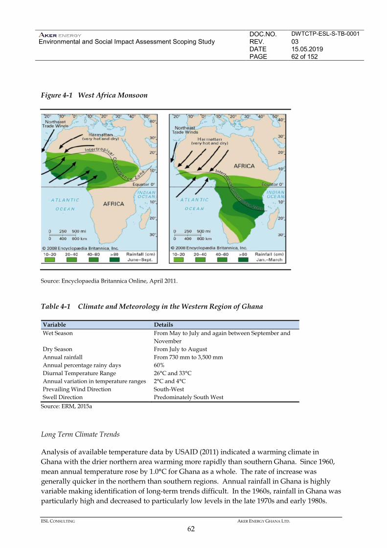
DOC.NO. DWTCTP-ESL-S-TB-0001 Environmental and Social Impact Assessment Scoping Study
REV. 03 DATE 15.05.2019 PAGE 62 of 152
ESL CONSULTING AKER ENERGY GHANA LTD.
62
Figure 4-1 West Africa Monsoon
Source: Encyclopaedia Britannica Online, April 2011.
Table 4-1 Climate and Meteorology in the Western Region of Ghana
Variable Details Wet Season From May to July and again between September and
November Dry Season From July to August Annual rainfall From 730 mm to 3,500 mm Annual percentage rainy days 60% Diurnal Temperature Range 26°C and 33°C Annual variation in temperature ranges 2°C and 4°C Prevailing Wind Direction South-West Swell Direction Predominately South West
Source: ERM, 2015a Long Term Climate Trends
Analysis of available temperature data by USAID (2011) indicated a warming climate in Ghana with the drier northern area warming more rapidly than southern Ghana. Since 1960, mean annual temperature rose by 1.0°C for Ghana as a whole. The rate of increase was generally quicker in the northern than southern regions. Annual rainfall in Ghana is highly variable making identification of long-term trends difficult. In the 1960s, rainfall in Ghana was particularly high and decreased to particularly low levels in the late 1970s and early 1980s.
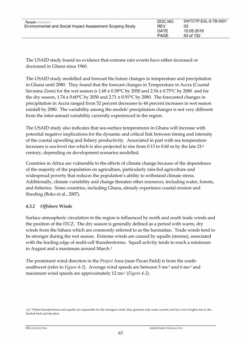
DOC.NO. DWTCTP-ESL-S-TB-0001 Environmental and Social Impact Assessment Scoping Study
REV. 03 DATE 15.05.2019 PAGE 63 of 152
ESL CONSULTING AKER ENERGY GHANA LTD.
63
The USAID study found no evidence that extreme rain events have either increased or decreased in Ghana since 1960. The USAID study modelled and forecast the future changes in temperature and precipitation in Ghana until 2080. They found that the forecast changes in Temperature in Accra (Coastal Savanna Zone) for the wet season is 1.68 ± 0.38°C by 2050 and 2.54 ± 0.75°C by 2080 and for the dry season, 1.74 ± 0.60°C by 2050 and 2.71 ± 0.91°C by 2080. The forecasted changes in precipitation in Accra ranged from 52 percent decreases to 44 percent increases in wet season rainfall by 2080. The variability among the models' precipitation changes is not very different from the inter-annual variability currently experienced in the region. The USAID study also indicates that sea-surface temperatures in Ghana will increase with potential negative implications for the dynamic and critical link between timing and intensity of the coastal upwelling and fishery productivity. Associated in part with sea temperature increases is sea-level rise which is also projected to rise from 0.13 to 0.60 m by the late 21st century, depending on development scenarios modelled.
Countries in Africa are vulnerable to the effects of climate change because of the dependence of the majority of the population on agriculture, particularly rain-fed agriculture and widespread poverty that reduces the population’s ability to withstand climate stress. Additionally, climate variability and change threaten other resources, including water, forests, and fisheries. Some countries, including Ghana, already experience coastal erosion and flooding (Boko et al., 2007). 4.3.2 Offshore Winds
Surface atmospheric circulation in the region is influenced by north and south trade winds and the position of the ITCZ. The dry season is generally defined as a period with warm, dry winds from the Sahara which are commonly referred to as the harmattan. Trade winds tend to be stronger during the wet season. Extreme winds are caused by squalls (storms), associated with the leading edge of multi-cell thunderstorms. Squall activity tends to reach a minimum in August and a maximum around March.1 The prominent wind direction in the Project Area (near Pecan Field) is from the south-southwest (refer to Figure 4-2). Average wind speeds are between 5 ms-1 and 6 ms-1 and maximum wind speeds are approximately 12 ms-1 (Figure 4-2).
(1) 1 Whilst thunderstorms and squalls are responsible for the strongest winds, they generate only weak currents and low wave heights due to the limited fetch and duration
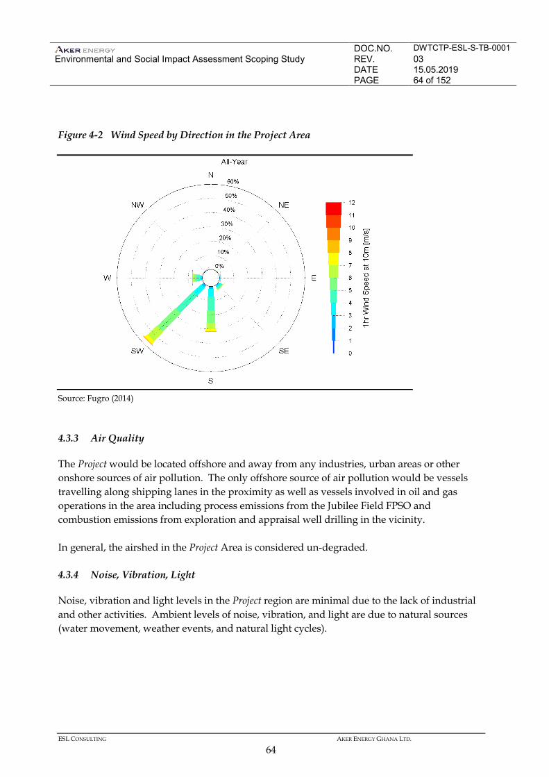
DOC.NO. DWTCTP-ESL-S-TB-0001 Environmental and Social Impact Assessment Scoping Study
REV. 03 DATE 15.05.2019 PAGE 64 of 152
ESL CONSULTING AKER ENERGY GHANA LTD.
64
Figure 4-2 Wind Speed by Direction in the Project Area
Source: Fugro (2014) 4.3.3 Air Quality
The Project would be located offshore and away from any industries, urban areas or other onshore sources of air pollution. The only offshore source of air pollution would be vessels travelling along shipping lanes in the proximity as well as vessels involved in oil and gas operations in the area including process emissions from the Jubilee Field FPSO and combustion emissions from exploration and appraisal well drilling in the vicinity. In general, the airshed in the Project Area is considered un-degraded. 4.3.4 Noise, Vibration, Light
Noise, vibration and light levels in the Project region are minimal due to the lack of industrial and other activities. Ambient levels of noise, vibration, and light are due to natural sources (water movement, weather events, and natural light cycles).
DOC.NO. DWTCTP-ESL-S-TB-0001 Environmental and Social Impact Assessment Scoping Study
REV. 03 DATE 15.05.2019 PAGE 65 of 152
ESL CONSULTING AKER ENERGY GHANA LTD.
65
4.3.5 Hydrology and Oceanography
Tides, Currents, and Waves
The oceanography of the Gulf of Guinea comprises the principal water types of the South Atlantic, but is largely influenced by the meteorological and oceanographic processes of the South and North Atlantic Oceans, principally oceanic gyral currents (Fontaine et al 1999, Merle and Arnault 1985). Surface water temperatures are warm (24ºC to 31ºC) with the daily sea surface temperature cycle showing annual variability (Fugro 2014). Hydrographic data collected in the Gulf of Guinea indicate that a thermal cycle occurs only in the upper two elements of the water column which together comprise the tropical surface water mass. The oceanic gyral currents of the North and South Atlantic Oceans produce a counter current, the Equatorial Counter Current that flows in an eastward direction. This becomes known as the Guinea Current as it runs from Senegal to Nigeria. The offshore waters of Ghana are dominated by the Guinea Current, which is an offshoot of the Equatorial Counter Current and is typically confined to the upper 40 to 50 m of the water column (refer to Figure 4-3) (Fugro 2014). Currents are typically aligned along the continental slope likely due to topographic steering. However reversal of the current does occur, predominantly during the less severe winter months. The Guinea Current, like other eastern ocean boundary currents, is characterised by areas of upwelling, and cooler surface waters during the boreal summer are typically associated with the intensification of the current (Jubilee EIA 2009). The tides in the Gulf of Guinea and specifically in the coasts of Ghana are regular and semi-diurnal of two almost equal high tides and two low tides each day (Noble-Denton 2008). Waves reaching the shores of Ghana consist of swells originating from the oceanic area around the Antarctica Continent and seas generated by locally occurring winds (Noble-Denton 2008). Wave heights are generally between 0.9 m and 1.4 m and rarely greater than 2.5 m. Occasionally, during swells, the wave amplitude may increase to five or six metres, though the periodicity of such events is about 10 to 20 years. The swell wave direction is usually from the south or south-west. Seabed current speeds are weak (0.15 ms-1). Maximum currents speeds at 4 m below mean sea level were 0.90 ms-1. The maximum recorded significant wave height measured during field surveys was 5.0 m and the minimum recorded significant wave height was 0.9 m (Fugro 2014).
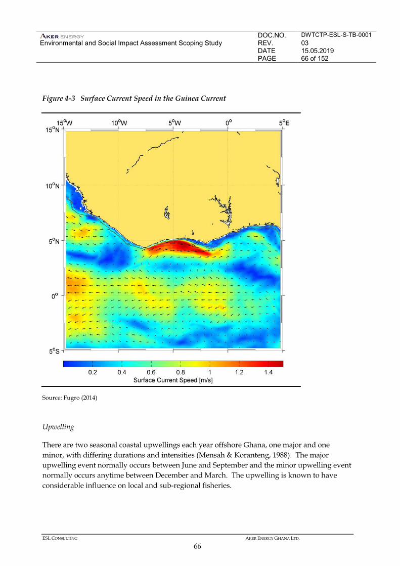
DOC.NO. DWTCTP-ESL-S-TB-0001 Environmental and Social Impact Assessment Scoping Study
REV. 03 DATE 15.05.2019 PAGE 66 of 152
ESL CONSULTING AKER ENERGY GHANA LTD.
66
Figure 4-3 Surface Current Speed in the Guinea Current
Source: Fugro (2014) Upwelling
There are two seasonal coastal upwellings each year offshore Ghana, one major and one minor, with differing durations and intensities (Mensah & Koranteng, 1988). The major upwelling event normally occurs between June and September and the minor upwelling event normally occurs anytime between December and March. The upwelling is known to have considerable influence on local and sub-regional fisheries.
DOC.NO. DWTCTP-ESL-S-TB-0001 Environmental and Social Impact Assessment Scoping Study
REV. 03 DATE 15.05.2019 PAGE 67 of 152
ESL CONSULTING AKER ENERGY GHANA LTD.
67
The upwelling influences the migratory patterns of pelagic fishes and is linked with the marine fish catch in Ghana (Armah and Amlalo 1998). The rest of the year the sea is characterized by a strong stratification and the presence of a thermocline. Turbidity is higher from June to October (average Secchi disk value 9 m) and lower from November to May (Secchi disk value 18 m). Generally, during the period of increased turbidity, corresponding with the major upwelling event, nutrient enrichment (nitrates and phosphates) occurs. Water Quality
Water column samples were tested in a survey conducted in December 2013 to January 2014 (Gardline 2015). Temperature of the surface waters ranged from 28 to 29°C and salinity ranged from 34.4 PSU and 34.8 PSU. A prominent thermocline was present at approximately 40 m water depth with another zone of cooling around 300 m depth. Temperature above the seabed was 3°C. Turbidity decreased with depth from 6.9 FTU at surface and 5.9 FTU near seabed. Dissolved oxygen decreased from a maximum 120% at surface to 23% at 250 m below the thermocline. Water conditions across the Contract Area was generally similar. Gardline’s water column profiles indicated an oligotrophic environment, absent of notable upwelling. The chlorophyll-a, suspended solids, nitrates and phosphate were below the level of detection for the majority of the samples. There was no indication of hydrocarbon contamination in the water column. There was little variation in dissolved metal concentrations within the water column. Cadmium, mercury and lead were below the limit of detection, with little or no variation in chromium, copper, nickel and between samples. Zinc and arsenic recorded the highest concentrations of all metals within the survey areas, but remained below <0.020 µgL- 1 in almost all samples with the majority recording comparable values across depths within each site. 4.3.6 Bathymetry, Seabed Topography and Sediments
Bathymetry
The continental shelf at about 200 m water depth off the coast of the Western Region of Ghana is at its narrowest off Cape St Paul in the east (20 km wide) and at its widest between Takoradi and Cape Coast in the west (90 km). The continental slope is steep and the depths increase sharply from approximately 100 m on the shelf and drop to approximately 1,600 m at the deepest part of the slope.
DOC.NO. DWTCTP-ESL-S-TB-0001 Environmental and Social Impact Assessment Scoping Study
REV. 03 DATE 15.05.2019 PAGE 68 of 152
ESL CONSULTING AKER ENERGY GHANA LTD.
68
The Project Area would be located on the deeper portion of the continental slope in water depths ranging between 1,600 to 2,500 m. Seabed Topography
Seabed features observed in the near the Project Area of Influence submarine canyons and sediment ridges and furrows (Gardline 2015, ERM 2012). Sediments
Sediment samples were analysed in a survey conducted in 2014 (Gardline 2015). Sediments across the Project Area were found to be generally similar. These sediments were determined to be poor to very poorly sorted and either fine or medium silt. Total Organic Matter ranged between 9.5% and 14.2% and Total Organic Carbon ranged between 1.48% and 2.36%. The Total Petroleum Hydrocarbons concentrations ranged from 5.9 µgg-1 to 18.4 µgg-1. 4.4 BIOLOGICAL ENVIRONMENT
4.4.1 Plankton
Phytoplankton
The plankton, including phytoplankton and zooplankton, constitutes the basis of trophic chains in marine ecosystems. Phytoplankton organisms are microscopic and range between 30 μm and 60 μm in size, and their abundance increases with increased nutrient availability because of an upwelling event. The composition and abundance of plankton is variable throughout the year and depends mainly of water circulation patterns, light, temperature, salinity, and nutrients (Nybakken, 1992 & Odum, 1971). However, the main limiting factor influencing the development of phytoplankton is the presence of nutrients, especially nitrate and phosphate (Nybakken, 1992). In the coasts off Ghana it is known that phytoplankton abundance increases during upwelling events when nutrient availability increases. Green algae blooms of non-toxic marine green algae (Enteromorpha flexuosa) occur seasonally and are expected to be a result of over fertilisation of soils alongside rivers draining into the sea, as well as the outflow of untreated sewage into rivers and the sea (CRC-URI, 2010). These blooms usually appear between August and October and may remain in the inshore region during several months or even a year, with impacts on local fishing activities. In recent years, Ghana has experienced an unprecedented increase in the presence of seaweed known as Sargassum (a genus of free-floating algae). The Sargassum has been particularly present in the Western Region where it has affected livelihoods of fishers and other
DOC.NO. DWTCTP-ESL-S-TB-0001 Environmental and Social Impact Assessment Scoping Study
REV. 03 DATE 15.05.2019 PAGE 69 of 152
ESL CONSULTING AKER ENERGY GHANA LTD.
69
community members (Ghana EPA, 2014b). The increase in Sargassum along Ghana’s shores is part of a regional and global trend. The reason for the migration of Sargassum from the Gulf of Mexico may be related to climate change, changes in Atlantic current patterns and changes in the productivity of marine habitat on a regional scale (Acorn, 2015). There are reports that the Sargassum actually originates in the Carribean as large blooms in that region are followed by high incidents of Sargassum on the West African coast. The Gardline (2015) survey than was conducted in December 2013 to January 2014 found the abundance of phytoplankton in the Project Area to be low during the survey period which means that there was limited evidence of any upwelling event during the survey (Gardline 2015). However, upwelling events have been previously documented to sometimes occur during January to December in Ghanaian waters (Ateweberhan et al 2012). Zooplankton
Zooplankton organisms are heterotrophic and rely on phytoplankton as a food source, becoming the first consumer in the food chain. Zooplankton includes a range of organism sizes including small protozoans and large metazoans. It includes holoplanktonic organisms, whose complete life cycle lies within the plankton, as well as meroplanktonic organisms that spend only part of their lives in the plankton (eg, fish eggs). Offshore Ghana zooplankton assemblages are generally dominated by copepods, followed by Ostracods (1), Appendicularians (2) and Chaetognaths (3). Maximum zooplankton abundance usually takes place during the major upwelling event (June to October) and to a minor extent during the minor upwelling event (December to February) following the increase in primary productivity by phytoplankton. A survey conducted in the Contract Area between December and January 2014 found high numbers of zooplankton in the top 200 m of the water column. The zooplankton community in the Contract Area was dominated by copepods with the predominant species the cyclopoid copepod Oncaea (Gardline 2015). 4.4.2 Benthic Invertebrates
Benthic fauna forms an important part of the marine ecosystem, providing a food source for other invertebrates and fish as well as cycling nutrients and materials between the water column and underlying sediments. Benthic fauna are relatively long-lived and sedentary and they exhibit different tolerances to stress, making them useful indicators of environmental
(1) Ostracoda is a class of the Crustacea, sometimes known as the seed shrimp because of their appearance. (2) Larvaceans (Class Appendicularia) are solitary, free-swimming underwater saclike filter feeders found throughout the world's oceans. (3) Chaetognatha is a phylum of predatory marine worms that are a major component of plankton worldwide.
DOC.NO. DWTCTP-ESL-S-TB-0001 Environmental and Social Impact Assessment Scoping Study
REV. 03 DATE 15.05.2019 PAGE 70 of 152
ESL CONSULTING AKER ENERGY GHANA LTD.
70
conditions. The macrobenthos of offshore Ghana has not been extensively studied, particularly in deeper waters. A survey of the Project Area showed that the macrofaunal community in the Project Area has a low abundance but proportionally high diversity. Polychaetes, arthropod, crustaceans and molluscs dominated species composition and abundance, with relatively few echinoderms or other taxa present in the samples. The results indicate an absence of contamination, under which circumstances only a few tolerant and highly abundant taxa might be expected to be present. No potentially sensitive or threatened species were observed during the survey (Gardline 2015). 4.4.3 Corals
Corals have very restricted ranges due to their requirements for specific thermal regimes, salinities, water depths, sedimentation and other physical and chemical characteristics. True coral reefs do not occur along the West African coast or in the vicinity of the Gulf of Guinea archipelagos, although mature coral communities are found at some discrete locations such as the oceanic islands and rocky mainland coasts; Cape Verde Islands, Gulf of Guinea Islands, Ghana, Gabon and Cameroon (Wells and Bleakley 2003). Deep water corals, dominated by the cold-water coral Lophelia pertusa, but also potentially including other cold-water corals (Madrepora oculata, Desmophyllum cristagalli, Dendrophyllia cornigera, Enallopsammia rostata and Solensmilia variabilis) have been recorded on raised offshore seabed features across the North East Atlantic Ocean (Tyler-Walters 2003). Eight species of sea anemone and corals present in the Gulf of Guinea are listed on the IUCN Red List of Threatened Species (IUCN 2015). None of the eight species are listed as Endangered or Vulnerable. During a survey of the DWT Block, north-west of the TEN Project area, a deepwater area offshore Ghana, a zone of coral was identified. The corals are deep water corals commonly found within the offshore waters of the Gulf of Guinea.
4.4.4 Fish
Pelagic Fish
The pelagic fish are those that live in the water column, and consist of species exploited commercially. The distribution and quantity of each population largely depend on
DOC.NO. DWTCTP-ESL-S-TB-0001 Environmental and Social Impact Assessment Scoping Study
REV. 03 DATE 15.05.2019 PAGE 71 of 152
ESL CONSULTING AKER ENERGY GHANA LTD.
71
hydrological conditions, with each species distributed according to the optimum temperature and salinity required for growth and reproduction. Most of the fish species discussed below have spawning grounds offshore Ghana and spawning of different species takes place throughout the year, typically with a peak from April to November. The commercially important small pelagic fish in the coastal and offshore waters of Ghana include round sardinella (Sardinella aurita); flat sardinella (S. maderensis); European anchovy (Engraulis encrasicolus); and chub mackerel (Scomber japonicus). These species are important commercially as they represent approximately 80 percent of the total catch landed in the country (approximately 200,000 tonnes per annum). In terms of biomass, acoustic surveys have shown that the two sardinella species and the European anchovy represent almost 60 percent of the total biomass in Ghanaian waters (FAO 2010). The large pelagic fish species include the tuna, billfish and some sharks. Key tuna species are skipjack tuna (Katsuwonus pelamis), yellowfin tuna (Thunnus albacares) and bigeye tuna (Thunnus obesus) (FAO 2010). These species are highly migratory and occupy the surface waters of the entire tropical and sub-tropical Atlantic Ocean. They are important species in the ecosystem as predators and prey, as well as providing an important commercial resource for industrial fisheries. Billfish species are also commercially exploited in much lower but notable numbers and include swordfish (Xiphias gladius), Atlantic blue marlin (Makaira nigricans) and Atlantic sailfish (Istiophorus albicans). In addition, there is a smaller but significant shark fishery in Ghana, with the main species caught being blue shark (Prionace glauca) and hammerhead shark (Sphyrna spp) (FAO 2010). Demersal Fish
Demersal fish species are those that live on or near the seabed. They are usually found over the continental shelf and the continental slope. Their distribution and composition is influenced by oceanographic conditions and specifically by the upwelling that results in changes of the bathymetric extension suitable for different species. This can also be observed by the differences recorded between the communities found above the thermocline, above 40 m depth and dominated by sciaenid species, and those living below (Koranteng, 1998). The density of demersal species is higher on shallower waters up to 50 m depth. Trawl surveys conducted between 1956 and 1992 have shown that demersal fish are widespread on the continental shelf along the entire length of the Ghanaian coastline
DOC.NO. DWTCTP-ESL-S-TB-0001 Environmental and Social Impact Assessment Scoping Study
REV. 03 DATE 15.05.2019 PAGE 72 of 152
ESL CONSULTING AKER ENERGY GHANA LTD.
72
(Koranteng 2001). Species composition is a typical tropical assemblage including the following families. • Porgies or Seabreams (Sparidae) (eg bluespotted seabream Pagrus caeruleostictus, Angola
dentex Dentex angolensis, Congo dentex Dentex congoensis, canary dentex Dentex canariensis and pink dentex Dentex gibbosus).
• Grunts (Haemulidae) (eg, bigeye grunt Brachydeuterus auritus and to a lesser degree sompat
grunt Pomadasys jubelini and bastard grunt Pomadasys incisus). • Croakers or drums (Sciaenidae) (eg, red pandora Pellagus bellottii, Cassava croaker
Pseudotolithus senegalensis). • Goatfishes (Mullidae) (eg, West African goatfish/red mullet Pseudupeneus prayensis). • Snappers (Lutjanidae) (golden African snapper Lutjanus fulgens, Goreean Snapper Lutjanus
goreensis). • Groupers (Serranidae) (eg, white grouper Epinephelus aeneus). • Threadfins (Polynemidae) (eg, lesser African threadfin Galeoides decadactylus). • Emperors (Lethrinidae) (eg, Atlantic emperor Lethrinus atlanticus). • Triggerfish (eg, grey triggerfish Balistes capriscus). The demersal species that are most important commercially (in terms of catch volumes) are cassava croaker (Pseudotolithus senegalensis), bigeye grunt (Brachydeuterus auritus), red pandora (Pellagus bellottii), Angola dentex (Dentex angolensis), Congo dentex (Dentex congoensis) and West African Goatfish (Pseudupeneus prayensis) (Koranteng, 1998). Deep Sea Species
Information on the distribution of specific deep water species is in Ghanaian waters is limited however Froese and Pauly (2009) identified 89 deep-sea fish species from 28 families including Alepocephalidae, Gonostomatidae, Myctophodae and Stomiidae that are likely to be found in Ghanaian waters over at depths over 1,000 m. Protected or Endangered Species
The sensitive fish species in offshore Ghana according to the IUCN Red List (IUCN 2015) and in the Project’s Area of Influence according to the IBAT database are presented in Table 4.2. Main
DOC.NO. DWTCTP-ESL-S-TB-0001 Environmental and Social Impact Assessment Scoping Study
REV. 03 DATE 15.05.2019 PAGE 73 of 152
ESL CONSULTING AKER ENERGY GHANA LTD.
73
species of concern include two species of sawfish (Pristis pectinata and P. perotteti), two species of angle sharks (Squatina aculeata and S. Oculata) and a grouper (Epinephelus itajara) all considered as critically endangered. Other species are subject to commercial fishing and to international regulations and monitoring, as is the case of all tuna species by the International Commission for the Conservation of Atlantic Tunas (ICCAT). Sharks are one of the groups most represented within the list. Local enforcement of protection programmes for fish is through the Fisheries Commission who monitors and inspects fish catch. Tuna fishing is monitored through on-board fishing inspectors that monitor activities in accordance with The International Commission for the Conservation of Atlantic Tunas programme requirements. Migratory patterns of the fish of high conservation importance will be investigated during the EIA and it will be confirmed if any species migrate through the Project Area. 4.4.5 Marine Mammals
The water of the Gulf of Guinea and offshore Ghana are considered favourable to the presence of marine mammals, especially due to the seasonal upwelling, which boosts productivity and therefore ensures food availability for these species. However, there is a lack of knowledge on the distribution, population estimated and ecology of cetaceans in the region. The majority of data are based on opportunistic sighting, incidental catches and strandings and species abundance in the Gulf of Guinea (Van Waerebeek et al 2009; Weir 2010; and ERM, 2012). Marine mammal species observed in the waters surrounding Ghana and potentially to occur within the Project Area, are listed in Table 4.3.
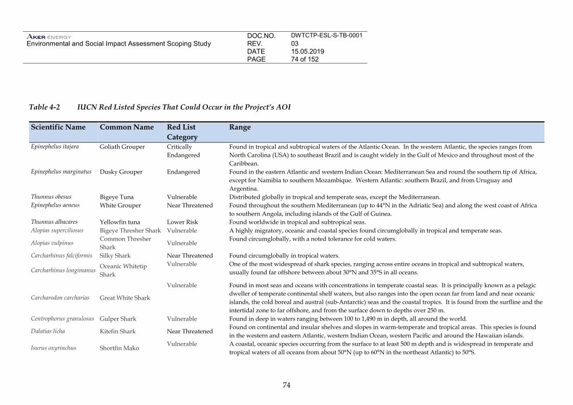
DOC.NO. DWTCTP-ESL-S-TB-0001 Environmental and Social Impact Assessment Scoping Study
REV. 03 DATE 15.05.2019 PAGE 74 of 152
74
Table 4-2 IUCN Red Listed Species That Could Occur in the Project’s AOI
Scientific Name Common Name Red List Category
Range
Epinephelus itajara Goliath Grouper Critically Endangered
Found in tropical and subtropical waters of the Atlantic Ocean. In the western Atlantic, the species ranges from North Carolina (USA) to southeast Brazil and is caught widely in the Gulf of Mexico and throughout most of the Caribbean.
Epinephelus marginatus Dusky Grouper Endangered Found in the eastern Atlantic and western Indian Ocean: Mediterranean Sea and round the southern tip of Africa, except for Namibia to southern Mozambique. Western Atlantic: southern Brazil, and from Uruguay and Argentina.
Thunnus obesus Bigeye Tuna Vulnerable Distributed globally in tropical and temperate seas, except the Mediterranean. Epinephelus aeneus White Grouper Near Threatened Found throughout the southern Mediterranean (up to 44°N in the Adriatic Sea) and along the west coast of Africa
to southern Angola, including islands of the Gulf of Guinea. Thunnus albacares Yellowfin tuna Lower Risk Found worldwide in tropical and subtropical seas. Alopias superciliosus Bigeye Thresher Shark Vulnerable A highly migratory, oceanic and coastal species found circumglobally in tropical and temperate seas.
Alopias vulpinus Common Thresher Shark
Vulnerable Found circumglobally, with a noted tolerance for cold waters.
Carcharhinus falciformis Silky Shark Near Threatened Found circumglobally in tropical waters.
Carcharhinus longimanus Oceanic Whitetip Shark
Vulnerable One of the most widespread of shark species, ranging across entire oceans in tropical and subtropical waters, usually found far offshore between about 30°N and 35°S in all oceans.
Carcharodon carcharias Great White Shark
Vulnerable Found in most seas and oceans with concentrations in temperate coastal seas. It is principally known as a pelagic dweller of temperate continental shelf waters, but also ranges into the open ocean far from land and near oceanic islands, the cold boreal and austral (sub-Antarctic) seas and the coastal tropics. It is found from the surfline and the intertidal zone to far offshore, and from the surface down to depths over 250 m.
Centrophorus granulosus Gulper Shark Vulnerable Found in deep in waters ranging between 100 to 1,490 m in depth, all around the world.
Dalatias licha Kitefin Shark Near Threatened Found on continental and insular shelves and slopes in warm-temperate and tropical areas. This species is found in the western and eastern Atlantic, western Indian Ocean, western Pacific and around the Hawaiian islands.
Isurus oxyrinchus Shortfin Mako Vulnerable A coastal, oceanic species occurring from the surface to at least 500 m depth and is widespread in temperate and
tropical waters of all oceans from about 50°N (up to 60°N in the northeast Atlantic) to 50°S.
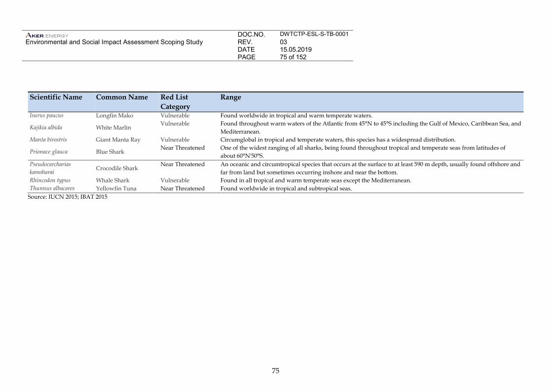
DOC.NO. DWTCTP-ESL-S-TB-0001 Environmental and Social Impact Assessment Scoping Study
REV. 03 DATE 15.05.2019 PAGE 75 of 152
75
Scientific Name Common Name Red List Category
Range
Isurus paucus Longfin Mako Vulnerable Found worldwide in tropical and warm temperate waters.
Kajikia albida White Marlin Vulnerable Found throughout warm waters of the Atlantic from 45°N to 45°S including the Gulf of Mexico, Caribbean Sea, and
Mediterranean. Manta birostris Giant Manta Ray Vulnerable Circumglobal in tropical and temperate waters, this species has a widespread distribution.
Prionace glauca Blue Shark Near Threatened One of the widest ranging of all sharks, being found throughout tropical and temperate seas from latitudes of
about 60°N'50°S. Pseudocarcharias kamoharai Crocodile Shark
Near Threatened An oceanic and circumtropical species that occurs at the surface to at least 590 m depth, usually found offshore and far from land but sometimes occurring inshore and near the bottom.
Rhincodon typus Whale Shark Vulnerable Found in all tropical and warm temperate seas except the Mediterranean. Thunnus albacares Yellowfin Tuna Near Threatened Found worldwide in tropical and subtropical seas.
Source: IUCN 2015; IBAT 2015
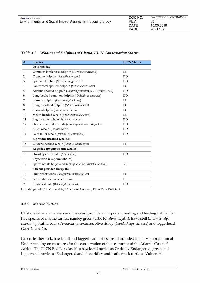
DOC.NO. DWTCTP-ESL-S-TB-0001 Environmental and Social Impact Assessment Scoping Study
REV. 03 DATE 15.05.2019 PAGE 76 of 152
ESL CONSULTING AKER ENERGY GHANA LTD.
76
Table 4-3 Whales and Dolphins of Ghana, IUCN Conservation Status
# Species IUCN Status Delphinidae 1 Common bottlenose dolphin (Tursiops truncatus) LC 2 Clymene dolphin (Stenella clymene) DD 3 Spinner dolphin (Stenella longirostris) DD 4 Pantropical spotted dolphin (Stenella attenuate) LC 5 Atlantic spotted dolphin (Stenella frontalis) (G. Cuvier, 1829) DD 6 Long-beaked common dolphin ( Delphinus capensis) DD 7 Fraser's dolphin (Lagenodelphis hosei) LC 8 Rough-toothed dolphin (Steno bredanensis) LC 9 Risso's dolphin (Grampus griseus) LC 10 Melon-headed whale (Peponocephala electra) LC 11 Pygmy killer whale (Feresa attenuata) DD 12 Short-finned pilot whale (Globicephala macrorhynchus DD 13 Killer whale (Orcinus orca) DD 14 False killer whale (Pseudorca crassidens) DD Ziphiidae (beaked whales) 15 Cuvier's beaked whale (Ziphius cavirostris) LC Kogiidae (pygmy sperm whales) 16 Dwarf sperm whale (Kogia sima) DD Physeteridae (sperm whales) 17 Sperm whale (Physeter macrocephalus or Physeter catodon) VU Balaenopteridae (rorquals) 18 Humpback whale (Megaptera novaeangliae) LC 19 Sei whale Balaenoptera borealis E 20 Bryde’s Whale (Balaenoptera edeni), DD
E: Endangered; VU Vulnerable; LC = Least Concern; DD = Data Deficient 4.4.6 Marine Turtles
Offshore Ghanaian waters and the coast provide an important nesting and feeding habitat for five species of marine turtles, namley green turtle (Chelonia mydas), hawksbill (Eretmochelys imbricata), leatherback (Dermochelys coriacea), olive ridley (Lepidochelys olivacea) and loggerhead (Caretta caretta). Green, leatherback, hawksbill and loggerhead turtles are all included in the Memorandum of Understanding on measures for the conservation of the sea turtles of the Atlantic Coast of Africa. The IUCN Red List classifies hawksbill turtles as Critically Endangered, green and loggerhead turtles as Endangered and olive ridley and leatherback turtle as Vulnerable
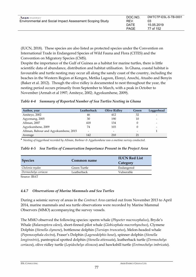
DOC.NO. DWTCTP-ESL-S-TB-0001 Environmental and Social Impact Assessment Scoping Study
REV. 03 DATE 15.05.2019 PAGE 77 of 152
ESL CONSULTING AKER ENERGY GHANA LTD.
77
(IUCN, 2018). These species are also listed as protected species under the Convention on International Trade in Endangered Species of Wild Fauna and Flora (CITES) and the Convention on Migratory Species (CMS). Despite the importance of the Gulf of Guinea as a habitat for marine turtles, there is little scientific data of abundance, distribution and habitat utilisation. In Ghana, coastal habitat is favourable and turtle nesting may occur all along the sandy coast of the country, including the beaches in the Western Region at Kengen, Metika Lagoon, Elonyi, Anochi, Atuabo and Benyin (Baker et al. 2012). Though the olive ridley is documented to nest throughout the year, the nesting period occurs primarily from September to March, with a peak in October to November (Armah et al 1997; Amiteye, 2002; Agyekumhene, 2009).
Table 4-4 Summary of Reported Number of Sea Turtles Nesting in Ghana
Author, year Leatherback Olive Ridley Green Loggerhead Amiteye, 2002 46 412 32 - Agyemang, 2005 30 190 10 - Allman, 2007 418 134 0 - Agyekumhene, 2009 74 103 0 - Allman, Babour and Agyekumhene, 2015 - - - 1 Average 142 210 21
* Nesting of loggerhead recorded by Allman, Barbour & Agyekumhene was a onetime survey conducted.
Table 4-5 Sea Turtles of Conservation Importance Present in the Project Area
Species Common name IUCN Red List Category
Chelonia mydas Green Turtle Endangered Dermochelys coriacea Leatherback Vulnerable
Source: IBAT 4.4.7 Observations of Marine Mammals and Sea Turtles
During a seismic survey of areas in the Contract Area carried out from November 2013 to April 2014, marine mammals and sea turtle observations were recorded by Marine Mammal Observers (MMO) accompanying the survey vessels. The MMO observed the following species: sperm whale (Physeter macrocephalus), Bryde’s Whale (Balaenoptera edeni), short-finned pilot whale (Globicephala macrorhynchus), Clymene Dolphin (Stenella clymene), bottlenose dolphin (Tursiops truncatus), Melon-headed whale (Peponocephala electra), Fraser’s Dolphin (Lagenodelphis hosei), spinner dolphin (Stenella longirostris), pantropical spotted dolphin (Stenella attenuata), leatherback turtle (Dermochelys coriacea), olive ridley turtle (Lepidochelys olivacea) and hawksbill turtle (Eretmochelys imbricata).
DOC.NO. DWTCTP-ESL-S-TB-0001 Environmental and Social Impact Assessment Scoping Study
REV. 03 DATE 15.05.2019 PAGE 78 of 152
ESL CONSULTING AKER ENERGY GHANA LTD.
78
As the data only represent individual observations, it is only conclusive as verification that the observed species do occur in the Contract Area. 4.4.8 Seabirds
The west coast of Africa forms an important section of the East Atlantic Flyway, an internationally important migration route for a range of bird species, especially shore birds and seabirds (Boere et al 2006; Flegg 2004). A number of species that breed in higher northern latitudes winter along the West African coast and many fly along the coast on migration. Seabirds known to follow this migration route include a number of tern species (Sterna sp), skuas (Stercorarius and Catharacta spp) and petrels (Hydrobatidae). The distance of the migration routes of these species from the shore depends on prey distribution and availability (eg the abundance and distribution of shoals of anchovies or sardines) (Flegg 2004). The highest concentrations of seabirds are experienced during the spring and autumn migrations, around March and April, and September and October. The marine birds of Ghana include storm petrels (Oceanodroma castro) and Ascension frigate birds (Fregata aquila). Records dating back to the 1960s reveal only limited sightings of a few species (Elgood et al 1994). The rarity of oceanic birds may be attributable to the absence of suitable breeding sites (eg remote islands and rocky cliffs) off the Ghana coast and in the Gulf of Guinea. Waders are present during the winter months between October and March. Species of waders known to migrate along the flyway include sanderling (Calidris alba) and knott (Calidris canuta). 4.4.9 Protected Areas
Coastal Protected Areas
Several coastal habitats are important for their biodiversity as well as for rare and endangered species. However, only five coastal areas are currently protected within the country. These areas are all located onshore and are protected under the Ramsar Convention. They are the Muni-Pomadze, Densu Delta, Sakumo Lagoon, Songor Lagoon and the Anglo-Keta Lagoon complex Ramsar sites (Table 4.6).None of these protected areas are located along the coast of the Western Region.
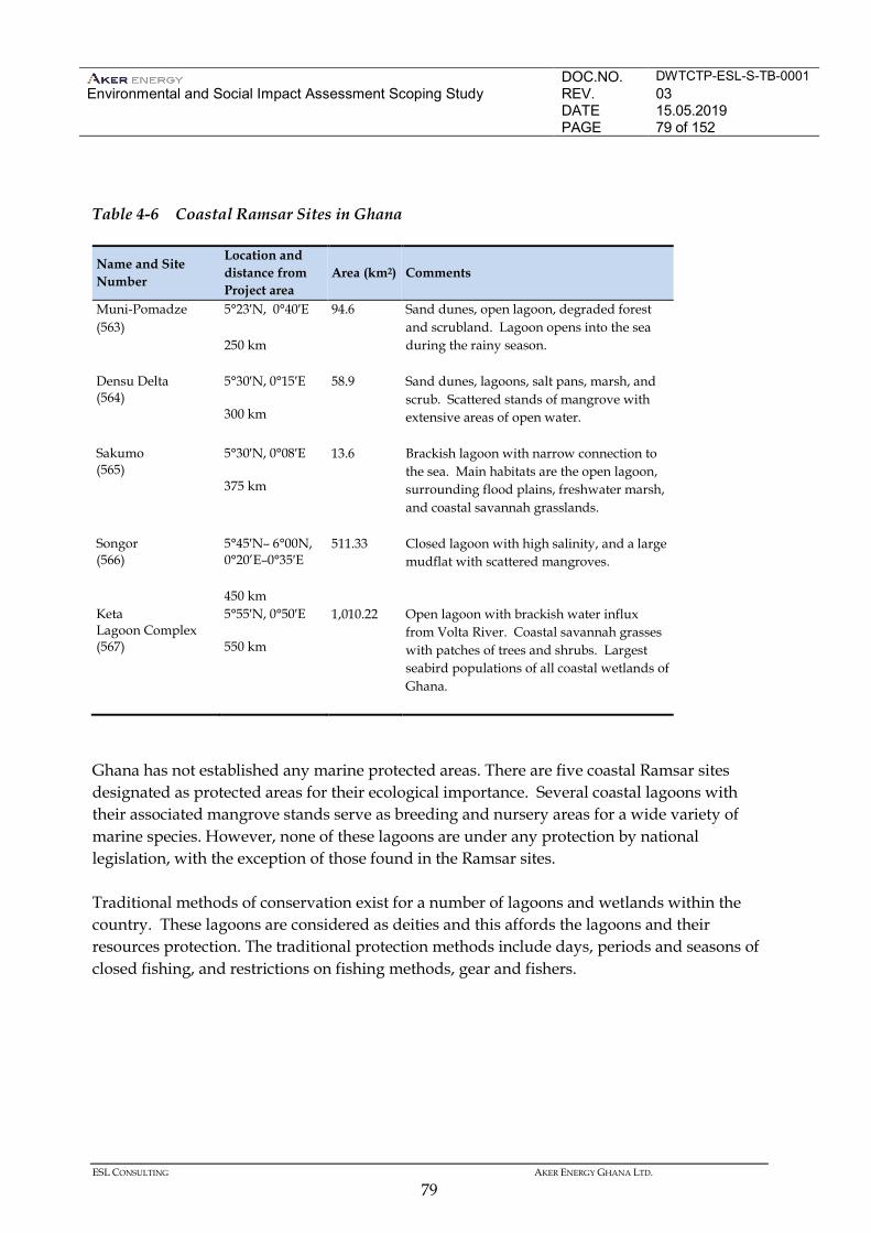
DOC.NO. DWTCTP-ESL-S-TB-0001 Environmental and Social Impact Assessment Scoping Study
REV. 03 DATE 15.05.2019 PAGE 79 of 152
ESL CONSULTING AKER ENERGY GHANA LTD.
79
Table 4-6 Coastal Ramsar Sites in Ghana
Name and Site Number
Location and distance from Project area
Area (km2) Comments
Muni-Pomadze (563)
5°23′N, 0°40′E 250 km
94.6 Sand dunes, open lagoon, degraded forest and scrubland. Lagoon opens into the sea during the rainy season.
Densu Delta (564)
5°30′N, 0°15′E 300 km
58.9 Sand dunes, lagoons, salt pans, marsh, and scrub. Scattered stands of mangrove with extensive areas of open water.
Sakumo (565)
5°30′N, 0°08′E 375 km
13.6 Brackish lagoon with narrow connection to the sea. Main habitats are the open lagoon, surrounding flood plains, freshwater marsh, and coastal savannah grasslands.
Songor (566)
5°45′N– 6°00N, 0°20’E–0°35′E 450 km
511.33 Closed lagoon with high salinity, and a large mudflat with scattered mangroves.
Keta Lagoon Complex (567)
5°55′N, 0°50′E 550 km
1,010.22 Open lagoon with brackish water influx from Volta River. Coastal savannah grasses with patches of trees and shrubs. Largest seabird populations of all coastal wetlands of Ghana.
Ghana has not established any marine protected areas. There are five coastal Ramsar sites designated as protected areas for their ecological importance. Several coastal lagoons with their associated mangrove stands serve as breeding and nursery areas for a wide variety of marine species. However, none of these lagoons are under any protection by national legislation, with the exception of those found in the Ramsar sites. Traditional methods of conservation exist for a number of lagoons and wetlands within the country. These lagoons are considered as deities and this affords the lagoons and their resources protection. The traditional protection methods include days, periods and seasons of closed fishing, and restrictions on fishing methods, gear and fishers.
DOC.NO. DWTCTP-ESL-S-TB-0001 Environmental and Social Impact Assessment Scoping Study
REV. 03 DATE 15.05.2019 PAGE 80 of 152
ESL CONSULTING AKER ENERGY GHANA LTD.
80
Important Bird Areas
Six Important Bird Areas (IBAs) are located along the coastline of Ghana, from the West to the East coast, namely (Birdlife International, 2015): • Amansuri Wetland; • Muni-Pomadze Ramsar Site; • Densu Delta Ramsar Site; • Sakumo Ramsar Site; and • Songor Ramsar Site. • Keta Lagoon Complex Ramsar Site; Five of these are designated Ramsar sites, however, only one, the Amansule Wetland, is located in the Western Region. The Amansule Wetland is the largest stand of intact swamp-forest in Ghana, with large portions of the wetland still in a relatively pristine condition. The wetland is classified as a blackwater area, and as such, the fauna on the site is species-poor, but distinctive. 4.4.10 Coastal Zone
The Ghanaian coast can be divided into three areas with definitive characteristics (COWI 2004). • West of Cape Three Points the coastline comprises sheltered, gently sloping, wide beaches,
backed by coastal lagoons. The wave heights are generally low. • Between Cape Three Points and Tema the coast consists of rock headlands and sandbars (or
spits) enclosing coastal lagoons, embayed coast, subject to medium to high wave energy. The wave heights often exceed 1 m. The south-westerly prevailing winds cause oblique wave approach to the shoreline, which generates an eastward littoral sediment transport.
• East of Tema, the shoreline is sandy and characterized by the eroding Volta delta. Wave
and sediment dynamics are similar to those between Cape Three Points and Tema. Rocky shores are restricted to the area between Axim and Tema, supporting a wide range of organisms in the intertidal zone.
DOC.NO. DWTCTP-ESL-S-TB-0001 Environmental and Social Impact Assessment Scoping Study
REV. 03 DATE 15.05.2019 PAGE 81 of 152
ESL CONSULTING AKER ENERGY GHANA LTD.
81
Estuaries
Estuaries are present along the eastern part of the Ghanaian coastline where large rivers enter the sea. Most studies on the estuaries of Ghana have concentrated on the estuary of the largest and longest river, the Volta River. The Densu, Ayensu, Nakwa, and Amisa Rivers flow into the Gulf of Guinea through lagoons. Generally, the estuaries are 15 to 50 km long and orientated perpendicular to the coast. Behind the coast, the estuaries branch into numerous tidal creeks surrounded by mangrove swamps (Allersma & Tilmans, 1993). Coastal Lagoons
There are approximately fifty lagoons along the coastline of Ghana. Very little is known about the majority of these lagoons. The amount of annual rainfall has an important effect on the nature of the coastal lagoons. Westwards from Takoradi, where the rainfall is approximately 1,250 mm annually, all the coastal lagoons have a permanent opening to the sea. East of Takoradi, only four rivers the Pra, Kakum, Densu, and the Volta, have a sufficient volume of water at all seasons to maintain a permanent outflow from the coastal lagoons at their mouths. Closed lagoons mainly occur in the eastern coastal region where rainfall is low and normally seasonal. Closed lagoons may be in contact with the sea for the greater part of year due to the inlets being kept open artificially: the sandbars being deliberately breached by local people who fish in the lagoons. Mullet fish (Mugilidae) are common in the coastal waters of tropical and subtropical countries. 4.5 SOCIAL BASELINE
This section of the report provides a description of the social baseline of the Project Area of Influence at various geographic levels. This information will be used to identify risks and impacts from Project activities and to develop the scope for the EIA. 4.5.1 Governance and Administration
Administrative Structure
This section of the baseline presents aspects of Ghana’s institutional structures that are of relevance to the Project. The levels of government outlined will have varying jurisdiction over the Project and the presence of the Project will necessitate interaction with a number of these structures. There is a dual system of governance in Ghana made up of formal government structures and traditional leadership structures. These systems of authority are recognised as complementary structures that have different responsibilities. There is a decentralised
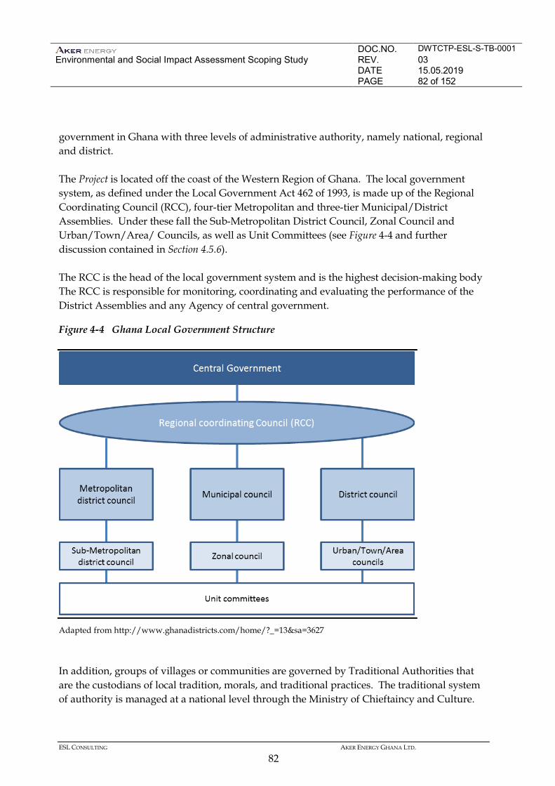
DOC.NO. DWTCTP-ESL-S-TB-0001 Environmental and Social Impact Assessment Scoping Study
REV. 03 DATE 15.05.2019 PAGE 82 of 152
ESL CONSULTING AKER ENERGY GHANA LTD.
82
government in Ghana with three levels of administrative authority, namely national, regional and district. The Project is located off the coast of the Western Region of Ghana. The local government system, as defined under the Local Government Act 462 of 1993, is made up of the Regional Coordinating Council (RCC), four-tier Metropolitan and three-tier Municipal/District Assemblies. Under these fall the Sub-Metropolitan District Council, Zonal Council and Urban/Town/Area/ Councils, as well as Unit Committees (see Figure 4-4 and further discussion contained in Section 4.5.6). The RCC is the head of the local government system and is the highest decision-making body The RCC is responsible for monitoring, coordinating and evaluating the performance of the District Assemblies and any Agency of central government.
Figure 4-4 Ghana Local Government Structure
Adapted from http://www.ghanadistricts.com/home/?_=13&sa=3627 In addition, groups of villages or communities are governed by Traditional Authorities that are the custodians of local tradition, morals, and traditional practices. The traditional system of authority is managed at a national level through the Ministry of Chieftaincy and Culture.
DOC.NO. DWTCTP-ESL-S-TB-0001 Environmental and Social Impact Assessment Scoping Study
REV. 03 DATE 15.05.2019 PAGE 83 of 152
ESL CONSULTING AKER ENERGY GHANA LTD.
83
The role of the Ministry is to preserve, sustain and integrate the regal, traditional and cultural values and practices. At the local level, the Paramount Chiefs are the traditional heads of the people and custodians of the land, and they carry great local influence. Each Chief will have a Traditional Council, which is composed of the elders who carry out the instructions of the chief and safeguard traditional customs and knowledge about an area for future generations. 4.5.2 Interpretation of the application of IFC Performance Standard 7
This section sets out to explain Aker Energy’s interpretation of IFC Performance Standard 7’s applicability to the offshore oil exploration and production project in the Deepwater Tano Cape Three Points (DWT/CTP) block. Cultural and linguistic characteristics of the project area of influence
In order to contextualise the subsequent discussion, an introduction to the social, cultural and linguistic landscape of the project area of influence is provided here. Aker Energy’s project area of influence (defined as the six coastal districts of Western Region, Ghana) is dominated by two ethnolinguistic groups. The Nzema primarily occupy the western coastline whilst the Ahantas occupy the eastern coastline of the region. The groups represent 11 and 6 percent of Ghanaians by birth in the region respectively. In addition to this, the area hosts people of other ethnolinguistic identities who are more recent arrivals. These residents are fully integrated members of the communities, and are primarily of Ewe, Fante or Ga origin, all recognised ethnolinguistic groups of a considerable size in Ghana. They mainly work as settler farmers, tenant farmer or fishermen/-mongers. These settlers are also deemed to fall outside of the scope of IFC Performance Standard 7, based on the interpretation detailed bnelow. Both the Nzema and the Ahantas are Akan people (the largest ethnic group in Ghana), and their respective languages (Nzema and Ahanta) are both part of the Central Tano group of Potou-Tano languages (Kwa languages). Nzema is one of the government-sponsored languages in Ghana, meaning educational materials are produced in the language, etc. IFC Performance Standard 7
IFC PS7 on Indigenous Peoples seeks to ensure that business activities minimise negative impacts, foster respect for human rights, dignity and culture of indigenous populations, and promote development benefits in culturally appropriate ways. A key requirement in IFC PS7 is the process of informed consultation and participation with indigenous peoples throughout the project cycle, and the requirement of Free, Prior and Informed Consent under certain
DOC.NO. DWTCTP-ESL-S-TB-0001 Environmental and Social Impact Assessment Scoping Study
REV. 03 DATE 15.05.2019 PAGE 84 of 152
ESL CONSULTING AKER ENERGY GHANA LTD.
84
circumstances where the potential project impacts on indigenous peoples is found to be substantial. The scope and application of IFC PS7 is specified in paragraphs 4-6 of the standard, and reads as follows: Paragraph 4. There is no universally accepted definition of “Indigenous Peoples.” Indigenous Peoples may be referred to in different countries by such terms as “Indigenous ethnic minorities,” “aboriginals,” “hill tribes,” “minority nationalities,” “scheduled tribes,” “first nations,” or “tribal groups.” Paragraph 5. In this Performance Standard, the term “Indigenous Peoples” is used in a generic sense to refer to a distinct social and cultural group possessing the following characteristics in varying degrees:
1. Self-identification as members of a distinct indigenous cultural group and recognition of this identity by others;
2. Collective attachment to geographically distinct habitats or ancestral territories in the project area and to the natural resources in these habitats and territories;
3. Customary cultural, economic, social, or political institutions that are separate from those of the mainstream society or culture; or
4. A distinct language or dialect, often different from the official language or languages of the country or region in which they reside.
Paragraph 6. This Performance Standard applies to communities or groups of Indigenous Peoples who maintain a collective attachment, i.e., whose identity as a group or community is linked, to distinct habitats or ancestral territories and the natural resources therein. It may also apply to communities or groups that have lost collective attachment to distinct habitats or ancestral territories in the project area, occurring within the concerned group members’ lifetime, because of forced severance, conflict, government resettlement programs, dispossession of their lands, natural disasters, or incorporation of such territories into an urban area. Interpretation of applicability
On the basis of the details provided, it is contended that the requirements specified in IFC PS7 to define a group as an Indigenous People are not met. Neither the Ahantas nor the Nzema have a distinct language or dialect, as their languages are closely related to, and mutually intelligible with, neighbouring languages and dialects. As a government-sponsored language, Nzema is one of the approximately ten largest and most supported languages in Ghana. These groups also utilize Fante as a language of instruction, and common communication language in addition to English.
DOC.NO. DWTCTP-ESL-S-TB-0001 Environmental and Social Impact Assessment Scoping Study
REV. 03 DATE 15.05.2019 PAGE 85 of 152
ESL CONSULTING AKER ENERGY GHANA LTD.
85
Moving to the characteristic concerning customary institutions, the Ahanta and Nzema both celebrate the traditional Kundum festival, and as such this tradition is not unique to either group. In terms of socio-political institutions, there are indeed traditional areas (stools) in the area of influence, but this is a characteristic shared with the rest of the country and officially recognised in the country’s dual government structure. Naturally, the Ahantas and the Nzema have a sense of attachment to their areas of residence, but not in the sense specified in the second characteristic. Culturally important locations, such as sacred sites and shrines, will be mapped in the project’s Environmental and Social Impact Assessment and their presence will be given weight in the construction of Aker Energy’s land base and related infrastructure, but no such locations have been made known to the Aker Energy team in our stakeholder and community engagements thus far. In terms of self-identification and external recognition as “a distinct indigenous cultural group”, both groups enjoy a sense of cultural coherence related to their ethnolinguistic identity, but not in the sense intended by PS7’s definition of Indigenous Peoples, as both groups are recognised as significant cultural groups which, together with other key groups in Ghana, form the basis of the Ghanaian national and cultural identity. The specifications in paragraph 6 do not apply to the people in the project area of influence as no resettlement or flight from territories of collective attachment have characterised the history of the relevant groups. 4.5.3 Economy and Livelihoods
Macroeconomy
Ghana is West Africa’s second largest economy (current GDP $38 trillion) behind Nigeria (current GDP $568 trillion). The largest contributor to GDP is the service sector (50 percent of GDP), followed by industry (30 percent) and then agriculture (21 percent). The mining and quarrying subsector’s contribution to GDP was 9.8 percent in 2013 (Ghana chamber of mines 2013; World Bank 2015). Ghana’s economic growth has developed in response to the discovery and production of oil in commercial quantities in 2011. Ghana experienced real GDP growth of 6 percent from 8 percent in 2010 to 14 percent in 2011(AFDB 2012). This has slumped to 4 percent in 2014 on the back of a drop in gold and oil production. Oil production had been affected by various periods of constrained production and down time at the Jubilee Field (for example arising from technical issues with FPSO gas compression systems), depressed global oil prices, and constraints at the Tema refinery (refer to Section 4.5.4)(1).
(1) http://databank.worldbank.org/data//reports.aspx?source=2&country=GHA&series=&period=
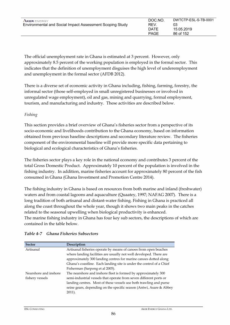
DOC.NO. DWTCTP-ESL-S-TB-0001 Environmental and Social Impact Assessment Scoping Study
REV. 03 DATE 15.05.2019 PAGE 86 of 152
ESL CONSULTING AKER ENERGY GHANA LTD.
86
The official unemployment rate in Ghana is estimated at 3 percent. However, only approximately 8.5 percent of the working population is employed in the formal sector. This indicates that the definition of unemployment disguises the high level of underemployment and unemployment in the formal sector (AFDB 2012). There is a diverse set of economic activity in Ghana including, fishing, farming, forestry, the informal sector (those self-employed in small unregistered businesses or involved in unregulated wage employment), oil and gas, mining and quarrying, formal employment, tourism, and manufacturing and industry. These activities are described below. Fishing
This section provides a brief overview of Ghana’s fisheries sector from a perspective of its socio-economic and livelihoods contribution to the Ghana economy, based on information obtained from previous baseline descriptions and secondary literature review. The fisheries component of the environmental baseline will provide more specific data pertaining to biological and ecological characteristics of Ghana’s fisheries. The fisheries sector plays a key role in the national economy and contributes 3 percent of the total Gross Domestic Product. Approximately 10 percent of the population is involved in the fishing industry. In addition, marine fisheries account for approximately 80 percent of the fish consumed in Ghana (Ghana Investment and Promotion Centre 2014). The fishing industry in Ghana is based on resources from both marine and inland (freshwater) waters and from coastal lagoons and aquaculture (Quaatey, 1997; NAFAG 2007). There is a long tradition of both artisanal and distant-water fishing. Fishing in Ghana is practiced all along the coast throughout the whole year, though it shows two main peaks in the catches related to the seasonal upwelling when biological productivity is enhanced. The marine fishing industry in Ghana has four key sub sectors, the descriptions of which are contained in the table below.
Table 4-7 Ghana Fisheries Subsectors
Sector Description Artisanal Artisanal fisheries operate by means of canoes from open beaches
where landing facilities are usually not well developed. There are approximately 300 landing centres for marine canoes dotted along Ghana’s coastline. Each landing site is under the control of a Chief Fisherman (Sarpong et al 2005).
Nearshore and inshore fishery vessels
The nearshore and inshore fleet is formed by approximately 300 semi-industrial vessels that operate from seven different ports or landing centres. Most of these vessels use both trawling and purse seine gears, depending on the specific season (Antwi, Asare & Abbey 2011).
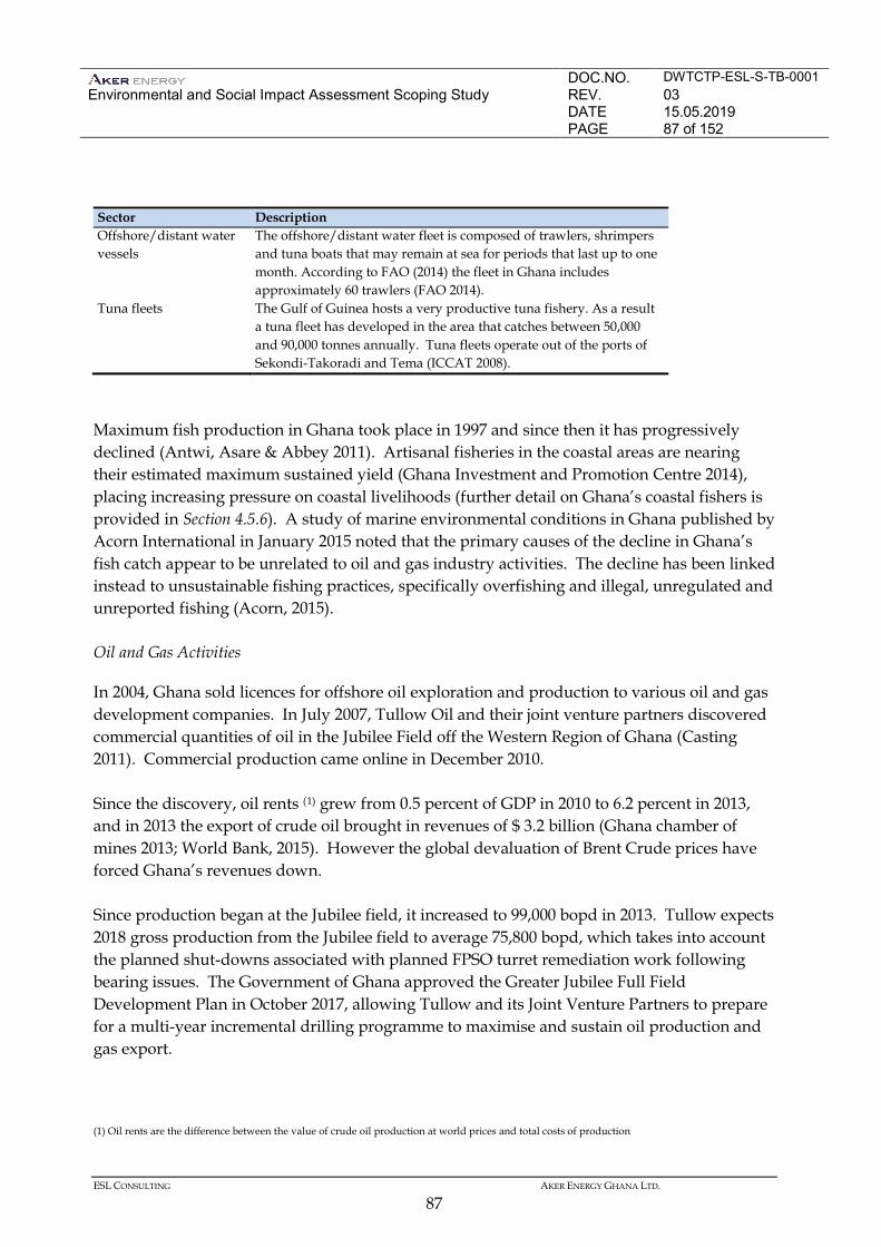
DOC.NO. DWTCTP-ESL-S-TB-0001 Environmental and Social Impact Assessment Scoping Study
REV. 03 DATE 15.05.2019 PAGE 87 of 152
ESL CONSULTING AKER ENERGY GHANA LTD.
87
Sector Description Offshore/distant water vessels
The offshore/distant water fleet is composed of trawlers, shrimpers and tuna boats that may remain at sea for periods that last up to one month. According to FAO (2014) the fleet in Ghana includes approximately 60 trawlers (FAO 2014).
Tuna fleets The Gulf of Guinea hosts a very productive tuna fishery. As a result a tuna fleet has developed in the area that catches between 50,000 and 90,000 tonnes annually. Tuna fleets operate out of the ports of Sekondi-Takoradi and Tema (ICCAT 2008).
Maximum fish production in Ghana took place in 1997 and since then it has progressively declined (Antwi, Asare & Abbey 2011). Artisanal fisheries in the coastal areas are nearing their estimated maximum sustained yield (Ghana Investment and Promotion Centre 2014), placing increasing pressure on coastal livelihoods (further detail on Ghana’s coastal fishers is provided in Section 4.5.6). A study of marine environmental conditions in Ghana published by Acorn International in January 2015 noted that the primary causes of the decline in Ghana’s fish catch appear to be unrelated to oil and gas industry activities. The decline has been linked instead to unsustainable fishing practices, specifically overfishing and illegal, unregulated and unreported fishing (Acorn, 2015). Oil and Gas Activities
In 2004, Ghana sold licences for offshore oil exploration and production to various oil and gas development companies. In July 2007, Tullow Oil and their joint venture partners discovered commercial quantities of oil in the Jubilee Field off the Western Region of Ghana (Casting 2011). Commercial production came online in December 2010. Since the discovery, oil rents (1) grew from 0.5 percent of GDP in 2010 to 6.2 percent in 2013, and in 2013 the export of crude oil brought in revenues of $ 3.2 billion (Ghana chamber of mines 2013; World Bank, 2015). However the global devaluation of Brent Crude prices have forced Ghana’s revenues down. Since production began at the Jubilee field, it increased to 99,000 bopd in 2013. Tullow expects 2018 gross production from the Jubilee field to average 75,800 bopd, which takes into account the planned shut-downs associated with planned FPSO turret remediation work following bearing issues. The Government of Ghana approved the Greater Jubilee Full Field Development Plan in October 2017, allowing Tullow and its Joint Venture Partners to prepare for a multi-year incremental drilling programme to maximise and sustain oil production and gas export.
(1) Oil rents are the difference between the value of crude oil production at world prices and total costs of production
DOC.NO. DWTCTP-ESL-S-TB-0001 Environmental and Social Impact Assessment Scoping Study
REV. 03 DATE 15.05.2019 PAGE 88 of 152
ESL CONSULTING AKER ENERGY GHANA LTD.
88
The offshore Tweneboa, Enyenra, and Ntomm (TEN) project has also been developed by Tullow with first oil to the FPSO Prof. John Evans Atta Mills in August 2016. Production in 2017 averaged 56,000 bopd and 2018 gross oil production is expected to average 64,000 bopd. In the last quarter of 2017, Tullow signed the TEN Associated Gas (TAG) Gas Sales Agreement with the Ghana National Petroleum Corporation and Tullow anticipates the start of gas sales from TEN in the third quarter of 2018. Gross gas sales equivalent to around 2,300 boepd (net: 1,100 boepd) have been forecast for the year (https://www.tullowoil.com). In addition, Eni (Operator), Vitol and GNPC have developed an oil and gas production project in the Offshore Cape Three Point (OCTP) fields. The OCTP integrated oil & gas development is made up of the Sankofa Main, Sankofa East and Gye-Nyame fields, which are located about 60 km off Ghana’s Western Region coast. Production is via the FPSO John Agyekum Kufuor which can produce up to 85,000 barrels of oil equivalent per day (boepd) through 18 underwater wells. A 63-kilometer submarine pipeline transports gas to Sanzule's Onshore Receiving Facilities (ORF), where it will be processed and transmitted to Ghana’s national grid, supplying approximately 180 million standard cubic feet per day (mmscfd). Currently there are approximately 15 petroleum agreements between the Government of Ghana, GNPC and petroleum operators, signifying significant interest in Ghana’s oil sector. Oil and gas exploration is ongoing and more discoveries are anticipated in the future. The country also has an active midstream and downstream oil and gas sector including a refinery at Tema and numerous storage and distribution systems for refined product. The Ghana National Gas Company operate a gas processing plant at Atuabo in the Western Region which receives gas from the Tullow developments.
Informal Economy
The Ghana Statistical Service estimates that approximately 86 percent of all employment in Ghana is in the informal sector (Osei-Boateng and Ampratwum 2011). More specifically, almost 91 percent of women and 81 percent of men are working informally. The informal sector in Ghana consists of various small-scale businesses, for example producers, wholesalers, retailers, and consumers. Informal sector workers are largely self-employed persons such as farmers, traders, food processors, artisans and craft-workers The rural informal economy centres on the following. • Agricultural activities focused on family farming units or community owned assets.
Farming is generally on a low technology basis dependent on family labour.
DOC.NO. DWTCTP-ESL-S-TB-0001 Environmental and Social Impact Assessment Scoping Study
REV. 03 DATE 15.05.2019 PAGE 89 of 152
ESL CONSULTING AKER ENERGY GHANA LTD.
89
• Artisanal fishing is predominantly undertaken by males (between 18-40 years old) along Ghana’s coastline. Women generally undertake processing activities, including the smoking and marketing of fish, and this takes place in coastal villages.
• Rural agro-based processing activities of local crops. These include processing cassava,
palm kernel, groundnut and copra oils, brewing distilling, and traditional soap-making. These activities are generally undertaken by women (Osei-Boateng and Ampratwum 2011).
The urban informal economy centres on the following. • Services sector, for example urban food traders, domestic workers and repair men and
women. • Construction sector, for example masons, carpenters, and small-scale plumbers (mainly
men between 18 and 40 that have dropped out of school). • Manufacturing sector which includes, food processing, textiles and garments, wood
processing and metal works(1). 4.5.4 Marine Infrastructure
Ports and Harbours
The nearest operational commercial port to the Project Area is the Port of Takoradi. Sekondi-Takoradi possesses the majority of the basic infrastructure required to support the offshore oil and gas industry as it is the city closest city to the Jubilee Field. Most oil and gas operational support bases are located in Sekondi-Takoradi, with administrative offices in Accra to deal with administrative and government relations. Takoradi Airbase is used to run flights between offshore oil rigs in the region and Accra (Quayson 2012). The Port of Takoradi was built as the first commercial port of Ghana in 1928 to handle imports and exports to and from the country respectively. The initial capacity of the port was 1 million tones of cargo. With the first expansion in 1956 the port was able to handle 1,153 vessels carrying 2.3 million tons of cargo in 1964. The port in 2015 handled 27% of national seaborne traffic, 15% of national seaborne imports, 68% of national seaborne exports, 6% of National seaborne container traffic and 7% of transit traffic to the Sahelian countries of Burkina Faso, Niger and Mali. Over the years vessel calls to the port have increased from 485 in 2003 to 1,525 calls in the 2015. The increase is attributed to the calls from Oil Supply vessels servicing the Jubilee Oil Fields at Cape Three Points. Since the discovery of
(1) Industry, according to International Standard Industrial Classification (ISIC), comprises value added in mining, manufacturing (reported as a separate subgroup), construction, electricity, water, and gas.
DOC.NO. DWTCTP-ESL-S-TB-0001 Environmental and Social Impact Assessment Scoping Study
REV. 03 DATE 15.05.2019 PAGE 90 of 152
ESL CONSULTING AKER ENERGY GHANA LTD.
90
oil in 2007, supply vessel calls have increased from 11% to 61% in 2015 of total vessel calls (www.ghanaports.gov.gh). The capacity of the slipway is 250 tones with dimensions of 11 metres wide and 38 metres in length. The port currently has a storage area of 140,000 m2 and has an open storage area of 250,000 m2 and is accessible by road and by rail. The Port of Takoradi is located on the Western Rail Line that runs from Takoradi to Kumasi and includes branches to Awaso and Prestea. The Port has three tug boats for berthing, sailing and shifting. The tugs are fitted with monitors for firefighting. Two (2) tug boats are always in attendance for berthing. The Port receives high traffic volumes and handles approximately a third of national sea borne traffic. Moreover, the port handles approximately 18 percent of National seaborne imports annually and 70 percent of National seaborne exports annually (Ghana Ports and Harbour Authority 2015). Major import commodities include clinker, wheat and quicklime and major exports are cocoa, bauxite, and manganese. Given the presence of oil and gas operators in the region some of the dry docks at the port are being utilised as an assemblage and receiving point for industrial goods such as heavy materials and oil pipes that are then transported to offshore locations. The port was modernised in 1986 but the development of oil and gas in the region necessitated further expansion and as such, a dedicated oil and gas hub is currently in the process of being constructed. In addition, Viking/Halliburton Company modified existing port infrastructure to create the ‘Viking Berth’, to facilitate storage and the delivery of services to oil supply vessels (Quayson 2012; GPHA 2015) (1) . Shipping and Navigation
The Gulf of Guinea experiences high maritime traffic. Figure 4-5 below provides a general illustration of shipping lanes across the Gulf of Guinea. A study of shipping routes will be carried out as part of the Project’s further design. This will be further evaluated in the EIA.
(1) Takoradi military base also serves as a storage area for oil companies operating at the Jubilee Oil field.
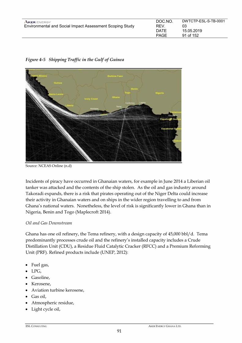
DOC.NO. DWTCTP-ESL-S-TB-0001 Environmental and Social Impact Assessment Scoping Study
REV. 03 DATE 15.05.2019 PAGE 91 of 152
ESL CONSULTING AKER ENERGY GHANA LTD.
91
Figure 4-5 Shipping Traffic in the Gulf of Guinea
Source: NCEAS Online (n.d) Incidents of piracy have occurred in Ghanaian waters, for example in June 2014 a Liberian oil tanker was attacked and the contents of the ship stolen. As the oil and gas industry around Takoradi expands, there is a risk that pirates operating out of the Niger Delta could increase their activity in Ghanaian waters and on ships in the wider region travelling to and from Ghana’s national waters. Nonetheless, the level of risk is significantly lower in Ghana than in Nigeria, Benin and Togo (Maplecroft 2014). Oil and Gas Downstream
Ghana has one oil refinery, the Tema refinery, with a design capacity of 45,000 bbl/d. Tema predominantly processes crude oil and the refinery’s installed capacity includes a Crude Distillation Unit (CDU), a Residue Fluid Catalytic Cracker (RFCC) and a Premium Reforming Unit (PRF). Refined products include (UNEP, 2012): • Fuel gas, • LPG, • Gasoline, • Kerosene, • Aviation turbine kerosene, • Gas oil, • Atmospheric residue, • Light cycle oil,
DOC.NO. DWTCTP-ESL-S-TB-0001 Environmental and Social Impact Assessment Scoping Study
REV. 03 DATE 15.05.2019 PAGE 92 of 152
ESL CONSULTING AKER ENERGY GHANA LTD.
92
• Heavy cycle oil, and • Clarified oil. Total crude storage capacity is about 2 million barrels, including liquid product storage and five LPG spheres of a total capacity of 6,400 metric tonnes (UNEP, 2012). Operations at the Tema refinery have been plagued by inefficiencies such as old equipment and the lack of funds to purchase crude oil for processing has hampered its operations. In 2014, the refinery processed only 18 percent of Ghana's 3.7 million metric tonnes of fuel imports (Reuters 2015). The Government is currently looking for strategic partners to manage the refinery with a view to expanding the current capacity of 45,000 bbl/d to 145,000 bbl/d (Ministry of Energy, n.d). Power generation is the main consumer of gas in Ghana and power demand is expected to grow at an annual rate of 7.5 percent for the period 2012-2021 and 6.3 percent from 2022 onwards. In 2017, total gas flow to the thermal power plants rose to about 43 million mmBTU (43,360 mmscf), almost 60% more the supply of 2016; only about 17% coming from Nigeria (18% in 2016) via the WAGP and the remaining 73% (82% in 2016) coming from Ghana Gas, i.e. the Atuabo gas processing plant. The average daily flow were about 30 mmscfd WAGP and almost 81 mmscfd from Ghana Gas. For 2018, total gas required for power generation would be almost 67 million mmBTU largely coming from the local fields. The expected average WAGP gas flow would be 60 mmscfd throughout the year, whilst an average of 150 mmscfd could come from Ghana Gas during the first half of the year. Additional gas is expected from the Sankofa-Gye Nyame fields during the second half of the year and that could boost average supply range to 200-300 mmscfd during the second half of the year…. (2018 Energy (Supply and Demand) Outlook for Ghana – Energy Commission – www.energycom.gov.gh)) The Ministry of Energy expects gas demand for power generation to start at 150 mmscfd in 2013 and grow to reach about 300 mmscfd in 2020 and about 600mmscfd in 2030. Ghana’s total gas supplies include local sources (1,150 mmscfd) and imports (150 mmscfd). Excluding Liquefied Natural Gas (LNG) imports, the Ministry of Energy expects Jubilee, Tweneboa-Enyenra-Ntomme (TEN) and the Sankofa and Gye Nyame fields to yield supplies of around 550 to 850 mmscfd between 2018 to 2020 (Ministry of Energy 2012). Current known existing and potential gas supplies include: • Imported gas from Nigeria via the West Africa Gas Pipeline (WAGP); • Associated gas from the Jubilee Field; • Associated and non-associated gas production from TEN and Mahogany East, Teak and
Akasa (META) discoveries; and
DOC.NO. DWTCTP-ESL-S-TB-0001 Environmental and Social Impact Assessment Scoping Study
REV. 03 DATE 15.05.2019 PAGE 93 of 152
ESL CONSULTING AKER ENERGY GHANA LTD.
93
• Non-associated gas from the eni Sankofa gas fields (Ministry of Energy 2012).
There are proposals for LNG import projects to supply gas on a temporary basis for power plants. These projects are in early stages of development. Pipelines and Cables
Ghana is experiencing a significant amount of offshore oil and gas development, and as a result there is subsea infrastructure currently in place and planned for the future. This includes submarine cables and pipelines such as the existing subsea pipeline from the Jubilee Field to the Ghana Gas Plant at Atuabo. There is also an onshore national gas supply pipeline from the central gas processing facility in Atuabo (currently processing gas from the Jubilee field) to Aboadze just north of Takoradi.
4.5.5 National Health Care
Health Care Facilities
Public health services are delivered through a hierarchy of hospitals, health centres, maternity homes and clinics, including Community-based Health Planning and Services (CHPS) compounds. There are primary, secondary and tertiary facilities organised at community, sub-district, district, regional and national levels (Arhinful 2009). Community and sub-district levels provide primary care, with district and regional hospitals providing secondary health care (Figure 4-6). Ghana has a universal health care system, National Health Insurance Scheme (NHIS). The system of health which operated prior to the establishment of the NHIS was the “Cash and Carry” system, under which the health need of an individual was only attended to after initial payment for the services was made. It was quite difficult for a large number of the public to access public health. However, the NHIS is an equitable insurance scheme that is to ensure treatment is provided first before payment. Since its inception, the country’s health facilities have seen constant rise in patient numbers and a considerable reduction in patient numbers (Health in Ghana – Wikipedia: https://en.m.wikipedia.org)
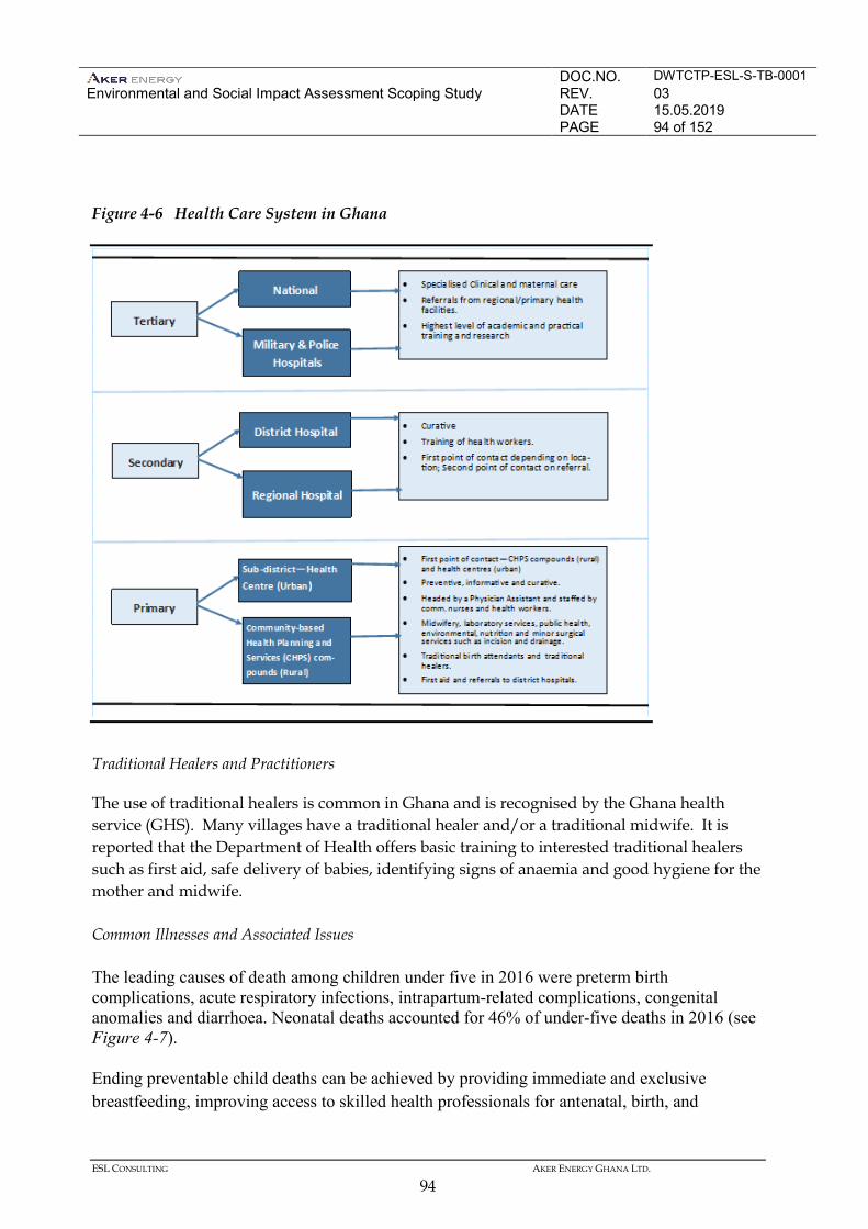
DOC.NO. DWTCTP-ESL-S-TB-0001 Environmental and Social Impact Assessment Scoping Study
REV. 03 DATE 15.05.2019 PAGE 94 of 152
ESL CONSULTING AKER ENERGY GHANA LTD.
94
Figure 4-6 Health Care System in Ghana
Traditional Healers and Practitioners
The use of traditional healers is common in Ghana and is recognised by the Ghana health service (GHS). Many villages have a traditional healer and/or a traditional midwife. It is reported that the Department of Health offers basic training to interested traditional healers such as first aid, safe delivery of babies, identifying signs of anaemia and good hygiene for the mother and midwife. Common Illnesses and Associated Issues
The leading causes of death among children under five in 2016 were preterm birth complications, acute respiratory infections, intrapartum-related complications, congenital anomalies and diarrhoea. Neonatal deaths accounted for 46% of under-five deaths in 2016 (see Figure 4-7).
Ending preventable child deaths can be achieved by providing immediate and exclusive breastfeeding, improving access to skilled health professionals for antenatal, birth, and
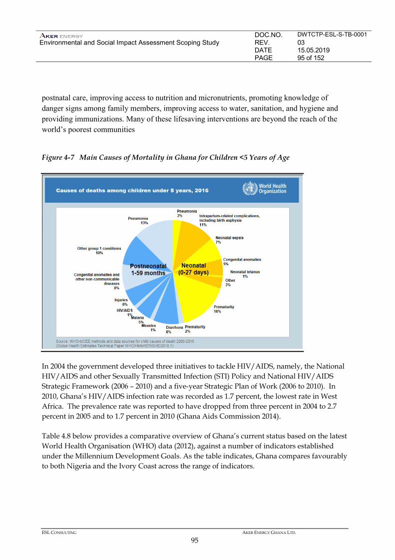
DOC.NO. DWTCTP-ESL-S-TB-0001 Environmental and Social Impact Assessment Scoping Study
REV. 03 DATE 15.05.2019 PAGE 95 of 152
ESL CONSULTING AKER ENERGY GHANA LTD.
95
postnatal care, improving access to nutrition and micronutrients, promoting knowledge of danger signs among family members, improving access to water, sanitation, and hygiene and providing immunizations. Many of these lifesaving interventions are beyond the reach of the world’s poorest communities
Figure 4-7 Main Causes of Mortality in Ghana for Children <5 Years of Age
In 2004 the government developed three initiatives to tackle HIV/AIDS, namely, the National HIV/AIDS and other Sexually Transmitted Infection (STI) Policy and National HIV/AIDS Strategic Framework (2006 – 2010) and a five-year Strategic Plan of Work (2006 to 2010). In 2010, Ghana’s HIV/AIDS infection rate was recorded as 1.7 percent, the lowest rate in West Africa. The prevalence rate was reported to have dropped from three percent in 2004 to 2.7 percent in 2005 and to 1.7 percent in 2010 (Ghana Aids Commission 2014). Table 4.8 below provides a comparative overview of Ghana’s current status based on the latest World Health Organisation (WHO) data (2012), against a number of indicators established under the Millennium Development Goals. As the table indicates, Ghana compares favourably to both Nigeria and the Ivory Coast across the range of indicators.
DOC.NO. DWTCTP-ESL-S-TB-0001 Environmental and Social Impact Assessment Scoping Study
REV. 03 DATE 15.05.2019 PAGE 96 of 152
ESL CONSULTING AKER ENERGY GHANA LTD.
96
Table 4-8 Status of Performance against Millennium Development Goals
Indicator Statistics*2012 and 2013 Ghana Nigeria Côte d'Ivoire
Under-five mortality rate (per 1000 live births) 78 117 100 Maternal mortality ratio (per 100 000 live births) 380 560 720 Deaths due to HIV/AIDS (per 100 000 population) 40.8 128.7 162.3 Deaths due to malaria (per 100 000 population) 68.7 106.9 71.7 Deaths due to tuberculosis among HIV-negative people (per 100 000 population)
4.4 94 20
Source: WHO Global Health Observatory (GHO) data *2012 for deaths due to HIV/AIDS and malaria; 2013 for other indicators http://www.who.int/gho/countries/en/ 4.5.6 Socio-Economic Characteristics of Western Region Coastal Districts
The increasing prospecting activities for oil and gas by oil and gas companies in the region will likely lead to increasing cumulative impacts, which means that stakeholders are likely to be interested in and or concerned with the associated real and/or perceived cumulative effects of this growing industry. Consequently, there is an increasing focus on the role of the oil and gas sector in regional development. Administrative Structure
The Western Region’s RCC oversees the administration of the Western Region. The council is chaired by the Regional Minister and the operations of the RCC are replicated by the various District Assemblies. The Western Region currently comprises 14 districts, two municipalities, and one metropolis run by the Sekondi-Takoradi Metropolitan Assembly (STMA) (Ghana Statistical Service 2013). Table 4.9 illustrates the political and administrative structures in the coastal districts of the Western Region.
Table 4-9 Coastal Political Administration in the Western Region
District Status Capital Jomoro District Half Assini Ellembelle District Nkroful Nzema East Municipal Axim Ahanta West District Agona Nkwanta Sekondo Takoradi Metropolitan Sekondi Shama District Shama
Source: Ghana Statistical Service (2013)
DOC.NO. DWTCTP-ESL-S-TB-0001 Environmental and Social Impact Assessment Scoping Study
REV. 03 DATE 15.05.2019 PAGE 97 of 152
ESL CONSULTING AKER ENERGY GHANA LTD.
97
Western Region Demographics
The Western Region comprises nine percent of Ghana’s total population (2.37 million people) and is the fifth most densely populated region in the country (Ghana Statistical Service 2012). Furthermore, the region has a large rural population, with 57.6 percent of the population living in rural areas (Ghana Statistical Service 2012). The breakdown of the population is as follows: • 1,187, 774 males; • 1,188,247 females; • Population under 15 constitute 39.6 percent of the population; • Population between 15 and 64 constitute 57 percent of the population; and • The population above 65 make up the remaining 3.4 percent. The population growth rate in the Western Region mirrors the national growth rate at two percent (Ghana Statistical Service 2012). However, it is important to note that the populations of key regions with high economic activity grew substantially between 2000 and 2010, most likely due to a combination of natural growth and in-migration. For example, the Central Region recorded the highest percentage increase in the population (38.1 percent) over this 10-year period. Similarly, although growth rates were low, population density in the Western Region increased from 80.5 people per square kilometre to 99.3 people per square kilometre between 2000 and 2010 (Ghana Statistical Service 2013). Again, it is likely that migration played a role in these changes in population. Moreover, it is estimated that one in four people in the region are ‘migrants’ born outside the Western Region. Despite this, there is no indication of conflict arising between the various ethnic groups or nationalities in the area. Finally, the region is expected to experience population growth in the future, as people migrate to the area in search of employment opportunities. Sekondi-Takoradi Metropolitan Assembly (STMA) has the highest share of the population with 23.5 percent and Nzema East Municipality has the least with 2.6 percent (Ghana Statistical Service 2013). Sekondi-Takoradi is the capital of the Western Region and has experienced growth as the port in Takoradi is a hub for offshore oil and gas activities. Table 4.10 illustrates the population size and regional district share of the coastal districts in the Western Region.
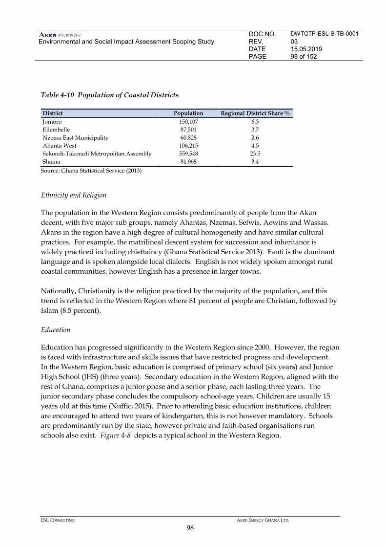
DOC.NO. DWTCTP-ESL-S-TB-0001 Environmental and Social Impact Assessment Scoping Study
REV. 03 DATE 15.05.2019 PAGE 98 of 152
ESL CONSULTING AKER ENERGY GHANA LTD.
98
Table 4-10 Population of Coastal Districts
District Population Regional District Share % Jomoro 150,107 6.3 Ellembelle 87,501 3.7 Nzema East Municipality 60,828 2.6 Ahanta West 106,215 4.5 Sekondi-Takoradi Metropolitan Assembly 559,548 23.5 Shama 81,968 3.4
Source: Ghana Statistical Service (2013) Ethnicity and Religion
The population in the Western Region consists predominantly of people from the Akan decent, with five major sub groups, namely Ahantas, Nzemas, Sefwis, Aowins and Wassas. Akans in the region have a high degree of cultural homogeneity and have similar cultural practices. For example, the matrilineal descent system for succession and inheritance is widely practiced including chieftaincy (Ghana Statistical Service 2013). Fanti is the dominant language and is spoken alongside local dialects. English is not widely spoken amongst rural coastal communities, however English has a presence in larger towns. Nationally, Christianity is the religion practiced by the majority of the population, and this trend is reflected in the Western Region where 81 percent of people are Christian, followed by Islam (8.5 percent). Education
Education has progressed significantly in the Western Region since 2000. However, the region is faced with infrastructure and skills issues that have restricted progress and development. In the Western Region, basic education is comprised of primary school (six years) and Junior High School (JHS) (three years). Secondary education in the Western Region, aligned with the rest of Ghana, comprises a junior phase and a senior phase, each lasting three years. The junior secondary phase concludes the compulsory school-age years. Children are usually 15 years old at this time (Nuffic, 2015). Prior to attending basic education institutions, children are encouraged to attend two years of kindergarten, this is not however mandatory. Schools are predominantly run by the state, however private and faith-based organisations run schools also exist. Figure 4-8 depicts a typical school in the Western Region.
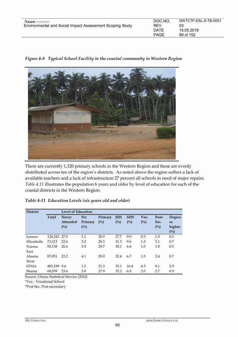
DOC.NO. DWTCTP-ESL-S-TB-0001 Environmental and Social Impact Assessment Scoping Study
REV. 03 DATE 15.05.2019 PAGE 99 of 152
ESL CONSULTING AKER ENERGY GHANA LTD.
99
Figure 4-8 Typical School Facility in the coastal community in Western Region
There are currently 1,320 primary schools in the Western Region and these are evenly distributed across ten of the region’s districts. As noted above the region suffers a lack of available teachers and a lack of infrastructure 27 percent all schools in need of major repairs. Table 4.11 illustrates the population 6 years and older by level of education for each of the coastal districts in the Western Region.
Table 4-11 Education Levels (six years old and older)
District Level of Education Total Never
Attended (%)
Pre Primary (%)
Primary (%)
JHS (%)
SHS (%)
Voc. (%)
Post- Sec. (%)
Degree or higher (%)
Jomoro 124,242 27.0 3.1 28.9 27.7 9.9 0.9 1.9 0.5 Ellembelle 73,213 22.6 3.2 28.3 31.3 9.6 1.3 3.1 0.7 Nzema East
50,138 26.6 3.9 29.7 30.1 6.6 1.0 1.8 0.5
Ahanta West
87,051 23.2 4.1 29.0 32.4 6.7 1.5 2.4 0.7
STMA 483,199 9.6 1.3 21.3 35.1 16.4 4.3 9.1 2.9 Shama 68,039 23.6 3.8 27.9 32.2 6.9 2.0 2.7 0.9
Source: Ghana Statistical Service (2010) *Voc.- Vocational School *Post Sec. Post-secondary
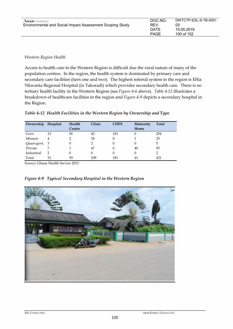
DOC.NO. DWTCTP-ESL-S-TB-0001 Environmental and Social Impact Assessment Scoping Study
REV. 03 DATE 15.05.2019 PAGE 100 of 152
ESL CONSULTING AKER ENERGY GHANA LTD.
100
Western Region Health
Access to health care in the Western Region is difficult due the rural nature of many of the population centres. In the region, the health system is dominated by primary care and secondary care facilities (tiers one and two). The highest referral system in the region is Effia Nkwanta Regional Hospital (in Takoradi) which provides secondary health care. There is no tertiary health facility in the Western Region (see Figure 4-6 above). Table 4.12 illustrates a breakdown of healthcare facilities in the region and Figure 4-9 depicts a secondary hospital in the Region.
Table 4-12 Health Facilities in the Western Region by Ownership and Type
Ownership Hospital Health Center
Clinic CHPS Maternity Home
Total
Govt. 15 56 42 181 0 294 Mission 4 2 18 0 1 25 Quasi-govt. 3 0 2 0 0 5 Private 7 1 47 0 40 95 Industrial 2 0 0 0 0 2 Total 31 59 109 181 41 421
Source: Ghana Health Service 2013
Figure 4-9 Typical Secondary Hospital in the Western Region
DOC.NO. DWTCTP-ESL-S-TB-0001 Environmental and Social Impact Assessment Scoping Study
REV. 03 DATE 15.05.2019 PAGE 101 of 152
ESL CONSULTING AKER ENERGY GHANA LTD.
101
Various illnesses are prevalent throughout the Western Region. In data recorded in hospitals in the region malaria, diarrhoeal diseases, and anaemia were the top three reasons for admission. The average number of hospital admissions per 1,000 population in the Western Region in 2009 was 45.10, as compared to 43.79 at the national level. Malaria is by far the most prevalent accounting for 39.3 percent of admissions in 2013. Moreover, anaemia and malaria were the top two causes of hospital recorded deaths, 8.21 and 7.7 percent respectively (Ghana Health Sector: facts and figures, 2010; Ghana Health Service 2013). The Ghanaian government is tackling malaria through the National Malaria Control Program, including a number of initiatives in the Western Region such as treated bed-nets for vulnerable groups, intermittent preventive treatment (IPT) given to pregnant women, and pesticide spraying on households and community infrastructure. Malaria as a cause of hospital admissions in the Western Region dropped from 43.7 percent in 2012 to 39.30 percent in 2013 (Ghana Health Service, Western Region, 2013). However, poor sanitation in the Western Region results in high incidence of related infections including diarrhoea, typhoid, cholera, dysentery and gastritis. HIV/AIDS accounted for 2.53 percent of hospital recorded deaths in 2013 (Ghana Health Service 2013). HIV/AIDS cases and issues are poorly reported in general in Ghana, however, health professionals in the Western Region reported that HIV infection rates in women are higher than in men. The causes are generally attributed to people having multiple sexual partners and trading sex for livelihoods, as well as an influx of infected persons entering the Western Region to live and work, (Ghana Health Service, Western Region, 2013). Water and Sanitation
There are three major sources of drinking water in the region namely, piped (inside, outside, tanker supply), well (well, borehole) and natural (spring, river, stream, lakes, rainwater, dugout). In the Western Region, 32 percent of houses have access to treated piped water with 8.5 percent having this available within their dwellings. The highly urbanised districts have almost 100 percent availability of, or accessibility to, piped water. This is in contrast to rural districts where over 60 percent of households use rivers, streams, wells, spring or rainwater as their main source of water. Proper sanitation remains an issue in the region where disposal of waste is often uncontrolled; the following sanitation facilities are common in rural areas (Ghana Statistical Service 2013): • Public toilet (37.4 percent); • Pit latrine (30.1 percent); • Toilet in dwelling (13.4 percent); and • Bush/beach/field (11.9 percent).
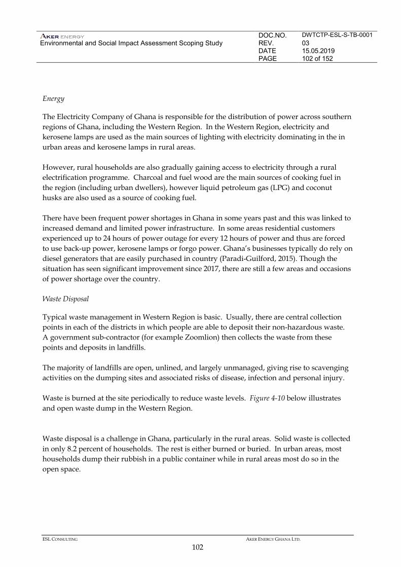
DOC.NO. DWTCTP-ESL-S-TB-0001 Environmental and Social Impact Assessment Scoping Study
REV. 03 DATE 15.05.2019 PAGE 102 of 152
ESL CONSULTING AKER ENERGY GHANA LTD.
102
Energy
The Electricity Company of Ghana is responsible for the distribution of power across southern regions of Ghana, including the Western Region. In the Western Region, electricity and kerosene lamps are used as the main sources of lighting with electricity dominating in the in urban areas and kerosene lamps in rural areas. However, rural households are also gradually gaining access to electricity through a rural electrification programme. Charcoal and fuel wood are the main sources of cooking fuel in the region (including urban dwellers), however liquid petroleum gas (LPG) and coconut husks are also used as a source of cooking fuel. There have been frequent power shortages in Ghana in some years past and this was linked to increased demand and limited power infrastructure. In some areas residential customers experienced up to 24 hours of power outage for every 12 hours of power and thus are forced to use back-up power, kerosene lamps or forgo power. Ghana’s businesses typically do rely on diesel generators that are easily purchased in country (Paradi-Guilford, 2015). Though the situation has seen significant improvement since 2017, there are still a few areas and occasions of power shortage over the country. Waste Disposal
Typical waste management in Western Region is basic. Usually, there are central collection points in each of the districts in which people are able to deposit their non-hazardous waste. A government sub-contractor (for example Zoomlion) then collects the waste from these points and deposits in landfills. The majority of landfills are open, unlined, and largely unmanaged, giving rise to scavenging activities on the dumping sites and associated risks of disease, infection and personal injury. Waste is burned at the site periodically to reduce waste levels. Figure 4-10 below illustrates and open waste dump in the Western Region. Waste disposal is a challenge in Ghana, particularly in the rural areas. Solid waste is collected in only 8.2 percent of households. The rest is either burned or buried. In urban areas, most households dump their rubbish in a public container while in rural areas most do so in the open space.
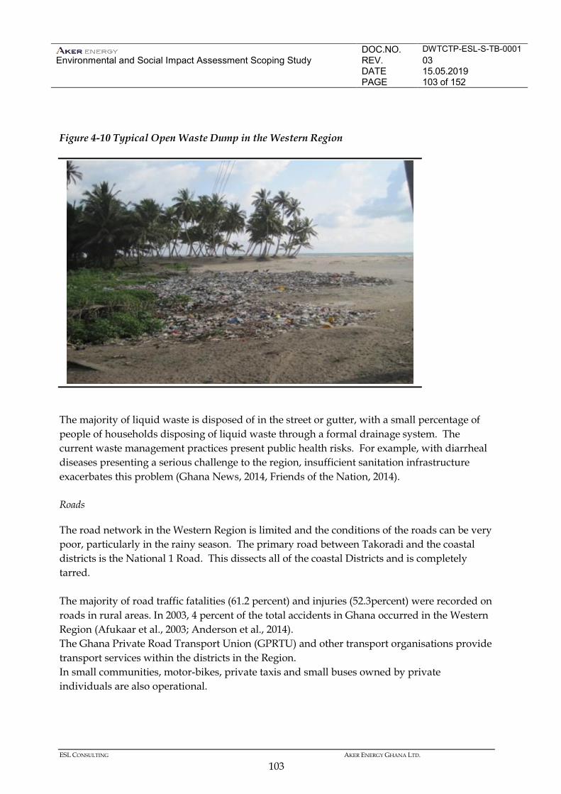
DOC.NO. DWTCTP-ESL-S-TB-0001 Environmental and Social Impact Assessment Scoping Study
REV. 03 DATE 15.05.2019 PAGE 103 of 152
ESL CONSULTING AKER ENERGY GHANA LTD.
103
Figure 4-10 Typical Open Waste Dump in the Western Region
The majority of liquid waste is disposed of in the street or gutter, with a small percentage of people of households disposing of liquid waste through a formal drainage system. The current waste management practices present public health risks. For example, with diarrheal diseases presenting a serious challenge to the region, insufficient sanitation infrastructure exacerbates this problem (Ghana News, 2014, Friends of the Nation, 2014). Roads
The road network in the Western Region is limited and the conditions of the roads can be very poor, particularly in the rainy season. The primary road between Takoradi and the coastal districts is the National 1 Road. This dissects all of the coastal Districts and is completely tarred. The majority of road traffic fatalities (61.2 percent) and injuries (52.3percent) were recorded on roads in rural areas. In 2003, 4 percent of the total accidents in Ghana occurred in the Western Region (Afukaar et al., 2003; Anderson et al., 2014). The Ghana Private Road Transport Union (GPRTU) and other transport organisations provide transport services within the districts in the Region. In small communities, motor-bikes, private taxis and small buses owned by private individuals are also operational.
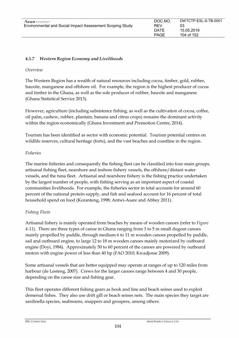
DOC.NO. DWTCTP-ESL-S-TB-0001 Environmental and Social Impact Assessment Scoping Study
REV. 03 DATE 15.05.2019 PAGE 104 of 152
ESL CONSULTING AKER ENERGY GHANA LTD.
104
4.5.7 Western Region Economy and Livelihoods
Overview
The Western Region has a wealth of natural resources including cocoa, timber, gold, rubber, bauxite, manganese and offshore oil. For example, the region is the highest producer of cocoa and timber in the Ghana, as well as the sole producer of rubber, bauxite and manganese (Ghana Statistical Service 2013). However, agriculture (including subsistence fishing, as well as the cultivation of cocoa, coffee, oil palm, cashew, rubber, plantain, banana and citrus crops) remains the dominant activity within the region economically (Ghana Investment and Promotion Centre, 2014). Tourism has been identified as sector with economic potential. Tourism potential centres on wildlife reserves, cultural heritage (forts), and the vast beaches and coastline in the region. Fisheries
The marine fisheries and consequently the fishing fleet can be classified into four main groups, artisanal fishing fleet, nearshore and inshore fishery vessels, the offshore/distant water vessels, and the tuna fleet. Artisanal and nearshore fishery is the fishing practice undertaken by the largest number of people, with fishing serving as an important aspect of coastal communities livelihoods. For example, the fisheries sector in total accounts for around 60 percent of the national protein supply, and fish and seafood account for 16 percent of total household spend on food (Koranteng, 1998; Antwi-Asare and Abbey 2011). Fishing Fleets
Artisanal fishery is mainly operated from beaches by means of wooden canoes (refer to Figure 4-11). There are three types of canoe in Ghana ranging from 3 to 5 m small dugout canoes mainly propelled by paddle, through medium 6 to 11 m wooden canoes propelled by paddle, sail and outboard engine, to large 12 to 18 m wooden canoes mainly motorized by outboard engine (Doyi, 1984). Approximately 50 to 60 percent of the canoes are powered by outboard motors with engine power of less than 40 hp (FAO 2010; Kwadjosse 2009). Some artisanal vessels that are better equipped may operate at ranges of up to 120 miles from harbour (de Lesteng, 2007). Crews for the larger canoes range between 4 and 30 people, depending on the canoe size and fishing gear. This fleet operates different fishing gears as hook and line and beach seines used to exploit demersal fishes. They also use drift gill or beach seines nets. The main species they target are sardinella species, seabreams, snappers and groupers, among others.
DOC.NO. DWTCTP-ESL-S-TB-0001 Environmental and Social Impact Assessment Scoping Study
REV. 03 DATE 15.05.2019 PAGE 105 of 152
ESL CONSULTING AKER ENERGY GHANA LTD.
105
The inshore/nearshore fishing fleet consists of locally built wooden vessels fitted with inboard engines of up to 400 hp ranging between 8 m and 37 m in length. Vessels with lengths less than 12 m are referred to as small-sized while those between 12 and 22 m are referred to as medium-sized vessels (FAO 2010).
Figure 4-11 Typical Canoe and Fishing Nets
There are about 300 inshore vessels, operating from seven landing centres, the larger centres being Takoradi, Tema, Elmina and Sekondi and the smaller centres being Apam, Axim, Mumford (TFS 2011). Currently this sector is estimated to land about 2% of the total marine fish production (Kwadjosse 2009). The inshore fleets are mainly multi-purpose and operate as purse-seiners during the upwelling periods and switching to bottom trawling for the rest of the year. Most purse-seine nets measure 400 to 800 m long, are 40 to 70 m deep and have a mesh size of approximately 25 to 40 mm. Bottom trawl gear has a mesh of 40 mm at the end of the net (cod end), 45 m head rope and 40 m foot rope. The fishermen in this category can stay offshore for three to five days depending on the availability of catch and as such carry ice for preserving fish, and they have a range of up to 200 nautical miles (de Lesteng, 2007). The industrial fishing fleet is composed of trawlers, shrimpers and tuna boats that may remain at sea for periods that last up to one month. According to FAO (2014) the fleet in Ghana includes approximately 60 trawlers and about 29 tuna boats. As deep-sea vessels, they are required by the Fisheries Act of 2002 (Act 625) to operate outside the Inshore Exclusion Zone (IEZ), that is in waters greater than 30 m depth (or 12 nautical miles), but as they generally cannot trawl in depths greater than 75 m, due to the state of disrepair of vessels and engines, their operational area is limited to areas between these two depths.
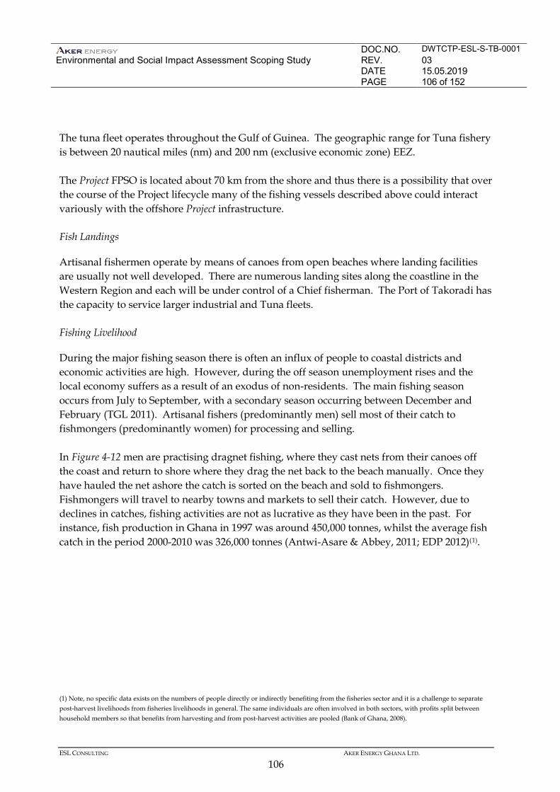
DOC.NO. DWTCTP-ESL-S-TB-0001 Environmental and Social Impact Assessment Scoping Study
REV. 03 DATE 15.05.2019 PAGE 106 of 152
ESL CONSULTING AKER ENERGY GHANA LTD.
106
The tuna fleet operates throughout the Gulf of Guinea. The geographic range for Tuna fishery is between 20 nautical miles (nm) and 200 nm (exclusive economic zone) EEZ. The Project FPSO is located about 70 km from the shore and thus there is a possibility that over the course of the Project lifecycle many of the fishing vessels described above could interact variously with the offshore Project infrastructure. Fish Landings
Artisanal fishermen operate by means of canoes from open beaches where landing facilities are usually not well developed. There are numerous landing sites along the coastline in the Western Region and each will be under control of a Chief fisherman. The Port of Takoradi has the capacity to service larger industrial and Tuna fleets. Fishing Livelihood
During the major fishing season there is often an influx of people to coastal districts and economic activities are high. However, during the off season unemployment rises and the local economy suffers as a result of an exodus of non-residents. The main fishing season occurs from July to September, with a secondary season occurring between December and February (TGL 2011). Artisanal fishers (predominantly men) sell most of their catch to fishmongers (predominantly women) for processing and selling. In Figure 4-12 men are practising dragnet fishing, where they cast nets from their canoes off the coast and return to shore where they drag the net back to the beach manually. Once they have hauled the net ashore the catch is sorted on the beach and sold to fishmongers. Fishmongers will travel to nearby towns and markets to sell their catch. However, due to declines in catches, fishing activities are not as lucrative as they have been in the past. For instance, fish production in Ghana in 1997 was around 450,000 tonnes, whilst the average fish catch in the period 2000-2010 was 326,000 tonnes (Antwi-Asare & Abbey, 2011; EDP 2012)(1).
(1) Note, no specific data exists on the numbers of people directly or indirectly benefiting from the fisheries sector and it is a challenge to separate post-harvest livelihoods from fisheries livelihoods in general. The same individuals are often involved in both sectors, with profits split between household members so that benefits from harvesting and from post-harvest activities are pooled (Bank of Ghana, 2008).
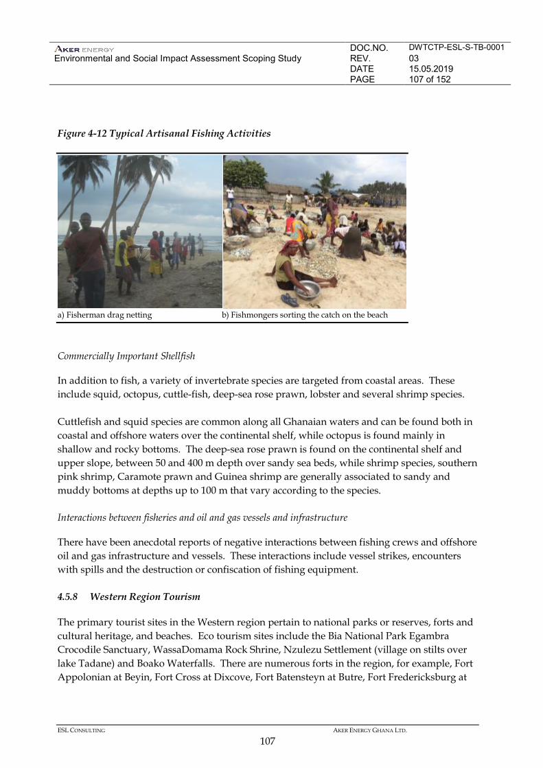
DOC.NO. DWTCTP-ESL-S-TB-0001 Environmental and Social Impact Assessment Scoping Study
REV. 03 DATE 15.05.2019 PAGE 107 of 152
ESL CONSULTING AKER ENERGY GHANA LTD.
107
Figure 4-12 Typical Artisanal Fishing Activities
Commercially Important Shellfish
In addition to fish, a variety of invertebrate species are targeted from coastal areas. These include squid, octopus, cuttle-fish, deep-sea rose prawn, lobster and several shrimp species. Cuttlefish and squid species are common along all Ghanaian waters and can be found both in coastal and offshore waters over the continental shelf, while octopus is found mainly in shallow and rocky bottoms. The deep-sea rose prawn is found on the continental shelf and upper slope, between 50 and 400 m depth over sandy sea beds, while shrimp species, southern pink shrimp, Caramote prawn and Guinea shrimp are generally associated to sandy and muddy bottoms at depths up to 100 m that vary according to the species. Interactions between fisheries and oil and gas vessels and infrastructure
There have been anecdotal reports of negative interactions between fishing crews and offshore oil and gas infrastructure and vessels. These interactions include vessel strikes, encounters with spills and the destruction or confiscation of fishing equipment. 4.5.8 Western Region Tourism
The primary tourist sites in the Western region pertain to national parks or reserves, forts and cultural heritage, and beaches. Eco tourism sites include the Bia National Park Egambra Crocodile Sanctuary, WassaDomama Rock Shrine, Nzulezu Settlement (village on stilts over lake Tadane) and Boako Waterfalls. There are numerous forts in the region, for example, Fort Appolonian at Beyin, Fort Cross at Dixcove, Fort Batensteyn at Butre, Fort Fredericksburg at
a) Fisherman drag netting b) Fishmongers sorting the catch on the beach
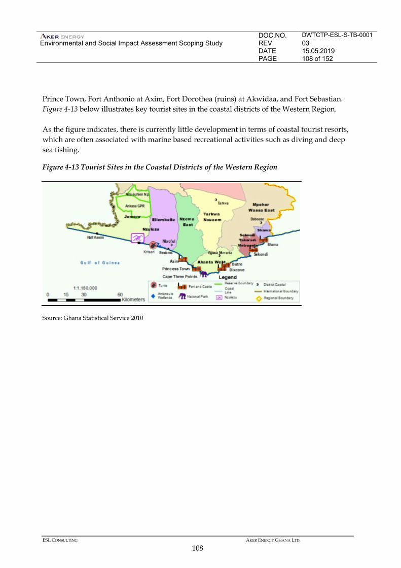
DOC.NO. DWTCTP-ESL-S-TB-0001 Environmental and Social Impact Assessment Scoping Study
REV. 03 DATE 15.05.2019 PAGE 108 of 152
ESL CONSULTING AKER ENERGY GHANA LTD.
108
Prince Town, Fort Anthonio at Axim, Fort Dorothea (ruins) at Akwidaa, and Fort Sebastian. Figure 4-13 below illustrates key tourist sites in the coastal districts of the Western Region. As the figure indicates, there is currently little development in terms of coastal tourist resorts, which are often associated with marine based recreational activities such as diving and deep sea fishing.
Figure 4-13 Tourist Sites in the Coastal Districts of the Western Region
Source: Ghana Statistical Service 2010
DOC.NO. DWTCTP-ESL-S-TB-0001 Environmental and Social Impact Assessment Scoping Study
REV. 03 DATE 15.05.2019 PAGE 109 of 152
ESL CONSULTING AKER ENERGY GHANA LTD.
109
5 IDENTIFICATION OF POTENTIAL IMPACTS
5.1 INTRODUCTION
One of the objectives with the EIA Scoping is to identify impacts most likely to be significant and therefore need to be addressed in the EIA. The main project activities associated with development of offshore oil fields are well established and the main potential environmental and social issues are generally well understood. The environmental aspects related to development and operation of DWT CTP are described in section 3.7. The environmental and social baseline is described in section 4. This section will give an overview of the potentially most significant environmental and social impacts from the development and operation of the DWT CTP block. The EIAS Scoping also includes stakeholder consulting to identify specific sensitivities and key issues, resources and receptors that may be affected by the project. The outcome of the stakeholder consultations is described in section 7 and in the appendices. This section will not go into detail on assessing the importance and severity of potential impacts, that will be conducted in the proceeding EIA study with specialist studies for some of the environmental topics and be reported in the final Environmental Impact Statement (EIS). 5.2 ENVIRONMENTAL AND SOCIAL RESOURCES AND RECEPTORS
For this Project the following main resources and receptor types were identified. • Physical Environment: including the seabed, sediment quality, water quality,
hydrodynamics and air quality. • Natural Environment: including plankton, benthic flora and fauna, pelagic and demersal
fish, marine mammals, turtles, birds, wetlands, mangrove and other coastal habitats. • Human Environment: including coastal communities, fishing (artisanal and industrial),
marine traffic / shipping, tourism / recreation, land use, land based traffic and transportation, infrastructure / services, employment and business opportunities, regional and national economy, public health and safety, occupational health and safety.
5.3 IDENTIFICATION OF POTENTIAL INTERACTIONS AND IMPACTS
The project activities, environmental aspects and issues as well as potential impacts were identified in an ENVID (Environmental Hazard Identification) workshop with the pre-FEED field development project team. The interaction of project activities / issues with resources and receptors that might occur during the project are shown in Table 5-1, for the entire field life from construction, operation to decommissioning.
DOC.NO. DWTCTP-ESL-S-TB-0001 Environmental and Social Impact Assessment Scoping Study
REV. 03 DATE 15.05.2019 PAGE 110 of 152
ESL CONSULTING AKER ENERGY GHANA LTD.
110
Table 5-1 Interaction of project activities and related environmental aspects with resources and receptors
Aspect Activity/Issue
Physical Natural Human
Oce
anog
raph
y
Sedi
men
t
Wat
er c
olum
n
Air
Plan
kton
Bent
hic
faun
a an
d flo
ra
Fish
Sea
bird
s
Mar
ine
mam
mal
s
Turt
les
Coa
stal
hab
itat
Coa
stal
com
mun
ities
Fish
ing
Mar
ine
traf
fic /
shi
ppin
g
Tour
ism
/ re
crea
tion
Land
use
Infr
astr
uctu
re a
nd s
ervi
ces
Econ
omy
Hea
lth a
nd s
afet
y
Physical Presence Presence of FPSO, drilling rig and support vessels Subsea equipment and pipelines
Marine Discharges
Produced water Cooling water Hydraulic discharge from subsea equipment Deck drainage, bilge and slop water Sewage water and food waste Ballast water Drilling fluids and drill cuttings Completion fluid
Air Emission Fuel combustion for power generation Flaring and venting Fugitive emission
DOC.NO. DWTCTP-ESL-S-TB-0001 Environmental and Social Impact Assessment Scoping Study
REV. 03 DATE 15.05.2019 PAGE 111 of 152
ESL CONSULTING AKER ENERGY GHANA LTD.
111
Aspect Activity/Issue
Physical Natural Human
Oce
anog
raph
y
Sedi
men
t
Wat
er c
olum
n
Air
Plan
kton
Bent
hic
faun
a an
d flo
ra
Fish
Sea
bird
s
Mar
ine
mam
mal
s
Turt
les
Coa
stal
hab
itat
Coa
stal
com
mun
ities
Fish
ing
Mar
ine
traf
fic /
shi
ppin
g
Tour
ism
/ re
crea
tion
Land
use
Infr
astr
uctu
re a
nd s
ervi
ces
Econ
omy
Hea
lth a
nd s
afet
y
Noise Machinery Propellers and thrusters Seismic in well
Light Illumination of FPSO and drilling rig Waste Generation of hazardous and non-hazardous waste
Accidental events Small spill of fuel, crude oil or chemicals Large spill of fuel or crude oil Fire / explosion
Employment Job creation Procurement Business opportunities and secondary job creations
Onshore infrastructure and support
Equipment transportation, port operations Crew transfer and helicopter operation Chemical handling and storage Expansion of or development of shore base Fabrication of FPSO and subsea equipment
DOC.NO. DWTCTP-ESL-S-TB-0001 Environmental and Social Impact Assessment Scoping Study
REV. 03 DATE 15.05.2019 PAGE 112 of 152
ESL CONSULTING AKER ENERGY GHANA LTD.
112
The probable environmental impacts associated with an oil and gas development and operation are generally narrower in scope than possible interactions identified in the table due to mitigation measures that will be built into the project design and operational philosophies. This identification process is intended to be broad at this stage so as to consider the wide range of possible interactions and impacts. Potential impacts, based on interactions shown in Table 5-1, will be assessed in detail in the EIA study, and can be grouped as follows:
• Physical footprint • Routine planned discharges of chemicals and hydrocarbons to sea • Non-routine planned discharges of chemicals and hydrocarbons to sea • Emission of GHG to air • Emission of pollutants to air • Accidental discharges of chemicals and hydrocarbons • Waste generation and handling • Socioeconomic impacts • Fishery impacts • Local community impacts from project related onshore activities • Cumulative and transboundary impacts
5.3.1 Physical Footprint
The key potential impacts are:
• Physical impact on the seabed and benthic communities through placement/presence of subsea infrastructure
• Interaction from vessel or helicopter movements and underwater sound potential for impact on marine fauna (marine mammals, turtles, fish, birds).
• Potential impact on fish ecology due the presence of the vessels (FPSO and construction related vessels) and its fish attracting quality.
• Installation of subsea infrastructure may disturb deepwater species. • Presence of subsea infrastructure will provide new seabed habitat. • Presence of surface installations and vessels may impact fishing and shipping
activities. 5.3.2 Routine planned discharges of chemicals and hydrocarbons
The key impacts identified include the following. • Discharges from drilling vessels, FPSO and project vessels contaminated with traces of
hydrocarbons could affect water quality and cause secondary impacts on marine fauna.
DOC.NO. DWTCTP-ESL-S-TB-0001 Environmental and Social Impact Assessment Scoping Study
REV. 03 DATE 15.05.2019 PAGE 113 of 152
ESL CONSULTING AKER ENERGY GHANA LTD.
113
• Black, grey water and food waste discharges from drilling vessels, FPSO and project vessels could affect water quality with secondary impacts on marine fauna.
• Discharge of ballast waters (from export tankers and other vessels) could impact on water quality and marine fauna and introduce invasive species.
• Discharge of produced water containing hydrocarbons could impact on water quality and cause secondary impacts on marine fauna.
• Hydraulic fluid from daily subsea valve activation could impact on water quality. 5.3.3 Non-routine planned discharges of chemicals and hydrocarbons to sea
• Discharge of cuttings and residual drilling fluid could impact on water and sediment quality and cause secondary impacts on marine fauna.
• Discharge of completion fluids and occasional discharge of workover fluids from the drilling vessels could impact on water quality and cause secondary impacts on marine fauna.
• Chemically treated hydro test waters discharged during commissioning could have an impact on water quality and secondary impact on marine fauna.
• Fall-out of non-combusted hydrocarbons during drilling could have an impact on seabirds, water quality and marine fauna.
5.3.4 Emissions of GHG to air
Emissions of greenhouse gases like CO2 , methane and non-methane volatile organic compounds (nmVOC) occur from fuel combustion in the gas turbine, from flaring of gas and liquid hydrocarbons during well tests and well cleanup, from flaring of gas in the commissioning phase and during routine and non-routine production shutdown and startup. Fugitive emission of methane occurs from flanges, valves and compressors. Emission of nm-VOC mainly occurs from crude storage and offloading. All these emissions have the potential to impact the global climate by increasing the greenhouse gas concentration in the atmosphere. 5.3.5 Emission of pollutants to air
Emissions of particulate matter, NOx, SOx and other gases from the fuel combustion in the gas turbine and from hydrocarbon flaring has the potential to impact the air quality.
DOC.NO. DWTCTP-ESL-S-TB-0001 Environmental and Social Impact Assessment Scoping Study
REV. 03 DATE 15.05.2019 PAGE 114 of 152
ESL CONSULTING AKER ENERGY GHANA LTD.
114
5.3.6 Accidental discharges of hydrocarbons and chemicals
An oil spill to sea has the potential to impact marine and coastal habitats, flora (mangrove, seaweed and seagrass) and fauna (seabird, coastal birds, marine mammals, sea turtles and fish) fisheries and livelihoods depending on the coast and marine environment impacted. Potential leaks or accidental releases of oil or chemicals from tanks, pipes, hoses and pumps, including during loading and unloading from the shore base could impact water quality, soil and groundwater quality, and secondary terrestrial life, marine life and community health. 5.3.7 Waste generation and handling
Non-hazardous and hazardous wastes will be generated during construction, production and decommissioning of the field. The waste handling will require storage, sea transportation, land transportation, treatment and disposal. The waste handling shall be conducted in manner to protect natural and human environment. Impact will be from energy use during transportation and treatment, emissions to air during treatment and for land use during disposal. 5.3.8 Socioeconomic impacts
Key positive and negative socio-economic impacts on human receptors include the following. Macroeconomy
• Revenue generated by the project through oil sales, taxes and royalties will be a source of income for the government.
Livelihoods and Local Economy
• Procurement of goods and services has the potential to result in positive impacts by stimulating local small and medium sized business development and generation of profits.
• Direct employment by the project and direct employment in the supply chain by contractors and suppliers will have a positive impact on those people employed, their families and their local communities from wages and other benefits. Similarly, skills development and training in the oil and gas sector will benefit those involved.
• Project demands for goods, housing and services have the potential to lead to shortages and price increases placing greater financial pressure on the local population.
DOC.NO. DWTCTP-ESL-S-TB-0001 Environmental and Social Impact Assessment Scoping Study
REV. 03 DATE 15.05.2019 PAGE 115 of 152
ESL CONSULTING AKER ENERGY GHANA LTD.
115
Infrastructure and Services • There may be increased strain on the capacity of the public infrastructure (eg roads)
and services (eg water supply) due project related activities. Navigation
• Vessel movements associated with the project has the potential to disrupt existing commercial shipping routes.
Health and Safety
• The presence of non-local workers and other project- related workers could introduce communicable diseases and sexually transmitted diseases.
• The may be health impacts to nearby communities from onshore operations if unmanaged project discharges or emissions result in reduced local air or water quality.
• The presence of non-local workers and other project related workers may lead to an increase in social pathologies such as prostitution and the potential influx of job seekers and associate unemployment may lead to an increase in crime levels.
CSR Investments and Community Relations
• There is the potential for increased grievances and tension within communities and between communities and the government, Aker Energy and third parties caused by expectations not being met. For example, in employment opportunities, investments in local infrastructure and the level of CSR investment.
• Differential benefits received across the six coastal districts may result in increased grievances and tension in the Western Region.
5.3.9 Fishery Impact
The following are main potential impacts and concerns as expressed by local fishermen in the Western Region:
• Loss of access to fishing grounds (through safety exclusion zones). • Attraction of fish to the drilling vessel and FPSO. • Disturbance of fishing operations and damage to fishing gear from project support
vessels. 5.3.10 Project Activities Onshore
In addition to the social-economic impacts described above, a range of activities likely to be undertaken at the onshore bases and yards can result in disturbance or damage to the health and wellbeing of local communities. The key impacts identified include the following.
• Elevated noise levels from shore base operations and increased traffic on local roads.
DOC.NO. DWTCTP-ESL-S-TB-0001 Environmental and Social Impact Assessment Scoping Study
REV. 03 DATE 15.05.2019 PAGE 116 of 152
ESL CONSULTING AKER ENERGY GHANA LTD.
116
• Storage, handling and transport of solid and liquid wastes at onshore bases could lead to loss of containment and spillages which could give rise to ground and ground water contamination.
• Air quality impacts from emissions, for example from combustion of fuel (eg NOx/ SOx), dust from ground disturbance and transportation or smoke from hot works.
5.3.11 Cumulative and Transboundary Impacts
An EIA requires consideration of the direct effects and any indirect, secondary and cumulative effects of a project. A cumulative impact is defined as an impact that results from incremental changes caused by other past, present or reasonably foreseeable activities together with the proposed project. The following categories of cumulative impacts will be addressed in the EIA:
• biodiversity; • environmental quality; • infrastructure and services; and • socio-economic effects.
The resources and receptors that may be subject to cumulative impacts include those that have been identified as potentially impacted by the project development at the offshore project location, the onshore logistics bases and the transit routes between these, and coastal areas that could be affected by routine discharges as well as accidents events such as an oil spill. The project is located near the border with Cote d'Ivoire and ecological systems are connected hence some interaction may occur. Transboundary impacts will therefore also be addressed in the EIA.

DOC.NO. DWTCTP-ESL-S-TB-0001 Environmental and Social Impact Assessment Scoping Study
REV. 03 DATE 15.05.2019 PAGE 117 of 152
ESL CONSULTING AKER ENERGY GHANA LTD.
117
6 SCOPING STAKEHOLDER ENGAGEMENT
6.1 OBJECTIVES AND APPROACH
The initial phase of work to develop the scope for the Deep Water Tano/Cape Three Point (DWT/CTP) EIA involved identifying the components of the Project and the activities involved in construction, operation and closure, and considering how these could be expected to interact with known environmental and social conditions in the vicinity of the Project. This process will be guided by reference to the EPA Guidance on EIA Scoping and the IFC Performance Standards (International Finance Corporation Sustainability Framework - available at http://www.ifc.org/ifcext/policyreview.nsf). The DWT/CTP EIA Terms of Reference is included in section seven (7) and will be submitted to the EPA. The purpose of the Terms of Reference is to define the Project and its potential impacts on the environment and communities, set out the proposed approach and methods for the impact assessment, identify the expertise that is needed to prepare the study, and present the schedule for its completion. The Terms of Reference will be reviewed and approved by the EPA.
6.2 STAKEHOLDER ENGAGEMENT PRINCIPLES AND ACTIVITIES
To inform the scope of the assessment, the EIA Team will also undertake a programme of consultations on the Project and the EIA Terms of Reference. Details will be set out in a Stakeholder Engagement Plan to be published, covering stakeholder engagement activities during the EIA study. The Plan will include an analysis and identification of potential stakeholders which will be used to inform the development of the programme. Engagement Principles International best practice recommends the active engagement of stakeholders throughout a Project lifecycle, commencing with scoping. Stakeholder engagement is an important part of the environmental and social impact studies leading up to EIA report, but it is the intention that this will continue as a crucial aspect of the way environmental and social impacts and risks are managed in the future. This will be undertaken in accordance with IFC guidance and Aker Energy’s policy with regard to engagement.
DOC.NO. DWTCTP-ESL-S-TB-0001 Environmental and Social Impact Assessment Scoping Study
REV. 03 DATE 15.05.2019 PAGE 118 of 152
ESL CONSULTING AKER ENERGY GHANA LTD.
118
In line with current international best practice, the Project will ensure that engagement:
• is free from manipulation, interference, coercion and intimidation; • is free of charges for participation; • takes place prior to decisions being made so that views expressed can be
considered; • is conducted based on timely, relevant, understandable and accessible
information; • is undertaken in a culturally appropriate manner; • includes all those interested in or affected by the Project, and in particular,
vulnerable groups; • achieves a two-way dialogue; and • is responsive, and includes explicit mechanisms for receiving, documenting
and addressing comments received. Aker Energy standards require that consultation and engagement are carried out in good faith with mutual obligation. Approaches and procedures must be transparent, inclusive and culturally appropriate, and must ensure that:
• people and organisations who may be affected by or interested in the Project are as fully informed as practically possible about the Project and its possible effects before they occur and have access to reliable independent advice;
• two-way discussions cover stakeholder issues and priorities as well as the concerns and needs of the company;
• discussions occur in a language and format that is understandable to local stakeholders;
• stakeholders participate to the greatest extent possible in social and environmental impact assessments;
• a record is kept of all formal and informal meetings that involve commitments, including how views of both the company and stakeholders may have changed and where agreements have been reached, and of action items with dates for completion; and
• discussions and community decision-making reflect established local conventions and protocols, including gender considerations, supplemented if necessary by additional processes for inadequately represented and marginalized groups.
The programme of engagement activities that was undertaken during scoping, was designed to accord with the above principles and the DWT/CTP Project is committed to continuing this through the lifetime of the Project. The Stakeholder Engagement Plan for the Project will be updated to describe the next steps in this process.
DOC.NO. DWTCTP-ESL-S-TB-0001 Environmental and Social Impact Assessment Scoping Study
REV. 03 DATE 15.05.2019 PAGE 119 of 152
ESL CONSULTING AKER ENERGY GHANA LTD.
119
The remainder of this section outlines the activities that was undertaken for the scoping exercise. The section also focuses on the plan for disclosure of this report and consultation on its findings with Project stakeholders. The processes for enabling and responding to feedback from stakeholders and for managing any grievances that may arise are also described.
DOC.NO. DWTCTP-ESL-S-TB-0001 Environmental and Social Impact Assessment Scoping Study
REV. 03 DATE 15.05.2019 PAGE 120 of 152
ESL CONSULTING AKER ENERGY GHANA LTD.
120
7 THE DWT/CTP SCOPING PROCESS AND OUTCOME
7.1 STAKEHOLDER IDENTIFICATION (MAPPING)
The IFC’s Handbook on Stakeholder Engagement (2007) defines stakeholders as “persons or groups who are directly or indirectly affected by a project, as well as those who may have interests in a project and/or the ability to influence its outcome, either positively or negatively.”
As part of scoping, a stakeholder identification exercise was undertaken to select key stakeholder groups and organisations, based on ESL’s experience in similar EIAs in Ghana. These stakeholders were selected based on the above definition, and that they would have an interest in the Project and would also have knowledge through which to provide insight into possible issues and concerns related to the Project. In addition, further stakeholder groups were identified through the consultation process.
The composition of stakeholders is likely to expand/change as the Project moves to feasibility, construction, operations and closure. 7.2 NOTIFICATION OF KEY STAKEHOLDERS
The stakeholders selected during the identification process were either contacted via telephone to arrange a stakeholder consultation meeting or by hand-delivery of an invitation letter with a Background Information Document (BID) attached. A copy of the BID and a covering letter requesting a meeting were hand-delivered to these stakeholders and meetings confirmed through subsequent telephone and email communication. The BID provided an overview of the Project and also outlined ways through which additional issues and comments could be raised with Aker Energy and the EIA team. Additional stakeholders that may be identified later will be engaged with written communication that may include the BID, and an invitation to submit written comment. A copy of the invitation letter and the BID is provided in Appendix 6-A. Below is a list of all fifteen (15) stakeholders contacted through an invitation letter and a BID:
DOC.NO. DWTCTP-ESL-S-TB-0001 Environmental and Social Impact Assessment Scoping Study
REV. 03 DATE 15.05.2019 PAGE 121 of 152
ESL CONSULTING AKER ENERGY GHANA LTD.
121
Environmental Protection Agency (EPA) Fisheries Commission Ghana Marine Police Ghana Ports and Harbours Authority (GPHA) Petroleum Commission National Canoe Fishermen Association Ghana Maritime Authority (GMA) Ghana Navy Ministry of Energy (MoEn) Western Regional Coordination Council (WRCC) Western Regional House of Chiefs (WRHC) Western Regional EPA Western Regional GPHA Western Regional Fisheries Commission
7.3 CONSULTATION MEETINGS
Fourteen (14) public scoping meetings were conducted in June and July 2018, with the dates and locations detailed in Table 6-1. Eight (8) of the meetings were held in Takoradi and 6 in Accra. The scoping meeting format and the information presented was the same at each public meeting. During the open house sessions, attendees had the opportunity to view presentation boards and maps that displayed Project information and could ask questions about the Project team. A Project overview, including an introduction to the EIA process, was also presented. The question and comment period was followed with the completion of comment forms, some of which were submitted immediately while others were received days after. Comment forms were made available at meetings so attendees could submit written comments during the meeting whenever possible. Supporting information for public scoping meetings and formal presentation is included in Appendix 6-B.
DOC.NO. DWTCTP-ESL-S-TB-0001 Environmental and Social Impact Assessment Scoping Study
REV. 03 DATE 15.05.2019 PAGE 122 of 152
ESL CONSULTING AKER ENERGY GHANA LTD.
122
7.4 MANAGING STAKEHOLDER FEEDBACK
Throughout the period of consultation, a formal comment and feedback system would operate. Comments and questions were requested to be submitted to the Project Team by various routes: • by email to: [email protected], [email protected] ; • by writing to:
The Chief Executive Officer ESL Consulting Ltd. P. O. Box LG 239 Legon-Accra, Ghana. Tel: +233-244771707 or
• by email to: [email protected], • by writing to:
Mr. Emmanuel Appiah 7th Floor Marina Mall Airport City Accra Tel: +233-544338699
• by raising a point or asking a question at a stakeholder event; • by leaving a written comment at a stakeholder event or • by raising an issue with the relevant authorities or regulators (the EPA and the
Petroleum Commission). Comments could be submitted by any means (in person, in writing, by email) including on the pre-printed feedback form which was made widely available. A copy of the feedback form is included in Appendix 6-C: Aker Energy Deep Water Tano Cape Three Points (DWT/CTP) Development EIA Scoping Study Background Information Document (BID), and is available on the website (www.akerenergy.com). All comments made by stakeholders, whether in person, by mail or email, was recorded. Where questions were raised that required an individual response, this was provided and if any parties raised a grievance or complaint this would be managed through the Aker Energy Grievance Procedure (see Section 6.2.7). This document is the report on the
DOC.NO. DWTCTP-ESL-S-TB-0001 Environmental and Social Impact Assessment Scoping Study
REV. 03 DATE 15.05.2019 PAGE 123 of 152
ESL CONSULTING AKER ENERGY GHANA LTD.
123
outcome of the stakeholders engagement at the scoping stage of the preparation of the Environmental and Social Impacts Assessment (EIA).
7.5 SUMMARY OF COMMENTS
Aker Energy scoping comments document interested parties' concerns about the scope of the proposed course of action as well as identify significant issues, resources and suggested alternatives. The scoping comments will be considered during the study process and in preparation of the draft EIA. 7.5.1 Summary of Aker Energy Scoping Comments
A total of a hundred and eighty-seven (187) people signed the attendance records for the fifteen (15) Aker Energy scoping engagements. These included, but not limited to, private citizens, industry stakeholders, non-governmental organizations (NGOs) and political representatives. A copy of the sign-in attendance record sheets for the public Aker Energy scoping meetings is provided in Appendix 6-D. A total of a hundred and fifty-two (152) comments were received during the Aker Energy scoping engagement period. Of these, fifty-five (55) verbal comments were articulated during the fifteen Aker Energy scoping meetings (Table 6-1; see Appendix 6-C). Ninety-seven (97) written comments (see extracts of comments tabulated in Appendix 6-E) were received, submitted either in person or electronically via email. Aker Energy stakeholder scoping engagement often contained several multi-part comments directed at multiple areas of concern. Hence, a single comment could potentially be addressed in multiple sections of the EIA. A total of two hundred and thirty-nine (239) specific comments (written categorised by subject matter) were expressed during the Aker Energy scoping engagement period (Table 6-2). For accurate representation, spoken scoping engagement comments were recorded and transcribed, and public comments may have grammatical or spelling errors.
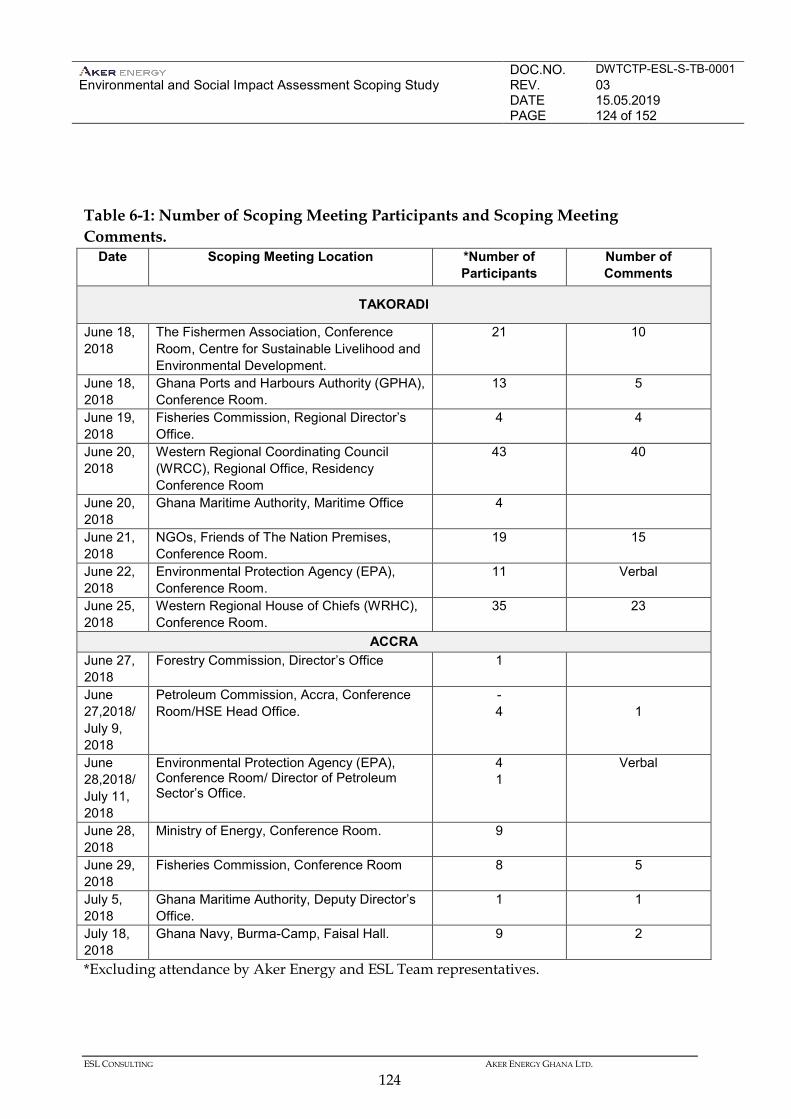
DOC.NO. DWTCTP-ESL-S-TB-0001 Environmental and Social Impact Assessment Scoping Study
REV. 03 DATE 15.05.2019 PAGE 124 of 152
ESL CONSULTING AKER ENERGY GHANA LTD.
124
Table 6-1: Number of Scoping Meeting Participants and Scoping Meeting Comments.
Date Scoping Meeting Location *Number of Participants
Number of Comments
TAKORADI
June 18, 2018
The Fishermen Association, Conference Room, Centre for Sustainable Livelihood and Environmental Development.
21 10
June 18, 2018
Ghana Ports and Harbours Authority (GPHA), Conference Room.
13 5
June 19, 2018
Fisheries Commission, Regional Director’s Office.
4 4
June 20, 2018
Western Regional Coordinating Council (WRCC), Regional Office, Residency Conference Room
43 40
June 20, 2018
Ghana Maritime Authority, Maritime Office 4
June 21, 2018
NGOs, Friends of The Nation Premises, Conference Room.
19 15
June 22, 2018
Environmental Protection Agency (EPA), Conference Room.
11 Verbal
June 25, 2018
Western Regional House of Chiefs (WRHC), Conference Room.
35 23
ACCRA June 27, 2018
Forestry Commission, Director’s Office 1
June 27,2018/ July 9, 2018
Petroleum Commission, Accra, Conference Room/HSE Head Office.
- 4
1
June 28,2018/ July 11, 2018
Environmental Protection Agency (EPA), Conference Room/ Director of Petroleum Sector’s Office.
4 1
Verbal
June 28, 2018
Ministry of Energy, Conference Room. 9
June 29, 2018
Fisheries Commission, Conference Room 8 5
July 5, 2018
Ghana Maritime Authority, Deputy Director’s Office.
1 1
July 18, 2018
Ghana Navy, Burma-Camp, Faisal Hall. 9 2
*Excluding attendance by Aker Energy and ESL Team representatives.
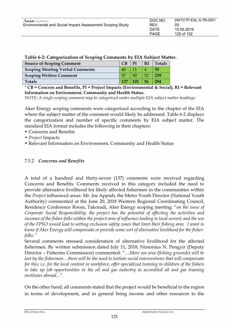
DOC.NO. DWTCTP-ESL-S-TB-0001 Environmental and Social Impact Assessment Scoping Study
REV. 03 DATE 15.05.2019 PAGE 125 of 152
ESL CONSULTING AKER ENERGY GHANA LTD.
125
Table 6-2: Categorization of Scoping Comments by EIA Subject Matter. Source of Scoping Comment CB PI RI Totals Scoping Meeting Verbal Comments 40 11 4 55 Scoping Written Comment 97 90 52 239 Totals 137 101 56 294 * CB = Concern and Benefits, PI = Project Impacts (Environmental & Social), RI = Relevant Information on Environment, Community and Health Status. NOTE: A single scoping comment may be categorized under multiple EIA subject matter headings. Aker Energy scoping comments were categorized according to the chapter of the EIA where the subject matter of the comment would likely be addressed. Table 6-2 displays the categorization and number of specific comments by EIA subject matter. The standard EIA format includes the following in their chapters: • Concerns and Benefits • Project Impacts • Relevant Information on Environment, Community and Health Status 7.5.2 Concerns and Benefits
A total of a hundred and thirty-seven (137) comments were received regarding Concerns and Benefits. Comments received in this category included the need to provide alternative livelihood for likely affected fishermen in the communities within the Project influenced areas. Mr. Joe Appiah, the Metro Youth Director (National Youth Authority) commented at the June 20, 2018 Western Regional Coordinating Council, Residency Conference Room, Takoradi, Aker Energy scoping meeting: “on the issue of Corporate Social Responsibility, the project has the potential of affecting the activities and incomes of the fisher-folks within the project area of influence leading to local unrest; and the use of the FPSO would lead to setting exclusion safety zones that limit their fishing area. I want to know if Aker Energy will compensate or provide some sort of alternative livelihood for the fisher-folks.” Several comments stressed consideration of alternative livelihood for the affected fishermen. By written submission dated July 11, 2018, Nimonius N. Pengyir (Deputy Director – Fisheries Commission) commented: “…More sea area (fishing grounds) will be lost by the fishermen…there will be the need to initiate social interventions that will compensate for this; i.e. for the local content in workforce, offer specialized training to children of the fishers to take up job opportunities in the oil and gas industry in accredited oil and gas training institutes abroad...”. On the other hand, all comments stated that the project would be beneficial to the region in terms of development, and in general bring income and other resources to the
DOC.NO. DWTCTP-ESL-S-TB-0001 Environmental and Social Impact Assessment Scoping Study
REV. 03 DATE 15.05.2019 PAGE 126 of 152
ESL CONSULTING AKER ENERGY GHANA LTD.
126
country. Captain Inusah (Deputy Director, Environment & Safety Standard of the Ghana Maritime Authority), in a written comment submitted on July 29, 2018, noted: “The project will bring a lot of economic benefits to Ghana. Secured offshore energy production is fundamental to sustainable economic growth, prosperity and employment.” 7.5.3 Project Impacts (Environmental & Social)
A total of a hundred and one (101) comments were received concerning Environmental Impacts. Concerns related to disruption of fishing activities and job creation dominated the comments received in this category. Joyce Obiri Yeboah, Department of Development Head, reiterated at the June 20, 2018 Western Regional Coordinating Council, Residency Conference Room Aker Energy Scoping meeting: “Aker Energy’s activities will distort their fishing activities of the fisher folks and these won’t be able to make a living and so there must be some help that must be given to them. Does Aker have any alternative economic activities for the fishermen?”. Mr Baba Nyina of the Trade and Industries also commented: “……cumulatively, the exclusive zones that have been set by Tullow, Tein, Sankofa etc., and will be set by Aker Energy are going to increase, and will potentially reduce the fisher-folk’s effective area of fishing activity thereby limiting the fish stock.” In addition, the leader of the Canoe Council commented at the June 18, 2018 Fishermen Association, Friends of the Nation Conference Room Aker Energy scoping meeting: “how will Aker Energy manage the effect of constructing an FPSO as it will affect our fishing activities…., and how will the company manage the effect of vessel traffic.” By written submission received July 2018, Nana Kusi Nsiah (Town Planning Officer – Physical Planning Department) listed points regarding negative impacts: “…The fish folks will be deprived of their activities……depletion of fish stocks……traffic management in urban areas……housing stock depletion….” Regarding positive impacts, all comments invariably mentioned job creation and regional and national development. Relevant Information on Environment, Community and Health Status A total of fifty-six (56) comments were received concerning Relevant Information on Environment, Community and Health Status. Comments received in this category concerned periodic or annual health screening for the coastal community members within the project area of influence, proper health facilities in the communities and gas flaring. At the June 18, 2018, Fishermen Association, Friends of The Nation Conference
DOC.NO. DWTCTP-ESL-S-TB-0001 Environmental and Social Impact Assessment Scoping Study
REV. 03 DATE 15.05.2019 PAGE 127 of 152
ESL CONSULTING AKER ENERGY GHANA LTD.
127
Room, Sekondi, Aker Energy scoping meeting, Mrs. Emelia Abaka-Adu (National Vice President – National Fish Processors and Traders Association) commented: “Some of our members suffer from diseases from time to time resulting from the oil and gas operations. I suggest that health screening should be arranged for the communities regularly.” By written submission dated July 2018, Nana Kofi Bentil (Chief Fisherman – Fishermen Association) listed: “…health screening for the fishing communities on yearly basis….”. J. F. Esumbey (Fisheries Commission) also commented: “Communities around the catchment area experience severe heat and other health hazards, hence the need for health screening for the coastal communities.” 7.5.4 Other Key Comments
Additional Key Comments on the scoping exercise of activities by Aker Energy in the Deep Water Tano Cape Three Points Block submitted by the Friends of the Nation (FoN) and the Ghana Maritime Authority (GMA-Accra) can be found in Appendix 6-F. List of Key Comments
A semi-quantitative method together with professional judgement were used to identify and extract the key issues raised by stakeholders during the scoping phase. A list of some of the key comments raised during the scoping consultations is as follows:
• Job creation in the districts with emphasis on employment of local community members.
• Improvement of social infrastructure including hospital, roads, sanitation and other facilities.
• Educational scholarships, training opportunities for locals. • Disposal of offshore waste, oil spill and discharge of ballast water at sea. • Livelihood of fishermen being affected negatively with the decline of fish catch
due to the presence of the FPSO limiting fishing grounds and light attracting fish into the safety zone.
• Complaint from the fishermen about some men of the Ghana Navy on patrol who disregard the ban on fishing within the 500 m safety exclusion zone.
• Fishermen from Elmina in the Central Region regularly fish near the FPSO calling for their inclusion in subsequent stakeholder engagements.
DOC.NO. DWTCTP-ESL-S-TB-0001 Environmental and Social Impact Assessment Scoping Study
REV. 03 DATE 15.05.2019 PAGE 128 of 152
ESL CONSULTING AKER ENERGY GHANA LTD.
128
• Alternative Livelihood Programmes for local community members especially fishermen.
• Enhanced cooperation between District Assemblies and Oil Companies to facilitate development.
• Rising cost of living with escalating rental charges for land, accommodation and cargo storage (warehousing).
• Security, maritime safety of oil operations including fire prevention and containment.
• Safety of marine mammals especially whales in the Western Region • The Fisheries Commission and other stakeholders demanded a Fisheries Impact
Assessment. • Cumulative Impacts of the oil activities on the marine environment, atmosphere
and the communities especially fishermen need to be addressed. • The Ghana Maritime Authority was concerned with maritime security and
would like negative activities including possible terrorist attack, narcotic smuggling, illegal oil bunkering, piracy and armed robbery to be addressed in the report.
7.6 GRIEVANCE PROCEDURE
A Grievance Procedure is under development to receive and facilitate resolution of concerns and grievances about the Project’s environmental and social performance. The Grievance Procedure can be made available on request. It has been designed to resolve concerns promptly, using an understandable and transparent process that is culturally appropriate and readily accessible. Grievances will be addressed with no cost to the party that raised the concern and without retribution. The mechanism will also not impede access to other judicial or administrative remedies available to affected parties. 7.7 FUTURE STAKEHOLDER ENGAGEMENTS
On completion of the EIA regulatory procedure, the Project will move into the Construction and Operation Phases. A full programme of stakeholder engagement will continue during Constructional and Operational Phases, and then throughout the lifetime of the Project. Details of this will be provided in an update of the Stakeholder Engagement Plan, which will be published at the time of Project approval. This will be regularly updated thereafter. The long-term programme of engagement will include:
DOC.NO. DWTCTP-ESL-S-TB-0001 Environmental and Social Impact Assessment Scoping Study
REV. 03 DATE 15.05.2019 PAGE 129 of 152
ESL CONSULTING AKER ENERGY GHANA LTD.
129
• on-going liaison with regulatory authorities concerned with environmental and social issues;
• establishment of local community liaison groups which will be used to keep people informed of Project activities and seek their participation in decisions affecting their communities;
• publication of regular reports on Project progress, implementation of mitigation measures, compliance with the Environmental Management Plan (EMP) and the overall performance; and
• the sharing of monitoring results and consultation on responses to unforeseen impacts that may occur.
7.8 GENERAL CONCLUSION FROM CATEGORIES OF SCOPING COMMENTS.
The stakeholders have raised several concerns, highlighting both positive and negative impacts. Analysis of the responses from the scoping consultations comments using content analysis and reflecting on key considerations that emerged, gives the general opinion and an overall impression that, despite stakeholder concerns raised, the stakeholders are of the view that the DWT/CTP development has more potential positive than negative impacts as all the comments invariably indicated preference in favour of the development. Consequently, details of the wide range of potential impacts and concerns identified during the scoping study and stakeholder engagement are presented in the Terms of Reference (TOR) under section 7, and will be addressed in the EIA. 7.9 DISCLOSURE AND CONSULTATION
A programme of disclosure and further stakeholder engagement is planned to run for 21 days subsequent advertising of this scoping report in public newspapers, publication on the EPA website and distribution in the relevant communities. The aim of this is to provide directly affected communities and other project stakeholders with the opportunity to understand and comment on the results of the assessment and the proposed mitigation measures. This will include the following activities:
• The EIA Report and accompanying leaflets and summary material will be published in the newspapers and also on the Aker Energy Project website at http://www. www.akerenergy.com and will be available to download at no cost (a soft copy may also be requested).
• Hard copies of the report will be available for inspection at the following locations in Ghana: EPA Head Office in Accra
DOC.NO. DWTCTP-ESL-S-TB-0001 Environmental and Social Impact Assessment Scoping Study
REV. 03 DATE 15.05.2019 PAGE 130 of 152
ESL CONSULTING AKER ENERGY GHANA LTD.
130
District Assemblies of the Western Region Regional Offices of the EPA in the Western and Central Regions Petroleum Commission Fisheries Commission Ghana Maritime Authority Ghana Navy Ghana Ports and Harbours Authority
• Notice of the report will be announced in newspaper advertisements. • A national and /or regional stakeholder conference, if so determined by the EPA
will be held. These will be widely publicised in local media and invitations will be sent to the regional, prefectural, sub-prefectural and local administrative authorities, to community leaders, and to community-based and non-governmental organisations.
In addition to these activities, a programme of community visits will be undertaken, visiting settlements throughout the Project area during the full scale consultations for the assessment of impacts. These visits will provide the opportunity for communities affected by the Project to be consulted on the EIA and allow local people to comment on the Project and its impacts prior to final decisions on the project. Meetings will be held in relevant villages directly affected by the Project. Local leaders, affected households and businesses, and special sectors within the community including women and other potentially vulnerable groups will be invited
DOC.NO. DWTCTP-ESL-S-TB-0001 Environmental and Social Impact Assessment Scoping Study
REV. 03 DATE 15.05.2019 PAGE 131 of 152
ESL CONSULTING AKER ENERGY GHANA LTD.
131
8 TERMS OF REFERENCE FOR EIA
8.1 INTRODUCTION
Based on the scoping activities undertaken, this Chapter provides the proposed Terms of Reference for the EIA. This includes establishing the basis for Baseline studies, additional stakeholder engagement, and the structure of the EIA Report. This Chapter is structured as follows. • Steps to complete the EIA; • Baseline studies; • Quantitative studies; • Impact assessment methodology; • Stakeholder engagement; • Structure for the EIA; and • Schedule for the EIA. 8.2 STEPS TO COMPLETE THE EIA
Following approval of the Scoping Report by EPA, the EIA Consultant will undertake the following activities to complete the EIA. • The project description will be updated and finalised as further technical details become
available from the Project. The EIA Consultant will work with the Project’s technical team and confirm parameters for quantitative studies and impact assessment.
• Baseline studies will be conducted to document the environmental and social setting with
focus on addressing gaps on the existing information. Baseline studies will involve further desk-top based research as well as primary data collection through surveys and interviews.
• Quantitative studies, including computer modelling, will be conducted to assist in the
prediction of environmental effects. • Impacts identified in the scoping process, as well as other impacts identified in the EIA
process, will be characterised. The impact will be evaluated to determine significance. The proposed impact assessment methodology is provided in Annex F. Mitigation measures and management actions will be developed and a provisional Environmental and Social Management Plan (ESMP) will be prepared.
DOC.NO. DWTCTP-ESL-S-TB-0001 Environmental and Social Impact Assessment Scoping Study
REV. 03 DATE 15.05.2019 PAGE 132 of 152
ESL CONSULTING AKER ENERGY GHANA LTD.
132
• The findings of the impact assessment will be summarised and reported in an EIA report. The EIA report will be submitted to the Ghana EPA for approval and disclosed for public comments under EPA’s direction.
• Stakeholder engagement will continue throughout the process. This will include the
establishment of a grievance mechanism to allow issues and concerns from stakeholders to be raised with the Project. To facilitate this, the project will set up drop in centres to allow grievances to be made in person and logged by the Project.
8.3 SCOPE OF EIA
The EIA report, called the Environmental Impact Statement (EIS) will include description of the scope of the EIA. 8.4 LEGAL FRAMEWORK
The EIA will identify and describe relevant legal framework. The basis for this part of the study will be the legal framework descried in Section 2 of this scoping report. 8.5 PROPOSED BASELINE STUDIES
8.5.1 Gap Assessment
During scoping, the quality of the existing information and data was reviewed in terms of: • Relevance – does is apply to the Project? • Coverage - does it comprise the Project Area of Influence? • Completeness - does it cover all elements of a particular topic area? • Accuracy – does it reflect the current status? The results of the gap assessment are summarised in Table 7.1. The information gaps identified during scoping will be addressed through baseline studies as part of the EIA.
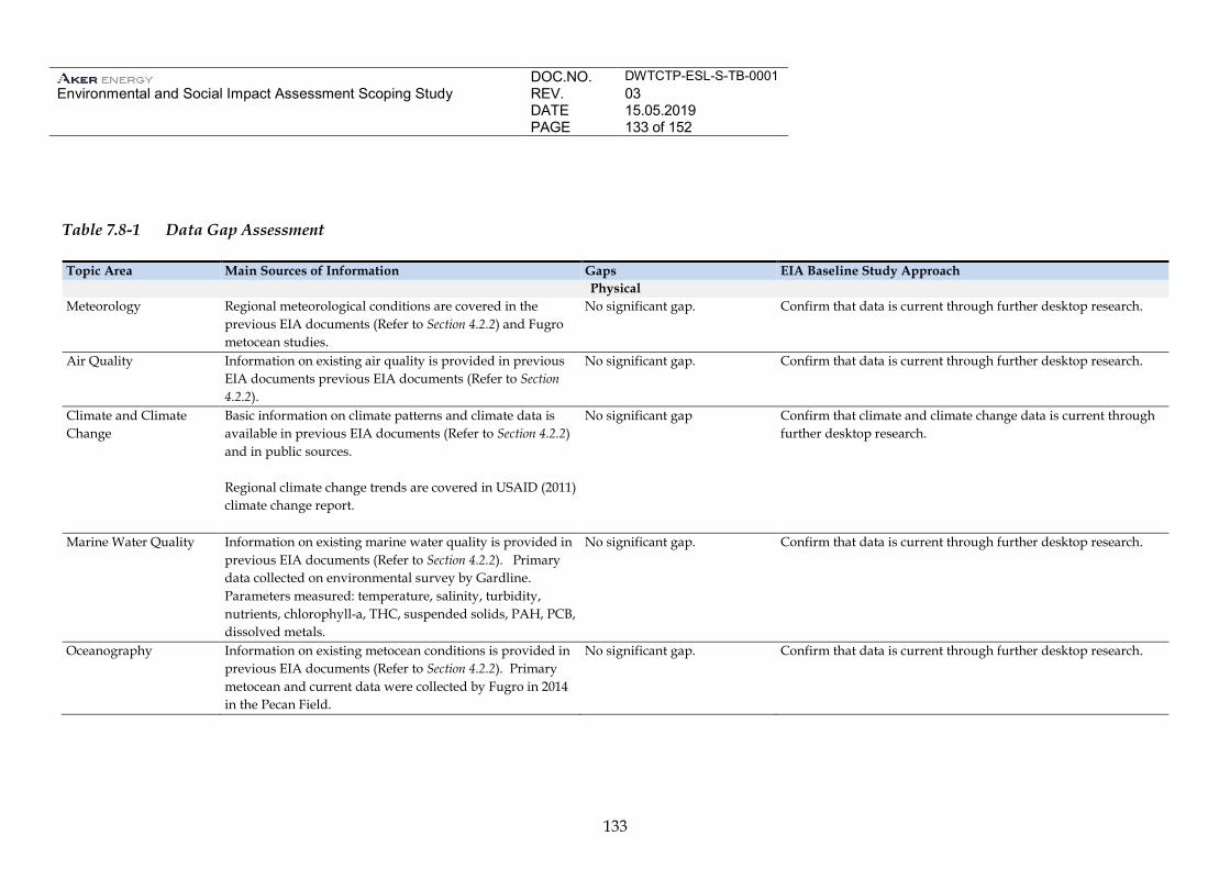
DOC.NO. DWTCTP-ESL-S-TB-0001 Environmental and Social Impact Assessment Scoping Study
REV. 03 DATE 15.05.2019 PAGE 133 of 152
133
Table 7.8-1 Data Gap Assessment
Topic Area Main Sources of Information Gaps EIA Baseline Study Approach Physical
Meteorology Regional meteorological conditions are covered in the previous EIA documents (Refer to Section 4.2.2) and Fugro metocean studies.
No significant gap. Confirm that data is current through further desktop research.
Air Quality Information on existing air quality is provided in previous EIA documents previous EIA documents (Refer to Section 4.2.2).
No significant gap. Confirm that data is current through further desktop research.
Climate and Climate Change
Basic information on climate patterns and climate data is available in previous EIA documents (Refer to Section 4.2.2) and in public sources. Regional climate change trends are covered in USAID (2011) climate change report.
No significant gap Confirm that climate and climate change data is current through further desktop research.
Marine Water Quality Information on existing marine water quality is provided in previous EIA documents (Refer to Section 4.2.2). Primary data collected on environmental survey by Gardline. Parameters measured: temperature, salinity, turbidity, nutrients, chlorophyll-a, THC, suspended solids, PAH, PCB, dissolved metals.
No significant gap. Confirm that data is current through further desktop research.
Oceanography Information on existing metocean conditions is provided in previous EIA documents (Refer to Section 4.2.2). Primary metocean and current data were collected by Fugro in 2014 in the Pecan Field.
No significant gap. Confirm that data is current through further desktop research.
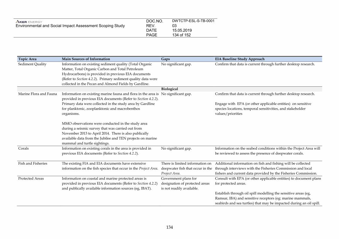
DOC.NO. DWTCTP-ESL-S-TB-0001 Environmental and Social Impact Assessment Scoping Study
REV. 03 DATE 15.05.2019 PAGE 134 of 152
134
Topic Area Main Sources of Information Gaps EIA Baseline Study Approach Sediment Quality Information on existing sediment quality (Total Organic
Matter, Total Organic Carbon and Total Petroleum Hydrocarbons) is provided in previous EIA documents (Refer to Section 4.2.2). Primary sediment quality data were collected in the Pecan and Almond Fields by Gardline.
No significant gap. Confirm that data is current through further desktop research.
Biological Marine Flora and Fauna Information on existing marine fauna and flora in the area is
provided in previous EIA documents (Refer to Section 4.2.2). Primary data were collected in the study area by Gardline for planktonic, zooplanktonic and macrobenthos organisms. MMO observations were conducted in the study area during a seismic survey that was carried out from November 2013 to April 2014. There is also publically available data from the Jubilee and TEN projects on marine mammal and turtle sightings.
No significant gap. Confirm that data is current through further desktop research. Engage with EPA (or other applicable entities) on sensitive species locations, temporal sensitivities, and stakeholder values/priorities
Corals Information on existing corals in the area is provided in previous EIA documents (Refer to Section 4.2.2).
No significant gap. Information on the seabed conditions within the Project Area will be reviewed to assess the presence of deepwater corals.
Fish and Fisheries The existing FIA and EIA documents have extensive information on the fish species that occur in the Project Area.
There is limited information on deepwater fish that occur in the Project Area.
Additional information on fish and fishing will be collected through interviews with the Fisheries Commission and local fishers and current data provided by the Fisheries Commission.
Protected Areas Information on coastal and marine protected areas is provided in previous EIA documents (Refer to Section 4.2.2) and publically available information sources (eg, IBAT).
Government plans for designation of protected areas is not readily available.
Consult with EPA (or other applicable entities) to document plans for protected areas. Establish through oil spill modelling the sensitive areas (eg, Ramsar, IBA) and sensitive receptors (eg: marine mammals, seabirds and sea turtles) that may be impacted during an oil spill.
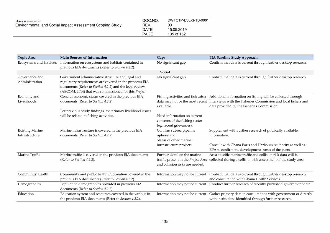
DOC.NO. DWTCTP-ESL-S-TB-0001 Environmental and Social Impact Assessment Scoping Study
REV. 03 DATE 15.05.2019 PAGE 135 of 152
135
Topic Area Main Sources of Information Gaps EIA Baseline Study Approach Ecosystems and Habitats Information on ecosystems and habitats contained in
previous EIA documents (Refer to Section 4.2.2).
No significant gap. Confirm that data is current through further desktop research.
Social Governance and Administration
Government administrative structure and legal and regulatory requirements are covered in the previous EIA documents (Refer to Section 4.2.2) and the legal review (AECOM, 2014) that was commissioned for this Project.
No significant gap. Confirm that data is current through further desktop research.
Economy and Livelihoods
General economic status covered in the previous EIA documents (Refer to Section 4.2.2). Per previous study findings, the primary livelihood issues will be related to fishing activities.
Fishing activities and fish catch data may not be the most recent available. Need information on current concerns of the fishing sector (eg, recent grievances).
Additional information on fishing will be collected through interviews with the Fisheries Commission and local fishers and data provided by the Fisheries Commission.
Existing Marine Infrastructure
Marine infrastructure is covered in the previous EIA documents (Refer to Section 4.2.2).
Confirm subsea pipeline options and Status of other marine infrastructure projects.
Supplement with further research of publically available information. Consult with Ghana Ports and Harbours Authority as well as EPA to confirm the development status of the ports.
Marine Traffic Marine traffic is covered in the previous EIA documents (Refer to Section 4.2.2).
Further detail on the marine traffic present in the Project Area and collision risks are needed.
Area specific marine traffic and collision risk data will be collected during a collision risk assessment of the study area.
Community Health Community and public health information covered in the previous EIA documents (Refer to Section 4.2.2).
Information may not be current. Confirm that data is current through further desktop research and consultation with Ghana Health Services.
Demographics Population demographics provided in previous EIA documents (Refer to Section 4.2.2).
Information may not be current. Conduct further research of recently published government data.
Education Education system and resources covered in the various in the previous EIA documents (Refer to Section 4.2.2).
Information may not be current Gather primary data in consultations with government or directly with institutions identified through further research.
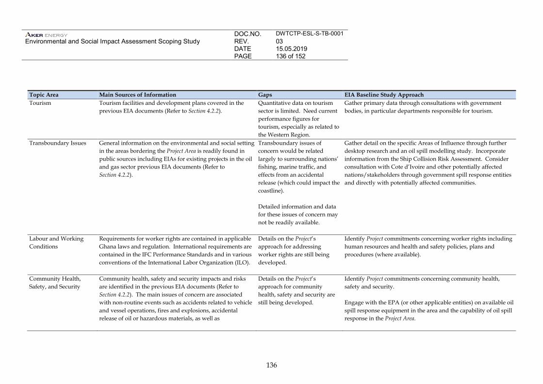
DOC.NO. DWTCTP-ESL-S-TB-0001 Environmental and Social Impact Assessment Scoping Study
REV. 03 DATE 15.05.2019 PAGE 136 of 152
136
Topic Area Main Sources of Information Gaps EIA Baseline Study Approach Tourism Tourism facilities and development plans covered in the
previous EIA documents (Refer to Section 4.2.2). Quantitative data on tourism sector is limited. Need current performance figures for tourism, especially as related to the Western Region.
Gather primary data through consultations with government bodies, in particular departments responsible for tourism.
Transboundary Issues General information on the environmental and social setting in the areas bordering the Project Area is readily found in public sources including EIAs for existing projects in the oil and gas sector previous EIA documents (Refer to Section 4.2.2).
Transboundary issues of concern would be related largely to surrounding nations’ fishing, marine traffic, and effects from an accidental release (which could impact the coastline). Detailed information and data for these issues of concern may not be readily available.
Gather detail on the specific Areas of Influence through further desktop research and an oil spill modelling study. Incorporate information from the Ship Collision Risk Assessment. Consider consultation with Cote d’Ivoire and other potentially affected nations/stakeholders through government spill response entities and directly with potentially affected communities.
Labour and Working Conditions
Requirements for worker rights are contained in applicable Ghana laws and regulation. International requirements are contained in the IFC Performance Standards and in various conventions of the International Labor Organization (ILO).
Details on the Project’s approach for addressing worker rights are still being developed.
Identify Project commitments concerning worker rights including human resources and health and safety policies, plans and procedures (where available).
Community Health, Safety, and Security
Community health, safety and security impacts and risks are identified in the previous EIA documents (Refer to Section 4.2.2). The main issues of concern are associated with non-routine events such as accidents related to vehicle and vessel operations, fires and explosions, accidental release of oil or hazardous materials, as well as
Details on the Project’s approach for community health, safety and security are still being developed.
Identify Project commitments concerning community health, safety and security. Engage with the EPA (or other applicable entities) on available oil spill response equipment in the area and the capability of oil spill response in the Project Area.
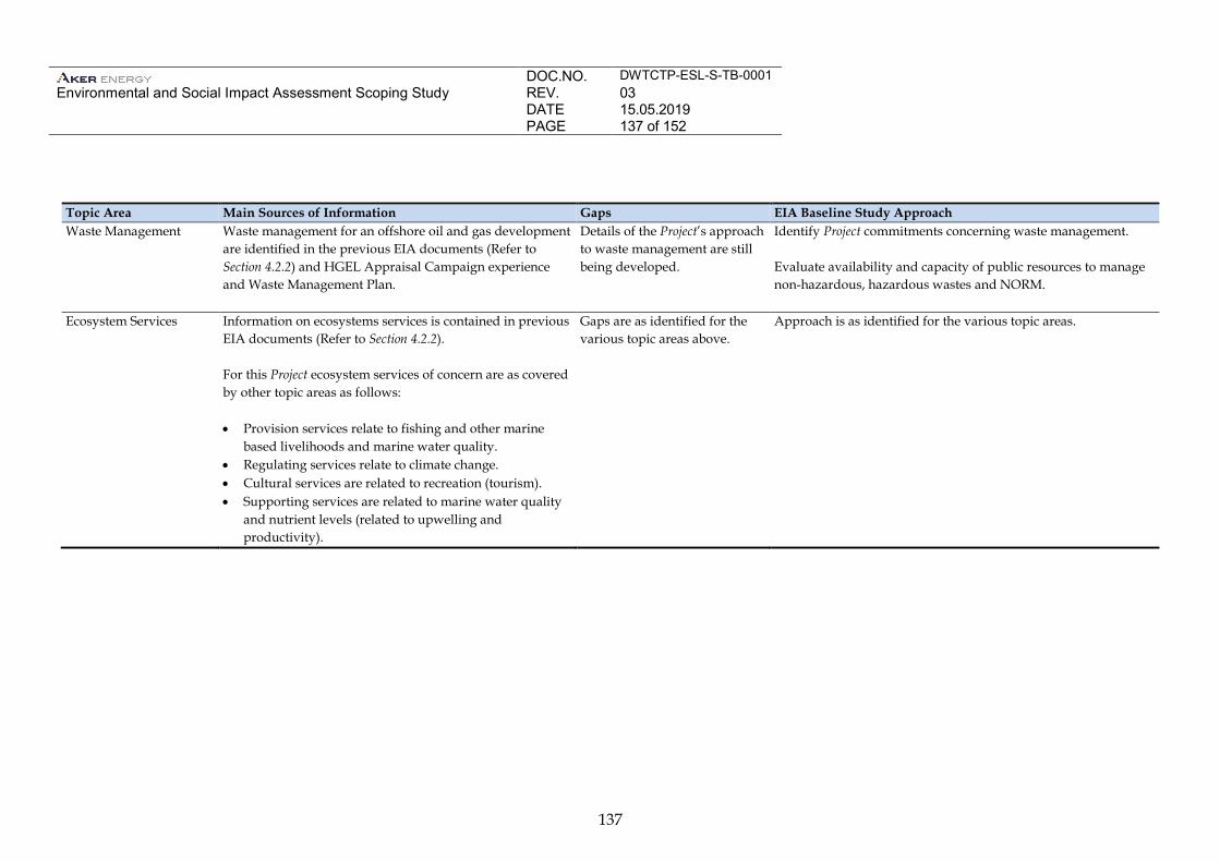
DOC.NO. DWTCTP-ESL-S-TB-0001 Environmental and Social Impact Assessment Scoping Study
REV. 03 DATE 15.05.2019 PAGE 137 of 152
137
Topic Area Main Sources of Information Gaps EIA Baseline Study Approach Waste Management Waste management for an offshore oil and gas development
are identified in the previous EIA documents (Refer to Section 4.2.2) and HGEL Appraisal Campaign experience and Waste Management Plan.
Details of the Project’s approach to waste management are still being developed.
Identify Project commitments concerning waste management. Evaluate availability and capacity of public resources to manage non-hazardous, hazardous wastes and NORM.
Ecosystem Services Information on ecosystems services is contained in previous EIA documents (Refer to Section 4.2.2). For this Project ecosystem services of concern are as covered by other topic areas as follows: • Provision services relate to fishing and other marine
based livelihoods and marine water quality. • Regulating services relate to climate change. • Cultural services are related to recreation (tourism). • Supporting services are related to marine water quality
and nutrient levels (related to upwelling and productivity).
Gaps are as identified for the various topic areas above.
Approach is as identified for the various topic areas.
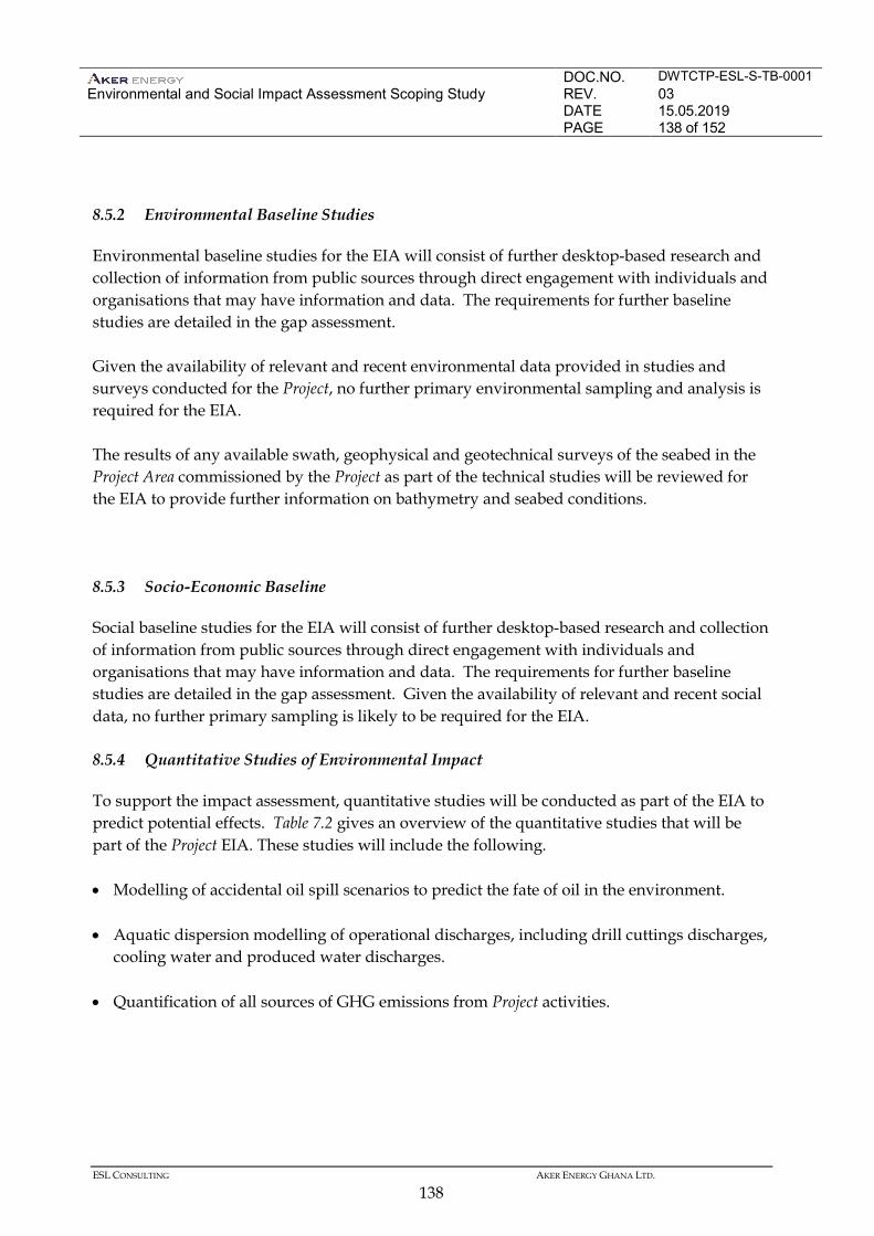
DOC.NO. DWTCTP-ESL-S-TB-0001 Environmental and Social Impact Assessment Scoping Study
REV. 03 DATE 15.05.2019 PAGE 138 of 152
ESL CONSULTING AKER ENERGY GHANA LTD.
138
8.5.2 Environmental Baseline Studies
Environmental baseline studies for the EIA will consist of further desktop-based research and collection of information from public sources through direct engagement with individuals and organisations that may have information and data. The requirements for further baseline studies are detailed in the gap assessment. Given the availability of relevant and recent environmental data provided in studies and surveys conducted for the Project, no further primary environmental sampling and analysis is required for the EIA. The results of any available swath, geophysical and geotechnical surveys of the seabed in the Project Area commissioned by the Project as part of the technical studies will be reviewed for the EIA to provide further information on bathymetry and seabed conditions.
8.5.3 Socio-Economic Baseline
Social baseline studies for the EIA will consist of further desktop-based research and collection of information from public sources through direct engagement with individuals and organisations that may have information and data. The requirements for further baseline studies are detailed in the gap assessment. Given the availability of relevant and recent social data, no further primary sampling is likely to be required for the EIA. 8.5.4 Quantitative Studies of Environmental Impact
To support the impact assessment, quantitative studies will be conducted as part of the EIA to predict potential effects. Table 7.2 gives an overview of the quantitative studies that will be part of the Project EIA. These studies will include the following. • Modelling of accidental oil spill scenarios to predict the fate of oil in the environment. • Aquatic dispersion modelling of operational discharges, including drill cuttings discharges,
cooling water and produced water discharges. • Quantification of all sources of GHG emissions from Project activities.
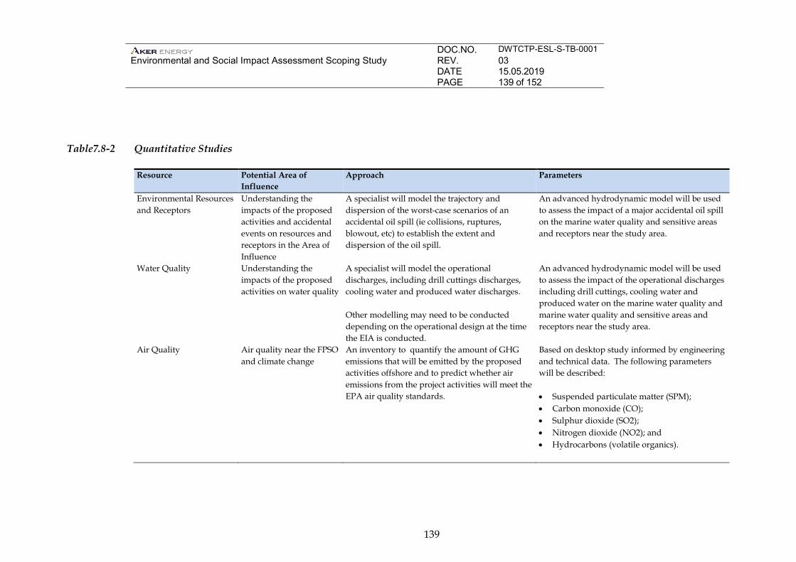
DOC.NO. DWTCTP-ESL-S-TB-0001 Environmental and Social Impact Assessment Scoping Study
REV. 03 DATE 15.05.2019 PAGE 139 of 152
139
Table7.8-2 Quantitative Studies
Resource Potential Area of Influence
Approach Parameters
Environmental Resources and Receptors
Understanding the impacts of the proposed activities and accidental events on resources and receptors in the Area of Influence
A specialist will model the trajectory and dispersion of the worst-case scenarios of an accidental oil spill (ie collisions, ruptures, blowout, etc) to establish the extent and dispersion of the oil spill.
An advanced hydrodynamic model will be used to assess the impact of a major accidental oil spill on the marine water quality and sensitive areas and receptors near the study area.
Water Quality Understanding the impacts of the proposed activities on water quality
A specialist will model the operational discharges, including drill cuttings discharges, cooling water and produced water discharges. Other modelling may need to be conducted depending on the operational design at the time the EIA is conducted.
An advanced hydrodynamic model will be used to assess the impact of the operational discharges including drill cuttings, cooling water and produced water on the marine water quality and marine water quality and sensitive areas and receptors near the study area.
Air Quality Air quality near the FPSO and climate change
An inventory to quantify the amount of GHG emissions that will be emitted by the proposed activities offshore and to predict whether air emissions from the project activities will meet the EPA air quality standards.
Based on desktop study informed by engineering and technical data. The following parameters will be described: • Suspended particulate matter (SPM); • Carbon monoxide (CO); • Sulphur dioxide (SO2); • Nitrogen dioxide (NO2); and • Hydrocarbons (volatile organics).
DOC.NO. DWTCTP-ESL-S-TB-0001 Environmental and Social Impact Assessment Scoping Study
REV. 03 DATE 15.05.2019 PAGE 140 of 152
ESL CONSULTING AKER ENERGY GHANA LTD.
140
8.5.5 Fisheries Impact Assessment
Section 93 of the Fisheries Act stipulates that if a proponent plans to undertake an activity that is likely to have a substantial impact on the fisheries resources, the Fisheries Commission should be informed of such an activity prior to commencement. The Commission may require information from the proponent on the likely impact of the activity on the fishery resources and possible means of preventing or minimising adverse impacts. As such, the Fisheries Commission will be consulted as a key stakeholder in the EIA. The baseline conditions and potential impacts on fisheries will be assessed and a Fisheries Impact Study will be conducted and submitted to the Fisheries Commission. 8.6 IMPACT ASSESSMENT METHODOLOGY
8.6.1 Introduction
An impact, as defined by the international standard ISO14001:2004 is: “Any change to the environment, whether adverse or beneficial, wholly or partially resulting from an organisation’s environmental aspects”. Where “environmental aspect” is defined as: “Element of an organisation’s activities or products or services that can interact with the environment”. An “impact” is defined where an interaction occurs between a project activity and an environmental receptor. The EIA process ranks impacts according to their “significance” determined by considering project activity “event magnitude” and “receptor sensitivity”. Determining event magnitude requires the identification and quantification (as far as practical) of the sources of potential environmental and socio-economic effects from routine and non-routine project activities. Determining receptor environmental sensitivity requires an understanding of the biophysical environment. Magnitude and receptor quality/importance/sensitivity will be looked at in combination to evaluate whether an impact is, or is not, significant and if so its degree of significance (defined in terms of Minor, Moderate or Major). Impacts classed as not significant include those that are slight or transitory, and those that are within the range of natural environmental and social change. This principle is illustrated schematically in Figure 7.1.
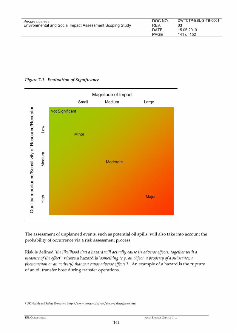
DOC.NO. DWTCTP-ESL-S-TB-0001 Environmental and Social Impact Assessment Scoping Study
REV. 03 DATE 15.05.2019 PAGE 141 of 152
ESL CONSULTING AKER ENERGY GHANA LTD.
141
Figure 7-1 Evaluation of Significance
The assessment of unplanned events, such as potential oil spills, will also take into account the probability of occurrence via a risk assessment process. Risk is defined ‘the likelihood that a hazard will actually cause its adverse effects, together with a measure of the effect’, where a hazard is ‘something (e.g. an object, a property of a substance, a phenomenon or an activity) that can cause adverse effects’1. An example of a hazard is the rupture of an oil transfer hose during transfer operations.
1 UK Health and Safety Executive (http://www.hse.gov.uk/risk/theory/alarpglance.htm)
Magnitude of Impact
Qua
lity/
Impo
rtanc
e/S
ensi
tivity
of R
esou
rce/
Rec
epto
r
Small Medium Large
Hig
hM
ediu
mLo
w
Not Significant
Minor
Moderate
Major
DOC.NO. DWTCTP-ESL-S-TB-0001 Environmental and Social Impact Assessment Scoping Study
REV. 03 DATE 15.05.2019 PAGE 142 of 152
ESL CONSULTING AKER ENERGY GHANA LTD.
142
This approach includes reference to qualitative risk evaluation that assigns severity and likelihood categories to the consequences for the hazards identified using a risk assessment matrix. 8.7 STAKEHOLDER ENGAGEMENT
Following the completion of scoping and the Scoping Report, further consultation will be undertaken as follows: • Disclosure of Scoping Report; • Baseline Studies; and • EIA. Disclosure of Scoping Report The Scoping Report will be submitted to the EPA for review. Following approval, the EPA will issue authorisation to the Project to proceed with the EIA phase. The letter will also include comments on the Scoping Report and the TOR. Following approval, the Scoping Report will be disclosed to government stakeholders and the public under EPA’s direction. The EPA will decide the process for disclosure. Typically, disclosure is announced via public notice (in newspaper). The Scoping Report is made available at public locations (subject to EPA advice). For this Project, locations may include: • PA library in Accra; • Public Library in Sekondi; • District Assembly Offices in Elembelle, Western Region; and • Paramount Chief Palace in Atuabo. The Scoping Report will also be hosted on a website and the address provided to consultees during consultations. Consultations during EIA Studies Further, local level engagement activities will be undertaken for the various impact studies. This will involve meetings and interviews. While the aim of the engagements is data collection, stakeholder views and concerns will continue to be gathered during these engagements.
DOC.NO. DWTCTP-ESL-S-TB-0001 Environmental and Social Impact Assessment Scoping Study
REV. 03 DATE 15.05.2019 PAGE 143 of 152
ESL CONSULTING AKER ENERGY GHANA LTD.
143
Consultation during EIA Disclosure Disclosure of the EIA will provide detailed information about the proposed Project activities, an assessment of the potential impacts and the planned mitigation measures and management actions. The disclosure of the EIA is led by Ghana EPA. Typically, the EIA is submitted to the EPA and advertised. Copies of the EIA are made available at a number of locations for public review and comment. The Project supports the disclosure process as required and directed by the EPA. Given the nature and scale of the Project, a public hearing will likely be required by EPA. The public hearing is organised by EPA and attended by representatives of the Project. Following the public hearing and EPA review, the EPA may grant provisional approval for the Project. The EPA will require that comments received on the EIA be addressed and a final EIA submitted to EPA for approval. The Scoping Report will also be hosted on a website and the address provided to consultees during consultations. The drop-in centres established for the purposes of receiving grievances will also be used to disseminate information on the project, including copies of the EIA Non-Technical Summary. 8.8 STRUCTURE OF THE EIA
The EA regulations specify the requirements for the content of the EIA (Figure 7-2).
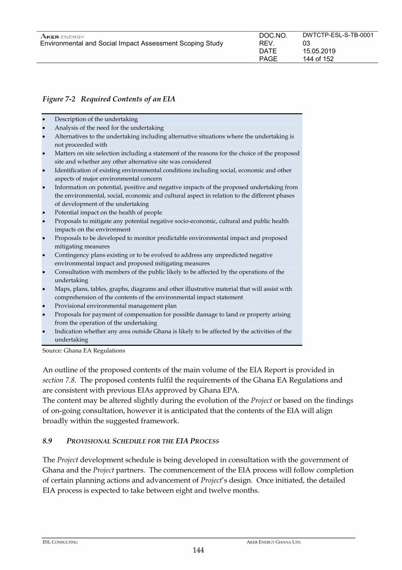
DOC.NO. DWTCTP-ESL-S-TB-0001 Environmental and Social Impact Assessment Scoping Study
REV. 03 DATE 15.05.2019 PAGE 144 of 152
ESL CONSULTING AKER ENERGY GHANA LTD.
144
Figure 7-2 Required Contents of an EIA
Source: Ghana EA Regulations An outline of the proposed contents of the main volume of the EIA Report is provided in section 7.8. The proposed contents fulfil the requirements of the Ghana EA Regulations and are consistent with previous EIAs approved by Ghana EPA. The content may be altered slightly during the evolution of the Project or based on the findings of on-going consultation, however it is anticipated that the contents of the EIA will align broadly within the suggested framework. 8.9 PROVISIONAL SCHEDULE FOR THE EIA PROCESS
The Project development schedule is being developed in consultation with the government of Ghana and the Project partners. The commencement of the EIA process will follow completion of certain planning actions and advancement of Project’s design. Once initiated, the detailed EIA process is expected to take between eight and twelve months.
• Description of the undertaking • Analysis of the need for the undertaking • Alternatives to the undertaking including alternative situations where the undertaking is
not proceeded with • Matters on site selection including a statement of the reasons for the choice of the proposed
site and whether any other alternative site was considered • Identification of existing environmental conditions including social, economic and other
aspects of major environmental concern • Information on potential, positive and negative impacts of the proposed undertaking from
the environmental, social, economic and cultural aspect in relation to the different phases of development of the undertaking
• Potential impact on the health of people • Proposals to mitigate any potential negative socio-economic, cultural and public health
impacts on the environment • Proposals to be developed to monitor predictable environmental impact and proposed
mitigating measures • Contingency plans existing or to be evolved to address any unpredicted negative
environmental impact and proposed mitigating measures • Consultation with members of the public likely to be affected by the operations of the
undertaking • Maps, plans, tables, graphs, diagrams and other illustrative material that will assist with
comprehension of the contents of the environmental impact statement • Provisional environmental management plan • Proposals for payment of compensation for possible damage to land or property arising
from the operation of the undertaking • Indication whether any area outside Ghana is likely to be affected by the activities of the
undertaking
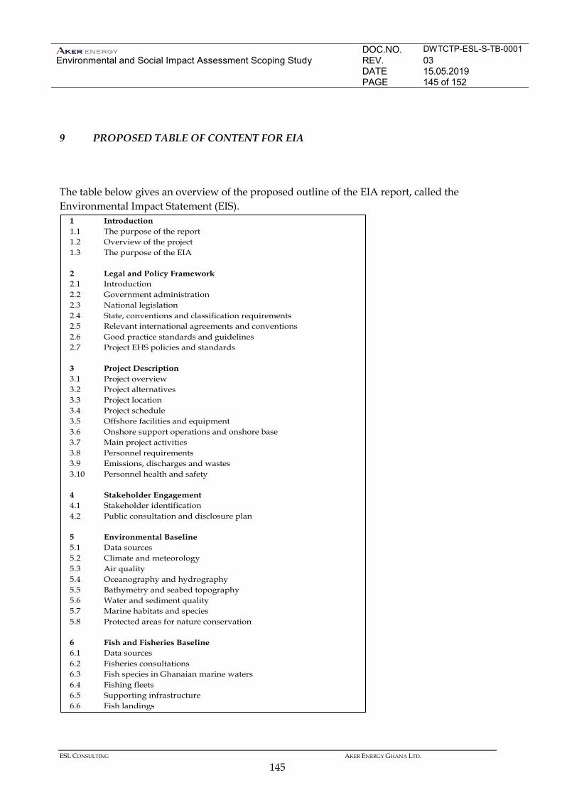
DOC.NO. DWTCTP-ESL-S-TB-0001 Environmental and Social Impact Assessment Scoping Study
REV. 03 DATE 15.05.2019 PAGE 145 of 152
ESL CONSULTING AKER ENERGY GHANA LTD.
145
9 PROPOSED TABLE OF CONTENT FOR EIA
The table below gives an overview of the proposed outline of the EIA report, called the Environmental Impact Statement (EIS).
1 Introduction 1.1 The purpose of the report 1.2 Overview of the project 1.3 The purpose of the EIA 2 Legal and Policy Framework 2.1 Introduction 2.2 Government administration 2.3 National legislation 2.4 State, conventions and classification requirements 2.5 Relevant international agreements and conventions 2.6 Good practice standards and guidelines 2.7 Project EHS policies and standards 3 Project Description 3.1 Project overview 3.2 Project alternatives 3.3 Project location 3.4 Project schedule 3.5 Offshore facilities and equipment 3.6 Onshore support operations and onshore base 3.7 Main project activities 3.8 Personnel requirements 3.9 Emissions, discharges and wastes 3.10 Personnel health and safety 4 Stakeholder Engagement 4.1 Stakeholder identification 4.2 Public consultation and disclosure plan 5 Environmental Baseline 5.1 Data sources 5.2 Climate and meteorology 5.3 Air quality 5.4 Oceanography and hydrography 5.5 Bathymetry and seabed topography 5.6 Water and sediment quality 5.7 Marine habitats and species 5.8 Protected areas for nature conservation 6 Fish and Fisheries Baseline 6.1 Data sources 6.2 Fisheries consultations 6.3 Fish species in Ghanaian marine waters 6.4 Fishing fleets 6.5 Supporting infrastructure 6.6 Fish landings
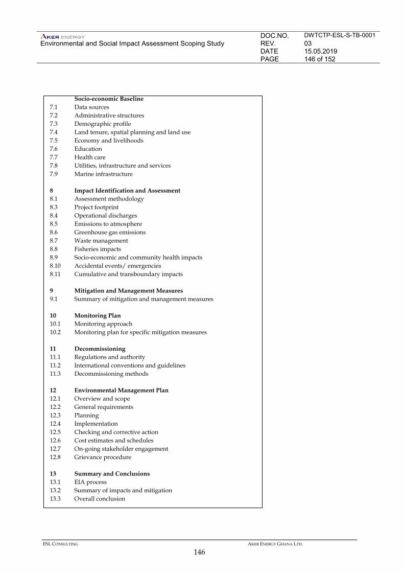
DOC.NO. DWTCTP-ESL-S-TB-0001 Environmental and Social Impact Assessment Scoping Study
REV. 03 DATE 15.05.2019 PAGE 146 of 152
ESL CONSULTING AKER ENERGY GHANA LTD.
146
Socio-economic Baseline 7.1 Data sources 7.2 Administrative structures 7.3 Demographic profile 7.4 Land tenure, spatial planning and land use 7.5 Economy and livelihoods 7.6 Education 7.7 Health care 7.8 Utilities, infrastructure and services 7.9 Marine infrastructure 8 Impact Identification and Assessment 8.1 Assessment methodology 8.3 Project footprint 8.4 Operational discharges 8.5 Emissions to atmosphere 8.6 Greenhouse gas emissions 8.7 Waste management 8.8 Fisheries impacts 8.9 Socio-economic and community health impacts 8.10 Accidental events/ emergencies 8.11 Cumulative and transboundary impacts 9 Mitigation and Management Measures 9.1 Summary of mitigation and management measures 10 Monitoring Plan 10.1 Monitoring approach 10.2 Monitoring plan for specific mitigation measures 11 Decommissioning 11.1 Regulations and authority 11.2 International conventions and guidelines 11.3 Decommissioning methods 12 Environmental Management Plan 12.1 Overview and scope 12.2 General requirements 12.3 Planning 12.4 Implementation 12.5 Checking and corrective action 12.6 Cost estimates and schedules 12.7 On-going stakeholder engagement 12.8 Grievance procedure 13 Summary and Conclusions 13.1 EIA process 13.2 Summary of impacts and mitigation 13.3 Overall conclusion
DOC.NO. DWTCTP-ESL-S-TB-0001 Environmental and Social Impact Assessment Scoping Study
REV. 03 DATE 15.05.2019 PAGE 147 of 152
ESL CONSULTING AKER ENERGY GHANA LTD.
147
REFERENCE LIST
ACORN, 2015. Independent study of marine environmental conditions in Ghana. January 2015. Adamec D and O'Brien J J, 1978. The seasonal upwelling in the Gulf of Guinea due to remote forcing. J Phys Oceanog 8: 1050-1060. AECOM Environment, 2014. Preliminary Environmental Report (PER). Appraisal Drilling, Deepwater Tano/ Cape Three Points Block Offshore Ghana. AFDB, 2012. Republic of Ghana Country Strategy Paper 2012-2016, AFDB, Tunis Aggrey-Fynn, 2007. The fishery of Balistes capriscus (Balistidae) in Ghana and possible reasons for its collapse. PhD Thesis. Centre for Tropical Marine Ecology, University of Bremen. Afukaar et al., 2003. Pattern of road traffic injuries in Ghana: Implications for control. Injury Control and Safety Promotion. 2003, Vol. 10, No. 1–2, pp. 69–76. Accessed: http://www.researchgate.net/publication/10737164_Pattern_of_Road_Traffic_Injuries_in_Ghana_Implications_for_Control (15/09/15) Allersma E. and Tilman M. K.W., 1993. Coastal Conditions in West Africa. Review in Ocean and Coastal Management Vol., pp. 199- 240. Anderson et al., 2014. Statistical Analysis of Vehicle Accident Cases in the Western Region, Ghana. Mathematical Theory and Modeling. V ol.4, No.13, 2014. Accessed: http://www.iiste.org/Journals/index.php/MTM/article/viewFile/17298/17596 (15/09/15) Amiteye B. T., 2002. Distribution and ecology of nesting sea turtles in Ghana. Unpublished Thesis University of Ghana. Arhinful, D. K., 2009. Health Facilities Survey in Ghana. Armah A K, Darpaah G A, Wiafe G, Adomako J K, Quartey S Q, Abotchie C, Ansah F and Fiagbedzi S 1997 . Traditional and modern perspectives of marine turtle conservation in Ghana Biodiversity Conservation: traditional knowledge and modern concepts (eds. Amlalo DS, Atsiatorme LD and Fiati C), p. 80-87: EPA/MAB/UNESCO. Armah A K and Amlalo D S 1998. Gulf of Guinea Large Marine Ecosystem Project: Coastal zone profile of Ghana Ministry of Environment Science and Technology, Accra Ghana.
DOC.NO. DWTCTP-ESL-S-TB-0001 Environmental and Social Impact Assessment Scoping Study
REV. 03 DATE 15.05.2019 PAGE 148 of 152
ESL CONSULTING AKER ENERGY GHANA LTD.
148
Ateweberhan, M., Gough, C., Fenelly, L. and Frejaville, Y. 2012. The nearshore rocky reefs of Western Ghna, West Africa: baseline ecological research surveys. Blue Ventures Conservation Report, 1·100 Birdlife International, 2015. Birdlife Data Zone – Important Bird Areas. Accessed at http://www.birdlife.org/datazone/site/search Boere G C & Stroud D A 2006. The flyway concept: what it is and what it isn’t. Waterbirds around the world. Eds. Boere G C, Galbraith C A & Stroud D A. The Stationery Office, Edinburgh, UK. pp. 40-47. Boko, M. et al., 2007. Chapter 9: Africa. Fourth Assessment Report of the IPCC: 441. Commonwealth Network Ghana 2014, Tourism and Travel. Accessed at: http://www.commonwealthofnations.org/sectors-ghana/business/tourism_and_travel/ (14/02/2015) CRC-URI, 2010. Our Coast, Our Future. Western Region of Ghana, Building capacity for adapting to a rapidly changing coastal zone. H&N Mpoano. Prepared by Coastal resources centre – University of Rhode Island (CRC-URI) and SustainaMetrix. pp. 66. Elgood J H, Heigham J B, Moore A M, Nason A M, Sharland R E and Skinner NJ, 1994. The birds of Nigeria (2nd edition) British Ornithologists’ Union Check-list No. 4. British Ornithologists' Union Tring. Ellembelle District Profile, 2012. Ellembele District Information, Ellembelle District. Accessed at: http://ghanadistricts.com EPA, 2010 Guidelines for Environmental Assessment and Management in the Offshore Oil and Gas Development. Available from: www.epa.gov.gh EPI Group 2014. 3D Seismic Survey Report. Cetacean and Sea Turtle Report. Hess Corporation. Deepwater Tano/ Cape Three Points, Ghana. EPI REPORT No. 1530-MMO. ERM, 2009. Ghana Jubilee Field Phase I Development. Environmental Impact Statement. Prepared for Tullow Ghana Limited in November 2009. ERM, 2012. Environmental and Social Scoping Study of the Tweneboa, Enyenra, Ntomme (TEN) Development, Ghana (prepared by ERM, ESL, and SRC), Tullow Ghana, 2012 ERM 2013. Environmental and Social Impact Assessment of an Oil Services Terminal (OST), Atuabo, Western Region, Ghana (prepared by ERM, ESL, and SRC (2013). ERM, 2015a. Environmental and Social Impact Assessment of the Offshore Cape Three Points (OCTP) Phase 2 Development [offshore gas production and transport to shore], Ghana (prepared by ERM and ESL), eni Ghana, 2015
DOC.NO. DWTCTP-ESL-S-TB-0001 Environmental and Social Impact Assessment Scoping Study
REV. 03 DATE 15.05.2019 PAGE 149 of 152
ESL CONSULTING AKER ENERGY GHANA LTD.
149
ERM, 2015b. Fisheries Impact Assessment of the Offshore Cape Three Points (OCTP) Phase 1 and Phase 2 Development, Ghana (prepared by ESL for ERM), Eni Ghana, 2015 ERM, 2015c. Environmental and Social Scoping Study of a 450 MW Power Plant in Aboadze, Western Region, Ghana (prepared by ERM and ESL), Globeleq Advisors Limited and Volta River Authority, 2015 Evans P G H and Nice H 1996. Review of the effects of underwater sound generated by seismic surveys on cetaceans. SeaWatch Foundation, Oxford. (Report commissioned by UKOOA.) FAO, 2010. Country reports presented at the FAO FishCode-STF/CECAF/FCWC Subregional Workshop on the Improvement of Fishery Information and Data Collection Systems in the West Central Gulf of Guinea Region. Accra, Ghana, 26–28 June 2007. FAO Fisheries and Aquaculture Report. No. 921, Suppl. 113p. FAO, 2014. FAO FishFinder [online]. FAO Fisheries and Aquaculture Department [online]. Rome. Available at http://www.fao.org/fishery/fishfinder/about/en [Accessed July 2014]. Flegg J 2004). Time to Fly. Exploring Bird Migration. BTO, Thetford. Fontaine B, Janicot S and Roucou P, 1999. Coupled ocean-atmosphere surface variability and its climate in the tropical Atlantic region. Climate Dynamics 15: 451-473. Froese R and Pauly D, Editors, 2010. FishBase version 09/2010 [online] Available at www.fishbase.org [Accessed July 2011]. Fugro, 2014. Current Data Report, Ghana Deepwater Current Measurements Phase 4, Survey Date 24 August to 27 December 2014. Fugro, 2014. Metocean Modelling Data Report, Metocean Criteria for the Pecan Field. Gardline 2015. Environmental Baseline Survey Report, Deep Water Tano Cape Three Points, Survey Date December 2013 to January 2014. Ghana Aids Commission, 2014. Country Aids Response Progress Report - Ghana, Ghana Aids Commission, Accra Ghana Health Service 2014. Ellembelle District Profile, Ghana Health Service, Accra Ghana Investment and Promotion Centre 2014. Investing in Ghana’s Fishing Sector. Office of the President (Ghana). Accessed at: http://gipcghana.com/21-investment-projects/agriculture-and-agribusiness/fishing-and-aquaculture/300-investing-in-ghana-s-fishing-industry.html (18/12/14) Ghana Investment and Promotion Centre 2014, Investing in Ghana's Agricultural & Agro-Processing Industry, Office of the President (Ghana). Accessed at: http://gipcghana.com/invest-in-ghana/sectors/agriculture-agro-processing/investing-in-this-sector.html (18/12/14)
DOC.NO. DWTCTP-ESL-S-TB-0001 Environmental and Social Impact Assessment Scoping Study
REV. 03 DATE 15.05.2019 PAGE 150 of 152
ESL CONSULTING AKER ENERGY GHANA LTD.
150
Ghana Ports and Harbour Authority n.d, Port of Takoradi. Accessed at: http://ghanaports.gov.gh/tr/page/39/Navigational-Information-Takoradi (18/12/14) Ghana Statistical Service 2013. Population and Housing Census- Regional Analytical Report- Western Region, Ghana Statistical Service, Accra. Ghana Statistical Service, 2012. 2010 Population and Housing Census: Provisional National and Regional Statistics. Republic of Ghana. Hess Offshore Operations, 2011. Fish and Fisheries Study, Hess, Accra IUCN 2015. http://www.iucnredlist.org/ [Accessed July 2014]. Kastning, T 2011. Basic Overview of Ghana’s Emerging Oil Industry, Friedrich Ebert Stiftung, Accra Koranteng K.A. 1998. The impacts of environmental forcing on the dynamics of demersal fishery resources of Ghana. PhD Thesis, University of Warwick, pp. 377 Mensah, M.A. and Koranteng, K.A. 1988. A review of the oceanography and fisheries resources in the coastal waters of Ghana. Marine Fisheries Research Report No. 8, Fisheries Research & Utilization Branch, Tema, Ghana, pp. 35. Ministry of Energy, 2012. Natural Gas Pricing Policy, May 2012. NCEAS 2014, Data Impacts. Accessed at: https://www.nceas.ucsb.edu/GlobalMarine/impacts. Noble Denton, 2008. Offshore Ghana MetOcean data report Report No: L22898/NDC/IGA 45pp. Osei-Boateng, C. and Ampratwum E, 2011. The Informal Sector in Ghana, Friedrich Ebert Stiftung, Accra Paradi-Guilford, 2015. How Ghana is tackling energy shortages, May 2015. Accessed: https://agenda.weforum.org/2015/03/how-ghana-is-tackling-energy-shortages/ (15/09/15) Soper, J. 2015. Ghana: Fishing in Oil's Ocean. September 11, 2015. Accessed. http://pulitzercenter.org/reporting/ghana-fishing-oils-ocean-soper (15/09/15) TGL Offshore Operations, 2011. Fish and Fisheries Study, TGL, Accra Tyler-Walters, H. 2003. Lophelia reefs. Marine Life Information Network: Biology and Sensitivity Key Information Sub-programme [on-line]. Plymouth: Marine Biological Association of the United Kingdom. [Available at: http://www.marlin.ac.uk]
DOC.NO. DWTCTP-ESL-S-TB-0001 Environmental and Social Impact Assessment Scoping Study
REV. 03 DATE 15.05.2019 PAGE 151 of 152
ESL CONSULTING AKER ENERGY GHANA LTD.
151
US Energy Information Administration 2014, Ghana- Country Analysis Note. Accessed at: http://www.eia.gov/countries/country-data.cfm?fips=gh (13/02/15) United States Agency for International Development (USAID), 2011. Ghana Climate Change Vulnerability and Adaptation Assessment. US Energy Information Administration 2014. Ghana- Country Analysis Note. Accessed at: http://www.eia.gov/countries/country-data.cfm?fips=gh (13/02/15) Van Waerebeek K, Ofori-Danson P K and Debrah J (2009). The Cetaceans of Ghana: a Validated Faunal Checklist. West African Journal of Applied Ecology Vol 15. Weir, C.R. 2010. A review of the cetacean occurrence in West African waters from the Gulf of Guinea to Angola. Mammal Rev. 40 (1): 2-39 WHO Global Health Observatory (GHO) data, 2015. (10/09/15)http://www.who.int/gho/countries/en/(10/09/15) World bank 2015. Accessed: http://databank.worldbank.org/data//reports.aspx?source=2&country=GHA&series=&period= (10/09/15)
DOC.NO. DWTCTP-ESL-S-TB-0001 Environmental and Social Impact Assessment Scoping Study
REV. 03 DATE 15.05.2019 PAGE 152 of 152
ESL CONSULTING AKER ENERGY GHANA LTD.
152
APPENDICES