definitions of favourable condition for designated ... · definitions of favourable condition for...
TRANSCRIPT

Definitions of Favourable Condition: Bognor Reef SSSI (Final draft 12.12.13)
Definitions of Favourable Condition for designated features of interest
These definitions relate to all designated features on the SSSI, whether designated as SSSI, SPA, SAC or Ramsar features.
Sussex Team Guildbourne House
Chatsworth Road Worthing BN11 1 LD
Enquiry Service: 0845 600 3078 Email: ELSE-
Name of Site of Special Scientific Interest (SSSI)
Bognor Reef
Names of designated international sites
Special Area of Conservation (SAC)
Special Protection Area (SPA)
Ramsar
Relationship between site designations
Version control information
Status of this Version (Draft, Consultation Draft, Final)
Final
Prepared by Elaine Webster
Date of this version 12 December 2013
Date of generic guidance on favourable condition used
CSM Guidance Coastal Shingle, August 2004 CSM Guidance Vascular Plants, February 2004 CSM Guidance Earth Science, February 2004 Geological Guidance, 2006
Other notes/version history
Consultation Draft - Alex Robbins (01/02/2008) Consultation Draft - Audrey Jones (15/03/2006)
Quality assurance information
Checked by Name Kristoffer Hewitt
Date 13 March 2013
Signature
www.naturalengland.org.uk

Definitions of Favourable Condition: Bognor Reef SSSI (Final draft 12.12.13)
Definitions of Favourable Condition: notes for users Definitions of Favourable Condition The definitions comprise one or more condition definitions for the special interest features at this site. These are subject to periodic review and may be updated to reflect new information or knowledge. They will be used by Natural England to determine if a site is in a favourable condition. The standards for favourable condition have been developed and are applied throughout the UK. Standards for favourable condition are defined with particular reference to the specific designated features listed in Table 1, and are based on a selected set of attributes for features which most effectively define favourable condition as set out in Tables 2, 2a and 3. When an SSSI‟s features meet these attributes, then they are said to be in „favourable condition‟. Explanatory text for Tables 2 and 3 Tables 2, 2a and 3 set out the measures of condition which we will use to provide evidence to support our assessment of whether features are in favourable condition. They have been tailored by local staff to reflect the particular characteristics and site-specific circumstances of individual sites. Quality Assurance has ensured that such site-specific tailoring remains within a nationally consistent set of standards. The tables include an audit trail to provide a summary of the reasoning behind any site-specific targets etc. In some cases the requirements of features or designations may conflict; the detailed basis for any reconciliation of conflicts on this site may be recorded elsewhere.
Use under the Habitats Regulations The Definitions of Favourable Condition (DFCs) are used to periodically measure and assess the condition of both notified SSSI features and designated European Site features. Where SSSIs also form part of a European Site (such as a SAC or SPA), a separate document containing specific European Site Conservation Objectives will have been prepared. These objectives are those referred to in the Conservation of Habitats and Species Regulations 2010 (the “Habitats Regulations”) and the Habitats Directive 1992. They are for use when either the appropriate nature conservation body or a competent authority is required to make an „appropriate assessment‟ of the likely effects of a proposed plan or project on the integrity of a European Site under the relevant parts of the respective legislation. The European Site Conservation Objectives are available at www.naturalengland.org.uk. The concepts of „site integrity‟ and „favourable condition‟ are similar and the assessment of a feature‟s condition will measure attributes that also represent aspects of a site‟s ecological integrity. However, the periodic determination of a feature‟s condition is separate from a judgement about the effect upon a site‟s overall integrity. This is because the DFCs do not represent a comprehensive or definitive list of all of the elements that might contribute to site integrity, merely those that are most appropriate to monitor in order to rapidly determine the present condition of a feature. The full range of factors that are components of a site‟s integrity, and which may need to be considered by an appropriate assessment, will be specified in the European Site Conservation Objectives. Some of the information contained within the DFCs may however contribute to such assessments.

Page 3 of 24 Definitions of Favourable Condition: Bognor Reef SSSI (Final draft 12.12.13)
Table 1 Individual designated interest features
BAP Broad Habitat type / Geological Site Type
Specific designated features
Explanatory description of the feature for clarification
SS
SI n
oti
fie
d i
nte
rest
fea
ture
s
SA
C
qu
ali
fyin
g i
nte
res
t
fea
ture
s
SPA qualifying interest features dependency on specific habitats
Ramsar criteria applicable to specific
habitats
An
ne
x 1
sp
ec
ies
Mig
rato
ry
sp
ec
ies
Wa
terf
ow
l
as
se
mb
lag
e
1a
Wetl
an
d
ch
ara
cte
ris
tic
s
2a
Ho
sti
ng
rare
sp
ec
ies
&c
3a
20
000
wa
terf
ow
l
3c
1%
of
po
pu
lati
on
Supralittoral Sediment
Rumex crispus-Glaucium flavum shingle community (SD1)
Vegetated shingle: Curly Dock – Yellow Horned Poppy
*
Lowland Acid Grassland
Population of Schedule 8 plant - Petrorhagia nanteuilii
Childing Pink
*
Coastal Cliffs and Foreshore (EC)
EC - Tertiary Paleobotany EC – Paleoentomology EC - Aves
Geological interest found on foreshore exposures
*
NB. Features where asterisks are in brackets (*) indicate habitats which are not notified for specific habitat interest (under the relevant designation) but because they support notified species.
Page 4 of 24 Definitions of Favourable Condition: Bognor Reef SSSI (Final draft 12.12.13)
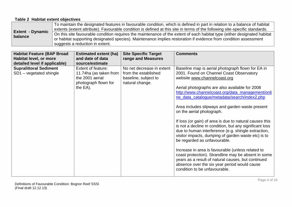
Table 2 Habitat extent objectives
Extent - Dynamic balance
To maintain the designated features in favourable condition, which is defined in part in relation to a balance of habitat extents (extent attribute). Favourable condition is defined at this site in terms of the following site-specific standards.
On this site favourable condition requires the maintenance of the extent of each habitat type (either designated habitat or habitat supporting designated species). Maintenance implies restoration if evidence from condition assessment suggests a reduction in extent.
Habitat Feature (BAP Broad Habitat level, or more detailed level if applicable)
Estimated extent (ha) and date of data source/estimate
Site Specific Target range and Measures
Comments
Supralittoral Sediment SD1 – vegetated shingle
Extent of feature: 11.74ha (as taken from the 2001 aerial photograph flown for the EA).
No net decrease in extent from the established baseline, subject to natural change.
Baseline map is aerial photograph flown for EA in 2001. Found on Channel Coast Observatory website www.channelcoast.org Aerial photographs are also available for 2008 http://www.channelcoast.org/data_management/online_data_catalogue/metadata/search/index2.php Area includes slipways and garden waste present on the aerial photograph. If loss (or gain) of area is due to natural causes this is not a decline in condition, but any significant loss due to human interference (e.g. shingle extraction, visitor impacts, dumping of garden waste etc) is to be regarded as unfavourable. Increase in area is favourable (unless related to coast protection). Strandline may be absent in some years as a result of natural causes, but continued absence over the six year period would cause condition to be unfavourable.
Page 5 of 24 Definitions of Favourable Condition: Bognor Reef SSSI (Final draft 12.12.13)
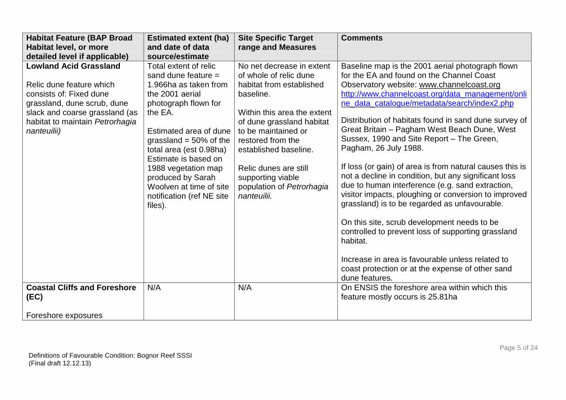
Habitat Feature (BAP Broad Habitat level, or more detailed level if applicable)
Estimated extent (ha) and date of data source/estimate
Site Specific Target range and Measures
Comments
Lowland Acid Grassland Relic dune feature which consists of: Fixed dune grassland, dune scrub, dune slack and coarse grassland (as habitat to maintain Petrorhagia nanteuilii)
Total extent of relic sand dune feature = 1.966ha as taken from the 2001 aerial photograph flown for the EA. Estimated area of dune grassland = 50% of the total area (est 0.98ha) Estimate is based on 1988 vegetation map produced by Sarah Woolven at time of site notification (ref NE site files).
No net decrease in extent of whole of relic dune habitat from established baseline. Within this area the extent of dune grassland habitat to be maintained or restored from the established baseline. Relic dunes are still supporting viable population of Petrorhagia nanteuilii.
Baseline map is the 2001 aerial photograph flown for the EA and found on the Channel Coast Observatory website: www.channelcoast.org http://www.channelcoast.org/data_management/online_data_catalogue/metadata/search/index2.php
Distribution of habitats found in sand dune survey of Great Britain – Pagham West Beach Dune, West Sussex, 1990 and Site Report – The Green, Pagham, 26 July 1988. If loss (or gain) of area is from natural causes this is not a decline in condition, but any significant loss due to human interference (e.g. sand extraction, visitor impacts, ploughing or conversion to improved grassland) is to be regarded as unfavourable. On this site, scrub development needs to be controlled to prevent loss of supporting grassland habitat. Increase in area is favourable unless related to coast protection or at the expense of other sand dune features.
Coastal Cliffs and Foreshore (EC) Foreshore exposures
N/A N/A On ENSIS the foreshore area within which this feature mostly occurs is 25.81ha

Page 6 of 24 Definitions of Favourable Condition: Bognor Reef SSSI (Final draft 12.12.13)
Audit Trail
Rationale for habitat extent attribute (Include methods of estimation (measures), and the approximate degree of change which these are capable of detecting).
Unit 1 is a mix of dune scrub, dune grassland, dune slack and coarse grassland areas. Dune grassland is the supporting habitat for the interest feature Petrorhagia nanteuilii. An additional target for the extent of dune grassland has therefore been set. The map used to estimate this area is the 1988 notification map produced by Sarah Woolven. This shows approximately 50% of the site as scrub (Ulex europaeus,Tamarix gallica, Lycium halimifolium and Populus alba) with most of the remainder as dune grassland or bare dune EW 2013.
Rationale for site-specific targets (including any variations from generic guidance)
The generic target for dune habitat extent of „no net decrease in extent from the established baseline, subject to natural change‟ has been modified to ensure the extent of dune grassland is not lost due to natural scrub development EW 2013.
Other Notes
Not all areas of dune grassland will provide suitable conditions for Petrorhagia nanteuilii.

Page 7 of 24 Definitions of Favourable Condition: Bognor Reef SSSI (Final draft 12.12.13)
Table 2a Species population objectives
Population balance
To maintain the designated species in favourable condition, which is defined in part in relation to their population attributes. Favourable condition is defined at this site in terms of the following site-specific standards.
On this site favourable condition requires the maintenance of the population of each designated species or assemblage. Maintenance implies restoration if evidence from condition assessment suggests a reduction in size of population or assemblage.
Species Feature (species or assemblage)
List supporting BAP Broad Habitats
Population Attribute (eg presence/absence, population size or assemblage score)
Site Specific Target range and Measures (specify geographical range over which target applies ie site, BAP broad habitat or more specific)
Comments
Childing pink (Petrorhagia nanteuilii)
Lowland Acid Grassland (Relic sand dune grassland).
Presence/absence Population size: 350 flowers recorded in 1988. Area covered by western clump. Number of additional clumps.
At least a viable population size present AND No more than 10% loss either in amount of area colonised or in the overall number of individual clumps. On this site:
1. No loss of area covered by the western population. Count of flowering plants within this area to be > 300
2. Numbers of additional clumps to
be > 3
Population is mainly found on the western side of the unit. Population numbers may vary naturally from year to year. Targets for direct attributes to be confirmed. Area of established western colony to be measured and more accurately mapped. Number of additional patches to be counted and confirmed by further surveys.

Page 8 of 24 Definitions of Favourable Condition: Bognor Reef SSSI (Final draft 12.12.13)
Audit Trail
Rationale for species population attributes (Include methods of estimation (measures), and the approximate degree of change which these are capable of detecting).
No specific target for population size for Petrorhagia nanteuilii have previously been set. Presence/absence is the mandatory direct attribute currently used for assessment (CSM vascular plants guidance, 2004). There is a need for increased confidence in the long-term viability of the population and specific attributes and targets are needed to measure population size. This may involve counts of individuals or extent of colony or a combination of both measures. A measure of regeneration potential may also be desirable EW 2013. The Sand Dune Survey of Great Britain, Site Report no 79, Pagham Beach Dune, W Sussex 1990. C L Holder and S Woolven. C NCC 1990 references the 1988 record of 350 flowers and provides the historical location of Petrorhagia nanteuilii. EW 2013
Rationale for site-specific targets (including any variations from generic guidance)
The generic popualtion targets for suite 6 species (viable population and no more than 10% loss) are difficult to assess against the available data which is a count. It is important to maintain the established colony of Petrorhagia nanteuilii at western end of the site. Petrorhagia nanteuilii is an annual species with heavy seeds which tend to fall nearby and this may limit potential for spread. The spatial area covered by the western colony needs to be more clearly defined so that any increase/decrease can be measured. Several additional patches of Petrorhagia nanteuilii were recorded in 2012. Recording and mapping these areas, ideally with a measure of population size will provide data to inform target setting, The target of > 3 additional patches to be confirmed. Number of individual flowering plants >300 is based on 1988 record of 350 flowering plants and abundance categories used for numbers above 100 (ie 101-300, 301-1000, 1001-3000 etc). Numbers may fluctuate widely and may need to be assessed in more than one season during recording cycle EW 2013.
Other Notes
Unit 1 is currently unfavourable declining (Dec 2013) due to scrub encroachment. Numbers of Petrorhagia nanteuilii are expected to be lower than at notification due to loss of suitable habitat EW 2013.

Page 9 of 24 Definitions of Favourable Condition: Bognor Reef SSSI (Final draft 12.12.13)
Table 3 Site specific Habitat/geological condition objectives [insert separate Table 3 for each BAP broad habitat]
To maintain the Supralittoral Sediment (SD1 - Vegetated Shingle) at Bognor Reef SSSI in favourable condition, with particular reference to relevant specific designated interest features. Favourable condition is defined at this site in terms of the following site-specific standards:
Site-specific details of any geographical variation or limitations (where the favourable condition standards apply)
Shingle vegetation is limited at the far eastern end of the site unit as the beach narrows and is subject to higher levels of recreational disturbance EW 2013.
Site-specific standards defining favourable condition
Criteria feature Attribute term in guidance
Measure Site-specific Targets Comments Use for Condition Assessment?
Supralittoral Sediment SD1 - Vegetated shingle
Vegetation structure: Range of zones should be present – from driftline to stable vegetation.
Visual assessment, e.g. using transects (extending from strandline to landward features) may be used to estimate the width of the vegetated shingle at points described by GPS and marked on a map. NB: Baseline surveys measuring the extent of each zone are not available from notification. Aerial photographs should be used as an aid, where available.
Zonation from strandline to landward features should be intact over at least 80% of the feature. At most recent ISA (July 2012) the width of perennial vegetation was between 50-70m narrowing to 20m at the far eastern end. Distance from strandline to AVDL averaged at 15.5m with no more than 3m between AVDL and seaward edge of perennial vegetation.
Points may change because of natural dynamism, but the overall diversity should not diminish. If strandline is absent this may be acceptable if due to natural causes (see comment under Extent). The shingle vegetation may be vulnerable to heavy trampling by people.
Yes
SD1 - Vegetated Vegetation Visual assessment of cover (modified Maintain frequency of Communities may Yes

Page 10 of 24 Definitions of Favourable Condition: Bognor Reef SSSI (Final draft 12.12.13)
Criteria feature Attribute term in guidance
Measure Site-specific Targets Comments Use for Condition Assessment?
shingle composition: positive indicator species
DAFOR scale), using structured walk and transects.
characteristic species of the vegetated shingle zones: Annual Vegetation of Drift lines (strandline): At least one of the following species frequent and another occasional: Honckenya peploides, Cakile maritima, Atriplex prostrata, A. glabriuscula, A. laciniata, Salsola kali, Galium aparine, Matricaria maritima, Polygonum oxyspermum.
Perennial Vegetation of Stoney Banks (SD1): At least two of the following species abundant and two frequent: Rumex crispus, Crambe maritima, Glaucium flavum, Silene uniflora, Beta vulgaris maritima, Lathyrus japonicus, Picris echioides.
be dynamic in their distribution and are linked to the physical processes operating at the site. Strandline vegetation is mostly Atriplex sp. Perennial vegetation is mostly Crambe maritime, Glacium flavum and Rumex crispus. (NVC SD1).

Page 11 of 24 Definitions of Favourable Condition: Bognor Reef SSSI (Final draft 12.12.13)
Criteria feature Attribute term in guidance
Measure Site-specific Targets Comments Use for Condition Assessment?
SD1 – vegetated shingle
Vegetation composition: negative indicator species
Aerial photographs, together with visual assessment of cover (modified DAFOR scale), using structured walk. The % of cover measured is cover across the entire feature.
1. Non-native species no more than rare, e.g. Lupinus arboreus, Centranthus ruber, Tamarix gallica and other garden escapes. 2. Invasive species indicative of changes in nutrient species e.g. Senecio jacobaea, Cirsium vulgare should be no more than frequent throughout the sward, or singly or together the cover of negative indicator species no more than 5%.
Impacts from adjacent properties (garden escapes, cultivated grass paths and bonfires). Centranthus ruber is a particular threat to this habitat especially in the western part of the unit.
Yes
SD1 - Vegetated shingle
Other negative indicators: shingle nutrient status
Visual assessment of cover using structured walk or transects. The % cover measured is cover of the entire feature
Area of bonfires and garden waste dumping should be < 2%.
The abundance of ruderal species indicative of nutrient enrichment would indicate unfavourable condition. Risks are bonfires and garden escapes encroaching on
Yes

Page 12 of 24 Definitions of Favourable Condition: Bognor Reef SSSI (Final draft 12.12.13)
Criteria feature Attribute term in guidance
Measure Site-specific Targets Comments Use for Condition Assessment?
the beach.
SD1 - Vegetated shingle
Other negative indicators: signs of disturbance vehicles
Visual assessment during site visit. (photographic evidence)
Vehicle damage or visitor damage at vulnerable locations (e.g. tracks, access points) should be absent or rare.
Bonfires, dumping of garden waste and the construction of paths across the shingle should be absent apart from where they have been consented by Natural England
Yes
SD1 - Vegetated shingle
Physical structure: functionality and sediment supply
Aerial photographs can be used, combined with information gathered from the site visit (such as fixed point photographs).
No further anthropogenic increase in factors leading to the decrease of natural mobility of the system. The natural circulation of shingle should be retained.
There is one breakwater at the eastern end of the vegetated shingle unit, plus a surface water outfall halfway along. Apart from these there are no coastal defence structures present. Recent accretion has necessitated in extension of outfall. Also a boardwalk and the BRYC boat ramp EW 2013.
Yes

Page 13 of 24 Definitions of Favourable Condition: Bognor Reef SSSI (Final draft 12.12.13)
Audit Trail
Rationale for limiting standards to specified parts of the site
Shingle vegetation is limited at the far eastern end of the site as the beach narrows and is subject to higher levels of recreational disturbance. Extent of vegetated shingle to be defined more accurately at next site assessment EW 2013.
Rationale for site-specific targets (including any variations from generic guidance)
Positive indicator species selected are typical species for vegetated shingle zones as defined by Sneddon & Randall 1993. (Sneddon, P. & Randall, R.E. 1993). Coastal vegetated shingle structures of Great Britain: Main report. Joint Nature Conservation Committee, Peterborough). Target for other negative indicators: signs disturbance nutrient status/bonfires and garden waste was originally set at 10%. Ideally no bonfire or compost sites should be within the SSSI. Reduced acceptable limit to 2%. (or no more than 2 bonfire or compost sites in total on the site) EW 2013.
Rationale for selection of measures of condition (features and attributes for use in condition assessment) (The selected vegetation attributes are those considered to most economically define favourable condition at this site for the broad habitat type and any dependent designated species).
Fixed point photographs could be used to monitor change in extent and record positive and negative indicators
Other Notes
Small grassey patches occur infrequently with false oat grass Arrenatherum elatius and red fescue Festuca rubra.

Page 14 of 24 Definitions of Favourable Condition: Bognor Reef SSSI (Final draft 12.12.13)
Table 3a Site specific Habitat/geological condition objectives [insert separate Table 3 for each BAP broad habitat]
To maintain the Lowland Acid Grassland (dune grassland) at Bognor Reef SSSI in favourable condition, with particular reference to relevant specific designated interest feature Petrorhagia nanteuilii. Favourable condition is defined at this site in terms of the following site-specific standards:
Site-specific details of any geographical variation or limitations (where the favourable condition standards apply)
Around 50% of Unit 1 is dense dune scrub which is not suitable habitat for Petrorhagia nanteuilii. However, the edges of paths/tracks through the scrub are potentially suitable habitat and benefit from the sheltered environment provided by taller vegetation.
Site-specific standards defining favourable condition
Criteria feature Attribute term in guidance
Measure Site-specific Targets Comments Use for Condition Assessment?
Petrorhagia nanteuilii
Niche availability
Mapping (area)
Count number of distinct patches of Petrorhagia nanteuilii within dune grassland habitat. Structured walk across whole of dune grassland area (including tracks through scrub) during flowering period (June-July).
No loss of extent of suitable habitat (though spatial arrangement of habitat „patches‟ can change from year to year).
Sufficient area of suitable habitat to maintain population.
>3 patches present in addition to the established patch in the western part of the site.
1988 vegetation map has been used to estimate the estimated extent of dune grassland area. Specific locations for Petrorhagia nanteuilii are recorded in Sand Dune Survey of Great Britain 1990.
Yes
Until confirmation of target for number of additional patches this is a discretionary target.

Page 15 of 24 Definitions of Favourable Condition: Bognor Reef SSSI (Final draft 12.12.13)
Criteria feature Attribute term in guidance
Measure Site-specific Targets Comments Use for Condition Assessment?
Petrorhagia nanteuilii
Bare ground Visual assessment >5% bare ground should be present in area where Petrorhagia nanteuilii is found.
Bare ground is essential for seed germination and seedling establishment. Open textured swards are ideal.
Yes
Petrorhagia nanteuilii
Vegetation structure: Sward height
Measure with a ruler
>50% of sward < 2cm sward height
Suite 6 species favour short swards frequently located within a matrix of unsuitable habitat (ie on pathsides).
Yes
Petrorhagia nanteuilii
Hydrology Visual assessment Visit during winter
Signs of flooding or direct evidence of dampness in winter
Most suite 6 species favour ground which is dry in summer and damp in winter.
Yes
Petrorhagia nanteuilii
Negative indicators: Shading
Visual assessment No shading; no encroachment of scrub or tall grassland
prefers very open/unshaded situations but can colonise along scrub margins.
Yes
Petrorhagia nanteuilii Negative Associated species (DAFOR) Poa anua and/or All suite 6 Yes
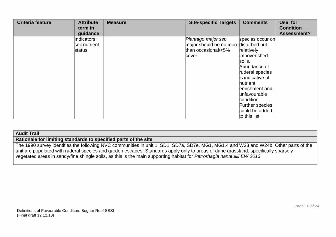
Page 16 of 24 Definitions of Favourable Condition: Bognor Reef SSSI (Final draft 12.12.13)
Criteria feature Attribute term in guidance
Measure Site-specific Targets Comments Use for Condition Assessment?
Indicators: soil nutrient status
Plantago major ssp major should be no more than occasional/<5% cover
species occur on disturbed but relatively impoverished soils. Abundance of ruderal species is indicative of nutrient enrichment and unfavourable condition. Further species could be added to this list.
Audit Trail
Rationale for limiting standards to specified parts of the site
The 1990 survey identifies the following NVC communities in unit 1: SD1, SD7a, SD7e, MG1, MG1.4 and W23 and W24b. Other parts of the unit are populated with ruderal species and garden escapes. Standards apply only to areas of dune grassland, specifically sparsely vegetated areas in sandy/fine shingle soils, as this is the main supporting habitat for Petrorhagia nanteuilii EW 2013.

Page 17 of 24 Definitions of Favourable Condition: Bognor Reef SSSI (Final draft 12.12.13)
Rationale for site-specific targets (including any variations from generic guidance)
The Sand Dune Survey of Great Britain (1990) indicates Petrorhagia nanteuilii is only found in the far western part of unit 1, however in 2012 Petrorhagia nanteuilii was recorded in sparsely vegetated areas in the centre of the unit. The whole extent of dune grassland should therefore be surveyed (through a structured walk) ensuring areas of known populations are represented in the assessed stops. This provides a measure of habitat condition and potential of the plant to spread to new areas EW 2013. In previous version: A Robbins 02/2008 recommended „the target for bare ground in SD7 – fixed dune increased to 20% as required to maintain the Petrorhagia nanteuilii population.The fixed dune is designated for the presence of Petrorhagia nanteuilii and invertebrates so it should be managed to support these features‟. Target for bare ground kept at > 5% and to be reviewed at next ISA. Apply bare ground target to all suitable dune grassland and not limit to SD7 NVC community EW 2013.
Rationale for selection of measures of condition (features and attributes for use in condition assessment) (The selected vegetation attributes are those considered to most economically define favourable condition at this site for the broad habitat type and any dependent designated species).
Generic guidance for suite 6 vascular plant species used (CSM guidance for vascular plants).
Other Notes
The Broad BAP habitat identified as supporting habitat for Petrorhagia nanteuilii is Acidic Grassland. NVC types identified in the 1990 survey suggests other grassland types are also present (SD1, SD7a, SD7e, MG1, MG1.4). Notably the sparse grassland vegetation has a strong maritime influence with species such as; Allium vineale, Ammophila arenaria, Carex arenaria, Erodium cicutarium, Filago minima, Honckenya peploides, Lactuca serriola, Leontodon saxatilis, Ophioglossum vulgatum, Plantago coronopus, Senecio viscosus, Spergularia rubra, Trifolium arvense and Trifolium suffocatum (BSBI records - various dates). Many of these species favour similar conditions to Petrorhagia nanteuilii and may be indicative of suitable conditions even if the notified species is absent EW 2013.

Page 18 of 24 Definitions of Favourable Condition: Bognor Reef SSSI (Final draft 12.12.13)
Table 3b Site specific Habitat/geological condition objectives
To maintain the Foreshore Exposures (EC) at Bognor Reef SSSI in favourable condition, with particular reference to relevant specific designated interest features. Favourable condition is defined at this site in terms of the following site-specific standards:
Site-specific details of any geographical variation or limitations (where the favourable condition standards apply)
Site-specific standards defining favourable condition
Criteria feature Attribute term in guidance
Measure Site-specific Targets Comments Use for Condition Assessment?
COASTAL CLIFFS AND FORESHORE (EC) - EC - Tertiary Paleobotany EC – Paleoentomology EC – Aves
Exposure of features of interest
Visual/fixed point photography Maintain existing exposure conditions; the foreshore features can be seen or exposed at low tides (some features are not exposed at all as below LWM).
The interest is also buried under shingle, boreholes would be needed to record.
Yes
COASTAL CLIFFS AND FORESHORE (EC) - EC - Tertiary Paleobotany EC – Paleoentomology EC – Aves
Geological specimen collecting
Visual/fixed point photography No damaging specimen collecting
GCR fossil interest includes Palaeobotany (Tertiary), Palaeoentomology, fish/Amphibia(Tertiary-Mesozoic (Lower Eocene)
Yes
COASTAL CLIFFS AND Engineering Visual/fixed point photography Avoid additional There are Yes

Page 19 of 24 Definitions of Favourable Condition: Bognor Reef SSSI (Final draft 12.12.13)
Criteria feature Attribute term in guidance
Measure Site-specific Targets Comments Use for Condition Assessment?
FORESHORE (EC) - EC - Tertiary Paleobotany EC – Paleoentomology EC – Aves
works development and coastal modifications that obscure or damage the fdeatures of interest. Maintain existing coastal management.
breakwaters and groynes at the eastern end. See aerial map for locations.
COASTAL CLIFFS AND FORESHORE (EC) - EC - Tertiary Paleobotany EC – Paleoentomology EC – Aves
Natural coastal processes
Visual/fixed point photography Maintian natural coastal processes. Processes that cause erosion are not constrained within or adjacent to the site.
There are breakwaters and groynes at the eastern end.
Yes
COASTAL CLIFFS AND FORESHORE (EC) - EC - Tertiary Paleobotany EC – Paleoentomology EC – Aves
Vegetation Visual/fixed point photography Maintain existing vegetation levels. Refer to shingle objectives.
Yes – but covered in vegetated shingle targets.does not apply to mud and sandflats
Audit Trail
Rationale for limiting standards to specified parts of the site
Refer to: Geological Site Documentation/Management Brief Bognor Reef SSSI West Sussex SZ89 (1993). Location: NE site files Worthing office.
Rationale for site-specific targets (including any variations from generic guidance)
The objectives for scree and sediment build up have been removed due to other coastal processes and interest features being present on the site. The geological interest is present underneath the sediment exposures and or/boreholes can be used to monitor interest A. Robbins 21/02/2008.

Page 20 of 24 Definitions of Favourable Condition: Bognor Reef SSSI (Final draft 12.12.13)
Rationale for selection of measures of condition (features and attributes for use in condition assessment) (The selected vegetation attributes are those considered to most economically define favourable condition at this site for the broad habitat type and any dependent designated species).
Other Notes
The full thickness of the London Clay exposure is not currently a notified feature for Bognor Reef SSSI, however it is regarded as a potential GCR site in the Tertiary Stratigraphy GCR volume. This should be revisited in the future to consider whether it should be notified. Mesozoic – Tertiary Fish/Amphibia is also listed as GCR interest but is not mentioned on the SSSI citation and therefore currently not a notified feature of Bognor Reef SSSI. this should also be reviewed in the future to consider amending the citation. A Robbins 21/02/2008.

Page 21 of 24 Definitions of Favourable Condition: Bognor Reef SSSI (Final draft 12.12.13)
Annex 1 Maps of key areas for monitoring Unit 1 (west) 2001 aerial photograph http://www.channelcoast.org/data_management/online_data_catalogue/metadata/search/index2.php (accessed Dec 2013)
Unit 1 (east) 2001 aerial photograph http://www.channelcoast.org/data_management/online_data_catalogue/metadata/search/index2.php (accessed Dec 2013)

Page 22 of 24 Definitions of Favourable Condition: Bognor Reef SSSI (Final draft 12.12.13)
Extract from original 1988 vegetation maps and key produced at time of notification.
Scrub Ue – Ulex europaeus (W23), Tx – Tamarix gallica – Lycium halimifolium, Pc – Populus canescens Main areas of grassland MG11 (Festuca rubra – Agrostis stolonifera - Potentilla anserina inundated grassland), Dg – dune grassland with scrub and ruderals, Ss – shingle sand community, T1 – tall grassland on bank (Arrhenatherum elatius, Dactylis glomerata, Achillea millefolium, Festuca rubra, Bromus sterilis, Elymus repens Elymus pungens) T2 – mosaic of damper grassland (Thymus repens, Vicia sativa, Equisetum arvense, Trifolium pratense, Lotus corniculatus, Agrostis stolonifera) with drier areas taller grasses (Arrhenatherum elatius, Dactylis glomerata, Ammophila arenaria, Rubus fruticosus, Vicia cracca).

Page 23 of 24 Definitions of Favourable Condition: Bognor Reef SSSI (Final draft 12.12.13)
Historical Petrorhagia nanteuilii areas.

Page 24 of 24 Definitions of Favourable Condition: Bognor Reef SSSI (Final draft 12.12.13)
Annex 2 Location of features by unit
Features units 1 2 3 4 5 6 7 8 9 10 11 12 13 15 16 17 18 19 20 21 22 23 24 25 26
Rumex crispus-Glaucium flavum shingle community (SD1)
*
Population of Schedule 8 plant - Petrorhagia nanteuilii
*
EC - Tertiary Paleobotany EC – Paleoentomology EC - Aves
* *