deglaciation of nova scotia: stratigraphy and … · Écosse : stratigraphie et chronologie à...
TRANSCRIPT
Document generated on 09/14/2018 2:28 p.m.
Géographie physique et Quaternaire
Deglaciation of Nova Scotia: Stratigraphy andchronology of lake sediment cores and buried organicsections
Rudolph R. Stea and Robert J. Mott
Volume 52, Number 1, 1998
URI: id.erudit.org/iderudit/004871arDOI: 10.7202/004871ar
See table of contents
Publisher(s)
Les Presses de l'Université de Montréal
ISSN 0705-7199 (print)
1492-143X (digital)
Explore this journal
Cite this article
Stea, R. & Mott, R. (1998). Deglaciation of Nova Scotia:Stratigraphy and chronology of lake sediment cores and buriedorganic sections. Géographie physique et Quaternaire, 52(1), 3–21. doi:10.7202/004871ar
Article abstract
The deglaciation of Nova Scotia is reconstructed using theAMS-dated chronology of lake sediments and buried organicsections exposed in the basins of former glacial lakes. Icecleared out of the Bay of Fundy around 13.5 ka, punctuated bya brief read- vance ca. 13-12.5 ka (Ice Flow Phase 4). GlacialLake Shubenacadie (1) formed in central Nova Scotia,impounded by a lobe of ice covering the northern Bay ofFundy outlet. Drainage was re-routed to the Atlantic Oceanuntil the Fundy outlet became ice free after 12 ka. When thislake drained, bogs and fens formed on the lake plain duringclimatic warming. Organic sediment (gyttja) began toaccumulate in lake basins throughout Nova Scotia.Glacierization during the Younger Dryas period (ca. 10.8 ka)resulted in the inundation of lakes and lake plains withmineral sediment. The nature and intensity of this mineralsediment flux or "oscillation" varies from south to northernregions. Southern lakes simply record changes in total organiccontent whereas northern lakes, where most buried peatsections are found, feature a thick inorganic sediment layer.Glacial ice or permanent snow cover and seasonal melting areessential in the formation of this mineral sediment layer; bothto provide the water source for erosion, and to prevent plantre- colonization and landscape stabilization. Some northernlakes do not appear to record the Younger Dryas event, withorganic accumulation starting around 10 ka. During theYounger Dryas, fine and coarse-grained deposits weredeposited in Glacial Lake Shubenacadie (2) and other lowlandareas at elevations similar to former (12 ka) lake levels,impounded by re-invigorated residual ice caps and permanentsnow/aufeis.
This document is protected by copyright law. Use of the services of Érudit (includingreproduction) is subject to its terms and conditions, which can be viewed online.[https://apropos.erudit.org/en/users/policy-on-use/]
This article is disseminated and preserved by Érudit.
Érudit is a non-profit inter-university consortium of the Université de Montréal,Université Laval, and the Université du Québec à Montréal. Its mission is to promoteand disseminate research. www.erudit.org
Tous droits réservés © Les Presses de l'Université deMontréal ,1998
Géographie physique et Quaternaire, 1998, vol. 52, n° 1, p. 1- 19, 11 fig., 1 tabl.
DEGLACIATION OF NOVA SCOTIA:STRATIGRAPHY AND CHRONOLOGY OFLAKE SEDIMENT CORES AND BURIEDORGANIC SECTIONSRudolph R. STEA, Nova Scotia Department of Natural Resources, P.O. Box 698, Halifax, Nova Scotia, B3J 2T9,[email protected].
Robert J. MOTT, Geological Survey of Canada, 601 Booth Street, Ottawa, Ontario, K1A 0E8.
Manuscrit reçu le 16 juillet 1996 ; manuscrit révisé et accepté le 2 juin 1997
, 199 8, vol. 52, n° 1, 11 fig., 1 ta bl., 52(1 ), 1998R.R. STEA and R. J. MOTTABSTRACT The deglaciation of Nova Scotiais reconstructed using the AMS-dated chro-nology of lake sediments and buried organicsections exposed in the basins of former gla-cial lakes. Ice cleared out of the Bay of Fundyaround 13.5 ka, punctuated by a brief read-vance ca. 13-12.5 ka (Ice Flow Phase 4).Glacial Lake Shubenacadie (1) formed incentral Nova Scotia, impounded by a lobe ofice covering the northern Bay of Fundy outlet.Drainage was re-routed to the Atlantic Oceanuntil the Fundy outlet became ice free after12 ka. When this lake drained, bogs and fensformed on the lake plain during climaticwarming. Organic sediment (gyttja) began toaccumulate in lake basins throughout NovaScotia. Glacierization during the Younger Dr-yas period (ca. 10.8 ka) resulted in the inun-dation of lakes and lake plains with mineralsediment. The nature and intensity of thismineral sediment flux or "oscillation" variesfrom south to northern regions. Southernlakes simply record changes in total organiccontent whereas northern lakes, where mostburied peat sections are found, feature athick inorganic sediment layer. Glacial ice orpermanent snow cover and seasonal meltingare essential in the formation of this mineralsediment layer; both to provide the watersource for erosion, and to prevent plant re-colonization and landscape stabilization.Some northern lakes do not appear to recordthe Younger Dryas event, with organic accu-mulation starting around 10 ka. During theYounger Dryas, fine and coarse-grained de-posits were deposited in Glacial LakeShubenacadie (2) and other lowland areas atelevations similar to former (12 ka) lake lev-els, impounded by re-invigorated residual icecaps and permanent snow/aufeis.
RÉSUMÉ La déglaciation en Nouvelle-Écosse : stratigraphie et chronologie à partirde carottes sédimentaires lacustres et decoupes de matériaux organiques enfouies. Ils'agit d'une reconstitution à partir de la chro-nologie par spectométrie de masse (SMA) desédiments lacustres et de certaines coupesde matériaux organiques enfouis dans lesbassins d'anciens lacs glaciaires. La baie deFundy, libre de glace vers 13,5 ka, a connuune récurrence vers 13-12,5 ka. Le Lac gla-ciaire Shubenacadie (1), qui s'est formé aucentre de la Nouvelle-Écosse, a été endiguépar un lobe glaciaire qui recouvrait la sortiede la baie de Fundy au nord. L'écoulement aalors été détourné vers l'océan Atlantiquejusqu'au retrait de la glace vers 12 ka. Unefois le lac asséché, tourbières et marécagesse formèrent sur l'ancien fond lacustre aucours du réchauffement climatique. Ensuite,la gyttja s'accumula dans les bassins lacus-tres à travers la Nouvelle-Écosse. L'englace-ment au cours du Dryas récent (vers 10,8 ka)a entraîné le comblement des lacs et desplaines lacustres par des sédiments miné-raux. La nature et l'intensité de ce flux de sé-diments ou « oscillation » varient du sud aunord. Dans les lacs du sud, la teneur organi-que totale a simplement varié, tandis quedans les lacs du nord, une importante couchede sédiment inorganique a été déposée. Cer-tains lacs du nord ne semblent pas avoir en-registré l'épisode du Dryas récent,l'accumulation de matière organique ayantcommencé vers 10 ka. Au Dryas récent, desdépôts à grains fins et grossiers ont été misen place dans le Lac Shubenacadie (2) etautres basses terres à des altitudes compa-rables aux anciens niveaux lacustres (12 ka),endigués par des calottes glaciaires résiduel-les ravivées et de neige permanente ou delentilles de glace.
ZUSAMMENFASSUNG Die Enteisung vonNova Scotia : Stratigraphie und Chronologievon See-Sedimentkernen und Torf-Profilen.Man hat die Enteisung von Nova Scotia rekon-struiert, indem man mittels Massenspektro-skopie die Chronologie von See-Sedimentenund vergrabenen organischen Profilen, die inden Becken ehemaliger glazialer Seen ausge-setzt sind, bestimmt hat. Etwa um 13,5 ka ver-schwand das Eis aus der Fundy-Bai,unterbrochen durch einen kurzen Rückvor-stoß um etwa 13-12,5 ka (Eisflussphase 4).Der glaziale Shubenacadie-See (1), der sichim Zentrum von Nova Scotia bildete, wurdedurch eine Eislobe eingedämmt, welche denNordausläufer der Fundy-Bai bedeckte. DieDränierung wurde zum Atlantischen Ozeanumgeleitet bis der Fundy-Ausläufer nach 12 kaeisfrei wurde. Als dieser See austrocknete, bil-deten sich Torfmoore und Fehne auf der See-Ebene während einer Klimaerwärmung. Orga-nisches Sediment (Gyttja) begann sich in denSee-Becken durch ganz Nova Scotia anzu-sammeln. Die Vereisung in der jüngerenDryas-Zeit (etwa 10,8 ka) führte zur An-schwemmung der Seen und See-Ebenen mitMineral-Sedimenten. Die Art und Intensitätdieses Mineral-Sedimentflusses oder seinerOszillation ist von Süden nach Norden unter-schiedlich. Die südlichen Seen belegen ein-fach Veränderungen im gesamtenorganischen Gehalt, wohingegen die nördli-chen Seen, in denen die meisten vergrabenenTorfprofile gefunden werden, eine dicke anor-ganische Sedimentschicht aufweisen. Glazia-les Eis oder eine permanente Schneedeckeund jahreszeitbedingtes Schmelzen sind beider Bildung dieser Mineral-Sedimentschichtentscheidend, sowohl, um die Wasserquellefür die Erosion bereitzustellen, als auch um dieWiederansiedlung von Pflanzen und die Stabi-lisierung der Landschaft zu verhindern. Einigenördliche Seen scheinen das jüngere Dryas-Ereignis nicht zu belegen, denn ihre organi-sche Ablagerung begann um etwa 10 ka.Während des jüngeren Dryas wurden feineund grobkörnige Ablagerungen im glazialenShubenacadie-See (2) und anderen Gebietendes Tieflands in Höhen, die den früheren See-Ebenen (12 ka) entsprechen, abgelagert, ein-gedämmt durch wiederbelebte Alluvialeiskap-pen und permanenten Schnee/Aufeis.
2 R.R. STEA and R. J. MOTT
Géographie physique et Quaternaire, 52(1), 1998
INTRODUCTION
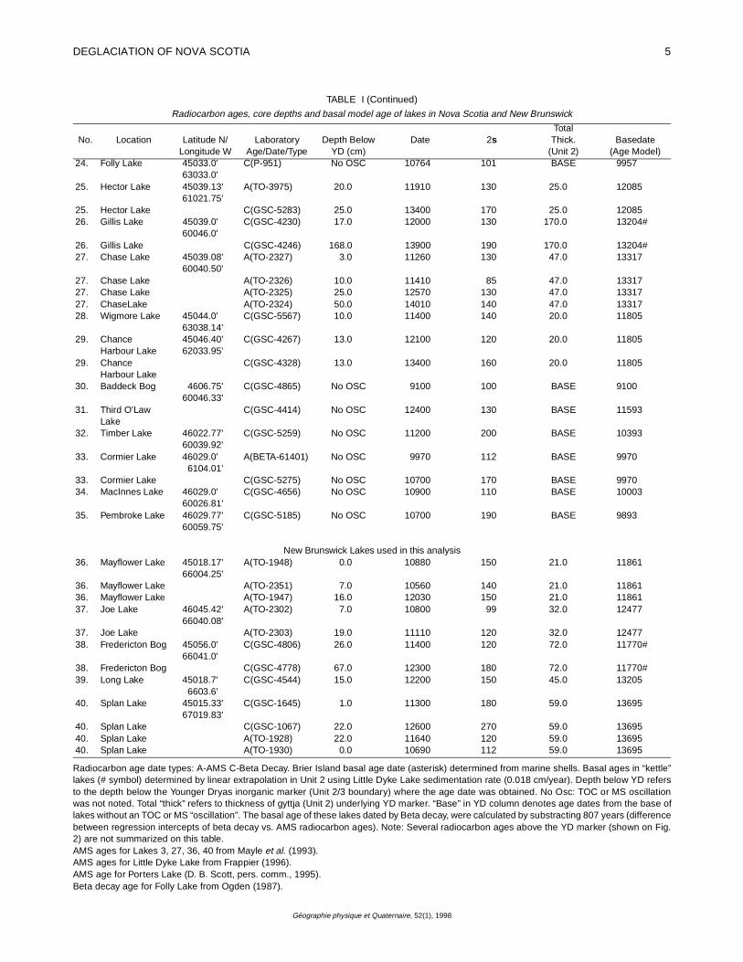
For the past 30 years Nova Scotia and New Brunswicklakes have been cored and studied by R. J. Mott with the pur-pose of defining the late-glacial paleoenvironments and doc-umenting glacier fluctuations during this period. The focus ofthat research was to establish the vegetation history of thelate-glacial to the present, and from that deduce the climatehistory (e.g. Mott, 1975; Jetté and Mott, 1989; Mott, 1991). Inmost studies of cored lake basins pollen and macrofossilstratigraphy are emphasized (e.g. Mott, 1991; Mayle et al.,1993; Marcoux and Richard, 1994). In this report we concen-trate on the late-glacial sedimentary record of lake cores andburied organic deposits (Stea and Mott, 1989; Mott and Stea,1994). The purposes of this report are threefold:
1 . Document the stratigraphy, and chronology of the lakesediments and late-glacial buried peat sections, specifical-ly the period of deglaciation between 14 and 10 ka.2. Develop an age-depth regression model based on
50 AMS (Accelerator Mass Spectrometry) and beta decayradiocarbon ages from basal lake sediments, in order toextrapolate the age of deglaciation (cf. Ogden, 1987) andthe onset of the Younger Dryas interval (cf. Mayle et al.,1993).3. Produce a comprehensive paleogeographical recon-struction of the deglaciation of Maritime Canada after15 ka, based on this new data.This paper presents a new chronology of deglaciation of
Maritime Canada based on AMS dating of plant macrofossilsfrom lake sediment cores in Nova Scotia and New Brunswickupdating previous work on lake basin dating and deglaciation(Stea and Mott, 1989; Mayle et al., 1993; Mott and Stea,1994; Mott, 1994). Forty lake basins are examined, 35 fromNova Scotia and 5 from New Brunswick (Fig. 1). A deglacia-tion chronology has already been established using betadecay radiocarbon ages from buried peats and organic lakesediments (Stea and Mott, 1989). . The validity of a chronol-
FIGURE 1. Location map of buried peat and lake sites in Nova Scotia classified according to mineral sediment (MS) or total organic carbon(TOC) "oscillations". Lake basins are numbered according to Table I. Some unlabelled lake basins were classified from stratigraphicinformation in Ogden (1987). Large numbered lakes are in the stratigraphic transect of Figure 2. The Cape Breton Highlands attain elevationsof 500 m. The highest point on mainland Nova Scotia (Cobequid Highlands) is 300 m.
Localisation de la tourbe enfouie et des sites lacustres en Nouvelle-Écosse classés selon les « oscillations » de sédiment minéral (MS) ou decarbone organique (TOC). La numéroration des bassins lacustres suit celle du tableau I. Les bassins lacustres sans désignation sont classésselon les données stratigraphiques de Ogden (1987). Les grands chiffres identifient les lacs dont la stratigraphie apparaît en figure 2. Leshautes terres du Cap Breton atteignent 500 m d'altitude. Les hautes terres de Cobequid sont la partie la plus élevée de la Nouvelle-Écossecontinentale (330 m).

DEGLACIATION OF NOVA SCOTIA 3
Géographie physique et Quaternaire, 52(1), 1998
ogy based on organic lake sediments has been questioned(Sutherland, 1980; Walker and Lowe, 1990) because of the"hard water effect" and redeposition of older organic materi-als. In this study, we utilized 24 AMS radiocarbon ages frombelow a distinctive Younger Dryas marker horizon to establishan age for initiation of sedimentation in a lake basin or a "min-imum" age for deglaciation.
METHODS
Lake basins were selected for this study based on 1) Evi-dence from nearby stratigraphic sections buried by glacial orperiglacial sediments related to Younger Dryas ice cover(Stea and Mott, 1989; Mott and Stea, 1994; King, 1994), 2)Geomorphological evidence of former ice margins, 3) Uni-form geographic distribution.
Lake basins were surveyed, prior to coring, using an echo-sounder and the deepest part of the lake basin was chosenfor coring. The basal sediments were cored using a modifiedwire-line Livingstone corer (Wright et. al., 1965). Total organic
carbon (TOC) was assessed by LECO carbon analysis, tak-ing the difference between total carbon and carbon afterdigestion in 10 % HCL and drying. Beta decay radiocarbonages were mostly determined by the radiocarbon laboratoryof the Geological Survey of Canada (Table I). Lake sedimentsamples were pre-treated with hot acid and base washes andrinsed with distilled water. Wood samples were dated usingAccelerator Mass Spectrometer (AMS) dating techniquesfrom BETA Analytic (Florida) and Isotrace laboratories (Tor-onto). Ages provided through the radiocarbon dating labora-tory of the Geological Survey of Canada were corrected for δ13C = -25.0 % PDB. For more detail on the radiocarbon meth-odologies as well as lake and buried peat site descriptionsand palynology, see McNeely and Atkinson (1996).
RESULTS
LAKE BASIN MORPHOLOGY AND STRATIGRAPHY
Four major lithostratigraphic "units" can be discerned fromlake cores in Nova Scotia (Fig. 2). In Figure 2, these units are
FIGURE 2. Stratigraphic correlation diagram and chronology of the basal 2 m of selected lake basins across Nova Scotia. The total corepenetration is shown in centimetres at the bottom of the sections. The vertical scale is in centimetres above the core base. The core grain sizevariations are represented by median clay on the far left to median gravel on the far right. Beta decay dated intervals are shown as a solid block.AMS dated intervals are shown as open blocks. Units 1-3 can be defined either by oscillation in total organic carbon values (TOC) or a mineralsediment (MS-Unit 3) sandwiched between gyttja units (Units 2/4).Diagramme de corrélation stratigraphique et chronologie des deux premiers mètres de certains bassins lacustres choisis à travers la Nouvelle-Écosse. La profondeur du forage apparaît à la base des coupes. L'échelle verticale au-dessus de la base de la carotte est en centimètres. Lagranulométrie varie des argiles moyennes à l'extrême gauche au gravier moyen à l'extrême droite. Les unités 1 à 3 sont définies par uneoscillation soit des valeurs de carbone organique total (TOC), soit du sédiment minéral (unité 3 ) contenu entre deux unités de gyttja (unités 2et 4).

4 R.R. STEA and R. J. MOTT
Géographie physique et Quaternaire, 52(1), 1998
TABLE I
Radiocarbon ages, core depths and basal model age of lakes in Nova Scotia and New Brunswick
No. Location Latitude N/Longitude W
LaboratoryAge/Date/Type
Depth BelowYD (cm)
Date 2sTotal
Thick.(Unit 2)
Basedate(Age Model)
1. Bower Lake 4405.24'65046.56'
C(GSC-5023) 8.0 10700 170 28.0 12253
1. Bower Lake C(GSC-5024) 23.0 12400 220 28.0 122532. Brier Island Bog 44012.84'
66022.03'C(GSC-4556) 5.0 11100 120 75.0 13200*
2. Brier Island Bog C(GSC-4443) 65.0 13100 190 75.0 13200*2. Brier Island Bog C(GSC-4431) 75.0 13200 130 75.0 13200*3. Lac a Magie 44015.83'
66004.66'A(TO-1431) 27.0 12140 130 33.0 12533
4. Church Point 44019.23'66008.38'
C(GSC-4476) 3.0 12300 130 40.0 12925
4. Church Point C(GSC-4440) 38.0 14300 150 40.0 129255. Pat Kempton
Lake44026.08'66010.15'
C(GSC-5031) No OSC 11900 190 BASE 11610
5. Pat KemptonLake
A(TO-3972) No OSC 11610 130 BASE 11610
6. Sandy CoveLake
44028.97'66005.20'
A(TO-3343) 96.0 12320 130 105.0 12820#
6. Sandy CoveLake
C(GSC-4460) 96.0 13300 130 105.0 12820#
7. Canoran Lake 44035.00'64033.0'
C(GSC-4462) 0.0 11200 150 25.0 12085
8. Porters Lake 44048.22'63022.75'
C(GX-17565) 4.0 11700 450 21.0 11861
8. Porters Lake A(BETA-53125) 32.0 11750 120 21.0 118619. Youngs Lake 44049.14'
65026.44'C(GSC-5048) No OSC 12500 220 BASE 11693
10. Pye Lake 44058.50'62005.45'
C(GSC-5242) 1.0 10800 190 16.0 11581
10. Pye Lake C(GSC-5543) 18.0 12200 200 16.0 1158111. Tupper Lake 4501.0'
64035.3'C(GSC-5049) No OSC 12800 200 BASE 11993
12. Silver Lake 4506.81'64035.67'
A(BETA-16400) 10.0 11350 85 14.0 11469
12. Silver Lake C(GSC-5053) 0.0 12600 280 14.0 1146913. Piper Lake 45020.83'
62039.63'A(TO-3973) 0.0 10890 113 15.0 11525
13. Piper Lake C(GSC-5252) 13.0 12300 200 15.0 1152514. Brookfield 45014.42'
63020.63'A(TO-3970) No OSC 10870 112 BASE 10870
15. CummingerLake
45016.11'6202.63'
C(GSC-5250) No OSC - 28.0 12253
16. Roger Lake 45021.23'61040.60'
A(BETA-62944) 2.0 10940 112 19.0 11749
17. Little Dyke Lake 45023.08'63033.63'
A(TO-3576) 23.0 10930 130 52.5 12400#
17. Little Dyke Lake A(BETA-54888) 35.0 11560 130 52.5 12400#18. Leak Lake 45026.0'
64020.0'A(TO-3971) 48.0 12260 130 65.0 13204#
18. Leak Lake C(GSC-2728 48.0 12900 160 65.0 13204#19. Manassette
Lake45026.96'61020.63
C(GSC-4964) No OSC 9910 110 BASE 9910
20. Gilbert Lake 45028.0'64021.0'
A(TO-807) 0.0 11360 112 BASE 11360
21. Welton Lake 45029.0'64029.0'
C(GSC-4474) No OSC 9720 110 BASE 9720
22. Indian Lake 45030.83'62011.90'
A(BETA-62945) 11.0 11020 112 24.0 12135
22. Indian Lake C(GSC-5943) 2.0 11500 170 24.0 1213523. Sutherland
Lake45031.11'63040.70'
C(GSC-5571) No OSC 10100 110 BASE 9293
DEGLACIATION OF NOVA SCOTIA 5
Géographie physique et Quaternaire, 52(1), 1998
No. Location Latitude N/Longitude W
LaboratoryAge/Date/Type
Depth BelowYD (cm)
Date 2sTotal
Thick.(Unit 2)
Basedate(Age Model)
24. Folly Lake 45033.0'63033.0'
C(P-951) No OSC 10764 101 BASE 9957
25. Hector Lake 45039.13'61021.75'
A(TO-3975) 20.0 11910 130 25.0 12085
25. Hector Lake C(GSC-5283) 25.0 13400 170 25.0 1208526. Gillis Lake 45039.0'
60046.0'C(GSC-4230) 17.0 12000 130 170.0 13204#
26. Gillis Lake C(GSC-4246) 168.0 13900 190 170.0 13204#27. Chase Lake 45039.08'
60040.50'A(TO-2327) 3.0 11260 130 47.0 13317
27. Chase Lake A(TO-2326) 10.0 11410 85 47.0 1331727. Chase Lake A(TO-2325) 25.0 12570 130 47.0 1331727. ChaseLake A(TO-2324) 50.0 14010 140 47.0 1331728. Wigmore Lake 45044.0'
63038.14'C(GSC-5567) 10.0 11400 140 20.0 11805
29. ChanceHarbour Lake
45046.40'62033.95'
C(GSC-4267) 13.0 12100 120 20.0 11805
29. ChanceHarbour Lake
C(GSC-4328) 13.0 13400 160 20.0 11805
30. Baddeck Bog 4606.75'60046.33'
C(GSC-4865) No OSC 9100 100 BASE 9100
31. Third O’LawLake
C(GSC-4414) No OSC 12400 130 BASE 11593
32. Timber Lake 46022.77'60039.92'
C(GSC-5259) No OSC 11200 200 BASE 10393
33. Cormier Lake 46029.0'6104.01'
A(BETA-61401) No OSC 9970 112 BASE 9970
33. Cormier Lake C(GSC-5275) No OSC 10700 170 BASE 997034. MacInnes Lake 46029.0'
60026.81'C(GSC-4656) No OSC 10900 110 BASE 10003
35. Pembroke Lake 46029.77'60059.75'
C(GSC-5185) No OSC 10700 190 BASE 9893
New Brunswick Lakes used in this analysis36. Mayflower Lake 45018.17'
66004.25'A(TO-1948) 0.0 10880 150 21.0 11861
36. Mayflower Lake A(TO-2351) 7.0 10560 140 21.0 1186136. Mayflower Lake A(TO-1947) 16.0 12030 150 21.0 1186137. Joe Lake 46045.42'
66040.08'A(TO-2302) 7.0 10800 99 32.0 12477
37. Joe Lake A(TO-2303) 19.0 11110 120 32.0 1247738. Fredericton Bog 45056.0'
66041.0'C(GSC-4806) 26.0 11400 120 72.0 11770#
38. Fredericton Bog C(GSC-4778) 67.0 12300 180 72.0 11770#39. Long Lake 45018.7'
6603.6'C(GSC-4544) 15.0 12200 150 45.0 13205
40. Splan Lake 45015.33'67019.83'
C(GSC-1645) 1.0 11300 180 59.0 13695
40. Splan Lake C(GSC-1067) 22.0 12600 270 59.0 1369540. Splan Lake A(TO-1928) 22.0 11640 120 59.0 1369540. Splan Lake A(TO-1930) 0.0 10690 112 59.0 13695
Radiocarbon age date types: A-AMS C-Beta Decay. Brier Island basal age date (asterisk) determined from marine shells. Basal ages in “kettle”lakes (# symbol) determined by linear extrapolation in Unit 2 using Little Dyke Lake sedimentation rate (0.018 cm/year). Depth below YD refersto the depth below the Younger Dryas inorganic marker (Unit 2/3 boundary) where the age date was obtained. No Osc: TOC or MS oscillationwas not noted. Total “thick” refers to thickness of gyttja (Unit 2) underlying YD marker. “Base” in YD column denotes age dates from the base oflakes without an TOC or MS “oscillation”. The basal age of these lakes dated by Beta decay, were calculated by substracting 807 years (differencebetween regression intercepts of beta decay vs. AMS radiocarbon ages). Note: Several radiocarbon ages above the YD marker (shown on Fig.2) are not summarized on this table.AMS ages for Lakes 3, 27, 36, 40 from Mayle et al. (1993).AMS ages for Little Dyke Lake from Frappier (1996).AMS age for Porters Lake (D. B. Scott, pers. comm., 1995).Beta decay age for Folly Lake from Ogden (1987).
TABLE I (Continued)
Radiocarbon ages, core depths and basal model age of lakes in Nova Scotia and New Brunswick

6 R.R. STEA and R. J. MOTT
Géographie physique et Quaternaire, 52(1), 1998
correlated from southern to northern Nova Scotia in selectedlake cores. The base of most lake sediment cores feature adistinctive, visible, sedimentological change or marked fluctu-ation in organic carbon percentages (Mott, 1975; Mott et al.,1986; Mayle et al., 1993). The basal unit (Unit 1) representsthe maximum depth of core penetration, usually into clasticsediment, and consists of several lithofacies including coarseand fine-grained mineral sediment. The coarse-grained litho-facies is either sand or gravelly-sand (Fig. 2). The fine-grained lithofacies is generally a laminated clayey-mud, oftenreddish in hue, with massive mud layers interbedded with thin(.1-1 cm) laminae of silt and sand (Fig. 2). Unit 1 often gradesinto, or is sharply overlain, by brown or black gyttja, a mixtureof inorganic sediment and organic (algal) components (Unit2). Unit 3 is either a silty gyttja or a mineral sediment whichmarks the onset of the Younger Dryas (Mott, 1975). In south-ern Nova Scotia lakes, the onset of the Younger Dryas inter-val is associated with a marked decrease in TOC values (Fig.3). In northern Nova Scotia lakes, Unit 3 consists of either amassive mud or a mud with silty interbeds. It can also containbeds or lenses of fine sand (Unit 3- Fig. 2). Unit 3 is overlainby gyttja, (Unit 4) which continues uninterrupted by visiblemineral sediment to the top of the core.
High-resolution sampling of Maritime Canada lake coreshas revealed organic carbon fluctuations within Unit 2,termed the Killarney Oscillation (Levesque et al., 1993).Sampling frequency in this study was insufficient to resolvehigher frequency "events" within Unit 2.
Significant latitudinal and elevational variations are appar-ent in the stratigraphic style of the basal part of the lake sed-iment cores. Lakes in Nova Scotia can be classified on thebasis of presence or absence of a mineral sediment (MS) orTOC "oscillation" between mineral-rich Units 1 and 3 andorganic-rich Units 2 and 4 (Stea et al., 1992; Figs. 1, 2, 3).The basal oscillation is present in most lowland lake cores,but absent in many lakes in highland regions of northernNova Scotia (Fig. 1).
The south to north lake basin stratigraphic transect anddata from the rest of the lakes studied (Figs. 1, 2; Table I)reveal regional stratigraphic variations including:
1 . A south to north decrease in the thickness and organiccontent of the pre-Younger Dryas gyttja sequence (Unit 2).
2. A concomitant south to north increase in the thicknessand mineral content of the Younger Dryas marker horizon(Unit 3). This unit either increases in thickness such that innorthern Nova Scotia it is too thick to be penetrated byconventional coring devices, or is absent due to non-dep-osition.
MINIMUM DEGLACIATION AGE OF LAKE BASINS
Fifty beta decay and AMS radiocarbon ages wereobtained from Unit 2 beneath the Younger Dryas markerhorizon (Unit 3; Table I; Fig. 1). Beta decay gyttja ages wereobtained from the lowest organic interval exceeding 10%organic content. AMS ages were obtained wherever a twig orplant fragment was available from various depth intervalsabove the inorganic base of the lake sediment core. To
obtain valid "minimum" ages for deglaciation the age datamust be extrapolated to the base of Unit 2 using sedimenta-tion rates. The consistency of sedimentation rates betweenlake basins has to be assessed before age estimates can bemade..
Sedimentation rates are affected by lake basin morphol-ogy. A histogram of Unit 2 (gyttja) thicknesses beneath theYounger Dryas "marker" horizon demonstrates this effect.
FIGURE 3. Plot of total organic carbon (TOC) values versus depthand visual stratigraphy for two lake cores in southern and northernmainland Nova Scotia. The Younger Dryas interval is discernable bya noticeable drop in TOC values in many lakes in southern NovaScotia, whereas, a distinct inorganic (mineral sediment: MS) intervalis present in some northern Nova Scotia lakes. The oscillationcharacterized by a drop in TOC values is known as a TOC oscillation,the mineral sediment layer as "MS" oscillation.
Courbes des valeurs de carbone organique total (TOC) sur laprofondeur et stratigraphie de deux carottes lacustres en Nouvelle-Écosse continentale septentrionale et méridionale. L'intervalle duDryas récent se réflète par une baisse des valeurs de carbone dansde nombreux lacs du sud de la Nouvelle-Écosse, tandis qu'unintervalle inorganique (sédiment minéral) apparaît dans quelqueslacs du nord. L'oscillation caractérisée par une baisse des valeurs decarbone est appelée « TOC oscillation » et la couche de sédimentminéral est appelée « MS oscillation ».

DEGLACIATION OF NOVA SCOTIA 7
Géographie physique et Quaternaire, 52(1), 1998
Two discrete populations (Table I; Fig. 4) are present reflect-ing variations in the thickness of Unit 2 (the basal organicsequence) associated with lake basin shape and topo-graphic setting. Most lakes represented by the 10-80cmthickness interval are in muted topographic settings, withgently-sloping margins and shallow basins that discouragesediment influx. These lake basins are defined as glaciatedbasins. Lakes where Unit 2 is >80 cm thick generally lack adistinct break between Units 1 and 2 and contain a thicksequence of slightly organic (1-3% TOC) sediment, dilutedwith mineral sediment or carbonates. Examples are SandyCove Lake, Little Dyke Lake, Leak Lake, and Gillis Lake(sites 6, 18, 20, 26; Fig. 1), which with the exception of GillisLake are steep sided, kettle lakes, surrounded by outwash orice contact stratified drift (Fig. 5). It is therefore assumed thatorganic sedimentation rates are similar within these broadlake classifications, and Unit 2 thickness is an indication ofduration of deposition.
DEGLACIATION AGE MODEL
Ogden (1987) used a core depth-age regression tech-nique to determine the age of first accumulation of organiclake sediments in Nova Scotia and hence a "minimum" ageof deglaciation. He used beta decay basal radiocarbon ageson gyttja from lakes throughout Nova Scotia and accommo-dated varying core depths by normalizing core depth to per-centages. Using this regression method, and assumingregional synchroneity of ice retreat, he obtained a generalage for deglaciation of 12 ka. Age variation resulting fromvarying sedimentation rates, and dating error were mitigatedby this regression technique, but ice retreat rates could notbe established. In our study, absolute (not relative) coredepth or gyttja thickness is used. Regional variation in timingof deglaciation can be established using varying gyttja thick-nesses, assuming that gyttja thickness is related to timeelapsed since ice removal, sedimentation rates betweencores are similar, and that the Younger Dryas marker isroughly synchronous throughout the region.
Figure 6 shows the results of the linear regression analy-sis using both beta decay and AMS ages against gyttja thick-ness or core depth below the Younger Dryas marker horizon(Unit 3). The deglaciation age model for AMS ages devel-oped by this analysis is (Fig. 6):
1. Age= 10685+(D X 55.99)
D = Depth below Younger Dryas boundary (Units 2/3)
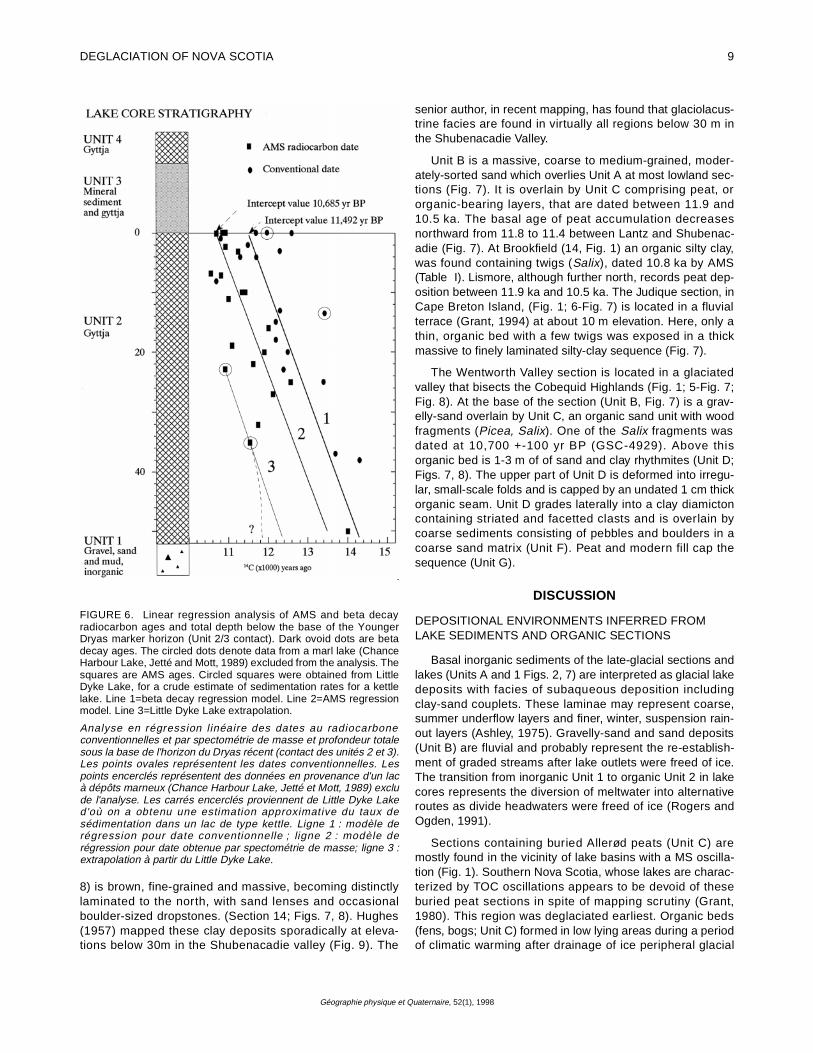
There are strong linear correlatons between sampledepth below the Younger Dryas boundary (base of Unit 3)and radiocarbon ages for both AMS analysis (R2=0.89,n=17, Line 2-Fig. 6) and beta decay ages (R2 =0.75, n=17;Line 1-Fig. 6). The YD marker horizon intercept value of10,656 yr BP is well within uncertainty limits of the YD incep-tion times of 10.8 ka quoted by Mott and Stea (1994) basedon radiocarbon ages on 26 buried wood and peat sites. Theintercept value of 11,492 yr BP is 806 radiocarbon yearsolder than the AMS intercept. The two regression lines (1,2Fig. 6) are nearly parallel, indicating a consistent error that isnot solely related to decreasing core depth and organic car-bon content. This depth-independent result indicates that"hard water" effects are prevalent, related perhaps togroundwater flux through the substrate (Fritz, 1983) ratherthan early deglacial meltwater effects (Sutherland, 1980).The sedimentation rate for glaciated basins using the linearregression model is 0.014 cm/yr.
Lakes without oscillations are not included in the agemodel (Table I). Unit 4 (Fig. 2) in these lakes has higherorganic content and can be sampled quite close to the actualbase of the core. Minimum deglaciation ages were estimatedfrom these basal ages, because sedimentation rates for Unit4 are not available. Eight hundred and six years (the system-atic age discrepancy between pre-YD gyttja beta decay andAMS radiocarbon ages-Fig. 6) were subtracted from betadecay radiocarbon ages older than 10,000 years to obtainthe basal age (Table I).
FIGURE 4. Histogram of total gyttja thickness in Unit 2 beneath theYounger Dryas marker horizon (Unit 3). Two lake types can bedifferentiated based on sedimentation rates: glaciated basins withUnit 2 gyttja thicknesses less than 80 cm and "Kettle" lakes with late-glacial gyttja thicknesses > 80 cm.
Histogramme de la profondeur totale de gyttja dans l'unité 2, sous lalimite de l'horizon du Dryas récent (unité 3). On distingue deux typesde lacs fondés sur le taux de sédimentation : les bassins englacésavec des profondeurs de gyttja (unité 2) de moins de 80 cm et leslacs de type kettle avec des profondeurs de gyttja tardiglaciairesupérieures à 80 cm.
8 R.R. STEA and R. J. MOTT
Géographie physique et Quaternaire, 52(1), 1998
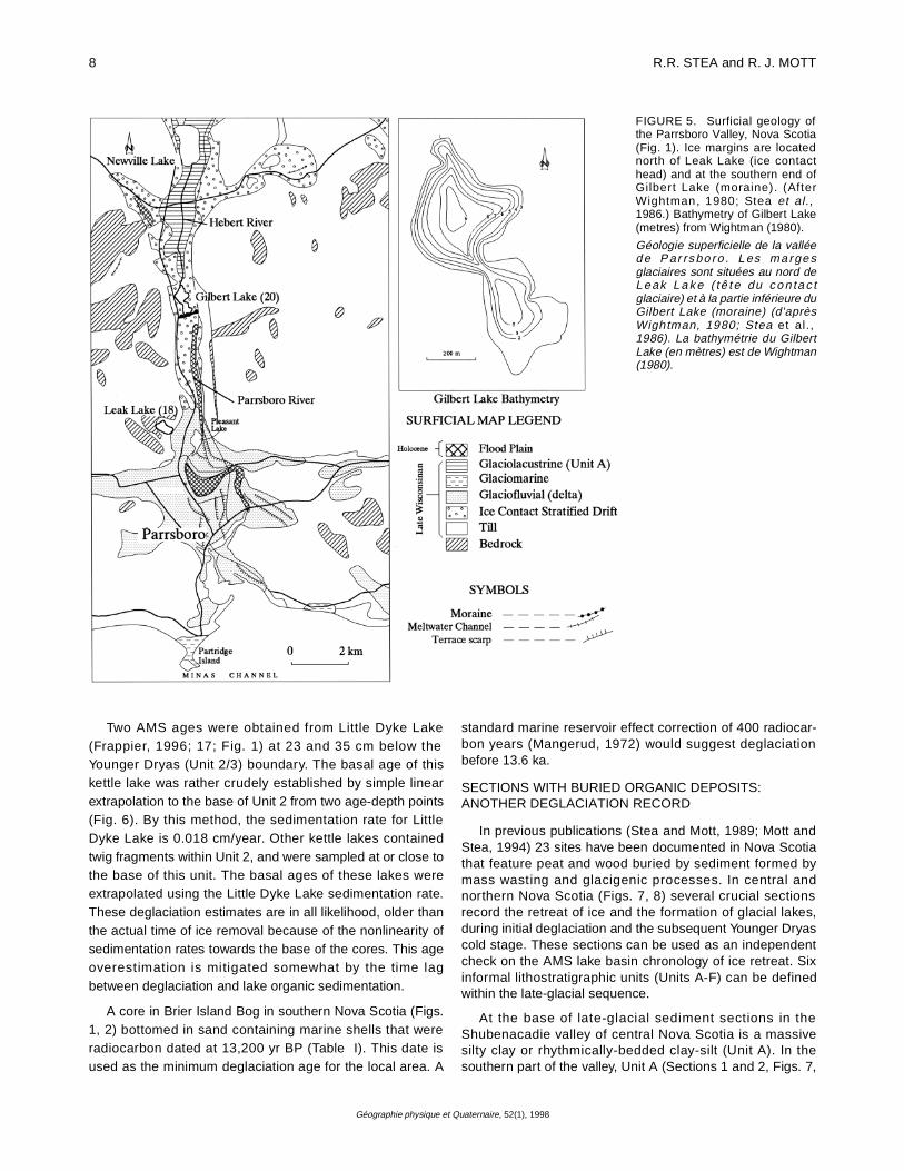
Two AMS ages were obtained from Little Dyke Lake(Frappier, 1996; 17; Fig. 1) at 23 and 35 cm below theYounger Dryas (Unit 2/3) boundary. The basal age of thiskettle lake was rather crudely established by simple linearextrapolation to the base of Unit 2 from two age-depth points(Fig. 6). By this method, the sedimentation rate for LittleDyke Lake is 0.018 cm/year. Other kettle lakes containedtwig fragments within Unit 2, and were sampled at or close tothe base of this unit. The basal ages of these lakes wereextrapolated using the Little Dyke Lake sedimentation rate.These deglaciation estimates are in all likelihood, older thanthe actual time of ice removal because of the nonlinearity ofsedimentation rates towards the base of the cores. This ageoverestimation is mitigated somewhat by the time lagbetween deglaciation and lake organic sedimentation.
A core in Brier Island Bog in southern Nova Scotia (Figs.1, 2) bottomed in sand containing marine shells that wereradiocarbon dated at 13,200 yr BP (Table I). This date isused as the minimum deglaciation age for the local area. A
standard marine reservoir effect correction of 400 radiocar-bon years (Mangerud, 1972) would suggest deglaciationbefore 13.6 ka.
SECTIONS WITH BURIED ORGANIC DEPOSITS:ANOTHER DEGLACIATION RECORD
In previous publications (Stea and Mott, 1989; Mott andStea, 1994) 23 sites have been documented in Nova Scotiathat feature peat and wood buried by sediment formed bymass wasting and glacigenic processes. In central andnorthern Nova Scotia (Figs. 7, 8) several crucial sectionsrecord the retreat of ice and the formation of glacial lakes,during initial deglaciation and the subsequent Younger Dryascold stage. These sections can be used as an independentcheck on the AMS lake basin chronology of ice retreat. Sixinformal lithostratigraphic units (Units A-F) can be definedwithin the late-glacial sequence.
At the base of late-glacial sediment sections in theShubenacadie valley of central Nova Scotia is a massivesilty clay or rhythmically-bedded clay-silt (Unit A). In thesouthern part of the valley, Unit A (Sections 1 and 2, Figs. 7,
FIGURE 5. Surficial geology ofthe Parrsboro Valley, Nova Scotia(Fig. 1). Ice margins are locatednorth of Leak Lake (ice contacthead) and at the southern end ofGilbert Lake (moraine). (AfterWightman, 1980; Stea et al.,1986.) Bathymetry of Gilbert Lake(metres) from Wightman (1980).
Géologie superficielle de la valléed e P ar rs bo ro . L es m a rge sglaciaires sont situées au nord deL e ak L a k e ( tê t e du c o n ta c tglaciaire) et à la partie inférieure duGilbert Lake (moraine) (d'aprèsWightman, 1980; Stea et al.,1986). La bathymétrie du GilbertLake (en mètres) est de Wightman(1980).
DEGLACIATION OF NOVA SCOTIA 9
Géographie physique et Quaternaire, 52(1), 1998
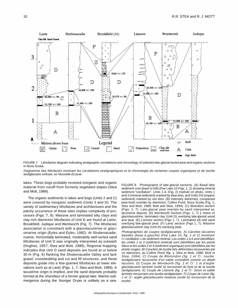
8) is brown, fine-grained and massive, becoming distinctlylaminated to the north, with sand lenses and occasionalboulder-sized dropstones. (Section 14; Figs. 7, 8). Hughes(1957) mapped these clay deposits sporadically at eleva-tions below 30m in the Shubenacadie valley (Fig. 9). The
senior author, in recent mapping, has found that glaciolacus-trine facies are found in virtually all regions below 30 m inthe Shubenacadie Valley.
Unit B is a massive, coarse to medium-grained, moder-ately-sorted sand which overlies Unit A at most lowland sec-tions (Fig. 7). It is overlain by Unit C comprising peat, ororganic-bearing layers, that are dated between 11.9 and10.5 ka. The basal age of peat accumulation decreasesnorthward from 11.8 to 11.4 between Lantz and Shubenac-adie (Fig. 7). At Brookfield (14, Fig. 1) an organic silty clay,was found containing twigs (Salix), dated 10.8 ka by AMS(Table I). Lismore, although further north, records peat dep-osition between 11.9 ka and 10.5 ka. The Judique section, inCape Breton Island, (Fig. 1; 6-Fig. 7) is located in a fluvialterrace (Grant, 1994) at about 10 m elevation. Here, only athin, organic bed with a few twigs was exposed in a thickmassive to finely laminated silty-clay sequence (Fig. 7).
The Wentworth Valley section is located in a glaciatedvalley that bisects the Cobequid Highlands (Fig. 1; 5-Fig. 7;Fig. 8). At the base of the section (Unit B, Fig. 7) is a grav-elly-sand overlain by Unit C, an organic sand unit with woodfragments (Picea, Salix). One of the Salix fragments wasdated at 10,700 +-100 yr BP (GSC-4929). Above thisorganic bed is 1-3 m of of sand and clay rhythmites (Unit D;Figs. 7, 8). The upper part of Unit D is deformed into irregu-lar, small-scale folds and is capped by an undated 1 cm thickorganic seam. Unit D grades laterally into a clay diamictoncontaining striated and facetted clasts and is overlain bycoarse sediments consisting of pebbles and boulders in acoarse sand matrix (Unit F). Peat and modern fill cap thesequence (Unit G).
DISCUSSION
DEPOSITIONAL ENVIRONMENTS INFERRED FROMLAKE SEDIMENTS AND ORGANIC SECTIONS
Basal inorganic sediments of the late-glacial sections andlakes (Units A and 1 Figs. 2, 7) are interpreted as glacial lakedeposits with facies of subaqueous deposition includingclay-sand couplets. These laminae may represent coarse,summer underflow layers and finer, winter, suspension rain-out layers (Ashley, 1975). Gravelly-sand and sand deposits(Unit B) are fluvial and probably represent the re-establish-ment of graded streams after lake outlets were freed of ice.The transition from inorganic Unit 1 to organic Unit 2 in lakecores represents the diversion of meltwater into alternativeroutes as divide headwaters were freed of ice (Rogers andOgden, 1991).
Sections containing buried Allerød peats (Unit C) aremostly found in the vicinity of lake basins with a MS oscilla-tion (Fig. 1). Southern Nova Scotia, whose lakes are charac-terized by TOC oscillations appears to be devoid of theseburied peat sections in spite of mapping scrutiny (Grant,1980). This region was deglaciated earliest. Organic beds(fens, bogs; Unit C) formed in low lying areas during a periodof climatic warming after drainage of ice peripheral glacial
FIGURE 6. Linear regression analysis of AMS and beta decayradiocarbon ages and total depth below the base of the YoungerDryas marker horizon (Unit 2/3 contact). Dark ovoid dots are betadecay ages. The circled dots denote data from a marl lake (ChanceHarbour Lake, Jetté and Mott, 1989) excluded from the analysis. Thesquares are AMS ages. Circled squares were obtained from LittleDyke Lake, for a crude estimate of sedimentation rates for a kettlelake. Line 1=beta decay regression model. Line 2=AMS regressionmodel. Line 3=Little Dyke Lake extrapolation.
Analyse en régression linéaire des dates au radiocarboneconventionnelles et par spectométrie de masse et profondeur totalesous la base de l'horizon du Dryas récent (contact des unités 2 et 3).Les points ovales représentent les dates conventionnelles. Lespoints encerclés représentent des données en provenance d'un lacà dépôts marneux (Chance Harbour Lake, Jetté et Mott, 1989) exclude l'analyse. Les carrés encerclés proviennent de Little Dyke Laked'où on a obtenu une estimation approximative du taux desédimentation dans un lac de type kettle. Ligne 1 : modèle derégression pour date conventionnelle ; ligne 2 : modèle derégression pour date obtenue par spectométrie de masse; ligne 3 :extrapolation à partir du Little Dyke Lake.
10 R.R. STEA and R. J. MOTT
Géographie physique et Quaternaire, 52(1), 1998
lakes. These bogs probably received inorganic and organicmaterial from runoff from formerly vegetated slopes (Steaand Mott, 1989).
The organic sediments in lakes and bogs (Units 2 and C)were covered by inorganic sediment (Units 3 and D). Thevariety of sedimentary lithofacies and architectures and thepatchy occurrence of these sites implies complexity of pro-cesses (Figs. 7, 8). Massive and laminated silty clays andclay-rich diamicton lithofacies of Unit D are found at Lantz,Brookfield, Judique and Wentworth (Fig. 7). The lithofaciesassociation is consistent with a glaciolacustrine or glaci-omarine origin (Eyles and Eyles, 1992). At Shubenacadie,coarse, horizontally-laminated, moderately well-sorted sandlithofacies of Unit D was originally interpreted as outwash(Hughes, 1957; Stea and Mott, 1989). Regional mappingindicates that Unit D sand deposits are found at or below30 m (Fig. 9) flanking the Shubenacadie Valley and lackgravel, crossbedding and cut and fill structures, and thesedeposits grade into a fine-grained lithofacies at lower ele-vations such as at Lantz (Figs. 1, 7; Stea and Mott, 1989). Alacustrine origin is implied, and the sand deposits probablyformed at the shoreface of a former glacial lake. Marine sub-mergence during the Younger Dryas is unlikely as a sea-
FIGURE 8. Photographs of late-glacial sections. (A) Basal lakesediment core (base to left) (Pye Lake 10-Figs. 1, 2) showing mineralsediment "oscillation". Units 1-4, (Fig. 2) marked on photo, Units 1and 3 (mineral sediment) marked by blue dots, and Units 2/4 (organicsediment) marked by red dots. (B) Intensely deformed, compactedpeat beds overlain by diamicton, Collins Pond, Nova Scotia (Fig. 1;Stea and Mott, 1989; Mott and Stea, 1994). (C) Blomidon section(Figs. 1, 7). Late-glacial peat overlain by sand interpreted aslacustrine deposit. (D) Wentworth Section (Figs. 1, 7) 1 metre ofglaciolacustrine, laminated clay (Unit D) overlying late-glacial woodand peat. (E) Lismore section (Figs 1. 7). Laminated silt and sandoverlying late-glacial peat. (F) Lantz section (Figs 1, 7). Massiveglaciolacustrine clay (Unit D) overlying peat.
Photographies de coupes tardiglaciaires. A) Carottes lacustresbasales (base à gauche) (Pye Lake 10, fig. 1 et 2) montrantl'« oscillation » du sédiment minéral. Les unités 1 à 4 sont identifiées,les unités 1 et 3 (sédiment minéral) sont identifiées par les pointsbleus et les unités 2 et 4 (sédiment organique) sont identifiées par lespoints rouges. B) Couches de tourbe très déformées recouvertes parun diamicton, au Collins Pond (fig. 1; Stea et Mott, 1989; Mott etStea, 1994). C) Coupe de Blomindon (fig. 1 et 7) : tourbetardiglaciaire recouverte d'un sable considéré comme un dépôtlacustre. D) Coupe de Wentworth (fig. 1 et 7) : 1 m d'argileglaciolacustre laminée (unité d) recouvrant du bois et de la tourbetardiglaciaire. E) Coupe de Lismore (fig. 1 et 7) : limon et sablelaminés recouvrant une tourbe tardiglaciaire. F) Coupe de Lantz (fig.1 et 7) : argile glaciolacustre massive (unité D) recouvrant de latourbe.
FIGURE 7. Lithofacies diagram indicating stratigraphic correlations and chronology of selected late-glacial buried peat and organic sectionsin Nova Scotia.
Diagramme des lithofaciès montrant les corrélations stratigraphiques et la chronologie de certaines coupes organiques et de tourbetardiglaciaire enfouie, en Nouvelle-Écosse.

DEGLACIATION OF NOVA SCOTIA 11
Géographie physique et Quaternaire, 52(1), 1998

12 R.R. STEA and R. J. MOTT
Géographie physique et Quaternaire, 52(1), 1998
level lowstand (-60m below sea level) is documented in theGulf of Maine at around 10.5 ka (Belknap et al., 1987; Steaet al., 1987; Barnhardt et al., 1995).
How were these lakes impounded?. We propose that thebuildup of permanent snow and/or glacial ice created andenlarged already existing glacial lakes by damming regionaldrainage pathways. In southern Nova Scotia thin silty-sandand gravel lithofacies of Unit D may have been transportedby surface meltwater released from snowfields. Similardeposits in southwest England have been termed "Niveo-Fluvial" (Kerney et al., 1964). The Nictaux Falls site, foundon the north-facing slope of the Annapolis Valley is overlainby a till-like diamicton and thick mound of gravelly-sand, sug-
gesting a nearby source of ice (Nielsen, 1976; Mott andStea, 1994; Fig. 1). In northern Nova Scotia, snow accumu-lation was sufficient to form larger bodies of permanent snowor to reinvigorate glaciers. Bodies of aufeis may have formedand persisted in lowlands, fed by melting snow and ground-water seepage (Veillette and Thomas, 1979). Larger glaciallakes were created by ice blocking former outlets such as themouth of Shubenacadie River (Fig. 9). Fine-grained sedi-ments were deposited (Unit D) in these glacial lakes.
The development of a lake in the Wentworth Valley (Fig.9) is only possible if free drainage to the NorthumberlandStrait had been blocked by ice covering the lowlands north ofthe Wentworth Valley (Fig. 9). Clay lithofacies of Unit D out-
FIGURE 9. Late-glacial lakes incentral Nova Scotia (in black). (Digi-tal terrain model of Nova Scotiacourtesy of Tim Webster, College ofGeographic Sciences, Lawrence-town Nova Scotia). 1. Glacial LakeShubenacadie outlet, Lake William-Lake Charles system. Lake drainageto the Atlantic Ocean through HalifaxHarbour. Sill at 30 m elevation. 2.Location of Lantz site (Fig. 7). 3.Shubenacadie site (Fig. 7). 4. Brook-field site (Fig. 7). 5. Truro diamictonsite (Stea and Mott, 1989). Retreat-ing ice blocked the mouth of theShubenacadie River (east of 5), andformed Glacial Lake Shubenacadiebetween 12.5 and 11.7 ka. A lake ofcomparable size reformed afterYounger Dryas glaciers reoccupiedthe Minas Basin ca 10.8 ka. 6. TheBrookside site indicates an ice mar-ginal lake in the Salmon River Valleywest of Truro during the Younger Dr-yas (Mott and Stea, 1994). 7. TheW en t w or th v al le y s i t e i n t heCobequid Highlands (Fig. 7). 8.Parrsboro Valley (Fig. 5). 9. Blomi-don site (Figs. 7, 8.) Lake problemat-ic.
Lacs tardiglaciaires du centre de laNouvelle-Écosse (en noir) (modèlenumérique de la Nouvelle-Écossegrac ieuse ment o f fert par T imWebster du College of GeographicSciences, Lawrencetown, Nouvelle-Écosse). 1. Exutoire du Lac glaciaireShubenacadie, réseaux des lacsWilliam et Charles. Écoulement versl'Atlantique par le port de Halifax(s e u i l à 3 0 m d' a l t i t ud e ) . 2 .Localisation du site de Lantz (fig. 7).3. Site de Shubenacadie (fig. 7). 4)Site de Brookfield (fig. 7). 5) Site dudiamicton de Truro (Stea et Mott,1989). La glace en retrait a obstruél'embouchure de la ShubenacadieRiver (à l'est de 5) et a formé le Lacglaciaire Shubenacadie entre 12,5
et 11,7 ka. Un lac de taille semblable s'est reformé après que les glaces du Dryas récent ait occupé le bassin de Minas vers 10,8 ka. 6) Lesite de Brookside présente un lac de marge glaciaire, au cours du Dryas récent dans la vallée de la Salmon River à l'ouest de Truro (Mott etStea, 1994). 7) Le site de la vallée de Wentworth dans les hautes terres de Cobequid (fig. 7). 8) La vallée de Parrsboro (fig. 5). 9) Le site deBlomidon (fig. 7et 8.) : un lac problématique.
DEGLACIATION OF NOVA SCOTIA 13
Géographie physique et Quaternaire, 52(1), 1998
crop sporadically along the north flank of the Cobequid High-lands suggesting an extensive ice-dammed lake system,perhaps draining westward and northward out of the RiverHebert system into Chignecto Bay (Figs. 5, 9). The south-ernmost site in Nova Scotia (Hirtles Beach; Fig. 1) featuresan unconsolidated organic and clay-rich diamicton, probablya solifluction deposit, overlying peat in a hollow betweendrumlins (Miller, 1995). Mass wasting processes were preva-lent in the transitional areas between permanent snowfieldsto the north and seasonally frozen ground to the south.
Direct evidence for glacier activity during the YoungerDryas has been found in northern regions where till and gla-ciotectonically-deformed peat overlies Allerød peat (CollinsPond; Figs. 1, 8; Stea and Mott, 1989; Mott and Stea, 1994;Stea et al., 1996). Manassette Lake (Table I; 19; Fig. 7) isonly one kilometre from the Collins Pond site. This lake doesnot record an obvious mineral or TOC oscillation, except fora slightly organic seam in the lowermost clay (Unit 3; Fig. 2).The thick lacustrine clay deposit (Unit 3) likely formed justafter the rapid and short-lived Collins Pond advance whichproduced a till and deformed peat at Collins Pond (Figs.7, 8;Stea et al., 1996). Many lakes in the upland regions of north-ern Nova Scotia, and Prince Edward Island (Anderson,1985) do not record the basal MS or TOC oscillation, and arepresumed to have formed after the retreat of Younger Dryasice, ca. 10 ka.
LAKE SEDIMENTATION DURING THE YOUNGER DRYAS
Lake basins in northern Nova Scotia lowlands generallyrecord a significant MS oscillation (Fig. 1). Mott et al. (1986)proposed that the flux of inorganic sediment was a result ofmass wasting from the drainage basin during the YoungerDryas, as plant cover decreased. It was not clear, however,what would cause long term destabilization of plant cover.Levesque et al., (1994) and Cwynar and Levesque (1995)describe lakes in southwest New Brunswick and Maine,where gravel and coarse sand were deposited during theYounger Dryas interval, and invoked intense erosion, withoutelaborating on the process. The influx of inorganic sedimentinto the lake basin is likely a combination of destabilization ofplant cover, and sediment-laden meltwater, entraining andtransporting coarse clastic sediments into the lake basins.Persistent ice or permanent snow cover and seasonal melt-ing must be essential in the formation of this mineral sedi-ment layer; both to provide the water source and preventplant re-colonization. The similarity between inorganic lakesediments deposited around 13-12 ka (when ice was stillextant) and the Younger Dryas indicates that meltwater wasinvolved. Inorganic sedimentation cannot be solely explainedby cooling-related plant cover destabilization. Continuousgyttja accumulation has been recorded in Nova Scotia lakebasins which have experienced vegetation removal due toforest fires in the Holocene (Green, 1981). Suppression oforganic activity during the Younger Dryas due to coolingalone is unlikely, as gyttja is presently forming in high arcticlakes (Blake, 1981). The presence of a snow-bed pollentaxon (Empetrum) was noted in the mineral layer of lakes inNewfoundland (Wolfe and Butler, 1994). The marked
decrease in diatoms in a New Brunswick lake during theYounger Dryas (Rawlence, 1988) may be interpreted as aresponse to permanent ice cover, although a southern NovaScotia lake did not exhibit a similar response (Wilson et al.,1993).
In northern Nova Scotia lakes with MS oscillation recordYD sedimentation rates around 0.19 cm/year (Fig. 2), anorder of magnitude increase from Allerød rates of sedimen-tation (0.018 cm/year). Southern Nova Scotia lakes with aTOC oscillation (Bower Lake for example; Fig. 2) also recordhigher sedimentation rates during the Younger Dryas. Not-withstanding these data, Spooner (1997) noted a decreasein sedimentation rates in a southern Nova Scotia lake, andlittle variability in quartz grain size between Allerød andYounger Dryas sediments. He proposed that during theYounger Dryas organic sedimentation was merely sup-pressed, and no ice or snow was extant. The results of thisstudy and others, however, (Mayle et al., 1993; Wilson et al.,1993; Levesque et al., 1994; Mayle and Cwynar; 1995)clearly indicate sedimentation rate increases during theYounger Dryas interval. The discrepancy between thesestudies may be explained by proximity to residual ice andsnow, whereby significant sedimentation rate increases (andmineral sediment flux) were largely recorded in northernNova Scotia, Maine and New Brunswick (Fig. 1). The MSoscillation, rather than the TOC oscillation records the pres-ence of permanent snow within the drainage basin, and pos-sibly permanent ice cover over the lake itself. Stea et al.(1992) inferred the distribution of Younger Dryas ice basedon the distribution of lakes with and without an oscillation,without defining the exact nature of this basal oscillation.Subsequent coring of lakes in the Antigonish Highlands (22-Table I; Fig. 1) where Younger Dryas glacial ice was postu-lated (cf. Stea et al., 1992) has revealed a thick MS oscilla-tion. A complete lake stratigraphic record through the late-glacial precludes erosive glaciers, but not permanent snow,with sub-pack meltwater presumably acting as a sedimentsource. Figure 10 provides a pictorial summary of the glacialand periglacial sedimentary environments of the YoungerDryas in Nova Scotia.
An average inception date of the Younger Dryas based onpeat and wood ages from all the organic sections and previ-ously published lake sediment AMS dates is 10.8 ka (Mayleet al., 1993; Mott and Stea, 1994). This compares favourablyto the 10.7 ka inception time obtained by linear regression ofthe AMS lake basin data in this study.
DEGLACIATION OF NOVA SCOTIA
15,000-13,000 yr BP
Figure 11 is a series of paleogeographic reconstructionsof ice retreat and sea level change from 15 ka to 10 ka. Dur-ing initial deglaciation in the Late Wisconsinan (ca. 18-15 ka)ice was drawn out of the Gulf of Maine, isolating an ice massover Nova Scotia which later became an active centre of out-flow (Scotian Ice Divide-Ice Flow Phase 3; Stea et al., 1987,1996). The Scotian Shelf End Moraine Complex (SSEMC)formed at the margin of this glacier (King, 1996). Ice receded
14 R.R. STEA and R. J. MOTT
Géographie physique et Quaternaire, 52(1), 1998
out of marine areas, depositing ice proximal and distal gla-cial marine sediment (Emerald Silt facies A and B) in theinner shelf basins (King, 1994). By 14 ka, active ice waslocated on the inner continental shelf off Nova Scotia (Gippand Piper, 1989; Gipp, 1994; Piper, 1991; Stea et al., 1996)and may have cleared out of much of the Bay of Fundy (Steaand Wightman, 1987). The formation of a calving bay in theBay of Fundy, rapid ice withdrawal from the Minas Basin andthe blocking effect of the North Mountain cuesta, trans-formed the Scotian Ice Divide into distinct ice caps over theAntigonish Highlands and South Mountain which mergedwith remnants of ice from the Magdalen Plateau region(Chignecto Glacier; Chalmers, 1895).
The rate of ice retreat after the last glacial maximum wasprobably modulated by climatic variability at various scalesand by fluctuating sea levels. As ice melted, the glacial isos-tatic DeGeer Sea (1-Fig. 11) inundated the sunken coastalregions and formed beaches such as those at CapeChignecto along the Bay of Fundy which are now strandedmore than 30 m above present sea level (Stea et al., 1987;Grant, 1989).
13-12.5 ka
The lake data from this study and age ages on marineinfauna from the DeGeer Sea (Stea and Wightman, 1987;Nicks, 1988; Smith and Hunter, 1989) show that areas adja-cent to the Bay of Fundy began to clear of ice around13.5 ka. Climatic warming gave further impetus to glacierretreat after 13.5 ka (Lowe et al., 1994). In the westernAnnapolis Valley (Fig. 11), massive, brown clay covers mostareas below 35 m. Raised beaches on the adjacent Bay ofFundy coast, are evidence of higher sea levels during the DeGeer Sea submergence phase (Stea et al., 1987). AlthoughBailey (1898) reported marine shells from the Annapolis clay,it has subsequently been interpreted as a glacial lakedeposit, based on low pore-water salinity, and lack of marineforaminifera (Ogden, 1980). According to Ogden, the DigbyGut outlet was blocked by a late-melting or re-advancinglocal glacier. The lake ages provided in this study suggestthat the outlet was deglaciated between 14 and 13 ka, andwas never overridden by late ice. With both eastern andwestern valley outlets blocked by ice, an ice-dammed lakewould likely have exceeded 35 m in elevation. The corre-spondence between maximum clay elevation (35 m) andmarine limit (40 m) strongly suggests a marine origin for theAnnapolis clay.
A series of ice margins were established along the northshore of the Minas Basin and in regions to the north (Figs. 7,11b). The oldest margin is marked by glaciofluvial and glaci-omarine sediments (Five Islands Formation) that form raisedand terraced outwash plains and deltas (Swift and Borns,1967; Wightman, 1980; Stea et al., 1986; Fig. 11). AMSradiocarbon ages on the Spencers Island delta (Fig. 1) rangefrom 14,300 yr BP to 12,600 yr BP. (Stea and Wightman,1987).
A late-glacial ice readvance into the Bay of Fundy fromadjacent lowland regions is recorded by striae, eskers anddrumlins (MacNeill in Prest, 1972; Stea and Wightman,1987; Ice Flow Phase 4-Chignecto Phase; Stea et al., 1987,1992, 1996) and postdates the Minas Basin outwash deltas(Stea et al., 1986). Nicks (1988) proposed that a glacierreadvanced over the Sheldon Point Moraine near St. John,New Brunswick, between 12.9 and 12.5 ka. Hickox (1962)inferred a late-glacial readvance from a kame superimposedon a delta at Margaretsville, Nova Scotia (Fig. 1). Stea et al.,(1987) noted discontinuities in marine limit north and southof this inferred ice margin, and proposed that lower marinelimits north of the margin were due to late-melting ice. ThePhase 4 advance margin is bracketed by basal accumulationmodel ages south of Digby (13.2 ka) and northeast andsouth of Margaretsville (ca. 12 ka; Table I).
A cross-valley moraine at Gilbert Lake in the ParrsboroValley (Fig. 5) has been interpreted as marking a recessionalor readvance margin of a late-glacial readvance (Ice FlowPhase 4-Chignecto Phase-Stea et al., 1986; 1992). Thislate-glacial event is bracketed by basal accumulation modelages from Leak Lake to the south (13.2) and Welton and Gil-bert Lakes (10.0 and 11.4 ka; Fig. 1; Table I). On the innerScotian Shelf, DeGeer moraines that represent the southern
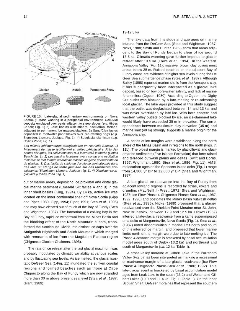
FIGURE 10. Late-glacial sedimentary environments on NovaScotia. ): Mass wasting in a periglacial environment. Colluvialdeposits emplaced over peats adjacent to steep slopes (e.g. HirtlesBeach; Fig. 1) 2) Lake basins with mineral oscillation, formedadjacent to permanent ice masses/glaciers. 3) Sand/Clay faciesdeposited in meltwater ponds/lakes over pre-existing bogs (e.g.Blomidon; Lismore; Judique; Fig. 1). 4) Subglacial diamicton (e.g.Collins Pond; Fig. 1).
Les milieux sédimentaires tardiglaciaires en Nouvelle-Écosse. 1)Mouvement de masse (solifluxion) en milieu périglaciaire. Près despentes abruptes, les colluvions sont sus-jacentes à la tourbe (HirtlesBeach, fig. 1). 2) Les bassins lacustres ayant connu une oscillationminérale se font formés au droit de masses de glace permanente oude glaciers. 3) Des faciès de sable ou d'argile se sont déposés dansdes lacs ou étangs de fonte glaciaire sur des tourbières pré-existantes (Blomindon, Lismore, Judique ; fig. 1). 4) Diamicton sous-glaciaire (Collins Pond ; fig. 1).

DEGLACIATION OF NOVA SCOTIA 15
Géographie physique et Quaternaire, 52(1), 1998
FIGURE 11. Paleogeographic reconstructions of the late-glacial period in Nova Scotia (14,000-10,000 yr BP) (Cape Breton deglaciationafter Grant, 1994).
Reconstitution paléogéographique de la période tardiglaciaire en Nouvelle-Écosse (14-10 ka BP). La déglaciation du Cap-Breton est de Grant(1994).
16 R.R. STEA and R. J. MOTT
Géographie physique et Quaternaire, 52(1), 1998
margin of the Antigonish Highland ice cap formed between14 and 11.6 ka, the time of formation of the Scotian ShelfEnd Moraine Complex (further seaward) and the lowstand ofsea level which destroyed them (Stea et al., 1996). Stea etal. (1996) estimated the age of this advance at around12.8 ka, and considered it a climatic event based on correla-tive glacial re-advances described in Newfoundland, NewBrunswick, and Maine (Borns and Hughes, 1977; Brookes,1977; Nicks, 1988). These advances may be synchronouswith the Port Huron advance of the midcontinent, as Bornsand Hughes (1977) first suggested, and may have northwestAtlantic counterparts (Elverhôi et al., 1995). At this time indeep ocean cores off the Scotian Shelf, a cooling signal wasrecorded in foraminiferal oxygen isotope records (Keigwinand Jones, 1995)
12.5 to 11 ka
Local centres of glaciation were active ca. 12.5 ka (Fig.11. Basal ages from sites in eastern Cape Breton Island sug-gest an early deglaciation (Table I; Fig. 1). Truro, at the headof the Minas Basin became ice free as early as 12.0 ka (Mottand Stea, 1994), but ice must still have blocked the lowerShubenacadie River valley sometime before 11.7 ka asbasal peat dates at Lantz suggest (Fig. 7). Glaciolacustrinesediments were deposited in a large glacial lake henceforthtermed "Glacial Lake Shubenacadie 1" that would haveencompassed much of the Shubenacadie Valley below 30 melevation (Fig. 9) and formed sometime between 12.5 and11.7 ka. This lake lasted for a few hundred years (varvecounts at Brookfield-Fig. 7; V. K. Prest, pers comm., 1984)with a southern outlet to the Atlantic through the Lake Will-iam-Lake Charles-MicMac Lake system, present site of theShubenacadie Canal (Fig. 9). Ice was persistent on thesouth side of the Minas Basin as no record of marine sub-mergence exists there, comparable to the raised deltas ofthe north shore. Once the ice corridor blocking the Shuben-acadie outlet was breached, flow through the outlet wouldhave rapidly drained the lake after 11.7 ka. Although amarine connection may have been established through theMinas Basin, a marine origin for the clay deposits seemsunlikely for reasons discussed earlier. After 11.7 ka, relativesea level in the Gulf of Maine had rapidly dropped below thepresent coastline to a lowstand of -60 m at 11 ka (Barnhardtet al., 1995). The role of differential uplift in the abandon-ment of outlets in this region is minimal as the retreating icefront was parallel to the Shubenacadie Valley outlets (Fig.11) and much of the isostatic recovery had already occurred(Stea et al., 1994).
The Atlantic coast was deglaciated ca. 12 ka, with slightlyearlier deglaciation in southern Nova Scotia, and in south-eastern Cape Breton Island (12.3-12.5? ka). The absence ofraised marine features in the region is considered to be aresult of late deglaciation, rather than minimal ice (Stea etal., 1994).
In Cape Breton Island, Grant (1994) proposed severallarge ice-dammed lakes within the Margaree and RiverDenys valleys dammed by ice in the lowlands to the south(Fig. 11). These lakes probably formed during the initial
deglaciation phase 13-12.0 ka (Fig. 11). Low shrub and her-baceous vegetation were the first to occupy the coastal land-scape, usually low, wet protected areas or where soils weremore suitable for plants to colonize (Mott and Stea, 1994).Trees began to migrate into the southern Nova Scotia,around 12.0 ka (Mott, 1991; Miller, 1995).
Pollen analysis from northern Nova Scotia lake and bur-ied peat sites indicate that forest growth was accentuatedafter 12 ka (Jetté and Mott, 1989; Mayle and Cwynar, 1995).Spruce, sometimes preceded by poplar-aspen trees, in theform of open woodlands occupied suitable sites south ofTruro and westward along the Minas Basin coast. The treeline lay somewhere in northern mainland Nova Scotia, buthad not reached Cape Breton Island.
Caribou and other large land mammals migrated to theMinas Basin area by this time, through the Bay of Fundy cor-ridor (Davis, 1991). Relative sea level (RSL) was near itslowest point. A lowstand shoreline is recorded along theAtlantic coast (ca. 11.6 ka) at -65 m (Stea et al., 1994). Thisshoreline can be traced around Nova Scotia to the Fundycoast where it appears to be tilted upwards to -35 m (Faderet al., 1977). The first human migrations probably followedthe lowstand corridors into the Bay of Fundy that had beendeglaciated first. Davis (1991) argues that human occupa-tion of the Debert site began around 11 ka, during the pre-Younger Dryas time of climatic warming, in spite of radiocar-bon ages which average around 10.6 ka (MacDonald, 1968).The younger ages at the site, Davis argues, may have beencontaminated by laboratory pre-treatment.
Nova Scotia was virtually ice free by 11,000 years ago.Small remnant ice masses may have persisted in theCobequid and the Cape Breton Highlands.
11-10 ka
At 10,800 yr BP, an abrupt and dramatic climatic coolinglasting several hundred years strongly affected the land-scape and its vegetation cover. Small glaciers were reacti-vated and produced ice dams that led to flooding of lowlandareas, sites of former peat bogs. Lake and bog basins wereinundated by clay and silt, emanating from the base of melt-ing glaciers or permanent snowpacks, leaving a distinctmarker horizon in lake sediment cores. In Nova Scotia,spruce trees were decimated if not completely eliminated atsome sites (Mott, 1994). Shrub birch communities revertedto willow dominance, and herbaceous taxa increased ordominated at some sites.
The extent of the Younger Dryas ice masses is a matter ofsome controversy. King (1994) proposed a major YoungerDryas glaciation of the continental shelf, based on correla-tion of an unconformity in offshore glaciomarine sequences,but later recanted based on evidence presented by Stea(1995), namely the continuity of a lowstand shoreline acrossthe proposed offshore Younger Dryas ice margin. On landthe glacier margins are not well defined, with the possibleexception of ice marginal? ribbed moraine in the vicinity ofthe stratotype locality at Collins Pond (Stea and Mott, 1989;Fig. 1). Stagnant masses of ice over the Magdalen Plateau
DEGLACIATION OF NOVA SCOTIA 17
Géographie physique et Quaternaire, 52(1), 1998
region (Figs. 1; 11) are necessary for the formation ofYounger Dryas glacial lakes in central Nova Scotia, westernCape Breton and the northern edge of the Cobequid High-lands (Fig. 11). A lake formed again in the Shubenacadievalley (Glacial Lake Shubenacadie 2) as the mouth of theShubenacadie River was blocked by aufeis/glacier (Fig. 11).The extent of this lake is less certain than Glacial LakeShubenacadie 1, the first phase of lake formation around 12ka. Clay deposits at Judique discovered by Robert Turner in1992 (Figs. 1, 7) may indicate an extensive Younger Dryasice marginal lake system, throughout the coastal lowlandssouth of Port Hood, which would also include the Campbellsite (Mott and Stea, 1994). Late ice over the Gulf of St.Lawrence area is inferred by a lack of pre-10 ka organic sed-iment in lake basins in Prince Edward Island and glaciomar-ine sediment in the Laurentian Channel dated at 10.6 ka(Loring and Nota, 1973).
THE YOUNGER DRYAS AS AN INCIPIENT GLACIATION
The sedimentary record outlined in this study suggeststhat during the Younger Dryas Chronozone, embryonic gla-ciers were created, then abruptly aborted with the onset ofHolocene warmth. Maritime Canada, has the highest precip-itation in eastern Canada, and harboured autonomous icecentres during the Quaternary (Prest and Grant, 1969; Steaet al., 1992; Piper et al., 1994), some of which extended towhat is now the offshore bank areas (Stea et al., 1996).
In Nova Scotia, there is a marked concordance betweenpresent-day areas of thick, residual snowpacks (F. Amirault,pers. comm., 1992) and the Younger Dryas ice /snowregions (Fig. 11). If net snow accumulation exceeded sum-mer melting then ice sheets would have formed in theseregions first. During most of the late-glacial period the regionaround Prince Edward Island was emergent (Loring andNota, 1973). The lack of a moderating ocean may have con-tributed to ice buildup in the northern Nova Scotia/PrinceEdward Island region. De Vernal et al. (1996) calculatedsummer temperatures of 1-5°C for the Gulf of St. Lawrenceregion. An increase in storminess, during the Younger Dryas,as noted in offshore records (Piper and Fehr, 1991; Gipp,1994; Stea et al., 1996) coupled with marked summer cool-ing in northern Nova Scotia, is a recipe for ice accretion. Gla-cier ization in the Maritimes during the Younger Dryasproceeded simultaneously in the uplands and lowlands byconcomitant upland snowfield and lowland aufeis accretion(Loewe, 1971), with small remaining outliers of Late Wiscon-sinan ice acting as "seeds" for incipient glaciers. The earlyWisconsinan throughout Eastern North America, is charac-terized by thick glacial lake deposits, which preceded theadvance of ice and the deposition of tills (Clark et al., 1993).Denton and Hughes (1981) described mechanisms of icebuildup in maritime areas relating to relatively rapid and thickbuildup of ice from impounded water in lowland regions. TheYounger Dryas in Nova Scotia, can be viewed as a glaciationthat was aborted in it's initial stages, and the sedimentaryrecord in Nova Scotia as an indication for glacierization as amechanism for the buildup of Appalachian ice sheets.
ACKNOWLEDGMENTS
We are grateful to Dr. Rod Klassen and an anonymousreviewer for their useful remarks and suggestions. Repre-sents contribution no. 1997040 of the Geological Survey ofCanada
REFERENCES
Anderson, T.W., 1985. Late-Quaternary pollen records from eastern Ontario,Quebec, and Atlantic Canada, p. 281-326. In M Bryant and R. G. Holloway,eds., Pollen Records of Late Quaternary North American Sediments.AASP Foundation.
Ashley, G.M., 1975. Rhythmic sedimentation in glacial lake Hitchcock,Massachusetts-Connecticut; Society of Economic Paleontologists andMineralogists Special Publication 23: 314-320.
Bailey, L.W., 1898. Report on the geology of southwestern Nova Scotia.Geological Survey of Canada, Annual Report, 9 (pt M):.30-60.
Barnhardt, W.A., Gehrels, W.R., Belknap, D.F. and Kelley, J.T., 1995. LateQuaternary relative sea-level change in the western Gulf of Maine:Evidence for a migrating glacial forebulge. Geology, 23: 317-320.
Belknap, D.F., Andersen, B.G., Anderson, R.S., Anderson, W.A., Borns, H.W.,Jr., Jacobson, G.L. Kelley, J.T., Shipp, R.C., Smith, D.C., Stuckenrath, R.Jr., Thompson, W.B. and Tyler, D.A., 1987. Late Quaternary sea-levelchanges in Maine, p. 71-85. In D. Nummedal, O.H., Pilkey, Jr., and J.D.Howard, eds., Sea-Level Fluctuations and Coastal Evolution. SEPMspecial publication 41.
Blake, W. Jr., 1981. Lake sediment coring along Smith Sound, EllesmereIsland and Greenland. In Current Research, Part A., Geological Survey ofCanada, Paper 81-1A: 191-200.
Borns, H.W. Jr. and Hughes, T.J., 1977. The implications of the Pineo Ridgereadvance in Maine. Géographie physique et Quaternaire, 31: 203-206.
Brookes, I.A. 1977. Geomorphology and Quaternary geology of CodroyLowland and adjacent plateaus, southwest Newfoundland. CanadianJournal of Earth Sciences, 14: 2101-2120.
Chalmers, R., 1895. Report on the surface geology of eastern New Brunswick,northwestern Nova Scotia and a portion of Prince Edward Island.Geological Survey of Canada, Annual Report 1894, 1: no. 7, pt. m, 144 p.
Clark, P.U., Clague, J.J., Curry, B.B., Dreimanis, A., Hicock, S., Miller, G.H.,Berger, G.W., Eyles, N., Lamothe, M., Miller, B.B., Mott, R.J., Oldale, R.N.,Stea, R.R., Szabo, J.P., Thorleifsen, L.H. and Vincent, J.-S., 1993.Initiation and development of the Laurentide and Cordilleran ice sheetsfollowing the last glaciation. Quaternary Science Reviews, 12: 79-114.
Cwynar, L. C. and Levesque, A. J., 1995. Chironomid evidence for late-glacialclimatic reversals in Maine. Quaternary Research, 43: 405-413.
Davis, S. A. 1991. Two concentrations of palaeo-indian occupation in the farnortheast. Revisita de Arquelogia Americana, 3: 31-55.
Denton, G.H. and Hughes, T.J., 1981. The last great ice sheets. John Wiley,Toronto, 484 p.
Elverhôi, A., Andersen, E., Dokken, T., Hebbeln, D., Spielhagen, R.,Svendsen, J.I., Sørflaten, M., Rørnes, A., Hald, M. and Forsberg, C.F.,1995. The growth and decay of Late Weichselian ice sheet in WesternSvalbard and adjacent areas based on provenance studies of the marinerecord. In Quaternary Research Association, Royal Society of Edinburgh,Annual Discussion Meeting 1995, Abstracts Volume.
Eyles, N. and Eyles, C.H., 1992. Glacial depositional systems, p.73-100.InR. G. Walker and N. P. James, eds., Facies Models: Response to Sea-level Change. Geological Association of Canada, Special Publication.
Fader, G.B., King, L.H. and MacLean, B., 1977. Surficial Geology of theEastern Gulf of Maine and Bay of Fundy. Geological Survey of Canada,Paper 76-17, 23 p.
Frappier, M. G., 1996. Late-glacial, fine resolution pollen and texture analysesof Little Dyke Lake sediments, central Nova Scotia. M. A. thesis,Department of Geography, University of Ottawa, 131 p.

18 R.R. STEA and R. J. MOTT
Géographie physique et Quaternaire, 52(1), 1998
Fritz, P., 1983. Radiocarbon dating of marl deposits - Can we assess the hardwater effect? Correlation of Quaternary Chronologies Symposium,Abstracts with Program, p. 51-52.
Gipp, M.R., 1994. Late Wisconsinan deglaciation of Emerald Basin, ScotianShelf. Canadian Journal of Earth Sciences, 31: 554-566.
Gipp, M.R. and Piper, D.J.W., 1989. Chronology of Late Wisconsinanglaciation, Emerald Basin, Scotian Shelf. Canadian Journal of EarthSciences, 26: 333-335.
Grant, D. R., 1980. Quaternary stratigraphy of southwestern Nova Scotia:Glacial events and sea level changes. Geological Association of Canadaand Mineralogical Association of Canada, Field Trip Guidebook, 63 p.
_____ 1989. Quaternary Geology of the Atlantic Appalachian region ofCanada, p. 393-440. In R.J. Fulton, ed., Quaternary Geology of Canadaand Adjacent Greenland. Geological Survey of Canada, Geology ofCanada 1 (also Geological Society of America, The Geology of NorthAmerica, v. K-1).
_____ 1994. Quaternary Geology, Cape Breton Island. Geological Survey ofCanada, Bulletin 482, 159 p.
Green, D.G., 1981. Time series and postglacial forest ecology. QuaternaryResearch, 15: 265-277.
Hickox, C.F. Jr., 1962. Pleistocene geology of the central Annapolis Valley,Nova Scotia. Nova Scotia Department of Mines, Memoir 5, 36 p.
Hughes, O. L., 1957. Surficial geology of the Shubenacadie map area, NovaScotia. Geological Survey of Canada, Paper 56-3, 10 p.
Jetté, H. and Mott, R. J., 1989. Palynostratigraphie du tardi-glaciaire et del'Holocéne de la région du lac Chance Harbour, Nouvelle-Écosse.Géographie physique et Quaternaire, 43: 27-38.
Keigwin, L. D. and Jones, G. A., 1995. The marine record of deglaciation fromthe continental margin off Nova Scotia. Paleoceanography, 10: 973-985.
Kerney, M.P., Brown, E.H. and Chandler, T.J., 1964. The late-glacial and Post-glacial history of the chalk escarpment near Brook, Kent. Proceedings ofthe Royal Society, B. 248: 135-204.
King, L.H., 1994. Proposed Younger Dryas glaciation of the eastern ScotianShelf. Canadian Journal of Earth Sciences, 31: 401-417.
_____ 1996. Late Wisconsinan ice retreat from the Scotian Shelf. GeologicalSociety of America Bulletin, 108: 1056-1067.
Levesque, A., Mayle, F.E., Walker, I. R. and Cwynar, L.C., 1993. A previouslyunrecognized late-glacial cold event in eastern North America. Nature,361: 623-626.
Levesque, A.J., Cwynar, L.C. and Walker, I.R., 1994. A multiproxyinvestigation of late-glacial climate and vegetation change at Pine RidgePond, Southwest New Brunswick, Canada. Quaternary Research, 42: 316-327.
Loewe, F., 1971. Considerations on the origin of the Quaternary Ice sheet ofNorth America. Arctic and Alpine Research, 3: 331-344.
Loring, D. H. and Nota, D. J. G., 1973. Morphology and sediments of the Gulfof St. Lawrence. Fisheries Research Board of Canada, Bulletin, 182, 147 p.
Lowe, J.J., Ammann, B., Birks, H.H., Björk, S., Coope, G.R., Cwynar, L.,Beaulieu, J.-L. De, Mott, R.J., Peteet, D.M. and Walker, M.J.C., 1994.Climatic changes in areas adjacent to the North Atlantic during the lastglacial-interglacial transition (14-9 ka). A contribution to IGCP-253. Journalof Quaternary Science, 9: 185-198.
MacDonald, G. F., 1968. Debert, a palaeo-indian site in central Nova Scotia.Anthropology Papers, National Museum of Canada 16, 207
MacNeill, R. H., 1951. Pleistocene geology of the Wolfville area, Nova Scotia.M.Sc. thesis, Acadia University, Wolfville, Nova Scotia Department ofMines and Energy, Thesis 241, 59 p.
Mangerud, J., 1972. Radiocarbon dating of marine shells, including adiscussion of apparent age of Recent shells from Norway. Boreas, 1: 143-172.
Marcoux, N. and Richard P.J.H, 1994. Végétation et fluctuations climatiquespostglaciares sur la côte septentrionale gaspésienne, Québec. CanadianJournal of Earth Sciences, 32: 79-96.
Mayle, F. E., Levesque, A. J. and Cwynar, L. C., 1993. Accelerator massspectrometer ages for the Younger Dryas event in Atlantic Canada.Quaternary Research, 39: 355-360.
Mayle, F. E. and Cwynar, L. E., 1995. Impact of the Younger Dryas coolingevent upon lowland vegetation of Maritime Canada. EcologicalMonographs, 65 (2): 129-154.
McNeely, R. and Atkinson, D. E., 1996. Geological Survey of CanadaRadiocarbon Dates XXXII. Geological Survey of Canada, CurrentResearch 1995-G, 92 p.
Miller, R. F., 1995. Late-glacial Coleoptera and the paleoclimate at Hirtles,Nova Scotia. Atlantic Geology, 31: 95-101.
Mott, R.J., 1975. Palynological studies of lake sediment profiles fromsouthwestern New Brunswick. Canadian Journal of Earth Sciences, 12:273-288.
_____ 1991. Postglacial history of Nova Scotia from pollen and macrofossilevidence,p. 1-20. In C.T. Schafer, and C.S Mason, eds., The Climate ofNova Scotia. Proceedings of the Climate of Nova Scotia Conference,November 1991, Environment Canada.
_____ 1994. Wisconsinan Late-glacial environmental change in Nova Scotia:A regional synthesis. Journal of Quaternary Science, 9: 155-160.
Mott, R.J., Grant, D.R.G., Stea, R.R. and Occhietti, S., 1986. Late-glacialclimatic oscillation in Atlantic Canada equivalent to the Allerød-YoungerDryas event. Nature, 323 (6085): 247-250.
Mott, R.J. and Stea, R.R., 1994. Late-Glacial (Allerød/Younger Dryas) buriedorganic deposits, Nova Scotia, Canada. Quaternary Science Reviews 12:645-657.
Nicks, L., 1988. A study of the glacial stratigraphy and sedimentation of theSheldon Point Moraine, Saint John, New Brunswick. M.Sc. thesis,Dalhousie University, Halifax, 171 p.
Nielsen, E., 1976. The composition and origin of Wisconsinan tills in mainlandNova Scotia. Ph.D. thesis, Dalhousie University, Halifax, 256 p.
Ogden, J.G. III, 1987. Vegetational and climatic history of Nova Scotia. I.Radiocarbon-dated pollen profiles from Halifax, Nova Scotia. CanadianJournal of Botany, 65: 1482-1490.
Ogden, K. F., 1980. An ice marginal lake in Annapolis Basin at the close of theLate Wisconsin. B.Sc. thesis, Acadia University, Wolfville, 59 p.
Piper, D.J.W., 1991. Surficial geology and physical properties 7: Paleo-oceanography and paleo-glaciology, p. 123. In East Coast Atlas S: ScotianShelf. Atlantic Geoscience Centre, Geological Survey of Canada.
Piper, D.J.W. and Fehr, S.D., 1991. Radiocarbon chronology of LateQuaternary sections on the inner and middle Scotian Shelf, south of NovaScotia. In Current Research, Part E, Geological Survey of Canada, Paper91-1E: 321-325.
Piper, D.J.W., Mudie, P.J., Aksu, A.E. and Skene, K.I., 1994. A 1 Ma record ofsediment flux south of the Grand Banks used to infer the development ofglaciation in southeastern Canada. Quaternary Science Reviews, 13: 23-37.
Purdy, C. A., 1951. Pleistocene geology of the Kentville area, Nova Scotia.M.Sc. thesis, Acadia University, Wolfville; Nova Scotia Department ofMines and Energy, Thesis 299, 51 p.
Prest, V. K., 1970. Quaternary geology of Canada, p. 676-764. In R. J. W.Douglas, ed., Geology and Economic Minerals of Canada. GeologicalSurvey of Canada, Economic Geology Report 1.
Prest, V.K. and Grant, D.R., 1969. Retreat of the last ice sheet from theMaritime Provinces - Gulf of St. Lawrence region. Geological Survey ofCanada, Paper 69-33, 15 p.
Prest, V.K., Grant, D.R., MacNeill, R.H., Brooks, I.A., Borns, H.W., Ogden J.G,Jones, J.F., Lin, C.L., Hennigar, T.W. and Parsons, M.L, 1972. Quaternarygeology, geomorphology and hydrogeology of the Atlantic Provinces. 24thInternational Geological Congress, Excursion Guidebook, A61-C61, 79 p.
Rawlence, D. J., 1988. The post-glacial diatom history of Splan Lake, NewBrunswick. Journal of Paleolimnology, 1: 51-60.

DEGLACIATION OF NOVA SCOTIA 19
Géographie physique et Quaternaire, 52(1), 1998
Rogers, P.J. and Ogden, J.G. III, 1991. Some geochemical consequences ofenvironmental change and human activity in Nova Scotia,Canada.Transactions of the Institute of Mining and Metallurgy, 101: b15-b22.
Smith, G.W. and Hunter, L.E., 1989. Late Wisconsinan deglaciation of coastalMaine, p. 13-22. In R. D. Tucker and R. G., Marvinney, eds., Studies inMaine Geology. Volume 6, Quaternary Geology.
Spooner, I.S., 1997. An investigation of late-glacial lacustrine sediments fromwestern Nova Scotia: Evidence of ice-free conditions during YoungerDryas time. Atlantic Geoscience Society, 25th Anniversary Colloquium,Program and Abstracts, p. 33.
Stea, R.R., 1983. Surficial geology of the western Part of Cumberland County,Nova Scotia. In Current Research, Part A, Geological Survey of Canada,Paper 83-1A: 197-202.
_____ 1995. Late Quaternary glaciations and sea-level change along theAtlantic Coast of Nova Scotia. Ph.D. Dissertation, Dalhousie University,Halifax, 407 p.
Stea, R.R., Boyd, R., Costello, O., Fader, G.B.J. and Scott, D.B., 1996.Deglaciation of the inner Scotian Shelf, Nova Scotia: Correlation ofterrestrial and marine glacial events, p. 77-101. In J.T. Andrews, H.H.Bergsten and A.E. Jennings, eds., Late Quaternary Palaeoceanography ofthe North Atlantic Margins. Geological Society Special Publication 111.
Stea, R.R., Boyd, R., Fader, G.B.J., Courtney, R.C., Scott, D.B. and Pecore,S.S., 1994. Morphology and seismic stratigraphy of the inner continentalshelf off Nova Scotia, Canada: Evidence for a -65 m lowstand between11,650 and 11,250 14C yr B.P. Marine Geology, 117: 135-154.
Stea, R.R., Conley, H. and Brown, Y. (compilers) 1992. Surficial geology of theProvince of Nova Scotia. Nova Scotia Department of Natural Resources,Map 92-1, Scale 1:500 000.
Stea, R.R., Finck, P.W. and Wightman, D.M., 1986. Quaternary geology andtill geochemistry of the western part of Cumberland County, Nova Scotia(sheet 9). Geological Survey of Canada, Paper 85-17, 58 p.
Stea, R.R., Mott, R.J., Belknap, D.F. and Radtke, U., 1992. The Pre-LateWisconsinan Chronology of Nova Scotia, Canada, p. 185-206. In P.U.Clark and P.D. Lea, eds., The Last Interglaciation / Glaciation Transition inNorth America. Geological Society of America, Special Paper 270.
Stea, R.R., and Mott, R.J., 1989. Deglaciation environments and evidence forglaciers of Younger Dryas age in Nova Scotia, Canada. Boreas, 18: 169-187.
Stea, R.R., Scott, D.B., Kelley, J.T., Kelley, A.R., Wightman, D.M., Finck, P.W.,Seaman, A., Nicks, L., Bleakney, S., Boyd, R. and Douma, M., 1987.Quaternary Glaciations, Geomorphology and Sea-level changes: Bay ofFundy Region. NATO Advanced Course on Sea-level Correlations andApplications, Halifax, Nova Scotia, Field Trip Guidebook, 79 p.
Stea, R.R. and Wightman, D.M., 1987. Age of the Five Islands Formation,Nova Scotia, and the deglaciation of the Bay of Fundy. QuaternaryResearch, 27: 211-219.
Sutherland, D.G., 1980. Problems of radiocarbon dating deposits from newlydeglaciated terrain: Examples from the Scottish lateglacial, p. 139-149. InJ. J. Lowe, J. M. Gray and J. E. Robinson, ed., The Late Glacial ofNorthwest Europe. Proceedings of the Symposium of the QuaternaryResearch Association, University College, London,
Swift, D.J.P. and Borns, H.W., Jr., 1967. A raised fluviomarine outwash terrace,north shore of the Minas Basin, Nova Scotia. Journal of Geology, 75(6):693-710.
Veillette, J. J., 1994. Evolution and paleohydrology of glacial lakes Barlow andOjibway. Quaternary Science Reviews, 13: 945-971.
Veillette, J.J. and Thomas, R.D., 1979. Icings and seepage in frozenglaciofluvial deposits, District of Keewatin, N. W. T. Canadian GeotechnicalJournal, 16: 789-798.
Walker, M.J.C. and Lowe, J.J., 1990. Reconstructing the environmental historyof the last glacial/interglacial transition: Evidence from the Isle of Skye,inner Hebrides, Scotland. Quaternary Science Reviews, 9: 15-49.
Wightman, D.M., 1980. Late Pleistocene glaciofluvial and glaciomarinesediments on the north side of the Minas Basin, Nova Scotia. Ph.D. thesis,Dalhousie University, Halifax; Nova Scotia Department of Mines andEnergy, Thesis 405, 426 p.
Wilson, S.E., Walker, I.R., Mott, R.J. and Smol, J.P., 1993. Climatic andlimnological changes associated with the Younger Dryas in AtlanticCanada. Climate Dynamics, 8: 177-187.
Wolfe, A.P. and Butler, D.L., 1994. Late-glacial and early Holoceneenvironments at Pine Hill Pond, Newfoundland Canada: Evidence frompollen and diatoms. Boreas, 23: 53-65.
Wright, H.E., Livingstone, D.A. and Cushing, E.J., 1965. Coring devices forlake sediment, p. 494-520. In B. Kummel and D.M. Raup, eds., Handbookof Paleontological Techniques. Freeman, San Francisco,