delay tolerant networks on vehicle-to-vehicle cognitive...
TRANSCRIPT

Delay Tolerant Networks on Vehicle-to-Vehicle CognitiveWireless Communication with Satellite System for Disaster
Information System in a Coastal City
Noriki Uchida∗ 1, Norihiro Kawamura2, and Yoshitaka Shibata3
1 Dept. of Informational Social StudiesSaitama Institute of Technology
1690 Fusaiji, Fukaya, Saitama 3692093 [email protected]
2 TAC Engineering Co.,LTD.2320, Tsushidanishi, Morioka, Iwate 0200836 Japan
3 Faculty of Software and Information scienceIwate Prefectural University
15252 Sugo, Takizawa, Iwate 0200193 [email protected]
Abstract
This paper introduces new Disaster Information System based upon Delay Tolerant Network (DTN)in Taro, Miyako, and Iwate Prefecture in Northern Japanese coastal towns which are the severelydamaged by the East Japan Great Earthquake in 2011. This paper reports and discusses about thenetwork conditions in disaster area by using our prototype network. Then, the computational exper-iments of the DTN by using cognitive wireless cars in those towns are discussed. The results showthat the proposed cognitive wireless network (CWN) under the Spray and Wait Routing can workeffectively. Finally we conclude that 25 wireless cars are expected to need for Disaster InformationSystem with DTN in the town of Taro.
Keywords: Disaster Information Network System, Delay Tolerant Network, Cognitive Wireless Net-work, QoS
1 Introduction
It has been already two years since there was Great Earthquake at the Eastern Japan in 2011. ManyNorthern Japan coastal cities were severely damaged by the catastrophic earthquake and tsunami. Itbrought various problems such as a great number of victims, isolation of areas, and nuclear crisis. Thereare still so many problems including political problems for the reconstruction. However, in recent, disas-ter related works are also being carried out for the reconstruction of the damaged cities. This paper dealswith the field experiments of network conditions in Taro, Miyako, Iwate, Japan, and discusses about
IT CoNvergence PRActice (INPRA), volume: 1, number: 1, pp. 53-66∗Corresponding author: Tel: 81-48-585-6876
53

DTN on V2V Cognitive Wireless Communication... Uchida, Kawamura, and Shibata
the DTN based Disaster Information System which employs cognitive wireless cars and satellite systembased fixed stations in the town.
The Great East Japan Earthquake caused not only destructions of many buildings but also disconnec-tions of communication networks [15]. The communication networks such as Internet, cellular phones,and land phones were unavailable after the earthquake. Moreover, there was a wide blackout spread overthe northern and central Japan. In addition, the disconnection came with various problems such as thedelay of rescue and the isolation of the cities. In result, the cities are still suffering from the poor networkconditions.
According to our previous reports about the ultra large scale earthquake [11, 16], wireless networkssuch as satellite system or wireless LAN were effective in reactivating the communication network inthe disaster area. However, it is not the case to the satellite system, which have some problems such asa large jitter and PER (Packet Error Rate) for the Disaster Information System. Besides, if the disasterarea was wider, it is not easy to cover the entire area by using Satellite System only. That is, even ifsome evacuation shelters in the area have a robust connection by Satellite System, it is necessary to carrythe significant information data to whole shelters at least. DTN is one of the communication methodssuitable for these problems. DTN is the “challenged computer network” approach originated from theInterplanetary Internet. Its data transmission is based upon the “store-carry-forward” protocol in orderto carry data packets under the condition of poor connections such as space [7]. If mobile nodes such aswireless cars with smart phones or mobile PCs are used with the DTN methods, it is supposed to be ableto communicate each other even during disasters. However, in the case of using DTN in local areas suchas Taro town, the probability of delivery data would be less than the urban areas because the number ofroads, cars, and pedestrians are fewer than these of the urban areas.
In this paper, we propose DTN based Disaster Information System which consists of cognitive wire-less cars as mobile nodes and Satellite System as fixed stations in Taro, Miyako City, Iwate Prefecture,Japan, which was severely damaged by the East Japan Great Earthquake. For the first, this paper re-ports about network conditions based upon the satellite system in Taro City Hall resulted by the fieldexperiments, and deals with DTN with CWN which consists of multiple wireless interfaces proposed bya Disaster Information Network System in order to set up in local areas. Then, considering the actualusage of DTN in local areas, the simulation is accomplished according to the map of Taro Town. In theexperiments, vehicle-to-vehicle communications with single wireless interfaces such as IEEE802.11b/gand amateur radio was simulated, and then a proposed CWN method was simulated by GIS map of Taro.The results are discussed for the future works of DTN usages for Disaster Information Network Systemin local areas.
In the followings, the East Japan Great Earthquake and its network conditions are explained in section2. System configuration and architecture of our proposed Disaster Information System by DTN andSatellite System are explained in section 3 and section 4, respectively. The field experiments in the townare reported in section 4. DTN on Vehicle-to-Vehicle CWN and it performance evaluations are describedin section 5. Finally, the conclusions and future works are summarized in section 6.
2 The East Japan Great Earthquake in Taro, Japan
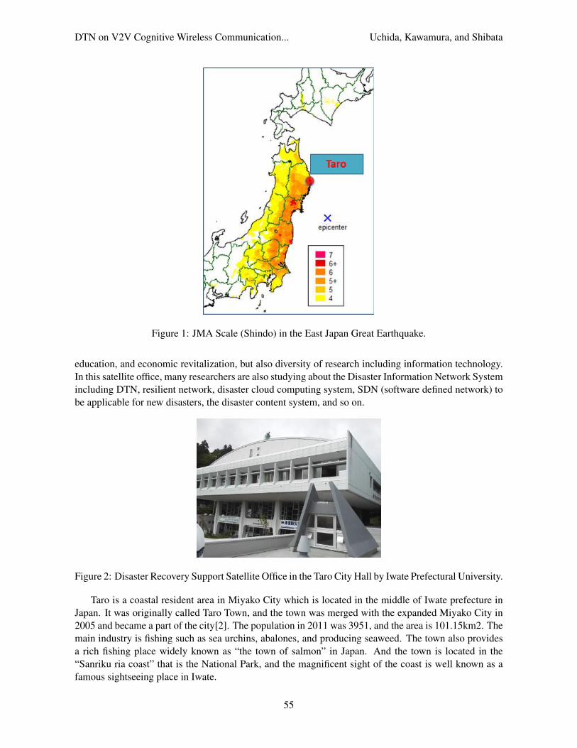
On March 11, 2011, the East Japan Great Earthquake hit the wide Northern and Middle parts of Japan asshwon in Figure 1 [13], and it caused severe damages such as blackout and nuclear crisis.
There are still many issues for the reconstruction of cities and the disaster prevention system evennow, and to do this, a few works are being carried out. For example, as shown in Figure 2, IwatePrefectural University in Japan opened the Disaster Reconstruction Support Satellite Office in Taro inOctober 1, 2012. The office aims to support not only various recovery activities such as volunteers,
54
DTN on V2V Cognitive Wireless Communication... Uchida, Kawamura, and Shibata
Figure 1: JMA Scale (Shindo) in the East Japan Great Earthquake.
education, and economic revitalization, but also diversity of research including information technology.In this satellite office, many researchers are also studying about the Disaster Information Network Systemincluding DTN, resilient network, disaster cloud computing system, SDN (software defined network) tobe applicable for new disasters, the disaster content system, and so on.
Figure 2: Disaster Recovery Support Satellite Office in the Taro City Hall by Iwate Prefectural University.
Taro is a coastal resident area in Miyako City which is located in the middle of Iwate prefecture inJapan. It was originally called Taro Town, and the town was merged with the expanded Miyako City in2005 and became a part of the city[2]. The population in 2011 was 3951, and the area is 101.15km2. Themain industry is fishing such as sea urchins, abalones, and producing seaweed. The town also providesa rich fishing place widely known as “the town of salmon” in Japan. And the town is located in the“Sanriku ria coast” that is the National Park, and the magnificent sight of the coast is well known as afamous sightseeing place in Iwate.
55

DTN on V2V Cognitive Wireless Communication... Uchida, Kawamura, and Shibata
However, Taro is also known as of “the tsunami and disaster prevention town.” That is because thetown has the tragic history severely damaged from three times of large scale disasters[17]. The first oneis the Keicho Sanriku Earthquake on December 2, 1611. The magnitude of the earthquake was expectedto 8.1, and it was said that the village disappeared under a 15 to 20m high tsunami according to theirancestral records. The second one is the Meiji Sanriku Earthquake on June 15, 1896, and a 14.6m highhuge tsunami after the 8.5 magnitude earthquake destroyed the town area and there were 1,859 deadout of a population of 2,248. The third one is the Showa Sanriku Earthquake on March 3, 1933. Thetsunami after the 8.4 magnitude earthquake killed 911 persons out of a 2,248 population. The height oftsunami at this time was recorded as 38.2m in the Village near Taro. Therefore, Taro built the biggestbreakwater along the seacoast in 1966, which has 10m high walls and 2,433m length. These disastersledthe town to declare “the tsunami and disaster prevention town” in 2003, and they have tried variousdisaster prevention events such as annual tsunami drills and disaster educations for all people in the townsince the declaration.
Figure 3: A Breakwater in Taro after the East Japan Great Earthquake
However, the East Japan Great Earthquake brought severe damage again as shown in Figure 3 evenfor this well-prepared town. A massive 9.1 magnitude earthquake caused huge tsunami, and the estimated15m high tsunami passed over the biggest breakwater in the world and destroyed the town like theprevious disasters did. The damaged buildings were recorded up to 1,091 [10], and some buildings in thetown disappeared. Fortunately, the victims were 166 dead out of the 3,951 population in the area, andthe reason was assumed that their previous prevention activities saved many lives while the earthquakewas quite serious like the number of buildings were damaged.
However, the disconnection of communication network made this town isolated from the other areas.Researchers reported about the terrible confusion caused by isolation and how our network reactivatingactivities worked well by Satellite System [15, 11, 16]. Although a few weeks passed after the tsunami,the disconnection of cellular phones, land phones, and internet made difficulty for the rescue of missingpeople. Even in developed countries like Japan, there must be some possibility of isolation from otherareas because of the disconnection of the communication network. Thus, a robust network connectionmethod has been focused on as one of the significant issues of disaster related research in the world, notonly in Japan.
3 Proposed Methods and Prototype System in Taro
According to the experiences of network reactivations in the coastal cities such as Taro, we proposethe DTN based Disaster Information System by Vehicle-to-Vehicle Cognitive Wireless Communicationwith Satellite System described in Figure 5. The system consists of fixed stations such as a disaster
56

DTN on V2V Cognitive Wireless Communication... Uchida, Kawamura, and Shibata
Figure 4: Network Reactivation by Satellite System in Taro
headquarters, evacuation shelters, and residents, and mobile nodes such as wireless cars, cellular phones,and mobile PCs in the system.
Figure 5: Proposed Disaster Information System with DTN and Satellite System
Major fixed stations have Satellite System to communicate with outside of disaster area such asgovernments, and self-productive energy such as solar power system. Moreover, all nodes have mul-tiple heterogeneous wireless interfaces such as IEEE802.11a/b/g/j/n, Wimax, amateur radio, and so on(w1,w2, . . . , wn). Then, mobile nodes such as wireless cars delivers these data to the inside of disasterarea. These wireless interfaces are automatically selected according to the network conditions, nodes,movements, message priorities, and user policies under disaster for the sake of improving the messagedelivery rate and the latency by DTN. Figure 6 shows the prototype system implemented in the TaroOffice. The system has multiple wireless gateways such as Satellite System, Wimax, 3G mobile system,and Wi-Fi (IEEE802.11a/b/g/n). Also, there are Wi-Fi routers for the communication with wireless carsand mobile terminals. Under such implementation, we are researching how DTN works effectively bythese mobile nodes. In this paper, we evaluate our prototype systems by using the network simulator
57

DTN on V2V Cognitive Wireless Communication... Uchida, Kawamura, and Shibata
based on the map of Taro.
Figure 6: Network Configuration of Prototype System in Taro
4 Delay Tolerant Network
DTN is the approach of “challenged computer network” that provides interoperable communication inwhere continuous end-to-end connectivity cannot be assumed [9]. Although the current TCP protocolneeds the end-to-end connectivity to establish network communication, DTN has been designed for theenvironment of that end-to-end communication cannot be available such as heterogeneous networks,interplanetary, military, and disaster networks.
DTN is originally designed from Interplanetary Internet such as the communication between an earthand the planet Mars[7]. In case of interplanetary network, interplanetary links are considered to be ex-tremely troublesome in the current TCP/IP architecture. In the environment of extrememly longer dis-tance of wireless data transmission, the important subjects mean extremely large latencies, bidirectionalcommunication on each connection, continuous end-to-end connectivity, intermittent scheduled connec-tivity by relay orbiters, low data rates, and so on. Therefore interplanetary network needs new networkprotocols designed for such an interoperable communication.
To achieve the interoperable communication in poor network environment, DTN generally takes intoaccount “store-carry-forward” protocol for its routing. That is, each node stores the transmission data ifthere is no available node nearby, and the data are duplicated when a node comes closer to be transmitted.Figure 7 shows an example of data duplication by DTN. Node 1 holds the message data (M1) when thereis no available node nearby. If Node 1 comes closer to Node 2, M1 is copied into Node 2. Then, M1 willbe carried to other nodes as the same way until the data is reached to a destination node.
However, the epidemic routing of DTN has some considerations to apply for the actual case of ad-hoc computer network. One is the limitation of a node’s resources such as storage volumes, battery, andbandwidth. If a node is assumed as a cellular phone, the data volume is significantly limited so it isonly able to hold a certain volume of copies of messages. In the case of epidemic routing, the oldestdata is abandoned when the capacity of a node’s volume is full. The second is the delivery rate. Thereare many considerable subjects to carry the messages such as the number of encounters, the deliverydistance, the network condition, and the node’s movements. If one of these factors is not enough, it ishard to deliver all messages by the epidemic routing. The last is delivered time (latency) from a sender
58

DTN on V2V Cognitive Wireless Communication... Uchida, Kawamura, and Shibata
Figure 7: Deprecation by DTN
node to a destination node. Since the mobile nodes carry messages, DTN is not suitable for the real-timecontents. Also, some other factors such as encounters, distance, and network conditions are supposed toaffect the latency.
To solve these considerations, there are some different approaches of DTN routing such as Spray andWait, MaxProp, PROPHET, and RAPID. Spray and Wait [12] attempts to gain the resource efficiencyby setting an upper limit of copies per message in the network. This is effective for the low resourceenvironments such as a low storage of mobile nodes. MaxProp is the flooding-based routing as well asthe epidemic routing. This method determines which messages should be transmitted first and whichmessages should be dropped first. And the priorities are based on the path likelihoods to peers accordingto historical data and also on several complementary mechanisms, including acknowledgments, a head-start for new packets, and lists of previous intermediaries [5]. PROPHET (The Probabilistic RoutingProtocol using History of Encounters and Transitivity) is a probabilistic routing protocol by using historyof node encounters and transitivity to enhance performance of the previous protocols [9]. RAPID whichis an acronym for Resource Allocation Protocol for Intentional DTN routing is based on flooding methodlike MaxProp, and attempts to replicate all packets if network resources allow. RAPID includes theeffective algorithm that is intentionally minimizing one of three metrics: average delay, missed deadlines,and maximum delay [4].
However, if DTN is applied for a Disaster Information Network System in local areas or severelydamaged areas, there should be more considerations to improve the delivery rate or the latency. Inthe case of Taro, like other local areas, the main transportation is car and pedestrians are rare. Publictransportation is also less than that of urban areas, and it is likely to stop after a disaster. Besides, availableroads and cars are supposed to be fewer than that of urban areas. Since these factors affect the deliveryrate or latency of DTN routing, additional functions are necessary to apply for the Disaster InformationNetwork System in local areas. In this paper, DTN with CWN consisting of multiple wireless interfacesis proposed for the improvement of QoS (Quality of Service) of DTN.
5 Experiments
5.1 Evaluations of the Prototype System
First of all, the network conditions in this office were evaluated by the field experiments. Although ithas been already two years after the earthquake, most of internet cables are still not available aroundthe office. Thus, our experiments were held by the ping data and the video conference system betweenthe Taro office and University of Shizuoka away about 500 km from Taro. Figure 8 shows the actualexperiment environment of video conference.
In the experiment, our results show 1.62Mbps by the Satellite System and 1.41Mbps by WiMax inthe average throughput. However, the quality of the video conference with the Satellite System wasworse than that of WiMax because of the poor resolution and high latency. In details, the 32 bytes ping
59

DTN on V2V Cognitive Wireless Communication... Uchida, Kawamura, and Shibata
Figure 8: The Video Conference between Taro and University of Ahizuoka
results show 785ms RTT (Round Trip Time) and 567ms jitter by the Satellite, although that of Wimaxwas 109ms RTT and 42ms jitter. Besides, large packets more than 64 bytes were unable to communicateby the Satellite. Figure 9 is the capture image delivered by the Satellite and Figure 10 is by the Wimax.
Figure 9: The Image under Satellite System
Therefore, we concluded that real time contents such as video confernce or VoIP are not suitable forthe communication with disaster area, and the packet size is also an important factor to maintain QoSunder the proposed system.
5.2 Evaluations of DTN on Vehicle-to-Vehicle Cognitive Wireless Communication
Next, for the DTN simulation, the ONE (The Opportunistic Network Environment Simulator) [3, 8]is used. Also, for the purposes of the simulation scenarios, we modified some modules such as theexperimental wireless interfaces, the GIS map, and the DTN routing. Figure 11 shows the modificationsof the ONE’s modules for the experiment.
The simulation scenario is shown in Figure 12. The seven evacuation shelters which are designatedby Miyako City are located in the map, and wireless cars as mobile nodes are also implemented in
60

DTN on V2V Cognitive Wireless Communication... Uchida, Kawamura, and Shibata
Figure 10: The Image under Wimax
Figure 11: Modified Modules in the Experiments
the map. Table 1 also shows the details of simulation scenarios. Three types of wireless interfaces(IEEE802.11a, b, and g) were experimented by the different numbers of mobile nodes. The messagedata is assumed as text contents such as life safety information or damage information after a large scaledisaster, and 0.5 - 1.0MB data is created at the Taro City Hall in every 50 - 60 seconds and carried to theGreen Peer Taro that is a major evacuation shelter in the town. Then, the message delivery rate and thelatency were calculated in each case.
The results of the Epidemic Routing are shown in Figure 13 and 14. Figure 13 is the results ofmessage delivery rate in each wireless interface and CWN. The graph of IEEE802.11b demonstratesdramatic increase until 50 mobile nodes, and then the probability is kept constant at around 80%. Also,amateur radio shows the sharp rise by 50 mobile nodes, and then the probability is kept constant at around60%. That is because amateur radio has only 128kbps throughput, and this is not enough to carry thewhole data by the Epidemic Routing.
61

DTN on V2V Cognitive Wireless Communication... Uchida, Kawamura, and Shibata
Figure 12: The Simulation Map in the Experiments
On the contrary, IEEE802.11a did not show any data delivery, and IEEE802.11g shows the poorresults. That is because mobile nodes did not have enough time to duplicate the message data. Sincemobile nodes goes fast from 10 km/h to 50km/h randomly and transmission range is extremely short as50m, transmittable mobile nodes have already passed by after 5 seconds duration for PWD identificationand DHCP preparation even if transmittable nodes come closer.
However, the proposed CWN methods do not work efficiently as we expected. Although the proba-bility rises up by 25 mobile nodes, it kept constant at around 60%. There are two considerable reasonswhy the proposed methods are worse than the single IEEE802.11b. First of all, because of the better datatransmission, more messages are possible to duplicate and these many messages are not easy to get thedestination node. In fact, the results showed that many redundant messages were copied among variousnodes even after the messages were already reached to the destination. Therefore, old messages shouldbe minimized after the reach of the message. Secondly, time duration of changing wireless interfacesaffected the probability. Since it takes five seconds to change the interfaces, the messages are not carriedefficiently.
Figure 14 indicates the results of delivery latency in each wireless interface. However, as the sameresults as Figure 13, the proposed CWN and amateur radio did not work well for the same reason.
Figure 13: The Experimental Results of Delivery Probalilites
62

DTN on V2V Cognitive Wireless Communication... Uchida, Kawamura, and Shibata
Figure 14: The Experimental Results of Delivery Latency
Fixed Wireless Seven evacuation sheltersStation (IEEE802.11a/b/g/amateur radio).
Taro City HallGreen Peer TaroJoun TempleTaro First Elementary SchoolKashinai Community HallRoad Station TaroSettai Kaizen Center
Mobile Nodes Cognitive Wireless cars(IEEE802.11a/b/g/amateur radio).(1) 25 cars (2) 50 cars (3) 75 cars (4) 100 carsShortestPath ModelSpeed 10 - 50 km/h
DTN (1) Epidemic routing(2) Spray and Wait (maximum pop is 6)
Wireless - IEEE802.11b (11Mbps, 100m, 2.4GHz)Conditions - IEEE802.11a (25Mbps, 25m, 5.2GHz)
- IEEE802.11g (20Mbps, 50m, 2.4GHz)- Amateur Radio(128kbps, 1000m, 430MHz)- Cognitive Wireless Network (automatic selection by SNR)Non-directional Antenna RTT (43200sec)
Data - Data are carried from Taro City Hall to Green Peer Taro.- 0.5 – 1.0 MB data are created in every 50 – 60 seconds.
Network - 5 seconds duration is needed before the linkConnection connections in order to such as PWD
identification and DHCP.Node - 2GB storage.Duration One day(43200 second)
Table 1: Simulation Senarios
63

DTN on V2V Cognitive Wireless Communication... Uchida, Kawamura, and Shibata
Then, the results of the Spray and Wait Routing are shown in Figure 15 and 16. Figure 15 indicatesthat the proposed CWN demonstrates the sharp rise by 25 mobile nodes, and then the probability is keptconstant at around 95%. This is better results than the Epidemic Routing, and that is because the upperlimit of copies makes the network resources efficiently.
Figure 16 also indicates that the proposed method works properly, and the latency is available tomake below 2,000 seconds by 25 mobile nodes.
In conclusion according to the experiments, the proposed methods under the Spray and Wait Routingwork effectively, and about 25 wireless cars are expected to be necessary for Disaster Information Systemwith DTN on viecle-to-viecle communication in the town of Taro.
Figure 15: The Experimental Results of Delivery Probalilites
Figure 16: The Experimental Results of Delivery Latency
6 Conclusion and Future Study
This paper introduced our approach for Disaster Information System in the town of Taro in Iwate prefec-ture, Japan, which is one of the severely damaged areas by the Great East Japan Earthquake.
DTN and Satellite System are considered as a useful method to transmit data by interoperable com-munication. However, DTN for the Disaster Information Network System in local areas such as Taro
64

DTN on V2V Cognitive Wireless Communication... Uchida, Kawamura, and Shibata
was not easy for the simulation based on fewer roads, pedestrians, and cars than those of urban areas. Sothat is still remained as a future work.
Therefore, this paper carried out the evaluation of network conditions in disaster areas and its sim-ulations by GIS data of Taro. The results indicated that the proposed CWN under the Spray and WaitRouting can work effectively, and about 25 wireless cars are expected to be necessary for Disaster Infor-mation System with DTN in the town of Taro.
Now we are studying new DTN protocols to improve QoS for improvement of Disaster InformationNetwork System in the coastal cities in Iwate, Japan. In detail, we are trying to find an automatic link androute selection methods in CWN, an automatic controls of directional antenna in a wireless car, messagepriority protocols, and a DTN routing protocols with coding such as Reed Solomon Coding in order toimprove the delivery rate and the latency with fewer mobile nodes.
Acknowledgments
This paper is an extended version of the work [14] originally presented at the 27th IEEE InternationalConference on Advanced Information Networking and Applications (AINA 2013), Barcelona, Spain,March 25-28, 2013.
We had the generous support of Prof. Nicholas Williams of Saitama Institute of Technology in theediting of this paper.
The authors thank TAC Engineering Co.,LTD. and Asia Air Survey Co.,LTD. for the provision ofGIS map data and the advice about the GIS technological operations.
References
[1] DtnBone - Delay Tolerant Networking Research Group. http://www.dtnrg.org/wiki/Home. accessedon March 24, 2013.
[2] Homepage of Taro in Iwate. http://warp.da.ndl.go.jp/info:ndljp/pid/246089/www.town.taro.iwate.jp/index.html. accessed on March 24, 2013.
[3] The ONE is a simulation. http://www.netlab.tkk.fi/tutkimus/dtn/theone/. accessed on March24, 2013.
[4] A. Balasubramanian, B. Levine, and A. Venkataramani. DTN routing as a resource allocation problem.In Proc. of the 2007 conference on Applications, Technologies, Architectures, and Protocols for ComputerCommunications (SIGCOMM’07), Kyoto, Japan, pages 373–384. ACM, August 2007.
[5] J. Burgess, B. Gallagher, D. Jensen, and B. Levine. MaxProp: Routing for Vehicle-Based Disruption-Tolerant Networks. In Proc. of the 25th IEEE International Conference on Computer Communications(INFOCOM’06), Barcelona, Spain. IEEE, April 2006.
[6] G. Dias and R. Salles. Epidemic SIR Model Applied to Delay-Tolerant Networks. In Proc. of the 30thBrazilian Telecommunications Symposium (SBrT’12), Brasilia, Brazil, September 2012.
[7] K. Fall, A. Hooke, L. Torgerson, V. Cerf, B. Durst, and K. Scott. Delay-Tolerant Networking: An Approachto Interplanetary Internet. IEEE Communications Magazine, 41(6):128–136, 2003.
[8] A. Keranen. Opportunistic network environment simulator. http://www.netlab.tkk.fi/tutkimus/
dtn/theone/pub/the_one.pdf, January 2008. Special Assignment, Helsinki University of Technology,Department of Communications and Networking.
[9] A. Lindgren, A. Doria, and O. Scheln. Probabilistic routing inintermittently connected networks. ACMSIGMOBILE Mobile Computing and Communications Review, 7(3):19–20, 2003.
[10] Miyako City. The damaged conditions in miyako, July 2011.
65

DTN on V2V Cognitive Wireless Communication... Uchida, Kawamura, and Shibata
[11] Y. Shibata, N. Uchida, and Y. Ohashi. Problem Analysis and Solutions of Information Network Systemson East Japan Great Earthquake. In Proc. of the 4th International Workshop on Disaster and EmergencyInformation Network Systems (IWDENS’12), Fukuoka, Japan, pages 1054––1059. IEEE, March 2012.
[12] T. Spyropoulos, K. Psounis, and C. S. Raghavendra. Spray and Wait: An Efficient Routing Scheme forIntermittently Connected Mobile Networks. In Proc.of the 2005 ACM SIGCOMM Workshop on Delay-Tolerant Networking (WDTN’05), Philadelphia, Pennsylvania, USA, pages 252–259, August 2005.
[13] T. Takano. Overview of the 2011 east japan earthquake disaster. The 2011 East Japan Earthquake Bul-letin of the Tohoku Geographical Association, April 2011. http://wwwsoc.nii.ac.jp/tga/disaster/articles/e-contents7.html.
[14] N. Uchida, N. Kawamura, N. Williams, K. Takahata, and Y. Shibata. Proposal of Delay Tolerant Networkwith Cognitive Wireless Network for Disaster Information Network System. In Proc. of the 27th IEEE Inter-national Conference on Advanced Information Networking and Applications (AINA’13), Barcelona, Spain.IEEE, March 2013.
[15] N. Uchida, K. Takahata, and Y. Shibata. Disaster Information System from Communication Traffic Analysisand Connectivity (Quick Report from Japan Earthquake and Tsunami on March 11th, 2011). In Proc. of the14th International Conference on Network-Based Information Systems (NBIS’11), Tirana, Albania, pages279–285. IEEE, September 2011.
[16] N. Uchida, K. Takahata, and Y. Shibata. Network Relief Activity with Cognitive Wireless Network for LargeScale Disaster. In Proc. of the 4th International Workshop on Disaster and Emergency Information NetworkSystems (IWDENS’12), Fukuoka, Japan, pages 1043–1047. IEEE, March 2012.
[17] F. Yamashita. The History of a declaration of Tsunami and Disaster Prevention Town and A Great Breakwaterin Sanriku, Taro. Historical Earthquake, 19:165–171, 2003.
Author BiographyNoriki Uchida received the B.S. degrees from University of Tennessee in 1994, M.S.degrees in Software and Information science from Iwate Prefectural University in2003, and Ph.D. degree degrees in the same University in 2011. Currently he is an as-sociate professor in the Saitama Institute of Technology. His research interests includeCognitive Wireless Networks, QoS, and Heterogeneous Network. He is a member ofIEEE, Information Processing Society of Japan (IPSJ), and Institute of Electronic andCommunication Engineering in Japan (IEICE).
Noritaka Kawamura received the engineering degrees from Chiba Institute of Tech-nology in 1994, M.S. degrees in Software and Information science from Iwate Pre-fectural University in 2004. Currently he is a enginner in TAC Engineering Co., LTD.His research interests include Geographic Information System for local goverments,and Digital Terrain Modeling by 3D Laser Data.
Yoshitaka Shibata received his Ph.D. in Computer Science from the University ofCalifornia, Los Angeles (UCLA), U.S.A. in 1985. From 1985 to 1989, he was a re-search member in Bell Communication Research, U.S.A., where he was working inthe area of high-speed information network and protocol design for multimedia infor-mation services. Since 1998, he is working for Iwate Prefectural University, Japanas an executive director of Media Center and a professor of Faculty of Software andInformation Science in the same university. He is a member of IEEE, ACM, Informa-
tion Processing Society of Japan (IPSJ) and Institute of Electronic and Communication Engineering inJapan (IEICE).
66