denr-ecogov flup training guide - june 2011.pdf
TRANSCRIPT

Forest Land Use Planning Training Guide
i

Forest Land Use Planning Training Guide
ii
The Philippine Environmental Governance 2 Project Forest Land Use Planning—Training Guide
Suggested Citation: 2011. Forest Land Use Planning—Training Guide. Philippine Environmental Governance 2 Project, Pasig City, Philippines
Published with assistance from the American people through the United States Agency for International Development’s (USAID) Philippine Environmental Governance 2 (EcoGov2) Project. Month and year of publication: May 2011.
The views expressed herein do not necessarily refl ect the views of USAID or the United States government.
Authors: Bien Dolom, Ernesto S. Guiang, Rebecca R. Paz and Casimiro Olvida
Technical Contributions: Edwin Camacho, Mark Ramirez, Justino Briones, Rodolfo Aragon, and Forest Management Bureau (FMB) and DENR Regional staff.
Editing, design supervision and print production: Lume Inamac and Joel D. Adriano
Book design: Randolf Gustaf P. Luna
Photo Credits: EcoGov Field Staff
The EcoGov2 project is managed by Development Alternatives, Inc., an international consulting fi rm engaged in research and policy advocacy, and its subcontractors:
• Cesar Virata & Associates, Inc.• The Marine Environment and Resources Foundation, Inc.• Orient Integrated Development Consultants, Inc.• Resources, Environment and Economics Center for Studies, Inc.
Forest Land Use Planning Training Guide
iii
Table of Contents
Foreword ............................................................................................................................... viiList of Acronyms ................................................................................................................... viiiUsing the Training Guide on Forest Land Use Planning .................................................. xi
Module 1 Orientation on Governance-Oriented Forest Land Use Planning .................................. 1
Module Coverage ..........................................................................................................................................1Expected Module Outputs ..........................................................................................................................2Participants ......................................................................................................................................................2Module Approach ..........................................................................................................................................3Module Content ............................................................................................................................................4
1.1 The Forestry Situation ..................................................................................................................41.2 Key Concepts: Governance-oriented FLUP as a tool
to improve management of forests and forest lands ..............................................................41.3 Governance-Oriented FLUP ........................................................................................................61.4 The Governance-Oriented FLUP Process ................................................................................81.5 Data and Map Requirements of FLUP .......................................................................................11
Module 2 Social Preparation, Profi ling and Mapping ......................................................................... 13
Module Coverage ..........................................................................................................................................13Expected Module Outputs ..........................................................................................................................14Module Approach ..........................................................................................................................................15Organizing the FLUP Data Gathering Team ............................................................................................15Community IEC and Profi ling .....................................................................................................................16Profi ling of Indigenous Peoples ...................................................................................................................16Mapping ............................................................................................................................................................16Validation/Updating of Socio-Economic-Cultural Data and Thematic Maps ....................................17Participants ......................................................................................................................................................18Module Content ............................................................................................................................................19
2.1 Training on Developing Simple IEC Plan for Forest Land Use Planning .............................192.2 FLUP Profi ling: Participatory Rural Appraisal .........................................................................192.3 Profi ling Indigenous Peoples’ Communities ............................................................................192.4 Mapping for Forest Land Use Planning ...................................................................................19
Module 3 Situational Analysis .............................................................................................................. 21
Module Coverage ..........................................................................................................................................21Expected Module Outputs ..........................................................................................................................22Module Approach ..........................................................................................................................................22Module Content ............................................................................................................................................23
3.1 Conducting Situational Analysis for Forest Land Use Planning .............................................233.2 Map Overlay Analysis ......................................................................................................................243.3 Determining Extent of FFL Assets and Locations ....................................................................243.4 Trends/Changes in Key FFL Assets ...............................................................................................263.5 Threats to FFL Assets .....................................................................................................................273.6 Opportunities for Improved Forest Management ...................................................................283.7 Zoning FFL into Production and Protection Areas .................................................................283.8 Comparative Analysis of Sub-Watersheds .................................................................................29

Forest Land Use Planning Training Guide
iv
3.9 Stakeholders’ Analysis ....................................................................................................................313.10 Institutional Analysis .....................................................................................................................32
Module 4 Cross-Visit and Exposure Trip ............................................................................................. 33
Module Coverage ..........................................................................................................................................33 Expected Module Outputs .........................................................................................................................34Module Approach ..........................................................................................................................................34Site Selection ..................................................................................................................................................35Prior Notice and Arrangements .................................................................................................................35Process Documentation .............................................................................................................................35Participants ......................................................................................................................................................35Module Content ............................................................................................................................................36
Module 5 Participatory Process in Planning the Allocation of Forest and Forest Lands and Prioritizing Sub-Watersheds ......................................................... 37
Module Coverage ..........................................................................................................................................37Module Approach ..........................................................................................................................................38Module Content
5.1 Categories of Allocation and Tenure Instruments in Forests and Forest Lands ..............405.2 Guides to Allocating Forests and Forest Lands .......................................................................405.3 Examples of Commonly Issued Tenure Instruments in FFL ..................................................415.4 Prioritizing Sub-Watersheds for Investments ..........................................................................47
Module 6 Drafting, Legitimization and Approval of FLUP ................................................................ 49
Module Coverage ..........................................................................................................................................49Module Approach ..........................................................................................................................................50Module Content ............................................................................................................................................516.1 Guide for Writing the Municipal FLUP ..............................................................................................51
AnnexesA: Forest Land Use Planning Data Collection Guide ....................................................................................59B: Suggested Municipal Forest Land Use Plan Outline ..................................................................................63

Forest Land Use Planning Training Guide
v
LIST of TABLESTable 1. Suggested Daily Program for Module 1 .....................................................................................2Table 2. Suggested Daily Program for Module 2 .....................................................................................18Table 3. Suggested Daily Program for Module 3 .....................................................................................23Table 4. FFL Assets Guide ............................................................................................................................25Table 5. Forest Cover Change Summary Table .......................................................................................27Table 6. Criteria/Indicators for Prioritizing Sub-watersheds ...............................................................30Table 7. Institutional Assessment Matrix ..................................................................................................32Table 8. Suggested Daily Program for Module 5 .....................................................................................39Table 9. Suggested Daily Program for Module 6 .....................................................................................50
LIST of FIGURESFigure 1. Forest Land Use Planning Process ............................................................................................9
LIST of BOXESBox 1. Checklist of Data Requirements ...................................................................................................11Box 2. Checklist of Thematic Maps Needed for FLUP ..........................................................................14Box 3. Sample Indicators for Measuring Criteria ...................................................................................48

Forest Land Use Planning Training Guide
vi

Forest Land Use Planning Training Guide
vii
FOREWORD
The use of forest resources and forest lands has long been a contentious issue, mainly between the government and dwellers in areas where they are situated. Especially problematic are the so-called open access areas or those which have not been allocated for certain use or not under any existing tenure arrangements, as these areas are the most susceptible to misuse and abuse.
The Department of Environment and Natural Resources has been working with local governments in an effort to properly manage forested lands, and to ensure that forests and its resources would be utilized in a sustainable manner. Some endeavors toward this end has been undertaken through the Philippine Environmental Governance Project, which has assisted local city and municipal governments to systematically formulate various plans of action, including a 10-year forest land use plan to be incorporated in their respective comprehensive land use plan.
We believe that forest land use planning is a necessary step in rationalizing allocation and management of an LGU’s forest and forest land resources. Good governance principles, however, has to be integrated in the process, specifi cally the practice of transparency, informed decision-making, increased accountabilities and stakeholder participation.
While mainly intended for trainers, this training manual will guide any reader in each step of the forest land use planning process. Our particular interest at the DENR is also to assist LGUs in deciding the approach to take in assigning forests and forest lands under various tenure, management or allocation arrangements.
In the long run, we hope that more people of the forests will soon be our partners in the protection and management of the country’s forests. Through efforts such as this one, they will no longer be just users of these resources but more important, responsible stewards of the forests.
RAMON J.P. PAJESecretary

Forest Land Use Planning Training Guide
viii
List of Acronyms
A&D Alienable and DisposableBFAR Bureau of Fisheries and Aquatic ResourcesCADT Certifi cate of Ancestral Domain TitleCBFM Community-Based Forest ManagementCDA Cooperative Development Authority (CDA)CDMP Comprehensive Development and Management Plan CENRO Community Environment and Natural Resources Offi ceCLUP Comprehensive Land Use PlanDA Department of AgricultureDAO Department Administrative OrderDAR Department of Agrarian ReformDENR Department of Environment and Natural ResourcesDILG Department of the Interior and Local GovernmentDOST Department of Science and TechnologyDPWH Department of Public Works and HighwaysECC Environmental Compliance Certifi cateEcoGov Philippine Environmental Governance ProjectEO Executive OrderFFL Forests and Forest LandsFGD Focus Group DiscussionFLUP Forest Land Use Plan/PlanningFMB Forest Management BureauGG Good GovernanceGIS Geographic Information SystemICC Indigenous cultural communityIEC Information, Education and CommunicationIEE Initial Environmental ExaminationIEEC Improved and Enhanced Environmental ConditionsIFMA Industrial Forest Management AgreementIP Indigenous PeoplesIRA Internal Revenue AllotmentJMC Joint Memorandum CircularLGU Local Government UnitLSP Local Service ProvidersMARO Municipal Agrarian Reform Offi ceMDC Municipal Development CouncilMENRO Municipal Environment and Natural Resources Offi ceMGB Mines and Geosciences BureauMOA Memorandum of AgreementMOE Maintenance and Operating Expenses MPDO Municipal Planning and Development Offi ce NAMRIA National Mapping and Resource Information AuthorityNCIP National Commission on Indigenous PeoplesNGO Non-Government OrganizationNIPAS National Integrated Protected Areas SystemsPACBRMA Protected Area Community-Based Resource Management AgreementPAMB Protected Area Management BoardPENRO Provincial Environment and Natural Resources Offi cePIS Performance Indicators based on Standards
Forest Land Use Planning Training Guide
ix
POs People’s OrganizationsPRA Participatory Rural AppraisalRA Republic ActRED Regional Executive Director SB Sangguniang BayanSEC Security and Exchange CommissionSIFMA Socialized Industrial Forest Management AgreementSW Sub-watershedTAP Transparency, Accountability and ParticipatoryTOP Technology of ParticipationTSRM Technical Solutions to Resource ManagementTWG Technical Working GroupUsec UndersecretaryVMO Vision, Mission and ObjectivesWFP Work and Financial Plan

Forest Land Use Planning Training Guide
x
Forest Land Use Planning Training Guide
xi
Using the Training Guide on Forest Land Use Planning
The Training Guide on Forest Land Use Planning is designed essentially for use by local service providers to train local government units (LGUs) in providing a sound basis for managing forests and forests lands (FFL). The local service providers referred to here include DENR fi eld offi ces, provincial governments, non-government organizations, consulting fi rms, academic institutions and individual professionals.
It is to the best interest of LGUs to have forests and forestlands within their jurisdiction placed under effective management. A key strategy for effective management is to allocate all forests and forestlands to responsible resource managers. The resource manager can be an individual, a group or an organization which can aptly preserve, rehabilitate and protect the area from illegal activities, and use the resources in a sustainable manner. The LGU itself, in partnership with DENR, can be a resource manager. So is the State especially for areas which need protection for the common good. While allocation decisions reside with the State, LGUs can be involved in the process. A municipal/city FLUP provides a good basis for these decisions.
With resource managers in place, unauthorized intrusion and use of resources in what were once “open access” areas will be minimized. It must be emphasized that allocation of forest lands is not a process of dividing the land to be handed out to benefi ciaries. Rather, it is a management tool for conserving and protecting resources and minimizing future land use and tenure confl icts. It is resource management by on-site resource managers with clear and established accountabilities.
Under Executive Order No. 318 (Promoting Sustainable Forest Management in the Philippines), LGUs are mandated to incorporate forest land use plans (FLUP) into their comprehensive land use plans. The FLUP Training Guide will facilitate this. It will show LGUs how to map and assess their forest and forestland assets that will complement the analysis of their settlement and agricultural areas. It will help LGUs, DENR and other stakeholders agree on the approach to assign forestlands under various tenure, management or allocation arrangements to close “open access” forests and forestlands. It will guide them in determining priorities for protection and production that considers the interdependencies between the uplands, lowlands and coastal areas.
The FLUP Training Guide helps incorporate good governance principles and practices in FFL management. Highlighted in the modules are governance principles applied to promote transparency, informed decision-making, increased accountabilities and stakeholder participation.
Produced under the Philippine Environmental Governance Project (EcoGov), the FLUP Training Guide is a synthesis of the training modules and materials used by the project’s national specialists and regional teams along with partners to help local city and municipal governments systematically formulate various plans of action, including a 10-year FLUP. In a way, the Training Guide may be considered a documentation of EcoGov’s “best practices.”
This Training Guide has six modules, discussing in details the steps in the forest land use planning process.

Forest Land Use Planning Training Guide
xii
Module 1: Orientation on Governance-Oriented Forest Land Use Planning – This module provides an overview of the FLUP process and discussion of good governance principles (transparency, accountability and participatory decision-making) that needs to be integrated in the preparation and implementation of the plan.
Module 2: Social Preparation, Profi ling and Mapping – In this module, training participants are encouraged to ensure stakeholders’ participation in the process of data gathering and validation.
Module 3: Situational Analysis – This part provides a step-by-step guide in evaluating the existing condition of the LGU’s FFL through map overlay analysis, simplifi ed simulation techniques and other tools. This step would validate initial fi ndings (based on data gathered during the previous module) with key stakeholders.
Module 4: Cross Visit and Exposure Trip – Through the activities, participants are to see fi rsthand successful forest management samples, and enable them to have a discussion with those implementing the FLUP. It also facilitates broader understanding of the need for pro-active LGU engagement in forest lands management.
Module 5: Participatory Process in Planning the Allocation of Forests and Forest Lands and Prioritizing Sub-watersheds – Training and simulation exercise is provided in this portion. An orientation on relevant policies and criteria for the allocation of FFL and prioritizing sub-watersheds are also discussed.
Module 6: Drafting, Legitimization and Approval of Municipal Forest Land Use Plan – This portion aims to provide a venue for the joint preparation of the FLUP by the DENR and the LGU. It also highlights the need to have the FLUP legitimized and approved by appropriate bodies and to secure a signed memorandum of agreement between the LGU and the DENR (and the National Commission on Indigenous Peoples in the case of ancestral lands).
To ensure that training participants will get an appreciation of the concepts, policies, processes and tools relevant to the modules, the training guide devotes a signifi cant portion to the content of the technical inputs given during the training. Lecture notes and discussion on the module topics are likewise provided. Cited as well are the specifi c experiences of the EcoGov Team and the LGUs in the formulation and implementation of FLUP.
In addition, the training guide refers its users to guidelines, sourcebooks and other related materials that have been developed by EcoGov for each particular module. It includes the detailed steps in mapping, relevant rules and laws, training schedule and presentation materials used in previous training to give users some references in the design of their training activities.
While the training guide is written for a specifi c clientele, however, it can also be a valuable reference material for all those who wish to expand their knowledge on forestry policies and enhance their technical, management and planning skills.
It should be noted that “FLUP” is used interchangeably in this document as both referring to the planning process and to the Plan itself.

Forest Land Use Planning Training Guide
1
Module Coverage
Local government units (LGUs) would have a better appreciation of the planning process and be more motivated to complete the Forest Land Use Plan (FLUP) if they understand the context, concepts and principles behind it and its relevance to local development priorities.
Thus, it is necessary that LGUs recognize forests and forest lands (FFL) as natural resource assets which if properly managed could contribute signifi cantly to their development and promote the welfare of their constituents as well as contribute nationally and even globally to ensuring food security, biodiversity conservation and climate change mitigation.
Module 1 discusses the rationale, importance and principles related to FLUP, and orients members of the FLUP technical working group (TWG) on the overall process. It explains the key concepts related to FLUP, its objectives, methodologies, required assessment and analysis and the importance of good governance principles and practices (transparency, accountability and participatory decision-making or TAP) in planning and managing FFL.
This module also discusses relevant government policies on the management of FFL, and stresses the need for community-validated forest land data and maps and the
Module 1Orientation on
Governance-Oriented
Forest Land Use Planning

Forest Land Use Planning Training Guide
2
legitimization and approval of FLUPs. Likewise, it briefl y discusses the suggested FLUP outline and the data and map requirements in the planning process. At the end of this training module, participants would have prepared a general activity plan for community orientation, data collection, analysis and validation.
The module is a two-day training course which can be conducted for a cluster of two to three LGUs.
Expected Module Outputs
The module aims to develop a general work plan for the FLUP formulation. At the end of this module and in preparation for the next activities, trainees are expected to complete an activity or action plan for retrieval of existing data and maps available in various offi ces.
The action plan includes information on the:1) Checklist of various data and maps to be collected with data sources;2) Organization of the TWG-Local Service Provider (LSP) sub-teams and their respective tasks/
responsibilities;3) Schedule of activities; and4) Supplies and logistics requirements to accomplish the expected outputs and their sources.
Participants
This module is intended for members of FLUP-TWG. The members are from the LGUs, local service providers (who will provide assistance to local governments) and the Department of Environment and Natural Resources or DENR (who are to support local governments in FLUP formulation, validation, legitimization, approval and implementation).
Table 1. Suggested Daily Program for Module 1
Activity Mechanics Estimated Time Allocation
Day 1
Preliminaries (opening program) 15 minutesLeveling of Expectations/Overview of Training Objectives and Schedule
Technology of Participation method 30 minutes
Walkthrough of Past Activities Presentation of activities undertaken that led to the signing of Memorandum of Agreement for the preparation of FLUP
15 minutes
Technical Input: Present Forest Situation in the Region Technical input using powerpoint presentation 30 minutes
Workshop 1: Current Reality Dialogue Group workshop focusing on the status of FFL highlighting the extent, causes and effects of deforestation in the LGU
30 minutes
Presentation of Workshop Outputs 30 minutesRelevant Concepts and Principles in FLUP (FFL as natural resource asset, property rights in FFL, FLUP as a tool to close “open access” areas and for improving management of FFL)
Technical input using powerpoint presentation
Open forum
1 hour
Technical Input: Governance Oriented Forest Land Use Planning
Interactive technical input – with powerpoint presentation
1 hour
Discussion/Lecture on the Need for LGUs To Be Involved in FLUP
30 minutes

Forest Land Use Planning Training Guide
3
Activity Mechanics Estimated Time Allocation
Lunch Break Technical Input: The FLUP Outline - Data and Map requirements
Interactive technical Input – with powerpoint presentation and open forum
1.5 hours
Workshop 2: Data Needs Assessment The TWG will assess the availability of existing data needed in FLUP formulation and identify where these are located or can be collected
1 hour
Day 2
Workshop 3: Action Planning for Module 2 and for Entire FLUP Process
The TWG will assess if the composition of its members is enough or there is a need to add members to ensure adequate participation from different sectors. An action plan is then prepared for collecting available data and in reorganizing the TWG. Working teams and individual tasks are identifi ed. Schedules are also indicated in the plan
1 hour
Plenary Presentation of Outputs Each team will present the workshop outputs in plenary discussion
1 hour
Module Approach
The module begins with an orientation on the present forest situation in the province and region concerned and in the country as a whole. After the lecture, a group discussion is facilitated focusing on the extent, underlying causes and effects of deforestation in the LGU. Results of the discussion are synthesized and presented to the group.
Given the present scenario on the community and regional situation of the forestry sector, the discussion moves to explain the FLUP process as a tool for addressing forestry issues and concerns. It is during this session that principles and key concepts of FLUP as well as important policies mandating LGUs to co-manage FFL are explained.
The module then elaborates on the FLUP process and associated TAP practices, data and map requirements of FLUP and a brief overview of the FLUP outline. The last session of the module is devoted to the inventory of available data and maps and organization of working teams and action planning for Module 2 preparatory activities and expected outputs, functions and composition of sub-teams and resource requirements.
The action plan is then presented in the plenary discussion.

Forest Land Use Planning Training Guide
4
Module Content
1.1 The Forestry Situation
Extent of Forest Cover Loss in the last 100 yearsSource: Environmental Science for Social Change, 1999
• The forestry situation puts in proper context the discussion on forest land use planning. The trainer starts by discussing the current forest cover in the province and region then compare this with previous forest cover data. The rate of forest cover decline especially of the natural forests is highlighted. To demonstrate the disparity in forest resources, the regional/provincial natural forest data can be compared with the national data or with other regions. To make the discussions more relevant to local situations, the trainer facilitates a workshop where participants from the same areas are grouped together to discuss the forestry situation in their own localities.
• Each group discusses the forestry situation in their municipalities by identifying areas that were previously forested but are now degraded or deforested due to forest conversion and illegal cutting (whenever possible, use a map to show the extent of forest destruction). The groups also assess the condition of other natural resource assets such as grasslands, plantations and cultivated lands. Discussions also focus on the causes or factors that led to current conditions and their effects/impacts in the community and adjoining areas. Each group then reports the results of their discussions in the plenary.
1.2 Key Concepts: Governance-oriented FLUP as a tool to improve management of forests and forest lands
• To appreciate FLUP better, it is necessary to understand how governance-oriented forest land use planning addresses the problems of forest destruction. The starting point is to make the participants realize that the problem of illegal cutting and forest conversion results from the absence of responsible on-site managers. To drive this point, a synthesis of the causes of forest destruction as identifi ed in the

Forest Land Use Planning Training Guide
5
fi rst workshop is necessary. The trainer requests each participant to write on a piece of cartolina or paper card one cause of forest destruction reported in the fi rst workshop. Together with the other participants, the suggested causes are processed to end up with the realization that the absence of responsible forest managers in forest lands is the main reason why the forests are being destroyed. Illegal cutting, kaingin making and migration into forest lands will not happen if there are managers on site who will protect and guard the forests. The trainer then proceeds with discussions on which portions of forest lands are most vulnerable to forest destruction.
• Open-access areas, which refer to parts of forest lands which have not been allocated for certain use or which are not under any tenure arrangements, are most vulnerable to destruction. Since there are no managers on-site guarding these areas, people can easily get in and out of these areas resulting in uncontrolled use and destruction of the forest lands’ assets. Forest lands which are abandoned or not managed in accordance with agreed uses and approved management plans by the current holders of tenure instruments are also considered open access. Irresponsible tenure holders result because they do not feel accountable to the public and their performance is not monitored and evaluated properly.
• Thus, the proper allocation and selection of responsible forest managers or tenure holders is crucial to the protection and development of forest lands. Allocation therefore is the heart of governance in FFLs. The allocation process should be participatory and transparent to ensure accountability of tenure holders. A governance-oriented forest land use planning is the fi rst crucial step in the allocation process of FFL to responsible tenure holders.
1.2.1 Forests and Forest Lands as Natural Resource Assets• The proper allocation and management of FFL requires an understanding of its unique characteristics
as a resource and the corresponding property rights arrangements. • FFL can be seen as natural resource asset which, if not properly managed, can adversely affect the
overall welfare of the LGU’s constituents. • FFL provide multiple products and services which relate to food, fi ber and water security, biodiversity
conservation and climate change mitigation. • With multiple services and uses, FFL also involve
multiple users. As such, the way it is managed, developed or used can affect both its immediate area (on-site impact) and areas outside the forests (off-site impacts) which could also affect not only the present generation but future generations as well.
1.2.2 Property Rights in Forests and Forest Lands
• Since FFL provide public/environmental services and its uses have inter-generational impacts, the State has been designated as owner and guardian of this resource. This is embodied in the Regalian Doctrine and adopted by the Philippine constitution, which provides that “All natural resources, forests, forest lands, grazing lands, minerals, etc…are owned by the State.”
• Hence the management, development, protection and use of FFL are placed under the responsibility of the State through its various agencies such as the DENR (Executive Order 192), the National Commission on Indigenous Peoples or NCIP (Indigenous Peoples’ Rights Act of 1997 or RA
Allocation confers property rights to tenure holders, which is a set of rights pertaining to the access to a stream of benefi ts from a given set of resources; these are bundles of entitlements defi ning the owner’s privileges and limitations in use, transfer, bequest or disposal of property. These bundles of property rights include:
• Use right - a property right pertaining to deriving benefi ts from an asset;
• Management right - the right to decide who shall be permitted to use the asset and under which conditions;
• Income right - the right to derive income from the use of the resource;
• Capital right - the right to consume, destroy and transform the asset; and
• Transfer right - the right to sell or give away.

Forest Land Use Planning Training Guide
6
8371), local governments (RA 7160) and other instrumentalities.
• For effective management, the State allocates FFL to resource managers or tenure holders who are to manage the allocated lands in accordance with a management plan approved by the agencies of the State. In effect, tenure holders manage the allocated FFL in behalf of the State and in return derive benefi ts from the use of the resource.
• If the property rights are suffi ciently recognized and enforced by the State (i.e. the resource manager has secured tenure), FFL allocation can be the ultimate enforcement mechanism as resource managers exercise rights and privileges over FFL assigned to them. Otherwise, tenure holders would either abandon the allocated FFL or exploit the resource in such a way as to derive immediate short term benefi ts. In this situation, the allocated FFL reverts to open access resource.
1.2.3 Other relevant concepts in forest land use planning
• The FLUP emphasizes the urgency of closing open access areas and putting “ownership” of FFL. Placing open access FFL under some form of ownership will enhance accountability, management and development of these areas and control illegal cutting and forest conversion as responsible tenure holders will exercise their rights to protect, develop, manage and derive benefi ts from their allocated areas.
• The goal of forest land use planning is to formulate an allocation plan acceptable to all stakeholders to ensure sustainable forest management, soil, water and biodiversity conservation and attain food and water security.
• The FLUP process is also to be guided by the principles of multiple use forestry, social equity, integrated watershed planning, and participatory planning.
1.3 Governance-Oriented FLUP • Considering the nature of FFL assets (i.e. multiple uses/users with on-site/off-site and temporal
impacts), it is important that its allocation process through FLUP is integrated with governance – that the environment and its resources could best be protected, managed, sustained and utilized if guided and motivated by governance principles such as TAP planning, decision-making and implementation.
Multiple use forestry – FFL have multiple and complementary uses and functions. While they may be designed primarily for use as protection, some areas may be used for agriculture, wood production, settlements and recreation among others. The various land uses within forest lands must complement each other to promote balance between ecological and economic concerns to optimize benefi ts. Social equity – FLUPs should be sensitive to the needs, aspirations and culture of upland and indigenous communities. The potential impacts of the planning options on the upland and indigenous peoples’ (IP) communities within the watershed should be carefully studied to ensure they are not displaced and have equal access to securing tenure in FFL. Integrated watershed planning – The uses of FFL have impacts on its immediate environment (on-site) and downstream areas (offsite). Conversely developments downstream (e.g. agricultural expansion and road development) have effects on adjacent forests and forest lands. The uses of FFL therefore cannot be planned in isolation. Forest land use planning must recognize the interactions among the uplands, lowlands and coastal ecosystems. FLUP uses the ridge to reef planning framework to integrate upland, lowland and coastal interactions within a watershed.

Forest Land Use Planning Training Guide
7
1.3.1 Transparency, Accountability and Participation as Indicators of Good Environmental Governance
• Environmental governance refers to the way government manages the environment. Good environmental governance requires the participation of key stakehoslders in planning, decision making, implementaion and monitoring of environmental programs to ensure transparency and make everybody accountable for their actions.
Participatory planning – The interconnectedness and interdependence of upland and lowland resources and users demand that relevant stakeholders should be actively involved in how FFLs are going to be allocated and managed. Forest land use planning should be a participatory process. It should consider the needs and concerns of local communities, LGUs and the national government’s policies and technical framework. The approach should provide for democratic consultations, negotiations and confl ict resolution among various stakeholders so that results are socially acceptable, technically feasible and ecologically sound.
Transparency is the extent to which the general public has current, complete and reliable information about decisions and actions taken by the government. Examples of transparency in practice include:
• posting of plans/zoning maps, ordinances, and proceedings in public bulletin boards; • periodic publication of performance audit reports, fi nancial statements, reports on license/permit
issuances, results of transactions/bidding; and • local legislations made public through various media.
Accountability is the degree to which the offi cials and staff of a government unit or of an agency is held responsible for their decisions and actions and for the performance of their staff and offi ces. It refers to the answerability by state offi cials, public employees, and private sector to their constituents for policies, actions and use of funds.Examples of accountability in practice are:
• Clearly articulated roles and responsibilities of stakeholders as indicated in plans and policies;• Holding of periodic public expenditures review;• Clear sanctions and incentives; • Periodic conduct of performance audit; and• Periodic assessment of policies.
Participation is the degree that the general public, especially key stakeholders and marginalized groups have access and opportunities to infl uence the decision or action of a government unit or public agency.Examples of participatory decision-making in action include:
• Consensus-building; establishment of confl ict resolution mechanisms• Public consultations/hearings prior to decision-making/legitimization of plans/issuance of
ordinances• Multi-sectoral representation in committees, working groups, management councils, enforcement
groups• Participatory monitoring and evaluation or community feedback system.
Forest Land Use Planning Training Guide
8
• To illustrate, reforestation is a technical solution to improve the conditions of degraded forest lands. If local stakeholders are not involved in analyzing local situations and in making decisions to reforest certain portions of forest lands (i.e. absence of GG), it will be very diffi cult to get their commitment to support said activity. And with the absence of a system for monitoring performance indicators, this activity is unlikely to succeed.
1.3.2 What is Governance-Oriented Forest Land Use Planning?• It is a transparent, iterative and participatory process in planning the allocation, management,
monitoring and investments in FFL within each LGU resulting in a vision of the future of FFL. • It is a vision anchored on analysis of situation, expression of interests and ideals of stakeholders,
responses to challenges and opportunities, and clear understanding of the different roles and responsibilities of various stakeholders.
1.3.3 Why Governance-Oriented FLUP?• FFL as natural resource asset has numerous stakeholders with varying interests. Hence, decisions on
its allocation and use cannot be unilateral. Such decisions should be based on sound environmental governance – meaning transparent and participatory so that stakeholders have a sense of accountability to ensure that the agreed actions are implemented and monitored properly.
1.3.4 Importance of Governance-Oriented FLUP • It serves as road map as such, it provides clear and common direction to the LGU, the DENR and
other stakeholders and guide them on how to organize, mobilize, and use their resources (money, human resource, network/linkages) to achieve objectives;
• It identifi es the major management zones (production, protection and multiple use zones) within forest lands, which can be used to delineate investment areas for production and conservation.
• It can be used as basis in assessing FFL improvements over time based on key performance indicators as agreed and demanded by key stakeholders.
1.3.5 Why Should LGUs be Involved in Forest Land Use Planning?• The LGU should be made to realize that it is to their advantage to properly manage FFLs.
Participants are to be told that with over 80 percent of the land resources of most LGUs classifi ed as forest lands, the development of these natural resource assets can signifi cantly contribute to the overall development of municipalities and provinces.
• LGUs and local stakeholders can best put these assets into sustainable management since they are physically present where the resources are.
• The upland-lowland interaction in rural communities necessitates that LGUs and their constituents have a voice on and “stake” in how forest lands will be managed. It is the role of the LGUs to mediate that upland activities do not adversely impact on its lowland constituents and vice versa.
• LGUs (at all levels) can best plan, direct and realign their public investments so that FFL management will complement its short-, medium- and long-term development objectives.
1.4 The Governance-Oriented FLUP Process• The governance-oriented FLUP process as shown in Figure 1 demonstrates that forest land use planning
is anchored on multi-sectoral analysis of community situation to generate consensus on FFL allocation. The analysis is not only based on technical data and maps but also on socio-economic, cultural and institutional information.

Forest Land Use Planning Training Guide
9
1.4.1 Data and Map Collection• Reliable data and maps are important in forest land use planning as basis for sound and informed
decision making. Using community profi ling methods, thematic mapping and community mapping, the multisectoral municipal TWG collects data and maps relating to the status of FFL assets and their uses, the users of FFL (or the stakeholders), institutional arrangements in managing FFL assets, identifi ed threats to resource assets, and opportunities for their development. These information are important to establish the current condition of FFL assets and the trends in its uses as infl uenced by activities of the different stakeholders and the way it is managed by resource institutions. From these, problems, threats and opportunities could be identifi ed which form the basis in developing strategies for effective FFL management. It should be emphasized that participation of key forest stakeholders is necessary in data collection, mapping and in validating related data as it is relevant in transparent decision-making.
1.4.2 Situational Analysis• The situational analysis phase identifi es issues and opportunities. It also generates preliminary
recommendations based on analyzed data. Through map overlay analysis, simplifi ed simulation techniques and other tools, the TWG evaluates the overall picture of current conditions and recent trends in FFL and identifi es confl icting/complementing interests, claims and use among stakeholders. It identifi es the extent of open access forest lands, improperly managed allocated areas, and institutional gaps in the management of FFL. Watersheds are used as the unit of analysis to demonstrate the relationships of FFL with respect to the other ecosystems following the ridge-to-reef framework. Results of the analysis are used during the planning phase where stakeholders generate consensus on zones, allocations, watershed prioritization and other technical, organizational and fi nancial strategies.
Figure 1. Forest Land Use Planning Process
Forest Land Use Planning Training Guide
10
1.4.3 Participatory Prioritization of Sub-Watersheds and Allocation of FFL• Key fi ndings in the situational analysis are discussed by the TWG highlighting on illegal cutting,
forest lands conversion, boundary and resource use confl icts and trends in losses of forest cover, among other issues. The TWG formulates the LGU’s vision, mission, goals and objectives for managing the FFL taking in consideration the issues and opportunities identifi ed and the needs of the municipality. Strategies are then developed which include zoning the FFL to identify production and protection zones, allocation of open access areas and sub-watershed prioritization. The TWG initially agrees on a set of criteria for zoning and allocating FFL and in prioritizing sub-watersheds. Based on these agreed sets of criteria, preliminary zoning and allocation plan and prioritization of sub-watersheds are developed.
1.4.4 Plan Preparation• Results of the previous phases of the FLUP process are integrated by organizing a writeshop.
Following the suggested FLUP outline, TWG members are divided into groups where each group is assigned a FLUP section to write on. The outputs of each group are presented in plenary to the municipal TWG and consolidated by a LSP or by an integration team, incorporating the comments/suggestions during the plenary presentation. The consolidated draft FLUP is then presented to different stakeholders in a meeting to validate and generate consensus on the visions, FFL allocation, prioritization of sub-watersheds and other recommendations. The draft FLUP also includes a 5-year and 1-year budget and implementation work plan.
1.4.5 Legitimization• The draft FLUP will have to be legitimized by the Sangguniang Bayan (SB) so that it becomes part
of the annual investment plan of the municipality. Prior to legitimization, the draft is presented to the Municipal Development Council (MDC) and the DENR-Community Environment and Natural Resources Offi ce (CENRO) or to the Provincial Environment and Natural Resources Offi ce (PENRO) for endorsement to the SB and the DENR Regional Executive Director (RED). Sometimes presentations with the SB’s Environment and Finance Committees are necessary. From the comments and suggestions during these various presentations, the TWG fi nalizes the FLUP and submits it to the SB, together with the resolution legitimizing and endorsing the plan to the DENR-RED. The SB also authorizes the municipal mayor to sign the joint FLUP implementation memorandum of agreement (MOA) with the DENR.
1.4.6 FLUP Approval • Completion and incorporation of comments in the plan will pave the way for the CENRO or
PENRO endorsements and eventual approval by the RED. Together with the FLUP approval, the RED also signs the joint FLUP implementation MOA with the LGU. This MOA emphasizes the roles and responsibilities of the LGU and the DENR, including joint partnership and resources sharing and complementation for FLUP implementation.
1.4.7 FLUP Implementation• Upon approval of the plan, the LGU and the DENR proceed with its implementation. Among
the activities that may require immediate attention are facilitating co-management of selected watersheds, issuance of tenure instruments, resource management planning, recognition of individual property rights, investment promotion, formation and training of multi-sector forest protection teams/committee, and regular monitoring of on-site management of tenure holders.
• Both the process and outputs of FLUP demonstrate good governance through TAP:o Transparency in the allocation of FFL and issuance of resource use rights; equal access to
information relating to FFL; and informed decision-making.

Forest Land Use Planning Training Guide
11
o Accountability of holders of tenure/allocation instruments based on their commitments, agreements, plans in the management of the areas they are responsible for; and accountability of the DENR and LGU to support forest/upland development and for their resource allocation decisions.
o Participation of stakeholders in the analysis, planning and land allocation process, and in forest management and policy advocacy. To ensure that the concerns of all stakeholders are addressed, women, youth, IPs and disadvantaged groups should be represented in the planning team.
1.5 Data and Map Requirements of FLUP
1.5.1 Checklist of Specifi c Data• The checklist below (Box 1) maybe referred to during data gathering. The team may enhance the
list if they fi nd new, relevant data while gathering information.
Box 1. Checklist of Data Requirements• Background information - Brief history of the municipality- Location, area and accessibility - Relation to a larger watershed- Previous logging operations in the area- Climate - Strategic importance of the municipality- Topography and slope- Land cover• The FFL assets: Current status, uses, related programs being managed, threats and opportunities- Land Resources
• Total area and land classifi cation- Alienable and disposable lands- Forest lands
• Tenure allocation (protected areas, Certifi cate of Ancestral Domain Title or CADT, mineral lands)• Physical limitations (slope, elevation, geologic hazards, soil)• Uses (Agriculture/cultivated, built-up, grasslands/brushlands)
- Natural Forests (area of closed canopy, open canopy, marginal forests and mangroves for at least two time periods)- Plantations and Orchards- Water Bodies and Watersheds (rivers and uses; watersheds/micro watersheds and service areas)- Biodiversity (protected areas, rare/endemic, endangered species) - Resources related to nature tourism (caves, waterfalls, lakes, etc.)- Minerals

Forest Land Use Planning Training Guide
12
Box 1. Checklist of Data Requirements• The Stakeholders: - Barangay Residents (upland/lowland barangays)
• Demographic situations (population for two periods, migration, ethnic composition, male-female ratio) • Profi le of IPs• Income and income sources (economic activities, including specifi c livelihoods aimed at improving women’s economic status)
- Social services and infrastructures - Dependence on forest lands for food, water, wood, etc.
• Tenure holders and forest occupants – assessment of on-site management and resource management practices• Water users (irrigators, water districts, domestic water consumers)• Forest-based industries (furniture makers, wood processors, etc.)
• The institutional arrangements and how they participate and work together in managing the FFL.- Barangay, municipal and provincial LGUs (Internal Revenue Allotment or IRA, manpower/Municipal Environment and Natural
resources Offi ce or MENRO, budget, projects, etc.)- DENR (manpower, budget, projects, etc.)- NCIP (manpower, budget, projects, etc.)- Other institutions working in or dependent on the forest lands such as non-government organizations (NGOs), furniture makers
associations, women’s associations
• Powerpoint presentations may be used to show the sample thematic maps and the data that they generate as well as how these data can be presented in tabular form.

Forest Land Use Planning Training Guide
13
Module Coverage
The relevance of FLUP in addressing forest concerns and issues is dependent on how plans have been contextualized within the socio-economic and cultural variables of the LGUs’ forest areas. Thus, reliable baseline data are important for a sound and informed decision-making. The participation of key forest stakeholders in giving inputs to the process of gathering and validating forest-related data should be given priority.
Module 2 provides a venue for the FLUP team’s fi eld activity. In this module, roles and responsibilities of the FLUP team members as identifi ed in Module 1, are reviewed and further clarifi ed.
Module 2 also focuses on gathering required data and maps for assessment of present socio-economic and cultural conditions as well as the status of forests and forest lands. Likewise, it discusses organizing data gathering, community information, education and communication (IEC) teams and activities on profi ling indigenous peoples (in areas where they are present) and mapping.
Module 2Social
Preparation, Profi ling and
Mapping
Forest Land Use Planning Training Guide
14
Specifi cally, the module centers on: 1) Collecting and consolidating required socio-economic and cultural data for the FLUP; 2) Collecting and preparing relevant thematic maps; 3) Validating key socio-economic, cultural data and completed thematic maps with concerned communities,
groups and other stakeholders; and 4) Updating data and maps after fi eld validation, reconnaissance surveys or selected community mapping
activities.
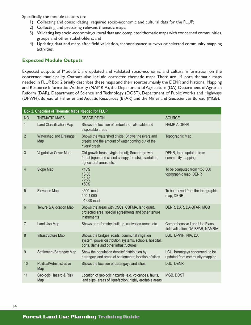
Expected Module Outputs
Expected outputs of Module 2 are updated and validated socio-economic and cultural information on the concerned municipality. Outputs also include corrected thematic maps. There are 14 core thematic maps needed in FLUP. Box 2 briefl y describes these maps and their sources, mainly the DENR and National Mapping and Resource Information Authority (NAMRIA), the Department of Agriculture (DA), Department of Agrarian Reform (DAR), Department of Science and Technology (DOST), Department of Public Works and Highways (DPWH), Bureau of Fisheries and Aquatic Resources (BFAR) and the Mines and Geosciences Bureau (MGB).
Box 2. Checklist of Thematic Maps Needed for FLUPNO. THEMATIC MAPS DESCRIPTION SOURCE1 Land Classifi cation Map Shows the location of timberland, alienable and
disposable areasNAMRIA-DENR
2 Watershed and Drainage Map
Shows the watershed divide; Shows the rivers and creeks and the amount of water coming out of the rivers/ creek
Topographic Map
3 Vegetative Cover Map Old-growth forest (virgin forest); Second-growth forest (open and closed canopy forests), plantation, agricultural areas, etc.
DENR, to be updated from community mapping
4 Slope Map <18%18-3030-50>50%
To be computed from 1:50,000 topographic map, DENR
5 Elevation Map <500 masl500-1,000>1,000 masl
To be derived from the topographic map, DENR
6 Tenure & Allocation Map Shows the areas with CSCs, CBFMA, land grant, protected area, special agreements and other tenure instruments
DENR, DAR, DA-BFAR, MGB
7 Land Use Map Shows agro-forestry, built up, cultivation areas, etc. Comprehensive Land Use Plans, fi eld validation, DA-BFAR, NAMRIA
8 Infrastructure Map Shows the bridges, roads, communal irrigation system, power distribution systems, schools, hospital, ports, dams and other infrastructures
LGU, DPWH, NIA, DA
9 Settlement/Barangay Map Show the population density/ distribution by barangay, and areas of settlements; location of sitios
LGU, barangays concerned, to be updated from community mapping
10 Political/Administrative Map
Shows the location of barangays and sitios LGU, DENR
11 Geologic Hazard & Risk Map
Location of geologic hazards, e.g. volcanoes, faults, land slips, areas of liquefaction, highly erodable areas
MGB, DOST

Forest Land Use Planning Training Guide
15
Box 2. Checklist of Thematic Maps Needed for FLUP12 Confl icts/Issues Map Shows the location of existing and emerging confl icts
in land use allocation plus other issues and concerns related to forest management (.e.g. overlapping tenures/claim, identifi ed boundary confl icts, location of new and old kaingin, location of cutting areas)
To be generated from map overlay analysis and community mapping, DA-BFAR
13 Forestry Projects Map Show forestry operation by various agencies, e.g. reforestation projects
Project documents
14 Mineral Map, if any Shows location of Mineral Production Sharing Agreement, exploration permits, Financial or Technical Assistance Agreements, mining claims
DENR-MGB, LGU
Note: These maps are discussed in details in the Mapping Guidebook.
Module Approach
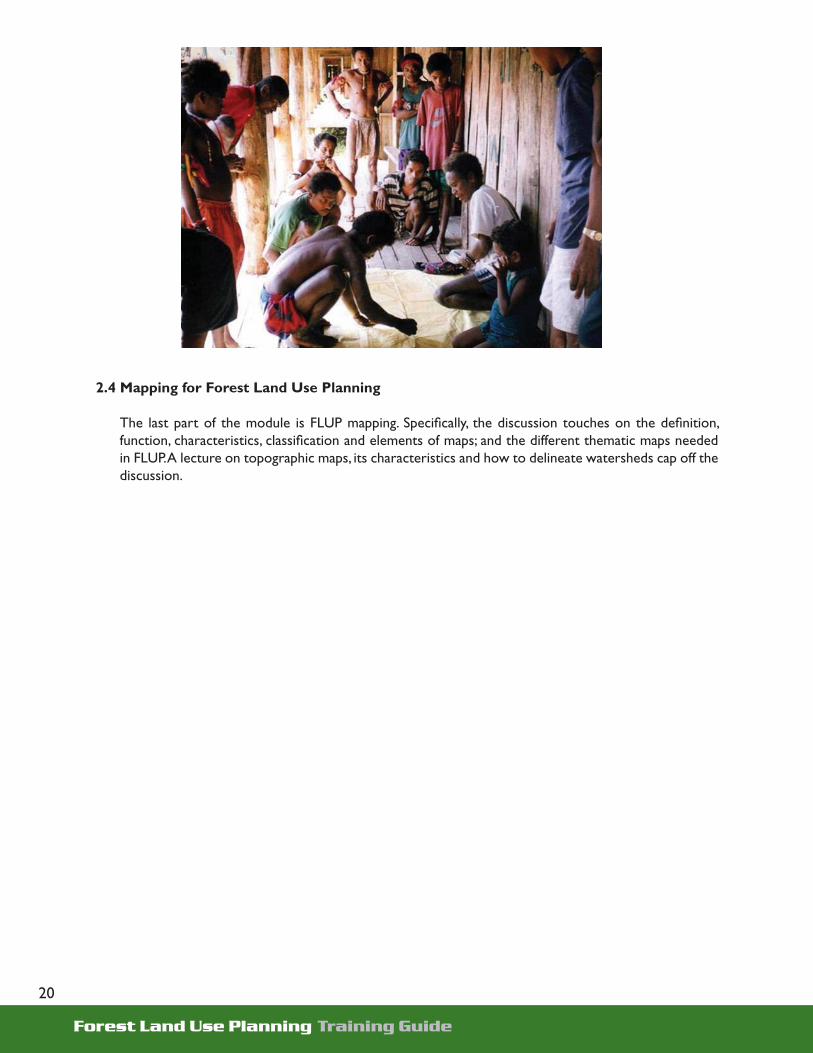
This module starts with organizing the FLUP data gathering teams at the LGU level. The teams organized under Module 1 may be augmented by other representatives from the DENR, LGU or relevant agencies. Once the teams are in place, they are trained on community IEC, mapping and the various techniques of gathering socio-economic and cultural data. This is to inform the various stakeholders about the FLUP before initiating any data gathering activity. The IEC team then proceeds with conducting community IEC about the FLUP after which, barangay data gathering teams are organized. Field data gathering and validation activities follow.
The formal training session starts with preparing an IEC plan for the FLUP activity. An exercise is included where the team prepares IEC presentation materials for the barangays. A stakeholders’ analysis is also to be undertaken to identify the primary stakeholders who will be invited during the community IEC and who would be mobilized to participate in the FLUP. A discussion then follows on the different community profi ling tools/techniques, thematic mapping and map overlay analysis. An exercise/workshop is conducted after the lecture to demonstrate community mapping, Technology of Participation (TOP) in FLUP, watershed delineation and map overlay analysis.
Organizing the FLUP Data Gathering Teams
At the minimum, at least two teams should be created: a) mapping team; and b) community profi ling and IEC team.
For the municipal level, data gathering teams involve members of the TWG and additional representatives from DENR-CENRO, LGUs, (i.e. Municipal Planning and Development Offi ce or MPDO, DAR/Municipal Agrarian Reform Offi ce or MARO) and other relevant agencies. Data gathering teams may also be organized in selected barangays, particularly in the uplands and in areas where there is signifi cant interaction between the barangay residents and forest resources. The Barangay Development Council can be tapped as the data gathering team. Community leaders and members of the TWG were to select the representatives, composed of 10-15 members of both sexes, with young people and adults, and a mix of IPs and migrants in heterogeneous communities.
Each team agrees on the roles, responsibilities and expected outputs of the group. At this point, accountable persons or groups for particular tasks are identifi ed. A detailed action plan is then prepared for the group. It is important that a group, such as the MPDO of local governments, is assigned for proper coordination, communication and collation of information.

Forest Land Use Planning Training Guide
16
Community IEC and Profi ling
Before any fi eld data gathering activity is initiated, the community IEC and profi ling team conducts IEC about forest land use planning in the municipality and its barangays particularly in upland areas. The IEC team undergoes training on IEC and formulates presentation materials for the community. This is to prepare them not only in promoting FLUP but also in enjoining the various stakeholders to participate in the development of the plan.
In the prepared material of the IEC team, it has to be emphasized that FLUP is important in promoting effective management of the community’s FFL. Emphasis is also given on the roles of community members and other stakeholders in the formulation of FLUP.
While conducting community IEC on FLUP, gathering of secondary data can be undertaken by some members of the IEC and Profi ling team. Basic socio-economic and cultural data are collected in appropriate offi ces of the LGU and other national agencies, such as population and migration at two time periods, ethnic composition, economic activities, resources and resource uses, agricultural production, forest-based economic activities, community facilities and infrastructures, stakeholders and community problems, issues, constraints and opportunities. The team may refer to the FLUP data collection guide in Annex A to assist them in the community profi ling activities.
Profi ling of Indigenous Peoples
This session concentrates on gathering information about IPs, who should be mobilized to participate in the formulation of the FLUP. It details the step-by-step process required in profi ling IPs.
Mapping
The municipal mapping team initially collects available thematic maps at the offi ces of the DENR, LGU, NCIP and other agencies. Thematic maps include administrative maps of barangays, drainage, slope, elevation, vegetative cover, location of infrastructures, land classifi cation, tenure, settlements and other maps as identifi ed in box 2.

Forest Land Use Planning Training Guide
17
Since in most cases the maps are in different scales, they should fi rst be converted into uniform scale of 1:50,000 so that the team can perform map overlay analysis. Subsequently, community mapping is undertaken especially in the upland barangays to validate and update the prepared thematic maps and to develop other thematic maps such as issues and hotspots map,
The community mapping team composed of barangay representatives and facilitators then conducts reconnaissance survey of the area to be mapped. Selected areas in the community are observed at this point. A discussion is held to contextualize the community mapping exercise. Details on farm, environment, farm practices and perception about their land, daily routines, livelihood and problems encountered are the foci of discussion. It is important that stakeholders are made aware of existing forest/environmental degradation in the municipality.
The actual mapping exercise begins with a base map preparation. A base map is a rough sketch of the permanent community features such as roads, rivers, creeks, mountain, ridges, peaks, springs, etc. It guides the community in generating community thematic maps. Consolidation and manual contorting of community maps are then conducted to come-up with the technical maps. FLUP teams are expected to produce the following from community mapping: base map; settlement and infrastructure maps; community resource map; existing land and resource use maps; issue map; and proposed allocation map.
The mapping team can refer to the Mapping Guidebook, a supplementary material for the Training Guide on FLUP, for details of mapping procedures and standards.
Validation/Updating of Socio-Economic-Cultural Data and Thematic Maps
The collected data and maps are reviewed and consolidated by the TWG members to identify data gaps and those information which need fi eld validation. Field validation and gathering of data gaps uses participatory community profi ling tools like participatory rural appraisal (PRA), key informant interview, focus group discussion (FGD), transect and community mapping.
Aside from fi eld validation through key informant interviews, FGDs, reconnaissance surveys and community mapping, the FLUP-TWG presents the consolidated data and maps in a general meeting attended by barangay offi cials or representatives, DENR, people’s organizations (POs), NGOs and the LGU. This provides an opportunity for stakeholders to review and update the collected data and maps and provide additional information which may be relevant in forest land use planning.

Forest Land Use Planning Training Guide
18
Participants
Those involved in the conduct of this module are members of the mapping and the community profi ling/IEC teams, which may include members of the TWG and representatives from the DENR and other LGU units (for the data gathering teams at the municipal level); and possibly members of the barangay development council (for the barangay level data gathering teams).
Table 2. Suggested Daily Program for Module 2
Activity Mechanics Estimated Time Allocation
Day 1Preliminaries (opening program) 15 minutesLeveling of expectations/Overview of training objectives and schedule
Technology of Participation method 30 minutes
Walkthrough of past activities Presentation of past activities in Module 1 15 minutesTechnical input: Developing simple IEC plan for forest land use planning
Interactive technical input with powerpoint presentation and open forum
2 hours
Workshop on preparation of FLUP IEC materials Participants will be divided by LGU and each group will design IEC materials for the community IEC
5 hours
Plenary presentation of workshop outputs Group presentation of draft IEC materials 1 hour
Day 2Technical Input: FLUP profi ling thru participatory rural appraisal
Interactive Technical Input – with powerpoint presentation
1 hour
Workshop: Community mapping simulation Map out the following: a) drainage system; b) roads; c) settlements; d) existing claims; and e) existing land uses
1 hour
Profi ling IP communities Interactive discussion on key information for IP profi ling 1 hourTechnical Input: Basic mapping for FLUP Interactive Technical Input – with powerpoint
presentation 1.5 hours
Workshop on watershed delineation Participants delineate watershed divide in topographic map
1 hour
Workshop: Inventory of FLUP data Each LGU prepare an inventory matrix of the availability of FLUP data and maps
1 hour
Action planning for fi eld activities Each LGU team re-adjust the schedule of activities previously prepared in Module 1
30 minutes

Forest Land Use Planning Training Guide
19
Module Content
2.1 Training on Developing Simple IEC Plan for Forest Land Use Planning
The module starts with a discussion on preparing a simple IEC plan. The different communication approaches that may be used at the local level are to be explained with emphasis on the importance of “knowing who you are talking to” to best communicate with locals. A review of communication process and concepts follows. To further demonstrate the communication process, an exercise on message relay or a similar drill maybe given. Some of the questions to ask when developing a simple IEC plan for FLUP are then discussed. These include knowing about the situation, product, target audience or adopters, target audience of the “product” and their profi le, how the product will be positioned, message, channel to use, available resources, and knowing the current or potential “opponents” of the planning effort. To reinforce the learning of the participants, a workshop on preparing FLUP IEC materials is to be conducted.
2.2 FLUP Profi ling: Participatory Rural Appraisal
The procedure on FLUP profi ling, with PRA as an approach, is discussed. In this portion, the FLUP process is reviewed. Then the rationale for community profi ling is discussed, and the PRA is described as well as the steps involved. In data gathering, the focus is on the techniques of key informant interview and focus group discussion.
2.3 Profi ling Indigenous Peoples’ Communities
Unlike other communities, those inhabited by IPs must be dealt with in a different manner. Hence, this module devotes a portion of the discussion on how to prepare a profi le of IP communities.
Locating and identifying IPs is the fi rst step. Ethnolinguistic maps provide information on the location and distribution of IPs. Other useful references available in locating and identifying IP groups are the following: Philippine Culture and Ecosystems Map (1998) by Environmental Science for Social Change; map by the National Council of Churches in the Philippines and the People’s Action for Cultural Ties (1983); and language map published by the Summer Institute of Linguistics (1999). Other materials are available in universities such as Ateneo de Manila and University of the Philippines. Maps of ancestral domains which have been granted CALC/CALT and CADC/CADT are also available at the NCIP.
The demographic data of IPs can be derived from the National Statistics Offi ce, National Museum, NCIP, NGOs, donor or funding agencies/researchers working in areas occupied by IPs, anthropological researches and the LGUs. The social structure of IPs is studied focusing on identifying patterns of social and political organization including forms of family, kinship and marriage since these will impact on land tenure and accompanying belief systems. Examination of IP’s political organization entails identifi cation of traditional community leaders.
Forest Land Use Planning Training Guide
20
2.4 Mapping for Forest Land Use Planning
The last part of the module is FLUP mapping. Specifi cally, the discussion touches on the defi nition, function, characteristics, classifi cation and elements of maps; and the different thematic maps needed in FLUP. A lecture on topographic maps, its characteristics and how to delineate watersheds cap off the discussion.

Forest Land Use Planning Training Guide
21
Module Coverage
Analysis of data and maps gathered as baseline information is the next critical step in forest planning. This will determine the succeeding course of action in coming up with a FLUP.
This module introduces the participants to the essence of conducting situational analysis, a tool in generating preliminary recommendations and identifying issues. It is considered a transition step to the planning phase where various stakeholders use the processed data as basis for decision-making. It provides the step-by-step guide in evaluating the existing condition of the municipality’s FFL through map overlay analysis, simplifi ed simulation techniques and other tools. The analysis is based on the validated socio-economic and cultural information and corrected/updated thematic maps. A primary objective of the module is the sharing and validation of initial fi ndings with key stakeholders, particularly the MDC and SB members, selected community and IP groups.
Specifi cally, the module aims to: 1) Discuss the overall purpose, direction and use of
situational analysis using updated socio-economic, cultural information and revised thematic maps;
2) Generate applicable, relevant and composite maps through overlay analysis;
3) Provide an overall picture of current conditions and recent trends in forests and forest lands;
Module 3Situational
Analysis

Forest Land Use Planning Training Guide
22
4) Provide a more detailed analysis of forests and forest lands using watershed as a planning unit; 5) Generate data to be used in participatory allocation of sub-watersheds and sub-watersheds
prioritization; 6) Identify stakeholders who should be involved in allocation and sub-watershed prioritization decision-
making and plan implementation; 7) Identify confl icting interests and claims among stakeholders and facilitate confl ict resolution; 8) Provide inputs to the IEC/advocacy and capability building components of the FLUP; 9) To identify capability building interventions for the effective implementation of FLUP; 10) Provide inputs to the development of the implementation support plan; and11) Prepare a situational analysis of municipal FFL and validate/disseminate the initial fi ndings with key
stakeholders.
The module involves a three-day formal lecture with coaching workshop and fi eld validation exercises. Including the generation of composite maps, analytical tables, graphs and drafting of the situational analysis report, the practicum will last for about a month.
Expected Module Outputs
By the end of the module, a draft situational analysis should have been completed using the updated socio-economic and cultural information, map overlays and consultations/validations with stakeholders. Tables, charts, thematic maps, derived and composite maps as well as documentation of formal session, coaching workshop and validation activities are also included in the report.
Module Approach
The training session provides a venue for the participants to be assisted in the analysis of the socio-economic–demographic-institutional environment. The objectives of conducting situational analysis are discussed with the participants before stakeholders are oriented on data analysis guidelines.
A demonstration and hands-on exercise on map overlay analysis using actual maps are facilitated to familiarize the participants with the process and enable them to carry out practicum tasks. A guide on criteria to be used, maps to overlay, result interpretation and derived and composite map variables is distributed to the participants followed by a session on manual map overlay and socio-economic data analyses. Initial fi ndings, issues and data gaps are synthesized then issue prioritization and detailing of proposed recommendations.
The practicum sessions allow the LSPs, TWG and technical experts in refi ning their data analysis and addressing data gaps identifi ed. The manual map overlay analysis is completed using the criteria and procedures agreed upon in the session. It is expected that the session will come up with data tables, charts and derived or composite maps that will describe current situation of LGU’s forest lands (e.g., settlements, extent of open areas, allocated areas which are improperly managed, resource-use confl ict areas and other confl ict areas). An Uplands Specialist and a GIS (Geographic Information System) Associate should check the correctness of procedures used and the quality of data and maps produced. The results of the analysis are then synthesized. The summary is to highlight the key features of each sub-watershed within the LGU territory and the boundary and resource use confl icts (per watershed).

Forest Land Use Planning Training Guide
23
Table 3. Suggested Daily Program for Module 3
Activity Mechanics Estimated Time Allocation
Day 1Preliminaries (opening program) 15 minutesLeveling of expectations/Overview of training objectives and schedule
Technology of Participation method 30 minutes
Walkthrough of past activities Presentation of activities undertaken by the TWG under Module 2
30 minutes
General guidelines in conducting situational analysis in forest land use planning
Powerpoint discussion of how to organize and present FLUP data to show trends/patterns
1 hour
Tool of analysis: Map overlaying Demonstrate through powerpoint presentation how to do map overlay
1 hour
Workshop: Determining conditions of FFL assets, threats and its causes, and opportunities for development
Participants to be grouped by LGUs and to examine data and maps to determine trends in natural forests and threats and opportunities
4 hours
Day 2Workshop: Zoning the FFL into production and protection areas
Participants to be grouped by LGUs and to examine data and maps to classify FFL into production and protection areas
2 hours
Workshop: Analyzing sub-watersheds Participants to be grouped by LGUs and to examine data and maps to analyze sub-watersheds
4 hours
Workshop: Stakeholders’ analysis Participants to be grouped by LGUs and to analyze different stakeholders of FFL assets
3 hours
Day 3Workshop: Institutional Analysis Participants to be grouped by LGU and assess the
institutional capabilities of the DENR/LGU2 hours
Plenary presentation of workshop outputs Each group present the workshop outputs 3 hoursWorkshop: Action planning Each group prepares an action plan for completing
the situational analysis report and schedules for the next module. The plan is presented in plenary
1 hour
Action planning Workshop, presentation and discussion of action plan with defi ned roles and responsibilities
1 hour
Module Content
3.1 Conducting Situational Analysis for Forest Land Use Planning
• Situational analysis is conducted to assess current situations and determine threats and opportunities for development of FFLs. It is also done to identify current and planned developments in the LGU that would impact on forest resources and affect stakeholders. The capabilities of the LGU and DENR in carrying out forest lands management are
Outputs of a situational analysis: (1) Brief municipal profi le, including its bio-
physical, socio-economic and cultural characteristics
(2) General trends and conditions of the LGU’s FFL resources including their extent, locations, uses and changes over time
(3) Identifi ed problems, issues, threats and opportunities for management and development of FFL
(4) Comparative sub-watershed analysis(5) Stakeholders’ analysis and institutional
capability assessment
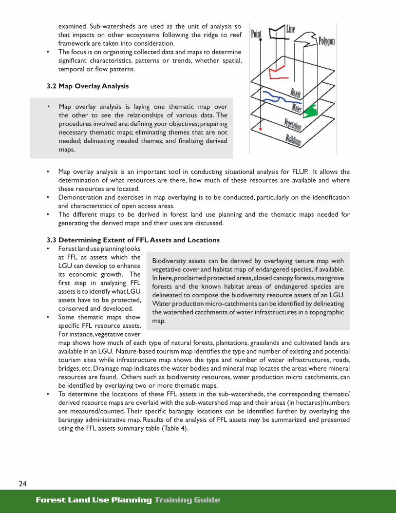
Forest Land Use Planning Training Guide
24
examined. Sub-watersheds are used as the unit of analysis so that impacts on other ecosystems following the ridge to reef framework are taken into consideration.
• The focus is on organizing collected data and maps to determine signifi cant characteristics, patterns or trends, whether spatial, temporal or fl ow patterns.
3.2 Map Overlay Analysis
• Map overlay analysis is an important tool in conducting situational analysis for FLUP. It allows the determination of what resources are there, how much of these resources are available and where these resources are located.
• Demonstration and exercises in map overlaying is to be conducted, particularly on the identifi cation and characteristics of open access areas.
• The different maps to be derived in forest land use planning and the thematic maps needed for generating the derived maps and their uses are discussed.
3.3 Determining Extent of FFL Assets and Locations• Forest land use planning looks
at FFL as assets which the LGU can develop to enhance its economic growth. The fi rst step in analyzing FFL assets is to identify what LGU assets have to be protected, conserved and developed.
• Some thematic maps show specifi c FFL resource assets. For instance, vegetative cover map shows how much of each type of natural forests, plantations, grasslands and cultivated lands are available in an LGU. Nature-based tourism map identifi es the type and number of existing and potential tourism sites while infrastructure map shows the type and number of water infrastructures, roads, bridges, etc. Drainage map indicates the water bodies and mineral map locates the areas where mineral resources are found. Others such as biodiversity resources, water production micro catchments, can be identifi ed by overlaying two or more thematic maps.
• To determine the locations of these FFL assets in the sub-watersheds, the corresponding thematic/derived resource maps are overlaid with the sub-watershed map and their areas (in hectares)/numbers are measured/counted. Their specifi c barangay locations can be identifi ed further by overlaying the barangay administrative map. Results of the analysis of FFL assets may be summarized and presented using the FFL assets summary table (Table 4).
• Map overlay analysis is laying one thematic map over the other to see the relationships of various data. The procedures involved are: defi ning your objectives; preparing necessary thematic maps; eliminating themes that are not needed; delineating needed themes; and fi nalizing derived maps.
Biodiversity assets can be derived by overlaying tenure map with vegetative cover and habitat map of endangered species, if available. In here, proclaimed protected areas, closed canopy forests, mangrove forests and the known habitat areas of endangered species are delineated to compose the biodiversity resource assets of an LGU. Water production micro-catchments can be identifi ed by delineating the watershed catchments of water infrastructures in a topographic map.

Forest Land Use Planning Training Guide
25
Table 4. FFL Assets Guide
FFL Assets Number/Area persub-watershed (SW) & barangays covered
Total area
Maps for overlaying
SW1 SW2 SWn
Total Land Area- Forest lands Land classifi cation + SW map- A&D lands Land classifi cation + SW map
Water bodies and sub-watersheds- Rivers and creeks (km) Drainage + SW map- Area of sub- watersheds (ha) Sub-watershed map
Natural Forests- Closed canopy Vegetative cover + SW map- Open canopy Vegetative cover + SW map- Marginal forests Vegetative cover + SW map- Mangroves Vegetative cover + SW map
Plantations Vegetative cover + SW map
Water production catchments (ha) Water infra + topo + SW map
Water infrastructures- irrigation (no.) Water infra + SW map- domestic water reservoirs (no.) Water infra + SW map - hydro power (no.) Water infra + SW map
Biodiversity assets Tenure + vegetative cover + habitat map
- proclaimed protected areas (ha) Tenure + SW map - known habitats of endangered species (ha or no)
Habitat map if available + SW map or local accounts
- closed canopy forests (ha) Vegetative cover + SW map- mangrove forests (ha) Vegetative cover + SW map- identifi ed endangered species (no & names)
Local accounts or scientifi c studies
Nature-based tourism assets- number of caves Nature based tourism map + SW map- number of waterfalls Nature based tourism map + SW map- number of lakes Nature based tourism map + SW map- other assets
Grasslands & brushlands Vegetative cover + SW map
Cultivated forest lands Vegetative cover + SW map
Mineral lands Mineral map + SW map
Other FFL assets
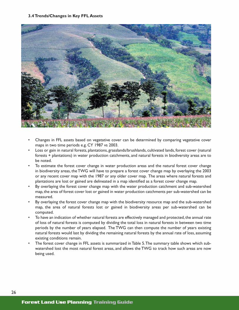
Forest Land Use Planning Training Guide
26
3.4 Trends/Changes in Key FFL Assets
• Changes in FFL assets based on vegetative cover can be determined by comparing vegetative cover maps in two time periods e.g. CY 1987 vs 2003.
• Loss or gain in natural forests, plantations, grasslands/brushlands, cultivated lands, forest cover (natural forests + plantations) in water production catchments, and natural forests in biodiversity areas are to be noted.
• To estimate the forest cover change in water production areas and the natural forest cover change in biodiversity areas, the TWG will have to prepare a forest cover change map by overlaying the 2003 or any recent cover map with the 1987 or any older cover map. The areas where natural forests and plantations are lost or gained are delineated in a map identifi ed as a forest cover change map.
• By overlaying the forest cover change map with the water production catchment and sub-watershed map, the area of forest cover lost or gained in water production catchments per sub-watershed can be measured.
• By overlaying the forest cover change map with the biodiversity resource map and the sub-watershed map, the area of natural forests lost or gained in biodiversity areas per sub-watershed can be computed.
• To have an indication of whether natural forests are effectively managed and protected, the annual rate of loss of natural forests is computed by dividing the total loss in natural forests in between two time periods by the number of years elapsed. The TWG can then compute the number of years existing natural forests would last by dividing the remaining natural forests by the annual rate of loss, assuming existing conditions remain.
• The forest cover change in FFL assets is summarized in Table 5. The summary table shows which sub-watershed lost the most natural forest areas, and allows the TWG to track how such areas are now being used.
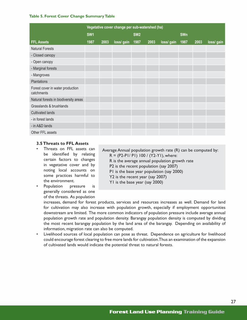
Forest Land Use Planning Training Guide
27
Table 5. Forest Cover Change Summary Table
Vegetative cover change per sub-watershed (ha)
SW1 SW2 SWn
FFL Assets 1987 2003 loss/ gain 1987 2003 loss/ gain 1987 2003 loss/ gainNatural Forests- Closed canopy- Open canopy- Marginal forests- MangrovesPlantationsForest cover in water production catchmentsNatural forests in biodiversity areasGrasslands & brushlandsCultivated lands - in forest lands- in A&D landsOther FFL assets
3.5 Threats to FFL Assets• Threats on FFL assets can
be identifi ed by relating certain factors to changes in vegetative cover and by noting local accounts on some practices harmful to the environment.
• Population pressure is generally considered as one of the threats. As population increases, demand for forest products, services and resources increases as well. Demand for land for cultivation may also increase with population growth, especially if employment opportunities downstream are limited. The more common indicators of population pressure include average annual population growth rate and population density. Barangay population density is computed by dividing the most recent barangay population by the land area of the barangay. Depending on availability of information, migration rate can also be computed.
• Livelihood sources of local population can pose as threat. Dependence on agriculture for livelihood could encourage forest clearing to free more lands for cultivation. Thus an examination of the expansion of cultivated lands would indicate the potential threat to natural forests.
Average Annual population growth rate (R) can be computed by:R = (P2-P1/ P1) 100 / (Y2-Y1), where:R is the average annual population growth rateP2 is the recent population (say 2007)P1 is the base year population (say 2000)Y2 is the recent year (say 2007)Y1 is the base year (say 2000)

Forest Land Use Planning Training Guide
28
• The opening up of roads could trigger migration into forest lands and lead to illegal cutting. By overlaying existing and proposed road system with forest cover change map one could relate the impact of accessibility on FFL assets.
• Other causes of threats can also be explored during the barangay FGD and key informant interviews. For instance, forest/grass fi res could signifi cantly reduce forest cover and increase the areas of grasslands. Open access forest lands are more vulnerable to destruction since nobody is guarding these areas and anybody could enter and exploit the resources. Overlaying the open access map with the forest cover change map could indicate possible relationship between these two parameters.
3.6 Opportunities for Improved Forest Management• The situational analysis including results of key informant interviews and FGD could point out certain
opportunities for improving management of FFL in an LGU. Expanding plantation areas and crops grown would indicate what types of plantations could be promoted and are acceptable to local communities.
• Open, grasslands, brushlands and cultivated areas within production zones would indicate how much areas are available for development into plantations where private sectors could invest.
• Other opportunities would include potential for institutionalizing payment for ecosystem services, existing and proposed industries (that may require raw materials from the forests), interested private investors and external funding agencies.
3.7 Zoning FFL into Production and Protection Areas• To effectively direct government and private investments in forest lands, it is necessary to identify which
areas are suited for production and protection purposes. This way, government can focus its limited funds to the protection of critical resources while the private sector can channel its investments in the production and multiple use areas.
• The fi rst step in zoning FFL is for the TWG to agree on the criteria for production and protection zones. Forest lands for protection purposes include those areas above 50% in slope, more than 1,000 meters in elevation, part of riparian zones, with close canopy forests and mangroves, within proclaimed protected areas, habitats of endangered and threatened wildlife species, and identifi ed micro-catchments which are sources of water for irrigation and domestic use. Forest lands outside the identifi ed protection areas comprise the production areas. The TWG may agree on additional criteria for classifying FFL into production or protection areas.
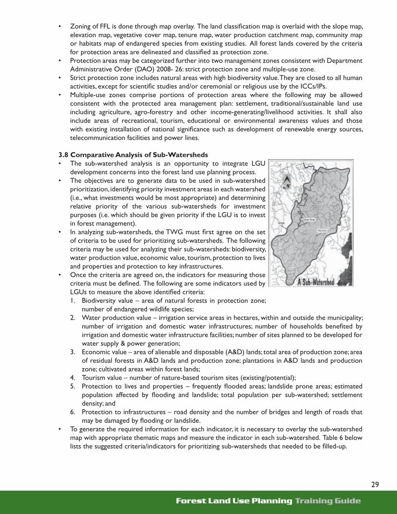
Forest Land Use Planning Training Guide
29
• Zoning of FFL is done through map overlay. The land classifi cation map is overlaid with the slope map, elevation map, vegetative cover map, tenure map, water production catchment map, community map or habitats map of endangered species from existing studies. All forest lands covered by the criteria for protection areas are delineated and classifi ed as protection zone.
• Protection areas may be categorized further into two management zones consistent with Department Administrative Order (DAO) 2008- 26: strict protection zone and multiple-use zone.
• Strict protection zone includes natural areas with high biodiversity value. They are closed to all human activities, except for scientifi c studies and/or ceremonial or religious use by the ICCs/IPs.
• Multiple-use zones comprise portions of protection areas where the following may be allowed consistent with the protected area management plan: settlement, traditional/sustainable land use including agriculture, agro-forestry and other income-generating/livelihood activities. It shall also include areas of recreational, tourism, educational or environmental awareness values and those with existing installation of national signifi cance such as development of renewable energy sources, telecommunication facilities and power lines.
3.8 Comparative Analysis of Sub-Watersheds• The sub-watershed analysis is an opportunity to integrate LGU
development concerns into the forest land use planning process. • The objectives are to generate data to be used in sub-watershed
prioritization, identifying priority investment areas in each watershed (i.e., what investments would be most appropriate) and determining relative priority of the various sub-watersheds for investment purposes (i.e. which should be given priority if the LGU is to invest in forest management).
• In analyzing sub-watersheds, the TWG must fi rst agree on the set of criteria to be used for prioritizing sub-watersheds. The following criteria may be used for analyzing their sub-watersheds: biodiversity, water production value, economic value, tourism, protection to lives and properties and protection to key infrastructures.
• Once the criteria are agreed on, the indicators for measuring those criteria must be defi ned. The following are some indicators used by LGUs to measure the above identifi ed criteria:1. Biodiversity value – area of natural forests in protection zone;
number of endangered wildlife species;2. Water production value – irrigation service areas in hectares, within and outside the municipality;
number of irrigation and domestic water infrastructures; number of households benefi ted by irrigation and domestic water infrastructure facilities; number of sites planned to be developed for water supply & power generation;
3. Economic value – area of alienable and disposable (A&D) lands; total area of production zone; area of residual forests in A&D lands and production zone; plantations in A&D lands and production zone; cultivated areas within forest lands;
4. Tourism value – number of nature-based tourism sites (existing/potential); 5. Protection to lives and properties – frequently fl ooded areas; landslide prone areas; estimated
population affected by fl ooding and landslide; total population per sub-watershed; settlement density; and
6. Protection to infrastructures – road density and the number of bridges and length of roads that may be damaged by fl ooding or landslide.
• To generate the required information for each indicator, it is necessary to overlay the sub-watershed map with appropriate thematic maps and measure the indicator in each sub-watershed. Table 6 below lists the suggested criteria/indicators for prioritizing sub-watersheds that needed to be fi lled-up.

Forest Land Use Planning Training Guide
30
Table 6. Criteria/Indicators for Prioritizing Sub-watersheds
Criteria/Indicators Unit SW1 SW2 SWn … Data sourceSub-watershed area hectares sub-watershed map
A. Biodiversity value 1. Total natural forests within protection zone
hectares Overlay sub-watershed map with protection-production map and delineate protection areas per sub-watershed. Then overlay latest vegetative cover map & measure area of natural forests within the protection zone per sub-watershed
Close canopy hectares Open canopy hectares Mangrove hectares Sub-marginal hectares 2. Presence of endangered species of wildlife
number Based on existing studies and on local accounts, locate sightings of endangered wildlife species in the sub-watershed & drainage map
B. Water Production value 1. Irrigation service areas Overlay water infrastructure map with sub-
watershed map & count number of irrigation, power & domestic water infrastructure in each sub-watershed. For each infrastructure, determine the service areas (in hectares), and number of households benefi ted through key informant interview w/ NIA/ MAO/ LGU offi cials & local community members. Identify areas planned to be developed for irrigation, power & domestic water supply
Within the LGU hectares Outside the LGU hectares 2. Number of households benefi ted
By Irrigation facilities number By domestic water infra number 3. Number of irrigation, power & domestic water infrastructure
number
4. Areas planned to be developed for irrigation, power & domestic water supply
number
C. Economic Production value 1. Total A&D lands hectares Overlay land classifi cation map with sub-
watershed map 2. Total production areas within forest lands
hectares Overlay production- protection map w/ sub-watershed map
3. Residual forests in A&D lands and production zones
hectares Overlay latest cover map w/ LC, sub-watershed and production-protection zone map & delineate areas within A&D lands and production forest lands covered with residual forests and plantations
4. Plantations in A&D lands and production zones
hectares
5. Cultivated areas within forest lands hectares Overlay latest cover map w/ LC, & sub-watershed map & delineate cultivated areas within forest lands per sub-watershed
D. Nature-based tourism value 1. Number of nature-based tourism sites Overlay nature-based tourism map w/
sub-watershed map and count the number of existing & potential tourism sites per sub-watershed
Existing number Potential number

Forest Land Use Planning Training Guide
31
Criteria/Indicators Unit SW1 SW2 SWn … Data source
E. Protection to lives and properties
1. Frequently fl ooded areas hectares Overlay hazard map w/ sub-watershed map & measure total area of fl ood prone and landslide prone sites per sub-watershed. Identify the barangays within the fl ood and landslide prone sites and estimate the population likely to be affected
2. Landslide prone areas hectares 3. Estimated population affected by fl ooding and landslide
number
4. Total population number Overlay barangay admin map & sub-watershed map & identify barangays within each sub-watershed. Add the barangay populations for each sub-watershed
5. Settlement density No./ha. Add the number of households of all barangays within each sub-watershed and divide by the sub-watershed area
F. Protection to infrastructures 1. Number of bridges which may be damaged by fl ooding or landslide
number Overlay infrastructure map with sub-watershed map & count the number of bridges per sub-watershed
2. Road density Kms/ha. Overlay road network map with sub-watershed map and add total length of roads within each sub-watershed divided by the sub-watershed area
3. Other infrastructure which may be damaged
G. Other criteria
3.9 Stakeholders’ Analysis• Stakeholders’ analysis is a systematic process of identifying the key groups, individuals, institutions,5
organizations or sectors that have legitimate interests in specifi c forest lands areas or may be affected by decisions on the use of FFL. This analysis is important to better understand the interests towards forest lands, their relationships, actual and potential confl icts among them and develop strategies to gain their support in FLUP implementation.
• The steps in conducting stakeholders’ analysis6 are:1. Identify the stakeholders2. Identify the specifi c interests and mandates of the stakeholders3. Assess the stakeholders’ importance to the success of FLUP4. Assess their strengths, weaknesses, constraints and confl icts with other stakeholders that may
affect their involvement in FFM5. Identify what can be done to gain their support and reduce confl icts 6. Summarize the analysis in a stakeholders’ matrix
• The stakeholders will have to be prioritized based on their importance to FLUP formulation and implementation. The strengths, weaknesses and constraints of stakeholders must be evaluated to assess their capability to participate in FLUP implementation (e.g. Do they have the fi nancial resources and adequate understanding of FFL related issues or confl ict with other stakeholders? What is the nature of confl ict? Do they have linkages with other groups and institutions? Are they potential supporter or opposition to FLUP implementation?).

Forest Land Use Planning Training Guide
32
• The TWG will agree among themselves on the “importance criteria” and decide who among the identifi ed stakeholders will be given priority consideration in designing the IEC strategy. The importance criteria may include their role in budget allocation, approval of work plans, deployment of personnel, policy formulation and enforcement, sustaining on site activities, direct impact on their livelihood, etc.
• Based on the assessment, the TWG will have to identify IEC and technical strategies to gain support from the stakeholders and reduce opposition on FLUP implementation. This may include production of information materials, conducting consultations to identify appropriate technical strategies and multi-stakeholder monitoring and evaluation. The analysis will be a basis for the TWG to ensure all relevant stakeholders are involved in the validation and consensus building on FFL allocation and sub-watershed prioritization.
3.10 Institutional Analysis• The institutional analysis gives an indication of the existing capabilities of the DENR and the municipal/
city LGU for joint FFL management. The TWG examines the DENR and LGU organizational structure in relation to FFM, the existing staff, their FFM related skills, budget, linkages with other institutions, forest law enforcement arrangements and existing and proposed FFM programs/projects.
• Objectives of the analysis are to: (i) assess current capability to implement the FLUP; (ii) identify capability building interventions for the effective FLUP implementation; (iii) provide inputs to the development of the implementation support and organizational management component of the plan.
• The organizational analysis is conducted by members of the TWG using the institutional assessment matrix found below.
Table 7. Institutional Assessment Matrix
Parameters DENR Municipal LGUExisting FFM Unit (specify name of unit if present, indicate N if none)FFM staff (no.)FFM skills (check if skill is present and cross if not available) - resource management planning- facilitating recognition of individual property rights- farm planning- forest protection and enforcement- agroforestry- tree plantation establishment- community organizing- monitoring and evaluation- investment profi lingCurrent Annual FFM budget (in Philippine pesos)If there is no current FFM allocation, how much can the LGU allocate Existing linkages with other agencies (names of agencies & nature of linkages)Past, existing and proposed projects related to FFMDescribe existing FFM, forest law enforcement and M&E bodies and arrangements.- are they effective?- problems encounteredOther considerations (e.g. local ordinances passed related to FFM)

Forest Land Use Planning Training Guide
33
Module Coverage
First-hand observations of successful forest management activities are useful in increasing appreciation of relevant and doable courses of actions, and demonstrate the importance of good governance processes in planning, allocating and managing FFL. From the observed experiences of other LGUs which have formulated, validated, implemented and legitimized FLUP, participants may come up with ideas of their own on how to incorporate the TAP processes in the development and implementation of the FLUP.
The exposure trip shall facilitate broader understanding of the need for pro-active engagement of LGUs in forest lands management. In addition, it explores positive implications of planning and implementing co-management agreements between and among the DENR, LGUs and communities. Observations and lessons learned on best practices in forest and watershed management from this module are used as inputs to subsequent FLUP activities.
Seven days are allotted for the cross visits and exposure trips. Observations and learning should be recorded to serve as reference for future decision-making.
Module 4Cross Visit and Exposure Trip

Forest Land Use Planning Training Guide
34
Expected Module Outputs
The participants are required to come up with a documentation report containing all lessons learned. The report may contain photos of the sites visited and the team’s recommendations (if there are any that the team has formulated right after the cross visit). The participants should prepare re-entry/activity plans to effect the echoing of the lessons learned from the activity. Prior to the actual trip, preparatory activities must be carried out. It is very important that the following are not missed in the activity: Site selection, sending prior notice, making arrangements to host agencies and follow through activities.
Module Approach
This module provides opportunity for LGUs to observe and learn from other LGUs that have initiated and championed the campaign for good environmental management.
During the exposure trip, the host LGU/Project Management provides an orientation and overview of their environmental project particularly on its rationale, TAP processes followed, public/private investments, project status, management organization, M&E system and key lessons learned in project implementation. Cordial exchanges of ideas, experiences and observations of the participants and hosts follow the presentation. The use of audio-visual and printed materials to enhance the learning process is encouraged.
This is supplemented by an actual visit to the project sites so that the participants will have an opportunity to directly observe fi eld activities, interact with local communities and synthesize learning that may work in their respective municipalities. Before leaving the site visited, participants are given orientation/ briefi ng and forms for documentation and other training materials. Small groups are formed to facilitate group management responsibility and accountability. Leaders and secretaries are selected to manage the small groups’ activities. Refl ection sessions and group observations synthesis are organized before the end of the day.

Forest Land Use Planning Training Guide
35
In this activity, the participants are given time to share their observations and the lessons learned from every site visited. The rapporteurs’ documentation is collected after each refl ection sessions for synthesis. A post-training evaluation session is facilitated after all the sites had been visited to synthesize all lessons learned into one document to be distributed among the LGUs concerned. The post-training evaluation is administered to gather information that can be used by the facilitator to identify areas for improvement in conducting similar activity in the future.
Site selection
Basically, the site selection process is done ahead of time to weigh the merits each site has in relation to the needs of visiting participants. This way, the transfer of learning process becomes facilitative. The site selection process also considers the relevance of the environmental projects to be visited and whether it can be replicated. These considerations will encourage the visiting LGUs to replicate good environmental governance practices in the management of their FFL. Similarity of site characteristics can motivate the LGUs to respond and act in the call for environmental development, management and protection.
Prior notice and arrangements
Advance notice provide the host teams prior information on the interests of the visiting teams. This way, the host teams can make necessary preparations ahead of time and could ensure smooth fl ow of activities within the site, while visiting groups can have a better idea of what to expect and what to prepare in respect to the site conditions and the host teams. Responsibility-sharing is mutually arranged between the visiting and the host teams in this activity.
Process documentation
Aside from the documentation undertaken by the facilitator, a documentation report is also required from the group. Each small group is required to submit their synthesized documentation reports (documentation from the fi rst day up to the last day of the activity). If the LGU has several groups, all groups are required to submit the integrated synthesized documentation report.
Photo documentation, briefi ng materials, and other informative materials related to the sites visited are requested from host teams whenever available. Forms for documentation are also distributed among the participants.
Participants
Local offi cials from the mayor’s offi ce, local policymakers, other local government unit heads, the DENR and staff and members of the multi-sectoral municipal TWG are given the opportunity to participate in an exposure trip to various LGU-led good environmental management initiatives and practices.

Forest Land Use Planning Training Guide
36
Module Content
While the training does not necessarily require lecture notes, it is important that the participants are provided with a copy of the activity design and a briefi ng kit of the areas to be visited. The briefi ng kit must contain the information that provides guidance to the participants on the following:
1. Daily schedule of activities 2. List of project sites to be visited with brief information on the peculiar characteristics of the project
sites (if available)3. List of contact persons4. Forms for documentation and other training kit5. Other travel guidelines
To facilitate the refl ection sessions, the participants are guided with a site documentation form to be fi lled up while doing the observations and having discussions with the host agencies/groups. This is also used in the synthesis of the groups’ learnings and observations from each project site.

Forest Land Use Planning Training Guide
37
Module Coverage
The participatory approach in the planning process cannot be understated. Increasing involvement of key stakeholders is one concrete application of good governance in sustainable forestry management since it creates an equitable environment where various interests of different stakeholders are considered in maximizing benefi ts from use of forest areas.
Module 5 is designed as a training and simulation exercise for the municipal FLUP team. Primarily, the module orients the TWG on policies and relevant criteria for allocating FFL and prioritizing sub-watersheds. It lays-out actual consensus-building activities and planning for the allocation of FFL. It assists LGUs on identifying and agreeing on quantitative and qualitative criteria for allocating and prioritizing sub-watersheds within the municipality. The module exercises facilitate generation of preliminary recommendations for the allocation of FFL. Furthermore, it walks the participants through potential problem analysis that equips them in forecasting and acting on issues and concerns that may arise. Finally, the module is directed at developing a plan and strategy for validation of the module’s outputs.
Specifi cally, the module has the following objectives: 1) discuss the results of the situational analysis including actual and emerging issues/confl icts in the FFL management; 2) formulate stakeholders’ vision for FFL to
Module 5Participatory
Process in Planning the Allocation of
Forests andForest Lands
and Prioritizing
Sub-Watersheds

Forest Land Use Planning Training Guide
38
be later discussed with barangays, SB members, the DENR, NGOs, community leaders, private sector, religious groups, etc.; 3) conduct a preliminary prioritization of sub-watersheds based on agreed criteria; 4) examine various options/strategies that may be adopted by the DENR, LGUs, communities and other stakeholders in closing open access FFL and to come-up with preliminary forest lands allocation; 5) identify and discuss potential strategies on how to protect, develop and manage priority sub-watersheds, and open access FFL; and 6) develop an action plan in carrying-out validation of the situation analysis, issues, vision, prioritized sub-watersheds, options for closing open access and, protecting and managing sub-watersheds.
The three-day module is expected to produce: (i) a set of criteria for generating preliminary but recommendatory FFL allocation and management plan; (ii) a set of criteria for prioritizing sub-watersheds; and (iii) initial allocation plan for FFL and prioritization of sub-watersheds based on the agreed sets of criteria. Participants to the module include LGU’s TWG members and representatives from indigenous groups, the NCIP, the private sector and the DENR, PENRO and CENRO.
Module Approach
The module starts with a review of past FLUP activities conducted in the municipality where focus is given on identifying TAP mechanisms used in the process. Key fi ndings in the situational analysis are presented with highlights on illegal cutting, forest land conversion, boundary and resource confl icts and other problems determined in the situational analysis. A visioning exercise using the TOP method is then facilitated.
Next, discussions center on allocation and tenure instruments. Emphasis is given on policy considerations in the allocation of FFL. A guide in the FFL allocation using biodiversity, bio-physical and socio-cultural criteria is presented to the group followed by a workshop on the application of allocation concepts. Afterwards, the group discusses strategies and recommendations on the following issues: 1) improving management of currently allocated FFL; 2) allocating forest lands with existing/confl icting claims; 3) allocating forest lands with existing/confl icting claim but without confl icts; and 4) allocating forest lands without claims.
The workshop then moves on to prioritization of sub-watersheds for investments. The groups are fi rst oriented on the rationale for prioritization, how to prioritize and the criteria used. Finally, a workshop is conducted on the application of criteria for prioritizing sub-watersheds.

Forest Land Use Planning Training Guide
39
In addition, discussion on IEC/advocacy inputs is facilitated with consideration of results of stakeholder analysis, synthesis of issues, FLUP legitimization process and advocacy needs. The activity ends with tasking or action planning on the drafting of the municipal FLUP and the conduct of multi-sectoral and expanded stakeholders’ consultation and advocacy work.
Table 8. Suggested Daily Program for Module 5
Activity Mechanics Estimated Time Allocation
Day 1Preliminaries (opening program) 15 minutesLeveling of expectations/Overview of training objectives and schedule
Technology of Participation method 30 minutes
Walkthrough of past activities Presentation of activities undertaken by the TWG in previous module
30 minutes
Technical input: Categories of allocation and tenure instruments
Lecture using powerpoint presentation 30 minutes
Technical input: Examples of commonly issued tenure instruments
Discussion of specifi c types of tenure instruments issued to communities, private investors and LGUs
1 hour
Technical Input: Guides in allocating FFL Powerpoint presentation on key steps 1 hourWorkshop: Determining allocation decision areas
Participants (group by LGU) defi ne criteria for zoning FFL and overlay maps to derive management zones
4 hours
Day 2Workshop: Determining allocations of open access areas
Participants (group by LGU) defi ne criteria for allocation and overlay maps to come up with preliminary allocation
4 hours
Plenary presentation of workshop outputs Each group presents the workshop outputs in plenary discussion
2 hours
Technical Input on Prioritization of Sub-Watersheds
Lecture using powerpoint or other means of presentation 1 hour
Workshop on Prioritization of Sub-Watersheds Participants (group by LGU) defi ne criteria for prioritization and decide on priority watersheds
1 hour
Day 3Workshop on Prioritization of Sub-Watersheds Participants (group by LGU) defi ne criteria for
prioritization and decide on priority watersheds 4 hours
Plenary presentation of workshop outputs Each group presents the workshop outputs in plenary discussion
2 hours
Action planning for completing Module 5 and schedules for Module 6
1 hour
Forest Land Use Planning Training Guide
40
Module Content
5.1 Categories of Allocation and Tenure Instruments in Forests and Forest Lands • The lecture begins with a review of previous discussions, particularly on the key FLUP concepts,
governance of FFL as assets,7 and responsibilities of stakeholders.• The basis of the State in protecting and managing FFL assets through stakeholders is again explained.
The existing national policies for the allocation and management of forests to achieve different objectives are reviewed. Among these include the conservation of biodiversity and the capacity to provide environmental services; production of food, forest and agro-forestry products; protection of prior rights and cultural heritage via ancestral domains; economic justice and poverty alleviation; research/academic; ecotourism, industrial use; and settlements/poverty/equity. Other considerations are also discussed, such as occupancy and indigenous claims; bio-physical considerations; organizational and institutional capacity; and other external factors that could affect FFL allocation.
• Allocation is always a socio-eco-political decision thus, should be anchored on accurate and equally accessible information, participatory processes, transparency, accountability, and sound technical analysis. The allocation of FFL provides the ultimate enforcement mechanism as resource managers exercise rights and privileges over FFL assigned to them.
• Key concepts involved in the allocation and management of FFL is discussed. The different categories of forest lands allocation and management are differentiated. Also included in the lecture are the topics on existing forest lands allocations at the national level by accountability center, and the total economic value of selected tenurial arrangements in the Philippines.
5.2 Guides to Allocating Forests and Forest Lands• Since different types of tenure instruments have varied purposes and uses, it is necessary to classify
FFL fi rst into production or protection areas. The zoning map derived during the situational analysis will be used as one of the basis in allocating FFL.
• There are four major steps in allocating FFL. First is to defi ne critical allocation decision areas in forest lands and indicate their location in maps. Second, examine the decision areas, describe the problem, identify and evaluate options and make recommendations. The discussions and agreed recommendations are to be documented. Third, evaluate the preliminary land allocation based on environmental, legal, equity, economic and political considerations. The fi nal step is to validate, refi ne and fi nalize the recommended allocations, along with the map.
• There are four allocation decision areas that should be examined, namely: 1. Unallocated FFL with confl icting claims2. Unallocated FFL with one claimant3. Unallocated forest lands without claims4. Tenured forest lands without effective management
• Each allocation decision area as refl ected in the map should be examined separately. For tenured but unmanaged forest lands, for example, some of the questions that should be discussed are:
o What is the existing tenure, who is the current tenure holder, when is existing tenure instrument expiring?
o Why is the area considered “unmanaged”?o What are options to put the area under effective management? What are advantages and
disadvantages of each option? o What measures should be taken to ensure effective area management? · .For unallocated but with one or more confl icting claims, the TWG can examine: o Who are the claimants? Basis and the status of their claims?o What are the options to resolve confl icting claims? (allocate to claimant, or other stakeholders,

Forest Land Use Planning Training Guide
41
joint management, other tenure arrangements)o What are the applicable tenure instruments based on existing policies, bio-physical conditions,
current uses, and capabilities of potential tenure holder, o Refl ect preliminary allocation in the map · In evaluating preliminary land allocations, the following should be considered:o Is it consistent with existing policies?o Is it equitably allocated?o Is it environmentally sound? o Can the proposed tenure holder invest in managing the area?o Is it acceptable to all stakeholders including the political leaders?
5.3 Examples of Commonly Issued Tenure Instruments in FFL• Various tenure instruments are available, depending on whether the involvement is by the communities,
investors or LGUs. FFL can also be allocated through legislations and Presidential Proclamations to government agencies for specifi c purposes (e.g. educational purposes) and to meet public goods and services (e.g. biodiversity, water or energy).
• Tenure instruments available for communities are: Community-Based Forest Management Agreement (CBFMA); Certifi cate of Ancestral Domain Titles (CADT); and Protected Area Community-Based Resource Management Agreement (PACBRMA).
o A. Community-Based Forest Management Agreement Governing policy: Took effect through Executive Order (EO) No. 263 issued on
July 1995; DAO 29 Series of 1996 (Implementing Rules and Regulations)
Period of tenure: 25 years, renewable for another 25 years
Who can participate: A group of at least 10 local Filipino citizens (or an existing PO) residing inside or near forest lands
General Application Requirements: A group of local residents may submit its application – together with the required endorsements from the barangay and municipal/city councils – to CENRO. After a series of meetings and consultations, a CBFM area will be selected by the community, CENRO and the LGU. Applicants should form an organization (if one has not been formed yet) and have it registered with the Security and Exchange Commission (SEC) or the Cooperative Development Authority (CDA)
Issuing Authority: PENRO - up to 5,000 ha; RED - 5,000-15,000 ha; Undersecretary for Operations - more than 15,000 to 30,000 ha; Secretary - more than 30,000 ha

Forest Land Use Planning Training Guide
42
Rights, Privileges of Tenure Holder: Tenure holder may occupy/use/develop forest lands within designated area; allocate to members and enforce rights to use and sustainably manage forest land resources; be exempted from paying land rent and forest charges on timber and non-timber products harvested from plantations; be consulted on all government projects in the area, be given preferential access to all available assistance in the development of the area; receive income/proceeds from use of forest resources within the area; enter into contracts with private/government entities, allocate/endorse areas to be placed under Certifi cate of Stewardship Contract
Example of Allowable activities: Forest protection, reforestation, agro-forestry, harvesting of non-timber and timber forest products
General Roles, Responsibilities: Tenure Holder: Prepare/implement plans, including resource use plans;
promote transparent and participatory management; pay forest charges (other than those for timber/non-timber products harvested from plantation areas)
LGU: Together with the DENR, monitor implementation in the area; provide technical and other assistance
Issuing authority: Together with the LGU, monitor implementation in the area; provide technical and other assistance
o B. Certifi cate of Ancestral Domain Titles Governing policy: RA No. 8371, issued in 1997
Period of tenure: Tenure is perpetual
Who can participate: Indigenous cultural communities (ICCs)/indigenous people. Non-members may be allowed under special circumstances
General Application Requirements:
• Proofs that include the testimony of elders or community under oath. Other documents directly or indirectly attesting to the possession or occupation of the area since time immemorial, namely: o written accounts of the ICCs/IPs customs, traditions, political
structure and institutions; o photos showing long-term occupation such as those of old
improvements, burial grounds, sacred places and old villages;o historical accounts including agreements and pacts concerning
boundaries entered into by the ICCs/IPs concerned with other ICCs/IPs;
• survey plans and sketch maps • anthropological data and genealogical surveys • pictures and descriptive histories of traditional communal forests and
hunting grounds • pictures and descriptive histories of traditional landmarks such as
mountains, rivers, creeks, ridges, hills, terraces and the like • write-ups of names and places derived from the native dialect of the
community

Forest Land Use Planning Training Guide
43
Issuing Authority: National Commission on Indigenous Peoples
Rights, Privileges of Tenure Holder:
The ICCs/IPs shall have the priority rights in the harvesting, extraction, development or exploitation of any natural resources within the ancestral domains.
Example of Allowable Activities: Forest protection, reforestation, agro-forestry; harvesting of non-timber and timber products
General Roles, ResponsibilitiesTenure Holder: Develop, control and use lands/territories traditionally occupied, owned, or
used; manage and conserve natural resources within the territories; maintain ecological balance; restore denuded areas and observe laws
Issuing authority: With the consent and involvement of the ICC/IP, initiate delineation of ancestral domain, preparation of perimeter maps, publication of preliminary census and report of investigation on the area covered, issuance and registration of CADT
o C. Protected Area Community-Based Resource Management Agreement Governing policy: DAO 2002-02 which repealed DAO 2000-44
Period of tenure: 25 years renewable for another 25 years
Who can participate: Duly organized tenured migrant communities (including interested IPs) who have been actually and continuously occupying a portion of the protected area for at least 5 years (in accordance with the National Integrated Protected Areas Systems or NIPAS Law) and solely dependent therein for subsistence
General Application Requirements:
For tenured migrant communities • accomplished application form • certifi cate of registration • list of offi cers and members (including address and name of spouse if
any) certifi ed by the Protected Area Management Board (PAMB) and resolution from the PO allowing the fi ling of the application.
For interested IPs • accomplished form • NCIP certifi cation• list of council of elders and names of IPs • proof of consent from the council of elders to apply for a PACBRMA.
Issuing Authority: DENR (the RED shall approve the instrument upon endorsement by the PAMB for areas not exceeding 15,000 ha; the DENR Secretary is the approving authority for areas more than 15,000 ha)
Rights, Privileges of Tenure Holder:
Allocate the entire or portion of the area without creating any vested right therein; develop the area allocated; receive income and proceeds from the development of areas; be informed and consulted on projects to be implemented in the area

Forest Land Use Planning Training Guide
44
Allowable activities: Reforestation, protection, sustainable use of forest products inside multiple-use and buffer zones, except any form of logging or timber cutting involving the natural forest
General Roles, Responsibilities:Tenure Holder: Formulate a Community Resource Management Plan, which should be
consistent with the Protected Area Management Plan, specifying activities pertinent to the management, development, use, conservation and protection of the resources in the coverage area
LGU: Be an active part of the PAMB which endorses the application; inform DENR of the LGU’s action on the tenure application in view of the recently-issued DENR-DILG (Department of the Interior and Local Government) Joint Memorandum Circular (JMC) 2003-01; and provide technical and other assistance
Issuing authority: Protected Area and Wildlife Bureau and the regional offi ce shall undertake periodic monitoring and evaluation of the Community-based program. The PAMB in coordination with CENRO, shall monitor compliance with the terms and conditions of the PACBRMA holder
• Arrangement options are varied for investors. These include the Integrated Forest Management Agreement (IFMA) and Socialized Industrial Forest Management Agreement (SIFMA).
o A. Integrated Forest Management Agreement Governing policy: DAO 99-53, issued in 1999
Period of tenure: 25 years, renewable for another 25 years
Who can participate: Filipino citizens of legal age who are technically and fi nancially capable; partnerships, cooperatives or corporations which are either 100% Filipino owned or 60% owned by Filipinos and 40% owned by foreigners, duly registered under Philippine laws
General Application Requirements:
Accomplished application form with fi ling fee of P0.50/ha and survey fee of P50/ha; for corporations, partnerships or cooperatives – corporation papers certifi ed by SEC or the CDA, Articles of Incorporation and By-Laws certifi ed by the Board Secretary; audited fi nancial statements, proof of fi nancial and technical capability, board resolution authorizing any of the offi cers to fi le the application in behalf of the corporation, cooperative and/or partnership duly certifi ed by the Board Secretary
Issuing Authority: The DENR Secretary, upon the recommendation of the Forest Management Bureau or FMB, shall approve (or disapprove) the IFMA, after which the notice of approval shall be sent to the applicant, copy furnished the FMB, RED, PENRO, CENRO and the LGUs concerned
Rights, Privileges of Tenure Holder:
Develop, manage, protect and use a specifi ed area of forest land and its resource; harvest, sell and use planted trees and crops consistent with the principle of sustainable development

Forest Land Use Planning Training Guide
45
Allowable activities: Reforestation, forest protection, harvesting of non-timber and timber products
General Roles, ResponsibilitiesTenure Holder: Conduct delineation and marking on the ground of the perimeter boundaries
of the IFMA area, including conduct of timber inventory; submit within one year from the date the IFMA was awarded a Comprehensive Development and Management Plan (CDMP) and an Initial Environmental Examination (IEE) for issuance of an Environmental Compliance Certifi cate (ECC); submit within one year (and every fi ve years thereafter) up-to-date aerial photos of the entire IFMA area
LGU: Assist in consultation sessions with communities about the delineation of the area for IFMA purposes; endorse delineated areas
Issuing authority: Make available to IFMA applicant existing information on the status of the land, resources and dependent communities within or adjacent to the IFMA areas; ensure that IFMA holder complies with the conditions agreed upon; assist the IFMA holder and host communities in the development and implementation of mutually benefi cial agreements
o B. Socialized Industrial Forest Management Agreement Governing policy: DAO 96-24, issued in August 1996
Period of tenure: 25 years, renewable for another 25 years
Who can participate: Individuals or families who are Filipino citizens, of legal age and preferably residents of the municipality where SIFMA area is located; government employees with consent of their respective heads of agency; and cooperatives and associations whose members are Filipino citizens and residents of the province where the SIFMA site is located
General Application Requirements:
Individuals, cooperatives and associations may fi le their application for a SIFMA with CENRO, paying the appropriate fi ling fees (depending on the land area applied for). For individuals/families, community tax certifi cates are needed; for cooperatives or associations, certifi ed true copy of the Certifi cate of Registration with the CDA or SEC; list of duly elected offi cers and members and their addresses and resolution (certifi ed by the Board Secretary), indicating the cooperative’s or association’s interest in participating in the program
Issuing Authority: PENRO (from 1 to 10 ha); RED (more than 10 to 500 ha)
Rights, Privileges of Tenure Holder:
Harvest, sell and use planted trees and crops except those retained for environmental purposes; export logs, lumber and other forest products (as long as they area allowed by the government) harvested from SIFMA area; be exempt from forest charges of all plantation products
Allowable activities: Reforestation, forest protection, harvesting of timber and non-timber products from plantations

Forest Land Use Planning Training Guide
46
General Roles, ResponsibilitiesTenure Holder: Rehabilitate open and denuded areas; protect existing natural forest
vegetation; plant forest tree species, which may include rubber or non-timber species like rattan, bamboo, etc. in not less than 90% of the planting area (the remaining areas shall be devoted to permanent agricultural purposes)
LGU: Together with the DENR, endorse validated SIFMA sites and conduct an information campaign about the program
Issuing authority: RED approves applications; issues cancellation orders and approves transfers of SIFMA areas that are more than 10 ha up to 500 ha. PENRO shall do the same for areas of up to 10 ha. PENRO shall maintain a database of all SIFMAs in the province and evaluate reports submitted by CENRO, which is directly responsible for implementing SIFMA within its jurisdiction (together with concerned government and non-government units). The CENRO shall also be responsible for site identifi cation, processing of SIFMA applications, and monitoring and evaluation of the program implementation
• Local governments can also be involved in the allocation of FFL by entering into a co-management agreement. A more detailed discussion on co-management could be found in EcoGov’s Frequently Asked Questions: DENR-DILG-LGU Partnership in Forest Management Primer.
Governing policy: RA 7160 mandates that LGUs shall share with the national government the responsibility in the management and maintenance of ecological balance within their territorial jurisdiction. Under DENR-DILG JMC 2003-01 and DENR-DILG JMC 98-01, LGUs can enter into co-management agreement with the DENR
Period of tenure: 25 years, subject for renewal
Who can participate: Individual LGU or cluster of LGUs
General Application Requirements:
LGUs should signify their interest in co-managing FFL (such as establishing community watersheds, tree parks, greenbelts, reforestation and other co-management areas) to CENRO. Once everything has been agreed upon, a MOA shall be executed signed by the DENR and LGU and witnessed by a DILG representative
Issuing Authority: Based on the size of the area to be co-managed, the DENR offi cers authorized to enter into a MOA are: CENRO – forest areas up to 1,000 ha; PENRO – more than 1,000 up to 5,000 ha; RED – more than 5,000 up to 15,000 ha; Undersecretary for Operations – more than 15,000 up to 30,000 ha; and Secretary – more than 30,000 ha

Forest Land Use Planning Training Guide
47
Rights, Privileges of Tenure Holder:
The MOA defi nes the tenure holder’s rights/privileges; they may include developing, managing, protecting and using a specifi ed area of forest land and its resource; harvest, sell and use planted trees and crops consistent with the principle of sustainable development. Under JMC 2003-01, the LGU has to be consulted by the DENR when it comes to any tenure application in FFL under the LGU’s jurisdiction
Allowable activities: Allowable activities are specifi ed in the MOA, which may include reforestation, forest protection, harvesting of non-timber and timber products, agro-forestry
General Roles, Responsibilities: MOA between the DENR and LGU specifi es each other’s roles and responsibilities
LGU: Provide the necessary funds to make the devolution, partnership and co-management work; approve the FLUP and enact it as ordinance; inform the DENR of the action taken by the LGU within 15 days from the date of receipt of document from the DENR regarding any tenure application within its jurisdiction
Issuing authority: Initiate coordination meetings with the DILG and the LGU, provide technical assistance to the LGU, approve LGU’s FLUPs; deputize LGU offi cials as environmental and natural resources offi cers
5.4 Prioritizing Sub-Watersheds for Investments• Discussion on this portion jumps off by answering why there is a need to prioritize sub-watersheds.• Prioritizing sub-watersheds will be done through the use of the Delphi approach, a process of reaching
a consensus through democratic or participatory process (the pros and cons and the implications of criteria are discussed). This means that as soon as a consensus is reached, members of the group are held accountable on what they have decided on.

Forest Land Use Planning Training Guide
48
• The fi rst step in watershed prioritization is to determine and decide on the criteria and indicators to be used. Possible criteria and indicators include: biodiversity value, water production value, economic value, tourism value, protection to lives and properties and protection to infrastructures.
Box 3. Sample Indicators for Measuring Criteria(1) Biodiversity value of a sub-watershed, may consist of the extent of natural forest cover by sub-watershed
and the presence of rare/threatened species (2) Water production value can be measured by the irrigation service areas (hectares) by sub-watershed
(within and outside the municipality), number and density of irrigation and domestic water infrastructures by sub-watershed, number of families benefi ted by irrigation and domestic water facilities per watershed, and potential for irrigation/power generation
(3) Economic value can refer to the extent of agricultural areas per sub-watershed, area of A&D by sub-watershed, extent of residual forests in production areas, and existing and potential production areas per sub-watershed
(4) Protection potential to infrastructures refers to the number and density of each infrastructure per watershed (5) Protection of lives and properties referring to the population and density by sub-watershed and settlement
density per watershed (6) Eco-tourism or aesthetic value accounts for the number of existing and potential sites for tourism and
nature-based attraction by sub-watershed.
• The second step is to agree on indicators to measure each criteria. • The third step is to agree on weights. This is done with each participant (all major stakeholder
groups should be represented) determining the “weights” or measure of degree of importance for each criterion (not to exceed 100 points for all criteria); determine the “acceptable weights of each criterion” using average or any democratic process after each participant has expressed the reason for his/her weights; determine available information that can be used to “measure” or “estimate” the actual weights or degree of importance of the criterion; and getting the “average” or consensus of weights for all criteria from all participants.
• The fi nal step is to assign priority number to each sub-watershed per criterion based on existing data sets.
For example, given 8 watersheds, a value from 1 to 8 is to be assigned where 8 is the highest priority. Then the points for each sub-watershed per criterion is computed using the formula below:
Point rank per criteria for the subwatershed = (X/8) x % weight of that criteria where: X= 1 to 8 with 8 the highest.
• The points for each sub-watershed are added and their rankings are determined. The results are then reviewed, and if necessary, the distribution of weights is refi ned.

Forest Land Use Planning Training Guide
49
Module Coverage
In Module 6, the LGU and the DENR jointly prepare the draft municipal FLUP through a writeshop integrating the inputs generated in the previous modules. The module intends to ready the plan for presentation to appropriate bodies and prepare fi nal draft for its legitimization at the LGU level and approval by the DENR. The IEC and advocacy components are included as major inputs of the module to facilitate the process of legitimization and approval. Moreover, the module is designed for drafting and facilitating the MOA signing between the DENR and the LGU.
Outputs of this module include the fi nalized FLUP document with thematic maps, derived and composite maps and other annexes specifi ed in the plan outline, signed LGU-DENR (or NCIP) implementation MOA, documentation of plan presentation to MDC, SB and DENR en banc review (to determine the technical integrity of the data and the recommendations), and the resolution adopting the plan. The MOA should emphasize roles and responsibilities of the DENR and the LGU, including joint partnership and resources sharing and complementation for FLUP implementation.
Participants to the module are TWG members, LSPs, MDC and the legislative council of concerned municipality. A period of 1-2 months is allotted for completion of the expected outputs of the module: writeshop (3 days);
Module 6Drafting,
Legitimization and Approval of
FLUP

Forest Land Use Planning Training Guide
50
writing of drafts by TWG-LSP sub-teams (2-3 weeks); and mentoring and preparation of presentation materials, actual presentation to SB, MDC and DENR, and revision (4 weeks).
Module Approach
Participants are divided into groups where each group is assigned a FLUP section to write on. They are tasked to prepare a detailed outline of their assigned section. The discussion also focuses on identifying data gaps and issues in previous outputs and formulating an action plan towards addressing them. A plenary session is scheduled for the group to review recommendations and fi nalize arrangements (e.g. budgets, monitoring and evaluation) for FLUP implementation. The outputs of the groups are to be integrated by the LSPs. The consolidated FLUP is subjected to fi nal review by the TWG. Prior to legitimization by the SB, a public hearing is conducted where the draft plan is presented to stakeholders for consensus on the visions, allocation, prioritization of watersheds and other recommendations in the FLUP.
A series of small presentations and informal discussions with legislative council or head/members of the environment committee will help increase understanding and appreciation of the plan to facilitate legitimization. Revision and fi nalization will be done by the TWG and the LSP in case additional issues and recommendations are discussed during the presentation. Another meeting of 1-2 days to review the recommendations and inputting them to the fi nal write-up is conducted. After the fi nalization of the plan, the group prepares a draft resolution legitimizing and endorsing FLUP to the DENR.
Table 9. Suggested Daily Program for Module 6
Activity Mechanics Estimated Time Allocation
Day 1Preliminaries (opening program) 15 minutesLeveling of expectations/Overview of training objectives and schedule
Technology of Participation method 30 minutes
Walkthrough of past activities Presentation of activities undertaken by the TWG in the previous module
30 minutes
Technical Input: Presentation of the FLUP outline and general guidelines in drafting the FLUP
Lecture using powerpoint presentation 1. hour
Technical Input: Guides in drafting Chapters 1-4
Lecture discussion on Chapters 1-4 1 hour
Workshop: Defi ning the LGU’s vision, mission, goals and objectives in FFL management
Participants group by LGU and agree on their vision mission goals and objectives
4 hours
Technical Input: Guides in drafting Chapters 5-9
Lecture – discussion on writing Chapters 5-9 1 hour
Day 2Workshop on Drafting FLUP Chapters 5- 9 Participants group by LGU and draft Chapters 5-9 5 hoursTechnical Input: Guides in drafting Chapters 10-13
Lecture – discussion on writing Chapters 10-13 1 hour
Workshop on Drafting FLUP Chapters 10-13 Participants group by LGU and draft Chapters 10-13
2 hours
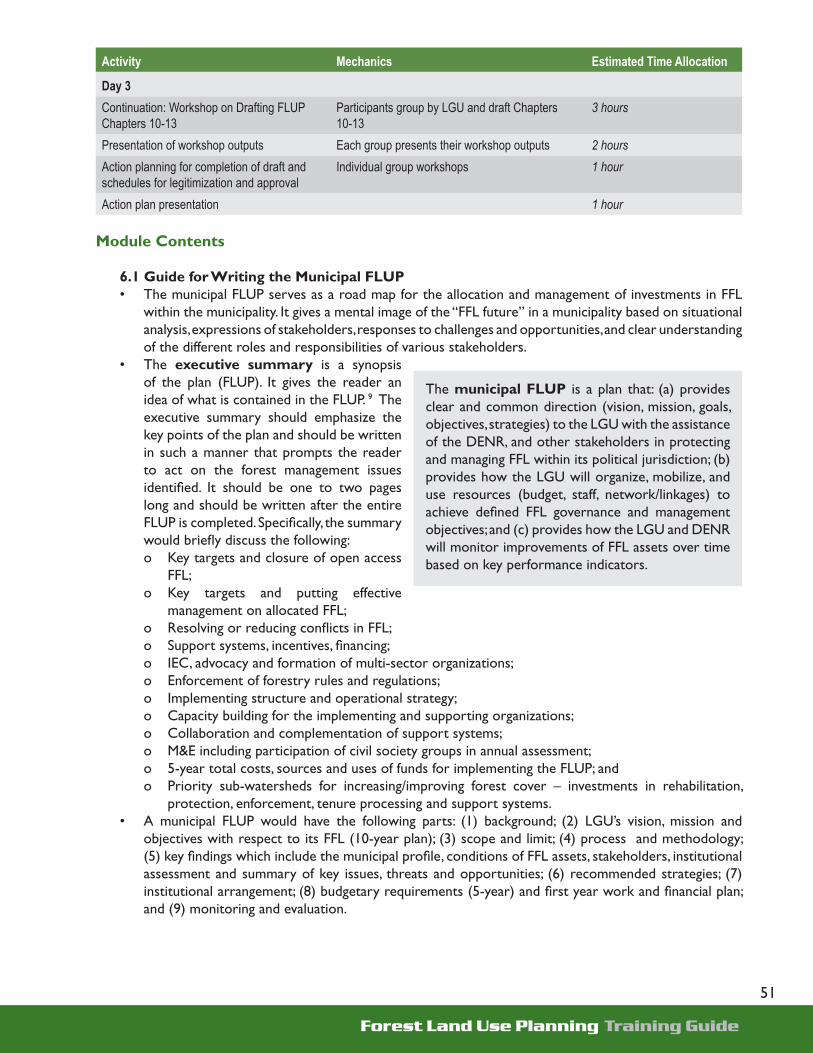
Forest Land Use Planning Training Guide
51
Activity Mechanics Estimated Time Allocation
Day 3 Continuation: Workshop on Drafting FLUP Chapters 10-13
Participants group by LGU and draft Chapters 10-13
3 hours
Presentation of workshop outputs Each group presents their workshop outputs 2 hoursAction planning for completion of draft and schedules for legitimization and approval
Individual group workshops 1 hour
Action plan presentation 1 hour
Module Contents
6.1 Guide for Writing the Municipal FLUP• The municipal FLUP serves as a road map for the allocation and management of investments in FFL
within the municipality. It gives a mental image of the “FFL future” in a municipality based on situational analysis, expressions of stakeholders, responses to challenges and opportunities, and clear understanding of the different roles and responsibilities of various stakeholders.
• The executive summary is a synopsis of the plan (FLUP). It gives the reader an idea of what is contained in the FLUP. 9 The executive summary should emphasize the key points of the plan and should be written in such a manner that prompts the reader to act on the forest management issues identifi ed. It should be one to two pages long and should be written after the entire FLUP is completed. Specifi cally, the summary would briefl y discuss the following: o Key targets and closure of open access
FFL;o Key targets and putting effective
management on allocated FFL;o Resolving or reducing confl icts in FFL;o Support systems, incentives, fi nancing;o IEC, advocacy and formation of multi-sector organizations;o Enforcement of forestry rules and regulations;o Implementing structure and operational strategy;o Capacity building for the implementing and supporting organizations;o Collaboration and complementation of support systems;o M&E including participation of civil society groups in annual assessment;o 5-year total costs, sources and uses of funds for implementing the FLUP; ando Priority sub-watersheds for increasing/improving forest cover – investments in rehabilitation,
protection, enforcement, tenure processing and support systems.• A municipal FLUP would have the following parts: (1) background; (2) LGU’s vision, mission and
objectives with respect to its FFL (10-year plan); (3) scope and limit; (4) process and methodology; (5) key fi ndings which include the municipal profi le, conditions of FFL assets, stakeholders, institutional assessment and summary of key issues, threats and opportunities; (6) recommended strategies; (7) institutional arrangement; (8) budgetary requirements (5-year) and fi rst year work and fi nancial plan; and (9) monitoring and evaluation.
The municipal FLUP is a plan that: (a) provides clear and common direction (vision, mission, goals, objectives, strategies) to the LGU with the assistance of the DENR, and other stakeholders in protecting and managing FFL within its political jurisdiction; (b) provides how the LGU will organize, mobilize, and use resources (budget, staff, network/linkages) to achieve defi ned FFL governance and management objectives; and (c) provides how the LGU and DENR will monitor improvements of FFL assets over time based on key performance indicators.

Forest Land Use Planning Training Guide
52
6.1.1 Background• The fi rst part of the municipal FLUP, the background is usually 1-2 pages and tells the plan’s
rationale written in the context of protecting existing forests and improving management of FFL at the LGU level. This part answers the question why the LGU is doing the FLUP and why it should play an active role in managing its FFL. It also gives an account of the historical, socio-economic, biophysical, life support systems (watershed), agricultural, industrial and political importance of FFL.
• The background explains how the FLUP and its implementation would respond to current problems, issues, needs and opportunities in the local government’s FFL.
• FLUP is also discussed in the context of the present and future consumption, production of food, fi ber and water, and freedom from fl ooding, in relation to the location and area of FFL in the LGU and its adjoining landscapes.
6.1.2 LGU’s Vision, Mission and Objectives with respect to its FFL • Planning period for the vision, mission and objectives (VMO) is 10 years. This step requires creating
a mental picture (visualization) of a desired future state of FFL in the municipality. The VMO tells about the condition that does not presently exist and never existed before FFL in the context of present socioeconomic and biophysical developments. This is written from the perspective of local stakeholders as expressed during consultation meetings, discussions and FGDs; as being revealed from the LGU history, profi ling and analysis, thematic mapping and overlays; and as agreed and endorsed by the LGU leadership.
• The mission and goal of the FLUP should be able to capture what will be done, for whom are these efforts, and how it will be carried out. It may be rationalized, for example, by saying that it will be supportive of the development goal of the LGU and its overall goal in protecting, developing and managing its forest lands.
• In formulating the FLUP fi ve-year goals and objectives, it must answer the question how will it achieve the LGU’s vision and mission (when approved and implemented). In other words, what should the LGU, in collaboration with the DENR and local stakeholders, do to allocate, protect and manage FFL resources based on key biophysical, socio-economic, legal and political criteria? Whenever possible, the set objectives should be quantifi able or can have numerical values.
• The objectives may be production of goods and services, conservation, protection of infrastructures and lives and public safety, biodiversity, research or aesthetic values. Example of an objective on the protection of infrastructure is “Protect communities, public and private investments from environmental hazards such as damages from sudden fl oods and landslides.”
6.1.3 Scope and Limit of the FLUP • This portion should be written in the context of the comprehensive land use plan (CLUP) of a
municipality or province. Examples may include an illustration that is applicable only within forest land or some maps may be used for FLUP only and not for CLUP. It has to be communicated that the FLUP is not about land use but instead contain recommendations on how best to allocate and manage FFL.
6.1.4 The FLUP Process and Methodology• An orientation is fi rst given on the TAP-enhanced FLUP process, formation of the FLUP team and
on action planning. It is followed with a discussion on the MOA between the DENR and the LGU, and the ordinance or resolution from the MDC and SB that would enact the agreement between the two parties. The sources of information for maps, socioeconomic and biophysical aspects are then explained.

Forest Land Use Planning Training Guide
53
• The mapping process ensues next. The maps would have to be prepared, validated and revised, both thematic and composite maps. Overlaying follows, along with analysis and consultations with various stakeholders (communities, private sector, civil society, LGUs, SBs and MDCs). The criteria are then explained for prioritizing sub-watersheds and for allocating open access (unallocated and unmanaged) FFL.
• The succeeding activities would not be confi ned to lectures and discussions. Cross visits will be conducted. Lessons learned and observations from these visits would be recorded and discussed. The visit would be followed by community mapping and fi eld validation of recommendations for the allocation and management of FFL.
• The next step is the fi nalization of the FLUP. This entails visioning, drafting and revising the fi nal FLUP. This would include stakeholders’ analysis.
• The FLUP would become a legal document once the MDC and SB passed ordinances or resolutions ordering its approval and adoption. Civil society groups or POs may also pass resolutions signaling their recognition of the FLUP. This would be followed by an endorsement and approval by the mayor/local chief executive and the DENR.
• The MOA would then be prepared, validated and signed. The MOA provisions would specify how the FLUP would be implemented by the parties concerned. It would also indicate the investments in infrastructure, extension services, tenure application and processing, community organizing, preparation of resource management plans, IEC/advocacy, and creation of MENRO, among others.

Forest Land Use Planning Training Guide
54
6.1.5 Findings • Findings refer to the results of data gathering, consultations, validations, site visits and analyses.
It captures the municipal level analysis of the FFL as assets, local stakeholders, key variables that may impact FFL governance and management, priority issues, needs, and constraints that require immediate actions and decisions.
• This section should provide a clear picture of the extent of the remaining forest cover (natural and man-made), how the forest is being protected and managed, potential of expanding forest cover, role of stakeholders in FFL protection and management, among others. Some of the guide questions to be answered in this section are listed in the next page.
o What FFL assets are in the LGU? - What are the types and extent of forest cover? How many hectares are covered with natural forests?
Plantation? Perennial tree crops?- How many hectares are open and denuded areas? Grasslands? Cultivated areas?- How many sub-watersheds? Extent of sub-watersheds? Existing or potential functions? Conditions?
o Where are the different kinds of FFL assets located or distributed?- Allocated?- Unallocated?
o Where are the protection and production forests? - In allocated or unallocated FFL?- In what tenure or allocation instruments are they located or distributed? - How is the “protection forest” managed under each allocation category?
o How are the allocated FFL assets protected, managed or developed?- What is the current status of various tenure/allocation instruments? How many are active, inactive,
expiring, suspended, etc.? Overlaps? - Are the tenured/allocated areas covered with approved “resource management plans and budget”?- Are there on-site protection and development activities in these areas? How are Communal/Individual
Property Rights being addressed?- How many of these tenure holders are capable, functional or active on the ground? What is your
assessment/analysis about the tenure holder or other concerned institution?o Who are the on-site and off-site stakeholders in FFL? DENR, LGUs, communities (on-site protection,
management, utilization, upland farming?), private sector (fi nanciers, processing, marketing, forest plantations, etc.), civil society organizations (advocacy, on-site management, monitoring, etc.), other government agencies (extension support, fi nancing, monitoring, etc.)- In both “allocated and unallocated FFL”?- What are their stakes? - What are their capabilities? Needs? Constraints? - How do they participate? In what decisions and action? Who determines their participation? - What are their fi nancial investments or in-kind contribution in the FFL protection and management?
o What and where are the current and emerging confl icts in the use and allocation of FFL resources? - Impacts of these confl icts?- How are these confl icts being resolved? - Who is and should do the mediation of these confl icts?
o What are the key issues, constraints, problems in the protection and management of FFL? At the LGU level? Tenure holder level? DENR level? Occupants/claim level?
o What are the FFL products that are being produced, harvested, processed and marketed? - Legal? Illegal? - Volumes of forest products that are being marketed? - Existing and potential markets?- Constraints and issues in forest products production and marketing?

Forest Land Use Planning Training Guide
55
• The fi ndings list down the FFL assets that can be found in the LGU, their location or distribution, and whether these assets are allocated or unallocated. It is in this portion that the following are presented:o Forest lands, A&D areas, protection forest lands per watershed;o Watersheds, sub-watersheds, key drainage systems, and priority sub-watersheds; o Vegetative cover of each sub-watershed - forest lands and A&D; tree farms, forest plantations,
natural forests, agroforestry systems, perennial high value crops;o Unallocated FFL (total and per sub-watershed) – those not covered by any form of tenure,
allocation instrument, or “set asides”;o Allocated forest lands and their existing management systems;o Total “open access FFL” – unallocated and unmanaged but allocated FFL; o Forests and forest lands with boundary and use confl icts;o Public and private investments – LGU and DENR allocated budgets in support of forestry activities,
historical and projected investments on infrastructures, processing facilities, forests and agroforestry nurseries, etc.; soft investments (such as tenure processing, preparation of proclamations or co-management agreements, preparation of resource management plans, extension services, social services in upland communities); investments of foreign-assisted projects;
o Settlements in forests and forest lands (IPs and migrants); ando Key issues, confl icts, problems, needs, investment/socio-economic opportunities (total and by sub-
watersheds);· Other information that may be presented include:o On-site and off-site stakeholders in FFL; ando FFL products that are being produced, harvested, processed and marketed.
6.1.6 Recommendations and Strategies• This portion looks into the aspect of
how the vision can be translated into reality. These are stated in support of a clearly defi ned strategy for achieving vision and mission, goals and objectives.
• Also discussed are the most appropriate technical strategies to achieve the LGU’s vision and mission and meet the goals and objectives of FLUP. The proposed strategies can be divided into the general and specifi c technical strategies. Financial and organizational strategies will be discussed in separate sections. The strategies should consider questions such as: o What internal and external opportunities and strengths are being responded to by the technical
recommendations? What problems, issues and needs are being responded to?o How do these technical recommendations deal with present and future constraints and
weaknesses, inadequacies or shortcomings of various stakeholders?o What should the LGU and DENR do to protect or conserve the remaining natural forests,
develop forest lands that have potential for high value crops and plantations, protect biodiversity, enhance ecotourism areas, rehabilitate and manage priority sub-watersheds which supply surface or ground water, recognize and help indigenous cultures, resolve confl icts, etc?
o What are the critical investments to effect protection, conservation or rehabilitation of areas under natural forests? In degraded but occupied/cultivated forest lands?

Forest Land Use Planning Training Guide
56
o What kind of extension support systems should be in place? Livelihood and micro-enterprise support system? Infrastructure support? Others?
o What incentive systems should be in place in order for different tenure/allocation holders invest their own resources? Those that can be acted by the LGU? Those outside the LGU system?
o What specifi c investments in priority sub-watersheds will produce the highest net positive environmental impacts? And protect on- and off-site communities and public infrastructures?
o Based on fi ndings, what should be the most appropriate mix of tenure/allocation instruments that could address protection and management of FFL assets? IFMA? CBFMA? Co-Management? Declared protected areas? (For what? community watershed?, local park?, biodiversity?, etc.)
o What should be done to ensure on-site protection, development, and management of FFL assets under existing tenurial/allocation instruments? individual property rights? Priority in employment opportunities, if any? Extension system?
o What are the proposed recommendations to address current and future confl icts in the use and allocation of FFL resources?
o How will each of the stakeholders be involved in the protection and management of FFL resources at the LGU level? Participate in delivery of extension and other support system to tenure/allocation holder? Provide fi nancing or other in-kind support?
6.1.7 Institutional Arrangement• This section includes proposed actions on how the LGU will organize, mobilize and internally
monitor its FLUP implementation with the assistance and collaboration of the DENR and the local stakeholders.
• Proposed actions are to be written with the following in view: that the LGU is in the driver’s seat; the DENR is the main source of technical standards, policy and technical support; and the market players (including civil society groups) as the ones who have the demands for environmental goods and services from FFL. The following questions maybe used as a guide: A. What is the most suitable structure and organizational arrangement to implement the FLUP
and monitor its progress and impacts over time? Who (among the stakeholders) should be involved in the annual work and fi nancial planning, implementation, monitoring? What capabilities need to be developed?
B. What kind of technical and support staff will this structure or organization need? Where will they come from?
C. What kind of collaborative arrangement should be done to implement the FLUP and leverage non-LGU resources and expertise?
D. How can the institutional structure and/or arrangement be formalized or become legally functional?
E. Will the creation of a MENRO facilitate implementation? How will the MENRO be organized, structured or funded? How will it coordinate plans and activities?
F. What kind of ordinances or legislative policy actions will strengthen the authority of the implementing organization?
G. How can the leagues affi rm or assist the organization in advocacy, networking, leveraging, monitoring and holding other partners accountable?
H. What will be the major tasks and responsibilities of the implementing organization or a responsible organization in the FLUP implementation?

Forest Land Use Planning Training Guide
57
6.1.8 Monitoring and Evaluation of FLUP Implementation• This section discusses how the LGU and DENR will jointly monitor and evaluate implementation
of the FLUP.• Participation of other stakeholders in monitoring implementation of FLUP should also be
discussed.• What are the key performance indicators that should be periodically monitored and assessed by
the LGU and the local DENR to track FFL asset improvement over time (open access areas placed under tenure, improvement in forest cover)? Who will be involved in this process? Who will fi nance the process? How will results be reported? How will accountability be carried out?
6.1.9 Budgetary Requirements • The budget required would cover a fi ve-year period. • This portion would feature a Gantt chart showing the strategic FLUP implementation activities and
their respective durations by year. It is to present estimated costs and sources of funds, whether in kind or in cash contributions from other partners.
• The fi nancial resources available at the LGU level are to be identifi ed, along with the short, medium and long term funding sources that may be tapped. It is to be ascertained as well if LGU, rentals, taxes, grants, DENR and other government agencies’ counterpart funding, income from joint venture agreements, fi nancing facilities, civil society groups, NGOs and private sector investments be enough to fund FLUP implementation.
• The total cost of implementing the technical recommendations and the institutional arrangements in the FLUP is to be determined as well. Also to be computed are: personnel, maintenance and operating expenses, and capital outlay for the fi rst, two and fi ve years; and the total cost that can be shouldered by the LGU, DENR, NGA, civil society groups and the private sector.
• Direct investments need to be identifi ed like nursery, rehabilitation or reforestation, establishment of tree farms or plantations, roads, bridges, and social services for FFL protection and management, along with the support that could be expected from the LGU, DENR, communities, private sector and civil society groups.
• The possible sources of funds would be determined. Strategies for fi nancing the total cost of FLUP implementation would be identifi ed as well as the organization which will carry out these strategies.
• A detailed fi rst year work and fi nancial plan will be included in the budgetary requirements. • Following the same format as the above, this portion is different only because the timeline or
duration will be in quarters and the activities will be done within the year.• In this portion, the priority activities that should be carried out during the fi rst year of FLUP
implementation are identifi ed and the quarter(s) when they would be implemented.

Forest Land Use Planning Training Guide
58

Forest Land Use Planning Training Guide
59
1. 0 From secondary sources and key informant interviews, gather the basic Information and socio-economic, cultural and institutional profi le of the LGU.
Basic Informationa. History of the municipality. Describe its origin,
legal basis and other vital information related to its creation.
b. Location and land area. Describe the geographic location.
c. Climatic condition of the area?d. What is the LGU’s classifi cation ? How much is
the IRA?e. Accessibility. How far is it from the nearest urban
center? From the capital town of the province? From Manila?
Describe the socio-economic, demographic, institutional and political condition of the municipality
a. Administrative jurisdiction. Describe the number of barangays and if possible, the sitios covered by the LGU.
Barangays Sitios Covered Land Area Percent of Total
TOTAL
b. Population. What is the total population? How many belong to IP/ethnic groups? Describe the population growth rate. Determine the population 10 years from now.
c. Describe the population density in each barangay.
Barangay Total Area(ha)
Population Growth rate
Density (persons/ha)
d. Describe the economic activities. What are the major sources of livelihood?
e. Describe the social services and infrastructures found in the LGU. What is/are the status of the infrastructure/s? Describe the communication facilities, education, health and other services.
Annex AForest Land Use
PlanningData Collection
Guide

Forest Land Use Planning Training Guide
60
Infrastructures Quantity (No./Length)
Status/Remarks
RoadsBridgesAirport areaSchoolsHospitalsDamsIrrigation SystemsWater SupplyBuilt-up AreasCommunication facilities
f. Describe the existing institutional arrangements in the management of forest resources g. Describe the presence of civil societies and the extent of their participation/involvement in forest
management
2.0 Prepare thematic maps and determine the bio-physical features and conditions of FFL assets/ resources of the LGU.
Biophysical Profi le:a. Discuss the land classifi cation/legal status of the municipality. How many hectares are considered
timberland? Express the numbers in percent.
Land Classifi cation Area (in hectares) Percent of TotalTimberlandAlienable and DisposableTOTAL
b. Describe the slope characteristics of the area. How many hectares are above 50% in slope?
Slope Category (in percent) Area (in hectares) Percent of Total> 1818-3030-50>50TOTAL

Forest Land Use Planning Training Guide
61
c. Describe the elevation status of the area. How many hectares are above 1,000 meters above sea level?
Elevation Category (masl) Area (in hectares) Percent of Total>500 500-1,000>1,000TOTAL
d. Discuss the importance of watershed with respect to its service areas/uses of the rivers. How many hectares of rice lands or croplands are being supported by what watershed? Where and what is/are size/s of this/these service area/s? Is there data on the amount of water (discharge fl ow) coming out of the river/watershed?
Name of Watershed/Sub-watershed
Rivers and Creeks Covered Uses/Service Areas
TOTAL
e. Describe the geologic hazards/status of the municipality
Geologic Hazards Location Length/Area/No./RemarksVolcanoesFaultsLandslipFrequently fl ooded areasHighly erodible areasTOTAL
Conditions of FFL Assets:f. Identify the FFL assets, determine the extent, area or number, their watershed/ barangay locations,
users and uses, conditions, trends/threats to these assets and opportunities
Vegetative Cover/Land Use
Area(ha.)/ No./ length per SW
Total
SW1 SW2 SWnLand assets Forestlands A & D landsWater bodies and sub-watersheds Rivers & creeks (kms.) Area of sub-watershedsNatural forests Closed Canopy forest

Forest Land Use Planning Training Guide
62
Vegetative Cover/Land Use
Area(ha.)/ No./ length per SW
Total
SW1 SW2 SWn Open Canopy MangrovesPlantationsWater production catchments (ha)Biodiversity assetsWater infrastructuresNature-based tourism assetsGrasslands/ brushlandsCultivated UplandsMineral landsOther assetsTOTAL
g. Tenure over forest lands. Describe the tenure status of the forest lands? How many are still open access?
Tenure/Allocation Instruments
Area (in hectares) Percent of Total
TOTAL
3.0 Identify the stakeholders through stakeholders analysis.
a. Who are the forest users and other groups or institutions that have interests in the forest resources? Any cooperation, confl ict or competition in the use of resources?
b. How organized are these forest occupants/forest users? Describe their decision making making patterns/leadership, communication, problem-solving, power infl uence and mutual support/cooperation
4.0 Assess the institutional capabilities of DENR and the LGU in joint management of forests and forestlands
a. Discuss the capabilities of DENR and the LGU in managing FFL by examining the existing personnel, their skills, budget allocation, equipment and their overall organizational structure.
b. Examine previous programs implemented by both agencies related to resource management including existing policies that may affect management of FFL
5.0 Summarize the key Problems, Issues Confl icts, Needs, Investment/Socio-Economic Opportunities

Forest Land Use Planning Training Guide
63
Summary
• Highlights and summary of the plan• Recommendations and plan of action on:
a. Key targets and closure of open access forests and forest lands
b. Key targets and putting effective management on allocated FFL
c. Resolving or reducing confl icts in FFLd. Support systems, incentives, fi nancinge. Information, education and communication,
advocacy and formation of multi-sector organizations
f. Enforcement of forestry rules and regulationsg. Implementing structure and operational strategyh. Capacity building for the implementing and
supporting organizationsi. Collaboration and complementation of support
systemsj. Monitoring and evaluation including participation
of civil society groups in annual assessmentk. 5-years (Total costs, sources and uses of funds
for implementing the FLUP)l. Priority sub-watersheds for increasing/improving
forest cover – investments in rehabilitation, protection, enforcement, tenure processing and support systems.
1.0 Background1.1 Rationale of the municipal FLUP in the context of
improving FFL management at the LGU level1.2 FLUP in the context of its historical, socio-
economic, biophysical, life support systems, agricultural, industrial, and political importance
1.3 FLUP in the context of the present and future consumption and production of food, fi ber and water. Relate this with the location and area (with location map) of the LGU.
1.4 Discussion on how the plan and its implementation respond to the current problems, issues, needs and opportunities in FFL management within the LGU.
2.0 LGU’s Vision, Mission, Goals and Objectives on its FFL
2.1 Vision and Mission 2.1.1 Improve the socio-economic condition
by ensuring sustainable production of food, fi ber and water in the locality
2.1.2 Maintain ecological balance and biodiversity through effective development and management of FFL
Annex BSuggested
Municipal Forest Land Use Plan
Outline

Forest Land Use Planning Training Guide
64
in each sub-watershed.2.1.3 Protect communities, public and private investments from environmental hazards such as
damages from sudden fl oods and landslides2.14 Manage the forests for tourism, aesthetic purposes and well-balanced clean environment.
2.2 Goals and Objectives Based on transparent and participatory approaches and clearly defi ned goals, standards and centers of
responsibility and accountability:2.2.1 Determine priority sub-watersheds for planning and allocating limited resources for
development and investments 2.2.2 Determine and recommend optimal allocation/management of FFL following
biophysical, socio-economic, legal and political criteria2.2.3 Recommend measures to facilitate resolution or reduction of confl icts arising from
the governance of FFL2.2.4 Provide a baseline to monitor and evaluate key criteria and indicators for the
implementation of legitimized FLUP to achieve sustainable environmental and FFL management.
3.0 Scope and limit of FLUP (in the context of the comprehensive land use plan of a municipality or province)
4.0 Methodology4.1 Orientation on TAP-enhanced FLUP process, formation of the FLUP team, action planning 4.2 MOA (DENR and LGU) with ordinance or resolution from MDC and SB4.3 Sources of information (maps, socioeconomic and biophysical) 4.4 Preparation, validation and revision of thematic and composite maps4.5 Map overlays, analysis, consultations with various stakeholders (communities, private sector, civil society,
LGU leaders, SBs, MDCs)4.6 Criteria for prioritizing sub-watersheds and for allocating open access (unallocated and unmanaged)
FFL4.7 Cross visits – lessons learned and observations4.8 Community mapping and fi eld validation of recommendations for the allocation and management of
the FFL4.9 Visioning, drafting and revising the fi nal FLUP 4.10 Legitimization (MDC and SB ordinances or resolutions from civil society groups or people’s
organizations)
4.12 Endorsement and approval of FLUP by the local chief executive and the DENR4.13 Preparation, validation and MOA signing for implementation - investments in infrastructure, extension
services, tenure application/processing, IEC, community organizing, preparation of resource management plans, etc.
5.0 Key Findings5.1 Municipal Profi le
5.1.1 Biophysical profi le – Total area, topography, slope, climate, recent vegetative cover, sub-watersheds and drainage, hazard areas
5.1.2 Socio-economic and cultural profi le – Political subdivisions (barangays & sitios), demography, 5.1.3 Major livelihood sources, social and infrastructure services 5.1.4 Institutional profi le – Describe how the different resource institutions collaborate in managing
the FFL

Forest Land Use Planning Training Guide
65
5.2 Conditions of Forest and Forest Land Assets Identify the FFL assets, determine the extent, area or volume, their locations, users and uses, conditions,
trends/threats to these assets and opportunities 5.2.1 Forest lands – area of timberlands and alienable and disposable lands tenure holders and
extent of open access 5.2.2 Natural forests5.2.3 Plantations5.2.4 Grasslands and brushlands5.2.5 Cultivated lands5.2.6 Water bodies and water production areas5.2.7 Biodiversity resources5.2.8 Nature-based tourism assets5.2.9 Mineral resources5.2.10 Other resources
5.3 Key Stakeholders (Discuss the results of the stakeholders analysis)
5.4 Institutional Assessment (Discuss the capabilities of key institutions in terms of personnel, budget, organization, equipment, etc.)
5.5 Summary of Key Issues, Confl icts, Problems, Needs, Investment/Socio-Economic Opportunities
6.0 Recommended Strategies6.1 General Strategies
a. Zoning b. Allocation of open access forest landsc. Prioritization of sub-watersheds
6.2 Specifi c Technical Strategiesa. Delineation of protection and production forest landsb. Protection of existing natural forestsc. Rehabilitation/development of grasslands, brushlands and cultivated forest lands d. Conservation and development of water production areas and biodiversity resourcese. Nature based tourism developmentf. Recognition of IPRg. Developing the priority sub-watershedh. Others
m. Organizational Structure and Operations in Support of FLUP Implementation• Creation and/or strengthening MENRO• IEC/Advocacy • Enforcement, deputation, litigation and penalties• Extension support systems – DENR, LGUs, collaborative arrangements, facilities and fi nancing
support for smallholder operations• Crafting, implementing and administering user fee systems• Forging partnership agreements or arrangements• Marketing the FLUP through investment fora.
Forest Land Use Planning Training Guide
66
n. Periodic Monitoring and Evaluation of FLUP Implementation • Multi-sector and interagency periodic assessment, analysis and reporting in support of the
FLUP• Participation of multi-sector groups to monitor compliance to commitments and MOA under
the FLUP.• Periodic assessment of key FLUP indicators – forest cover, reduction of open access FFL, etc.• Annual tenure holders assessment
o. Estimated 5-Year Financial Requirements for Implementing FLUP• Total costs of personnel requirements, maintenance and operating expenses (MOE), capital
outlay• Sources of funds – LGU, rentals, taxes, grants, counterparts of DENR and other government
agencies, income from joint venture agreements, private sector investments, etc.• Uses of funds – personnel, MOE, investments, support for smallholder upland farmers/groups,
facilities such as nursery, capacity building activities, coordination costs, etc.• Strategies for meeting the total FLUP implementation fi nancial requirements• First work and fi nancial plan for implementing FLUP – details of specifi c activities (who is
responsible, target date, how much will it cost, etc.)
Attachmentsa) thematic mapsb) location mapc) derived mapsd) composite mape) vision map (if any)f) appendix tablesg) appendix fi guresh) minutes of meetings, validations, public hearings and consultationsi) recommended organizational set-up for implementing FLUPj) details of recommended schedule and required budget of key activities for implementing FLUPk) resolutions and adoption by the MDC, civil society groups, POs, private sector l) resolution and approval by the Sangguniang Bayanm) signed MOAs (for FLUP preparations; and for FLUP implementation)n) Approval of the FLUP by the LCE and DENR

Forest Land Use Planning Training Guide
67

Forest Land Use Planning Training Guide
68