dentists' forum: south china sea arbitral award
TRANSCRIPT


1. China’s Claim to Historic Rights under the Nine-Dashed Lines
2. Status of Geologic Features in Spratlys to Generate 200-NM EEZ and Jurisdiction of the Tribunal to Rule on Maritime Issues in the Spratlys
3. Status of Geologic Features in Spratlys whether Low-Tide or High-Tide Elevations
4. Status of Scarborough Shoal and Right to Traditional Fishing
5. Harm to Marine Environment 6. Unlawful Actions of China
Six Major Issues Resolved by the Annex VII UNCLOS Tribunal

China’s Nine-Dashed Lines

• The nine-dashed lines are illegal under UNCLOS and
cannot be the basis for claiming maritime zones; maritime zones must be claimed from land;
• China’s maritime zones, just like other coastal states, cannot extend beyond the limits prescribed under UNCLOS;
• All historic rights in the EEZ were extinguished upon effectivity of UNCLOS;
• No evidence that China historically exercised exclusive control over the waters and resources of the South China Sea;
• The Tribunal upheld the Philippine position on this issue.
China’s Claim to Historic Rights Under the Nine-Dashed Lines

High Seas and EEZs in South China Sea
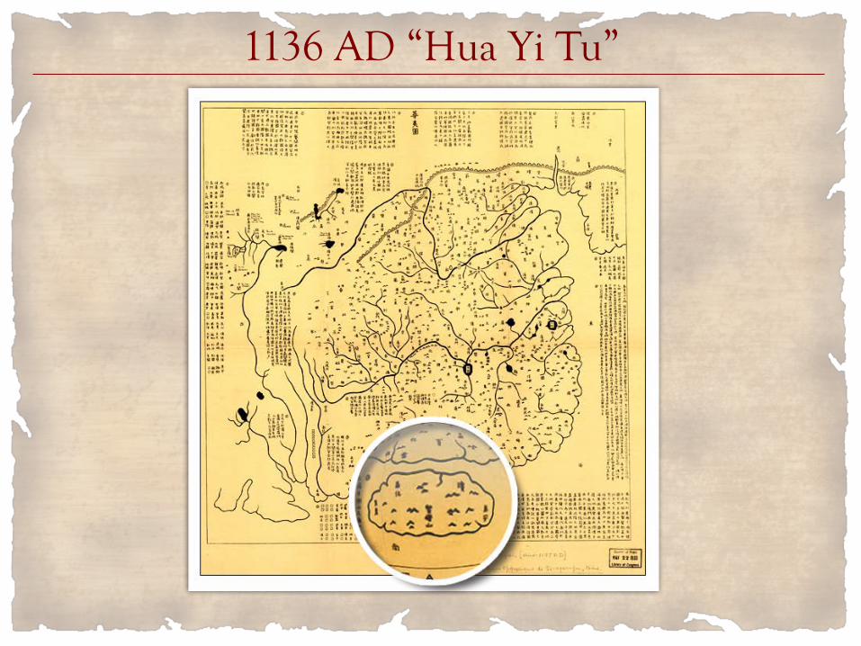
1136 AD “Hua Yi Tu”

1896 “Huang Chao Zhi Sheng Yu Di Quan Tu” or The Qing Empire’s Complete Map of All Provinces
During the Chinese dynasties, Hainan Island was a part of Guangdong Province. Hainan became a separate province only in 1988. The Qing Dynasty saw one of the largest expansions of Chinese territory throughout the Chinese dynasties. The Qing dynasty ceded Formosa to Japan in 1895 following the Qing’s defeat in the First Sino-Japanese War (1894-1895).

China’s Southernmost Territory Through the Dynasties – Hainan (1894)

1595 Ortelius Map - Champa Kingdom and Champa Sea
Before Portuguese navigators coined the name South China Sea, the sea was known as the Champa Sea, after the Cham people who established a great kingdom in central Vietnam from the late 2nd to the 17th century. The Chams had sailboats with outriggers, just like the sailboats of the Austronesians. The ancestors of the Chams spoke a Malayo-Polynesian language that is derived from the Austronesian language, just like the Tagalog language. The word “cham” comes from the flower of the champaka tree. This flower is the symbol of the Cham Kingdom. The Chams are believed to have migrated from Borneo to central Vietnam.
“For centuries the South China Sea was known by navigators throughout Asia as the Champa Sea, named for a great empire that controlled all of central Vietnam xxx.” - National Geographic, June 18, 2014

Islands in the Champa Sea Had Austronesian Names
1596 Linschoten Map: “Pulo” in Tagalog means an “island, isolated place.” https://www.tagalog-dictionary.com/search?word=pulo. This map was made during the Ming Dynasty (1368-1644).
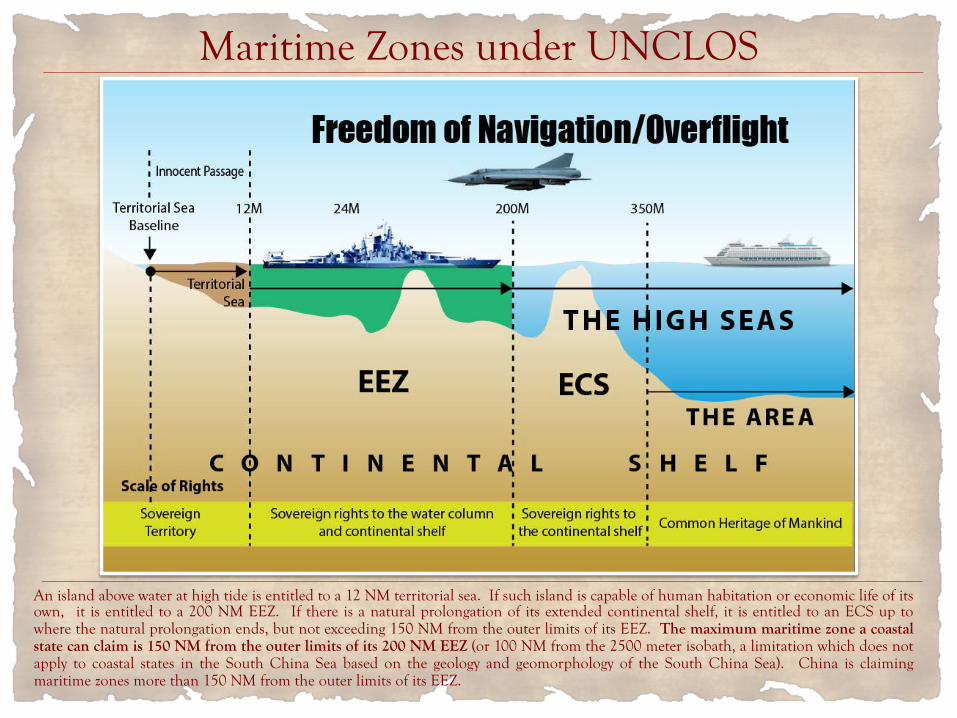
Maritime Zones under UNCLOS
An island above water at high tide is entitled to a 12 NM territorial sea. If such island is capable of human habitation or economic life of its own, it is entitled to a 200 NM EEZ. If there is a natural prolongation of its extended continental shelf, it is entitled to an ECS up to where the natural prolongation ends, but not exceeding 150 NM from the outer limits of its EEZ. The maximum maritime zone a coastal state can claim is 150 NM from the outer limits of its 200 NM EEZ (or 100 NM from the 2500 meter isobath, a limitation which does not apply to coastal states in the South China Sea based on the geology and geomorphology of the South China Sea). China is claiming maritime zones more than 150 NM from the outer limits of its EEZ.
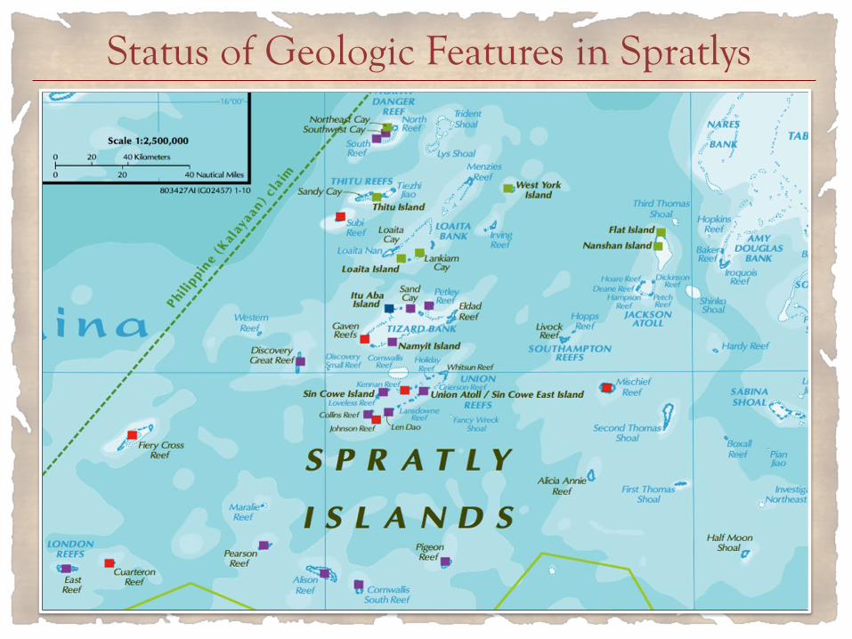
Status of Geologic Features in Spratlys

• None of the geologic features (rocks and islands) in the Spratlys is capable of “human habitation or economic life of [its] own” so as to be entitled to a 200-NM EEZ; thus the Tribunal has jurisdiction to rule on the maritime issues in the Spratlys
• The Spratlys cannot be taken as a single unit to determine capability to sustain human habitation or economic life;
• To be entitled to a 200-NM EEZ, the geologic feature must have the “objective capacity, in its natural condition, to sustain either a stable community of people or economic activity that is not dependent on outside resources or purely extractive in nature.”
• Itu Aba, the largest geologic feature in the Spratlys, does not satisfy this requirement. Thus, Itu Aba is entitled only to a 12-NM territorial sea.
• The Tribunal upheld the Philippine position on this issue.
Status of Geologic Features in Spratlys to Generate 200-NM EEZ

Itu Aba’s 200-NM EEZ and Reed Bank

South China Sea Islands

Seven Geologic Features Occupied by China in Spratlys
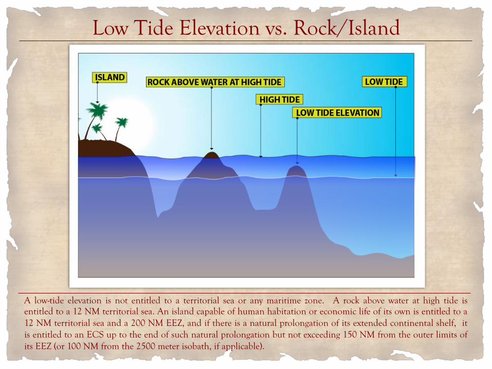
Low Tide Elevation vs. Rock/Island
A low-tide elevation is not entitled to a territorial sea or any maritime zone. A rock above water at high tide is entitled to a 12 NM territorial sea. An island capable of human habitation or economic life of its own is entitled to a 12 NM territorial sea and a 200 NM EEZ, and if there is a natural prolongation of its extended continental shelf, it is entitled to an ECS up to the end of such natural prolongation but not exceeding 150 NM from the outer limits of its EEZ (or 100 NM from the 2500 meter isobath, if applicable).

• Of the seven (7) reefs China occupies in the Spratlys, five (5) are high-tide elevations (above water at high tide), namely: Fiery Cross Reef, Johnson South Reef, Gaven Reef, Cuarteron Reef and McKennan Reef; these reefs are entitled to 12-NM territorial sea;
• The two (2) other reefs - Mischief Reef and Subi Reef - are low-tide elevations not entitled to a territorial sea; they form part of the Philippines’ submerged continental shelf; only the Philippines can erect structures or artificial islands on these reefs; China cannot appropriate these low-tide elevations situated within the Philippine EEZ; China’s structures on these reefs are illegal; Ayungin Shoal, occupied by the Philippines, is also a low-tide elevation;
• The Tribunal upheld the Philippine position on this issue except for Gaven Reef and McKennan Reef, which the Philippines argued are only low-tide elevations but the Tribunal ruled they are high-tide elevations entitled to 12-NM territorial sea.
Status of Geologic Features in Spratlys - Whether Low-Tide or High-Tide Elevations
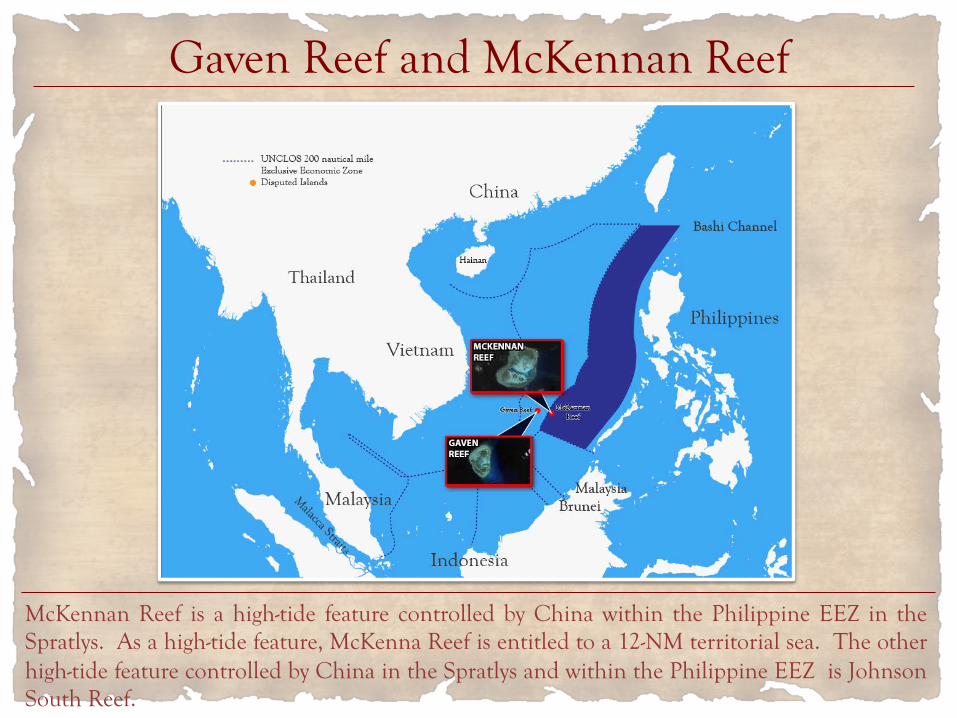
Gaven Reef and McKennan Reef
McKennan Reef is a high-tide feature controlled by China within the Philippine EEZ in the Spratlys. As a high-tide feature, McKenna Reef is entitled to a 12-NM territorial sea. The other high-tide feature controlled by China in the Spratlys and within the Philippine EEZ is Johnson South Reef.
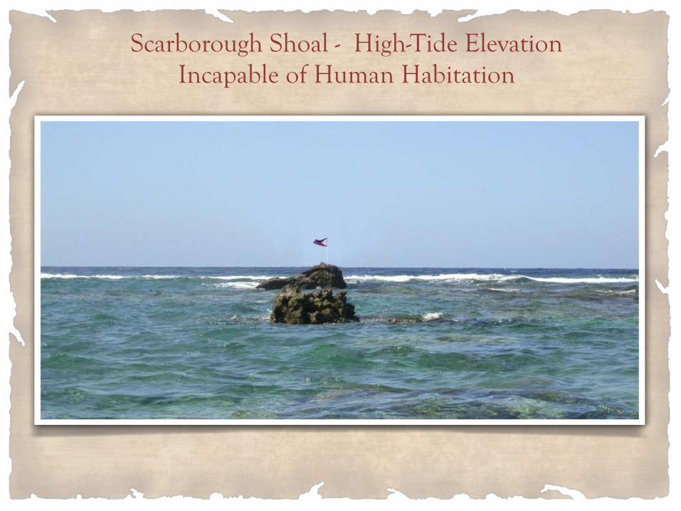
Scarborough Shoal - High-Tide Elevation Incapable of Human Habitation

• Scarborough Shoal is a high-tide elevation entitled to 12-NM territorial sea but not to a 200-NM EEZ since obviously it is not capable of human habitation;
• The territorial sea of Scarborough Shoal is a traditional fishing ground of Filipino and Chinese fishermen, as well as fishermen from other countries; China cannot prevent Filipino fishermen from fishing in Scarborough Shoal;
• The Tribunal upheld the Philippine position on this issue.
Status of Scarborough Shoal; Right to Traditional Fishing

Disputed EEZ Area before the Ruling of Tribunal
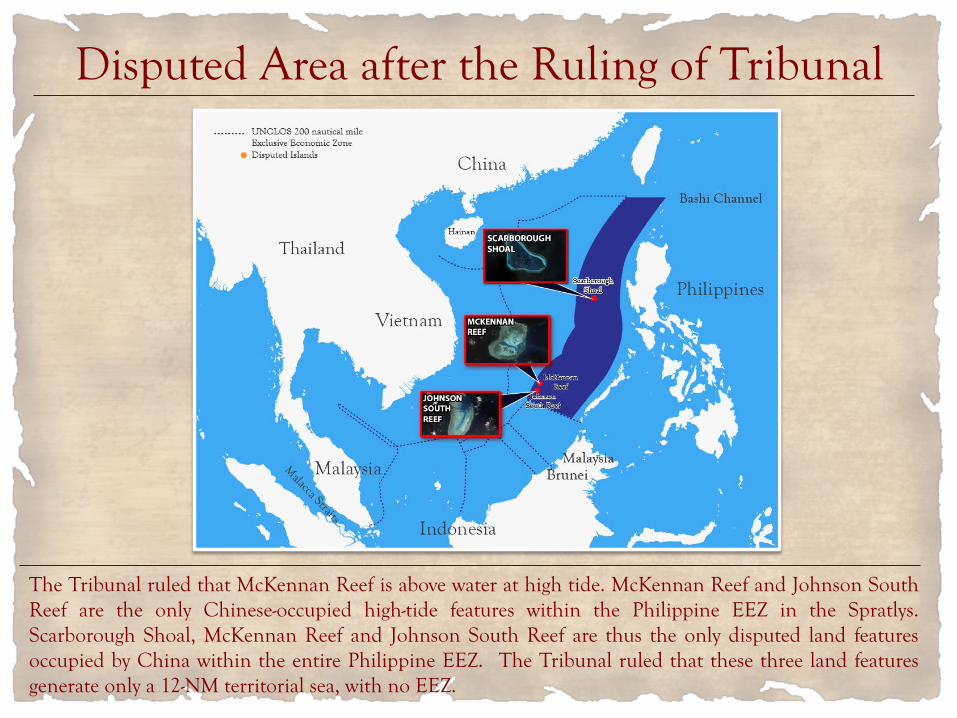
Disputed Area after the Ruling of Tribunal
The Tribunal ruled that McKennan Reef is above water at high tide. McKennan Reef and Johnson South Reef are the only Chinese-occupied high-tide features within the Philippine EEZ in the Spratlys. Scarborough Shoal, McKennan Reef and Johnson South Reef are thus the only disputed land features occupied by China within the entire Philippine EEZ. The Tribunal ruled that these three land features generate only a 12-NM territorial sea, with no EEZ.

The Philippine EEZ in the SCS has an area of about 381,000 square kilometers. Deducting the 4,650 square kilometers total territorial seas of Johnson South Reef, McKennan Reef and Scarborough Shoal, the Philippines has an EEZ of about 376,350 square kilometers in the SCS free from any Chinese claim. This maritime area is larger than the total land area of the Philippines of 300,000 square kilometers. All the living and non-living resources in this maritime area – the fish, oil, gas and other minerals – belong exclusively to the Philippines.
The Philippines’ EEZ in the South China Sea Is Larger than its Total Land Area

China violated its obligation under UNCLOS to “protect and preserve the marine environment” when China: 1. Dredged and built islands on seven (7) reefs; 2. Failed to prevent its fishermen from harvesting
endangered species like sea turtles, corals and giant clams in the Spratlys and Scarborough Shoal.
The Tribunal upheld the Philippine position on this issue. This is the first time that an international tribunal ruled on harm to the coral reef ecosystem.
Harm to the Marine Environment

Mischief (Panganiban) Reef Before And at Start of Island Building

Mischief (Panganiban) Reef May 1, 2016
Mischief Reef is a circular atoll with a diameter of 7.4 KM, and its lagoon has an area of 3,600 hectares. The average depth inside the lagoon is 26 meters. As of November 2015, China has created an artificial island of 590 hectares. Mischief Reef is 125 NM from Palawan and 596 NM from Hainan.
Source: http://time.com/

Chinese Reef Killer Dredges 4,500 Cubic Meters of Sand per Hour
The Tiang Jing Hao (Heavenly Whale) dredger, a 127 meter-long seagoing cutter suction dredger designed by the German engineering company Vosta LMG. At 6,017 gross tons, this dredger is the largest in Asia. China has dozens of dredgers in the Spratlys.

How China Dredged in the Spratlys
Coral reef and hard sediment on the seabed are pulverized by the rotating cutter. Pulverized materials are sucked into the ship. Pulverized materials are transported by pressure through a floating pipe. Pulverized materials are deposited on the rim of the reef.

Tanmen Fishing Boat Scraping Coral Reef to Harvest Giant Clams
http://thediplomat.com/2016/01/satellite-images-show-ecocide-in-the-south-china-sea/

Tanmen Fishermen’s Harvest of Giant Clams
http://thediplomat.com/2016/01/satellite-images-show-ecocide-in-the-south-china-sea/

Dr. John McManus, the world-renowned marine scientist who studied the Spratlys in the 1990s, went back to the Spratlys last February 2016. He surveyed several reefs, including those exploited by clam dredgers from Tanmen, Hainan. Dr. McManus said:
“The damage was much worse than even I expected it to be. I swam over one whole kilometer of reef before I saw a single living invertebrate. It was really massive, massive destruction.”*
*http://www.csmonitor.com/World/Asia-Pacific/2016/0720/In-South-China-Sea-case- ruling-on-environment-hailed-as-precedent
Severe Harm to the Fragile Marine Ecosystem

China violated the exclusive right of the Philippines to its EEZ by: 1. Interfering with the fishing activities of Filipino
fishermen within the Philippine EEZ; 2. Interfering with the petroleum activities of Filipino vessels
within the Philippine EEZ; 3. Failing to prevent Chinese fishermen from fishing within
Philippine EEZ; 4. Constructing artificial islands and structures (Mischief
Reef and Subi Reef) within the Philippine EEZ and continental shelf.
The Tribunal upheld the Philippine position on these issues.
Unlawful Chinese Actions

Chinese Coast Guard Vessels Harassed A Philippine Survey Ship in Reed Bank in 2011
In March 2011, two Chinese coast guard vessels, the CMS-71 and CMS-75, prevented a Philippine-commissioned ship, the MV Veritas Voyager, from undertaking oil and gas survey in the Reed Bank, which is entirely within the Philippines’ EEZ. The 9-dashed lines cut through Malampaya, the Philippines’ largest operating gas field which supplies 40% of the energy requirement of Luzon. Malampaya will run out of gas in 10-12 years.

1. China violated its obligation not to aggravate the dispute during the arbitration when (a) China dredged the reefs and built the islands, and (b) destroyed the evidence of the natural condition of the geologic features in the Spratlys.
2. China violated its obligation to observe maritime safety when Chinese coast guard vessels crossed the path of Philippine fishing vessels at high speed.
The Tribunal upheld the Philippine position on these issues.
Other Issues Resolved by the Tribunal
The Tribunal refused to rule on the stand-off between Philippine marines and Chinese coast guard vessels in Ayungin Shoal, stating that this issue involves “military activities” outside the jurisdiction of the Tribunal. The Philippines asked the Tribunal to direct China to respect in the future the rights and freedoms of the Philippines under UNCLOS. The Tribunal also declined to rule on this issue since bad faith is not presumed in the performance of duties under UNCLOS, which already mandates that the parties to the dispute shall comply with the arbitral award.
Other Issues the Philippines Did Not Win

Article 288(4), UNCLOS: “In the event of a dispute as to whether a court or tribunal has jurisdiction, the matter shall be settled by decision of that court or tribunal.” Article 9, Annex VII, UNCLOS: “xxx Absence of a party or failure of a party to defend its case shall not constitute a bar to the proceedings. xxx.” Article 11, Annex VII, UNCLOS. “The award shall be final and without appeal, unless the parties to the dispute have agreed in advance to an appellate procedure. It shall be complied with by the parties to the dispute.” Article 300, UNCLOS. “State parties shall fulfill in good faith the obligations assumed under this Convention xxx.” Thus, China and the Philippines, which have both ratified UNCLOS, have the obligation to comply in good faith with the award.
Next Steps – Enforcement of Ruling

1. Enforcement of the ruling by the world’s naval powers with respect to freedom of navigation and overflight for military vessels and aircraft in the high seas and EEZs of the South China Sea.
2. Enforcement of the ruling by the Philippines with respect to its exclusive right to exploit the resources of its EEZ in the South China Sea.
Two Aspects in Enforcement of Ruling

Maritime Zones under UNCLOS
An island above water at high tide is entitled to a 12 NM territorial sea. If such island is capable of human habitation or economic life of its own, it is entitled to a 200 NM EEZ. If there is a natural prolongation of its extended continental shelf, it is entitled to an ECS up to where the natural prolongation ends, but not exceeding 150 NM from the outer limits of its EEZ. The maximum maritime zone a coastal state can claim is 150 NM from the outer limits of its 200 NM EEZ (or 100 NM from the 2500 meter isobath, a limitation which does not apply to coastal states in the South China Sea based on the geology and geomorphology of the South China Sea). China is claiming maritime zones more than 150 NM from the outer limits of its EEZ.

High Seas and EEZs in South China Sea

1. Philippine response if China installs a gas platform in the Reed Bank;
2. Recovery of damages from China for severe harm to the marine environment in the Spratlys;
3. Suspension of China’s exploration permits for the seabed until China complies with the ruling;
4. Suspension of China’s application for an extended continental shelf in the East China Sea until China complies with the ruling.
Enforcement of Exclusive Right to the EEZ

Dr. Graham Allison, Director of the Harvard Kennedy School’s Center for Science and International Affairs, wrote in the 16 July 2016 issue of the Singapore Strait Times:
1. Nicaragua v. United States: “In the Nicaragua case, when the court (ICJ) found in favor of Nicaragua, the U.S. refused.”
2. Netherlands v. Russia: Russia “ignored the tribunal’s order that the crew be released while the dispute was being resolved.”
3. Mauritius v. United Kingdom: “[A]n Arbitral Tribunal ruled for Mauritius and against Britain xxx. The British government disregarded the ruling xxx.”
Graham’s article, entitled “Heresy to say great powers don’t bow to tribunals on the Law of the Sea?”, was quoted by columnists in the Philippines and abroad.
Misconceptions that Great Powers Ignore Rulings of International Tribunals

1. Nicaragua v. United States (ICJ, 1986) In 1986, the ICJ ruled that the U.S. violated the territorial integrity of Nicaragua when the U.S. armed the contra rebels and mined the territorial waters of Nicaragua, among others. The U.S. had refused to participate in the proceedings and also refused to comply with the ruling, which directed the U.S. and Nicaragua to negotiate the amount of damages the U.S. should pay Nicaragua. Nicaragua asked the ICJ to proceed with the hearings on the amount of damages, which Nicaragua claimed run into billions of dollars. In 1991, while the proceedings were on-going, the U.S. and Nicaragua struck a deal: the U.S. would provide US$541 million in economic aid to Nicaragua if Nicaragua would withdraw the pending case with the ICJ. On 5 June 1991, Nicaragua’s National Assembly overwhelmingly repealed the law requiring the U.S. to pay damages to Nicaragua. On 12 September 1991, Nicaragua informed the ICJ that Nicaragua “Places on record the discontinuance by the Republic of Nicaragua of the proceedings instituted by the Application filed on 9 April 1984.”
Nicaragua, Arctic Sunrise and Mauritius Cases

2. Netherlands v. Russia (Annex VII Tribunal, UNCLOS, 2013)
On 22 November 2013, the ITLOS, upon a provisional measure requested by the Netherlands, ordered: “The Russian Federation shall immediately release the vessel Arctic Sunrise and all persons who have been detained, upon the posting of a bond or other financial security by the Netherlands which shall be in the amount of 3,600,000 euros, to be posted with the Russian Federation in the form of a bank guarantee.” Russia refused to participate in the proceedings and refused to comply with the ITLOS order. On 18 December 2013, the Russian Parliament amended its amnesty law to include hooliganism, the crime that the Arctic Sunrise crew were charged. Before Christmas day of December 2013, Russian President Putin pardoned the Artic Sunrise crew who were then allowed to leave Russia. The Arctic Sunrise vessel was likewise allowed to leave. Putin stated that the crew and vessel were released under Russian law, and not because of the ITLOS order.

3. Mauritius v. United Kingdom (Annex VII Tribunal, UNCLOS, 2015)
On 18 March 2015, the Tribunal ruled that “in establishing the MPA surrounding the Chagos Archipelago, the United Kingdom breached its obligations under Articles 2(3), 56(2), and 194(4) of the Convention.” These provisions required the U.K. to consult Mauritius, the coastal state, before establishing a marine protected area surrounding the Chagos Archipelago. On 15 June 2015, MP Patrick Grady of the UK Parliament raised a parliamentary inquiry to the Secretary of State for Foreign and Commonwealth Affairs as to “what steps the Government is taking to comply with the award of the Arbitral Tribunal in the case of Chagos Marine Protected Area Arbitration (Mauritius v. U.K.) dated 18 March 2015.” On 23 June 2015, MP James Duddridge, Under-Secretary for Foreign and Commonwealth Affairs, replied:
“The Government wishes to implement the award in the spirit of greatest possible cooperation, and has written to the Mauritian government several times since the award, making a proposal to hold consultations about the protection of the marine environment as early as July.”
As a win-win solution to the territorial dispute in the Spratlys, (the Tribunal’s ruling does not resolve the territorial dispute), all claimant states should suspend for 100 years their territorial claims and declare all the low-tide and high-tide features in the Spratlys, and an area of 3--NM around each feature, an international marine peace park* for the benefit of all coastal states in the South China Sea. This insures that the Spratlys will remain the South China Sea’s nursery where fish spawn. The eggs and larvae of fish that spawn in the Spratlys are carried by currents to the coasts of China, Vietnam, Luzon, Palawan, Malaysia, Brunei, Natuna Islands, as well as the Celebes and Sulu seas. The claimant states will hold on to whatever islands/structures they now possess. Only coast guard personnel and vessels can be stationed in the Spratlys. The islands/structures can only be used for marine scientific research and eco-tourism. There is a precedent to this. The 1994 peace agreement between Israel and Jordan created the Red Sea Marine Peace Park in the Gulf of Aqaba in the Red Sea. * First proposed by Dr. John W. McManus, Kwang-Tsao Shao and Szu-Yin Lin in 2010. http://www.tandfonline.com/ doi/abs/10.1080/00908320.2010.499303?journalCode=uodl20
Declare the Spratlys an International Marine Peace Park

Spratlys International Marine Peace Park

Dispersal of Eggs and Larvae of Fish
