department of parks and wildlife 2015–16 annual report · department of parks and wildlife...
TRANSCRIPT

Department of Parks and Wildlife2015–16 Annual Report
Part 3: Supporting our Department and Significant issues and trends

Overview of agency
Department of Parks and Wildlife Annual Report 2014–15 7
Contents
Acknowledgments Inside cover
Letter to the Minister 3
Director General’s foreword 4
Overview of agency 8Executive summary 9
Operational structure 14
Enabling legislation 14
Responsible Minister 14
Legislation administered by the Department at 30 June 2016 14
Parks and Willdife organisational chart 15
Changes made in 2015–16 to legislation administered 16
Proposed changes to legislation administered 17
Notices, appointments, orders and approvals 18
Performance management framework 20
Agency performance 22Report on operations 23
Service 1: Provision of Parks and Visitor Services 23
Service 2: Conserving Habitats, Species and Ecological Communities 34
Service 3: Conservation Partnerships 46
Service 4: Forest Management Plan Implementation 54
Service 5: Provision of Services for Commercial Forestry 58
Service 6: Prescribed Burning and Fire Management 62
Service 7: Bushfire Suppression 67
Service 8: Protection of the Swan and Canning Rivers System 75
Supporting our Department 86Public Information and Corporate Affairs 86
Legal matters 88
Office for Information Management 88
Visitor risk management 89
Corporate Services Division 90
Financial Services Branch 90
Corporate Information Services Branch 90
People Services Branch 90
Geographic Information Services 90
Parks and Wildlife-managed lands and waters 91
Map of Parks and Wildlife-managed lands and waters at 30 June 2016 97
Significant issues and trends 98
Disclosures and legal compliance 100Certification of financial statements 101
Auditor General’s opinion 102
Financial statements 104
Certification of key performance indicators 139
Key performance indicators 140
Key efficiency indicators 143
Ministerial directives 144
Other financial disclosures 145
Pricing policies 145
Capital works: incomplete and completed 145
Employment and industrial relations 145
Governance disclosures 147
Unauthorised use of credit cards 147
Contracts with senior officers 147
Board and committee remuneration 148
Other legal requirements 154
Expenditure on advertising, market research, polling and direct mail 154
Disability access and inclusion plan outcomes 155
Compliance with public sector standards and ethical codes 157
Recordkeeping plans 158
Government policy requirements 159
Government building training policy 159
Substantive equality 160
Workplace health, safety and injury management 161
Department of Parks and Wildlife Annual Report 2015–1686
CONTENTS
Supporting our DepartmentAgency performance
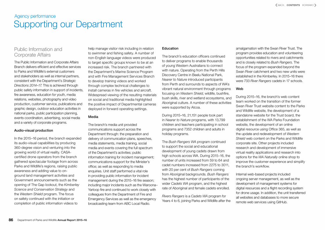
Public Information and Corporate AffairsThe Public Information and Corporate Affairs Branch delivers efficient and effective services to Parks and Wildlife’s external customers and stakeholders as well as internal partners, consistent with the Department’s Strategic Directions 2014–17. This is achieved through public safety information in support of incidents, fire awareness, education for youth, media relations, websites, photography and video production, customer service, publications and graphic design, outdoor education activities in national parks, public participation planning, events coordination, advertising, social media and a variety of corporate programs.
Audio-visual production
In the 2015–16 period, the branch expanded its audio-visual capabilities by producing 360-degree vision and venturing into the growing world of virtual reality. CASA-certified drone operators from the branch gathered spectacular footage from across Parks and Wildlife’s regions, raising public awareness and adding value to on-ground land management activities and Government announcements such as the opening of The Gap lookout, the Kimberley Science and Conservation Strategy and the Western Shield program. The focus on safety continued with the initiation or completion of public information videos to
help manage visitor risk including in relation to swimmer and fishing safety. A number of non-English language videos were produced to target specific groups known to be at an increased risk. The branch partnered with the Department’s Marine Science Program and with Fire Management Services Branch to develop training videos and worked through complex technical challenges to install cameras in fire vehicles and aircraft. Widespread viewing of the resulting materials on social and traditional media highlighted the positive impact of Departmental cameras deployed in forward operating settings.
Media
The branch’s media unit provided communications support across the Department through: the preparation and delivery of communication plans, speeches, media statements, media training, social media and events covering the full spectrum of the Department’s activities; public information training for incident management; communications support for the Minister’s office; as well as responding to media enquiries. Unit staff performed a vital role in providing public information for incident management during the 2015–16 fire season; including major incidents such as the Waroona–Yarloop fire and continued to work closely with colleagues from the Department of Fire and Emergency Services as well as the emergency broadcasting team from ABC Local Radio.
Education
The branch’s education officers continued to deliver programs to enable thousands of young Western Australians to connect with nature. Operating from the Perth Hills Discovery Centre in Beelu National Park, Nearer to Nature introduced participants from Perth and surrounds to aspects of WA’s vibrant natural environment through programs focusing on Western Shield, wildlife, bushfire, bush skills, river and wetland ecosystems, and Aboriginal culture. A number of these activities were supported by Alcoa.
During 2015–16, 21,151 people took part in Nearer to Nature programs, with 13,799 children and teachers participating in school programs and 7352 children and adults in holiday programs.
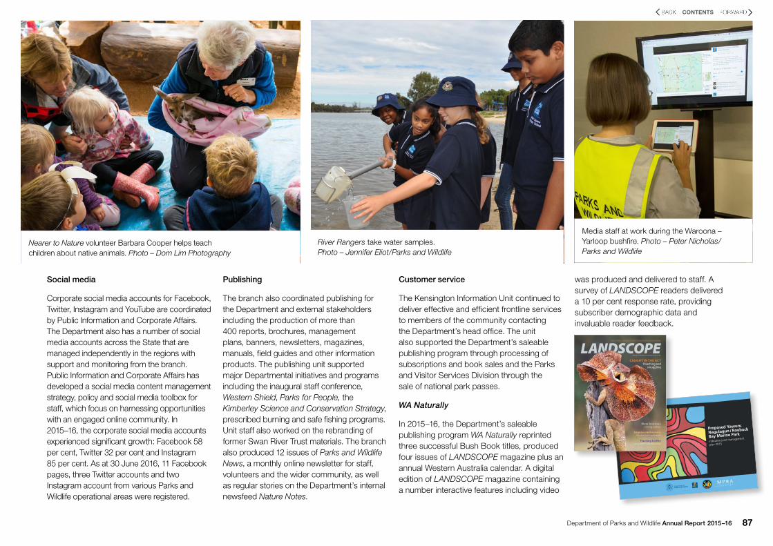
The Bush Rangers WA program continued to support the social and educational development of young cadets drawn from high schools across WA. During 2015–16, the number of units increased from 59 to 64 and cadet numbers increased from 2275 to 3011, with 20 per cent of Bush Rangers coming from Aboriginal backgrounds. Bush Rangers has the highest number of participants of the wider Cadets WA program, and the highest rate of Aboriginal and female cadets enrolled.
Rivers Rangers is a Cadets WA program for Years 4 to 6, joining Parks and Wildlife after the
amalgamation with the Swan River Trust. The program provides education and volunteering opportunities related to rivers and catchments and is closely related to Bush Rangers. The focus of the program expanded beyond the Swan River catchment and two new units were established in the Kimberley. In 2015–16 there were 733 River Rangers cadets in 17 schools.
Web
During 2015–16, the branch’s web content team worked on the transition of the former Swan River Trust website content to the Parks and Wildlife website, the development of a standalone website for the Trust board, the establishment of the WA Parks Foundation website, the development of an online digital resource using Office 365, as well as the update and redevelopment of Western Shield web content on the Parks and Wildlife corporate site. Other projects included research and development of immersive virtual reality applications and research into options for the WA Naturally online shop to improve the customer experience and simplify the branch’s workflow.
Internal web-based projects included ongoing server management, as well as the development of management systems for digital resources and a flight recording system for drone usage. In addition, the unit transferred all websites and databases to more secure remote web services using GitHub.
Department of Parks and Wildlife Annual Report 2015–16 87
CONTENTS
Social media
Corporate social media accounts for Facebook, Twitter, Instagram and YouTube are coordinated by Public Information and Corporate Affairs. The Department also has a number of social media accounts across the State that are managed independently in the regions with support and monitoring from the branch. Public Information and Corporate Affairs has developed a social media content management strategy, policy and social media toolbox for staff, which focus on harnessing opportunities with an engaged online community. In 2015–16, the corporate social media accounts experienced significant growth: Facebook 58 per cent, Twitter 32 per cent and Instagram 85 per cent. As at 30 June 2016, 11 Facebook pages, three Twitter accounts and two Instagram account from various Parks and Wildlife operational areas were registered.
Publishing
The branch also coordinated publishing for the Department and external stakeholders including the production of more than 400 reports, brochures, management plans, banners, newsletters, magazines, manuals, field guides and other information products. The publishing unit supported major Departmental initiatives and programs including the inaugural staff conference, Western Shield, Parks for People, the Kimberley Science and Conservation Strategy, prescribed burning and safe fishing programs. Unit staff also worked on the rebranding of former Swan River Trust materials. The branch also produced 12 issues of Parks and Wildlife News, a monthly online newsletter for staff, volunteers and the wider community, as well as regular stories on the Department’s internal newsfeed Nature Notes.
Customer service
The Kensington Information Unit continued to deliver effective and efficient frontline services to members of the community contacting the Department’s head office. The unit also supported the Department’s saleable publishing program through processing of subscriptions and book sales and the Parks and Visitor Services Division through the sale of national park passes.
WA Naturally
In 2015–16, the Department’s saleable publishing program WA Naturally reprinted three successful Bush Book titles, produced four issues of LANDSCOPE magazine plus an annual Western Australia calendar. A digital edition of LANDSCOPE magazine containing a number interactive features including video
was produced and delivered to staff. A survey of LANDSCOPE readers delivered a 10 per cent response rate, providing subscriber demographic data and invaluable reader feedback.
River Rangers take water samples. Photo – Jennifer Eliot/Parks and Wildlife
Media staff at work during the Waroona – Yarloop bushfire. Photo – Peter Nicholas/ Parks and Wildlife
Proposed Yawuru
Nagulagun / Roebuck
Bay Marine Park
indicative joint management
plan 2015
As told by Matthew Gil
ber
t
20150014 0615 200
Prop
osed
Yawu
ru N
agu
lagu
n / R
oeb
uck B
ay Marin
e Park indicative joint managem
ent plan 2015
20150014 Proposed Yawuru Nagulagun Roebuck Marine Plan COVER.indd 1
15/06/2015 3:35 pm
River JourneysLinking culture
Surprise rediscoveryElusive rock-wallabies
Tracking turtlesLong-term volunteering
WA’S PARKS, WILDLIFE AND CONSERVATION MAGAZINE
Volume 31 Number 3 Autumn 2016 $7.95
CAUGHT IN THE ACTPoaching and
smuggling
Nearer to Nature volunteer Barbara Cooper helps teach children about native animals. Photo – Dom Lim Photography

Department of Parks and Wildlife Annual Report 2015–1688
CONTENTS
Legal mattersFreedom of Information
The Office of the Director General managed the processes for the Department under the Freedom of Information Act 1992. The Department’s Information Statement 2015–16 (available on the Parks and Wildlife website) describes the functions of the Department and its related agencies, the nature of the information held by the Department and its related agencies, and the type of information that is made available to the public.
Parks and Wildlife received 26 valid applications for access to information, with three applicants requesting an internal review and one an external review of the Department’s decisions.
Litigation
Information regarding litigation in progress is available in Note 32 of the Notes to the Financial Statements on page 126 of this report.
Prosecutions
The Department initiated 37 prosecutions during 2015–16, involving a total of 296 charges covering a broad range of offences including the illegal taking or possession of protected and rare fauna or flora, illegal importation or selling of fauna, illegal exportation of fauna, cruelty to fauna,
failure to comply with licence conditions, and offences relating to activities on State forest, nature reserves and national parks.
Finalised prosecutions for 2015–16Of the 37 prosecutions commenced, 19 were subject to final court determination during 2015–16, including cases relating to the Conservation and Land Management Act 1984, Wildlife Conservation Act 1950, Animal Welfare Act 2002, Conservation and Land Management Regulations 2000, the Wildlife Conservation Regulations 1970 and the Wildlife Conservation (Reptiles and Amphibians) Regulations 2002.
These matters resulted in the imposition of fines totalling $22,000 and costs to the value of $7747.40.
In addition to the 37 prosecutions commenced during this period a further 26 were carried forward and finalised from 2014–15.
Prosecutions currently before the courtsAs at 30 June 2016, 10 prosecutions were yet to be concluded and remained before the courts. A further eight cases were pending, subject to the evidentiary standard being met, and could result in either prosecution or a letter of warning.
Total reported offencesBetween 1 July 2015 and 30 June 2016, a total of 1366 offences were reported, of which 72 were dealt with by way of prosecution, 224 were pending, 596 were dealt with by infringement notice, six resulted in letters of warning, 379 were dealt with by caution notices, one required no further action, 33 were withdrawn and 55 dismissed.
Office for Information ManagementThe Office for Information Management (OIM) provides Statewide management of the Department’s information and related technology (IT) and also oversees the development of IT policies, standards and architecture.
In 2015–16, OIM focused on initiatives that addressed the Department’s strategies for IT, including:
• delivering an IT change program to support the Department’s strategic directions
• delivering reliable IT products and services to support the Department’s critical business functions
• making use of technology that enables workforce mobility and collaboration
• strengthening the security and risk management framework to protect the Department’s IT systems and assets
• enabling IT systems that provide digital engagement with the community and the Department’s partners.
Key achievements for 2015–16 include:
• improving the resilience of IT systems through migration to cloud services in line with State Government strategic directions
• reducing energy consumption, costs and carbon emissions through more efficient use of infrastructure and sustainable work practices
• enabling interagency and public data exchange by increasing the adoption of open source technology
• improving community safety through the expansion and upgrade of the Department’s telecommunications network
• contributing to the Office of the Government Chief Information Officer’s whole-of-Government strategy for information and communications technology.
Supporting our DepartmentAgency performance
Department of Parks and Wildlife Annual Report 2015–16 89
CONTENTS
Visitor risk managementThe Department has a responsibility to consider the personal safety and welfare of visitors to Parks and Wildlife-managed lands and waters. The Department aims to manage the potential for misadventure and injuries to visitors in a manner that does not unnecessarily diminish visitor use and enjoyment. The Department manages the risk presented to visitors by implementing a Statewide Visitor Risk Management program. This includes conducting reviews of fatal and major incidents and implementing the key recommendations of those reviews.
Tragically, during 2015–16, four visitors died in the extensive areas managed by Parks and Wildlife. All of these deaths were due to drowning while participating in recreational activities along the coast, including one rock fishing death.
During 2015–16:
• Parks and Wildlife continued to work on a broad range of issues regarding visitor safety including remote camping, walk trail classifications and redevelopments and improvements to recreational sites and facilities
• Sixty-six staff completed a nationally accredited course provided by the Department as part of the Statewide Visitor Risk Management program
• Fifty-six staff completed induction training for the recently introduced online incident and hazard management reporting system
• Parks and Wildlife continued to contribute to the Statewide approach to reduce the number of injuries and deaths associated with rock fishing in WA in conjunction with Recfishwest and other stakeholders
• In partnership with the local fishing community and Recfishwest, anchor points, angel rings (life buoys) and new signs were installed in various locations in national parks around Esperance, Albany and Denmark
• In partnership with Recfishwest, suitable locations for life buoys were investigated along the Leeuwin-Naturaliste coastline between Dunsborough and Augusta
• The Department’s public website was updated to improve the accessibility of safety-related information
• The Department reviewed its operational policy on park closure due to fire danger ratings following its introduction several years ago.
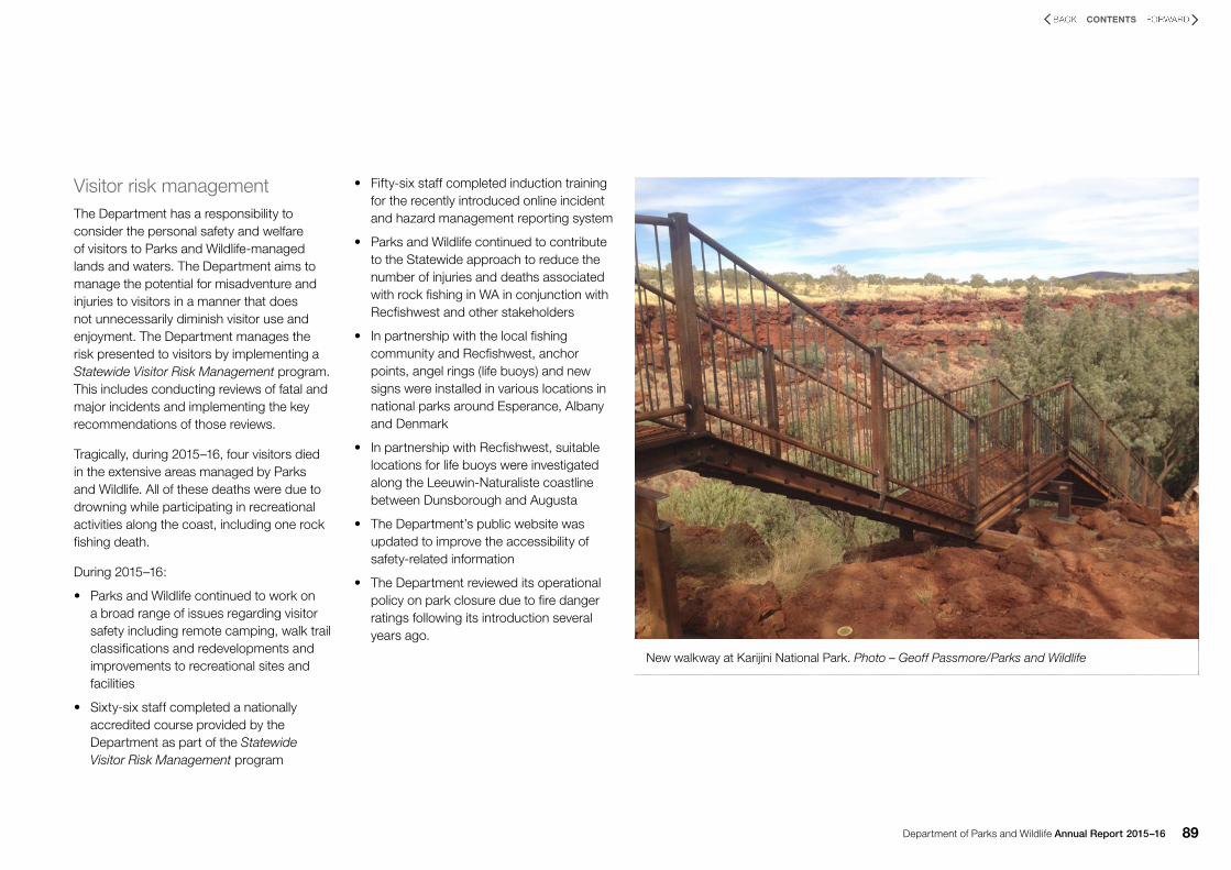
New walkway at Karijini National Park. Photo – Geoff Passmore/Parks and Wildlife

Department of Parks and Wildlife Annual Report 2015–1690
CONTENTS
Corporate Services DivisionThe Corporate Services Division provided corporate services to the Department and other agencies including the Department of Environment Regulation, the Office of the Environmental Protection Authority, the Swan River Trust Board, the Forest Products Commission and the Waste Authority of Western Australia.
Financial Services Branch
The Department’s central Financial Services Branch continued to maintain core financial software and manage accounts payable, accounts receivable, asset records, tax reporting and remote area housing. The branch also managed the Department’s light and heavy vehicle fleet and produced a range of statutory and management financial reports.
Corporate Information Services Branch
The Corporate Information Services (CIS) Branch continued to provide recordkeeping services and improve business recordkeeping processes, particularly through the continued roll-out of recordkeeping awareness training and ongoing use of the electronic document and records management system Inf0Base. Comprehensive training on the use of Inf0Base is available to all staff. Training is designed to ensure staff understand and fulfil their recordkeeping responsibilities as well as gain the necessary skills to create and manage electronic documents in the system, including version control and document approvals.
The Electronic Document and Records Management System team provided system administration, training and support to the Department of Environment Regulation and participated in recordkeeping projects within the Department. During the year, CIS completed a major upgrade of Inf0Base to take into account new features to make corporate information more accessible.
CIS supported the work of the Ministerial Liaison Unit, in capturing, processing and responding to Ministerials and other types of correspondence from the Office of the Director General.
CIS is also responsible for implementing the Department’s recordkeeping plan framework and working towards to ensuring compliance with State Records Act 2000.
CIS also provided various records services to other agencies including the Department of Environment Regulation and the Conservation and Parks Commission.
People Services Branch
The People Services Branch continued to provide client-focused human resource services including employee relations, workforce services, policy delivery, learning and development programs and initiatives, strategic planning, data analysis and reporting, and management of the safety, health and wellbeing of employees.
Geographic Information Services
The Geographic Information Services Branch provided services to support the Department’s mission of protecting and conserving the nature of WA and promoting the use and enjoyment of the natural environment by:
• monitoring of Earth’s surface using remote sensing to provide information on the current and historical attributes of WA’s natural resources
• using spatial analysis of geospatial information to assist in natural resource management. producing maps and other information products to meet operational and public needs
• managing corporate geospatial databases for the Department and bureau clients
• developing standards for the use of geospatial data and information within the Department.
The key achievements and activities of the branch for 2015–16 are outlined below.
Remote sensing and spatial analysis
Vegetation monitoring• Developed a monitoring framework for
the draft Perth and Peel Green Growth Plan for 3.5 million detailing the potential applications of spatial data with a focus on the use of high-resolution digital aerial photography.
• Completed the Dirk Hartog Island National Park vegetation monitoring program for 2015–16. This included using remote sensing to report on impacts of the removal of sheep and goats.
• Completed vegetation mapping across the Pilbara islands using high-resolution multispectral imagery.
• Completed vegetation monitoring for the Kimberley Science and Conservation Strategy. This included analysis of rainforest patch extents and vegetation cover change.
• Completed an assessment of riparian vegetation extent change across the Swan and Canning rivers using high-resolution digital aerial photography.
Spatial analysisCompilation and analysis of geospatial data and preparation of maps for the draft Perth and Peel Green Growth Plan for 3.5 million.
• Spatial analysis of horse and donkey movements to assist in determining the effectiveness of the Judas method for controlling feral herbivores in the Fortescue Marsh system.
• Provided continued spatial analysis support for the establishment of the conservation reserve system by producing Statewide vegetation and tenure statistics and assisting in the extension of vegetation complex mapping for the south-west of the State.
Supporting our DepartmentAgency performance

Department of Parks and Wildlife Annual Report 2015–16 91
CONTENTS
Fire• Ongoing development of a spatial fire risk
model for the Perth urban and peri-urban areas to assist in planning vegetation fuel reduction programs.
• Assessed key fire spatial metrics for the Kimberley Landscape Conservation Initiative to assess the effectiveness of changed fire management regimes.
• Mapping of Pilbara and Western Desert annual fire scarring to assess size and number of previous prescribed burns, to aid in planning future management actions.
• Develop new more efficient methodology for historic fire scar extraction utilising eCognition software.
• With Landgate, develop near real-time Normalised Burn Ratio web product for quick evaluation of burns and fires for all agencies involved in fire management.
Marine• Use of remote sensing to report to the
former Marine Parks Reserve Authority for mangrove condition monitoring, Penguin Island coastal vegetation monitoring and seagrass extent.
• Collaboration with Landgate’s Managing Coastal Vulnerability project to improve data management and access to marine dataset in State Government agencies.
• Further acquisitions of high-resolution satellite imagery through Landgate and the State-funded Location Information Strategy.
• In collaboration with the Marine Science Program, conducting ongoing investigations into impacts of the 2010–11 marine heatwave on the seagrass of Shark Bay.
Mapping and data capture
• Completion of the extended 2016 South West Emergency Services Directory, including maps for all town sites.
• Consolidating and inputting information about the Department’s strategic road network into the State’s Topographic Geodatabase at Landgate.
• Producing maps for reserve creation and Indigenous Land Use Agreements associated with the Kimberley Science and Conservation Strategy.
• Producing navigational maps of the Department’s long trails for the public.
• Preparing maps to support a wide range of Departmental activities including the Western Shield wildlife recovery program, park management and regional and fire operations.
Database and application development
• Development and deployment of mobile data collection software for use in crocodile surveys, road condition field capture, marine habitat sampling, apiary sites placement and fauna surveys on Penguin Island.
• Development of various applications to enhance the management of the Department’s geospatial data.
Parks and Wildlife-managed lands and watersTotal estate
At 30 June 2016, the total area under Parks and Wildlife’s care was 29,192,323ha, representing a net increase of 647,578ha during 2015–16.
The majority of the increase was 599,402ha due to the addition of lands set aside for future conservation as a result of the 2015 pastoral lease renewal program.
The terrestrial area managed (that is, not including marine reserves) is approximately 10.6 per cent of the land area of Western Australia.
Table 10 on page 92 provides a summary of all tenure classifications.

Department of Parks and Wildlife Annual Report 2015–1692
CONTENTS
Table 10: Tenure classification of Parks and Wildlife-managed lands and waters
Supporting our DepartmentAgency performance
Tenure classification Goldfields Kimberley Midwest Pilbara South Coast South West Swan Warren Wheatbelt Total
National park 153,177 1,406,089 568,869 2,434,241 861,419 143,906 117,232 562,459 1292 6,248,684
Conservation park 183,020 467,259 15,755 149,348 677 13,597 24,407 76 2254 856,393
Nature reserve 6,299,182 174,653 740,175 251,019 1,569,517 12,982 54,590 87,265 1,058,631 10,248,014
State forest 781 - - - 4055 542,230 466,380 262,642 28,066 1,304,154
Timber reserve 28,509 - 26,224 - 5231 26,474 28,496 8201 - 123,135
Marine park - 899,700 868,860 330,215 - 123,000 16,391 1446 - 2,239,612
Marine nature reserve - - 132,000 - - - - - - 132,000
Marine management area - - - 143,385 - - - - - 143,385
Sections 5(1)(g) & 5(1)(h) reserve 81,566 286,566 1976 7810 644 31,207 28,618 1614 1599 441,600
Miscellaneous reserve <1 568,010 505 1779 3767 124 6006 244 15 580,450
Freehold (CALM Exec Body) - <1 1550 <1 91 19,884 50 4658 <1 26,233
Leasehold (CALM Exec Body) - - - - - - - - - 0
Unallocated Crown land – Department interest 1,920,753 203,503 3,299,930 1,157,282 16,885 - - - 43,142 6,641,495
Section 33(2) managed land 28,514 90,118 118,632
Sections 16A managed land - 37,941 - - - - 37,941
Swan River Trust – river reserve 3600 3600
Crown freehold – Department interest - - 10,959 - 6201 3975 19,675 1702 4483 46,995
Totals 8,695,502 4,043,721 5,756,921 4,475,079 2,468,487 917,379 765,445 930,307 1,139,482 29,192,323
Department of Parks and Wildlife Annual Report 2015–16 93
CONTENTS
Establishment of the Conservation and Parks Commission
In May 2016 the majority of the 2015 amendments to the Conservation and Land Management Act 1984 (CALM Act) were proclaimed by the Governor and came into operation. The Conservation and Parks Commission was established and the membership appointed by the Minister for Environment. The Conservation and Parks Commission replaces the Conservation Commission of Western Australia and the Marine Parks and Reserves Authority; combining the functions of these entities. New terrestrial and marine reserves can be vested in the Conservation and Parks Commission in accordance with section 7 of the CALM Act in a similar manner to the vesting under statute in the previous Conservation Commission of WA. All existing conservation reserves vested in the Conservation Commission of WA will remain so vested but the responsibilities for these reserves will be undertaken by the Conservation and Parks Commission.
Amendments to the recording of statistics about lands and waters managed by Parks and Wildlife
In 2010 and 2015 changes were made to the CALM Act that altered the tenure that the Department administers and manages. The amendments to the CALM Act required changes to the way statistics concerning
the area of land, type of tenure and land management regimes are recorded and presented.
Landgate is the custodian of the State’s land titles system and repository of information about Crown and freehold land. To minimise the duplication of statistics held by the Department and Landgate a decision was made to solely rely on Landgate datasets and records of land tenure. Landgate’s statistical data about the area of conservation reserves, land tenure types and other information will be integrated into the Department’s Annual Report and Yearbook over coming years. It is expected that there will be some variation in the statistics previously presented in the Department’s Annual Report and Yearbook, and explanatory statements will be provided as required.
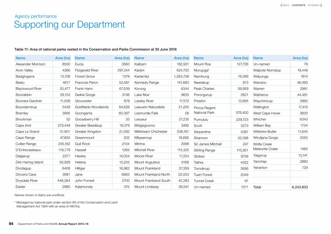
National parks
The area of the 99 national parks solely vested in the Conservation and Parks Commission of WA at 30 June 2016 was 6,243,833ha, a net decrease of 71ha. The major decrease was 83ha due to the excision of four caves within the Leeuwin-Naturaliste National Park. These caves are now vested with the Margaret River Busselton Tourism Association Incorporated. The area of the 100 national parks at 30 June 2016 is 6,248,684ha (see Section 8A).
Section 8A
Section 8A was introduced into the CALM Act on 8 December 2012.
This section of the CALM Act empowers Parks and Wildlife to enter into agreements to jointly manage land with another party or parties, on land not vested in either the former Conservation Commission of WA or the Marine Parks and Reserves Authority, now the Conservation and Parks Commission. For example, private land, pastoral lease land and other Crown land can be managed jointly with other parties. A section 8A agreement is managed in accordance with the CALM Act as if the land was State forest, timber reserve, national park, conservation park, nature reserve or managed for a public purpose consistent with that Act.
Murujuga National Park is jointly managed as a national park under section 8A of the CALM Act by the Murujuga Aboriginal Corporation and Parks and Wildlife. Murujuga National Park was proclaimed the 100th national park on 17 January 2013. The area of the national park is 4851ha and is recorded in the national park tenure category under Pilbara in Table 10 on page 94. There was no change during the year.
Conservation parks
The area of conservation parks solely vested in the Conservation and Parks Commission at 30 June 2016 was 849,076ha. There was an increase of 732ha. The majority of the increase was 695ha due to the creation of a new conservation park in the Shire of Wongan-Ballidu.
Yawuru Birragun Conservation Park is jointly managed as a conservation park under section 8A of the CALM Act by the Yawuru Native Title Holders Aboriginal Corporation, Registered Native Title Body Corporate and Parks and Wildlife. The conservation park was proclaimed on 1 February 2016. The area of the conservation park is 7317ha and is recorded in the conservation park tenure category under Kimberley in Table 10.
The area of conservation parks at 30 June 2016 was 856,393ha.
Nature reserves
The area of nature reserves at 30 June 2016 was 10,248,014ha, representing a net increase of 819ha. The majority of the increase was 699ha due to the transfer of land formerly in the care of the Department of Water in the Shire of Mukinbudin.
Department of Parks and Wildlife Annual Report 2015–1694
CONTENTS
Supporting our DepartmentAgency performance
Names shown in italics are unofficial.
* Managed as national park under section 8A of the Conservation and Land Management Act 1984 with an area of 4851ha.
Name Area (ha)
Alexander Morrison 8500
Avon Valley 4366
Badgingarra 13,108
Beelu 4617
Blackwood River 20,477
Boorabbin 28,153
Boorara-Gardner 11,008
Boyndaminup 5439
Bramley 3895
Brockman 52
Cape Arid 279,449
Cape Le Grand 31,801
Cape Range 47,655
Collier Range 235,162
D’Entrecasteaux 118,779
Dalgarup 2377
Dirk Hartog Island 62,928
Dordagup 6408
Drovers Cave 2681
Drysdale River 448,264
Easter 2985
Name Area (ha)
Eucla 3560
Fitzgerald River 297,244
Forest Grove 1379
Francois Peron 52,587
Frank Hann 67,539
Geikie Gorge 3136
Gloucester 878
Goldfields Woodlands 64,628
Goongarrie 60,397
Gooseberry Hill 33
Greater Beedelup 19,379
Greater Kingston 21,092
Greenmount 202
Gull Rock 2104
Hassell 1265
Hawke 14,004
Helena 12,255
Hilliger 16,962
Jane 6863
John Forrest 2700
Kalamunda 375
Name Area (ha)
Kalbarri 182,931
Karijini 624,700
Karlamilyi 1,283,706
Kennedy Range 141,660
Korung 6344
Lake Muir 9625
Lawley River 17,572
Leeuwin-Naturaliste 21,200
Lesmurdie Falls 56
Lesueur 27,235
Midgegooroo 2492
Millstream Chichester 238,167
Milyeannup 18,692
Mirima 2068
Mitchell River 115,325
Moore River 17,254
Mount Augustus 9168
Mount Frankland 37,359
Mount Frankland North 22,053
Mount Frankland South 42,283
Mount Lindesay 39,541
Name Area (ha)
Mount Roe 127,726
Murujuga* -
Nambung 19,268
Neerabup 973
Peak Charles 39,959
Porongurup 2621
Preston 12,665
Prince Regent National Park 576,400
Purnululu 239,723
Scott 3273
Serpentine 4387
Shannon 52,598
Sir James Mitchell 247
Stirling Range 115,921
Stokes 9726
Tathra 4322
Torndirrup 3936
Tuart Forest 2049
Tunnel Creek 91
Un-named 1571
Name Area (ha)
Un-named 79
Walpole-Nornalup 19,448
Walyunga 1814
Wandoo 46,493
Warren 2981
Watheroo 44,481
Waychinicup 3982
Wellington 17,415
West Cape Howe 3605
Whicher 6343
William Bay 1734
Wiltshire-Butler 11,645
Windjana Gorge 2050
Wolfe Creek Meteorite Crater 1460
Yalgorup 13,141
Yanchep 2860
Yelverton 729
Total 6,243,833
Table 11: Area of national parks vested in the Conservation and Parks Commission at 30 June 2016
Department of Parks and Wildlife Annual Report 2015–16 95
CONTENTS
State forest
The area of State forest at 30 June 2016 was 1,304,154ha, representing a net decrease of 97ha. The majority of the decrease was 91ha due to the construction of the Perth-Darwin National Highway through the City of Swan.
Timber reserves
The area of timber reserves at 30 June 2016 was 123,135ha representing a net decrease of 19ha. The majority of the decrease was 14ha due to the transfer of land to a Section 5(1)(h) reserve in the Shire of Manjimup.
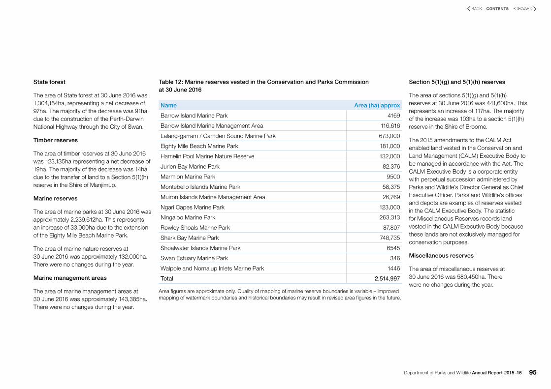
Marine reserves
The area of marine parks at 30 June 2016 was approximately 2,239,612ha. This represents an increase of 33,000ha due to the extension of the Eighty Mile Beach Marine Park.
The area of marine nature reserves at 30 June 2016 was approximately 132,000ha. There were no changes during the year.
Marine management areas
The area of marine management areas at 30 June 2016 was approximately 143,385ha. There were no changes during the year.
Section 5(1)(g) and 5(1)(h) reserves
The area of sections 5(1)(g) and 5(1)(h) reserves at 30 June 2016 was 441,600ha. This represents an increase of 117ha. The majority of the increase was 103ha to a section 5(1)(h) reserve in the Shire of Broome.
The 2015 amendments to the CALM Act enabled land vested in the Conservation and Land Management (CALM) Executive Body to be managed in accordance with the Act. The CALM Executive Body is a corporate entity with perpetual succession administered by Parks and Wildlife’s Director General as Chief Executive Officer. Parks and Wildlife’s offices and depots are examples of reserves vested in the CALM Executive Body. The statistic for Miscellaneous Reserves records land vested in the CALM Executive Body because these lands are not exclusively managed for conservation purposes.
Miscellaneous reserves
The area of miscellaneous reserves at 30 June 2016 was 580,450ha. There were no changes during the year.
Table 12: Marine reserves vested in the Conservation and Parks Commission at 30 June 2016
Name Area (ha) approx
Barrow Island Marine Park 4169
Barrow Island Marine Management Area 116,616
Lalang-garram / Camden Sound Marine Park 673,000
Eighty Mile Beach Marine Park 181,000
Hamelin Pool Marine Nature Reserve 132,000
Jurien Bay Marine Park 82,376
Marmion Marine Park 9500
Montebello Islands Marine Park 58,375
Muiron Islands Marine Management Area 26,769
Ngari Capes Marine Park 123,000
Ningaloo Marine Park 263,313
Rowley Shoals Marine Park 87,807
Shark Bay Marine Park 748,735
Shoalwater Islands Marine Park 6545
Swan Estuary Marine Park 346
Walpole and Nornalup Inlets Marine Park 1446
Total 2,514,997
Area figures are approximate only. Quality of mapping of marine reserve boundaries is variable – improved mapping of watermark boundaries and historical boundaries may result in revised area figures in the future.

Department of Parks and Wildlife Annual Report 2015–1696
CONTENTS
Supporting our DepartmentAgency performance
Swan River Trust reserves
The area of Swan River Trust river reserves at 30 June 2016 was 3600ha.
Amendments to the Swan and Canning Rivers Management Act 2006 (SCRM Act) came into operation in 2015. The amendment transferred management responsibility of the river reserve from the Swan River Trust to the Parks and Wildlife CEO. This statistic includes all land that is vested or owned by the Swan River Trust that is part of the Riverpark (section 9 of the SCRM Act).
Other land
The area of freehold land held by the Conservation and Land Management (CALM) Executive Body at 30 June 2016 was 26,233ha. There were no changes during the year.
The area of former pastoral lease land being held under an interim management arrangement prior to formal reservation is 6,641,495ha. This represents an increase of 599,402ha. The majority of the increase is due to the addition of lands set aside for future conservation as part of the 2015 pastoral lease renewal program. The figures for this category are shown in the tenure table as ‘Unallocated Crown land – Department interest’.
The area of Crown land placed under the management of the Department under section 33(2) of the CALM Act at 30 June 2016 totalled 118,632ha.
There were no changes during the year. This land is proposed for addition to the conservation estate, which is managed accordingly under an interim arrangement. Section 33(2) of the CALM Act was amended in 2010 and historically negotiated agreements under this section will remain in force until they are amended or cancelled. Two examples of land managed by the Department through historic s33(2) CALM Act are the former pastoral lease lands surrounding Kennedy Range National Park, and the unallocated Crown land that comprises the Goldfields Woodland Management Area. Sections 8A or 8C of the CALM Act replaced the functions that were previously included in section 33(2) of the CALM Act.
Areas currently managed under section 16A of the CALM Act by agreement between the lessees and the Department at 30 June 2016 was 37,941ha. There were no changes during the year. Historically, two section 16A of the CALM Act management agreements were negotiated with the lessees of Anna Plains and Carlton Hill stations. The management agreement over part of Anna Plains stations was cancelled in July 2015 when the pastoral lease was renewed. The land has reverted to unallocated Crown land and is managed by the Department until such time as a new conservation reserve over the land is created (expected to be in early 2017). The Carlton Hill management agreement area is under review
and consideration could be given to cancelling this agreement if the pastoral lease is sold.
The area of freehold land managed by the Department under section 8A and the former s16A of the CALM Act at 30 June 2016 was 8,703 hectares. This represents an increase of 639ha. Most of this land falls within regional parks and is managed by agreement between the Western Australian Planning Commission and the Department. The figures for this category are shown in the tenure table as Crown freehold – Department interest. The 2015 amendments to the CALM Act included provisions to formally recognise and gazette regional parks as areas of land with regionally significant conservation, landscape protection or recreation values (s8D-F of the CALM Act). As appropriate Parks and Wildlife will negotiate joint management agreements in accordance with s8A of the CALM Act with landholders so these lands can be included in regional parks.
The area of freehold land acquired for addition to the conservation reserve system at 30 June 2016 was 38,825ha. This represents an increase of 2672ha. Reservation of these areas pends the completion of administrative processes.
The 2015 amendments to the CALM Act allow the Environment Minister to make a determination that a new or existing CALM Act conservation reserve can be jointly managed with an Aboriginal body corporate
(s8AA of the CALM Act). The Department will consider if it is appropriate to provide specific statistics on the area of land subject to a joint vesting determination.
Conservation land acquisitions
During the year Parks and Wildlife purchased 10 parcels of land of high conservation value covering a combined total area of about 5182ha for future addition to the formal conservation reserve system.
The Department’s priorities for purchases are areas containing ecosystems not adequately represented in existing conservation reserves, areas containing threatened species and ecological communities, or additions to existing reserves that will greatly improve their diversity or facilitate their management.
The purchases were funded from environmental offset funds (provided from a variety of sources as a result of approved development projects and land clearing). The total expenditure was $17.920 million.

Department of Parks and Wildlife Annual Report 2015–16 97
CONTENTS
Purchases finalised during the year were:
• 720ha property in the Shire of Kellerberrin
• 79ha property in the Shire of Harvey
• 72ha property in the Shire of Harvey
• 605ha property in the Shire of Dandaragan
• 83ha property in the Shire of Murray
• 375haproperty in the Shire of Kulin
• 251ha property in the Shire of Murray
• 51ha property in the Shire of Murray
• 1995ha property in the Shire of Dandaragan
• 951ha property in the Shire of Mandurah.
REGISTRATION LADDER REGISTRATION LADDER
AA
Kununurra
Geraldton
PERTH
Bunbury
Albany
Narrogin
Karratha
S o
u t
h
A u
s t
r a
l i
aN
o r
t h
e r
n
T e
r r
i t
o r
y
KIMBERLEY
PILBARA
GOLDFIELDS
SOUTH COASTWHEATBELTSWAN
l
MIDWEST
SOUTHWEST
WARREN
Manjimup
Kalgoorlie
26
30
22
34
112 116 120 124 128
34
30
26
22
18
14
128124120116112
0 100 200 300 400 Km
Broome
REGISTRATION LADDER REGISTRATION LADDER
AA
Kununurra
Geraldton
PERTH
Bunbury
Albany
Narrogin
Karratha
S o
u t
h
A u
s t
r a
l i
aN
o r
t h
e r
n
T e
r r
i t
o r
y
KIMBERLEY
PILBARA
GOLDFIELDS
SOUTH COASTWHEATBELTSWAN
l
MIDWEST
SOUTHWEST
WARREN
Manjimup
Kalgoorlie
26
30
22
34
112 116 120 124 128
34
30
26
22
18
14
128124120116112
Broome
Figure 9: Parks and Wildlife-managed lands and waters at 30 June 2016

Department of Parks and Wildlife Annual Report 2015–1698
CONTENTS
Significant issues and trends
• A new Kalbarri Skywalk and National Park Tourist Infrastructure project will commence with a $20 million total project budget, providing new sealed roads to the Loop and Z Bend tourist sites and the development of new facilities at several sites including two new lookout structures overlooking the Murchison River gorge in Kalbarri National Park.
• Implementation of the Government’s Parks for People Caravan and Camping initiative will continue, directed at parks in the State’s south-west and mid-west with a total project budget of $21 million. The number of low-cost camping and caravan facilities in those regions is being significantly expanded to promote the State’s world-class parks system and help people enjoy their parks safely by providing a range of facilities and services.
• New public recreation and joint management arrangements for the Ningaloo Coast will commence with $6 million in total funding over four years to continue negotiation of an Indigenous Land Use Agreement, establish coordinated management of the coast and provide new and improved visitor infrastructure including roads.
• The Department will continue to strengthen and expand its partnership approach to managing the State’s terrestrial and marine parks and reserves with volunteers, private conservation organisations, Aboriginal communities and the private sector.
• The Department will continue to prepare management plans and implement conservation actions for terrestrial and marine reserves across the State. This includes continuing to implement the Government’s expanded Kimberley Science and Conservation Strategy to provide the largest ever targeted investment in conservation of the Kimberley’s natural assets, the protection of Aboriginal cultural heritage and rock art and the development of sustainable nature-based tourism. As part of the strategy the Government will invest an additional $22 million over four years in establishing and managing new Kimberley national and marine parks, including the Great Kimberley Marine Park which will be the second largest coastal marine park in Australia. This takes the Government’s total investment to more than $103 million. The strategy is being delivered in partnership with traditional owners, community, industry and non-Government organisations.
• The Department will continue to undertake an active fire management program in an increasingly complex operating environment, exacerbated by drying conditions in the south-west of the State. Funding for prescribed burning to maximise the reduction of bushfire risk will increase by $2 million in 2016–17.
• Western Australia has unique and highly significant biodiversity that faces threats and complex challenges, requiring integrated multi-disciplinary approaches to conservation and management.
• Invasive pests, weeds and diseases will continue to be managed. The Department will maintain the Western Shield wildlife recovery program in partnership with industry and the community, including expansion of trials of the new Eradicat® bait for feral cats.
• Implementation of the State Cane Toad Strategy will continue to manage the impact of cane toads on native wildlife.
• Priority will be given to assisting with Parliamentary and public consideration of the Biodiversity Conservation Bill 2015 which is intended to replace the Wildlife Conservation Act 1950 and Sandalwood Act 1929.
• The State’s forests will continue to be managed to conserve plants and animals, protect water catchments, for recreation and tourism, for a sustainable timber industry, for mining and other public uses. This will be done under the framework of the Forest Management Plan 2014–2023. Further research, monitoring and reporting will be conducted. This includes completion of the third five-yearly progress report on implementation of the Regional Forest Agreement for the south-west forest region.
• The Department will continue to contribute to the State Government’s strategic assessment of the Perth and Peel regions which seeks upfront environmental approval for development under the Commonwealth Environment Protection and Biodiversity Conservation Act 1999, and State Environmental Protection Act 1986. The strategic assessment aims to promote more efficient environmental assessment and improve environmental outcomes in the Perth and Peel region as it expands over the next 30 years to accommodate 3.5 million people. The draft Green Growth Plan for 3.5 million released for public comment in late 2015 includes a number of commitments for protection of bushland, rivers and wetlands including 170,000ha of new and expanded conservation reserves in the Perth and Peel regions and immediate surrounds.

Department of Parks and Wildlife Annual Report 2015–16 99
CONTENTS
A pair of cleaner shrimp. Photo – Richard Evans/Parks and Wildlife
Matuwa (Lorna Glen) in the Goldfields. Photo – Jennifer Eliot/Parks and Wildlife
• Integration of the operations of the Swan River Trust and the Department have been successfully completed and in place since July 2015. Extra funding has accelerated major shoreline restoration projects in partnership with adjoining foreshore land managers. The release of the Swan Canning River Protection Strategy in 2015 will provide the basis for improved coordination of efforts across Government in managing and protecting the Riverpark.
• $28.9 million has been allocated for the development of a new Parks and Wildlife headquarters in Bunbury. Planning is well advanced. The project will initially see 100 extra jobs relocated to Bunbury and will be one of the most significant long-term economic investments by the Government in the region, providing ongoing benefits.
Aerial view of a Kimberley river system. Photo – Peter Nicholas/Parks and Wildlife