department of the interior - nsf · 14 department of the interior the department of the interior...
TRANSCRIPT

14
Department of the Interior
The Department of the Interior performs biological, physical, engineering,and social science research; conducts mapping, monitoring, and assessmentprograms throughout Alaska and its offshore regions; and managesdepartment lands in Alaska. These activities are performed by services orbureaus, each with administrative and technical offices located in Alaska.
Minerals ManagementService
The Minerals Management Service (MMS) hasthe statutory responsibilities to manage the mineralresources located on the U.S. Outer ContinentalShelf (OCS) in an environmentally sound and safemanner and to collect, verify, and distribute mineralrevenues from Federal and Indian lands.
In support of these responsibilities, MMSconducts two major programs of research that arerelevant to activities in the Arctic. One, the Tech-nology Assessment and Research (TA&R) Pro-gram, focuses on engineering and technologyissues. The other, the Environmental StudiesProgram, focuses on issues related to assessingand predicting potential environmental and socio-economic impacts.
Technology Assessment andResearch Program
The MMS supports an active research programto understand the engineering constraints foroffshore operations, especially related to thestructural integrity of oil and gas facilities andpipelines, the prevention of pollution, and thetechnologies necessary to clean up an oil spillshould one occur. In essence, the program pro-vides an independent assessment of the status ofOCS technologies and, where deemed necessary,investigates technology gaps and provides lead-ership in reaching solutions. The program alsofacilitates a dialogue among engineers in theindustry, the research community, and MMS indealing with the many complex issues associatedwith offshore oil and gas operations.
The TA&R Program supports research associ-ated with operational safety and pollution preven-
tion, as well as oil-spill response and cleanupcapabilities. It was established in the 1970s toensure that industry operations on the OCS incor-porated the use of the Best Available and SafestTechnologies (BAST). The program comprisestwo functional research activities: OperationalSafety and Engineering Research (OSER) and OilSpill Research (OSR).
The TA&R Program has four primary objec-tives:
• Technical Support: TA&R provides engineer-ing support to MMS decision makers in eval-uating industry operational proposals andrelated technical issues and ensuring thatthese proposals comply with applicable regu-lations, rules, and operational guidelines andstandards.
• Technology Assessment: Industry applica-tions of technological innovations are investi-gated and assessed to ensure that governingMMS regulations, rules, and operationalguidelines encompass the use of BAST.
• Research Catalyst: The program promotesleadership in OSER and OSR by acting as acatalyst for industry research initiatives.
• International Regulations: The program pro-vides international cooperation for researchand development initiatives to enhance thesafety of offshore oil and natural gas activi-ties and the development of appropriate regu-latory program elements worldwide.
The TA&R Program operates through con-tracts with universities, private firms, and govern-
Funding (thousands)FY 02 FY 03
Technology Assessment/Research 400 500Environmental Studies 4,866 4,273Total 5,266 4,773

15
ment laboratories to assess safety-related technol-ogies and to perform necessary applied research.Participation in jointly funded projects with indus-try, other Federal and state agencies, and interna-tional regulatory organizations has become theprimary funding mechanism in view of the overlapof issues and challenges. Participation in jointprojects is the most effective and efficient meansto leverage available funds.
The TA&R Program enhanced its researchcapabilities in FY 99 through the establishment ofa five-year cooperative research program with theOffshore Technology Research Center in CollegeStation, Texas. This cooperative agreement pro-vides direct research support to MMS as well as aforum for identifying and jointly funding researchprojects with industry on a variety of topics.
The TA&R Program operates Ohmsett—theNational Oil Spill Response Test Facility—inLeonardo, New Jersey. This facility provides test-ing and research capabilities to MMS, other gov-ernment agencies, and the private sector on topicsassociated with the prevention and cleanup of oilspills. Ohmsett is the only facility in North Americawhere full-scale response equipment (containmentbooms, skimmers, etc.) can be tested in a con-trolled environment, using real oil. (See below fora fuller discussion of Ohmsett.)
In the past the TA&R Program was motivatedby the need to acquire basic engineering informa-tion necessary to oversee the general develop-ment of offshore operations. As a direct result ofresearch funded by the TA&R program, regulatorychanges were initiated on:
• The design and operation of diverter systems,well control procedures, and training require-ments;
• The need for periodic platform inspections,methodologies for assessing the integrity ofolder or damaged platforms, and the reductionof exhaust pollution offshore; and
• The development of oil pollution plans toensure that the proper equipment, personnel,and procedures were available to respond toan offshore oil spill, should one occur.
However, the future has provided new goalsand directions for offshore oil and gas researchinitiatives. This new emphasis is a result of pasttechnology developments, economic constraintswithin the industry, and a continuing need toensure that offshore oil and gas operations can beconducted in a safe manner without harm to theenvironment.
With a sound appreciation for the current state
of offshore technology, the TA&R Program willcontinue to focus its research efforts in the follow-ing four areas:
• Frontier areas of operations (both deep waterand the Arctic), including safety issues aswell as the integrity of structures and pipe-lines;
• Human and organizational factors and howthey can be addressed to mitigate accidents;
• Aging offshore infrastructure, including plat-forms and pipelines; and
• Spill mitigation measures, including cleanupand containment technologies for an oil spill,should one occur.
The TA&R Program is a contract research pro-gram; that is, the research is not performed withinthe agency but is conducted by academic institu-tions, private industry, and government laborato-ries. Studies are performed in cooperation with theoffshore industry or with other agencies or gov-ernments. This aspect of the program provides animportant multiplier of funding support, but proba-bly of equal importance is the discourse it pro-vides with the industry.
The ability to work together to assess a partic-ular technology or the rationale for future techni-cal developments helps both industry and govern-ment. Such cooperation and dialogue allow us tounderstand each other’s needs and eliminate pos-sible conflicts or misunderstandings concerningthe engineering feasibility of an operational deci-sion. As a result of this dialogue, a valuableexchange of information is provided betweenMMS and the industry.
Operational Safety and Engineering ResearchArctic offshore operations have been ham-
pered more by the lack of commercially economicdiscoveries than by technology. The industry hastended to develop onshore resources in the Arc-tic, with just minimal exploration and developmentoffshore. However, recently there has been anincreased interest by the oil and gas industry inArctic offshore resources.
Sea ice is still the most severe environmentalhazard posed by the Arctic relative to future off-shore development. Such hazards include the forcesthat moving sea ice may exert against offshorestructures, icing of structures resulting from freez-ing spray, gouging of the seafloor by sea ice(which could interfere with buried pipelines), andinterference with locating or cleaning up a poten-tial oil spill. Engineering data for these hazards willbecome increasingly important as operations
For additional infor-mation regarding the
TA&R Program, pleasecontact Sharon Buffington
at 703-787-1147 [email protected].

16
move from an exploration mode to a productionmode and as structures are considered for deeperwater, especially within the shear zone or pack ice.
A final report called Worldwide Assessment ofIndustry Leak Detection Capabilities for Singleand Multiphase Pipeline summarizes the currentissues for pipeline leak detection by identifyingthe state-of-the-art technologies used in pipelineleak detection, assessing the effectiveness of cur-rent leak detection technology, and evaluating theeffect of multiphase flow conditions on leak detec-tion technologies. For offshore pipelines operatingin the Arctic, leak detection systems are intenselyscrutinized for their effectiveness in detectingand locating a leak. The results from this projectidentify which technologies can work in an Arcticoffshore environment and how many redundantand complementary systems can be employed tominimize leak volumes. The final report is availablefrom the MMS web site for TA&R Project 409 athttp://www.mms.gov/tarprojects.
The 2003 International Offshore Pipeline Work-shop was held during February 26–28, 2003, inNew Orleans. The workshop was hosted by theMMS and the U.S. Department of Transportation(DOT) Research and Special Programs Administra-tion and sponsored by major oil and gas compa-nies, offshore pipeline contractors, offshoreservice companies, and other related entities.Information collected and shared at this success-ful event will lead to new research projects andupdated and new codes and standards, define crit-ical technology needs to maintain the aging pipe-line infrastructure and enter frontier areas, andprovide critical feedback and background knowl-edge for the MMS and DOT policymakers. Theworkshop proceedings also provide ample itemsthat can be used to address a multitude of issuesfor the Arctic related to design, installation, leakdetection, inspection, and repair. The final reportis available at http://www.mms.gov/tarworkshops/pipelines.htm.
A project called “Strain-Based Design of Pipe-lines” had as its objective to develop a best-practice guide for strain-based design of pipelines.It was also jointly funded by MMS and the DOTResearch and Special Programs Administration tohelp fill an industry need for a complete guide onoffshore pipeline design. The final report consti-tutes the first of two efforts to complete thisguide, which will cover design, assessment, andtesting guidelines for designers of pipelines thatmay experience high strains in service. Historically,pipelines have been designed to codes that are
stress based. This requires a less rigorous detailedengineering analysis to meet acceptable pipelinesafety. For offshore pipelines, however, especiallythose in deep water and in the Arctic, an exactingsite-specific analysis including loading conditionsand material mechanical properties is needed tomaintain the acceptable level of pipeline safetyexpected. This research project will investigatehow the use of strain-based design of pipelinescan better assure safe and pollution-free opera-tions, especially in environmentally sensitive areas.
The Banff/03 Pipeline Workshop, held in Banff,Canada, during April 14–17, 2003, was the sixth ina series of workshops that Natural Resources Can-ada (NRC) has organized to address new pipelinetechnologies for the Arctic environment. Theworkshop reviewed the progress achieved fromthe 2001 workshop and carried out intensivegroup discussions on such topics as risk assess-ment/risk management, abandonment issues,strain-based design, and in-line inspections. Theworkshop was sponsored by NRC and a numberof industry participants, including the MMS.Because of the aging condition of existing pipe-lines and the progression of the industry intodeeper water and the Arctic, a need exists to beaware of new managing techniques for pipelineintegrity. The workshop discussed such issuesand provided a forum for the exchange of informa-tion.
Oil Spill Response ResearchThe MMS is the principal U.S. government
agency funding offshore oil spill responseresearch (OSRR). Through funding provided byMMS, scientists and engineers from worldwidepublic and private sectors are working to addressoutstanding gaps in information and technologyconcerning oil spill cleanup. Credible scientificresearch and technological innovations areconsidered key elements for improving oil spillresponse and protecting our coasts and oceanwaters against the damage that could be causedby spills.
The MMS research supports the bureau’s goalof safe and environmentally sound operations byimproving capabilities to detect, contain, andclean up open-ocean oil spills. This research pro-gram complies with Title VII of the Oil PollutionAct of 1990 (OPA-90) and is conducted in cooper-ation with the Interagency Coordinating Commit-tee for Oil Pollution Research, as called for inOPA-90. Oil spill response research is one toolthat MMS uses to fulfill its regulatory responsibil-

17
ities mandated by OPA-90. Information derivedfrom the OSRR Program is directly integrated intoMMS’s offshore operations and is used in makingregulatory decisions pertaining to permit andplan approvals, safety and pollution inspections,enforcement actions, and training requirements.
Funds for the OSRR Program are specificallyappropriated from the Oil Spill Liability TrustFund. The fund receives revenues from costrecovery and civil penalties incurred from oil spillsand from an oil tax collected from the oil industry(five cents per barrel on domestically produced orimported oil). As intended by OPA-90, companiesthat produce or transport oil are required to sup-port research and development to improve oil spillresponse capabilities.
The OSRR Program has funded a variety ofprojects to develop and improve Arctic oil spillresponse. The MMS research currently underwayfocuses on three main types of cleanup technology:in-situ burning, chemical treating agents, andmechanical response.
In-Situ BurningIn-situ burning technology includes the tech-
niques and equipment required to ignite and sus-tain combustion of oil spills on the water, shore-lines, and the marshland environment. In-situburning is the most promising technique forremoving large quantities of oil from the surfaceof the water as encountered during major and cat-astrophic spills. It is also effective for mitigatingspills on land and in coastal areas. Potentialimpacts and benefits of developing this technol-ogy are high. Burning can be applied in remoteareas where other response techniques cannot beused because of distance and lack of infrastruc-ture. In some circumstances, such as when oil ismixed with or on ice, it may be the only option fordealing with an oil spill.
The MMS is designated as the lead agency for
in-situ burn research in the Oil Pollution Researchand Technology Plan prepared under the authorityof Title VII of the Oil Pollution Act of 1990 (OPA-90). The TA&R Program has assembled In-SituBurning of Oil Spills: Resource Collection, whichis a comprehensive compendium of scientific liter-ature on the role of in-situ burning as a responseoption for the control, removal, and mitigation ofmarine oil spills. All operational aspects of burningare covered in detail. The potential impacts of thistechnique on the environment and on humanhealth and safety are also addressed. The 2-CDset includes a substantial percentage of the scien-tific and technical literature on research, develop-ment, planning, and implementation undertaken byhundreds of individuals and dozens of organiza-tions. In-situ burning is not necessarily the pre-ferred oil spill response tool for all incidents butis one that is considered by a growing numberof responders.
The collection provides a wealth of informationin a convenient format that can be used in theplanning, response, or research environment. Itcontains more than 350 documents with over13,000 pages and nearly an hour of video. Forthose new to the subject of in-situ burning, thecollection includes a 13-minute video developedby the Alaska Department of Environmental Con-servation and Alaska Clean Seas.
Publication of this in-situ burn literature collec-tion fulfills MMS’s mandate in the Oil PollutionResearch and Technology Plan as well as its com-mittment to the Interagency Coordinating Commit-tee for Oil Pollution Research. The MMS distrib-utes this 2-CD collection without charge.
A research project called Mid-Scale Tests toDetermine the Limits to In-Situ Burning of Thin OilSlicks in Broken Ice was designed to investigatethe minimum ignitable thickness, combustion rate,residue amount, and effect of waves on thin oilslicks burned in situ on frazil or slush ice typicalof freeze-up and on brash ice typical of break-up.The focus was on thin oil slicks, such as those thatcould be generated by blowouts or subsea pipe-line leaks; previous laboratory and field experimentshave adequately addressed the burning of thick oilslicks in broken ice. This project consisted of a liter-ature review, small-scale burns in a chilled wavetank in Ottawa, Canada, and mid-scale burns in anoutdoor wave tank at Prudhoe Bay, Alaska. A totalof 114 burns of 40 cm and 42 burns of 170 cm werecompleted. Results from this project will be usedto propose “rules of thumb” for burning thin oilslicks in broken ice relevant to existing production
For copies of In-SituBurning of Oil Spills:Resource Collection,
please contactJoseph Mullin at703-787-1556 or
Test burn with crude oilon frazil ice.

18
fields in Cook Inlet and Prudhoe Bay and to pro-posed fields in Alaska, Norway, and Russia.
Chemical Treating Agents and DispersantsDispersants are a specific type of oil spill
chemical countermeasure that reduces oil/waterinterfacial tension so that oil can disperse intosmall droplets in the water column. Dispersantsare an important tool in spill response when it iscritical to prevent oil from reaching a sensitiveresource. Even though their use is pre-approvedin various Area Contingency Plans, so much con-troversy surrounds dispersant use in the U.S. thatit is seldom used. Analysis of tradeoffs betweendispersant use and conventional mechanicalrecovery techniques demonstrates that, in manyincidents, dispersant use either in combinationwith or instead of mechanical recovery could sig-nificantly enhance protection of human health andthe environment. Potential impacts and benefitsof developing this technology are high. Develop-ment areas include increasing dispersant effective-ness, reducing the environmental impacts of thechemicals themselves, developing vessel and air-craft application methodologies and equipment,conducting a program of mesoscale and field test-ing to refine application techniques and proce-dures, and researching the effects and effective-ness of this technology. Specific focus will be ondispersant use on cold water spills in the Arcticand sub-Arctic environments. The results of thisresearch will facilitate the acceptance and useof dispersants throughout the U.S. and NorthAmerica.
A project called “Dispersant EffectivenessTesting on Alaskan Crude Oils in Cold Water”studied whether Corexit 9500 and Corexit 9527 dis-persants are effective in dispersing Alaskan crudeoils in cold-water conditions. Dispersant effective-ness experiments completed at Ohmsett in 2002
demonstrated that Alaska North Slope (ANS)and Hibernia crude oils could be successfully dis-persed in cold water. Four Prudhoe Bay crude oils(ANS, Northstar, Endicott, and Pt. McIntyre) andone Cook Inlet crude oil (Middle Ground Shoals)were selected for testing. This project consistedof small-scale dispersant experiments conductedin a chilled wave tank in Ottawa, Canada, andlarge-scale dispersant experiments conductedat Ohmsett. A total of 64 small-scale experimentswere conducted to develop the final test matrix forthe large-scale tests. A total of 14 large-scale testswere completed at the Ohmsett facility using vari-ous combinations of oil type and dispersant-to-oilratios.
The chemically dispersed runs resulted in highpercentages (75 to nearly 100%) of oil dispersinginto the water column, with the exception of evap-orated Northstar and evaporated Endicott. Thedispersant effectiveness trends identified in thesmall-scale testing were mirrored in the large-scaletest results. The heavily evaporated Northstar andevaporated Endicott crude oils were resistant tochemical dispersion in both the small-scale andOhmsett tests. A higher percentage of the freshEndicott crude oil was dispersed in the Ohmsetttests compared to the small-scale results (74 vs.20–30%). This may be due to additional mixingenergy present in the Ohmsett tests, in the form ofbreaking waves that do not develop in the smalltank tests. Fresh Northstar was the only testwhere no visible oil was present on the surface atthe end of the test. The initial Northstar crude oilslick was thinner (because of its lighter oil charac-teristics and its tendency to spread faster) thanthe other oils, so it received a somewhat higherdispersant dosage. The lighter oil characteristicsand higher dispersant dosage may account for thecomplete dispersion and the absence of visible oilon the water surface at the end of this test.
Ohmsett: The National Oil SpillResponse Test Facility
Ohmsett—The National Oil Spill ResponseTest Facility—is located in Leonardo, New Jersey.Ohmsett is the only facility in the world where full-scale oil spill response testing, training, andresearch can be conducted with oil in a marineenvironment under carefully controlled condi-tions. It is a vital component of MMS’s researchprogram and plays a critical role in developing themost effective response technologies, as well aspreparing responders with the most realistic train-ing available before an actual spill. The facility
Dispersant experiment incold water and broken ice
at Ohmsett.
19
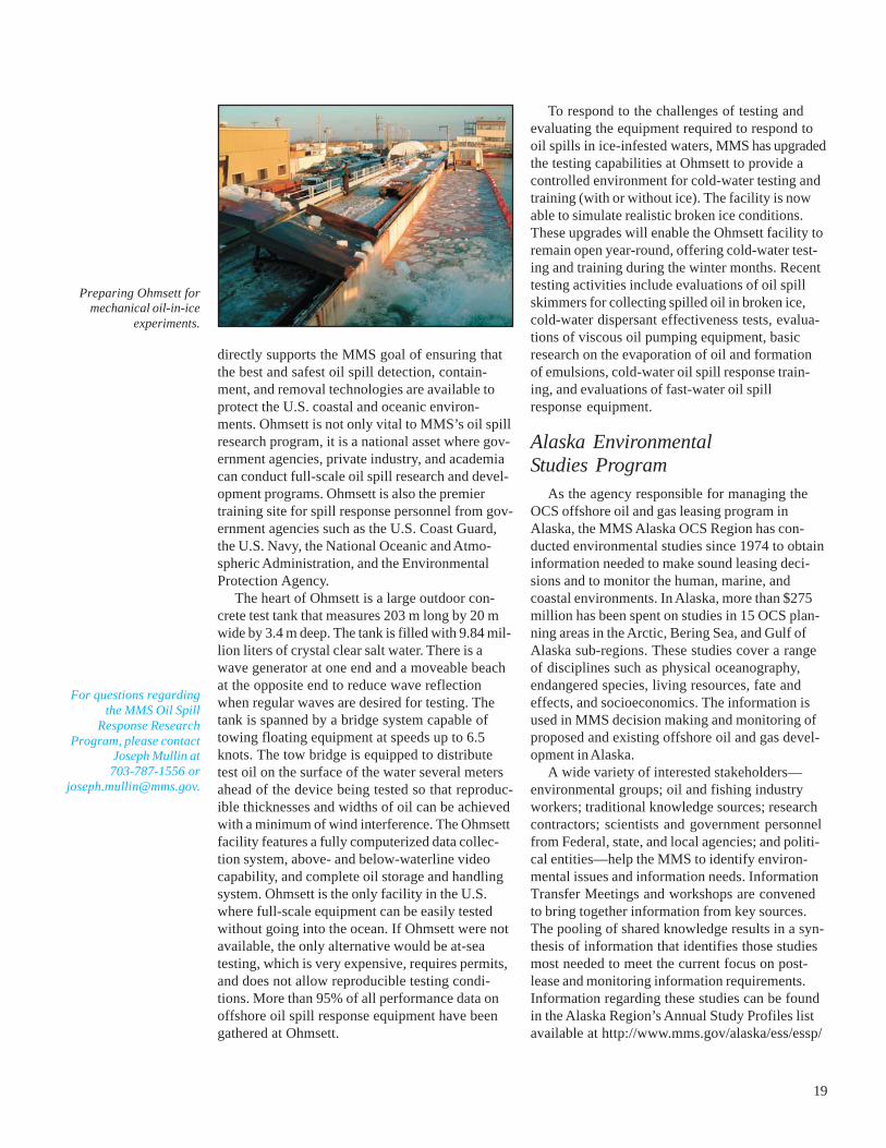
directly supports the MMS goal of ensuring thatthe best and safest oil spill detection, contain-ment, and removal technologies are available toprotect the U.S. coastal and oceanic environ-ments. Ohmsett is not only vital to MMS’s oil spillresearch program, it is a national asset where gov-ernment agencies, private industry, and academiacan conduct full-scale oil spill research and devel-opment programs. Ohmsett is also the premiertraining site for spill response personnel from gov-ernment agencies such as the U.S. Coast Guard,the U.S. Navy, the National Oceanic and Atmo-spheric Administration, and the EnvironmentalProtection Agency.
The heart of Ohmsett is a large outdoor con-crete test tank that measures 203 m long by 20 mwide by 3.4 m deep. The tank is filled with 9.84 mil-lion liters of crystal clear salt water. There is awave generator at one end and a moveable beachat the opposite end to reduce wave reflectionwhen regular waves are desired for testing. Thetank is spanned by a bridge system capable oftowing floating equipment at speeds up to 6.5knots. The tow bridge is equipped to distributetest oil on the surface of the water several metersahead of the device being tested so that reproduc-ible thicknesses and widths of oil can be achievedwith a minimum of wind interference. The Ohmsettfacility features a fully computerized data collec-tion system, above- and below-waterline videocapability, and complete oil storage and handlingsystem. Ohmsett is the only facility in the U.S.where full-scale equipment can be easily testedwithout going into the ocean. If Ohmsett were notavailable, the only alternative would be at-seatesting, which is very expensive, requires permits,and does not allow reproducible testing condi-tions. More than 95% of all performance data onoffshore oil spill response equipment have beengathered at Ohmsett.
To respond to the challenges of testing andevaluating the equipment required to respond tooil spills in ice-infested waters, MMS has upgradedthe testing capabilities at Ohmsett to provide acontrolled environment for cold-water testing andtraining (with or without ice). The facility is nowable to simulate realistic broken ice conditions.These upgrades will enable the Ohmsett facility toremain open year-round, offering cold-water test-ing and training during the winter months. Recenttesting activities include evaluations of oil spillskimmers for collecting spilled oil in broken ice,cold-water dispersant effectiveness tests, evalua-tions of viscous oil pumping equipment, basicresearch on the evaporation of oil and formationof emulsions, cold-water oil spill response train-ing, and evaluations of fast-water oil spillresponse equipment.
Alaska EnvironmentalStudies Program
As the agency responsible for managing theOCS offshore oil and gas leasing program inAlaska, the MMS Alaska OCS Region has con-ducted environmental studies since 1974 to obtaininformation needed to make sound leasing deci-sions and to monitor the human, marine, andcoastal environments. In Alaska, more than $275million has been spent on studies in 15 OCS plan-ning areas in the Arctic, Bering Sea, and Gulf ofAlaska sub-regions. These studies cover a rangeof disciplines such as physical oceanography,endangered species, living resources, fate andeffects, and socioeconomics. The information isused in MMS decision making and monitoring ofproposed and existing offshore oil and gas devel-opment in Alaska.
A wide variety of interested stakeholders—environmental groups; oil and fishing industryworkers; traditional knowledge sources; researchcontractors; scientists and government personnelfrom Federal, state, and local agencies; and politi-cal entities—help the MMS to identify environ-mental issues and information needs. InformationTransfer Meetings and workshops are convenedto bring together information from key sources.The pooling of shared knowledge results in a syn-thesis of information that identifies those studiesmost needed to meet the current focus on post-lease and monitoring information requirements.Information regarding these studies can be foundin the Alaska Region’s Annual Study Profiles listavailable at http://www.mms.gov/alaska/ess/essp/
For questions regardingthe MMS Oil Spill
Response ResearchProgram, please contact
Joseph Mullin at703-787-1556 or
Preparing Ohmsett formechanical oil-in-ice
experiments.

20
SP.HTM. As final reports become available, theywill be added to the Environmental Studies Pro-gram Information System (ESPIS) web site athttp://mmspub.mms.gov:81/search.html.
Coastal Marine Institutes (CMIs) were initiatedby MMS to take advantage of the expertise ofhighly qualified scientifists at local levels and toachieve cooperative research goals in key OCSregions. In 2003 the MMS renewed funding of theCMI at the University of Alaska Fairbanks (UAF)to benefit from its scope and depth of scientificexpertise. Under a recently extended cooperativeagreement, the MMS committed $1 million per yearfor studies to be conducted by the CMI if match-ing state funds were available. The institute con-ducts research focused on environmental, social,and economic studies relevant to both Federal andstate offshore oil and gas and mineral resourcemanagement issues. The internationally renownedUAF School of Fisheries and Ocean Science man-ages the CMI. The Institute creates an opportu-nity for the MMS and the State of Alaska tojointly accomplish research that could not other-wise be carried out. In addition to 22 ongoingstudies, 8 new studies are being evaluated forfunding through the CMI in 2004.
Endangered and Protected SpeciesThe bowhead whale, an endangered marine
mammal of high importance to Native cultures inthe Arctic, migrates through areas of oil and gasexploration and development, including the North-star offshore production site. Efforts to monitorthe fall migration of bowhead whales and relatedenvironmental factors will continue through 2004under the MMS-conducted Bowhead WhaleAerial Survey Project (BWASP) (OCS Study MMS2002-061 is available at http://www.mms.gov/alaska/reports/BWASP/2002_061adobe6test.pdf)and the MMS-funded study called “Analysis of
Covariance of Human Activities and Sea Ice inRelation to Fall Migrations of Bowhead Whales.”
The BWASP results indicate that fall bowheadwhale sightings tend to be farther offshore inheavy ice years across the central Alaskan Beau-fort Sea (142–155°W longitudes). While factorsother than sea ice may have localized effects onsite-specific distributions, broad-area distributionsof bowhead whales in the central Alaskan Beau-fort Sea apparently are related to overall sea iceseverity. The fall 2001 report showed a greater rel-ative occurrence of feeding and/or milling behav-iors of bowhead whales in six different years nearthe mouth of Dease Inlet, Alaska. It showed similaractivity in four of those years near Cape Halkett,Alaska. The analysis of covariance study wasfunded in early 2003 and will further test hypothe-ses regarding the relative degree to which varioushuman activities and sea ice may explain variancein observed bowhead whale distributions.
A multi-year study, “Bowhead Whale Feedingin the Eastern Alaskan Beaufort Sea: Update ofScientific and Traditional Information,” has beenunique in the extent of its coordination with areawhale hunters (http://www.mms.gov/alaska/reports/BowheadWhaleFeeding/2002_012.pdf).Residents of Kaktovik assisted in the studydesign, field implementation, report review, andknowledge sharing needed to determine the impor-tance of the eastern Alaskan Beaufort Sea area tofeeding bowheads. Other study componentsincluded aerial photography, behavioral observa-tions, isotopic analysis of baleen and muscle tis-sue, stomach content analysis, and energeticsmodeling. The results of the study providedimportant information that was used in the envi-ronmental assessment for OCS Lease Sale 186.
Beluga whales are an important species forNative subsistence, with more than 300 harvestedannually in Alaska. The movements of belugawhales were documented using satellite telemetryunder the MMS/CMI study entitled “SatelliteTracking of Eastern Chukchi Sea Beluga Whalesin the Beaufort Sea and Arctic Ocean.” From 1998to 2002, 23 whales were instrumented with thehelp of Native subsistence hunters in KasegalukLagoon near the village of Point Lay. Data fromthis and a previous MMS-funded study suggestthat female belugas may not move as far north inthe Beaufort Sea as male belugas do. Belugas ofall ages and both sexes were found most often inwater deeper than 200 m and beyond the continen-tal shelf break. Tagged females remained withinabout 60 km of shore and quite near the continen-
Northstar, the first off-shore oil development in
the Alaskan Beaufort Sea.

21
tal shelf break in the Beaufort Sea. Conversely,all instrumented males tended to travel north oflatitude 75oN, past the shelf break over watersexceeding 3,000 m in depth. Belugas rarely usedthe inshore waters within the OCS lease sale areaof the Beaufort Sea.
Another MMS-supported study, “Use of SeaIce Habitat by Polar Bears in the Southern Beau-fort Sea,” correlated seasonal polar bear locationsfor the years 1998 through 2001 with sea ice andbathymetry data.
Ringed seals are the primary prey of polar bearsand a significant source of food for Natives livingin the Arctic. The MMS funded two studies dur-ing 2001–2003 addressing the distribution, abun-dance, and/or behavior of the species in order toevaluate potential effects from OCS development.An MMS/UAF CMI project entitled “Timing andReinterpretation of Ringed Seal Surveys” began in2001, building on the results of a previous study:“Correction Factor for Ringed Seal Surveys inNorthern Alaska.” During these studies, 60 ringedseals have been monitored with radio transmitters.The proportion of seals visible during aerial sur-veys has been found to vary as a function ofsnow conditions on the surface of fast ice. A cor-rection factor has been developed, and densityestimates derived from previous surveys are beingre-analyzed.
Harbor seals, another important subsistencespecies, are abundant in the Gulf of Alaska region,including Cook Inlet. In 2003 the MMS fundedtwo new studies of harbor seals through an inter-agency agreement with the National Marine Fish-eries Service, National Marine Mammal Laboratory.The first of these, “Distribution and Abundance ofHarbor Seals in Cook Inlet: Seasonal Variability inRelation to Key Life History Events,” supportsrepeated, seasonal aircraft surveys of seals athaulouts. The second, “Development of RemoteSensing Survey Techniques for Marine Mammalsand Birds in the Arctic: Assessing Variation inHarbor Seal Haulout Patterns,” makes use ofremote cameras for continuous monitoring of har-bor seals at selected haulouts. The latter studywill provide insight into factors causing variationin the observations of the aircraft surveys.
Two other studies of marine mammals werefunded by the MMS through interagency agree-ments with the U.S. Fish and Wildlife Service. Thefirst, “Demography and Behavior of Polar BearsFeeding on Stranded Marine Mammal Carcasses,”began in 2002 and focused on polar bear use ofbowhead bone piles left by Native whalers near
the village of Kaktovik (in the Arctic NationalWildlife Refuge) and near a traditional whalingcamp on Cross Island (near Prudhoe Bay).Increasing numbers of bears have aggregated andfed on whale remains at these locations, with con-current risks to the resident human populationsand to the bears. This study is expected to yielddata on the patterns of use of these sites by indi-vidual bears and on other bear behaviors in orderto establish better estimates of bear mortality inthe event of an oil spill. The second study,“Development of Remote Sensing Survey Tech-niques for Marine Mammals and Birds in theArctic: Development of Airborne Thermal RemoteSensing for Survey of Pacific Walrus,” providedfunds for the development of high-altitude thermalremote sensing for use in surveys of walrus. Sur-vey flights were completed near St. LawrenceIsland in the Bering Sea during April 2003, anddata are being analyzed.
Eiders (a species of sea duck) are harvestedfor subsistence by Alaska Natives, who haveexpressed concerns that the abundance of all fourspecies living in the Alaskan Arctic may be declin-ing. From 2001 to 2003, the MMS funded five newstudies through the MMS/UAF CMI that addressissues related to the population biology of eidersand the potential risks from offshore oil and gasdevelopment. The study entitled “Importance ofthe Alaska Beaufort Sea to King Eiders,” funded in2001, was designed to provide information abouthow king eiders make use of the OCS waters oradjacent near-coastal areas. A total of 33 adulteiders were implanted with satellite transmitters.The investigators discovered that king eidersstaged in the Beaufort Sea before migrating south-ward to molt along the Chukotsk Peninsula andKamchatka Peninsula of Russia and in U.S. watersoff St. Lawrence Island and the Alaska Peninsula.
Three eider studies were funded in 2002. Thestudy titled “Breeding Biology and Habitat Use ofKing and Common Eiders on the Coastal Plain ofNorthern Alaska” will examine and compare thenesting timing, clutch size, reproductive success,and habitat use between a relatively undisturbedsite at Teshekpuk Lake (in the National PetroleumReserve–Alaska) and an area with considerableactivity in the Kuparuk oil field. Another study,“King and Common Eider Migrations Past PointBarrow,” repeats a count of those species that hasbeen conducted periodically for several decades.Results of previous surveys suggested that popu-lations of king and common eiders had declinedby about 50% between 1976 and 1996. Preliminary

22
results of this study suggest that those popula-tions have not declined further and may haveincreased since 1996. The third study, “PopulationStructure of Common Eiders Nesting on CoastalBarrier Islands Adjacent to Oil Facilities in theBeaufort Sea,” is designed to use molecular geneticmarkers to examine the level of population struc-turing among common eiders breeding on coastalbarrier islands along the Beaufort Sea coastline.Results of this study will include a test of the dis-creteness of genetic stocks of common eidersinhabiting the Beaufort Sea region and an analysisof the risks posed to maintain those stocks bypotential oil spills.
A study entitled “Foraging Ecology of CommonRavens (Corvus corax) on Alaska’s Coastal Plain”was initiated during 2003. This study is expectedto provide information on the predator–prey rela-tionships between ravens and waterfowl breedingnear the developed areas of Alaska’s North Slope.Among the questions this study will address arewhether industrial infrastructure is advantageousto ravens, and the extent to which proximity tosuch infrastructure increases raven depredation ofeider nests and ducklings.
Physical OceanographyKnowledge of predominant weather patterns
and wind/current dynamics in the Beaufort Seaenables us to evaluate better the potential effectsof an oil spill and to develop precautionary oil spillresponse strategies. A recently completed MMS/UAF CMI study that examined the seasonal andinterannual variability of the Arctic Ocean andBeaufort Sea found that there has been a decadalcycle between wind-driven anticyclonic (ACCR)and cyclonic circulation regimes (CCR). HigherArctic atmospheric pressure, lower wind speed,and lower winter temperatures characterize theACCR compared with cyclonic summer winds, pre-cipitation increases over the ocean, and decreasesover land during the CCR. The cyclonic summerwind produces more openings in the sea ice,allowing upper ocean heat accumulation. The icemelt season lengthens, increasing freshwater con-tent and leading to generally thinner ice. Anoma-lous weather patterns in recent years will receiveadditional scrutiny to determine whether a newpattern is emerging.
The study entitled “Synthesis and Collectionof Meteorological Data in the Nearshore BeaufortSea” completed over two and half years of meteo-rological data collection from five stations alongthe Beaufort Sea coast. A new station was added
on Cottle Island in August 2002. This study willprovide a completed time series of wind data toMMS ocean circulation modelers and researchersfor use in their ongoing modeling of the nearshoreBeaufort Sea. A project web site (http://www.resdat.com/mms) provides up-to-date projectinformation, station locations and pictures, datadownloading, and quarterly graphical data results.This information will assist MMS in improving oilspill trajectory modeling and is available to thegeneral public.
An MMS/UAF CMI study completed threeyears of moorings, including the first successfulwinter-long measurements of currents directlyunder the ice in the nearshore Beaufort Sea. Threeupward-looking acoustic Doppler current profilerswere moored on the sea bottom within the barrierislands near the Northstar and Liberty offshoredevelopment prospects, and a fourth profiler wasadded offshore of the barrier islands in the thirdyear. The project collected data on water and icevelocity, temperature, salinity, and water clarity(transmissivity) from August 1999 to August 2002.Once landfast ice formed and blocked the wind,current speeds dropped drastically, with less than1% of current speeds exceeding 20 centimeters persecond. A new study, “Beaufort Sea NearshoreCurrents,” will deploy three similar moorings forthree years, starting in 2004, over a greater lengthof coastline, extending across most of the U.S.Beaufort Sea coast.
An MMS/UAF CMI study entitled “A Now-cast/Forecast Model for the Beaufort Sea Ice–Ocean–Oil Spill System” has developed a new 3-Dcoupled ice–ocean model with links to a regionalmesoscale atmospheric model. The resolution ofthe model is currently being increased to 1 km orless to resolve coastal barrier islands. This modelwill be used by the MMS to improve oil spill riskanalysis.
In Cook Inlet the MMS/UAF CMI study“Water and Ice Dynamics of Cook Inlet” is using acombination of global positioning system (GPS)-equipped ARGOS drifters, satellite remote sensing,and oceanographic modeling to enhance under-standing and to improve the predictability of waterand ice dynamics. A parallel MMS/UAF CMIstudy, “High-Resolution Numerical Modeling ofNear-Surface Weather Conditions over Alaska’sCook Inlet and Shelikof Strait,” will provide a high-resolution meteorological model that can capturelow-elevation wind jets known to occur in CookInlet and Shelikof Strait. This model will providehigh-resolution grid wind fields to the oceano-

23
graphic modelers, ultimately enhancing the MMSenvironmental assessment of the potential effectsof oil spills, which, although very unlikely, mayoccur after OCS development.
Fate and EffectsOne of several MMS/UAF CMI laboratory
studies documented synergistic effects of weath-ered North Slope crude oil and ultraviolet light onzooplankton. Establishment of a correlation coeffi-cient between total lipid content and polycyclicaromatic hydrocarbon (PAH) uptake will allowestimates of the PAH load of predominant plank-ton on the basis of abundance data and their lipidprofile. The possibility of further distribution ofPAHs into the ecosystem through zooplankton fe-ces is also being evaluated. Another study looksat the kinetics and mechanism of slow PAH des-orption from sediments in the lower Cook Inletand the Beaufort Sea. This study will lead to bettercapability for predicting the environmental fate ofPAH in Arctic sediments. A third and related CMIstudy examines petroleum-degrading bacterialcommunities in Beaufort Sea sediments and willcompare the current community to that existing atthe onset of coastal Beaufort Sea development inthe late 1970s.
In the first of four modeling studies, “Revisionof the OCS Weathering Model, Phases II and III,”the MMS is participating in a consortium toadvance the state of the art in oil weathering mod-els, including additions of Alaska-specific oils andice conditions and the development of an experi-mental and observational spill database suitablefor model validation. In the second and third stud-ies, the MMS is investigating “Alternative OilSpill Occurrence Estimators for the Beaufort/Chuk-chi Sea OCS” with parallel fault-tree and statisticalengineering approaches. These latter studiesinclude analyses of differences in potential spillcauses in these Arctic areas versus elsewhere inthe U.S. OCS, primarily in the Gulf of Mexico. Inthe fourth study, “Persistence of Crude Oil Spillson Open Water,” the MMS is developing empiricalstatistical relationships among environmental andresponse factors related to the persistence ofcrude oil slicks at sea.
Research MonitoringA multi-disciplinary, site-specific Beaufort Sea
monitoring study, “Arctic Nearshore Impact Moni-toring in the Development Area (ANIMIDA)”was initiated in June 1999. This study examinesimpacts associated with the first Federal oil devel-
opment on the Alaskan OCS at Northstar and theanticipated Liberty prospect near Prudhoe Bay.Phase I of ANIMIDA reported the results of mea-sured changes in ambient noise, resuspension ofsediments, and sediment quality.
Designed to provide long-term continuitybeyond what could be expected through industry-sponsored studies alone, ANIMIDA Phase IIexpanded monitoring in 2000–2002 by measuring:
• Partitioning of contaminants betweendissolved and particulate water phases;
• Trace metals, hydrocarbons, persistentorganic pollutants, and biomarkers in fish;
• Effects on kelp in the Boulder Patch (anarea of Special Biological Concern); and
• Perceived effects on Native subsistencewhaling.
The Phase II studies were reported in a specialsession at SETAC in November 2003, with the finalreports expected in January 2004. A third phase,cANIMIDA (Continuation of ANIMIDA), is beingprocured in 2003 and will start field work in 2004.
An MMS/UAF CMI study recently examinedand reported on the historical changes in tracemetals and hydrocarbons in the inner shelf sedi-ments of the Beaufort Sea. The study used a com-bination of dated sediment cores, freshly collectedsurface sediment, 30 years of prior analytical mea-surements by the investigator, and data from priorMMS Beaufort Sea monitoring projects. Of multi-ple metals, only vanadium and barium levels werepossibly elevated in more recently collected andanalyzed sediments. The levels of vanadium andbarium found were still low and well below harmfullevels. The hydrocarbon analyses primarily foundnatural compounds indicative of decayed marineplankton and peat from onshore. No petroleumsignal was found. The study concluded that thenearshore Beaufort Sea has remained a relativelyclean environment as far as trace metals andhydrocarbons are concerned, despite the adjacentpetroleum-related industrial activities during thepast 30 years. A follow-up CMI study continuesthe documentation of trace metals and hydro-carbons in sediments across the Beaufort Seafrom Elson Lagoon near Barrow, to Prudhoe Bay,to Beaufort Lagoon in eastern Alaska.
The MMS/UAF CMI study “Seabird Samplesas Resources for Marine Environmental Assess-ment” collects and curates seabird tissues incooperation with the University of Alaska Museumto provide further resources for contaminant andother scientific researchers. Loans and tissue sam-ples from this collection have already been made

24
available to scientists for contaminant and oil-spill-related studies. The MMS/UAF CMI has alsoarranged for the University of Alaska Museum toarchive high-quality surface sediments and datedsediment cores from the MMS study “SedimentQuality in Shelikof Strait and Outermost CookInlet.”
A greater knowledge of Arctic fishes is impor-tant to protecting subsistence and biologicalresources while developing offshore oil and gasresources. Very little documentation exists on theactual locations of overwintering habitat of Beau-fort Sea anadromous fish. The potential of remotesensing applications, such as synthetic apertureradar, is being investigated to reduce the high costof locating and evaluating overwintering habitats.Native Alaskans are concerned that a major sub-sistence species in the Colville River, Arctic cisco,has been less abundant during the last few yearsthan in preceding years. An effort to quantifyinterannual variation in their abundance and esti-mate which environmental factors contribute toobserved variation will provide better predictions,which will allow adjustment to natural cycles andhelp avoid potential development effects on thisimportant resource.
SocioeconomicsSince its formation the MMS Alaska Region
Environmental Studies Program has been uniquein its emphasis on social and economic studiesrelating to the potential effects of offshore oil andgas development. Because of the distinctivenature of subsistence activities and socioculturalattributes throughout rural villages and coastalcommunities in Alaska, MMS social research goeswell beyond conventional economic consider-ations.
In response to recommendations of communityleaders of Alaska’s North Slope, MMS initiated astudy in 2001 entitled “Quantitative Description ofPotential Impacts of OCS Activities on BowheadWhale Hunting and Subsistence Activities in theBeaufort Sea.” The study, to be completed in 2004,focuses on Native perceptions of the acute andcumulative effects of oil industry operations onbowhead whale hunting. The study will collectinformation from residents of Nuiqsut, Kaktovik,and Barrow through survey instruments and willconsider both beneficial and detrimental potentialeffects.
Another North Slope project aims to developand implement a GIS mapping system to describesubsistence hunting and fishing activities for
selected species, including bowhead whales,ringed seals, caribou, Arctic cisco, broad white-fish, Arctic char, and various waterfowl. Theproject focuses on collecting and describing con-temporary subsistence patterns while accommo-dating the addition of past and future harvest datato enable analyses of pattern changes over time.A sample of hunters in each community will beselected using systematic social networking meth-ods. In addition, the project will document thelocations of harvest campsites and travel routes.
In Cook Inlet the prospect of OCS oil and gasdevelopment presents some potential for spatialconflict with local fishing operations, especiallythe commercial driftnet fishery. Drift gillnet fisher-men often focus their efforts near turbulent riptides because salmon are known to concentratein these areas. The presence of an oil platform infavorable fishing areas could pose a navigationalhazard, with potential consequences of diminishedaccess, loss of harvest resulting from prematurenet release, or gear entanglement. A study entitled“Mitigation of Oil Industry Operations on DriftnetFishing in Cook Inlet,” begun in 2003, intends toexplore and define specific ways to mitigate thesepotential conflicts and to analyze the significanttradeoffs of reasonable alternative proposals.
On Kodiak Island a new study is underwayto collect and analyze data on the major socio-economic consequences of the Exxon Valdez oilspill litigation settlement for local residents. Theproject will investigate and document key second-ary social and economic impacts from the litigationand settlement experiences that follow the primaryimpacts of the original spill event. It will alsoattempt to formulate general recommendationspertaining to the effective management of poten-tial future oil spills and related litigation settlementprocedures, even though the spill event did notoccur under MMS jurisdiction or even withinimaginable MMS offshore spill scenarios.
To document the extent of social research inAlaska and the substantial information accumu-lated over the past 20 years, MMS initiated a bookproject in 1998 that will enhance the accessibilityof research products and summary findings for allinterested parties. When completed, the projectwill produce a peer-reviewed book that will explainand synthesize the results of more than 160 MMS-funded studies.
A study entitled “North Slope Economy, 1965to the Present” will provide detailed informationon local government revenues and expenditures,including capital projects of North Slope commu-

25
nities (both prior to and after the formation of theNorth Slope Borough), as well as property tax andother categories that merit analysis. The studywill:
• Classify local government services by depart-ments and other major categories;
• Describe how the revenues and expenditureshave been a component and shaping force ofthe North Slope economy;
• Describe the structure of the North Slopeeconomy, including employment, income, andtheir fluctuations;
• Describe how quantifiable, non-cash eco-nomic factors for households have changedfrom 1965 to the present in relation to thegreater availability of salaried jobs;
• Describe the role of the Arctic Slope RegionalCorporation, the Ukpeagvik Inupiat Corpora-tion, and other village for-profit corporationsin the North Slope economy; and
• Describe how individual and household econ-omies have responded to changes in theregional economy.
Some of the empirical measures will include incomeand changes in quality of life, such as housingand sewer and water facilities. A draft of the studyreport was submitted in 2003 and is now underreview.
GIS DatabasesThe study entitled “Evaluation of Sub-Sea
Physical Environmental Data for the Beaufort Sea”was completed in 2002. It integrates all FederalBeaufort Sea OCS site-specific geological andhigh-resolution geophysical data results and simi-lar data sets into a geographical information sys-tem (GIS) database in support of exploration anddevelopment projects. The GIS database includesspatial and attribute data on the location of strudelscour, ice gouge, and drain racks, in addition todata on bathymetry, faulting, near-surface stratig-raphy, seismic anomalies, boulder patch, andearthquakes. The documentation is available athttp://www.mms.gov/alaska/reports/SubseaGIS/evaluation_of_sub.htm.
An ongoing MMS/UAF/University of AlaskaAnchorage CMI study is in the process of com-pleting an updated sea ice atlas for Arctic and sub-Arctic Alaska marine waters. A web site (http://holmes-iv.engr.uaa.alaska.edu/), which is underconstruction, will provide statistical and GIS out-put of National Ice Center and National WeatherService sea ice data for the Alaska OCS, including
Cook Inlet. This web site will contain a unique setof tools to query and graph historical meteorologi-cal data from first-order weather stations locatedthroughout Alaska.
Information TransferAn Information Update Meeting was convened
by the MMS Alaska OCS Region in Barrow inMarch 2003. The MMS and officials of the NorthSlope Borough scheduled this meeting in Barrow,Alaska, so that residents would have betteraccess to information on key MMS studies. Princi-pal investigators presented information on 11 on-going studies at the one-day event. Also, MMSheld its Ninth Information Transfer Meeting inAnchorage, Alaska, in March 2003. Principalinvestigators presented information on 37 on-going studies in the Beaufort Sea and Cook Inletregions. It was attended by a diverse audiencedrawn from local communities, industry, other Fed-eral agencies, and state and local governments.
In cooperation with the U.S. Fish and WildlifeService, the MMS also supported a 2003 work-shop in Anchorage entitled “Polar Bear PopulationMonitoring Workshop.” Management issues wereidentified, and recommendations for futureresearch and monitoring were made by individualsrepresenting a variety of organizations.
In 2003 the MMS Alaska OCS Region alsosponsored two international workshops designedto produce recommendations regarding futureArctic oceanographic research needs. The MMS/UAF CMI “Workshop on Small-Scale Sea-Ice andOcean Modeling (SIOM) in the Nearshore Beau-fort and Chukchi Seas” brought together interna-tional sea-ice modelers and researchers to developstrategies to advance the state of the art in Arcticice modeling. Following recommendations fromthis workshop, MMS and the National Aeronau-tics and Space Administration signed an Inter-agency Agreement in 2003 to research “Sea-IceModeling in Nearshore Beaufort and Chukchi Seain the Arctic Ocean.” The MMS Physical Ocean-ography of the Beaufort Sea Workshop broughttogether international experts in Arctic oceanogra-phy to review the state of knowledge concerningBeaufort Sea physical oceanography and to rec-ommend long-range goals for oceanographicresearch to meet MMS needs.
Reports of MMS-sponsored information trans-fer meetings and MMS studies are available fromthe MMS Environmental Studies Information Sys-tem (ESPIS) at http://mmspub.mms.gov:81/.

26
Fish and Wildlife ServiceThe U.S. Fish and Wildlife Service (FWS) con-
ducts research in the Arctic to help accomplish itsmission to conserve and manage migratory birds,threatened and endangered species, certain marinemammals, and anadromous fish, as well as all biotainhabiting nearly 77 million acres within 16 NationalWildlife Refuges in Alaska.
Fisheries and Ecological ServicesFisheries
Fishery research in the Arctic by the FWS con-tinues to focus on Yukon River salmon shared bythe United States and Canada in support of theU.S.–Canada Treaty. The FWS continues todevelop enumeration techniques for Yukon Riversalmon to quantify abundance, apply geneticstock identification techniques to assess geneticdiversity, and determine what portion of the U.S.harvest is of Canadian origin. These studies alsogenerate data needed for in-season managementof Canadian-origin salmon. Research includesa mark–recapture study of fall chum salmon atRapids/Rampart and the use of video technologyto determine marked-to-unmarked ratios of fallchum salmon and catch-per-unit-effort for chinookand fall chum salmon. To manage U.S. stocks ofsalmon, the FWS uses resistance board weirs toenumerate summer chum and chinook salmon onthe Gisasa River and summer chum, chinook, andcoho salmon on the Andreafsky River. Split beamsonar is used to count fall chum salmon on theChandalar River. The information from these moni-toring studies is used to schedule fishery open-ings and ensure stock conservation on NationalWildlife Refuges.
Although salmon are extremely important tosubsistence users and ecological productivity, theimportance of other species is becoming apparent.Whitefish are used seasonally in areas with salmonfisheries and are used extensively in areas with nosalmon runs. Studies indicate that whitefish in cer-tain river systems are as abundant as salmon, andthey may be critical to food webs and nutrientcycling. Radiotelemetry has identified importanthabitats and migration corridors of inconnu(sheefish), broad and humpback whitefish, andleast cisco in several National Wildlife Refuges.Also, electron probe microchemistry has identifiedseveral anadromous stocks and indicates thatthese fish rival salmon in the distances traveledduring their migration. These long-distance move-
ments make these stocks vulnerable to fisheries asthey travel to their spawning areas.
Fish stocks of Alaska’s North Slope in the Arc-tic National Wildlife Refuge have also receivedconsiderable attention recently. One study beingconducted in the coastal lagoons near the villageof Kaktovik is designed to determine the relativeabundance of Arctic cisco and Dolly Varden.Catch results, length frequencies, length–weightrelationships, and fish condition will be comparedto baseline data collected on these speciesbetween 1988 and 1991. A second study will usedual-frequency induction sonar to estimate thenumber of Dolly Varden that return to spawn inthe Hulahula River and provide the first quantita-tive information about population size of thesefish on the North Slope. A third study focuses onlocating the overwintering areas of Dolly Vardenin the lower Canning River. These studies will pro-vide valuable information to use for conservingviable populations should the area be availablefor oil and development.
The FWS’s Conservation Genetics Lab contin-ues to study Yukon River chinook and fall chumsalmon and has collected both species from anumber of drainages in the U.S. and Canada. Arecent study concluded that genetic diversity ofchum salmon in the Yukon River is widely distrib-uted over a broad geographic area, whereas cohosalmon populations are small and discrete. Thishas important implications for management ofthese species and suggests that the genetic diver-sity of coho salmon is at higher risk from habitatdegradation than chum salmon.
Environmental ContaminantsThe FWS and its partners have actively pur-
sued scientific studies and management solutionsconcerning complex contaminants problems in theArctic for several decades. International researchprograms such as the Arctic Monitoring andAssessment Program (AMAP) have shownthat pollutants are a circumpolar, and indeedglobal, issue. The FWS conducted a number ofcontaminant-related studies during FY 2001–2003.
Funding (thousands)FY 02 FY 03
Migratory Birds 3,884 3,800Fisheries 4,068 4,300Marine Mammals 1,768 2,255CAFF 200 200U.S.–Russia Environ. Agreement 150 350Total 10,070 10,905

27
Chinook and Chum Salmon. In 2001 the FWSbegan collecting baseline data on contaminantsin chinook and chum salmon from the Yukon andKuskokwim Rivers. Runs of these salmon havedeclined in recent years, and subsistence usersare concerned about the presence of environmen-tal contaminants in their food. Analyses for heavymetals and persistent organochlorine compoundsindicate that these fish have relatively low con-taminant concentrations, and the State of Alaskarecommends unlimited subsistence consumptionof these stocks.
Spectacled and Steller’s Eiders. Environmentalcontaminants specialists are investigating leadconcentrations in threatened spectacled and Stell-er’s eiders and other waterfowl from Alaska. Expo-sure to lead in breeding areas, presumably fromingestion of lead shot, can contribute to popula-tion declines. Recent research compared isotopic“signatures” in eider blood to known lead sources,including samples of lead shot and various wet-land sediments. Initial results indicate that shotis the primary source of lead for eiders with highblood lead levels, while eiders with low lead levelshave signatures that match the sediments in theirbreeding areas. Work is ongoing to further charac-terize these sources and determine thresholds forexposure to lead shot in eiders. Positive identifica-tion of shot as the lead source will contribute toongoing FWS efforts to reduce lead shot usethrough education and enforcement.
Wood Frog. The wood frog is the onlyamphibian that occurs across most of Alaska,including areas within the Arctic. Since 2001,surveys for abnormal wood frogs have been con-ducted on several National Wildlife Refuges inAlaska. Low numbers (<3%) of abnormal frogshave been found in Arctic areas of Alaska, withthe most prevalent anomalies being missing hindlimbs and digits. Initial sampling suggests that thedramatic abnormalities seen in frogs in more tem-perate climates, such as additional appendages
and misplaced eyes, are not commonly observedin localized areas of northern and western Alaska.
Marine MammalsPacific Walrus. Research on Pacific walruses
continues to focus on monitoring haul-outs inBristol Bay, monitoring the spring subsistenceharvest to collect information on the size anddemographics of the harvest, and developingtechniques to estimate the size and trend of thePacific walrus population.
The size and trend of the Pacific walrus popula-tion remain unknown. Several approaches areunder investigation for developing an accurateestimate, including genetic fingerprinting in amark–recapture study. Computer simulationsindicate that for a modeled walrus population of300,000, even relatively large sample sizes (15,000–30,000 samples annually) produce poor populationestimates. However, incorporating age into themark–recapture analysis dramatically increasedthe efficiency and precision of the estimate andsimulated sampling rates as low as 1,500 animals.The successful application of mark–recapturetechniques to estimate the size and trend of thePacific walrus population will require the ability todetermine age and gender and identify individualanimals with negligible error rates, but collectingrepresentative samples from free-ranging animalsacross a wide-ranging, dynamic habitat presentssignificant logistical challenges.
The FWS is also evaluating remote sensingtools for use in developing a population estimate.Techniques under evaluation include high-resolution aerial photography and satelliteimagery. Previous studies demonstrated thecapability to detect and enumerate walruses withappropriate satellite imagery; additional workrefined the technique for use in counting walruseson terrestrial haul-outs. Imagery of walruses on iceis currently under analysis. The results suggestthat a walrus survey could potentially be flownwith an airborne thermal scanner from a height of3,500 m. The advantages of this technique are thata high-altitude, scanner-based survey wouldcover more than four times the area per surveyhour compared to traditional visual-based obser-vation methods. Also, a high-altitude, scanner-based survey would produce a permanent datarecord that could be re-examined, eliminateobserver bias in estimating numbers of animalsin groups, minimize disturbance to walruses, andincrease safety for flight crews by eliminatinglow-altitude flights over open ocean and pack ice.
Steller’s eiders.

28
Northern Sea Otter. The FWS continues tofocus its efforts on the stock-wide populationdecline of sea otters in southwestern Alaska.Abundance estimates for some areas havedeclined by as much as 93% since the surveysin the mid-late 1980s and early 1990s. Rates ofdecline have varied from 6.7% per year at KodiakIsland since 1989 to 17.5% per year in the AleutianIslands. Sea otter population declines are similaramong survey areas in the Aleutians, along theAlaska Peninsula, and in the Kodiak Archipelagoin terms of severity and timing, and severedeclines of pinniped populations have occurred inthe same areas. The results of broad-scale aerialsurveys prompted the FWS to designate thesouthwest sea otter population stock as a candi-date species under the Endangered Species Act;the FWS published a proposal to list this stock asthreatened under the Endangered Species Act onFebruary 11, 2004. Site-specific surveys at repre-sentative islands in the central and western Aleu-tians in 2003 indicate that the decline is continu-ing, with an estimated 63% decline between 2000and 2003 at these sites.
Polar Bear. The FWS, in cooperation with theNorth Slope Borough, the Alaska Nanuuq Com-mission, and the Native villages of Kaktovik andNuiqsut, initiated a polar bear feeding ecologystudy during September 2002. In the southernBeaufort Sea, polar bears tend to migrate to near-shore coastal areas during the fall to look for densand feed on seals and whale carcasses. In recentyears the number of bears using the coastal habi-tat in the fall has increased. The objectives of thethree-year study are to determine the number, sex,and ages of the bears and their behavior and habi-tat use at Cross and Barter Islands during the fallopen-water period. These locations were chosenbecause of the presence of subsistence-harvestedbowhead whale remains that attract numbers ofpolar bears. The maximum number of bears seen atBarter Island at one time was 51. A maximum ofseven bears were observed at one time at CrossIsland. The majority of bear use at both the BarterIsland and Cross Island feeding sites was by sin-gle adult bears (41% and 76%, respectively) andby family groups of adult females with dependentcubs (26% and 13%, respectively). At both loca-tions, all age/sex classes of bears fed predomi-nantly at night. During the day the majority ofbears were inactive. The study was continued in2003–2004.
The FWS, in cooperation with BP Explorationand LGL Research, completed four years of weekly
aerial surveys along the coastline and barrierislands of the Beaufort Sea (2000–2003). Duringthe first three years, there were 706 polar bearobservations. The number of observationsbetween the fall open-water period and freeze-upwas quite variable among years, with the greatestnumber of observations in fall 2002 (five surveys,377 observations). A greater number of bears usedcoastal habitat during years when the pack iceremained farther offshore for extended periods oftime. Adult females with dependent young com-prised 45.5% of the observations. Habitats usedby polar bears most frequently during the studywere barrier islands and shore-fast ice.
Threatened and Endangered SpeciesSpectacled and Steller’s eiders. In 2002 and
2003 the FWS continued to participate in a long-term study of the threatened Steller’s eider in thevicinity of Barrow in cooperation with the NorthSlope Borough. The study focuses on document-ing abundance and distribution and identifyingthe primary influences on survival and reproduc-tion. Nesting effort and success of Steller’s eidersvary tremendously from year to year. Predation isconsidered to be the main cause of Steller’s eidernest failure near Barrow. Management strategiesto improve nesting success may be necessary tomaintain the population. Research projects in sup-port of this objective include video monitoring ofSteller’s eider nests to identify predators that areresponsible for egg loss and collaborative effortswith the Alaska SeaLife Center to develop artificialincubation techniques.
Satellite telemetry was used to determine thatAlaska-breeding individuals of both Steller’s andspectacled eiders spend part of their annual cycle(molt or pre-molt staging) in northeast Russia.Recognizing that effective wildlife conservationefforts must reach across the border, the FWS hassponsored several projects in northeast Russia.Aerial and boat surveys were conducted in west-ern Chukotka in the summer of 2002 to locate keyareas being used by both species. Large numbers(approximately 14,000) of Steller’s eiders wereobserved there in 2002 and 2003 during the pre-molt period.
Virtually the entire Pacific population of Stell-er’s eider molts and spends the winter in the near-shore waters of southwestern Alaska. This popu-lation is estimated at roughly 100,000 individualsand appears to be declining at over 6% annually.Currently the Alaska-breeding population includes,at most, 2,500 individuals. The FWS, in coopera-

29
tion with the Corps of Engineers, has conductedboat surveys of wintering eiders in a number ofcoastal areas where development may occur thatcould impact the protected lagoons and produc-tive, shallow areas that eiders depend on for theirover-winter survival.
In 2003 a nesting biology and survival studyof spectacled eiders in the Chaun River Delta,Chukotka, was initiated. The long-term goal of thisproject is to compare the productivity and survivalof spectacled eiders in Russia and Alaska. TheFWS also sponsored a pilot subsistence harvestsurvey in villages in the Yakutia and Chukotkaregions in 2002 and 2003. Data from 2002 indicatedthat hunting pressure on eiders may be greaterthan previously thought and that local knowledgeof waterfowl conservation issues, such as theeffects of lead shot, is very low.
Short-tailed albatross. Once numbering in themillions, the short-tailed albatross was driven tothe brink of extinction by feather hunters. Today,fewer than 1,800 individuals exist, and they neston only two islands in the western Pacific. Japan’sTorishima Island, home to 80% of the world popu-lation, is an active volcano, with the albatross col-ony located in the caldera’s fluvial outwash plain.The short-tailed albatross is listed as endangeredthroughout its range. Since 1990 there have beenfive documented takes of this endangered seabirdin Alaska’s longline fisheries. Recently the FWShas undertaken, funded, and cooperated in a num-ber of projects aimed at understanding the birds’movements and threats.
As a joint conservation initiative, the FWS andJapanese Ministry of Environment began a satel-lite tracking study of post-breeding short-tailedalbatrosses in 2001. Since 2001, tracks lastingbetween 50 and 140 days have been obtained from17 albatrosses, for a total of over 6,000 at-sea loca-tions. In an effort to further define where short-tailed albatrosses are foraging, the FWS under-took a study to track adult and sub-adult birds atsea. All of these data will be used in conjunctionwith oceanographic data (collected via satelliteremote sensing) and fishing effort and bycatchdata to identify important marine habitats for theshort-tailed albatross and environmental factorsthat affect their potential interaction with longlinefishing fleets.
Previous studies conducted by the Washing-ton Sea Grant Program indicated that pairedstreamer lines, towed behind longline fishing ves-sels, are very effective at reducing seabird attackson bait (thus reducing potential bird hookings and
drownings). Current research will help determinewhether proposed streamer line performancestandards are appropriate for small vessels and onvessels using snap-on gear. Additionally the FWSis funding Washington Sea Grant to study whetherintegrated-weight groundlines, with their fastersink rates, are effective in reducing seabirdbycatch by the longline fishery.
National Wildlife RefugesThe National Wildlife Refuge system in Alaska
encompasses 16 refuges and approximately 77 mil-lion acres. Staff of each refuge conduct a varietyof research, monitoring, and inventorying studies,ranging from long-term ecological monitoring tomore narrowly focused intensive studies of specificplant, fish, and wildlife species. Research high-lights are included for several refuges in Alaska.
Yukon Delta National Wildlife RefugeThe bar-tailed godwit is the most abundant
large shorebird in the East Asian–AustralasianFlyway. Each fall, approximately 100,000 godwitsmigrate from the coast of western Alaska to Aus-tralia and New Zealand. This 11,000-km flight isapparently the longest non-stop bird migration inthe world. Since 1999, refuge staff in collaborationwith the USGS have studied flocks of godwitsstaging on the coast of the refuge to determinethe wintering grounds, migration routes, andracial identity of godwits staging on the Yukon–Kuskokwim Delta and determine the proportion ofjuveniles in the staging flocks in order to estimateannual reproductive success. By reading site-specific color-flags on the godwits’ legs, fieldcrews have been able to identify godwits thathave wintered in northeastern and southeastern
Bar-tailed godwit with leg bands at the Yukon DeltaNational Wildlife Refuge.

30
Australia, as well as on the North and Southislands of New Zealand. Godwits banded onspring migration in both China and Japan havealso been observed in Alaska. The proportion ofjuveniles in the fall staging flocks has been con-sistently low, never exceeding 3% since the studybegan and averaging considerably lower than ageratios among small samples of birds captured onthe wintering grounds. Therefore, refuge scien-tists, along with researchers from Australia andNew Zealand, are evaluating hypotheses toexplain this discrepancy. A population model toassess the impact of chronically low productivityon population growth is being developed in col-laboration with the USGS. The refuge plans toinitiate a pilot study of godwit breeding biology in2004 to begin exploring the factors contributing tothe apparently low reproductive success.
About 42,000 pairs of black scoters, or 47% ofthe western North American breeding population,nest on the Yukon Delta National Wildlife Refuge.Black scoters remain the least known of all water-fowl species. Because of a steady decline in Alas-ka’s breeding population, refuge staff and USGSresearchers initiated a multi-year study of blackscoter breeding ecology. The study, designed toidentify nesting habitat and timing, has foundmore scoter nests than any previous researcheffort. Preliminary results indicate that black
scoters are one of the latest-nesting waterfowlspecies, with onset of nesting occurring betweenlate June and early July. Nests contain an averageof eight eggs and are difficult to find. They areoften situated far from large water bodies in densethickets of knee-high (or taller) dwarf birch andwillow along the sides of pingos, drainages, anddry lake basins. Researchers have only foundabout 40 nests per year, despite several weeks ofintensive searching in areas identified as havinghigh concentrations of pairs. Black scoters aresought by subsistence hunters in late May andearly June on large lakes and along rivers of therefuge as they migrate to breeding areas. They areheavily harvested on the refuge, averaging about6,000 birds per year. Ultimately the results of thestudy will assist refuge staff with the managementand conservation of this little-known species.
Arctic National Wildlife RefugeTemperatures in northern Alaska have warmed
over the past 30 years. To determine whethertundra vegetation has changed, botanists from therefuge in northeastern Alaska examined data from26 plots that were sampled 5–6 times each between1984 and 2002. The plots represented all of themajor vegetation types on the coastal plain of therefuge. The investigators used point sampling toestimate percent cover of all plant species, mea-sured the depth of thawed soil above the perma-frost, took photographs from permanent photopoints, and measured the height of willows at fourplots. They used linear mixed-effects regressionmodels to test for changes over time in plant spe-cies cover, willow height, and active-layer depth.The investigators detected small but significantdecreases in cover of nonvascular plants (i.e.,mosses, liverworts, and lichens) but no trend invascular plant cover or willow height. The depthof thawed soil increased over the 18-year period.Refuge staff plan to continue monitoring thepermanent vegetation plots every five years todevelop a long-term record of changes in plantcover and active-layer depth and will examine rela-tionships between observed changes and climaticconditions in the region.
The Arctic coastal plain of northern Alaska pro-vides important breeding habitat for over 70 spe-cies of birds, including shorebirds, waterfowl,loons, and passerines. The coastal plain is alsoincreasingly influenced by human activities, espe-cially oil exploration/development and growth ofNative villages. Human food sources may enhancepopulations and alter the distributions of preda-
Braids at the Yukon DeltaNational Wildlife Refuge.
Black scoter research atthe Yukon Delta National
Wildlife Refuge.

31
tors such as arctic foxes, common ravens, glau-cous gulls, and grizzly bears. Predator populationsmay also be influenced by man-made structuresthat are used for nesting, denning, or surveillance.Increased numbers of predators in the vicinity ofhuman developments could negatively affect theproductivity of breeding birds via increased pre-dation on eggs and young. The FWS, WildlifeConservation Society, BP Exploration (Alaska),Inc., ConocoPhillips Alaska, Inc., ExxonMobil Cor-poration, and Manomet Center for ConservationSciences initiated a project in 2002 to investigatethe effects of development on populations of nestpredators and productivity of shorebirds on thecoastal plain. Study sites were established acrossthe North Slope. At each site, investigators arecollecting data on nest density, nest fate (hatchvs. fail), and causes of nest failure. They arealso investigating the relationship between nestsurvival, predator abundance, and proximity tohuman developments.
Yukon Flats National Wildlife RefugeBreeding scoter populations have declined
over 50% in North America since 1955. The YukonFlats National Wildlife Refuge (NWR), the largestinterior wetland basin in Alaska, supports the larg-est breeding population of white-winged scotersin Alaska. Refuge staff, in collaboration with theUniversity of Alaska, initiated a study in 2002 toestimate nesting success, nest habitat selection,and duckling survival for white-winged scoters.They captured female scoters with mist nets priorto breeding and marked them with prong andsuture radios to locate nests. They performed nestsearches and extensive brood surveys. Preliminarydata suggest low nesting success, high adultfemale mortality, and earlier nest initiation datesthan previously estimated. Nesting habitat rangedfrom densely vegetated shrubby areas near lake-shores to sites up to 400 m inland in black spruceforest. Brood surveys showed that large numbersof scoter arrive on the brood-rearing lakes in lateJuly and August. This study will provide informa-tion essential for modeling the population dynam-ics of this species and making sound managementdecisions.
White-winged scoter study at the Yukon Flats NationalWildlife Refuge.
The Yukon Flats NWR and the USGS are col-laborating to develop a baseline earth coverinventory of the Yukon Flat NWR using Landsatthematic mapping (TM) imagery that meets therequirements for the National Land Cover Data-base (NLCD) 2001 project administered by theUSGS. The refuge’s goal is to produce an integratedGIS database that can be used to improve naturalresources planning. The field effort has focusedon purchasing, classifying, field verifying, andproducing high-quality, high-resolution, digitaland hard copy resource-based maps. Over 800
Vegetation sampling at theArctic National Wildlife
Refuge.
A rope drag being used tofind nests of birds on the
coastal plain of the ArcticNational Wildlife Refuge.

32
ground-truthed points have been archived. A draftmap, which will include 35–40 earth cover types,will be constructed in the winter of 2004. An accu-racy assessment is scheduled for the summer of2004.
Migratory Bird ManagementThe Migratory Bird Management Program is
responsible for conducting research, monitoring,and surveys of migratory bird populationsthroughout Alaska in support of the managementof migratory birds. In Arctic Alaska, efforts areconcentrated on sea ducks and other waterfowlthat inhabit areas undergoing exploration anddevelopment by the oil and gas industry.
Breeding Population Surveys of Waterbirds onthe North Slope of Alaska
Since 1992 the FWS has conducted systematicaerial surveys of waterbirds on the North Slope ofAlaska. One of the objectives of the study is todetermine the breeding range and relative abun-dance of the threatened spectacled eider on theNorth Slope. To date, significant positive growthrates have been observed for Arctic terns, red-breasted mergansers, greater scaup, king eiders,snow geese, and black brant, while a significantnegative growth rate was observed for red-throatedloons.
Program for Regional and InternationalShorebird Monitoring
The goals of PRISM are to estimate the size ofbreeding populations of 74 shorebird taxa in NorthAmerica; describe the distribution, abundance,and habitat relationships for each of these taxa;monitor trends in shorebird population size; moni-tor shorebird numbers at stopover locations; andassist local managers in meeting their shorebirdconservation goals. PRISM has four main compo-nents: Arctic and boreal breeding surveys, temper-ate breeding surveys, temperate non-breeding sur-veys, and neotropical surveys. Arctic PRISM hasthree components: an extensive survey of theentire Arctic region of North America, using ran-dom sampling and methods that permit estimatingabundance (not just an index to it); annual orsemi-annual surveys at 10–20 non-randomlyselected permanent shorebird sites using eitherindex or density methods; and collection of check-list data, using a standard protocol, at as manysites and as often as possible. Taken together,these components will provide essentially unbi-
ased estimates of actual population size and thusof change in size since the last major survey.
To date, most of the focus has been placed ondeveloping and testing methods to accomplish thefirst component. The extensive surveys use acombination of GIS methods to select plots anddouble sampling to collect the bird information.Stratified sampling is used to separate the goodand less good habitat so that sampling effort canbe concentrated in the higher-quality areas. Fullimplementation of the program awaits additionalfunding.
International ActivitiesBecause of its strategic location in the North
and its wealth of diverse and productive habitat,Alaska shares populations of wildlife with manyother countries. To successfully achieve its con-servation mission, the Fish and Wildlife Servicefrequently participates in international cooperativeresearch, management, and conservation activi-ties.
Arctic Monitoring and Assessment ProgramFWS contaminants data figure prominently in
the latest round of assessment reports publishedby the Arctic Monitoring and Assessment Pro-gram. In particular, a long-term peregrine falconmonitoring study was highlighted in recentreports on heavy metals and persistent organicpollutants. Long-term contaminants data sets arerare, both in the Alaskan Arctic and within theUnited States. The FWS also contributed Alaskanpolar bear tissue data, which fill a significant datagap identified in the first AMAP assessmentreport. In addition to helping complete the circum-polar database for contaminants such as PCBs,DDT, and mercury, the FWS cooperated withresearchers at Michigan State University to inves-tigate some “new” compounds of concern, includ-ing perfluorooctane sulfonate (PFOS) and bromi-nated flame retardant chemicals, both of whichhave recently been identified as emerging issuesfor Arctic wildlife.
Conservation of Arctic Flora and FaunaThe Fish and Wildlife Service is the designated
Federal agency for participation in the ArcticCouncil’s CAFF program. For the period 2002–2004, FWS employees are chairing CAFF as wellas its Flora Group and the Circumpolar SeabirdWorking Group. CAFF recently produced two sig-nificant products. The vegetation map of the cir-

33
National Park ServiceNPS Goals
The National Park Service (NPS) preservesunimpaired the natural and cultural resources andvalues of the National Park system for the enjoy-ment, education, and inspiration of present andfuture generations. The NPS cooperates with part-ners to extend the benefits of natural and culturalresource conservation and outdoor recreationthroughout the U.S. and the world.
The NPS’s goals for Arctic research stem fromthe specific authorizing legislation that estab-lished Arctic parks, preserves, monuments, andprograms and from strategic planning and man-agement policies. An overarching goal is to ensurethat management of units of the National Parksystem is enhanced through a broad program ofhigh-quality science and information.
The NPS’s Natural Resource programs inAlaska emphasize four priorities: preservingAlaska’s ecosystems, visitation and access,balancing preservation and consumptive uses,and building a scientific foundation for parkmanagement. The natural resource Inventory andMonitoring program is intended to provide con-sistent databases of information about naturalresources, including species diversity, distribu-tion, and abundance and to determine the currentcondition of park resources and how they changeover time. The NPS’s Cultural Resource programsin Alaska are focused on preserving Alaska’scultural resources and contributing to knowledgeabout cultural resources and human populations.The Shared Beringian Heritage Program recognizesand celebrates the contemporary and historicexchange of biological resources and cultural heri-
tage shared by Russia and the United States onboth sides of the Bering Strait. The Beringia pro-gram seeks local resident and international partici-pation in preserving and understanding naturalresources and protected lands as well as workingto sustain the cultural vitality of Native peoplesin the Central Beringia region. All projects addressInteragency Arctic Research Policy Committee(IARPC) program areas of natural ecology andcultural resources.
Biological Inventory Programin Alaska’s Arctic NetworkWhat is Inventory and Monitoring in theNational Park Service?
The NPS established the Inventory and Moni-toring Program in 1992 to provide a consistentdatabase of information about our National Parks’natural resources, including species diversity, dis-tribution, and abundance, and to determine thecurrent condition of these resources and how theychange over time. Inventory and monitoring aretwo key strategies of the Natural Resource Chal-lenge, a multi-year funding initiative begun in FY2000 to revitalize and expand the NPS’s resourcemanagement program.
For administrative purposes, parks have beenorganized nationally into 32 ecosystem-based net-works. Alaska has four such networks: the South-east, Southwest, Central, and Arctic Networks.
cumpolar Arctic was published in 2003. CAFF alsopublished a major review of the status and conser-vation of Arctic fauna and flora.
Area VUnder Area V of the U.S.–Russia Conservation
Agreement, the FWS continues to support scien-tific exchanges with Russia to promote researchand monitoring of key Arctic species and smallgrants to Russian colleagues to further scientificinquiry and conservation of species of mutualconcern in Russia.
U.S.–Asia ActivitiesThe FWS became a part of the Asia–Pacific
Migratory Waterbird Committee. Under the aus-pices of the APMWC, the FWS is participating ina study of the migration and wintering of fourArctic-nesting subspecies of dunlin. The FWS isalso participating in the South Pacific RegionalEnvironment Program. Under the auspices of thisprogram, the FWS participated in an expeditionto document the wintering range of the bristle-thighed curlew, as well as the ranges of severalshorebird species endemic to south Pacific islands.
Funding (thousands)FY 02 FY 03
Cultural Resources 1,400 1,296Natural Ecology 2,486 2,810Inventory and Monitoring 0 3,500Total 3,886 7,606

34
The Arctic Network (ARCN) consists of fiveparks: Gates of the Arctic National Park and Pre-serve (GAAR), Noatak National Preserve (NOAT),Kobuk Valley National Park (KOVA), Cape Krusen-stern National Monument (CAKR), and BeringLand Bridge National Preserve (BELA). The ArcticNetwork spans much of the Brooks Range ecosys-tem. To the east, the network encompasses a largeexpanse of mostly mountainous Arctic ecosystemsat the northern limit of treeline. To the west, thenetwork extends to the coast and has strong bio-geographic affinities to the Beringian subconti-nent, the former land bridge between North Americaand Asia.
Why Inventory?The Alaskan Arctic represents some of the
least biologically documented ecoregions in ourcountry. Covering approximately 21 million acres,the ARCN alone represents about 25% of all of theNational Park Service land in the country.
Understandably this huge area of remote land,which contains no publicly maintained roads, pro-vides a logistical challenge for systematic and rig-orous scientific investigation. These challengeshave resulting in significant geographic and taxo-nomic gaps in knowledge of species occurrence,distribution, and abundance. The BiologicalInventory Program represents an important stepin filling these large gaps in knowledge. The trueextent of these gaps, and the success of theinventory program in beginning to fill them, isdemonstrated by the large proportion of newspecies and range extensions revealed throughthis effort.
NPS’s ApproachInitial work involved compiling a bibliography
of research conducted within the ARCN anddeveloping lists of species known, or suspected,to occur within the ARCN boundaries. These listsserve as a baseline to help direct inventory effortsin the field and are a starting point for data collec-tion. This information is stored in a species data-base (NPSpecies) and bibliography (NatureBib).These are being updated with new information asthe Biological Inventories progress. The currentemphasis for inventory fieldwork in the ARCN ison vascular plants, montane-nesting birds, andsmall mammals. NatureBib and NPSpecies will ulti-mately be made available to the public. Inventoryfieldwork is complete, and final products will becompleted in 2005.
Interesting FindsVascular plant inventories in the ARCN during
the 2001 and 2002 field seasons resulted in manynew plant records for each of the five parklands,including many rare species, and five species newto Alaska or North America. In CAKR, which wasfloristically understudied prior to the surveys, 305species were documented as new to the monu-ment. New species included the first record ofDupoa labradorica in Alaska, and the documen-tation of six other rare plants (listed as rare to criti-cally imperiled by the Alaska Natural Heritage Pro-gram). In KOVA, 131 species were documented asnew to the park, including five new rare speciesand a second population of Saussurea triangulata,recently found to be new to North America duringa previous survey. In BELA, 32 new species weredocumented for the park, including one new rarespecies and additional populations of Dupoalabradorica. In NOAT, 151 new species weredocumented for the park, including 11 new rarespecies. In GAAR, 168 new species were docu-mented, including 12 new rare species and Drabapauciflora and Festuca edlundiae, both newto Alaska. Range extensions (more than 150 km)within Alaska were also documented for numerousrare and widespread species.
Small-mammal inventories of the ARCN duringthe 2001–2003 field seasons have resulted in majorrange extensions for several small mammals. Thetiny shrew, one of the most poorly documentedsmall mammals in North America, only recentlydiscovered in Alaska, was found in BELA, GAAR,and CAKR, extending its range by 300 km. Majorrange extensions of 200–300 km were also docu-mented for the barren ground shrew, which was
Beach ridge flowersat Cape KrusensternNational Monument,part of the vascular
plant inventory.

35
collected for the first time in BELA, CAKR, NOAT,GAAR, and KOVA, and the pygmy shrew, whichwas found in CAKR. In total, 12 small mammalspecies were documented for the first time in oneor more of the ARCN parks through this effort.
Inventories of montane-nesting birds wereconducted in all of the parks except BELA during2001–2003. Initial examination of the surveyresults provides documentation of 115 birdspecies, at least 17 of which were previouslyundocumented in one or more of the four ARCNparks surveyed. Of these, three are shorebirdsconsidered to be of high regional and nationalconservation concern: the bar-tailed godwit inGAAR, the pacific golden plover in NOAT, andthe surfbird in GAAR and NOAT.
Looking ForwardAs these biological inventories are completed,
the Arctic Network turns to designing a programto monitor the status and long-term trends in thecondition of the ecosystems under National ParkService stewardship. This program will identifyand monitor indicators of ecosystem condition,or “vital signs,” to develop scientifically soundinformation for use in management and research.The results of the biological inventories providea much needed foundation for this important nextstep.
Other Arctic ProjectsReindeer Impacts to Lichen Ecosystems
Reindeer grazing was established as a Nativeindustry on the Seward Peninsula in 1892 to helpNatives overcome food shortages caused by over-hunting of marine mammals by international fleets.The enabling legislation of BELA requires theNational Park Service to continue to permit rein-deer grazing according to sound range manage-
ment practices without allowing damage to pre-serve resources. All of BELA (2.8 million acres)is included in active reindeer grazing allotments.This project will provide data needed for a compre-hensive, scientifically based reindeer managementplan focused on protecting sensitive lichen habi-tats. The major objectives were to assess andmodel the condition of lichen communities foreach landscape stratum and to quantify the rela-tionship between condition class and grazingintensity. During FY 2003, fieldwork consisting ofrange assessment and non-vascular plant collec-tions was completed. Data analysis, voucher iden-tification, and overall synthesis are ongoing. Apublishable, peer-reviewed manuscript describinglichen community gradients and their relationshipto major environmental variables and successionalstate is estimated to be completed in FY 2005.
Alaska Park Science PublicationDuring FY 2003, 2500 copies of the first two
issues of Alaska Park Science were produced anddistributed. Both issues can also be viewed on-line at http://www.nps.gov/akso/AKParkScience/index.htm. The purpose of Alaska Park Science isto provide information about scientific investiga-tions within and relevant to Alaska’s NationalParks. Articles were contributed by scientists fromseveral agencies and institutions. An editorialboard recommended content, and the AlaskaNatural History Association designed, edited,and produced the publication.
Population Ecology of Wolverinesin Northwestern Alaska
Wolverine ecology has been studied withinNoatak National Preserve and Kobuk ValleyNational Park, Alaska, since 1996. The project wasinitiated to gather baseline population parametersfor evaluating the impacts of harvest by huntingand trapping. Specific project objectives include
Approximately one squaremeter of late-successional
lichen tundra dominatedby Cladina stelaris, BELAlava beds. This area has
not been grazed inhundreds of years
because of natural land-scape barriers. A one-
acre plot is likely tohave more than
60 lichen species.
Veterinarian holding anesthetized wolverine after surgery.

36
survival estimation, harvest assessment, repro-ductive performance, and testing of prototypesatellite-transmitting radiocollars. Nine VHF radio-collars, 12 VHF implants, and 9 satellite transmit-ters have been deployed on 17 male and 8 femalewolverines. Wolverines fitted with VHF radio-collars or implants have provided over 130 loca-tions, but distance to the study area and inclementweather have inhibited consistent efforts to obtainradiotelemetry locations at regular intervals. Satel-lite transmitter performance has been variable buthas provided accurate locations; however, trans-missions have been intermittent because satellitesignals are impeded when wolverines are presum-ably in snow or rock caves or dens.
Home range and habitat use data have beenanalyzed. Eleven animals (44%) have died becauseof predation, harvest, starvation, or unknowncauses. As expected, the harvested wolverinesample is male biased (66% of 137 individuals).Fifteen of 17 females harvested were more thantwo years old. Examination of stomach contentsfrom harvested wolverines indicate that caribouare an important diet item. Preliminary isotopeanalyses of liver, muscle, and femur samples fromharvested wolverines indicate seasonal variationin diet.
North and West Alaska CooperativeEcosystem Studies Unit
The North and West Alaska Cooperative Eco-system Studies Unit (CESU) was established inAugust 2003. This CESU, which is administeredthrough the University of Alaska Fairbanks, willfocus on providing research, education, and tech-nical assistance for Federal agencies in studies ofhigh-latitude ecosystems. The NPS, along with theGeological Survey, Bureau of Land Management,and USDA Forest Service, demonstrated their sup-port for the proposal developed by the University
of Alaska System, University of New Hampshire,and Alaska SeaLife Center by joining the CESU.During early 2004, the cooperating agencies andinstitutions met to develop a role and missionstatement, first-year work plan, and multi-yearstrategic plan. Future activities will include thedevelopment of specific research, education, andtechnical assistance projects involving universityfaculty, students, and cooperators.
Cape Krusenstern Muskoxen Range UseMuskoxen were extirpated from Alaska in the
late 1800s. In 1935–1936, 27 animals from Green-land were reintroduced to Nunavak Island, andfrom that stock, 70 were brought to northwestAlaska in 1970 and 1977. The muskoxen popula-tion within the monument is an extension of thelatter. Fieldwork was done in 2002, and will becompleted in 2004, on a study of the muskoxenpopulation composition and behavior in CapeKrusenstern National Monument The objectiveis to determine conditions necessary to maintainthe NPS-mandated “natural and healthy” popula-tion and to assess the feasibility of providing anopportunity for local Eskimo hunters to harvestthese muskoxen as a subsistence resource. A finalreport and Ph.D. dissertation are due in FY 2004.
Nutritional and Contaminant Assessmentof Lynx and Snowshoe Hare
The area of the Brooks Range near Wiseman,Alaska, is the location of a project investigatingthe presence of heavy metals in lynx and hare. Itwill also assess the nutritional status of lynx andanalyze hare forage. Post-mortem analysis will bepreformed on carcasses acquired from local trap-pers, and samples will be collected. Analysis willbe directed at determining if there is a link betweenhare and lynx body condition. Lynx in the Wise-man area appear to exhibit unhealthy characteris-
Muskoxen groupexhibiting defensive
behavior, which makesthem particularly
vulnerable to hunting.

37
tics while the hare population is at its peak. Tissuewill be examined to determine levels of heavymetals, nutritional status, reproductive status,and the presence, abundance, and significanceof potential pathogens. The study will provide theNPS with information regarding the park’s dynamic
ecosystem where the populations of hare and lynxexhibit unique characteristics absent in neighbor-ing populations.
Ancient Hunters of the Western Brooks RangeIn 2002 NPS archaeologists from Western
Arctic National Parklands, along with studentsand researchers from Washington State University,Brown University, University of Alaska Anchor-age, and the Russian Academy of Sciences, con-ducted test excavations at the Caribou Crossingsite in northwestern interior Alaska. The site, esti-mated to date to approximately 10,000 B.P., hascontributed key information to a multi-year projectaimed at understanding the lifeways of the earlyinhabitants of eastern Beringia at the end of thelast ice age. More than 150 large spear points wererecovered at Caribou Crossing, more than at anyother site of this age in Beringia. It seems thatpeople were visiting this location repeatedly,perhaps on a seasonal basis over the course ofseveral years, and were harvesting animals infairly large numbers. However, despite the site’sname, there is no direct evidence for caribou hunt-ing, and the prey targeted at the site remains anopen question.
Selection of spear pointsfrom the Caribou Cross-ing site. All but one of theover 150 points found at
the site are basal frag-ments like these, whichwould remain hafted in
spears after the tips werebroken. The bases were
discarded whenre-arming spear shafts
with new points. Thisis an activity hunters
probably engaged in atthese hilltop locations
while watching for game.
Excavations at theCaribou Crossing site.

38
Bureau of LandManagementMineral Assessments
BLM Solid Minerals has completed its secondyear of a mineral resource assessment of the DeltaRiver Mining District and has began a four-yearmineral resource assessment of the Aniak MiningDistrict. Mineral assessment objectives are toidentify the nature, extent, and developmentpotential of mineral resources; perform miningfeasibility studies, using hypothetical mine modelson mineral deposits that have economic potential;and fund geophysical investigations of areashaving the potential to contain concealed mineraldeposits. Bureau work includes locating, sam-pling, mapping, and evaluating historic mines,prospects, and occurrences and investigatingnewly discovered mineralization. This assessmentis part of BLM’s mining district evaluation pro-gram authorized under the Alaska National Inter-est Lands Conservation Act (ANILCA), whichhas been ongoing since the early 1980s.
The Delta Mining District study area encom-passes approximately 2.9 million acres in east-central Alaska. BLM geologists have collectedand analyzed approximately 960 samples sincethe beginning of the study. In addition, 264 U.S.Geological Survey stream sediment samples havebeen re-analyzed. Fieldwork during 2002 consistedof a five-week field season, focusing on propertyexaminations and sample collection
The Aniak Mining District study area encom-passes approximately 27 million acres in south-
western Alaska and includes parts of the adjacentAnvik, Iditarod, Innoko, Marshall, and McGrathmining districts. The area contains over 405 mineralsites, including those located in the historic min-ing areas of Iditarod–Flat, Nyac, Crooked Creek–Donlin Creek, Candle Creek, Ganes Creek, NixonFork, Illinois Creek, and Red Devil, to name a few.
Placer gold has been the main commodity pro-duced from the area since the late 1900s. Placerplatinum and mercury, as well as lode gold andmercury and its byproducts silver and antimony,have also been mined. Placer gold productiontotals nearly 2.6 million ounces of gold, along withminor amounts of mercury and platinum. Lodeproduction totals nearly 197,000 ounces of goldand over 35,000 76-pound flasks of mercury andbyproduct antimony between 1902 and 1967.Other commodities prospected in the regioninclude barite, copper, lead, molybdenum, silver,tin, tungsten, uranium, and zinc.
Fieldwork during 2003 consisted of a seven-week field season, focusing on property examina-tions and sample collection in the eastern third ofthe district. Bases of operation were McGrath andFarewell Lake. BLM geologists collected 351 rock,stream sediment, pan concentrate, soil, and placersamples from the Ganes Creek–Beaver Mountainsand Nixon Fork areas southeast to the headwatersof Windy Fork and the Post River area.
Shallow UnconventionalHydrocarbon Resources
The Alaska North Slope (ANS) contains enor-mous potential in the form of unconventional oiland gas (viscous oil, gas hydrates, and coalbedmethane). As production of conventional oil andgas resources declines, unconventional resourcestake on a more important role in supplying energyneeds. Large onshore viscous oil and gas hydratedeposits exist beneath the current ANS infrastruc-
Minerals field assistantexposing mineralized
bedrock at the Red KnobOccurrence.
Funding (thousands)FY 02 FY 03
Natural Ecology 2,700 2,500O&G Minerals Research 1,000 1,100Solid Minerals Assessments 720 580Cultural Resources 210 160Pipeline Monitoring 600 600Fire Control 380 380Total 5,610 5,320

39
ture. Estimates of in-place shallow gas resourceson the ANS are 590 TCF (trillion cubic feet), with100 TCF or more beneath the existing develop-ment infrastructure. In-place shallow viscous oilresources exceed 18 billion barrels. Research hasfocused on:
• Assessing known ANS unconventional oiland gas resources, which promotes BLMunderstanding for potential unconventionalresources leasing and permitting;
• Reviewing and evaluating existing best-production methods for shallow resourceextraction;
• Developing technology to encourage ANSshallow unconventional resource develop-ment;
• Identifying shallow drilling and completionmethods applicable on ANS; and
• Identifying existing, emerging, and new tech-nologies to enable economically viable pro-duction of the vast shallow ANS unconven-tional resources, with a focus on economy ofscale, low impact, and low cost. Technologiesmay include highly portable, lightweight rigsand simple shallow well completions, withoptions to consider complex horizontal andmulti-lateral well completions.
Alaska Rural EnergyBLM Alaska partnered with U.S. Geological
Survey, the State of Alaska, the University ofAlaska Fairbanks, and the Department of Energyin evaluating the potential of exploring for anddeveloping coal bed methane (cbm) resources forrural Alaska villages. These villages currently relyon expensive diesel fuel for transportation, heat-ing, and electricity. In places, this fuel costs up to$3.50 per gallon. This high cost deters develop-ment of other resources that would help generateincome for the villages. This fuel is transported tothese villages on prime fish-spawning rivers andstreams, where a spill would be a disaster.
Weed ManagementBLM joined as a lead agency with 31 other
agencies and organizations in 2000 to form theAlaska Committee for Noxious and Invasive PlantsManagement (CNIPM). In December 2001 CNIPMpublished the Strategic Plan for Noxious andInvasive Plants Management in Alaska. Muchhas been accomplished by CNIPM and the partneragencies and organizations. During 2002 and 2003,
through a National Fish and Wildlife Foundationmatching grant awarded to the Northern FieldOffice, BLM was successful in developing prelimi-nary weed awareness programs targeting citizensand agency managers. BLM was able to poolresources and work across agency boundariesto initiate weed inventories on public and privatelands. Through the project, BLM also developeda statewide weed database, housed in a centralclearinghouse. A Plant Management Area (PMA)was established by CNIPM partners in Juneau,driven by the invasion of such plants as garlicmustard. A research needs assessment was devel-oped and prioritized and will be published in thejournal Agroborealis.
BLM initiated an invasive plant inventory onBLM-managed lands in 2002, completing a surveyof 20,000 acres of the Steese National Conserva-tion Area. During 2003, an inventory was conductedin the White Mountains National Recreation Areaand in the Glennallen area (40,000 acres).
Biologists and other specialists in BLM Alaskacontinue to work actively with CNIPM and con-tribute to the education and outreach efforts, data-base development, coordination with other agen-cies and groups in Alaska, identification ofresearch needs and procurment of funds, anddevelopment of management options and tools,such as a certified weed-free forage and mulchprogram.
Fortymile Caribou Herd RecoveryDuring 1994, BLM joined state and Federal
agencies and concerned citizens to begin planningfor the recovery of the Fortymile Caribou Herd(FCH). This effort was triggered by requests fromsubsistence hunters throughout Alaska andYukon, Canada, to develop a broad managementplan by all agencies and organizations. The FCHmanagement plan was completed in 1995, andimplementation began in 1996 and was completedin June 2001. Results of the implementation havebeen monitored in 2002 and 2003.
Important to subsistence hunters throughoutthe ages, the FCH once occupied 220,000 squarekilometers of Alaska and Yukon, and based onestimates by the biologist Olas Murie in 1935, itnumbered about 568,000. In 1994 the FCH occu-pied less that a quarter of its original range andnumbered 22,104. Years of research showed thatwolf predation was the primary factor limiting thesurvival of calves and thereby the growth of theFCH. The management plan included actions to
40
increase calf survival. Today the herd is growingbecause of the recovery efforts and has begun toexpand west and south into former ranges, includ-ing the highlands of the Steese National Conser-vation Area, and east into former ranges in Yukon.During the winter of 2002, Fortymile cariboucrossed the Yukon River in Yukon, Canada, for thefirst time in 30 years. Calf/cow ratios have improvedfrom 22 calves per 100 cows in 1994 to 38.7 calvesper 100 cows in 2002, and the herd has grown byabout 10% annually since implementation of themanagement plan began (22,104 in 1994 to 43,373in 2003). Harvest bag limits have increased, begin-ning in regulatory year 2001–2002, and will continueto increase modestly over the next few yearsbased on herd growth.
The management plan was carefully crafted bysubsistence and sport hunters, wildlife enthusiasts,animal rights advocates, environmental advocates,ecotourism representatives, and agency represen-tatives from Alaska and Yukon. Implementation ofthe plan included reduced harvest, monitoring ofland use within the FCH range, fertility control ofalpha wolves, and translocation of subordinatewolves. The BLM has formed a partnership with theAlaska Department of Fish and Game to continueto monitor calf survival and population growth.
Neotropical Migratory Bird SurveysBLM Alaska wildlife biologists continued
to participate in the Neotropical Migratory Bird(NTMB) Conservation program during FY 2002and 2003. The program is better known as PartnersIn Flight.
In an effort to monitor trends in North Ameri-can bird populations, 11 breeding bird surveysand 7 off-road breeding bird surveys were con-ducted annually in northern and northwesternAlaska. Survey routes were initiated in 1992 and1993. Many species detected on these routes areidentified by Boreal Partners in Flight, the workinggroup for Canada and Alaska, as species of con-servation priority. These include the olive-sidedflycatcher, Hammond’s flycatcher, gray-cheekedthrush, varied thrush, Townsend’s warbler, black-poll warbler, and white-winged crossbill.
Breeding bird surveys were also conductedalong the Unalakleet and Anvik Rivers in westernAlaska, adapting standard protocols to a river,rather than roadside, setting. Thirty-five specieshave been recorded on the Unalakleet route and42 on the Anvik survey since the routes wereestablished in 1996.
The surveys provide a source of standardizeddata on populations of breeding birds throughoutthe U.S. and Canada. Breeding habitats in Alaskaare largely intact and provide an opportunity toclarify the importance of breeding habitat versusmigration and wintering habitats for many speciesof long-distance migrants.
All survey data are reported to the BiologicalResources Division (BRD) of USGS. A trend analy-sis statistical procedure is used to estimate thepopulation change for every species or trend eachyear.
Three bird banding stations were establishedto inventory breeding landbirds in 1998 and con-tinued to be run in FY 2002 and 2003. In June ofeach year, birds were banded at the Old Womanpublic use cabin on the Old Woman River, a tribu-tary to the Unalakleet River that drains into NortonSound. An off-road breeding bird survey was alsoestablished in 1998 on Old Woman Mountain tosupplement the banding efforts. Bird banding sta-tions were also established on the upper reachesof the Anvik and Bonasila Rivers, which drain intothe Yukon River near the village of Anvik. Thenorthern waterthrush was the primary species cap-tured, followed by Swainson’s thrush, Wilson’swarbler, and myrtle warbler. Banded birds havereturned to the stations in subsequent years.These recaptures provide information on breedingsite fidelity and longevity. The BLM bander con-ducted a demonstration for local children at theUnalakleet site this summer, taking advantage ofthe project to teach about migratory birds.
Forest Age ProfilesA study to gather baseline data on the fire his-
tory of the Steese National Conservation Area andWhite Mountains National Recreation Area in theYukon–Tanana Uplands of interior Alaska wasbegun in 2001. In addition to documenting currentforest stand age profiles of this area, the studyattempts to examine the relationship betweenspruce stand age and lichen abundance. Duringlate July and early August 2001 and 2002, 225randomly selected sites were visited, resulting inmore than 1,100 tree samples (disks or incrementcores). With University of Alaska Fairbanks coop-erators, these samples are being dated. Also incooperation with UAF scientists, sediment coreswere collected from two lakes in the study area toexamine past changes in vegetation (pollen) andfire frequency (charcoal). Sample dating and dataanalysis continue. Congress directed in ANILCA

41
that caribou habitat was a special value to be con-sidered in the management of the Steese NationalConservation Area. Because fire can impact cari-bou habitat, this study and similar studies willprovide an improved basis for caribou habitatmanagement.
Fuels ReductionRecent large wildfire events have captured the
nation’s attention and caused many communities,homeowners, and agencies to seek methods toreduce wildfire risks to homes and property at theurban interface. Cleared fuel breaks or prescribedburns have been employed, but sometimes lessdramatic treatments are desirable for ecological,aesthetic, or engineering reasons. The BLMAlaska Fire Service (AFS) and Tanana Chiefs Con-ference, Inc. initiated a three-year Fuels TreatmentDemonstration project in 2001, with funding fromthe national interagency Joint Fire Science Pro-gram. This study was intended to compare degreesof fuel reduction by thinning with or without prun-ing in boreal black spruce with the concomitantrisk reduction, visual impact, environmental effects,and cost/benefit ratio.
Preliminary results after two years of monitor-ing the treated and control sites have demon-strated changes in live moss cover, shrub andseedling development, microclimate, permafrost,
and forest floor moistures. Attempts to predictchanges in fire behavior indicated tradeoffsbetween increased rates of spread due to higheraverage wind speed in thinned and pruned treat-ments versus an increase in the fire intensitythreshold required for sustaining a crown fire.
Fire Management of LandscapeThe University of Alaska Fairbanks (UAF) is
leading an effort along with AFS, U.S. GeologicalSurvey, and several Federal and state partners todevelop a computer model for landscape-levelanalysis of fire–human interactions, vegetationchange over time, and prediction of regional firerisk in interior Alaska’s boreal forest. The inter-agency Joint Fire Science Program granted fund-ing of $442,000 for this project for 2002–2004. Thegoal is to build a model that will provide land man-agers with thematic representations spanningyears to centuries into the future of how forestcover and the probability of large fire eventsrespond to different scenarios of fire managementand climatic change. The model utilizes physical,biological, and human thematic layers and simu-lates boreal forest ecosystem dynamics that influ-ence wildlife, hydrology, and soil processes. UAFfield crews have been systematically samplingtrees to establish stand age and fire regimesacross interior Alaska in 2002–2003.
Student ConservationAssociation volunteer
measuring duff moisturein a research plot thatdemonstrates thinning
and pruning for mitiga-tion of fire hazard inboreal black spruce
forest (Delta, Alaska,July 2003).

42
Fire Effects ResearchThe USFS Pacific Northwest Research Station
(PNW) is determining how weather and fuel dry-ness affect the reduction in moss/duff forest floorduring fire. This question is integral in targetingrevegetation with desired plant species in manywildlife habitat improvement projects, as well asin determining erosion potential and the extent ofsmoke pollution during wildfires and prescribedfires. In June 2003 the Joint Fire Science boardgranted funding for a proposal by PNW, AFS, theNational Park Service, and the U.S. Fish and Wild-life Service entitled “Forest Floor Consumptionand Smoke Characterization in Boreal ForestedFuelbed Types of Alaska.” Fuel consumption andsmoke emissions data were collected on activewildfires and prescribed fires in June–August.The data will be used to develop forest floor fuelconsumption models (i.e. how much bare soil isexposed by burns under various conditions) and
to develop emission rate equations for boreal for-est types. Because of the thick layer of moss andorganic material in boreal forests, large quantitiesof pollutants can be released by fire; this issue isonly beginning to be understood, thanks to on-going research.
NASA approved a proposal by the VeridianSystems Division to fund a project entitled“Remotely Monitoring Plant and Soil Fuel Mois-ture for Wildfire Danger Assessment using Satel-lite Radar Data.” The proposal will study therelationship between the Fire Weather Indexand Alaska fire occurrence and soil moisture asdetected by synthetic aperture radar.
Fire Monitoring StudiesThe BLM Alaska Fire Service and field offices
have established long-term vegetation monitoringplots at several prescribed fire or fuel treatmentsites to look at vegetation changes that mayimpact land users and wildlife. Partners include theState of Alaska, the Army Corps of Engineers, andthe Tanacross Village Corporation. An interagencyFire Effects Task Group meets regularly to exchangeinformation on fire research and monitoring stud-ies and to look at means of standardizing somedata collection on certain types of studies.
National PetroleumReserve—Alaska
In April 2003 the BLM, in cooperation with theAlaska Department of Fish and Game, conducted astudy of the effects of vibroseis (seismic explora-tion) on fish overwintering in lakes. In two trials,one or five vibroseis trucks were operated overlake ice while arctic char (from a hatchery nearAnchorage) were suspended beneath the ice intraps. Two control trials, with no vibroseis trucksoperating, were also run with fish placed under theice either for a brief exposure to lake water or forthe same period of time as for the fish that experi-enced vibroseis. None of the fish (108 in each offour trials) was observed to suffer any adverseeffects from the experiments. All were alive andapparently healthy after removal from the lake.None had ruptured gill filaments prior to euthana-sia, and subsequent necropsy revealed no rup-tured blood vessels in their eyes and no rupturedswim bladders.
Another series of vibroseis trials, conductedover wild, free-swimming broad whitefish in anearby river, was conducted while the fish were
Fallen, shallow-rootedblack spruce along a
monitoring transect atChena Lakes PrescribedFire. Deep burning into
the dry moss/duff from alow-intensity surface fire
caused the spruce totopple (July 2003).
Forest Serviceresearchers from the
Fire and EnvironmentalResearch Applications
team in Seattle andMissoula Fire Lab
preparing to measuresmoke emissions and duffconsumption on a wildfire
near the Arctic Circlealong the Dalton
Highway (June 2003).

43
observed by underwater cameras. In each trial thefish were observed to swim slowly away from thevibroseis source and then to slowly return. By thesixth trial, little response to the vibroseis applica-tion was observed. Apparently seismic explorationusing vibroseis over lake ice has no adverseimpact on overwintering fish, nor does it causedisplacement from preferred areas of the water-body on more than a temporary basis.
A study by the BLM of the effects on tundravegetation of overlapping, multi-winter ice roadswas begun in 2002 and continued in 2003. Thiswas intended as a pilot study, and the sample size(5) was limited by the availability of overlappingice road paths in suitable vegetation cover types.The resulting power of statistical tests was low.The four treatments in the study were control, iceroad path from 2001 only, ice road path from 2002only, and overlapping ice road paths from bothwinters. The characteristics measured were thedepth of thaw (late summer distance between thetundra surface and the permafrost layer), the pro-portion of tussocks that were scuffed or crushed,and the percent cover of each of eight vegetationcover types.
No statistically significant differences in thawdepth were observed among the four treatments,
but the overall depths were significantly greaterwhen measured in 2003 than when measured in2002. This could be caused by a warmer summer in2003, or a cumulative effect of greater sunlightabsorption by impacted vegetation over twosummers, or both. Weather records for the twosummers have not yet been investigated.
Tussock damage was significantly greater in allthree manipulated treatments than in the control,greater in the “2002 only” treatment than in the“2001 only,” and significantly less overall in thesecond summer of data collection. The differencebetween 2001 and 2002 treatments may indicatethat ice road construction techniques or snowcover differed between the two years. The overalldifference between measurements in each of thetwo summers indicates that recovery is occurringregardless of treatment.
The percent cover of eight vegetation typeswas the only measure that showed a significantlygreater effect in the overlap treatment than ineither single-season treatment. In a comparison ofthe ratio of live versus dead vegetation, especiallyamong shrubs and forbs, the control had the high-est ratio, the single-year treatments had an inter-mediate level, and the overlap treatment had thelowest ratio of live to dead vegetation. This
The 120,000-acreErickson Creek fire
looming over the DaltonHighway, which follows
the Alaska pipeline alongits track to the North
Slope oil fields. This fireprovided good access for
research teams to studysmoke emissions and fire
effects in the northernboreal forest (June 2003).

44
implies that the effects of ice road constructionare additive over multiple years. It may be benefi-cial to construct ice roads over new paths eachyear, increasing the area affected but decreasingthe intensity of the effect per unit area.
In 2003 the BLM continued its cooperativeeffort with the Alaska Department of Fish andGame and the North Slope Borough’s Departmentof Wildlife Management to monitor the populationdynamics, movements, and range use of theTeshekpuk Caribou Herd, which calves in thenortheastern NPRA. Both traditional satellitetelemetry and GPS collars have been deployedto document large- and small-scale movementpatterns. The importance of this informationincreases as plans progress for the first oil devel-opment in the northeastern NPRA.
A river trip was conducted along the ColvilleRiver in 2003 to assess the occupancy of cliff-nesting raptors. Peregrine falcons, gyrfalcons, andrough-legged hawks were the targeted species,although information was also collected on com-mon ravens. The trip was conducted in June andJuly, and all suitable cliff-nesting raptor habitatalong the Colville River, beginning just below themouth of the Etivluk River and ending at OceanPoint, was surveyed, a distance of 347 km. The
survey team detected 56 territorial pairs of pere-grine falcons, 63 of rough-legged hawks, and 13of gyrfalcons. A total of 41 nests were located forperegrine falcons, 57 for rough-legged hawks, and12 for gyrfalcons. This 2003 survey was a continu-ation of a long-term data set documenting thepresence of cliff-nesting raptors on the ColvilleRiver. Surveys were first conducted along theColville River in 1952. After that first survey,efforts were sporadic until 1978, after which sur-veys have been conducted yearly. This valuabledata set has documented the decline and subse-quent recovery of the peregrine falcon populationalong the Colville River, with a low of 14 pairsdetected in 1973 and a high of 62 pairs in 1998.The U.S. Fish and Wildlife Service (USFWS) hastaken the lead on conducting this survey for thepast 15 years, with some financial and personnelhelp from BLM. In 2003 the USFWS was unableto participate, so BLM conducted the survey withthe assistance of a consulting raptor biologist.
BLM-USGSBering Glacier System Program
The BLM and the U.S. Geological Survey(USGS) have carried out complementary physical
Vehicle effects on tundrain the National Petroleum
Reserve–Alaska, July,2003. BLM is studying the
effects on tundravegetation of overlapping,
multi-winter ice roads todetermine whether it maybe beneficial to constructthe roads over new paths
each year, increasingthe area affected but
decreasing the intensityof the effect per unit area.
45
and biological inventory and research programsat Bering Glacier, Alaska. The synthesis of resultsfrom these studies, which range from glaciologyto ecology, show that the Bering Glacier systemis very dynamic, a system that is undergoingprofound changes. To better address the short-and long-term management of the Bering Glacierregion, BLM, in cooperation with USGS, hascreated a public/private partnership between Fed-eral, state, local, academic, and non-governmentalorganizations (NGOs), as well as commercial Ber-ing Glacier stakeholders. The successful operationof the Bering research facility, populated by thestakeholders each summer conducting investiga-tions in geology, glaciology, paleontology, plantbiology, animal biology, oceanography/water qual-ity, remote sensing, and GIS decision support, istestimony to the public/private partnership.
The Bering Glacier is the largest and longestglacier in continental North America, with an areaof approximately 5175 square kilometers and alength of 190 km. It is also the largest surging gla-cier in America, having surged at least five timesduring the twentieth century. The last great surgeoccurred in 1993–1995. Bering Glacier alone coversmore than 6% of the glacier-covered area of Alaskaand may contain 15–20% of Alaska’s total glacierice. The entire glacier lies within 100 km of the Gulfof Alaska. The rapid ongoing retreat of the glacierand the expansion of Vitus Lake at the glacier ter-minus has provided opportunities for establish-ment of new habitat and new flora and fauna. Thepost-surge retreat of Bering Glacier has created adynamic landscape of reticulated and fluted sur-faces with subtidal invertebrate fossils, lake sedi-ments, and previously overrun forests.
The BLM/USGS’s coordinated investigationsof the Bering Glacier system have suggested thatthe site is biologically and environmentally signifi-cant. Paleontological research has documented adiverse assemblage of invertebrate species, pre-served forests, and ancient peats, and preliminarybotanical studies have identified more than 350vascular and non-vascular species. The forelandsare also known to support a highly diverse verte-brate community: fresh and anadromous fishes,three rare subspecies of geese, genetically distinctpopulations of wolf and goat, and a previouslyundocumented harbor seal haulout. The diversityof fauna and flora in the area around the marginsof the Bering Glacier is likely due to the dynamicphysical habitat. In contrast to the forelands ofmost retreating glaciers, in which distance fromthe glacier reflects both habitat age and climate,
the pattern of surges and retreats has created alandscape where local climate and time since gla-cial cover have effectively decoupled. Within thisrelatively small region, the impact of habitat age,climate, and physical properties on communitystructure can be studied independently over abroad range of habitats. In the limited area aroundthe glacier, habitats vary from newly exposedrocks at close to sea level to 10,000-year-oldmoraines at elevations above 5,000 m, and fromwet fens to relatively dry subalpine forests. Out-crops and corings reveal sediments that record theinteractions of climate, sea level, and earthquake-induced land movements over the past few thou-sand years.
BLM personnel are currently developing a newland use plan for the Glennallen District, whichincludes the Bering Glacier region. This plan isreferred to as the East Alaska Resource Manage-ment Plan. The current guiding document is theSouthcentral Management Framework Plan of1980. This plan is outdated, and the only refer-ence to Bering Glacier is to “provide opportunitiesfor development of coal reserves in the Beringplanning block.” A set of decisions will be made inthe East Alaska Resource Management Plan rela-tive to the Bering Glacier. These include vegeta-tion resource management, special status speciesmanagement, state role in fish and wildlife man-agement, recreation use, off-highway vehicle use,land use planning, and oil, gas, coal, and mineralmanagement.
In addition to the formidable task of creatinga new land use plan for the Bering Glacier region,there are three scientific reasons for research onBering Glacier. First, because the Bering Glacierlandscape is being created by the dramatic andcatastrophic disintegration of a piedmont ice lobe,it will likely be substantively changed as the gla-cier continues to retreat. Second, understandingthe interactions between the physical habitat andthe biological communities in this region will helpscientists understand how glacial retreats (nowoccurring world-wide) are likely to impact localbiotic communities. And third, because humanactivities at the site are increasing because ofgrowing interest by commercial and recreationalusers, it is likely that there will be impacts on thefragile ecosystems in the area.
To address the Bering Glacier research and landuse issues, the BLM, in cooperation with USGS,operates the Bering Glacier field camp each sum-mer. The field program typically starts in early Julyand runs through the end of August. The camp is

46
located on the edge of Vitus Lake on a former ter-minal moraine. The camp, complete with refuelingairstrip, kitchen and mess tent, command center,and restrooms can comfortably host 25 scientistsat a time. The scientists and their staff sleep intents or wooden-floor huts.
BLM-invited investigators, representing otherFederal, state, academic, and non-governmentorganizations, address a variety of scientific andobservational issues, including:
• Bering Glacier observations (terminus, icemovement, ablation, thickness, berg calvingrate, ice depth, and sub-glacial geology);
• Vegetation studies (mapping communitiessurrounding the glacier);
• Water properties of Vitus, Berg, and otherBering Glacier lakes (bathemetry, conductivity,temperature, density, O2, pH, turbidity, oxida-tion–reduction potential, and total dissolvedsediments);
• Paleontology and paleoseismology (fossiland plant analysis in estuarine, lake, andglacial outwash areas);
• Geology, geomorphology, and sea levelstudies (moraine deposits, thermokarst,and coastal and lake sediments);
• Seal population studies (count, behavior,and food source);
• Fish population (species, count, and size);• Remote sensing (mapping) of the Bering
Glacier area;• Hazard modeling and mitigation; and• Environmental monitoring.
These specific investigations all aid the BLMin managing this wilderness area.
To support the ongoing Bering Glacier scienceand observational investigations, the BLM hasincorporated the use of National Technical Means(NTM). NTM contributions, along with the use ofcivil and commercial satellite remote sensing data,are being used to specifically support hazard andrisk mitigation issues at the glacier, as well as tosupport the environmental characterization andmonitoring. The NTM contributions are coordi-nated through the Civil Applications Committee(CAC). The lessons learned at the Bering Glacierare being used by BLM and other civil agencies atother sites such as the Alaskan North Slope.
The BLM Bering field camp is a good exampleof leveraging resources. BLM provides logisticalsupport to invited investigators, while salaries,equipment, analysis, and reporting are the respon-sibility of the participating investigators.
To encourage and facilitate collaborationacross the various science disciplines, the BLMhas created a web-based portal (http://quickplace.erim.org/bering) as a repository for the field obser-vations and reports. A part of the portal is a com-prehensive geographic information system (GIS)that includes the geological, glacier, oceano-graphic, and water properties, as well as thebiological surveys. The BLM also conducts anannual Bering Glacier workshop, where previousfindings are reported and planning for future fieldactivities occurs.
Wildlife Project Workon the Dalton Highway
In cooperation with the Alaska Department ofFish and Game, the BLM performed a herd compo-sition count of the Ray Mountains Caribou Herd.During this study three new animals were radio-tagged in this herd, bringing the number ofcollared caribou in the Ray Mountains to 12. Inaddition, the BLM also cooperated on a herd com-position count of caribou inhabiting the DaltonCorridor in the vicinity of the Hodzana Hills south-east of Bettles, Alaska, and also radio-tagged fourof these animals.
The BLM surveyed five Areas of Critical Envi-ronmental Concern (ACEC) for important Dallsheep habitat in 2003. Sheep use by season andthe presence of sheep licks were noted during thiswork.
In FY 2003 the BLM cooperated with the KanutiNational Wildlife Refuge and the Alaska Depart-ment of Fish and Game in a moose trend count inthe northern part of Game Management Unit 24near and in the Dalton Highway Corridor.
BLM personnel and a volunteer conductedthree 25-mile breeding bird survey routes alongthe Dalton Highway in 2003.
BLM personnel began a nest box monitoringstudy for raptors along the Dalton Highway in theBrooks Range in 2002. In 2003 the BLM checkedthese boxes and found five active nests of Ameri-can kestrels and five of boreal owls. Prey remainsand unhatched eggs were collected from each nestfor later food habits and contaminant analysis,respectively.
The BLM funded a cooperative study with theUniversity of Alaska Herbarium to search for rareplants in the Toolik Lake Research Natural Area.This project was begun in 2002, and 8000 acreshave been surveyed.

47
U.S. Geological SurveyBiological Resources Discipline
The U.S. Geological Survey (USGS) BiologicalResources Discipline (BRD) conducts research inthe Arctic to generate information that will helpDepartment of the Interior agencies and otherpartners in Alaska meet their resource manage-ment responsibilities. These responsibilitiesinclude conservation of migratory birds, certainmarine mammals, endangered species, anadro-mous fishes, and all biota inhabiting NationalWildlife Refuges and National Parks and Pre-serves. Research is designed to address theeffects of development, disturbance, hunter har-vest, and natural environmental cycles on fishand wildlife populations. Other research will helpdevelop improved census and survey methodsthat will better detect trends in populations. Allresearch has the ultimate goal of providing infor-mation that will lead to better management deci-sions and actions to promote conservation of liv-ing resources in the vast ecosystems of the Arctic.Fish and wildlife populations in the U.S. Arctic areextensively shared with Canada and Russia, anda portion of the research effort is directed towardtreaty and other international requirements tojointly manage shared resources.
Most Arctic research of the BRD is conductedfrom the Alaska Science Center (ASC), Anchorage,and the Cooperative Fish and Wildlife ResearchUnit at the University of Alaska Fairbanks. Someadditional research is performed by others of the15 national research centers or the more than 50cooperative research units, each of which has spe-cial capabilities that may be applicable to problemsin Arctic research.
Ecological research in Arctic ecosystems isdifficult, given the harsh conditions, frequentlyinaccessible habitats, and often wide-rangingmovements of Arctic biota. It is also very costly.Since it has often been necessary to develop newmethods of obtaining information, some of themost advanced technologies have been devel-oped for, or first applied to, research in the Arctic.Satellite-linked biotelemetry and heavy metal trac-ers are but two of many new techniques that havebeen successfully applied to the problems of fishand wildlife conservation in the Arctic.
FisheriesFisheries biologists from the Alaska Science
Center are conducting several studies in the
region dealing with a broad range of aquaticresource issues. These studies range from detailedecological investigations to determination ofthe genetic population structure within species.Current research projects in the region focus onchum salmon, chinook salmon, sockeye salmon,rainbow trout, and blackfish.
The USGS and the National Park Service sharea collaborative study of microevolution lookingat genetic and phenotypic differences in sockeyesalmon in Albert Johnson Creek and the recentlycolonized Surprise Lake, Aniakchak National Mon-ument and Preserve, Alaska. Aniakchak calderawas formed by a massive eruption 3500 yearsbefore the present (BP). The caldera filled withwater and subsequently breached the caldera wallroughly 1800 BP. Additional sizable eruptionsoccurred in the caldera 500 and 72 BP. Sockeyesalmon populations in Aniakchak caldera wereestablished naturally by colonization following thecollapse of the caldera wall, and they perhaps re-established following the eruptions 500 and 72years ago. In comparison, most other sockeyesalmon populations in southwest Alaska wereestablished 10,000 years ago following glacialrecession. Sockeye that spawn in Surprise Lake,inside the caldera, exhibit the typical lake-type lifehistory, with juvenile access to a lake for one totwo years of rearing before the seaward migration.The likely colonizing population at the base of thevolcano exhibits a river-type life history, with nojuvenile lake access. The juveniles of this life his-tory must rear in the less-productive river. Thisstudy will determine if the populations havegenetically diverged with respect to nuclear micro-satellite markenjrs. It will also determine if diver-gence in juvenile body shape has occurred, andif so, the role different food and foraging tacticsplay in these local adaptations.
The USGS Global Change Initiative fundedrecent research on non-linear systems and sock-eye salmon growth in the Bering Sea, 1955–2002.Non-linear systems present a challenge to concep-tual thinking in reductionist science. When therate of change of one or more variables is a non-
Funding (thousands)FY 02 FY 03
Marine Mammals 1,660 1,560Migratory Birds 2,390 2,250Fisheries Research 360 360Cooperative Research 330 330Terrestrial Ecology 1,130 1,060Park Research 1,140 1,070Total 7,010 6,630

48
linear function of one or more states or conditions,we find evidence of unexpected thresholdsbeyond which change occurs much more rapidlyand qualitative changes in behavior that can leadto cyclic extremes in abundance and diversity.There are few biological models that cross asmany thresholds and follow such divergent life-history trajectories as Pacific salmon. The dynam-ics of non-linear systems is an essential part ofunderstanding how and where this culturally andeconomically important group of fishes will bemodified by global change.
Most research on Pacific salmon has focusedon freshwater growth and marine harvest. How-ever, the interactions among important ecosystemcomponents for Pacific salmon are not proportionaland therefore are non-linear. The transitions salmonmake between freshwater and marine environ-ments are critical times during which fish undergophysical, behavioral, and morphological changes.These changes are a response to challenges asso-ciated with water ion balance, food requirements,diseases, parasites, predators, and the shiftbetween riverine and pelagic ecosystems. Thetiming of these transitions is regulated by climate,hydrology, oceanography, development rate,growth, and genetics. Changes in ecosystem con-ditions, including nutrients, food distribution andabundance, predators, currents, and temperature,are important factors that interact to supportsalmon at these critical stages of their life history.All of these non-linear factors are subject toextreme shifts and discontinuities with globalchange. The degree that changes in ecosystemcondition in both freshwater and marine habitatsare non-linear will impact the survival of salmonpopulations adapted to a particular schedule orsequence of change.
Salmon live in the ocean as pelagic fish for vari-ous lengths of time and return with unique fidelityto their stream of origin to reproduce and createsubsequent generations. Human-induced changesto both freshwater and marine environments havegreatly complicated this relationship. The impactsof marine harvest, habitat destruction, and devel-opment on salmon stocks have been well docu-mented in the scientific literature. Hatchery pro-duction and supplementation of salmon stockswere linear fixes for a complex system that havenot worked out as expected. Recent studies ofAlaskan sockeye salmon in the Bering Sea, 1955–2001, showed a strong negative relationshipbetween late marine growth in sockeye and Asianhatchery releases of odd-year pink salmon. Pink
salmon have a distinct two-year life history, andhatchery production originating from northernJapan and wild pink salmon production fromstreams in eastern Kamchatka are especially abun-dant in odd-numbered years. These populationsoverlap both temporally and spatially with wildAlaska sockeye in the Bering Sea. Density depen-dence for Alaskan sockeye in the ocean appearsto result from prey reduction caused by large num-bers of hatchery pink salmon feeding in the BeringSea in June and July before they migrate backto Asian coastal waters. This results in a sharpreduction in prey availability for Alaska sockeyesalmon because of mortality and ontogenetic ver-tical migrations of some prey during the summer.Subsequently Alaskan sockeye, in years whenthey overlap with hatchery pink salmon, sufferpoor marine growth and lowered reproductivepotential.
Migratory BirdsIn 1999 the ASC initiated a cooperative survey
and research program with the U.S. Fish and Wild-life Service, Region 7 (Alaska), to examine thedistribution, abundance, and life histories of seaducks and other marine birds in the nearshorewaters of the Beaufort Sea. This work wasdesigned in response to information needs identi-fied by the Minerals Management Service, AlaskaOuter Continental Shelf Region. Presented hereare the results from four field seasons of a multi-faceted research program designed to assess thebreeding ecology of Pacific common eiders andthe molting ecology of long-tailed ducks along theBeaufort Sea coast of Alaska. The study area wasdivided into an Industrial Area adjacent to currentoilfield development to the west of Prudhoe Bayand an undeveloped Control Area around FlaxmanIsland.
Long-tailed ducks congregate in the lagoonsystem of the Beaufort Sea for a post-breedingmolt period from mid-July through mid-September.During this time the lagoons host 10,000–30,000flightless long-tailed ducks. The combination oftheir large numbers, limited mobility, and nutri-tional demands, along with a declining populationtrend, had led to concern for this species. In 1999and 2000 the ASC collected ducks through themolt period for a study of body condition, molttiming, and flight parameters. The dynamics ofbody composition during the molt act to minimizethe flightless period for long-tailed ducks. Theseducks meet their nutritional demands by foragingduring the molt period, but there is no indication

49
that they are resource limited. Body condition wasnot affected by experimental boat disturbances orproximity to industrial development. During 2000–2002 the ASC studied aspects of movement, sitefidelity, habitat use, and foraging ecology usingradiotelemetry. In general, long-tailed ducks foragein the lagoons by day and roost along the barrierislands at night. Movement patterns of long-tailedducks among years and areas were highly vari-able, with some individuals showing a great dealof mobility. There were no apparent effects of dis-turbance (including underwater seismic gunning)on movement, habitat use, or foraging; rather,weather (especially wind) appears to be the primaryinfluence on these behaviors.
To examine the role of disease and contami-nants on long-tailed ducks, the ASC analyzedblood and cloacal samples taken from live ducksand tissue samples from carcasses. Blood levels oflead were low, and there were no major differencesin concentrations of trace elements between theIndustrial and Control Areas. The ASC identifiedan adenovirus outbreak as the cause of poor bodycondition and mortality of long-tailed ducks in theControl Area in 2000. The data suggest that molt-ing long-tailed ducks are more influenced by natu-ral phenomena such as wind and disease than byhuman disturbance.
There is concern for the common eider of theBeaufort Sea because of recent dramatic popula-tion declines. Along the Arctic coast of Alaska,the greatest concentration of breeding commoneiders is in the central Beaufort Sea, where theynest almost exclusively on barrier islands. TheASC used aerial surveys and ground-based nestmonitoring to assess the breeding ecology ofcommon eiders in the study areas. Both aerial sur-veys and ground-based nest searches showed acontinued decline in nesting effort since 1999.This decline parallels increasingly late break-up ofthe sea ice between the mainland and the barrierislands, and it may be in part due to eiders forgo-ing nesting because of poor conditions on thebreeding grounds. All of the measures of produc-tivity (nesting effort, clutch size, hatch success,and fledging success) were low and substantiallybelow those of Pacific common eiders nesting onthe Yukon–Kuskokwim Delta in western Alaska.Predation by Arctic foxes and glaucous gulls wasthe greatest contributor to nest failure of commoneiders. Of 52 broods followed in 2000 and 2001,none were known to survive until fledging. Areovirus, similar to one responsible for a major die-off of common eiders in Finland, was isolated from
two duckling carcasses collected in 2000. Diseaseand predation may be responsible for poor duck-ling survival. Concentrations of lead and mercuryin blood and eggs were lower than on the Yukon–Kuskokwim Delta. The data do not show an effectof industrial development on common eiders, withthe possible exception of an increased risk of pre-dation for eiders breeding near the oilfields. Withthe breeding success that the ASC documentedsince 2000, this population will not persist on itsown. There are three possible scenarios for thispopulation: the population may be decliningrapidly, the population is maintained by recruit-ment from other populations, or the populationis maintained by infrequent years of high recruit-ment. Regardless, there is cause for significantconcern about the long-term viability of this popu-lation.
The ASC is engaged in research on otheraspects of the life history of sea ducks in Alaska.Little is known about the migration and winterecology of most sea ducks, which is considered apriority information need by the Sea Duck JointVenture of the North American Waterfowl Man-agement Plan. New and smaller satellite transmit-ters that can be surgically implanted in the abdom-inal cavities of sea ducks has permitted significantadvances in understanding links between breed-ing areas and staging and winter habitats.
The ASC used satellite telemetry to study themigration routes and wintering areas of two allo-patric breeding populations of Pacific commoneiders in Alaska: the Yukon–Kuskokwim Delta andthe western Beaufort Sea coast. Only 6% (2 of 36)of females wintered within the wintering area ofthe other breeding population. Both breeding pop-ulations wintered in the closest available ice-freehabitat, perhaps to minimize migratory distance.Beaufort Sea breeding birds wintered primarilyin the Chukchi Sea near the Chukotka Peninsula,Russia, and St. Lawrence Island, Alaska. Thosebirds that were marked in nesting areas on theYukon–Kuskokwim Delta wintered in marine habi-tats off the Yukon and Kuskokwim Rivers and inBristol Bay, Alaska. Two Beaufort Sea females win-tered in areas used by Yukon–Kuskokwim Deltafemales, implying potential gene flow amongbreeding areas. The ASC concluded that thesetwo populations are largely geographically iso-lated throughout the annual cycle, and the envi-ronmental factors influencing survival and repro-duction likely differ between these groups ofbirds. Thus, regardless of the potential gene flowamong breeding populations, birds from these two

50
breeding areas should be managed as separatepopulations.
Spectacled eiders were listed as threatened in1993 under authority of the Endangered SpeciesAct. The ASC has studied the life history of spec-tacled eiders in Russia, on the Yukon–KuskokwimDelta in western Alaska, and on the North Slope ofAlaska in an effort to identify factors that may belimiting their recovery. However, too little informa-tion, especially away from their breeding grounds,existed to determine the causes of the significantpopulation decline on the Yukon–KuskokwimDelta. The ASC described characteristics of thewintering area used by spectacled eiders in theBering Sea, Alaska, and evaluated these character-istics in relation to long-term population trends.Remoteness, limited daylight, and extreme weatherconditions precluded direct observations, so theyderived the location of the wintering area fromsatellite telemetry, ice conditions from remotelysensed data, weather conditions from archiveddata sets, and benthic communities from the litera-ture. Based on analyses of two indices spanning1957–2002 and 1988–2002, they identified nosingle environmental parameter that explained theprecipitous decline in nesting populations in west-ern Alaska. In general, the number of days withextreme sea ice in winter, extreme winds, and windsin spring explained the greatest variability inannual indices. These analyses support the con-clusion that annual population estimates on thebreeding grounds can be negatively impacted byextended periods of dense sea-ice concentrationand weather during the previous winter. Examina-tion of population indices did not support thehypothesis that changes in benthic communitieson the wintering grounds have contributed to thedecline or inhibited the recovery of the spectacledeider breeding population in western Alaska.
The ASC and the National Park Service (NPS)recently agreed to collaborate on a multi-yearproject to inventory montane-nesting birds inNational Parks of northwest Alaska. The NPSadministers five large land units in northwestAlaska: Cape Krusenstern National Monument,Noatak National Preserve, Bering Land BridgeNational Preserve, Gates of the Arctic NationalPark and Preserve, and Kobuk Valley NationalPark. Together they comprise the Arctic Networkof Parks and cover almost 81,000 square kilometers(20.4 million acres), or about 5% of Alaska’s landarea. These parks host between 150 and 200 spe-cies of birds, but adequate documentation is lack-ing for 20–40% of these. The poorest documented
avifauna occurs in montane habitats, especially inthe larger parks. Recent regional and nationalshorebird conservation planning efforts haveidentified certain shorebird species and habitatsas being of high conservation concern, primarilybecause of documented or perceived populationdeclines and/or restricted distributions. In Alaska,14 such species have been identified. Six of themnest in montane regions, including Pacific goldenplovers, wandering tattlers, whimbrels, bristle-thighed curlews, bar-tailed godwits, and surfbirds.Despite the obvious importance of the Arctic Net-work Parks to regional, national, and internationalpopulations of montane-nesting birds, particularlyshorebirds, information on species distributionand abundance is limited or nonexistent for mostgeographic areas of the parks. The goal of thisproject is to document the occurrence of 90% ofthe species of montane-breeding birds likely tooccur in the Arctic Network of Parks. The ASC hasemployed a repeatable, scientifically valid sam-pling design suited to expansive areas with limitedaccess to address three principal objectives:
• Collect and summarize all existing informationon the distribution and abundance of all avianspecies occurring on upland habitats;
• Obtain geographic data layers needed tocharacterize elevation, slope, habitat, andmeasures of seasonal green-up; and
• Determine species-specific associationsbetween distribution, abundance, and habitatcharacteristics, particularly for species ofshorebirds and passerines occurring onupland areas during the breeding season.
Results from the 2001 and 2002 field seasonsrevealed a total of 100 species of birds on sampledplots, including 53 in Cape Krusenstern, 54 inKobuk Valley, and 87 in Noatak. Overall, therewere 23 species of shorebirds; 13 species ofpotential predators of shorebird adults, eggs, oryoung, including 8 raptors, 3 jaegers, and 2 cor-vids; 35 species of passerines; 22 species ofwaterfowl; 2 species of gulls; 2 species of ptarmi-gan; 1 species of grouse; 1 species of tern; and 1species of crane. On average the ASC detected30.4 species on Cape Krusenstern plots, 25.0 spe-cies on Kobuk Valley plots, and 26.0 species onNoatak plots during and between surveys.
Observers were able to directly associate a birdwith a vegetation class for 27% of the detectionsof shorebirds and their potential predators.Among these, 52% of bird detections were associ-ated with mesic graminoid herbaceous vegetation(MGH) and 13% with Dryas dwarf shrub (DDS)

51
vegetation. The remaining birds were associatedwith 20 other vegetation classes or combinationsof classes. Habitat associations also varied byspecies. For example, whimbrels were almostalways associated with MGH (76%), whereasAmerican golden plovers were usually foundamong various classes, including MGH (38%),DDS (26%), and dry forb herbaceous vegetation(12%).
The ASC classified the behavior of 79% of1,423 detections of shorebirds and potentialshorebird predators. Based on this subsample, thebehavior of most shorebirds was characterizedas courtship or breeding display (47%); standing,preening, or sleeping (26%); or flying or walking(14%). For potential predators, most detectionswere of individuals flying or walking (68%), orstanding, preening, or sleeping (24%). They werelikewise able to determine the behavior for a highproportion of passerines (90% of 2,916 detections)because behavior can be inferred from vocaliza-tions. Most passerines were performing courtshipor breeding displays (81%), or flying or walking(14%). Very few passerines were seen feeding orengaged in maintenance or agonistic behaviors.Waterfowl were typically seen as pairs or groupson water bodies (24%) or flying (45%) over plots.Most detections of gulls (64%) were of birds fly-ing low along creeks or rivers, and most detec-tions of ptarmigans (54%) were of males standingon prominent shrubs or rock outcroppings.
Additional data analyses are in progress. TheASC will use logistic regression to estimate theprobability of detecting a species at any locationin the study area. To do so, they will construct aresource selection probability function by compar-ing characteristics of the sample points that areused or unused by each species. The presence orabsence of the species will be the dependent vari-able, and habitat and topographic characteristicsaround the point will be used as explanatory vari-ables. For those variables for which information isavailable on a park-wide GIS, resource selectionprobability functions will be developed by com-paring points used by each species with a ran-domly selected sample of points available in thestudy area. Habitat composition at the points iscurrently being summarized.
Marine MammalsThe Department of the Interior has trust respon-
sibility for managing three species of marine mam-mals: polar bear, Pacific walrus, and sea otter. Polarbears and Pacific walruses are apical carnivores in
Arctic regions. The USGS is responsible for con-ducting research to satisfy U.S. Fish and WildlifeService information needs for these two species.The U.S. shares both species with Russia, andpolar bears are also shared with Canada. The inter-national nature of the populations requires theU.S. to coordinate research programs with bothRussia and Canada. The focus of current researchrelates to international actions necessary to con-serve shared populations. Both species are sub-ject to legal harvests by Alaska Natives, andresearch seeks to develop methods for definingand monitoring populations to establish sustain-able population goals. Resource development inthe Arctic habitats and their potential impacts onpopulations of polar bears and Pacific walrusesare also topics of research interest.
Walruses.The USGS Pacific walrus researchprogram focuses primarily on studies related tothe estimation of walrus abundance, animal divingbehavior and patterns of migration, and popula-tion genetics.
Pacific walruses occur throughout the Chukchiand Bering Seas and are important to Native sub-sistence in Alaska and Russia, where thousandsof animals are harvested each year. Reliable abun-dance estimates for walrus are currently unavail-able. Estimates of the potential biological removal(PBR) for all marine mammal species are requiredunder the 1994 amendment to the U.S. MarineMammal Protection Act. PBR estimates require anestimate of population size with estimable preci-sion. The status of the walrus population is poorlyknown, but there are indications that the popula-tion declined from its most recent peak in abun-dance in the 1980s. Estimates of walrus populationtrends are critical for effective management. Thepurpose of the USGS studies is to evaluate trendsin the walrus population by establishing new sur-veys, evaluating past data collected from monitor-ing programs in U.S. and Russia, and investigatingpotential genetic structuring in the walrus popula-tion.
To estimate the total population abundancefrom an aerial survey, the number of animals enu-merated on ice and land haulouts must be dividedby the proportion of the population hauled out,and thus available for sighting, at the time of thesurvey. Because walruses are distributed overvast areas of sea ice, an estimate of the proportionof time hauled out is best obtained using satellitetelemetry data. The USGS is investigating meth-ods to remotely affix satellite transmitters to wal-ruses in order to estimate an availability correction
52
factor that can be used by the U.S. Fish and Wild-life Service in future aerial surveys. This methodof affixing transmitters would alleviate the needfor animal captures, which have been problematic.If funding permits, 40–60 transmitters will bedeployed across a range of age and sex classesthroughout the Bering Sea. The success of thisyear’s efforts will dictate whether the developmentof these methods will continue into 2005.
Relatively few studies have investigated thepopulation structure of the Pacific walrus. Nogenetic studies of the Pacific walrus have utilizedmicrosatellite DNA, which is now commonly usedin population genetic investigations. Comprehen-sive genetic studies using microsatellite andmitochondrial DNA might reveal distinct subpopu-lations within the Pacific walrus and aid in identi-fying the migration patterns of animal groups.Subpopulations may be uniquely adapted to givenareas and may respond to harvest or habitat alter-ations in different ways, so they may warrant spe-cial management considerations. In addition, anincreased understanding of walrus distributionsand movement patterns will help in planning andinterpreting future population studies, such asaerial surveys. The USGS is using microsatelliteand sequence information from the hypervariableportion of the control region of the walrus mito-chondrial DNA to investigate potential populationstructuring within the geographic range of thePacific walrus. Tissue samples are derived frompast research cruises, subsistence hunts, and liveanimal biopsies using crossbows. Preliminaryresults are expected to be completed by 2005.
Measures of heavy metal concentrations alongthe axis of growth in hard tissues such as teethcan provide a history of environmental or dietaryexposure of animals to metals such as mercury,lead, copper, zinc, strontium, and calcium. Further-more, if isotopic and metal profiles are known forgeographic regions of the animal’s environment,measures of these profiles can provide informationon the animal’s residency within geographic areas.
The USGS is collaborating with the GeologicalSurvey of Canada to use measures of heavy metalsfrom walrus teeth to determine walrus group affili-ation and the distribution of segregated segmentsof the population. The study requires coordina-tion with U.S. Fish and Wildlife Service, Universityof Alaska Fairbanks, and Alaskan and Russianhunters. Lab analyses have been completed on over250 teeth, and results will be published in 2005.
Polar Bears.USGS polar bear studies havefocused for nearly two decades on ways to man-
age human activities so as to eliminate or reducethe possible impacts of those activities on polarbears and their habitat. As a result, we now haveinformation on populations to more effectivelymanage the harvest of polar bears. We also havedeveloped knowledge that can dramatically reducethe impacts that may occur as a result of hydro-carbon exploration and development in the Arctic.Whereas these proximate effects of human activitycan be managed, understanding and managing theultimate effects of the dramatic decline in the habi-tat upon which polar bears depend may presentmuch more challenging problems. The USGS polarbear project will be focusing on those issues sur-rounding large-scale climate change for the nextseveral years.
Radio-collared polar bears have been shownto travel from the Canadian Beaufort Sea into theeastern Chukchi Sea of Alaska. Recognition thatthese animals are shared by Canada and Alaskaprompted the development of the Polar Bear Man-agement Agreement for the Southern BeaufortSea. This agreement between the Inupiat huntersof Alaska and the Inuvialuit hunters of Canadawas ratified by both parties in 1988. The text of theagreement included provisions to protect bears indens and females with cubs, and it mandated thatthe overall harvests from the southern BeaufortSea (SBS) polar bear population would be splitbetween the two jurisdictions. It also dictatedthat the quota for each jurisdiction would be setaccording to the best available scientific informa-tion and would be reviewed annually.
A principal assumption of the agreement isthat hunters from villages between Cape Bathurst,NWT, and Wainwright, Alaska, are harvestingpolar bears from the same SBS population. Theassumption that there is one group of bears in theSBS was based on analysis of radiotelemetry datacollected between 1981 and 1988. Ensuing analysesof those data indicated that the concept of onehomogeneous group is probably not accurate.
The studies first reported in 1999 have been re-examined. This re-assessment benefits fromimproved methodologies, new radio tracking datafrom the eastern and southern portions of theBeaufort Sea collected through June of 2003, andall available data from the Chukchi Sea. Previousresearch concluded there were three populationsof polar bears in the study area. This conclusionwas drawn from a variety of scientific data collectedover a period exceeding 30 years, as well as localknowledge. Quantifiable evidence of three popula-tions discrete enough to be managed separately,

53
however, has been lacking. The recent analysiscorroborates the earlier suggestion that threegroups of bears occur in this area.
Most human activities of concern for polarbear conservation, notably hunting and oil andgas exploration and development, occur in thevery near shore zone. This is the area in whichour predictive abilities are strongest. Also, it is asimple matter to convert our relative probabilitiesof encountering a bear from each population toabsolute probabilities of encountering any polarbear. Hence, managers could advise recreationistsof the likelihood of bumping into a polar bearwhen they are out on the land, and they canaddress questions such as which areas proposedfor industrial developments will minimize the risksof incidental bear encounters. They also can nowcalculate the numbers of bears that might beexposed to oil in the event of a spill. This is thesort of information that makes risk assessmentsfor environmental impact statements meaningful.
Another focus of these new findings will betheir application to population estimates for polarbears in the Beaufort Sea. Previous capture–recapture efforts illustrated how recognition ofdifferent populations with different capture proba-bilities could impact population size estimates.Knowing not only that capture probabilities differ,but what the different probabilities are, is currentlybeing built into ongoing population modeling forpolar bears in the Beaufort Sea.
Polar bears in the southern Beaufort Sea arecurrently managed as a single population. Anaccurate assessment of the status of this popula-tion is needed to maintain sustainable levels ofharvest by Native peoples, to understand theimpact of hydrocarbon development along Alas-ka’s North Slope, and to monitor the effects oflong-term environmental change on the Arcticecosystem. Unfortunately, despite over 30 yearsof capture–recapture data, conventional capture–recapture models have produced unreliable esti-mates of the size of the SBS population. The prob-lematic structural features in the historic data setare sporadic capture–recapture effort and, moregenerally, small sample size. These issues, whichare a direct result of the financial and logisticalchallenges of operating in the Arctic, make itdifficult to take advantage of recent advances incapture–recapture theory (for example, the robustdesign).
In recent years the USGS has taken major stepsto address the difficulties associated with estimat-ing SBS polar bear abundance and has improved
our understanding of the size and trend of thispopulation. Spring 2004 will mark the fourth yearof five years of a new capture–recapture effortin the SBS. These five years (2001–2005) of moreconsistent, uniform capture–recapture data shouldallow an expanded analysis that includes morestate-of-the-art capture–recapture models (e.g. themulti-state model) and will also mitigate bias andprecision problems associated with modeling thehistoric (1967–2000) data.
Spring 2003 capture–recapture operations werebased out of Prudhoe Bay, Kaktovik, and Barrow,Alaska. The goal in using multiple logistical baseswas to distribute the capture effort as evenly aspossible throughout the SBS, thereby obtaininga representative sample of the polar bears utilizingthis area. USGS scientists attempted to identifyand/or capture every polar bear they observedregardless of age, sex, reproductive status, or pre-vious capture history. They encountered 118 indi-vidual polar bears during the spring 2003 capture–recapture season, 104 of which were captured. Ofthe captured individuals, 89 were located by stan-dard searching techniques (not by radiotelemetry).Only 21 of these bears had been captured andmarked in a previous year, giving a recapture rateof about 24%. The remaining 15 captured individu-als were located by radiotelemetry.
One of this year’s goals was to develop a newcapture–recapture model that can handle someof the difficulties specific to the SBS data set andwould also be useful in other capture–recapturestudies. In response to these issues a new modelwas developed by extending an existing model,and the model’s behavior is being investigatedunder a wide variety of conditions. Manuscriptsdescribing the model’s performance in computersimulations and on real-world data sets are inpreparation.
The USGS polar bear research program will ini-tiate a new study in 2004 examining issues relatedto global climate change. Abundant evidencesuggests that climate patterns are changing. Theeffects of this change may be greatest in the Arc-tic. Because of their reliance on the sea ice for allaspects of their survival, polar bears are especiallyvulnerable. How those changes will affect polarbears in the Beaufort Sea is not understood. Thenew research program is a five-year study of theeffects of a changing sea ice environment on polarbear population parameters. It will examine howsea ice quality and condition have changed andwill change for the period 1985–2008, and it willestablish how polar bears adapt to those changes

54
spatially and will test whether there is evidencethat spatial responses, mediated by climatechange, alter polar bear condition, productivity,and survival of young.
Studies of polar bear post-denning behaviorhave been conducted in areas with high den con-centrations, including Russia’s Herald Island andNorway’s Kongsøya Island. In contrast, the lowdensity of maternal dens in Alaska usually pre-cludes such an opportunity. During the winter of2001-02 and 2002-03, however, several polar beardens occurred relatively near the Prudhoe Bay oil-field. This allowed one of the first opportunities toobserve the post-emergence behavior of familygroups at den sites in Alaska.
The activity budgets of undisturbed animalsprovide a basic understanding of their behaviorpatterns as well as a benchmark against whichhuman impacts can be evaluated. Polar bears areespecially susceptible to disturbance during thedenning period. Cubs are unable to leave dens forat least two months after birth, and even after thebears emerge, a disturbance may cause den aban-donment before the cubs are developed enoughto endure the rigors of life on the ice.
During the winter of 2001-02 and 2002-03, polarbear maternal dens were located near the PrudhoeBay oilfield by conventional aerial radio trackingor by forward-looking infrared (FLIR) mounted onaircraft. In late winter, observation blinds wereestablished at den sites. Den emergence dateswere determined by fixed-wing aircraft or ground-based observations. The mean emergence datewas earlier and the mean length of stay at the densite shorter than den observation studies in otherparts of the Arctic. Weather factors were similar tothose reported in other studies during the emer-gence period.
Bear response to human activity near den sitesranged from slight to significant, underscoring aneed for further research investigation. Determin-ing what comprises disturbance events as well asmeasuring individual variation in bear responsesto disturbance can provide managers with infor-mation to mitigate potential stressors.
Contaminants and EcologyThe banking of environmental specimens under
cryogenic conditions for future retrospectiveanalysis is an important part of wildlife healthand environmental monitoring programs. The goalof the Alaska Marine Mammal Tissue ArchivalProject (AMMTAP) is to collect tissue samplesfrom marine mammals for archival in the National
Biomonitoring Specimen Bank (NBSB) at theNational Institute of Standards and Technology(NIST).
Along with the continuation of sample banking,a new emphasis of collaborative research betweenAMMTAP cooperators is polar bear–ice seal ecol-ogy. This Arctic focus appropriately addressesU.S. Department of the Interior strategic goals forresearch and management of trust resources. Fur-ther, it brings attention to rural concerns related tosubsistence resources as well as larger-scale inter-national environmental concerns being addressedby the Arctic Monitoring and Assessment Pro-gram.
In 2003 the USGS initiated a collaborative effortwith the North Slope Borough Department ofWildlife, the Alaska Nanuuq Commission, and theUniversity of Alaska Fairbanks titled “Influence ofDiet on Biomagnification of Organochlorine Pol-lutants in Polar Bears.” Varying concentrations oforganochlorine contamination have been found inthe tissues of polar bears throughout their range.Many of these organic pollutants are biomagnifiedwith each trophic transfer in the food web.
Polar bears are one of the top carnivores in theArctic marine ecosystem, with ringed seals likelyrepresenting the majority of their annual diet.However, polar bears also feed on bearded seals,beluga whales, and walruses, as well as scavengeon the carcasses of bowhead whales landed byNative subsistence hunters. Stable isotopes are animportant tool in identifying trophic relationshipswithin an ecosystem. By using two isotopes andmass balance equations it is possible to estimatewhat proportions of three isotopically distinct preyitems may make up the diet of the predator. Toestimate prey composition the USGS used 15N and13C values from packed blood cells collected from43 free-ranging polar bears along Alaska’s Beau-fort Sea coast in the spring of 2003. The resultssuggest that these polar bears may not be feedingon a single prey species; prey from a lower trophiclevel, such as scavenged bowhead whale carcasses,may make up as much as 33% of the diet of anaverage South Beaufort Sea polar bear. Isotopedata on Beaufort Sea walrus are lacking.
Comparisons of the isotope signature of thesebears to existing data from Canadian subpopula-tions reveal significantly lower 15N values thanthose reported for bears sampled in Resolute Bayand Lancaster Sound. This may be because bow-head whale carcasses are more available to polarbears in the southern Beaufort Sea or because ofthe varying types of tissue analyzed.

55
Climate and Sea IceArctic sea ice is not only critical habitat for
polar bears, walruses, and several species ofseals; it is also a significant component of the glo-bal climate system. The Arctic Ocean’s ice covergoverns heat exchange between the ocean andthe atmosphere, and changes in sea ice affectlarge feedback mechanisms that can amplify cli-mate change and variability. The USGS Alaska Sci-ence Center recently concluded a study with theRussia Academy of Sciences, Moscow, that inves-tigated spatial and temporal changes in durationof the summer melt season over Arctic sea ice dur-ing 1979–2001. Because liquid and frozen waterpossess different emissivity signatures, passivemicrowave satellite images were used to documentthe onset dates of spring melt and autumn freeze.Details of the study are presented in the January2004 issue of the Journal of Climate.
On average, melt began in the peripheral seasduring late May and early June, then advancedrapidly over the Arctic Ocean, reaching the polenear the end of the third week of June. Freezeonset at the northernmost latitudes began, onaverage, during the fourth week of August, reach-ing the East Siberian and Laptev Seas in mid-September and the Chukchi, Barents, and KaraSeas in late September. In the Arctic Ocean, meltduration varied from a 75-day minimum season in1987 to a 103-day maximum in 1989. On average,annual ice (ice that does not survive the summermelt season) began to melt 10.6 days earlier andfreeze 18.4 days later than perennial (multiyear)
ice. Melt duration in annual ice averaged 30.6 dayslonger than perennial ice and was nearly constantover the 23-year record.
Average annual melt and freeze onset dates,and melt season duration, were significantly corre-lated with the Arctic Oscillation (AO). The AOindex is a commonly used parameter for character-izing alternating high- and low-pressure anomaliesover the Arctic. Under high-index AO conditions,sea level pressures over the central Arctic Oceanare substantially lower and the vorticity of thegradient wind fields are more cyclonic. Followinghigh-index AO winters (January–March), springmelt tends to be earlier and autumn freeze later,leading to longer melt seasons. Northward expan-sions of earlier melt and later freeze during thehigh-index AO period were most apparent in thenorthern East Siberian and Chukchi Seas, wherethe mean annual melt duration was 2–3 weekslonger after the AO shifted to a more positivephase in 1989, compared to prior years.
During high-index AO winters, atmosphericlow-pressure systems in the eastern Arctic estab-lish wind-forcing patterns that contribute to earliersea ice melt by advecting warm southerly air intothe East Siberian and northern Chukchi Seas. Thelow-pressure systems also force cyclonic sea icemotion anomalies that reduce ice transport intothe eastern Arctic and increase divergence within,promoting the formation of thin ice and openleads. A greater abundance of open water, leads,and thin ice enhances heat flux from water,decreases surface albedo, and amplifies the sum-mer melt through positive feedbacks. Hence, bothdynamic and thermodynamic processes associatedwith winter AO conditions can imprint signaturesthat persist later into the year through their influ-ences on spring melt and summer feedbacks.
Invasive SpeciesAlaska’s National Parks have few invasive spe-
cies compared to National Parks in other states,but the rate of exotic plant invasion and spread isincreasing rapidly in developed areas of Alaska. Inresponse, the Alaska Science Center is cooperat-ing with the National Park Service (NPS) to con-duct the first comprehensive study in AlaskanNPS units for early detection and rapid eradicationof invaders. They have determined location, popu-lation size, and general site conditions of exoticplants, entered data in a statewide database (http://agdc.usgs.gov/akepic), and coordinated withNPS personnel to rapidly eradicate or control thespread of invasive plants. Starting in 2000 they
White sweet clover, a non-native species that has
invaded hundreds ofacres of the gravel bars of
the Nenana River ininterior Alaska. This
infestation could spreaddown the Nenana River,
then down the TananaRiver, and on down
the Yukon River. Theinfestation was discovered
in 2003, and quick-response interagency
control efforts areunderway. Sweet cloveris considered a severe
threat to riparian wild-lands throughout Alaska.

56
have worked in Denali National Park and Preserve,Gates of the Arctic National Park and Preserve,Kenai Fjords National Park and Preserve, SitkaNational Historical Park, Wrangell–St. EliasNational Park and Preserve, and Yukon–CharleyRivers National Preserve and will expand to addi-tional parks in 2004. The results vary among parks.In Gates of the Arctic, a remote park with few visi-tors and no road access, they documented near-pristine baseline conditions; the only non-nativeplant they found was one patch of commondandelion. In contrast, in Denali, the park withthe most visitors, easy road access, and ongoingconstruction disturbance, non-native plants werewidespread in human-disturbed areas. In 2003they discovered, in conjunction with USDA staff,that dense stands of sweet clover had invadedundisturbed riparian areas downstream of Denali.This is the first exotic plant to invade wildlandsin Interior Alaska, and this population can spreaddownstream all the way down the Yukon River.They consider sweet clover a serious threat toAlaskan parks, as it has the potential to invaderiparian areas in every park. They are organizingan interagency team to develop a rapid responseto the sweet clover invasion.
In 2002 they began two invasive plant researchprojects in Denali. The first project addressed thequestion of whether planting native legumes and/or fertilization had a long-term effect on the inva-sion of exotic plants. They studied cut-and-fillroad construction disturbances that includedareas without assisted revegetation and areasrevegetated in 1991 by seeding with native legumesand grasses and adding slow-release fertilizer.Measurements on sample plots included densityand cover of exotic plants, cover of native plants,
and soil nitrogen, phosphorus, and potassiumlevels. They found no relationship between reveg-etation methods, soil nutrient levels, and the den-sity and cover of exotic plants. Microclimate, how-ever, was an important factor, with exotic plantsconcentrated in the warmest sites. Based on theseresults, revegetation with a native legume/grassmix is continuing on new construction areas. Theresults also show that climate warming will expandthe range of invasive plants in Denali.
The surveys in Alaskan National Park unitsshowed that exotic plant invasion was concentratedin a few small areas, primarily the road entrances.A second project tested methods for intensiveearly detection and rapid eradication at an inva-sion “hot spot,” the entrance area to Denali.Repeated surveys throughout the growing seasonincreased the number of exotic plants detected.They detected and, in coordination with NPS,eradicated four new invaders.
Geology Discipline:Petroleum Resource Potentialof the National PetroleumReserve in Alaska and RecentExploration Activities
“Whereas there are large seepages of petro-leum along the Arctic Coast of Alaska and condi-tions favorable to the occurrence of valuablepetroleum fields on the Arctic Coast....” PresidentWarren G. Harding used those words in 1923 todescribe the apparent petroleum potential of atract of land on the western North Slope of Alaska,as he issued a one-page executive order establish-ing the 23-million-acre (36,000 square miles) NavalPetroleum Reserve No. 4.
During the following six decades, the U.S. Gov-ernment conducted two petroleum explorationprograms in the reserve, one in the wake of WorldWar II and the second in the wake of the 1970s oilembargo. These programs found only a handful ofoil and gas fields, none of them large enough to becommercial. Management of the reserve was trans-ferred to the Department of the Interior, and thename was changed to the National PetroleumReserve–Alaska (NPRA) in 1976. Four lease saleswere held in the 1980s, but only two explorationwells were drilled by industry within the NPRAboundary—one on a Federal lease and another onNative land—and neither resulted in the develop-ment of petroleum resources.
Following a 10-year hiatus in explorationactivity, NPRA again became a focus of interest
Locations and relative sizes of the National Petroleum Reserve–Alaska (NPRA) andthe Arctic National Wildlife Refuge (ANWR). ANWR’s 1002 Area was evaluated forpetroleum potential by the USGS in 1998. The Trans-Alaska Pipeline System (TAPS)and “feeder” pipelines extending east and west of Prudhoe Bay show the extent of theexisting petroleum infrastructure. Locations of the Alpine and Prudhoe Bay oil fieldsand the Point Thomson gas and oil accumulation are also shown.

57
with the 1996 announcement of the discovery ofthe Alpine oilfield, located just outside NPRA.A Federal lease sale was held in part of the north-east planning area of NPRA in 1999, and a numberof exploration wells in that lease sale area werecompleted by industry during the 2000, 2001, and2002 winter drilling seasons. Another Federallease sale was held in the northeast planningarea in 2002, and additional exploration wells weredrilled during the 2003 and 2004 winter drillingseasons.
Several of the wells drilled following the 1999lease sale were announced in 2001 to haveencountered oil and gas. The operator of thosewells proposed in 2003 to develop the discoveredoil accumulations as satellites to the Alpine oil-field, and that proposal is under evaluation bythe Department of the Interior and other Federaland Alaska state agencies. The Department ofthe Interior during 2003 also initiated proceduresto make available for leasing part of the northwestplanning area and to expand the portion of thenortheast planning area available for leasing.
In light of the recent and proposed explorationactivity, it is timely to review recent estimates ofoil and natural gas volumes that may occurbeneath NPRA. The USGS in 2002 released anassessment of undiscovered oil and gas resourcesin NPRA. The results of this study provide a con-text for understanding recent exploration activityin NPRA and for anticipating activity that mayoccur in coming years.
2002 USGS AssessmentThe NPRA assessment involved nearly four
years of study by a team of USGS scientists.Research was coordinated with colleagues in otherFederal agencies, Alaska state agencies, and sev-eral universities. New field studies were conducted,new well and sample data were analyzed, somenew geophysical data were acquired, and publictechnical workshops examining core samples wereheld. Data and interpretations from previous U.S.Government exploration programs were incorpo-rated. About one-third of the 14,000 line-miles oftwo-dimensional seismic data collected by thethe U.S. Government between 1974 and 1981 werereprocessed and reinterpreted. Special attentionwas focused on understanding the more recentoil discoveries immediately east of NPRA and thepotential for those productive geologic trendsto extend westward beneath NPRA. All availableinformation was integrated and used as basicinput to the 2002 petroleum resource assessment.Significantly, none of the data from newer, three-dimensional seismic surveys or new wells drilledin NPRA since the 1999 lease sale were availablefor this study, as all those data were proprietaryduring the assessment.
In keeping with the USGS responsibility forassessing the petroleum potential of all onshoreand state water areas of the U.S., the total areaconsidered in this assessment was extended off-shore to the boundary between State and Federaljurisdiction. Thus, in addition to Federal landsof NPRA, this assessment includes resourcesbeneath State waters offshore from NPRA andbeneath Native lands within the NPRA boundary.The total assessment area consists of 24.2 millionacres, of which 22.5 million acres are Federal and1.7 million acres are non-Federal (State and Native).
The methodology used in this assessmentis essentially identical to that used in the earlierUSGS assessments of NPRA (1978–1980) and theArctic National Wildlife Refuge (1987 and 1998).Twenty-four petroleum plays were defined as theinitial step of the assessment. A play is a volumeof rock that contains similar geological parameters(such as petroleum charge, reservoir, and trap)that determine petroleum potential. The term“petroleum” is used to include crude oil, naturalgas, and natural gas liquids.
For each play, distributions of the numberand size of potential petroleum accumulationswere estimated on the basis of a probabilisticrange of values for certain geological attributes,such as reservoir thickness and porosity. These
National PetroleumReserve–Alaska (NPRA;boundary shown by yel-
low line), with locations ofwells and the Alpine oil
field. Native lands withinthe NPRA boundary also
are labeled with “N.”Northeast and northwest
planning areas are shownin blue and green, respec-
tively. Exploration wellsdrilled in NPRA during
the 2000–2004 winterdrilling seasons are
shown by yellow symbols(“new NPRA” in legend).Wells proposed for devel-opment are labeled as fol-lows: L = Lookout wells;
S = Spark wells. The mapbase is a false-color com-
posite Landsat image.

58
distributions were restricted to potential accumu-lations larger than 50 million barrels of oil-equiva-lent (MMBOE) “in place,” so that the assessmentwould not be influenced by smaller accumulationsthat are generally noneconomic on the NorthSlope.
The resulting distributions were subjected to ageologic risking procedure designed to weigh thelikelihood that petroleum charge, reservoir, andtrap conditions were sufficient to generate a 50-MMBOE in-place accumulation. In turn, a probabi-listic estimate of in-place petroleum resources wascalculated on the basis of the risked distributionsof size and number of potential petroleum accumu-lations in each play. A recovery factor appropriateto each play was applied to the estimates of in-place petroleum resources to calculate technicallyrecoverable petroleum resources. Typically only30–50% of in-place oil resources are recoverablewith existing technology. Estimates for each playwere aggregated to calculate total technicallyrecoverable petroleum resources for the entireassessment area, the Federal area, and the non-Federal areas.
This assessment methodology yields resultsthat include probabilistic expressions of uncertainty.To stress the importance of this uncertainty,results reported here include 95% and 5% proba-bilities, in addition to mean values. The 95% prob-ability level means that there is a 19 in 20 chancethat the amount of petroleum present will be atleast as large as the amount shown; the 5% proba-bility level means that there is a 1 in 20 chance thatthe amount of petroleum present will be at least aslarge as the amount shown. Volumes of petroleumassociated with the 95% and 5% probabilities areconsidered reasonable estimates of minimum andmaximum volumes that may be present, and themean is the average or expected value.
Commercial viability of undiscovered oilresources was estimated by considering costsassociated with finding, developing, producing,and transporting to market (the west coast of thelower 48 states) the technically recoverable oilresources estimated to be present. The cost func-tions are calculated in constant 2001 dollars andare based on the expectation that production willrepay all operating costs, including taxes andtransport to market, and all investment expendi-tures and will provide an after-tax rate of returnof at least 12% on the investment. The economicanalysis simulates exploration by assuming thatlarger accumulations will be discovered earlyand that these accumulations may be developed
Ages, names, and rock types present in NPRA. The colored bars on the right showthe stratigraphic position of the 24 petroleum plays evaluated in the 2002 assessment.Note that the bars with a “+” symbol indicate multiple plays in different areas. Playsindicated by bold outlines include those with the greatest oil and/or gas potential.
Petroleum volumes and probabilities. The curves represent categories of oil assess-ment. How one reads this graph is illustrated by the blue and orange lines projectedto the curve for economically recoverable oil—in this example, there is a 95% chance(probability F95) of at least volume V1 of economically recoverable oil, and there is a5% chance (probability F05) of at least volume V2 of economically recoverable oil.

59
depending on their size and location. Anyaccumulation large enough to be developed ata specific location will support the costs of con-structing processing facilities and extending infra-structure into the area. Smaller accumulations thenmay become economically viable if they can bedeveloped as satellites to the larger fields. Resultsof the economic analysis are presented in termsof oil volume as a function of market price.
No analysis of the commercial viability ofundiscovered gas resources has been made bythe USGS. Such analysis is deferred until plansfor a natural gas transportation system are morefirmly developed.
Assessment ResultsOil. The total quantity of undiscovered, techni-
cally recoverable oil within the entire assessmentarea is estimated to be between 6.7 and 15.0 billionbarrels (BBO) (95% and 5% probability range),with a mean value of 10.6 BBO. The quantity ofundiscovered, technically recoverable oil beneathFederal lands in NPRA (excluding State and Nativeareas) is estimated to be between 5.9 and 13.2 BBO(95% and 5% probability range), with a mean valueof 9.3 BBO.
Most oil accumulations are expected to be of
Expected (mean) numbers of oil and nonassociated gas accumulations estimated to exist in various size categoriesof technically recoverable resources according to the 2002 USGS assessment of NPRA. Each histogram bar isdivided into Federal and non-Federal portions. The left sides of the histograms appear truncated because the meth-odology assesses only accumulations larger than 50 million barrels of oil-equivalent (MMBOE) in place (typicallyonly 30–50% of in-place oil resources and 60–70% of in-place gas resources are technically recoverable).A. Expected (mean) numbers of oil accumulations, read as follows: It is estimated that the assessment area con-tains approximately ten accumulations containing between 256 and 512 million barrels of technically recoverableoil; eight of those accumulations are under Federal jurisdiction and two are non-Federal. B. Expected (mean)numbers of nonassociated gas accumulations, read as follows: It is estimated that the assessment area containsapproximately fifteen accumulations containing between 768 and 1,536 billion cubic feet of technically recoverablegas; fourteen of those accumulations are under Federal jurisdiction and one is non-Federal.
moderate size, on the order of 30–250 million bar-rels (MMBO) each, and large accumulations likePrudhoe Bay (ultimate recovery approximately 13BBO) are not expected to occur. This conclusion isconsistent with the fact that numerous explorationwells previously drilled in NPRA and in adjacentState and Federal waters tested prospects thatwere geologically similar to Prudhoe Bay, withoutsuccess. Significantly NPRA is expected to con-tain many accumulations in the size range com-monly developed on the Alaska North Slope inrecent years. Some of these recently developedaccumulations have been developed as “stand-alone” fields, which include processing facilitiesto prepare the oil for transport through the TAPS,whereas others have been developed as “satellite”fields, which do not have processing facilities andmust use existing processing facilities of a nearbyfield. The determination of whether a newlydiscovered accumulation will be developed as astand-alone or satellite field, or not developed atall, depends largely on the size of the accumula-tion and the distance from existing infrastructure.For comparison, announced estimates of ultimaterecoveries from recently discovered fields nearNPRA include 429 MMBO for Alpine, 70 MMBOfor Tarn (20 miles southeast of Alpine), 50 MMBO
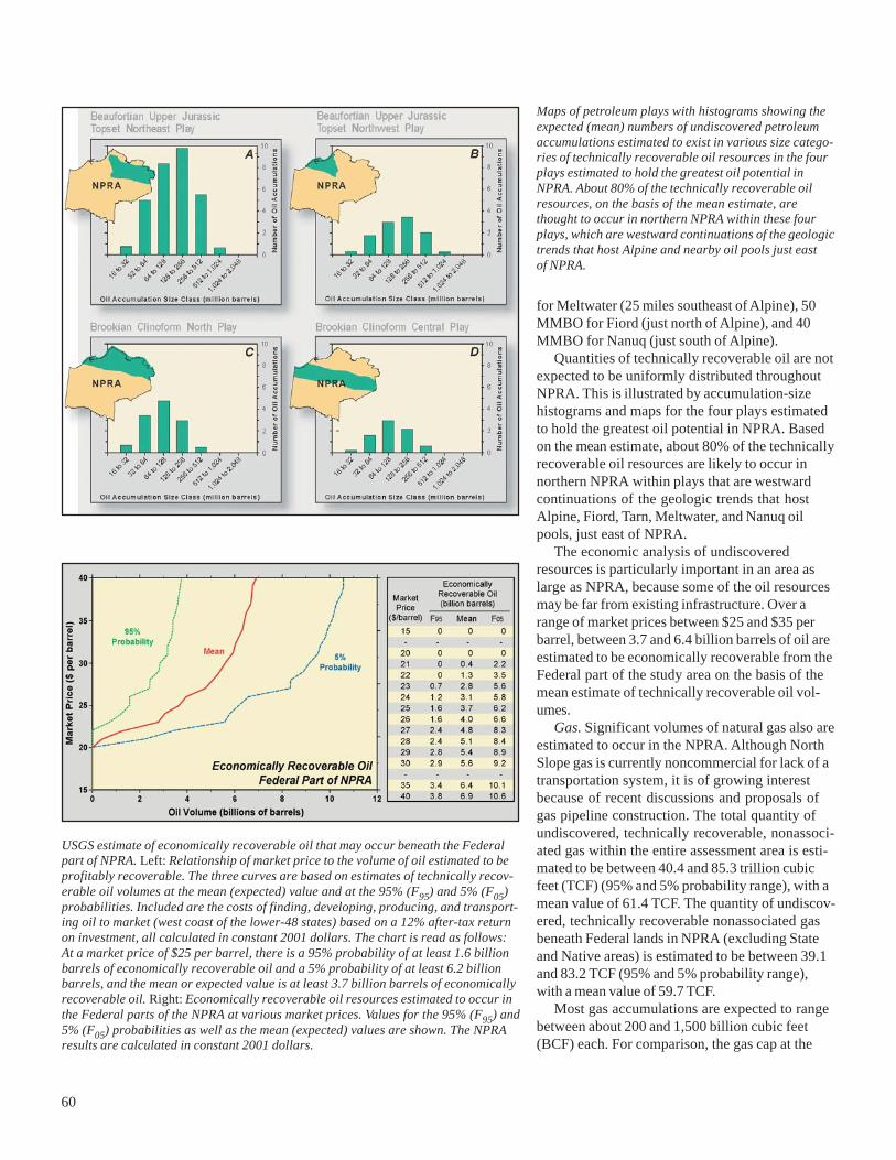
60
Maps of petroleum plays with histograms showing theexpected (mean) numbers of undiscovered petroleumaccumulations estimated to exist in various size catego-ries of technically recoverable oil resources in the fourplays estimated to hold the greatest oil potential inNPRA. About 80% of the technically recoverable oilresources, on the basis of the mean estimate, arethought to occur in northern NPRA within these fourplays, which are westward continuations of the geologictrends that host Alpine and nearby oil pools just eastof NPRA.
for Meltwater (25 miles southeast of Alpine), 50MMBO for Fiord (just north of Alpine), and 40MMBO for Nanuq (just south of Alpine).
Quantities of technically recoverable oil are notexpected to be uniformly distributed throughoutNPRA. This is illustrated by accumulation-sizehistograms and maps for the four plays estimatedto hold the greatest oil potential in NPRA. Basedon the mean estimate, about 80% of the technicallyrecoverable oil resources are likely to occur innorthern NPRA within plays that are westwardcontinuations of the geologic trends that hostAlpine, Fiord, Tarn, Meltwater, and Nanuq oilpools, just east of NPRA.
The economic analysis of undiscoveredresources is particularly important in an area aslarge as NPRA, because some of the oil resourcesmay be far from existing infrastructure. Over arange of market prices between $25 and $35 perbarrel, between 3.7 and 6.4 billion barrels of oil areestimated to be economically recoverable from theFederal part of the study area on the basis of themean estimate of technically recoverable oil vol-umes.
Gas. Significant volumes of natural gas also areestimated to occur in the NPRA. Although NorthSlope gas is currently noncommercial for lack of atransportation system, it is of growing interestbecause of recent discussions and proposals ofgas pipeline construction. The total quantity ofundiscovered, technically recoverable, nonassoci-ated gas within the entire assessment area is esti-mated to be between 40.4 and 85.3 trillion cubicfeet (TCF) (95% and 5% probability range), with amean value of 61.4 TCF. The quantity of undiscov-ered, technically recoverable nonassociated gasbeneath Federal lands in NPRA (excluding Stateand Native areas) is estimated to be between 39.1and 83.2 TCF (95% and 5% probability range),with a mean value of 59.7 TCF.
Most gas accumulations are expected to rangebetween about 200 and 1,500 billion cubic feet(BCF) each. For comparison, the gas cap at the
USGS estimate of economically recoverable oil that may occur beneath the Federalpart of NPRA. Left: Relationship of market price to the volume of oil estimated to beprofitably recoverable. The three curves are based on estimates of technically recov-erable oil volumes at the mean (expected) value and at the 95% (F95) and 5% (F05)probabilities. Included are the costs of finding, developing, producing, and transport-ing oil to market (west coast of the lower-48 states) based on a 12% after-tax returnon investment, all calculated in constant 2001 dollars. The chart is read as follows:At a market price of $25 per barrel, there is a 95% probability of at least 1.6 billionbarrels of economically recoverable oil and a 5% probability of at least 6.2 billionbarrels, and the mean or expected value is at least 3.7 billion barrels of economicallyrecoverable oil. Right: Economically recoverable oil resources estimated to occur inthe Federal parts of the NPRA at various market prices. Values for the 95% (F95) and5% (F05) probabilities as well as the mean (expected) values are shown. The NPRAresults are calculated in constant 2001 dollars.

61
Maps of petroleum plays with histograms showing the expected (mean) numbers ofundiscovered petroleum accumulations estimated to exist in various size categories oftechnically recoverable gas resources in the four plays estimated to hold the greatestgas potential in NPRA. About 60% of the technically recoverable gas resources, onthe basis of the mean estimate, are thought to occur in central and southern NPRAwithin these four plays.
Prudhoe Bay oilfield contains more than 23,000BCF, the Point Thomson gas and oil accumulationmay contain more than 6,000 BCF, and a recentlyannounced discovery in the Mackenzie Riverdelta of Canada (about 150 miles east of the U.S.–Canada border) is estimated to contain 200–300BCF recoverable reserves. Quantities of technicallyrecoverable gas are most abundant in central andsouthern NPRA.
Recent Exploration and DevelopmentActivity in NPRA
A total of 18 exploration wells were drilled inNPRA during the 2000 through 2004 winter drillingseasons. Data from six of these wells have beenreleased by the State of Alaska; data from theother wells are not yet available because of confi-dentiality restrictions. Although little informationhas been released by the companies that havedrilled the exploration wells in NPRA, announce-ments by two companies indicate that at leastseven wells have encountered oil or gas and con-densate in amounts that may be commercial. Oneadditional well drilled during the 2002 winter sea-
son encountered hydrocarbons in a rock unitcharacterized by poor reservoir quality. Signifi-cantly, all eight of these wells in which hydrocar-bons have been encountered targeted the rockunit that is the main reservoir in Alpine field.Another well, announced in 2001 to be a dry hole,targeted a different rock unit. No information hasbeen released on the remaining nine wells.
ConocoPhillips Alaska, Inc., which operates theAlpine field and has drilled most of the explorationwells in NPRA since the 1999 lease sale, has sub-mitted to the Bureau of Land Management a pro-posal to develop NPRA discoveries as Alpinesatellites. The proposed plan specifies the devel-opment of three production pads in NPRA. Two ofthe pads are located near the Spark and Lookoutwell sites, apparently indicating that those discov-eries are large enough to be developed as satellitefields. The third pad (Alpine West), located in theeasternmost part of NPRA, appears to be an exten-sion of the Alpine field proper.
The limited information available from the wellsdrilled in NPRA during the 2000 through 2004 drill-ing seasons indicates that the main explorationtarget is the western extension of the Alpine play.The USGS 2002 assessment of undiscoveredpetroleum resources divided this play into twoparts: the Beaufortian Upper Jurassic topsetnortheast play and the Beaufortian Upper Jurassictopset northwest play. These two plays wereassessed to have the greatest potential for undis-covered oil across NPRA, and together thesetwo plays extend across the entire width of boththe northeast planning area and the northwestplanning area. This correlation suggests thatexploration during the next several years is likelyto continue westward across northern NPRA.
Several other plays also have the potential tobecome exploration objectives in NPRA. However,these plays are estimated to contain a lower totalvolume of oil, and the oil is inferred to occur insmaller accumulations than the Alpine-type plays.These plays are likely to become secondary explo-ration objectives if additional discoveries in theAlpine-type plays sustain continued explorationacross NPRA.
SummaryAnticipating the need for updated scientific
information to support policy decisions, the USGSin 2002 completed a new assessment of undiscov-ered petroleum resources in NPRA. This newassessment concluded that the volume of techni-cally recoverable, undiscovered oil beneath Federal

62
lands in NPRA ranges between 5.9 and 13.2 billionbarrels (95% and 5% probabilities), with a mean(expected) value of 9.3 billion barrels. Over a rangeof market prices between $25 and $35 per barrel,between 3.7 and 6.4 billion barrels of oil are esti-mated to be economically recoverable, on thebasis of the mean estimate of technically recover-able oil volumes.
Most of the oil is estimated to occur in the north-ern third of NPRA, to be distributed among severalplays, and to occur in accumulations of moderatesize. It is unlikely that a Prudhoe Bay-size accumu-lation occurs in NPRA. The plays estimated tocontain the greatest potential for undiscovered oilaccumulations are westward extensions of theAlpine play, which hosts the 429-million-barrelAlpine field on the eastern border of NPRA. Infor-mation released from exploration drilling in NPRAduring the 2000 through 2004 winter drilling sea-sons confirms that the Alpine play is the mainobjective of industry activity.
Estimates of technically recoverable, undiscov-ered, nonassociated natural gas resources for thesame area range between 39.1 and 83.2 trillioncubic feet (95% and 5% probabilities), with a mean(expected) value of 59.7 trillion cubic feet. Theeconomic viability of these natural gas resourceswill depend on the availability of a pipeline totransport the gas to market.
The results of the NPRA assessment should beviewed in the context of the larger North Slope oiland gas picture, which includes spare capacity inthe oil pipeline, multiple proposals for a gas pipe-line, and changing makeup of the group of compa-nies exploring for oil and gas. An important factoraffecting the future of existing North Slope oilfields and all future oilfield development is thecontinued operation of the Trans-Alaska PipelineSystem (TAPS). Currently TAPS transports about1 million barrels of oil per day (bpd), about half ofpeak production of 2 million bpd achieved in 1988.A basic, but unanswered question is the minimumthroughput rate required for efficient, cost-effective operation. Multiple proposals for a natu-ral gas pipeline are being considered to tap morethan 30 trillion cubic feet of gas known to occurin the Prudhoe Bay and nearby accumulations.An important consideration is the amount of gasavailable beyond what is currently known. A gaspipeline would likely renew and expand explora-tion efforts in the foothills province. With the fail-ure to find additional multi-billion-barrel oilfields,most of the larger, “major” oil companies havereduced or abandoned North Slope exploration. Atthe same time, smaller, “independent” companieshave expanded their exploration activities. Thisshift in activity is a common pattern observed inpetroleum-producing basins as they mature.
;