department of the interior u.s. geological survey … · 2010-12-07 · river valley area, and the...
TRANSCRIPT

DEPARTMENT OF THE INTERIOR
U.S. GEOLOGICAL SURVEY
United States Earthquakes, 1946
By
Ralph R. Bodle
and
Leonard M. Murphy
Open-File report 84-946
Prepared in cooperation with National Oceanic and Atmospheric Administration,
This report has not been reviewed for conformity with U.S. Geological Survey editorial standards.
1984

CONTENTS
PageIntroduction. _.__.___._________________________-__--___-__--_----_..--------_--_---_ 1
Modified Mercalli intensity scale of 193l__-___-___--__------_---_.__----__----__-_- 3Xoninstrumental results. ____-__--____________-_-___-_------__- __-___-___---_____---_ 6
Earthquake activity in the various states_.___ _____________________________________ 6Earthquake activity outside the United States____ ____-_-_-_--__-___---_-___-_-_-___ 6Northeastern region____________________-________-_-_---_-__-__-__--_---_-_____-_ 6Piaster n region. __ _____.______________-__-___-_-__-___-----__--____--_-_-_____--__ 6Central region._____________________________--__-___---_--__-___--__--__..-__-___ 6Western Mountain region.___________-__--_-_--__----------_-_------__________-__ 7California and Western Nevada.__________-___-___--__-_---_--____-____-______-___ 8Washington and Oregon __________ _________-____-_-__---_-___-___-_______________ 17Alaska.-.--..-----._-_----.---.-.-----.-----------_----.----------------------- 22Hawaiian Islands. ________.__...L-_.-___---_-----------_-_-..-__.--_.-__.-__.-___ 22Puerto Rico.___________________________________________________________________ 22Panama Canal Zone...______-___-___-_-__--__--_---------___-___---_-_-_-_______ 22
Miscellaneous activities--. _-__________-_____..-__.---_..-------_---_---_---_-_-_-___-___ 23Geodetic work of seismological interest____________________________________________ 23Tidal disturbances of seismic origin______ __________________________________________ 23
Seismological observatory results._______-_-____-___----_-_---_--__-__..-__--___-_______ 24Table 1. Summary of instrumental epicenters for the first quarter of 1945__.____-_____ 25Table 2. Principal earthquakes of the world from January 1946 to December 1946,
inclusive.-___________-_____----__---_-_---_-------_-_--_---__-_______________ 26Strong-motion seismograph results. ___________________________________________________ 27
Introduction.______._ _ _ _ _______________________________________________________ 27Notes on strong-motion seismograph records- ____________ ___________________________ 28Table 3. List of shocks recorded and records obtained on strong-motion seismographs in
1946____-____-_---._-__--__-------_-------_-------------____----__._--_.--. 29Table 4. Summary of strong-motion seismograph data for the year 1946. _____________ 39Table 5. Instrumental constants of strong-motion seismographs in 1946_______________ 44
Tilt observations._______--_-_________--_-_-_-_-_-_-----_---_-_-_-__________.____-___ 47Corrections to previous publications, _ _________________________________________________ 47
ILLUSTRATIONS
Figure 1. Destructive and near destructive earthquakes in the United States through 1946.. iv Figure 2. Earthquake epicenters, 1946___ __--_-____-___-______-__________-_.._.._____-_ 2Figure 3. Areas canvassed for earthquake information by various organizations,.__________ 5Figure 4. Area affected by the earthquake of March 15__--__--__--______.._______________ 10Figure 5. Area affected by the earthquake of February 14.______________________________ 18Figure 6. Area affected by the earthquake of June 23____________ _______________________ 20Figure 7. Tracings of accelerograph records obtained at El Centro on January 8, and Lima,
Peru, on January 28___-_-___--__-_-_-___________________..__"_____________ 30Figure 8. Tracings of accelerograph records obtained at Los Angeles Subwav Terminal on
March 15. ._.__-___. ______________ _____________ ._________"__. ________ 31Figure 9. Tracings of accelerograph records obtained at Los Angeles Chamber of Commerce
and West wood on March 15_ _____________________________________________ 33Figure 10. Tracings of accelerograph records obtained at Hollywood Storage Co. on March 15_ 34 Figure 11. Tracings of accelerograph records obtained at Pasadena and Santa Barbara on
March 15 _____________________________________________________________ 35Figure 12. Tracings of accelerograph records obtained at Oakland City Hall, San Jose Bank of
America, and San Francisco Southern Pacific Building on May !___________.___ 36Figure 13. Tracings of accelerograph records obtained at San Francisco Southern Pacific
Building on May 1, and Eureka on December 18_ _________________________ 37Figure 14. Tracing of accelerograph record obtained at Ferndale on December 18. _________ 38Figure 15. Berkeley tilt graph for 1946. __ ___ _ ___________________ ______ .__ Facing p. 48
HI

FIG
UR
E 1
. D
estr
uct
ive
and
near
des
truc
tive
ear
thqu
akes
in
the
Uni
ted
Sta
tes
thro
ugh
1946
.

UNITED STATES EARTHQUAKES, 1946INTRODUCTION
This publication is a summary of earthquake activity in the United States and the regions under its jurisdiction for the calendar year 1946. A history of the more import ant shocks of the country appears in Serial 609, Earthquake History of the United States: Part I. Continental United States (Exclusive of California and Western Nevada) and Alaska, Revised (1947) edition; and Part II. Stronger Earthquakes of California and Western Nevada, Revised (1941) edition.
The history of .minor activity is covered largely in a series of references listed in Serial 609, in recent reports of the United States Coast and Geodetic Survey, and in the Bulletin of the Seismological Society of America. 1 The last two references give very detailed information for all California earthquakes. The last one contains all of the information appearing in the early catalogs published by the Smithsonian Institution.
Earthquakes of volcanic origin in the Hawaiian Islands are not included. Complete reports are published by local seismological institutions. Earthquakes adjacent to the United States and felt within its borders are described only in a general way when detailed descriptions are published elsewhere.
Cooperation of investigators solicited. In order that these publications may be as complete as possible in the more important details of earthquakes and in references, it is desired that investigators cooperate to the fullest extent, as such cooperation will be to the mutual advantage of everyone concerned. The Survey is willing to furnish investigators all information at its disposal, consisting principally of seismographic records and postcard questionnaires obtained in many instances through special can vassing of affected areas. In return it is requested that advance notices be furnished of results obtained so that abstracts and references may be inserted in these reports. An advance notice of a planned investigation might save considerable overlapping of effort and would give wider publicity to the work of the investigator.
Earthquake information services. The Coast and Geodetic Survey maintains a field party in San Francisco, the Seismological Field Survey, which in addition to other duties collects earthquake information in the Pacific Coast and Western Mountain States. In this work the seismological station of the University of California, Berkeley (Dr. Perry Byerly in charge), and the Seismological Laboratory of the California Institute of Technology, at Pasadena (Dr. Beno Gutenberg in charge), cooperate actively. Among the commercial agencies on the west coast rendering valuable services are telephone, power, oil, railroad, and especially insurance companies. Certain concerns interested in the manufacture of earthquake-resistant building materials are also active together with various organizations of structural engineers and architects.
Outside of California the following Collaborators in Seismology served as agents of the Coast and Geodetic Survey in collecting earthquake information in their respective States in 1946.
Arizona. Dean G. M. Butler, University of Arizona, Tucson.Colorado. Prof. C. A. Heiland, Colorado School of Mines, Golden.Idaho. Dean A. W. Fahrenwald, University of Idaho, Moscow.Montana. Dr. Francis A. Thomson, Montana School of Mines, Butte.Nevada. Prof. Vincent P. Gianella, University of Nevada, Reno.New Mejcico. Prof. Stuart A. Northrop, University of New Mexico, Albuquerque.Oregon. Dean E. L. Packard, Oregon State Agricultural College, Corvallis.Utah. Prof. J. Stewart Williams, Utah State Agricultural College, Logan.Washington. Dr. Harold E. Culver, Washington State College, Pullman.Wyoming. Prof. Horace D. Thomas, University of Wyoming, Laramie.In other parts of the country the Jesuit Seismological Association was active in
cooperative projects. The central office of the association at St. Louis University (Rev. Dr. J. B. Macelwane, S. J., in charge) collected information in the central Mississippi River Valley area, and the seismological station at Weston College, Massachusetts
i Descriptive Catalog of Earthquakes of the Pacific Coast of the United States, 1769 to 1928. S. D. Townley and M. W. Alien, Bulletin of the Seismological Society of America, vol. 29, no. 1, January 1939.

to
/ \
I -1
\ / N
1946
E
arth
quak
es o
f in
tens
ities
I V
E
arth
quak
es o
f int
ensi
ties
VI -
VIII
0 E
arth
quak
es o
f int
ensi
ties
IX
XII
Smal
l fig
ure
indi
cate
s nu
mbe
r of
ear
thqu
akes
rep
orte
d du
ring
the
year
. No
fig
ure
indi
cate
s on
e sh
ock
only,
exc
ept
for
min
or
fore
- an
d af
ters
hock
s. S
den
otes
a s
warm
of
earth
quak
es.
cl
co 8 o
FIG
UR
E 2
. E
art
hquake e
pice
nter
s, 1
946.

UNITED STATES EARTHQUAKES, 1946 3
(Rev. Daniel Linehan, S. J., in charge), undertook similar work in the Northeastern States under the auspices of the Northeastern Seismological Association and in close collaboration with the Harvard Seismological Observatory. Figure 3 shows areas canvassed for earthquake information by these various organizations.
Other sources of information used in compiling this report included: (1) The United States Weather Bureau, whose observers prepare periodic reports on local seismic activity; (2) telegraphic information collected by Science Service, Washington; (3) Bulletins of the Seismological Society of America; (4) bulletins of the Northeastern Seismological Association; (5) special bulletins of the Jesuit Seismological Association; (6) Earthquake Notes; (7) reports of the Hawaiian Volcano Observatory; and (8) re ports from many interested individuals.
Notes on the regional earthquake lists. The destructive features of all shocks are enumerated in the abstracts, but otherwise the descriptive matter is reduced to a minimum. The original reports arc open for inspection by anyone interested in un published details. More detailed descriptions of earthquakes on the west coast will be found in the mimeographed reports available at the office of the Supervisor, Western District, in San Francisco.
Beginning with the 1931 number of this series, Serial 553, the Coast and Geodetic Survey has used and will continue to use the modified Mercalli intensity scale of 1931, in place of the Rossi-Forel scale, to designate the intensity of earthquake activity. All intensity numbers therefore refer to the modified Mercalli scale unless otherwise desig nated. The reasons for this change are set forth in an article entitled "Modified Mer calli Intensity Scale of 1931," by Harry O. Wood and Frank Neumann, in the Decem ber 1931 number of the Bulletin of the Seismological Society of America, volume 21, no. 4. This article contains the original unabridged scale and also an abridged scale. The latter is given here, together with equivalent intensities according to the Rossi- Forel scale.
MODIFIED MERCALLI INTENSITY SCALE OF 1931
(ABRIDGED)
I. Not felt except by a very few under especially favorable circumstances. (I Rossi-Forel scale.)II. Felt only by a few persons at rest, especially on tipper floors of buildings. Delicately suspended
objects may swing. (I to II Rossi-Forel scale.)III. Felt quite noticeably indoors, especially on upper floors of buildings, but many people do not
recognize it as an earthquake. Standing motorcars may rock slightly. Vibration like pass ing of truck. Duration estimated. (Ill Rossi-Forel scale.)
IV. During the day felt indoors by many, outdoors by few. At night some awakened. Dishes, windows, doors disturbed; walls make creaking sound. Sensation like heavy truck striking building. Standing motorcars rocked noticeably. (IV to V Rossi-Forel scale.)
V. Felt by nearly everyone, many awakened. Some dishes, windows, etc., broken; a few instances of cracked plaster; unstable objects overturned. Disturbance of trees, poles, and other tall objects sometimes noticed. Pendulum clocks may stop. (V to VI Rossi-Forel scale.)
VI. Felt by all, many frightened and run outdoors. Some heavy furniture moved; a few instances of fallen plaster or damaged chimneys. Damage slight. (VI to VII Rossi-Forel scale.)
VII. Everybody runs outdoors. Damage negligible in buildings of good design and construction; slight to moderate in well-built ordinary structures; considerable in poorly built or badly de signed structures; some chimneys broken. Noticed by persons driving motorcars. (VIII Rossi-Forel scale.)
VIII. Damage slight in specially designed structures; considerable in ordinary substantial buildings with partial collapse; great in poorly built structures. Panel walls thrown out of frame struc tures. Fall of chimney;:;, factory stacks, columns, monuments, walls. Heavy furniture overturned. Sand and mud ejected in small amounts. Changes in well water. Persons driving motorcars disturbed. (VIII + to IX Rossi-Forel scale.)
I.. Damage considerable in specially designed structures; well-designed frame structures thrown out of plumb; great in substantial buildings, with partial collapse. Buildings shifted off foundations. Ground cracked conspicuously. Underground pipes broken. (IX + Rossi- Forel scale.)
X. Some well-built wooden structures destroyed: most masonry and frame structures destroyed with foundations; ground badly cracked. Rails bent. Landslides considerable from river banks and steep slopes. Shifted sand and mud. Water splashed (slopped) over banks. (X Rossi-Forel scale.)
XI. Few, if any (masonry), structures remain standing. Bridges destroyed. Broad fissures in ground. Underground pipe lines completely out of service. Earth slumps and land slips in soft ground. Rails bent greatly.
XII. Damage total. Waves seen on ground surfaces. Lines of sight and level distorted. Objects thrown upward into air.

4 U. S. COAST AND GEODETIC SURVEY
In the case of California, earthquakes reported as feeble are not plotted on the epicenter map of the United States, nor arc minor after-shocks plotted for heavy earth quakes in California or any other region. The reader should bear in mind that the information service in California has been developed to a point not approached in any other section of the country. When the coordinates of epicenters are given, the sources of information are stated. The epicenters are frequently determined by organizations such as the Seismological Station of the University of California or the Seismological Laboratory of the California Institute of Technology. The bulletins of these institu tions should be consulted for further details and often for data on additional shocks.
Within the United States the same regional arrangement has been followed as in Serial 609 previously mentioned.
Special quarterly report. Attention is invited to a special quarterly report issued by the Seismological Field Survey, with headquarters at San Francisco, entitled "Ab stracts of Earthquake Reports for the Pacific Coast and the Western Mountain Region." The reports are in mimeographed form and tabulate in unabridged style all information of value contained in noninstrumental reports collected in the region indicated.
Epicenter maps. Figures 1 and 2 are designed to show earthquake distribution in the United States at a glance, but the reader is cautioned in accepting all epicenter locations as correct. In a few cases, especially offshore epicenters and others in unin habited areas where instrumental control is not satisfactory or where results of investi gations are overdue, the plotted epicenters may be in error. The maps must therefore be accepted as showing in come cases the existence of epicenters rather than their precise locations. The text should be consulted to appraise any individual case. This same condition prevails also to some extent in the case of isoseismal maps.
In figure 1 the smallest solid dot indicates the shock was strong enough to overthrow chimneys or affect an area of more than 25,000 square miles, intensity VII to VIII; the largest solid dot may be associated with damage ranging from several thousand dollars to one hundred thousand, or to shocks unusually perceptible over more than 150,000 square miles, intensity VIII to IX; the smaller encircled dots represent damage ranging approximately from one hundred thousand to one million dollars, or an affected area greater than 500,000 square miles, intensity IX to X; the larger encircled dots represent damage of a million dollars or more, or an affected area usually greater than 1,000,000 square miles, intensity X.
The number after a dot inchoates the number of shocks which have occurred at or near the location shown. Points of origin of many of the earlier shocks are uncertain.
Teleseismic results. On page 24 is a list of Survey and cooperating teleseismic stations for which the Survey publishes results. Immediate epicenter determinations are frequently made through the cooperation of Science Service, the Jesuit Seismological Association, the Coast and Geodetic Survey, and individual stations. The results are furnished by mail to cooperators.
Strong-motion results. The introductory remarks in the chapter on this subject explain in detail the purpose of the work, which is primarily to furnish engineers exact information concerning ground movements in the central regions of strong earthquakes. The instrumental equipment is essentially different in type from teleseismic equipment although the principles involved are the same. Strong-motion instruments are installed mostly in the urban areas of California, and operate only when actuated by the move ments of a strong earthquake.
The interpretation of strong-motion results is one of the duties assigned to the Survey in connection with a broad cooperative program of Seismological research being carried out on the Pacific coast between the Survey and a number of local organizations and institutions interested in the engineering aspects of the earthquake problem. The details of this program are fully described in the Survey's Special Publication No. 201, Earthquake Investigations in California, 1934-35. which is obtainable from the Super intendent of Documents, Washington 25, D. C., for 35 cents.
Preliminary reports on strong-motion results arc issued in quarterly mimeographed bulletins and sometimes in special mimeographed reports. They appear in revised form in this publication.

U. S. COAST AND GEODETIC SURVEY
792022 48-

NONINSTRUMENTAL RESULTSNOTE. The following symbols arc used to indicate authority for the data shown.J' epicenter reported by the Seismologies! Laboratory of the California Institute of Technology at Pasadena.B epicenter reported by the Seismological Station of the University of California at Berkeley.BC epicenter reported by the Boulder City office of the Lake Mead Seismological Survey.W epicenter reported by the Washington Office of the United States Coast and Geodetic Survey.An asterisk (*) indicates instrumental origin time of the earthquake wheu coordinates of the epicenter are given. Otherwise,
instrumental times shown with asterisks are those of first motions.When more than one degree of intensity is reported from a town, the town is listed under the highest intensity reported. More
details will be found in the quarterly Abstracts of Earthquake Reports for the Pacific Coast and the Western Mountain Region which may be obtained from the Washington OfUce of the United States Coast and Geodetic Survey.
EARTHQUAKE ACTIVITY IN THE VARIOUS STATES
Arizona: July 18, November 26.California: March 5, 15, 18; April 25; May 1; July 6, 18; September 27; December 18. Minor
shocks are not listed here.Colorado: January 31, April 2.Illinois: February 24.Missouri: May 15, October 7.Montana: January 22; March 8, 25; July 1G; August 3; September 11 (2), 23, 29; October 9,
10 (2), 26; November 2 (2); December 8, 11.Nevada: February 9, 14, 27: March 17. Minor shocks are not listed here.New York: March 15, 19 (3); June 20; September 4; November 24, 28.North Dakota: October 26.South Carolina: February 8.South Dakota: July 23.Tennessee: April 6.Utah: March 19, May 5, October 25.Virginia: May 24.Washington:"February 5 (2), 6, 14, 15, 23; March 19; June 23; December 27.Wyoming: January 26, September 14.
EARTHQUAKE ACTIVITY OUTSIDE THE UNITED STATES
Alaska: January 12; March 1,11; April 1 (2), 18; June 25, 30; August 28; October 19. Canal Zone: July 12, December 11. v Puerto Rico: June 4, August 4, October 4.
NORTHEASTERN REGION
(75TH MERIDIAN OK EASTEKS STANDARD TIME)
March 15: 23:20. Masscna. N. Y. Slight shock felt.March 19: 21:01, 21:29, and 22:02. Alexandria Bay, N. Y. Sharp shocks felt by many. First
began with increasing vibration followed by one single-wave motion. Last two were minor. Felt only in a schoolhouse at edge of town.
June 20: 18:09. (labriels. N. Y. Light tremor felt by many.September 4: 14:30. Massena, N. Y. Sharp shock heard and felt by many. No damage.November 24: 05:20. Massena, X. Y. Light shock felt, by many. Subterranean sounds heard
8 seconds before and 4 seconds after the shock. Many awakened but no damage.November 28: About 17:00. Schroon Lake, N. Y. Sharp shock rattled windows and doors.
Humbling sound like an explosion heard. Many uncertain whether it was an earthquake or an explosion.
EASTERN REGION
(75TH MKKIDIAN OR KASTERN' STASDA1U) TIME)
February 8: 13:09. Summerville, S. ('. Light shock felt by several.May 24: 14:40. Albemarle County, Va. Several people in western part of county reported
an explosive sound preceded t lie earth tremor.
CENTRAL REGION
(OOTH MERIDIAN" OK CENTRAL STANDARD TIME)
February 24: 18:52. Centralia, 111. The following is taken from a report by Dr. Ross H. Hein- rieh. of St. Louis University: "The shock had a maximum intensity of IV. modified Mercalli intensity scale, and was felt in Hartelso. Carlyle, Cartler, Centralia, Huey. Kinnuindy. Odin. Patoka. Sandoval, Shattue. and Yernon. 111. It was recorded on the seismographs at St. Louis and Florissant, Mo. l"sing \Valter-Hirkenhauer tables the data indicate an epicentral distance of about 65 miles from St. Louis. Although indefinite these data and the macroseismic information suggest an epicenter in the region of the stronger Illinois Basin earthquake of November 17. 1937. which was on the, northern extension of the DuQuoin Flexure, a minor tectonic feature on the western limb of the Illinois Basin."
April 6: 24:00. Cleveland, Tenn. Sharp shock like truck hitting building reported by several in and near the town. Some heard sound like distant thunder on the horizon.
May 15: 00:10. Marston and Doniphan, Mo. Light shock. No details.

UNITED STATES EARTHQUAKES, 1946
July 23: 00:45. Wessington, S. Dak. Water mains cracked at two points. Generally felt from Pierre eastward to DeSmet and northward including Redfield. Strong enough to awaken sleepers in Huron.
October 7: 19:12:02.5.* Epicenter by St. Louis University, 37°28' north, 90°34' west, about midway between towns of Chloride and French Mills, Mo., in vicinity of Hogan Fault. Felt over approximately 3,000 square miles in Missouri and in a small portion of Illinois. Residents of Annap olis, Lesterville, Lodi, Saco, and Vulcan reported very distinct rumblings like dynamite or big motors underground. Also felt in Missouri at Des Arc, Farmington, Jackson, Gates Tower, Perryville, St. Louis, Washington, and Webster Grove; and in Illinois at Belleville, Cairo, Edwardsville, and Waterloo.
October 26: 14:37. Williston, X. Dak. Light shock of about 5 seconds duration felt by many in vicinity. Also felt at Plentywood, Mont. No damage. At Williston beds swayed and dishes rattled.
WESTERN MOUNTAIN REGION
(105TH MERIDIAN OR MOU.NTAN STANDARD TIME)
January 7: 16:00* BC. Boulder City, Nev. Light 2- or 3-second shock felt by many. January 8: 04:13* BC. Boulder Citv, Nev. Light shock felt. January 8: 04:32* BC. Boulder Citv, Nev. Light shock felt. January 22: 06:42. Helena, Mont. " Weak shock.January 26: 23:55. Thermopolis, Wyo. Mild shock rattled windows and dishes. Rumblings
heard for about 10 seconds. Water in Big Horn Hot Spring at Hot Springs State Park was roiled for several hours.
January 31: 15:45. Glenwood Springs, Colo. Light shock felt. Moderately loud, roaring sub terranean sounds heard by many at time of shock.
February 14: 03:45**BC. 'Boulder City, Nev. 19:12* BC. Boulder City, Nev. Stronger of two shocks.
Boulder City, Nev.
Light shock felt. Light shock felt by many.
Light shock felt by many. Rattled windows
February 15:doors, and dishes.
February 15: 19:43* BC. and doors.
March 8: 13:10. Helena, Mont. Weak shock.March 10: 17:16* BC. Boulder City, Nev. L%ht shock felt by several.
Boulder City, Nev. Boulder City, Nev. Boulder City, Nev.
Rattled windows,
22:18* BC. 06:46* BC. 04:45* BC.
Very light shock felt by one person. Very light shock felt.
Light shock felt by several. Rattled windows
March 10: March 11: March 12:
and door?.March 14: 02:17* BC. Boulder power plant, Nev. Light shock felt by several in control
room only.March 14: 20:25* BC. Boulder City, Nev. Light shock felt by many. Rattled windows
and doors.March 16: 21:52* BC.March 19:
Nev. Slight quiver felt by observer in home. Box Elder County, Utah. Very light shocks reported
Boulder City, 14:15 and 20:00 (about)",
on the Kunzler Ranch near Park Valley.March 25: 08:25. Helena, Mont. Very weak shock.April 2: 19:05. Riland, Colo. Light shock felt by several. Rattled windows and dishes.
Walls of log house creaked.May 5: 19:30. Logan, Utah. Widely felt in western Bear River Valley from the bird refuge
to Garland. Maximum intensity V reported from Garland and Tremerton where small objects shifted and vases overturned. Also felt at Bear River City, Bothell, Brigham City, Deweyville, Elwood, Evans, Fielding, Portage, Riverside, and Snowville. Recorded on seismograph at Logan.
June 7: 18:42. Helena, Mont. Weak shock.June 8: 04:25. Helena, Mont. Weak shock.June 12: 12:21. Helena, Mont. Weak shock.June 15: 02:21*. 02:38*, and 03:30* BC. Boulder City, Nev. Very light shocks felt.July 13: 10:14* BC. Boulder City, Nev. Light shock felt in city and at Boulder power plant
control room. Slight rumble.July 14: 09:57* BC. Boulder City, Nev. Light shock felt by observer in home.July 14: 14:23* BC. Boulder power plant, Nev. Light shock felt by several.July 14: 14:30* BC. Boulder power plant, Nev. Light shock felt by several.July 16: 08:00. Helena, Mont. Weak shock.July 18: 06:27:58* P. Parker, Ariz. Light shock felt. Rattled windows, walls creaked.August 3: 01:07. Helena, Mont. Light shock.September 11: 01:42. Helena, Mont. Light shock.September 11: 19:24. Helena, Mont. Weak shock.September 14: 05:45. Rock Springs, Wyo. Light shock felt by several. Buildings creaked
and loo«e objects rattled. September 23: 22:02. September 29: 22:45. October 2: 04:28* BC.
noise, followed bv .slight tremble 1 second later.October 4: 07:42* BC'. Boulder City, Nev.
Rattled windows, doors, and dishes.
Helena, Mont. Weak shock.Helena, Mont. Weak shock.
Boulder City, Nev. Light shock felt by observer in home. Earth
Two light shocks felt by observer in home.

8 U. S. COAST AND GEODETIC SURVEY
October 6: 00:19* BC. Boulder power plant, Nev. Sharp shock felt in control room. Com bination of vertical and horizontal motion.
October 6: 09:00* BC. Boulder power plant, Nev. Light shock felt by all in power plant, by others outdoors.
October 9: 14:00. Helena, Mont. Weak shock.October 10: 19:15. Helena, Mont. Weak shock.October 10: 19:50. Helena, Mont. Weak shock.October 25: 09:53. Magna, Utah. Light shock felt by many at schoolhouse. Rattled windows.October 26: Between 13:45 and 14:30. Northeastern Montana. Quake of short duration felt
quite generally throughout section. Residents at Wolf Point reported a rumble followed by one sharp tremor which gradually died *away. Men working at the Nef zger Body Shop felt the quake noticeably when timbers which were jacked up suddenly slipped out and let their loads fall. Large buildings were reported to have swayed. Plentvwood reported mild tremor of short duration.
November 2: 08:12. Helena, Mont. Weak shock.November 2: 17:22. Helena, Mont. Weak shock.November 3: 22:14* BC. Boulder City, Nev. Light shock felt by several. Rattled windows.November 18: 06:31* BC. Boulder City, Nev. Light shock felt by observer in home. Rattled
windows, doors, and dishes.November 26: 15:49 (about). Pierce Ferry, Ariz. Light shock felt by observer. Rattled
windows and doors.December 6: 04:36* BC. Boulder City, Nev. Light shock felt by a few. Rattled windows,
doors, and dishes.December 8: 07:10. Helena, Mont. Weak shock.December 11: 06:09* BC. Northwestern Montana. Felt over an area of approximately 3,000
square miles in northwestern Flathead Lake region. Maximum intensity of VI was reported from Kalispell, Trout Creek, Warland, and Whitefish. Press at Kalispell reported a sharp earthquake but no major damage. At many homes bric-a-brac and light articles were jarred to the floor and dishes rattled. One report of a toppled chimney was received, and several reports indicated loose plaster fell. The quake, which was of 10-second duration, started with a heavy jolt«nd tapered off into lesser vibrations. A rumble accompanied the quake.
INTENSITY VI : (|
Kalispell. Felt by and awakened many. Felt outdoors by some. Cracked plaster and chim neys, some bricks fell. Broke dishes. Pendulum clocks stopped. Hanging objects swung and pictures fell.
Trout Creek. Felt by many. Rattled dishes. Hanging objects swung northeast. Pictures were displaced.
Warland. Felt in homes, few awakened. Rattled windows, doors, and dishes. Knickknacks fell.Whitefish. Awakened and frightened many. Considerable plaster cracked. Dishes rattled and
walls creaked. Quake was accompanied by roar or rumble. Two-story buildings swayed.
INTENSITY V:
Bigfork, Columbia Falls, Jennings and Dunn Creek, and Kila.
INTENSITY IV:Dayton, Eureka, Fortine, Libby, Marion, Niarada, Pablo, Poison, Rexford, and Yakt.
INTENSITY I TO Hi:Essex. Negative reports were received from 6 places in Montana and 7 places in Idaho.
CALIFORNIA AND WESTERN NEVADA(120TH MERIDIAN OR PACIFIC STANDARD TIME)
NOTE. All places are in Califoria unless otherwise stated. The Bulletin of the Seismolopical Society of America is referred to HS the SSA Bulletin.
January 1: 15:56:32.* Epicenter 32°43' north, 117°25' west. P. Localized shock in the coastal area running from La Jolla through San Diego city proper. National City, and Coronado. It was strong enough to sway buildings, knock mirrors and pictures from walls, and trip burglar alarms. San Diego residents fled their homes in fear. Rolando Village and Crown Point residents described the shock as similar to the explosion of a bomb truck in Rose Canyon the previous month.
January 8: 10:54:18.* Epicenter 33°00' north, 115°50' west/P. San Jacinto Fault, about 20 miles northwest of El Centro. This earthquake was of mild intensity and was felt over an area of about 12,000 square miles in southern California. Reports of intensity V were received from scattered
A strong-motion record was obtained from the accelerograph at El Centro.
INTENSITY V:
Dulzura, Imperial. Lakeside, Mountain Center, Palm Springs, and San Diego.
INTENSITY IV:Alpine. Barren Dam, Brawley, Cabazon, Campo, Coachello. Descanso, El Cajon, El Centro,
Forest Home, Hipass, Holtville, idyllwild, Jacumba, Julian, La Mesa. Mecca. Miramar, Mount Lagtina, National City, Palomar Mountain, Plaster City, San Dimas, San Marcos, SeeK-y, Warner Springs, and Wildonmr.

UNITED STATES EARTHQUAKES, 1946 9
INTENSITY I TO Hi:Beaumont, Calipatria, ('hula Vista, Encinitas, Fawnskin, Jamul, La Jolla, Los Angeles, Mount-
Wilson, Palm City, San Pedro, San Ysidro, Thermal, Twentynine Palms, and Valley Center. Negative reports were received from 45 places.January 8: 11:00 (about). Coleville. Light shock felt at Mono Observatory.January 13: 08:31:15.* Epicenter 37°19' north, 118°39' west, P. About 2 miles west of Bishop.
Felt strongest, at Owens River Gorge, where all were frightened, ("racked windows arid chimneys. Many rocks fell down sides of canyon. Sharply felt at Adams main powerhouse and lightly felt in Nevada at Hawthorne.
January 13: 09:12:58.* Epicenter 34°24' north, 117°56' west, P. Southwest of Valyenno. Felt in Los Angeles and north of Los Angeles over a small area. No damage reported. Also felt at Altadena, Glendale, La Crescenta, Pasadena, Sierra Madre, and South Pasadena.
Negative reports were received from 24 places.January 31: 15:12:39.* Epicenter 33°50' north, 118°06' west, P. North of Los Alamitos.
Felt slightly at Long Beach and South Gate.February 9: 18:56 (about). Brucite, Nev. Strong tremor rattled windows. Confined to area
west of foot of Paradise Mountains.February 10: 03:01:18.* Epicenter 36°10' north, 120°55' west, P. East of San Lucas. Felt
over an area of approximately 2,000 square miles in west-central California. Maximum intensity V reported from San Benito.
INTENSITY IV:Big Sur, Chualar, Greenfield, Hollister (7 miles south of), Lonoak, San Lucas, San Miguel, Santa
Cruz, and Soledad.
INTENSITY I TO III:King City, Moss Landing. Pacific Grove, Robles del Rio, and San Ardo. Negative reports were received from 19 places.February 13: 15:58. Fresno. Mild shock caused a low rumbling and rattled windows and
dishes.February 14: 09:50. Washoe Valley, Nev. "Mild earth tremors rattled windows and swung
chandeliers for several minutes at 9:50 a. in., P. S. T., in homes in Washoe Valley, about 20 miles south of Reno, Nevada." (SSA Bulletin, April 1946.)
February 15: 04:07. Parkfield. Light shock rattled windows, doors, and dishes. Hanging objects swung. Pendulum clock facing south stopped.
February 20: 05:11:38.* Epicenter 34°03' north, 118°05' west, P. Near Barton Flat. Re ported felt at a cabin near San Gorgonio Peak.
February 23: 22:07:52.* Epicenter 34°24' north, 117°48' west, P. Southeast of Valyermo. Intensity VI in Valyermo where all were awakened. Houses creaked and pictures fell. There were no intensity V reports.
INTENSITY IV:Big Bear Cit}-, Cabazon, Glendale, Littlerock, Los Angeles, and Pasadena. Negative reports were received from 50 places.February 27: Between 14:00 and 14:30. Gables, Nev. Three shocks in rapid succession and
increasing intensity. Windows rattled. Preceded by sounds like a heavy truck. Felt only in the vallev.
March 5: 06:05* B. Epicenter 38.9° north, 120.1° west. Maximum intensity VI at Bijou, where all were awakened. Rattled windows, doors, and dishes. Hanging objects swung north-south. Pendulum clock facing north stopped. Trees and bushes were shaken strongly. Small objects over turned and knickknacks fell. Also felt at Carnino, Camp Richardson, Homewood, Kyburz, Meyers. Tahoe, Tahoe Vista, and Woodfords. Felt in Nevada at Carson City, Lake Tahoe, Minden, Steam boat, and Virginia City.
Negative reports were received from 3 places in California and 4 places in Nevada,March 15: 05:00. Grass Vallev. "Several Grass Valley residents reported a severe jolt at
5 a. in., P. S. T. The tremor roused some from their sleep." (SSA Bulletin, April 1946.)March 15: 05:20:01*. 05:49:36*. 06:00:35*, and 11:18:54*. Epicenter 35°44' north, 118°02.5'
west. P. North of Walker Pass. These earthquakes were felt over an area of approximately 65,000 square miles. See map. The following is quoted from a report of the field investigation made by the Seismological Laborator}': "The foreshock at 05:20:01* was felt by many persons in the area of Pasadena and Los Angeles, but the intensity there was described as slight. The main shock at 05:49:36* in the same area was reported as notably stronger, with the effect of a long-period roll which set suspended objects swinging and nauseated sensitive persons. The strong-motion instru ment at Pasadena recorded a maximum ground motion of about 1 millimeter with a period of about 2 seconds. The after-shocks at 10:18:54* and on March 16 at 01:46* were also felt in Los Angeles. In the epicentral region the main shock reached intensity VIII. Most of the more conspicuous effects could be referred to VII; damage to adobe structures, cracks in brick chimneys, fall of plaster. These were found in the region of Walker Pass and the South Fork of the Kern River south and west of the epicenter. In San Canyon, a few miles east of the epicenter, large boulders were rolled down onto the line of the Los Angeles Aqueduct. Part of the roof and sidewall were torn off by these boulders; this damage was repaired in about 2 days. Minor cracks were produced in the ground and in concrete along the aqueduct. Magnitude: The above numbers refer to local intensity. The magnitude of the main shock on the scale in use at Pasadena has been determined from the strong-

10 U. S. COAST AXD GEODETIC SURVEY
Fic;rnK 4. Area affected by the earthquake of March 15.
motion record and from comparison with aftershocks as being 6.2 to 6.t. The corresponding magni tude for the Long Beach earthquake of March 10, 1933 (March 11, 1933. G. C. T.), is 6.3. The San Franci.-co earthquake of 190(5 had a magnitude of about S ]/i. The last previous shock of comparable magnitude in southern California occurred on October 21, 1942 (magnitude about 6..~>; epicenter near Borego Valley), in eastern San Diego County, 33.1° north, 116.1° west."
INTKNSITY Vlir.
On //./ . Awakened and frightened all. Houses creaked. Pendulum clocks facing northeast stopped. Trees and bushes strongly shaken. Cracked plaster, windows, walls, chimneys, and ground. Pictures and plaster fell. Considerable damage to wood, brick, masonry, and concrete. The second shock was mo^t severe, lasting almost 1 minute in a series of four rolls. Heavy shocks occurred throughout the day, and continued for 3 days.
INTENSITY VII:
\\~dilon. Awakened and frightened all. Pendulum clocks stopped. Trees and bushes strongly shaken. Shifted furnishings. Cracked pla>ter, windows, and chimneys. Broke dishes and windows. Damage slight to brick and masonry.

UNITED STATES EARTHQUAKES, 1946 11
INTENSITY VI:Bakersfield. Reported as heavy in area 20 to 40 miles east of Bakersfield. Felt by practically
all. Rattled loose objects; buildings creaked. Door chimes rung. Few small plaster cracks. Hang ing objects swung. Damaged basement in City Hall. Broke pipes.
Rodfish. Awakened and frightened many. Some drugs and groceries fell off shelves and were broken. Rattled windows, doors, and dishes. Hanging objects swung. Cracked walls. Damage slight to concrete.
Brown. Felt by and awakened all. Rattled windows, doors, and dishes. Overturned small objects. Broke dishes. Rocks rolled in hills, sound could be heard in community. Cracked cement
Canlil. Felt by all. Rattled windows, doors, and dishes. Trees and bushes moderately shaken Shifted small objects and furnishings. Cracked plaster. Slight damage to masonry and concrete
Inyokern. Felt by and awakened all, frightened many. Rattled windows, doors, and dishes. Hanging objects swung. Trees and bushes moderately shaken. Shifted small objects and furnish ings. Small crack in road about 2 miles north of Walker Pass.
Isabella. Felt by, awakened, and frightened all. Earth seemed to have almost a continuous movement with intermittent large quakes from 05:20 to 08:10. Rocker arms on Fairview Bridge showed considerable movement; the rocker arm on the east side moved 1 inch, the rocker arm on the west side moved a complete turn.
.1'ohnsondale. Felt by and awakened all. Rattled windows, doors, and dishes violently. Trees and bushes moderately shaken. Shifted small objects and broke dishes.
Kernville. Awakened all and frightened many. Rattled windows, doors, and dishes. Walls creaked. Hanging objects swung. Overturned small objects.
Little Lake. Felt by and awakened all. Walls creaked. Overturned small objects. Cracked windows and walls. Slight damage to concrete. Aqueduct showed many cracks.
Lone Pine. Felt by several in house trailer. Slight damage to plaster and concrete. Trees and bushes moderateh- shaken. Rattled windows, doors, and dishes. Hanging objects swung.
Mojave. Three shocks felt very strongly. Rattled windows, doors, and dishes. Shifted small objects and overturned vases. Felt by 3 people at ranch 7 miles south of Mojave. Dull rumbling sound heard before and during second shock. Window pane cracked.
NewhalL. Awakened many. Houses creaked. Hanging objects and doors swung. Cracked plaster. One half-inch water pipe broke.
Olnncha. Felt by and awakened all. Rattled windows, doors, and dishes. Hanging objects swung. Slight plaster cracks.
Porterville. Felt by, awakened, and frightened many in hotel. Rattled windows and shifted small objects. Cracked plaster. Trees and bushes slightly shaken.
h'idgecrest. Felt by and awakened all. Rattled windows, doors, and dishes. Hanging objects swung. Cracked plaster and cement floor.
Itoads End. Awakened and frightened all. Rattled windows, doors, and dishes violently. Hanging objects swung northeast. Overturned small objects. Big rumble when quakes came.
San Bernardino. Felt by and frightened many. Pendulum clocks stopped. Cracked plaster. Overturned small objects.
Searles Valley. Felt by. awakened, and frightened many. Rattled windows, doors, and dishes. Houses creaked. Cracked plaster.
Shatter. Two strongest shocks awakened and frightened many. Rattled windows, doors, and dishes. Trees and bushes slightly shaken. Cracked plaster.
Springvillc. Felt by and awakened all. Rattled windows, doors, and dishes. Shifted small objects, overturned knickknacks. Hanging objects swung.
Sultana. Felt by and awakened many. Rattled windows. Shifted small objects and furnish ings. Hanging objects swung.
Tehacha/>i. Felt by, awakened, and frightened all. Rattled windows, doors, and dishes strongly. Houses creaked. Shifted small objects. Noticeable plaster cracks. Food in glass jars fell from shelves.
Trona. Felt by all. Loose objects rattled and buildings creaked. Moderate rumbling at be ginning. Visible swaying of buildings and trees. Minor plaster cracks. Dishes fell from shelves and water splashed from fish bowls.
Tulnre. Felt by all. Rattled windows, doors, and dishes. Hanging objects swung. One chimney cracked.
V'isalia. Felt by and awakened all. Rattled windows, doors, and dishes. Pendulum clocks stopped. Trees and bushes moderately shaken. Cracked plaster.
INTENStTY V:
Acton, Arvin, Big Pine, Burbank, Buttonwillow, Caliente, California Hot Springs, Cartago, Castair, Chowchilla, Coso Junction, Darwin, Death Valley, Karlimart, Fellows, Frazier Park, Fresno and vicinity, Friant, Fulton Hanger Station, Grapevine, CJroveland, Hanford, Incline, Keller, Lake Hughes, I.omoncove, Lon»; Barn, Los Alamos. Los Angeles, Lost Hills, May wood, McFarland, Mira- monte, Nipcnnawassc, Owenyo, Oxnard, Port Hueneme, Posev, Raisin, Rosamond, Saltdale, Sanger, Santa Barbara, Sepulveda, Shoshone, Stratford, Taft, Tecopa, Tineniaha Dam, Valyermo, West haven, Wheeler Hidge, Wildomar, and Yosemite National Park.
INTENSITY IV:
Academy, Adelanto, Aguanya, Ahwalmee, Alhambra, Altadena, A in boy, Arroyo Urande, Artesia, Auberry, Baldwin Park, Barstow, Bass Lake, Beaumont, Ben 11 ur, Beverly Hills, Big Bear Citv, Bishop, Bonsall, Caba/.on, Cainmaehe, Camp Baldy, Caruthers, Casmalia, Cedar Cllen, Coleville,
12 U. S. COAST AND GEODETIC SURVEY
Compton, Corcoran, Corona, Cotilterville, Covina, Co\v Creek, Cuyama, Daggett, El Monte, El Nido, F,l Portal, El Segundo, Etiwanda, Fairmont, Fawnskin, Fillmore, Firebaugh, Fullerton, Glendale, Glendora, Glennville, Helm, Hermosa Beach, Highland, Hinkley, Hondo, Huntington Park, Huron, Independence, Indio, Inglewood, Kettleman City, Knights Ferry, Lake Arrowhead, Lancaster, Laws, Le Grand, Lemoore, Lindsay, Long Beach, Los Alamitos, Los Olivos, Lucerne Valley, Ludlow, Mari- posa, McKittrick, Mendota, Monrovia, Montalvo, Moreno, Mount Wilson, Muroc, Newberry, North- fork, North Hollywood, North Long Beach, Oilfields, Ojai, O'Neals, Orange, Orange Cove, Palm City, Palm Springs, Pasadena, Patterson, Pinedale, Pineridge, Piru, Planada, Pond, Randsburg, Reedley, Riverside, Rosemead, San Diego, Sandberg, San Gabriel, Sanger, San Joaquin, San Miguel, San Pedro, Santa Ana, Santa Fe Springs, Santa Margarita, Santa Paula, Santa Ynez, Seven Oaks, Sierra Madre, Simi, Snelling, Sonora, South Gate, Terra Bella, Turlock, Twentynine Palms, Venice, Ventucopa, Ventura, Walnut, Wasco, Whittier, Wishon, Woodlake, and Wrightwood.
INTENSITY I TO III:
Angiola, An/a, Baker, Bartlett, Bridgeport, Cambria, Coachella, Coalinga, Colton, Culver City, Eagle Rock, Elsinore, P>1 Toro, Encino, Forest Home, Goleta, Hemet, Knowles, Littlerock, Mecca, Morongo Valley, Newman, Oceano, Ontario, Palos Verdes Estates, Paso Robles, Placentia, Pomona, Redlands, Romolarid, San Dimas, Santa Maria, Shandon, Thousand Palms, Torrance, Tranquillity, and Upland.
Negative reports were received from 85 places.March 15: 21:49:23.* Epicenter 33°57' north. 118°17' west, P. Southeast of Inglewood. Light
shock distinctly felt without damage at Hawthorne, Los Angeles, Manhattan Beach, Maywood, and Venice.
March 16; 01:46:19* and 01:58. Epicenter 34°44' north, 118°02.5' west, P. North of Walker Pass. Felt lightly at Los Angeles and Bakersfield.
March 16: 02:10. 08:05, and 08:06. Kernville. Felt generally without damage.March 16: 02:20. 03:15, and 22:04:15* P. Trona. Many awakened.March 16-17: 23:30 and 01:00. Quincy. "A series of three earth shocks of brief but severe
intensity was reported to have rocked homes in Quincy and the Feather River region. Residents reported feeling two shocks in quick succession about 11:40 p. m., P. S. T., on the 16th, and another shock about 1 a. m. on the 17th, all strong enough to shake buildings." (SSA Bulletin, April 1946.)
March 17: 00:17:02* P. Trona. Mild shockMarch 17: 06:45:56.* Epicenter 38.3° north, 118.2° west, W. Southwest of Hawthorne, Nev.
Felt over approximately 12,000 square miles in a sparsely inhabited region. Maximum intensity V reported from Liming. All other reports indicate a moderate shock. Felt in California at Bridgeport. Coleville, El Portal, June Lake, Kyburz, Laws, Leevining, and Yosemite National Park; and in Nevada at Carson City, Fallon, Hawthorne, Mina, Minden, Schurz, Smith, Smokey Valley, Tonopah, Welling ton, Wabuska, and Yorington.
Negative reports were received from 7 places in California and 5 places in Nevada.A strong-motion record was obtained from the accelerograph at Hawthorne.March 18: 02:05:54.* Epicenter 35.7° north, 118.0° west, P. North of Walker Pass. Felt
slightlv at McKittrick (Olig pump station).March 18: 07:49:27* and 07:50:43.* Epicenter 35.7° north, 118.0° west, P. North of Walker
Pass.
INTENSITY Vi:
Brown. Felt by and awakened all. Rattled windows. Trees and bushes moderately shaken. Knickknaeks fell.
Los Angeles. Two sharp shocks in Sand Canyon sent deluge of huge boulders down mountainside in area of Lo* Angeles aqueduct.
Trona. Strong swaying motion. Rattled dishes and loose objects.Weldon. Felt by all. Rattled windows, doors, and dishes. Hanging objects swung. Trees
and bushes moderately shaken. Shifted small objects.
INTENSITY V:
Coso Junction, Ducor, Little Lake, and Muroc.
INTENSITY IV:
Acton. Adelanto. Bodfish. ('until, Darwin, Fawnskin, Friant. Hobo Hot Springs, Lebee, McFar- land, McKittrick, Oildale, Porterville, Red Mountain, Saltdale, Wrightwood, and Yosemite.
INTENSITY I TO Hi:
Lake Arrowhead, Lake Hughes, Ludlow, and Santa Maria. Negative reports were received from 21 places.March 26: 00:3S. Little Lake, 12 miles south of. Slight shock felt by several.March 27: 08:30 (about). San Martin. Slight shock felt bv several. Walls creaked.March 29: 02:40:17.* Epicenter 37°51' north. 121°59' west, B. Berkeley region. Moderate
shock felt at Berkeley. Canyon, Lafayette, Martincz, Oakland, and San Francisco.Negative reports were received from 27 places.March 29: 03:58. Epicenter 40.9° north, 121.7° west, B. Shasta County. Light shock felt
at Cassel and Fall River Mills.April 1-30: Epicenter 35.7° north, 118.0° west. P. Aftershocks of March 15 earthquake.
During April, 53 aftershocks were either felt at the Sand Canyon or Nine Mile aqueduct stations or recorded at one or more stations of the Pasadena Seismological Laboratory.

UNITED STATES EARTHQUAKES, 1946 13
April 9: 07:16:07.* Epicenter 34°20' north, 118°41' west, P. Prairie Fork, San Gabriel River. Slight shock felt by several in Big Pine recreation area.
April 9: 21:16. Hollister, 7}^ miles south of. Very slight shock felt by several.April 17: 05:34* P. San Martin and Watsonville. Many awakened in both towns. Recorded
at Tinemaha.April 19: 04:50. Santa Maria. Very slight shock. Felt.April 19: 07:55:13.* Epicenter 33°53' north, 117°18' west, P. Near Box Springs. Felt lightly
at Riverside and Perris. Rocks broke loose and tumbled down slopes at Box Springs repeater station.April 19: 13:00 (about). Laytonville. Felt by several.April 21: 23:42.* Epicenter 37°42' north, 121°29' west, B. South of Hollister. One quick
jerk, very short. Felt by several in Vernalis.April 25: 03:50. Watsonville. Shock of momentarv duration awakened many in community.April 25: 13:50:40.* Epicenter, 37°33' north, 121°55' west. B. Near Santa "Clara. Felt over
an area of approximately 400 square miles, mainly in western Alameda County. Maximum intensity VI reported from two places; all other reports indicate a moderate shock.
INTENSITY VI:Milpitas. Felt by many. Rattled windows. Walls creaked and plaster was cracked.Pleasanton. Felt by many. Rattled windows. Trees and bushes moderately shaken. Water
line on main street was broken.
INTENSITY V:
Alviso, Agnew, Mission San Jose, Moraga, Newark, and Newark substation.
INTENSITY IV:
Centerville, Hayward, Irvington, Niles, San Lorenzo, Sunol, and Warm Springs.
INTENSITY I TO III:
Alvarado, Mount Eden, Oakland, and San Leandro. Negative reports were received from 18 places.April 29-May 4: Childs Meadows, Man/anits Lake, and Mineral. A series of at least 12 shocks
were felt by manv. Windows and loose objects rattled. Trees and bushes slightly shaken.May 1: 17:26:16.* Epicenter 37°41' north, 121°33' west, B. Felt over an area of approxi
mately 3,000 square miles in west-central California. Tracy felt shock more than other localities.Strong-motion records were obtained from the accelerographs in San Francisco, Oakland, and
San Jose.
INTENSITY VI:Tracy. Felt by all. Rattled windows, doors, and dishes. Hanging objects swung north-south.
Shifted articles on shelves. Some plaster cracked.
INTENSITY V:Byron and Moraga.
INTENSITY IV:Agnew, Alma, Decoto, Diablo, Isleton, Irvington, Lafayette, Lathrop, Livermore, Mission San
Jose, Mount Eden, Niles, Pinole, Pleasanton, Ripon, San Gregorio, San Lorenzo, San Francisco, and Sunol.
INTENSITY I TO III:Ben Lomond, Berkeley, Brentwood, Canyon, Cresta Blanea, Cupertino, Manteca, Milpitas,
Modesto, Oakdale, Oakland, Orinda. Pescadero, Redwood City, Sacramento, St. Mary's College, San Bruno, San Ramon, Stockton, and Vernalis.
Negative reports were received from 44 places.May 3-31. Epicenter 35.7° north, 118.0° west, P. Aftershocks of March 15 earthquake.
During May 20, aftershocks were either felt at the Sand Canyon or Nine Mile aqueduct stations or recorded at one or more stations of the Pasadena Scismological Laboratorv.
May 8: 16:13:59.* Epicenter 33°53' north, 117°1S' west, P. Near Box Springs. Aftershock of April 19 shock. Felt distinctly at Riverside and Tenaja Guard Station.
May 12: 10:19:05.* Epicenter 33°53' north, 117°18' west, P. Near Box Springs. Felt slightly at Riverside.
May 12: 17:16:57.* Epicenter 36°03' north, 117°55' west, P. Felt at Haiwee.May 12: 17:18:33.* Epicenter 30°03' north, 117°55' west, P. Felt at Haiwee.May 13: 16:28:30.* Epicenter 37°20' north, 118°50' west, P. West of Bishop. Felt at Laws.May 17: 19:55:00.* Epicenter 37°22' north, 118°50' west, P. West of Bishop. Felt slightly
at Laws.May 19: 17:51:13.* Epicenter 33°57' north, 118°09' west, P. Northwest of Downey. Slight
earthquakes felt at Alhambra, Los Angeles, Pasadena, and South Gate.Negative reports were received from 9 places.May 20: 21:36:4.* Epicenter 35.9° north. 118.5° west, P. Upper Kern River. Felt by many
at Kern River powerhouse No. 3. Rattled windows and doors.
792022- -48 -3

14 U. S. COAST AXD GEODETIC SURVEY
May 22: 11 :OI :53.* Epicenter 36°08' north, 117°57' west, P. Very near Haiwee. Felt slightly at Haiwee aqueduct station.
May 28: 21:58.* Epicenter about 10 miles southeast of University of California, B. Felt over a small area in East Bay region. Maximum intensity V reported from Moraga.
Strong-motion records were obtained from the accelerographs in the Southern Pacific Building, San Francisco.
INTENSITY IV:Alameda, Albany, Berkeley, Canyon, Hay ward, Oakland, Piedmont, Rodeo, and Walnut Creek.
INTENSITY I TO III.Lafayette, Mount Eden, and Pinole. Negative reports were received from 16 places.May 29: 09:51.* Epicenter 36°48' north 121°34' west, B. Xear Hollister. Felt over very
small area inland from the Moutercy Bay region. Maximum intensity V reported from one locality a few miles south of Hollister where many were frightened and small objects were shifted.
A record was obtained from the Weed instrument in Hollister.
INTENSITY IV:
Hollister, Sail Juan Bautista, and San Martin.
INTENSITY I TO III!Salinas and Watsonville.Xegative reports were received from 11 places.June 1: 03:06:31.* Epicenter 34°25' north, 118°50' west, P. Xear Fillmore. Felt in San
Pedro, Hollywood. Los Angeles, and more strongly (intensity about IV) at ("amarillo.June 2-29: Epicenter 35.7° north. 118.0° west, P. Aftershocks of March 15 earthquake.
During June, 20 aftershocks were either felt at the Sand Canyon or Xine Mile aqueduct stations or recorded at one or more stations of the Pasadena Seismological Laboratory.
June 4: 03:55. Desert Center, 15 miles west of. Slight shock awakened two. Rattled light fixtures.
June 4: 04:05:24.* Epicenter 33°55' north, 115°42' west. P. Pinto Basin, Little San Beruar- clino Mountains. Felt bv several in Xeedles. Hanging objects swung.
June 5: 13:59:36.* 'Epicenter 35°35' north, 118°20' west, P. X>ar Weldon. Xo damage. Felt distinctly at Borel powerhouse. Kern River powerhouse X'o. 3, Keruville, and X'ine Mile aqueduct station.
June 5: 16:04:44.* Epicenter 35°35' north, 118°20' west, P. Xear Weldon. Felt distinctly at Borel powerhouse and felt lightly at Xine Mile, Jawbone, and Sand Canyon aqueduct stations.
June 6: 22:51. Jawbone aqueduct station. Slight shock felt.June 13: 17:26* P. Kern County. Trembling motion felt by two at Kern River powerhouse
Xo. 1. Recorded at Tinemaha.June 13-14: 22:56 to 07:30. Mineral. Series of about 20 mild shocks. Disturbed objects
observed by several. Very slight movement of buildings. Pull chains of lights swung east-west. Distant, thunderous sounds heard immediatelv before shocks.
June 15: ll:4f>:53.* Epicenter 32°36'' north, 116°19' west, P. Xear Hipass. Maximum intensity V reported from Hipass. Also felt at Alpine, Barrett Dam, Descanso, Jacumba, Julian, and San Diego. Small object.- shifted. Lighting fixtures swung. Windows and dishes rattled.
June 23: 21:25. Mineral. Mild shock felt by several. Rattled windows, doors, and dishes.June 24-25: 12:25. 1<S:14. and 05:18. Pasadena region. "Three local tremors, all within 50
miles of Pasadena, were re-corded at the California Institute of Technology within a 24-hour period, but there were no reports of anv damage. The tremors were at 12:25 and 6:14 p. in., P. S. T., June 24, and at 5:1S a. in.. June 25.'' (SSA Bulletin. October 1946.)
June 26: 19:16:35.* Epicenter 33°53' north. 117°18' west, P. Xear Box Springs. Short sharp shock rattled windows in Perri> and Riverside. Fell bv manv and frightened children.
June 29: 21:22:18.* Epicenter 34°02' north. 118° 18'' west, P. Los Angeles. Mild temor reported by resident- of Beverly Hill-. Culver City. Hawthorne. Inglewood, and Lawndale.
Xegative reports were received from 12 places.July 1: 23:28:35.* Epicenter 34 = ()6' north. 117°46' west, P. Xear Pomona. Apparently a
strictly local earthquake felt by hundred* of Claremont and Pomona residents but not reported out side the Pomona Valley region. A <ingle, -harp jolt was felt by many and awakened many others. Claremont re.-idetit- reported a very .-light .-hock the following morning at 06:50.
July 5: 18:15. Sand Canyon aqueduct .-tation. Mild shock.July 6: 22:55.* Epicenter near 40.5° north. 121.5° west, B. Lassen Xational Park. Felt over
all area of approximately 7.000 -quare mile- in northern California. Maximum intensity VI reported from Mill Creek. Mineral. :ind the l.a.-.-eti National Park area, where small object.- fell and canned tiood> were -hakeii from shelve.-.
INTENSITY VI :
Mitt (VM/,-. Felt by and awakened all. Rattled windows, doors, and disho. Hanging objects swunii. Tree* and l)ii-he> moderately shaken. Knickckacks and books fell.
Miit<r>it. - Feit In and awakened all. Hamming objects swung. Overturned a fe\\ vases, some di.-he.- fell.

UNITED STATES EARTHQUAKES, 1946 15
INTENSITY V:Caribou and Grass Valley.
INTENSITY I TO IVIChester, Chico, Deer Creek, Dutch Flat, Emigrant Gap, Gridley, In\vood, Las Plumas, Marys-
ville, Milford, Oroville, Paradise, Portola, Quincy, Redding, Storrie, and Susanvillo.Negative reports were received from 35 places.July 6: 23:32:00.* Epicenter 35.7° north, 118.0° west, P. Near Walker Pass. Mild shock felt
at Sand Canyon Aqueduct Station.July 8: 04:04. Mineral. Felt by and awakened many. Rattled windows and doors. Very slight
shock felt in Caribou.July 8: 19:19:01.* Epicenter 35°40' north, 118°04' west. P. Near Walker Pass. Felt at Nine
Mile and Sand Canyon aqueduct stations.July 13: 04:00':33.* Epicenter 35.7° north, 117.6° west, P. East of Inyokern. Felt at Sand
Canyon aqueduct station.'July 17: 08:38:02.* Epicenter 35°41' north, 117°35' west, P. East of Inyokern. Felt slightly
at Nine Mile and Sand Canyon aqueduct stations.July 17: 21:02:02.* Epicenter 35°42' north, 117°41' west, P. East of Inyokern. Felt slightly
at Jawbone aqueduct station.July 18: 06:27:58.* Epicenter 34°32' north, 115°59' west, P. West of Bagdad. Felt over an
area of approximately 27,000 square miles in southern California. Maximum intensity VI reported from Yucca Valley, near White Water, where small objects shifted and knickknacks fell.
INTENSITY V:Amboy, Baker, Forest Home, Rice, and Twentynine Palms.
INTENSITY IV:Acton, Atwood, Beaumont, Big Bear City, Blythe, Chubbuck, Daggett, Desert Center, Essex,
Etiwanda, Glendora, Hinkley, Idyllwild, Indio, Ivanpah. Lake Arrowhead, Lucerne Valley, Ludlow, Maywood, Mecca, Needles. Newberry, Palm Springs, Redlands, Romoland. San Bernardino, San Jacinto, Santa Ana, Seven Oaks, Thousand Palms, Trona, Van Nuys, Victorville, Vidal, and Wildomar.
INTENSITY I TO Hi:An/a, Artesia, Boron, Caba/.ori, Castaic, Coachella, Corona, Elsinore, Fall Brook, Hesperia,
Jawbone Aqueduct Station, Kelso, Lake Hughes, Niland, Pasadena, Pomona, Riverside. San Clemente, San Juan Capistrano, and Upland.
Negative reports were received from 42 places.July 9: 18:05. Sand Canyon aqueduct station. Mild shock.July 20: 06:33. Nine Mile aqueduct station. Slight shock.July 22: 07:19:33.* Epicenter 35°44' north, 118°02' west, P. Near Walker Pass. Felt at
Haiwee powerhouse and Freeman, Little Lake. Nine Mile, and Sand Canyon aqueduct stations.July 23: 03:25:58.* Epicenter 35°50' north, 118°00' west, P. Near Walker Pass. Shook
house rather severelv at Nine Mile aqueduct station.July 23: 16:19:08.* Epicenter 35°06' north, llfl°05' west, P. North of Wheeler Ridge. Felt
slightly at Tuft.July 27: 21 :14:11.* Epicenter 35°40' north, 117°50' west, P. Near Inyokern. Felt by several
at Kern River powerhouse No. 3.August 2: 20:00 (about). Eureka. "An earthquake which swayed light fixtures in Eureka homes
shortly after 10 p. in., P. S. T.. was registered on the University of California seismograph at Ferndale. Il was classed as 'very slight' and its origin was estimated as about 20 miles north of the station." (SSA Bulletin. October 1946.)
August 4: 20:OS.* Epicenter, 36°53' north, 121°36' west. B. On Sau Andreas Fault near Alma and Los Gatos. Felt at Alviso. Aptos. Los Gatos. San Francisco. San Gregorio, and Waton- \ ille.
August 5: 20:55:07.* Epicenter 34°57' north. 120°11' west, P. East of Santa Maria. Slightly felt at Lo> Alamo^.
August 8: 12:13* B. Scotia and Upper Mauole. Very slight shock felt by observer.August 11: 15:46. Kern Riverpowerhou.se No. 1. Slight shock felt by several.August 14: 14:01* B. San Francisco Bay area. Entire area trembled slightly during 45-
-econd earthquake. No damage reported although it was particularly felt in the East Bay region where dishes and pans were shaken. Residents of Forest Hill and other areas west of T\\in Peaks reported a -hort. .-harp earthquake accompanied by a rumbling noi-e. The shock was also fell at Lafayette. Oakland, and Uockaway Beach.
August 19: 02:20. MarklecviMc, 5 miles .-outh of. Slight shock felt by several.August 27: 21:47:33.* Epicenter 35°4U north. 11S°12' west. 1'. Near Walker Pass. Felt by
-everal at Kern River powerhouse No. 1 (Kern Camon). and Kern Ri\er powerhouse No. 3 (near Kernville).
August 31:01:15.* Epicenter 35°37' north. 11S°00' west, P. South of Walker Pass. Awakened many at, Kernville and Tehuchapi. AUo felt bv -everal at Kern River powerhouse No. 1.
September 2: 07:26*1*. Trona. Slisrht .-hock fell. Buildings creaked and loose objects rattled.September 9: 03:20. Santa Maria. Slight -h«u-U felt by many. Al-o felt at Orcutt pump
house (near Santa Maria).

16 U. S. COAST AND GEODETIC SURVEY
September 13: 08:13:07.* Epicenter 35°3G' north, I17°40' west, I'. East of Jnyokern. Felt by several at Cantil. Rattled windows, doors, and dishes.
September 27: 23:19:09.* Epicenter 33°57' north. Hfi°r>r west, P. North of Beaumont. Felt over an area of approximately 9,000 square miles in southern California. Maximum intensity VI reported from several places, where slight damaged occurred.
INTENSITY VI:Banning. Felt by all and awakened many. Hanging objects swung north. Cracked plaster
and overturned vases. Rattled windows, doors, and dishes. Those awake reported hearing the shock before feeling it.
Cabazon. Felt by all. Cracked plaster and shifted small objects and furnishings. Knickknacks fell. Damage slight.
Cathedral City. Felt by all. Overturned small objects. Hattled windows, doors, and dishes. Damage slight.
Palm Springs. Felt by many. Hanging objects swung north. Cracked plaster. Trees and bushes slightly shaken. Shifted small objects. Damage slight.
INTENSITY V:Aguanga, Beaumont. Fall Brook. Fawnskin, Forest Home, Hayfield Reservoir, Idyllwild, Men-
tone, Riverside, and White Water.
INTENSITY IV:Altadena. Anaheim, Anza. Burbank, Calimesa, Coachella. Colton, Corona. Desert Center,
Elsinore, Etiwanda, Hemet. Huntington Beach, Laguna Beach. La Habra, Mill Creek Canyon, Mountain Center, Xorco. Perris. Pomona, Romoland, Rosernead, San Bernardino, San Dimas, San Jacinto. South Gate, Thousand Palms, Walnut, and Wildomar.
INTENSITY I TO III:Balboa, Lakeview, La Mirada. Newport Beach, Iledlands, San Diego, Santa Ana, Twentynine
Palms, Victorville. and Warner Springs.Negative reports were received from 50 places.October 1:11:23. San Jose. "A light earthquake felt in San Jose at 11:23 a. in.. P. S. T.. was
recorded on the University of Santa Clara seismograph. There was no damage." (SSA Bulletin, October 194G).
October 28.: 14:02:38* and 14:27:21.* Epicenter 33°25' north, 116°54' west, P. North of Palomar Mountain. Two shocks of rapid motion; first was the larger.
October 30: 12:10. Canvon. Very slight shock felt.November 9: 21:12:12.* ' Epicenter 33°14' north, 116°32' west. P. Near Warner Springs. Felt
at Borego Valley. Buildings creaked and loose objects rattled. Rumbling subterranean sounds heard before and after shock.
November 19: 18:08. Near Bakersfield. P'elt by several at Kern River powerhouse No. 1.November 23: 17:02. Eureka. Felt by many. Buildings creaked and loose objects rattled.
Disturbed objects observed by many. One crack reported in a new sidewalk at Arcata.November 24: 23:20. Hollister. Felt by all. Rattled windows, doors, and dishes. Walls
creaked.November 27: 06:44:51.* Epicenter 35°30' north. 120°55' west, P. Near Cayucos. Awakened
many at Morro Bay and Santa Margarita. Hanging objects swung, pendulum clock stopped. Trees and bushes moderately shaken. Also felt at Atascadero, Los Alamos, Pismo Beach, and San Luis Obispo.
December 8: 20:45. Bakersfield. Felt bv several in a Kern Canvon powerhouse.December 18: 00:21.* Epicenter 40.3° north, 124.5° west, B. Northern California. Felt over
an area of approximately 3.500 square miles in the coastal region. Maximum intensity VI reported from Ferndale and Capetown, near Cape Mendocino, where knickknacks, books, and pictures fell. Eureka press reports indicated the shock was the heaviest felt there since 1932.
Strong-motion records were obtained from the accelerographs located at Eureka and Ferndale.
INTENSITY VI
Arcata, Blue Lake, Eureka. Fields Landing. Fortuna. Honeydew. Pepperwood, Petrolia. Shelter Cove, and L'pper Mattole.
INTENSITY IV:Ben bow. Briceland. Bridgeville. Burnt Ranch. Colusa, Cape Mendocino Light Station, Dyerville,
Ettersburg. Fort Bragg, darberville. Kneeland. Miranda, Orick, Orleans. Punta Clorda Light Station, Piercy, Redding, Rockport, Scotia, Trinidad, Trinity Center, and \Vestport.
INTENSITY I TO III:
Denny, Hoopa, and Laytonville.Negative reports were received from 25 places.December 20: 20:25. Eureka. Very light shock felt by .several.December 22: 12:17:41.* Epicenter 33°5S' north. 118°14' west. P. Near Huntington Park.
A very small shock rocked the southwestern section of Los Angeles. No damage reported.December 23: 17:40. San Jose. Two shocks felt by many. Buildings creaked and loose
objects rattled. Building walls swayed.

UNITED STATES EARTHQUAKES, 1946 17
December 25: 21:28:01.* Epicenter 35.7° north, 118.0° west, P. Felt at Grand Canyon aqueduct station. Windows rattled and walls creaked.
December 26: 23:06:23.* piccnter 37.6° north, 118.8° west, P. Northern Owens Valley. Awakened all at Long Valley Reservoir. Rattled doors and dishes.
WASHINGTON AND OREGON
(I20TH MERIDIAN OK PACIFIC STANDARD TIME)
February 5: 08:12.5* BC. Ardenvoir and Chclan, Wash. Light shock felt by many at Arden- voir, rattled dishes at Ohclan. At Fmtiat the 3-second shock resembled an explosion and was felt by many.
February 5: 19:20. Marblemount, Wash. Light shock of about 30 seconds' duration. Felt by many. Rattled windows, doors, and dishes.
February 6: 02:11. Sedro-Wool ley. Wash. Moderate shock awakened many. Sounded like black powder blast underground.
February 14: 19:17:47.* Epicenter near 47.3° north, 122.9° west, W. This shock reached inten sities VI and VII at many places in the Puget Sound area and was felt over about 70,000 square miles. The estimated magnitude was 5%. A few deaths were charged indirectly to the shock, and damage was estimated at $250,000, most of it occurring in Seattle. A survey of the affected area was made by representatives of the United States Coast and Geodetic Survey and the University of Washington. The instrumental data, as well as the intensity distribution, indicated some depth of focus of tin- order of 25 kilometers or more. A unique circumstance is fpund in the fact that the epicenter lies on the line of zero gravity anomaly in an area showing one of the sharpest gradients in the country. To the north and east of this line there is a negative anomaly of 93 milligals; to the southwest there is a positive anomaly of 33 milligals. The epicenter presumably lies along the line of greatest stress since it is almost on a line between the extreme anomalies.
At Shelton an observer reported the shock as the worst in his 56 years in the state. The absence of a zone of high intensity in the sparssly settled epicentral area is indicative of a deep focus, but not necessarily beneath the continental layers.
INTENSITY VII:
Olympia. At the Olympia Hotel about 80 feet of cornice or "fire wall," 2 feet high, was knocked off the north wall: otherwise there were only a few plaster cracks inside the building. Many of the buildings in the statehouse group showed small plaster cracks, but there was no structural damage. There were rather frequent cases throughout the city of plaster cracks, fallen knickknacks, and over turning of unstable objects. The populus was generally frightened.
Seattle. Damage in Seattle was marked by a few spectacular cases which tend to give a false impression of the general severity of the shock. Except for these cases, cracking of plaster in either residences or buildings was rare, as were reports of broken windows and chimneys. The worst damage occurred in former tideland where buildings were constructed on pile foundations; yet even there it was spotty and with the exception of the Sears, Roebuck Building the damaged structures were generally old. The outstanding cases were the Sears, Roebuck Building, 2465 ( : tah Street; Fisher flour mills and grain elevator on Harbor Island: Frye & Co. packing plant, 2203 Airport Way; Seattle Port of Embarkation Building Xo. 14, 1500 Alaska Way; and the Smith Tower, 42 stories high, Second and Vessler streets.
The Sears, Roebuck Building is a 225-foot long structure. 9 stories high, with a 3-story tower canying a 15,000-gallon water tank on the eleventh floor level and a 60,000-gallon tank on the twelfth floor. It is of reinforced concrete frame construction with brick veneer walls and pile foundation. Kxtensive cracking of planter occurred on all floors; on several floors hollow-tile partitions were cracked; and diagonal cracks appeared in the tower and on the eighth and ninth floors. Considerable damage occurred on the seventh floor from the collapse of shelving loader! with heavy automotive parts. Broken bricks and flashing gave evidence of hammering between the main building and annex of similar construction. Damage was estimated at $50,000.
At the Fisher flour mill a 50,000-gallon water tank was mounted on top of the 16-story grain elevator No. 3, which i< of reinforced concrete and rests on 4,000 40-foot piles. The I-beams support ing the tank were twisted and the tank fell to the roof fracturing the standpipe and flooding the -t met ure. The 40-foot steel tower supporting a similar tank on the 8-story high grain elevator No. 1 \\a.- deformed but otherwise withstood the shock.
The Frye A: Co. meat packing plant was an old unrcinforced brick structure 3 stories high, 140 feet loim, and 70 feet wide. The floor joists apparently battered down about SO feet of the wall 20 feet from the top on one side of the buildimr, and pushed out over a length of 20 feet on the opposite >idc. Considerable machine-shop equipment was lost when the falling brick crushed a corrugated iron shed housing the shop.
The old Port of Kmbarkation Building at the edge of the harbor is a 3-story brick struct ure, 300 fed long by 50 feet wide, built on piles. The building, which was in \crv poor condition, was aban doned. Daylight flowed through the cracks made at all four corners. A heavy safe was thrown 8 feet across the floor during the earthquake, and many filing cases overturned. Expensive ship's \n<i nmieiits were thrown to the floor and damaged.
In the 42-story Smith Tower Building plaster chipped from the- walls of the elevator shafts above the twenty-fir-! floor. Only one office on the thirty-second floor suffered from cracked plaster. The lire-- reported .-ouue windows broken. During the earthquake t he elevator cables were reported to have

18 IT. S. COAST AND GEODETIC SURVEY
hit the sides of the >haft, and the motion of the building badly frightened the few occupants. Ob-er- vers on the tenth floor of a ncarbv building reported that the tower appeared to sway through inanv feet.
In the Marine Hospital and Public Safety Building some plaster was cracked. Hoth building* are on high ground. Concrete watertank columns on a cold-storage plant were cracked, exposing the reinforcing steel. Some plaster was reported to have fallen in the 10-story County-City Building. At Salmon Terminal hundreds of cases of salmon were thrown about with some damage, and the setting off of sprinkler systems caused thousands of dollars damage to the contents of two piers. One ve.*>el reported that the swaying motion of the pier to which it was moored was imparted to the ship. In a hospital the beds rolled back and forth. A life-sixe stone statue toppled from the top of Briscoe Boys School and crashefl through a glas* conservatory roof. An 8-foot high rock wall with poor foundation
FK;I HI: ,">. Area affected by the earthquake of February 1 I.
eaxed in and one home reported that all the pictures fell from the wall-. In the South Knd a biinditm lla.-h wa.- reported from t wo -hurt-circuited 2/>,000-volt power line.-. 1 "nion Lake "boiled and bubbled."
Pei'.-on.* in movie.-, public gathering*, and diner* generally took cogni/ancc of the motion, but t here \\ a> generally lit tie -erions alarm alt hough -ome persons left movie hou.-es. The most prevailing impre-sioii wa.- that the motion wa.- like t lie pa.-*ing of a heavy truck. Many reported sound* pre ceding t he -hock.
Tut-oiim. Several old brick chimneys were broken off at the roof line. At a good many place* article.- fell from -helve- and knickknacks were knocked over. People were generally frightened. Many reported that a noi-e preceded the.-hock.
1 NTKNSITY VI:
MX clock- -t >p|M'd.
riirtrs. Some pla.-ter cracked and *mall objects fell. ill. -Knickknack- fell. Slight d'.imaue. mtlnti. -"Alert " siren \\a.- -et oil".

UNITED STATUS EARTHQUAKES. 1040 19
Ccntrnlia. A few plaster walls and a chimney cracked.Cle El u m. Light chimney damage. Mot water tanks swayed.Concrete. Some wall plaster cracked. Chairs moved.Dabob. Small objects such as pictures and dishes were displaced or knocked Mown.Darringlon. Strong shock rattled windows and broke dishes.Eutonvillf. Some plaster fell or cracked.Cjg //arbor. Cracked plaster. Small objects fell or toppled.floodxport. Plaster cracked. Damage slight.fndcjr. Cracked plaster.Lti Granite. Hooks and plaster fell.Isitngley. Overturned small objects. Cracked plaster and broke dishes. Slight tremors felt for
1 .1 minutes.hnki-bay. Chimneys and plaster cracked.Isongvicir. Roaring subterranean sounds. Buildings swayed and .-ome plaster cracked.Morton. Broke dishes and shook objects from shelves.Mount Vermin. Small objects fell and overturned.\exfielern. Slightly cracked chimneys.Oakville. Many expected houses to collapse. Objects fell southwest. Damage slight.I'ort AngeU-s. A Tost severe near water front. Cracked plaster.Port Tmrnsand. One store window cracked. Loud rumble heard.Qnileene. Cracked plaster and broke dishes. Boil rang.Itnngle. Hooks and knickknacks fell. Cracked plaster. Sound like wind in trees.Seaheek. One residence destroyed by Ore as result of short, circuit.fihelton. Many left homes. Loud roaring heard. Plaster cracked.Yakinift, 20 miles north of. Oil stove overturned in railroad bunkhou.-e and resulting Ore cut
telephone trunk line between Yakima and Kllensburg.
INTENSITY VI IN OREGON:Portland. Pictures fell and floor lamps toppled. Slight plaster cracks.
INTENSITY V:Ardenvoir, Battle Ground, Belfair, Bellingham, Brooklyn, Bumping Lake. Chclan. Chewelah.
Coupeville, Kphrata, Kverett. Fairfax, Holden, Kosmos, La Conner, Lakeside, Leavenworth, Little- rock, Longmire, Mineral, Afonroe, Mud Afountain Dam, Pack wood, Port (Iambic. Proton, Ravensdale, Renton, Richmond Beach, Skykomish, Snohomish. Sno(|ualmie. Spirit. Lake. Sultan, Toutle, Trinidad, Tumwater, Washougal, Wcnatchee., White Salmon, and Win ton.
INTENSITY V IN OREGON:Bay City. Multnomah, and Ve.ronia.
INTENSITY IV:Adna. Ariel, Arlington. Blaine. Buckley, ( atlilamet, Carson. Chelialis, Clallam Bay. Clear Lake.
rille. Congor. Coulee City. Deer Park. Diablo. Kastsound, Kibe. Klectron, Kllen.-biirn. Klnia.
INTENSITY IV IN OUKGOX!Astoria. Hood River. Oswego. Salem, and Willamettc.
INTENSITY I TO III;Creston. Harringtori. Kel-o. Laurier. Marietta. Ma/ama. Aft. Rainier \ation:il Park. Pa-en,
Republic. Valley, and \Vilbur.
INTENSITY 1 TO III IN OKECONBaker. Beaverion. Dayion. (iold Beach. Molluba. Newberg. Hockaway. St. Helen-, and Sea-ide- Negative report- were received from 3 I place.-, in Washington and IS place.- in Oregon.
February 15: ()4:17:l."i* and 0-4 :.~>S:3ti* BC. Xorth western Washington. Li«ht >hocks. The fir-t u;i- fell at Karonville. Clear Lake, and Handle; both *=hoek.- were felt at (litc Harlior, Olympia. and Stampede Pa .
February 23: 00:.")-4 :.")3* BC. Olympia. Wa.-h. Moderate .-hock fell by .-everal. Small object- moved and loo-ened pla.-ter fell. Di.-hes clattered. Kelt by manv at l.akc\ ie\\ and panicnlarlv not icealile in Seat I le.
March 19: 20:27. l.-.-aqiiah and Ivirklaud. \\"ash. Moderate shock felt by many. Rattle<l window-, duor.-. and dishe-. Pendulum clocks Mopped. Tree- and bushe- moderately shaken. Al-o felt at Auburn. North Bend, a no* Pilchuek \ alley.
June 23: 0!»:!3:l!».* Kpicenter -40.9° north. 12'.").3° \\e.-t. in (leoruia Strait. Briti.-h Columbia. by Dominion ()l).-ervatory. ()tta\va. ( anada. based on a Held study of surface effect-. A compre hensive -I udy of -ei-mographie data I.- beinK made by (he ob.-ervatory for fill lire publication. Thi- .-trong cart li(|iial« < wa.- felt o\ er an area of approximately .">.">. 000 .-fjiiare mile- in \\a-hinKton and

20 U. S. COAST AND GEODETIC SURVEY
Oregon. See map. In the epieentral area intensity VIII may have been exceeded. The bottom of Deep Hay (49°2").">' north, 124°45' west) in Georgia Strait was reported by the Canadian Hydro- graphic Department to have sunk from 9 to 84 feet. There was a 10-foot vertical shift, of the ground on Read Island and persistent rumblings were reported by residents. Beaches at the mouths of Cot- tonwood Creek and Little Shaw Creek sank JOO feet beneath the water. At another point one person was drowned when a small boat was overturned by waves set up by a nearby landslide. Near Camp bell Kiver a hillside slid 3o feet, and a house was shifted 5 feet. Waves we;re reported sweeping, in from the sea, flooding fields and highways. Hock slides occurred along the railroad between Port Alberni and Victoria. Fishermen reported muddy water and some bottom changes in bays along the seaward coast of Vancouver Island. The magnitude was rated between 7 and 1Y\. South of the
Ficriu: o. Area affected by the earthquake of June 23.
border a >p<-cial can va. for information wa.- conducted by the I'nited State.- ('oast and Geodetic Survey in cooperation \vith the l"niver.-ity of \\a-hington.
At ('ourtenay thoii.-and- of dollars of damage was done to the interiors of building.- and many show window- were shattered. A wall was knocked from the po-t olfiee building and a chimney on a >chool plunged through two lloors. The highwav between Courtenay and Comax was badly broken.
In \ancoiiver cracks appeared in the walls of -evernl downtown building- and pieces of masonry fell from the Canadian National Railways station. Several chimney (ires were -tarted. and in one district power line- \\ere down. Lionsgate Bridge ".-waved like a leaf." and a -wing-span bridge was knocked open.
At Port Alberni the top of a brick front crashed to the .-treet. At Xew \Ve-tmin-ler bricks were shaken from an old building which was thrown out of alignment. The -hock wa.- reported heavy in \ancouver. Changes in terrain and fallen tree- were reported in the Mat.-qui area a few miles nort h of I.ynden.
South of the boundary a 20-foot crack appeared in a glacier on Big Four .Mountain in Snohomi.-h Count v, and at Big Four Inn .-cveral layers of rock were shaken from the fireplace and large sections of pla-ter fell.
UNITED STATES EARTHQUAKES, 1946 21
INTENSITY VI:
Eastsound. Some chimneys fell.Everetl. City clock stopped. Swaying power lines caused temporary interruption to service.Friday Harbor. Pendulum clocks stopped. Trees and bushes strongly shaken. Knickknacks
and pictures fell.Grapeview. Some plaster cracked. Very long duration.La Grande. Few slight plaster cracks. Subterranean sounds heard during shock.Langley. Pendulum clocks stopped. Cracked plaster. Overturned small objects.Mount Vernon. Cracked plaster. Hanging objects swung. Pendulum clocks stopped.Northport. Houses swayed. Slight damage to buildings.Olympia. Pendulum clocks stopped. Slight damage to buildings. Cracked windows, and
cracks from previous quakes widened in plaster and woodwork.Port Angeles. Large concrete mill reported distorted. Western Union master clock stopped.
Water sloshed from pools and fish ponds.Port Townsend. Cracked plaster slightly. Pendulum clocks stopped. Slight damage to build
ings. Lighting fixtures swung.Puyallup. Hanging objects swung. Pendulum clocks stopped. Shifted small objects and
furnishings. Slight visible swaying of trees and buildings.Quinanlt. Shifted small objects and knickknacks. Cracked chimneys. Trees and bushes
strongly shaken. Reported quite severe in upper Quinault Valley.Seattle. Hardest hit in Puget Sound area. In the 42-story Smith Tower Building plaster in
upper half of elevator shaft fell on elevator roof. One person suffered a fatal heart attack after seeing the tower sway. Some plaster fell in County-City Building and a few bricks fell from the Sears, Roebuck Building on which the flagpole "whipped as though it would snap." An aquarium built on piles was badly shaken. Many pendulum clocks stopped. Some parts of city reported rumbling noises. A 3J4-inch gap appeared between two sections of East Slough Bridge on Sno- qualmie Highway. Weights on fill pipes of Standard Oil Co. swung back and forth. Landslides occurred near Glacier Park.
Sedro-\Voolley. Some plaster cracked. Pendulum clocks stopped. Water on lake came in light rolling swells from west to east. Moderately loud scraping and rattling subterranean sounds heard.
Sekiu. Broke dishes. Shifted small objects. Knickknacks fell. Trees and bushes strongly shaken.
Tatoosh Island. Walls cracked slightly. Moderate subterranean sounds like distant thunder or cannon fire heard at time of shock. Pendulum clocks stopped. Water overflowed from full water tank. Heavy wrenches on east-west wall fell off nails. Lighthouse tower swayed.
Tacoma. Some cracked walls reported in downtown buildings.
INTENSITY V:
Blaine, Brooklyn, Camano Island, Carbonado, Carnation, Cle Elum, Colfax, Colville, Concrete, Coupeville, Darrington, P^aston, Kdmonds, Elma, Enumclaw, Everson, Forks, Glacier, Granite Falls, Hartford, Hoquiam. Kent, Kirkland, La Conner, Littlerock, Longmire, Marietta, Metaline Falls, Mineral, Moclips, Monroe, Neah Bay, Nespelern, North Bend, Nooksack, Olga, Omak, Oroville, Packwood, Point Roberts. Port Gamble, Port Ludlow, Poulsbo, Preston, Quilcene, Ravensdale. Rock- port, Sequim, Shelton, Skykomish, Snohomish, Snoqualmie Pass, South Bend, Startup, Stehekin, Sultan, and Winslow.
INTENSITY V IN OREGON:Astoria, Hillsboro, Portland. Tillamook, and Vernonia.
INTENSITY IV:
Adna, Ariel, Auburn. Bothcll. Bremerton, Chehalis, Chelan, Chclan Falls, Chewelah, Clearwater, Diablo Dam, Ealonvillc. Ellcnsburg. Electron. Fairfax. Greenwater, Holden, Hoodsport, Kelso, Lake side. Leavenworth, Longview. Mazama, North Head, Oakville, Okanogan, Palmer, Port Madison, Possession. Pot latch, Randle, Raymond. Ruche Harbor, Satsop, Scenic, Skagit Power Plant. Winthrop, and Woodland.
INTENSITY IV IN OUEGON:
Clalskanie, Corvallis, Mult iiomali, Rockaway Beach, Sherwood. Timberline Lodge. West Linn, and Willametle.
INTENSITY I TO III:Amboy, Conger. Elbe. Grand Coulee Dam. Laurier. Morion. Xasclle. Paradise Inn, Pateros,
Stampede Pa>s Tona.-ket. \allev. Vancouver, and Va.-hon.
INTENSITY I TO III IN OREGON:
Milwaukie and St. Helen.-.Negative report > were received from ~i(') places in Washington and 28 places in Oregon.
December 27: 0<S:-13. Thur^ton County. Wa.-h. Mild earth tremor felt in Olympia and other Thur*ton County rninmunitie-. l)i-lie> rallied and house* creaked. One report of picture .-liuhtlv

22 U. S. COAST AND GEODETIC SURVEY
displaced in Tacoma. Felt slightly at Baldi, Bremerton, Hoosport, Index, North Bend, Seattle, Shelton, and Startup.
Negative reports were received from 22 places.
ALASKA
(150th MERIDIAN OR ALASKAN STANDARD TIME)
January 12: 10:26. Anchorage. Felt strongly. Also felt at Cordova.March 1: 21:51. McGrath. Felt by most of population. One quick lurch. Cracks appeared
in one chimney.March 11: 01:20. Anchorage. Minor tremor felt by several. Windows rattled.April 1: 01:57. Ketchikan. Light shock felt by two. Rattled doors and windows.April 1: 02:28:58.* Epicenter 53J4° north, 163° west, W. South of Unimak Island, Alaska.
Minor damage occurred to Navy buildings a short distance inland from Scotch Cap Lighthouse on the southwest coast of the island. A few minutes after the earthquake a sea wave destroyed the light house and took lives of the five attendants. Effects indicate clearly that the wave reached a height of 90 to 100 feet. Minor wave damage in the Aleutians occurred at Dutch Harbor and at Ikatan . Island. Many aftershocks were felt, principally on Ikatan Island. Aftershocks were also reported from Chignik, ('old Bay, Sanak Island, and the Shumagin Islands. The great distances between the instrumental epicenter and the points reporting aftershocks suggests they may not have originated at the point of the main shock.
Tidal-wave effects were disastrous in the Hawaiian Islands where 173 lives were lost and damage was estimated at $25,000,000. A major portion of the damage occurred at Hilo. The wave was also noted at the .Society and Marquesas Islands and at many points on the Pacific shores of North and South America.
Details regarding the effects of this seismic sea wave are given in references listed in the section on Tidal Disturbances of Seismic Origin, page 23.
April 18: 16:30. Anchorage. One light shock felt by several.June 25: 20:43. Fairbanks. One light but sharp shock felt by several.June 30: 17:54. Fairbanks. Light shock felt by many. Buildings creaked. Some residents
awakened.August 28: 18:01. Anchorage. Sharp shock felt by several. Printing press in operation was
thrown out of line, breaking a moving part.October 19: 04:25. Anchorage and Cordova. Light shock felt. Some people at Anchorage
reported two shocks.HAWAIIAN ISLANDS
(HAWAIIAN STANDARD TIME)
With the exception of minor activity near Kilauea, no earthquakes were reported in the Hawaiian Islands. Heavy damage occurred as a result of the seismic sea wave caused by the Aleutian Island earthquake of April 1. A brief discussion of the damage and references to special articles appears in the Alaska section of this publication.
PUERTO RICO
(60th MERIDIAN' TIME)
June 4: 18:20. Canovas. Light shock felt.August 4: 13:51. Off northeast coast of Dominican Republic. This shock was destructive
over most of the Republic and was felt sharply throughout Puerto Rico and eastward across Mona Passage. Onlv a few instances of minor damage were reported in Puerto Rico, where the maximum intensity was VI at Comcrio Plants, Maricao, and Mona Island in Mona Passage.
INTENSITY VI
Adjuntas, Agnirre, Arecibo, Borinquen Field, Cabo Rojo, Cayey, Coloso, Dorado, Dos Bocas. Guayama, Hato Hey, Isabela, Juana Dias, Xamiabo, Orocovis, Pemielas, Ponce, Quebradillas, Rio Piedras, Roosevelt Roads, San Lorenzo, St. Isabel, Ttuado, Villalba, and Yabucoa.
INTENSITY IV:
Bareeloiu'ta, Canovanas, Knsenada, Fajardo, Guaynabo, Humacao, Manati, San German, Santa Rita, and Santurce.
No reports received indicated an intensity of less than IV". The north and west coast was most strongly affected.
October 4: 10:46. Ponce. Light shock felt by many at local airfield.
PANAMA CANAL ZONE
(MVTIETfl MERIDIAN TIME)
July 12: 10:05:03.* Balboa Heights. Slight shock felt, with intensity III. December 11: 0:13:19.* Balboa Heights. Very little shock felt by a few.

UNITED STATES EARTHQUAKES, 1946 23
MISCELLANEOUS ACTIVITIES
GEODETIC WORK OF SEISMOLOGlCAt INTEREST
From the period May 1945 to March 1946 a series of first-order level lines was run in Los Angeles County, Calif., with intensified development in the vicinity of Terminal Island. There is evidence of settlement in this area, and it is intended that this comprehensive series of leveling will be repeated in future years, and the adjustment for each repeat leveling will be on the same basis. The releveling recently accomplished is now in process of adjustment.
During the spring of 1941 repeat observations were made at about 50 triangulation stations in southern California in the vicinity of El Centre to determine what earth movements occurred because of the earthquake of May 18, 1940. The final adjustment of this work was deferred because of pres sure of war activities until recently and has just been completed. The results indicate earth move ments of about 10 feet at the fault line east of Calexico, Calif., diminishing as the line approaches Brawlev, Calif.
TIDAL DISTURBANCES OF SEISMIC ORIGIN
Seismic sea waves resulted from four earthquakes in 1946. The Aleutian Islands earthquake * of April 1 with epicenter at 53}_° north, 163° west, produced one of the world's greatest sea waves and an unusually large amount of wave-velocity data. Following studies of this and other sea waves a map was constructed at the Coast and Geodetic Survey showing seismic sea wave travel times to Honolulu. This map is available on request to the Director, United States Coast and Geodetic Survey, Washington 25, D. C. The observed and computed travel times to automatic tide recording gages in east Pacific areas gave excellent agreement. Average difference between computed and observed travel times of the waves was approximately 1 percent based on the best possible epicenter determina tion. Observed.travel times to tide gages were:
h m h in h mHonolulu.._-..-__-_._ 4 34Clavoquot-- -------- 4 18Xeah Bay--.--_---_-. 4 31Crescent City.-.._-___ 4 38
San Francisco___--_ _. _ 5 31San Luis Obispo Bay__ 5 36Port Huenerne-___-__- 5 54La Jolla_._ ___________ 0 11
Tolara.--.-----.--.- 14 31MataranL--.-__----_ 16 26Aritofagasta_ ________ 17 21Valparaiso-..-------- 18 07
The destructive Dominican Republic shock 2 of August 4 with epicenter at 19J4° north, 69° west, produced a small sea wave which drowned nearly 100 persons in the Matanzas area on the north coast of the island. Observed travel times to tide gages were:
h m kmSan Jiian__-_------------------_-_--_- 0 36Bermuda..--_-------.__--_._-__._._-. 2 07
Daytona Beach__-_-__-__-._- _____-__ 3 59Atlantic Citv. _-__-.____-_---_--_-.--_ 4 49
The aftershock of August 8 was also accompanied by a sea wave, with the following observed travel times to tide gages:
h m h mSan Juan-_---______--__-_.._-_-__-_--_ 0 35Bermuda-. -__._--_---.____-____-__ 2 02
Daytona Beach--_._____-.--.__ _._ 4 02 Atlantic Citv---_--------------------- 4 42
On December 20 an earthquake with epicenter at 33.0° north, 135.6° east, occurred off the south coast of Honshu Island. Japan. A 10-foot sea wave was reported along the eastern shores of Sliikoku and Honshu with extensive property damage and a loss of 1,997 lives.
' The Tidal Ware nf April I, Wtf, hy H. A. Rowers. Hawaiian Volcano fitter. \o. 191, January-March HMfi.The Tsunami of April 1 , lOjfi, in /tit llmrniinn Islands, hy (i. A. Macdonald. F. P. Shepard, and D. C. Cox, Pacific Science Maga
zine, rniversity of Hawaii, January 1947.Seismic Sen \\~apf of April !, !'J.',fi. hy K. C. McKay. Transactions of the American Geophysical Union, vol. 27, Xo. :i, June 194fi.Seismic $td ll'are nf April I. HUfi, ax Rccnrdtd on Tidi Gaqta, bv C. K. Green, Transactions of the American Geophysical Union,
vol. 27, \o. 4. Aueu.st 194ti.Trard Times of Sdxinic .S'«i Wares to Honolulu, hy B. I). Zetler. Pacific Science Magazine, University of Hawaii, July 1947.2 The Dominican KarthqiiaUx of. 1 nyn.it 101,6, hy Joseph J. Lynch, s. J., and Ralph K. Bodle, Bulletin of the Seismolopical Society
of America, vol. .'is, Xo. 1, January 1!MS.

SEISMOLOGICAL OBSERVATORY RESULTS
The Coast and Geodetic Survey publishes the results of its teleseismic stations and cooperating stations quarterly in mimeographed form. In these reports all seismogram interpretations are tabulated, together with epicenters based on the published data and instrumental results received from seismological stations in all parts of the world. These reports will be furnished upon request made to the Director of the Coast and Geodetic Survey.
Instrumental results are published for the following observatories:
Balboa Heights, Canal Zone.(The Panama Canal)
Bermuda.(Meteorological Station and Inter national Union Geodesy andGeophysics.)
Boulder City, Nev.(Bureau of Reclamation,National Park Service)
Bozernan, Mont.(Montana State College)
Burlington', Vt.(University of Vermont)
Butte, Mont.(Montana School of Mines)
Chicago, 111.(University of Chicago andU. S. Weather Bureau)
College, Alaska.(University of Alaska)
Columbia, S. C.(University of South Carolina)
Grand Coulee, Wash.(Bureau of Reclamation,National Park Service)
Honolulu, T. H.(University of Hawaii)
Huancayo, Peru.(Carnegie Institute of Washington)
Lincoln, Nebr.(Nebraska Wesleyan University)
Logan, Utah.(Utah State Agricultural College)
Montezuma, Chile.(Smithsonian Institution)
New Kensington, Pa.(Private station)
Overtoil, Nev.(Bureau of Reclamation,National Park Service)
Philadelphia, Pa.(The Franklin Institute)
Pierce Ferry, Nev.(Bureau of Reclamation,National Park Service)
Rapid City, S. D.(South Dakota State Schoolof Mines)
Salt Lake City, Utah.(University of Utah)
San Juan, P. R. Seattle, Wash.
(University of Washington) Shasta, Calif.
(Bureau of Reclamation,National Park Service)
Sitka, Alaska. Tucson, Ariz. Ukiah, Calif.
(International LatitudeObservatory)
San Juan, Sitka, Tucson, and Ukiah are Coast and Geodetic Survey stations.Bermuda, Bozeman. Butte, Chicago, College, Columbia, Honolulu, Lincoln, Rapid City, and Salt
Lake City are cooperative stations.Balboa Heights, Burlington, Huancayo, Logan, Montezuma, New Kensington, Philadelphia, and
Seattle are independent stations.Boulder City, Grand Coulee, Overton, Pierce Ferry, and Shasta are cooperative stations of the
Lake Mead Seismological Survey.All readings were made or revised at the Washington Office except those for Balboa Heights and
Bureau of Reclamation stations.The provisional epicenter results for the first quarter of 1945 are listed in table 1. Epicenters of
the stronger shocks of 1946 are listed in table 2.
24

UNITED STATES EARTHQUAKES, 1946 25
Table 1. Summary of instrumental epicenters for the first quarter of 1945
\, ( ,4 - Origin tim 1.M5 , o. C.T.
h m .« .Tun. 1. . .......... 1 20 43
5 .. . .. ..... (i 30 in (i. ......... ........ 9 3(1 2.17........... . .. 22 2.5 32
» .-.- .......... 12 17 4111... ... ... . 11 ,5<i 0(1 11.......... .... 21 08 4012. ........... .._' 18 38 27
12 . ... .... 21 59 3.5
17. ......... ... 3 59 18
18 .... . 3 12 50"18 ............. 3 4.5 23'18. ...... . .... IX (Hi 21'
22. .. ......... .1 7 47 51*
23..... .......... 21 34 1125 .. ............ 0 31 55*25............. ; 0 00 23'2(i... ........ ....J 4 23 50
1. ...... ..... 12 13 37*2..... .... ..... 2 02 30*2 . ..... ......... 21 37 4H*2.. .... . 23 27 .50*5. .............. 8 02 3S*0 ............ ....; 22 5fi 11
10 ...... . ! 4 57 .50
13................ .1 11 27 13*14... ............... 3 01 15
IS. ..... (i 4ti 2.518 ............. II) 08 0.5
20 (I 3.5 >, 2(1 .... . . 22 14 2427 .... ..... 7 1C, 23* 27 , 9 Oti .53
Mar. 1 .... 11 19 .IS 2 10 3<i 252. . 19 42 30*3 . .... . . 14 13 105 ..... .. 12 17 0.5*
II ...... 0 01 31
11 ...... . . 0 20 113
II . ... 121 37 19
12 ]1 03 13 17 . i>3 :,7 .53
IN . (1 2] Hi* IN is .54 42* IN _' { IN 09 19 13 I'.i I'll' 20 7 ,5s :,.(
20 21 .'>." 07
22 .. .1 23 4.!' J3 s 13 25* 23 ... . 23 11 15* 2.N 13 03 (Hi* 2!i 1 111 17 29 ._ 17 53 11 31 . is ,5<1 1.5 31. .Ill 27 37
1 Region, focal depth, and remarks
S;m Olemente Island, south of. Mag. 3.0.................
1 California, near northwest coast. .Minor damage in San Hen i to County. Mag. 5.1.
,' Honshu, Japan, near southern coast. Slight damage. .Mag. 6.9.
Mexico, near southern coast. Felt in Chiapas. Deptli about 150 kilometers.
Chile, near west-central coast. Felt. Deptli slightly greater than normal.
Isthmus of Tehuantepec, near north coast. Felt in Coat- 7,icoalcos.
0 California, Inglewood Fault. Felt. Mag. 3. 5. ............ Dominican Republic, near north coast. Felt in Ciudad
Trujillo.
California, near Lake Arrowhead. Felt. -Mag. 3.5 ......
, ....do. ....................................................
....do....................................... .............
California, neir Inglewood Fault. Felt. Mag. 3.5 ._ .... Honshu, Japan, off northeast coast. Felt in northern
Honshu. Deptli slightly greater than normal. Mag. 7.3.
Idaho. Felt in Montana, Washington, and Oregon. Mag. fi.
Hokkaido, Japan, oIT south coast. Depth slightly greater I than normal. Mag. 7.0.
Coordinates of provisional epicenter
Latitude Longitude
73 N. 30 24 X.
2 S. 32 30 N. 12 S. 36.5 N.
19K> N. 37. 4 NT .18X> N. 34H N.
10. 0 X.
35 V.35,4 S.
57 X. 57 X. 18 X.
33 50. 5X. 20 X.
33 28 X. 60 N. 27 X. 34 12 X.29 S. 22 S.22 S. GO}-- X.
X S. H S.
0 X. 33 .57 X. 4m X.
32 S. 34 X. 44. 7 X.
34 12 X. 7 X.
42 X.
32 X. 2(1 X. 1.5 .C.
Uonin Islands region. Depth about 500 kilometers.. . ...i
, Tonga Islands region. Depth about 100 kilometers ... ..' California, near Little San Bernardino Mountains. '
i Mag. 3.2. California, near Little San Bernardino Mountains.
Mag. 3.N. Honshu, Japan. otT cast coast. Deptli slightly greater
than normal. Mag. 7.2.
Colombia, otf coast. Felt in Panama Canal /one. 'Mag. ri» 4 .
Chile, oil northern coast . .... .......... Tin ke\ . fourteen killed and hundreds injured in a sene*
of earthquakes. California. Mojave Desert, northwest of TweiiMnine
I'ahns. Mag. .5.0. Chile, north cvn t r:il. 1'oSSiblv slight Iv deeper than normal
.do .... . ... .... . .... . ........N'ew Xealand. about 1.100 miles soiilhuesi of. Mag. 7.1 .
California, nnrthucst of Twciityiiini' I'ahns Mag 4.2 California, northwest of Twent\ nine 1'idiii-. Mac. 3.7 ( iull of California. M;IL'. .5
do .....
32 03 X. 42 X. ,2.5 x. ;32 .58 X. i 19 S. 34 00 X.
33 52 X.
37 ' a X.
3.5 11 X. , li. 7 X.
33 S. .5.5 X. 3S'., X. 23 S. 3(1'.; V.
34 15 X.
'2 ") S . HI S.
34 17 X. 31 17 X. 31 X. 31 X.
t«t^ AV. 117 55 W. 107 W. 118 14 "VV. 110 W. 111.8 \V.
73 AV. 114.9 \V. 76 H \V.
138 E.
93.0 W.
137,'^ E.72 -\V.
34 \V. 34 \V. 94 AV.
118 9.5 W. 70 V.
110 42 W. 173 W. 140 K. 117 09 W.71K> \V.
Itil) K. 140 \\". 81 W. HI AV. 77 W.
118 21 \V. 142 K.
7° AV. 39 w!
11.5.4 W.
117 09 \\". X2 W.
144 E.
115)2 W.143 E.
9.5 W.115.5 W.HO 09 \V. 3f, E.
143 E. 1 |l> (M( \V. 172 \V.in; 13 \v.
11C, 12 \V.
142). E.
117 24 \V. 7S. I \\".
179 \V. 1.57 \V. 2't \\' . 72 \\". 31 E.
llii 10 \V.
ii't \V. ii'» \V.
1551, K. 14D E.no ii \v.Ill) 11 \\". Ill \\" 111 \V.

26 U. S. COAST AND GEODETIC SURVEY
Table 2. Principal earthquakes of the world from January 1946 to December 1946, inclusive
NOTE. This_ table lists (I) the strongest shocks of the period as revealed by seismographic records, particularly those of Western Hemisphere stations; (2) important destructive and near destructive earthquakes; (3) earthquakes of unusm! interest outside the two preceding categories: and (4) magnitudes as determined by Pasadena.
1916
Jan. 5 1112 ..
Keb."l2..
IS _
Mar. IS..
29 . Apr. 1...
.1 11 ..
Mav 12.. 21.
31.
June 23 . July 11 .
12 Hi
Aug. 2
Origin time Q.C.T.
h in
i20 17
3
13
12
201
13U
3
174
21
JC1
in 57 33 2.1 31 43
17
49
26 2^
5452
2016
12
134(1
5t> 26is
.* 20 27 3S 50 24
47
3d
045S
no24
IS 49
19 39
9
j Coordinates of provisional epicenter
Region i
Latitude
New Hebrides Islands region ..i 154 S.
Switzerland, south of Bcrnes Alps 46,4 X. N'ort hern A Igeria . -.___-.__-.___ S5J< X.
' Pugct Sound. Wash.. ..... ...... 47. 3 X.
California . . 35. 7 X.
Kcnador, <>ll coast . . .. 1. 7 S.Aleutian Inlands. ... .. . ..... 534 X'.
:Crete, otTurM coast ....... ..... 354 X.Atlantic Ocean, oil coast of ; IK S.
Azores . .. ..... ........ . .... 394 X.
I Turkev ... .. ............ .... 394 X.
C.eorgia Strait. British Columbia .. 49. 9 X. Mexico. Istlmiu- of Tehuanicpcc ., 174 X".
Aleutian Islands... _............. 53^' X.MediteiTanean Sea. south of Crete. 34 X. Chile, olf north west coast . . . ... ' 264 X.
Longitude
l«7 E. 129^ K. 1474 W.74 E.
5 E.
122.9 W.
118.0 W.
80.8 W. 163 W.
23tf E. 13^4 W.
29 W. «>H W.
41 E.
125.3 W.9:% w.
1684 W. 254 K. 714 W.
Hernarks
Mag. 7.3. Depth about WO kilometers. Mag. 7.2. Mag. 7.2. Kelt in southwestern Switzerland. Destructive in Algeria, 264 persons
reported killed. Felt. Estimated property damage
$250,000 in Washington and Oregon. Mag. S»i.
Felt. Slight propertv damage. Mac. 6.2 to 6.4.
Felt in Ecuador. 20-foot sea wave struck Hawaiian
Islands. 173 persons killed and $25,000,000 property damage. Light station on I'nimak Island washed away. Waves recorded on west coasts of Xorth and South America, and at many islands in the Pacific Ocean.
Felt in Crete. Mag. 7.2.
Property damage in Martinique. Depth slightly less than 100 kilo meters. Mag. 7.
1,300 persons reported killed and several villages destroyed in eastern Turkey.
Property damage. Mag. 7.3. Felt in Vera Cruz. Oaxaca. and
Chiapas. Depth about 100 kilo meters. Mag. 7.
Mag. &A.
1 persons killed and extensive tironei 1 v
Aug. 4... 17 51 06 Dominican Republic, off Sainana Peninsula.
Dominican Republic, aftershock Argentina. Province of Santiago
del Esiero. Htinna . ..........._.\eu Britain Island. .... ...Pel a. near \\e-t-central coast ....
Aleutian I.-. Turki.stan
69 W.
19'.)' X (W/i W.26'i S. ! 63 W.
24 X. ! 96 E.5 S. 153'., E.
14 S. I 76"^ W.
54 X. 1644 W.41).' X. i 72 E.
Turkmen, I'liion of Soviet Social ist Republic-, near west coast.
I'ern, near northwest const ....._
Tonga Islands rctrion ... . Tainan, proluhlj <i(T southeast
eoaM. Honshu Island. Japan, oil south
coast.
Hokk.iido, hip,ill. oil' ca>t
40 X. ! 54' 2 E.
&/4 S. , 78K W.
20 S. 173 W.
33.0 X. 135.6 E.
damage in northern Chile. Depth about 100 kilometers Mag. 7,4-
About 100 persons drowned by small sea wave. Few [xrsons killed by collapsing buildings. Very extensive
: property damage. Mag. H.I.Mag. 6.1.Depth slightly less than 600 kilometers.
Mag. 7.2.Mag. -'/,.Mag. 1*A.Depth slightIj less than UK) kilometeis.
Mag. 7.Mag. 6.9.Damage retried in region-, of Naman
gan, Fergana, Andizhan, and Dzhalal-Abad.
Mag. 7.5.
Severe property damage, WH1 IHTSOIIS killed and 5(X) persons injured
Mag. 74,.53 persons retried killed and loo
houses destioyed.10-fiH)t sea \vave along eastern shores of
Shikoku and Honshu with ver\ ex tensive property dani'iL'e in -.mie regions, 1.997 [H-rsons ie|Mirted killed.
Depth alxitit 60 kilometers. Mag. 7,'J.

STRONG MOTION SEISMOGRAPH RESULTSINTRODUCTION
During the latter part of 1932, the Coast and Geodetic Survey inaugurated a pro gram of recording strong ground movements in the seismically active regions of the country to obtain data needed in the design of earthquake resisting structures. Notes pertinent to the development of this program will be found in the 13 preceding issues of this series, Serials 579, 593, 600, 610, 619, 629, 637, 647, 655, 662, 672, 682. and 699, and in Special Publication 201, Earthquake Investigations in California, 1934-35. Material in the United States earthquakes series is restricted to the analysis of strong motion seismograph records. Special Publication 201 is much broader of scope, contain ing data on structural and ground vibrations and detailed descriptions of the various activities which comprise the seismological program as a whole. The reader is also referred to Special Publication 206, Selection, Installation, and Operation of Seismo graphs, for descriptive material on strong motion instruments and vibration meters in addition to similar information on teleseismic instruments.
Interpretation of records. The following analyses are based on the assumption of simple harmonic motion. This refers especially to the computation of displacement from accelerograph records. As most accelerograph records are of irregular character, and the character of the longer period waves is often obscured by the superposing of shorter period waves of relatively large amplitude, the estimates of displacement must be considered as only approximate. One must refer to the illustrations of the curves themsleves to evaluate the probable accuracy ot the estimated displacements.
For the more important records those involving destructive gound motions the use of integration methods in computing velocity and displacement curves has be come established practice. The accuracy of such work, as well as an appraisal of instru mental performance, has been definite!}7 established through accelerometer shaking table tests made at, and with the cooperation of, the Massachusetts Institute of Tech nology. (See Bulletin of the Seismological Society of America, vol. 33, No. 1, January 1943.) In the displacement results the errors of mensuration, computation, and adjust ment can be kept within a range of 1 centimeter. Errors due to minute shiftings of the zero positions of the pendulums on pivot accelerometers increase this range of error to about 2 or 3 centimeters. In both cases the errors apply only to displacements of a slow drifting type, somewhat similar to waves of about 10 seconds period and over. But they represent motions that are necessarily associated with extremely small accel erations and are therefore of no significance in engineering studies.
None of the 1946 records was strong enough to require integration.[^nita uxed. Quantitative results are expressed in c. g. s. units; centimeters or
millimeters for displacement; centimeters pers second for velocity; and centimeters per second per second for acceleration. It is sometimes desirable to express acceleration in terms of the acceleration of gravity, indicated by"g" which is equal to 980 cm./sec.- For practical purposes it is only necessary to point oil' three decimal places to convert cm./sec.- to "g. M
Sensitivity of the seismographs is expressed as the deflection of the trace, or light spot, in centimeters for a constant acceleration of 100 cm./sec. 2 This means that the seismometer pendulum is tilted sideways until the effective, component of the earth's gravitational field is equal to 100 cm./sec.-, or practically 0.1 g.
The following are constants which may be used in converting c. g. s. units to the customary English units:
1 cm. =-- 0.3'.i37 in.-- 0.03281 ft.1 cm. see. --= 0.03281 ft./sec.1 cm./sec..- = 0.03281 ft./sec.-'1 cm. = 10 mm.0.1 \i. -= <>8 cm. sec.-' 3.215 ft.'sec. :1 (statute; mile -=- 1.(>()!> km.

28 I T . S. COAST AND GEODETIC SURVEY
Damping ratio of the pendulum is the ratio between successive amplitudes when the pendulum oscillates under the influence of the damping force alone.
Seimnogram illustrations. Reproductions of scismograms arc usually tracings of the original records and must not be accepted as genuine copies. They are intended to show the nature of the data rather than furnish a means through which the reader can make his own measurements. Those who desire true copies for critical study should address the Director of the Coast and Geodetic Survey for further particular's.
The tabulated instrumental constants refer to the original records. The tracings in this publication are reduced so that the same scales do not apply. The reductions are approximately in the ratio of 1.8 to 1.
NOTES ON STRONG-MOTION SEFSMOGRAPH RECORDS
The practice of attempting to describe the scismograms in detail in the text is believed to be rather superfluous because the outstanding periods are listed in tables, such as table 4 in this issue. The illustrations provide a far better picture of the records than can be obtained in any other way. The following notes will therefore contain only such information on the earthquake's and the records which may not be evident from table 4 or from the illustrations. For convenience certain fundamental information on the earthquakes will be repeated from the noninstrumental part of the publication.
It is well to repeat here that, as the measurement of periods on records of this nature is dependent largely on the judgment of the person reading them, considerable latitude must be allowed in appraising their accuracy. The aim of such analyses is primarily to give a fair picture of the magnitudes of the various elements involved, and the figures tabulated should therefore not be used for important studies without first referring to the illustrations for some idea of the nature of the original records.
Acceleration scales are indicated on the tracings of acceleration curves by two dots, the distance between them representing the equivalent of 100 cm./sec. 2 when applied to the curves over which they appear. A similar scheme is adopted for other types of curves. These dots provide a quick means for making auxiliary scales in cases where an investigator desires to make rough measurements on the published curves. They are especially necessary at this time in view of the instrumental changes begun in 1942.
The pendulum periods of a number of accelerographs in southern California have been reduced from 0.1 second to about 0.07 second. Also a number of the 6-inch and 12-inch recorders have been interchanged. Most of this work was done during 1942. The purpose was to arrange the instruments so that their recording capacities wouhf more nearly equal the accelerations which might be expected at the various station sites. As a result of previous experience the following expectable earthquake accelerations were used in determining the adjustment and placement: (a] Rock foundation 25 per cent of gravity, (6) conglomerate foundations 40 percent of gravity, (c) alluvium 70 percent of gravity, (d] top floors of tall buildings 100 to 200 percent of gravity. The four sensitivities may be roughly listed as 26, 19.0, 13, and 6.5 millimeters per 0.1 gravity, respectively. Tn order to realize the desired recording capacities it was neces sary to shift a number of accelerographs because of the greater recording range of the 12-inch drums as compared with the (5-inch.
In the notes following table 3 listing the strong-motion records obtained during 1946 the maximum values of acceleration and displacement are given for each station. Accelerations shown may have been recorded by any one of the three components. As will be seen in table 4 maximum recorded acceleration is not necessarily associated with the same ground period as the maximum computed displacement.

UNITED STATES EARTHQUAKES, 1946 29
Table 3. List of shocks recorded and records obtained on strong-motion seismographs in1946
Records
Date, epicenter, ;ni(l recording station Accelero-
graph
Jan. S: Southern California: Kl Ccntro.
Mar. IS: Southern California:
Los Angeles Chamber of Commerce
Vernon . . .........\VcstwoodOakland Citv Hall... ....... . .....
San Hcrnardino . ... ....S.an Francisco Southern Pacific Bldg
Mar. 17: Hawthorne. Nov.: Hawthorne Mar. 29: Off coast of Ecuador: QuitoMay 1: Northern California:
San Francisco Southern Pacific Hide
Oakland Citv Hall... . . .... ......Mav 28: Northern California: San Franc May 29: Northern California: Hollister . Aug. 14: Northern California: San Franc
Dec. 18: Northern California:
Total . . ..... .... . . .....
! 11
i 1
- \ :5:i
.... . . ... ... . 112
.... '. ti(i
: 1........ ......... ....... ..' 1
. . .._ .. ...... .. . ...' 1
..... .. .......... . ..... ... ..... 2
. ... . . . . ... .................. . 2
seo Southern Pacific Bldg _ ... ..... .. . . 2 .... . ............ ........... ........ , 1
............ .......... .................. .. .J 1
Displace ment meter
1
2
i)
2
2
Weed strong- motion
seismograph
1
1
1
..-.-...........-_...... --.--..-.-----..... ....... 45 i 9 .,
SOUTHERN CALIFORNIA EARTHQUAKE OF JANUARY 8
Epicenter from local instrumental data 35°00' north, 115°50' west, San Jacinto Fault. Maxi mum intensity V at several scattered places.
FA Centra, Figure 7. Station about 153 miles SE 174° of epicenter. Intensity IV in El Centro. Maximum acceleration 8 cm./sec.2 and computed maximum displacement 0.012 centimeter.
EARTHQUAKE OF JANUARY 28 NEAR LIMA, PERU, SOUTH AMERICA
Epicenter in the region of Lima, Peru, South America. Maximum intensity unknown. Lima. Figure 7. Maximum acceleration 5 cm./sec. 2 and computed maximum displacement
0.002 centimeter.
FORESHOCK OF SOUTHERN CALIFORNIA EARTHQUAKE OF MARCH 15
Epicenter from local instrumental data, 35°44' north, 118°02.5' west, north of Walker Pass. Maximum intensity VII at one place and intensity VI at very many places.
Los Anyeles Subway Terminal. Station 117 mi. SW. 186° of epicenter. Intensity V in Los Angeles. Maximum acceleration 5 cm./sec.2 and computed maximum displacement 6.046 centi meter on thirteenth floor. Maximum acceleration 1 em./sec.2 and computed maximum displacement 0.008 centimeter in sub-basement. Maximum displacement 0.06 centimeter on displacement meter and computed maximum acceleration 1 cm./sec. 2
San Francisco Southern Pacific liuiliiini/. Station about 279 mi. XW. 301° of epicenter. Maxi mum acceleration 8 cm./'sec.'-' and computed maximum displacement 0.296 centimeter on fourteenth floor. Maximum acceleration 1 cm./sec.- and computed maximum displacement 0.031 centimeter in basement. Maximum displacement 0.03 centimeter recorded on displacement meter and computed maximum acceleration 3 cm.'see.- in basement.
SOUTHERN CALIFORNIA EARTHQUAKE OF MARCH 15
Epicenter from local instrumental data 35°44' north, 118°02.o' west, north of Walker Pass. Maximum intensity possibly VIII at one place and intensity VI at many places.
Los Anf/elex Chumlter of Commerce. Figure 9. Station 117 mi. SW. 187° of epicenter. Intensity V in Los Angeles. Maximum acceleration 22 cm./sec.- and computed maximum displacement 1.034 centimeters on eleventh floor. Maximum acceleration 12 cm./sec.- and computed maximum displace ment 0.054 centimeter in basement.
Los Angles Subway Tirmitinl. Figure 8. Station 117 mi. SW. 186° of epicenter. Intensity V in Los Angeles. Maximum acceleration 4 cm. see. 2 and computed maximum displacement 0.050

30 U. 8. COAST AND GEODETIC SURVEY
El Centre, California Accelerograph Record
January 8, 1946
Up
NO"
E90°
Seconds 5 10 15
Lima, PeruAccelerograph Record
January 28, 1946
UP
NW2780
NE8°
Seconds 5 10
K 7. Tracing of accelero^rap records obtained at Kl C'eiitro on January 8, and Lima. Peru* on .January 28.
centimeters on thirteenth floor. Maximum acceleration 5 cm.;.sec.- and computed maximum dis placement 0.002 centimeter in sul>-l>a>ement. Maximum displacement 0.32 centimeter recorded on displacement meter and computed maximum acceleration 4 cm. /sec.- in sub-basement.
llolli/u-ooil Storat/c Cn. Fiu;ure 10. Station 114 mi. SW. 181° of epicenter. Intensity not reported in Hollywood. .Maximum acceleration Hi cm, sec.-' and computed maximum displacement 0.21(1 centimeter in penthouse. Maximum acceleration ~) cm. 'sec.-' and computed maximum dis placement 0.0(12 centimeter in basement. Maximum acceleration 5 cm. 'see.-' and computed maxi mum di-placeinent 0.034 centimeter in I'. K. lot.
Xd/t FratH'txco Xaiitlniti I'dfijic Hml'iing. Station 279 mi. N\V. 301° of epicenter. Intensity not reported in San Kranei>co. Maximum acceleration 7 cm., >ec.- and cotii[)uted maximum di>place- ment 0.210 centimeter on fourteenth floor. Maximum acceleration 1 cm. sec.-' and computed maxi mum displacement 0.009 centimeter in ba-ement. Maximum displacement 0.00 centimeter recorded on displacement meter and computed maximum acceleration 3 cm. sec. -
Sun .1 <>x( Hunt; uf . \in< rini. --Stat ion 240 mi. X\V. 298° of epicenter. Reported not. felt in San .Io.se. Maximum acceleration 4 cm. see.-' and computed maximum displacement 0.2(18 centimeter on thirteenth lloor. Surface \\aves .scarcely perceptible on basement accelero^raph.
I'utitili tid. Station 110 mi. S\V. 183° of epicenter. Intensity IV in Pasadena. Maximum acceleration 4 cm. .sec.-' and computed maximum displacement 0.079 centimeter. Maximum dis placement 0.3-") centimeter recorded on displacement meter and computed maximum acceleration II cm. .sec.-
Sunlu n<irl>ttru. Station 131 mi. S\V. 228° of epicenter. Intensity V in Santa Barbara. Maxi mum acceleration 9 cm. s ( -c.- :nid computed maximum displacement 0.193 centimeter.
Luntj liaicli. Station 13.') mi. S\\ . 184° of epicenter. Intensity IV in Lonu; Beach. Maximum acceleration 1 cm sec. J and computed maximum displacement 0.029 centimeter.

UNITED STATES EARTHQUAKES, 1946 31
Los Angeles, California, Subway Terminal 13th Floor Accelerograph Record
March 15, 1946
UP
SW 219°
NW309"
0 Seconds 10
Los Angeles, California, Subway Terminal Sub-Basement Accelerograph Record
March 15, 1946
UP
SE 129°
SW219'
Seconds 5 10
Los Angeles, California, Subway TerminalSub-Basement Displacement Meter Record, Right Drum
March 15, 1946
SW2190
0- . Secpnds_ _ 5 ________ _1_0_ _______ _L5 _ _______ _?P_ ______ .25 _30
Sub-Basement Displacement Meter Record, Left DrumSE 129°
0 Seconds 5 10 20 25 30
KK x. Tracing of accelcnmrapli record* obtained at Lot Angeles Suh\vay Terminal on March ir>.

32 U. S. COAST AXD GEODETIC SURVEY
Oakland City Hall. Station 270 mi. XW. 303° of epicenter. Intensity not reported in Oak land. Maximum acceleration 8 cm./sec.- and computed maximum displacement 0.328 centimeter on thirteenth floor. Surface waves scarcely perceptible on basement accclerograph.
San Hernardino. Station 120 mi. SE. 159° of epicenter. Intensity VI at San Bernardino. Maxi mum displacement 0.032 centimeter recorded on Weed seismograph.
Vernon. Station 120 mi. S\V. 185° of epicenter. Reported not felt in Vernon. Maximum acceleration 2 cm./sec.2 and computed maximum displacement 0.021 centimeter.
West wood. Figure 9. Station 117 mi. S\V. 192° of epicenter. Intensity not reported in West- wood. Maximum acceleration 4 cm./sec. 2 and computed maximum displacement 0.024 centimeter.
AFTERSHOCKS OF SOUTHERN CALIFORNIA EARTHQUAKE OF MARCH i5
Los Angeles Subway Terminal. Station 117 mi. SW. 186° of epicenter. Intensity III to V in Los Angeles. Maximum acceleration 5 cm./sec.2 and computed maximum displacement 0.038 centi meter on thirteenth floor. Maximum acceleration 1 cm./sec. 2 and computed maximum displacement 0.006 centimeter in sub-basement. Maximum displacement 0.02 centimeter recorded on displacement meter and computed maximum acceleration 1 cm./sec. 2
Holluwood Storage Co. Station 114 mi. SW. 181° of epicenter. Intensity not reported in Holly wood. Maximum acceleration 2 cm./'sec. 2 and computed maximum displacement 0.082 centimeter in penthouse. Maximum acceleration 1 cm./sec.2 and computed maximum displacement 0.027 centimeter in basement. Surface waves scarcely perceptible on P. E. lot record.
San P^rancisco Southern Pacific Building. Station 279 mi. XW. 301° of epicenter. Intensity not reported in San Francisco. Results of three aftershocks on fourteenth floor: Maximum accelera tion 2 cm./sec.2 and computed maximum displacement 0.062 centimeter, maximum acceleration 1 cm. sec. 2 and computed maximum displacement 0.031 centimeter, and maximum acceleration 1 cm./sec.2 and computed maximum displacement 0.023 centimeter. Surface waves scarcely perceptible for two aftershocks on basement accelerograph and displacement-meter records.
San Jose Hank of America. Station 240 mi. N\V. 298° of epicenter. Intensity not reported in San Jose. Results of two aftershocks on thirteenth floor: Maximum acceleration 1 cm./sec. 2 and computed-maximum displacement 0.084 centimeter, and maximum acceleration 2 cm./sec.2 and computed maximum displacement 0.168 centimeter. Surface waves scarcely perceptible for two aftershocks on basement accelerograph.
HAWTHORNE, KEY., EARTHQUAKE OF MAR. 17
Epicenter from local instrumental data 38.3° north, 118.2° west, southwest of Hawthorne. Maximum intensity V at one place.
Hawthorne. Station about 30 mi. XW. 310° of epicenter. Maximum acceleration 15 cm./sec. 2 and computed maximum displacement 0.017 centimeter.
EARTHQUAKE OF MAR. 29 OFF ECUADOR, SOUTH AMERICA
Epicenter from instrumental data 1.7° south, 80.8° west, off coast of Ecuador. Maximum intensity unknown.
Quito. Station about 200 mi. XE. of epicenter. Surface waves scarcely perceptible.
NORTHERN CALIFORNIA EARTHQUAKE OF MAY 1
Epicenter in the Altamont-Tracy area, 37°41' north, 121°33' west. Maximum intensity VI at one place.
San Francisco Southern Pacific liiiilding. Figure 12. Station about 50 mi. XW. 275° of epi center. Maximum intensity IV reported in San Francisco. Maximum acceleration 11 cm./sec. 2 and computed maximum displacement 0.085 centimeter on fourteenth floor. Maximum acceleration 2 cm.'sec. 2 and computed maximum displacement 0.010 centimeter in basement. Maximum displace ment 0.20 centimeter recorded in displacement meter and computed maximum acceleration 3 cm./sec.- in basement.
San Francisco Shell Uuildinn. Station about 50 mi. XW. 275° of epicenter. Maximum di-- placement 0.002 centimeter and computed maximum acceleration 1 cm./sec. 2 on twenty-ninth floor.
Oakland City Hall. Figure 12. Station about 40 mi. XW. 275° of epicenter. Maximum in- teiiMty III. Maximum acceleration fl cm.-sec. 2 and computed maximum displacement 0.234 centi meter on sixteenth floor. Surface waves scarcely perceptible on basement aceelerograph.
San Jose. Figure 12. Station about 35 mi. SW. 215° of epicenter. InteiiMty not reported. Maximum acceleration 4 cm./sec.-and computed maximum displacement 0.293 centimeter on thir teenth floor. Maximum acceleration 1 cm. sec. 2 and computed maximum displacement 0.020 centi meter in basement.
NORTHERN CALIFORNIA EARTHQUAKE OF MAY 28
Epicenter probably in east-central San Francisco Bay region. Maximum intensity V at one place.
San Francisco Southern Pacific Building. Station about 10 mi. west of epicenter. Intensity not reported in San Francisco. Maximum acceleration 3 cm./sec. 2 and computed maximum displacement 0.079 centimeter on fourteenth floor. Surface waves scarcely perceptible on basement accelerograph Maximum displacement 0.10 centimeter recorded on displacement meter and maximum computed displacement 5 cm.,'sec. 2 in basement.

UNITED STATES EARTHQUAKES, 1946 33
Los Angeles, California, Chamber of Commerce
llth Floor Accelerograph Record
March 15. 1946
UP
SW 220°
NW310"
Seconds 5 10 15
Los Angeles, California, Chamber of Commerce Basement Accelerograph Record
March 15. 1946
UP
SE 130°
SW 220°
Seconds 5 10 15
Westwood, California Accelerograph Record
March 15, 1946
UP
100 Cm/S*
E90C
S 180°
Seconds 5 10
FIGURE 9. Tracings of accelerograph records obtained at Los Angeles Chamber of Commerce andWestwood on March 15.
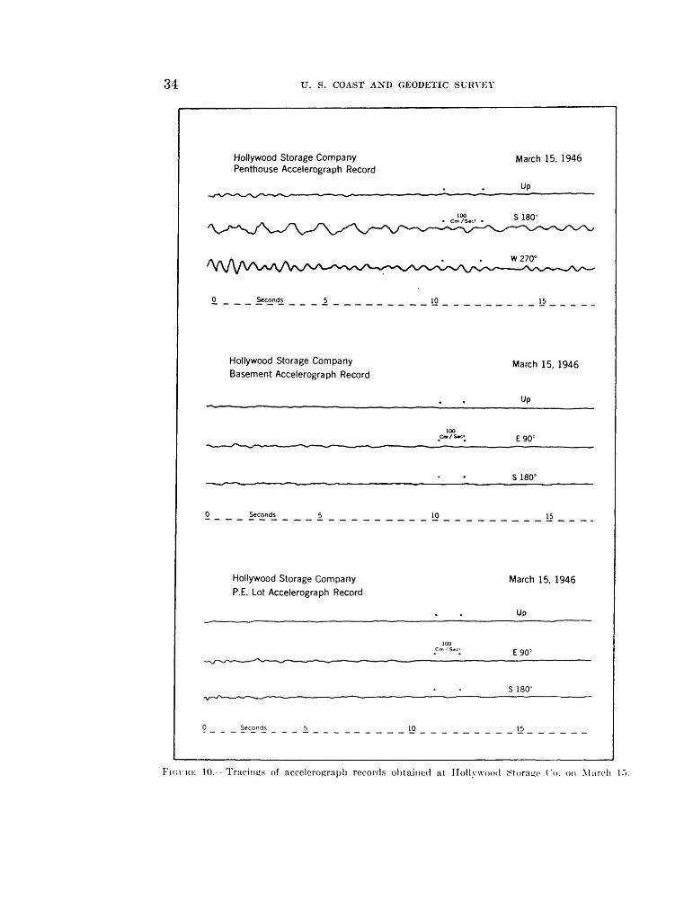
34 U. S. COAST AND GEODETIC SURVEY
Hollywood Storage Company Penthouse Accelerograph Record
March 15, 1946
UP
0 Seconds 10
Hollywood Storage Company Basement Accelerograph Record
March 15, 1946
Up
£90°
S 180°
0 Seconds 5 10
Hollywood Storage Company
P.E. Lot Accelerograph RecordMarch 15, 1946
UP
£90"'
S 180°
Seconds 5 10 15
10. Tracings of accelerograph records obtained at Hollywood iStoratco Co. on March !.">.

UNITED STATES EARTHQUAKES, 1946 35
Pasadena, California Accelerograph Record
100 Cm/S«c-
Seconds 5 10
Pasadena, California
Displacement Meter Record, Right Drum
0_ _ Seconds _ _ 5 .10 15
Displacement Meter Record, Left Drum
20
0 Seconds 5 10 15
Santa Barbara, California Accelerograph Record
Seconds 5 10
March 15, 1946
UP
S 180°
W270°
March 15, 1946
NO-
E90°
25 30
March 15, 1946
Up
NE45°
SE 135°
15
FicntK 11. Tracings of accelrronraph record.- obtained at Pasadena and Santa Barbara on March 15.

36 U. S. COAST AND GEODETIC SURVEY
Oakland, California, City Hall16th Floor Accelerograph Record
May 1, 1946
UP
NE25"
SE 115°
Seconds 10 15 20
San Jose, California, Bank of America 13th Floor Accelerograph Record
May 1, 1946
Up
100 . Cm/S»c« NE60°
SE 150°
0 Seconds 10 15 20
San Francisco, California, Southern Pacific 14th Floor Accelerograph Record
May 1, 1946
UP
100 Cm/S«c' SW 229°
NWS 19°
0 Seconds 15 20
FICITRE 12. Tracings of accelerograph records obtained at Oakland City Hall, San Jose Bank of America, and San Francisco Southern Pacific Building on May 1.

UNITED STATES EARTHQUAKES, 1946 37
San Francisco, California, Southern Pacific May 1, 1946 Basement Accelerograph Record
Up
100,cm/s«>. NW319"
NE49°
0 Seconds 5 10 15
Eureka, California December 18, 1946 Accelerograph Record
Up
NE 79°
SE 169'
.0 _ _ _ Seconds^ _ _ _ _5_
FIGURE 13. Tracings of accelerograph records obtained at San Francisco Southern Pacific Buildingon May 1, and Eureka on December 18.
NORTHERN CALIFORNIA EARTHQUAKE OF MAY 29
Epicenter in the Hollistcr area. Epicenter 3G°48' north, 121°34' west. Maximum intensity V near Ilollister.
v* Hollistcr. Station about 10 mi. XE 70° of epicenter. Maximum acceleration 4 cm./sec.2 and maximum displacement 0.000 centimeter.
NORTHERN CALIFORNIA EARTHQUAKE OF AUGUST 14
Epicenter in the San Francisco area. Maximum intensity IV at one place.Sun Francisco Southern Pacific Building. Maximum acceleration 2 cm./sec.2 and computed
maximum displacement 0.036 centimeter on fourteenth lloor. Surface waves scarcely perceptible on.basement accelerograph and displacement meter.
EARTHQUAKE OF DECEMBER 15 NEAR QUITO, ECUADOR, SOUTH AMERICA
Epicenter in the region of Quito, Ecviador, South America. Quito. Surface waves scarcely perceptible.
NORTHERN CALIFORNIA EARTHQUAKE OF DECEMBER 18
Epicenter in the Cape Mendocino area. Epicenter 40.3° north, 124.5° west. Maximum intensity VII at a few places.
Fcrniinlc. Figure 14. Maximum acceleration 56 cm./sec.2 and computed maximum displacement 0.090 centimeter.
Eureka. Figure 13. Maximum acceleration 13 cm./sec.2 and computed maximum displacement 0.11)5 centimeter. Maximum displacement 0.02 centimeter recorded on displacement meter and maximum computed acceleration 4 cm.''sec. :

38 U. ri. COAST AND GEODETIC SURVEY
ll
101 icol

UNITED STATES EARTHQUAKES, 1946 39
Table 4. Summary of strong-motion seismograph data for the year 1946
(See the text preceding this table for additional details. Simple harmonic motion is assumed when computing displacement from an accelerogram and when computing acceleration from a displacement-meter record.)
SOUTHERN CALIFORNIA EARTHQUAKE OF JAN. 8
Station and component
El reiitroaccelcrograph: Vertical-up. ........... .......... ..............
X.O 0 .. .. .................. ..................
E.WV . ._ . ..... .......... .................
Earth wave period
StCOHd*0.11 %
:%.21.l.i .18 .4<J
Maxiiiium w>/v>h*ra ill^lA<lt,l It*
lion
0«./w.2 338
I87 (i 2
Maximum displace-
mrnt
Cm. 0.001
. (X)2
.(K)l
.0(14
.003
.0(19
.(KM
. 005
.'012
Remarks
Weak.
Short periods superposed.
motion.
EARTHQUAKE OF JAN. 28 XEAR LIMA, PERU, SOUTH AMERICA
Lima accelcrograpli:
X\V. 278° .................. ..................
XF..80 ........................ .... ...
0 15.i:i.!.-{||Q
.10
151 51
0.001002
.001
.001
.(Mil
Weak motion.
Do.
FORESHOCK OF SOUTHERN CALIFORNIA EARTHQUAKE OF MAR. 15
Los Angeles Subway Terminal, thirteenth floor aceel- erograph:
Vertical-tip....---.-.---...--..-......... ...S\V.2H>° ............... ... ..
xw.3oyc ........ ..... . ................. ...Los Angeles Subway Terminal. sub-basement aeeel-
crograph: Vert ieal-u p. ....................................SE. 129°.........................................SW.219° .................................. ....
Right displacement meter: XE..W. ......................... ..............
I<<-ft displacement meter: SE. 129°. .. .......... .... . ... .......... ....
San Francisco Southern Pacific Bldg.. fourteenth floor accelerograph:
Vcrtical-up.... ....................... ...... ...SW.22!i° ............................... ..... .
(). in.m.54
.50
.57
3. 2.'{
4.118
... .. . .. ..-an Francisco Southern Pacific Hldt.. basement
accelerograph:Vertical-tip---- ..... ............. ....... .. ..X\V.319 C ...... ... ....... ... .......... ......XE. 49°... .. ......... ....... ... ....... ..
Right displacement meter: X\V. :ti5=... ...... ............... ........
1.03 '
1.21 '
i o.ooi Very weak.5: .04*1 Short periods superposed.3 .0223 . .00.x Do.
I . .003 Very weak.. OOti Do.. (R)J> Do.
1 .02 Do.
1 .Of. ! Long period.
.... Too weak..081 Weak..2<*i Sinusoidal waves.
. .. Too weak..015 Very weak..031 Do.
L'-ft displaccrneirt meter: \E. 4.T ... ... ...
.49
. C.3
. <;:*
3 3
.02
. 03
.02
.03
Very weak.
Do.
80UTHERX CALIFORNIA EARTHQUAKE OF MAR. 15
.wv Angeles rhamtxT of Commeu-e. ele\eiith Ilo<ir :icceIerr)Kr.iph.
Vcrtiral-up .... .......SW. 220C ..........
XW.3IO-
L(» Ancele> ('h.iinU-r of ('oruineieo. K<-.i.|iient .icecl- erouraph
Vertic.il-iip . . SE. 13(1
SW.220
0.72 1.3h.94
I.Hi 1.24.S4
I. 11
.117
. 12
1 0013 Short-period wasos superposed.22 1 (134 Irregular stioim wave:-.
3 .0-;: Weak.3 . 102
22 . S3«: Strong waves.3 OM3 .091
2 .0234 ' .025 Weak motion.1 , .004
12 .0.V41 i IKK; Weak.

40 U. S. COAST AND GEODETIC SURVEY
Table 4. Summary of strong-motion seismograph data for the year 1946 Continued
SOUTHERN CALIFORNIA EARTHQUAKE OF MAR. 15 Continued
Station and component
Los Angeles]Subway Terminal, thirteenth floor aceel- erograph:
SW. 219°. . ... ..........
XW.3090 ...... ...... ... ......................
Los Angeles Subway Terminal, sub-basement accelero- praph:
SE. 129°... ............ ..........................
SW. 219°.. ..... ..................Right displacement meter:
XE.390 . .... ...........
Left displacement meter: SF 129°
Hollywood Storage Co., penthouse accelerograph:
S. ISO0 ...---.-....-.--.-.-.--...---.------------.
E. 90°-...-..-..-...------.----. .................
Hollywood Storage Co., basement accelerograph:
E. 90°....-.-... .. - - - ----- . .........
S. ISO0 ........-.-..-....... --...--.-............
Hollywood Storage Co., P. E. lot accelerograph:
E. 90°. -.......----- ----- .----....--.-
S. 180°_. ...... . .....
San Francisco Southern Pacific Bldg., fourteenth floor accelerograph:
VTertical-up.-. ---------- .......... ..............SW. 229° .
San Francisco Southern Pacific Bid?., basement accelerograph:
Vertical-up.. ...... ... . ..... .................XW. 319° .. . .-XE. 49°---..---.-. _ . ' ......
Right displacement motor: XW. .119°... .. ..-- .- -_ -----
Left displacement meter: XE. 49°- .
San Jose Bank of America, thirteenth door accelero- praph:
Vertieal-up..... ....... ... . ....XE. 00°.....- ......SE. 1.50°.. . .............
Sun Jose Bank of America, haM-ment nwlcroL'r.iph: Vertical-up. . . .XE. 60"...... .......SE. 1.50°.. ..--.-.--.- _. _
Pasadena accelerograph: Vertical-up. .......
Earthwave period
. , ...
Srcondt .14.70 .31.61 .68 .29.61
21.90 .38.83 .70
1.563.88
1.335.64
.46
.39
.61 1.41 .41.46 .54
.45
.38
.37
.48
.90
.46
.50
.50
.29
.50
.62
1.031 f\Q
1. 11
56.58
.63
1.48.63
.ill
Maximum accelera
tion
Cm./sec.t 3422 111
1
415
41
41
41
168
8 12
o1
2 32
01
1
1
^3
6
,
33
1
,
Maximum displace
ment
Cm..001.050.005.019 .012 .002.009
.001
.041 . 015.018 .062
.27
.26
.18
.32
.022
.004
.216
.075
.348
.009
.042
.089
.005
.004
.017
.012
.062
.011
.013
.006
.011
.006
.034
.010
. 103
.081
.210
.186
008.009
.02
.01
.009
Remarks
Irregular waves.
Irregular waves.Do.
Sinusoidal waves.
Do.
Do. Short periods superposed.
Irregular waves.
Strong regular waves.Long period.
Superposed wave.Irregular long period.
Short-period waves superposed.
Irregular waves.Sinusoidal waves.
Do. Do.Do.
Weak irregular waves.
Do.
Short periods superposed.
Weak irregular waves.
Irregular waves.
Do.
Too weak.Short periods superposed.
Regular waves.
Too weak.
Do,
Irreeular waves.
Do.
Too weak.Sinusoidal waves.
Do.
Too weak.Do.Do.
Irregular waves.
S. 180°.
W. '.'70°
Right displacement meter: X. 0°-.......... ........
Left displacement meter: K. 90°--... ............
.1.143 .037 Do.1 ' .013 I4 .079 i Do.2 .031 I
3 17 I Regular sinusoidal waves.1 , .01 j
11 . N.T I Po>sjhly preceded by stronger motion.

UNITED STATES EARTHQUAKES, 1946 41
Table 4. Summary of strong-motion seismograph data for the year 1946 Continued
SOUTHERN' CALIFORNIA EARTHQUAKE OF MAR. 15 continued
Station and component
Santa Barbara acrelerograph: Vertical-up .. - - _...-_.. ....
NT E. 45°. _.....__._.._.
Long Beach accelerograph
X. 0° .. ..............E 90°
Oakland City Ilall, sixteenth floor accelcrograph: Vertical-np ............ .. .XE.2o°..._ ...... ...SE 115°
Oakland City Hall, basement accelerocraph :
SW. 20.V-.. ...........XW. 295°. ....... . . .. .. ..
San Bernard ino Weed scistnot'raph: SE. 135°
XE. 45°... ............Vernon accelproirraph:
SW. 188° . . .....
XW. 278°. ...........
West wood aceeleropraph:
E. 90°. ...............
S. ISO 0 --.......--.--..
Earth wave period
Second* .82.t>3.54 .92 .(H .W.87 .65
1.38 1.00 1.08
i.oi1.23 1.28
.79 1.14 1.01
.S9
.fii
.87
.4.3
.91
. >i7.'59
.49
.43
.32
.32
Maximum accelera
tion
Cm./xec.- 4
9
C, 5 2
1 1
1S 8
1
1
12 ji1 4 ]
3
Maximum displace
ment
Cm. .(V58 .020 .015 .193 .019 .140 .09G . 021
.025
.029
. (I2f.
.301
.328
.ON.
.032
.026
.020
.019
.019
.009
.021
.003
.009
.024
.005
.OO.1)
.008
Remarks
Smooth regular wave.
Very weak. Strong irregular motion.
Irregular waves.
Weak.
Too weak. Very weak.
Do.
Too weak. Sinusoidal waves.
Do.
Too weak. Do. Do.
Very weak.
Do.
Weak. Short periods superposed.
Irregular waves.
Do.
Do.
Do.
AFTERSHOCKS OF SOUTHERN CALIFORNIA EARTHQUAKE OF MAR. 15
Los Angeles Subway Terminal, thirteenth floor accelero-graph: .
Vertical-up. ........................ .... .. . ..(S\V. 219°....-..-._-.-..-..........._.-.._....... I
XW. 3()90 .. \'ertieal-np SW. 219°...
XW. 30'<° .................................... j
Los Angeles Subw ay Terminal, sub-basement accelero- graph: '
Vertical-np .....-.-..-..---.--.--................ISE. 129' ...................... ...... . ..!SW.2190 ................................ ._...__
Right displacement meter: 'XE.39°....... .... .......... ..................|
Left displacement meter: jSE. 129° ...... ................... .......... ..!
Hollywood Storage Co., penthouse arrelerograph: |Vertic-il-iii).. .......-----... .... ............ .|S. 180°................. .. ..... ..... ...
.36
Too weak. 0.019 | Weak.
I .011 jII .007 | Do.i ; .002') ', . 038 i Short periods superposed. 1 ' .035 j3 | .020 ' Weak.4 I .021
...... j Very w eak..(Mlti Do..002 Do.
.01 j AVeak irregular waves.
. 02 ! Do.
1. 38 I. 17 .40
.' Too weak. . <)S2 : Sinusoidal waxes. .03.5 i .00") \\'c.ik.E. 90° ............ .... . . . ... . . ........
Hollywood Storage Co . basement aeceleiograph:Vertical-lip.-..-.- ......... . . .... . ! .... .....' Too weak.E.90° . ......... .... .... .. . . ..... . . .......... ... .. .. ...... Do.S. lt>0 0 .......... ... .. ... . J.04 1 .027 ' Very weak.
Hollywood Storage. Co., P. E. lot arcelcronraph:Vertical-up . . . .... ..... . . ' . Too weak.E. 9<ic ...... ........... .... . . Do.S. ISO" __ .......... .
-an Francisco Southern I'ucifir
Vertical-lip....SW. 229° . X\V. 319°.....Vertical-up....SW. 229°. .....N'\V.3I9°. ...Vertieal-up -- S \V . 229 C
Di:, fourteenth floor
. I Do. . 0*12 !.03(1 Weak. .....! Too weak. .027 ' .031. (Kil : Very weak. .022 Do. .023 I Do.

42 U. S. COAST AND GEODETIC SURVEY
Table 4. Summer!/ of strong-motion seismograph data for the pear /9*ff Continued
AFTFRSHOCKS OF SOUTHERN CALIFORNIA EARTHQUAKE OF MAR. 15 Continued
Station and component
Sim Francisco Southern Pacific Bldg., basement ac- celerograph:
Vertical-upX\V.:U9° ...... N'K.490 ...... Vertical-up ... .. ... X'W :!I9°XK.40" ...... .... . .... . .
Right displacement meter: XW.:ur,° .............
Left displacement meter: XK.450 ....... ....... ... ............ . . ..
San Jose Bank of America, thirteenth door accelero- gi-aph:
Vertical-up. ..... .. .... ....... . .XK.OO0 ..... ....... SK. 150°..... .... ...... .
XK.fiO0 ...... . .... ...
SK. 1.50° ....... ... San Jose Bank of America, basement aeeelerograph:
Vertical-up.. ........ ..... ...................XK.ftO0 .. _.._._.._....... . ..... ... .... . ....SK. 150° ......... ....... . .....Vertical-up. .... . . .... .... . .XK.GO0 ..... ...... ..... .... ..... . ..SK. 150°... ..... . . ..... ....... ...
P _.,!, . ,- Maximum Kartnwa\e accelera-I'm0(l tion
Second* OM./.W.'
2. 10
.82 1 . 5-1 1
.82 2
. 82 2
. 7<; ' i
1.78i
Maximum displace
ment
Cm.
. 084 .000
.168
. Hi*
.078
Remarks
Too weak. Do. Do. Do. Do. Do.
Very weak long-period waves.
Do.
Too weak.
Do. Sinusoidal waves.
Too weak. Do. Do. Do. Do.
HAWTHORNE, NEV., EARTHQUAKE OF MAR. 17
Hawthorne aceelerograph: Vertical-up.. ......... ....... ..... .
S. 180° .. ........ . ... .. . ...............
W.2700 . .... . .. ........ . .................
0. I?, 1 .12 S. 15 j 5 . 15 2 .28 15 . 20 ' 9 .22 2 .09 ; 11. 2(i 10 . 19 5
(I.IKH .INN . 002 .(Kll {wo'. 002 .(KI2 .017 .005
EARTHQUAKE OF MAR. 29 NEAR QUITO, ECUADOR,._.... . . __ _ _ ___._...
!NORTHERN CALIFORNIA EARTHQUAKE OF
S;m Francisco Southern Pacific llldg.. fourteenth floor accelcrograph:
Vertical-up ..... . . .... ....SW. 229°.. ..... ... ...... ......
XW. 319°... . ........... ..... ...
San Francisco Southern Pacific Bldg., basement .iccelerograph:
Vertical-Mp . . . . .... .... XW.:U9°.._. ....... . . .....XE.4SI 0 .. .. . . . . .
Right displacement meter: XK.49°..... ........ .... ... .... ..
Lefl displacement meter:
San Frnncisco Shell Bldg., T \veiit\-ninlh floor Weed seismograph:
X o°
0.75 111.02 :t.*» fi
. 90 9
. 02 (i
. 49 1
.4*
. 4 1 2
. 45 1
1 2(1 5
.81', ' :<
. 9o 4
.711 1 7(1 1
0. 157 . 078 . 02S
'.129
.IKK;
.010
.010
.005
.20
.05
. 002
.002
Very weak. Short periods suiierposed.
Do.
Strong phase.
SOUTH AMERICA
Surface waves scarcely perceptible.
MAY 1
Very weak. Shorter periods superposed. Kegular sinusoidal waves. Wave suiwrposed on longer |x.'riod
waves.
Regular waves.
Weak. Do. Do. Do.
Weak sinusoidal wave-.
Weak irregular waves.
Sinusoidal \v-jve.
Verv weak.

UNITED STATES EARTHQUAKES, 1940 43
Table 4. Summary of strong-motion seismograph data for the year 1946 Continued
NORTHERN CALIFORNIA EARTHQUAKE OF MAY 1 Continued
Station and component
Oakland City Hall, Sixteenth floor accelerograph:
XK.250 .... ... . ............... ..... .... .
SE. 115°...... ................... .. .. ..
Oakland City Hall, basement accelerograph: Vertical-down. ............ . . ...S\V. 2(15° ................ ...... .... ... .....
San Jose Bank of America, Thirteenth floor accelero graph:
XE. 60°....... .... ......... . .. ...... ......
SE. 150°.-.. ......... .......... ........ .....
San Jose Bank of America, basement accelerograph:
XE. 60°..
E3ST TiFSeconds Cm. I sec.'
0.36 ' ' 2. 38 1
1. 03 «i1.01 ! :t
1.06 , r>
.19 1i.2S :(1.G8 > 2 .51 4. 56 ;s
1.70 4
.52 1
.88 1
Maximum displace
ment
Cm.0.006.004 .162.078 .234.140
.001
.123
. 143 . 026.024 . 293
.1)07
.020
Remarks
Do.
Regular sinusoidal waves.
Do.Do.
Sinusoidal waves.
Do. Sinusoidal waves.
Do.Do.Do.
XORTHERX CALIFORNIA EARTHQUAKE OF MAY 28
.San Fr.tncisc-o Southern Pacific lildg., fourteenth door : aceelerograph; ,
Vertieal-up .-------------..-..- . .... .. . . iS\V. 229° ........... iX\V.319° .......................................
San Francisco Southern Pacific Bid?., basement i acceleropraph:
Yerticjil-up. ......... ... ...X\V. :U9° . ......XE. 49C ......... -........._.._.__.__. , .....
Left displacement meter: '
0. 12 .M
1.04
. ......Right displacement meter:
XE.490 _ .__.._.:_...
1 0 001 ' \"cry weak.1 1 .017 I \Veak.3 .079 Regular sinusoidal waves.1 .023
\>ry weak. "Do. Do.
Do.
Do.
XORTHERN CALIFORNIA EARTHQUAKE OF MAY 29
HolliMer \Veed seismograph: S\V. 22.". 0 .. ..... 0 004
. 006 i Irretular mot ion.
.001 .
.001
XORTHERN CALIFORNIA EARTHQUAKE OF AUG. 14
Sun Franci«i-o Southern Pacific Hldg., fourteenth floor accrleroL'iaph:
Veitieal-up ..... S\V. 221*°N\v.:n9° . . ...... . .!
San Fratici^eo Souiln-rn Pacific Jildj!.. lusetfieiit accvlerograph:
Vcrtical-up . .\\V.:U9°NE. W.__ ..... .. ..........
Right di^-placrtfU'iir meter:.\\\-.:i!9° .. . ........ .....
I.i'ft displaecfiii-nt meier:XK. 4'»c ...... . . ....
Very weak lonp-pcriod w ..... Do..(tit; Itrejitilar long-period «av .020 Do.
Very small motion. 'Do. Do.
Very small lonn-period wa\
Do.
EARTHQUAKE OF DEC. lo XEAR QTITO, ECl'DAOU, SOUTH AMERICA
I .... .I Siirfatv waves scarcely perceptible.

44 U. S. COAST AND GEODETIC SURVEY
Table 4. Summary of strong-motion seismograph data for the year 1946 Continued
NORTHERN CALIFORNIA EARTHQUAKE OF DEC. 18
Station and component
Ferndale accelerograph:
SW. 225° .
NW. 315° .
Eureka accelerograph:
NE. 79°....
SE. 169°.... .
Right displacement meter: SE. 169°.... _
Left displacement meter: SW. 259°.
Earthwave ' ,?j!l!LIirarll 'n period ac£0enra-
Seconds Cm.jsec.i 0. 10 3
.26 20
.22 11
.22 7
. 11 . 20
. 14 22
. 13 , 11
.30 ' 11
.49 2
. 25 56
.14 26
.24 i IS
.25 10
.41 2
. 14 ! 8
. 10 3
.12 3
.14 <> 1.15 5 .34 ' 3 . 11 : 5 .25 3
1.44 4 1.32 1
1.52 1
Maximum displace
ment
Cm. 0.001 .034 .013 .009 .006 .011 .005 .024 .012
.090
.013
.027
.016
.009
.004
.001
.001
.003
.165
.009
.002
.005
.02
.02
.02
Remarks
Weak at beginning. Strong waves. Irregular waves.
Possibly preceded by stronger motion. Strong waves. Irregular waves. Sinusoidal waves. Short-period waves superposed on
long-period waves. Possibly preceded by stronger motion.
Regular waves. Do.
Irregular long-period waves.
Regular wives.
Possibly preceded by stronger motion Long-period wave. Weak. Irregular motion. Weak.
Possibly preceded by stronger motion. Very weak.
Do.
Table 5. Instrumental constants of strong-motion seismographs in 1946
\ o . .. f | Pendu- Static
Station and instrument | strinii ) r i i ' llm magnifi- period cation
3ensitiv Damp- l *; ~ ity 2 ing ratio ?£l
SOUTHERN CALIFORNIA EARTHQUAKE OF JAN. 8
1 Sec. El Centro aocelcropraph No. 4 1'p ' 0.099 76
N.()° .099 77 1E. 90° -,.... . 100 77
Cm. I 1.93 12 i V-10 1.91 8 LH 1.94 11 ; T-15
EARTHQUAKE OF JAN. 28 NEAR LIMA, PERU, SOUTH AMERICA
NW. 278° .097 85 NE.8°.... ... .105 77
2. 08 8. 7 V-7 2.03 ' 6.7 L-2 2.16 6.9 T-17
SOUTHERN CALIFORNIA EARTHQUAKE OF MAR. 15
Los Angeles Chamber of Commerce: 3 Eleventh floor actrlerograph No. 42.. T'p ....... 0.099 SO
SW. 220°...... . .098 82 ,
Basement accelerograph No. 21 .- . T'p . .0*7 107SK. 1*1° .067 109 'SW. 220°-... ... .lHi8 111
Los Angeles Subway Terminal: 3 I Thirteenth floor aceeleropraph No. 39 - T'p. .... .. .101 83
S\V. 219°.... .. . IK) 81 NW. 309° . . loo 79
Sub-basement aoeolcrogruph No. 3. ... . l"p . 069 116 SK. 129 C .- . . .069 118 SW. 219°.. . .07(1 120
Sub-basement displacement meter No. 13.. . . NK .^9° _. 10. 0 1
See footnotes at end of table.
1.98 8.5 V-115 2. (HI 9 L-95 1.95 9 T-Ul"> 1.22 111 \"-2>v 1.24 7 L-9 1.28 8 T-2ii
2.15 ! 11 i V-112 2. 05 8 L-92 2.01 11 T-102 1.40 9 V-.r.s 1.43 9 L-.V.i 1.48 11 ' T-60
i). ...... 11 ... .. . .

UNITED STATES EARTHQUAKES, 1940 45
Table 5. Instrumental constants of strong-motion seismographs in 1946 Continued
SOUTHERN CALIFORNIA EARTHQUAKE OF MAR. 15 Continued
Station and instrument
Hollywood Storage Co.:' Penthouse acccleropraph No 40
Basement acceleropraph Xo. 22... . .
San Francisco Southern Pacific Hide.: '
San lose Rank of America: »Thirteenth floor accelerocruph No. 35..
Basement aeeelerofir.iph No. 8
Displacement meter Xo. 17
Long Reach accelerograph No. 24
Oakland City Hall: s Sixteenth floor aucelerosraph No. 37.. .
West wood accelerocraph No. 20. ._...___..
Orientation of instrument '
i
... .... .. ... ' up .......S. ISO 0 . .. E.90°. .. ......
.. Up ............E.90° .. ......
' S. IN)" ... .. .... .... -.-- up..............
: E.90° ...S. ISO 0 ...... ..
SW. 229° .....XW.3190 .......
......... .... Up .............XW.3190 . ... XE. 49°.. ......
........ XW.3190 ......XE l<»°
XE.OO". .. ...< t/ i ri.3 ^ 1 . . 1 JU ... .....
XE.OO0 .....SE. 150°.........
.......... .. .., rp.. ..........S. ISO 0 .... ...W. 270°.........
......... ..... N.0= .. ... ....E. 90°. .............. rp... ...........NE. 45°.. _..___. SE. 135=.........
.... ----------- rp. ...........K 0(l0
........ Up..............XE.250 .. .......
' SE. 115=.........
SW. 205°.. ......XW. 2<I5°_ ......
........ SE. 135°.........NE. 45°... ......Up
XW.27S 0 .... .................. rp..
E. 00°... ........S. 1SO°. .........
Pendu- Static him mapn in-
period cat ion
.101 HI
.099 84
. 100 79
.009 105
. 070 1 1 1
.070 110
. (Ml ION
.009 10S
.009 111
. 101 ' 75
. 102 i 73
. 102 70
.(HiS , 115
.oos ' ' 117
. (Mis 1 1 1(1. 8S 19. 75 : i
. 101 SO
.04)\ ' 7S
.098 ' 77
.009 ' 110
.OOS 113
.OOS ! 110
.101 70
. 100 71)
. 099 72 K). * 1 10.0 1
.101 7S
. 097 79
. 099 ' 77
.009 112
.070 111
.071 109
.103 ' 75
. 101 78
. 101 70
.0*57 117
.007 110
.007 112
. 21 »)3
. 21 02
. 009 KM)
.008 115
.007 110
. 100 ' 75
. 099 75
.097 74
Sensitiv- Damp- it y-' ins ratio
2.04 10 2. 04 s 2. 00 9
. 20 S
.32 i 9
. 30 7
. 30 9
.30 , 7
. 34 S
94 S .92 10 .01 27 .35 10 .37 15
1. 30 1 1 .......... 9.4. ........' ii. s
2.0*; < 101.91 13 1.87 9 1.32 ' 15 1.32 , 9 1. 3d 9 1.97 ' 10 2. 00 9 1.79 10
11
Instru ment No.
V-113 L-93
T-103 V-25 L-3
T-18 V-0»> L-4&4 T-05
V-108 L-8S T-9S
V-111) L-90
T-100
V-107 L--S7
y-49I.-50 T-51
V-114 L-94
T-104
.. . 13 ........ .2. 02 7 1.87 S 1.01 9 1.30 9 .3h 8 . 3b 10. 5
. 03 S
.00 12
.95 8
.33 ' 10.0
. 32 10. 7
. 27 9. 7
.70 2.0
.09 ' 1.9
. 32 i S. 5
.35 ; 10
.32 9
.91 , S
. S7 7
.75 8
V-5.5 L-50 T-57 V-70 L-5
T-34
V-109
T-89 V-12 L-33T-H5
V-47 L-37 T-4s V-7S L-70 T-77
FORESHOCKS AND AFTERSHOCKS OF SOUTHERN CALIFORNIA EARTHQUAKE OF MAU. 15
No chance in constants of instruments
HAWTHORNE, NEV., EARTHQUAKE OF MAR. 17
............... , Ups. is<f .. ... .W.2700 . .....
0.007 in;. (HiS ' 114.OC,7 110
1.31 8 1.33 7 5 1.32 7..",
Y-27 L-22 T-l
EARTHQUAKE OF MAR. 29 NEAR QUITO, ECUADOR, SOUTH AMERICA
......... .. . ' Up . . ... ...W.2700 . .. .x.o° . . . ....
0. 097 S3 . 097 SO.( 97 S3
1.98 71.110 S1.97 7
V-132 L-127 T-12S
NORTHERN CALIFORNIA EARTHQUAKE OF MAY 1
Sim Francisco Southern Pacific Hide : 3... .. ....... Up .. . ... ....
XW. 319r ......
XW.3190 . ..... NE 49° ... ....
0. 099 75 .102 73 . 102 76 .007 ' 115 .008 117 .(jib 1 111
, SO S .92 13
01 29 .33 14 .38 10 .31 ' 11
V-108L-ss
V-110 L-90
T-loo
Sec footnotes at cud of table.
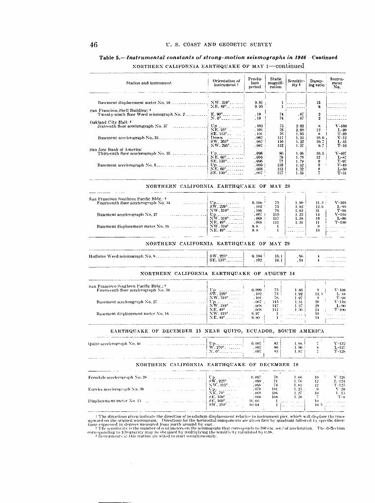
46 U. S. COAST AND GEODETIC SURVEY
Table 5. Instrumental constants of strong-motion seismographs in 1946 Continued
NORTHERN' CALIFORNIA EARTHQUAKE OF MAY 1 Continued
Station and instrument
San Francisco Shell Building: *
Oakland City Hall: 3
San Jose Bank of America:
Orientation of , r instrument ' "
N'E. 49°.. .....
E.900 .... .....X.0°..__ .......
Up ._.... .... !NE. 25° ........SE. 115°.. ... DownS\V. 205° N"\V. 295°. .. .
Up..............NE. 60°.. - .... SE. 150°.. .....Up..............NE. 60° ........SE. ISO0 ,.......
idu- Static m magnifi- iod cation
9.9.3 , 1
.19 74
.19 74
. 103 75
. 101 78
. 101 7fi
.067 117
.067 116
.007 112
.098 80
. 095 78
. 090 77
.069 110
.068 113
.067 117
Sensitiv ity'
.67
.67
2.03 2.00 1.95 1.33 1.32 1.27
1.96 1.79 1 79 1.32 1.32 1.33
Damp ing ratio
138
2 2
8 12 8
10.6 10.7 9.7
10.5 12 9 98 7
Instru ment Xo.
V-109 L-99 T-89 V-12 L-33 T-16
V-107 L-87 T-97 V-49 L-50 T-51
NORTHERN CALIFORNIA EARTHQUAKE OF MAY 28
San Francisco Southern Pacific Bldg.- s
Basement displacement meter Xo. 18 ...-._.---... -.-.
Up. ............ 0SW. 229°..---..X\V.319°. ..... UnX\V.319°. ..... XE.49°...... .. XW. 319° ... ' 9 XE. 49°. ........ 9
100 ' 7.5 102 73 100 76 067 115 068 117 068 : 111 8 1 S 1
1.90 1.92 1.93 1.33 1.38 1.31
11.5 12.6 311*10 11 tj
13
V-10S L-8S T-9S
V-110 L-90
T-100
NORTHERN CALIFORNIA EARTHQUAKE OF MAY 29
SW. 22.1°. 0SE. 13.5°... ......
194 10. 1 192 10. 1
.96
.9444
NORTHERN CALIFORNIA EARTHQUAKE OF AUGUST 14
San Francisco Southern Pacific Bldg.: 3Up . 0 099 7.1SW. 229° .......XW. 319°..-....,Up .... ... .XW.319 0 .....NE. 49° .........
NE.490 ...... ..' 9
1(12 73 101 7(> 067 115 ! 068 1 17or.s 11197 1 S>0 1
.86
.92
.97
.31
.37
.30
8 12.5
!t 20 29 14 10 14
V-108 L-88 T-98
V-llo L-90
T-100
EARTHQUAKE OF DECEMBER 15 NEAR QUITO, ECUADOR, SOUTH AMERICA
Up.............. 1 0W.270°. ...... X.O0 ..... ......
097 83 1.98 097 , KO .90 097 S3 ] . 97
1
7 ' V-132 S L-127 7 : T-12J>
NORTHERN CALIFORNIA EARTHQUAKE OF DECEMBER 18
UP. ........... : o.S\V. 225° ... XW. 315°. . . Up. .........XK. 79° ...... SK. 1(19°. .. . . SK. Hi9°... . ' 10.SW.2590 .. 1(1
097 7(1 . 66 099 71 .7ti ' 099 74 . S3 070 ' 101 .2.') 069 i 106 . 27 (><W 108 . 26
10 12 12 y
10
in
V-126 L-124 T-12.r. V-29 L-13 T-S
1 The directions given indicate the direction of pendulum displacement relative to instrument, pier, which will displace the trace upward on the orijriiril seisinocram. Directions for the horizontal components arc given first by quadrant followed In specific direc tions expressed in decrees measured from north around by east.
: The scMsitu ity i« the mini her of centimeters on the seisinocram that corresponds to 100 cm. sec. ; of acceleration. The deflection corresponding to 1/io gravity may he obtained by multiplying the sensitiv ity tabulated by 0.9s.
1 Instruments at this stm ion'are wired to start simultaneously.

TILT OBSERVATIONS
Two tiltmotors were operated at Berkeley, Calif., in cooperation with the University of California. The tiltgraph data obtained from these instruments during 1946 are shown in figure 15, inside back cover.
A third tiltmeter was operated intermittently at Long Beach, Calif.
CORRECTIONS TO PREVIOUS PUBLICATIONS
1945, Alaska time was published as 105th fifth meridian time. This should be 150th meridian time.
1945, page 27, the total of the Weed strong-motion seismograph column in table 3 should be G.
47

PUBLICATION NOTICESTo make immediately available the results of its various activities to those interested, the Coast and
Geodetic Survey maintains mailing lists of persons and firms desiring to receive notice of the issuance of charts, Coast Pilots, maps, and other publications.
.Should you desire to receive such notices, you may use the form given below, checking the list covering the subjects in which you are interested.
(Date)...--_------.._-------------DIRECTOR U. S. COAST AND GEODETIC SURVEY,
Washington 25, D. C.DEAR SIR: I desire that my name be placed on the mailing lists indicated by check below, to
receive notification of the issuance of publications referring to the subjects indicated:D 101). Astronomic Work D 109-1. OceanographyD 109-A. Base Lines. D 109-J. TraverseD 109-B. Coast Pilots. D 109-K. Seismology .D 109-C. Currents Q 109-L. GeomagnetismD 109-D. Geodesy D 109-M. TidesD 109-K. Gravity D 109-X. TopographyD 109-F. Hydrography Q 109-O. TriangulationD 109-G. Leveling * Q 109-P. CartographyD 109-H. Nautical charts D 109-R. Aeronautical charts.
(Xame;__ __________________._-_-.._-__----__-......-----
(Add ress) ______-___-_---_-_-_____-----_.--.
48