department of water underground statement of …deq.wyoming.gov/media/attachments/water quality...4...
TRANSCRIPT

Wyoming Department of Environmental Quality
Water Quality Division
Underground Injection Control Program
Statement of Basis for Aquifer Exemption
Well Class: Class I Non‐Hazardous Date of Aquifer Exemption Request :
12/9/2017
Operator: Lost Creek ISR, LLC WY UIC Permit No. 16‐145
Well/Project Name: DW Nos. 1, 3, and 4 County: Sweetwater County
Well Status: ☐ Proposed ☒ Existing (converted oil and gas or injection well)
Well Location(s): DW No. 1: NESW, Section 25, Township 25 North, Range 93 West
DW No. 3: SESW, Section 13, Township 25 North, Range 93 West
DW No. 4: NWSE, Section 18, Township 25 North, Range 92 West
Latitude and Longitude (Decimal Degrees):
DW No. 1: 42.10696, ‐107.88607
DW No. 3: 42.13335, ‐107.88443
DW No. 4: 42.134545, ‐107.85915
Substantial or Non‐Substantial Program Revision:
Non‐substantial .
Basis for Substantial or Non‐Substantial Determination:
This Aquifer Exemption request is considered non‐substantial, consistent with EPA Guidance No. 34.
DESCRIPTION OF PROPOSED AQUIFER EXEMPTION (depths are approximate values at the well bore)
Name of Aquifer (formation) to be exempted: Lower Battle Spring Formation.
Top and bottom (feet below ground surface (ft bgs):
DW No. 1: 5,549 – 5,923
DW No. 3: 5,612 – 5,969
DW No. 4: 5,652 – 5,960
Estimated or known Water quality – TDS (milligrams per liter (mg/L)): >3,000 and <10,000 (estimated in Lower Battle Spring Formation)
Source of WQ Data: (e.g., previous O&G sample, formation sample) Estimated from well logs.
AREAL EXTENT PROPOSED EXEMPTED AQUIFER
Radial distance from wellbore and how determined (e.g., AREA OF EMPLACED WASTE (AEW) or 1,320’) 1,320 feet (ft); determined as the greater of the AEW or 1,320 ft.
Total Area of Aquifer to be Exempted: 125.6 acres for each well; see the attached figures.
Legal Description (Encompassing ¼, ¼ Sections, Township, Range): See Table 4 in Permit 16‐145
2
REGULATORY CRITERIA UNDER WHICH THE EXEMPTION IS REQUESTED
Wyoming Water Quality Rules and Regulations: Class VI Groundwater Classification
Wyoming Water Quality Rules and Regulations, Chapter 27, Section 5(c) states: Injections from Class I wells shall be restricted to those receivers defined as Class VI groundwaters by the department pursuant to Chapter 8, Quality Standards for Wyoming Groundwaters, Water Quality Rules and Regulations and receivers which have obtained an aquifer exemption pursuant to this section.
Chapter 8, Section 4(d)(ix) states: Class VI Groundwater of the State may be unusable or unsuitable for use :
☐ Due to excessive concentration of total dissolved solids or specific constituents; or
☐ Is so contaminated that it would be economically or technologically impractical to make the water useable; or
☒ Is located in such a way, including depth below the surface, so as to make use economically and technologically impractical.
NOTES: TDS concentrations in the Lower Battle Spring Formation are expected to exceed 3,000 milligrams per liter (mg/L) and be less than 10,000 mg/L based on estimates from resistivity logs from the DW No. 1, DW No. 3 and DW No. 4 wells. Additionally, a formation sample collected from DW No. 4 exhibited a concentration of 13,900 mg/L total dissolved solids, 6,330 mg/L Chloride, 0.0024 mg/L Mercury (dissolved), 0.060 mg/L Selenium (dissolved), 89 mg/L Oil & Grease, 49.3 pCi/L Gross Alpha, and 8.3 pCi/L Radium 226 and 228 (combined). Groundwater confirmation samples in the Upper Battle Springs will be required for all wells.
Code of Federal Regulations Aquifer Exemption Criteria: THE CONSOLIDATED PERMITS REGULATIONS (40 CFR §146.4 AND 144.7) ALLOW EPA, OR APPROVED STATE PROGRAMS WITH ENVIRONMENTAL PROTECTION AGENCY (EPA) CONCURRENCE, TO EXEMPT UNDERGROUND SOURCES OF DRINKING WATER FROM PROTECTION UNDER CERTAIN
CIRCUMSTANCES. AN UNDERGROUND SOURCE OF DRINKING WATER MAY BE EXEMPTED IF:
40 CFR 146.4
☒ (a) Not currently used as a drinking water source :
Identify any source water assessment and/or protection areas and designated sole source aquifers. None.
Identify any public water supply (PWS) or private drinking water wells completed in the aquifer
proposed for exemption.
There are no PWS or drinking water supply wells within the proposed aquifer exemption areas. Wyoming State Engineers Office (WSEO) database search performed in June 2017.
Identify the maximum depth of the public or private drinking water wells above the proposed
aquifer exemption. Note: the private drinking water well will be permitted by the WSEO as
“domestic” and the public water supply well will be permitted as “municipal”. Additionally, in
some cases wells permitted by the WSEO as “miscellaneous” may also include use as a potable
water supply. The maximum depth will determine if there any drinking water wells in the
aquifer proposed for exemption.

3
There are no private drinking water wells above the proposed aquifer exemption areas.
What is the distance of the nearest drinking water well utilizing the aquifer proposed for exemption? There are no drinking water wells completed in the Lower Battle Spring Formation within the following search area: Townships 22 through 27 N and Ranges 90 through 95 W. The deepest drinking water well located within this search area (which extends approximately 17 or more miles in all directions) is 700 ft deep (Rochelle #4, P6386.0P). The 700 foot well is a private domestic drinking water well completed in the Wasatch Formation, equivalent and lithologically similar to the Upper Battle Spring Formation. It is located approximately 19 miles SW of injection well DW No. 1, the closest of the three injection wells for which aquifer exemptions are requested. Additionally, the deepest “miscellaneous” use water wells within this search area include a group of six (6) water wells with depths ranging from 2,002 to 2,084 feet. The water produced from the wells is reportedly co‐mingled with water systems for the Lost Soldier and Wertz Fields, and the identified uses include: use at the Wertz Gas Plant (boilers, cooling tower operations, cooling systems, and potable and sanitary supply) and miscellaneous use for drilling and workover operations in the Lost Soldier and Wertz Fields. The wells are completed in the Upper Battle Spring Formation, and the closest well is located approximately 11 miles northeast of DW No. 4, the closest of the three injection wells for which aquifer exemptions are requested.
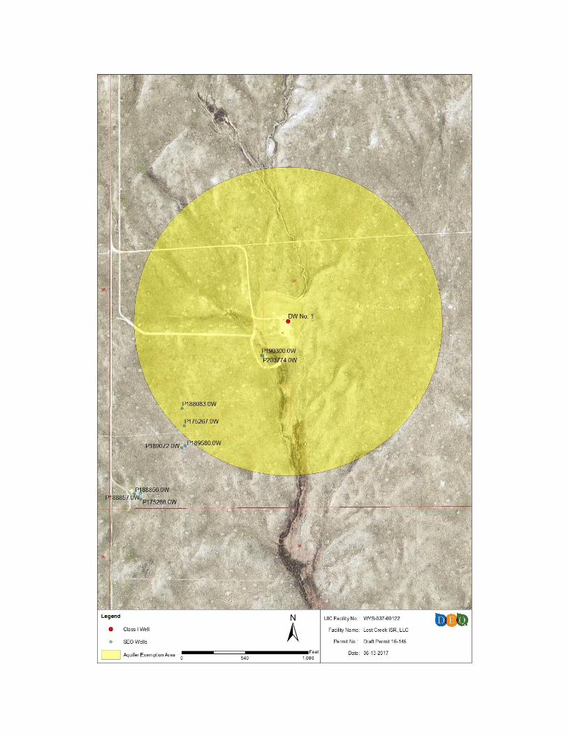
Provide map of AE boundary and location of drinking water wells. There are no drinking water wells or oil and gas wells located within the AE boundaries. WSEO well permits within and in the immediate vicinity of the AE boundaries are depicted in the attached figures. The depicted WSEO well permits are monitor wells or “miscellaneous use” wells associated with the Lost Creek ISR, LLC facility.
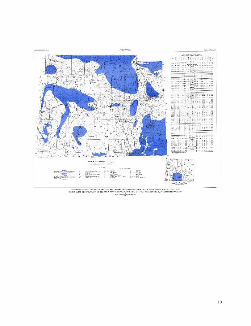
Regional and local (if available) groundwater flow direction. Regional groundwater flow directions for the Battle Spring aquifer system is provided in Plate 2 (attached) from G.E. Welder and L. J. McGreevy, 1961, Ground‐water Reconnaissance of the Great Divide and Washakie Basins, Southwestern Wyoming, USGS Hydrologic Investigations Atlas HA‐219.
And check one or more of the following CFR citations:
☒ (b)(2) It is situated at a depth or location which makes recovery of water for drinking water purposes economically or technologically impractical;
Projections on future use of the proposed aquifer. There are no projections on the future use of the Lower Battle Spring Formation aquifer.
Current sources of water supply in the area of the proposed exempted aquifer. For public water supplies, the town of Rawlins reportedly uses springs in the Sage Creek Basin and wells completed in the Nugget Sandstone aquifer, Wamsutter uses wells completed in the Green River Formation, and Bairoil uses wells completed in the Upper Battle Spring Formation. This information was included in the permit modification application submitted by Lost Creek ISR, LLC and available in the 2010 Green River Basin Water Plan Groundwater Study prepared by the Wyoming Water Development Commission (WWDC).
Availability, quantity and quality of alternative water supply source(s) to meet present and future needs. A median value of 197,429 acre‐feet (ac‐ft) of groundwater storage was estimated to be present within the upper 1,000 feet of tertiary aquifers of the Green River Basin (WWDC, 2010). Based on
4
information summarized in the 2010 WWDC Water Plan, the Upper Battle Spring Formation and shallower aquifers of the Green River Basin appear adequate to meet present and future water needs for the area.
Population trends in the area and analysis of future water supply needs within the general area. The WWDC projected future population growth in the Green River Basin from 2000 to 2055. The population in 2010 was projected to be between 61,762 and 67,078, and a population of between 66,464 and 134,225 was projected in 2055 for the low and high growth projections, respectively. Significant population growth in the vicinity of the Lost Creek ISR, LLC facility is not expected due to low coal, oil, and natural gas prices. Additionally, the WWDC projected future domestic groundwater usage in the Green River Basin from 2010 through 2055 for low, moderate and high growth scenarios. The estimated domestic use in 2010 was 884 ac‐ft annually. Future use projections range from 2,170 to 4,382 ac‐ft by 2055 depending on the growth scenario (WWDC, 2010).
Well construction and water transportation and/or treatment costs to develop aquifer proposed for exemption compared to costs to develop alternative resource(s).
Well Costs: A review of available WWDC well cost estimates from seven (7) WWDC funded projects completed in Wyoming between 2003 and 2012 revealed well construction cost estimates ranging from $167/foot to $439/foot for wells at depths between 2,156 feet and 3,500 feet. These cost estimates generally included only the drilling, completion, testing, and/or pump installation for the well, and did not include the additional cost associated with water delivery/treatment systems. No WWDC cost data was available for wells of comparable depth to the Lower Battle Spring Formation; however, using an average well construction cost derived from WWDC data of $260/foot as a conservative estimate, a well completed in the Lower Battle Spring Formation would cost approximately $1,443,000. By contrast, using the same $260/foot estimate, a 1,000 foot well completed in the Upper Battle Spring Formation would cost approximately $260,000. Further, the majority of domestic wells completed within approximately 13 miles of the Lost Creek ISR, LLC facility are less than 500 feet deep. In any case, wells to deeper aquifers would be progressively more expensive, and operating costs (per gallon) are likely to increase with depth as yields are probably lower in deeper aquifers. Treatment Costs: Water from aquifers below the Lower Battle Spring Formation would require treatment to meet EPA drinking water standards. Even minor treatment adds substantially to costs. For example, it was estimated that a centralized reverse osmosis facility to reduce uranium in a 250 gallon/minute water supply for the town of Manville, WY would have a capital cost of $690,000 (in 2009 dollars) and a 30‐year operating cost of $1,830,000 (in 2009 dollars) (Olsson Associates and AVI, P.C., 2008). The total annualized treatment cost would amount to more than $2,500 per gallon of capacity, or $0.64 per 1,000 gallons per year. For an average daily consumption of 175 gallons per capita per day (Manville’s actual consumption is unusual and much higher than this), this minimal treatment for Manville’s water would add about $65 to the cost of water per tap per year. Manville residents paid $180 per tap per year for unlimited use in 2007. TDS for the Manville water is 390 mg/L. The capital and operating costs to treat a 347 gallon/minute supply with TDS up to 3,000 mg/L would be at least twice as much (HDR, 2000).
References:
HDR, 2000, Desalination for Texas water supply: Texas Water Development Board, Contracted Reports No. 2000483328. (http://www.twdb.state.tx.us/RWPG/rpgm_rpts/2000483328.pdf)
Olsson Associates and AVI, P.C., 2008, Manville source water supply study, Level II study, Final Report: Wyoming Water Development Commission, Technical Report.

5
Petrotek Engineering Corporation, 2015‐2016, Application Materials for Class I UIC permit modification (16‐145), Lost Creek ISR Project.
Wyoming Water Development Commission, 2010, Green River Basin Water Plan Final Report, (http://waterplan.state.wy.us/plan/green/2010/finalrept/finalrept.html)
Wyoming Water Development Commission, 2003, Dayton Groundwater Exploration Final Report, (http://library.wrds.uwyo.edu/wwdcrept/)
Wyoming Water Development Commission, 2011, Big Horn Regional Groundwater Level II Study Final Report, (http://library.wrds.uwyo.edu/wwdcrept/)
Wyoming Water Development Commission, 2012, Wright Water Sewer District Water Supply Level II Study Final Report, (http://library.wrds.uwyo.edu/wwdcrept/)
Petrotek Engineering Corporation, 2012, Application Materials for Class I UIC permit modification (08‐314), Table 3 Actual and Estimated Costs WWDC‐funded Small Public Water Supply Projects.
☐ (b)(3) It is so contaminated that it would be economically or technologically impractical to render that water fit for human consumption; or
☒ (c) TDS is more than 3,000 and less than 10,000 mg/L and it is not reasonably expected to supply a public water system.
Projections on future use of the proposed aquifer. There are no projections to use the Lower Battle Spring aquifer as a public drinking water source.
Include information about the quality and availability of water from the aquifer proposed for exemption. The Upper Battle Spring Formation and shallower aquifers within the Green River Basin
appear to be adequate to meet present and future water needs for the area.
Analysis of the potential for public water supply use of the aquifer. This may include: a
description of current sources of public water supply in the area, a discussion of the adequacy of current water supply sources to supply future needs, population projections, economy, future technology, and a discussion of other available water supply sources within the area.
For public water supplies, the town of Rawlins reportedly uses springs in the Sage Creek Basin and wells completed in the Nugget Sandstone aquifer, Wamsutter uses wells completed in the Green River Formation, and Bairoil uses wells completed in the Upper Battle Spring Formation. This information was included in the permit modification application submitted by Lost Creek ISR, LLC and available in the 2010 Green River Basin Water Plan Groundwater Study prepared by the WWDC. The WWDC projected future population growth in the Green River Basin from 2000 to 2055. The population in 2010 was projected to be between 61,1762 and 67,078, and a population of between 66,464 and 134,225 was projected in 2055 for the low and high growth projections, respectively. Significant population growth in the vicinity of the Lost Creek ISR, LLC facility is not expected due to low coal, oil, and natural gas prices. Additionally, the WWDC projected future domestic groundwater usage in the Green River Basin from 2010 through 2055 for low, moderate and high growth scenarios. The estimated domestic use in 2010 was 884 ac‐ft annually. Future use projections range from 2,170 to 4,382 ac‐ft by 2055 depending on the growth scenario (WWDC, 2010). Finally, a median value of 197,429 ac‐ft of groundwater storage was estimated to be present within the upper 1,000 feet of tertiary aquifers of the Green River

6
Basin (WWDC, 2010). Based on information summarized in the 2010 WWDC Water Plan, the Upper Battle Spring Formation and shallower aquifers of the Green River Basin appear adequate to meet present and future water needs for the area.
Public Comment
Public Comment Period: 12/9/2017 To 1/8/2018 List of Public Commenters: To be determined.
Results of Public Comment Process: To be determined at the end of the public comment period.
Note: In accordance with the MOA, this response will be an interim response pending receipt and review by EPA of the results of the public participation process conducted by WQD. This interim response will become final if there are no comments related to the classification of the groundwater during either the comment period or the public hearing (if held). If comments are received during the comment period or the public hearing the interim response will become final if not modified within 20 days of the receipt of all the comments by Region VIII.
Additional Considerations to Support Aquifer Exemption Approval:
Include a map of the proposed Aquifer Exemption and Area of Review, including all wells (drinking water wells and O&G wells)
Additional Information: Additional information may be provided upon request.
WDEQ document Prepared By: Chris Brown Date: August 9, 2017
WDEQ document Approved By: John Passehl Date: November 1, 2017
Sent to EPA representative: Wendy Cheung Date: December 9, 2017
Interim Response Received from EPA:
N/A Date: N/A
Aquifer Exemption Response Received from EPA:
N/A Date: N/A
In accordance with the MOA, within 45 days from EPA receipt of the information and findings referred to in Nos. I.D.1 and I.D.2, EPA will respond to WQD. This response will be an interim response pending receipt and review by EPA of the results of the public participation process conducted by WQD. This interim response will become final if there are no comments related to the classification of the groundwater during either the comment period or the public hearing (if held). If comments are received during the comment period or the public hearing the interim response will become final if not modified within 20 days of the receipt of all the comments by Region VIII.

8

9
10