dept. of historic resources preliminary information … · web viewbruce, phillip h. an economic...
TRANSCRIPT

Disclaimer:This document was not produced by DEQ. Some of its content may not be in an accessible format pursuant to Section 508 of the federal Rehabilitation Act of 1973, as amended (29 U.S.C. § 794 (d)). Please call 800-592-5482 if you need assistance.
Preliminary Information FormRevised September 2012

DEPARTMENT OF HISTORIC RESOURCES2801 Kensington Avenue, Richmond, Virginia 23221
Telephone: (804) 367-2323 Fax: (804) 367-2391
PRELIMINARY INFORMATION FORMHISTORIC DISTRICT
An historic district is defined as a significant concentration of buildings, structures, or sites that are united historically and aesthetically by plan or physical development. The following constitutes an application for preliminary consideration of eligibility for the nomination potential of a historic district for listing in the Virginia Landmarks Register and the National Register of Historic Places. This does not mean that the district is being nominated to the registers at this time. Rather, it is being evaluated to determine if it qualifies for such listings. Applicants will be notified of the staff’s and the State Review Board's recommendations.
Contact the Virginia Department of Historic Resources Archivist to determine if previous survey material for this proposed district is on file, and if the district has been previously evaluated by DHR. Obtaining previously recorded information could save a significant amount of time in preparing this Preliminary Information Form (PIF). The archivist may be reached by phone at (804) 482-6102, or by email at [email protected]. The archivist will also give you the address of the regional office to which you should send your completed PIF materials.
Please type this form and, if additional space is needed, use 8½" x 11" paper. If an electronic version of this PIF is available, it would be helpful if it could be submitted on a disc, or via email to the archivist. Note: All submitted materials become the property of the Virginia Department of Historic Resources and will not be returned.
Photographs: Please provide at least four (4) color or black-and-white (B&W) photographs of general streetscapes and four (4) color or B&W photographs showing a sample of individual buildings within the proposed district. The inclusion of photographs is essential to the completion of this application. Without photographs, the application cannot be evaluated. Photographs should be labeled on the reverse side in soft pencil or china marker (not with adhesive labels), and are not to be mounted or affixed in any way.
Digital Images: In addition to the images printed on photographic paper, digital images, if available, should be submitted in TIF or JPEG format and can be included on the same disc as the PIF.
Maps: Please include two (2) maps showing the location of the proposed district:● A copy of a USGS Quad map with name of county/city printed on the map and with the name
of the proposed district indicating its location (sections of USGS Quadrangle maps can be printed free of charge from http://store.usgs.gov and hand-labeled to mark property boundaries or location), and
● A map showing a closer picture of the proposed boundaries with street names and/or routes and possible building footprints would also be helpful. Please include a "North" arrow, date, and “Not to Scale” on this map.
Before submitting this form, please make sure that you have included the following:● Section of labeled USGS Quadrangle map● Proposed district boundary map● 4 labeled color or B&W general photos ● 4 labeled color or B&W individual building photos ● Completed Resource Information Sheet, including
1/14/2017 2 of 19

o Applicant contact information and signatureo City or county official’s contact information
Thank you for taking the time to submit this Preliminary Information Form. Your interest in Virginia’s historic resources is helping to provide better stewardship of our cultural past.
Virginia Department of Historic ResourcesPIF Resource Information Sheet
This information sheet is designed to provide the Virginia Department of Historic Resources with the necessary data to be able to evaluate the significance of the proposed district for possible listing in the Virginia Landmarks Register and the National Register of Historic Places. This is not a formal nomination, but a necessary step in determining whether or not the district could be considered eligible for listing. Please take the time to fill in as many fields as possible. A greater number of completed fields will result in a more timely and accurate assessment. Staff assistance is available to answer any questions you have in regards to this form.
General Property Information For Staff Use OnlyDHR ID #:
District Name(s):
Union Hill/Woods Corner Rural Historic District
District or Selected Building Date(s):
18th, 19th, & 20th Centuries
☐Circa ☐Pre ☐Post Open to the Public?
☐Yes ☒No
Main District Streets and/or Routes:
Routes 602, 660, 661, 60, 663 and 649 and 56
City:
Buckingham Zip:
23921
County or Ind. City:
Buckingham County USGS Quad(s):
Saint Joy and Buckingham
Physical Character of General Surroundings
Acreage:
19.5 sq. miles/ 12,480 acres
Setting (choose one): ☐City ☐Urban ☐Town ☐Suburban ☒Rural ☐Transportation Corridor
Site Description Notes/Notable Landscape Features/Streetscapes:
The area proposed for the Union Hill/Woods Corner Rural Historic District consists of approximately nineteen square miles in the central western part of Buckingham County, Virginia,
1/14/2017 3 of 19

southeast of the James River and the community of Wingina, the Warminster Rural Historic and the Yogaville Historic District. The Buckingham Court House Historic District (http://www.dhr.virginia.gov/registers/Counties/Buckingham/014-0111_Buckingham_Court_House_Historic_District_1969_Final_Nomination.pdf) lies due east along Route 60.
The proposed district is also home to two individually-listed National Register of Historic Places and Virginia Landmarks Register properties: Perry Hill (http://www.dhr.virginia.gov/registers/Counties/Buckingham/014-0019_Perry_Hill_1980_Final_Nomination.pdf) and Woodside (http://www.dhr.virginia.gov/registers/Counties/Buckingham/014-0041_Woodside_1993_Final_Nomination.pdf). Col Alto, Mt. Rush and Afton have been recorded by the Virginia Department of Historic Resource and Col Alto and Afton have been found to be eligible for inclusion on the National Register of Historic Places.
The district is a rural area with agricultural fields and woodlots. Several drainages traverse the area including Ripley Creek, Forslip Creek, Austin Creek, Mathews Creek, Meadow Creek and the North River. While not readily evident to the casual passerby, the proposed historic district is a multi-layered cultural landscape that combines natural and built features that reveal an agricultural utilization of the land from the period of plantation slavery, through Reconstruction to the present.
The boundaries are based on several previous plantations and the post-Emancipation African-American uses of the land with the core of the district being the Freedmen community of Union Hill. Cultural features include demarcated pastures, agricultural fields, roads and ponds formed by 18th-19th century tobacco-farming plantations. The buildings include extant domestic plantation complexes and agricultural buildings as well as dwellings, churches, schools and stores built by Freemen and women after Emancipation. Many cemeteries, both black and white, exist within the proposed boundaries. Buried in the cemeteries are many ancestors of African- Americans who currently live within the district boundaries.
The Union Hill/Woods Corner historic district boundaries extend north and south of Route 56 (South James River Hwy) to Route 660 (Shelton’s Store Road) to the north. The main district corridors are Route 663, which runs in a north-south direction in the western portion of the proposed district, and Route 649, which runs east-west on the eastern side of the proposed district boundaries.
The African-American Union Hill Baptist Church, Union Hill School, Union Grove Baptist Church, Union Grove School, Shelton’s Store and multiple African-American cemeteries exist along Routes 663, 660, and 649. Also located on Route 649 is the site of the former Variety Shade Plantation which includes a large slave burial site and a well-tended and fenced family cemetery belonging to the white Moseley, Bondurant and Perkins families. Two main plantation dwellings, Perry Hill and Willow Lake, are present on Route 56, close to Rt. 649 where Variety Shade stood until the 1960s. Texas School Road (Route 661) forms the western boundary, Route 60 forms the southern boundary and Howardsville Road (Route 602) delineates the eastern boundary.
The significance of the proposed Union Hill/Woods Corner Rural Historic District stems from the manner in which the parent plantation land became, after Emancipation, a community established after the Civil War by Freedmen (who had acquired their freedom before Emancipation) and a large number of Emancipated African-Americans. A majority of the current residents of Union Hill are descendants of the Freedmen and slaves who started the community.
Ownership Categories: ☒Private ☐Public-Local ☐Public-State ☐Public-Federal
1/14/2017 4 of 19

General District Information
What were the historical uses of the resources within the proposed district? Examples include: Dwelling, Store, Barn, etc…
In the 18th -19th centuries large tobacco plantations were established in the area creating a predominantly agricultural landscape. The plantation complexes include main dwellings of different styles as well as dependencies. Eleven known plantations are sited within the boundary with eight still standing. At least two white churches, Mulberry Grove Baptist Church and Mount Tabor Methodist Church, along with several known white cemeteries, also exist within the boundary.
Other historical resources include small farms with vernacular dwellings and outbuildings established by Freedmen and women. The Freedmen community also includes three churches, one of which, Union Hill, began as a Brush Arbor site in 1868. An early 20th century neighborhood store, owned and operated by the African-American community, sits within the district boundary as well as numerous black cemeteries (including enslaved peoples’ cemeteries). Two non-extant black schools previously existed within the boundaries.
What are the current uses? (if other than the historical use)
Continued agricultural use to the present
Architectural styles or elements of buildings within the proposed district:
Vernacular, Gothic Revival, Early Classical Revival, Italianate, Georgian
Architects, builders, or original owners of buildings within the proposed district:
Alexander BondurantJohn Peter BondurantEmily McFarland Morrison Bondurant Marcia Louise Moseley BondurantRichard BondurantColonel Thomas Moseley BondurantWilliam CabellAnne Francis Perkins EllisJames Nimmo EllisPowhatan EllisAngela Bondurant HallDr. William HallCharles HarperJoseph JonesArthur MoseleyColonel William MoseleyCaesar PerkinsWilliam Harding PerkinsWilliam SwoopeCharles White
Are there any known threats to this district?
The district lies along the route of the proposed Atlantic Coast Pipeline; an approximately 70-acre compressor station industrial site is planned for the northwest area of the district.
1/14/2017 5 of 19

General Description of District: (Please describe building patterns, types, features, and the general architectural quality of the proposed district. Include prominent materials and noteworthy building details within the district and a general setting and/or streetscape description.)
Tobacco farming on several large plantations in the area determined the spatial organization of the rural community with large tracts of land and clusters of plantation buildings. In the late-19th century, most of the large plantations were divided and sold, often to free slaves who had remained in the area. The land use of the proposed district has remained primarily agricultural and has been occupied by some of the same families for over 200 years. Many of the African-American families that currently reside in the proposed district boundaries are descendants of previously enslaved people who served the Union Hill/Woods Corner-area plantations.
As for the built environment, some of the former plantation complexes have deteriorated and are no longer extant. Likewise, some of the structures associated with the African-American community have been lost. A large number of both black and white cemeteries are present within the boundary which demonstrate the interconnectedness of the people and how the rural landscape has been inhabited for generations by the same families.
National Register CriteriaThe Union Hill/Woods Corner historic district appears to be eligible under National Register Criterion A (That are associated with events that have made a significant contribution to the broad patterns of our history) and possibly B (That are associated with the lives of significant persons in our past). The event that has made a significant contribution to the broad patterns of history is the way in which previously enslaved people and Freemen acquired and successfully utilized former plantation lands to create their own community. This phenomena has been little studied but has the likelihood to help researchers better understand the lives of post-Emancipation African Americans. The continuous genealogical lines that have lived in the area for the duration of the period of significance (Late 18th century- 21st century) makes the area even more exceptional. The historic district’s agricultural use patterns that have remained intact for over 200 years; the plantation buildings; the churches, schools and stores built by African-Americans and the numerous cemeteries embody this event. The fact that Caesar Perkins, a formerly enslaved man who became a member of Virginia’s General Assembly, lived in the district boundaries may also signify that the district is eligible under criterion B.
IntegrityA property's period of significance is the benchmark for measuring whether subsequent changes contribute to its historic evolution or alter its historic integrity. In the case of the Union Hill/Woods Corner district, where the period of significance spans the 18th to the 21st centuries, consideration of integrity should include how the landscape has changed over time as formerly enslaved people acquired the land of former plantations and created their own communities. The rural setting and agricultural land use patterns have not changed significantly, remaining much as they were 200 years ago. The agricultural and livestock practices that shaped the land during the historic period are still present today. The additions of buildings by formerly-enslaved people has changed the landscape somewhat, underscoring the multi-generational development of the area. Many of the buildings related to the parent plantations also remain intact.
Post-Emancipation African-American Built EnvironmentResidentialAfrican-American residential parcels in the district are characterized by clustered housing of long-time Buckingham County families either on small, separate parcels divided by inheritance, or on larger, single parcels with tracts of woodlands and open fields. This follows a post-Emancipation rural settlement pattern of multiple dwellings (original frame or brick dwellings with supplemental mobile homes or small frame or modular dwellings).
Churches
1/14/2017 6 of 19

As is the case with other post-Emancipation landscapes, churches were focal points for the social and spiritual lives of the residents of Union Hill, Union Grove, and Woods Corner. Three African American churches located within the boundaries are Saint Joy Baptist Church, Union Hill Baptist Church and Union Grove Baptist Church; the latter two have congregations that date to 19th century. Mulberry Grove Baptist Church, a white church organized in 1786, served black members and is the second-oldest surviving church in Buckingham County. Union Hill was established as a Brush Arbor in 1868 after Freedmen were allowed to separate from Mulberry Grove.
The current Union Hill Baptist Church is a front-facing, gable-roof, brick building with a wood steeple. It was constructed in 1887 after the original was destroyed by fire. The adjacent cemetery contains many graves bearing the names shared with white plantation families, including Jefferson (name taken by descendants of Betsey Hemmings), Laury, Ellis, Perkins, Moseley, Gordon, and Gooden.
Union Grove Baptist Church broke away from Union Hill Baptist Church sometime in the early 20th century. Union Grove Church is a one-story, gable-roof, wood-framed rectangular building that was built near an existing slave cemetery where there are Claiborne, Pride, Washington and Harper family burials, among them recent graves. Next to the existing Union Grove Baptist are Laury, Pride, Washington, Booker, Shelton, Eldridge, and Harper family graves, also with recent burials. Many other local families still living in Buckingham are also buried in all of these cemeteries.
SchoolsOne-room schoolhouses were built across the road from both Union Hill and Union Grove Churches; Union Hill School was destroyed by fire, and Union Grove School was moved to the Robert E. Lee Wayside on Rt. 60, east of Buckingham Court House. Union Grove School was built around 1925 by African-American members of the Union Grove community, after the land was donated by a local African-American farmer and store owner. The teachers were usually educated women of the community who taught between 20 and 35 students in grades one through seven. Union Grove School closed in 1964 and was subsequently moved. The Texas School, for which Texas School Road is named, was relocated to a private parcel in the Woods Corner area.
Twelve one-room African-American schools existed in Buckingham County, but they were consolidated in the mid-1960s into new, but still segregated, multi-classroom brick schools. The new elementary schools, Stephen J. Ellis and Washington Carver, remained segregated until complete desegregation of the county school system in the fall of 1970.
Stores Shelton Store (for which Rt. 660 was named), stands on the north side of the Shelton Store Road. The store is a one-story, gable-roofed, wood-framed rectangular building that was established by Flemming Shelton, son of formerly enslaved Dicey Haskins Shelton. The store served the local African-American community for many years until it closed in the 1960s. The building is currently in fair condition.
Cemeteries At least twenty-one slave, or African-American, cemeteries are located within the proposed district boundaries. Most of these were mapped by the Works Progress Administration in the 1930s, which Carl and Lynn Henshaw researched to create an extensive, stand-alone map of slave cemeteries in Buckingham County. Recollections and oral histories from residents of Union Hill, collected by Lynn Henshaw, suggest that many more family cemeteries and single graves exist in the area but have not yet been mapped.
A large African-American cemetery exists at Variety Shade Plantation and contains at least 100 graves. Some graves are neatly marked by fieldstones, but most are unmarked and can only be identified by depressions in the ground. A number of graves from the early-20th century are identified by simple stone or early concrete grave markers inscribed with names and dates.
1/14/2017 7 of 19

Berkeley Laury, a local resident, disclosed that formerly enslaved family members of the Laury Family are among those buried at this location.
Another large cemetery is the Haskins/Perkins family cemetery, located off Route 663 (Woods Road) west of Route 56. This cemetery contains the graves of slaves as well as people who died free soon after Emancipation. The cemetery was used until the early 20th century. Many descendants of the people buried in the Haskins Cemetery continue to live nearby.
Plantation Complexes At least twelve parent plantation tracts existed within the proposed boundary. Some written evidence exists that other plantations including Winter Tract, Seven Oakes and Black Rock may also exist within the boundary, but further research is necessary for this to be confirmed. The main dwelling house of nine of the plantation complexes remain intact.
At least five of the known plantations in the district were owned by the Bondurant and Moseley families. The first mention of John Peter Bondurant in Buckingham County was a land grant signed by then-Governor Thomas Jefferson for 1,125 acres in 1755. In 1797, Gov. James Monroe granted Richard Bondurant 2,113 acres and another parcel of 135 acres in what is now Buckingham County. By this time, the Bondurant and Moseley families had intermarried and their descendants established Variety Shade, Perry Hill, Willow Lake, Wheatland and Woodside, all of which are within the proposed district boundaries. All of the white families who owned plantations within the proposed district owned slaves. The 1860 Slave Schedule reveals the number of slaves owned just before the Civil War.
Bondurant - 151Moseley - 53Woods- 67 slaves Jones- 110Perkins - 261Cabell - 25Hall - 20White - 15Swoope- 10
Variety Shade Variety Shade, located north of Route 56 and east of Mulberry Grove Road, was formed as early as 1798 by Colonel William Moseley. When it was a working plantation, Moseley had between 350-400 enslaved workers who tended many acres of tobacco fields and apple orchards. The main dwelling, slave dwellings and the dependencies including a well-house, smokehouse, salt house and ice house, as well as numerous agricultural buildings that were destroyed by fire in the 1960s, and are now evident on the site as piles of stones, bricks, and depressions. Enslaved workers also operated a non-extant sawmill and blacksmith shop on the plantation. Former resident Charles Harper, who grew up on Union Hill Road, stated that remains of an extensive brick slave quarter existed on the former plantation property. Remnants of the structures, historic road beds, and two cemeteries- the white Mosley-Bondurant Cemetery and a black slave-era cemetery that contains upwards of 200 graves- are present on the property. The only surviving structure is a tobacco barn dating to the mid-to-late 1800s.
The plantation was built by Colonel Moseley for his daughter Marcia Louise Moseley and her husband Colonel Thomas Moseley Bondurant. Mr. Bondurant served in the War of 1812, was an owner of the Richmond Whig newspaper, a member of the Virginia Senate and elder in the nearby Marysville Presbyterian Church. He was also the head of a family with extensive property; at one time he reportedly owned 30,000 acres in Buckingham County. He was an international tobacco trader and travelled the world and is said to have brought home to his Buckingham County plantation a variety of unique species of trees, which led to the name of the property. The 1860
1/14/2017 8 of 19

Slave Schedule for this property describes 76 individuals by age, color, and sex, also noting there were 16 slave dwellings.
Perry Hill Perry Hill (DHR site number 14-0019) is listed on the Virginia Landmarks Register and the National Register of Historic Places. Located south of Route 56, Perry Hill plantation lands were owned by Colonel Thomas Moseley Bondurant. He built a Gothic Revival cottage for his daughter and son in law, Angelina Bondurant and Dr. William Hall. According to the 1860 Population Census, the estate was valued at $31,000. The Slave Schedule recorded 20 individuals and 5 slave dwellings. According to the Virginia Department of Historic Resources:
Perry Hill is a rare example of architecture designed for use as a country residence in Piedmont Virginia. Such building types were promulgated widely in the mid-19th century by the writings of Alexander Jackson Downing and Calvert Vaux, however the few surviving examples in the Commonwealth indicate a limited acceptance in the region. This is due in part to the popularity of the Classical-Revival styles that continued to dominate architectural taste to the Civil War. Colonel Thomas Moseley Bondurant, a prominent Whig politician and publicist in Buckingham County, built the house for his daughter and son-in-law ca. 1851-1852 and is believed to have named it in honor of Oliver Hazard Perry, naval hero of the War of 1812.
Wilderness Wilderness Plantation house was built in 1780 by Joseph Jones, an immigrant from Wales, who came to Buckingham County during an early phase of the “Buckingham Gold Rush.” Gold and copper had been mined previously in the area by the Monacans, a Souian- speaking Native American tribal group whose territory included Buckingham County.
In 1855, William Cabell bought Wilderness and built a law office on the property. The Cabell family’s original land grant was a vast area that spanned both sides of the James River in this western Piedmont region of what became the first shire in Virginia – Henrico. During the Civil War, Cabell brought slaves to Wilderness from other family plantations close to the James River to hide them from the invading Northern Army. Today, Wilderness retains the historic main house, several historic outbuildings including the Cabell law office and a Jones and Cabell family cemetery.
Wheatland Wheatland, reportedly named for the vast wheat crops it yielded, was established by Arthur Moseley in the 1790s south of Route 56 near the Alcoma community. The Agriculture Census of 1860 valued the 600-acre farm at $12,000. The Slave Schedule noted 32 individuals.
Willow Lake Built ca. 1758 and located south of Route 56 and close to Wheatland, Willow Lake was another Moseley plantation. Owned by Colonel Moseley in 1860, it was valued at $50,000 and consisted of 1,100 acres. That year he reported $1,700 worth of livestock, 600 bushels of wheat, 700 bushels of corn, 1,000 bushels of oats, and 1,800 pounds of tobacco grown. The main house still stands and the property is currently a large working farm with livestock and domesticated animals.
Woods Family HousesTwo Wood’s family houses exist within the boundaries. Without knowing the historic names of these, one is referred to as Chad Oba’s House (the current owner) and the other is referred to as a “Wood’s Family House.” The former Texas School was later moved to Chad Oba’s house; the Woods Family Cemetery is present just north of the house along Route 663.
Woodside Located north of Route 56, Woodside Plantation was established in the Maysville area in the 1860s by Dr. William M. Swoope. The 103-acre parcel was valued at $12,500 in 1860.
1/14/2017 9 of 19

Solitude Located south of Route 56 in the Saint Joy area, Solitude was established by William Harding Perkins, who served as deputy sheriff in Powhatan and Buckingham Counties. He left the property to his son, William H. Perkins, who served in the House of Delegates from 1853-1854, and his wife Anne Frances Perkins.
AftonAfton (DHR site number 14-0042) is a more than 400-acre farm with a circa 1850s Georgian farmhouse and outbuildings, including a slave dwelling. It has been determined eligible for inclusion on the Virginia Landmarks Register and the National Register of Historic Places. Built by Anne Francis Perkins Ellis and Richard Shelton Ellis, the land was given to Anne Francis by her father, William H. Perkins, of Solitude, who owned much land in Buckingham County. The present home (ca. 1850s) was built on the foundation of the original house, which burned. Servant’s quarters predate the present home. Afton was one of the first area homes with running water. A windmill above the hand-dug, brick-lined well pumped water into a tank allowing for gravity-fed running water. The tower is still present and in fairly good condition. The 1850 Agricultural Census valued the property at $10,000 and noted 1,000 bushels of corn and 10,000 lbs. of tobacco grown.
Notable Ellis family members include James Nimmo Ellis (1863-1931), the child of Anne Francis and Richard Shelton Ellis, who was born at Afton. James Nimmo Ellis was a physician and surgeon and invented the “Ellis bag” which was used in gall bladder operations. Charles Ellis (1772- 1840), father of Richard Shelton Ellis, was a prominent business man. He formed a partnership in Richmond with John Allan, foster father of Edgar Allan Poe. Powhatan Ellis (1790-1863) was the Uncle of Richard Shelton. Friends with Andrew Jackson, he served as a U.S. senator between 1827 and 1832, and as a federal judge of the district of Mississippi.
Mt. RushMt. Rush (DHR site number 14-0016) includes a circa 1803, two-story, three-bay, single-family dwelling constructed in the Early Classical revival-style with a cross-gabled plan and several secondary agricultural resources. It was built by John Morris; the 1850 census listed the value of his estate at $34,000. Members of the Ellis family have owned Mt. Rush since the early 20th Century. Mount Rush was recommended not eligible for individual listing on the National Register of Historic Places under Criterion A–C in 2014.
Col Alto Col Alto (DHR site number 14-0010) was recommended eligible for the National Register of Historic Places in 2001. The Italianate house was built by Colonel Thomas Moseley Bondurant between 1849 and 1858 for his son Alexander Joseph Bondurant and his wife, Emily McFarland Morrison Bondurant. The 1860 Agricultural Census noted the plantation was valued at $15,000 and produced 1,000 bushels of corn and 9,000 lbs. of tobacco. Mr. Bondurant served in the Civil War and was considered a tobacco expert. He lived in Victoria, Australia, in that capacity, from 1896-1901. The following is an excerpt from the Virginia Department of Historic Resources:
Colonel Thomas Moseley Bondurant owned more than 20,000 acres in Buckingham County the height of his wealth and with them at least 7 houses: Variety, Shade, the old family homestead, Algoma, Black Rock, Perry Hill, which he built for his daughter Angelina Judith Bondurant Hall, Col Alto, and Eastview, which he gave to his son Dr. Thomas Lee Bondurant, who remained a bachelor all his life and who served as a physician for the Confederate Army.
In 1913 Col Alto was bought by Chiswell Dabney Langhorne for his son Elisha Keene Langhorne and his Buckingham bride, Sayde Reynolds. While he lived there, he had several famous family visitors, the period artist Charles Dana Gibson and his wife, Irene Langhorne Gibson "The Gibson Girl," and Lady Nancy Langhorne Astor, first woman Member of the English Parliament. These visits were recorded in the
1/14/2017 10 of 19

Farmville Herald. There are two Charles Dana Gibson originals hanging in the house, which came from the former owners.
Below is a list of the known historic resources within the proposed historic district. It is certain that more historic resources exist that have yet to be researched.
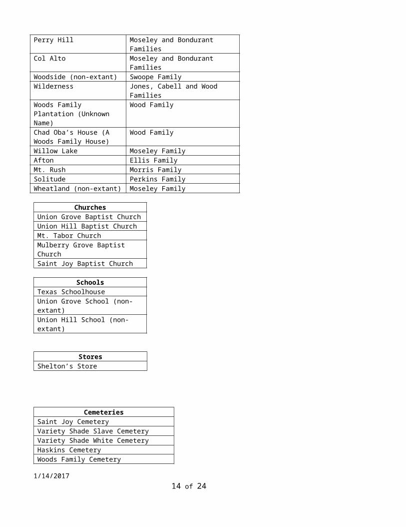
PlantationsVariety Shade (non-extant).
Moseley and Bondurant Families
Perry Hill Moseley and Bondurant Families
Col Alto Moseley and Bondurant Families
Woodside (non-extant) Swoope FamilyWilderness Jones, Cabell and Wood
FamiliesWoods Family Plantation (Unknown Name)
Wood Family
Chad Oba’s House (A Woods Family House)
Wood Family
Willow Lake Moseley FamilyAfton Ellis FamilyMt. Rush Morris FamilySolitude Perkins FamilyWheatland (non-extant) Moseley Family
ChurchesUnion Grove Baptist ChurchUnion Hill Baptist ChurchMt. Tabor ChurchMulberry Grove Baptist ChurchSaint Joy Baptist Church
SchoolsTexas SchoolhouseUnion Grove School (non-extant)Union Hill School (non-extant)
StoresShelton’s Store
CemeteriesSaint Joy CemeteryVariety Shade Slave CemeteryVariety Shade White CemeteryHaskins CemeteryWoods Family CemeteryWheatland Cemetery
1/14/2017 11 of 19
Union Hill CemeteryUnion Grove CemeterySolitude Cemetery 30 more currently unnamed cemeteries
Significance Statement: Briefly note any significant events, personages, and/or families associated with the proposed district. It is not necessary to attach lengthy articles or genealogies to this form. Please list all sources of information. Normally, only information contained on this form is forwarded to the State Review Board.
Buckingham County was created in 1761 from the southeastern portion of Albemarle County. In the nineteenth century the county was settled more heavily by people migrating from the Tidewater area. It was devoted chiefly to tobacco plantations and worked by enslaved African Americans. The landscape of the proposed district has retained its rural nature consisting of agricultural fields and wooded lots. It is notable that the destruction of the Thomas Jefferson-designed Buckingham Courthouse by arson on Feb. 26, 1869 (the same day the United States Senate passed the 15th Amendment granting formerly enslaved people the right to vote) adds an extra layer of difficulty when researching the proposed district.
The area of the proposed district is home to multiple families, both black and white, that have resided in the county from the Colonial era to the present day. The Union Hill portion of the proposed district, located on the northeast side of Rt. 56, has been historically, and remains today, populated primarily by African-American families. A significant number of descendants of formerly-enslaved people own land and reside in the proposed district, including the cattle farm and orchard on land owned by a descendant of slaves. During research for the proposed district, a landowner stated, “The majority of families’ grandparents were slaves in this area.”
Significant PeopleCaesar Perkins The son of Joseph Mosely and Clarisse Mosely, Caesar Perkins was born into slavery in 1839. Later accounts indicate that he chose to keep the last name of his former owner, William H. Perkins, who had been a member of the House of Delegates during the 1853–1854 session. Caesar Perkins achieved his freedom through unknown circumstances and in 1867 helped secure rations for Freedpeople through the Bureau of Refugees, Freedmen and Abandoned Lands. Later, the local Freedmen's Bureau agent included Perkins on a list of prominent whites and blacks who were considered suitable for public office in Buckingham County.
Perkins was an ordained Baptist minister and an advocate for the education of former slaves. Perkins owned 628 acres in Buckingham County on which he raised corn, oats, tobacco, and wheat. He also operated a store in Buckingham Court House and in June 1871 received a license to sell alcohol. In 1872 he was licensed to keep two ordinaries in the county.
Perkins also had a political career which began in 1869, when he and James H. Noble defeated Conservative Party candidates for each of Buckingham County's two seats in the House of Delegates. During the October session of the General Assembly, Perkins voted in favor of Virginia's ratification of the Fourteenth and Fifteenth Amendments to the U.S. Constitution, required for states to be re-admitted into the Union. Perkins continued his political activity by attending the 1870 and 1872 Republican State Conventions and the 1872 Republican National Convention, in Philadelphia, where Ulysses S. Grant was re-nominated as the party's candidate for president. In January 1873, the governor named Perkins one of the curators responsible for overseeing the recently-established land-grant educational fund for Hampton Normal and Agricultural Institute (later Hampton University).
1/14/2017 12 of 19

By 1880, Perkins supported the Readjusters, a biracial coalition that sought to reduce and refinance payments on the state’s public debt to fund public education and other services. After the Readjusters formally merged with the Republican Party, Perkins was named to its state committee and as an alternate delegate from the Sixth Congressional District to the 1884 Republican National Convention, in Chicago. In November 1887, Perkins was elected to a second term in the House of Delegates, representing Buckingham and Cumberland Counties. During the single session that met from December 8, 1887 until March 5, 1888, he sat on the Committee on Labor and the Poor and the Committee on Manufactures and Mechanic Arts. Perkins also attended the Tenth District Republican Convention held in Staunton in 1898.
By 1891, Perkins helped establish and was minister at the Second Baptist Church (later Main Street Baptist Church) in Clifton Forge, Virginia. He later returned to Buckingham County. He is buried on his property near Dillwyn, in Buckingham County.
Historical documentation exists on Caesar Perkins even though Buckingham County is considered a “burnt county” due to Buckingham County’s courthouse being destroyed by fire (possibly arson) on the day in 1869 that the U.S. Senate passed the 15th Amendment giving African-Americans the right to vote.
Charles Jefferson HarperCharles (Jefferson) Harper, formerly of the Union Hill area, was interviewed within the last year and spoke of slave history in his family as being “passed down by men only,” that is, from older to younger male family members or by male mentors, as was the case for him. Mr. Harper explained the sense of secrecy around this history as stemming from their “shaming” elements, as they often concerned births out of wedlock, some illegal inter-racial births, or births from adulterous unions (often met with dire consequences for the parents and children involved). Mr. Harper stated during his interview that he had never spoken of the particulars of his family and slave history to his own children.
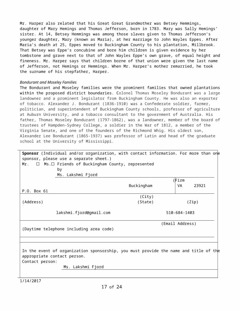
Mr. Harper also related that his Great Great Grandmother was Betsey Hemmings, daughter of Mary Hemings and Thomas Jefferson, born in 1783. Mary was Sally Hemings’ sister. At 14, Betsey Hemmings was among those slaves given to Thomas Jefferson’s younger daughter, Mary (known as Maria), at her marriage to John Wayles Eppes. After Maria’s death at 25, Eppes moved to Buckingham County to his plantation, Millbrook. That Betsey was Eppe’s concubine and bore him children is given evidence by her tombstone and grave next to that of John Wayles Eppe’s own grave, of equal height and fineness. Mr. Harper says that children borne of that union were given the last name of Jefferson, not Hemings or Hemmings. When Mr. Harper’s mother remarried, he took the surname of his stepfather, Harper.
Bondurant and Moseley FamiliesThe Bondurant and Moseley families were the prominent families that owned plantations within the proposed district boundaries. Colonel Thomas Moseley Bondurant was a large landowner and a prominent legislator from Buckingham County. He was also an exporter of tobacco. Alexander J. Bondurant (1836-1910) was a Confederate soldier, farmer, politician, and superintendent of Buckingham County schools, professor of agriculture at Auburn University, and a tobacco consultant to the government of Australia. His father, Thomas Moseley Bondurant (1797-1862), was a landowner, member of the board of trustees of Hampden-Sydney College, a soldier in the War of 1812, a member of the Virginia Senate, and one of the founders of the Richmond Whig. His oldest son, Alexander Lee Bondurant (1865-1937) was professor of Latin and head of the graduate school at the University of Mississippi.
Sponsor (Individual and/or organization, with contact information. For more than one sponsor, please use a separate sheet.) Mr. ☐ Ms.☐ Friends of Buckingham County, represented by
Ms. Lakshmi Fjord (Firm
1/14/2017 13 of 19
P.O. Box 61 Buckingham
VA 23921
(Address)
(City) (State) (Zip)
510-684-1403 (Email Address) (Daytime telephone including area code)
In the event of organization sponsorship, you must provide the name and title of the appropriate contact person.Contact person:
Ms. Lakshmi Fjord
Daytime Telephone: (510) 684-1403
Applicant Information (Individual completing form)
Mr. ☐ Mrs.☐ Ms. ☐ Miss ☐ Sonja Ingram, Justin Sarafin, Lisa Bergstrom
Preservation Virginia
(Name)
204 W. Franklin Street
Richmond, VA
(Firm)
23220
(Address)
[email protected] 434-770-1209
(City) (State) (Zip Code)
(Email Address) (Daytime telephone including area code)
Applicant’s Signature:
Date: 1/14/17 (revised 2/16/17)
NotificationIn some circumstances, it may be necessary for DHR to confer with or notify local officials of proposed listings of properties within their jurisdiction. In the following space, please provide the contact information for the local County Administrator or City Manager.
Mr. ☐ Mrs.☐ Dr. ☐
Miss ☐ Ms. ☐ Hon.☐ Rebecca S. Carter
Buckingham County Administrator
Buckingham County,
VA
(Name) (Position)
13360 W. James Anderson Hwy (Locality)
Buckingham VA
23921
(Address)
434-969-4242
1/14/2017 14 of 19

(City) (State) (Zip Code) (Daytime telephone including area code)
Please use the following space to explain why you are seeking an evaluation of this district.
While many former slaves left Buckingham County plantations at the end of the Civil War, others remained. Some formerly-enslaved workers stayed because they were able to acquire land, while others stayed and became sharecroppers or tenant farmers in order to maintain their livelihood. Some former slaves remained because of the continued racial biases and lack of resources to move and re-establish themselves. Still others stayed because of the strong bonds to the area and to the families and communities they had formed before Emancipation.
The closely-knit and supportive network of families in the Union Hill/Woods Corner area began to establish their own community by building churches, schools, stores and dwellings that eventually altered the area from a landscape of slavery into one that was theirs to claim. These types of formerly-enslaved and free African-American communities after Emancipation have been scarcely studied in Virginia, but have the potential to provide an enormous amount of invaluable historical information on the lives of Emancipation and Reconstruction-Era blacks and the communities they created. Recognition of the district would fill an almost total gap of public knowledge about its importance.
Local resident Mr. Charles Harper (great grandson of Betsey Hemmings) stated, “I can tell you what I’ve never even told my children– the history of Betsey Hemmings told me in secret by Walter (Patteson).” To historians of the South, none of this is news. However, the character of Buckingham County has been formed by its isolation, because of its economy, and the effects of that isolation on generations of inequitable social dynamics. Our hope is that by better knowing the history of this district, from all perspectives and forms of evidence, and not just that of the plantation houses and their white owners, that a more inclusive history will address some of the deep wounds of this overlooked and important slavery history.
In response to a decided lack of cultural and historic resource survey in the area, we are seeking this designation as a way of raising awareness of the threat of erasure of this landscape that will occur with the construction of the proposed Atlantic Coast Pipeline and related Compressor Station. The compressor station will be located within the district boundaries and it is highly likely that its existence will draw more pipelines and pipeline infrastructure in the future. The intensification of pipeline networks, feeder lines and above ground facilities all combine to ensure that Union Hill/Woods Corner Rural Historic District will face serious threats to its historical and cultural resources in the future. Formal recognition of the historical significance of the district may afford some type of protection but will, at the very least, record the poignant history of the area before it is irrevocably altered.
Bibliography Anderson, James M. Jr. Early History of Buckingham County. Master’s Thesis, University of Richmond, 1938. Armitage, Thomas. The History of the Baptists. New York: 1889. Bean, Robert. The Peopling of Virginia. Boston: 1938. Berkeley, Robert. The History and Present State of Virginia. Charlottesville: 1968. Bolling, Phillip. Speeches of Phillip Bolling (of Buckingham) in the House of Delegates of Virginia on the policy of the state in relation to her Colored Population. January 11, 25: 1832. Brewer, James H. Confederate Negro. Durham, NC: 1969. Bruce, Phillip H. An Economic History of Virginia in the Seventeenth Century. New York: 1935. Bushnell, David I. Five Monacan Towns in Virginia. Washington: 1938.
1/14/2017 15 of 19

Henshaw, Lynn and Carol. Map of Buckingham County African –American cemeteriesHull, Janice J.R., Buckingham Burials: A Survey of Cemeteries in Buckingham County, Virginia. Volume I. Revised edition, 2014.James, Charles. The Documentary History of the Struggle for Religious Liberty in Virginia. Mahoney, Eugene. A History of Buckingham Virginia: Buckingham County Founded 1761 Mooney, James. Souian Tribes of the East. Washington: 1938. Nugent, Nell Marion. Cavaliers and Pioneers: A Calendar of Land Grants. Richmond: 1929-1931. Robinette, D. L., & the Dictionary of Virginia Biography. From The Encyclopedia of Virginia. Caesar Perkins (1839–1910). (2015, January 9). In Encyclopedia Virginia. Retrieved from http://www.EncyclopediaVirginia.org/Perkins_Caesar_1839-1910.Tooker, William W. “The Algonquin Appelatives of the Souian Tribes in Virginia.” American Anthropologist, VIII Washington: War of Rebellion: The Official Papers of the Northern and Southern Armies. 1903. White, Charles. The Hidden and The Forgotten: Contributions of Buckingham Blacks to American History, 1985. White, Charles and E. Renee Ingram. Buckingham County (VA) (Black America Series), 2005.
Would you be interested in the State and/or the Federal Rehabilitation Tax Credits? Yes ☐ No X☐Would you be interested in the easement program? Yes ☐ No X☐
Figure 1: Manuscript plat illustrating Variety Shade plantation (courtesy of University of Virginia Special Collections)
1/14/2017 16 of 19
1/14/2017 17 of 19

Figure 2: Manuscript plat confirming the existence of Black Rock plantation, located near Variety Shade, showing tobacco barns (courtesy of University of Virginia Special Collections)
1/14/2017 18 of 19

Figure 3: Excerpt from Buckingham County slave burial map, created by Lynn and Carl Henshaw, courtesy of Mr. Charles White (with scan provided by Justin Sarafin)
1/14/2017 19 of 19