deptt: - madhya pradesh road development corporation · pdf filemadhya pradesh have decided to...
TRANSCRIPT
Satna – Bela Road (National Highway No-75)
Total Length-48.040 K.M (from Km 155 to Km 198.60)
2-Lane to 4-Lane with Paved Shoulder
Report On
(Executive Summary in English)
Satna – Bela Road (National Highway No-75)
Total Length-48.040 K.M (from Km 155 to Km 198.60)
2-Lane to 4-Lane with Paved Shoulder
Deptt: - Madhya Pradesh Road Development Corporation
Ltd
Please purchase PDFcamp Printer on http://www.verypdf.com/ to remove this watermark.

Introduction A. Introduction
The Govt. of India (GOI) through Ministry of Roads & Highways (MORT&H) is
contemplating to enhance the traffic capacity and safety for efficient transshipment of
Goods as well as passenger traffic on few of the Selected heavily trafficked
stretches/paved shoulder of National Highways. The Madhya Pradesh Road
Development Corporation (MPRDC) has been entrusted for the development.
EXECUTIVE SUMMARY
1.1 Background The Government of India, MORT&H, Madhya Pradesh Road Development Corporation, Govt. of MP and the Public Works Department, Government of Madhya Pradesh have decided to take up the development of NH-75 from Km 155.00 to Km 198.600 to National Highway 4 Lane paved shoulders standards and specifications.
The Government of Madhya Pradesh Public Works Department awarded the Contract to M/s Holtec Consulting Private Limited for the consultancy services for Feasibility Report for Two-laning with paved shoulders of NH-75 stretch between Km 57.40 to Km 198.600 vide Agreement No. 29 / NH / 2008-09 dated 20-02-2009. This Project has been bifuracated and transferred to MPRDC in compliance with the MoRT&H order dated 08 September 2009 and will be developed as under :
The Project Road starts from Km 155.000 of NH-75 at Hanuman Mandir Deora (Sohawal), the start of Proposed Satna Bypass and terminates at Km 203.040 (Design Chainage) of NH-75 at Bela meeting point of NH-75 and NH-7 and is under governance and implementation of MPRDC Bhopal.
Bamitha-start Of Proposed Satna Bypass: Two Lane with Paved Shoulders Start of Proposed Satna Bypass-End of Satna Bypass- Bela Junction: Four Lane with Paved Shoulders.
Please purchase PDFcamp Printer on http://www.verypdf.com/ to remove this watermark.

The Feasibility Report is with a view to attract Public - Private Investment for the development of the road through BOT mode. 1.2 Objective of the Assignment: The objectives of this consultancy assignment are as summarised below :
• Feasibility Report of the Project Highway and Project facilities
• Operation and Maintenance System
• Impact on the local environment, population and road users
• Financial Viability and Analysis
• Assistance during Bid Process
1.3 Scope of work It is as specified in the TOR. 1.4 Feasibility study of the Assignment • Holtec Consulting Pvt. Ltd. has carried out the Feasibility Study and is presenting this
feasibility Report 1.5 Salient Features of the Project • Start : Km 155.000 (Start of proposed Satna By pass).
• End : Km 198.600 of NH-75 at Bela meeting point of NH-75 and NH-7.
• Length : Km 43.600
• Important Towns: Hanuman Mandir, Amaudha, Bagaha, Bamuraha, Ghoodng, Birla cement, Badkhar, Nimal, Kripal pur, Sajjanpur, Rampur. and the important towns/villages are Amodha ,Kripalpur ,Madhawgarh ,Siholi , Baghelan, Rimar.
• Terrain: Plain and Rolling terrain.
• Road Formation (existing): 8.90 m to 12.85m.
• Carriageway (existing): 5.20 m to 7.00 m. Poor to fair
• Traffic Volume: The traffic on this road is medium to high between Start of proposed Satna By pass and Bela junction which ranges from 8789 PCU to 15048 PCU.
• Culverts (Existing) : 22 nos (Weak and inadequate).
• Minor Bridges: 14 nos (require upgradation by way of special repairs / rehabilitation, widening and reconstruction).
• Major Bridges: 01 nos. (New Construction on river Tamas on Satna Bypass).
Please purchase PDFcamp Printer on http://www.verypdf.com/ to remove this watermark.
• Proposed ROB: One.
• Flyover: Nil.
• Proposed Vehichular UnderPasses: 2 nos
• Proposed Grade Seperator: 1 nos
• Junction/Intersection: 21 nos major and 07 nos minor.
1.6 Project Road The Project Road has been declared as National Highway and it is to be upgraded to 4- lane with paved shoulders National Highway standards and specifications. The Project Road is of length 48.040 Kms after providing bypasses in the districts of Satna and Rewa.Project Road provides linkage to NH-86 and NH-7 in Rewa district. The Project Road is located in the East direction. The land-use pattern is varying with urbanized area, sub-urban area, and barren land stretches. The vegetation in the shape of trees is also having variable density and has been earmarked in the report. Some major roads off-shoot the project road to provide connectivity to various villages and towns in the region. The project is partly in the plain area and partly in the rolling terrain. There is movement of medium to high percentage of vehicles in of project road. There are several minor passages crossing this road. Some villages and settlements are situated along the road, attracting heavy local traffic. It includes the town Hanuman Mandir, Amaudha, Bagaha, Bamuraha, Ghoodng, Badkhar, Nimal, Kripal pur, Sajjanpur, Rampur.The existing Right of Way varies from 15 meters to 30 metres,from End of proposed Satna By pass to Bela town(Km 168.900 to Km 199.600) SALIENT POINTS
• Start Point : Ø Start of proposed Satna By pass (Km 155.00 of NH-75) Ø Km of Project Road 155.00
• End Point
Ø Bela town Ø Km of Project Road 198.600
• Length Of Project Road
Ø Length as per chainage Km 43.600 Towns and Villages
Please purchase PDFcamp Printer on http://www.verypdf.com/ to remove this watermark.
• Towns : Ø Satna (Km 162.00 to 186.600) Ø Rampur Baghelam ( Km. 186.600 to188.000)
• Villages :
Ø Madhavgarh (Km 171.000) Ø Sajjanpur (Km 177.600)
• Districts :
• Satna
Major Roads Connectivity :
• NH-7 : Mughal Sarai-Mirzapur-Rewa-Jabalpur-Nagpur. Local Roads Connectivity :
• Satna-Maihar. • Satna-Katni.
1.7 General Data of Project Road Data collected during map study and reconnaissance are as under. It provides the complete in-sight of the Project Road.
Data Collection During Reconnaissance 1 Details of route NH-75 Bamitha (Km 58/400) – Panna – Satna – Bela
(Km 198/600) 2 Length of the road Km 48.040( Proposed Satna Bypass- Bela Junction) 3 Bridging requirements
number, length Major Bridge- 01, Minor Bridges : 17 (Rehabilitation/Widening/Reconstruction)
Geometric Features: a) Gradient Flat b) Curves Smooth Curves through out the road
4
c) Ground constraints Not significant 5 Existing means of surface
travel Existing Highway.
6 Right-of-way available, Available 7 Terrain and soil conditions: Terrain: Plain and Rolling, Soil condition: Sandy /
Clay Soil / Black Cotton Soil 7.1 Geology of the area Earthen 7.2 Nature of soil, Weak soil of 3-5% (approximate) except in some isolated
stretches.
Please purchase PDFcamp Printer on http://www.verypdf.com/ to remove this watermark.
Road length passing through (i) Rolling / Mountains
terrain Nil
(ii) Steep terrain Nil (iii) Rocky stretches with
indication of the length in loose rock stretches
Nil
(iv) Areas subject to avalanches and snow drifts
Nil
(v) Areas subject to inundation and flooding
Nil
(vi) Areas subject to sand dunes including location of dunes
Nil
(vii) Areas of poor soils and drainage conditions
Predominantly BC soil on the project Road.
(viii) Areas with very poor sub-soil strength, e.g. marshes
Nil
7.3
(ix) Areas of high salinity or wet saline soil
Nil
7.4 Cliffs and gorges Nil 7.5 Drainage characteristics of the
area including susceptibility to flooding
Nil
7.6 General elevation of the road Around 200m (650 feet) 7.7 Total number of ascents and
descents in hill sections Nil
7.8 Disposition and location of sand dunes
Nil
7.9 Vegetation-extent and type Thin 8 Climatic Condition
8.1 Temperature-monthly maximum and minimum readings
Average 33-35?�C
8.2 Rainfall data- average annual, peak intensities, monthly distribution (to the extent
970 mm (39 inches)
Please purchase PDFcamp Printer on http://www.verypdf.com/ to remove this watermark.

available) 8.3 Snowfall data-average annual,
peak intensities, monthly distribution (to the extent available)
Nil
8.4 Wind direction and velocities Nil 8.5 Visibility Good 8.6 Exposure to sun Yes, Normal 8.7 Water Table and its variation
between maximum and minimum
8 m to 20 m and fall 2 m to 4 m
8.8 History of unusual weather, like, cloudbursts, etc.
Flood during 1999 and 2005
9 Facilities resources 9.1 Landing ground in case of
hilly stretches N.A.
9.2 Dropping zones in case of hilly stretches
N.A.
9.3 Foodstuffs Sufficient 9.4 Labour-local availability and
need for import Local labour is sufficient
9.5 Construction material sand, stones, shingle, etc.
Available
9.6 Availability of water Available 9.7 Availability of local
contractors Yes
10 Value of land –agriculture land, irrigated land, built-up land, forest land etc.
Worked Out
11 Approximate construction cost
Worked out
12 Access points indicating possibility of induction of equipment.
Yes
13 Period required for construction.
2 Years
14 Strategic considerations. Up-gradation to NH standard to 4 –laning with paved Shoulder
15 Recreational potential. Historical places of interest as well as wild life. 16 Important villages, town and
marketing centers connected. Satna and Bela
17 Economic factors: 1. Population served by the
Satna has limestone deposits. In this locality cement
Please purchase PDFcamp Printer on http://www.verypdf.com/ to remove this watermark.
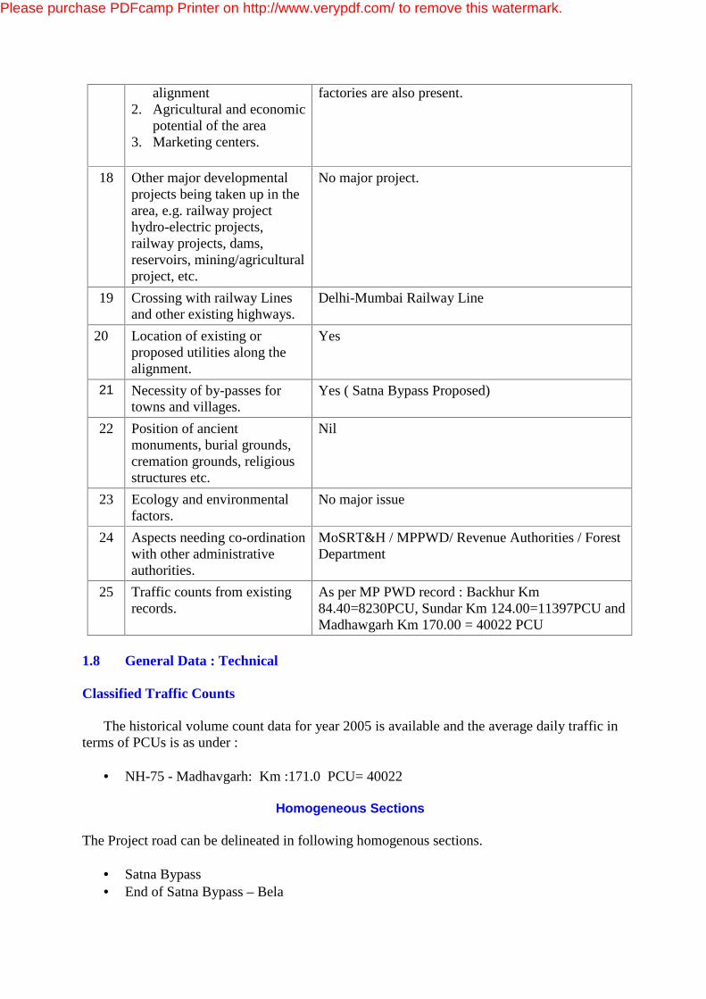
alignment 2. Agricultural and economic
potential of the area 3. Marketing centers.
factories are also present.
18 Other major developmental projects being taken up in the area, e.g. railway project hydro-electric projects, railway projects, dams, reservoirs, mining/agricultural project, etc.
No major project.
19 Crossing with railway Lines and other existing highways.
Delhi-Mumbai Railway Line
20 Location of existing or proposed utilities along the alignment.
Yes
21 Necessity of by-passes for towns and villages.
Yes ( Satna Bypass Proposed)
22 Position of ancient monuments, burial grounds, cremation grounds, religious structures etc.
Nil
23 Ecology and environmental factors.
No major issue
24 Aspects needing co-ordination with other administrative authorities.
MoSRT&H / MPPWD/ Revenue Authorities / Forest Department
25 Traffic counts from existing records.
As per MP PWD record : Backhur Km 84.40=8230PCU, Sundar Km 124.00=11397PCU and Madhawgarh Km 170.00 = 40022 PCU
1.8 General Data : Technical Classified Traffic Counts
The historical volume count data for year 2005 is available and the average daily traffic in terms of PCUs is as under :
• NH-75 - Madhavgarh: Km :171.0 PCU= 40022
Homogeneous Sections The Project road can be delineated in following homogenous sections.
• Satna Bypass • End of Satna Bypass – Bela
Please purchase PDFcamp Printer on http://www.verypdf.com/ to remove this watermark.
Existing Right of Way (ROW) Information on relevant road way width has not been readily available. However, more or less it is in the range of 15-30m. Road Geometrics • Horizontal Alignment The alignment is mostly straight.The curves at places are more or less with the design speed and the general topography of area. • Vertical Alignment The Road was previously a State Highway. The road level is low at places and is damaged due to flooding and / or high water table from chainage Km 171 to Km 172. Hence reconstruction is required. Such stretches have been fine-tuned.The Longuitudinal profile blend with the topography.
• Camber / Cross fall / Super-elevation Camber / cross-fall / super elevation needs correction.
Road Formation Width The road formation width is 8m to 14m, almost in all the stretches.
Carriageway Width
The carriageway varies from 5.0 m to 7 m in various sectors and upto 14m in Buit-up area. Height of Embankment The embankment is in filling. Embankment is about 1.0 to 1.5 m above OGL.
Drainage of the Area Road follows the natural drainage condition.
Sub soil Water level is high in the surroundings of rivers.
By and large, the water table level is low in most of the area.Project area is mostly drained by river Tamas.
Please purchase PDFcamp Printer on http://www.verypdf.com/ to remove this watermark.
Other reaches are having self-drained system to the fields.
Some areas are affected by flood water in the fields and / or stagnant water along road. The drainage is through balancing culverts.
The project road passes through an area flanked by rivers & nallas.
Provision of adequate cross-drainage structures is very important for all weather traffic worthiness of the road on the basis of reconnaissance. It is found that :
• Existing provision of CD works is inadequate and is required to be upgraded.
• Cross-fall / Camber / Super-elevation needs improvement.
• Inadequacy of the roadside drainage is also noted in built-up areas with the result that water either remains stagnant or does not reach outlet point.
• The towns, villages and habituated places are affected because of inadequacy or system failure of the existing facility at some places.
Pavement Condition The existing road is having flexible pavement and the capacity augmentation will be by provision of flexible pavement.
Culverts (CD Works)
Inventorisation of existing culverts has been carried out during reconnaissance survey. It is noted that :
• Culvert marking does not follow any standardized numbering system. Numbers are not in conformity with chainage / Kilometerage. Therefore, the numbering / marking has been followed in inventorisation.
• Spans and vent ways mentioned on culverts do not match with actual measurements.
• Re-measured span and vent way has been accounted for as clear span (not center to center).
Data has been fine-tuned during detailed condition survey. Chainages have been properly linked to actual topographical survey locations. The number of culverts for cross-drainage or balancing are less in number. Some stretches do not have C.D. Works. It is also observed that number of culverts are structurally not sound and have to be reconstructed.
Please purchase PDFcamp Printer on http://www.verypdf.com/ to remove this watermark.
Number of culverts are having cut stone and Arch slab arrangement. Many culverts are of less roadway width. In the view of observations we have examined the system of CD works Since the whole project road is reconstructed leading to raising of Road level , and proposed upgradations are under following categories :
• Reconstruction • Additional culverts
Minor Bridges There are 08 nos of Minor Bridges.
All minor bridges have been examined for upgradation under following cateogires :
• Reconstruction or Replacement • Widening of Bridges
Major Bridge There are 1 Major Bridges on the project road corridor having 2-lane carriageway width. It is proposed to retain the bridge with minor repairing and additional 1 no. bridge having 2-lane carriageway width is proposed for construction to accommodate the 4-lane traffic. ROB There is one ROB proposed on the Satna bypass of project Road. Flyover There is no Flyover on the project Road. Vehichular Underpasses 02 nos vehichular under passes have been proposed on Satna Bypass stretch. Grade Seperator It is proposed to provide a grade seperator at junction of NH-75 and NH-7 at Bela to ease the traffic at the junction. Intersections / Junctions A few cross roads connect villages, towns and institutions interesect the project road at various places. Location of the Junctions / Intersections are as mentioned below :
Please purchase PDFcamp Printer on http://www.verypdf.com/ to remove this watermark.
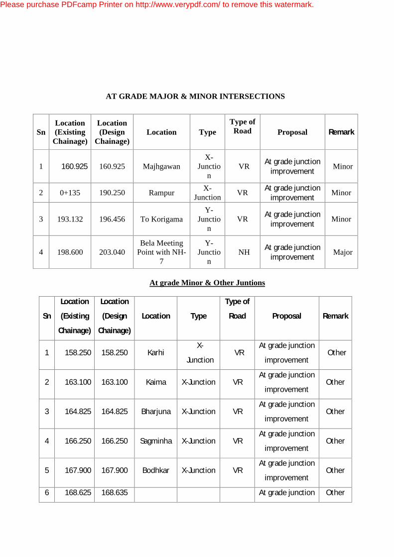
AT GRADE MAJOR & MINOR INTERSECTIONS
Sn Location (Existing
Chainage)
Location (Design
Chainage) Location Type
Type of Road
Proposal Remark
1 160.925 160.925 Majhgawan X-
Junction
VR At grade junction improvement Minor
2 0+135 190.250 Rampur X-Junction VR At grade junction
improvement Minor
3 193.132 196.456 To Korigama Y-
Junction
VR At grade junction improvement Minor
4 198.600 203.040 Bela Meeting
Point with NH-7
Y-Junctio
n NH At grade junction
improvement Major
At grade Minor & Other Juntions
Sn
Location
(Existing
Chainage)
Location
(Design
Chainage)
Location Type
Type of
Road
Proposal Remark
1 158.250 158.250 Karhi X-
Junction VR
At grade junction
improvement Other
2 163.100 163.100 Kaima X-Junction VR At grade junction
improvement Other
3 164.825 164.825 Bharjuna X-Junction VR At grade junction
improvement Other
4 166.250 166.250 Sagminha X-Junction VR At grade junction
improvement Other
5 167.900 167.900 Bodhkar X-Junction VR At grade junction
improvement Other
6 168.625 168.635 At grade junction Other
Please purchase PDFcamp Printer on http://www.verypdf.com/ to remove this watermark.
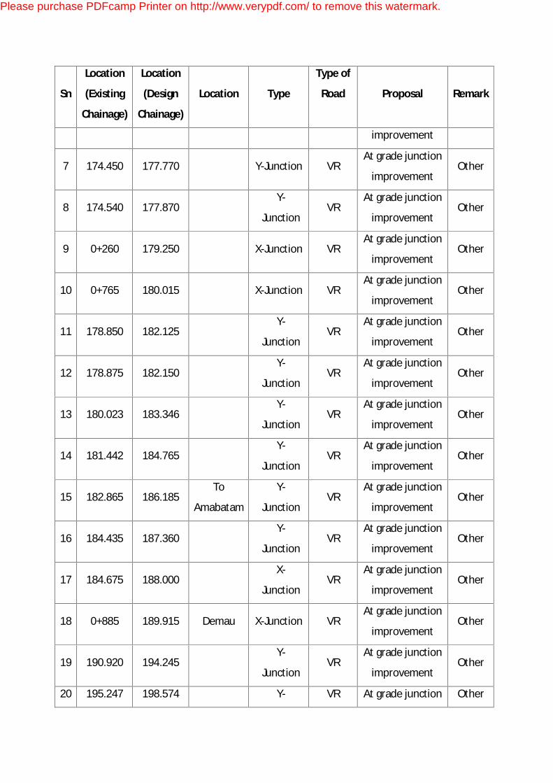
Sn
Location
(Existing
Chainage)
Location
(Design
Chainage)
Location Type
Type of
Road
Proposal Remark
improvement
7 174.450 177.770 Y-Junction VR At grade junction
improvement Other
8 174.540 177.870 Y-
Junction VR
At grade junction
improvement Other
9 0+260 179.250 X-Junction VR At grade junction
improvement Other
10 0+765 180.015 X-Junction VR At grade junction
improvement Other
11 178.850 182.125 Y-
Junction VR
At grade junction
improvement Other
12 178.875 182.150 Y-
Junction VR
At grade junction
improvement Other
13 180.023 183.346 Y-
Junction VR
At grade junction
improvement Other
14 181.442 184.765 Y-
Junction VR
At grade junction
improvement Other
15 182.865 186.185 To
Amabatam
Y-
Junction VR
At grade junction
improvement Other
16 184.435 187.360 Y-
Junction VR
At grade junction
improvement Other
17 184.675 188.000 X-
Junction VR
At grade junction
improvement Other
18 0+885 189.915 Demau X-Junction VR At grade junction
improvement Other
19 190.920 194.245 Y-
Junction VR
At grade junction
improvement Other
20 195.247 198.574 Y- VR At grade junction Other
Please purchase PDFcamp Printer on http://www.verypdf.com/ to remove this watermark.

Sn
Location
(Existing
Chainage)
Location
(Design
Chainage)
Location Type
Type of
Road
Proposal Remark
Junction improvement
21 196.310 199.635 Y-
Junction VR
At grade junction
improvement Other
22 196.427 199.703 Y-
Junction VR
At grade junction
improvement Other
23 198.155 201.415 Y-
Junction VR
At grade junction
improvement Other
Please purchase PDFcamp Printer on http://www.verypdf.com/ to remove this watermark.

Bypass Three nos of Bypasses are proposed to Satna town, Sajjanpur town and Rampur Baghelan town of approx. 22.585 Kms, 3.90 kms and 6.0 kms length respectively of NH-75. 1.9 Traffic Survey Homogeneous Sections Based on the traffic movement pattern ensuring minimum variation in traffic level within such sections, the total road length has been divided into two homogenous sections as given below : Homogenous Sections of the Project Road
Section Stretch Approximate Length (Km)
1 Start of Proposed Satna By pass (km 155.000) to Bela town (203.040)
48.040
Traffic Survey. Comprehensive data has been collected from various departments / organizations / agencies / institutions and other sources related to the Traffic Census & Socio-economic indicators. The following types of traffic surveys have been conducted :
• Classified Traffic Volume Count for Seven days Twenty Four hours. • Turning Movement Count • Pedestrian Crossing Survey • Cattle Crossing Survey
Traffic Surveys have been conducted in the month of March and April 2009. Historical Traffic Data of Project Road The historical volume count data for year 2005 is available and the average daily traffic in terms of PCUs is as under : • NH-75 – Madhawgarh (Km :171.0) : 40022 PCUs
Please purchase PDFcamp Printer on http://www.verypdf.com/ to remove this watermark.

Executive Summary in EIA (English Report) for Four laning with paved shoulders Satna -Bela
Total length Km. 48.040 (from Km 155 to Km 198)
Confirmatory Survey of Traffic Volume Count: Count Stations Traffic Volume Count Survey is carried out at locations specified hereunder :
Traffic Survey Locations for Classified Volume Count
Sn Section Existing Chainage
Location
1 Nagod – Start of Proposed Satna By pass Km 143.000 Between Nagod and start of proposed
Satna By pass.
2 Satna – Bela Km 198/00 Between Satna and Bela
Toll Plaza Locations Following location has been considered for the toll plazas :
Sn Toll Plaza Point Number
Location Brief Description of Location
1 No.1 Km198.500 (Design Chainage)
About 03 Kms short of Bela Town
Survey for Cattle and Pedestrian Crossing Survey counts have been carried out at the locations (Km 143.000 and km 198.00) . 1.10 Survey and Investigations: Technical Data Collection/ Compilation Following data has been compiled for analytical study of impact on alignment:
Survey data Remarks Road Inventory It includes kilometerwise details of road structure,
drain and service road, including proposal for widening / new construction. It is based on Standard Proforma
Inventory of Culverts It includes details of all culverts. It has structural and condition assessment. It is utilized to conceptualize Reconstruction, Widening and Retention.
Road Condition Survey Data is utilized to conceptualize design of road structure.
Bridge Condition Survey It is applied to carry out performance evaluation of the structure and to conceptualize the rehabilitation or new construction.
Please purchase PDFcamp Printer on http://www.verypdf.com/ to remove this watermark.
Executive Summary in EIA (English Report) for Four laning with paved shoulders Satna -Bela
Total length Km. 48.040 (from Km 155 to Km 198)
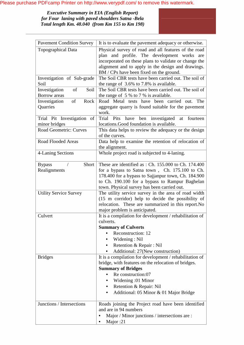
Pavement Condition Survey It is to evaluate the pavement adequacy or otherwise. Topographical Data Physical survey of road and all features of the road
plan and profile. The development works are incorporated on these plans to validate or change the alignment and to apply in the design and drawings. BM / CPs have been fixed on the ground.
Investigation of Sub-grade Soil
The Soil CBR tests have been carried out. The soil of the range of 3.6% to 7.8% is available.
Investigation of Soil Borrow areas
The Soil CBR tests have been carried out. The soil of the range of 5 % to 7 % is available.
Investigation of Rock Quarries
Road Metal tests have been carried out. The aggregate quarry is found suitable for the pavement work.
Trial Pit Investigation of minor bridges
Trial Pits have ben investigated at fourteen locations.Good foundation is available.
Road Geometric: Curves This data helps to review the adequacy or the design of the curves.
Road Flooded Areas Data help to examine the retention of relocation of the alignment.
4-Laning Sections Whole project road is subjected to 4-laning.
Bypass / Short Realignments
These are identified as : Ch. 155.000 to Ch. 174.400 for a bypass to Satna town , Ch. 175.100 to Ch. 178.400 for a bypass to Sajjanpur town, Ch. 184.900 to Ch. 190.100 for a bypass to Rampur Baghelan town. Physical survey has been carried out.
Utility Service Survey The utility service survey in the area of road width (15 m corridor) help to decide the possibility of relocation. These are summarized in this report.No major problem is anticipated.
Culvert
It is a compilation for development / rehabilitation of culverts. Summary of Culverts
• Reconstruction: 12 • Widening : Nil • Retention & Repair : Nil • Additional: 27(New construction)
Bridges
It is a compilation for development / rehabilitation of bridge, with features on the relocation of bridges. Summary of Bridges
• Re construction:07 • Widening :01 Minor • Retention & Repair: Nil • Additional: 05 Minor & 01 Major Bridge
Junctions / Intersections Roads joining the Project road have been identified
and are in 94 numbers • Major / Minor junctions / intersections are : • Major :21
Please purchase PDFcamp Printer on http://www.verypdf.com/ to remove this watermark.

Executive Summary in EIA (English Report) for Four laning with paved shoulders Satna -Bela
Total length Km. 48.040 (from Km 155 to Km 198)
• Minor : 07 ROB Details are compiled to assess or the requirement or
up gradation or otherwise There is 01 no. ROB proposed on the project road in Bypass portion.
Vehichular Underpasses The details are compiled and 02 nos vehichular under passes have been proposed in Satna Bypass.
Grade Seperator The details are compiled and 01 no grade seperator have been proposed at junction of NH-75 and NH-7.
Flyover No Flyover exists or proposed. Design and Drawings Design and drawings of the upgradation work are elaborated in the Chapter-9 under following major heads : Alignment Design: The existing corridor has been followed with modifications which includes bypass to Satna,Sajjanpur and Rampur town and a realignment at one locations. The alignment has been approved by the Authorities of MPRDC,MoRT&H and the state PWD. Roadway Design: The proposed 4-laning stretches are for a total length of 48.040 kms. Pavement Reconstruction The existing bituminous surfaces will be scarified and new course from sub-base onwards will be laid on the surface after providing a subgrade layer of 500 mm thick. Bypass These are identified as : Ch. 155.000 to Ch. 174.400 (22.585 Km) for a bypass to Satna town , Ch. 175.100 to Ch. 178.400 (3.9 Km) for a bypass to Sajjanpur town, Ch. 184.900 to Ch. 190.100 (6 Km) for a bypass to Rampur Baghelan town. Improvement of Curves There is no curve which has been included for the improvement of curvature. Design of Layers The road is designed for 4-lane Paved Shoulder for 48.040 Kms. Traffic Design Traffic volume count survey has been carried out for 2 locations for seven days X 24 hours. Details are attached. Analysis is as under: a) Average Daily Traffic Based on Survey, ADT is as below:
Please purchase PDFcamp Printer on http://www.verypdf.com/ to remove this watermark.
Executive Summary in EIA (English Report) for Four laning with paved shoulders Satna -Bela
Total length Km. 48.040 (from Km 155 to Km 198)
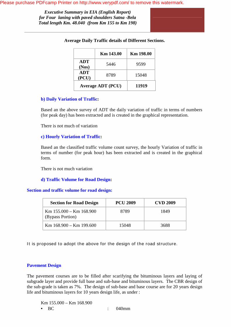
Average Daily Traffic details of Different Sections.
Km 143.00 Km 198.00
ADT (Nos) 5446 9599
ADT (PCU) 8789 15048
Average ADT (PCU) 11919
b) Daily Variation of Traffic: Based an the above survey of ADT the daily variation of traffic in terms of numbers
(for peak day) has been extracted and is created in the graphical representation. There is not much of variation c) Hourly Variation of Traffic: Based an the classified traffic volume count survey, the hourly Variation of traffic in
terms of number (for peak hour) has been extracted and is created in the graphical form.
There is not much variation d) Traffic Volume for Road Design: Section and traffic volume for road design:
Section for Road Design PCU 2009 CVD 2009
Km 155.000 – Km 168.900 (Bypass Portion)
8789 1849
Km 168.900 – Km 199.600 15048 3688
It is proposed to adopt the above for the design of the road structure.
Pavement Design The pavement courses are to be filled after scarifying the bituminous layers and laying of subgrade layer and provide full base and sub-base and bituminous layers. The CBR design of the sub-grade is taken as 7%. The design of sub-base and base course are for 20 years design life and bituminous layers for 10 years design life, as under : Km 155.000 – Km 168.900
• BC : 040mm
Please purchase PDFcamp Printer on http://www.verypdf.com/ to remove this watermark.

Executive Summary in EIA (English Report) for Four laning with paved shoulders Satna -Bela
Total length Km. 48.040 (from Km 155 to Km 198)
• DBM : 115 mm • WMM : 250 mm • GSB : 230 mm Total : 635mm Km 168.900 – Km 199.600 • BC : 050 mm • DBM : 140mm • WMM : 250 mm • GSB : 230 mm Total : 670 mm
Culverts The design proposals include the following :
Structure
Hum
e Pi
pe
Cul
vert
RC
C S
lab
Cul
vert
RC
C B
ox
Cul
vert
Ston
e A
rch
Widening + Repair and strength.
- - - -
Retention with Repairs
Reconstruction 05 07 - -
Additional 10 17 - -
Total 15 24
Grand Total 39
Hume Pipe Culverts and RCC Slab Culverts have been adopted as per site conditions. Major Bridges New construction of Major Bridges (01Nos) There is only one major bridge which is proposed to be a new construction. Details of the major bridge are as under :
Please purchase PDFcamp Printer on http://www.verypdf.com/ to remove this watermark.

Executive Summary in EIA (English Report) for Four laning with paved shoulders Satna -Bela
Total length Km. 48.040 (from Km 155 to Km 198)
Details of Existing Structure
S.No Design
Chainage (Km) Type of
Structure Opening
Width of
Structure (m) Remarks
1 174.110 Box Girder 5 x 50 27.5
New
construction
to Four lane
Standards
Minor Bridges There are 17 nos. Minor Bridges requiring following treatment :
• Widening 01
• Retention with Minor Repairs 00
• Reconstruction 07
• Additional 05
Total 14 Toll Plazas One numbers Toll Plaza has been proposed. The Toll Plaza design includes Utility Building, First-aid Services, General Layout, Toll Collection System, Vehicle Counting Classifier, Toll Booth, Road Work (Cement Concrete road), Lighting, Water Supply, Fire fighting, etc. As one number of the toll plaza will be insufficient to trap all the running traffic on the project road one number of checkpost is required to trap the leakage of traffic. Bus Shelters Bus Shelters have been provided. Laybye for Trucks Laybyes for Trucks has been planned on the project Road
Road Side Furniture and Miscellaneous Works The Road Side Furniture and other miscellaneous works have been planned as per requirements. Utilities Relocation of telephone lines and other utility services interfering with the operation of the road have been included. 1.11 Concept Plan of Major Activities
Please purchase PDFcamp Printer on http://www.verypdf.com/ to remove this watermark.

Executive Summary in EIA (English Report) for Four laning with paved shoulders Satna -Bela
Total length Km. 48.040 (from Km 155 to Km 198)
The major issues involved are summarized below :
A. Embankment & Pavement Work 1 4-Lane with Paved Shoulders
48.040 Kms
B. Culverts 39 nos 1 Culverts – Widening - 00 nos 2 Culverts – Reconstruction – 12 nos 3 Culverts – Retention with Repairs – 0 nos 3 Culverts - Additional / New Proposals - 27 nos C. Bridges (Minor) 13Nos. 1 Bridge : Widening – 01 nos 2 Bridge : Reconstruction - 07 nos 3 Retention with Minor Repairs – 0 nos 4 Additional – 05 nos D Bridges (Major) 01 Nos. 1 Bridge : Widening – 00 nos 2 Bridge : New construction - 01 nos 3 Retention with Minor Repairs – 00 nos 4 Additional -00 nos E Toll Plazas :One Toll Plaza is proposed to be
constructed : • Km 198.500 One number of checkpost is required at • Km 173.00- 173.300 (Design Chainage)
01 Nos
F Truck Lay-Byes 02Nos
G Bus Shelters 11 Nos H Intersections / Junctions (Major 01 + Minor 03 + 23
others) 27 Nos
I Drainage System : • Drain in 4-Lane section
96.060Kms
J ROB 01 No
K Vehichular Underpasses 02 Nos
L Grade Seperator 01 No
M Road Safety Structures, and Miscellaneous works As per requirement N Landscape and Arboriculture
At Toll Plazas Locations: 01 nos.
Please purchase PDFcamp Printer on http://www.verypdf.com/ to remove this watermark.
Executive Summary in EIA (English Report) for Four laning with paved shoulders Satna -Bela
Total length Km. 48.040 (from Km 155 to Km 198)
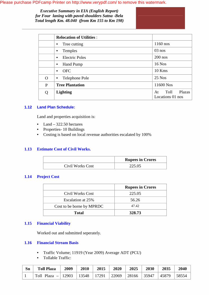
Relocation of Utilities : • Tree cutting 1160 nos • Temples 03 nos • Electric Poles 200 nos • Hand Pump 16 Nos
• OFC 10 Kms
O • Telephone Pole 25 Nos
P Tree Plantation 11600 Nos
Q Lighting At Toll Plazas Locations 01 nos
1.12 Land Plan Schedule: Land and properties acquisition is:
• Land – 322.50 hectares • Properties- 10 Buildings • Costing is based on local revenue authorities escalated by 100%
1.13 Estimate Cost of Civil Works.
Rupees in Crores Civil Works Cost 225.05
1.14 Project Cost
Rupees in Crores Civil Works Cost 225.05 Escalation at 25% 56.26
Cost to be borne by MPRDC 47.42
Total 328.73 1.15 Financial Viability Worked out and submitted seperately. 1.16 Financial Stream Basis
• Traffic Volume; 11919 (Year 2009) Average ADT (PCU) • Tollable Traffic:
Sn Toll Plaza 2009 2010 2015 2020 2025 2030 2035 2040
1 Toll Plaza – 12903 13548 17291 22069 28166 35947 45879 58554
Please purchase PDFcamp Printer on http://www.verypdf.com/ to remove this watermark.

Executive Summary in EIA (English Report) for Four laning with paved shoulders Satna -Bela
Total length Km. 48.040 (from Km 155 to Km 198)
1 : Km 198.500
• Concession Period : 25 Years • Civil Works Cost : Rs 225.05 Crores • Toll Rates shall be prevalent in NHAI / MoRT&H projects and as detailed in the
Publication. • Grant of 0% •
B. Project Influence Area
i) Direct Area of Influence
The direct influence area of the project is restricted to proposed Right of way (RoW) ,
since the project involves widening of existing highway and all construction and
operation stage activities will be contained within it. The existing Right-Of-Way
(ROW) of the project road is in range of 15 m to 30 m.
ii) Indirect Area of influence
As per MoEF guidelines for conducting EIA (EIA notification, S O 1533 dated 14th
Sept, 2006); the geographical scope of the EIA study has been considered as 15 km
radius for highway projects for major environmental features like national park,
wildlife sanctuary, Critically Polluted Area, Notified Eco-Sensitive Zone, Inter-state
Boundaries and International Boundaries (10 km), Coastal Zones, Areas protected
under international convention, defense installations etc. Physical features like
physiography, hydrology were also studied/ recorded within 15 km radius of the
project road.
C. Statutory clearance requirement
S.
No
Clearance Required for Statute under which
clearance is required
Statutory Authority
1 Environmental Clearance EIA notification, 2006
issued under EP Act
1986
Ministry of Environment
& Forest, GOI, New
Delhi
2 Wildlife Clearance Wildlife protection Act
1972
State Wildlife Board,
Dept of Forest, Govt. of
Please purchase PDFcamp Printer on http://www.verypdf.com/ to remove this watermark.
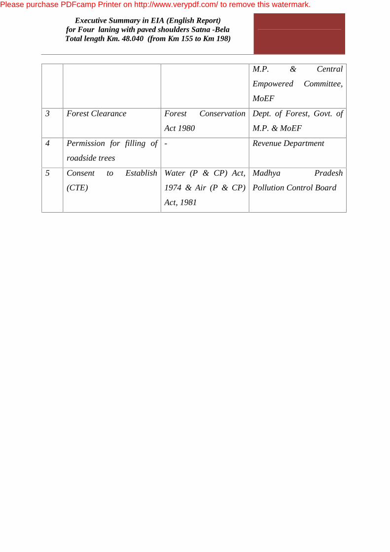
Executive Summary in EIA (English Report) for Four laning with paved shoulders Satna -Bela
Total length Km. 48.040 (from Km 155 to Km 198)
M.P. & Central
Empowered Committee,
MoEF
3 Forest Clearance Forest Conservation
Act 1980
Dept. of Forest, Govt. of
M.P. & MoEF
4 Permission for filling of
roadside trees
- Revenue Department
5 Consent to Establish
(CTE)
Water (P & CP) Act,
1974 & Air (P & CP)
Act, 1981
Madhya Pradesh
Pollution Control Board
Please purchase PDFcamp Printer on http://www.verypdf.com/ to remove this watermark.

Executive Summary in EIA (English Report) for Four laning with paved shoulders Satna -Bela
Total length Km. 48.040 (from Km 155 to Km 198)
Please purchase PDFcamp Printer on http://www.verypdf.com/ to remove this watermark.
Executive Summary in EIA (English Report) for Four laning with paved shoulders Satna -Bela
Total length Km. 48.040 (from Km 155 to Km 198)
Description of the Environment
A) Physical Environment
i) Meteorology
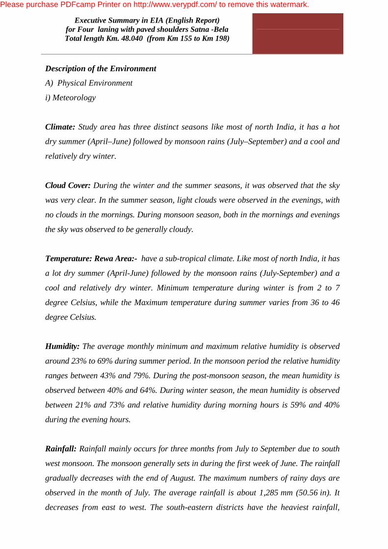
Climate: Study area has three distinct seasons like most of north India, it has a hot
dry summer (April–June) followed by monsoon rains (July–September) and a cool and
relatively dry winter.
Cloud Cover: During the winter and the summer seasons, it was observed that the sky
was very clear. In the summer season, light clouds were observed in the evenings, with
no clouds in the mornings. During monsoon season, both in the mornings and evenings
the sky was observed to be generally cloudy.
Temperature: Rewa Area:- have a sub-tropical climate. Like most of north India, it has
a lot dry summer (April-June) followed by the monsoon rains (July-September) and a
cool and relatively dry winter. Minimum temperature during winter is from 2 to 7
degree Celsius, while the Maximum temperature during summer varies from 36 to 46
degree Celsius.
Humidity: The average monthly minimum and maximum relative humidity is observed
around 23% to 69% during summer period. In the monsoon period the relative humidity
ranges between 43% and 79%. During the post-monsoon season, the mean humidity is
observed between 40% and 64%. During winter season, the mean humidity is observed
between 21% and 73% and relative humidity during morning hours is 59% and 40%
during the evening hours.
Rainfall: Rainfall mainly occurs for three months from July to September due to south
west monsoon. The monsoon generally sets in during the first week of June. The rainfall
gradually decreases with the end of August. The maximum numbers of rainy days are
observed in the month of July. The average rainfall is about 1,285 mm (50.56 in). It
decreases from east to west. The south-eastern districts have the heaviest rainfall,
Please purchase PDFcamp Printer on http://www.verypdf.com/ to remove this watermark.

Executive Summary in EIA (English Report) for Four laning with paved shoulders Satna -Bela
Total length Km. 48.040 (from Km 155 to Km 198)
some places receiving as much as 2,096 mm (82.48 in), while the western and north-
western districts receive 987 mm (38.89 in) or less.
Wind speed: In Satna-Bela, the northwestern wind blows, predominantly, over the city
of Satna-Bela and the wind speed generally ranges from 8 km per hour in summer to 2
km per hour in winter time. In Satna-Bela district, wind velocity is higher during the
pre monsoon period as compared to the post monsoon period. The maximum wind
velocity is 11.3 km/h during the month of June and minimum is 3.1 km/h during the
month of November. Average normal annual wind velocity is 6.4 km/h.
(ii) Physiographic & Terrain:
The project area falls under plain as well as rolling terrain in Ghat section. Some
Forest area is present in project road and Forest land will acquired under Forest
Conservation Act
(iii) Land use
The mean elevation above the sea is about 2000 ft. The entire stretch is essentially a
highland tract, divided naturally into three distinct portions, differing in their
superficial aspects, the character of their soil and their geological formation. The
land use pattern along with the project road is given below:
Soil quality:
Soil quality of the project area has been characterized depending on the analysis of
various soil parameters. Soil quality testing has been carried out in Six different areas
along with the project road namely Sajjanpur,Birla cement,,Ch-22, Rampur &Village
Mdhavgarh,Rampur Baghlan .
(iv) Water Resources
Surface Water: Project stretch crossessome small nalla Most of which is non-
perennial and drain only for few days/weeks during & after the monsoons. The cross
drainage structure at most of the locations are not seen over the water courses during
the construction of 4-Lane of National highway so that there will not be much
Please purchase PDFcamp Printer on http://www.verypdf.com/ to remove this watermark.
Executive Summary in EIA (English Report) for Four laning with paved shoulders Satna -Bela
Total length Km. 48.040 (from Km 155 to Km 198)
adverse impacts on water during the further widening to 2-lane to 4-Lane with paved
shoulders.
Ground Water: Ground water is the major source of the drinking water in , Satna-
Bela and their surrounding area. The villages are dependent on ground water for
their everyday requirement. Ground water is fetched from open dug as well as bore
wells which are both mechanized and manual.
(v) Water Quality
Water quality can be expressed in terms of physical, chemical & biological
characterization of water. Environmental survey was conducted & collected 10 No
sampling locations for surface as well as ground water.
Surface water:
The pH value ranges between 7 to 7.9. TDS content ranged between 678-750 mg/I.
while chloride values ranged from 591 to 885 mg/I respectively, well below the
tolerance limits. Iron content is found to be varying between 0.32-0.70 mg/I. There is
no significant presence of trace metals in the surface waters. Faecal contamination
where ranges from 1.2-1.8 per 100 ml of water, total coliform bacteria recorded as
2.5-3.8 mg/I. Total Hardness varies from 397 to 472 mg/l.
Ground water:
Ground water testing report shows that colour is below 2 Hazen (Hz), Odour & taste
is agreeable, pH ranges from 7.1-7.8, total hardness ranges from 648-738mg/l,
arsenic found less than 0.01mg/l where MPN count is less than 1 MPN/100ml.
(vi) Air Quality
The ambient air quality has been carried out in 12 locations & the result reveals that
the seasonal average concentration of SPM ranges from 73 to 100 ug/m3, RSPM
varies between 34.5 to 84 ug/m3, S02 range between 14.5 to 40.1 ug/m3 and Nox
ranges between 20 to 22 ug/m3. The values of SPM, SO2, NOX and CO are well within
the prescribed limits of National Ambient Air Quality Standards for the Industrial and
Please purchase PDFcamp Printer on http://www.verypdf.com/ to remove this watermark.
Executive Summary in EIA (English Report) for Four laning with paved shoulders Satna -Bela
Total length Km. 48.040 (from Km 155 to Km 198)
Commercial areas published by Ministry of Environment & Forest Notification 16
November 2009. Ambient air quality of the area lies within permissible limits as per
the discussion with the State Pollution Control Board personnel's owing to the
highway passing through industrial area and agricultural hinterland. The Contractor
should monitor the air quality in consultation with the, Regional office of the State
Pollution Control Board, so that appropriate mitigation measures may be adopted if
the air quality exceeds the permissible limits of CPCB to minimize the adverse effects
on the environment.
(vii) Noise Quality
Noise level monitoring was conducted at 6 locations namely Birla
Cement,Sajjanpur,Rampur,Madhavgarh,Sihholi,Baghlan
All sample , Day time noise was found to vary between 49.3 to 65 levels [dB (A)]
wherein night time noise was found to vary between 44.9 to 54 level [dB (A)].
(B) Ecological Environment
Forest
Flora: In the project affected districts mainly mixed miscellaneous forest are found.
These forests mainly have Shisham (Dallbergia Sisso), Ashok (saraca Asoca), Neem
(Azadirachta indica) etc. There are also Non wood forest products (NWFP) like
Tendu leaves or Bidi leaves (DiospyrosmeloNO2ylon), Sal Seed (Shorea robusta),
Chebulic Myrobolan or Harra (Terminaliachebula), Gum, Chirobji (Buchanania
lanzan), flower and seeds of Mahua Madhuca indica) and flowrs, seeds, bark & roots
of various plants species.
Main Trees in Rewa Area,Project area& Satna-Bela:
Tectona grandis, Diospyrous melanoxylon, Madhuca indica, Buchanania tanzan,
Anogeissus latifolia, Anogeissus pendula, Lannea coromandalica, Boswellia serrata,
Acacia catechu, Zizyphus spp., Aegle marmelos, Butea monosperma and Gardenia
spp.
Please purchase PDFcamp Printer on http://www.verypdf.com/ to remove this watermark.

Executive Summary in EIA (English Report) for Four laning with paved shoulders Satna -Bela
Total length Km. 48.040 (from Km 155 to Km 198)
Fauna: Common animal like dog, cats, monkey, pig and cattle are also present. The
presence of wild animals in the project areas is not reported and may be considered
very rare.
Main animals in Satna-Bela :Mammlas:Tiger, Jungle Cat, Leopard, Hyena, Wild
Dog, Wolf, Sloth Bear, Sambhar, Chital, Nilgai, Chinkara, Chausinga, Porcupine,
Jungle Cat, Rusty Spotted Cat, Hare, Ratel and Tree Shrew.
Please purchase PDFcamp Printer on http://www.verypdf.com/ to remove this watermark.

Executive Summary in EIA (English Report) for Four laning with paved shoulders Satna -Bela
Total length Km. 48.040 (from Km 155 to Km 198)
(C) Socio-economic Environment
Socio economy of Satna-Bela and Project area:
As of 2001 India census, Satna-Bela had a population of 225,468. Males constitute
53% of the population and females 47%. Project area& Satna-Belahas an average
literacy rate of 70%, higher than the national average of 59.5%: male literacy is 76%,
and female literacy is 62%. In Project area& , 15% of the population is under 6 years
of age. Industries in Project area& Satna-Bela include cement manufacturing, hand
loom weaving, flour, oilseed milling, and distribution of agricultural and fabric
products via road and rail. Most of the trade supplies to the region are unloaded and
further supplied to the surrounding regions from here. Trade between Utter Pradesh
and Vindhya region occurs mostly through Project area& Rewa Area. Currently the
economy is growing rapidly in this region of the country. Project area& Satna-Belais
in the transient stage of its transformation into a big city. As Project area& Satna-
Belatakes the trade hub stature, it has a high rate of migrant coming into the city from
other regions looking for work. The population growth creats an increase in demand
for goods and services that needs to be fulfilled. Service sectors such as banking is
growing rapidly in Project area& Rewa Area. Commercial and trade activity, demand
for consumer goods (brands name items) are registering impressive growth in Project
area& Rewa Area.
Socio economy ofSatna-Bela& Project area :
As of 2001 India census Project area& Satna-Belahad a population of 17,451. Males
constitute 53% of the population and females 47%. Project area& Satna-Belahas an
average literacy rate of 56%, with male literacy of 61% and female literacy of 40%.
12% of the population is under 6 years of age. There is no large scale industry in
Project area& Satna-Belaapart from a few small scale industries available, but these
industries are not sufficient for giving enough employment for local people. The
economy is mostly dependent on farming. The city however, has a growing private
commercial sector, mainly retail businesses.
Please purchase PDFcamp Printer on http://www.verypdf.com/ to remove this watermark.

Executive Summary in EIA (English Report) for Four laning with paved shoulders Satna -Bela
Total length Km. 48.040 (from Km 155 to Km 198)
AND MITIGATION
Please purchase PDFcamp Printer on http://www.verypdf.com/ to remove this watermark.

Executive Summary in EIA (English Report) for Four laning with paved shoulders Satna -Bela
Total length Km. 48.040 (from Km 155 to Km 198)
Air Environment
Impact Measures
Generation of
Dust
• Sprinkling of water
• Earth handling, Asphalt mixing site, borrow areas, construction
site
• Air Pollution control at stone crusher site
• Masks for workers of stone crushing units
• Regulation of construction timings near sensitive receptors and
settlements
• Regular Air Quality Monitoring
Gaseous
Pollution
• Vehicles and machineries - regularly maintained to conform to
the emission standards
• Asphalt mixing sites at least 500 m away from residential
quarters.
• Workers in asphalt mixing, application of asphalt mix will be
provided with masks.
• Supervising officers will ensure that the worker use the masks
Noise Environment
Impact Measures
Noise
• Noise levels of machineries used shall conform to relevant
standard
• Workers shall not be exposed to noise level more than 90 dB (A)
(Leq) for 8 hours.
• Workers will be provided ear plugs
• Regulation of timings of construction work generating noise
pollution near the sensitive and residential areas.
• Regular Noise Level Monitoring
Please purchase PDFcamp Printer on http://www.verypdf.com/ to remove this watermark.

Executive Summary in EIA (English Report) for Four laning with paved shoulders Satna -Bela
Total length Km. 48.040 (from Km 155 to Km 198)
Water Environment
Impact Mitigation Measures
Loss or impacts
on water
bodies
Precautions need to be taken during the construction work of
culverts and bridges across the rivers and canals such that the flow
in these water bodies is not obstructed thus affecting the cross
drainage. Further, attention to be paid so that no waste, debris is
discharged into surface water body.
Siltation of
water bodies
• Turfing or pitching of embankments where possible to prevent
erosion.
• Slopes of embankments - modified and re-channelised so that
contaminants may not enter the water body
• No solid waste will be dumped in or near the water bodies or
rivers
Flooding due
to siltation of
drainages
channel
Excavated earth and other construction materials shall be stored
away to prevent washing away
Water for
construction
Water sources would be selected such that local availability is not
affected
Contamination
from wastes
• Septic tanks and oil interceptors will be provided to prevent any
uncontrolled effluent discharge from workers camps and
storages.
• The camp site will be provided with proper drainage connected
with local drain
Contamination
from fuel
• Vehicle maintenance will be carried out in a confined area,
away from water sources.
• It will be ensured that used oil or lubricants are not disposed to
watercourses.
Please purchase PDFcamp Printer on http://www.verypdf.com/ to remove this watermark.
Executive Summary in EIA (English Report) for Four laning with paved shoulders Satna -Bela
Total length Km. 48.040 (from Km 155 to Km 198)
Impact Mitigation Measures
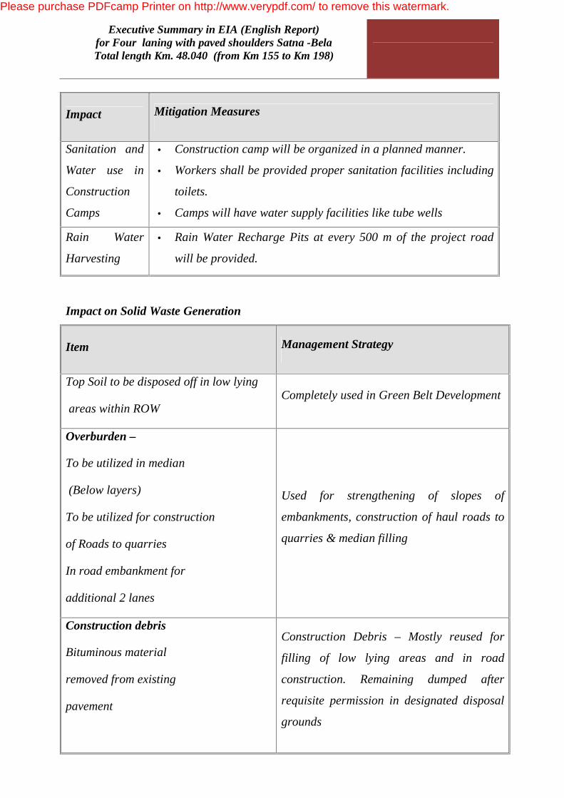
Sanitation and
Water use in
Construction
Camps
• Construction camp will be organized in a planned manner.
• Workers shall be provided proper sanitation facilities including
toilets.
• Camps will have water supply facilities like tube wells
Rain Water
Harvesting
• Rain Water Recharge Pits at every 500 m of the project road
will be provided.
Impact on Solid Waste Generation
Item Management Strategy
Top Soil to be disposed off in low lying
areas within ROW Completely used in Green Belt Development
Overburden –
To be utilized in median
(Below layers)
To be utilized for construction
of Roads to quarries
In road embankment for
additional 2 lanes
Used for strengthening of slopes of
embankments, construction of haul roads to
quarries & median filling
Construction debris
Bituminous material
removed from existing
pavement
Construction Debris – Mostly reused for
filling of low lying areas and in road
construction. Remaining dumped after
requisite permission in designated disposal
grounds
Please purchase PDFcamp Printer on http://www.verypdf.com/ to remove this watermark.
Executive Summary in EIA (English Report) for Four laning with paved shoulders Satna -Bela
Total length Km. 48.040 (from Km 155 to Km 198)
Item Management Strategy
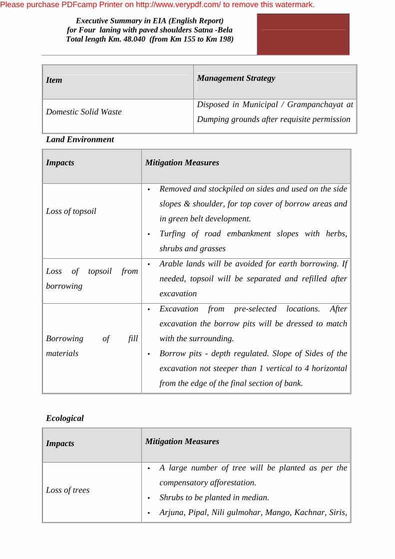
Domestic Solid Waste Disposed in Municipal / Grampanchayat at
Dumping grounds after requisite permission
Land Environment
Impacts Mitigation Measures
Loss of topsoil
• Removed and stockpiled on sides and used on the side
slopes & shoulder, for top cover of borrow areas and
in green belt development.
• Turfing of road embankment slopes with herbs,
shrubs and grasses
Loss of topsoil from
borrowing
• Arable lands will be avoided for earth borrowing. If
needed, topsoil will be separated and refilled after
excavation
Borrowing of fill
materials
• Excavation from pre-selected locations. After
excavation the borrow pits will be dressed to match
with the surrounding.
• Borrow pits - depth regulated. Slope of Sides of the
excavation not steeper than 1 vertical to 4 horizontal
from the edge of the final section of bank.
Ecological
Impacts Mitigation Measures
Loss of trees
• A large number of tree will be planted as per the
compensatory afforestation.
• Shrubs to be planted in median.
• Arjuna, Pipal, Nili gulmohar, Mango, Kachnar, Siris,
Please purchase PDFcamp Printer on http://www.verypdf.com/ to remove this watermark.

Executive Summary in EIA (English Report) for Four laning with paved shoulders Satna -Bela
Total length Km. 48.040 (from Km 155 to Km 198)
Neem are the predominant tree species along the
project corridor and same species will be planted
Please purchase PDFcamp Printer on http://www.verypdf.com/ to remove this watermark.
Executive Summary in EIA (English Report) for Four laning with paved shoulders Satna -Bela
Total length Km. 48.040 (from Km 155 to Km 198)
Public Health / Occupational Safety
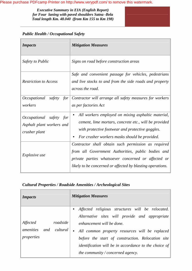
Impacts Mitigation Measures
Safety to Public Signs on road before construction areas
Restriction to Access
Safe and convenient passage for vehicles, pedestrians
and live stocks to and from the side roads and property
across the road.
Occupational safety for
workers
Contractor will arrange all safety measures for workers
as per factories Act
Occupational safety for
Asphalt plant workers and
crusher plant
• All workers employed on mixing asphaltic material,
cement, lime mortars, concrete etc., will be provided
with protective footwear and protective goggles.
• For crusher workers masks should be provided.
Explosive use
Contractor shall obtain such permission as required
from all Government Authorities, public bodies and
private parties whatsoever concerned or affected or
likely to be concerned or affected by blasting operations.
Cultural Properties / Roadside Amenities / Archeological Sites
Impacts Mitigation Measures
Affected roadside
amenities and cultural
properties
• Affected religious structures will be relocated.
Alternative sites will provide and appropriate
enhancement will be done.
• All common property resources will be replaced
before the start of construction. Relocation site
identification will be in accordance to the choice of
the community / concerned agency.
Please purchase PDFcamp Printer on http://www.verypdf.com/ to remove this watermark.

Executive Summary in EIA (English Report) for Four laning with paved shoulders Satna -Bela
Total length Km. 48.040 (from Km 155 to Km 198)
Please purchase PDFcamp Printer on http://www.verypdf.com/ to remove this watermark.

Executive Summary in EIA (English Report) for Four laning with paved shoulders Satna -Bela
Total length Km. 48.040 (from Km 155 to Km 198)
Project Benefit
Implementation of the Project will have following benefit:
1. Accelerate regional economic development in term of industry, tourism and
agriculture
2. Reduce vehicle operating and maintenance costs by improving road conditions
3. Reduce vehicle travel time by minimizing congestion in settlement areas and
providing a four lane facility
4. Minimize road accidents by increasing road width, improving intersection and
road geometry
5. The project may also generate local employment opportunities through the
construction activities and local business
6. Abatement of ambient air and noise pollution in comparison to a do- nothing
situation
7. Increase in safety due to construction of median between two direction of traffic
flow and plantation of shrub in median
8. Provision of pedestrian and cattle underpasses shall provide safe movement from
one side of the project road to other side of the Project road
9. Project facilities included in the project preparation are Rest Area , Bus Bays,
Truck Lay Bye, Road Side Furniture, Street lighting, Traffic Aid Post Patrolling,
Medical Aid post, vehicles Resource posts etc.
10. Main benefit of the construction of 4-Lane with paved shoulder ,easy movement of
traffic ,easy movement of forest officials in forest and surrounding area.
11. After construction of 4-Lane tourist will go to Jaipur and other states.
Please purchase PDFcamp Printer on http://www.verypdf.com/ to remove this watermark.
Executive Summary in EIA (English Report) for Four laning with paved shoulders Satna -Bela
Total length Km. 48.040 (from Km 155 to Km 198)
ENVIRONMENTAL
Please purchase PDFcamp Printer on http://www.verypdf.com/ to remove this watermark.
Executive Summary in EIA (English Report) for Four laning with paved shoulders Satna -Bela
Total length Km. 48.040 (from Km 155 to Km 198)
Environmental Management Plan
Several mitigation measures have been suggested along with the agency responsible
for planning, execution, supervision and monitoring of the Environmental
Management Plan for pre- construction , construction and operation stages to avoid
or mitigation the adverse impacts.
Pre- Construction Phase
Pre-construction activities include acquisition of land and structure, relocation of
utilities, removal of trees, and relocation of common property resources viz. temple,
hand pump, obtaining Environmental clearance Forest Clearance and wildlife
clearance from MoEF, Consent to Establish from MPPCB etc.
Construction Phase
Concessionaire activities during this phase include setting up of construction Camp,
setting up of plants namely crusher plant, concrete batching plant, hot mix plant;
clearing and grubbing, collection storage and utilization of topsoil, identification of
borrow pit & aggregated quarry (if other than those identified by design consultant),
operation of the quarry, plantation along the road side & at median, environmental
protection & monitoring. Concessionaire shall also be responsible for implementation
of the Environmental protection measures during construction’s The Independent
Engineer shall be responsible for monitoring & supervision of the Concessionaire’s
activities as per Contract & report it to PIU, MPRDC time to time. Project
implementation Unit (PIU), MPRDC shall be regulatory compliance.
Operation Phase
Operation phase activities include environmental monitoring of survival rate of the
plantation etc. The PIU and Concessionaire shall be responsible for those activities.
Please purchase PDFcamp Printer on http://www.verypdf.com/ to remove this watermark.

Executive Summary in EIA (English Report) for Four laning with paved shoulders Satna -Bela
Total length Km. 48.040 (from Km 155 to Km 198)
Y
Please purchase PDFcamp Printer on http://www.verypdf.com/ to remove this watermark.
Executive Summary in EIA (English Report) for Four laning with paved shoulders Satna -Bela
Total length Km. 48.040 (from Km 155 to Km 198)
Corporate Social Responsibility
The project proponent will generate direct as well as indirect employment facilities in
the nearby areas and also determined to provide clean and green environment. The
widening of project demands more manpower for its operation. This already
generates basic needs. This will generate opportunity for indirect employment, basic
commodity, dhabas, road side shops & many other facilities in the junction areas as
transportation will increase. This will boost the size of existing market. Villagers have
opportunity to sell their commodities to nearby area only. This will also boost the
consumption for opening new fast food corner.
The proponent will provide all socio economic growth opportunity for its workers and
villagers. This will boost the demand of skilled and unskilled worker. The villagers
have opportunity to work in road area when there is slack period in harvesting.
Employment
The most benefit due to the proposed road project will be in the sphere of generating
employment for a large number of people in that area during construction period. The
project activities will lead to generation of commercial activities in construction as
well as service sector. These activities will generate huge employment potential which
will benefit local population.
Transportation
There will also be increase in the vehicular traffic due to passenger transport. This
increase in traffic will not have any consequence to warrant special mention. One
should expect that the increased passenger load in the sector would prompt the state
government to start new and frequent public transport services to this area, bringing
upliftment to the whole locality.
Please purchase PDFcamp Printer on http://www.verypdf.com/ to remove this watermark.
Executive Summary in EIA (English Report) for Four laning with paved shoulders Satna -Bela
Total length Km. 48.040 (from Km 155 to Km 198)
Other Benefits
Besides faster connectivity and commercial, economic upsurge, the project will
provide:
• More Plantation and Greenery.
• Highways accident hazards considerably reduced by four laning.
• Medical aid available across the highway.
• More safety of users assured through curve improvements, reconstruction of
bridges, crash barriers, roadside furniture.
• Substantial Saving in vehicle operation cost & less pollution.
• Creation of beautiful Water Bodies.
• Economic upliftment due to faster, better accessibility & saving in vehicle
operation cost.
Please purchase PDFcamp Printer on http://www.verypdf.com/ to remove this watermark.

Executive Summary in EIA (English Report) for Four laning with paved shoulders Satna -Bela
Total length Km. 48.040 (from Km 155 to Km 198)
SUMMARY &
Please purchase PDFcamp Printer on http://www.verypdf.com/ to remove this watermark.

Executive Summary in EIA (English Report) for Four laning with paved shoulders Satna -Bela
Total length Km. 48.040 (from Km 155 to Km 198)
The location of the project site selected based on its Traffic Volume, socio, techno
economical suitability. As a positive impact the entire socio economical status of the
region will be improved to the better level. The potential environmental, social and
economic impacts have been assessed. The proposed project has certain level of
marginal impacts on the local environment. With effective implementation of proposed
environment management plan, these effects will be insignificant. Implementation of
the project has beneficial impact in terms of providing direct and indirect employment
opportunities. This will be a positive socio-economic development in the region.
Quality of life of the people will improve.
The improvement of this highway will provide the following technological benefits
ü Providing better level of service in terms of improved riding quality and smooth
traffic flow.
ü Faster transportation will ultimately lead to massive savings in the form of
reduced wear & tear vehicles, reduced vehicles operating costs and total reduction
in transportation costs etc.
ü With the improvement of road surface, the traffic congestion due to obstructed
movements of vehicles will be minimized and thus wastage of fuel emissions from
vehicles will be reduced.
ü Introduction of additional safety measures like crash barrier, road illumination,
retro-eflective signage, delineators etc. will result in lesser accident.
Socio economic benefits
The improvement of this highway will provide the following socio economic benefits to
the regions:
Ø It will increase access of the villages and other small settlements to urban areas,
thus providing connectivity of rural produce to urban markets, there by enhancing
the reach and export of perishable farm-products, leading to better remuneration
for the producer.
Ø By reducing the transportation costs, it will be more feasible to transfer
construction materials which are important for many economic activities (house
Please purchase PDFcamp Printer on http://www.verypdf.com/ to remove this watermark.

Executive Summary in EIA (English Report) for Four laning with paved shoulders Satna -Bela
Total length Km. 48.040 (from Km 155 to Km 198)
building, small hydro-electric projects etc.) to hinterland. This will in turn, lead to
direct as well as indirect strenthing of local economics.
Ø Access to social infrastructure like schools, colleges, health centers will improve,
providing many benefits from increased education and health facilities and
improved social interaction and mobility.
Ø During the execution of the project i.e. during the construction period, employment
will be provided to workers from the local communities.
Ø The educated as well as uneducated people from villages will obtain access new
employment centers.
Ø The improvement of the road will prevent single vehicle collision as the road will
be two lanes to Four lane with paved shoulders. This would be very beneficial
from the safety point of view and will thus, reduce accident rate. The proposed
project will attract more & more domestic & international tourists. Thus tourism
is likely to flourish.
Ø Overall improved quality of life for the lesser developed areas in the
neighborhood.
Please purchase PDFcamp Printer on http://www.verypdf.com/ to remove this watermark.
Executive Summary in EIA (English Report) for Four laning with paved shoulders Satna -Bela
Total length Km. 48.040 (from Km 155 to Km 198)
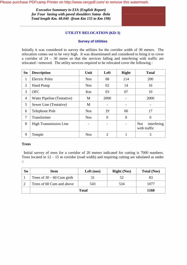
UTILITY RELOCATION (KD-3)
Survey of Utilities Initially it was considered to survey the utilities for the corridor width of 30 meters. The relocation comes out to be very high. It was disseminated and considered to bring it to cover a corridor of 24 – 30 metre so that the services falling and interfering with traffic are relocated / removed. The utility services required to be relocated cover the following : Sn Description Unit Left Right Total
1 Electric Poles Nos 68 114 200
2 Hand Pump Nos 02 14 16
3 OFC Km 03 07 10
4 Water Pipeline (Tentative) M 2000 - 2000
5 Sewer Line (Tentative) M - - -
6 Telephone Pole Nos 19 06 17
7 Transformer Nos 0 0 0
8 High Transmission Line - - - Not interfering with traffic
9 Temple Nos 2 1 3 Trees Initial survey of trees for a corridor of 20 meters indicated for cutting is 7000 numbers. Trees located in 12 – 15 m corridor (road width) and requiring cutting are tabulated as under ::
Sn Item Left (nos) Right (Nos) Total (Nos)
1 Trees of 30 – 60 Cum girth 31 52 83
2 Trees of 60 Cum and above 543 534 1077
Total 1160
Please purchase PDFcamp Printer on http://www.verypdf.com/ to remove this watermark.