derivation of instantaneous unit hydrograph for a sub
TRANSCRIPT
Journal of Spatial Hydrology Journal of Spatial Hydrology
Volume 10 Number 1 Article 1
2010
Derivation of Instantaneous Unit Hydrograph for a sub-basin using Derivation of Instantaneous Unit Hydrograph for a sub-basin using
Linear Geomorphological Model and Geographic Information Linear Geomorphological Model and Geographic Information
Systems Systems
Follow this and additional works at: https://scholarsarchive.byu.edu/josh
BYU ScholarsArchive Citation BYU ScholarsArchive Citation (2010) "Derivation of Instantaneous Unit Hydrograph for a sub-basin using Linear Geomorphological Model and Geographic Information Systems," Journal of Spatial Hydrology: Vol. 10 : No. 1 , Article 1. Available at: https://scholarsarchive.byu.edu/josh/vol10/iss1/1
This Article is brought to you for free and open access by the Journals at BYU ScholarsArchive. It has been accepted for inclusion in Journal of Spatial Hydrology by an authorized editor of BYU ScholarsArchive. For more information, please contact [email protected], [email protected].

Journal of Spatial Hydrology Vol.10, No.1 Spring 2010
1,2,3 Centre for Water Resources, Anna University Chennai, Chennai, India – 600025.
Derivation of Instantaneous Unit Hydrograph for a sub-basin using Linear Geomorphological Model and Geographic Information
Systems
R. Sudharsanan1, M. Krishnaveni2, and K. Karunakaran3 ABSTRACT Rainfall is converted into runoff and reaches the river and it becomes river flow. Geomorphological Instantaneous Unit Hydrograph (GIUH) based approach, which uses the geomorphologic parameters, is used to simulate basin runoff. Compilation of the required database consists of various geomorphic and other hydrologic characteristics used by the GIUH model is facilitated using Geographical Information System (GIS). The main aim of this study is develop 1-Hr Unit Hydrograph (UH) from the GIUH using Linear Geomorphological Model (LGM) with the help of GIS. Valliyar is one of the sub basins of Kodaiyar River Basin in Tamil Nadu, India. Valliyar is 5th order stream. Sixteen possible paths are identified for stream order 5 and block diagram for each path is prepared. The overland region for each path is delineated and measured with the help of GIS. GIUH is developed for 15 minutes time step using probability density function. Lagging the GIUH, 1-Hr Unit Hydrograph (UH) is prepared. Key Words: GIS, Linear Geomorphological Model (LGM), GIUH INTRODUCTION Water is a basic necessity for sustaining the life and development of society. The total quantum of water available is almost constant. Proper management, protection and exploitation of the water resources are the challenges imposed by the population growth. Combination of the Geographical Information System (GIS) and mathematical models provide a convenient platform for handling, compiling and presenting large amounts of spatial & attribute data essential in achieving the solution to water resources challenges. Rainfall, which is falling in the overland region, is converted into runoff and reaches the river and it becomes river flow. The geomorphological parameters of the over land region, where the rainfall is falling, plays a vital roll the quantity of runoff in the river. The main aim of this study is to develop Geomorphological Instantaneous Unit Hydrograph (GIUH) that can be used to estimate runoff at the outlet of river. The geomorphologic characteristics of a basin can easily be derived using a GIS. The paper maps, primary and secondary data are used as input to a GIS. GIS provide a digital representation of watershed characteristics, used in hydrological modeling. GEOMORPHOLOGICAL INSTANTANEOUS UNIT HYDROGRAPH (GIUH) Rainfall occurring in the overland regions is converted into runoff, which is transmitted through streams and after joining it reaches sub basin outlet. The quantity and its time
Sudharsanan et.al / JOSH 2010 (10)30-40
distribution of runoff are depending on topography of falling surface (overland region) as well as the transmission surface (channels). GIUH, which uses the Geomorphological parameters, is used to simulate sub basin runoff, which is a physically based method. The derivation of GIUH, while incorporating the fundamental concepts of linearity and time invariance, is based on Horton’s geomorphic laws of stream order of the sub basin and can be interpreted as the probability density function of the travel time to the sub basin outlet of a drop of water landing anywhere in the sub basin. The modeling of the rainfall runoff process is accomplished using a physically based approach referred to as the GIUH by Rodriguez-Iturbe and Valdes (1979) and Valdes et al (1979). Chandramohan T. et al (2002) carried out the rainfall-Runoff modeling based on GIUH approach in a GIS environment. The model simulated the rainfall-runoff events for the study area quite accurately. The utility of GIS in hydrologic modeling is demonstrated using two sub basins by Nageshwar R. et al (1992). The channel network and the overland regions in a river basin satisfy Horton’s geomorphological laws. This setting was presently employed in a kinetic theory of framework for obtaining an explicit mathematical representation for Instantaneous Unit Hydrograph (IUH) at the outlet of three basins of Illionis by Guptha et al (1980). The basins are represented in terms of linear reservoirs and channels. The theory provided excellent agreement for two basins. Sanjay K. Jain et al (1997) derived the IUH using geomorphologic characteristics of the basin was used. For each storm event IUH is used to convert rainfall into runoff. The objective of this study is developing the GIUH using Linear Geomorphological Model (LGM) using GIS for higher Stream Order Rivers. Further the GIUH is used to derive the 1-Hr Unit Hydrograph (UH) for that particular sub basin to assess the runoff generating from the sub basin. MORPHOMETRIC PROPERTY - STREAM ORDER The Geomorphological approach is chosen to estimate the runoff from the sub basin. Hence, Stream Order, the basic morphometric property of the study basin was analyzed for conformity of sub basin to the laws of drainage composition. The streams are ordered after Strahler’s (1952) adaptation of the Horton (1945) scheme of classification. In this system, channel segments were ordered numerically from a stream’s headwaters to a point somewhere down stream. Small fingertip tributaries at the stream’s headwaters are designated as order 1. Two first-order streams unite to form a second-order segment. The master stream is always a segment of highest order. A basin is designated as of the same order as the master-stream segment. METHODOLOGY First of all, base map of the study area is created in GIS. The ordering of streams is carried out and stream order of the sub basin is calculated. Based on the stream order the network diagram of sub basin is developed. The corresponding route area diagram for each stream order is delineated using GIS and the respective area and length of streams are determined. These values are used to for the parameter estimation. Finally, the GIUH and 1-Hr UH for the sub basin is developed. The flow chart of methodology for the derivation of GIUH for a sub basin using GIS adopted in this study is presented in Figure 1.
Journal of Spatial Hydrology 31

Sudharsanan et.al / JOSH 2010 (10)30-40
Figure 1. Flow Sheet for derivation of IUH using LGM
Stream Ordering
Overland & Channel Routes identification
Conceptualization of Watershed Block Diagram
Route - Area Diagram
Lag Time Parameter Estimation (K & C)
Development of GIUH
Development of 1-Hr UH
GIS
THE LINEAR GEOMORPHOLOGICAL MODEL (LGM) Rodriguez-Iturbe and Valdes (1979) developed an approach for derivation of the Instantaneous Unit Hydrograph (IUH) by explicitly incorporating the characteristics of drainage composition. The approach coupled the empirical laws of geomorphology with the principles of linear hydrologic systems. Gupta et al (1980) examined this approach, and reformulated, simplified and made it more general and even more elegant. Its assumptions, limitations, and potential for application to synthesis of direct runoff from un-gauged sub basins become more apparent. A sub basin is of a fixed order W. It consists channels C1, C2, .. CW, where Ci denotes the ‘i ’th order of stream. The sub basin network is ordered according to the Strahler-Horton ordering scheme. The time taken by water to travel to the sub basin outlet depends upon the position where the travel is initiated and the path it follows. In a basin there can be an infinite number of paths of travel, which are carved by topographic slope configuration and channel network. Conceptualization of Sub Basin The development of conceptual block diagram, comprising overland flow regions and channels to recognize the various flow paths that exist in the sub basin is done. The sub basin is represented by a parallel arrangement of cascades each represents a particular path. Based on the geomorphic laws stated in Singh and Aminian (1985), these block diagrams give the maximum number of possible flow paths in any sub basin. The actual path is observed to be the same as the maximum number of possible flow paths in all the sub basins in the study area. A sub basin surface is comprised of overland regions and channels. The raindrops fall and start their journey on the overland regions and travel through the channel network to their destination at the sub basin outlet. Let Ai the overland regions be assigned the
Journal of Spatial Hydrology 32

Sudharsanan et.al / JOSH 2010 (10)30-40
same order as the channels to which they directly contribute. Let ri be the overland region of order ‘i’. The travel path of raindrop follows the following rules, which defines a collection of paths that water can take from the start of its journey to the sub basin outlet. Rule 1: The only possible route from the overland region ri is to the channel Ci, 1≤ i ≤W. Rule 2: The only possible route from the channel Ci is to the channel Cj, j > i, 1≤ i ≤W. Rule 3: The only possible route from the channel CW is the sub basin outlet. The number of possible paths (N) (Rodriguez-Iturbe and Valdes, 1979) for a particular stream order is given by,
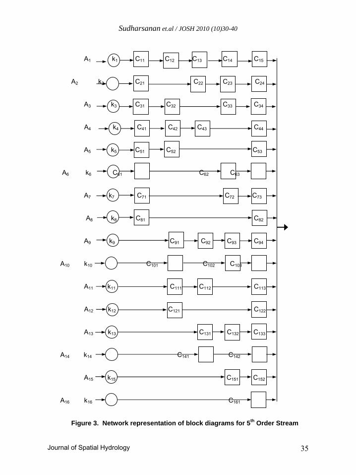
N = 2(W - 1). ---------------- (1) For example, if, the stream order of the basin is equal to five, i.e. W = 5. Therefore, the number of possible paths N = 16. They are as follows: The 16 possible paths were shown in Figure 2. Network Representation of Sub Basin Flow paths specify the spatial evolution of rainwater through a geomorphologic network of channels and overland regions and the time of travel depends upon its composition. A path is composed of one overland region and one or more channels. Computing travel times of its overland region and channels and then summing them up can specify the travel time of a path. The transformation of rainfall to runoff from the overland region, depends on its characteristics, are lumped as area. Similarly, transmission of overland flow through channels downstream depends upon channel characteristics are combined through the length. An overland region and a channel are represented by linear reservoir of lag times ‘K ’ & ‘C ’ (Rodriguez-Iturbe and Valdes, 1979). The lag time of an element is an average of the lag times of the portions of the actual sub basin. This averaging reduces the number of parameters needed to define the cascade arrangement. The network representation of block diagrams for 5th Order Stream is given in Figure 3. Ki = 0.875 (Ai)
0.3 ------------------------- (2) Ci = 0.875 (Li)
0.3 ------------------------- (3) Where, Ai – Overland route area, km2; and Li – Average Channel length, km Development of IUH
The IUH of this model (Rodriguez-Iturbe and Valdes, 1979) is expressed as,
N 1 h(t) = (1/A) ∑ -------------------------------- δ(t) Ai ----------- (4) i=1 (1 + KiD) ∏ (1+CijD)
Where, D–Differential Operator; Ki–Overland flow lag time, hr; Cij–Channel flow lag time, hr; A–Total sub basin area, km2; Ai –Overland area of route i, km2.
Journal of Spatial Hydrology 33

Sudharsanan et.al / JOSH 2010 (10)30-40
C4C3C2C1 C5 r1
C4C3C1 C5 r1
C4 C5 C2C1 r1 C3 C5 C2C1 r1 C2C1 C5 r1
C3 C5 C1 r1 C4 C5 C1 r1
C1 C5 r1
C5 r2 C3 C4C2
C5 r2 C2 C3 C4 C5 C2r2
r2 C2 C5
r3 C3 C5
r3 C3 C4 C5
r4 C5 C4
C5 r5
Figure 2. Various possible path of flow for 5th order stream
Journal of Spatial Hydrology 34
Sudharsanan et.al / JOSH 2010 (10)30-40
A1 k1 C11 C12 C13 C14 C15
A2 k2 C21 C22 C23 C24
A3 k3 C31 C32 C33 C34
A4 k4 C41 C42 C43 C44
A5 k5 C51 C52 C53
A6 k6 C61 C62 C63
A7 k7 C71 C72 C73
A8 k8 C81 C82
A9 k9 C91 C92 C93 C94
A10 k10 C101 C102 C103
A11 k11 C111 C112 C113
A12 k12 C121 C122
A13 k13 C131 C132 C133
A14 k14 C141 C142
A15 k15 C151 C152
A16 k16 C161
Figure 3. Network representation of block diagrams for 5th Order Stream
Journal of Spatial Hydrology 35

Sudharsanan et.al / JOSH 2010 (10)30-40
STUDY AREA Valliyar is one of the sub basin of Kodiayar River Basin. The Valliyar sub basin lies in the Southern most tip of Indian peninsula. It is located between latitude 8° 6’ N and 8° 18’ N and longitude 77° 14’E and 77° 22’E. The geographical area of Valliyar sub basin is 108 km2. The entire sub basin lies in Tamil Nadu state, India. It is surrounded by Kuzhithuraiyar Sub Basin in the Northern side, Arabian Sea in the Southern side, Pazhayar Sub Basin in the Eastern side, and Kuzhithuraiyar Sub Basin in the Western side. GIS DATA BASE A scientific database must be required to do the rainfall runoff modeling. The database consists of physical, meteorological, and hydraulic characters of basin. Both attribute and map data are collected and a GIS database was created using MapInfo Version 6.0 and Arc View 8.0. To create the GIS database sequence of operations such as scanning, geo-registration, digitizing, edge matching, rubber sheeting, data encoding, etc. are performed. The attribute tables required for the project are also compiled. The parameters required for LGM are obtained from the digital maps with the help of GIS. The drainage map of Valliyar sub basin was prepared from the 8 Survey of India Toposheets of 1:25000 scale by edge matching and rubber sheeting. The stream order diagram of Valliyar Sub Basin is prepared and is found to have 5th order stream. The Valliyar sub basin map with 5th order stream is given in Figure 4. ROUTE-AREA DIAGRAM The Route-Area diagram for Valliyar River, which is used determine the parameters used in LGM, created in GIS. First of all, the over land area of each stream length are delineated from stream order diagram. Area of each over land region responsible for each stream length and path are determined. The Route-Area diagram of Valliyar River is presented in Figure 5. RESULTS AND DISCUSSION
DEVELOPMENT OF INSTANTANEOUS UNIT HYDROGRAPH (IUH)
The lag time parameters were calculated from the overland region and channel length of each particular path. The area of overland region and length of channel are also calculated. Computed overland area and its lag time and channel lag time for each route were substituted in the IUH equation and summed up. A time step of 15 minutes is used to develop IUH ordinates. The resulting ordinates are plotted in order to get GIUH at the outlet of Valliyar River. The ordinates of GIUH are presented in Table 1 and the hydrograph is shown in Figure 5. The developed GIUH has base time of 26 hours and time to peak of 4 hours. The peak discharge of GIUH is 60.33 m3/sec. This shows that, the peak flow occurs in a shorter time period and longer recession time. Since the hydrograph was developed for the instantaneous duration of rainfall, Unit Hydrograph (UH) of any duration can be
Journal of Spatial Hydrology 36

Sudharsanan et.al / JOSH 2010 (10)30-40
developed from the developed GIUH. This will allow the user to choose the required duration of Unit Hydrograph based on the available data of the duration of rainfall.
Figure 4. Valliyar Sub Basin with Figure 5. Route-Area diagram Valliyar Sub Basin for 5th Order Stream
DERIVATION OF 1-HR UH FOR VALLIYAR SUB BASIN UH of any duration can be developed form the GIUH, a 1-Hr UH is developed from the already generated GIUH. The ordinate of developed IUH, first of all, is lagged by one hour. The average of ordinates of IUH & lagged IUH gives the ordinates for 1-Hr UH. A 15 minutes time step is used for calculating the ordinates of 1-Hr UH and the same is presented in Table 1. The ordinates are plotted to get 1-Hr UH for the Valliyar Sub Basin. The UH is presented in Figure 6. The UH has peak flow of 58.46 m3/sec with time to peak as 4.5 hours. The runoff generated from Valliyar can be calculated by multiplying the one hour rainfall excess with the UH ordinates. This will be very easy and useful for the users to do assessment and management of water resources with in the sub basin. CONCLUSION GIS is found to be a very effective and efficient tool in handling and analyzing the hydrological data required for the river basin modeling. The GIUH for Valliyar Sub Basin is developed using GIS. The spatial database and parameters required for the Linear Geomorphological Model (LGM) is derived from the developed GIS. The geomorphological laws for Valliyar sub basin were very well considered in this LGM
Journal of Spatial Hydrology 37

Sudharsanan et.al / JOSH 2010 (10)30-40
model Instantaneous Unit Hydrograph was developed at the outlet of Valliyar River. From the so developed IUH a 1-Hr UH for Valliyar sub basin is developed using GIUH in this study. This will allow the user to estimate the flow generated from the Valliyar sub basin with ease.
Table 1. Ordinates of GIUH and 24-Hr UH
Sl. No.
Time (hr)
GIUH (m3/sec)
UH (m3/sec)
Sl. No.
Time (hr)
GIUH (m3/sec)
UH (m3/sec)
Sl. No.
Time (hr)
GIUH (m3/sec)
UH (m3/sec)
1 0.00 0.00 0.00 36 8.75 16.37 20.18 71 17.50 0.30 0.39 2 0.25 0.00 0.00 37 9.00 14.81 18.34 72 17.75 0.26 0.35 3 0.50 0.00 0.00 38 9.25 13.38 16.63 73 18.00 0.23 0.30 4 0.75 0.00 0.00 39 9.50 12.07 15.06 74 18.25 0.20 0.27 5 1.00 0.00 0.00 40 9.75 10.87 13.62 75 18.50 0.18 0.24 6 1.25 0.00 0.00 41 10.00 9.78 12.29 76 18.75 0.16 0.21 7 1.50 0.00 0.00 42 10.25 8.79 11.08 77 19.00 0.14 0.19 8 1.75 0.00 0.00 43 10.50 7.89 9.98 78 19.25 0.12 0.16 9 2.00 7.45 3.72 44 10.75 7.07 8.97 79 19.50 0.11 0.15 10 2.25 23.05 11.53 45 11.00 6.34 8.06 80 19.75 0.10 0.13 11 2.50 35.24 17.62 46 11.25 5.67 7.23 81 20.00 0.08 0.11 12 2.75 44.48 22.24 47 11.50 5.07 6.48 82 20.25 0.08 0.10 13 3.00 51.20 29.33 48 11.75 4.53 5.80 83 20.50 0.07 0.09 14 3.25 55.82 39.44 49 12.00 4.04 5.19 84 20.75 0.06 0.08 15 3.50 58.67 46.96 50 12.25 3.61 4.64 85 21.00 0.05 0.07 16 3.75 60.08 52.28 51 12.50 3.22 4.15 86 21.25 0.04 0.06 17 4.00 60.33 55.77 52 12.75 2.87 3.70 87 21.50 0.04 0.05 18 4.25 59.65 57.73 53 13.00 2.56 3.30 88 21.75 0.04 0.05 19 4.50 58.24 58.46 54 13.25 2.28 2.94 89 22.00 0.03 0.04 20 4.75 56.28 58.18 55 13.50 2.02 2.62 90 22.25 0.03 0.04 21 5.00 53.91 57.12 56 13.75 1.80 2.33 91 22.50 0.03 0.03 22 5.25 51.26 55.46 57 14.00 1.60 2.08 92 22.75 0.02 0.03 23 5.50 48.44 53.34 58 14.25 1.42 1.85 93 23.00 0.02 0.03 24 5.75 45.51 50.89 59 14.50 1.26 1.64 94 23.25 0.02 0.02 25 6.00 42.54 48.23 60 14.75 1.12 1.46 95 23.50 0.02 0.02 26 6.25 39.60 45.43 61 15.00 0.99 1.29 96 23.75 0.01 0.02 27 6.50 36.72 42.58 62 15.25 0.88 1.15 97 24.00 0.01 0.02 28 6.75 33.92 39.71 63 15.50 0.78 1.02 98 24.25 0.01 0.01 29 7.00 31.24 36.89 64 15.75 0.69 0.90 99 24.50 0.01 0.01 30 7.25 28.69 34.14 65 16.00 0.61 0.80 100 24.75 0.01 0.01 31 7.50 26.27 31.49 66 16.25 0.54 0.71 101 25.00 0.01 0.01 32 7.75 23.99 28.96 67 16.50 0.48 0.63 102 25.25 0.01 0.01 33 8.00 21.87 26.55 68 16.75 0.43 0.56 103 25.50 0.01 0.01 34 8.25 19.89 24.29 69 17.00 0.38 0.49 104 25.75 0.01 0.01 35 8.50 18.06 22.17 70 17.25 0.33 0.44 105 26.00 0.00 0.00
Journal of Spatial Hydrology 38

Sudharsanan et.al / JOSH 2010 (10)30-40
0
5
10
15
20
25
30
35
40
45
50
55
60
65
0 3 6 9 12 15 18 21 24 27
Time (hr)
Ru
no
ff (
m3 /s
)
GIUH 1- hr UH
Figure 6. GIUH & 1-Hr UH for Valliyar sub basin
REFERENCES Chandramohan T., Venkatesh B. and Jain S.K. (2002), “Rainfall-Runoff modeling based on GIUH approach in a GIS environment”, IE(I) Journal, Vol 83, November 2002, pp 180-185. Gupta V.K., Waymire E., and Wang C.T. (1980), “A representation of an instantaneous unit hydrograph from geomorphology”, Water Resources Research, 16(6), pp 855-862. Institute for Water Studies (1999), “State Frame Work Water Resources Plan of Tamil Nadu, IWS Report No.1/99”, IWS, Taramani, Chennai-113. Institute for Water Studies – Annexure 16 (1996), “State Frame work Water Resource Plan - Annexure 16 – Kodaiyar River Basin”, IWS, Taramani , Chennai-113. Nageshwar R. Bhaskar, Wesley P. James, and Ravikumar S. (1992), “Hydrologic Parameter Estimation Using Geographic Information System”, Journal of Water Resources Planning and Management, September/October, 1992, pp 492-511. Rodriguez-Iturbe I. and Valdes J.B. (1979), “The geomorphologic structure of hydrologic response”, Water Resource Research, 1979, pp 1409-1420. Valdes J.B., Fiallo Y., and Rodriguez-Iturbe I., (1979), “A rainfall-runoff analysis of the geomorphologic IUH”, Water Resource Research, 1979, pp 1421-34.
Journal of Spatial Hydrology 39

Sudharsanan et.al / JOSH 2010 (10)30-40
Journal of Spatial Hydrology 40
Sanjay K. Jain, Hemant Chowdhary, Sobhagya M. Seth, and Rajesh K. Nema (1997),“Flood estimation using a GIUH based on a conceptual rainfall-runoff model and GIS”, ITC Journal, 1997, pp 20-25.
View publication statsView publication stats