deschutes national forest mountain bike trail...
TRANSCRIPT
APPENDIX A: Magnolia Trails EA -- Recreation Specialist Report
1
Deschutes National Forest – Mountain Bike Trail Standard – Tiered to FSH 2309.18 23.13 Bicycle Design Parameters:
Purpose and Need: This handbook supplement seeks to update current FSH guidance for Mountain Bike
(Bicycle) trails on the Deschutes National Forest in order to respond to changes in the activity brought
on by increasing demand and technological improvements. Many of the ideas put forward in this
supplement are based on the work of the Central Oregon Trails Alliance (COTA) and the experiences
collected by the International Mountain Bike Association (IMBA). See the Draft Mountain Bike White
Paper for more information.
Per the FSH 2309.18 14.1 Trail Type, the Deschutes National Forest Mountain Bike Standard applies to
the standard terra trail type for trails managed primarily for mountain biking under 23.13 Bicycle Design
parameters. Presently, guidance for Bicycle Design Parameters in the Trail Management Handbook says,
“Application considerations for Bicycle Design Parameters may be developed as determined necessary”
(FSH 2309.18, 23.13). This handbook supplement seeks to flesh out that additional information for
mountain bike trails and goes beyond bicycle specific design parameters to include added information
about trail class, difficulty, signing, optional trail feature (OTF) placement, fall zones, and signing
guidance. These elements may have additional guidance in other areas of the FSH and FSM. In those
cases, the reference number is included, but for the purposes of clarity all of these mountain bike
specific trail standards are grouped as a supplement to FSH 2309.18 23.13 Bicycle Design Parameters.
23.13 - Bicycle Design Parameters This trail standard applies to trails on the Deschutes National Forest with a Designed Use of Bicycle. For
more information on Designed Use see FSH 2309.18 14.4. This standard may also be used for trails with
an allowed use of Bicycle as an additional Managed Use of the trail. In fact, the primary intent is for this
handbook supplement to support a shared use trail system to accommodate the array of forest users as
appropriate, while also providing for a safe and enjoyable mountain bike user experience.
Bicycle Trail Class (FSH 2309.18, 14.2 Trail Class)
The Trail Class is the prescribed scale of development for a non-motorized trail, representing its
intended design and management standards found in the FSH at FSH 2309.18 14.2. The Bicycle Trail
Class is a design parameter that seeks to create general categories reflecting bicycle trail development
and level of visitor traffic to allow for a wide range of trails within the Recreational Opportunity
Spectrum.
This standard maintains the five Trail Classes which are:
1. Trail Class 1: Minimally Developed
2. Trail Class 2: Moderately Developed 3. Trail Class 3: Developed 4. Trail Class 4: Highly Developed 5. Trail Class 5: Fully Developed
APPENDIX A: Magnolia Trails EA -- Recreation Specialist Report
2
Use Trail Classes to inventory NFS trails and to identify the applicable Design Parameters and costs for
meeting the National Quality Standards for Trails.
1. Identify only one Trail Class per trail or trail segment. 2. Class descriptors reflect typical attributes of trails in each class. Local deviations from any Trail Class descriptor may be established based on trail-specific conditions, topography, or other factors, provided that the deviations are consistent with the general intent of the applicable Trail Class. 3. There is a direct relationship between Trail Class and Managed Uses (sec. 14.3): generally, one cannot be determined without consideration of the other. 4. Identify the appropriate Trail Class for each NFS trail or trail segment based on the management intent in the applicable land management plan, travel management decisions, trail-specific decisions, and other related direction. Apply the Trail Class that most closely reflects the management intent for the trail or trail segment, which may or may not reflect the current condition of the trail.
For specifics on each Trail Class, refer to the Bicycle Trail Class Matrix (Exhibit 01).
Trail Designation is a Trail Class descriptor unique to trails managed for Mountain Bikes. Each trail is
assigned one of three overriding Trail Designations, which is somewhat independent of Trail Class.
1. Traditional Single Track: This is the most restrictive Trail Designation. These trails are generally Trail Class 1 or 2 and should have few or no OTFs. Once a trail receives this designation, there should be no further proliferation of OTFs. Generally, routine maintenance should be completed without the aid of machines. There should be no constructed features other than bridges necessary for crossing water bodies or as needed for proper drainage or to mitigate soil erosion. Fasteners should only be uses for bridges, drainage, and signs. Dirt work should be minimized and constructed to appear consistent with the natural terrain or using historic trail building techniques.
2. Open Optional: All OTFs shall be alternate to the main tread. 3. Open Tread: These trails are constructed with some or all OTFs in the main tread and not
restricted to being an alternate line. OTFs in the main tread should be constructed with an alternate line around each feature or a grouping of features.
.
Bicycle Design Parameter and Trail Difficulty Ratings (FSH 2309.18, 22.3 -
Trail Class and Level of Challenge, FSM 2353.29 Difficulty Levels)
Trail Classes may generally reflect the level of recreational challenge provided by a trail, including the
corresponding level of user skill and experience needed to negotiate the trail. However, many factors
that influence difficulty are not dictated by Trail Class. This section is a supplement to the sections listed
in the above heading, which linked difficulty closely with trail class and design parameters. This
supplement describes these design parameters on the basis of difficulty, with a range of the trail classes
where combinations of difficulty and trail designation may occur. Difficulty ratings are based on the
degree of technical challenge presented by a trail, which depends on a combination of trail
characteristics, including trail grade, alignment, clearing width, tread conditions, gain or loss of

APPENDIX A: Magnolia Trails EA -- Recreation Specialist Report
3
elevation, placement of OTFs, and other criteria outlined in the Bicycle Design Parameters (sec. 23.13
Exhibit 02).
Per FSM 2353.29, difficulty ratings will be based on the managed or designed use of a trail, which in this
case is Bicycle. These ratings are to be used for direction in signs, maps, and brochures. On shared use
trails, it is particularly important to specify the type of Managed or Designed Use that the difficulty
ratings refer to.
Optional Trail Feature (OTF) Design Principles
There are two types of OTFs on system Mountain Bike Trails. Natural Trail Features (NTFs) are
constructed using native dirt, rocks, and logs. With the exception of an allowance to pin logs to the
ground using rebar, these features are constructed without fasteners. Technical Trail Features may be
constructed using dimensional lumber and fasteners. OTFs should be inspected during routine
maintenance to ensure serviceable condition until the next scheduled inspection. Inspections should be
recorded on TTF/NTF inspection sheets. Forest Service employees and volunteer trail stewardship
partners are encouraged to maintain and make these sheets available to land managers and other
interested parties for review upon request. OTFs that do not pass inspection should be immediately
closed until repaired, replaced or removed.
In most cases, both types of OTFs should include a qualifier at the entrance to the feature. A qualifier,
sometimes referred to as a gateway, is a narrow section or difficult turn at the beginning of the feature
close to the ground. Qualifiers are used to make the most challenging part of the OTF to encourage
inexperienced riders to dismount before attempting something beyond their skill level. Additionally, the
most difficult section of an OTF should be visible from the entrance to the feature, which will help riders
to make informed decisions about whether to attempt the OTF or take the alternate line. Height and
Width guidelines for OTFs can be found below in Exhibit 02 Modified Bicycle Design Parameters By
Difficulty Rating.
NTF Specific Design Principles
NTFs are constructed using available native materials including dirt, rocks, and logs. These features
should be placed alternate to the main tread on trails with the Open Optional Trail Designation and may
be in the main tread on Open Tread trails. Logs used in NTFs may be pinned to the ground using Rebar,
and when present the rebar should be buried 2” into the log. Log members may be joined without
fasteners using an interlocking technique, such as with a dovetail joint. When wood is used in an OTF,
the strength of the log spans should be tested with a centered vertical load of approximately 500
pounds. All rocks should also be placed so that they are solidly fixed to the ground and/or adjacent
rocks.
APPENDIX A: Magnolia Trails EA -- Recreation Specialist Report
4
TTF Specific Design Principles
Most TTFs over 16” in height must be engineered and approved by Forest Engineers prior to placement
on Deschutes National Forest System Trails. Exceptions are structures less than 16” in height built to
follow puncheon guidelines and structures built following the US Forest Service National Trail Drawings
and Specifications made available here by Region 6 of the Forest Service:
http://www.fs.fed.us/database/acad/dev/trails/trails.htm. TTFs may be designed and stamped by
professional trailbuilders and submitted to the Forest Service and will have to follow engineering
guidelines found in the FSM 7700 and associated sections of the FSH.
Fall Zone Guidelines
When OTFs are placed, inspected, and maintained, reasonable efforts should be made to assess the
surrounding fall zone. A fall zone is the area surrounding an OTF or the landing zone for a jump or drop,
which provides a clear landing for a rider who fails to negotiate the OTF. During routine maintenance,
Forest Service employees or volunteer partners should consider removing branches, stumps, logs, rocks,
and other protruding objects that could cause injury. The area of a fall zone differs by difficulty rating
and can be found in Exhibit 02 Modified Bicycle Design Parameters By Difficulty Rating.
Trail Construction and Trail Maintenance
New Bicycle Trail construction should be completed following other trail construction and maintenance
guidelines found in the FSH and Deschutes National Forest Policies, which include NEPA compliance and
the development of trail management objectives (TMOs). Maintenance and inspection priorities may be
set for each trail using trail management plans and MOUs with volunteer partners.
Risk Management and Sign Guidelines
For standards and guidelines on the use of signs and posters on trails, refer to the Sign and Poster
Guidelines for the Forest Service (EM-7100-15 Ch. 5 Trail Signing). Mountain Bike Trails on the Deschutes
National Forest use an existing signing hierarchy, which includes Trail Network Kiosks, Trail Junction
Signs, and Trail Advisory Signs. These signs can be placed to assist trail users with identifying trails to
meet their desired recreation experience and to match their skill level. Trail Network Kiosks generally
contain basic information concerning Mountain Bike use, trail etiquette, and safety. Safety messages can
include information on the inherent risks of mountain biking and entering a natural or forest
environment. Trail Junction signs can indicate the map locator number, the trail name, difficulty rating,
length, and the accepted or restricted users for a trail. Additionally, these signs may indicate the
quantity of higher difficulty OTFs present on the trail.
A Trail Advisory sign is a general category that can be used to alert users to a trail section increasing in
difficulty, road crossings, continuing segments of trails, accepted or restricted users, and specific risks or
hazards present on an upcoming section of trail. Trail Advisory signs should be placed prior to higher
difficulty OTFs alternate to the main tread. Signs should also be inspected for wear and tear and
vandalism during periodic routine maintenance.

APPENDIX A: Magnolia Trails EA -- Recreation Specialist Report
5
Volunteer Mountain Bike Trail Stewardship groups are encouraged to develop a risk management plan
for system trails inspected or maintained under an MOU or group volunteer agreement. Several
examples of risk management plans are available in the project file and the IMBA website.

APPENDIX A: Magnolia Trails EA -- Recreation Specialist Report
6
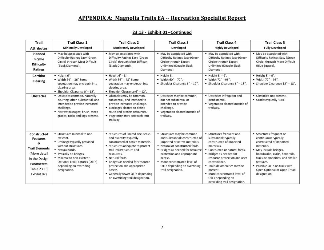
23.13- Exhibit 01
MOUNTAIN BIKE TRAIL CLASS MATRIX
The following table tiers to FSH 2309.18 14.2 Exhibit 01 Trail Class Matrix and will apply to trails managed primarily for bicycle use. Trail Classes are general categories reflecting trail development scale, arranged along a continuum.
The Trail Class identified for a National Forest System (NFS) trail prescribes its
development scale, representing its intended design and management standards.1 Local deviations from any Trail Class descriptor may be established based on
trail-specific conditions, topography, or other factors, provided that the deviations are consistent with the general intent of the applicable Trail Class. Identify the appropriate Trail Class for each NFS trail or trail segment based on the management intent in the applicable land management plan, travel management decisions, trail-specific decisions, and other related direction. Apply the Trail Class that most closely reflects the management intent for the trail or trail segment, which may or may not reflect the current condition of the trail.
Trail
Attributes
Trail Class 1 Minimally Developed
Trail Class 2 Moderately Developed
Trail Class 3 Developed
Trail Class 4 Highly Developed
Trail Class 5 Fully Developed
Overriding
Trail
Designations
Primarily Traditional Singletrack, may be Open Optional.
Primarily Traditional SingleTrack and Open Optional, may be Open Tread.
Primarily Open Optional and Open Tread, may be Traditional Singletrack.
Primarily Open Optional and may be Open Tread.
Primarily Open Optional and may be Open Tread.
Tread
&Traffic Flow:
Planning,
Construction,
&
Maintenance
Tread intermittent and often indistinct.
May require route finding. Single lane, with no
allowances constructed for passing.
Predominantly native materials.
Hand built.
Tread continuous and discernible as traditional singletrack, but may be narrow and rough.
Tread Width 12”–18”. Single lane, with minor
allowances constructed for passing where applicable.
Possible Use of one way designation to improve traffic flow.
Typically native materials. Generally hand built, but where
machine built reduced to an appropriate width.
Tread continuous and obvious. Tread width 12”–18”. Singletrack, with possible
allowances constructed for passing where required by traffic volume in places where there is no reasonable opportunity to pass.
Possible use of one way designation to improve traffic flow.
Native or imported materials. May be machine built.
Tread wide and relatively smooth, and remove all embedded trail obstacles.
Tread width 3’ for singletrack and 6’–10’ for double-track.
Singletrack, with allowances constructed for passing where required by traffic volume in places where there is no reasonable opportunity to pass.
Double-track where traffic volume is high and passing is frequent.
Native or imported materials, and may be hardened.
Machine built and may be possible to use existing decommisioned road beds, crushed gravel with fines, or well compacted gravel.
May be hardened
Tread wide, firm, stable, and generally uniform, and remove all embedded trail obstacles.
Tread width 10’–20’ for double track with improved surface.
Machine built and commonly hardened with asphalt or other imported material, crushed gravel with fines, or well compacted gravel.
APPENDIX A: Magnolia Trails EA -- Recreation Specialist Report
7
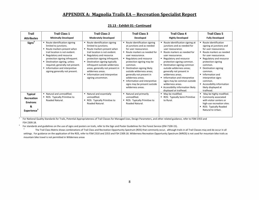
23.13 - Exhibit 01--Continued
Trail
Attributes
Trail Class 1 Minimally Developed
Trail Class 2 Moderately Developed
Trail Class 3 Developed
Trail Class 4 Highly Developed
Trail Class 5 Fully Developed
Planned
Bicycle
Difficulty
Ratings
May be associated with Difficulty Ratings Easy (Green Circle) through Most Difficult (Black Diamond).
May be associated with Difficulty Ratings Easy (Green Circle) through Most Difficult (Black Diamond).
May be associated with Difficulty Ratings Easy (Green Circle) through Expert Unlimited (Double Black Diamond).
May be associated with Difficulty Ratings Easy (Green Circle) through Expert Unlimited (Double Black Diamond).
May be associated with Difficulty Ratings Easy (Green Circle) through More Difficult (Blue Square).
Corridor
Clearing
Height 6’. Width 24” – 36” Some
vegetation may encroach into clearing area.
Shoulder Clearance 0’ – 12”.
Height 6’ – 8’. Width 36” – 48” Some
vegetation may encroach into clearing area.
Shoulder Clearance 6” – 12”.
Height 8’. Width 60” – 72”. Shoulder Clearance 6” – 12”.
Height 8’ – 9’. Width 72” – 96”. Shoulder Clearance 6” – 18”.
Height 8’ – 9’. Width 72” – 96”. Shoulder Clearance 12” – 18”.
Obstacles Obstacles common, naturally ocurring, often substantial, and intended to provide increased challenge.
Narrow passages; brush, steep grades, rocks and logs present.
Obstacles may be common, substantial, and intended to provide increased challenge.
Blockages cleared to define route and protect resources.
Vegetation may encroach into trailway.
Obstacles may be common, but not substantial or intended to provide challenge.
Vegetation cleared outside of trailway.
Obstacles infrequent and insubstantial.
Vegetation cleared outside of trailway.
Obstacled not present. Grades typically < 8%.
Constructed Features
&
Trail Elements
(More detail
in the Design
Parameters
Table 23.13
Exhibit 02)
Structures minimal to non-existent.
Drainage typically provided without structures.
Natural fords. Typically no bridges. Minimal to non-existent
Optional Trail Features (OTFs) depending on overriding designation.
Structures of limited size, scale, and quantity; typically constructed of native materials.
Structures adequate to protect trail infrastructure and resources.
Natural fords. Bridges as needed for resource
protection and appropriate access.
Generally fewer OTFs depending on overriding trail designation.
Structures may be common and substantial; constructed of imported or native materials.
Natural or constructed fords. Bridges as needed for resource
protection and appropriate access.
More concentrated level of OTFs depending on overriding trail designation.
Structures frequent and substantial; typically constructed of imported materials.
Contructed or natural fords. Bridges as needed for
resource protection and user convenience.
Trailside amenities may be present.
More concentrated level of OTFs depending on overriding trail designation.
Structures frequent or continuous; typically constructed of imported materials.
May include bridges, boardwalks, curbs, handrails, trailside amenities, and similar features.
Possible OTFs on trails with Open Optional or Open Tread designation.
APPENDIX A: Magnolia Trails EA -- Recreation Specialist Report
8
23.13 - Exhibit 01--Continued
Trail
Attributes
Trail Class 1 Minimally Developed
Trail Class 2 Moderately Developed
Trail Class 3 Developed
Trail Class 4 Highly Developed
Trail Class 5 Fully Developed
Signs2 Route identification signing
limited to junctions. Route markers present when
trail location is not evident. Regulatory and resource
protection signing infrequent. Destination signing, unless
required, generally not present. Information and interpretive
signing generally not present.
Route identification signing limited to junctions.
Route markers present when trail location is not evident.
Regulatory and resource protection signing infrequent.
Destination signing typically infrequent outside wilderness areas; generally not present in wilderness areas.
Information and interpretive signing uncommon.
Route identification signing at junctions and as needed for user reassurance.
Route markers as needed for user reassurance.
Regulatory and resource protection signing may be common.
Destination signing likely outside wilderness areas; generally not present in wilderness areas.
Information and interpretive signs may be present outside wilderness areas.
Route identification signing at junctions and as needed for user reassurance.
Route markers as needed for user reassurance.
Regulatory and resource protection signing common.
Destination signing common outside wilderness areas; generally not present in wilderness areas.
Information and interpretive signs may be common outside wilderness areas.
Accessibility information likely displayed at trailhead.
Route identification signing at junctions and for user reassurance.
Route markers as needed for user reassurance.
Regulatory and resource protection signing common.
Destination signing common.
Information and interpretive signs common.
Accessibility information likely displayed at trailhead.
Typical
Recreation
Environs
&
Experience3
Natural and unmodified. ROS: Typically Primitive to
Roaded Natural.
Natural and essentially unmodified.
ROS: Typically Primitive to Roaded Natural.
Natural and primarily unmodified.
ROS: Typically Primitive to Roaded Natural.
May be modified. ROS: Typically Semi-Primitive
to Rural.
May be highly modified. Commonly associated
with visitor centers or high-use recreation sites.
ROS: Typically Roaded Natural to Urban.
1 For National Quality Standards for Trails, Potential Appropriateness of Trail Classes for Managed Uses, Design Parameters, and other related guidance, refer to FSM 2353 and
FSH 2309.18. 2 For standards and guidelines on the use of signs and posters on trails, refer to the Sign and Poster Guidelines for the Forest Service (EM-7100-15).
3 The Trail Class Matrix shows combinations of Trail Class and Recreation Opportunity Spectrum (ROS) that commonly occur, although trails in all Trail Classes may and do occur in all
settings. For guidance on the application of the ROS, refer to FSM 2310 and 2353 and FSH 2309.18. Wilderness Recreation Opportunity Spectrum (WROS) is not used for mountain bike trails as
mountain bike travel is not permitted in Wilderness areas
APPENDIX A: Magnolia Trails EA -- Recreation Specialist Report
9
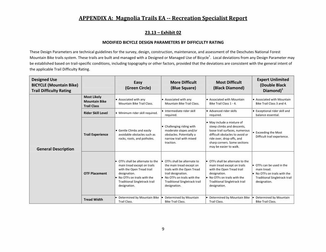
23.13 – Exhibit 02
MODIFIED BICYCLE DESIGN PARAMETERS BY DIFFICULTY RATING
These Design Parameters are technical guidelines for the survey, design, construction, maintenance, and assessment of the Deschutes National Forest
Mountain Bike trails system. These trails are built and managed with a Designed or Managed Use of Bicycle1. Local deviations from any Design Parameter may
be established based on trail-specific conditions, including topography or other factors, provided that the deviations are consistent with the general intent of
the applicable Trail Difficulty Rating.
Designed Use BICYCLE (Mountain Bike) Trail Difficulty Rating
Easy
(Green Circle) More Difficult (Blue Square)
Most Difficult (Black Diamond)
Expert Unlimited (Double Black
Diamond)1
General Description
Most Likely Mountain Bike Trail Class
Associated with any Mountain Bike Trail Class.
Associated with any Mountain Bike Trail Class.
Associated with Mountain Bike Trail Class 1 - 4.
Associated with Mountain Bike Trail Class 3 and 4.
Rider Skill Level Minimum rider skill required. Intermediate rider skill required.
Advanced rider skills required.
Exceptional rider skill and balance essential.
Trail Experience Gentle Climbs and easily avoidable obstacles such as rocks, roots, and potholes.
Challenging riding with moderate slopes and/or obstacles. Potentially a narrow trail with mixed traction.
May include a mixture of steep climbs and descents, loose trail surfaces, numerous difficult obstacles to avoid or ride over, drop-offs, and sharp corners. Some sections may be easier to walk.
Exceeding the Most Difficult trail experience.
OTF Placement
OTFs shall be alternate to the main tread except on trails with the Open Tread trail designation.
No OTFs on trails with the Traditional Singletrack trail designation.
OTFs shall be alternate to the main tread except on trails with the Open Tread trail designation.
No OTFs on trails with the Traditional Singletrack trail designation.
OTFs shall be alternate to the main tread except on trails with the Open Tread trail designation.
No OTFs on trails with the Traditional Singletrack trail designation.
OTFs can be used in the main tread.
No OTFs on trails with the Traditional Singletrack trail designation.
Tread Width Determined by Mountain Bike
Trail Class. Determined by Mountain
Bike Trail Class. Determined by Mountain Bike
Trail Class. Determined by Mountain
Bike Trail Class.

APPENDIX A: Magnolia Trails EA -- Recreation Specialist Report
10
23.13 – Exhibit 02--Continued
Designed Use BICYCLE (Mountain Bike) Trail Difficulty Rating
Easy
(Green Circle) More Difficult (Blue Square)
Most Difficult (Black Diamond)
Expert Unlimited (Double Black
Diamond)1
Design Surface2
Protrusions (may be ridable)
Maximum of 4”vertical.
Not continuous.
Logs and roots perpendicular to direction of travel (±20 degrees).
Maximum of 6” vertical.
May be continuous.
Maximum of 12” vertical.
May be continuous. Exceeding Most Difficult.
Obstructions (may be ridable)
Maximum of 8” vertical. Maximum of 12” vertical. Maximum of 24” vertical. Exceeding Most Difficult.
Design Turn Radius
6’ minimum. 4’ minimum. 2’ minimum. No minimum.
Design Grade
Target Grade Maximum sustained grade: 10%.
Maximum sustained grade: 15%.
Maximum sustained grade: 20%.
Exceeding Most Difficult.
Short Pitch Maximum Grade
Maximum climbing grade: 15% not to exceed 200’.
Maximum descending grade: 35% not to exceed 100’.
Maximum climbing grade: 20% not to exceed 200’.
Maximum descending grade: 70% not to exceed 100’.
Maximum climbing grade: 30% not to exceed 100’.
Maximum descending grade: 100% not to exceed 100’.
Exceeding Most Difficult.
Maximum Pitch Density
5% - 20% of trail. 10% - 30% of trail. 20% - 40% of trail. Exceeding Most Difficult.
Target Cross Slope
3
5% 5% 5% 5%
Design Clearing
Height Width Shoulder Clearance
Determined by Mountain Bike Trail Class.
Determined by Mountain Bike Trail Class.
Determined by Mountain Bike Trail Class.
Determined by Mountain Bike Trail Class.

APPENDIX A: Magnolia Trails EA -- Recreation Specialist Report
11
23.13 – Exhibit 02—Continued
Designed Use BICYCLE (Mountain Bike) Trail Difficulty Rating
Easy
(Green Circle) More Difficult (Blue Square)
Most Difficult (Black Diamond)
Expert Unlimited (Double Black
Diamond)1
General Optional Trail Feature (OTF)
Width to Height Ratio
OTF minimum width to height ratio of 1: 1.33.
OTF minimum width to height ratio of 1:2.
OTF minimum width to height ratio of 1:4.
No OTF minim ratio except a ratio of 1:4 for OTFs exceeding 6’.
Feature Experience
Wide, flat, low, rollable features.
Small features wide and rollable.
Elevated features.
Connected features may require wheel lifting techniques.
Steep descents with sharp transitions.
Elevated features.
Connected features.
Steep descents with sharp transitions.
Jumps and Drops No drops or jumps.
Small jumps.
Small rollable drops.
No Gap jumps.
Large double jumps.
Drop offs not to exceed 5’ vertical.
No Gap jumps.
Mandatory air – gap jumps.
Detailed Natural Trail Feature (NTF)
Basic Description
Log features less than 2’ high. Minimum width of flat tread is three quarters of the height.
For connected sections, the bisecting angle between each section must be large enough to allow a bicycle to complete a rollable turn.
Log features less than 4’ high. Minimum width of flat tread is one-half the height.
For connected sections, no wheel lifting techniques required.
Log features less than 6’ high. Minimum width of flat treat is one-quarter the height.
May require wheel lifting techniques to navigate.
Short sections may exceed criteria.
Log features less than 10’ high. Minimum width of flat tread is one-quarter the height.
May require wheel lifting techniques to navigate.
Many sections may exceed criteria.
Drops, Jumps, and Ramps
None.
Drop-offs not exceeding 16” high.
Rock or Dirt ramps not to exceed 100% grade and less than 50’.
Jumps: table top jumps maximum height 3’, no double jumps.
No jumps with consequences for lack of speed.
Drop-offs not exceeding 5’ vertical.
Steep Rock or Dirt ramps, no grade limit, less than 50’.
Jumps: table top jumps, no maximum height. Double jumps no maximum height.
Jumps must be rollable.
Drop-offs not exceeding 8’ vertical.
Steep Rock or dirt ramps, no grade limit.
Jumps exceeding Most Difficult.
Fall Zone 3’ from center line on all sides.
4’ from center line on all sides.
5’ from center line on all sides.
5’ from center line on all sides.

APPENDIX A: Magnolia Trails EA -- Recreation Specialist Report
12
23.13 – Exhibit 02—Continued
Designed Use BICYCLE (Mountain Bike) Trail Difficulty Rating
Easy
(Green Circle) More Difficult (Blue Square)
Most Difficult (Black Diamond)
Expert Unlimited (Double Black
Diamond)1
Detailed Technical Trail Feature (TTF)
Basic Description
Features less than 2’ high. Minimum width of flat decking is three-quarters the height.
For connected sections, the bisecting angle between each section must be large enough to allow a bicycle to complete a rollable turn.
Features less than 4’ high. Minimum width of decking is one-half the height.
For connected sections, no wheel lifting techniques required.
Features less than 6’ high. Minimum width of flat decking is one-quarter the height.
May require wheel lifting techniques to navigate.
Short sections may exceed criteria.
Features less than 10’ high. Minimum width of the flat tread is one-fifth the height for structures.
May require wheel lifting techniques to navigate.
Short sections may exceed criteria.
Drops, Jumps, and Ramps
None.
Drop-offs not exceeding 16” high.
Ramps not to exceed 100% grade and less than 50’.
Jumps: table top like jumps maximum height 3’, no double jumps.
No jumps with consequences for lack of speed.
Drop-offs not exceeding 5’ vertical.
Steep Ramps, no grade limit, less than 50’.
Jumps: table top like jumps, no maximum height. Double jumps no maximum height.
Jumps must be rollable.
Gap Jumps and rhythm sections.
Drop-offs not exceeding 8’ vertical.
Jumps exceeding Most Difficult.
Fall Zone 3’ from center line on all sides.
4’ from center line on all sides.
5’ from center line on all sides.
5’ from center line on all sides.
1
For definitions of Design Parameter attributes (e.g., Design Tread Width and Short Pitch Maximum), see FSH 2309.18, section 05. 2
This Difficulty Rating will not be found on US Forest Service system trails except in areas managed under a special use permit or through a special event permit. 3
The determination of the trail-specific Design grade, Design Surface, and other Design Parameters should be based upon soils, hydrological conditions, use levels, erosion
potential, and other factors contributing to surface stability and overall sustainability of the trail. 4 Cross slope, also called outslope, is the grade of the tread perpendicular to the flow of traffic on hillside trails, and should be barely noticeable