description and analysis of the debris flows occurred
TRANSCRIPT

Nat. Hazards Earth Syst. Sci., 10, 1635–1645, 2010www.nat-hazards-earth-syst-sci.net/10/1635/2010/doi:10.5194/nhess-10-1635-2010© Author(s) 2010. CC Attribution 3.0 License.
Natural Hazardsand Earth
System Sciences
Description and analysis of the debris flows occurred during 2008in the Eastern Pyrenees
M. Portilla 1,2, G. Chevalier1,3, and M. Hurlimann 1
1Department of Geotechnical Engineering and Geosciences, Technical University of Catalonia, Barcelona, Spain2Geosciences Department – Faculty of Sciences, National University of Colombia, Bogota, Colombia3Sediment Transport Research Group, Technical University of Catalonia, Catalonia, Barcelona
Received: 4 November 2009 – Revised: 26 April 2010 – Accepted: 12 May 2010 – Published: 30 July 2010
Abstract. Rainfall-triggered landslides taking place in theSpanish Eastern Pyrenees have usually been analysed on aregional scale. Most research focussed either on terrain sus-ceptibility or on the characteristics of the critical rainfall, ne-glecting a detailed analysis of individual events. In contrastto other mountainous regions, research on debris flow hasonly been performed marginally and associated hazard hasmostly been neglected.
In this study, five debris flows, which occurred in 2008,are selected; and site specific descriptions and analysis re-garding geology, morphology, rainfall data and runout wereperformed. The results are compared with worldwide dataand some conclusions on hazard assessment are presented.
The five events can be divided into two in-channel de-bris flows and three landslide-triggered debris flows. The in-channel generated debris flows exceeded 10 000 m3, whichare unusually large mass movements compared to historicevents which occurred in the Eastern Pyrenees. In contrast,the other events mobilised total volumes less than 2000 m3.The geomorphologic analysis showed that the studied eventsemphasize similar patterns when compared to published datafocussing on slope angle in the initiation zone or catchmentarea.
Rainfall data revealed that all debris flows were triggeredby high intensity-short duration rainstorms during the sum-mer season. Unfortunately, existing rainfall thresholds in theEastern Pyrenees consider long-lasting rainfall, usually oc-curring in autumn/winter. Therefore, new thresholds shouldbe established taking into account the rainfall peak intensityin mm/h, which seems to be a much more relevant factor forsummer than the event’s total precipitation.
Correspondence to:M. Portilla([email protected])
The runout analysis of the 2008 debris flows confirms thetrend that larger volumes generally induce higher mobility.The numerical simulation of the Riu Runer event shows thatits dynamic behaviour is well represented by Voellmy fluidrheology. A maximum front velocity of 7 m/s was back-analysed for the transit section and even on the fan velocitieslarger than 2 m/s were obtained.
This preliminary analysis of the major Eastern Pyreneandebris flows represents the first background for future stud-ies. Additional research on other events is necessary to sup-port the results presented herein, and to properly assess andreduce hazard related to debris flows.
1 Introduction
In the Eastern Pyrenees, shallow landslides and debris flowsare not as widely reported as in other mountainous catch-ments. However, they represent an important hazard thatshould be assessed. Until now, most of the descriptions oranalyses focus on shallow landslides and have been carriedout at regional scale, applying geographical information sys-tem (GIS) techniques (e.g. Baeza and Corominas, 2001; San-tacana et al., 2003), inventory data (Gallart and Clotet, 1988)or other types of models (Bathurst et al., 2006). Addition-ally, the majority of these studies focuses on failures trig-gered during the catastrophic 1982 rainstorm. All this showsthe lack of information and research on debris-flow initiation,flow behaviour and hazard in the Eastern Pyrenees. Onlyin the Principality of Andorra some analysis on debris-flowhazards has been carried out for urban planning purposes(Hurlimann et al., 2006).
During the summer of 2008, several mass movements oc-curred and caused important damages and economic lossesin infrastructures in the Eastern Pyrenees. Finally, five debris
Published by Copernicus Publications on behalf of the European Geosciences Union.
1636 M. Portilla et al.: Description and analysis of the debris flows in the Pyrenees
Figure 1: a) Location of the five debris flows, b) Mean annual precipitation (in mm) of Catalonia (Source: CAC). (A: Andreuet, F: Fontanals del Pui, PA. Portainé, RR: Riu Runer, SN: Sant Nicolau, ULLRB: Upper Llobregat River Basin)
Figure 1: a) Location of the five debris flows, b) Mean annual precipitation (in mm) of Catalonia (Source: CAC). (A: Andreuet, F: Fontanals del Pui, PA. Portainé, RR: Riu Runer, SN: Sant Nicolau, ULLRB: Upper Llobregat River Basin)
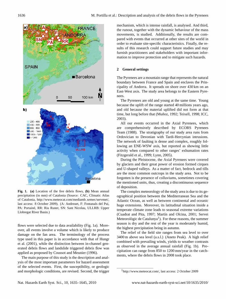
Fig. 1. (a) Location of the five debris flows,(b) Mean annualprecipitation (in mm) of Catalonia (Source: CAC, Climatic Atlasof Catalonia,http://www.meteocat.com/mediambxemec/servmet/,last access: 8 October 2009). (A: Andreuet, F: Fontanals del Pui,PA: Portaine, RR: Riu Runer, SN: Sant Nicolau, ULLRB: UpperLlobregat River Basin.)
flows were selected due to data availability (Fig. 1a). More-over, all events involve a volume which is likely to producedamage on the fan area. The terminology of the processtype used in this paper is in accordance with that of Hungret al. (2001), while the distinction between in-channel gen-erated debris flows and landslide triggered debris flow wasapplied as proposed by Coussot and Meunier (1996).
The main purpose of this study is the description and anal-ysis of the most important parameters for hazard assessmentof the selected events. First, the susceptibility, or geologicand morphologic conditions, are revised. Second, the trigger
mechanism, which is intense rainfall, is analysed. And third,the runout, together with the dynamic behaviour of the massmovements, is studied. Additionally, the results are com-pared with events that occurred at other sites of the world inorder to evaluate site-specific characteristics. Finally, the re-sults of this research could support future studies and mayfurnish practitioners and stakeholders with important infor-mation to improve protection and to mitigate such hazards.
2 General settings
The Pyrenees are a mountain range that represents the naturalboundary between France and Spain and enclaves the Prin-cipality of Andorra. It spreads on shore over 430 km on anEast-West axis. The study area belongs to the Eastern Pyre-nees.
The Pyrenees are old and young at the same time. Youngbecause the uplift of the range started 40 millions years ago,and old because the material uplifted did not form at thattime, but long before that (Munoz, 1992; Teixell, 1998; ICC,2003).
All our events occurred in the Axial Pyrenees, whichare comprehensively described by ECORS PyreneesTeam (1988). The stratigraphy of our study area runs fromOrdovician to Devonian with Tardi-Hercynian intrusions.The network of faulting is dense and complex, roughly fol-lowing an ENE-WSW axis, but reported as showing littleactivity when compared to other ranges’ exhumation rates(Fitzgerald et al., 1999; Lynn, 2005).
During the Pleistocene, the Axial Pyrenees were coveredby glaciers and their great power of erosion formed cirquesand U-shaped valleys. As a matter of fact, bedrock and tillsare the most common outcrops in the study area. Not to beforgotten is the presence of colluviums, sometimes coveringthe mentioned units, thus, creating a discontinuous sequenceof deposition.
The complex meteorology of the study area is due to its ge-ographical position between the Mediterranean Sea and theAtlantic Ocean, as well as between continental and oceanichuge extensions. Moreover, its latitudinal situation inside atemperate climate zone leads to seasonal extreme variations(Cuadrat and Pita, 1997; Martın and Olcina, 2001; ServeiMeteorologic de Catalunya1). For these reasons, the summerseason is dry and the rest of the year is moderately humid,the highest precipitation being in autumn.
The relief of the field site ranges from sea level to over3400 m above sea level (a.s.l.) (Aneto Peak). A high reliefcombined with prevailing winds, yields to weather contrastsas observed in the average annual rainfall (Fig. 1b). Pre-cipitation can range from 850 to 1200 mm/year in the catch-ments, where the debris flows in 2008 took place.
1http://www.meteocat.com/, last access: 2 October 2009
Nat. Hazards Earth Syst. Sci., 10, 1635–1645, 2010 www.nat-hazards-earth-syst-sci.net/10/1635/2010/
M. Portilla et al.: Description and analysis of the debris flows in the Pyrenees 1637
Table 1. Geomorphological parameters assessed by field work (volumes), topographic maps, aerial pictures, and archives. For Riu Runer andPortaine, maximum elevations correspond to the catchment’s maximum elevation. For the others, maximum elevations refer to the landslidecrown zone. The minimum elevation is always for the elevation of the fan’s apex.
Riu Runer Fontanals del Pui Portaine Andreuet Sant Nicolau
Volume (m3) 14 000 1500 26 000 1000 1800Catchment area (km2) 8.2 0.2 5.5 0.029 0.26Catchment exposure W ESE N S SMaximum/minimum elevation (m a.s.l.) 2150/885 1240/950 2400/975 1975/1550 1985/1480Mean slope angle of fan (◦) 11 13 9 10 10Mean slope angle of channel (◦) 13 37 16 32 35Runout,L (m) 5175 710 4400 890 995Vertical drop,H (m) 1154 290 1155 425 505H/L (–) 0.22 0.41 0.26 0.48 0.51Melton ratio 0.45 0.67 0.61 2.91 0.98
3 Event descriptions
This section accounts for an interdisciplinary description ofthe investigated events. Geology, morphology, hydrology, el-ements at risk, process description and damages are reported.This part focuses first on in-channel debris flows. Then land-slide triggered debris flows are tackled. Data used in thispart are presented in Table 1, which were gathered throughthe study of aerial pictures and topographic map, as well asarchives like newspapers or administrative reports and fieldwork.
3.1 In-channel generated debris flows
3.1.1 Riu Runer
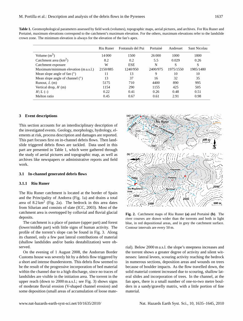
The Riu Runer catchment is located at the border of Spainand the Principality of Andorra (Fig. 1a) and drains a totalarea of 8.2 km2 (Fig. 2a). The bedrock in this area datesfrom Silurian and consists of slate (ICC, 2003). Most of thecatchment area is overtopped by colluvial and fluvial glacialdeposits.
The catchment is a place of pasture (upper part) and forest(lower/middle part) with little signs of human activity. Theprofile of the torrent’s slope can be found in Fig. 3. Alongits channel, only a few past lateral contributions of material(shallow landslides and/or banks destabilization) were ob-served.
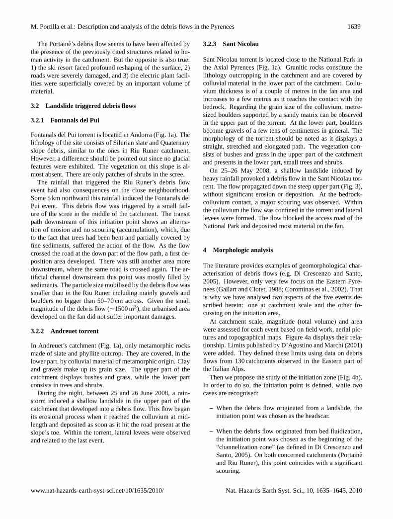
On the evening of 1 August 2008, the Andorran BorderCustoms house was severely hit by a debris flow triggered bya short and intense thunderstorm. This debris flow seemed tobe the result of the progressive incorporation of bed materialwithin the channel due to a high discharge, since no traces oflandslides are visible in the initiation area. The torrent in theupper reach (down to 2000 m a.s.l.; see Fig. 3) shows signsof moderate fluvial erosion (V-shaped channel erosion) andsome deposition (small areas of accumulation of loose mate-
Figure 2: Catchment maps of Riu Runer (a) and Portainé (b). The river courses are drawn wider than the torrents and both in light blue, in red depositional areas, and in grey the catchment surface. Contour intervals are every 50 meters.
(a)
(b)
Fig. 2. Catchment maps of Riu Runer(a) and Portaine (b). Theriver courses are drawn wider than the torrents and both in lightblue, in red depositional areas, and in grey the catchment surface.Contour intervals are every 50 m.
rial). Below 2000 m a.s.l. the slope’s steepness increases andthe torrent shows a greater degree of activity and silent wit-nesses: lateral levees, scouring activity reaching the bedrockin numerous sections, deposition areas and wounds on treesbecause of boulder impacts. As the flow travelled down, thesolid material content increased due to scouring, shallow lat-eral slides and incorporation of trees. In the channel, at thefan apex, there is a small number of one-to-two metre boul-ders in a sandy/gravelly matrix, with a little portion of finematerial.
www.nat-hazards-earth-syst-sci.net/10/1635/2010/ Nat. Hazards Earth Syst. Sci., 10, 1635–1645, 2010

1638 M. Portilla et al.: Description and analysis of the debris flows in the Pyrenees
0 500 1000Distance (m)
800
1200
1600
2000
Ele
vatio
n (m
asl
)
0 2000 4000 6000Distance (m)
800
1200
1600
2000
2400
Elev
atio
n (m
asl
)
Initiation zone
Apex
0 2000 4000 6000Distance (m)
2400
l)as 2000
m (at
ion 1600
v 1200
Ele
800
(c)Vertical exaggerationof 4 times
LegendPortainéRiu RunerAndreuetFontanalsSant NicolauMaximum runout
Apex
Vertical exaggeration of 2 times
Vertical exaggeration null
(a)
(b)
Figure 3: Topographic profiles of a) the landslide triggered debris flows (profiles start at the landslide’s headscar), b) the in-channel generated debris flows and c) both sorts of debris flows.
Fig. 3. Topographic profiles of(a) the landslide triggered debrisflows (profiles start at the landslide’s headscar),(b) the in-channelgenerated debris flows, and(c) both sorts of debris flows.
The deposit area starts just a couple of hundred metresupstream of the Andorran Border Customs house at the fanapex (900 m a.s.l.). Eventually the torrent channel could notdrain the flow discharge; a culvert was obstructed, block-ing the flow and forcing both material and trees to depose.The consequence was the accumulation of material partly
burying buildings and cars present on site. The water sup-ply in the near proximity was also disturbed, as two aque-ducts present in the channel were destroyed. Fortunately nocasualties were reported.
An estimate of the scoured material quantity, as well ascontributions along the debris flow path, was carried out andcross-checked with the total volume of material depositedat the fan, which was estimated on field. Finally, the to-tal volume of the debris flow was assumed to be 14 000 m3
(Table 1).
3.1.2 Portaine
In the Portaine ski resort area, bedrock is the oldest outcrop-ping in the Pyrenees, Cambrian to Ordovician in age (ICC,2003), and consisting of sedimentary units made of pelite,sandstone and greywacke. To some extent colluviums andfluvio-glacial deposits overtop them.
The catchment consists of two main torrents, the Portainetorrent in the West and the Reguerals torrent in the East(Fig. 2b). The morphology of the basin can be divided intotwo parts: a smooth higher part, where the presence of rillscan be observed; and a steep lower part, where well incisedchannels were formed (Fig. 3). In the steep section, the flanksof the torrents are unstable and lateral failures due to erosionof the slope’s toe are recurrent but small (about several tensof cubic metres).
On the evening of 12 September 2008, a rainstorm hit thearea and triggered one of the largest debris flows that tookplace in the Eastern Pyrenees. No clear initiation failurecould be observed, thus, promoting the idea that the flowprobably started by minor erosion along rills in the higherparts and transformed into a mature debris flow in the subse-quent steep section of the torrent, where scouring rates of upto∼10 m3/m led the bedrock to outcrop in some portions andthe amount of material transported to considerably increase.Several secondary failures of adjacent slopes were also ob-served, which enlarged the total volume of the debris flow.Although the access road to the ski resort crosses the torrentin three distinct points and even though material depositionoccurred at those points, as well as excessive failure of theroad foundation, the main volume of the debris flow was de-posited at the fan. Note the presence on the fan of an electricplant, including a dam and a retention lake, which was onlymarginally hit by the debris flow.
The total solid volume of the debris flow was estimatedby assessing the volume of material built up on the fan andalso a volume estimate of scoured material along the flowtrajectory. Finally, a total volume of about 26 000 m3 wasassumed (Table 1). A detailed granulometric analysis of thedebris-flow material was not possible, but two to three metreboulders in large proportion are visible in a gravel matrix,with a small fine fraction that could be observed in the lowestpart of the flow trajectory.
Nat. Hazards Earth Syst. Sci., 10, 1635–1645, 2010 www.nat-hazards-earth-syst-sci.net/10/1635/2010/
M. Portilla et al.: Description and analysis of the debris flows in the Pyrenees 1639
The Portaine’s debris flow seems to have been affected bythe presence of the previously cited structures related to hu-man activity in the catchment. But the opposite is also true:1) the ski resort faced profound reshaping of the surface, 2)roads were severely damaged, and 3) the electric plant facil-ities were superficially covered by an important volume ofmaterial.
3.2 Landslide triggered debris flows
3.2.1 Fontanals del Pui
Fontanals del Pui torrent is located in Andorra (Fig. 1a). Thelithology of the site consists of Silurian slate and Quaternaryslope debris, similar to the ones in Riu Runer catchment.However, a difference should be pointed out since no glacialfeatures were exhibited. The vegetation on this slope is al-most absent. There are only patches of shrubs in the scree.
The rainfall that triggered the Riu Runer’s debris flowevent had also consequences on the close neighbourhood.Some 5 km northward this rainfall induced the Fontanals delPui event. This debris flow was triggered by a small fail-ure of the scree in the middle of the catchment. The transitpath downstream of this initiation point shows an alterna-tion of erosion and no scouring (accumulation), which, dueto the fact that trees had been bent and partially covered byfine sediments, suffered the action of the flow. As the flowcrossed the road at the down part of the flow path, a first de-position area developed. There was still another area moredownstream, where the same road is crossed again. The ar-tificial channel downstream this point was mostly filled bysediments. The particle size mobilised by the debris flow wassmaller than in the Riu Runer including mainly gravels andboulders no bigger than 50–70 cm across. Given the smallmagnitude of the debris flow (∼1500 m3), the urbanised areadeveloped on the fan did not suffer important damages.
3.2.2 Andreuet torrent
In Andreuet’s catchment (Fig. 1a), only metamorphic rocksmade of slate and phyllite outcrop. They are covered, in thelower part, by colluvial material of metamorphic origin. Clayand gravels make up its grain size. The upper part of thecatchment displays bushes and grass, while the lower partconsists in trees and shrubs.
During the night, between 25 and 26 June 2008, a rain-storm induced a shallow landslide in the upper part of thecatchment that developed into a debris flow. This flow beganits erosional process when it reached the colluvium at mid-length and deposited as soon as it hit the road present at theslope’s toe. Within the torrent, lateral levees were observedand related to the last event.
3.2.3 Sant Nicolau
Sant Nicolau torrent is located close to the National Park inthe Axial Pyrenees (Fig. 1a). Granitic rocks constitute thelithology outcropping in the catchment and are covered bycolluvial material in the lower part of the catchment. Collu-vium thickness is of a couple of metres in the fan area andincreases to a few metres as it reaches the contact with thebedrock. Regarding the grain size of the colluvium, metre-sized boulders supported by a sandy matrix can be observedin the upper part of the torrent. At the lower part, bouldersbecome gravels of a few tens of centimetres in general. Themorphology of the torrent should be noted as it displays astraight, stretched and elongated path. The vegetation con-sists of bushes and grass in the upper part of the catchmentand presents in the lower part, small trees and shrubs.
On 25–26 May 2008, a shallow landslide induced byheavy rainfall provoked a debris flow in the Sant Nicolau tor-rent. The flow propagated down the steep upper part (Fig. 3),without significant erosion or deposition. At the bedrock-colluvium contact, a major scouring was observed. Withinthe colluvium the flow was confined in the torrent and laterallevees were formed. The flow blocked the access road of theNational Park and deposited most material on the fan.
4 Morphologic analysis
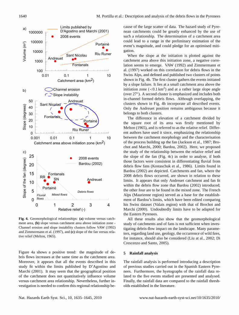
The literature provides examples of geomorphological char-acterisation of debris flows (e.g. Di Crescenzo and Santo,2005). However, only very few focus on the Eastern Pyre-nees (Gallart and Clotet, 1988; Corominas et al., 2002). Thatis why we have analysed two aspects of the five events de-scribed herein: one at catchment scale and the other fo-cussing on the initiation area.
At catchment scale, magnitude (total volume) and areawere assessed for each event based on field work, aerial pic-tures and topographical maps. Figure 4a displays their rela-tionship. Limits published by D’Agostino and Marchi (2001)were added. They defined these limits using data on debrisflows from 130 catchments observed in the Eastern part ofthe Italian Alps.
Then we propose the study of the initiation zone (Fig. 4b).In order to do so, the initiation point is defined, while twocases are recognised:
– When the debris flow originated from a landslide, theinitiation point was chosen as the headscar.
– When the debris flow originated from bed fluidization,the initiation point was chosen as the beginning of the“channelization zone” (as defined in Di Crescenzo andSanto, 2005). On both concerned catchments (Portaineand Riu Runer), this point coincides with a significantscouring.
www.nat-hazards-earth-syst-sci.net/10/1635/2010/ Nat. Hazards Earth Syst. Sci., 10, 1635–1645, 2010
1640 M. Portilla et al.: Description and analysis of the debris flows in the Pyrenees
0.01 0.1 1 10Catchment area (km2)
100
1000
10000
100000
1000000
Vol
ume
(m3 )
Andreuet
Fontanals
Sant Nicolau Riu Runer
Portainé
Limits published byD'Agostino and Marchi (2001)2008 events
a)
0.001 0.01 0.1 1 10Catchment area above initiation zone (km2)
0
10
20
30
40
50
Slo
pe (d
egre
es)
Fontanals
Sant NicolauAndreuet
Portainé
Riu Runer
Channel erosionSlope instability
b)
0 1 2 3 4Relative relief (-)
0
5
10
15
20
25
Slo
pe o
f the
fan
(deg
ree) 2008 events
Bardou (2002)
Portainé
AndreuetRR
FontanalsSN
Fluvialflows
Mixed flowsDebris flows
c)
Figure 4: Geomorphological relationships: a) volume versus catchment area, b) slope versus catchment area above initiation zone – Channel erosion and slope instability’s clusters follow VAW (1992) and Zimmermann et al. (1997), and c) slope of the fan versus relative relief (Melton, 1965).
Fig. 4. Geomorphological relationships:(a) volume versus catch-ment area,(b) slope versus catchment area above initiation zone -Channel erosion and slope instability clusters follow VAW (1992)and Zimmermann et al. (1997), and(c) slope of the fan versus rela-tive relief (Melton, 1965).
Figure 4a shows a positive trend: the magnitude of de-bris flows increases at the same time as the catchment area.Moreover, it appears that all the events described in thisstudy fit within the limits published by D’Agostino andMarchi (2001). It may seem that the geographical positionof the catchment does not quantitatively influence volumeversus catchment area relationship. Nevertheless, further in-vestigation is needed to confirm this regional relationship be-
cause of the large scatter of data. The hazard study of Pyre-nean catchments could be greatly enhanced by the use ofsuch a relationship. The determination of a catchment areacould lead to a range in the preliminary estimation of theevent’s magnitude, and could pledge for an optimised miti-gation.
When the slope at the initiation is plotted against thecatchment area above this initiation zone, a negative corre-lation seems to emerge. VAW (1992) and Zimmermann etal. (1997) worked on this correlation for debris flows in theSwiss Alps, and defined and published two clusters of pointsshown in Fig. 4b. The first cluster gathers the events initiatedby a slope failure. It lies at a small catchment area above theinitiation zone (<0.1 km2) and at a rather large slope angle(over 27◦). A second cluster is emphasized and includes bothin-channel formed debris flows. Although overlapping, theclusters shown in Fig. 4b incorporate all described events.Only the Andreuet position remains ambiguous because itbelongs to both clusters.
The difference in elevation of a catchment divided bythe square root of its area was firstly mentioned byMelton (1965), and is referred to as the relative relief. Differ-ent authors have used it since, emphasizing the relationshipbetween the catchment morphology and the characterisationof the process building up the fan (Jackson et al., 1987; Bro-chot and Marchi, 2000; Bardou, 2002). Here, we proposedthe study of the relationship between the relative relief andthe slope of the fan (Fig. 4c) in order to analyse, if boththose factors were consistent in differentiating fluvial fromdebris flow fans (Kostaschuk et al., 1986). Limits found inBardou (2002) are depicted. Catchments and fan, where the2008 debris flows occurred, are shown in relation to theselimits. It appears that only Andreuet catchment and fan fitwithin the debris flow zone that Bardou (2002) introduced;the other four are to be found in the mixed zone. The FrenchAlps (Maurienne region) served as a base for the establish-ment of Bardou’s limits, which have been edited comparinghis Swiss dataset (Valais region) with that of Brochot andMarchi (2000). Undoubtedly limits have to be adapted forthe Eastern Pyrenees.
All these results also show that the geomorphologicalstudy of catchments and of fans is not sufficient when inves-tigating debris-flow impact on the landscape. Many parame-ters, regarding land use, geology, the occurrence of wild fires,for instance, should also be considered (Liu at al., 2002; DiCrescenzo and Santo, 2005).
5 Rainfall analysis
The rainfall analysis is performed introducing a descriptionof previous studies carried out in the Spanish Eastern Pyre-nees. Furthermore, the hyetographs of the rainfall data re-lated to the five events studied are presented and analysed.Finally, the rainfall data are compared to the rainfall thresh-olds established in the literature.
Nat. Hazards Earth Syst. Sci., 10, 1635–1645, 2010 www.nat-hazards-earth-syst-sci.net/10/1635/2010/
M. Portilla et al.: Description and analysis of the debris flows in the Pyrenees 1641
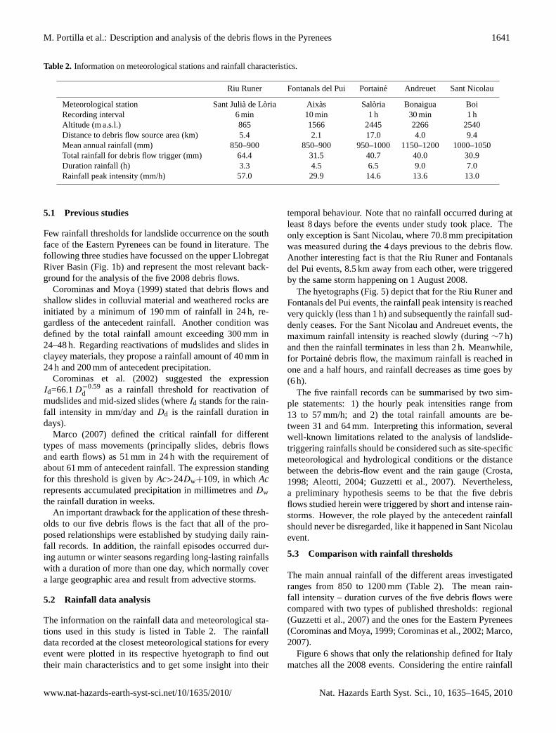
Table 2. Information on meteorological stations and rainfall characteristics.
Riu Runer Fontanals del Pui Portaine Andreuet Sant Nicolau
Meteorological station Sant Julia de Loria Aixas Saloria Bonaigua BoiRecording interval 6 min 10 min 1 h 30 min 1 hAltitude (m a.s.l.) 865 1566 2445 2266 2540Distance to debris flow source area (km) 5.4 2.1 17.0 4.0 9.4Mean annual rainfall (mm) 850–900 850–900 950–1000 1150–1200 1000–1050Total rainfall for debris flow trigger (mm) 64.4 31.5 40.7 40.0 30.9Duration rainfall (h) 3.3 4.5 6.5 9.0 7.0Rainfall peak intensity (mm/h) 57.0 29.9 14.6 13.6 13.0
5.1 Previous studies
Few rainfall thresholds for landslide occurrence on the southface of the Eastern Pyrenees can be found in literature. Thefollowing three studies have focussed on the upper LlobregatRiver Basin (Fig. 1b) and represent the most relevant back-ground for the analysis of the five 2008 debris flows.
Corominas and Moya (1999) stated that debris flows andshallow slides in colluvial material and weathered rocks areinitiated by a minimum of 190 mm of rainfall in 24 h, re-gardless of the antecedent rainfall. Another condition wasdefined by the total rainfall amount exceeding 300 mm in24–48 h. Regarding reactivations of mudslides and slides inclayey materials, they propose a rainfall amount of 40 mm in24 h and 200 mm of antecedent precipitation.
Corominas et al. (2002) suggested the expressionId=66.1D−0.59
d as a rainfall threshold for reactivation ofmudslides and mid-sized slides (whereId stands for the rain-fall intensity in mm/day andDd is the rainfall duration indays).
Marco (2007) defined the critical rainfall for differenttypes of mass movements (principally slides, debris flowsand earth flows) as 51 mm in 24 h with the requirement ofabout 61 mm of antecedent rainfall. The expression standingfor this threshold is given byAc>24Dw+109, in whichAcrepresents accumulated precipitation in millimetres andDwthe rainfall duration in weeks.
An important drawback for the application of these thresh-olds to our five debris flows is the fact that all of the pro-posed relationships were established by studying daily rain-fall records. In addition, the rainfall episodes occurred dur-ing autumn or winter seasons regarding long-lasting rainfallswith a duration of more than one day, which normally covera large geographic area and result from advective storms.
5.2 Rainfall data analysis
The information on the rainfall data and meteorological sta-tions used in this study is listed in Table 2. The rainfalldata recorded at the closest meteorological stations for everyevent were plotted in its respective hyetograph to find outtheir main characteristics and to get some insight into their
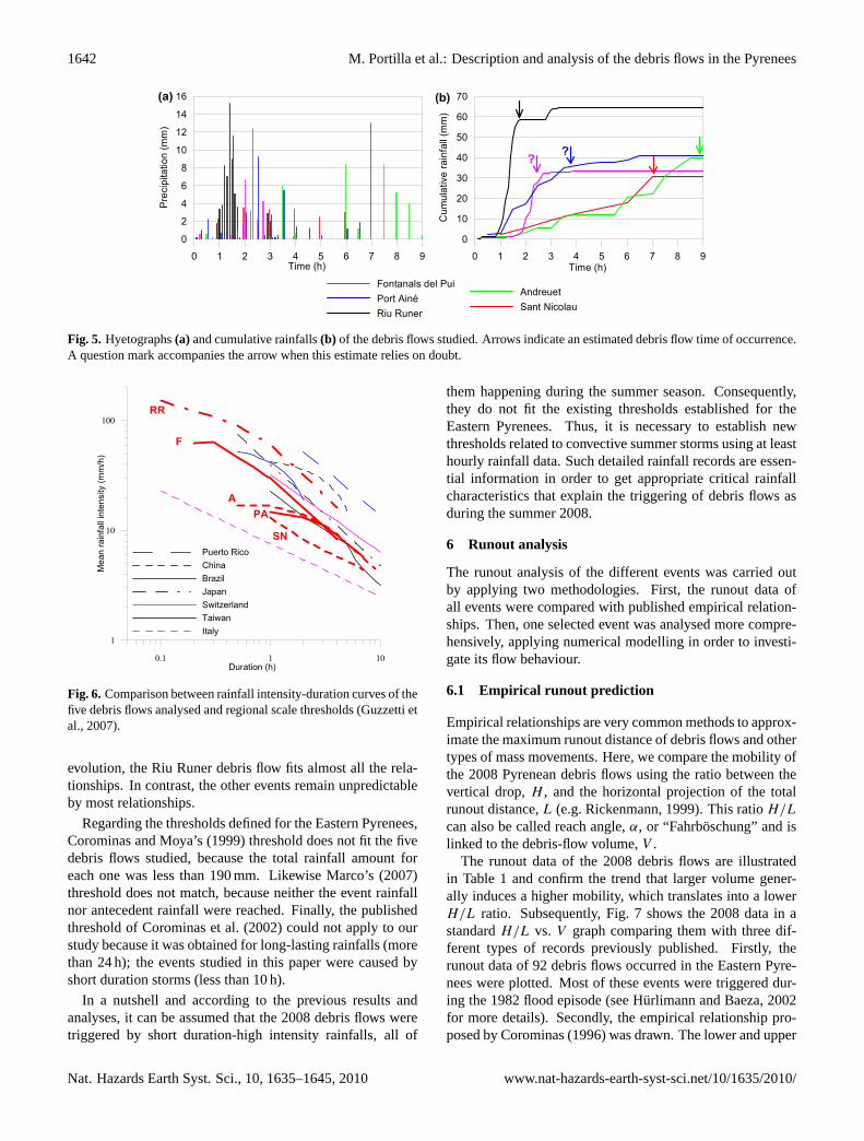
temporal behaviour. Note that no rainfall occurred during atleast 8 days before the events under study took place. Theonly exception is Sant Nicolau, where 70.8 mm precipitationwas measured during the 4 days previous to the debris flow.Another interesting fact is that the Riu Runer and Fontanalsdel Pui events, 8.5 km away from each other, were triggeredby the same storm happening on 1 August 2008.
The hyetographs (Fig. 5) depict that for the Riu Runer andFontanals del Pui events, the rainfall peak intensity is reachedvery quickly (less than 1 h) and subsequently the rainfall sud-denly ceases. For the Sant Nicolau and Andreuet events, themaximum rainfall intensity is reached slowly (during∼7 h)and then the rainfall terminates in less than 2 h. Meanwhile,for Portaine debris flow, the maximum rainfall is reached inone and a half hours, and rainfall decreases as time goes by(6 h).
The five rainfall records can be summarised by two sim-ple statements: 1) the hourly peak intensities range from13 to 57 mm/h; and 2) the total rainfall amounts are be-tween 31 and 64 mm. Interpreting this information, severalwell-known limitations related to the analysis of landslide-triggering rainfalls should be considered such as site-specificmeteorological and hydrological conditions or the distancebetween the debris-flow event and the rain gauge (Crosta,1998; Aleotti, 2004; Guzzetti et al., 2007). Nevertheless,a preliminary hypothesis seems to be that the five debrisflows studied herein were triggered by short and intense rain-storms. However, the role played by the antecedent rainfallshould never be disregarded, like it happened in Sant Nicolauevent.
5.3 Comparison with rainfall thresholds
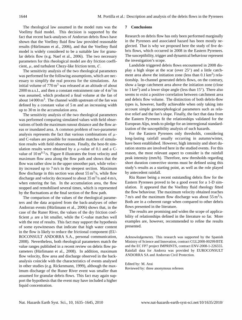
The main annual rainfall of the different areas investigatedranges from 850 to 1200 mm (Table 2). The mean rain-fall intensity – duration curves of the five debris flows werecompared with two types of published thresholds: regional(Guzzetti et al., 2007) and the ones for the Eastern Pyrenees(Corominas and Moya, 1999; Corominas et al., 2002; Marco,2007).
Figure 6 shows that only the relationship defined for Italymatches all the 2008 events. Considering the entire rainfall
www.nat-hazards-earth-syst-sci.net/10/1635/2010/ Nat. Hazards Earth Syst. Sci., 10, 1635–1645, 2010
1642 M. Portilla et al.: Description and analysis of the debris flows in the Pyrenees
0 1 2 3 4 5 6 7 8 9Time (h)
0
10
20
30
40
50
60
70
Cum
ulat
ive
rain
fall
(mm
)
0 1 2 3 4 5 6 7 8 9Time (h)
0
2
4
6
8
10
12
14
16
Pre
cipi
tatio
n (m
m)
AndreuetSant Nicolau
Fontanals del PuiPort AinéRiu Runer
? ?
(a) (b)
Figure 5: Hyetographs (a) and cumulative rainfalls (b) of the debris flows studied. Arrows indicate an estimated debris flow time of occurrence. A question mark accompanies the arrow when this estimate relies on doubt.
Fig. 5. Hyetographs(a) and cumulative rainfalls(b) of the debris flows studied. Arrows indicate an estimated debris flow time of occurrence.A question mark accompanies the arrow when this estimate relies on doubt.
0.1 1 10Duration (h)
1
10
100
Mea
n ra
infa
ll in
tens
ity (m
m/h
)
Puerto RicoChinaBrazilJapanSwitzerlandTaiwanItaly
RR
F
APA
SN
Figure 6: Comparison between rainfall intensity-duration curves of the five debris flows analysed and regional scale thresholds (Guzzetti et al, 2007).
Fig. 6. Comparison between rainfall intensity-duration curves of thefive debris flows analysed and regional scale thresholds (Guzzetti etal., 2007).
evolution, the Riu Runer debris flow fits almost all the rela-tionships. In contrast, the other events remain unpredictableby most relationships.
Regarding the thresholds defined for the Eastern Pyrenees,Corominas and Moya’s (1999) threshold does not fit the fivedebris flows studied, because the total rainfall amount foreach one was less than 190 mm. Likewise Marco’s (2007)threshold does not match, because neither the event rainfallnor antecedent rainfall were reached. Finally, the publishedthreshold of Corominas et al. (2002) could not apply to ourstudy because it was obtained for long-lasting rainfalls (morethan 24 h); the events studied in this paper were caused byshort duration storms (less than 10 h).
In a nutshell and according to the previous results andanalyses, it can be assumed that the 2008 debris flows weretriggered by short duration-high intensity rainfalls, all of
them happening during the summer season. Consequently,they do not fit the existing thresholds established for theEastern Pyrenees. Thus, it is necessary to establish newthresholds related to convective summer storms using at leasthourly rainfall data. Such detailed rainfall records are essen-tial information in order to get appropriate critical rainfallcharacteristics that explain the triggering of debris flows asduring the summer 2008.
6 Runout analysis
The runout analysis of the different events was carried outby applying two methodologies. First, the runout data ofall events were compared with published empirical relation-ships. Then, one selected event was analysed more compre-hensively, applying numerical modelling in order to investi-gate its flow behaviour.
6.1 Empirical runout prediction
Empirical relationships are very common methods to approx-imate the maximum runout distance of debris flows and othertypes of mass movements. Here, we compare the mobility ofthe 2008 Pyrenean debris flows using the ratio between thevertical drop,H , and the horizontal projection of the totalrunout distance,L (e.g. Rickenmann, 1999). This ratioH/L
can also be called reach angle,α, or “Fahrboschung” and islinked to the debris-flow volume,V .
The runout data of the 2008 debris flows are illustratedin Table 1 and confirm the trend that larger volume gener-ally induces a higher mobility, which translates into a lowerH/L ratio. Subsequently, Fig. 7 shows the 2008 data in astandardH/L vs. V graph comparing them with three dif-ferent types of records previously published. Firstly, therunout data of 92 debris flows occurred in the Eastern Pyre-nees were plotted. Most of these events were triggered dur-ing the 1982 flood episode (see Hurlimann and Baeza, 2002for more details). Secondly, the empirical relationship pro-posed by Corominas (1996) was drawn. The lower and upper
Nat. Hazards Earth Syst. Sci., 10, 1635–1645, 2010 www.nat-hazards-earth-syst-sci.net/10/1635/2010/

M. Portilla et al.: Description and analysis of the debris flows in the Pyrenees 1643
100 1000 10000 100000Volume (m3)
0
0.2
0.4
0.6
0.8
1
H/L
(−)
2008 eventshistoric Pyrenean eventsgeneral trend (Corominas,1996)limits (Rickenmann, 2005)
Riu RunerPort Ainé
Sant Nicolau
Andreuet Fontanals
Figure 7: Mobility comparison of 2008 debris flows with other published data from the Eastern Pyrenees and worldwide records. Fig. 7. Mobility comparison of 2008 debris flows with other published data from the Eastern Pyrenees and worldwide records.
0 500 1000 1500 2000 2500 3000 3500 4000 4500 5000
800
1000
1200
1400
1600
1800
2000
2200
Elev
atio
n (m
a.s
.l.)
topographic profilechannel widthbed slope
0
5
10
15
20
25
30
35
Cha
nnel
wid
th (m
) Be
d sl
ope
(deg
ree)
0 500 1000 1500 2000 2500 3000 3500 4000 4500 5000Horizontal distance (m)
0
2
4
6
8
10
Fron
t vel
ocity
(m/s
)
velocityarea (simulated)area (field)
0
10
20
30
40
50
Max
imum
flow
are
a (m
2 )
(a)
(b)
Figure 8: Numerical simulation results of the Riu Runer event. a) Longitudinal profile, channel width and bed slope used in the simulation. b) Results obtained by DAN for C = 10 m1/2/s and µ = 0.1, showing the variation of the front velocity and the maximum flow area. Squares represent cross-section areas. Fig. 8. Numerical simulation results of the Riu Runer event.(a) Longitudinal profile, channel width and bed slope used in the simulation.(b) Results obtained by DAN forC=10 m1/2/s andµ=0.1, showing the variation of the front velocity and the maximum flow area. Squaresrepresent cross-section areas.
limits of the data published in Rickenmann (2005) were alsoillustrated. The comparison of the 2008 debris flows with thedata from other published events indicate, that: 1) the RiuRuner and Portaine events are one of the largest debris flowsthat have recently been observed in the Eastern Pyrenees, 2)all five events are located in the mobility range defined byempirical relationships and published data.
6.2 Numerical simulation
The Riu Runer event was selected to carry out a detailed anal-ysis of the dynamic behaviour by numerical modelling. Thisback-analysis may lead to the answering of questions such
as: Can Pyrenean debris flows be simulated by similar rheo-logic models and parameter values like the ones from differ-ent mountain ranges? Which were the maximum velocitiesand discharges of the debris flow? Are they comparable toevents from other mountain ranges?
The 1-D, finite difference code “DAN” has been used(Hungr, 1995), in which necessary input parameters includethe topographic profile, the channel shape and width, rheo-logical parameters, and the initial volume. Additionally, thescour rate can be incorporated, which was an important factsince entrainment was a significant process in the Riu Runerevent.
www.nat-hazards-earth-syst-sci.net/10/1635/2010/ Nat. Hazards Earth Syst. Sci., 10, 1635–1645, 2010
1644 M. Portilla et al.: Description and analysis of the debris flows in the Pyrenees
The rheological law assumed in the model runs was theVoellmy fluid model. This decision is supported by thefact that recent back-analyses of Andorran debris flows haveshown that the Voellmy fluid flow law provided reasonableresults (Hurlimann et al., 2006), and that the Voellmy fluidmodel is widely considered to be a suitable law for granu-lar debris flow (e.g. Naef et al., 2006). The two necessaryparameters for this rheological model are dry friction coeffi-cient,µ, and turbulent Chezy-like friction term,C.
The sensitivity analysis of the two rheological parameterswas performed for the following assumptions, which are nec-essary to simplify the real process for the simulations. Aninitial volume of 770 m3 was released at an altitude of about2000 m a.s.l., and then a constant entrainment rate of 4 m3/mwas assumed, which produced a final volume at the fan ofabout 14 000 m3. The channel width upstream of the fan wasdefined by a constant value of 5 m and an increasing widthup to 30 m in the accumulation area.
The sensitivity analysis of the two rheological parameterswas performed comparing simulated values with field obser-vations of both the maximum runout distance and the flow ar-eas or inundated area. A common problem of two-parameteranalysis represents the fact that various combinations ofµ-and C-values are possible for reasonable matches of simula-tion results with field observations. Finally, the best-fit sim-ulation results were obtained by aµ-value of 0.1 and a C-value of 10 m0.5/s. Figure 8 illustrates the front velocity andmaximum flow area along the flow path and shows that theflow was rather slow in the upper smoother part, while veloc-ity increased up to 7 m/s in the steepest section. Maximumflow discharge in this section was about 55 m3/s, while flowdischarge and velocity decreased to about 35 m3/s and 4 m/s,when entering the fan. In the accumulation area, the flowstopped and remobilised several times, which is representedby the fluctuations at the final section of the flow path.
The comparison of the values of the rheological parame-ters and the data acquired from the back-analyses of otherAndorran events (Hurlimann et al., 2006) shows that, in thecase of the Runer River, the values of the dry friction coef-ficient µ are a bit smaller, while the C-value matches wellwith the rest of results. This fact may support the hypothesisof some eyewitnesses that indicate that high water contentin the flow is likely to reduce the frictional component (EU-ROCONSULT ANDORRA S.A., personal communication,2008). Nevertheless, both rheological parameters match thevalue ranges published in a recent review on debris flow pa-rameters (Hurlimann et al., 2008). In addition, maximumflow velocity, flow area and discharge observed in the back-analysis coincide with the characteristics of events analysedin other studies (e.g. Rickenmann, 1999), although the max-imum discharge of the Runer River event was smaller thanassumed for granular debris flows. This fact may again sup-port the hypothesis that the event may have included a higherliquid concentration.
7 Conclusions
Research on debris flow has only been performed marginallyin the Pyrenees and associated hazard has been mostly ne-glected. That is why we proposed here the study of five de-bris flows, which occurred in 2008 in the Eastern Pyrenees.The susceptibility, trigger and dynamical behaviour representthe investigation’s scope.
Landslide triggered debris flows encountered in 2008 dis-play a high slope at the scar (over 25◦) and a little catch-ment area above the initiation zone (less than 0.1 km2) rela-tionship. In-channel generated debris flows, on the contrary,show a large catchment area above the initiation zone (closeto 1 km2) and a lower slope angle (less than 15◦). There alsoseems to exist a positive correlation between catchment areaand debris flow volume. The distinction of both debris-flowtypes is, however, hardly achievable when only taking intoaccount simple geomorphological parameters such as rela-tive relief and the fan’s slope. Finally, the fact that data fromthe Eastern Pyrenees fit the relationships validated for theEuropean Alps, tends to pledge for an interregional standard-ization of the susceptibility analysis of such hazards.
For the Eastern Pyrenees only thresholds, consideringlong-lasting rainfall usually occurring in autumn/winter,have been established. However, high intensity and short du-ration storms are involved here in the studied events. For thisreason, the most relevant aspect to consider is the rainfallpeak intensity (mm/h). Therefore, new thresholds regardingshort duration convective storms must be defined using thisstudy’s results as a starting point, as well as the role playedby antecedent rainfall.
Riu Runer being a recent outstanding debris flow for theEastern Pyrenees proved to be a good event for a 1-D sim-ulation. It appeared that the Voellmy fluid rheology fittedthe flow behaviour. The maximum velocity obtained reaches7 m/s and the maximum flow discharge was about 55 m3/s.Both are in a coherent range when compared to other debrisflows presented in the literature.
The results are promising and widen the scope of applica-bility of relationships defined in the literature so far. Moreexamples are, however, recommended to refine the resultspresented.
Acknowledgements.This research was supported by the SpanishMinistry of Science and Innovation, contract CGL2008-00299/BTEand the EC FP7 project IMPRINTS, contract ENV-2008-1-226555.Rainfall data for Andorra was provided by EUROCONSULTANDORRA SA and Andorran Civil Protection.
Edited by: M. AraiReviewed by: three anonymous referees
Nat. Hazards Earth Syst. Sci., 10, 1635–1645, 2010 www.nat-hazards-earth-syst-sci.net/10/1635/2010/
M. Portilla et al.: Description and analysis of the debris flows in the Pyrenees 1645
References
Aleotti, P.: A warning system for rainfall-induced shallow failures,Eng. Geol., 73, 247–265, 2004
Baeza, C. and Corominas, J.: Assessment of shallow landslide sus-ceptibility by means of multivariate statistical techniques, EarthSurf. Proc. Land., 26, 1251–1263, 2001.
Bardou, E.: Methodologie de diagnostic des laves torrentiells surun bassin versant, Ecole Polytechnique de Lausanne, these doc-torale, 188 pp., 2002 (in French).
Bathurst, J. C., Burton, A., Clarke, B. G., and Gallart, F.: Appli-cation of the SHETRAN basin-scale, landslide sediment yieldmodel to the Llobregat basin, Spanish Pyrenees, Hydrol. Pro-cess., 20, 3119–3138, 2006.
Brochot, S. and Marchi, L.: Les cones de dejection torrentiels dansles Alpes francaises. Morphometrie et processus de transportsolide torrentiel, Revue de geographie alpine, 88, 23–38, 2000(in French).
Coussot, P. and Meunier, M.: Recognition, classification and me-chanical description of debris flows, Earth-Sci. Rev., 40, 209–227, 1996.
Corominas, J.: The angle of reach as a mobility index for small andlarge landslides, Can. Geotech. J., 33(2), 260–271, 1996.
Corominas, J. and Moya, J.: Reconstructing recent landslide activ-ity in relation to rainfall in the Llobregat River basin, EasternPyrenees, Spain, Geomorphology, 30, 79–93, 1999.
Corominas, J., Moya, J., and Hurlimann, M.: Landslide rainfall trig-gers in the Spanish Eastern Pyrenees, Editrice, MediterraneanStorms, Proceedings of the 4th EGS Plinius Conference held atMallorca, Spain, 2002.
Crosta, G.: Regionalization of rainfall thresholds: an aid to land-slide hazard evaluation, Environ. Geol., 35, 131–145, 1998.
Cuadrat, J. M. and Pita, M. F.: Climatologıa. Ediciones Catedra,Madrid, Espana, 496 pp., 1997.
D’Agostino, V. and Marchi, L.: Debris Flow Magnitude in the East-ern Italian Alps: Data Collection and Analysis, Phys. Chem.Earth Pt. C, 26(9), 657–663, 2001.
Di Crescenzo, G. and Santo, A.: Debris slides-rapid earth flows inthe carbonate massifs of the Campania region (Southern Italy):morphological and morphometric data for evaluating triggeringsusceptibility, Geomorphology, 66, 255–276, 2005.
ECORS Pyrenees Team: The ECORS deep reflection seismic sur-vey across the Pyrenees, Nature, London, 331, 508–510, 1988
Fitzgerald, P. G., Munoz, J. A., Coney, P. J., and Baldwin, S. L.:Asymmetric exhumation across the Pyrenean orogen: implica-tions for the tectonic evolution of a collisional orogen, EarthPlanet. Sc. Lett., 173(3), 157–170, 1999.
Gallart, F. and Clotet, N.: Some aspects of the geomorphic pro-cesses triggered by an extreme rainfall event: The November1982 flood in The Eastern Pyrenees, Catena Supp., 13, 79–95,1988.
Guzzetti, F., Peruccacci, S., Rossi, M., and Stark, C. P.: Rain-fall thresholds for the initiation of landslides in central andsouthern Europe, Meteorol. Atmos. Phys., 98(3–4) , 239–267,doi:10.1007/s00703-007-0262-7, 2007.
Hungr, O.: A model for the run-out analysis of rapid flow slides, de-bris flows, and avalanches, Can. Geotech. J., 32, 610–623, 1995.
Hungr, O., Evans, S. G., Bovis, M. J., and Hutchinson, J. N.: A re-view of the classification of landslides of the flow type, Environ.Eng. Geosci., 3, 221–238, 2001.
Hurlimann, M. and Baeza, C.: Analysis of debris-flow events inthe eastern Pyrenees, Spain, 1st European Conference on Land-slides, Balkema, Prague, 213–220, 2002.
Hurlimann, M., Copons, R., and Altimir, J.: Detailed debris flowhazard assessment in Andorra: A multidisciplinary approach,Geomorphology, 78, 359–372, 2006.
Hurlimann, M., Rickenmann, D., Medina, V., and Bateman, A.:Evaluation of approaches to calculate debris-flows parametersfor hazard assessment, Eng. Geol., 102, 152–163, 2008.
ICC, Institut Cartografic de Catalunya: Mapa geologic de Catalunya1:250 000, Barcelona, 2003.
Jackson, L. E., Kostaschuk, R. A., and MacDonald, G. M.: Iden-tification of debris flow hazard on alluvial fans in the Canadianrocky mountains, Eng. Geol., 7, 115–124, 1987.
Kostaschuk, R. A., MacDonald, G. M., and Putnam, P. E.: Deposi-tional process and alluvial fan-drainage basin morphometric re-lationships near Banff, Alberta, Canada, Earth Surf. Proc. Land.,11, 471–484, 1986.
Liu, X., Yue, Z. Q., Tham, L. G., and Lee, C. F.: Empirical assess-ment of debris flow risk on a regional scale in Yunnan Province,southwestern China, Environ. Manage., 30, 249–264, 2002.
Lynn, G.: Macrogeomorphology and Erosional History of the Post-Orogenic Pyrenean Mountain Belt, Ph.D. thesis, The Universityof Edinburgh, Edinburgh, 388 pp., 2005
Marco, P. L.: Determinacio de llindars de pluja desencadenantsd’esllavisades a Catalunya, Tesina de Grau, Departamentd’Enginyeria del Terreny, Cartografica i Geofısica, UniversitatPolitecnica de Catalunya, Barcelona, Espanya, 150 pp., 2007 (inCatalan).
Martın, V. J. and Olcina, C. J.: Climas y Tiempos de Espana,Alianza Editorial, S.A., Madrid, Espana, 258 pp., 2001.
Melton, M. A.: The morphologic and paleoclimatic significance ofalluvial deposits in southern Arizona, J. Geol., 73, 1–38, 1965.
Munoz, J. A.: Evolution of a continental collision belt: ECORS-Pyrenees crustal balanced cross-section, in: Thrust Tectonics,edited by: McClay, K. R., Chapman and Hall, 235–246, 1992.
Naef, D., Rickenmann, D., Rutschmann, P., and McArdell, B. W:Comparison of flow resistance relations for debris flows using aone-dimensional finite element simulation model, Nat. HazardsEarth Syst. Sci., 6, 155–165, doi:10.5194/nhess-6-155-2006,2006.
Rickenmann, D.: Empirical relationships for debris flows, Nat.Hazards, 19, 47–77, 1999.
Rickenmann, D.: Run-out prediction methods, in: Debris-flow Haz-ards and Related Phenomena, edited by: Jakob, M. and Hungr,O., Springer, Berlin, 305–324, 2005.
Santacana, N., Baeza, B., Corominas, J., Paz, A. D., and Mar-turia, J.: A GIS-Based Multivariate Statistical Analysis for Shal-low Landslide Susceptibility Mapping in La Pobla de Lillet Area(Eastern Pyrenees, Spain), Nat. Hazards, 30, 281–295, 2003.
Teixell, A.: Crustal structure and orogenic material budget in thewest-central Pyrenees, Tectonics, 17, 395–406, 1998.
VAW: Murgange 1987: Dokumentation und Analyse, in: Ver-suchsanstalt fur Wasserbau, Hydrologie und Glaziologie (VAW),No. 97.6, ETH Zurich, unpublished, 620 pp., 1992.
Zimmermann, M., Mani, P. Gamma, P., Gsteiger, P., Heiniger,O., and Hunziker, G.: Murganggefahr und Klimaanderung –ein GIS-basierter Ansatz, in: Schlussbericht NFP 31, vdf-ETHZurich, Switzerland, 161 pp., 1997 (in German).
www.nat-hazards-earth-syst-sci.net/10/1635/2010/ Nat. Hazards Earth Syst. Sci., 10, 1635–1645, 2010