description of a rdes ba ony in the county of down · deal they had struck with con o’neill of...
TRANSCRIPT

IT WAS MAY 1606 when Scottish families began to settle in the Ards andNorth Down, led by James Hamilton and Hugh Montgomery from Ayrshire, following the landdeal they had struck with Con O’Neill of Castlereagh. In 1683, Montgomery’s grandson William (who is buried at Grey Abbey) wrote the first tourist trail of the area, entitled Description ofArdes Barony, in the County of Down. Many of the places he described can still be visited today.
NEWTOWNARDS
GRAHAM’S PORT
QUINTINCASTLE
COPELANDISLANDS
CREBOY
SCRABO
PORTAVO
BURIAL ISLEBALLYHALBERT
BALLYWALTERCOMBER
DONAGHADEE
PORTAFERRY
ARDQUINABBACY
BANGOR
S T R A N G F OR
D L O
UG
H
NEWCASTLE
KIRKISTOWNCASTLECASTLEBOY
ARDKEENCASTLE
SKETRICKCASTLE
BALLYGALGETCASTLE
GREYABBEY
NEWTOWNARDSPRIORY
MOVILLAABBEY
BANGORABBEY
BLACKABBEY
Description ofArdes Baronyin the Countyof Down by WILLIAMMONTGOMERYof Greyabbey,1683
A MAP FROM
FREE APPAVAILABLE FROM ITUNESAND GOOGLE PLAY
FOR MOREINFORMATIONVisit North Down Museum, wherethe Plantation Room housesthe original 17th Century RavenMaps and interactive exhibit.www.northdownmuseum.comTel: 028 9127 1200
Visit Cathedral Quarter’s newDiscover Ulster-Scots CentreCorn Exchange, 1–9 Victoria Street,Belfast BT1 3GAwww.discoverulsterscots.comTel: 028 9043 6710
A&ND DUS A5 AW FINAL:Layout 1 14/01/2016 16:56 Page 1
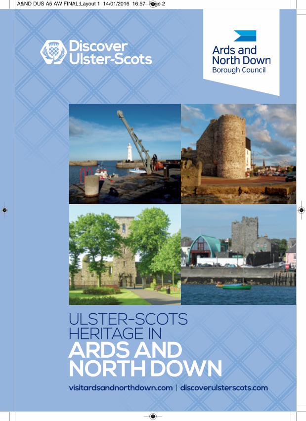
ULSTER-SCOTSHERITAGE INARDS ANDNORTH DOWNvisitardsandnorthdown.com | discoverulsterscots.com
A&ND DUS A5 AW FINAL:Layout 1 14/01/2016 16:57 Page 2

NEWTOWNARDS
CONLIG
CRAWFORDSBURN
HOLYWOOD
GROOMSPORT
DONAGHADEE
MILLISLE
CARROWDORE
BALLYWALTER
KIRCUBBIN
PORTAVOGIE
CLOUGHEY
UPPER‘LITTLE’ARDS
LOWER‘GREAT’ARDS BALLYHALBERT
PORTAFERRY
STRANGFORD
DOWNPATRICK
CROSSGAR
KILLYLEAGH
KILLINCHY
BALLYGOWAN
HILLSBOROUGHSAINTFIELD
LISBURN HILLHALL CARRYDUFF
HAMILTON
O’NEILL
MONTGOMERY
SAVAGE
COMBER
DUNDONALD
GREYABBEY
BANGORBE
L F A S T L O U G H
S T RA
N
GF
OR
D L
OU
GH
Based on a map shown in The Scottish Migration to Ulsterin the Reign of James I by Michael Perceval-Maxwell (1973)
Con O’Neill’s castle and powerbase was at Castlereagh.The O’Neills retained townlandsin this area, indicated in white.
COUNCILBOUNDARY
COUNCILBOUNDARY
Many Scottish familiessettled in the Savageestates known as the Upper Ards or Little Ards. The Savages leased land to Hamilton and Montgomery.
CASTLEREAGH
Local tradition says that St Patrickarrived at Templepatrick justsouth of Donaghadee, having leftPortpatrick in Scotland. Vikingraiders gave Strangford Loughits name, Anglo-Normans like theSavages built abbeys and castles.A branch of the O’Neillsmoved inand remained until the 1570swhen Sir Thomas Smith attemptedbut failed to establish an Englishcolony here with a new city, a‘little London’, called Elizabetha.
Hamilton and MontgomerySmith failed to oust the O’Neillsof Castlereagh, but over 30 yearslater Ayrshiremen James Hamiltonand Hugh Montgomery struck adeal with Con O’Neill. In May 1606they started to bring boatloads ofScottish families to our shores.Working with the O’Neills, and alsothe Savage family, Lowland Scotssettled from the River Lagan allthe way to the bottom of thePeninsula. Their surnames canstill be found all over the Ardsand North Down today.
Centuries of ConnectionsIt was these Scottish settlers ofthe 1600s that transformed Ardsand North Down. In 1606 therewere only a few ‘ruined churches’and ‘roofless cabins’. What youcan see today is largely a resultof centuries of Ulster-Scots thrift,graft and perseverance. Fromtowns and villages to our rollinglandscape and place names, andthe ‘wee’ turns of phrase you’lloverhear when talking to the olderlocals, all of Ards and North Downis in some way Ulster-Scots.
JUST 18 MILES TO SCOTLAND
MAP OF ARDSAND NORTH DOWN,MAY 1606
People have been visiting Ards and North Down for thousands of years. Our area is dotted with dolmens,cairns and raths from ancient times – and our close proximity to Scotland is a big part of our story.
Many Scottish familiessettled here; others movedon to other parts of Ulster,others came across in thecenturies which followed.
A&ND DUS A5 AW FINAL:Layout 1 14/01/2016 16:57 Page 3
es
ton
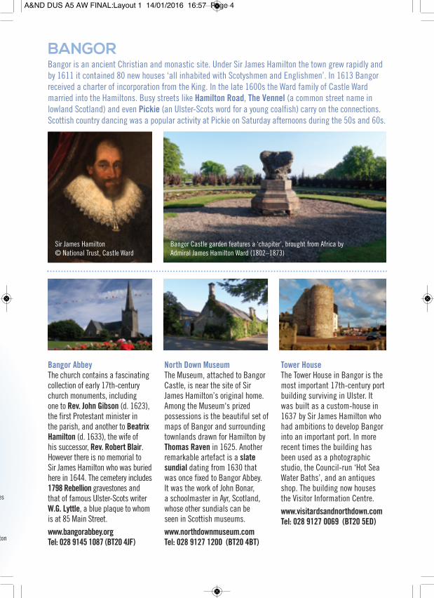
Bangor AbbeyThe church contains a fascinatingcollection of early 17th-centurychurch monuments, includingone to Rev. John Gibson (d. 1623),the first Protestant minister inthe parish, and another to BeatrixHamilton (d. 1633), the wife ofhis successor, Rev. Robert Blair.However there is no memorial toSir James Hamilton who was buriedhere in 1644. The cemetery includes1798 Rebellion gravestones andthat of famous Ulster-Scots writerW.G. Lyttle, a blue plaque to whomis at 85 Main Street.www.bangorabbey.orgTel: 028 9145 1087 (BT20 4JF)
North Down MuseumThe Museum, attached to BangorCastle, is near the site of SirJames Hamilton’s original home.Among the Museum's prizedpossessions is the beautiful set ofmaps of Bangor and surroundingtownlands drawn for Hamilton byThomas Raven in 1625. Anotherremarkable artefact is a slatesundial dating from 1630 thatwas once fixed to Bangor Abbey.It was the work of John Bonar,a schoolmaster in Ayr, Scotland,whose other sundials can beseen in Scottish museums.www.northdownmuseum.comTel: 028 9127 1200 (BT20 4BT)
Tower HouseThe Tower House in Bangor is themost important 17th-century portbuilding surviving in Ulster. Itwas built as a custom-house in1637 by Sir James Hamilton whohad ambitions to develop Bangorinto an important port. In morerecent times the building hasbeen used as a photographicstudio, the Council-run ‘Hot SeaWater Baths’, and an antiquesshop. The building now housesthe Visitor Information Centre.www.visitardsandnorthdown.comTel: 028 9127 0069 (BT20 5ED)
BANGOR
Sir James Hamilton© National Trust, Castle Ward
Bangor Castle garden features a ‘chapiter’, brought from Africa byAdmiral James Hamilton Ward (1802–1873)
Bangor is an ancient Christian and monastic site. Under Sir James Hamilton the town grew rapidly andby 1611 it contained 80 new houses ‘all inhabited with Scotyshmen and Englishmen’. In 1613 Bangorreceived a charter of incorporation from the King. In the late 1600s the Ward family of Castle Wardmarried into the Hamiltons. Busy streets like Hamilton Road, The Vennel (a common street name inlowland Scotland) and even Pickie (an Ulster-Scots word for a young coalfish) carry on the connections.Scottish country dancing was a popular activity at Pickie on Saturday afternoons during the 50s and 60s.
A&ND DUS A5 AW FINAL:Layout 1 14/01/2016 16:57 Page 4

Newtownards Priory and BawnIn 1244 a Dominican priory wasfounded in Newtownards. WhenSir Hugh Montgomery moved toNewtownards he converted thecloistral buildings of the priory tohis domestic residence – NewtownHouse – and had the priory churchrestored as a place of worship. Thetower with its handsome classicalentrance was built in 1636 –the year in which Sir Hugh died.His funeral was along the linesof an impressive Scottish statefuneral, and he was buried withinthese walls. Newtown House burneddown in 1664, but a portion of thebawn wall – from which Castlebawntakes its name – survives. (BT23 7NX)
Market CrossUnder Sir Hugh Montgomery’sdirection Newtownards became animportant market centre. The storyis told that in 1607 merchantswould travel from Scotland toNewtownards and back in a day todo business. The Market Cross inNewtownards is the second on thesite, the first having been builtunder Montgomery’s direction asa replica of the market cross inEdinburgh. At the market cross‘all proclamations that come fromthe Chief Governor of this kingdom’were issued. It bears the date 1636,the year that Montgomery died.(BT23 7HS)
Movilla Abbey and CemeteryOn the outskirts of Newtownardsis Movilla Cemetery. This was thesite of a monastery founded bySt Finian in the 6th century whichbecame an Augustinian abbey inthe 13th century – the ruins of theabbey church stand in one cornerof the cemetery. The cemeteryincludes some memorials to rebelsexecuted in 1798 includingArchibald Warwick who washanged at Kircubbin. The Corrymausoleum is one of three gravesat Movilla to former Provosts ofNewtown - Provost being a Scottishterm for mayor.(BT23 8HH)
NEWTOWNARDS
Sir Hugh MontgomeryArds Arts Centre, formerly the Town Hall, was attacked in 1798.The building still has the prison cell where the 1798 rebellion men were held.
Originally an important Anglo-Norman settlement, in the early 1600s Sir Hugh Montgomery establishedhis ‘headquarters’ at Newtownards and with the assistance of his wife Elizabeth oversaw the developmentof the town which by 1611 included around 100 houses ‘all peopled with Scottes’. In 1744 Newtownardswas acquired by the Stewart family. The Town Hall was built as a market house around 1770; during the1798 Rebellion it was held for a time by a party of United Irishmen. St Mark’s Church of Ireland, completedin 1817, is one of the best examples for its date of the Perpendicular Gothic style in the British Isles.
A&ND DUS A5 AW FINAL:Layout 1 14/01/2016 16:57 Page 5

Parish ChurchSir Hugh Montgomery had a largecruciform church constructed inDonaghadee. It was in this churchthat the Rev. Andrew Stewart,one of the earliest historians of theUlster Scots, began his ministerialcareer in the mid 1640s. After hewas ejected from the church in1661, on account of his Presbyterianbeliefs, Stewart continued tominister to Presbyterians inDonaghadee until his death in1671. The graveyard contains afascinating collection of memorials,many of them reflectingDonaghadee’s maritime heritage.donaghadee.down.anglican.org(BT21 0AJ)
HarbourIn 1616 Sir Hugh Montgomeryreceived a Royal Warrant whichattempted to limit all crossingsbetween Ulster and Scotland to thePortpatrick/ Donaghadee route.A decade later he built the firstmajor harbour at Donaghadee.Donaghadee was the main port ofentry for travellers from Scotlandfrom the early 1600s until themid 19th century. The harbouris dominated by the lighthouseconstructed in 1836 which wasthe first in Ireland to be lit byelectricity.(BT21 0DG)
Copeland IslandsThese three small islands – namedCopeland, Light House and Mew –are located just off the CountyDown coastline. The islands taketheir name from the Anglo-Normanfamily of de Coupland. In the early1600s the islands were acquired bySir James Hamilton and weremapped for him by Thomas Ravenin 1625. The islands are no longerinhabited, but once supported asmall population of farmers andfishermen. The islands can bereached by boat from Donaghadeeduring the summer months – anunforgettable experience is feedingfish to the grey seals!
DONAGHADEE
Donaghadee Harbour viewed from The Moat whichoverlooks the town - with Scotland visible on the horizon
Donaghadee ‘Alias Montgomery’ stone,Cottage Kitchen, Killaughey Road
Donaghadee was an ancient Christian site just north of Templepatrick, where centuries of localtradition say St Patrick landed in the 5th century – having sailed from Portpatrick in Scotland. At thebeginning of the 1600s Donaghadee was acquired by Sir Hugh Montgomery and an important portdeveloped. Montgomery tried to rename the town Montgomery, but the new name failed to take hold.The historic Manor House in High Street is believed to stand on the site of Sir Hugh’s original dwelling.Donaghadee is home to Grace Neill’s, said to be the oldest pub in Ireland, founded in 1611.
A&ND DUS A5 AW FINAL:Layout 1 14/01/2016 16:57 Page 6
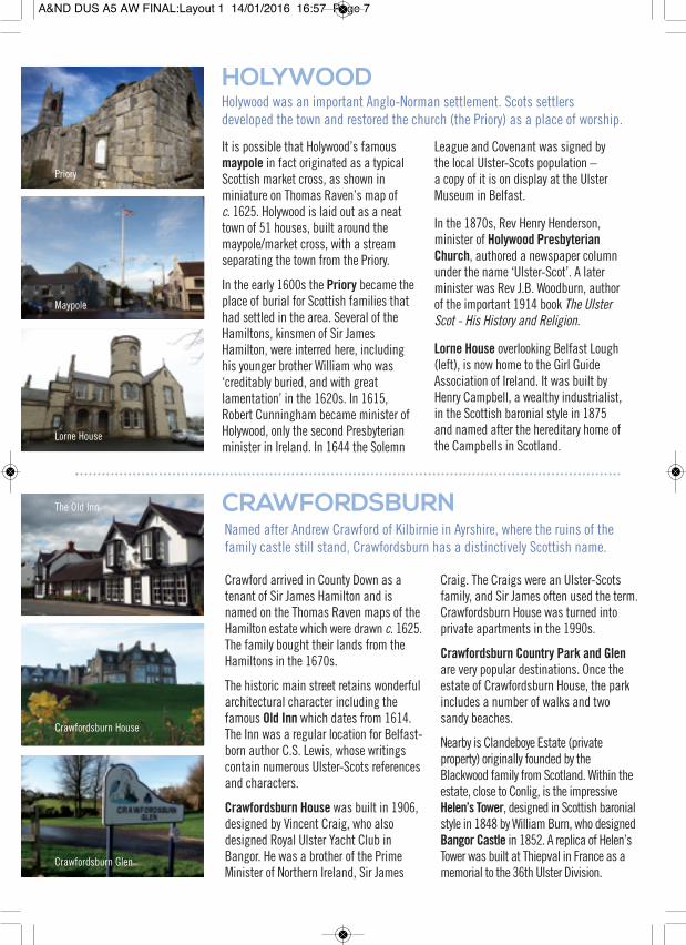
HOLYWOOD
CRAWFORDSBURN
Holywood was an important Anglo-Norman settlement. Scots settlersdeveloped the town and restored the church (the Priory) as a place of worship.
It is possible that Holywood’s famousmaypole in fact originated as a typicalScottish market cross, as shown inminiature on Thomas Raven’s map ofc. 1625. Holywood is laid out as a neattown of 51 houses, built around themaypole/market cross, with a streamseparating the town from the Priory.
In the early 1600s the Priory became theplace of burial for Scottish families thathad settled in the area. Several of theHamiltons, kinsmen of Sir JamesHamilton, were interred here, includinghis younger brother William who was‘creditably buried, and with greatlamentation’ in the 1620s. In 1615,Robert Cunningham became minister ofHolywood, only the second Presbyterianminister in Ireland. In 1644 the Solemn
League and Covenant was signed bythe local Ulster-Scots population –a copy of it is on display at the UlsterMuseum in Belfast.
In the 1870s, Rev Henry Henderson,minister of Holywood PresbyterianChurch, authored a newspaper columnunder the name ‘Ulster-Scot’. A laterminister was Rev J.B. Woodburn, authorof the important 1914 book The UlsterScot - His History and Religion.
Lorne House overlooking Belfast Lough(left), is now home to the Girl GuideAssociation of Ireland. It was built byHenry Campbell, a wealthy industrialist,in the Scottish baronial style in 1875and named after the hereditary home ofthe Campbells in Scotland.
Named after Andrew Crawford of Kilbirnie in Ayrshire, where the ruins of thefamily castle still stand, Crawfordsburn has a distinctively Scottish name.
Crawford arrived in County Down as atenant of Sir James Hamilton and isnamed on the Thomas Raven maps of theHamilton estate which were drawn c. 1625.The family bought their lands from theHamiltons in the 1670s.
The historic main street retains wonderfularchitectural character including thefamous Old Inn which dates from 1614.The Inn was a regular location for Belfast-born author C.S. Lewis, whose writingscontain numerous Ulster-Scots referencesand characters.
Crawfordsburn House was built in 1906,designed by Vincent Craig, who alsodesigned Royal Ulster Yacht Club inBangor. He was a brother of the PrimeMinister of Northern Ireland, Sir James
Craig. The Craigs were an Ulster-Scotsfamily, and Sir James often used the term.Crawfordsburn House was turned intoprivate apartments in the 1990s.
Crawfordsburn Country Park and Glenare very popular destinations. Once theestate of Crawfordsburn House, the parkincludes a number of walks and twosandy beaches.
Nearby is Clandeboye Estate (privateproperty) originally founded by theBlackwood family from Scotland. Within theestate, close to Conlig, is the impressiveHelen’s Tower, designed in Scottish baronialstyle in 1848 by William Burn, who designedBangor Castle in 1852. A replica of Helen’sTower was built at Thiepval in France as amemorial to the 36th Ulster Division.
The Old Inn
Crawfordsburn House
Crawfordsburn Glen
Priory
Maypole
Lorne House
A&ND DUS A5 AW FINAL:Layout 1 14/01/2016 16:57 Page 7

COMBER
KILLINCHY AND WHITEROCK
A town famous for potatoes and whiskey and the designer of the SS Titanic.
St Mary’s Parish Church stands on thesite of the original Comber Abbey, whichwas burned in the tension between theO’Neills and the Smiths in the 1570s.Some of the original carved stones areon display inside the church.
In the early 1600s Hamilton andMontgomery jointly funded the restorationof the church. However, their rivalry sawHamilton attempt to set up a new town –New Comber – across the River Enler.Meanwhile the Montgomerys developedthe original town, and built a grandhouse at Mount Alexander for their sonand his bride Jean Alexander. Her father,Sir William Alexander, was tasked withsettling Scots at Nova Scotia in Canada.
Overlooking the Square is a monumentto Robert Rollo Gillespie, a local war heroof Ulster-Scots descent.
The Andrews family are Comber’s mostfamous dynasty. Also tracing their rootsback to Scotland, the town today recallstheir influence in some of the historicbuildings. John Andrews & Sons flaxspinning mill is still a spectacularstructure, recently converted intoapartments. Just across the road isAndrews Memorial Primary School,named after Thomas Andrews thedesigner of the SS Titanic who was onher maiden voyage and sank with her.
Comber Early Potatoes have beenrecognised by European law and havePGI status (protected geographicalindication). The legal definition of atrue Comber potato is that it must havebeen grown in the area of County Downwhich was once the original Hamiltonand Montgomery lands!
Rev John Livingstone, chaplain of the Countess of Wigtown in Scotland,was invited to Killinchy by Sir James Hamilton in 1630.
Livingstone’s congregation worshippedin an earlier church on the site of thepresent-day Parish Church. InSeptember 1636 he was one of fourministers onboard Eagle Wing on herill-fated voyage to America. WhenLivingstone returned, he soon relocatedto Stranraer. His Killinchy congregationis known to have rowed across toScotland from Donaghadee to visit him.
One of his successors at Killinchy wasMichael Bruce, who was arrested inScotland for illegally preaching in theopen air. When the judge sentencedBruce he gave him a choice of wherehe would like to be banished to. Brucechose ‘the wild woods of Killinchy’ -the judge had no idea that he had justgiven Bruce permission to return home!
The church cemetery includes the gravesof Bruce’s children, and of 1798 fightersJames McCann and Dr James Cord.
Killinchy Presbyterian Church is basedon an unusual cruciform plan.
Sketrick Castle, now ruined, is one ofthe many castles built by the Anglo-Normans, probably in the 1400s.
Scottish author James Meikle publisheda novel entitled Killinchy in the Days ofLivingstone in 1839, telling the story ofthe Scots settlers of the 1600s.
Ulster-Scots author W.G. Lyttle’s famousbook Daft Eddie and the Smugglersof Strangford Lough, first publishedin 1890, is a County Down classic.A local restaurant takes its name fromthe hero of the story.
Parish Church
Parish Church
The Square
Old Mill
Presbyterian church
Sketrick Castle
A&ND DUS A5 AW FINAL:Layout 1 14/01/2016 16:57 Page 8
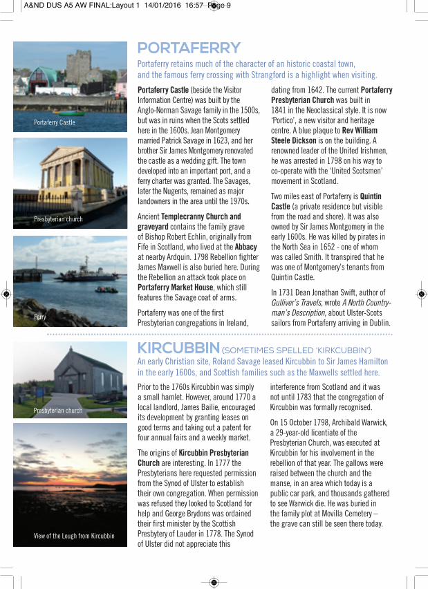
PORTAFERRYPortaferry retains much of the character of an historic coastal town,and the famous ferry crossing with Strangford is a highlight when visiting.
Portaferry Castle (beside the VisitorInformation Centre) was built by theAnglo-Norman Savage family in the 1500s,but was in ruins when the Scots settledhere in the 1600s. Jean Montgomerymarried Patrick Savage in 1623, and herbrother Sir James Montgomery renovatedthe castle as a wedding gift. The towndeveloped into an important port, and aferry charter was granted. The Savages,later the Nugents, remained as majorlandowners in the area until the 1970s.
Ancient Templecranny Church andgraveyard contains the family graveof Bishop Robert Echlin, originally fromFife in Scotland, who lived at the Abbacyat nearby Ardquin. 1798 Rebellion fighterJames Maxwell is also buried here. Duringthe Rebellion an attack took place onPortaferry Market House, which stillfeatures the Savage coat of arms.
Portaferry was one of the firstPresbyterian congregations in Ireland,
dating from 1642. The current PortaferryPresbyterian Church was built in1841 in the Neoclassical style. It is now‘Portico’, a new visitor and heritagecentre. A blue plaque to Rev WilliamSteele Dickson is on the building. Arenowned leader of the United Irishmen,he was arrested in 1798 on his way toco-operate with the ‘United Scotsmen’movement in Scotland.
Two miles east of Portaferry is QuintinCastle (a private residence but visiblefrom the road and shore). It was alsoowned by Sir James Montgomery in theearly 1600s. He was killed by pirates inthe North Sea in 1652 - one of whomwas called Smith. It transpired that hewas one of Montgomery’s tenants fromQuintin Castle.
In 1731 Dean Jonathan Swift, author ofGulliver’s Travels, wrote A North Country-man’s Description, about Ulster-Scotssailors from Portaferry arriving in Dublin.
KIRCUBBIN (SOMETIMES SPELLED ‘KIRKCUBBIN’)An early Christian site, Roland Savage leased Kircubbin to Sir James Hamiltonin the early 1600s, and Scottish families such as the Maxwells settled here.
Prior to the 1760s Kircubbin was simplya small hamlet. However, around 1770 alocal landlord, James Bailie, encouragedits development by granting leases ongood terms and taking out a patent forfour annual fairs and a weekly market.
The origins of Kircubbin PresbyterianChurch are interesting. In 1777 thePresbyterians here requested permissionfrom the Synod of Ulster to establishtheir own congregation. When permissionwas refused they looked to Scotland forhelp and George Brydons was ordainedtheir first minister by the ScottishPresbytery of Lauder in 1778. The Synodof Ulster did not appreciate this
interference from Scotland and it wasnot until 1783 that the congregation ofKircubbin was formally recognised.
On 15 October 1798, Archibald Warwick,a 29-year-old licentiate of thePresbyterian Church, was executed atKircubbin for his involvement in therebellion of that year. The gallows wereraised between the church and themanse, in an area which today is apublic car park, and thousands gatheredto see Warwick die. He was buried inthe family plot at Movilla Cemetery –the grave can still be seen there today.
Presbyterian church
Ferry
Presbyterian church
Portaferry Castle
View of the Lough from Kircubbin
A&ND DUS A5 AW FINAL:Layout 1 14/01/2016 16:57 Page 9

PORTAVOGIEFamous for fishing and seafood, Portavogie was settled in 1606 as part ofJames Hamilton’s estate, and developed as a fishing village in the 1700s.
The first recorded Ulster-Scots settlersare believed to have been the Boyds ofKilmarnock whose impressive Dean Castlecan still be visited there today. A map ofPortavogie was drawn for Hamilton byThomas Raven c. 1625.
It remained as a small settlement until1750 when it developed rapidly thanksto the arrival of a community of Scottishfishing families from Maidens in Ayrshire.They made use of the natural harbour atMcCammon Rocks and sandy beach atthe north of the present day village. In thelate 1800s around 60 boats shelteredhere. A new promenade along the beach
from the Warnocks Road to the harbouris popular and enjoyable route.
In 1683, William Montgomery recordedScots language fish names which arestill used here today - ‘lythe’ for pollack,‘blockan’ for coalfish and ‘bavins’ forwrasse. Today, Portavogie fish sellerstravel to local markets, and fish vans godoor-to-door, all over Ulster every week.
The earliest place of worship in thevillage was a Presbyterian outreach, theFisherman’s Hall, which opened in 1887.Portavogie Presbyterian Church wasfounded later, in 1926.
CLOUGHEY AND KIRKISTOWNFrom ‘cauld hames’ to a grand castle – and golf.Kirkistown Castle is an impressive towerhouse said to have been built by RolandSavage in 1622. It was located near theother Savage castles at Ballygalget andArdkeen, each visible from the others. Thecastle was later acquired by James McGilland in 1683 it was said that he had‘improved this place very much, bybuilding garden walls, and houses, andrepairing in and about'.
The local name ‘Calhame’ comes from aScots term meaning ‘cold home’, a namewhich can be found all over Scotland aswell as in counties Antrim and Donegal.
The golf courses nearby bring that mostScottish of sports to the area. ArdkeenChurch of Ireland includes a memorialto George Francis Savage-Armstrong,the renowned Ulster-Scots poet. Newboardwalks through the sandy ‘knowes’(knolls) provide access to the beach.
THE ‘LITTLE’ OR UPPER ARDSAn ancient boundary, with Scottish settlers on both sides.
The Saltwater Brig over the BlackstaffRiver, by the historic St Patrick’sChurch, marks an age-old divisionseparating the southern end of the Ards(the ‘Little Ards’ or ‘Upper Ards’) fromthe rest of the peninsula (the ‘Great Ards’or ‘Lower Ards). The river used to runright across the Peninsula, reaching theNorth Channel between Ballyhalbert andPortavogie. In the 1570s, it was proposedto build a fortification along the river.
In the early 1600s the ‘Little Ards’remained in the possession of the oldAnglo-Norman family of Savage, withthe ‘Great Ards’ to the north beinggranted to Hamilton and Montgomery.There are many sites in the ‘Little Ards’that are associated with the Savages andthese early Scottish families. Well worth avisit is Kearney on the outer coast whichwas restored by the National Trust as a19th-century fishing village.
Kirkistown Castle
Promenade
Harbour
Beach boardwalks
Some of the buildings at Kearney
Restaurant named after, and situatedbeside, the Saltwater Brig
A&ND DUS A5 AW FINAL:Layout 1 14/01/2016 16:57 Page 10

BALLYWALTERAn important part of Sir James Hamilton’s estate in 1606, this coastalvillage with popular sandy beaches attracts visitors all year round.
When it was built in the 1200s,Whitechurch (also known as AlbaEcclesia – which translates as both‘White Church’ or ‘Scots Church’) was oneof the biggest churches in County Down.Today some stone coffin-lids of its Anglo-Norman founders can be still be seen.
The gravestones include that of JohnCooper, originally of Kilwinning inAyrshire, who settled with his family atnearby Ballyhaskin. One of the first Scotsto settle here, he died in 1608 aged 92.Thomas Makie, an early 17th-centuryBurgess of Stranraer also lies here. Lookout for the 1798 Rebellion gravestonesof David and Hugh Maxwell, James Kainand William Stuart, all killed on theattack on Newtownards Market House.
In 1623 King James I granted JamesHamilton permission to build a harbourwhich is still in daily use by small
pleasure boats and local fishermen asthey land crubins (large edible crabs),lobsters in creels, and line-caught fish.
In 1626 Hamilton’s nephew Rev JamesHamilton became the first Presbyterianminister on the Ards Peninsula – adatestone can be seen on the communitycentre in Main Street. A stone bearing thedate 1644 can be seen at Whitechurch –this was the year in which the SolemnLeague & Covenant was signed here.
Ballywalter has many brown heritagestreet signs which recall the originalUlster-Scots street names around thevillage. The main street is dominated bythe Presbyterian Church, built in 1889, withthe smaller Parish Church built in 1849.
Ballywalter Park (private property) is theseat of Lord and Lady Dunleath. The estatewas bought in 1846 by Andrew Mulholland,from a Belfast Ulster-Scots merchant family.
BALLYHALBERTThe most easterly point of Ireland, Ballyhalbert is within the Parish ofSt Andrew, the patron saint of Scotland.
The slopes of the Anglo-Norman mottewhich overlooks Ballyhalbert include aprehistoric standing stone, indicating thatthis is an ancient settlement. The ruinedAnglo-Norman church at the seafrontdates from around the late 1200s. Earlyrecords name the church as ‘Talbotston’.
When Sir James Hamilton acquired thearea in 1606, Ballyhalbert church wasrestored for its Scottish population and in1622 a Rev George Porter became minister.
The church fell into ruin, and in 1704 itshandcrafted rooftimbers were salvaged foruse in the new church at nearby Balliganwhere they can still be seen today.
Ballyhalbert graveyard is a fine exampleof an 18th century burying-ground, theoldest surviving gravestone dating from1709. Its gravestones include that ofCaptain John McWhir who inspired theheroic character Captain MacWhirr in the1902 Joseph Conrad novel Typhoon.
Ballyhalbert has many brown heritagestreet signs which recall the originalUlster-Scots street names around thevillage, such as Tay Pot Raa.
During the summer months, jet skiersenjoy the harbour and bay, while thedulse-pickers dry their seaweed harvestalong the harbour wall.
Harbour
Old church and graveyard
Community centre datestone
View from the harbour
Whitechurch
Balligan church interior
A&ND DUS A5 AW FINAL:Layout 1 14/01/2016 16:57 Page 11
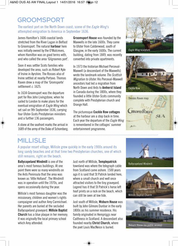
GROOMSPORTThe earliest port on the North Down coast; scene of the Eagle Wing’sattempted emigration to America in September 1636.
James Hamilton’s 1606 coastal landsstretched from the River Lagan in Belfastto Groomsport. The natural harbour herewas initially owned by the O’Mulcreves,whom Hamilton was on good terms with,and who called the area ‘Gilgroomes port’.
Soon it was settler Scots families whodeveloped the area, such as Robert Kyleof Irvine in Ayrshire. The Rosses also ofIrvine settled at nearby Portavo. ThomasRaven drew a map of the ‘Gromsporte’settlement c. 1625.
In 1634 Groomsport was the departureport for Rev John Livingstone, when hesailed to London to make plans for theeventual emigration of Eagle Wing whichset sail on 9th September 1636, carryingfour Ulster-Scots Presbyterian ministersand a further 136 passengers.
A stone at the seafront marks the arrival in1689 of the army of the Duke of Schomberg.
Groomsport House was founded by theMaxwells in the late 1600s. They cameto Ulster from Calderwood, south ofGlasgow, in the early 1600s. The currentbuilding, dating from 1849, was recentlyconverted into private apartments.
In 1973 the historian Michael Perceval-Maxwell (a descendant of the Maxwells)wrote the landmark volume The ScottishMigration to Ulster. His Perceval-Maxwellancestors had led a migration fromNorth Down and Ards to Amherst Islandin Canada during the 1800s, where theyfounded a little Ulster-Scots communitycomplete with Presbyterian church andOrange Hall.
The picturesque Cockle Row cottagesat the harbour are a step back in time.Each year the departure of the Eagle Wingis remembered in the cottages’ summerentertainment programme.
MILLISLEA popular resort village, Millisle grew quickly in the early 1900s around itslong sandy beaches and at that time two Presbyterian churches, one of whichstill remains, right on the beach.Ballycopeland Windmill is one of thearea’s most famous buildings. At onepoint there were so many windmills onthe Ards Peninsula that the area wasknown as ‘little Holland’. The Windmillwas in operation until the 1970s, andopens occasionally during the year.
Millisle’s most famous daughter was themissionary, children and women’s rightscampaigner and author Amy Carmichael.Her parents are buried at the secludedBallycopeland graveyard. Millisle BaptistChurch has a blue plaque in her memory;it was originally the local primary schoolwhich Amy attended.
Just north of Millisle, Templepatricktownland was where the telegraph cablefrom Scotland came ashore. 1500 yearsago it is said that St Patrick landed here,where a small church and well onceattracted visitors to the tiny graveyard.Legend has it that St Patrick’s horse lefthoof prints on a rock on the beach, whichcan still be seen at low tide.
Just south of Millisle, Woburn House wasbuilt by John Gilmore Dunbar in the early1800s as his summer residence. Hisfamily originated in Hempriggs nearCaithness in Scotland. A descendant alsofounded nearby Christ Church, wherethe poet Louis MacNeice is buried.
Woburn House (no public access)
Millisle Baptist Church
Thomas Raven map
Cockle Row
Eagle Wing sculpture
Ballycopeland Windmill
A&ND DUS A5 AW FINAL:Layout 1 14/01/2016 16:57 Page 12
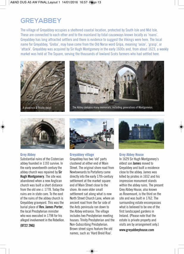
Grey AbbeySubstantial ruins of the Cistercianabbey founded in 1193 survive. Inthe early seventeenth century theabbey church was repaired by SirHugh Montgomery. The site wasabandoned when a new Anglicanchurch was built a short distancefrom the old one c. 1778. Today theruins are in state care. To the eastof the ruins of the abbey church isGreyabbey graveyard. This was theburial place of Rev. James Porter,the local Presbyterian ministerwho was executed in 1798 for hisalleged involvement in the Rebellion.(BT22 2NQ)
Greyabbey villageGreyabbey has two ‘old’ partsclustered at either end of MainStreet. The original shore road fromNewtownards to Portaferry camedirectly into the early 17th-centurysettlement at the market squareend of Main Street close to theshore. An even older smallsettlement sat along what is nowNorth Street Church Lane, where anancient road from the far side ofthe Ards peninsula ran down tothe Abbey entrance. The villageincludes two Presbyterian meetinghouses: Trinity Presbyterian and theNon-Subscribing Presbyterian.Brown street signs feature the oldnames, such as ‘Hard Breid Raa’.
Grey Abbey HouseIn 1629 Sir Hugh Montgomery’seldest son Jamesmoved toGreyabbey and built a residenceclose to the abbey. James waskilled by pirates in 1652 and hisimpressive monument standswithin the abbey ruins. The presentGrey Abbey House, also knownas Rosemount, is the third on thesite and was built in 1762. Thesurrounding estate encompasseswhat is believed to be one of thefirst landscaped gardens inIreland. (Please note that theestate is private property andvisits are by arrangement only.)www.greyabbeyhouse.com
GREYABBEY
The Abbey contains many memorials, including generations of Montgomerys.A shamrock & thistle detail
The village of Greyabbey occupies a sheltered coastal location, protected by South Isle and Mid Isle.These are connected to each other and to the mainland by tidal causeways known locally as ‘roans’.Greyabbey has long attracted settlers and there is evidence to suggest the Vikings were here. The localname for Greyabbey, ‘Greba’, may have come from the Old Norse word Grípa, meaning ‘seize’, ‘grasp’, or‘attack’. Greyabbey was acquired by Sir Hugh Montgomery in the early 1600s and, from about 1623, a weeklymarket was held at The Square, serving the thousands of lowland Scots farmers who had settled here.
A&ND DUS A5 AW FINAL:Layout 1 14/01/2016 16:57 Page 13

NEWTOWNARDS
CONLIG
CRAWFORDSBURN
HOLYWOOD
GROOMSPORT
DONAGHADEE
18 MILES TO PORTPATRICK
MILLISLE
CARROWDORE
BALLYWALTER
KIRCUBBIN
PORTAVOGIE
CLOUGHEY
KEARNEY
COPELANDISLANDS
BISHOPS MILL
MOUNT STEWARTSCRABO
WHITEROCK
NENDRUM
CUNNINGBURN
BALLYHALBERT
PORTAFERRYSTRANGFORD
DOWNPATRICK
KILLYLEAGH
KILLINCHY
BALLYGOWAN
COMBER
DUNDONALD
WEST LOUGH COAST28 MILES / 45 MINUTES
GREYABBEY
BANGORB
EL F A S T L O U G H
S T R AN
G
FO
RD
LO
UG
H
COUNCILBOUNDARY
COUNCILBOUNDARY
EAST LOUGH COAST22 MILES / 40 MINUTES
NORTH CHANNEL COAST45 MILES / 1 HR 30 MINUTES
THE N
ARRO
WS
N O R T HC H A N N E L
Our Council area surrounds Strangford Lough, said to be the largest sea water inlet in the BritishIsles. At the Narrows, between Portaferry and Strangford, strong currents are created by millionsof gallons of water surging through, the energy of which is captured by the SeaGen tidal turbine.In 1683, William Montgomery wrote of ‘... a whirle-poole or eddy of the returning tides, called bythe Scotch the rowling weele from the loud sound it sometimes makes... near to which if smallboats come ... it is said they will be suckt in ...’
The ferry crossing between Portaferry and Strangford isa must-do experience, giving a real sense of the strongcurrents below. You can see why the Vikings named this‘Strong Fjord’. Windmill Hill overlooking Portaferry is theideal viewpoint.
COASTAL DRIVESAlong the west coast the road winds through ancientChristian sites like Nendrum, island-hopping causeways,sailing clubs, and castles such as the ruined Sketrickto James Hamilton’s impressive 17th century home atKillyleagh, which looks like a grand French chateau.
Along the east coast from Newtownards to Portaferry ispart of the St Patrick’s Trail. As you head south, get offthe beaten track and take the lesser-known routes – hugthe coastline from Bishops Mill south to Portaferry; thentravel from Portaferry up to Cloughey – the beauty ofthese country roads is an experience you’ll remember.
The outer North Channel coast is part of theMourne Coastal Route, but it could just aseasily be called the County Down Ulster-ScotsRoute. On a clear day Scotland is easily visiblefrom Crawfordsburn to Cloughey – at night thelighthouses of the Mull of Galloway, and boatsof all sizes from fishing trawlers to cruiseships, twinkle in the darkness.
STRANGFORD LOUGH
The view from Tullycarnan townland across ‘The Narrows’ of Strangford Lough, towards Lecale and the Mourne Mountains.It is said that Con O’Neill may have spent his latter years here. His widow Eilis married Henry Savage of Ardkeen in 1628.
A&ND DUS A5 AW FINAL:Layout 1 14/01/2016 16:57 Page 14
MOUNT STEWARTMount Stewart is one of Northern Ireland’s best National Trust properties,and was recently reopened following a major programme of renovationsthat lasted for three years and cost £7m.
Having previously been owned by thefamilies of Montgomery and Colville,Mount Pleasant, as it was originallyknown, was acquired by AlexanderStewart when he purchased the manorsof Newtownards and Comber for £42,000in 1744. Like the Montgomerys and theColvilles, the Stewarts were originallyfrom Scotland. Stewart was fromBallylawn in County Donegal and hadbeen MP for Londonderry. He used someof his wife Mary’s fortune (inherited fromher brother who had been Governor ofBombay) to buy the estate.
Alexander Stewart’s eldest son Robertbecame an MP in 1769 and a peer in1783, rising to Marquess of Londonderryin 1816. He died in 1821 and was buriedat Newtownards Priory in the family tomb.His son was Lord Castlereagh, the Chief
Secretary of Ireland who forced throughthe Act of Union in 1800 and later theBritish Foreign Secretary at the time ofthe Congress of Vienna of 1814-15.
The house was constructed over decadesand much of its present appearancedates from the late 1840s. The mostdistinguished building on the propertyis the Temple of the Winds, built in the1780s, which is in the first rank ofClassical buildings in Ireland.
With an incredible collection of plantsas well as great ingenuity in their design,Mount Stewart’s gardens are amongthe finest in the world. Edith, LadyLondonderry, was instrumental in thedevelopment of these gardens. Look outfor the Red Hand of Ulster flower bed aswell as topiary shaped like an Irish harp.
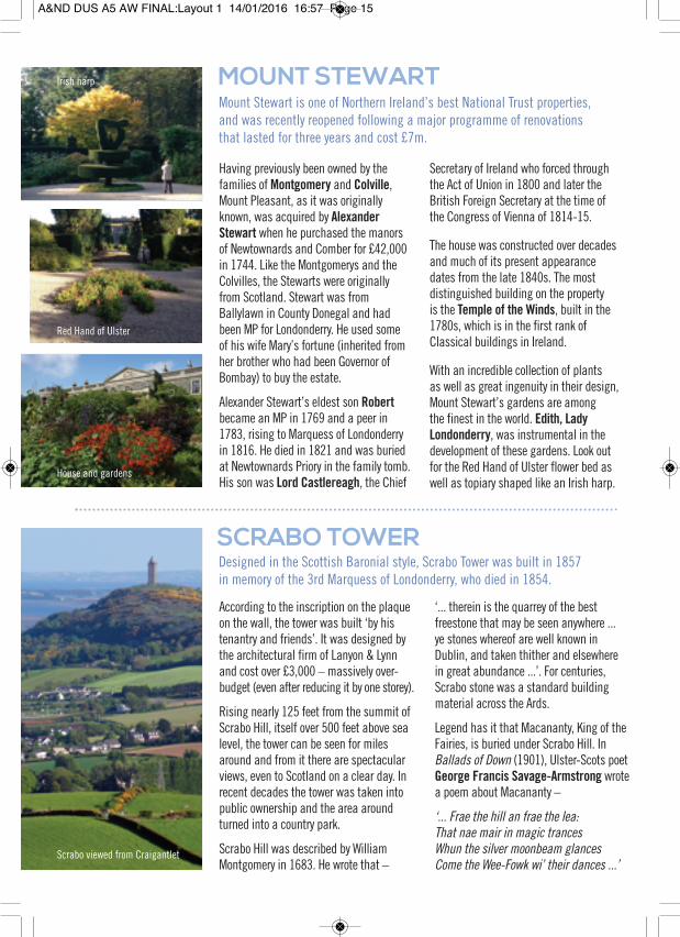
SCRABO TOWERDesigned in the Scottish Baronial style, Scrabo Tower was built in 1857in memory of the 3rd Marquess of Londonderry, who died in 1854.
According to the inscription on the plaqueon the wall, the tower was built ‘by histenantry and friends’. It was designed bythe architectural firm of Lanyon & Lynnand cost over £3,000 – massively over-budget (even after reducing it by one storey).
Rising nearly 125 feet from the summit ofScrabo Hill, itself over 500 feet above sealevel, the tower can be seen for milesaround and from it there are spectacularviews, even to Scotland on a clear day. Inrecent decades the tower was taken intopublic ownership and the area aroundturned into a country park.
Scrabo Hill was described by WilliamMontgomery in 1683. He wrote that –
‘... therein is the quarrey of the bestfreestone that may be seen anywhere ...ye stones whereof are well known inDublin, and taken thither and elsewherein great abundance ...’. For centuries,Scrabo stone was a standard buildingmaterial across the Ards.
Legend has it that Macananty, King of theFairies, is buried under Scrabo Hill. InBallads of Down (1901), Ulster-Scots poetGeorge Francis Savage-Armstrong wrotea poem about Macananty –
‘... Frae the hill an frae the lea:That nae mair in magic trancesWhun the silver moonbeam glancesCome the Wee-Fowk wi’ their dances ...’
Scrabo viewed from Craigantlet
Red Hand of Ulster
Irish harp
House and gardens
A&ND DUS A5 AW FINAL:Layout 1 14/01/2016 16:57 Page 15

ULSTER FOLK AND TRANSPORT MUSEUM
The Museum is on the former Kennedyestate at Cultra. The Kennedys had movedto Ulster from Ayrshire in the 1660s,settling at Ballycultra. They bought theestate from the Hamiltons a few yearslater, and married into the Stewarts ofBallylawn in Donegal (who later moved toCounty Down and bought Mount Stewart).
The open-air folk museum opened in 1964and has reconstructed a traditionallandscape with dozens of old dwellings fromall over Ulster. Two in particular are from anUlster-Scots background — the Coshkib HillFarm (north Antrim) and the Ballyveaghthatched house (Mournes). Both these
houses were well-known in their communitiesas ‘kailey’ houses where neighbours gatheredfor a ‘guid nicht’s crack’. There is also aT-plan Presbyterian Church, or ‘Meeting-House’,from County Tyrone.
The transport museum at the same sitehas exhibits and exhibitions which tell thestory of many Ulster-Scots innovatorssuch as tractor entrepreneur Harry Ferguson.
The Ulster Dialect Archive at the museumhas invaluable collections relating to thevarieties of language in Ulster, particularlyUlster-Scots. The archival collections andresearch library of the museum are open tovisitors by appointment (office hours only).
PARKS AND COASTAL WALKSNorth Down Coastal Path is a 16-mileroute from Holywood to Orlock nearGroomsport, following Sir JamesHamilton’s estate boundaries of 1606. Itconnects with Crawfordsburn CountryPark, where Crawfordsburn Glen winds1.5 miles inland from the coast.
The Commons at Donaghadee is verypopular with locals and of course enjoysviews to Scotland. All of the beaches on theNorth Channel coast are easily accessible.
Further south, Kearney has coastalgrassland walks, while Knockinelder Bayand Ballyquinton Farm trails nearPortaferry are local favourites.
For a bird’s-eye view, Scrabo Country Parkis a must. To get close to the Lough you canwalk from Greyabbey to Mid Isle, or alongthe shorelines at Islandhill and Whiterock.
Strangford Lough is on the National CycleRoute, and there are 11 canoeing trails.
PLACE NAMESThe burns and braes of the Ards and North Down.
From Crawfordsburn village, toCunningburn just north of Mount Stewart,to the Carrstown Burn near Portaferry,if you keep your eyes open you’ll seeUlster-Scots place names dotted naturallyright across our Council area.
The Scots settlers of the 1600s kept thetownland names which the O’Neills hadbeen familiar with, but they introducedtheir own new Scots-influenced names
as well. Some of these have been restoredon brown signs in some of the villages,whilst others can be seen on the regularwhite street signs. Talk to the older localsand you’ll find names which live on inpopular memory - ‘Coo Vennel’ in Comber,‘Schoolhouse Brae’ in Donaghadee,‘Echlinville’ in Ballyhalbert parish, ‘WhaupRock’ in Greyabbey, ‘Saltwater Brig’ inArdkeen... keep your eyes and ears open!
Situated at Cultra near Holywood, the Ulster Folk and Transport Museum is oneof Europe’s most prestigious ‘national’ open-air museums.
Holywood
Portaferry
Coshkib Hill Farm
Traditional Ulster gate
Knockinelder Bay near Kearney
Ballydorn Lightship near Whiterock
A&ND DUS A5 AW FINAL:Layout 1 14/01/2016 16:57 Page 16