description paper spatiowl location-based services · the millions of modern cars out there have...
TRANSCRIPT

Description Paper SPATIOWL Location-Based Services
Page 1 of 4 http://www.fujitsu.com/fts
Human-centric intelligent society With the emergence of new mobile devices, PCs, and mobile phones, as well as new services, and due to advances in sensor technologies, in recent years people have been overwhelmed by information in every area of daily life. Fujitsu is aiming to bring about a human-centric intelligent society in which people can live more prosperous and secure lives. As a way to make this happen, Fujitsu is working to leverage massive volumes of data by capturing and analyzing the vast amounts of data generated by human activity and the movement of things, and harnessing it to develop new insights. SPATIOWL - Service platform for the human-centric intelligent society SPATIOWL - a Fujitsu development with many possible applications – is based on this idea. It is a generic framework that can deal with large amounts of data coming from multiple sources. SPATIOWL brings all collected information together and derives suggestions for possible actions. This enables customers to develop unique services to create new value based on location data delivered by Fujitsu and other customer-specific data. Such services, for instance, report traffic information in real-time, facilitate urban planning, or address desires of local residents. Traffic management service One of the examples we are now going to have a closer look at is the SPATIOWL-based traffic information and management service. Masses of data are collected from an incredibly rich variety of sources. From sensors planted in fleets of vehicles like taxis or haulers, from roadside sensors that monitor traffic flow, even down to subtle things like the speed that windscreen wipers are moving in the rain. But SPATIOWL also collects data from individuals and communities, from social media and events. And of course, location information of pedestrians and vehicles is constantly updated, when they move. This enables SPATIOWL to map the real world to a digital world. Take for example the problem of managing the traffic of a huge metropolis with a very large population. Traffic jams and transport disruption is ubiquitous. The picture on the right shows the city map of Tokyo. Blue stands for flowing traffic, yellow for high density slow traffic and red for congestion. People and navigation systems can use this information to optimize their route planning.
Description Paper SPATIOWL Location-Based Services
SPATIOWL location-based data services deliver new value by providing information to people on-the-move, facilitating urban planning, and offering new services to local residents.
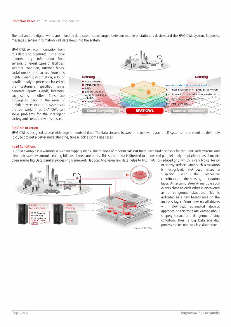
Description Paper SPATIOWL Location-Based Services
Page 2 of 4 http://www.fujitsu.com/fts
The real and the digital world are linked by data streams exchanged between mobile or stationary devices and the SPATIOWL system. Requests, messages, sensor information - all data flows into the system. SPATIOWL extracts information from this data and organizes it in a logic manner, e.g. information from sensors, different types of facilities, weather condition, internet blogs, social media, and so on. From this highly dynamic information, a lot of parallel analytic processes based on the customer's specified terms generate reports, trends, forecasts, suggestions or offers. These are propagated back to the users of mobile devices or control systems in the real world. Thus, SPATIOWL can solve problems for the intelligent society and creates new businesses. Big Data in action SPATIOWL is designed to deal with large amounts of data. The data streams between the real world and the IT systems in the cloud are definitely “big”, but to get a better understanding, take a look at some use cases. Road Conditions Our first example is a warning service for slippery roads. The millions of modern cars out there have brake sensors for their anti-lock systems and electronic stability control, sending billions of measurements. This sensor data is directed to a powerful parallel analytics platform based on the open source Big Data parallel processing framework Hadoop. Analyzing raw data helps to find hints for reduced grip, which is very typical for icy
or snowy surface. Once such a situation is recognized, SPATIOWL raises a suspicion with the respective coordinates to the sensing information layer. An accumulation of multiple such events close to each other is discovered as a dangerous situation. This is indicated as a new hazard area on the analysis layer. From now on all drivers with SPATIOWL connected devices approaching this zone are warned about slippery surface and dangerous driving condition. Thus, a Big Data analytics process makes our lives less dangerous.

Description Paper SPATIOWL Location-Based Services
Page 3 of 4 http://www.fujitsu.com/fts
Smart congestion resolution Here we see a situation, where SPATIOWL can handle different types of data coming from multiple data sources, which makes the situation of course more complex. Look at a traffic situation with cars, pedestrians and a tram. All these objects and their positions are known in the SPATIOWL coordinate system. Since the car ride was planned using SPATIOWL, the intended routes of the cars are known, too. Thus SPATIOWL can find indications for an overload condition related to the street ahead of the drivers, predict an upcoming congestion and a smart way to resolve it. Another data source for SPATIOWL can be social networks. Let us assume, a social network scan figures out a flash mob appointment for the current time and location. As a result, this event object on the real-time information layer is now activated. From these two facts - high density routes and ongoing flash mob - SPATIOWL predicts congestion in this particular street. This is indicated as a congestion zone on the analysis and forecast layer.
Likewise, SPATIOWL collects traffic data for statistical analysis and pattern recognition, which means that historical data can be involved for congestion prediction and warnings. To resolve this problem, knowledge from the social network profile of the drivers can be leveraged. If a driver has a season ticket for the public transportation system, a short check of the timetable will show us, that he can reach his destination timely by tram; so tram could be a viable alternative for this driver. If a driver is married, flowers for his wife from a nearby
shop could increase his relationship scorecard. If a driver holds a loyalty card from a gas station found in the neighborhood, he could fill up the tank of his car. These individual suggestions are now posted to the drivers together with the congestion warning. They are buying into the offers, and follow the adapted routes. So the traffic jam is gone with a win-win situation for the participants. To make this happen, the system had to use different types and sources of data from inside and outside of SPATIOWL and deliver results in real-time.

Description Paper SPATIOWL Location-Based Services
Page 4 of 4 http://www.fujitsu.com/fts
Combining public and personal data When driving through a city by car, there are often situations demanding our full concentration. Phone calls might cause dangerous distractions here. Traffic becomes safer when we do our phone calls in non-critical traffic. How can SPATIOWL know this in advance?
From historical accident analysis and from situational short term traffic prediction, SPATIOWL can derive indications. Whenever it foresees an easy and relaxed ride for a driver, it can send a trigger to his mobile device. This can then ask the enterprise collaboration system for a list of outstanding phone calls. Using voice command, the driver can select a call and the number is dialed.
From on-premise solutions to cloud based services SPATIOWL is an entire Big Data framework from on-premise solutions to cloud based services. It includes Fujitsu analytic and infrastructure products, and many enhancements of standard tools such as Hadoop. Building from scratch a system that can collect and process large volumes of data in real-time requires considerable investments in time and resources. By offering as a cloud service, customers can use only the necessary services and analysis results, thereby making for an easy, quick and inexpensive way to gain new business insights. For Big Data projects, Fujitsu has got experts that support customers in consulting and integration. More than just traffic management We have seen that fleet and logistics management can use SPATIOWL to route their traffic in the most efficient way. Individuals can use it to get simple reports of traffic. Urban authorities can use it to manage traffic control – in real time. And as we move into the future, a major application will be to link drivers to supply points for electric vehicles. However, SPATIOWL is not limited to traffic management. It can also be used as a platform for industry-specific services required in other vertical industry segments, such as agriculture, healthcare, automotive and utility. The potential of SPATIOWL and Big Data is vast.
Contact FUJITSU Technology Solutions GmbH Address: Mies-van-der-Rohe-Strasse 8, 80807 Munich, Germany Website:www.fujitsu.com/fts
ƒ Copyright 2013 Fujitsu, the Fujitsu logo are trademarks or registered trademarks of Fujitsu Limited in Japan and other countries. Other company, product and service names may be trademarks or registered trademarks of their respective owners. Technical data subject to modification and delivery subject to availability. Any liability that the data and illustrations are complete, actual or correct is excluded. Designations may be trademarks and/or copyrights of the respective manufacturer, the use of which by third parties for their own purposes may infringe the rights of such owner.