design code south denes - great yarmouth
TRANSCRIPT
1
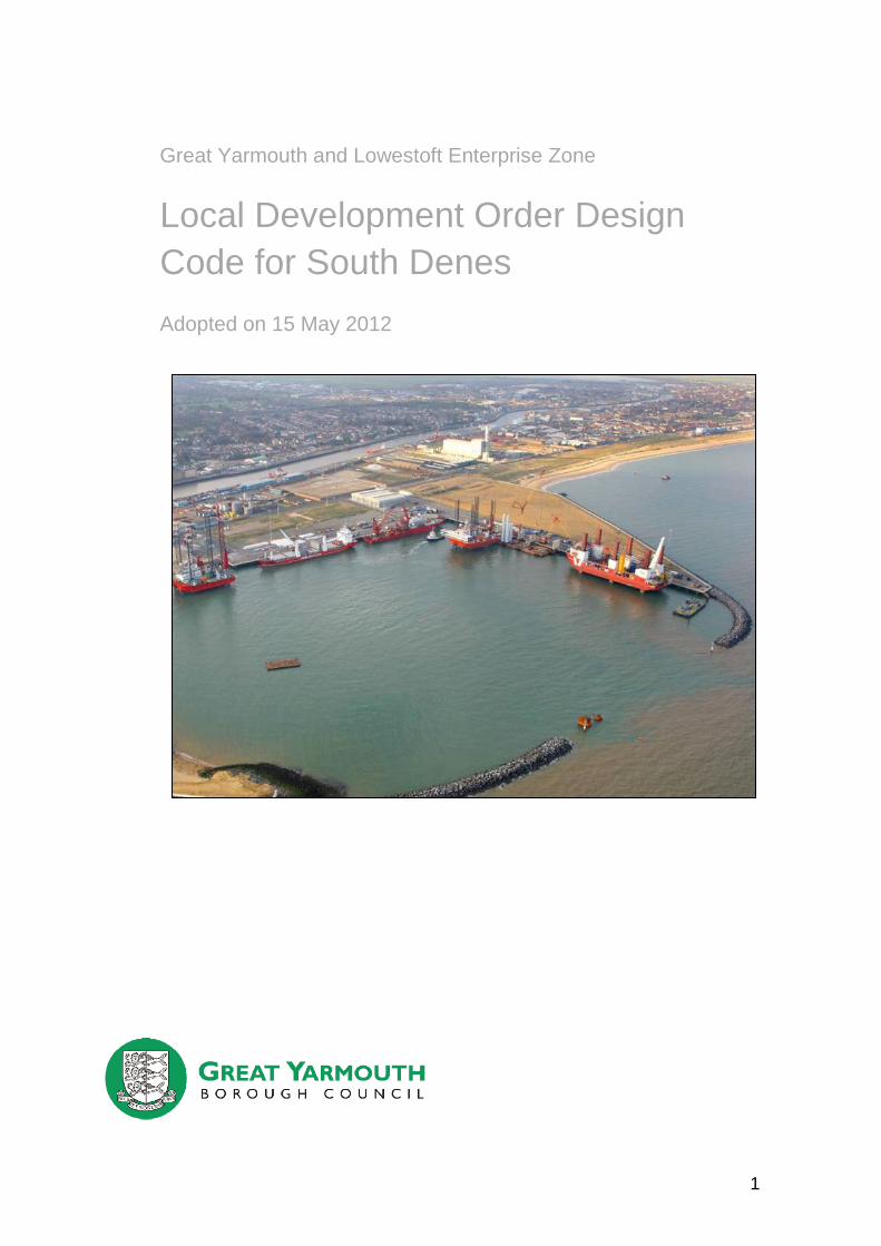
Great Yarmouth and Lowestoft Enterprise Zone
Local Development Order Design
Code for South Denes
Adopted on 15 May 2012
2
Peter Warner BA (Hons) MA MRTPI Head of Planning and Business Services Great Yarmouth Borough Council Town Hall Hall Plain Great Yarmouth Norfolk NR30 2QF David Glason BSc (Hons) MSc MRTPI Strategic Planning, Housing and Regeneration Development Manager Great Yarmouth Borough Council Town Hall Hall Plain Great Yarmouth Norfolk NR30 2QF
3
Contents
Page
1. Introduction 5
2. General Requirements 6
2.1 General Design Guidance 6
2.2 Materials and Colours 7
2.3 Listed buildings and scheduled monuments 8
2.4 Walls and Fencing 11
2.5 Landscaping and Biodiversity 11
2.6 Cranes and Gantries 12
2.7 Lighting 13
2.8 Noise 14
2.9 Air Quality 14
2.10 Surface Water 15
2.11 Water Quality 15
2.12 Hazardous Installations 15
2.13 Parking Standards 15
2.14 General Highway Considerations 19
2.15 Archaeology 20
3. Flood Risk 21
4. Character Areas 24
4.1 South 24
4.2 North 26
4.3 West of the River 27
4.4 Nelson’s Monument and Surroundings 29
4
Appendices
Appendix 1: Listed Buildings and Scheduled Ancient Monuments 37
Appendix 2: Critical Highways Routes 38
Appendix 3: Archaeology Protocol 39
Appendix 4: Future Defended 1 in 200 Flood Risk Areas for South Denes
41
Appendix 5: Predicted Flood Levels (mAOD) for Future Defended 1 in 200 year Flood Event
42
Appendix 6: South Denes LDO Character Area Map 43
Appendix 7: South Character Area Maximum Building Heights 44
Appendix 8: North Character Area Maximum Building Heights 45
Appendix 9: West Character Area Maximum Building Heights 46
Appendix 10: Nelson’s Monument and Surrounds Character Area Maximum Building Heights
47
Appendix 11: Monument Road Building Lines 48
5
1. Introduction
This Design Code is intended to ensure that a satisfactory standard of development is achieved within the South Denes Local Development Order (LDO) area and that the cumulative affects of developments are neither detrimental to existing neighbours, nor detrimental to the emerging developments within the LDO area. The LDO specifies which types of development must accord with the requirements of the Design Code. These developments must accord with all aspects of the code that apply to that form of development within the area specified.
1.1. The Design Code recognises that there are several distinct character areas within South Denes and within the LDO areas west of the river and different criteria will therefore be appropriate in these different areas. Accordingly the requirements of the Design Code have been divided into the following character areas:
South
North
West of the River
Nelson’s Monument and Surroundings
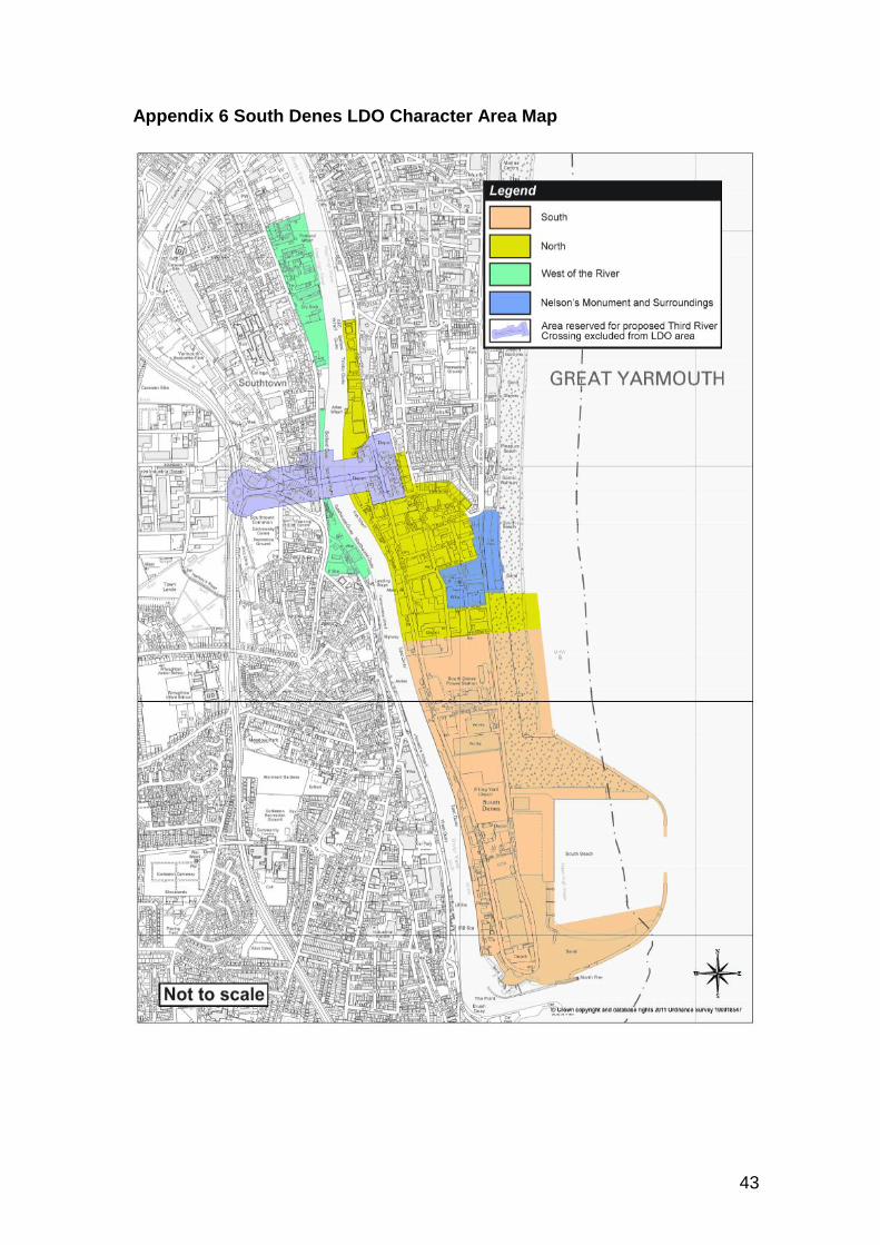
1.2. The above areas are indicated on the maps at Appendix 6 to 10.
1.3. In addition there are a series of requirements that will extend across the boundaries of the above character areas:
General Requirements
Flood Risk Areas
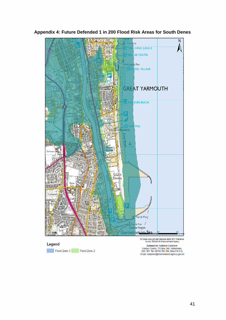
1.4. The whole of the South Denes LDO area is situated behind flood defences, but is subject to residual flood risks. The extent of potential flood waters is indicated on the map at Appendix 4.
1.5. A route has been reserved to facilitate the future construction of a third river crossing between Gorleston and South Denes. The area reserved for this crossing has been excluded from the LDO area, to ensure that development does not compromise the future construction of this important transport link. Proposals for development within the third river crossing area will be subject to the planning application processes. The reserved route is shown on the map at Appendix 2.
1.6. This Design Code contains both advice and compulsory standards. Those requirements that are compulsory are highlighted in bold text within a blue box.
Where a development spans the boundary of more than one character area, the requirements of each character area shall apply to those parts of the building/site or activity which is situated within each character area.
6
2. General Requirements (see character areas for specific design
guidance)
2.1. Form and design of development
2.1.1. The underlying objective for the architectural design of industrial and commercial buildings should be the same as for all new development, which is to make the public places in which they stand as attractive and welcoming as possible. The architectural treatment of industrial buildings should play its part in improving the image of new development in the Borough.
2.1.2. Contemporary building designs can fit well into an existing urban area, reinforcing the local townscape and creating new landmarks or focal points. Buildings should not resort to copying neighbouring building design but should give consideration to certain local characteristics (such as building lines, heights, scale, materials) in developing an appropriate design.
2.1.3. Wherever it is practicable, developers should consider laying out sites so that
buildings front onto the public realm and enclose ‘private’ external spaces, such as yards and car parks, behind them
2.1.4. There can be many benefits in locating new industrial and commercial buildings close to front boundaries and giving them a ‘public face’:
Using buildings as a barrier to enclose secure areas can minimise the need for lengths of fencing along frontages, this will not only improve the quality of the public realm, but also improve security for the plots. Well-designed building elevations can be both more secure and more attractive than chain-link fencing. This approach is compatible with many of the principles of ‘Secured by Design’ for commercial developments.
General security can be further enhanced where industrial buildings provide windows (to offices, canteens, or other active rooms) that overlook the public street and provide surveillance.
Buildings can better screen noise and other disturbance than fences, and thus reduce potential conflicts between neighbouring businesses and activities.
2.1.5. Frontages adjacent to pedestrian routes or public spaces should be designed to provide visual interest, activity and casual supervision at ground floor level. There are particular advantages in ensuring that office developments are orientated towards public space as the fenestration of such buildings can provide visual interest and articulation within the street scene. However, even industrial or warehouse buildings can be designed to break up the appearance of large areas of roof and walls and provide visual interest at ground level. For
7
example the use of different profiles of sheeting of the same colour, or articulated building footprints could be used to promote architectural definition and interest.
2.1.6. Space between buildings, or between buildings and their relevant boundaries, could be influenced by the requirements of the building regulations. These would include the separation of buildings to avoid fire spread, and the provision of access for fire appliances.
2.1.7. In addition developers should give consideration to the potential impact of their development on neighbouring sites and the potential for proposals on neighbouring sites to affect their developments. Particular regard should be given to the location of air intakes and extraction flues and the potential for loss of light that might arise from developments adjacent to boundaries.
2.1.8. Where adjacent sites are being developed concurrently, developers should seek to understand each others proposals and make efforts to achieve designs that do not have unacceptable impacts on neighbouring developments.
2.1.9. Loading bays, bin stores, outdoor storage mechanical plant, and other operational requirements should be incorporated into the overall design of the building and its site. Developments should seek to avoid such facilities appearing as dominant features in the street scene.
2.1.10. Where practicable consideration should be given to the re-use of any site demolition waste and the use of recycled/recovered materials including secondary/recycled aggregates.
2.2. Materials and colours
2.2.1. Over much of the South Denes LDO area it is intended that there should be few significant restrictions on materials (the exception being in the character area for ‘Nelson’s Monument and Surroundings’, where more specific requirements are considered necessary).
2.2.2. Modern cladding materials will be considered acceptable in most locations, but the use of a palette of different materials is encouraged, in order to achieve articulation and texture in the overall appearance of the area.
2.2.3. The visual impact of the colours and finishes of wall and roof cladding materials should be considered in relation to the background and context of the building. Their impact on the townscape or landscape should also be assessed in long views and views from higher ground. Where very large buildings are proposed, the use of colours and tones that differ from those of adjacent buildings can help to break up the collective visual mass of a group of buildings and give visual texture to the area when viewed from long distances.
2.2.4. Generally more subdued and non-reflective finishes can reduce the overall impact of a building. Colour contrast and highly reflective materials may be used to highlight key features such as entrances, windows and structure, but must generally be avoided over large areas of buildings.
8
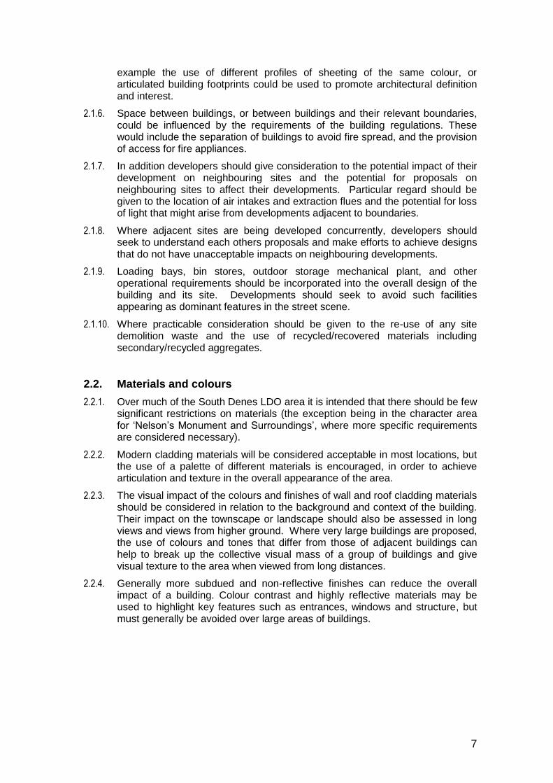
Examples of the use of colour, contrast, texture and a mix of cladding materials, to break up the massing of large walls and add visual interest:
2.3. Listed buildings and scheduled monuments
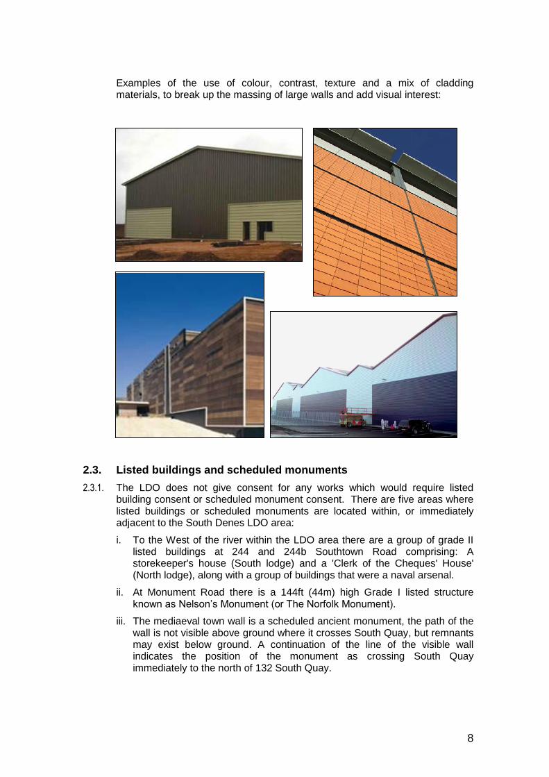
2.3.1. The LDO does not give consent for any works which would require listed building consent or scheduled monument consent. There are five areas where listed buildings or scheduled monuments are located within, or immediately adjacent to the South Denes LDO area:
i. To the West of the river within the LDO area there are a group of grade II listed buildings at 244 and 244b Southtown Road comprising: A storekeeper's house (South lodge) and a 'Clerk of the Cheques' House' (North lodge), along with a group of buildings that were a naval arsenal.
ii. At Monument Road there is a 144ft (44m) high Grade I listed structure known as Nelson’s Monument (or The Norfolk Monument).
iii. The mediaeval town wall is a scheduled ancient monument, the path of the wall is not visible above ground where it crosses South Quay, but remnants may exist below ground. A continuation of the line of the visible wall indicates the position of the monument as crossing South Quay immediately to the north of 132 South Quay.

9
iv. At the Fish Warf the grade II listed Dolphin public house (also known as: Fish Wharf Refreshment Rooms) lies immediately adjacent to the edge of the LDO area.
v. On Admiralty Road there is a Grade II listed cast iron and steel gas holder frame which lies immediately adjacent to the edge of the LDO area.
Listed buildings in the South Denes LDO area
ii
i

10
Listed buildings/Ancient monuments adjacent to the South Denes LDO area
2.3.2. The map at Appendix 4 shows the location of the listed buildings, scheduled monuments and conservation areas in the vicinity of the South Denes LDO.
Any developments in the immediate surroundings of the above structures and buildings must have regard to their setting.
2.3.3. Developers are encouraged to contact the Conservation Section at the Council and seek advice regarding the design of buildings in these locations.
2.3.4. Some site specific requirements are included in the character area sections of the Design Code.
iii
iv
5
v

11
2.4. Walls and Fencing 2.4.1. Security is an important consideration and the design and layout of new
development should minimise the opportunities for crime. However, the quality of the public realm is significantly affected by the form of boundary treatments that separate it from private spaces.
2.4.2. Within the South Denes LDO area there are many varied wall and fence types,
some of which are highly detrimental to the appearance of the public realm and many of which are probably ineffective in terms of security.
2.4.3. It is accepted that security is likely to be a high priority for companies locating
within the South Denes LDO area and therefore preventing the use of security fencing would not be appropriate.
2.4.4. In the area of Nelson’s Monument there is a need for further limitations in relation to fencing, in order to protect the setting of the monument. Further guidance can be found in the character area “Nelson’s Monument and Surroundings”.
2.4.5. Further considerations will also apply in flood risk areas. Further guidance can be found in the ‘Flood Risk’ section of the Design Code.
2.5. Landscaping and Biodiversity
2.5.1. The environment in the South Denes LDO area is relatively hostile to many types of plant, with salty sea air and sandy soils (some of which may be contaminated); furthermore there is little evidence of a tradition of landscaping within the area. Nevertheless, developers are encouraged to make landscaping part of their design and include landscaped areas within development sites.
2.5.2. Where buildings are very large, planting can create an environment at a human scale, adding to the legibility of the environment. Landscaping can be used to highlight entrances and can be used to create comfortable breakout areas for workers, within a safe area of the site. Planting can break up the expanse of parking areas and provide shade from the sun in summer months.
2.5.3. To some extent larger scale planting might help to break up the massing of larger buildings and punctuate spaces; however in the context of the South Denes LDO area it is unlikely that such planting could be of sufficient scale to screen buildings and given the stability of the sandy soils planting large specimen trees may be inadvisable.
X X
12
2.5.4. Many species of birds and bats are declining in numbers and one of the key factors affecting their survival is the lack of suitable sites where they can successfully nest, roost, hibernate and rear their young. Developers are encouraged to ensure that nesting and roosting opportunities are designed into buildings.
2.5.5. While there is specific legislation that protects certain species and habitats Local Planning Authorities (LPAs) in exercising their functions ‘must have regard to the requirements of the Habitats Directive so far as they may be
affected by the exercise of those functions’ (Regulation 9(5) of the Habitats
Regulations).
2.5.6. It is for this reason that the LDO requires developers to undertake protected species surveys. This approach also minimises the likelihood of future costs and delays, should particular species be encountered during development.
2.6. Cranes and gantries
2.6.1. Cranes and gantries are permitted by Class 1 of the South Denes LDO in association with activities authorised by those classes. The Great Yarmouth Outer Harbour Act 1986 also grants permission for such structures within the operational area of the Port. Cranes required temporarily during construction are permitted by part 4 of schedule 2 of the Town and Country Planning General Permitted Development Order 1995. Some cranes are vehicles and do not require planning permission.
2.6.2. Cranes come in many shapes and sizes, including mobile and fixed variants. Tall cranes can appear highly visible in the landscape and cranes sited in South Denes are likely to be visible both from residential areas and from the Broads. It is important to recognise however that in the South Denes area, cranes are considered to be a normal feature of the landscape, providing visual markers that denote the location of the port while announcing the activity of the area through their movement. Tall cranes in the South Denes LDO area are considered to be an acceptable and appropriate element within the wider landscape.
2.6.3. It is considered that the choice of crane type must be a matter for the operator to determine, as each crane must have a technical specification that is suitable for its task. No height, type or location constraints on cranes or gantries are therefore imposed by the order or this Design Code.
13
2.7. Lighting 2.7.1. Lighting design should keep glare to a minimum by ensuring that the main
beam angle of all lights directed towards any potential observer is not more than 70o. Higher mounting heights allow lower main beam angles, which can assist in reducing glare.
2.7.2. Some activities may require the deliberate and careful use of upward light - to which these limits cannot apply. However, care should always be taken to minimise any light trespass by the proper application of suitably directional luminaires and light controlling attachments. See Figure below:
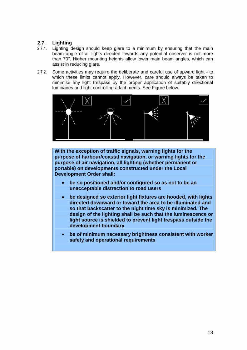
With the exception of traffic signals, warning lights for the purpose of harbour/coastal navigation, or warning lights for the purpose of air navigation, all lighting (whether permanent or portable) on developments constructed under the Local Development Order shall:
be so positioned and/or configured so as not to be an unacceptable distraction to road users
be designed so exterior light fixtures are hooded, with lights directed downward or toward the area to be illuminated and so that backscatter to the night time sky is minimized. The design of the lighting shall be such that the luminescence or light source is shielded to prevent light trespass outside the development boundary
be of minimum necessary brightness consistent with worker safety and operational requirements

14
2.8. Noise
2.8.1. As much of the South Denes LDO area is already in port or industrial use there is an existing level of noise that is “normal” in an historic context. Nevertheless, developers should pay close attention to how they can mitigate the effects of noisy activity, machinery or plant.
2.8.2. In order to avoid any harm to occupiers of nearby premises, developers should seek to design developments to minimise the potential for noise pollution from the activities intended. Developers are advised to seek advice from the Council’s Environmental Health Officer with respect to design measures to attenuate noise.
2.8.3. It is recommended that consideration be given to locating any noisy activities within buildings and ensuring that those buildings are suitably insulated to provide noise attenuation. Special attention should be given to the location of door and window openings and where possible buildings should be designed so that doors and windows can remain closed during noisy activities.
2.8.4. The use of buildings as built barriers to attenuate noise is recommended, particularly where external activities are expected to generate noise.
2.8.5. Particular attention should be given to the attenuation of noise where 24 hour operations are expected. Ambient noise levels are likely to be significantly lower at night and noise generated will therefore have the potential to cause greater disturbance.
2.8.6. Attention should be paid to the potential noise impacts of air extraction and other plant located on the roofs of buildings and consideration should be given to their screening and noise attenuation.
2.8.7. Consideration should also be given to the potential impact of audible hazard warnings on reversing vehicles, or alarms on other mechanical equipment. While it is accepted that such features are important for health and safety reasons, the sensible location of turning areas and the use of built barriers could help to minimise disturbance for neighbours.
2.9. Air Quality
2.9.1. Many of the locations within the South Denes LDO area are exposed to the wind and consequently any loose material that is stored in the open could become a source of dust, which has the potential to be a nuisance to residents and other businesses in the locality.
Where loose materials such as aggregates are stored external to buildings they must be stored within enclosures that will mitigate wind blown dust. The enclosures do not have to be roofed and can for example consist of a three walled storage bay.
2.9.2. Where necessary additional measures to suppress dust should be considered, such as water or foam sprays.
2.9.3. Spray painting and industrial processes can create fumes that may have detrimental affects on occupiers of adjacent property. The location of such processes relative to site boundaries should be considered in the design of
15
developments and the location of appropriate extraction and air filtering equipment should be considered from the outset.
2.9.4. Developers are advised to seek advice from the Council’s Environmental Health Officer with respect to any air quality issues.
2.10. Surface Water
2.10.1. Not all Sustainable Drainage Systems (SuDS) will be appropriate for use in South Denes. As infiltration SuDS are likely to be difficult to employ due to the ground conditions. It is therefore most likely that SuDS attenuation and flow features are most appropriate with discharge of surface water either to a watercourse, or to mains sewer at a restricted rate.
2.11. Water Quality
2.11.1. Note that South Denes is situated on a Principal Aquifer which is particularly sensitive to pollution.
2.11.2. The Environment Agency has written a range of Pollution Prevention Guidance Notes (PPGs). These are available to view at: www.environment-agency.gov.uk/business/topics/pollution/39083.aspx. They have also produced a quick guide to pollution prevention entitled “Getting Your Site Right” available at: http://publications.environment-agency.gov.uk/PDF/PMHO0104BHQI-E-E.pdf.
2.11.3. Developers should read the above guidance and complete the checklist to ensure that they are taking appropriate steps to protect the water environment.
2.12. Hazardous Installations
2.12.1. Hazardous installations use, manufacture or store significant quantities of hazardous substances that have the potential to cause serious harm to people on and surrounding the site. There is a major hazard installation on the South Denes peninsular.
2.12.2. The Health and Safety Executive (HSE) are a government agency responsible for regulating the safety of hazardous installations and assessing the potential hazards and risks of such developments. The HSE provides advice to planning authorities on the suitability of proposed developments within close proximity to hazardous installations.
2.12.3. In order to mitigate the effects of a potential accident at the installation the HSE have advised that the LDO manages the number of people that could be in close proximity to the site. Therefore condition x for Class 1 developments applies to the area illustrated on Appendix E of the South Denes LDO.
2.13. Parking Standards
2.13.1. As much of the South Denes LDO Design Code area is on a spit of land confined on three sides by water, inadequate provision of on site parking within the area could potentially lead to congestion within the area, or may lead to an overflow of parking in to the adjacent land area to the north. The land area to
16
the north is one of the primary tourist areas of Great Yarmouth (including the Golden Mile) and it is considered important to ensure that overflow parking from the industrial area does not impact on tourist parking facilities or residential on street parking. For this reason it is considered to be essential that adequate parking provision is provided for new developments in the South Denes LDO area.
2.13.2. The Local Planning Authority will therefore not permit any exception to the parking standards below unless the developer is able to demonstrate an effective means of providing off site car parking and/or transport arrangements that can be securely tied to the site activities for the lifetime of the development. One means of securing off site car parking and transport arrangements might be through the means of a unilateral undertaking under section 106 of the Town and Country Planning Act 1990.
2.13.3. All standards referred to in this section are minimum standards. Developers may judge for themselves whether additional parking would be necessary for their proposed use and are at liberty to provide additional spaces if they believe that they may be required, however, developers are also encouraged to consider the use of ‘workplace travel planning’ to minimise the use of cars.
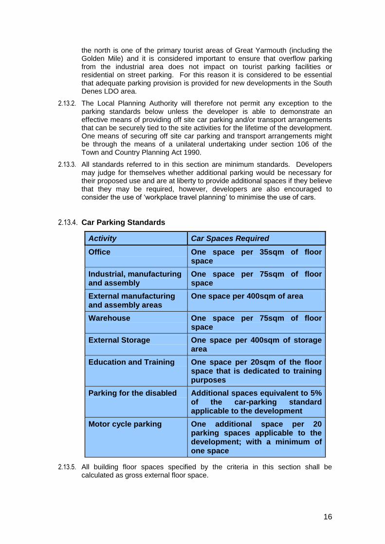
2.13.4. Car Parking Standards
2.13.5. All building floor spaces specified by the criteria in this section shall be calculated as gross external floor space.
Activity Car Spaces Required
Office One space per 35sqm of floor space
Industrial, manufacturing and assembly
One space per 75sqm of floor space
External manufacturing and assembly areas
One space per 400sqm of area
Warehouse One space per 75sqm of floor space
External Storage One space per 400sqm of storage area
Education and Training One space per 20sqm of the floor space that is dedicated to training purposes
Parking for the disabled Additional spaces equivalent to 5% of the car-parking standard applicable to the development
Motor cycle parking One additional space per 20 parking spaces applicable to the development; with a minimum of one space
17
2.13.6. Numbers derived from the standards set out below should be rounded down to the nearest whole number.
2.13.7. If an extension is proposed the standard applies to the area of the extension. If the extension results in the loss of any car parking spaces such spaces shall be replaced elsewhere on the site on a one for one basis.
Parking in accordance with Design Code standards must be provided within the development site, unless otherwise agreed in writing by the Local Planning Authority.
2.13.8. Parking spaces should be set out in accordance with the dimensions indicated within ‘Parking Standards for Norfolk 2007’1
Car parking spaces shall be clearly marked on the surface of a designated parking area and shall be kept free of other obstructions that might prevent the use of the area for parking.
Parking for the Disabled
2.13.9. Parking spaces for the disabled should accord with the standards in part M of the building regulations. 2
Lorry Parking
2.13.10. The extent to which a business may need to park lorries can only be determined by that business. Accordingly there are no specified requirements for the number of lorry parking spaces. It is important to ensure that lorry parking does not result in the obstruction of the highway and accordingly developers must ensure that sufficient space is allocated within their site to facilitate off road parking and manoeuvring of lorries.
2.13.11. Lorry parking spaces should be of dimensions that are adequate to accommodate the types of vehicles that the business proposes to use.
2.13.12. Space should be provided in accordance with the FTA publication, ‘Designing for Deliveries’3 and regard must be taken to prevent any pollution.
1 www.norfolk.gov.uk/Travel_and_transport/Roads/Traffic_management/Parking/NCC05493
2 www.planningportal.gov.uk/buildingregulations/approveddocuments/partm/approved
3 www.fta.co.uk/
18
Cycle Parking
2.13.13. In addition to the car parking standards above, parking space for cyclists shall be provided to at least the following standards:
2.13.14. All building floor spaces specified by the criteria in this section shall be calculated as gross external floor space.
2.13.15. Numbers derived from the standards set out below should be rounded down to the nearest whole number.
2.13.16. If an extension is proposed the standard applies to the area of the extension. If the extension results in the loss of any cycle parking spaces such spaces shall be replaced elsewhere on the site on a one for one basis.
2.13.17. Developers are encouraged to provide covered shelters for cycle parking where it is practicable to do so.
2.13.18. Cycle spaces should be set out in accordance with the dimensions indicated
within Parking Standards for Norfolk 2007.4
4 www.norfolk.gov.uk/Travel_and_transport/Roads/Traffic_management/Parking/NCC05493
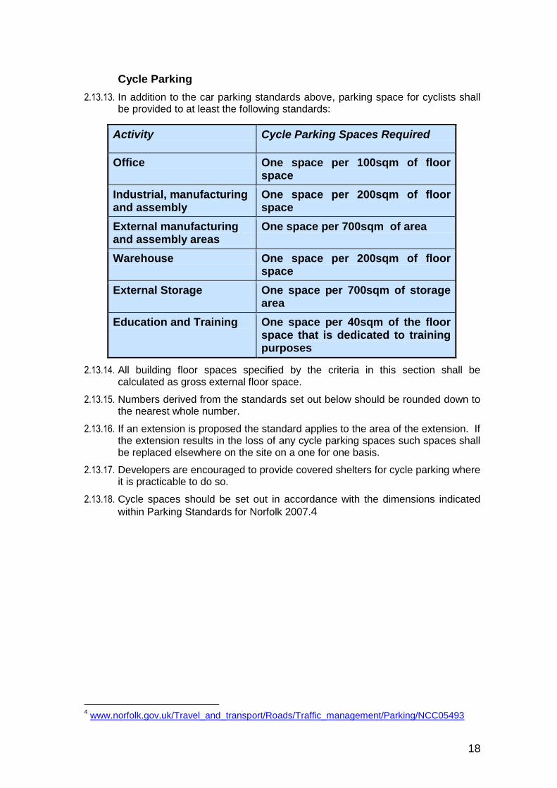
Activity Cycle Parking Spaces Required
Office One space per 100sqm of floor space
Industrial, manufacturing and assembly
One space per 200sqm of floor space
External manufacturing and assembly areas
One space per 700sqm of area
Warehouse One space per 200sqm of floor space
External Storage One space per 700sqm of storage area
Education and Training One space per 40sqm of the floor space that is dedicated to training purposes
19
2.14. General Highway Considerations
Sight Lines
2.14.1. In order to ensure a satisfactory and safe access and egress from the highway:
Developments shall (as a minimum) be completed in accordance with the standards for sight lines set out in Norfolk County Council’s document ‘Safe sustainable Development’5.
Turning
2.14.2. In order to ensure satisfactory and safe turning facilities:
Developments shall (as a minimum) be completed in accordance with the standards set out in Freight Transport Association (FTA) publication ‘Designing for Deliveries’6
Construction Standards
2.14.3. In order for roads to be adopted:
Where roads built as part of a development approved by the South Denes Local Development Order are intended to become adopted highways, the construction standards shall (as a minimum) accord with those set out in ‘Estate Design Guide – Industrial Estate Roads’7
Critical Highway Routes
2.14.4. Occasionally, a developer may have a desire to combine a group of buildings and the highway into a larger site. In such circumstances a public highway could be closed, following approval of an application for a closure order.
2.14.5. In some cases there would be no reason to prevent the stopping up of a minor highway however it is essential that the critical routes are maintained in the interest of ensuring effective movement around the area.
2.14.6. The map at Appendix 2 indicates those routes that are considered to be critical to the movement of vehicles and pedestrians in the area of the South Denes LDO. To ensure the effective circulation of traffic:
5
http://www.norfolk.gov.uk/Environment/Highway_advice_to_developers/Publications_and_guidance_for_developers/index.htm 6 www.fta.co.uk/
7 www.norfolk.gov.uk/Travel_and_transport/Roads/Highway_boundaries_and_new_roads/Highways_development_management/NCC048245
20
No development permitted by the order shall obstruct or divert any of the critical routes indicated on the map at Appendix 2.
2.14.7. Where highways are not identified as critical routes the existing width of roads and pavements that are to remain in use after a development should not be reduced.
Development that requires the closure of any highway that serves an existing premises or a neighbouring development is not permitted, unless an alternative access arrangement can be provided that meets the existing and planned needs of existing occupiers or developers.
2.15. Archaeology
2.15.1. Archaeological finds made in the course of construction are important because they can shed light on past human use of the landscape, sea and seabed. The information that such discoveries bring to light can help archaeologists better understand society and human endeavour in the past, and better protect significant aspects of our history on behalf of future generations.
2.15.2. Most of the built area at the southern end of the South Denes peninsula was not developed until the inter war period or after World War II and therefore significant archaeological remains of buildings are unlikely to occur in the South Denes LDO area. Smaller archaeological finds may however still be found on the peninsula, as throughout history there has been considerable human activity in the area of South Denes, including horse racing, shipping and various military activities in defence of the town.
2.15.3. Within the South Denes LDO, conditions requiring archaeological appraisal have been limited to the area of Gashouse and Malthouse quays to the west of the river. This area specifically requires archaeological investigation because of its proximity to a 14th century Augustinian Priory in Gorleston.
2.15.4. Although the majority of the South Denes LDO area is not subject to a requirement for specific archaeological investigation, archaeological finds might still occur during site investigation works or during construction.
2.15.5. Developers may wish to carry out their own archaeological appraisal in order to mitigate the risk of archaeological finds leading to delays to construction projects
Where no specific archaeological provision has been made, the Archaeology Protocol at Appendix 3 must be followed.
21
3. Flood Risk
3.1. Note that a completed Flood Response Plan needs to be submitted and acknowledged for any occupied buildings permitted by Class 1 within the entire South Denes area. For Class 1 developments within the flood risk area (see Appendix 4) the South Denes Flood Risk Management Form (see Appendix D South Denes LDO) also needs to completed and submitted to ensure that flood risk is addressed.
3.2. In the event of flood defences being overtopped or breached some areas of South Denes could be inundated with sea water. The areas that are considered at risk of inundation are indicated on the map at Appendix 4. Note that Appendix 4 shows the future defended 1 in 200 flood extents. At the peak of any major flood event that exceeds the defences the central part of South Denes may not be flooded but it will be cut off from the town centre by flood water. Therefore this area will still be considered to be subject to flood risk in terms of requiring a Flood Response Plan.
3.3. The LDO requires by condition that, where Class 1 developments are located within the flood risk area, a Flood Response Plan detailing measures to ensure the evacuation of personnel should be submitted to and agreed in writing by the planning authority before the development is occupied. Further information on appropriate strategies and recommended content for a Flood Response Plan can be obtained from the emergency planning officer at the Council and the Flood Response Plan Guidance8
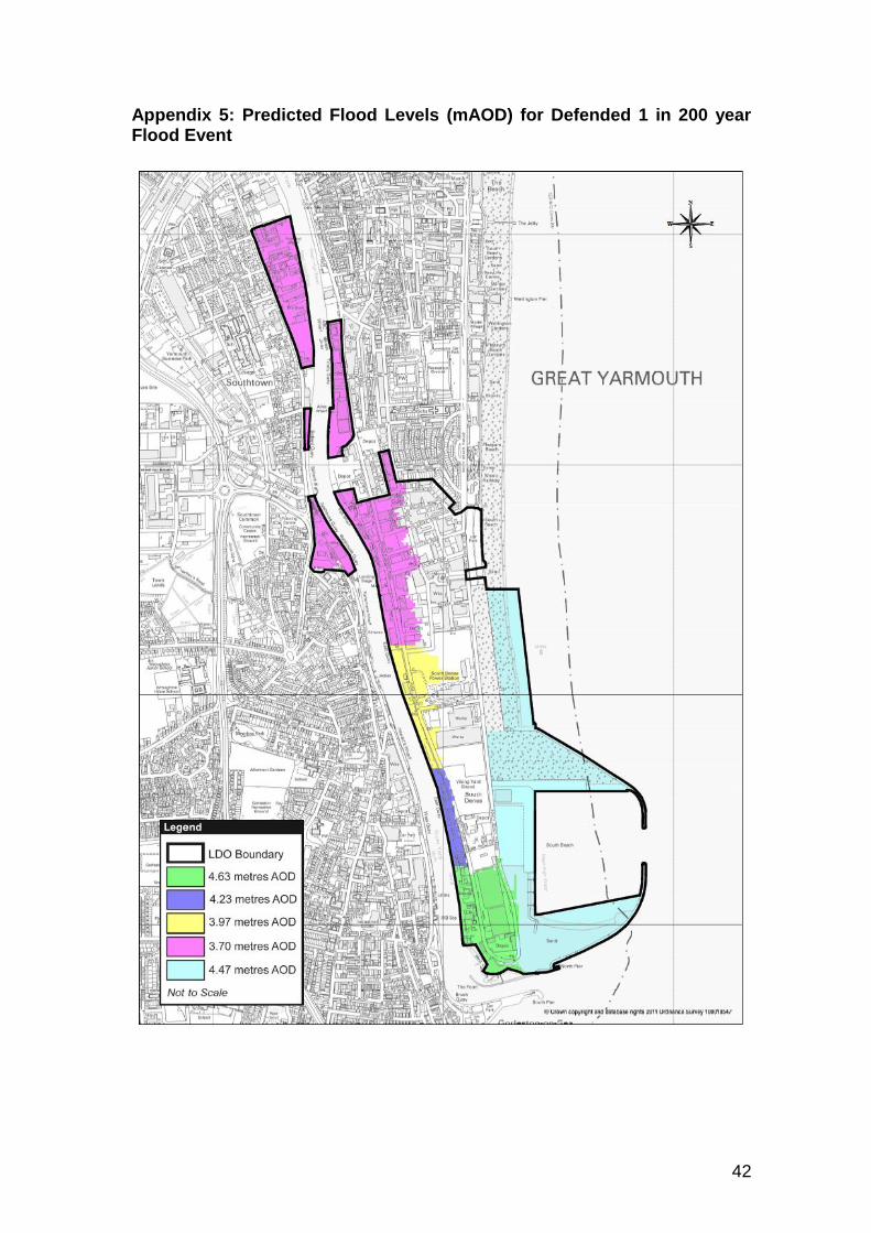
3.4. The predicted flood level will vary across the South Denes LDO Area (due to the effects of river flow) in order to address this variance the area has been split into five areas. The metres above Ordnance Datum Newlyn (mAOD) of the expected flood level in each area are illustrated on the map in Appendix 5. For Class 1 Developments within this area at risk of flooding a completed Flood Risk Management Form needs to be submitted and acknowledged. The Local Planning Authority will not agree to designing for differing flood levels unless the developer submits a flood risk assessment which provides a rational justification for a departure from the levels indicated on the map at Appendix 5.
3.5. In addition to safeguarding personnel through means of evacuation, it is advisable to consider the resilience of buildings and structures that may be affected by flood water in the event of defences being breached. Flood water can be a powerful force, capable of destroying buildings that are not designed to deal with inundation, however if buildings are designed correctly they should be able to withstand the effects of inundation and be brought back in to use in a relatively short time after a flood has receded. In order to ensure the economic resilience of the area it is considered to be important to ensure that resilience to flooding is built in to developments.
All flood resilience measures shall be designed to take account of the flood levels indicated on the map at Appendix 5, unless otherwise agreed in writing by the Local Planning Authority. For Class 1 Developments with the flood risk areas (Appendix 5) a completed South Denes LDO Flood Risk Management Form (Appendix D South Denes LDO) needs to be submitted and
8 http://www.great-yarmouth.gov.uk/advice-benefits/emergencies/flood-response-plan.htm
22
acknowledged. A Flood Response Plan needs to be completed and submitted for any occupied buildings permitted by Class 1 within the entire South Denes area.
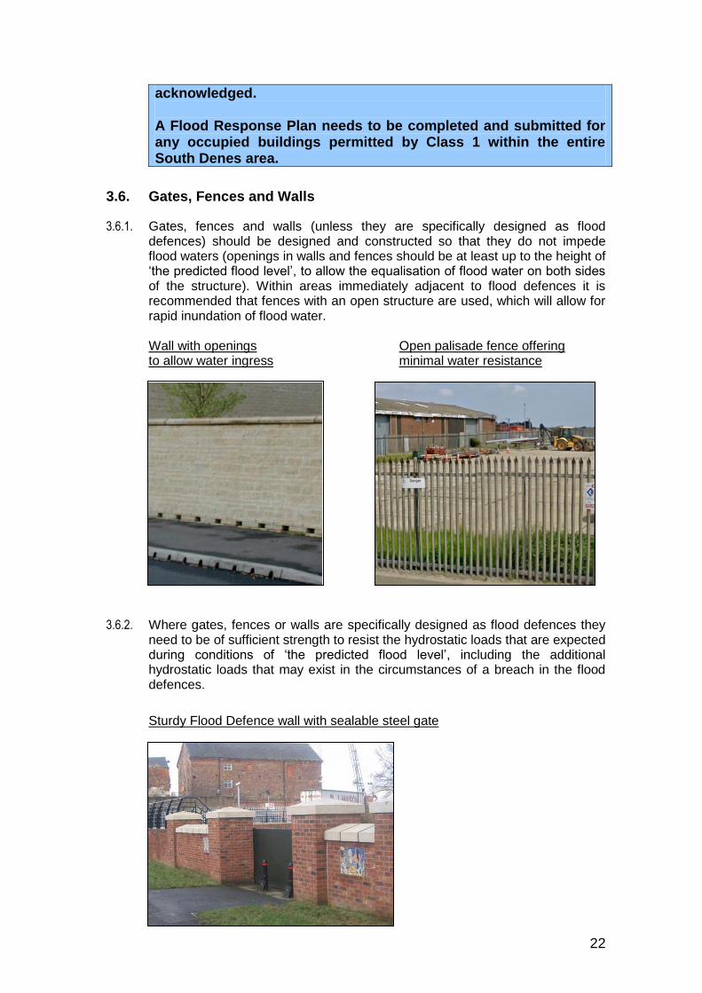
3.6. Gates, Fences and Walls
3.6.1. Gates, fences and walls (unless they are specifically designed as flood defences) should be designed and constructed so that they do not impede flood waters (openings in walls and fences should be at least up to the height of ‘the predicted flood level’, to allow the equalisation of flood water on both sides of the structure). Within areas immediately adjacent to flood defences it is recommended that fences with an open structure are used, which will allow for rapid inundation of flood water.
Wall with openings Open palisade fence offering to allow water ingress minimal water resistance
3.6.2. Where gates, fences or walls are specifically designed as flood defences they need to be of sufficient strength to resist the hydrostatic loads that are expected during conditions of ‘the predicted flood level’, including the additional hydrostatic loads that may exist in the circumstances of a breach in the flood defences.
Sturdy Flood Defence wall with sealable steel gate
23
3.6.3. Further information on flood risk in the locality is available within the Great Yarmouth Strategic Flood Risk Assessment (SFRA). 9
3.6.4. It is important to note that no development should take place within 9 metres of the landward toe of any tidal defence, without the prior consent of the Environment Agency and/or coastal defence authority. Formal Flood Defence Consent is required for any such works or structures under the terms of the Water Resources Act, 1991. For guidance, the Environment Agency will generally require a 9 metre (minimum) access strip adjacent to any tidal defence in order to facilitate future maintenance requirements.
9 http://www.great-yarmouth.gov.uk/environment-planning/planning/planning-policy/local-development-framework/ldf-
background-evidence-studies/strategic-flood-risk-assessment.htm

24
4. Character Areas
4.1. The LDO Design Code recognises that there are several distinct character areas within the LDO area therefore the requirements of the Design Code have been divided into the following character areas which are illustrated on the map at Appendix 6:
South
North
West of the River
Nelson’s Monument and Surroundings
4.2. South
4.1.1. The Southern area of the South Denes LDO is located at the end of a spit, with the river port to the West and the outer harbour to the East. The mouth of the River Yare (the entrance to the river port) lies to the South. The area is dominated by port activities with frequent ship movements and the storage, loading and unloading of goods.
4.1.2. There are no notable residential areas within the ‘South’ character area, but opposite the port, on the west side of the River Yare, the area of Gorleston contains a mix of uses including residential properties that face towards the harbour. Some of these residential properties are in elevated positions with views over the port area.
4.1.3. The area of Gorleston also contains two Conservation Areas from which properties overlook this character area. In assessing the appropriate scale of development for this character area, the LDO and Design Code have had regard to the amenities of these residential properties and the setting of the conservation area. However, in doing so the historic context of the relationship between these residential areas and this active port area must be acknowledged; furthermore, the need to develop the area in the interests of the local and national economy and the requirement to service proposed offshore energy developments is also considered to carry significant weight.
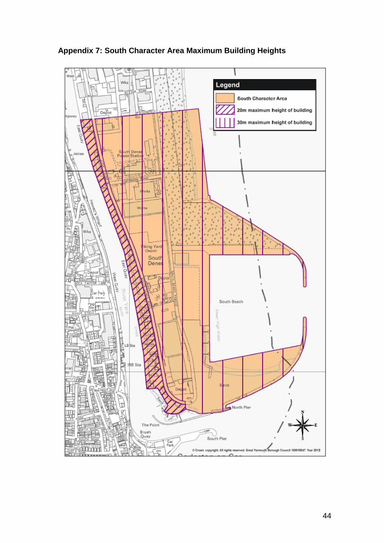
4.1.4. The existing character of the area is defined by large warehouses, areas of open storage, storage tanks and a range of cranes and other tall plant. The largest existing building in the character area is the gas fired power station. This building has a lower roof which is 30m above ground level and a higher roof that is 39m above ground level. The power station chimney is 70m high.
In the ‘South character area’, the maximum height of buildings or storage tanks permitted by the South Denes Local Development Order shall not exceed:
20m in the area between the River Yare and South Denes Road; and
30m between South Denes Road and the coast.
25
See Appendix 7: South Character Area
4.1.5. The LDO Design Code does not impose any restriction on the height of materials or products stored externally in this character area. Developers and operators are reminded of their obligation to ensure that materials and products are stored safely.
26
4.2. North
4.2.1. The Northern area of the South Denes LDO contains a varied mixture of businesses and port related activities. The area is bounded on the West side by the River Yare, (which in this area is part of the river port) and on the East side predominantly by terraced two storey housing.
4.2.2. The amenities of these residential properties needs to be taken into account, in defining the character of permissible development in the LDO and Design Code, but in doing so it is important to recognise that there is a historic context to the relationship of these residential dwellings to this commercial area.
4.2.3. Existing buildings in this character area vary in both height and design with a mixture of brick built buildings up to three or four storeys in height and steel framed and clad warehouse buildings and storage tanks alongside the river port.
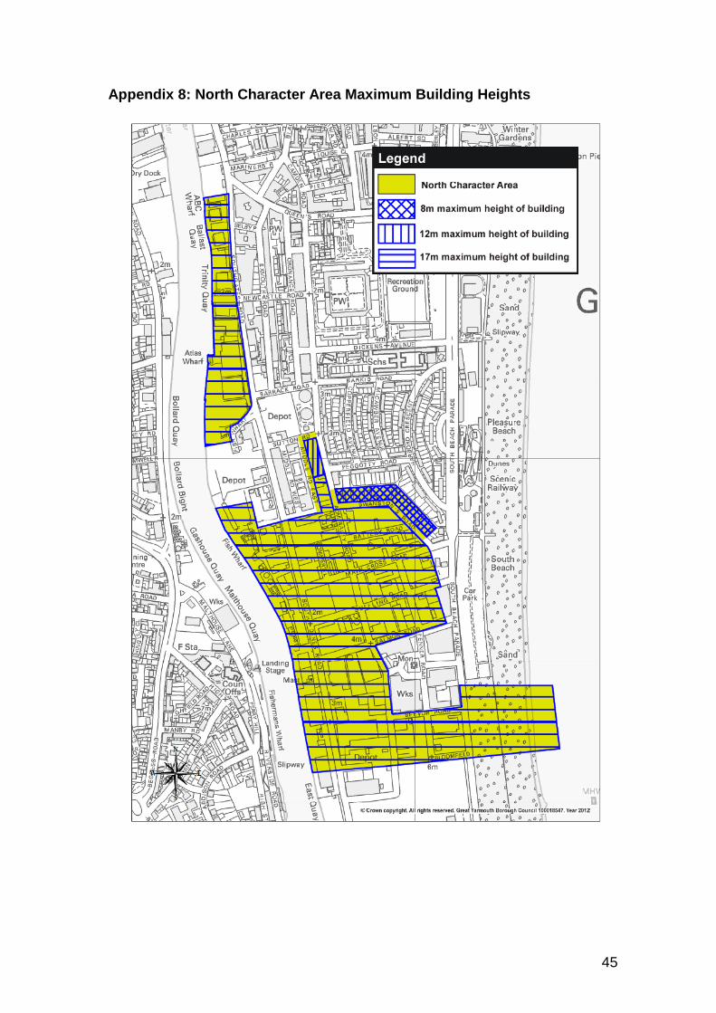
4.2.4. The need to have regard to the close proximity of residential properties requires limitations on building heights to respect the existing relationships between commercial and residential sites. Those buildings nearest to residential properties need to be of a scale where they will not dominate residential outlook or severely overshadow residential gardens or windows. Beyond the immediate environment of the residential areas, buildings can be taller, but in order to have regard to the existing character of the area and the setting of Nelson’s monument building heights need to be lower than those in the Southern area.
In the ‘North character area’, the maximum height of buildings or storage tanks permitted by the South Denes LDO shall not exceed:
8m in area North of Swanston’s Road and East of Admiralty Road;
12m within a rectangular parcel of land bounded by Middle Road East, Sutton Road and Admiralty Road that is bisected in line with Peggotty Road (See North Character Map)
17m across the remainder of the character area lying West of South Denes Road and, South of the parcel of land bisected in line with Peggotty Road.
See Appendix 8: North Character Area
4.2.5. The Design Code does not impose any restriction on the height of materials or products stored externally in this character area. Developers and operators are reminded of their obligation to ensure that materials and products are stored safely.

27
4.3. West of the River
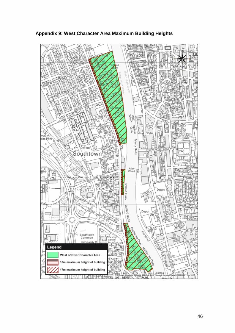
4.3.1. The area west of the river has historically been used primarily as a dockside area, occupied by businesses involved in the storage loading and unloading of goods and other maritime activities such as ship building and repair.
4.3.2. On its Eastern side, the area is bounded by the River Yare with commercial properties on the opposing river bank, however, to the West; there is a predominance of two storey residential properties which face towards the area on the opposite side of Southtown Road. The amenities of these residential properties needs to be taken into account, in defining the character of permissible development in the LDO and Design Code, but in doing so it is important to recognise that there is a historic context to the relationship of these residential dwellings to this commercial area.
4.3.3. In the ‘West of the River character area’ the proximity of areas of housing to dockside activities is closer than in any of the other areas within the South Denes LDO. Developers will therefore have to pay particular attention to the potential impacts of noise, light, fumes and dust on residential occupiers and should seek to design sites to minimise the effects of these impacts.
4.3.4. One historic response to the proximity of residential property in this area has been to use buildings as a barrier to shield residential properties from noisy activities. To some extent this solution is successful in terms of minimising nuisance, but in design terms the result has sometimes been less than satisfactory.
4.3.5. The photograph below of Southtown Road shows a good example of how a building can be used as a barrier to noise, dust, light and activity, but this is also a bad example of how to achieve articulation and interest at pedestrian level and create an attractive outlook for residential properties.
4.3.6. The use of buildings to shield residential properties from noise and activity is still a recommended design technique within this character area, but this technique should be used alongside greater articulation of the façade facing the residential properties.
4.3.7. Developments along Southtown Road should include:
Occasional setbacks in the building line
Variation in building heights, materials, tone and colour
The introduction of areas of landscaping between the buildings and Southtown Road to break up the continuous line of buildings and to provide variations in texture and scale
The use of windows and doors to articulate the frontage of development facing Southtown Road may also be appropriate if activities within the building are not noisy, or if the windows and doors are suitably designed to attenuate noise.
In the ‘West of the River character area’, the maximum height of buildings or storage tanks permitted by the South Denes Local Development Order shall not exceed:
10 m for any part of a building that lies within 10m of the eastern edge of Southtown Road/Beccles Road, except for a proportion of any individual building, equal to or less than 20% of the

28
building footprint, which may be up to 13m high (in order to allow for articulation of the design);
17m for any part of a building that lies 10m or more away from the eastern edge of Southtown Road/Beccles Road.
See Appendix 9: West Character Area
4.3.8. The Design Code does not impose any restriction on the height of materials or products stored externally in this character area. Developers and operators are reminded of their obligation to ensure that materials and products are stored safely.

29
4.4. Nelson’s Monument and Surroundings
4.4.1. Nelson’s Monument is a Grade I listed structure built between 1817 and 1819. It was the first monument erected in England to Admiral Lord Nelson. The overall height of the Monument is 44 metres (144 ft.) The monument features a figure of Britannia at the top of the column.
4.4.2. Originally the monument was built standing in the open, on a sand spit, but
over the intervening years this location has been developed and the context of the monument is now radically altered.
Nelson’s Monument (original setting)
Nelson’s Monument (existing)
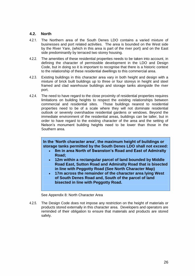
4.4.3. Views of the monument are considered to make a significant contribution to the
monuments character. However, while the monument can be seen from many surrounding locations (due to its impressive height), development in the surrounding area has historically paid little attention to the location of the monument and, with the exception of Monument Road itself, no roads in the locality are orientated to align with the monument. Consequently although the monument is seen through gaps in the built environment, or at greater distance
30
over the roofs of the town, most views of the monument are incidental or fleeting rather than being part of a wider planned setting.
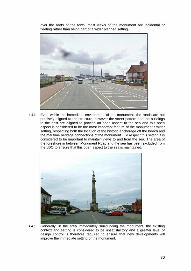
4.4.4. Even within the immediate environment of the monument, the roads are not precisely aligned to the structure, however the street pattern and the buildings to the east are aligned to provide an open aspect to the sea and this open aspect is considered to be the most important feature of the monument’s wider setting, respecting both the location of the historic anchorage off the beach and the maritime heritage connections of the monument. To respect this setting it is considered to be important to maintain views to and from the sea. The area of the foreshore in between Monument Road and the sea has been excluded from the LDO to ensure that this open aspect to the sea is maintained.
4.4.5. Generally, in the area immediately surrounding the monument, the existing context and setting is considered to be unsatisfactory and a greater level of design control is therefore required to ensure that new developments will improve the immediate setting of the monument.
31
Building height in the ‘Nelson’s Monument and Surroundings’ area
4.4.6. The tallest building in this character area is clearly Nelson’s Monument, which is 44m high. It is considered essential that this landmark should remain a prominent feature of the townscape. Long distance views of the monument from the surrounding area are considered to be an important aspect of its setting.
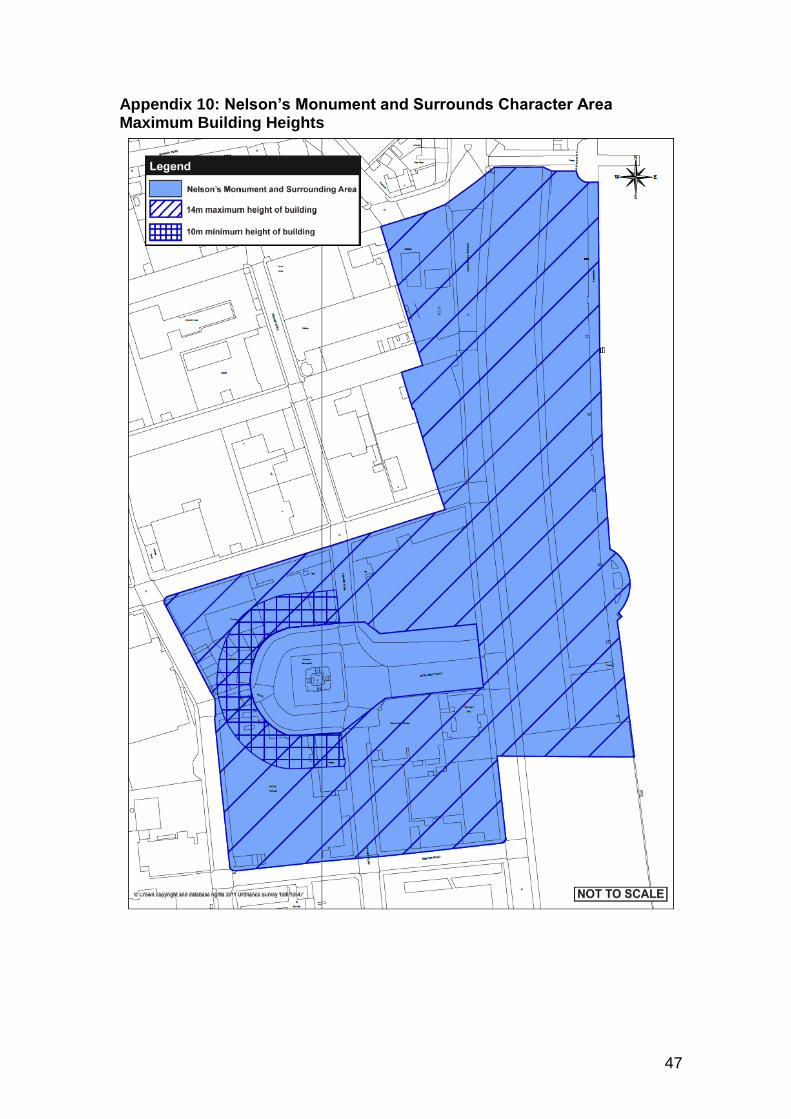
Within the ‘Nelson’s Monument and Surroundings’ character area the maximum height of the eves or parapet of any buildings shall not exceed 10m (three storeys) and the overall height of any building shall not exceed 14m.
See Appendix 10: Nelson’s Monument and Surroundings Character Area
Monument Road special provisions
4.4.7. It is an ambition to create a more appropriate setting for the monument within an enhanced public square. The vision for the environment of the monument is that it should be a high quality office and administration location, providing support services and central administration facilities for the surrounding general industrial area and offshore activities. Developments in this location could take advantage of the monuments grandeur to create a sense that the monument square is an important location.
4.4.8. In the environment of Monument Road, the South Denes Local Development Order requires that plans, elevations and materials are submitted to the Local Planning Authority for approval.
4.4.9. The submission of details is considered to be necessary to ensure that the appearance of buildings that will affect the setting of the monument can be fully considered. The following indicates the characteristics that will be expected of new developments.
4.4.10. When new developments are proposed in this locality, the scale of development needs to be more suited to the grandeur of the monument.
4.4.11. In order to achieve this objective:
Any new buildings erected within the square surrounding the monument, or on the west side of Fenner Road for a distance of at least 20m from the junction with Monument Road, must be built to a height equivalent to three storeys.
See Appendix 10: Nelson’s Monument and Surroundings Character Area
4.4.12. The objective is to create a unified appearance to development around monument square, while this can be achieved by buildings that do not replicate each other’s design, once the first new development has taken place, following buildings will be expected to respect the design, materials, heights and fenestration patterns of that development.
32
4.4.13. It would be desirable to achieve formal frontages on buildings facing the monument, to enhance and reinforce the sense of arrival and emphasise the importance of the space. Buildings that surround the monument square will be expected to have windows and doors within the elevation that face the monument.
4.4.14. The frontages of new buildings should be orientated towards the monument and significant gaps in the building line around the monument square should be avoided (with the exception of the existing gaps for roads to the north and south of the monument).
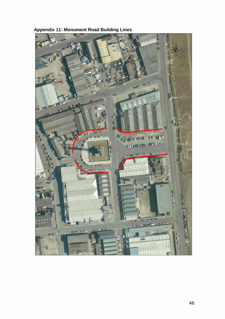
To reinforce the sense of place and enclosure, buildings surrounding the monument and along Monument Road shall be built on the alignment of the building line indicated on the map at Appendix 11 (to ensure an open aspect to the sea, developments along Monument Road must not encroach further forward than the building line of the existing buildings).
See Appendix 10: Nelson’s Monument and Surroundings Character Area and Appendix: 11 Monument Road Building Lines
4.4.15. The square around the monument and the frontages facing Monument Road are not considered to be an appropriate location for prefabricated industrial type buildings and high quality materials will be required for any new development. Façades facing the monument could include materials such as brick, smooth render, stone or a combination of these materials. Some unity of materials will be expected across different developments within monument square.
4.4.16. In the area immediately surrounding the monument fences and walls are limited by the LDO to a maximum height of 2m, where they face the monument.
In the square surrounding the monument, fences built as part of a development permitted by the South Denes Local Development Order must be made of metal rod and the use of wire fencing, pressed steel/palisade fencing or wooden fencing is not permitted. Walls should be constructed of brick, render or stone or a combination of these materials and should complement the materials used in the façade of any new buildings.
4.4.17. It is considered desirable to maintain the basic street pattern surrounding Nelson’s Monument. The roads around the monument form a misshapen square with roads leading off to north, east, south and west. The pattern of these roads does not have a particular historic significance, the form having emerged during the inter-war period in the first half of the 20th century, however in order to ensure that the monument remains a focal point it is desirable to maintain the basic intersection and form of these roads. Realignment of the roads, to create a more symmetrical square around the
33
monument and/or to align the east/west route with the monument would however be acceptable in principal.
South Beach Parade special provisions
4.4.18. To the north-east of the monument lies Great Yarmouth’s Golden Mile. This is a tourist area dominated by funfairs, amusements and other traditional ‘seaside’ activities. The current relationship between the industrial area of South Denes and the tourist environment of the Golden Mile is poorly defined. Planning permission exists for a new casino and hotel on the east side of South Beach Parade, which (if it is built) would bring tourism activities even closer to the industrial environment of South Denes.
4.4.19. It is considered to be important that development within the South Denes LDO area should not detract from the environment of the tourist area beyond. A greater level of design control is therefore considered to be necessary in respect of those properties that are located to the north of Monument Road fronting South Beach Parade.
South Beach Parade (existing)
4.4.20. New buildings that abut South Beach Parade should present a public face
towards South Beach Parade, including windows and doors.
4.4.21. The maximum height of buildings on South Beach Parade must adhere to the height limitations set out above (10m to eaves/parapet and 14m overall height).
34
4.4.22. Profile sheet metal is not considered to be an acceptable material for walls facing South Beach Parade or Monument Road and its use must be avoided.
Façades facing South Beach Parade shall be built using brick, smooth render, stone, high quality cladding materials, glazing, or a combination of these materials.
Examples of high quality cladding suitable for South Beach Parade frontages

35
Appendices

36
Page left blank
37
Appendix 1: Listed Buildings and Scheduled Ancient Monuments
38
Appendix 2: Critical Highways Routes
39
Appendix 3: Archaeology Protocol
The Protocol anticipates discoveries being made by Project Staff, who report to a Site Champion on their site (usually the senior person on site), who then reports to a person (the Nominated Contact) who has been nominated by the developer to co-ordinate implementation of the Protocol. The developer may have appointed a Retained Archaeologist to provide archaeological advice and/or services to the development. In this case the Retained Archaeologist would be an appropriate person to take the role of the Nominated Contact. The nominated contact will in turn inform the Norfolk County Council Historic Environment Service ([email protected] 01362 869275).
It is recognised that, for the Protocol to be effective, participants (such as Site Champions or project staff) may require appropriate training. The Norfolk County Council Historic Environment Service would be pleased to speak to developers about facilitating such training.
Where items of archaeological interest are recovered, Project Staff (under direction of the Site Champion) will:
Handle all material with care.
Any rust, sediment, concretion or marine growth should not be removed and ‘groups’ of items or sediments should not be separated.
If possible photograph the item in the condition in which it was recovered.
Record the position at which the artefact/sediments were recovered.
Provide a unique reference number for each artefact, which is to be included on all recording and storage mediums.
If the find is from a waterlogged or underwater environment, then Project Staff (under direction of the Site Champion) will arrange for the find to be immersed in seawater in a suitable clean container, which should be covered. It should be noted that ‘time is of the essence’ in terms of the recovery of waterlogged archaeological material. If waterlogged organic items are allowed to dry out this can cause irreparable damage. Care in handling items is paramount.
Where it is possible to identify the position from which the discovery originated, the Site Champion will arrange for a Temporary Exclusion Zone (TEZ) in which construction activities will cease temporarily (in the vicinity of the location), or move to an alternate location, until the advice of the County Council Historic Environment Service has been obtained.
The Nominated Contact should inform other teams engaged in potentially damaging activities in the same area, to ensure that they are aware of the position of the discovery so that further possible damage to the historic environment can be avoided.
The initial response of the Historic Environment Service will include an assessment of archaeological potential and a decision on the continuation or removal of the Temporary Exclusion Zone (TEZ).
The following types of discovery are likely to be of low potential:
Reports of single, apparently isolated, finds that are not datable or are of modern (post-1800) or later date (with the exception of military remains).
The following types of discovery are likely to be of high potential:
40
Reports of single finds that are of post-medieval or earlier date
Reports of single finds that relate to military aircraft
Reports of multiple finds from the same area
Reports indicating the presence of a wreck or other structural remains
In the case of discoveries of low potential, the Historic Environment Service is likely to advise the Nominated Contact that the TEZ may be lifted and that construction activities in the vicinity of the discovery may recommence.
In the case of a discovery of high potential, the Historic Environment Service will advise the Nominated Contact of the implications of the discovery and of further actions that might be required. Further actions may include call-out investigations, the conversion of a TEZ to an Archaeological Exclusion Zone (AEZ), and/or the institution of a watching brief. The rationale for conclusions reached will be provided to the Nominated Contact.
If an AEZ is established a scheme of archaeological investigation will be required. Such investigation shall be undertaken in accordance with a written scheme which shall be submitted to and approved in writing by the Historic Environment Service. Work shall be carried out in accordance with that approved scheme and by a suitably qualified investigating body acceptable to the planning authority.
If the discovery is something to which specific legal provisions apply (treasure, human remains, wreck etc.), it will remain the responsibility of the developer to undertake such statutory reporting as is required. The subsequent handling, retention or disposal of finds will be subject to applicable law and to arrangements between the developer and the institution receiving the archaeological archive arising from the scheme.
41
Appendix 4: Future Defended 1 in 200 Flood Risk Areas for South Denes
42
Appendix 5: Predicted Flood Levels (mAOD) for Defended 1 in 200 year Flood Event
43
Appendix 6 South Denes LDO Character Area Map
44
Appendix 7: South Character Area Maximum Building Heights
45
Appendix 8: North Character Area Maximum Building Heights
46
Appendix 9: West Character Area Maximum Building Heights
47
Appendix 10: Nelson’s Monument and Surrounds Character Area Maximum Building Heights
48
Appendix 11: Monument Road Building Lines