design deficiency report with environmental assessment€¦ · design deficiency report . with ....
TRANSCRIPT

DESIGN DEFICIENCY REPORT With
Environmental Assessment Northport Levee Repair Project
Northport, Alabama
JUNE 2014
i
DESIGN DEFICIENCY REPORT With
Environmental Assessment Northport Levee Repair Project
Northport, Alabama
TABLE OF CONTENTS
PAGE TITLE NUMBER INTRODUCTION ...............................................................................................................1 PROBLEM ...........................................................................................................................1 PROJECT AUTHORITY ....................................................................................................2 CONGRESSIONAL INTEREST ........................................................................................2 NON-FEDERAL SPONSOR ..............................................................................................2 DESCRIPTION OF INVESTIGATIONS ...........................................................................2 PLANS CONSIDERED.......................................................................................................2
a. Alternative Plan 1 ..............................................................................................3 b. Alternative Plan 2 ..............................................................................................3 c. Alternative Plan 3 ..............................................................................................3
SELECTED PLAN – LEVEE REPAIR ..............................................................................3 REAL ESTATE PLAN ........................................................................................................4 ENVIRONMENTAL COMPLIANCE ................................................................................6 SAFETY AND ECONOMIC ANALYSIS ..........................................................................6
General Information .................................................................................................6 Evacuation Effectiveness .........................................................................................6
COST ESTIMATE...............................................................................................................6 PROJECT BENEFITS .........................................................................................................7 COST APPORTIONMENT.................................................................................................8
Operation and Maintenance .....................................................................................8 PLAN IMPLEMENTATION ..............................................................................................8
Institutional Requirements .......................................................................................8 Federal Responsibilities ...........................................................................................9 Non-Federal Responsibilities ...................................................................................9
CONCLUSION ..................................................................................................................10 RECOMMENDATION .....................................................................................................10
ii
DESIGN DEFICIENCY REPORT With
Environmental Assessment Northport Levee Repair Project
Northport, Alabama TABLE OF CONTENTS (CONTINUED)
LIST OF FIGURES
PAGE FIGURE NO. DESCRIPTION NUMBER
1 Longitudinal Cracking With Displacement along Walking Track of the Levee .............................................1 2 Typical Cross Section For the Selected Levee Repair Plan .................................................................................3
3 Picture of the Proposed Levee Easement Limits .................5
LIST OF TABLES
TABLE NO. DESCRIPTION 1 Summary of Levee Repair Cost Fully Funded ....................7
2 Project First Cost of Repair Work .......................................7 3 Cost Apportionment For Levee Repair ................................8
LIST OF PLATES
PLATE NO. DESCRIPTION 1 Project Map – Proposed Levee Realignment Reach 2 Northport Levee Project 3 Shows The Existing Levee and The Proposed 35-FT Levee
Setback With Excavated 1V:2H Bank Slopes and Levee End- of-Construction Condition
ENVIRONMENTAL ASSESSMENT Appendix A – Images Appendix B – Agency Coordination
FINDING OF NO SIGNIFICANT IMPACT
LIST OF APPENDIXES APPENDIX A ECONOMIC ANALYSIS B ENGINEERING INVESTIGATIONS C REAL ESTATE PLAN D COORDINATION
1
DESIGN DEFICIENCY REPORT With
Environmental Assessment Northport Levee Repair Project
Northport, Alabama
INTRODUCTION The Northport Levee Project was constructed to reduce flood damages from the Black Warrior River. The project was completed in August 1999 at a cost of approximately $4.2 million dollars. The project was cost-shared at 75/25 percent Federal/non-Federal respectively and had a 5 million Federal project limit. The levee is designed to provide protection against a 100-year exceedance probability. The City of Northport is the non-Federal sponsor and is required to operate and maintain the levee project in accordance with the operations and maintenance manual.
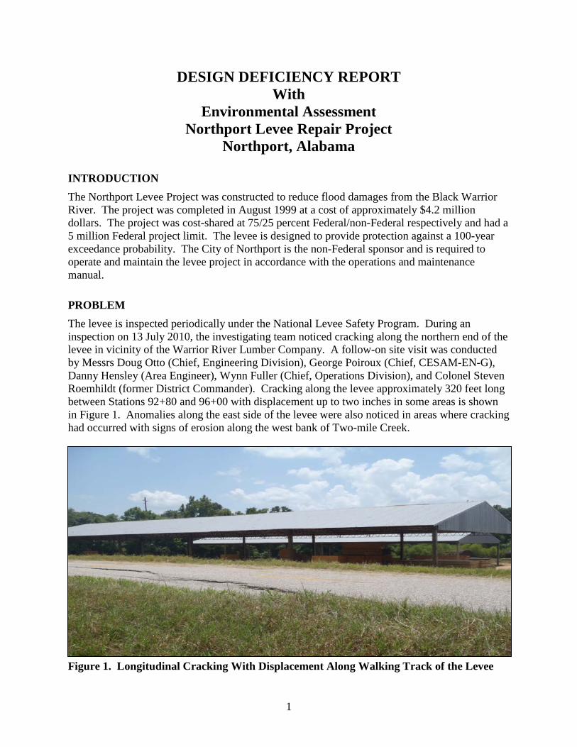
PROBLEM The levee is inspected periodically under the National Levee Safety Program. During an inspection on 13 July 2010, the investigating team noticed cracking along the northern end of the levee in vicinity of the Warrior River Lumber Company. A follow-on site visit was conducted by Messrs Doug Otto (Chief, Engineering Division), George Poiroux (Chief, CESAM-EN-G), Danny Hensley (Area Engineer), Wynn Fuller (Chief, Operations Division), and Colonel Steven Roemhildt (former District Commander). Cracking along the levee approximately 320 feet long between Stations 92+80 and 96+00 with displacement up to two inches in some areas is shown in Figure 1. Anomalies along the east side of the levee were also noticed in areas where cracking had occurred with signs of erosion along the west bank of Two-mile Creek.
Figure 1. Longitudinal Cracking With Displacement Along Walking Track of the Levee
2
PROJECT AUTHORITY A reconnaissance phase study was undertaken in response to a letter dated 1 August 1991, from Mayor Wayne Rose requesting a study to address a flooding problem in the City of Northport, Alabama. The Detailed Project Report (DPR) along the Black Warrior River at Northport, Alabama was conducted under Section 205 of the Flood Control Act of 1948, as amended. The study was completed in September 1995. A feasible flood control levee project was identified with a 1.6 benefit-to-cost ratio (BCR), which warranted Federal participation leading to project construction. The project was initiated in 1997 and completed in 1999 and subsequently turned over to the City of Northport for operation and maintenance (O&M). This repair will be constructed under the same authority.
CONGRESSIONAL INTEREST Congressional interests includes Senator Richard Shelby and Senator Jeff Sessions and Congressman Spencer Bachus (R-6)
NON-FEDERAL SPONSOR The City of Northport (City) is the non-Federal sponsor and is responsible for operating and maintaining the levee. Due to the crack the levee system, the City lost its acceptable rating and has been placed in an inactive status of the Rehabilitation and Inspection Program (RIP) under Public Law (PL) 84-99. This means, the Northport Levee Project is ineligible for project rehabilitation assistance in the event of a flooding disaster. The City desire’s the levee be repaired and restored with an acceptable rating to qualify for disaster assistance.
DESCRIPTION OF INVESTIGATIONS After receiving the periodic inspection report, follow-on field investigations were made by the U.S. Army Corps of Engineers (Corps), Mobile District and the City of Northport, Alabama to assess the levee cracking problem to develop measures to repair it in July 2010.
Three subsurface borings were drilled by the Mobile District Core Drill Unit from 28-31 July 2010, which helped to arrive at a conclusion of design deficiency leading to an appropriate concept plan to remediate the cracking reach of levee between Stations 92+80 to 96+00. Refer to the attached engineering subsurface investigation report dated August 2010. A rough-order-of-magnitude (ROM) cost estimate is provided for selected plan.
Elevations described in this report are relative to National Geodetic Vertical datum 1929 (NGVD29) so as to be compatible with the vertical datum used for contract drawings for the original construction of the levee. NGVD29 elevations vary from NAVD88 elevations by only about 0.1 foot at this project.
PLANS CONSIDERED Three alternative plans were considered for repairing of the cracked reach in the levee. Stability analyses were conducted to accomplish a satisfactory design using criteria in EM-1110-2-1913 to assure that a satisfactory stability is achieved. The “no action plan” is not being considered since a Federal interest had already been made with the investment of the $4.2 million to construct the project. Further, a failed levee could result in the loss of life and would devastate the City of Northport. Therefore, levee repair is the only appropriate option.

3
a. Alternative Plan 1 - The levee would be relocated further away from the creek. The relocated dike would be located off (west) of the existing crack and slip surface. This alternative would require acquisition of private property that is currently used as a lumberyard and includes two existing lumber sheds. The actual required setback distance of the levee and resulting additional real estate requirements should be determined by slope stability analyses using levee design criteria given in EM 1110-2-1913, Table 6-1b.
b. Alternative Plan 2 - The creek would be relocated further east with flatter side slopes. A stability berm would be built near existing creek bank if stability analyses indicate it to be necessary to achieve stability. Although more real estate would be required, the real estate likely would not cost as much as Alternative 1. The levee would remain cracked. It may be impossible to achieve required stability without a stability berm. The work likely would affect creek hydraulics and stone protection might be needed.
c. Alternative Plan 3 - A sheet pile retaining wall extending to top of shale would be driven and a closely spaced row of pre-drilled and grouted H-piles that extend into shale would be installed immediately behind the sheet-pile wall to buttress it. Additional real estate probably would not be needed; however the levee would remain cracked. The piling would act as a retaining wall to minimize future slope movement. Another disadvantage is that slope movements could occur during construction, particularly from vibrations caused by pile driving.
SELECTED PLAN – LEVEE REPAIR Alternative Plan 1, the selected plan, would relocate the levee section westward approximately 35 feet from centerline of the existing levee, which would move it further from Two-mile Creek. The relocated section would be moved westward of the existing levee crack and slip surface. This plan would require acquisition of private property that is currently being used as a lumberyard. Two existing lumber sheds will be impacted. The actual setback distance of the levee with additional real estate requirements has been determined. This alternative with a setback distance of 35 feet from centerline of the existing levee crest was assumed for the ROM cost estimate. Figure 2 shows a typical cross section for this alternative. Figure 2. Typical Cross Section for the Selected Levee Repair Plan

4
REAL ESTATE REQUIREMENTS
The requirements for Lands, Easements, Rights-of-Way, Relocations, and Disposal and/or Borrow Areas (LERRD) should include the rights to construct, operate, and maintain the levee and flood protection works. The parent tract to be impacted by the proposed easement acquisition is approximately 20 +/- acre industrial site that is currently used as a wood treatment facility and lay down lumberyard. The tract is irregularly shaped and is zoned M1-Light Industrial. The entire east side of the parent tract is bordered by the Northport Levee and Two-mile Creek lies just east of the levee. The Tuscaloosa County Tax Assessor identifies the parent tract as Parcel # 31-05-15-1-001-006.001. This parcel is currently vested in the name of John M. Richardson per that deed dated 24 March 1982, recorded in Deed Book 838, Page 230.
a) Levee Acquisition: A standard Flood Protection Levee Easement covering approximately 0.59 acres of land adjoining the levee’s western boundary between Stations 92+80 and 96+00 will be required for the proposed levee repair work. There are two open-sided lumber sheds that will be demolished within the easement area. A depreciated value for these sheds will be added to the cost to acquire subject easement. See Exhibit “A” and “B” attached hereto. See Section 5 herein for the standard estate language required.
b) Access: Additional access rights are not required for the proposed levee repair as sufficient rights exist per that right-of-way agreement recorded in Deed Book 1997, Page 4375 between John M. Richardson and the City of Northport. This agreement states that the City of Northport “shall have all other rights and benefits necessary or convenient for the full enjoyment or use of the rights herein granted, including, but without limiting the same to, the free and full right of ingress and egress over and across said lands and other lands of the Grantor to and from said right-of-way and easement.”
c) Staging: A standard temporary work area easement for a period not to exceed one (1) year is expected for project construction. This staging area is not expected to exceed 0.45 acres and will be located on the parent tract in an open area adjoining the levee and access easement. See Section 5 herein for the standard estate language required.
d) Borrow Areas: The proposed borrow area is located on sponsor-owned land (parent parcels 31-05-21-2-001-000 and 31-0-21-2-001-002-002) and is approximately 1.7 miles southwest of the levee repair area. See Exhibit “C” attached hereto. Based on recent Corps test borings, the material is suitable for the proposed levee repair. While no real estate acquisition will be necessary for the borrow area since it is sponsor-owned, a land value estimate is included in this report for crediting purposes.
The estates being recommended for use under the proposed project are the standard Flood Protection Levee Easement and a Temporary Work Area Easement. For additional information regarding the real estate requirements, refer to Appendix C attached hereto.

5
Figure 3. Picture of the Proposed Levee Easement Limits

6
ENVIRONMENTAL COMPLIANCE
Repairing the damaged section of the levee project is not expected to cause any adverse environmental impacts. However, the repair reach of the levee will require environmental agency coordination. The levee footprint would be moved approximately 35 feet from center line of the existing levee westward away from the Two-mile Creek. Since this reach of the levee would be moved westward, it was determined that a categorical exclusion (CX) could not be used because the levee repair work would not be performed along the current alignment of the original levee footprint.
The current National Environmental Policy Act (NEPA) documentation for the Northport Levee completed in 1995 titled "Environmental Assessment for Section 205 Flood Control Levee, Northport Tuscaloosa County, Alabama" addresses the environmental impacts for the original levee construction. In order to stay up to date with the current Council on Environmental Quality (CEQ) regulations and to properly address the proposed design deficiency repair work, an Environmental Assessment (EA) was completed. The EA included in this report addresses the repair work needed for the cracking and slippage of the 320-foot section of the Northport Levee and contains appropriate Federal and state coordination.
SAFETY AND ECONOMIC ANALYSIS Paragraph 7 of Engineering Regulation (ER) 1165-2-119 (1982) “Modifications to Completed Projects” gives project deficiency eligibility conditions, one of which is found in item 4, under subheading a. “Eligible works.” It states, “It is justified by safety or economic considerations.”
Refer to the Safety and Economic Analysis write-up in Appendix A
General Information. Based on the Federal Emergency Management Agency (FEMA) Hazard United States Multi-Hazard (HAZUS-MH) data, the population in Levee Area is estimated to be around 617 persons during the day and 766 persons during the night with about 419 structures in the protected area of the levee. The property value of these structures in the levee area is estimated to be $99,621,120.
The Hazus-MH is a nationally applicable standardized methodology that estimates potential losses from earthquakes, hurricane winds, and floods. Hazus-MH uses state-of-the-art Geographic Information Systems (GIS) software to map and display hazard data and the results of damage and economic loss estimates for buildings and infrastructure. It also allows users to estimate the impacts of earthquakes, hurricane winds, and floods on populations.
Evacuation Effectiveness. Evacuation planning for the population in Levee area does not exist. The City of Northport is not aware, as of August 2011, whether an emergency evacuation plan exists. The City’s Floodplain Management Plan, develop pursuant to standard Section 205 agreements, mentions emergency evacuation. However, the Tuscaloosa County Hazard Mitigation Plan dated 2009 does not mention one.
COST ESTIMATE
Table 1 provides a summary of costs for the plan to repair the levee system. For this plan, favorable subsurface conditions were used, based on existing data for the area. The cost of repair is estimated at $1,070,000 project first cost and $1,096,000 for fully funded cost without Design

7
Deficiency cost. Refer to Section III of Appendix B for the cost certification, total project cost summary, estimate and narrative of the development.
PROJECT BENEFITS - Table 2 provides a summary of project first cost for levee repair work. Using the information from above and from the table, it appears reasonable to conclude average annual damages prevented are at least equal to if not greater than the average annual cost of repairs. Likewise, it can be concluded that the proposed repair work has a BCR greater than 1.0 to 1. The average annual cost with a 3.5 percent interest rate is $46,000 rounded.
TABLE 1 - SUMMARY OF LEVEE REPAIR COST FULLY FUNDED
Description Quantity Unit Unit Price Total 11. LEVEE REPAIR – STRUCTURAL COMPONENT LS $ 449,000 01. LANDS AND DAMAGES COMPONENT LS 377,000 Land acquisition included Building acquisition included 30. PLANNING, ENGINEERING AND DESIGN LS 228,000 31. CONSTRUCTION MANAGEMENT LS 42,000 TOTAL PROJECT COST FY-2014 $ 1,096,000
TABLE 2 - PROJECT FIRST COST OF REPAIR WORK FLOOD DAMAGE REDUCTION PLAN (FY14 DISCOUNT RATE 3.5%)
Project First Cost $ 1,070,000
Interest During Construction (2 months) 1,500
Subtotal 1,071,500
Annual Costs 46,000
O&M Cost (included in the original project cost) 0
Total Annual Repair Cost 46,000

8
COST APPORTIONMENT The sharing of costs between Federal and non-Federal interests for the Selected Plan is based on policy established by the Water Resources Development Act of 1986. Non-Federal interests will be required to furnish all lands, easements and rights-of-way, utility relocations, and all alterations necessary for the purpose of flood damage reduction. Additionally, in the event the LERRD’s total is less that 35 percent of the total construction cost, a cash contribution will be required to meet the 35 percent minimum by the non-Federal sponsor. Further, non-Federal interests will be required to operate and maintain the project after construction in accordance with Federal requirements. Apportionment of cost is shown in Table 3.
TABLE 3 COST APPORTIONMENT FOR LEVEE REPAIR
ITEM FEDERAL NON-FEDERAL TOTAL
Project Construction/PED/CM $719,000 $ 6,600 (cash) $719,000
Lands and Damages 377,000 377,000
Subtotal 712,400 383,600 1,096,000 Percentages 65% 35% 100%
Total Project Repair Cost $712,400 $384,600 $1,096,000
Operation and Maintenance – It is the responsibility of the non-Federal sponsor to operate and maintain all features of the existing project and repair section of the project. The total cost is estimated at $22,000 per year for the existing levee project. No new operation and maintenance (O&M) cost is expected for the levee repair section. Once an initial grass cover is established, the non-Federal sponsor would maintain the repair section in accordance with the O&M manual for the existing project.
PLAN IMPLEMNENTATION Institutional Requirements - Submission of this report by the District Commander will constitute the first step in a series of events which must take place before the repairs to the Northport Levee can be made. The project may be modified at any stage of review, and only if it successfully passes all stages will the repairs ultimately be accomplished. The events leading to completion of the project are as follows:
a) The South Atlantic Division (SAD) will provide approval of the Design Deficiency Report.
b) Funds for design and implementation will be allotted once PPA is amended and executed by the District Commander and the non-Federal sponsor.
c) The non-Federal sponsor will provide a cash contribution for project repair amounting to five percent of the total project first cost.

9
d) Project will be designed and constructed, turned over to the non-Federal sponsor and O&M manual provided.
Federal Responsibilities:
a) Responsibility for the design and preparation of plans and specifications with appropriate cost sharing;
b) Construction of the project with appropriate cost sharing; and
c) Annual inspection of the completed project to make sure the project is operated and maintained in accordance with the O&M manual.
Non-Federal Responsibilities: a) Provide all lands, easements, rights-of-way necessary for the construction and
maintenance of the project;
b) Accomplish all alterations and relocations of buildings, highways, railroads, bridges, storm drains, utilities, cemeteries, and other facilities, structures and improvements necessary for the project;
c) Provide during period of construction, an amount equal to not less than 35 percent of the total project cost, at least five percent of which will be cash. The amount to be provided shall include the value or cost of all lands, easements, rights-of-way, utility and facility alteration and relocations necessary for construction and subsequent maintenance of the project, provided that the non-Federal share not exceed 50 percent of the total cost of the project assigned to flood control;
d) Maintain and operate the project after completion in accordance with regulations prescribed by the Secretary of the Army;
e) Hold and Save the United States free from damages due to the construction, operation and maintenance of the project when not the fault of the United States;
f) Assume responsibility for project costs in excess of the Federal cost limitation of $7,000,000 or as directed by HQUSACE;
g) Participate in and comply with applicable Federal floodplain management and flood insurance programs, to include publicizing floodplain information in the area of concern and shall provide this information to zoning and other regulatory agencies for their guidance and leadership in preventing unwise future development in the floodplain and in adopting such regulations as may be necessary to prevent unwise future development and to ensure compatibility with protection levels provided by the project;
h) No less than once a year, the non-Federal sponsor shall inform affected public interests of the limitations of the protection afforded by the project; and,
i) Comply with applicable provisions of the Uniform Relocation Assistance and Real Property Acquisition Policies Act of 1970, PL 91-646, approved January 2, 1971, in acquiring lands, easements, and rights-of way for construction and subsequent operation and maintenance of the project, and inform all affected persons of applicable benefits, policies, and procedures in connection with said Act.
10
CONCLUSION Based on investigations of damaged levee section at Northport, Alabama, it is concluded that the Selected Plan could be accomplished within the monetary limits of Section 205 of the Flood Control Act of 1948, as amended. The investigations reported herein shows that the levee repair works desired by the non-Federal sponsor is in the Federal interest and the repair solution conform to Federal policy. It is further concluded, that the repaired levee would restore the levee to the 1999 constructed level of protection providing a 90 percent probability of containing the 100-year flood event and 70 percent probability of containing the 300-year flood event and would sustain the current overall BCR of 1.6 to 1.0. It is also concluded that the repair work of the project would yield a BCR of greater than 1.0.
RECOMMENDATION In view of the need to restore and maintain the flood protection levee system at Northport, Alabama, and to protect the $4.2 million Federal funds already invested in the project, it is highly recommended that the levee section identified in this report be approved at an estimated fully funded total project cost of $1,146,000. This recommendation reflects the information available at this time and current policies governing design deficiencies. It does not reflect program and budgeting priorities inherent in the repair nor the perspective of higher levels. Consequently, the recommendation may be modified before it is approved and funded for repair. Jon J. Chytka, P.E. Colonel, Corps of Engineers District Commander

PLATES
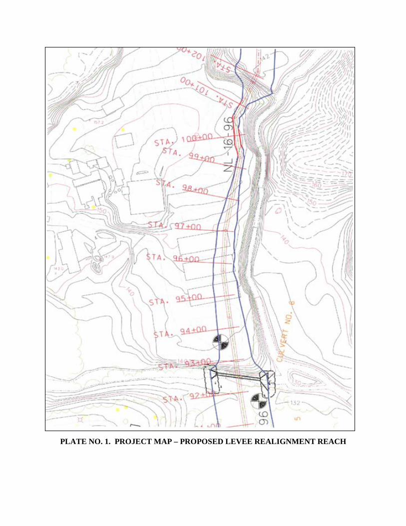
PLATE NO. 1. PROJECT MAP – PROPOSED LEVEE REALIGNMENT REACH
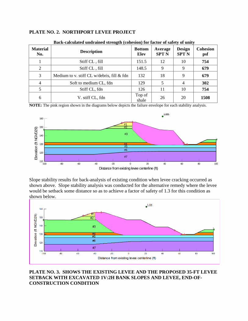
PLATE NO. 2. NORTHPORT LEVEE PROJECT
Back-calculated undrained strength (cohesion) for factor of safety of unity Material
No. Description Bottom Elev
Average SPT N
Design SPT N
Cohesionpsf
1 Stiff CL , fill 151.5 12 10 754 2 Stiff CL , fill 148.5 9 9 679 3 Medium to v. stiff CL w/debris, fill & fdn 132 18 9 679 4 Soft to medium CL, fdn 129 5 4 302 5 Stiff CL, fdn 126 11 10 754
6 V. stiff CL, fdn Top of shale 26 20 1508
NOTE: The pink region shown in the diagrams below depicts the failure envelope for each stability analysis.
Slope stability results for back-analysis of existing condition when levee cracking occurred as shown above. Slope stability analysis was conducted for the alternative remedy where the levee would be setback some distance so as to achieve a factor of safety of 1.3 for this condition as shown below.
PLATE NO. 3. SHOWS THE EXISTING LEVEE AND THE PROPOSED 35-FT LEVEE SETBACK WITH EXCAVATED 1V:2H BANK SLOPES AND LEVEE, END-OF-CONSTRUCTION CONDITION
1.005
#1#2
#3
#4#5#6
#7
Distance from existing levee centerline (ft)-100 -80 -60 -40 -20 0 20 40 60 80 100
Elev
atio
n (ft
NG
VD29
)
110
120
130
140
150
160

ENVIRONMENTAL ASSESSMENT
DRAFT EA-1
DRAFT ENVIRONMENTAL ASSESSMENT
FOR
NORTHPORT LEVEE REPAIR PROJECT
ALONG THE BLACK WARRIOR RIVER
NORTHPORT, ALABAMA
1.0 INTRODUCTION: This environmental assessment was prepared utilizing a systematic, interdisciplinary approach integrating the natural and social sciences and the design arts with planning and decision making. The proposed action and its alternatives are evaluated in multiple contexts for short-term and long-term effects and for adverse and beneficial effects. This assessment indicates the effects on the human environment from the proposed action are well known and do not involve unique or unknown risk. It is not anticipated that this is a precedent-setting action, nor does it represent a decision in principle about any future consideration. This document was prepared for the purpose of obtaining environmental compliance documentation for the proposed Northport Levee Repair Project in Northport, Alabama. The proposed project is to repair levee damage on the Northport Levee in the vicinity of the Warrior River Lumber Company. A routine inspection on 13 July 2010 showed approximately 320 feet of cracking along the northern end of the levee with displacement up to two inches in some areas, as shown in Appendix A. Anomalies along the east side of the levee were also noticed in areas where cracking had occurred with signs of erosion along the west bank of Two-Mile Creek.
1.1 LOCATION: The necessary repair work is located in Northport, Alabama in Tuscaloosa County along Two-mile creek which is a tributary to the Black Warrior River, (Figure 1). Northport is located on the Black Warrior River in west-central Alabama. The Black Warrior River is formed by the confluence of the Locust and Mulberry Forks approximately 20 miles west of Birmingham. This river is a major tributary of the Tombigbee River. Most of the basin lies upstream of Northport.
1.2 PROPOSED ACTION: The proposed action is to relocate the damaged levee section westward approximately 35 feet from the centerline of the existing levee and further from Two-Mile Creek. This plan would require acquisition of private property. The parent tract to be impacted by the proposed easement acquisition is approximately 20 acres of industrial site that had been used as a wood treatment facility and lay down yard. Approximately 0.59 acres of land adjoining the levee’s western boundary would be required for the proposed levee repair work. A standard temporary work area easement for a period not to exceed 1 year is expected for project construction and is not expected to exceed 0.45 acres. The staging area would be located on the parent tract in an open area adjoining the levee and access easement. If any additional material is required for construction of the levee it will come from the City-owned borrow site.

DRAFT EA-2
1.3 PURPOSE AND NEED: The purpose of the proposed project is to correct the design deficiency and conduct the repairs required to make the project function as initially intended in a safe, viable, and reliable manner. The regraded shallower slope of the proposed repair section would simultaneously correct the design deficiency of the crack and slip section and the erosion issues along the west bank of Two-mile Creek. Without corrective measures, the consequences of a levee failure include the potential loss of life of four to seven persons and potential economic damages estimated to be around $69 million.
Figure 1. Project Vicinity Map

DRAFT EA-3
1.4 AUTHORITY: The original construction of the Northport Levee was authorized under Section 205 of the Flood Control Act of 1948, as amended. Since the proposed action would move this reach of the levee westward, it was determined that a categorical exclusion could not be used because the levee repair work would not be performed along the current alignment of the original levee footprint. Necessary repairs to the levee are also authorized under Section 205 of the Flood Control Act of 1948, as amended.
2.0 ENVIRONMENTAL SETTING WITHOUT THE PROJECT:
2.1 GENERAL ENVIRONMENTAL SETTING: The City of Northport is located in the Fall Line Hills of the East Gulf Coastal Plain section of the Coastal Plain physiographic province. The entire Northport Levee project area (reference Figure 1) is located in a temperate and subtropical region. The topography is gently rolling, with medium to fine textured soils. The locale is characterized by southern floodplain forests; however large, unbroken stands of timber are not in the vicinity. Undeveloped areas in the vicinity of the project area are primarily mixed pine and hardwoods, consisting of oaks [water (Quercus nigra), willow(Quercus phellos), and red (Quercus rubra)], sweetgum (Liquidambar styraciflua), sycamore (Platanus occidentalis), beech (Fagus sp.), shag bark hickory (Carya ovata), willow (Salix sp.), mimosa—an invasive species—(Mimosa sp.), magnolia (Magnolia sp.), elm (Ulmus sp.), red maple (Acer rubrum), and sugarberry (Celtis laevigata). The edges and underbrush are primarily privet, a non-native invasive species. There are also areas of high quality bottomland hardwoods, and hardwood stands. Pine tends to cluster on the ridges, with other species scattered throughout the area and nearer the slough edges. The area is populated by wildlife species capable of adapting to the close proximity of industry and human habitation, such as turkey, white-tail deer, and squirrels. Development flanking the project area includes a sawmill, sewage treatment facility, a wharf, grain silo, warehouses, residents and commercial buildings. The wharf and grain silo are owned by the Alabama State Docks, and are now used as a weighing and docking facility for transport of timber.
The proposed repair section is located on the eastern portion of the Northport Levee and consists of a grass covered earthen levee with an access road that is used for maintenance purposes. Any woody vegetation is prevented from rooting in the levee because it damages the integrity of the structure. Adjacent to the property is a lumberyard and further beyond lies residential and urban development. Based on the Federal Emergency Management Agency (FEMA) Hazard United States Multi-Hazard (HAZUS-MH) data, the population in the levee area is estimated to be around 617 persons during the day and 766 persons during the night with about 419 structures in the protected area of the levee. The property value of these structures in the levee area is estimated to be $99,621,120.00.
2.2 SIGNIFICANT RESOURCES DESCRIPTION:
2.2.1 WETLANDS: Wetland surveys were completed by the USACE during the original construction of the Northport Levee. Any previously existing wetlands have been filled

DRAFT EA-4
and mitigated for (USACE 1995). The proposed project site is adjacent to commercial and residential development. Two-mile Creek flows below the levee however there are no wetlands associated with this creek. As such, there are no wetlands within the vicinity of the proposed project.
2.2.2 FISHERY RESOURCES: There are no commercial quality fisheries in the vicinity of the proposed project. Sport fish in the Black Warrior River basin include largemouth bass (Micropterus salmoides), smallmouth bass (Micropterus dolomieu), striped bass (Morone saxatilis), spotted bass (Micropterus punctulatus), crappie (Pomoxis spp.), catfish (Ictalurus spp.), bluegill (Lepomis macrochirus), and sunfish (Lepomis spp.). Other species are drum (Aplodinotus grunniens), buffalo (Ictiobus bubalus), carp (Cyprinus carpio), striped mullet (Mugil cephalus), Gulf sturgeon (Acipenser oxyrinchus desotoi), and the Atlantic needlefish (Strongylura marina). Common mussels found in the Black Warrior-Tombigbee River basin include Washboard (Megalonaias nervosa), (Plectomerus dombeyana), Alabama ord (Quadrula asperata), Southern mapleleaf (Quadrula apiculata), Threeridge (Amblema plicata), ebonyshell (Fusconaia ebena), (Fusconaia cerina), Elephant-ear (Elliptio crassidens), fragile papershell (Leptodea fragilis), yellow sandshell (Lampsilis teres), southern fatmucket (Lampsilis straminea claibornensis), Alabama heelsplitter (Potamilus inflatus), Threehorn wartyback (Obliquaria reflexa).
2.2.3 WILDLIFE RESOURCES: The proposed project area is in an urban environment. Species now in the area are those adapted to the close proximity of human habitation, such as white-tail deer (Odocoileus virginianus), turkey (Meleagris gallopavo), squirrels (Sciurus spp.), Eastern cottontail rabbit (Sylvilagus floridanus), etc. It is anticipated these animals would avoid the area during the construction phase of the proposed project. Future development in the area would result in the migration of wildlife to less developed areas.
2.2.4 THREATENED AND ENDANGERED SPECIES: Federally-listed threatened and endangered species with potential to exist in the proposed project area are the wood stork (Mycteria americana), triangular kidneyshell (Ptychobranchus greeni), inflated heel splitter (Potamilus inflatus), and flattened musk turtle (Sternotherus depressus). With the exception of the wood stork, these are strictly aquatic species and have no habitat within the proposed levee repair section. Potential habitat for the wood stork does not exist in the proposed project area as well. None of these species have been observed within the proposed project boundaries.
2.2.5 HISTORIC AND ARCHEOLOGICAL RESOURCES: The Mobile District has evaluated historical and contemporary documents, as well as survey reports, and has found no cultural resources or historic properties eligible for listing on the National Register of Historic Places within the proposed project area, pending any new information from the Alabama State Historic Preservation Officer.
DRAFT EA-5
2.2.6 NAVIGATION: The Black Warrior River is a federally maintained navigation channel that is actively used for barge navigation. The barge navigation channel is maintained by the operation of the locks and dams on the rivers and by routine channel dredging/disposal operations. The Northport Levee repair does not interfere with the main navigation channel.
2.2.7 RECREATION: There is no recreation within the proposed project since this section of the Northport Levee is surrounded by private lands.
2.2.8 AESTHETICS: The current scenery of the proposed project site is dominated by an existing lumberyard which houses three sheds.
2.2.9 NOISE: The proposed project location is in a remote area cut off from public use. A wood treatment facility, located within the scope of work, has since gone out of business. Noise levels are low due to the minimal activity within the area.
2.2.10 AIR QUALITY: The Air Quality Index (AQI) is an index for reporting daily air quality. Based on the air quality historical records from the Alabama Department of Environmental Management (ADEM) for Tuscaloosa County, the average AQI is good with the 3 year annual average between 2008 and 2010 for particulate Matter (PM2.5) [µ/m3] reading at 10.8. The 8-hour 3 year Ozone average between 2009 and 2011 is 0.058 parts per billion (ADEM 2013).
2.2.11 WATER QUALITY: The Alabama Department of Environmental Management states, “Section 303(d) of the Clean Water Act (CWA) establishes that states are to list (the 303(d) list) waters for which technology-based limits alone do not ensure attainment of applicable water quality standards (WQS)” (2013). The proposed repair section of the Northport Levee abuts Two-mile Creek which flows into the Black Warrior River. Two-mile Creek is not listed on the Alabama 303(d) list. The nearest affected body of water, North River, lies approximately 6 miles north on the Black Warrior River (ADEM 2013).
2.2.12 FLOODPLAIN: The proposed levee repair is located within the 100 year floodplain; however, the existing levee was constructed so that the majority of the levee was created outside the floodway, including the levee repair section. A no-rise certification was prepared for the Northport Levee (USACE 1995).
2.2.13 SOCIO-ECONOMICS: According the 2012 U.S. Census Bureau, the City of Northport has a total population of 24,088 with population density of 1,313.2 people per square mile. As of the 2000 Census, the estimated per capita income is $20,163. Median house value was $159,447. The most common occupation is other production occupations, i.e. supervisors, secretaries and administrative assistants, health care, and social assistance (2013). The vicinity of the immediate project area is comprised of an abandoned lumberyard. This lumberyard was a lay down and wood treatment facility that has gone out of business in recent years. Residential houses dominate the surrounding area outside of the project vicinity.

DRAFT EA-6
2.2.14 LAND USE: The surrounding land is approximately 20 acres of industrial site that has been used by a wood treatment facility and lay down yard. This facility has three lumber sheds on the property. In recent years the facility closed business and has since stopped operating.
2.2.15 PRIME AND UNIQUE FARMLAND: Consultation with the U.S. Department of Agriculture, Natural Resources Conservation Service during the preparation of the 1995 Northport Levee Environmental Assessment indicated there were no prime or unique farmland in the proposed project area.
2.2.16 HAZARDOUS, TOXIC AND RADIOLOGICAL WASTE (HTRW): An HTRW assessment, conducted as part of the completion of the Northport Levee in the late 1990s, determined that there were no contaminants at the preexisting lumberyard site.
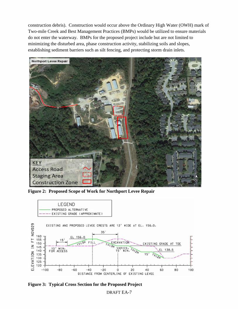
3.0 DESCRIPTION OF THE RECOMMENDED PLAN: The recommended plan would relocate the levee section westward approximately 35 feet from centerline of the existing levee crack and slip surface (Figure 2) and would move it further from Two-mile Creek. This plan would require acquisition of private property that currently contains an inoperable lumberyard. Three existing lumber sheds would be impacted, and would need relocating. Approximately 0.59 acres of land adjoining the levee’s western boundary would be required for the proposed levee repair work. A standard temporary work area easement for a period not to exceed 1 year is expected for project construction. For construction materials and equipment to be kept in proximity to the project area, a staging area would be needed. This staging area is not expected to exceed 0.45 acres and would be located on the parent tract in an open area adjoining the levee and access easement. The proposed construction measures within this footprint include excavation of material, re-grading the levee, placing new compacted fill, clearing and grubbing, seeding, and road replacement.
To construct the levee, the contractor would have to work in 100 ft sections to insure that the levee can be closed if a high water event is predicted. The original levee would be excavated to match the proposed grading and to achieve the proper slope necessary for the proposed repaired levee section. Dozers, excavators, rollers, and dump trucks would be used for construction. The material for the embankment would most likely be clay to clay/sand material. The existing levee material can be used if the material is satisfactory. Figure 3 shows a typical cross section of the selected plan.
An approved local borrow area would be used for fill and disposal material. The borrow site is owned and operated by the City of Northport and is used for city projects. It is located at the end of 3rd Street in Northport, just north of Oliver Lock and Dam. The material was previously used for the original construction of the levee, and will be utilized during the repair. The contractor would be required to perform soil property testing of the material to determine the soils are suitable for construction. The contractor would also be required to dispose of excess material off of government controlled lands in an approved landfill (one which accepts
DRAFT EA-7
construction debris). Construction would occur above the Ordinary High Water (OWH) mark of Two-mile Creek and Best Management Practices (BMPs) would be utilized to ensure materials do not enter the waterway. BMPs for the proposed project include but are not limited to minimizing the disturbed area, phase construction activity, stabilizing soils and slopes, establishing sediment barriers such as silt fencing, and protecting storm drain inlets.
Figure 2: Proposed Scope of Work for Northport Levee Repair
Figure 3: Typical Cross Section for the Proposed Project

DRAFT EA-8
4.0 POTENTIAL ENVIRONMENTAL IMPACTS OF THE PROPOSED ACTION:
4.1 BIOLOGICAL AND PHYSICAL IMPACTS: The proposed action involves the excavation and relocation of fill material to create the elevated land at the correct slope as needed for the relocated levee section. A staging area would be required during construction. This staging area is not expected to exceed 0.45 acres and would be located on the parent tract in an open area adjoining the levee and access easement. The staging area is located in a previously disturbed area. The relocated levee would be seeded with grasses except those portions along the top of the levee which would be covered by the replaced road. Like the staging area, all work would occur in previously disturbed areas and would generally be returned to the previous state. The buildings to be impacted would be relocated to an area inside the lumberyard out of the project scope of work.
4.1.1 WETLANDS: No wetlands exist within the scope of work. For this reason, there would be no impacts to wetlands under the proposed project.
4.1.2 FISHERY RESOURCES: All work would be completed above the Ordinary High Water (OHW) of Two-mile Creek and BMPs would be utilized to ensure no erosion or materials enter the water. Therefore, there would be no impacts to fishery resources.
4.1.3 WILDLIFE RESOURCES: Because the proposed project location is within a heavily developed area, the wildlife which exists in the project area is adapted to human development. The result of relocating the section of the levee westward by 35 feet would not cause any effects to the existing wildlife.
4.1.4 THREATENED/ENDANGERED SPECIES: The habitat of the proposed project footprint does not support any threatened and endangered species. The habitat was altered when the Northport Levee was first constructed. Therefore, the USACE has determined that the proposed project would have no effect on any threatened or endangered species. The U.S. Fish and Wildlife concurred with the USACE determination via letter dated 25 September 2013. A copy of the correspondence can be found in Appendix B.
4.1.5 HISTORIC AND ARCHEOLOGICAL RESOURCES: The USACE has determined that there is no potential affect to cultural resources as a result of the proposed action. A copy of the correspondence with the Alabama SHPO will be included in the Final EA under Appendix B.
4.1.6 NAVIGATION: There would be no effects to navigational resources because the Northport Levee repair does not interfere with the main navigation channel.
4.1.7 RECREATION: Neither the proposed alternative, or any of the other alignments considered adversely affect the values for which a component of the National Wild and Scenic Rivers System was established; have any impacts on a part of the National Trails System; or

DRAFT EA-9
affect parks, parklands, ecologically critical areas, or other areas of ecological, recreational, scenic, or aesthetic importance. The existing roadway would be realigned to the repaired levee section and would be used for maintenance purposes. It is not anticipated recreation would be impacted by the proposed action.
4.1.8 AESTHETICS: Temporary changes in aesthetics would be seen during project construction but would be minor and would generally return to previous project conditions, with the exception of the relocated portion of the levee and the removal of buildings from the site.
4.1.9 NOISE IMPACTS: There would be no permanent noise impacts associated with the proposed levee repair. Noise impacts would be temporary, associated with construction activities, and cease upon completion of the action. Noise levels associated with construction activities would not significantly exceed ambient levels.
4.1.10 AIR QUALITY: Tuscaloosa County has relatively high air quality. The only impacts to air quality would result from construction of the levee. These impacts would be periodic, and would subside upon completion of the construction effort. BMPs would be implemented to contain pollutants and prevent the releasing of toxic chemicals into the atmosphere.
Neither the proposed alternative nor the other alternatives are affected by primary or secondary National Ambient Air Quality Standards; are required to conform to an approved State Implementation Plan; are affected by New Source Performance Standards; are subject to a Class I designation; are affected by national Emission Standards for hazardous Air Pollutants; or required to adhere to any emission limitations in an Air Quality Control Region.
4.1.11 WATER QUALITY: The proposed project construction would occur above the OHW for Two-mile Creek and BMPs would be utilized to ensure no material or runoff enters the water. A 401 Water Quality Certification is not necessary because no work is occurring in the waters. Therefore, it is not anticipated that construction of the proposed project would result in adverse impacts to the quality of waters behind the levee.
4.1.12 FLOODPLAIN IMPACTS: The proposed project would be to repair a design deficiency within a section of the levee and there would be no adverse impacts the floodplain.
4.1.13 SOCIOECONOMICS: Repairing the design deficiencies of the Northport Levee along Two-mile creek would prevent potential levee failure which could result in loss of life and property damage. The existing lumberyard is out of business but the proposed project would not preclude the business from thriving in the future and would provide flood damage reduction.
4.1.14 LAND USE: This plan would require acquisition of private property. The parent tract to be impacted by the proposed easement acquisition is an approximately 20 acres industrial

DRAFT EA-10
site that had been used as a wood treatment facility and lay down yard. Three existing lumber sheds would be impacted, and would need relocating. Additional access rights are not required for the proposed levee repair as sufficient rights exist per that right-of-way agreement between the land owner, Mr. John M. Richardson, and the City of Northport. Surrounding land use is not anticipated to change in response to the recommended plan.
4.1.15 PRIME AND UNIQUE FARMLAND: Previous consultation confirmed no farmlands exist within the scope of work for the proposed Northport Levee Repair and no impacts to farmlands would occur. None of the considered alignments converts farmland to other uses.
4.16 HAZARDOUS, TOXIC AND RADIOLOGICAL WASTE: Potential liabilities were identified during the Preliminary Assessment Screening of the Northport Levee (1995). Those included a former automobile junkyard, former cotton gin, former oil company site and former landfill. The proposed levee repair is not located at any of these sites. Therefore the proposed project would not result in the generation, transport, treatment, storage or disposal of hazardous or toxic wastes.
4.17 CUMULATIVE EFFECTS: The Council on Environmental Quality defines cumulative effects as “the impact on the environment which results from the incremental impact of the action when added to other past, present, and reasonably foreseeable future action regardless of what agency or person undertakes such other actions (40 CRF 1408.7).”
The recommended plan to remedy the cracked reached of the levee would be to relocate the levee further away from the creek. The relocated dike would be located off (west) of the existing crack and slip surface. This alternative would require acquisition of private property that is currently used as a lumberyard and includes three existing lumber sheds.
The proposed project would result in a relatively small permanent alteration to the immediate landscape and surrounding area. Most of these impacts would be during construction and would rapidly stabilize after the completion of construction and revegetation of the levee and areas subject to ground disturbing activities. The Northport Levee was completed in 1999 for the City of Northport and as such, there are no future plans for additional levee structures. There are no existing Federal projects underway that lie fully or partially within the proposed project area as well as the easements and rights-of-way required for construction. Therefore, no significant cumulative impacts are anticipated.
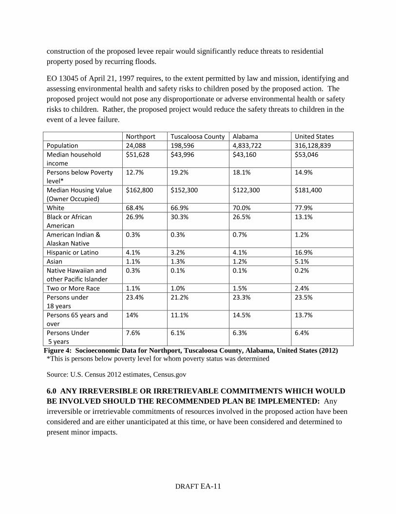
5.0 ENVIRONMENTAL JUSTICE AND PROTECTION OF CHILDREN: Executive Order (EO) 12898 of February 11, 1994 requires addressing, as appropriate, disproportionately high and adverse human health or environmental effects of Federal actions on minority and low-income populations. As shown in Figure 4 below, the proposed project would have no disproportionate adverse impacts generated on minority or low-income populations in the area. No residential properties would be negatively impacted by the proposed project. The
DRAFT EA-11
construction of the proposed levee repair would significantly reduce threats to residential property posed by recurring floods.
EO 13045 of April 21, 1997 requires, to the extent permitted by law and mission, identifying and assessing environmental health and safety risks to children posed by the proposed action. The proposed project would not pose any disproportionate or adverse environmental health or safety risks to children. Rather, the proposed project would reduce the safety threats to children in the event of a levee failure.
Figure 4: Socioeconomic Data for Northport, Tuscaloosa County, Alabama, United States (2012) *This is persons below poverty level for whom poverty status was determined
Source: U.S. Census 2012 estimates, Census.gov
6.0 ANY IRREVERSIBLE OR IRRETRIEVABLE COMMITMENTS WHICH WOULD BE INVOLVED SHOULD THE RECOMMENDED PLAN BE IMPLEMENTED: Any irreversible or irretrievable commitments of resources involved in the proposed action have been considered and are either unanticipated at this time, or have been considered and determined to present minor impacts.
Northport Tuscaloosa County Alabama United States Population 24,088 198,596 4,833,722 316,128,839 Median household income
$51,628 $43,996 $43,160 $53,046
Persons below Poverty level*
12.7% 19.2% 18.1% 14.9%
Median Housing Value (Owner Occupied)
$162,800 $152,300 $122,300 $181,400
White 68.4% 66.9% 70.0% 77.9% Black or African American
26.9% 30.3% 26.5% 13.1%
American Indian & Alaskan Native
0.3% 0.3% 0.7% 1.2%
Hispanic or Latino 4.1% 3.2% 4.1% 16.9% Asian 1.1% 1.3% 1.2% 5.1% Native Hawaiian and other Pacific Islander
0.3% 0.1% 0.1% 0.2%
Two or More Race 1.1% 1.0% 1.5% 2.4% Persons under 18 years
23.4% 21.2% 23.3% 23.5%
Persons 65 years and over
14% 11.1% 14.5% 13.7%
Persons Under 5 years
7.6% 6.1% 6.3% 6.4%
DRAFT EA-12
7.0 ADVERSE ENVIRONMENTAL EFFECTS WHICH CANNOT BE AVOIDED: Any adverse environmental effects which cannot be avoided should the recommended project be implemented are expected to be minor individually and cumulatively.
8.0. THE RELATIONSHIOP BETWEEN LOCAL SHORT-TERM USES OF MAN’S ENVIRONMENT AND MAINTENANCE AND ENHANCEMENT OF LONG-TERM PRODUCTIVITY: The proposed project constitutes short-term impacts of man’s environment including noise and air pollution, as well as soil and vegetation disturbance. Long-term productivity would be enhanced from the reduction of future flood threats and the increase of public safety.
9.0 ALTERNATIVES TO THE PROPOSED ACTION:
9.1 NO ACTION: With the No Action Alternative, the levee would not be repaired and continual degradation of the existing levee would occur. This could lead to failure of the levee and subsequent flooding. As a result, loss of life and extensive property damage would occur.
9.2 ALTERNATIVE 1: A sheet pile retaining wall extending to top of shale would be driven and a closely spaced row of pre-drilled and grouted H-piles that extend into shale would be installed immediately behind the sheet-pile wall to buttress it. Additional real estate probably would not be needed; however the levee would remain cracked. The piling would act as a retaining wall to minimize future slope movement. Another disadvantage is that slope movements could occur during construction, particularly from vibrations cause by pile driving.
9.3. ALTERNATIVE 2: The creek would be relocated further east with flatter side slopes and stability berm would be built near existing creek bank if stability analyses indicate it to be necessary to achieve stability. Although more real estate would be required, the real estate likely would not cost as much as Alternative 1. The levee would remain cracked. It may be impossible to achieve required stability without a stability berm. The work likely would affect creek hydraulics and stone protection might be needed.
10.0 COORDINATION: As required by the National Environmental Policy Act, the Corps coordinated this project with various local, state and Federal agencies.
10.1 U.S. Fish and Wildlife Service
10.2 U.S. Environmental Protection Agency
10.3 Alabama State Historic Preservation Officer
10.4 Alabama Department of Environmental Management
10.5 Public Coordination: A Public Notice (Public Notice Number FP13-BW01-7) on this proposed action will be distributed to appropriate Federal, State, and local agencies,
DRAFT EA-13
organizations, and the general public in order to solicit comments. A summary of comments received will be included in the Final EA.
11.0 REFERENCES:
ADEM. "303(d) Information and Map." Alabama Department of Environmental Management. Available from http://adem.alabama.gov/programs/water/303d.cnt. Internet; accessed 6 August 2013.
ADEM. “Historical Ozone and PM2.5 Data.” Alabama Department of Environmental Management. Available from http://www.adem.state.al.us/programs/air/airquality/ozone/historical.cnt. Internet; accessed 6 August 2013.
"Annual Estimates of the Resident Population for Incorporated Places: April 1, 2010 to July 1, 2012" (HTML). 2012 Population Estimates. U.S. Census Bureau, Population Division. June 12, 2013. Retrieved June 12, 2013.
U.S. Census Bureau, Population division. (2013). Annual Estimates of the Resident Population by Sex, Age, Race, and Hispanic Origin for the United State, States, and Counties: April 1, 2010 to July 1, 2012. Retrieved from http://www.census.gov/popest/data/index.html.
U.S. Department of Defense, Corps of Engineers. Environmental Assessment, Black Warrior River, Northport, Alabama. 1995.
U.S. Fish and Wildlife Service. Draft Fish and Wildlife coordination Act Report on Northport Alabama, Flood Control Project. May 1995.

APPENDIX A: IMAGES

DRAFT EA A-1
Image 1: Longitudinal cracking with displacement along levee
Image 2: Longitudinal cracking with displacement along levee

DRAFT EA A-2
Image 3: Longitudinal cracking with displacement. Levee approaching elevation of natural ground
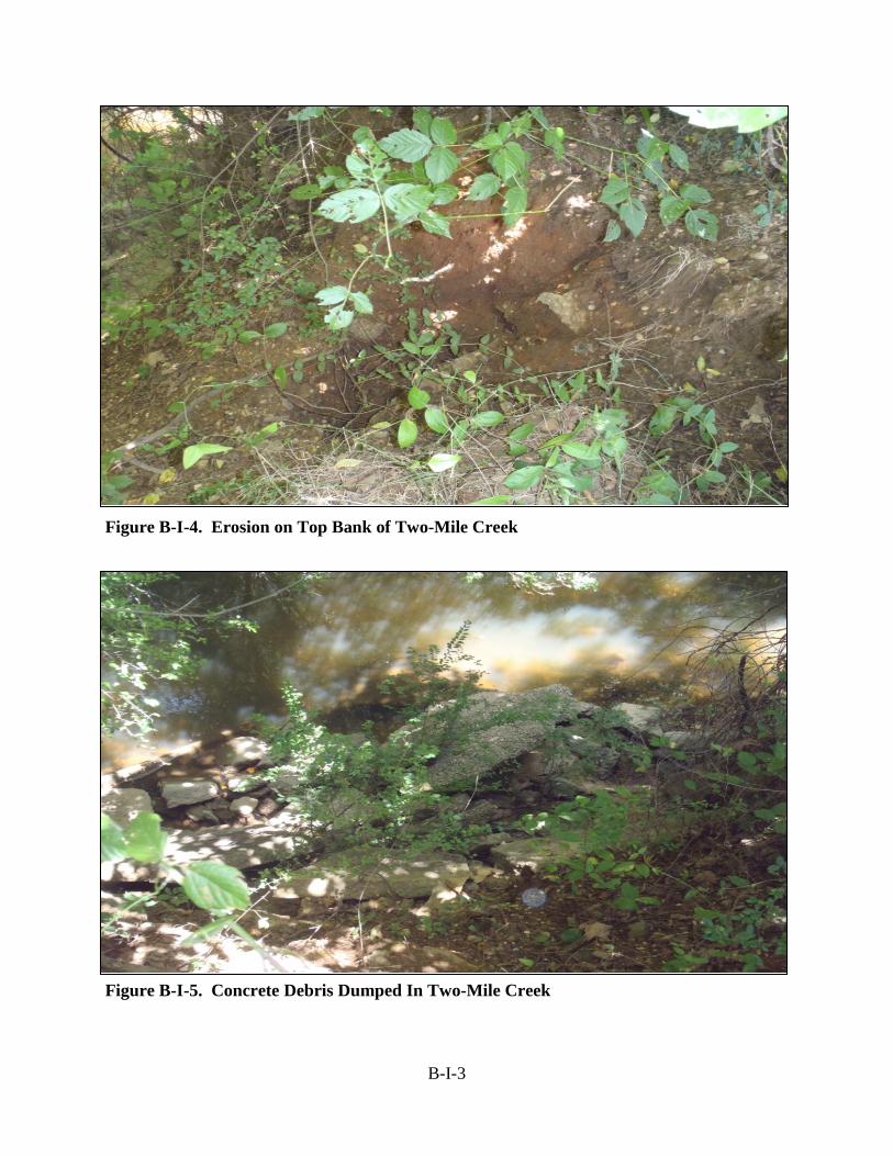
Image 4: Erosion on top bank of Two-mile Creek

DRAFT EA A-3
Image 5: Concrete debris dumped in Two-mile Creek
Image 6: East bank of Two-mile Creek (approximate slop 2V:1H)

APPENDIX B: AGENCY COORDINATION
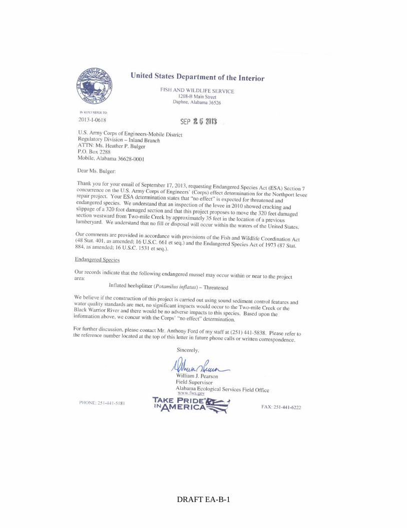
DRAFT EA-B-1
DRAFT FONSI-1
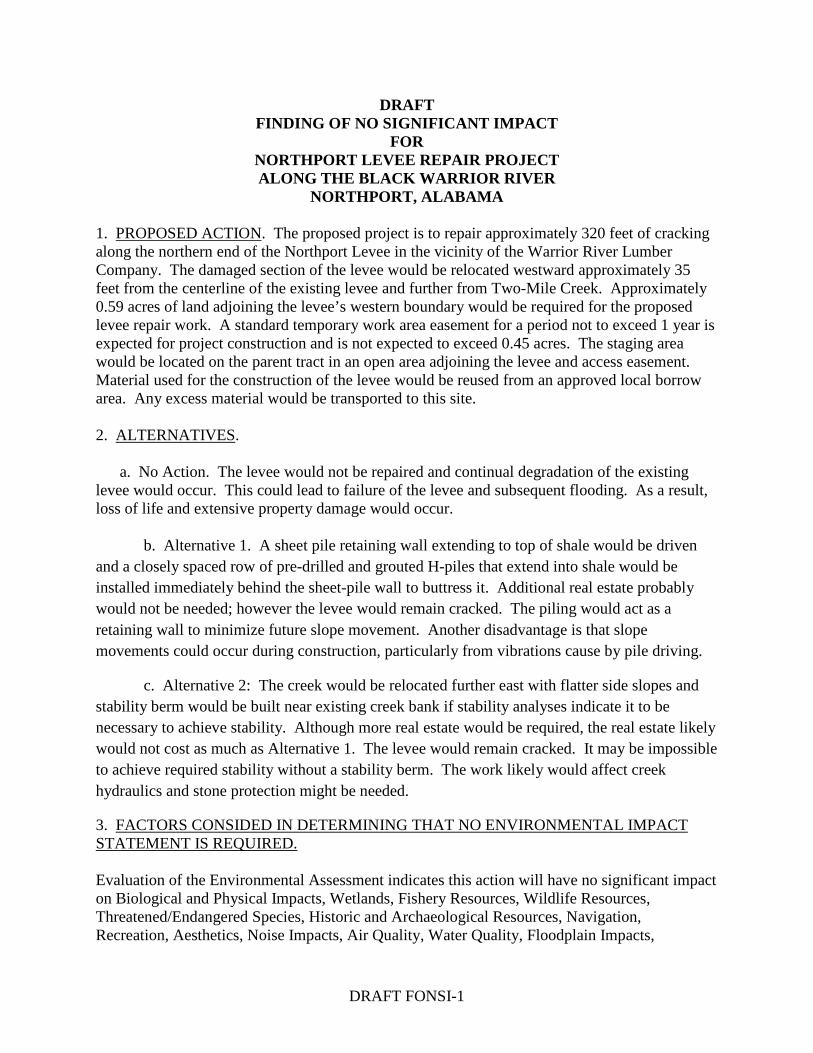
DRAFT FINDING OF NO SIGNIFICANT IMPACT
FOR NORTHPORT LEVEE REPAIR PROJECT ALONG THE BLACK WARRIOR RIVER
NORTHPORT, ALABAMA 1. PROPOSED ACTION. The proposed project is to repair approximately 320 feet of cracking along the northern end of the Northport Levee in the vicinity of the Warrior River Lumber Company. The damaged section of the levee would be relocated westward approximately 35 feet from the centerline of the existing levee and further from Two-Mile Creek. Approximately 0.59 acres of land adjoining the levee’s western boundary would be required for the proposed levee repair work. A standard temporary work area easement for a period not to exceed 1 year is expected for project construction and is not expected to exceed 0.45 acres. The staging area would be located on the parent tract in an open area adjoining the levee and access easement. Material used for the construction of the levee would be reused from an approved local borrow area. Any excess material would be transported to this site. 2. ALTERNATIVES. a. No Action. The levee would not be repaired and continual degradation of the existing levee would occur. This could lead to failure of the levee and subsequent flooding. As a result, loss of life and extensive property damage would occur.
b. Alternative 1. A sheet pile retaining wall extending to top of shale would be driven and a closely spaced row of pre-drilled and grouted H-piles that extend into shale would be installed immediately behind the sheet-pile wall to buttress it. Additional real estate probably would not be needed; however the levee would remain cracked. The piling would act as a retaining wall to minimize future slope movement. Another disadvantage is that slope movements could occur during construction, particularly from vibrations cause by pile driving.
c. Alternative 2: The creek would be relocated further east with flatter side slopes and stability berm would be built near existing creek bank if stability analyses indicate it to be necessary to achieve stability. Although more real estate would be required, the real estate likely would not cost as much as Alternative 1. The levee would remain cracked. It may be impossible to achieve required stability without a stability berm. The work likely would affect creek hydraulics and stone protection might be needed.
3. FACTORS CONSIDED IN DETERMINING THAT NO ENVIRONMENTAL IMPACT STATEMENT IS REQUIRED. Evaluation of the Environmental Assessment indicates this action will have no significant impact on Biological and Physical Impacts, Wetlands, Fishery Resources, Wildlife Resources, Threatened/Endangered Species, Historic and Archaeological Resources, Navigation, Recreation, Aesthetics, Noise Impacts, Air Quality, Water Quality, Floodplain Impacts,
DRAFT FONSI-2
Socioeconomics, Land Use, Prime and Unique Farmland, Hazardous and Toxic Materials/Wastes, Environmental Justice, and Protection of Children, Cumulative Impacts. The proposed project is in compliance with all applicable environmental laws and regulations. 4. CONCLUSIONS. It has been reasonably concluded that the proposed action would have no significant environmental impacts, precluding the need for an Environmental Impact Statement. DATE:______________________________ _______________________________ Jon J. Chytka, P.E. Colonel, Corps of Engineers District Commander

APPENDIX A ECONOMIC ANALYSIS

A-i
APPENDIX A - ECONOMIC ANALYSIS
TABLE OF CONTENTS
PAGE TITLE NUMBER Overview ......................................................................................................................... A-1 Purpose ............................................................................................................................ A-1 Safety and Economic Consideration ............................................................................... A-1 Benefit Analysis .............................................................................................................. A-2 Recommendation ............................................................................................................ A-3
LIST OF FIGURES
FIGURE NO. DESCRIPTION
A-1 Typical Cross Section .................................................................. A-3

A-1
APPENDIX A ECONOMIC ANALYSIS
Overview The levee project at Northport, Alabama, was constructed under Section 205 of the Flood Control Act of 1948, as amended, to reduce flood damages from the Black Warrior River. The contract was awarded in September of 1997 and was completed in August 1999 at a cost of $4.14 million. The project was cost-shared at 75/25 percent Federal/non-Federal share, respectively. The project is certified as providing protection to the regulatory one percent annual chance event and is operated and maintained by the City of Northport.
In its present state, the levee may resist the design flood event; however, it is susceptible to failure during rapid drawdown events after wetting of the creek bank and levee slope and after heavy rainfall that causes the levee and creek slope material to become more saturated. Such adverse conditions are not unusual and may be expected to occur annually in the long term and thus the level of protection is expected to continue to decline in the near term, resulting in an unacceptable flood protection system condition. Purpose Cracking and displacement of the levee crest noted in the July 2010 periodic inspection are indicative of a sliding soil failure involving the levee prism and underlying soil mass. Indications are that the failure plane daylights at or near the adjacent streambed of Two-mile Creek. The proximity of the levee to the incised channel and inadequate knowledge of detrimental underlying soil conditions suggest the project design did not properly account for site conditions and riverine processes and likely contributed to the sliding soil failure. A design deficiency is evident, and funding is requested for repairs under the existing Section 205 authority. Safety and Economic Consideration Paragraph 7 of ER 1165-2-119 (1982) “Modifications to Completed Projects” gives project deficiency eligibility conditions, one of which is found in item 4, under subheading a. “Eligible works.” It states, “It is justified by safety or economic considerations.”
General Information. Based on the Federal Emergency Management Agency (FEMA) Hazard United States Multi-Hazard (HAZUS-MH) data used in the U.S. Army Corps of Engineers Levee Screening Tool (LST), the population in the Levee Area is estimated to be around 617 persons during the day and 766 persons during the night with about 419 structures in the protected area of the levee. The property value of these structures in the levee area is estimated to be $99,621,120.
The Hazus-MH is a nationally applicable standardized methodology that estimates potential losses from earthquakes, hurricane winds, and floods. Hazus-MH uses state-of-the-art
A-2
Geographic Information Systems (GIS) software to map and display hazard data and the results of damage and economic loss estimates for buildings and infrastructure. It also allows users to estimate the impacts of earthquakes, hurricane winds, and floods on populations. Evacuation Effectiveness. Evacuation planning for the population in the Levee area does not exist. The City of Northport is not aware, as of August 2011, whether an emergency evacuation plan exists. The City’s Floodplain Management Plan, develop pursuant to standard section 205 agreements, mentions emergency evacuation. However, the Tuscaloosa County Hazard Mitigation Plan dated 2009 does not mention one.
Benefit Analysis
The Northport Levee is designed to protect the town/community from flooding along Two-mile Creek that borders the eastern boundary of the protected area and from the Black Warrior River which runs east to west through the area. Using existing and available information from the Corps Levee Safety Tool and Geospatial data, the PDT was able to determine the entire levee provides protection to approximately 419 structures which are roughly valued at $99,621,120. Using this levee wide large data set and evaluating the portion of the dike that has been determined to be deficient, the PDT was able to isolate a smaller number of structures that could be at an increased risk of flooding if the deficient portion of the levee were to fail due to high flows along the creek that borders the eastern portion of the levee or due to backwater flooding from the Black Warrior River south of the levee footprint. Starting with the larger data set and looking at the selected area near the deficient levee reach, it appears as many as 60 and as few as perhaps 10 homes or structures could be at an increased risk of flooding if a failure were to occur in this reach. Also, based on the greatest potential for flooding being due to backwater effect for flows along the Black Warrior River and the physical distance from the area of concern from the river, it seems more likely that a smaller number of structures, approximately 25 to 15, are at an increased risk of flooding, if a failure in this area were to occur. Note: This analysis/assessment is limited to the area directly impacted by a potential failure at the identified deficient location and only evaluates damages that might occur if the section were to fail prior to the next most vulnerable method of non-satisfactory performance failure to occur at any other point in the levee. (IE: overtopping of the levee or water flanking the end of the levee). Due to the relative size of the adjacent creek channel in comparison to distance of houses from the interior of the levee, it appears most potential flooding damage would occur as water ponds against the levee and Rice Mine Rd (also may be known as 5th street or State Rd 30) where water might pond until any breech could be closed, river level receded, and or water could be pumped or removed from the area. Using this approach to the analysis, it appears that any increased potential for flooding in this manner presents a case for a very small if any increase in the chance of potential life loss due to the identified deficiency. If the levee were to fail in the area of active failure (“substandard” location) and allow water to enter the protected area, concern would appear to be more for “ponding” of water that becomes trapped between the outside of the levee and Rice Mine Rd (also may be known as 5th street or State Rd 30) where water might continue to pond until any breech could be closed, river level recedes, and/or water could be pumped or removed from the area. Note the report seems to indicate failure in the identified location is more likely to occur as water levels begin to recede

A-3
thus indicating a smaller amount of water coming through a breech than if a failure were to occur as water was rising.
Citing from the Northport Levee Report – “In its present state, the levee may resist the design flood event; however, it is susceptible to failure during rapid drawdown events after wetting of the creek bank and levee slope and after heavy rainfall that causes the levee and creek slope material to become more saturated. Such adverse conditions are not unusual and may be expected to occur annually in the long term and thus the level of protection is expected to continue to decline in the near term, resulting in an unacceptable flood protection system condition.”
Using the information from above and from the original report which states “repairs are expected to cost $1,096,000,000 or $46,000 on an Average Annual basis”, it appears reasonable to conclude average annual damages prevented are at least equal to if not greater than the average annual cost of repairs. Likewise, it can be concluded that the proposed repair work has a BCR greater than 1.0 to 1.
Recommendation The recommended plan to remedy the cracked reach of the levee would locate the levee further away from the creek. The dike would be located off (west) of the existing crack and slip surface. Rehabilitation Plan. This plan would require acquisition of private property that is currently used as a lumberyard and includes existing lumber sheds. The actual required setback distance of the levee and resulting additional real estate requirements should be determined by slope stability analyses using levee design criteria given in EM-1110‐2‐1913, Table 6‐1b. This alternative with a setback distance of 35 feet has an estimated first cost of 1,070,000. The Figure A-1 shows a typical cross‐section for this plan.
Figure A-1. Typical Cross Section
APPENDIX B ENGINEERING INVESTIGATIONS
SECTION I
TRIP REPORT NORTHPORT LEVEE, NORTHPORT, TUSCALOOSA COUNTY, ALABAMA

B-I-1
APPENDIX B ENGINEERING INVESTIGATIONS
Trip Report – 20 July 2010
Northport Levee, Northport, Tuscaloosa County, Alabama
http://maps.google.com/maps?q=+ 33.225724,-87.565225&iwloc=A&hl=en&z=17&t=k
Attendees: Daniel Dix – EN-HH; Dennis Mekkers-EN-HH; Valerie Morrow – EN-GG; Ron Nettles - EN-GG
Background Information: The Northport Levee Section 205 Project is approximately 11,100 feet long. The levee project was awarded in September of 1997 and construction was completed in August of 1999 at a cost of $4.2 million. The levee non-Federal sponsor is the City of Northport, Alabama. This levee is inspected periodically under the National Levee Safety Program. During a Periodic Inspection on 13 July 2010 the inspection team noted cracking that needed additional attention. The Mobile District assembled a team to conduct this site visit and further investigate the situation.
Narrative: The Mobile team met with Doug Otto (CESAM-EN), George Poiroux (CESAM-EN-G), District Commander Colonel Steven Roemhildt, Danny Hensley, and Wynn Fuller on site at noon before conducting a site investigation. During the site investigation typical pavement cracking was noted along the walking path. The team verified approximately 320 feet of longitudinal cracking between National Levee Database Stations 92+80 and 96+00 with displacement up to two inches in some areas. Anomalies along the east side of the levee were noticed in areas where cracking with displacement occurred. Signs of erosion were also noted along the bank of Two-mile Creek. A cross section was taken in the area of concern by profile leveling. The location of cross section was marked with orange paint at the levee centerline. Two stakes marking the locations from which borings are to be obtained were placed along the cross section alignment on the east side of the levee. Figure B-I-1. Longitudinal cracking with displacement along levee

B-I-2
Figure B-I-2. Longitudinal Cracking with Displacement along Levee Figure B-I-3. Longitudinal Cracking with Displacement. Levee Approaching Elevation
of Natural Ground.
B-I-3
Figure B-I-4. Erosion on Top Bank of Two-Mile Creek Figure B-I-5. Concrete Debris Dumped In Two-Mile Creek
B-I-4
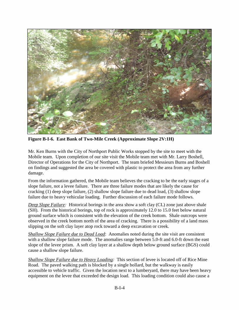
Figure B-I-6. East Bank of Two-Mile Creek (Approximate Slope 2V:1H)
Mr. Ken Burns with the City of Northport Public Works stopped by the site to meet with the Mobile team. Upon completion of our site visit the Mobile team met with Mr. Larry Boshell, Director of Operations for the City of Northport. The team briefed Messieurs Burns and Boshell on findings and suggested the area be covered with plastic to protect the area from any further damage.
From the information gathered, the Mobile team believes the cracking to be the early stages of a slope failure, not a levee failure. There are three failure modes that are likely the cause for cracking (1) deep slope failure, (2) shallow slope failure due to dead load, (3) shallow slope failure due to heavy vehicular loading. Further discussion of each failure mode follows.
Deep Slope Failure: Historical borings in the area show a soft clay (CL) zone just above shale (SH). From the historical borings, top of rock is approximately 12.0 to 15.0 feet below natural ground surface which is consistent with the elevation of the creek bottom. Shale outcrops were observed in the creek bottom north of the area of cracking. There is a possibility of a land mass slipping on the soft clay layer atop rock toward a deep excavation or creek.
Shallow Slope Failure due to Dead Load: Anomalies noted during the site visit are consistent with a shallow slope failure mode. The anomalies range between 5.0-ft and 6.0-ft down the east slope of the levee prism. A soft clay layer at a shallow depth below ground surface (BGS) could cause a shallow slope failure.
Shallow Slope Failure due to Heavy Loading: This section of levee is located off of Rice Mine Road. The paved walking path is blocked by a single bollard, but the walkway is easily accessible to vehicle traffic. Given the location next to a lumberyard, there may have been heavy equipment on the levee that exceeded the design load. This loading condition could also cause a

B-I-5
shallow slope failure. This failure mode seems less likely because the settlement is uniformly on the east side of the levee prism.
Figure B-I-7 compares the cross section measurements obtained in this inspection with previous surveys. Approximate locations of previously described slope failure modes and proposed locations of borings are also shown.
Figure B-I-7. Typical Section at Station 95+47
Conclusion: The cracks are indicative of a slope failure. The levee remains intact and is not considered to be in a failed state. The ability of the levee to withstand future or repeated flood loadings remains undetermined. Subsurface investigations and slope stability analyses are required to understand the nature of the slope failure and to identify a remedy.
Recommendations:
• Water should be prevented from infiltrating into the cracks. Asphaltic patch may be a more enduring and functional measure than plastic sheeting.
• The City should regularly monitor the area of concern.
• The Mobile team suggests sending the Mobile District Core Drill Unit to this site when next available to complete drilling.
• Conceptual remedial designs and cost estimates should be developed once borings have been obtained and slope stability analyses conducted.
SECTION II
SUBSURFACE INVESTIGATION REPORT
B-II-1
SUBSURFACE INVESTIGATION REPORT NORTHPORT LEVEE, NORTHPORT, ALABAMA
AUGUST 2010
1. General. This report documents the results of a recent subsurface investigation at Northport Levee, provides conclusions, and offers recommendations for concept alternatives that may be further considered to remediate a cracked reach of levee from about Stations 92+80 to 96+00. A rough-order-of-magnitude (ROM) cost estimate is provided for the first alternative. Only preliminary design analyses were conducted, as analyses and design of remedial alternatives was not included in the scope of this investigation.
Elevations stated in this report are relative to National Geodetic Vertical datum of 1929 (NGVD29) so as to be compatible with the vertical datum used for contract drawings. NGVD29 elevations vary from NAVD88 elevations by only about 0.1 foot at this project.
2. Subsurface Investigation. Three borings were drilled by the USACE Mobile District Core Drill Unit 28-31 July 2010, at approximate Levee Station 95+47. Logs of these borings are attached to this report. Some of the boring data is also shown on attached cross section. One boring was drilled from the dike crest just east of crack in the crest and the other two boring were drilled near the toe of each levee slope. The boring depths varied from 25.5 to 35.3 feet below ground surface. All borings were sampled by continuous splitspoon (e.g. on 1.5 ft intervals) and were terminated after shale was encountered. Standard penetration tests (SPT) were made. Soil was visually classified and described in accordance with the Unified Soil Classification System and placed in sample jars. Groundwater level readings were obtained. Boreholes were grouted at the end of the investigation. No laboratory testing was conducted or is currently planned. Most of the samples were transported to the Core Drill warehouse at Jones Bluff for storage, after which they will be disposed of after some undetermined time. A few samples were transported by the inspector to the Mobile District office for observation by others.
3. Subsurface Conditions. Boring NL-1-10 indicates that the levee fill material at this location is predominately stiff lean clay (CL). Blow counts in the levee fill extent of boring NL-1-10 varied from eight to 20 blows per foot. All three borings indicate that the native foundation material is predominately lean clay with consistency typically varying from soft (SPT N=4 blows per foot) to very stiff. Very soft materials were not found in any of the three borings. Top of shale was encountered at depths varying from 25.2 to 35.0 feet below ground surface, corresponding to elevations 118.1 to 121.8 feet NGVD. Shale outcrops were observed in the creek bottom to the north, beginning at approximate Station 98+00 where the creek bottom is about elevation 133 feet. Groundwater elevations were obtained and varied from elevation 131.5 to 140.3 feet NGVD. The creek bottom at Station 95+47 was estimated to be at approximately elevation 130 ft NAVD and the water in the creek was estimated to be approximately 1.5 feet deep when the site was visited July 2010.
4. Hydraulic Conditions. Two-mile Creek is an ungaged stream. At this location, Two-mile Creek is incised and would not be expected to produce discharge sufficient to interact with the levee prism. Stream gage data for USGS Gage 0246500, Black Warrior River at Northport,
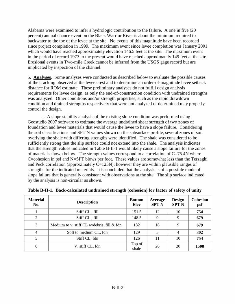
B-II-2
Alabama were examined to infer a hydrologic contribution to the failure. A one in five (20 percent) annual chance event on the Black Warrior River is about the minimum required to backwater to the toe of the levee at the site. No events of this magnitude have been recorded since project completion in 1999. The maximum event since levee completion was January 2001 which would have reached approximately elevation 146.5 feet at the site. The maximum event in the period of record 1973 to the present would have reached approximately 149 feet at the site. Erosional events in Two-mile Creek cannot be inferred from the USGS gage record but are implicated by inspection of the channel.
5. Analyses. Some analyses were conducted as described below to evaluate the possible causes of the cracking observed at the levee crest and to determine an order-of-magnitude levee setback distance for ROM estimate. These preliminary analyses do not fulfill design analysis requirements for levee design, as only the end-of-construction condition with undrained strengths was analyzed. Other conditions and/or strength properties, such as the rapid drawdown condition and drained strengths respectively that were not analyzed or determined may properly control the design.
a. A slope stability analysis of the existing slope condition was performed using Geostudio 2007 software to estimate the average undrained shear strength of two zones of foundation and levee materials that would cause the levee to have a slope failure. Considering the soil classifications and SPT N values shown on the subsurface profile, several zones of soil overlying the shale with differing strengths were identified. The shale was considered to be sufficiently strong that the slip surface could not extend into the shale. The analysis indicates that the strength values indicated in Table B-II-1 would likely cause a slope failure for the zones of materials shown below. The strength values correspond to a correlation of C=75.4N where C=cohesion in psf and N=SPT blows per foot. These values are somewhat less than the Terzaghi and Peck correlation (approximately C=125N); however they are within plausible ranges of strengths for the indicated materials. It is concluded that the analysis is of a possible mode of slope failure that is generally consistent with observations at the site. The slip surface indicated by the analysis is non-circular as shown.
Table B-II-1. Back-calculated undrained strength (cohesion) for factor of safety of unity
Material No. Description Bottom
Elev Average SPT N
Design SPT N
Cohesion psf
1 Stiff CL , fill 151.5 12 10 754 2 Stiff CL , fill 148.5 9 9 679
3 Medium to v. stiff CL w/debris, fill & fdn 132 18 9 679
4 Soft to medium CL, fdn 129 5 4 302 5 Stiff CL, fdn 126 11 10 754
6 V. stiff CL, fdn Top of shale 26 20 1508
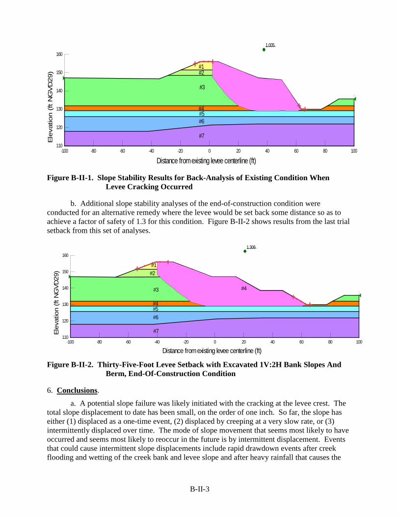
B-II-3
Figure B-II-1. Slope Stability Results for Back-Analysis of Existing Condition When
Levee Cracking Occurred
b. Additional slope stability analyses of the end-of-construction condition were conducted for an alternative remedy where the levee would be set back some distance so as to achieve a factor of safety of 1.3 for this condition. Figure B-II-2 shows results from the last trial setback from this set of analyses.
Figure B-II-2. Thirty-Five-Foot Levee Setback with Excavated 1V:2H Bank Slopes And
Berm, End-Of-Construction Condition
6. Conclusions.
a. A potential slope failure was likely initiated with the cracking at the levee crest. The total slope displacement to date has been small, on the order of one inch. So far, the slope has either (1) displaced as a one-time event, (2) displaced by creeping at a very slow rate, or (3) intermittently displaced over time. The mode of slope movement that seems most likely to have occurred and seems most likely to reoccur in the future is by intermittent displacement. Events that could cause intermittent slope displacements include rapid drawdown events after creek flooding and wetting of the creek bank and levee slope and after heavy rainfall that causes the
1.005
#1#2
#3
#4#5#6
#7
Distance from existing levee centerline (ft)-100 -80 -60 -40 -20 0 20 40 60 80 100
Ele
vatio
n (
ft N
GV
D29)
110
120
130
140
150
160
1.306
#1#2
#3
#4#5
#4
#6
#7
Distance from existing levee centerline (ft)-100 -80 -60 -40 -20 0 20 40 60 80 100
Elev
atio
n (ft
NG
VD29
)
110
120
130
140
150
160

B-II-4
levee and creek slope material to become more saturated. The magnitude and velocity of the potential future slope movement is uncertain, but could both be large.
b. The slip surface associated with the potential slope failure begins at the observed cracks at the levee crest. The location of the slip surface was not clearly identified except at these cracks. The slip surface is likely non-circular and is likely to extend downward, first vertically and then on a curved slope, to a zone of softer than average clay, then likely proceeds approximately horizontally to near the creek, and then exits, possibly on a slope, to ground surface at or near the creek bottom. The most likely location of the approximately horizontal bottom part of the slip surface appears to be approximately Elevation 129 to 132 feet NAVD. This zone includes the materials with the smallest SPT blow counts found anywhere within the section. Materials at the slip surface are likely to be weaker than before the levee slipped and may continue to weaken over time.
7. Recommendations: Three alternatives are described below that may be considered for remediation of the cracked reach of levee. Stability analyses should be conducted to accomplish a satisfactory design for each alternative that is further considered, using the design criteria given in EM 1110-2-1913 to assure that a satisfactory stability is achieved.
a. Alternative 1 - The levee would be relocated further away from the creek. The relocated dike would be located off (west) of the existing crack and slip surface. This alternative would require acquisition of private property that is currently used as a lumberyard and includes an existing lumber shed. The actual required setback distance of the levee and resulting additional real estate requirements should be determined by slope stability analyses using levee design criteria given in EM-1110-2-1913, Table 6-1b. This alternative with a setback distance of 35 feet was assumed for the ROM cost estimate. Figure B-II-3 shows a typical cross section for this alternative.
Figure B-II-3. Typical Cross Section for Alternative 1
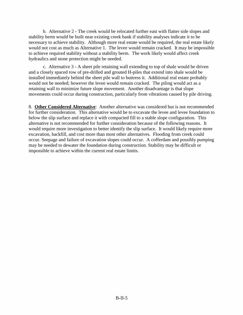
B-II-5
b. Alternative 2 - The creek would be relocated further east with flatter side slopes and stability berm would be built near existing creek bank if stability analyses indicate it to be necessary to achieve stability. Although more real estate would be required, the real estate likely would not cost as much as Alternative 1. The levee would remain cracked. It may be impossible to achieve required stability without a stability berm. The work likely would affect creek hydraulics and stone protection might be needed.
c. Alternative 3 - A sheet pile retaining wall extending to top of shale would be driven and a closely spaced row of pre-drilled and grouted H-piles that extend into shale would be installed immediately behind the sheet pile wall to buttress it. Additional real estate probably would not be needed; however the levee would remain cracked. The piling would act as a retaining wall to minimize future slope movement. Another disadvantage is that slope movements could occur during construction, particularly from vibrations caused by pile driving.
8. Other Considered Alternative: Another alternative was considered but is not recommended for further consideration. This alternative would be to excavate the levee and levee foundation to below the slip surface and replace it with compacted fill to a stable slope configuration. This alternative is not recommended for further consideration because of the following reasons. It would require more investigation to better identify the slip surface. It would likely require more excavation, backfill, and cost more than most other alternatives. Flooding from creek could occur. Seepage and failure of excavation slopes could occur. A cofferdam and possibly pumping may be needed to dewater the foundation during construction. Stability may be difficult or impossible to achieve within the current real estate limits.

SECTION III
COST ESTIMATE
Northport Levee Repair Cost Narrative
B-III-1
Northport Levee Repair
Northport, Alabama
Cost Narrative
POC: RITA PERKINS Mobile District, USACE

Northport Levee Repair Cost Narrative
B-III-2
Purpose of Estimate The purpose of this Engineer’s Estimate for Project Cost is to establish an Engineer’s opinion of probable cost for construction of the selected plan at the feasibility stage.
General Project Description The U.S. Army Corps of Engineers (USACE) Mobile District has proposed to repair an existing levee that was built 1999. Cracking along the levee was observed approximately 320’. With life safety a concern, three plans were considered. The chosen plan relocates the levee approximately 35’ from centerline of the existing levee westward.
Markups Phase The following typical contractor markups were applied to the Cost Estimate: Owner Markups Sales Tax 6%
Contingency See TPCS SIOH 0%
Prime Contractor Markups JOOH (own work) 22%
HOOH (own work) 8% JOOH (sub work) 8% HOOH (sub work) 5% Profit (own work) 8% Profit (sub work) 5% Bond 1.58%
Design Contingency see TPCS Subcontractor Markups
Sub HOOH 8% Sub JOOH 10% Sub Profit 9%
Northport Levee Repair Cost Narrative
B-III-3
Contingency and Escalation
Contingency and escalation for the project are included in the Total Project Cost Summary spreadsheet. Contingency was calculated using the Abbreviated Cost Risk Analysis for projects less than $40 million. Escalation was calculated using the Total Project Cost Summary Spreadsheet. The resultant contingency is 25% for the construction value, 17% for 30 Account and 31 Account.
• Indices used in the TPCS is a U.S. Army Corps of Engineers publication (Engineer Manual (EM) 1110-2-1304, Civil Works Construction Cost Index System, CWCIS) which provides historical and forecasted cost indexes for use in escalating civil works cost estimates. The indexes presented in this manual are specifically designed for civil works construction and are specific for each of the major civil works features. Index factors are based on actual labor, equipment and material escalation. Future years are based on data from the Office of Management and Budget (OMB) projections. This EM is updated twice a year (March 31 & Sept. 30).
• Escalation factors are based on the latest EM 1110-2-1304, Civil Works Construction Cost Index System (CWCCIS) and EC 11-2-199. Indices were used in the TPCS to escalate the effective pricing level to the anticipated feature midpoint.
Estimate Format -MII (MCACES, ver 4.2) was used for development of the project costs.
Estimates are structured by sites and incorporated into the Total Project Cost Summary (TPCS).
Total Project Cost Summary (TPCS) is prepared for the selected plan. It is
formatted by the Civil Works features by the work breakdown structure. The TPCS details escalation, contingency and non-federal costs.
• Price Level of Estimate is 1 OCT 13
• Program Year is FY 14
• Initial Construction Start is FY 15

Northport Levee Repair Cost Narrative
B-III-4
Estimate Methodology This cost estimate is considered a bottom rolled up type estimate with detailed cost items and breakdown of Labor, Materials and Equipment. The estimate may include allowance cost and dollars per SF cost for certain components of the estimate.
Major Assumptions and Quantity Development 1. The estimate is based on the assumption the work will be done by an 8A contractor (mostly sub-contracting) and a reasonable amount of time to complete the work, with a reasonable project schedule, constructed under a single contract. This estimate should be evaluated for market changes.
2. It is estimated that construction duration is approximately 90 days.
3. Construction access to the project site will be available via public right-of-way and purchased easements. Land acquisition costs are included in the Total Project Cost Summary as a 01 Account cost.
4. Construction quantities are estimated from conceptual design and used as the basis of the estimate.
5. Unit prices used within this estimate were derived from a variety of sources, but checked for consistency with surrounding businesses and similar projects.
6. The cost estimate is considered to be a class 3/4 CAP feasibility level estimate. There is no contingency or escalation included in this estimate. See TPCS for contingency and escalation.
30 - Feature Account - Planning, Engineering & Design - PED
• Cost was previously received at $145K per the Project Manager.
31 - Feature Account – Construction Management –
• Costs were developed and assigned at 10% by the PM with input from the Construction Office that would be managing this project. This is the cost that has historically been seen for these types of civil works projects
Excluded Costs The cost estimate excludes the Operation & Maintenance of the levee.
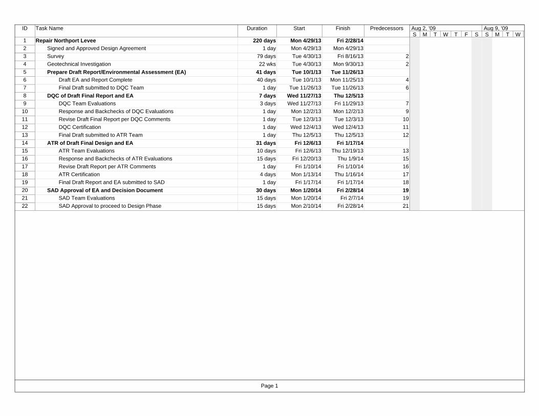
ID Task Name Duration Start Finish Predecessors
1 Repair Northport Levee 220 days Mon 4/29/13 Fri 2/28/142 Signed and Approved Design Agreement 1 day Mon 4/29/13 Mon 4/29/133 Survey 79 days Tue 4/30/13 Fri 8/16/13 24 Geotechnical Investigation 22 wks Tue 4/30/13 Mon 9/30/13 25 Prepare Draft Report/Environmental Assessment (EA) 41 days Tue 10/1/13 Tue 11/26/136 Draft EA and Report Complete 40 days Tue 10/1/13 Mon 11/25/13 47 Final Draft submitted to DQC Team 1 day Tue 11/26/13 Tue 11/26/13 68 DQC of Draft Final Report and EA 7 days Wed 11/27/13 Thu 12/5/139 DQC Team Evaluations 3 days Wed 11/27/13 Fri 11/29/13 7
10 Response and Backchecks of DQC Evaluations 1 day Mon 12/2/13 Mon 12/2/13 911 Revise Draft Final Report per DQC Comments 1 day Tue 12/3/13 Tue 12/3/13 1012 DQC Certification 1 day Wed 12/4/13 Wed 12/4/13 1113 Final Draft submitted to ATR Team 1 day Thu 12/5/13 Thu 12/5/13 1214 ATR of Draft Final Design and EA 31 days Fri 12/6/13 Fri 1/17/1415 ATR Team Evaluations 10 days Fri 12/6/13 Thu 12/19/13 1316 Response and Backchecks of ATR Evaluations 15 days Fri 12/20/13 Thu 1/9/14 1517 Revise Draft Report per ATR Comments 1 day Fri 1/10/14 Fri 1/10/14 1618 ATR Certification 4 days Mon 1/13/14 Thu 1/16/14 1719 Final Draft Report and EA submitted to SAD 1 day Fri 1/17/14 Fri 1/17/14 1820 SAD Approval of EA and Decision Document 30 days Mon 1/20/14 Fri 2/28/14 1921 SAD Team Evaluations 15 days Mon 1/20/14 Fri 2/7/14 1922 SAD Approval to proceed to Design Phase 15 days Mon 2/10/14 Fri 2/28/14 21
S M T W T F S S M T WAug 2, '09 Aug 9, '09
Page 1

Meeting Date: 29-Oct-13
PDT Members
Project Management: DAVID NEWELLE & D/Technical Lead: RON NETTLES, GEOTECH ENGINEER
Plan Formulation: CHARLES OWENSCost Engineering: RITA PERKINS
Economics: VONGMONY VAREnvironmental/Permitting: LARRY PARSON
(SAM) NORTHPORT LEVEE REPAIR CAP PROJECT
Abbreviated Risk Analysis
Feasibility (Recommended Plan)
Note: PDT involvement is commensurate with project size and involvement.
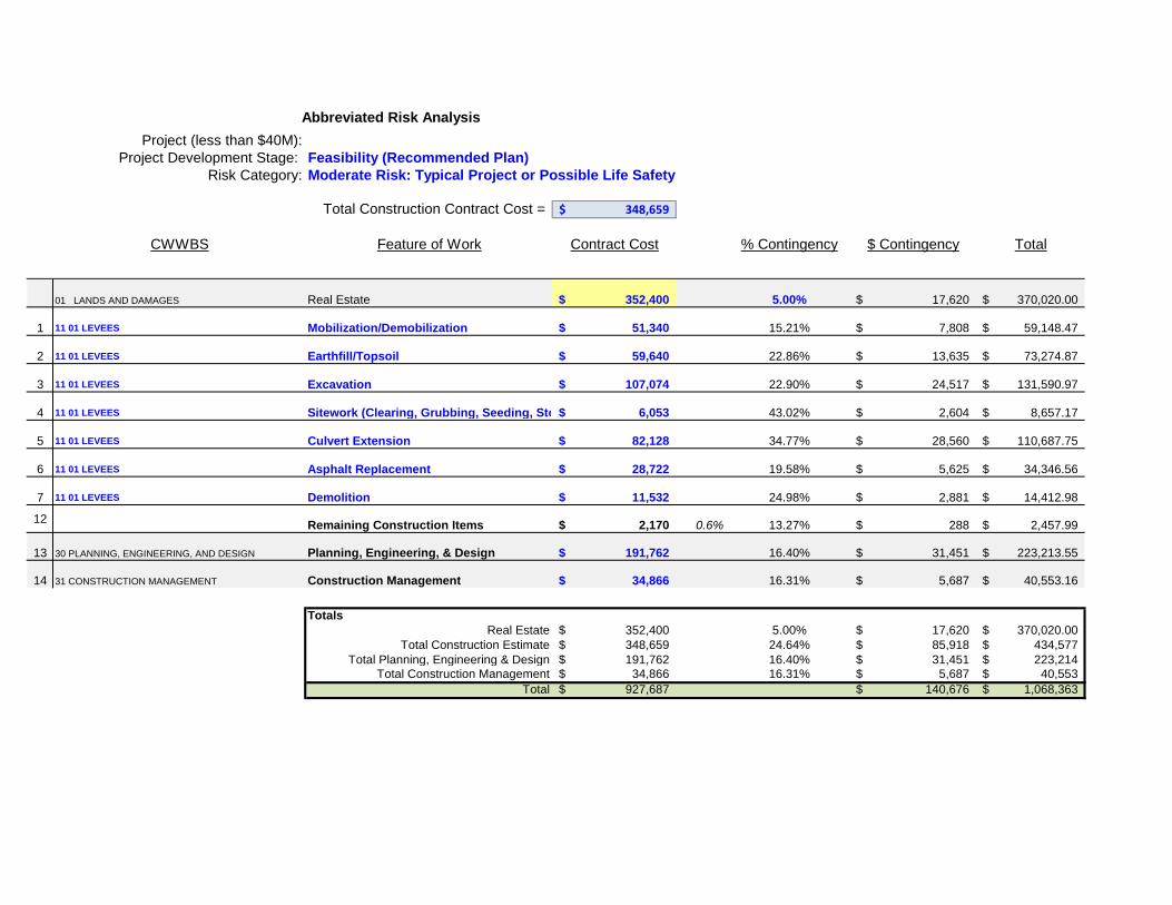
Project (less than $40M):Project Development Stage:
Risk Category:
Total Construction Contract Cost = 348,659$
CWWBS Feature of Work Contract Cost % Contingency $ Contingency Total
01 LANDS AND DAMAGES Real Estate 352,400$ 5.00% 17,620$ 370,020.00$
1 11 01 LEVEES Mobilization/Demobilization 51,340$ 15.21% 7,808$ 59,148.47$
2 11 01 LEVEES Earthfill/Topsoil 59,640$ 22.86% 13,635$ 73,274.87$
3 11 01 LEVEES Excavation 107,074$ 22.90% 24,517$ 131,590.97$
4 11 01 LEVEES Sitework (Clearing, Grubbing, Seeding, Sto 6,053$ 43.02% 2,604$ 8,657.17$
5 11 01 LEVEES Culvert Extension 82,128$ 34.77% 28,560$ 110,687.75$
6 11 01 LEVEES Asphalt Replacement 28,722$ 19.58% 5,625$ 34,346.56$
7 11 01 LEVEES Demolition 11,532$ 24.98% 2,881$ 14,412.98$
12 Remaining Construction Items 2,170$ 0.6% 13.27% 288$ 2,457.99$
13 30 PLANNING, ENGINEERING, AND DESIGN Planning, Engineering, & Design 191,762$ 16.40% 31,451$ 223,213.55$
14 31 CONSTRUCTION MANAGEMENT Construction Management 34,866$ 16.31% 5,687$ 40,553.16$
TotalsReal Estate 352,400$ 5.00% 17,620$ 370,020.00$
Total Construction Estimate 348,659$ 24.64% 85,918$ 434,577$ Total Planning, Engineering & Design 191,762$ 16.40% 31,451$ 223,214$
Total Construction Management 34,866$ 16.31% 5,687$ 40,553$ Total 927,687$ 140,676$ 1,068,363$
Abbreviated Risk Analysis
Feasibility (Recommended Plan)Moderate Risk: Typical Project or Possible Life Safety
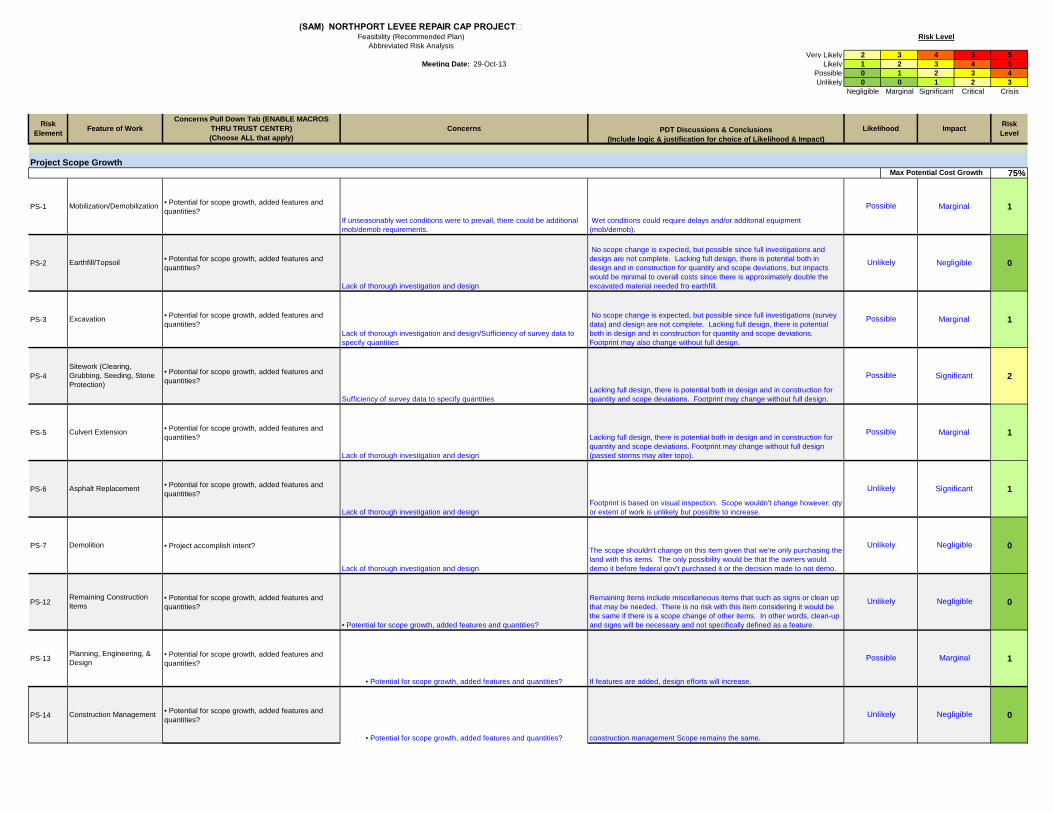
Very Likely 2 3 4 5 5Meeting Date: 29-Oct-13 Likely 1 2 3 4 5
Possible 0 1 2 3 4Unlikely 0 0 1 2 3
Negligible Marginal Significant Critical Crisis
Project Scope Growth75%
PS-1 • Potential for scope growth, added features and quantities? 1
PS-2 • Potential for scope growth, added features and quantities? 0
PS-3 • Potential for scope growth, added features and quantities? 1
PS-4 • Potential for scope growth, added features and quantities? 2
PS-5 • Potential for scope growth, added features and quantities? 1
PS-6 • Potential for scope growth, added features and quantities? 1
PS-7 • Project accomplish intent? 0
PS-12 • Potential for scope growth, added features and quantities? 0
PS-13 • Potential for scope growth, added features and quantities? 1
PS-14 • Potential for scope growth, added features and quantities? 0
(SAM) NORTHPORT LEVEE REPAIR CAP PROJECTFeasibility (Recommended Plan)
Abbreviated Risk Analysis
Demolition
Remaining Construction Items
Planning, Engineering, & Design
Construction Management
• Potential for scope growth, added features and quantities?
If unseasonably wet conditions were to prevail, there could be additional mob/demob requirements.
• Potential for scope growth, added features and quantities?
• Potential for scope growth, added features and quantities?
Unlikely
Unlikely
Possible
The scope shouldn't change on this item given that we're only purchasing the land with this items. The only possibility would be that the owners would demo it before federal gov't purchased it or the decision made to not demo.
Remaining Items include miscellaneous items that such as signs or clean up that may be needed. There is no risk with this item considering it would be the same if there is a scope change of other items. In other words, clean-up and signs will be necessary and not specifically defined as a feature.
If features are added, design efforts will increase.
construction management Scope remains the same.
Lack of thorough investigation and design
Lacking full design, there is potential both in design and in construction for quantity and scope deviations. Footprint may change without full design (passed storms may alter topo).
Lack of thorough investigation and design
Lack of thorough investigation and design
Negligible
Marginal
NegligibleUnlikely
Possible Marginal
Possible
Possible
Possible
Unlikely Negligible
Negligible
Unlikely Significant
Sufficiency of survey data to specify quantities
Lack of thorough investigation and design/Sufficiency of survey data to specify quantities
Lack of thorough investigation and design
Earthfill/Topsoil
Mobilization/Demobilization
Wet conditions could require delays and/or additonal equipment (mob/demob).
Footprint is based on visual inspection. Scope wouldn't change however; qty or extent of work is unlikely but possible to increase.
Risk Level
Likelihood ImpactRisk Element
Risk LevelFeature of Work PDT Discussions & Conclusions
(Include logic & justification for choice of Likelihood & Impact)
Max Potential Cost Growth
Concerns Pull Down Tab (ENABLE MACROS THRU TRUST CENTER)(Choose ALL that apply)
Concerns
Excavation
Sitework (Clearing, Grubbing, Seeding, Stone Protection)
Culvert Extension
Asphalt Replacement
Marginal
Significant
Marginal
No scope change is expected, but possible since full investigations and design are not complete. Lacking full design, there is potential both in design and in construction for quantity and scope deviations, but impacts would be minimal to overall costs since there is approximately double the excavated material needed fro earthfill.
No scope change is expected, but possible since full investigations (survey data) and design are not complete. Lacking full design, there is potential both in design and in construction for quantity and scope deviations. Footprint may also change without full design.
Lacking full design, there is potential both in design and in construction for quantity and scope deviations. Footprint may change without full design.

Acquisition Strategy30%
AS-1 • Contracting plan firmly established? 2
AS-2 • Contracting plan firmly established? 2
AS-3 • 8a or small business likely? 2
AS-4 • 8a or small business likely? 2
AS-5 • 8a or small business likely? 2
AS-6 • 8a or small business likely? 2
AS-7 • 8a or small business likely? 2
AS-12 • 8a or small business likely? 2
AS-13 0
AS-14 0
• Contracting plan firmly established?• 8a or small business likely?
• 8a or small business likely?• Contracting plan firmly established?
• 8a or small business likely?• Contracting plan firmly established?
General contingency amount used for these perceived low risk items.
General contingency amount used for these perceived low risk items.Construction Management Oversight requirements change based on acquisition strategy?
Negligible
Negligible
Likely
Likely
Unlikely
Unlikely
Marginal
This job does not have an acquisition strategy; therefore, open to the possibility of an 8A or small business.
Marginal
• Contracting plan firmly established?• 8a or small business likely?
Likely
Likely
Marginal
Marginal
Marginal
Marginal
Marginal
Marginal
Likely
Likely
Likely
Likely
This job does not have an acquisition strategy; therefore, open to the possibility of an 8A or small business.
This job does not have an acquisition strategy; therefore, open to the possibility of an 8A or small business.
This job does not have an acquisition strategy; therefore, open to the possibility of an 8A or small business.
This job does not have an acquisition strategy; therefore, open to the possibility of an 8A or small business.
Max Potential Cost Growth
Remaining Construction Items
Planning, Engineering, & Design
• Contracting plan firmly established?• 8a or small business likely?
• Contracting plan firmly established?• 8a or small business likely?
• Contracting plan firmly established?• 8a or small business likely?
Culvert Extension
Asphalt Replacement
• Contracting plan firmly established?• 8a or small business likely?
Design variability based on aquistion strategy?
Mobilization/Demobilization
Earthfill/Topsoil
Excavation
Sitework (Clearing, Grubbing, Seeding, Stone Protection)
This job does not have an acquisition strategy; therefore, open to the possibility of an 8A or small business.
This job does not have an acquisition strategy; therefore, open to the possibility of an 8A or small business.
This job does not have an acquisition strategy; therefore, open to the possibility of an 8A or small business.
Demolition

Construction Elements25%
CE-1 • Potential for construction modification and claims? 1
CE-2 • Potential for construction modification and claims? 2
CE-3 • Potential for construction modification and claims? 1
CE-4 • Potential for construction modification and claims? 2
CE-5• High risk or complex construction elements, site access, in-water? 3
CE-6 • Accelerated schedule or harsh weather schedule? 1
CE-7 • Potential for construction modification and claims? 2
CE-12 • Accelerated schedule or harsh weather schedule? 0
CE-13 • Potential for construction modification and claims? 2
CE-14 • Potential for construction modification and claims? 2
• High risk or complex construction elements, site access, in-water?
Weather Schedule
• Potential for construction modification and claims?
• Potential for construction modification and claims?Construction Management potential for mods/claims will increase the level of construction management
Likely Marginal
Planning, Engineering, & Design varying site conditions will increase the design efforts
Possible
Remaining Construction Items
Harsh Weather may affect schedule of clean-up or how much clean-up will be necessary.
Unlikely Negligible
Significant
Significant
DemolitionNot likely, but possibility of unknown material to need special environmental considerations will increase chance of modification/claim.
Possible
Marginal
Significant
Significant
Marginal
Possible
Max Potential Cost Growth
Marginal
Significant
Possible
weather schedule
Possible
Possible
Possible
Likely
Asphalt Replacement
This seems like a straighforward project wince it was constructed before by the Corps in the late 90's. The potential for variances in contruction methods may arise. The mob/demob of equipment may have mod if additional equipment is needed given an unexpected site condition.
If more material is necessary than expected to meet design or if the material onsite is unsuitable, a modification/claim will be likely.
Unforeseen material (roots or debris) or wet material may impact complexity, a modification/claim will be possible.
Possibility for rocks and roots to impact complexity; wet material
diverting flow to extend culvert increases the complexity
This isn't a complex feature, but harsh weather would affect the conditions. Schedule may need to be adjusted given harsh weather conditions in turn increasing possibility of modification.
Mobilization/Demobilization
Earthfill/Topsoil
Excavation
Sitework (Clearing, Grubbing, Seeding, Stone Protection)
Culvert Extension
• Potential for construction modification and claims?
• Potential for construction modification and claims?
• Potential for construction modification and claims?
• Potential for construction modification and claims?
• High risk or complex construction elements, site access, in-water?
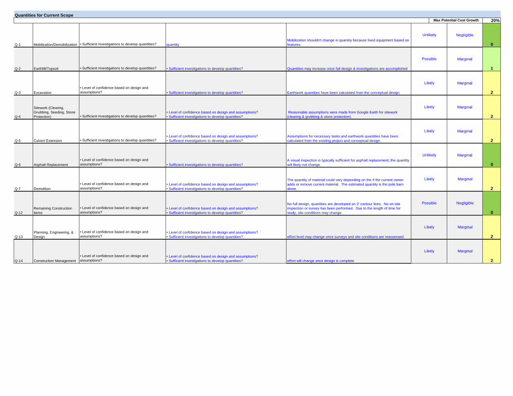
Quantities for Current Scope20%
Q-1 • Sufficient investigations to develop quantities? 0
Q-2 • Sufficient investigations to develop quantities? 1
Q-3• Level of confidence based on design and assumptions? 2
Q-4 • Sufficient investigations to develop quantities? 2
Q-5 • Sufficient investigations to develop quantities? 2
Q-6• Level of confidence based on design and assumptions? 0
Q-7• Level of confidence based on design and assumptions? 2
Q-12• Level of confidence based on design and assumptions? 0
Q-13• Level of confidence based on design and assumptions? 2
Q-14• Level of confidence based on design and assumptions? 2
Marginal
Construction Management effort will change once design is complete
Likely Marginal
Planning, Engineering, & Design effort level may change once surveys and site conditions are reassessed.
Likely
Remaining Construction Items
No full design, quantities are developed on 2' contour lines. No on-site inspection or survey has been performed. Due to the length of time for study, site conditions may change.
Possible Negligible• Level of confidence based on design and assumptions? • Sufficient investigations to develop quantities?
• Level of confidence based on design and assumptions? • Sufficient investigations to develop quantities?
• Level of confidence based on design and assumptions? • Sufficient investigations to develop quantities?
Marginal
Demolition
The quantity of material could vary depending on the if the current owner adds or remove current material. The estimated quantity is the pole barn alone.
Likely• Level of confidence based on design and assumptions? • Sufficient investigations to develop quantities?
MarginalUnlikely
Excavation
Sitework (Clearing, Grubbing, Seeding, Stone Protection)
Culvert Extension
Asphalt Replacement
Mobilization shouldn't change in quantity because fixed equipment based on features.
Quantities may increase once full design & investigations are accomplished
Earthwork quantities have been calculated from the conceptual design
Reasonable assumptions were made from Google Earth for sitework (clearing & grubbing & stone protection).
Assumptions for necessary tasks and earthwork quantities have been calculated from the existing project and conceptual design.
A visual inspection is typically sufficient for asphalt replacement; the quantity will likely not change. • Sufficient investigations to develop quantities?
Negligible
Marginal
Marginal
Marginal
Marginal
Max Potential Cost Growth
Unlikely
Possible
quantity
• Sufficient investigations to develop quantities?
• Sufficient investigations to develop quantities?
Likely
Likely
Likely
• Level of confidence based on design and assumptions? • Sufficient investigations to develop quantities?
• Level of confidence based on design and assumptions? • Sufficient investigations to develop quantities?
Mobilization/Demobilization
Earthfill/Topsoil
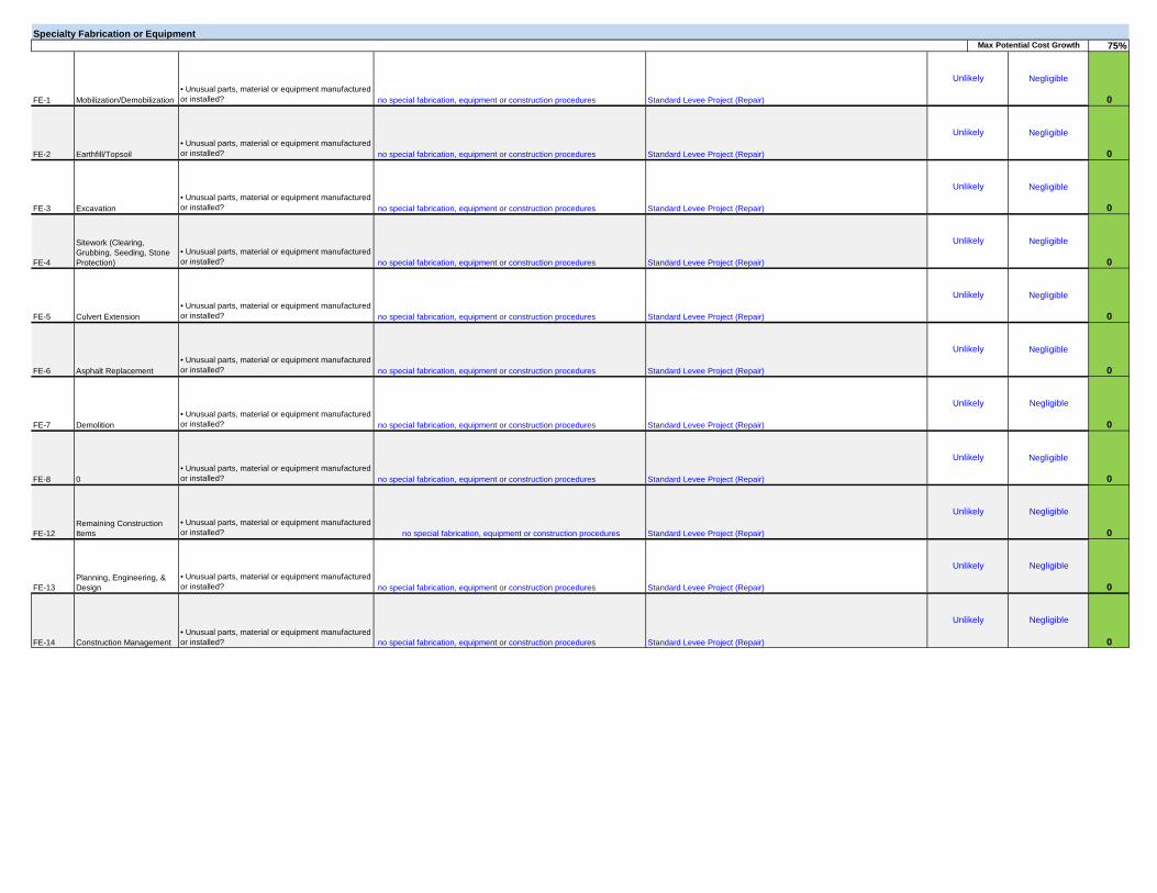
Specialty Fabrication or Equipment75%
FE-1• Unusual parts, material or equipment manufactured or installed? 0
FE-2• Unusual parts, material or equipment manufactured or installed? 0
FE-3• Unusual parts, material or equipment manufactured or installed? 0
FE-4• Unusual parts, material or equipment manufactured or installed? 0
FE-5• Unusual parts, material or equipment manufactured or installed? 0
FE-6• Unusual parts, material or equipment manufactured or installed? 0
FE-7• Unusual parts, material or equipment manufactured or installed? 0
FE-8• Unusual parts, material or equipment manufactured or installed? 0
FE-12• Unusual parts, material or equipment manufactured or installed? 0
FE-13• Unusual parts, material or equipment manufactured or installed? 0
FE-14• Unusual parts, material or equipment manufactured or installed? 0
Negligible
no special fabrication, equipment or construction procedures
no special fabrication, equipment or construction procedures
no special fabrication, equipment or construction procedures
no special fabrication, equipment or construction procedures
Construction Management Standard Levee Project (Repair)
Unlikely Negligible
Planning, Engineering, & Design Standard Levee Project (Repair)
Unlikely
Remaining Construction Items Standard Levee Project (Repair)
Unlikely Negligible
no special fabrication, equipment or construction procedures
no special fabrication, equipment or construction procedures
no special fabrication, equipment or construction procedures
Negligible
0 Standard Levee Project (Repair)
Unlikely Negligible
Demolition Standard Levee Project (Repair)
Unlikely
no special fabrication, equipment or construction procedures
no special fabrication, equipment or construction procedures
Max Potential Cost Growth
Unlikely
Unlikely
no special fabrication, equipment or construction procedures
no special fabrication, equipment or construction procedures
Negligible
Negligible
Negligible
Negligible
Negligible
Negligible
Unlikely
Unlikely
Unlikely
Unlikely
Culvert Extension
Asphalt Replacement
Standard Levee Project (Repair)
Standard Levee Project (Repair)
Standard Levee Project (Repair)
Standard Levee Project (Repair)
Standard Levee Project (Repair)
Standard Levee Project (Repair)
Mobilization/Demobilization
Earthfill/Topsoil
Excavation
Sitework (Clearing, Grubbing, Seeding, Stone Protection)

Cost Estimate Assumptions35%
CT-1 • Site accessibility, transport delays, congestion? 1
CT-2• Assumptions related to prime and subcontractor markups/assignments? 2
CT-3• Assumptions regarding crew, productivity, overtime? 1
CT-4 • Lack confidence on critical cost items? 4
CT-5 • Reliability and number of key quotes? 2
CT-6• Assumptions regarding crew, productivity, overtime? 1
CT-7• Assumptions regarding crew, productivity, overtime? 0
CT-12• Assumptions regarding crew, productivity, overtime? 0
CT-13• Assumptions related to prime and subcontractor markups/assignments? 0
CT-14• Assumptions related to prime and subcontractor markups/assignments? 0
Unlikely Negligible
Negligible
site management efforts
PM input taken for PED and CM.
Unlikely
Negligible
Likely
Possible
Marginal
Construction Management PM input taken for PED and CM.
Remaining Construction Items Historical data used on most items; therefore growth is possible, but neglible.
Unlikely Negligible
Assumptions related to crew, production
Design effort assumptionsPlanning, Engineering, & Design
Demolition
Site conditions are unknown. Depending on condition at purchase (owner may reclaim lumber before sale), the pole barn may decrease in cost, but a minor cost. Senior estimators judgment input.
Possible
• Assumptions regarding crew, productivity, overtime?
Critical
Marginal
Marginal
Possible
Possible
Possible
Likely
Max Potential Cost Growth
Culvert Extension
Asphalt Replacement
Assuming conservative productions & no problems with site access. No major delays were considered in estimate. If 8a sole source contractor gets job, mark-ups are insufficient.
Conservative productions used for onsite disposal; of course, the cost & production will chage significantly if material of existing levee is not suitable. If 8a sole source contractor gets job, mark-ups are insufficient.
Assumptions are reasonable. The productions varied for on-site and off-site disposal. Two off-site disposal areas were located and the most conservative approach for estimating was used for production. If 8a sole source contractor gets job, mark-ups are insufficient.
Production is unknown because the site condition(# of trees & size) for clearing & grubbing hasn't been investigated. Stone yard & prices were identified and the more conservative approach to not reuse the all of the stone onsite was made.
Even though efforts will be made to relocate the gate; the more conservative approach was taken in the estimate to purchase new gate. Quote was used. The lack of a full design and full site investigation leaves estimate without full confidence.
No quote for item; however a standard work feature. Conservative production used. Senior estimators judgment input.
Mobilization/Demobilization
Earthfill/Topsoil
Excavation
Sitework (Clearing, Grubbing, Seeding, Stone Protection)
• Assumptions regarding crew, productivity, overtime?• Site accessibility, transport delays, congestion?
• Reliability and number of key quotes? • Assumptions related to prime and subcontractor markups/assignments?
• Assumptions regarding crew, productivity, overtime?• Lack confidence on critical cost items?
• Assumptions regarding crew, productivity, overtime?• Lack confidence on critical cost items?
Number of quotes- lack of full design
• Assumptions regarding crew, productivity, overtime?
Significant
Marginal
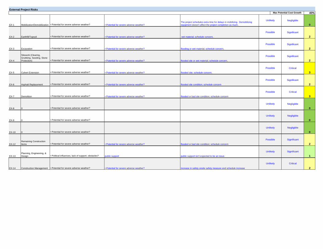
External Project Risks40%
EX-1 • Potential for severe adverse weather? 0
EX-2 • Potential for severe adverse weather? 2
EX-3 • Potential for severe adverse weather? 2
EX-4 • Potential for severe adverse weather? 2
EX-5 • Potential for severe adverse weather? 3
EX-6 • Potential for severe adverse weather? 2
EX-7 • Potential for severe adverse weather? 3
EX-8 • Potential for severe adverse weather? 0
EX-9 • Potential for severe adverse weather? 0
EX-10 • Potential for severe adverse weather? 0
EX-12 • Potential for severe adverse weather? 2
EX-13 • Political influences, lack of support, obstacles? 1
EX-14 • Potential for severe adverse weather? 2
Critical
Construction Management increase in safety onsite safety measure and schedule increase
Unlikely
• Potential for severe adverse weather?
Unlikely
Critical
Negligible
Negligible
Negligible
Significant
Significant
Possible
Unlikely
Unlikely
Unlikely
Possible
Possible
Possible
Negligible
Significant
flooded or bad site condition; schedule concern
public support isn't expected to be an issue.
Demolition
0
0
0
Remaining Construction Items
public supportPlanning, Engineering, & Design
flooded or bad site condition; schedule concern• Potential for severe adverse weather?
• Potential for severe adverse weather?
Significant
Significant
Critical
Significant
Unlikely
Possible
Possible
Possible
Max Potential Cost Growth
Asphalt Replacement
The project schedules extra time for delays in mobilizing. Demobilizing equipment doesn't affect the project completion as much.
wet material; schedule concern,
flooding or wet material; schedule concern,
flooded site or wet material; schedule concern,
flooded site; schedule concern,
flooded site condition; schedule concern
Mobilization/Demobilization
Earthfill/Topsoil
Excavation
Sitework (Clearing, Grubbing, Seeding, Stone Protection)
Culvert Extension
• Potential for severe adverse weather?
• Potential for severe adverse weather?
• Potential for severe adverse weather?
• Potential for severe adverse weather?
• Potential for severe adverse weather?
• Potential for severe adverse weather?

Rem
aini
ng
Cons
truct
ion
Item
s
Plan
ning
, En
gine
erin
g, &
De
sign
(SAM) NORTHPORT LEVEE REPAIR CAP PROJECTFeasibility (Recommended Plan)
Potential Risk Areas
Mob
iliza
tion/
Dem
ob
iliza
tion
Earth
fill/T
opso
il
Exca
vatio
n
Site
wor
k (C
lear
ing,
Gru
bbin
g, S
eedi
ng,
Ston
e Pr
otec
tion)
Culv
ert E
xten
sion
Asph
alt
Repl
acem
ent
Dem
oliti
on
Abbreviated Risk Analysis
Cons
truct
ion
Man
agem
ent
1 - 1 2 1 1 - - 1 -
2 2 2 2 2 2 2 2 - -
1 2 1 2 3 1 2 - 2 2
- 1 2 2 2 - 2 - 2 2
- - - - - - - - - -
1 2 1 4 2 1 - - - -
- 2 2 2 3 2 3 2 1 2
Rem
aini
ng
Cons
truct
ion
Item
s
Typi
cal R
isk
Elem
ents
Project Scope Growth
Acquisition Strategy
Construction Elements
Quantities for Current Scope
Specialty Fabrication or Equipment
Cost Estimate Assumptions
External Project Risks
Plan
ning
, En
gine
erin
g, &
De
sign
Mob
iliza
tion/
Dem
ob
iliza
tion
Earth
fill/T
opso
il
Exca
vatio
n
Site
wor
k (C
lear
ing,
Gru
bbin
g, S
eedi
ng,
Ston
e Pr
otec
tion)
Culv
ert E
xten
sion
Asph
alt
Repl
acem
ent
Dem
oliti
on
Cons
truct
ion
Man
agem
ent

Project Scope Growth
Max Potenital Cost Growth 75 %
x y0 0 0.00%1 2.37 2.37%2 5.62 5.62%3 13.34 13.34%4 31.63 31.63%5 75.00 75.00%
y = a^xa = y^(1/x)a = 2.371441
Acquisition Strategy
Max Potenital Cost Growth 30 %
x y0 0 0.00%1 1.97 1.97%2 3.90 3.90%3 7.70 7.70%4 15.19 15.19%5 30.00 30.00%
y = a^xa = y^(1/x)a = 1.97435
y = e0.8635x
0.00
10.00
20.00
30.00
40.00
50.00
60.00
70.00
80.00
0 2 4 6
y = e0.6802x
0.00
5.00
10.00
15.00
20.00
25.00
30.00
35.00
0 1 2 3 4 5 6

Construction Elements
Max Potenital Cost Growth 25 %
x y0 5 5.00%1 1.90 6.90%2 3.62 8.62%3 6.90 11.90%4 13.13 18.13%5 25.00 30.00%
y = a^xa = y^(1/x)a = 1.903654
Quantities
Max Potenital Cost Growth 20 %
x y0 0 0.00%1 1.82 1.82%2 3.31 3.31%3 6.03 6.03%4 10.99 10.99%5 20.00 20.00%
y = a^xa = y^(1/x)a = 1.820564
y = e0.6438x
0.00
5.00
10.00
15.00
20.00
25.00
30.00
0 1 2 3 4 5 6
y = e0.5991x
0.00
5.00
10.00
15.00
20.00
25.00
0 1 2 3 4 5 6
Fab or Equip
Max Potenital Cost Growth 75 %
x y0 0 0.00%1 2.37 2.37%2 5.62 5.62%3 13.34 13.34%4 31.63 31.63%5 75.00 75.00%
y = a^xa = y^(1/x)a = 2.371441
Cost Est Assumptions
Max Potenital Cost Growth 35 %
x y0 0 0.00%1 2.04 2.04%2 4.15 4.15%3 8.44 8.44%4 17.19 17.19%5 35.00 35.00%
y = a^xa = y^(1/x)a = 2.036168
95
y = e0.8635x
0.00
10.00
20.00
30.00
40.00
50.00
60.00
70.00
80.00
0 1 2 3 4 5 6
y = e0.7111x
0.00
5.00
10.00
15.00
20.00
25.00
30.00
35.00
40.00
0 1 2 3 4 5 6
External Risks
Max Potenital Cost Growth 40 %
x y0 0 0.00%1 2.09 2.09%2 4.37 4.37%3 9.15 9.15%4 19.13 19.13%5 40.00 40.00%
y = a^xa = y^(1/x)a = 2.091279
y = e0.7378x
0.00
5.00
10.00
15.00
20.00
25.00
30.00
35.00
40.00
45.00
0 1 2 3 4 5 6
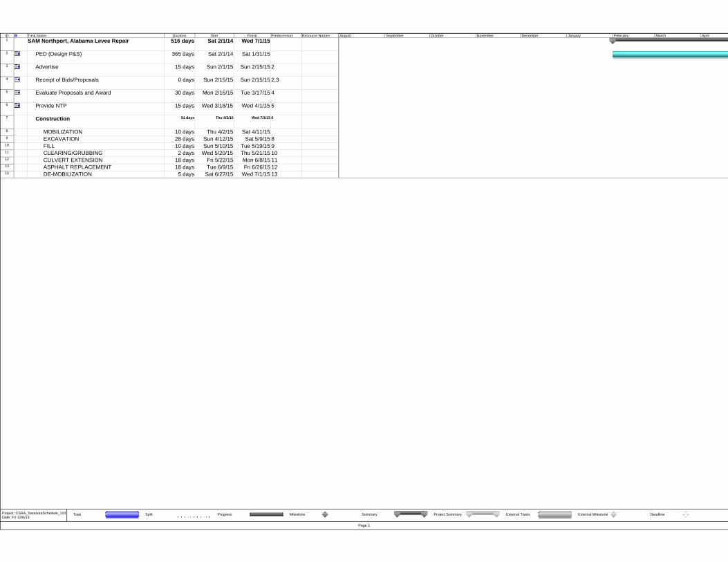
ID Task Name Duration Start Finish Predecessors Resource Names1 SAM Northport, Alabama Levee Repair 516 days Sat 2/1/14 Wed 7/1/15
2 PED (Design P&S) 365 days Sat 2/1/14 Sat 1/31/15
3 Advertise 15 days Sun 2/1/15 Sun 2/15/15 2
4 Receipt of Bids/Proposals 0 days Sun 2/15/15 Sun 2/15/15 2,3
5 Evaluate Proposals and Award 30 days Mon 2/16/15 Tue 3/17/15 4
6 Provide NTP 15 days Wed 3/18/15 Wed 4/1/15 5
7 Construction 91 days Thu 4/2/15 Wed 7/1/15 6
8 MOBILIZATION 10 days Thu 4/2/15 Sat 4/11/159 EXCAVATION 28 days Sun 4/12/15 Sat 5/9/15 8
10 FILL 10 days Sun 5/10/15 Tue 5/19/15 911 CLEARING/GRUBBING 2 days Wed 5/20/15 Thu 5/21/15 1012 CULVERT EXTENSION 18 days Fri 5/22/15 Mon 6/8/15 1113 ASPHALT REPLACEMENT 18 days Tue 6/9/15 Fri 6/26/15 1214 DE-MOBILIZATION 5 days Sat 6/27/15 Wed 7/1/15 13
August September October November December January February March April
Task Split Progress Milestone Summary Project Summary External Tasks External Milestone Deadline
Page 1
Project: CSRA_SarasotaSchedule_110Date: Fri 12/6/13

**** TOTAL PROJECT COST SUMMARY **** Printed:6/17/2014 Page 1 of 2
Filename: SAM-TPCS-northport CAP JUN14.xlsxTPCS
PROJECT: DISTRICT: SAM (MOBILE) PREPARED: UPDATED 3/15/14LOCATION: Northport, Alabama POC: CHIEF, COST ENGINEERING, GEORGE L. BROWN
This Estimate reflects the scope and schedule in report; CAP STUDY - NORTHPORT LEVEE
Program Year (Budget EC): 2014Effective Price Level Date: 1 OCT 13
Spent Thru:WBS Civil Works COST CNTG CNTG TOTAL ESC COST CNTG TOTAL 1-Oct-13 COST CNTG FULL
NUMBER Feature & Sub-Feature Description ($K) ($K) (%) ($K) (%) ($K) ($K) ($K) ($K) ($K) ($K) ($K) A B C D E F G H I J K L M N O
11 LEVEES & FLOODWALLS $349 $87 25% $436 $349 $87 $436 $359 $90 $449__________ __________ __________ _________ _________ __________ _________ _________ ______________
CONSTRUCTION ESTIMATE TOTALS: $349 $87 $436 $349 $87 $436 $359 $90 $449
01 LANDS AND DAMAGES $352 $18 5% $370 $352 $18 $370 $359 $18 $377
30 PLANNING, ENGINEERING & DESIGN $191 $32 17% $223 $191 $32 $223 $195 $33 $228
31 CONSTRUCTION MANAGEMENT $35 $6 17% $41 0.0% $35 $6 $41 $36 $6 $42
__________ __________ __________ _________ _________ __________ ___________ _________ _________ ______________PROJECT COST TOTALS: $927 $143 15% $1,070 $927 $143 $1,070 $949 $147 $1,096
Mandatory by Regulation CHIEF, COST ENGINEERING, GEORGE L. BROWNESTIMATED TOTAL PROJECT COST: $1,096
Mandatory by Regulation PROJECT MANAGER, DAVID NEWELL ESTIMATED FEDERAL COST: 65% $713ESTIMATED NON-FEDERAL COST: 35% $384
Mandatory by Regulation CHIEF, REAL ESTATE, WILLIE L. PATTERSON 22 - FEASABILITY STUDY (CAP studies): $50
CHIEF, PLANNING, xxx ESTIMATED FEDERAL COST: $50ESTIMATED NON-FEDERAL COST:
CHIEF, ENGINEERING, Notes: ATED FEDERAL COST OF PROJECT $763
CHIEF, OPERATIONS, xxx
CHIEF, CONSTRUCTION, xxx
CHIEF, CONTRACTING, xxx
CHIEF, PM-PB,
CHIEF, DPM, xxx
P2 No. 353461: Repair Northport Levee
WBS Structure ESTIMATED COST PROJECT FIRST COST (Constant Dollar Basis) TOTAL PROJECT COST (FULLY FUNDED)
**** TOTAL PROJECT COST SUMMARY **** Printed:6/17/2014 Page 2 of 2
Filename: SAM-TPCS-northport CAP JUN14.xlsxTPCS
**** CONTRACT COST SUMMARY ****
PROJECT: DISTRICT: SAM (MOBILE) PREPARED: UPDATED 3/15/14LOCATION: Northport, Alabama POC: CHIEF, COST ENGINEERING, GEORGE L. BROWNThis Estimate reflects the scope and schedule in report; CAP STUDY - NORTHPORT LEVEE
1-Nov-13 2014 1-Oct-13 1 OCT 13
RISK BASED WBS Civil Works COST CNTG CNTG TOTAL ESC COST CNTG TOTAL Mid-Point INFLATED COST CNTG FULL
NUMBER Feature & Sub-Feature Description ($K) ($K) (%) ($K) (%) ($K) ($K) ($K) Date (%) ($K) ($K) ($K) A B C D E F G H I J P L M N O
11 LEVEES & FLOODWALLS $349 $87 25% $436 $349 $87 $436 2015Q3 2.9% $359 $90 $449
__________ __________ _________ __________ _________ _________ __________ _________ _________ ______________
CONSTRUCTION ESTIMATE TOTALS: $349 $87 25% $436 $349 $87 $436 $359 $90 $449
01 LANDS AND DAMAGES $352 $18 5% $370 $352 $18 $370 2015Q1 2.0% $359 $18 $377
30 PLANNING, ENGINEERING & DESIGN5.0% Project Management $17 $3 17% $20 $17 $3 $20 2015Q1 2.0% $17 $3 $203.8% Planning & Environmental Compliance $13 $2 17% $15 $13 $2 $15 2015Q1 2.0% $13 $2 $16
30.0% Engineering & Design $105 $18 17% $123 $105 $18 $123 2015Q1 2.0% $107 $18 $1252.0% Engineering Tech Review ITR & VE $7 $1 17% $8 $7 $1 $8 2015Q1 2.0% $7 $1 $82.0% Contracting & Reprographics $7 $1 17% $8 $7 $1 $8 2015Q1 2.0% $7 $1 $86.0% Engineering During Construction $21 $4 17% $25 $21 $4 $25 2015Q3 2.9% $22 $4 $254.0% Planning During Construction $14 $2 17% $16 $14 $2 $16 2015Q3 2.9% $14 $2 $172.0% Project Operations $7 $1 17% $8 $7 $1 $8 2015Q1 2.0% $7 $1 $8
31 CONSTRUCTION MANAGEMENT6.0% Construction Management $21 $4 17% $25 $21 $4 $25 2015Q3 2.9% $22 $4 $252.0% Project Operation: $7 $1 17% $8 $7 $1 $8 2015Q3 2.9% $7 $1 $82.0% Project Management $7 $1 17% $8 $7 $1 $8 2015Q3 2.9% $7 $1 $8
CONTRACT COST TOTALS: $927 $143 $1,070 $927 $143 $1,070 $949 $147 $1,096
Estimate Prepared:Effective Price Level:
Program Year (Budget EC):Effective Price Level Date:
P2 No. 353461: Repair Northport Levee
ESTIMATED COST PROJECT FIRST COST (Constant Dollar Basis) TOTAL PROJECT COST (FULLY FUNDED)WBS Structure

APPENDIX C
REAL ESTATE PLAN
C-i
APPENDIX C - REAL ESTATE PLAN
NORTHPORT LEVEE REPAIR PROJECT NORTHPORT, ALABAMA
June 2014
TABLE OF CONTENTS
PAGE SUBJECT NUMBER
1. Purpose of the Real Estate Plan ...........................................................................C-1 2. Project Type, Applicability, and Authority..........................................................C-1 3. Project Description...............................................................................................C-1 4. Real Estate Requirements ....................................................................................C-1 5. Recommended Estates for Proposed Project .......................................................C-2 6. Lands Owned By The Non-Federal Sponsor (NFS) ............................................C-3 7. Existing Federal Projects .....................................................................................C-4 8. Federally-Owned Lands .......................................................................................C-4 9. Navigational Servitude.........................................................................................C-4 10. Extent of Induced Flooding .................................................................................C-4 11. Baseline Cost Estimate For Real Estate (BCERE) ..............................................C-5 12. Public Law (P.L.) 91-646, Relocation Assistance Benefits .................................C-6 13. Mineral Rights .....................................................................................................C-6 14. Non-Federal Sponsor Responsibilities and Capabilities ......................................C-7 15. Application of Zoning Ordinances.......................................................................C-7 16. Acquisition Schedule ...........................................................................................C-7 17. Utility/Facility Relocations ..................................................................................C-7 18. Environmental Impacts and Potential Hazardous, Toxic, Radioactive Waste (HTRW) .................................................................................................C-8 19. Environmental Mitigation ....................................................................................C-8 20. Attitude of Property Owners ................................................................................C-8 21. Cultural Resources/Historical Significance .........................................................C-8 22. List of Exhibits/Maps/Tables ...............................................................................C-8 23. Other Real Estate Issues.......................................................................................C-8
LIST OF FIGURES
PAGE FIGURE NO. DESCRIPTION NUMBER
1 Real Estate Cost Estimate ................................................C-5 2 Chart of Accounts ............................................................C-6
C-1
APPENDIX C - REAL ESTATE PLAN NORTHPORT LEVEE REPAIR PROJECT
NORTHPORT, ALABAMA
1. PURPOSE OF THE REAL ESTATE PLAN The Real Estate Plan (REP) provided herein supports the plan formulation and implementation of the Northport Levee Repair Project. More specifically, it identifies the Lands, Easements, Rights-of-Way, Relocations, and Disposal Areas (LERRD) required for construction, operation, and maintenance of the proposed project. This REP is understood to be prepared to the same level of detail as this decision document and drafted to further support the proposed project.
2. PROJECT TYPE, APPLICABILITY, AND AUTHORITY
The proposed project is authorized under Section 205 of the 1948 Flood Control Act, as amended, which provides the U.S. Army Corps of Engineers (Corps) with the ability to construct small flood damage reduction projects that have not already been specifically authorized by Congress. The City of Northport is the non-Federal sponsor (NFS). The NFS is responsible for providing all LERRD required for the construction, operation, and maintenance of the proposed flood protection project. The NFS is entitled to receive credit against its share of project costs for the value of LER it provides and the value of relocations potentially required for the project.
3. PROJECT DESCRIPTION
The City of Northport is located along the Black Warrior River in the western part of Tuscaloosa County, Alabama. Based on the Subsurface Investigation Report, dated August 2010, provided by CESAM-EN-G, the proposed project repair site footprint is located along the existing levee between National Levee Database Stations 92+80 and 96+00 (See Exhibit “A” attached hereto). The longitudinal cracking along the 12-foot wide concrete walking path across the levee crest is approximately 320 feet in length. The proposed construction measures within this footprint include excavation of material, re-grading the levee, placing new compacted fill, clearing and grubbing, seeding, culvert extension, and stone protection along the levee.
Alternative 1 of the aforementioned Subsurface Investigation Report was determined to be the most appropriate means of correcting the existing levee crack and slip surface. According to the typical cross section for this area, the levee would be setback westward along this 350-foot reach which would require an additional 50’ +/- in width to be added to the existing levee easement. While the majority of said construction can take place within the previously acquired easement limits, additional acreage is required to implement said levee repair project.
4. REAL ESTATE REQUIREMENTS
The requirements for Lands, Easements, Rights-of-Way, Relocations, and Disposal and/or Borrow Areas (LERRD) should include the rights to construct, operate, and maintain the levee and flood protection works. The parent tract to be impacted by the proposed easement acquisition is approximately 20 +/- acre industrial site that is currently used as a wood treatment facility and lay down lumberyard. The tract is irregularly shaped and is zoned M1-Light Industrial. The entire east side of the parent tract is bordered by the Northport Levee and Two-

C-2
mile Creek lies just east of the levee. The Tuscaloosa County Tax Assessor identifies the parent tract as Parcel # 31-05-15-1-001-006.001. This parcel is currently vested in the name of John M. Richardson per that deed dated 24 March 1982, recorded in Deed Book 838, Page 230.
e) Levee Acquisition: A standard Flood Protection Levee Easement covering approximately 0.59 acres of land adjoining the levee’s western boundary between Stations 92+80 and 96+00 will be required for the proposed levee repair work. There are two open-sided lumber sheds that will be demolished within the easement area. A depreciated value for these sheds will be added to the cost to acquire subject easement. See Exhibit “A” and “B” attached hereto. See Section 5 herein for the standard estate language required.
f) Access: Additional access rights are not required for the proposed levee repair as sufficient rights exist per that right-of-way agreement recorded in Deed Book 1997, Page 4375 between John M. Richardson and the City of Northport. This agreement states that the City of Northport “shall have all other rights and benefits necessary or convenient for the full enjoyment or use of the rights herein granted, including, but without limiting the same to, the free and full right of ingress and egress over and across said lands and other lands of the Grantor to and from said right-of-way and easement.”
g) Staging: A standard temporary work area easement for a period not to exceed one (1) year is expected for project construction. This staging area is not expected to exceed 0.45 acres and will be located on the parent tract in an open area adjoining the levee and access easement. See Section 5 herein for the standard estate language required.
h) Borrow Areas: The proposed borrow area is located on sponsor-owned land (parent parcels 31-05-21-2-001-000 and 31-0-21-2-001-002-002) and is approximately 1.7 miles southwest of the levee repair area. See Exhibit “C” attached hereto. Based on recent Corps test borings, the material is suitable for the proposed levee repair. While no real estate acquisition will be necessary for the borrow area since it is sponsor-owned, a land value estimate is included in this report for crediting purposes.
5. RECOMMENDED ESTATES FOR PROPOSED PROJECT In support of the proposed project, the following standard estates are recommended for use by the NFS:
FLOOD PROTECTION LEVEE EASEMENT A perpetual and assignable right and easement in (the land described in Schedule A) (Tracts Nos.___, ___, and___) to construct, maintain, repair, operate, patrol and replace a flood protection levee, including all appurtenances thereto; reserving, however, to the owners, their heirs and assigns, all such rights and privileges in the land as may be used without interfering with or abridging the rights and easement hereby acquired; subject,
C-3
however, to existing easements for public roads and highways, public utilities, railroads and pipelines. Note: If sand and gravel or other quarriable material is in the easement area and the excavation thereof will not interfere with the operation of the project, the following clause will be added: "excepting that excavation for the purpose of quarrying (sand) (gravel) (etc.) shall be permitted, subject only to such approval as to the placement of overburden, if any, in connection with such excavation;"
TEMPORARY WORK AREA EASEMENT A temporary easement and right-of-way in, on, over and across (the land described in Schedule A) (Tracts Nos. _____, _____ and _____), for a period not to exceed 1- year, beginning with date possession of the land is granted to the Project Sponsor, for use by the Project Sponsor, its representatives, agents, and contractors as a work area, including the right to deposit backfill, move, store and remove equipment and supplies, and erect and remove temporary structures on the land and to perform any other work necessary and incident to the construction of the Northport Levee Repair Project, together with the right to trim, cut, fell and remove therefrom all trees, underbrush, obstructions, and any other vegetation, structures, or obstacles within the limits of the right-of-way; reserving, however, to the landowners, their heirs and assigns, all such rights and privileges as may be used without interfering with or abridging the rights and easement hereby acquired; subject, however, to existing easements for public roads and highways, public utilities, railroads and pipelines.
Note: The easement estate may be limited as to time, depending upon project requirements.
6. LANDS OWNED BY THE NON-FEDERAL SPONSOR (NFS)
As previously stated in Section 4 herein, the NFS did acquire, by and through a Deed of Gift from the current landowner, a Right-of-Way Agreement for a Flood Control Levee Easement and a Water Retention Easement over portions of the subject property on 31 March 1997. This acquisition was in direct response to the cooperative project between the Corps and the City of Northport as designed under the Section 205, Detailed Project Report, Black Warrior River, Northport, Alabama, dated September 1995.
Construction of the levee took place thereafter for reach segments I and II. A typical levee cross section from said report depicts an average 12’ high levee, 12’ top of levee width, and average 84’ base width footprint with an additional 20’ temporary construction easement adjoining both sides. In the late 1990’s, the NFS requested and granted LERRD credits for the real estate acquisition that was provided as an item of local cooperation for the project. The current owner of the existing perpetual flood protection levee easements is the City of Northport who supports the proposed levee repair project described herein.
C-4
7. EXISTING FEDERAL PROJECTS
The easement acquisition being recommended herein is outside of the previous Federal project footprint and will be in addition to the previously acquired Lands, Easements, and Rights-of-Way (LER).
8. FEDERALLY-OWNED LANDS
There are no Federally-owned lands identified within the project area.
9. NAVIGATIONAL SERVITUDE
The Federal Navigational Servitude doctrine arises from two related components: navigation power which is derived from the commerce clause of the U.S. Constitution giving Congress regulatory power over navigable waters; and navigation servitude which provides that certain private property may be taken, without compensation to the landowner, if the taking is necessary to exercise the navigation power. Private ownership of land below navigable or tidal waters is acquired and held subject to the dominant public right of navigation. This dominant public right may be exercised by Congress without giving rise to a compensable taking. Exercise of Federal Navigational Servitude is not applicable to the subject project as the focus of this project is for flood protection rather than for commerce related purposes.
10. EXTENT OF INDUCED FLOODING
No induced flooding is expected for subject project as the purpose of this project is for levee repair. No supplementary acquisitions will be required as a result of additional induced flooding. However, it is important to note that during the initial land acquisition for this levee project, a water retention easement was acquired over a portion of the subject parent tract to allow for periodic water retention. This flood retention easement area is recorded in Deed Book 1997, Page 4375.

C-5
11. BASELINE COST ESTIMATE FOR REAL ESTATE (BCERE)
An Informal Value Estimate was prepared by USACE-SAS, dated 8 May 2014, and approved 23 May 2014 for those properties required for the levee repair project. A determination was made that proposed project will not preclude the lumberyard business from operating in the future by acquiring the levee easement and the two lumber sheds within the easement footprint. It was further determined that purchasing the easement and demolishing the lumber sheds is a more cost feasible approach when compared to the cost to relocate the sheds to another area within the lumberyard. This rationale is further buoyed by the fact that the lumberyard is currently not in operation and is not expected to resume operation in the foreseeable future.
Figure C-1. Real Estate Cost Estimate
Baseline Cost Estimate for Real Estate (BCERE) CATEGORY COST A. Lands:
I. Lands
$252,700.00 II. Improvements (Depreciated Value) $72,500.00 III. Severance Damages $0.00 IV. Minerals
$0.00
Total Lands & Damages $325,200.00 Contingency (5%) $16,300.00 B. ADMINISTRATIVE COSTS
I. Federal Review of NFS $18,000.00
Contingency ( 5% ) $900.00
II. Non-Federal Sponsor (NFS)
a. Surveys/Mapping/Legals $3,000.00
b. Title Insurance $600.00
c. Appraisal $1,500.00
d. Condemnation (10k if required) $0.00
e. Legal Counsel / Doc Prep. $2,000.00
f. Negotiations $2,000.00
NFS subtotal $9,100.00
Contingency (5%) $500.00
III. Public Law 91-646 Relocation Costs $0.00 IV. Administrative Costs Sub-Total $27,100.00 V. Administrative Contingency (5%) Sub-Total $1,400.00 V. Overall Sub-Total: $352,300.00 VI. Contingency (5% Rounded) $17,700.00 VII. Total RE Cost Estimate (Rounded): $370,000.00
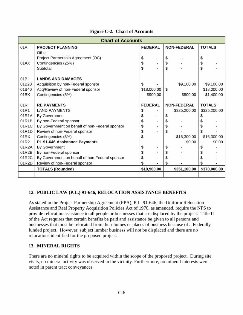
C-6
Figure C-2. Chart of Accounts
Chart of Accounts 01A PROJECT PLANNING FEDERAL NON-FEDERAL TOTALS Other Project Partnership Agreement (OC) $ - $ - $ - 01AX Contingencies (25%) $ - $ - $ - Subtotal $ - $ - $ -
01B LANDS AND DAMAGES 01B20 Acquisition by non-Federal sponsor $ - $9,100.00 $9,100.00 01B40 Acq/Review of non-Federal sponsor $18,000.00 $ $18,000.00 01BX Contingencies (5%) $900.00 $500.00 $1,400.00
01R RE PAYMENTS FEDERAL NON-FEDERAL TOTALS 01R1 LAND PAYMENTS $ - $325,200.00 $325,200.00 01R1A By Government $ - $ - $ - 01R1B By non-Federal sponsor $ - $ - $ - 01R1C By Government on behalf of non-Federal sponsor $ - $ - $ - 01R1D Review of non-Federal sponsor $ - $ - $ - 01RX Contingencies (5%) $ - $16,300.00 $16,300.00 01R2 PL 91-646 Assistance Payments $0.00 $0.00 01R2A By Government $ - $ - $ - 01R2B By non-Federal sponsor $ - $ - $ - 01R2C By Government on behalf of non-Federal sponsor $ - $ - $ - 01R2D Review of non-Federal sponsor $ - $ - $ - TOTALS (Rounded) $18,900.00 $351,100.00 $370,000.00
12. PUBLIC LAW (P.L.) 91-646, RELOCATION ASSISTANCE BENEFITS
As stated in the Project Partnership Agreement (PPA), P.L. 91-646, the Uniform Relocation Assistance and Real Property Acquisition Policies Act of 1970, as amended, require the NFS to provide relocation assistance to all people or businesses that are displaced by the project. Title II of the Act requires that certain benefits be paid and assistance be given to all persons and businesses that must be relocated from their homes or places of business because of a Federally- funded project. However, subject lumber business will not be displaced and there are no relocations identified for the proposed project.
13. MINERAL RIGHTS
There are no mineral rights to be acquired within the scope of the proposed project. During site visits, no mineral activity was observed in the vicinity. Furthermore, no mineral interests were noted in parent tract conveyances.

C-7
14. NON-FEDERAL SPONSOR RESPONSIBILITIES AND CAPABILITIES
The City of Northport is the NFS for the proposed project. The NFS has the responsibility to acquire all real estate interests required for the project. The NFS shall accomplish all alterations and relocations of facilities, structures and improvements determined by the government to be necessary for construction of the project. The NFS is aware of their acquisition risks involved prior to signing of the PPA and understand their LERRD responsibilities as the NFS has past experience with cooperative land acquisitions of this nature.
Title to any acquired real estate will be retained by the NFS and will not be conveyed to the United States Government. The government will require access rights be provided by the NFS for entry to the project. Prior to advertisement of any construction contract, the NFS shall furnish to the government an Authorization for Entry for Construction (Exhibit “D”) to all lands, easements and rights-of-way, as necessary. The NFS will also furnish to the government evidence supporting their legal authority to grant rights-of-way to such lands.
During the acquisition process, the NFS shall comply with applicable provisions of the Uniform Relocation Assistance and Real Property Acquisition Policies Act of 1970, P.L. 91-646, approved 2 January 1971, and amended by Title IV of the Surface Transportation Uniform Relocation Assistance Act of 1987, Public Law 100-17, effective 2 April 1989, in acquiring real estate interests for the proposed project, and inform all affected persons of applicable benefits, policies, and procedures in connection with said Act(s).
A real estate acquisition assessment of the non-Federal Sponsor’s legal and professional capability and experience to acquire and provide the LERRD for the construction, operation and maintenance of the proposed project, including its condemnation authority and capability is attached hereto as Exhibit “E”.
The NFS has been notified in writing about the risks associated with acquiring land before the execution of the PPA. The risk notification letter is attached hereto as Exhibit “F”.
15. APPLICATION OF ZONING ORDINANCES
There will be no application or enactment of zoning ordinances in lieu of, or to facilitate, acquisition in connection with the proposed project.
16. ACQUISITION SCHEDULE
The real estate acquisition schedule is anticipated to be 6 to 9 months. The NFS, Corps Project Manager and Real Estate Technical Manager will formulate specific milestones based upon project approval to allow adequate time to complete the real estate acquisition to meet the contract solicitation and advertisement for construction date(s).
17. UTILIITY/FACILITY RELOCATIONS
There are no known utility or facility relocations within the project footprint.
C-8
18. ENVIRONMENTAL IMPACTS AND POTENTIAL HAZARDOUS, TOXIC, RADIOACTIVE WASTE (HTRW)
An Environmental Assessment (EA) has been prepared in conjunction with this report. It has been reasonably concluded that the proposed action would have no significant environmental impacts, precluding the need for an Environmental Impact Statement.
19. ENVIRONMENTAL MITIGATION
There are no lands required for mitigation due to the proposed construction.
20. ATTITUDE OF PROPERTY OWNERS
According to the NFS, the private landowner is agreeable to easement negotiations for the construction of the proposed levee repair. No opposition is expected from surrounding landowners.
21. CULTURAL RESOURCES/HISTORICAL SIGNIFICANCE
The USACE has determined that there is no potential affect to cultural resources as a result of the proposed action.
22. LIST OF EXHIBITS/MAPS/TABLES
a. Exhibit “A” – Northport Levee System Design – Sheet Reference No. F-16 b. Exhibit “B” – Aerial/Tax Map w/ Proposed Levee Easement Area Outlined c. Exhibit “C” – Aerial/Tax Map depicting Borrow Area d. Exhibit “D” – ROE for Construction and NFS Attorney’s Certificate e. Exhibit “E” – Assessment of NFS Acquisition Capability f. Exhibit “F” – Risk Notification Letter
23. OTHER REAL ESTATE ISSUES
No other pertinent real estate issues are expected for the proposed project.

EXHIBITS

EXHIBIT “A”
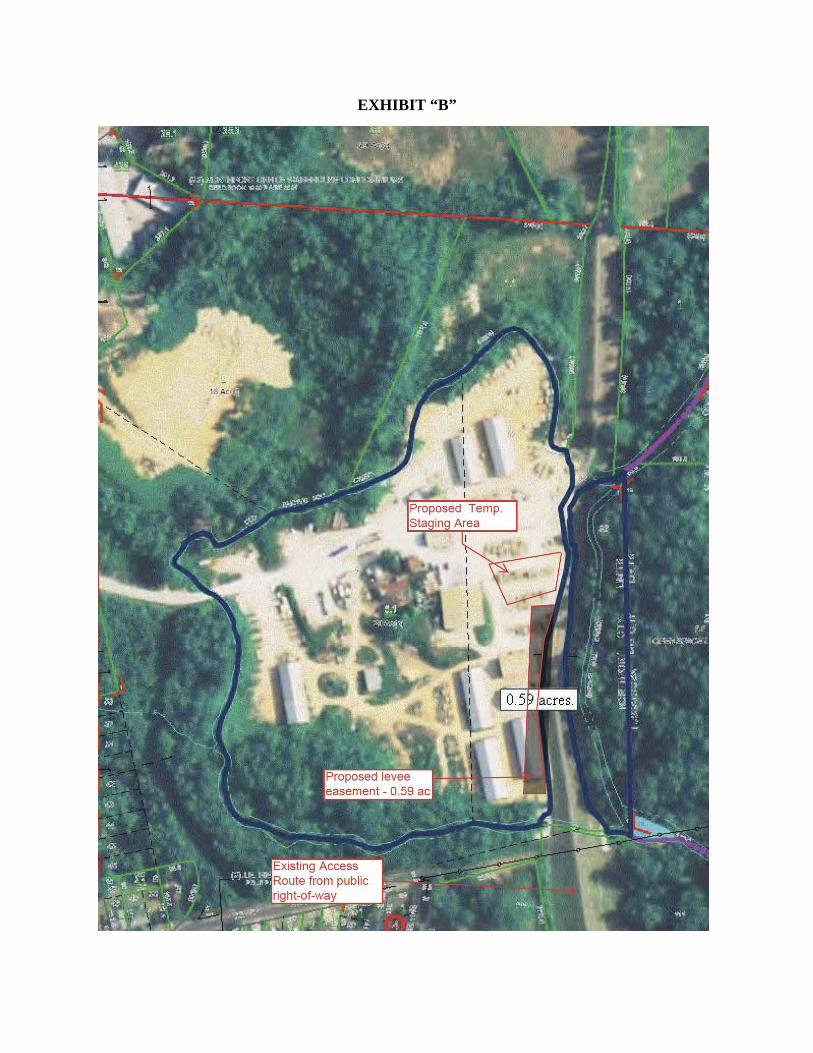
EXHIBIT “B”
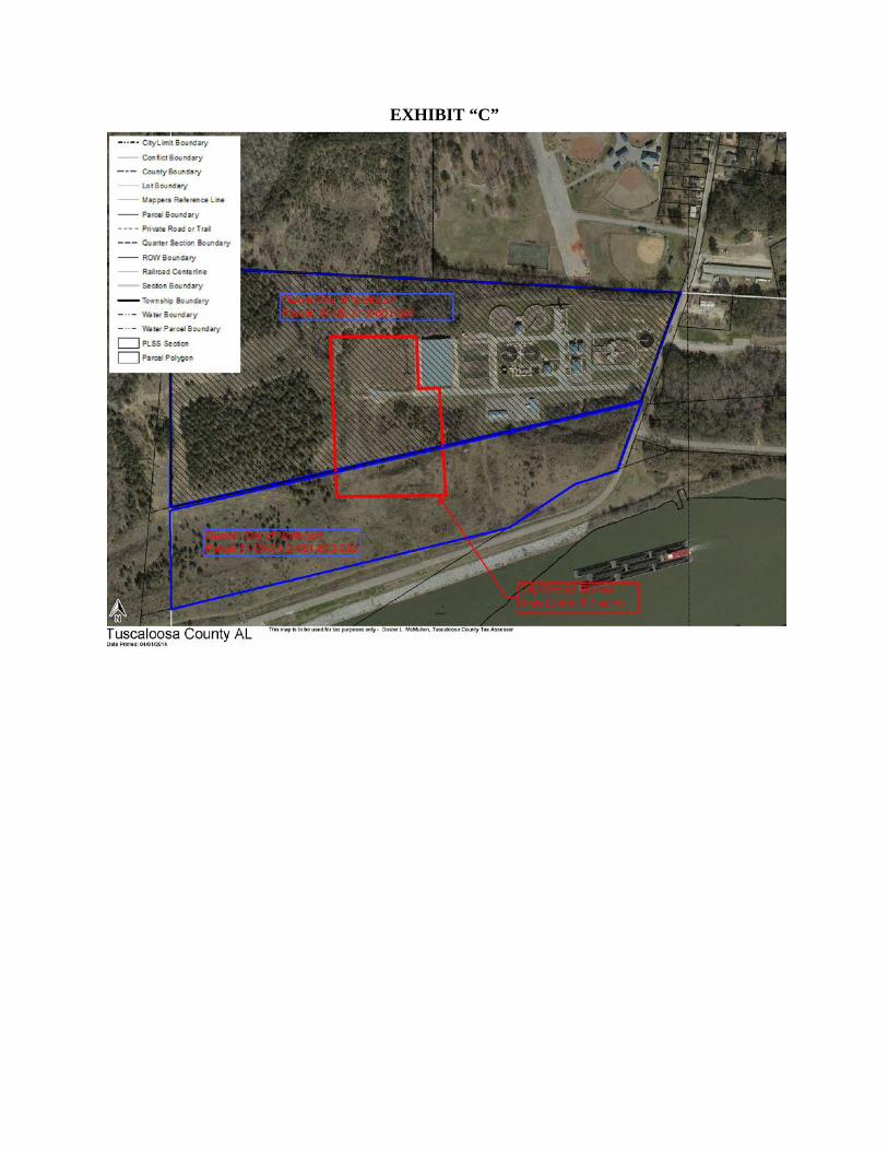
EXHIBIT “C”
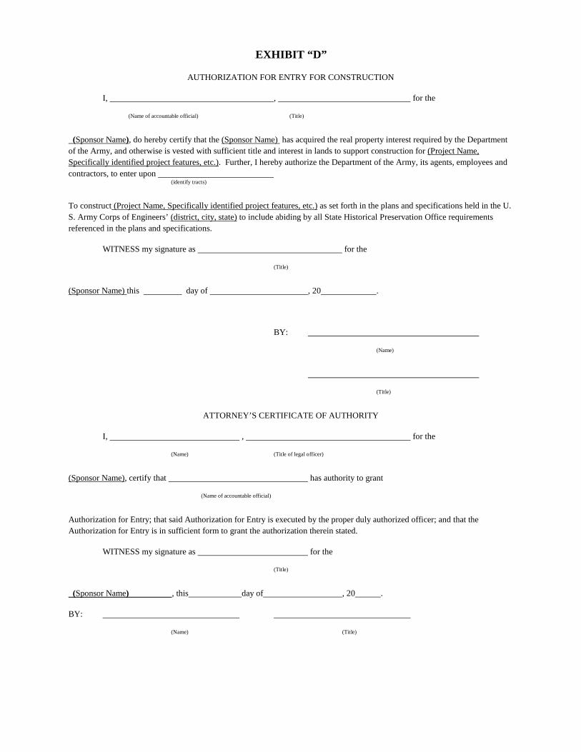
EXHIBIT “D”
AUTHORIZATION FOR ENTRY FOR CONSTRUCTION
I, , for the
(Name of accountable official) (Title)
(Sponsor Name), do hereby certify that the (Sponsor Name) has acquired the real property interest required by the Department of the Army, and otherwise is vested with sufficient title and interest in lands to support construction for (Project Name, Specifically identified project features, etc.). Further, I hereby authorize the Department of the Army, its agents, employees and contractors, to enter upon (identify tracts)
To construct (Project Name, Specifically identified project features, etc.) as set forth in the plans and specifications held in the U. S. Army Corps of Engineers’ (district, city, state) to include abiding by all State Historical Preservation Office requirements referenced in the plans and specifications.
WITNESS my signature as for the
(Title)
(Sponsor Name) this day of , 20 .
BY:
(Name)
(Title)
ATTORNEY’S CERTIFICATE OF AUTHORITY
I, , for the
(Name) (Title of legal officer)
(Sponsor Name), certify that has authority to grant
(Name of accountable official)
Authorization for Entry; that said Authorization for Entry is executed by the proper duly authorized officer; and that the Authorization for Entry is in sufficient form to grant the authorization therein stated.
WITNESS my signature as for the
(Title)
(Sponsor Name) , this day of , 20 .
BY:
(Name) (Title)

EXHIBIT “E”


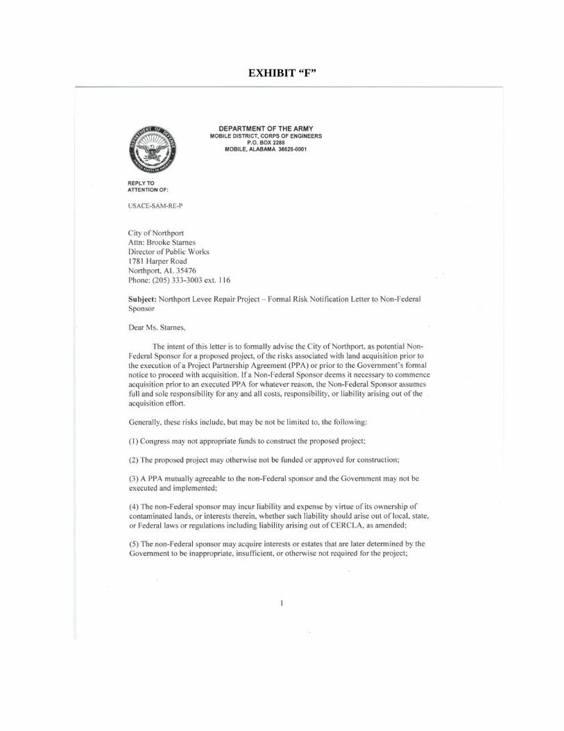
EXHIBIT “F”
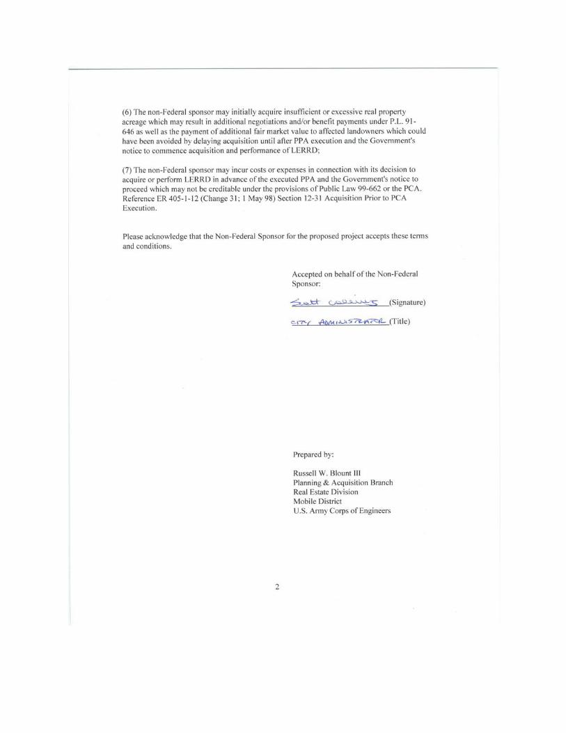
APPENDIX D COORDINATION
D-1
D-2

D-3