detailed flora & vegetation survey medcalf vanadium … · 4.1.2 flora of conservation...
TRANSCRIPT

Detailed Flora & Vegetation Survey
Medcalf Vanadium Mining Project
& Proposed Haul Road
Prepared For
Audalia Resources Limited
October 2017
Version 2
Prepared by:
Botanica Consulting
PO Box 2027
Boulder WA 6432
90930024

Disclaimer This document and its contents are to be treated as confidential and are published in accordance with and
subject to an agreement between Botanica Consulting (BC) and the client for whom it has been prepared
and is restricted to those issues that have been raised by the client in its engagement of BC. Neither this
document nor its contents may be referred to or quoted in any manner (report or other document) nor
reproduced in part or whole by electronic, mechanical or chemical means, including photocopying, recording
or any information storage system, without the express written approval of the client and/or BC.
This document and its contents have been prepared utilising the standard of care and skill ordinarily
exercised by Environmental Scientists in the preparation of such documents. All material presented in this
document is published in good faith and is believed to be accurate at the time of writing. Any person or
organisation who relies on or uses the document and its contents for purposes or reasons other than those
agreed by BC and the client without primarily obtaining the prior written consent of BC, does so entirely at
their own risk. BC denies all liability in tort, contract or otherwise for any loss, damage or injury of any kind
whatsoever (whether in negligence or otherwise) that may be endured as a consequence of relying on this
document and its contents for any purpose other than that agreed with the client.
Quality Assurance An internal quality review process has been implemented to each project task undertaken by BC. Each
document and its contents are carefully reviewed by core members of the Consultancy team and signed off
at Director Level prior to issue to the client. Draft documents are submitted to the client for comment and
acceptance prior to final production.
Document Job Number: 2017/18
Prepared by: Lauren Pick
Senior Environmental Consultant
Botanica Consulting
Reviewed by: Andrea Williams
Director
Botanica Consulting
Approved by: Jim Williams
Director
Botanica Consulting

Contents Page No.
1 Introduction 1 Project Description ........................................................................................................................................... 1 Objectives ......................................................................................................................................................... 1
2 Regional Biophysical Environment 3 Regional Environment ...................................................................................................................................... 3 Great Western Woodlands ............................................................................................................................... 5 Soils and Landscape Systems ......................................................................................................................... 7 Remnant Vegetation ...................................................................................................................................... 10 Climate ........................................................................................................................................................... 14 Hydrology ....................................................................................................................................................... 15 Land Use ........................................................................................................................................................ 17
3 Survey Methodology 17 Desktop Assessment ..................................................................................................................................... 17
3.1.1 Groundwater Dependent Ecosystems ........................................................................................................... 21 Field Assessment ........................................................................................................................................... 23
3.2.1 Sampling Quadrats ........................................................................................................................................ 23 3.2.2 Personnel involved ......................................................................................................................................... 25 3.2.3 Scientific licences ........................................................................................................................................... 25
Data Analysis Tools ....................................................................................................................................... 25 3.3.1 PATN Analysis ............................................................................................................................................... 25 3.3.2 EstimateS ....................................................................................................................................................... 26
Flora survey limitations and constraints ......................................................................................................... 26
4 Results 27 Desktop Assessment ..................................................................................................................................... 27
4.1.1 Literature Review ........................................................................................................................................... 27 4.1.2 Flora of Conservation Significance ................................................................................................................ 30 4.1.3 Groundwater Dependence Assessment ........................................................................................................ 37 4.1.4 Field Assessment ........................................................................................................................................... 39
Flora of conservation significance .................................................................................................................. 39 4.2.1 Marianthus aquilonaris (T) ............................................................................................................................. 39 4.2.2 Acacia hystrix subsp. continua (P1) ............................................................................................................... 41 4.2.3 Acacia mutabilis subsp. stipulifera (P3) ......................................................................................................... 42 4.2.4 Bossiaea flexuosa (P3) .................................................................................................................................. 43 4.2.5 Brachyloma stenolobum (P1) ......................................................................................................................... 44 4.2.6 Eucalyptus pterocarpa (P4) ............................................................................................................................ 44 4.2.7 Eucalyptus rhomboidea (P4) .......................................................................................................................... 46 4.2.8 Hakea pendens (P3) ...................................................................................................................................... 47 4.2.9 Microcybe sp. Windy Hill (G.F. Craig 6583) (P3) ........................................................................................... 48 4.2.10 Stenanthemum bremerense (P4) ................................................................................................................... 49 4.2.11 Teucrium sp. dwarf (R. Davis 8813) (P1) ....................................................................................................... 50
Floristic Communities ..................................................................................................................................... 52 4.3.1 Low samphire shrubland of Tecticornia indica subsp. bidens over low open forbland of Disphyma
crassifolium on playa (CD-CSSSF1) .............................................................................................................. 54 4.3.2 Low open woodland of Eucalyptus salmonophloia over mixed shrubs on clay-loam plain (CLP-EW1) ........ 55 4.3.3 Mid mallee shrubland of Eucalyptus spp. over mid shrubland of Melaleuca pauperiflora and mixed low
shrubland on clay-loam plain (CLP-MWS1) ................................................................................................... 57 4.3.4 Mid mallee woodland of Eucalyptus spp. over mixed low shrubland/ heathland on clay-loam plain (CLP-
MWS2) ........................................................................................................................................................... 58 4.3.5 Heathland of Thryptomene spp. over sparse tussock grassland of Neurachne alopecuroidea on granite
outcrop (G-H1) ............................................................................................................................................... 59 4.3.6 Regrowth of dense low forest of Eucalyptus sp. (Sterile) on hillslope (HS-EW1) .......................................... 60 4.3.7 Regrowth mid open mallee woodland Eucalyptus livida over mid open shrubland of Hakea pendens and
open low shrubland of Goodia medicaginea on hillslope (HS-MWS1) .......................................................... 61

4.3.8 Regrowth low open mallee shrubland of Eucalyptus spp. over low shrubland of Acacia spp. and open
tussock grassland of Schoenus breviculmis on hillslope (HS-MWS2) ........................................................... 62 4.3.9 Mid open mallee woodland Eucalyptus livida over heathland of Allocasuarina/ Hakea/ Melaleuca and open
low sedge of Lepidosperma sanguinolentum on hillslope (HS-MWS3) ......................................................... 63 4.3.10 Regrowth mixed low shrubland on hillslope (HS-OS1) .................................................................................. 64 4.3.11 Low woodland of Eucalyptus salicola over low open shrubland of Phebalium filifolium and low open
sedgeland of Gahnia ancistrocarpa on sand-loam plain (SLP-EW1) ............................................................ 65 4.3.12 Mid sparse mallee shrubland of Eucalyptus eremophila over heathland of Melaleuca spp. on sand-loam plain
(SLP-MWS1) .................................................................................................................................................. 66 4.3.13 Regrowth mid sparse mallee shrubland of Eucalyptus spp. over low open shrubland of Acacia / Grevillea
spp. and open hummock grassland of Triodia scariosa on sand-loam plain (SLP-MWS2)........................... 67 4.3.14 Regrowth low open woodland of Codonocarpus cotinifolius over mid shrubland of Acacia/ Melaleuca spp.
and open tussock grassland of Schoenus breviculmis on sand-loam plain (SLP-OS1) ................................ 68 Vegetation Condition ...................................................................................................................................... 69 Introduced Plant Species ............................................................................................................................... 73
4.5.1 Asphodelus fistulosus (Onion Weed) ............................................................................................................. 73 4.5.2 Bromus rubens (Red brome) .......................................................................................................................... 74 4.5.3 Carrichtera annua (Ward’s Weed) ................................................................................................................. 75 4.5.4 Centaurea melitensis (Maltese Cockspur) ..................................................................................................... 76 4.5.5 Lysimachia arvensis (Pimpernel) ................................................................................................................... 77 4.5.6 Pentameris airoides ....................................................................................................................................... 78 4.5.7 Rostraria pumila (Roughtail) .......................................................................................................................... 79 4.5.8 Sonchus oleraceus (Common Sowthistle) ..................................................................................................... 80 4.5.9 Vulpia ?muralis ............................................................................................................................................... 81
Floristic Composition of the Medcalf Vanadium Mining Project Quadrats ..................................................... 82 4.6.1 Species Richness and accumulation estimates ............................................................................................. 84
Vegetation of Conservation Significance ....................................................................................................... 84 4.7.1 Matters of National Environmental Significance ............................................................................................ 84 4.7.2 Matters of State Environmental Significance ................................................................................................. 85
5 Summary 86
6 Bibliography 87
Tables
Table 1: Soil Landscape Systems within the survey area ............................................................................................. 8 Table 2: Pre-European Vegetation Associations within the survey area ..................................................................... 11 Table 3: Definitions of Conservation Significant Flora ................................................................................................. 18 Table 4: Definition of conservation significant communities ........................................................................................ 19 Table 5: Scientific Licences of Botanica Staff coordinating the survey ....................................................................... 25 Table 6: Limitations and constraints associated with the flora and vegetation survey ................................................ 26 Table 7: Previous Flora and Vegetation Surveys within the surrounding area ............................................................ 28 Table 8: Likelihood of occurrence for Flora of Conservation Significance within the survey area .............................. 30 Table 9: Groundwater Dependent Ecosystems within the survey area ....................................................................... 37 Table 10: Summary of floristic communities within the survey area ............................................................................ 52 Table 11: Vegetation assemblage for Low samphire shrubland of Tecticornia indica subsp. bidens over low open forbland of Disphyma crassifolium on playa ................................................................................................................ 54 Table 12: Vegetation assemblage for Low open woodland of Eucalyptus salmonophloia over mixed shrubs on clay-loam plain ..................................................................................................................................................................... 55 Table 13: Vegetation assemblage for Mid mallee shrubland of Eucalyptus spp. over mid shrubland of Melaleuca pauperiflora and mixed low shrubland on clay-loam plain ........................................................................................... 57 Table 14: Vegetation assemblage for Mid mallee woodland of Eucalyptus spp. over mixed low shrubland/ heathland on clay-loam plain ........................................................................................................................................................ 58 Table 15: Vegetation assemblage for Heathland of Thryptomene spp. over sparse tussock grassland of Neurachne alopecuroidea on granite outcrop ................................................................................................................................ 59 Table 16: Vegetation assemblage for Regrowth of dense low forest of Eucalyptus sp. (Sterile) on hillslope ............. 60 Table 17: Vegetation assemblage for Regrowth mid open mallee woodland Eucalyptus livida over mid open shrubland of Hakea pendens and open low shrubland of Goodia medicaginea on hillslope ...................................... 61 Table 18: Vegetation assemblage for Regrowth low open mallee shrubland of Eucalyptus spp. over low shrubland of Acacia spp. and open tussock grassland of Schoenus breviculmis on hillslope ......................................................... 62

Table 19: Vegetation assemblage for Mid open mallee woodland Eucalyptus livida over heathland of Allocasuarina/ Hakea/ Melaleuca and open low sedge of Lepidosperma sanguinolentum on hillslope ............................................. 63 Table 20: Vegetation assemblage for Regrowth mixed low shrubland on hillslope .................................................... 64 Table 21: Vegetation assemblage for Low woodland of Eucalyptus salicola over low open shrubland of Phebalium filifolium and low open sedgeland of Gahnia ancistrocarpa on sand-loam plain ......................................................... 65 Table 22: Vegetation assemblage for Mid sparse mallee shrubland of Eucalyptus eremophila over heathland of Melaleuca spp. on sand-loam plain ............................................................................................................................. 66 Table 23: Vegetation assemblage for Regrowth mid sparse mallee shrubland of Eucalyptus spp. over low open shrubland of Acacia / Grevillea spp. and open hummock grassland of Triodia scariosa on sand-loam plain............. 67 Table 24: Regrowth low open woodland of Codonocarpus cotinifolius over mid shrubland of Acacia/ Melaleuca spp. and open tussock grassland of Schoenus breviculmis on sand-loam plain ................................................................ 68 Table 25: Vegetation Condition Rating of the survey area .......................................................................................... 69 Table 26: Vegetation communities with corresponding quadrats ................................................................................ 82
Figures
Figure 1: Regional map of the survey area .................................................................................................................... 2 Figure 2: Map of Interim Biogeographic Regionalisation of Australia (IBRA) ................................................................ 4 Figure 3: Location of the survey area within the Great Western Woodlands ................................................................ 6 Figure 4: Map of Soil Landscape Systems within the survey area ................................................................................ 9 Figure 5: Pre-European Vegetation Associations within the survey area.................................................................... 13 Figure 6: Mean monthly rainfall and maximum temperature (1999 to 2017) for the Norseman Aero weather station (#12009) (BoM, 2017a) ................................................................................................................................................ 14 Figure 7: Monthly rainfall and mean monthly rainfall (January 2014 to September 2017) for the Norseman Aero weather station (#12009) (BoM, 2017a) ...................................................................................................................... 15 Figure 8: Hydrology of the survey area (data obtained from Geoscience Australia, 2001) ......................................... 16 Figure 9: Survey area boundary and GPS tracks traversed throughout the survey area............................................ 24 Figure 10: Potential for Groundwater Dependent Ecosystems within the survey area ............................................... 38 Figure 11: Flora of Conservation Significance identified within the survey area ......................................................... 51 Figure 12: Vegetation Condition Rating of the survey area ......................................................................................... 71 Figure 13: Map of fire history along the extent of the survey area obtained from Landgate fire watch database (Landgate, 2017) .......................................................................................................................................................... 72 Figure 14: Species accumulation curve ....................................................................................................................... 84
Plates
Plate 1: Marianthus aquilonaris (T) .............................................................................................................................. 40 Plate 2: Acacia hystrix subsp. continua (P1) ............................................................................................................... 41 Plate 3: Acacia mutabilis subsp. stipulifera (P3) .......................................................................................................... 42 Plate 4: Bossiaea flexuosa (P3) ................................................................................................................................... 43 Plate 5: Brachyloma stenolobum (P1) ......................................................................................................................... 44 Plate 6: Eucalyptus pterocarpa (P4) ............................................................................................................................ 45 Plate 7: Eucalyptus rhomboidea (P4) (Image provided by Paul Armstrong, 2012) ..................................................... 46 Plate 8: Hakea pendens (P3) ....................................................................................................................................... 47 Plate 9: Microcybe sp. Windy Hill (G.F. Craig 6583) (P3) ........................................................................................... 48 Plate 10: Stenanthemum bremerense (P4) ................................................................................................................. 49 Plate 11: Teucrium sp. dwarf (R. Davis 8813) (P1) ..................................................................................................... 50 Plate 12: Low samphire shrubland of Tecticornia indica subsp. bidens over low open forbland of Disphyma crassifolium on playa ................................................................................................................................................... 54 Plate 13: Low open woodland of Eucalyptus salmonophloia over mixed shrubs on clay-loam plain ......................... 55 Plate 14: Regrowth Eucalyptus salmonophloia over mixed shrubs on clay-loam plain .............................................. 56 Plate 15: Mid mallee shrubland of Eucalyptus spp. over mid shrubland of Melaleuca pauperiflora and mixed low shrubland on clay-loam plain ....................................................................................................................................... 57 Plate 16: Mid mallee woodland of Eucalyptus spp. over mixed low shrubland/ heathland on clay-loam plain .......... 58 Plate 17: Heathland of Thryptomene spp. over sparse tussock grassland of Neurachne alopecuroidea on granite outcrop ......................................................................................................................................................................... 59 Plate 18: Regrowth of dense low forest of Eucalyptus sp. (Sterile) on hillslope .......................................................... 60 Plate 19: Regrowth mid open mallee woodland Eucalyptus livida over mid open shrubland of Hakea pendens and open low shrubland of Goodia medicaginea on hillslope ............................................................................................ 61 Plate 20: Regrowth low open mallee shrubland of Eucalyptus spp. over low shrubland of Acacia spp. and open tussock grassland of Schoenus breviculmis on hillslope ............................................................................................. 62

Plate 21: Mid open mallee woodland Eucalyptus livida over heathland of Allocasuarina/ Hakea/ Melaleuca and open low sedge of Lepidosperma sanguinolentum on hillslope ........................................................................................... 63 Plate 22: Regrowth mixed low shrubland on hillslope ................................................................................................ 64 Plate 23: Low woodland of Eucalyptus salicola over low open shrubland of Phebalium filifolium and low open sedgeland of Gahnia ancistrocarpa on sand-loam plain ............................................................................................. 65 Plate 24: Mid sparse mallee shrubland of Eucalyptus eremophila over heathland of Melaleuca spp. on sand-loam plain .............................................................................................................................................................................. 66 Plate 25: Regrowth mid sparse mallee shrubland of Eucalyptus spp. over low open shrubland of Acacia / Grevillea spp. and open hummock grassland of Triodia scariosa on sand-loam plain ............................................................... 67 Plate 26: Regrowth low open woodland of Codonocarpus cotinifolius over mid shrubland of Acacia/ Melaleuca spp. and open tussock grassland of Schoenus breviculmis on sand-loam plain ................................................................ 68 Plate 27: Asphodelus fistulosus (Onion Weed) ........................................................................................................... 73 Plate 28: Bromus rubens (Red Brome) (DPIRD, 2017) ............................................................................................... 74 Plate 29: Carrichtera annua (Ward’s Weed) ................................................................................................................ 75 Plate 30: Centaurea melitensis (Maltese Cockspur).................................................................................................... 76 Plate 31: Lysimachia arvensis (Pimpernel) .................................................................................................................. 77 Plate 32: Pentameris airoides (False Hairgrass) (DPIRD, 2017) ................................................................................ 78 Plate 33: Rostraria pumila (Roughtail) ......................................................................................................................... 79 Plate 34: Sonchus oleraceus (Common Sowthistle) .................................................................................................... 80 Plate 35: Vulpia muralis (Silver Grass-Wall Fescue) (DPIRD, 2017) .......................................................................... 81
Appendices
Appendix 1: Regional map of the survey area including DBCA Flora of Conservation Significance and areas of Conservation Significance ........................................................................................................................................... 90 Appendix 2: Vegetation maps of the survey area ........................................................................................................ 91 Appendix 3: List of species identified within each floristic community ......................................................................... 96 Appendix 4: GPS coordinates of Flora of Conservation Significance locations within the survey area (GDA94) ..... 109 Appendix 5: GPS Coordinates of Quadrat Locations (GDA 94) ................................................................................ 128 Appendix 6: Vegetation Condition Rating .................................................................................................................. 131 Appendix 7: PATN Analysis Results .......................................................................................................................... 132 Appendix 8: Quadrat Datasheets ............................................................................................................................... 135 Appendix 9: Quadrat Photographs............................................................................................................................. 136
Glossary
Acronym Description
ANCA Australian Nature Conservation Agency.
Audalia Audalia Resources Limited.
BA Birdlife Australia (Formerly RAOU, Birds Australia).
BAM Act Biosecurity and Agriculture Management Act 2007, WA Government.
BC Botanica Consulting.
BoM Bureau of Meteorology.
CAMBA China Australia Migratory Bird Agreement 1998.
DAFWA Department of Agriculture and Food (now DPIRD), WA Government.
DBCA Department of Biodiversity, Conservation and Attractions (formerly DPaW), WA
Government.
DER Department of Environment Regulation (now DWER), WA Government.
DMIRS Department of Mines, Industry Regulation and Safety (formerly DMP), WA Government
DMP Department of Mines and Petroleum (now DMIRS), WA Government.
DotEE Department of the Environment and Energy (formerly DSEWPaC), Australian
Government.
DoW Department of Water (now DWER), WA Government.
DPaW Department of Parks and Wildlife (now DBCA), WA Government.
DPIRD Department of Primary Industries and Regional Development, WA Government

Acronym Description
DSEWPaC Department of Sustainability, Environment, Water, Population and Communities (now
DotEE,), Australian Government.
DWER Department of Water and Environmental Regulation (formerly EPA, DER and DoW), WA
Government
EP Act Environmental Protection Act 1986, WA Government.
EP Regulations Environmental Protection (Clearing of Native Vegetation) Regulations 2004, WA
Government.
EPA Environmental Protection Authority (now DWER), WA Government.
EPBC Act Environment Protection and Biodiversity Conservation Act 1999, Australian Government.
ESA Environmentally Sensitive Area.
Ha Hectare (10,000 square metres).
IBRA Interim Biogeographic Regionalisation for Australia.
IUCN International Union for the Conservation of Nature and Natural Resources – commonly
known as the World Conservation Union.
JAMBA Japan Australia Migratory Bird Agreement 1981.
Km Kilometre (1,000 metres).
MVG Major Vegetation Groups.
NVIS National Vegetation Information System.
OEPA Office of the Environmental Protection Authority, WA Government.
PEC Priority Ecological Community.
RAOU Royal Australia Ornithologist Union.
ROKAMBA Republic of Korea-Australia Migratory Bird Agreement 2007.
SRE Short Range Endemic.
SSC Species Survival Commission, International.
TEC Threatened Ecological Community.
WA Western Australia.
WAHERB Western Australian Herbarium.
WAM Western Australian Museum, WA Government.
WC Act Wildlife Conservation Act 1950, WA Government.

Executive Summary
Botanica Consulting (BC) was commissioned by Audalia Resources Limited (Audalia) to undertake a
Detailed (quadrat based) flora and vegetation survey of the Medcalf Vanadium Mining (MVM) Project and
associated haul road (referred to collectively as the ‘survey area’). The MVM Project is located
approximately 97km south-west of Norseman, Western Australia with the proposed haul road extending
approximately 73km east from the project to the Coolgardie-Esperance Highway. The inaugural detailed
flora and vegetation survey of the MVM Project was conducted in spring 2013; 62 quadrats were established
and re-surveyed in autumn 2013. In spring 2014, the MVM Project area was expanded with a further 30
quadrats established. These quadrats were re-surveyed in autumn 2015. A detailed flora and vegetation
survey of the proposed haul road was conducted on the 19th to the 23rd March 2017, with 35 quadrats
established. These quadrats we re-surveyed from the 8th to 10th September 2017. A total of 127 quadrats
were established within the 18,770 ha survey area (MVM Project and haul road inclusive).
Fourteen floristic communities were identified within the survey area. These communities were located
within five different landform types and comprised of five major vegetation groups, which were represented
by a total of 58 Families, 162 Genera and 411 Taxa.
One Threatened Flora taxon as listed under the Wildlife Conservation (WC) Act 19501 was recorded within
the survey area; Marianthus aquilonaris (T). This taxon is not currently listed as threatened under the
Commonwealth Environment Protection and Biodiversity Conservation (EPBC) Act 1999. Ten Priority Flora
taxa as listed by the Department of Biodiversity, Conservation and Attractions (DBCA) were identified within
the survey area:
1. Acacia hystrix subsp. continua (P1);
2. Acacia mutabilis subsp. stipulifera (P3);
3. Bossiaea flexuosa (P3);
4. Brachyloma stenolobum (P1);
5. Eucalyptus pterocarpa (P4);
6. Eucalyptus rhomboidea (P4);
7. Hakea pendens (P3);
8. Microcybe sp. Windy Hill (G.F. Craig 6583) (P3);
9. Stenanthemum bremerense (P4); and
10. Teucrium sp. dwarf (R. Davis 8813) (P1).
No Threatened Ecological Communities (TEC) pursuant to Commonwealth or State legislation were
identified within the survey area. The survey area does not contain any world or national heritage places
and does not occur within a Bush Forever site. There are no wetlands of international importance (Ramsar
Wetlands), national importance (Australian Nature Conservation Agency (ANCA) Wetlands) or conservation
category wetlands within the survey area. Approximately 2236 ha of the western extremity of the survey
area is located within the Bremer Range Vegetation Complexes Priority 1 Ecological Community (PEC) as
listed by DBCA.
The survey area contains Environmentally Sensitive Areas (ESA) which occur within a 50m radius of each
Threatened Flora plant (covering an area of 19.7 ha), listed under the Environmental Protection (EP) Act
1986. One un-named Class A Nature Reserve (Identifier R 42943) managed by DBCA is located within the
eastern extremity of the survey area (approximately 301 ha of the survey area). This Nature Reserve is also
listed as a Schedule 1 Area under the EP Act.
1 Biodiversity Conservation Act 2016 received assent on 21 September 2016 with Parts of the Act coming into effect on 3 December 2016. Once fully enacted with enabling subsidiary regulations, it will replace the Wildlife Conservation Act 1950.

Desktop assessments indicate the survey area has potential to include two Groundwater Dependent
Ecosystems (reliant on subsurface presence of groundwater); The first potential ecosystem is described as
Medium Woodland; Salmon Gum. The database results indicate a moderate potential for interaction of this
ecosystem with groundwater. The second ecosystem is described as Shrublands; scrub heath in the
Coolgardie Region. The database results indicate a low potential for interaction of this ecosystem with
groundwater.
Based on the vegetation condition rating scale adapted from Keighery, 1994 and Trudgen, 1988 (ranging
from ‘pristine’ to ‘completely degraded’), eight communities were rated as ‘good’ and the remaining seven
communities had a vegetation condition rating of ‘very good’. Nine introduced species were identified in the
survey area:
1. Asphodelus fistulosus (Onion Weed);
2. Bromus rubens (Red brome);
3. Carrichtera annua (Ward’s weed);
4. Centaurea melitensis (Maltese cockspur);
5. Lysimachia arvensis (Pimpernel);
6. Pentameris airoides;
7. Rostraria pumila (Roughtail);
8. Sonchus oleraceus (Common sowthistle); and
9. Vulpia ?muralis.

Audalia Resources Limited Medcalf Vanadium Mining Project & Haul Road- Flora & Vegetation Survey
Botanica Consulting 1
1 Introduction
Project Description
Botanica Consulting (BC) was commissioned by Audalia Resources Limited (Audalia) to undertake a
Detailed (quadrat based) flora and vegetation survey of the Medcalf Vanadium Mining (MVM) Project and
associated haul road (referred to collectively as the ‘survey area’). The MVM Project is located
approximately 97km south-west of Norseman, Western Australia with the proposed haul road extending
approximately 73km east from the project to the Coolgardie-Esperance Highway (Figure 1). The
inaugural detailed flora and vegetation survey of the MVM Project was conducted in spring 2013; 62
quadrats were established and re-surveyed in autumn 2013. In spring 2014, the MVM Project area was
expanded with a further 30 quadrats established. These quadrats were re-surveyed in autumn 2015. A
detailed flora and vegetation survey of the proposed haul road was conducted on the 19th to the 23rd
March 2017, with 35 quadrats established. These quadrats we re-surveyed from the 8th to 10th September
2017. A total of 127 quadrats were established within the 18,770 ha survey area (MVM Project and haul
road inclusive). This report presents the findings of flora surveys conducted within the MVM Project area
(conducted from spring 2013 to autumn 2015) and flora surveys of the associated haul road (conducted
from autumn 2017 to spring 2017).
Objectives
The survey was conducted in accordance with Guidance for the Assessment of Environmental Factors
(No. 51) Terrestrial Flora and Vegetation Surveys for Environmental Impact Assessment in Western
Australia (EPA, 2004) and Technical Guide - Terrestrial Flora and Vegetation Surveys for Environmental
Impact Assessment – December 2016 (DPaW & EPA, 2016). The objectives of the assessment were to:
• gather background information on flora and vegetation in the target area (literature review,
database and map-based searches);
• identify significant flora, vegetation/ecological communities and assess the potential sensitivity to
impact;
• conduct a field survey to verify / ground truth the desktop assessment findings through targeted
and detailed survey;
• undertake floristic community mapping to a scale appropriate for the bioregion and described
according to the National Vegetation Information System (NVIS) structure and floristics;
• undertake vegetation condition mapping;
• assess the project area’s plant species diversity, density, composition, structure and weed cover,
using NVIS classification system for vegetation description;
• assess Matters of National Environmental Significance (MNES) and indicate whether potential
impacts on MNES as protected under the EPBC Act are likely to require referral of the project to
the Commonwealth DotEE; and
• determine the State legislative context of environmental aspects required for the assessment.

Audalia Resources Limited Medcalf Vanadium Mining Project & Haul Road- Flora & Vegetation Survey
Botanica Consulting 2
Figure 1: Regional map of the survey area

Audalia Resources Limited Medcalf Vanadium Mining Project & Haul Road- Flora & Vegetation Survey
Botanica Consulting 3
2 Regional Biophysical Environment
Regional Environment
The survey area lies within the Coolgardie Botanical District of the South-West Province of WA. The
Coolgardie Botanical District consists of predominantly mulga low woodland on plains and reduces to
scrub on hills (Beard, 1990).
Based on the Interim Biogeographic Regionalisation of Australia (IBRA), Version 7 (DotEE, 2012), the
survey area is located within the Coolgardie Bioregion of WA (Figure 2). The Coolgardie Bioregion is
further divided into three subregions; Mardabilla, Southern Cross and Eastern Goldfields subregion with
the survey area located within the Southern Cross (COO2) and Eastern Goldfields (COO3) subregion
(Figure 2). The survey area is located approximately 5km north of the Mallee Bioregion, which is divided
into two subregions; Eastern Mallee (MAL1) and Western Mallee (MAL2) as shown in Figure 2.
The Coolgardie Bioregion is within the Yilgarn Craton. The climate is arid to semi-arid warm
Mediterranean with 250-300mm of mainly winter rainfall. It comprises diverse woodlands, rich in endemic
eucalypts, which occur on low greenstone hills, alluvial soils on the valley floors, around the saline playas
of the region’s occluded drainage system and on broad plains of calcareous earths. Granite basement
outcrops occur at mid-level in the landscape, supporting swards of ‘granite grass’, Acacia shrublands and
York Gum. The playa lakes support dwarf shrublands of samphire. Sand lunettes are associated with
playas along the broad valley floors, and sand sheets surround the granite outcrops. Upper levels in the
landscape are the eroded remnants of a Tertiary lateritic duricrust, with yellow (in the Southern Cross
subregion) or red (in the Eastern Goldfields subregion) sandplains, gravel plains and laterite breakaways.
These support scrubs and mallees. In the west, these scrubs are rich in endemic Proteaceae; in the east,
they are rich in endemic Acacias (McKenzie, May and McKenna, 2002).
The Mallee Bioregion occurs within the south-eastern part of Yilgarn Craton and is gently undulating, with
partially occluded drainage. The climate is Mediterranean to semi-arid, with winter rainfall of between 250
and 500mm. This region includes mallee communities, samphires around small salt lakes and Eucalyptus
woodlands occur mainly on fine-textured soils, with scrub-heath on sands and laterite (McKenzie et. al.,
2002).

Audalia Resources Limited Medcalf Vanadium Mining Project & Haul Road- Flora & Vegetation Survey
Botanica Consulting 4
Figure 2: Map of Interim Biogeographic Regionalisation of Australia (IBRA)

Audalia Resources Limited Medcalf Vanadium Mining Project & Haul Road- Flora & Vegetation Survey
Botanica Consulting 5
Great Western Woodlands
The survey area lies within the Great Western Woodlands (Figure 3). The Great Western Woodlands
is considered by The Wilderness Society to be of global biological and conservation importance as
one of the largest and healthiest temperate woodlands on Earth, containing many endemic species.
The region covers almost 16 million hectares, 160,000 square kilometers, from the southern edge of
the Western Australian Wheatbelt to the pastoral lands of the Mulga country in the north, the inland
deserts to the northeast, and the treeless Nullarbor Plain to the east.
The area provides an eastward connection between southwest forests and inland deserts (Gondwana
Link) as well as linking the north-west passage to Shark Bay. The majority of the Great Western
Woodlands is unallocated crown land (61.1%) with other interests including pastoral leases (20.4%),
conservation reserves (15.4%) unallocated crown land ex pastoral managed by the DPaW (2%) and
private land (approximately 1%) (Watson et. al., 2008).
No specific management strategy applies to the Great Western Woodlands, rather an approach to
conservation which occurs across all land tenures and when different stakeholders work together with
biodiversity in mind. The central component of this approach is to identify and conserve key large-
scale, long term ecological processes that drive connectivity between ecosystems and species. The
Great Western Woodlands currently includes towns, highways, roads, railways, private property,
Crown Reserves, agricultural activities and mining tenements.

Audalia Resources Limited Medcalf Vanadium Mining Project & Haul Road- Flora & Vegetation Survey
Botanica Consulting 6
Figure 3: Location of the survey area within the Great Western Woodlands

Audalia Resources Limited Medcalf Vanadium Mining Project & Haul Road- Level 2 Flora & Vegetation Survey
Botanica Consulting 7
Soils and Landscape Systems
The Southern Cross subregion (COO2) lies on the Yilgarn Craton's ‘Southern Cross Terrains'. The
relief is subdued and comprises of gently undulating uplands dissected by broad valleys with bands
of low greenstone hills. The underlying geology is of granite strata interrupted by parallel intrusions
of Archaean Greenstone. Calcareous earths are the dominant soil community and cover much of the
plains and greenstone areas. A series of large playa lakes in the western half are the remnants of an
ancient major drainage line (Cowan, 2001). Beard (1990) describes the topography of the region as
gently undulating with occasional range of low hills and sandplains in the western area and some
large playa lakes. The dominant soil type is calcareous earth.
The Eastern Goldfields subregion (COO3) lies on the Yilgarn Craton's 'Eastern Goldfields Terrains'.
The relief is subdued and comprises of gently undulating plains interrupted in the west with low hills
and ridges of Archaean greenstones and in the east by a horst of Proterozoic basic granulite. The
underlying geology is of gneisses and granites eroded into a flat plane covered with tertiary soils and
with scattered exposures of bedrock. Calcareous earths are the dominant soil group and cover much
of the plains and greenstone areas. A series of large playa lakes in the western half are the remnants
of an ancient major drainage line (Cowan, 2001).
Based on geographic information provided by the Department of Primary Industries and Regional
Development (DPIRD), the survey area is located within the Salmon Gums Mallee Zone (246) of the
Stirling Province (24) and the Norseman Zone (266) of the Kalgoorlie Province (26).
The Salmon Gums Mallee Zone is characterized by flat to undulating plains (with some salt lakes) on
deeply weathered mantle and alluvium over Bremer Basin sediments on granite and gneiss of the
Yilgarn Craton and Albany-Fraser Orogen. Soils include calcareous loamy earths and alkaline grey
shallow sandy duplexes with salt lake soils and some alkaline grey shallow loamy duplexes and pale
deep sands. Vegetation includes merrit-coral gum-Salmon gum-red mallee woodlands with mallee
scrub and some mallee heath. This zone is located in the South Coast district between Pyramid Lake,
Scaddan, Norseman and Mt Ragged (Tille, 2006).
The Norseman Zone is characterized by undulating plains and uplands (with some sandplains and
salt lakes) on granitic rocks of the Yilgarn Craton. Soils include calcareous loamy earths, yellow sandy
and loamy earths, red loamy earths, red deep sands and salt lake soils. Vegetation includes Salmon
gum-redwood-merrit-red mallee-gimlet woodland with Acacia-Casuarina thickets (and some mulga
shrublands and spinifex grasslands). This zone is located in the southern Goldfields between
Koolyanobbing, Menzies, Zanthus (Trans-Australian Railway), Norseman and Lake Hope (Tille,
2006).
These zones are further divided into soil landscape systems, with the soil landscape systems of the
survey area shown in Table 1 and Figure 4 (ASRIS, 2014).

Audalia Resources Limited Medcalf Vanadium Mining Project & Haul Road- Level 2 Flora & Vegetation Survey
Botanica Consulting 8
Table 1: Soil Landscape Systems within the survey area
Zone Landscape System/
Mapping Unit Description
Salmon Gums Mallee Zone (246)
Halbert System
Level to gently undulating plain with numerous salt lakes within a paleo valley on Tertiary marine sediments
(Plantagenet and Werrilup formations). Soils are alkaline grey shallow sandy duplex soils and salt lake soils.
Johnston System Gently undulating inland plain with occasional rises on
Archaean granite deeply weathered
JY1 Undulating land with small valleys and flats
Salmon Gums System
Level to very gently undulating, slightly elevated, inland plain with few surface drainage features and occasional swamps.
Soils are alkaline grey shallow sandy duplex soils with associated calcareous loamy earths and red non-cracking
clays
Norseman Zone (266)
DD13 Gently undulating plains with some gilgai areas, occasionally
broken by stony ridges and hills
Nc2 Gently undulating plains with some gilgai areas, and
irregularly broken by small remnants of sand plain, unit AC1, and granitic bosses and tors
SV2 Saline valleys with some dunes including barchan forms-salt lake channels, mostly devoid of true soils, and their fringing
areas
Ya28 Sandy plains with some clay pans and small salt lakes, dunes,
and lunettes

Audalia Resources Limited Medcalf Vanadium Mining Project & Haul Road- Flora & Vegetation Survey
Botanica Consulting 9
Figure 4: Map of Soil Landscape Systems within the survey area

Audalia Resources Limited Medcalf Vanadium Mining Project & Haul Road- Flora & Vegetation Survey
Botanica Consulting 10
Remnant Vegetation
The DPIRD GIS file (DAFWA, 2011) indicates that the survey area is located within Pre-European
Beard vegetation associations of the Binneringe, Bremer Range, Cave Hill and Dundas system
(Figure 5). The extent of these vegetation associations as specified in the 2015 Statewide Vegetation
Statistics (DPaW, 2015) is provided in Table 2.
Areas retaining less than 30% of their pre-European vegetation extent generally experience
exponentially accelerated species loss, while areas with less than 10% are considered “endangered”
(EPA, 2000). All of the vegetation types present in the areas intersected by the survey area are
estimated to remain at >97% their estimated pre-European extent.

Audalia Resources Limited Medcalf Vanadium Mining Project& Haul Road- Flora & Vegetation Survey
Botanica Consulting 11
Table 2: Pre-European Vegetation Associations within the survey area
IBRA Subregion Vegetation
association
Pre-
European
Extent (Ha)
Current
Extent (Ha)
Pre-European
extent remaining
(%)
% of Current
extent within
DPaW managed
lands
Vegetation Description
(Beard, 1990)
Southern Cross
Subregion (COO2)
Bremer Range 491*** 67,120.09 67,021.01 99.85 0 Medium woodland; morrel &
Dundas blackbutt (E. dundasii)
Cave Hill 125* 46,346.61 46,345.88 100.00 0.00 Bare areas; salt lakes
Cave Hill 128* 35,277.85 35,265.94 99.97 0.50 Bare areas; rock outcrops
Cave Hill 522*** 160,658.84 160,643.58 99.99 0.18
Medium woodland; redwood
(Eucalyptus transcontinentalis)
& merrit (E. flocktoniae)
Cave Hill 936** 157,638.63 157,638.63 100.00 0 Medium woodland; salmon gum
Cave Hill 1148* 21,463.89 21,463.89 100.00 0.00 Shrublands; scrub-heath in the
Coolgardie Region
Cave Hill 1413* 81,471.54 81,471.54 100.00 0.10 Shrublands; Acacia, Casuarina
& Melaleuca thicket
Eastern Goldfields
(COO3)
Binneringe 522*** 166,611.55 166,394.75 99.87 0.34
Medium woodland; redwood
(Eucalyptus transcontinentalis)
& merrit (E. flocktoniae)
Cave Hill 522*** 14,855.84 14,855.84 100.00 0
Medium woodland; redwood
(Eucalyptus transcontinentalis)
& merrit (E. flocktoniae)
Cave Hill 1413* 6,463.46 6,463.46 100.00 0 Shrublands; Acacia, Casuarina
& Melaleuca thicket
Dundas 125* 56,750.21 56,750.21 100.00 16.19 Bare areas; salt lakes
Dundas 128* 3,516.23 3,515.92 99.99 0 Bare areas; rock outcrops
Dundas 486 22,349.06 22,349.06 100.00 0 Mosaic: Medium woodland;
salmon gum & red mallee /

Audalia Resources Limited Medcalf Vanadium Mining Project& Haul Road- Flora & Vegetation Survey
Botanica Consulting 12
IBRA Subregion Vegetation
association
Pre-
European
Extent (Ha)
Current
Extent (Ha)
Pre-European
extent remaining
(%)
% of Current
extent within
DPaW managed
lands
Vegetation Description
(Beard, 1990)
Shrublands; mallee scrub
Eucalyptus eremophila
Dundas 551* 844.42 844.42 100.00 0 Shrublands; Allocasuarina
campestris thicket
Dundas 3106 52,659.62 51,601.68 97.99 7.81 Medium woodland; salmon gum
& Dundas blackbutt
*Low Reservation Priority according to the International Union for Conservation of Nature (IUCN)
**Medium Reservation Priority according the IUCN
***High Reservation Priority according the IUCN

Audalia Resources Limited Medcalf Vanadium Mining Project& Haul Road- Flora & Vegetation Survey
Botanica Consulting 13
Figure 5: Pre-European Vegetation Associations within the survey area

Audalia Resources Limited Medcalf Vanadium Mining Project & Haul Road- Flora & Vegetation Survey
Botanica Consulting 14
Climate
The climate of the Coolgardie Bioregion is characterised as arid to semi-arid warm Mediterranean
with 250-300mm of mainly winter rainfall (McKenzie et. al., 2002). Mean climate data for the
Norseman aero weather station (#12009) obtained from the Bureau of Meteorology (BoM) is provided
in Figure 6 (BoM, 2017a). Monthly rainfall of across the entire survey period (2014 to 2017) is shown
in Figure 7.
Figure 6: Mean monthly rainfall and maximum temperature (1999 to 2017) for the Norseman Aero
weather station (#12009) (BoM, 2017a)

Audalia Resources Limited Medcalf Vanadium Mining Project & Haul Road- Flora & Vegetation Survey
Botanica Consulting 15
Figure 7: Monthly rainfall and mean monthly rainfall (January 2014 to September 2017) for the
Norseman Aero weather station (#12009) (BoM, 2017a)
Hydrology
According to the Geoscience Australia database (2001) there are multiple non-perennial/ intermittent
drainage lines within the survey area. No inland waters are recorded on the database within the
survey area (Figure 8).
The survey area intercepts two paleochannels; Lake Lefroy and Lake Cowan. The Lefroy
Palaeochannel covers an area of approximately 881,400 ha and is located in the western end of the
survey area. The Cowan Paleochannel covers an area of approximately 765,300 ha and is located
within the eastern end of the survey area.
The Lefroy and Cowan Paleochannels were excavated into the Archaean Yilgarn Craton during the
Jurassic period and historically drained from the southwest to the northeast (Clarke 1994).
Groundwater flows eastwards in the direction of the original drainage. The groundwater outflow is
ultimately towards the Eucla Basin, which is approximately 150 km to the east of the area. The Lefroy
and Cowan Paleochannels contain marine sediments derived from multiple Eocene eustatic
transgressions, in addition to fluvio-lacustrine sediments (Magee, 2009).
According to the Department of Water (DoW) groundwater salinity database (DoW, 2017),
groundwater salinities in the Project area ranges from 14,000 mg/L to 35,000 mg/L with the Lake
Lefroy and Lake Cowan Paleochannels recording a groundwater salinity >35,000 mg/L. Groundwater
in the region is a local flow system in Precambrian Rocks. The survey area is located within the
Yilgarn-Goldfields Groundwater Province.
Jan Feb Mar Apr May Jun Jul Aug Sep Oct Nov Dec
2014 72.8 13.2 8.6 25.6 14 9 27.4 17.2 42.2 76 71.8 12.6
2015 0 6.4 25.2 29.4 2.4 20.6 37.8 42.8 12.2 21.2 36.4 16.4
2016 50 11 25.4 13.2 17.2 54.8 24.6 25.6 8.8 10.8 2.6 16.4
2017 30.2 64.4 19.8 6.4 40.2 4.2 11.8 26.6 24.4
Mean 38.4 27.8 31.1 24.3 20.2 17 23.2 22.8 22.3 21.9 30.6 22.2
0
10
20
30
40
50
60
70
80
Rai
nfa
ll (m
m) 2014
2015
2016
2017
Mean

Audalia Resources Limited Medcalf Vanadium Mining Project & Haul Road- Flora & Vegetation Survey
Botanica Consulting 16
Figure 8: Hydrology of the survey area (data obtained from Geoscience Australia, 2001)

Audalia Resources Limited Medcalf Vanadium Mining Project & Haul Road- Flora & Vegetation Survey
Botanica Consulting 17
Land Use
The dominant land uses of the Southern Cross subregion are; native pastures (17%), Conservation
Reserves (11.53%), UCL & Crown Reserves (66.74%) and Cultivation – Dry Land agriculture (2.27%)
(Cowan, 2001). The dominant land uses of the Eastern Goldfields subregion are UCL and Crown
reserves, Grazing-Native pastures-leasehold (37.8%) freehold (7.15%), conservation, and Mining
leases (Cowan, 2001).
3 Survey Methodology
Desktop Assessment
Searches of the following databases were undertaken to aid in the compilation of a list of plant taxa within the survey area:
• DBCA Priority/ Threatened Flora Database Search (DEC, 2013a; DPaW, 2017a)
• DPaW Priority/ Threatened Ecological Communities Database Search (DEC, 2013b; DPaW,
2017b)
• DBCA NatureMap Database (DPaW, 2017c);
• DotEE Protected Matters search tool (DotEE, 2017a).
The Naturemap and Protected Matters searches were conducted for an area encompassing a 40km
radius of the centre coordinates; 32° 31' 1.2'' S 121° 11' 38.4'' E.
It should be noted that these lists are based on observations from a broader area than the survey
area (40 km radius) and therefore may include taxa not present. The databases also often include
very old records that may be incorrect or in some cases the taxa in question have become locally or
regionally extinct. Information from these sources should therefore be taken as indicative only. Local
knowledge and information also needs to be taken into consideration when determining what actual
species may be present within the specific area being investigated.
Prior to the field survey, a combined search of the DPaW Flora of Conservation Significance
databases (DEC, 2013a; DPaW, 2017a) was undertaken within a 60km radius of the survey area.
Significant flora species identified through the database search were examined on the Western
Australian Herbarium’s (WAHERB) web page prior to the survey, to familiarise staff with their
appearance. Locations of Threatened Flora and Priority Flora were overlaid on aerial photography of
the area. Vegetation descriptions and available images of the Threatened/ Priority Flora were also
obtained from Florabase.
The conservation significance of flora taxa was assessed using data from the following sources:
• EPBC Act. Administered by the Australian Government (DotEE);
• WC Act. Administered by the WA Government (DBCA)2;
• Red List produced by the Species Survival Commission (SSC) of the World Conservation
Union (also known as the IUCN Red List – the acronym derived from its former name of
the International Union for Conservation of Nature and Natural Resources). The Red List
2 Biodiversity Conservation Act 2016 received assent on 21 September 2016 with Parts of the Act coming into effect on 3 December 2016. Once fully enacted with enabling subsidiary regulations, it will replace the Wildlife Conservation Act 1950.

Audalia Resources Limited Medcalf Vanadium Mining Project & Haul Road- Flora & Vegetation Survey
Botanica Consulting 18
has no legislative power in Australia but is used as a framework for State and
Commonwealth categories and criteria; and
• DBCA Priority Flora list. A non-legislative list maintained by DBCA for management
purposes.
Table 3 represents the definitions of Flora of Conservation Significance ratings under the WC Act and
EPBC Act.
Table 3: Definitions of Conservation Significant Flora
Code Category
State categories of threatened and priority species
T
Threatened Flora
“flora that has been declared to be ‘likely to become extinct or is rare, or otherwise in need of special protection’, pursuant to section 23F (2) of the Wildlife Conservation Act.”
P1
Priority One – Poorly Known Taxa
“Taxa which are known from one or a few (generally <5) populations which are under threat, either due to small population size, or being on lands under immediate threat. Such taxa are under consideration for declaration as ‘rare flora’, but are in urgent need of further survey.”
P2
Priority Two – Poorly Known Taxa
“Taxa which are known from one or a few (generally <5) populations, at least some of which are not believed to be under immediate threat (i.e. not currently endangered). Such taxa are under consideration for declaration as ‘rare flora’, but urgently need further survey.”
P3
Priority Three – Poorly Known Taxa
“Taxa which are known from several populations and the taxa are not believed to be under immediate threat (i.e. not currently endangered), either due to the number of known populations (generally >5), or known populations being large, and either widespread or protected. Such taxa are under consideration for declaration as ‘rare flora’ but needs further survey.”
P4
Priority Four – Rare Taxa
“Taxa which are considered to have been adequately surveyed and which, whilst being rare (in Australia), are not currently threatened by any identifiable factors. These taxa require monitoring every 5 – 10 years.”
P5
Priority Five-Conservation Dependent Taxa
Taxa that are not threatened but are subject to a specific conservation program, the cessation of which would result in the species becoming threatened within five years.
Commonwealth categories of threatened species
Extinct Taxa where there is no reasonable doubt that the last member of the species has died.
Extinct in the wild
Taxa where it is known only to survive in cultivation, in captivity or as a naturalised population well outside its past range; or it has not been recorded in its known and/or expected habitat, at appropriate seasons, anywhere in its past range, despite exhaustive surveys over a time frame appropriate to its life cycle and form.
Critically endangered
Taxa that are facing an extremely high risk of extinction in the wild in the immediate future, as determined in accordance with the prescribed criteria.
Endangered Taxa which are not critically endangered and is facing a very high risk of extinction in the wild in the near future, as determined in accordance with the prescribed criteria.

Audalia Resources Limited Medcalf Vanadium Mining Project & Haul Road- Flora & Vegetation Survey
Botanica Consulting 19
Code Category
Vulnerable Taxa which are not critically endangered or endangered and is facing a high risk of extinction in the wild in the medium term future, as determined in accordance with the prescribed criteria.
Conservation dependent
Taxa which are the focus of a specific conservation program the cessation of which would result in the species becoming vulnerable, endangered or critically endangered; or (b) the following subparagraphs are satisfied:
(i) the species is a species of fish;
(ii) the species is the focus of a plan of management that provides for actions necessary to stop the decline of, and support the recovery of, the species so that its chances of long term survival in nature are maximised;
(iii) the plan of management is in force under a law of the Commonwealth or of a State or Territory;
(iv) cessation of the plan of management would adversely affect the conservation status of the species.
Conservation significant flora identified during the database searches were assessed and ranked for
their likelihood of occurrence within the survey area. The rankings and criteria used were:
• Unlikely: Area is outside of the currently documented distribution for the species and /or no
suitable habitat (type, quality and extent) was identified as being present during the
field/desktop assessment.
• Possible: Area is within the known distribution of the species in question and habitat of at least
marginal quality was identified as being present during the field/desktop assessment, supported
in some cases by recent records being documented from within or near the area.
• Known to Occur: The species in question was positively identified as being present during the
field survey.
A search of the DBCA PEC and TEC database was also conducted within a 60km radius of the survey
area (DEC, 2013b; DPaW, 2017b). Table 4 represents the definitions of Threatened and Priority
Ecological Communities.
Table 4: Definition of conservation significant communities
Category Code Category
State categories of Threatened Ecological Communities (TEC)
PTD
Presumed Totally Destroyed
An ecological community will be listed as Presumed Totally Destroyed if there are no recent records of the community being extant and either of the following applies:
records within the last 50 years have not been confirmed despite thorough searches or known likely habitats or;
all occurrences recorded within the last 50 years have since been destroyed.
CE
Critically Endangered
An ecological community will be listed as Critically Endangered when it has been adequately surveyed and is found to be facing an extremely high risk of total destruction in the immediate future, meeting any one of the following criteria:
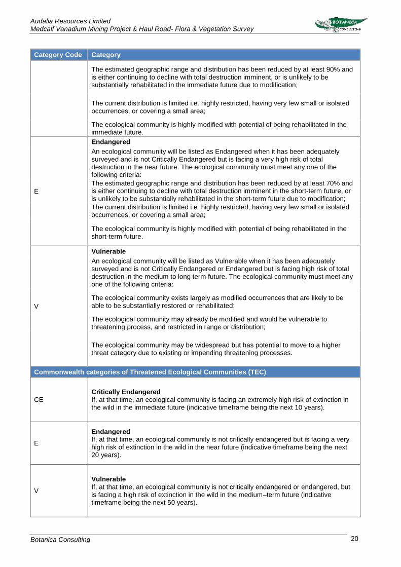
Audalia Resources Limited Medcalf Vanadium Mining Project & Haul Road- Flora & Vegetation Survey
Botanica Consulting 20
Category Code Category
The estimated geographic range and distribution has been reduced by at least 90% and is either continuing to decline with total destruction imminent, or is unlikely to be substantially rehabilitated in the immediate future due to modification;
The current distribution is limited i.e. highly restricted, having very few small or isolated occurrences, or covering a small area;
The ecological community is highly modified with potential of being rehabilitated in the immediate future.
E
Endangered
An ecological community will be listed as Endangered when it has been adequately surveyed and is not Critically Endangered but is facing a very high risk of total destruction in the near future. The ecological community must meet any one of the following criteria:
The estimated geographic range and distribution has been reduced by at least 70% and is either continuing to decline with total destruction imminent in the short-term future, or is unlikely to be substantially rehabilitated in the short-term future due to modification;
The current distribution is limited i.e. highly restricted, having very few small or isolated occurrences, or covering a small area;
The ecological community is highly modified with potential of being rehabilitated in the short-term future.
V
Vulnerable
An ecological community will be listed as Vulnerable when it has been adequately surveyed and is not Critically Endangered or Endangered but is facing high risk of total destruction in the medium to long term future. The ecological community must meet any one of the following criteria:
The ecological community exists largely as modified occurrences that are likely to be able to be substantially restored or rehabilitated;
The ecological community may already be modified and would be vulnerable to threatening process, and restricted in range or distribution;
The ecological community may be widespread but has potential to move to a higher threat category due to existing or impending threatening processes.
Commonwealth categories of Threatened Ecological Communities (TEC)
CE Critically Endangered If, at that time, an ecological community is facing an extremely high risk of extinction in the wild in the immediate future (indicative timeframe being the next 10 years).
E
Endangered If, at that time, an ecological community is not critically endangered but is facing a very high risk of extinction in the wild in the near future (indicative timeframe being the next 20 years).
V
Vulnerable If, at that time, an ecological community is not critically endangered or endangered, but is facing a high risk of extinction in the wild in the medium–term future (indicative timeframe being the next 50 years).

Audalia Resources Limited Medcalf Vanadium Mining Project & Haul Road- Flora & Vegetation Survey
Botanica Consulting 21
Category Code Category
Priority Ecological Communities (PEC)
P1
Poorly-known ecological communities
Ecological communities with apparently few, small occurrences, all or most not actively managed for conservation (e.g. within agricultural or pastoral lands, urban areas, active mineral leases) and for which current threats exist.
P2
Poorly-known ecological communities
Communities that are known from few small occurrences, all or most of which are actively managed for conservation (e.g. within national parks, conservation parks, nature reserves, State forest, un-allocated Crown land, water reserves, etc.) and not under imminent threat of destruction or degradation.
P3
Poorly known ecological communities
Communities that are known from several to many occurrences, a significant number or area of which are not under threat of habitat destruction or degradation or:
Communities known from a few widespread occurrences, which are either large or within significant remaining areas of habitat in which other occurrences may occur, much of it not under imminent threat, or;
Communities made up of large, and/or widespread occurrences, that may or not be represented in the reserve system, but are under threat of modification across much of their range from processes such as grazing and inappropriate fire regimes.
P4 Ecological communities that are adequately known, rare but not threatened or meet criteria for near threatened, or that have been recently removed from the threatened list. These communities require regular monitoring.
P5
Conservation Dependent ecological communities
Ecological communities that are not threatened but are subject to a specific conservation program, the cessation of which would result in the community becoming threatened within five years.
3.1.1 Groundwater Dependent Ecosystems
A search of the BoM Atlas of Groundwater Dependent Ecosystems database (BoM, 2017b) was
conducted to assess the potential for Groundwater Dependent Ecosystems (GDE) to occur within the
survey area. A GDE refers to ecosystems that rely on groundwater for some or all of their water
requirements (Geoscience Australia, 2017). According to the database, there are two potential GDE
classes:
1. Aquatic ecosystems that rely on the surface expression of groundwater–this includes surface
water ecosystems which may have a groundwater component, such as rivers, wetlands and
springs.
2. Terrestrial ecosystems that rely on the subsurface presence of groundwater–this includes all
vegetation ecosystems
A low potential for groundwater interaction means that ecosystems ‘are relatively unlikely to be
interacting with groundwater. This includes ecosystems that are not interacting with groundwater’
(Australian Government, 2012). High potential for groundwater interaction means that ‘there is a
strong possibility that ecosystems are interacting with groundwater’ (Australian Government, 2012).

Audalia Resources Limited Medcalf Vanadium Mining Project & Haul Road- Flora & Vegetation Survey
Botanica Consulting 22
GDE Potential categories specified in the database are based on the physical landscape and
ecosystem characteristics as specified by the following rules (Australian Government, 2012):
Rule 1: Vegetation that demonstrates an evapotranspiration that is higher than rainfall is more likely
to be using groundwater.
Rule 2: Vegetation that intersects with a spring is likely to be using groundwater.
Rule 3: Vegetation is more likely to be using groundwater in areas where the watertable is shallow.
Rule 4: Vegetation growing in areas where water stored in the unsaturated zone is limited, is more
likely to be using groundwater.
Rule 5: Certain vegetation communities are more likely to access groundwater than others.
The GDE potential assessment does not convey the confidence of the prediction, or the reliability of
the GDE potential result. This is conveyed using the ‘Lines of Evidence’ attribute which indicates the
amount of evidence (i.e. number of rules listed above that could be applied) used in determining the
GDE potential for each ecosystem. Details on the ‘Lines of Evidence’ are not available on the
database.
Results of the GDE assessment are provided in Section 4.1.3.

Audalia Resources Limited Medcalf Vanadium Mining Project & Haul Road- Flora & Vegetation Survey
Botanica Consulting 23
Field Assessment
The inaugural detailed flora and vegetation survey of the MVM Project was conducted in spring 2013; 62
quadrats were established and re-surveyed in autumn 2013. In spring 2014, the MVM Project area was
expanded with a further 30 quadrats established. These quadrats were re-surveyed in autumn 2015. A
detailed flora and vegetation survey of the proposed haul road was conducted on the 19th to the 23rd March
2017, with 35 quadrats established. These quadrats we re-surveyed from the 8th to 10th September 2017.
A total of 127 quadrats were established within the 18,770 ha survey area (MVM Project and haul road
inclusive).
Prior to the commencement of field work, aerial photography was inspected and obvious differences in
the vegetation assemblages were identified. The different vegetation communities identified were then
inspected during the field survey to assess their validity. A handheld GPS unit was used to record the
coordinates of the boundaries between existing vegetation communities. At each sample point, the
following information was recorded:
• GPS location;
• Photograph of vegetation;
• Dominant taxa for each stratum;
• All vascular taxa (including annual taxa);
• Landform classification;
• Vegetation condition rating;
• Collection and documentation of unknown plant specimens; and
• GPS location, photograph and collection of flora of conservation significance if encountered.
Unknown specimens collected during the survey were identified with the aid of samples housed at the BC
Herbarium and WAHERB. Floristic communities were classified in accordance with the NVIS Floristic
Community Type classification. The survey area was traversed by three people via 4WD, all-terrain vehicle
and on foot (Figure 9).
3.2.1 Sampling Quadrats
One hundred and twenty-seven 20m x 20m quadrats were established within the survey area (Figure 9).
The objective was to have at least three quadrats per vegetation type to capture the floristic variations
within the survey area. Where a community was insufficiently large to accommodate three quadrats, the
maximum number of quadrats that would fit within that specific community was established. The quadrats
were established by inserting metal pickets in each corner, and measuring the length of the resultant
boundaries to verify the quadrats were 20m x 20m (square quadrats).
Following their establishment and boundary verification, the location of each quadrat was recorded by
GPS (Appendix 5) photographed (Appendix 9) and all vascular plants within the quadrat were recorded
(Appendix 8). This included recording of dominant taxa from the upper, middle and lower stratum, and
sampling of all unknown taxa. Unknown taxa were identified using BC’s own reference herbarium and
relevant taxonomical keys or by a taxonomic consultant. Data on level of disturbance, presence of coarse
fragments on surface, topographical position, elevation, aspect, percentage litter, percentage bare
ground, percentage surface rock (bedrock and surface deposits), soil types (colour, profile, field texture
and surface type), and vegetation structure were collected from each quadrat (Appendix 8). Methods of
recording data from these quadrats largely follow those outlined in CSIRO’s Australian Soil and Land
Survey Field Handbook (McDonald et al. 1998) and in accordance with current DPaW/EPA Guidelines
(2016).

Audalia Resources Limited Medcalf Vanadium Mining Project & Haul Road- Flora & Vegetation Survey
Botanica Consulting 24
Figure 9: Survey area boundary and GPS tracks traversed throughout the survey area

Audalia Resources Limited Medcalf Vanadium Mining Project & Haul Road- Flora & Vegetation Survey
Botanica Consulting 25
3.2.2 Personnel involved
Jim Williams - Environmental Consultant/ Director (Diploma of Horticulture)
Andrea Williams - Environmental Consultant (BSc Hons Mineral Resources Management)
Lauren Pick - Environmental Consultant (Bachelor of Science-Conservation Biology)
Patrick Harton - Environmental Consultant (Bachelor of Environmental Science)
Matthew Newlands - Environmental Technician
Emma Williams - Environmental Technician
Alana Butler - Environmental Technician
Frank Obbens - Taxonomical Consultant
Mike Hislop - WA Herbarium Taxonomic Consultant
3.2.3 Scientific licences
Table 5: Scientific Licences of Botanica Staff coordinating the survey
Licensed staff Permit Number Valid Until
Jim Williams
SL011001 SL011451
SL011826
SL012116
21-05-15 21-05-16 21-05-17 21-05-18
Andrea Williams
SL011002
SL011450
SL011824
SL012115
21-05-15 21-05-16 21-05-17 21-05-18
Lauren Pick
SL011000
SL011449
SL011825
SL012117
21-05-15 21-05-16 21-05-17 21-05-18
Pat Harton SL011003 SL011452
21-05-15 21-05-16
Data Analysis Tools
Once the survey was completed the data obtained was analysed to generate a vegetation map
(Appendix 2). The statistical program PATN was used to assess species composition of the quadrats
(Appendix 7).
3.3.1 PATN Analysis
The PATN software package was used to assess the similarities/ dissimilarities between quadrats
based on presence/ absence of species. Annual taxa were removed from the data prior to analysis
(total of six annual taxa). Species reconciliation eliminated those sterile taxa that could not be fully
identified from the analysis (five taxa), and reconciled subsp. and/or variant taxa. Singleton taxa were
excluded from the analysis (79 taxa).
The analysis produced a quantitative estimate of the relationship between species composition of
each quadrat. The classifications were based upon a Bray-Curtis association matrix using a flexible
Unweighted Pair Group Arithmetic Mean (UPGMA) method (with a beta value of -0.1) which
standardises the data enabling the analysis to be completed. Semi-strong hybrid (SSH) ordination of

Audalia Resources Limited Medcalf Vanadium Mining Project & Haul Road- Flora & Vegetation Survey
Botanica Consulting 26
the quadrat is then undertaken to show spatial relationships between groups and to elucidate possible
environmental correlates with the classification.
The analysis also produced a stress value which is a measure of the ‘strength’ of the analysis (i.e.
how well the quadrats are grouped together into the appropriate floristic groups). The lower the stress
value the greater the strength of the analysis with a value of less than 0.3 showing that the analysis
appropriately grouped quadrats. A stress value greater than 0.3 suggests that the analysis was
unable to group quadrats appropriately due to extraneous variables (i.e. other factors influencing
differences in floristic groups other than species composition e.g. fire, clearing disturbance etc.).
3.3.2 EstimateS
EstimateS software was used to estimate species richness present using the Chao2 richness
estimator. For any number of samples, the estimator uses the existing pattern of species
accumulation to estimate the true number of species at a site. The estimators tend to under-estimate
species number when sample size is small, hence the estimated number of true species can be seen
to increase with sample size. This software was also used to compute Coleman rarefaction curves
estimates which were used to calculate species accumulation curves.
Flora survey limitations and constraints
It is important to note that flora surveys will entail limitations notwithstanding careful planning and
design. Potential limitations are listed in Table 6.
Table 6: Limitations and constraints associated with the flora and vegetation survey
Variable Potential Impact
on Survey Details
Access problems Not a constraint Access tracks within the survey area was limited, however the area was sufficiently covered through the use of 4WD, all-terrain vehicle and on foot.
Competency/ Experience
Not a constraint
The BC personnel that conducted the survey were regarded as suitably qualified and experienced. Coordinating Botanist: Jim Williams Field Staff: Jim Williams, Andrea Williams, Lauren Pick, Pat Harton, Matthew Newlands, Alana Butler, Emma Williams Data Interpretation: Jim Williams, Andrea Williams & Lauren Pick
Timing of survey, weather & season
Not a constraint
Survey work has been conducted over multiple years and different seasons in accordance with Technical guidelines for flora and vegetation surveys. Surveys were conducted during optimum time when a large number of annual species were present and many species were in flower. Supplementary surveys were also conducted in dry periods as recommended by EPA and additional wet periods.
Area disturbance Minor constraint The survey area has been subject to disturbance from fire over multiple years.
Survey Effort/ Extent Not a constraint
Survey intensity was high with a quadrat based detailed survey conducted. Prior to the quadrats being established a reconnaissance of the survey area was conducted in order to identify vegetation communities and any Flora of Conservation Significance.

Audalia Resources Limited Medcalf Vanadium Mining Project & Haul Road- Flora & Vegetation Survey
Botanica Consulting 27
Variable Potential Impact
on Survey Details
Availability of contextual
information at a regional and local
scale
Not a constraint
Threatened flora database searches provided by the DBCA were used to identify any potential locations of Threatened/Priority Flora species. BoM, DWER, DPIRD, DBCA and DotEE databases were reviewed to obtain appropriate regional desktop information on the biophysical environment of the local region. Environmental assessments within the local region have been limited however BC was able to obtain information about the area from previous flora assessments conducted within the Coolgardie region and reconnaissance surveys conducted by BC which provided context on the local environment.
Data Analysis Minor constraint
BC staff conducting the PATN analyses are not statistical analysts and have basic statistics training. These analyses are able to provide basic information on the relationships between vegetation communities.
Completeness Minor constraint
In the opinion of BC, the survey area was covered sufficiently in order to identify vegetation assemblages. Few of the plants during the survey were in flower and there were very few annual species present. It is estimated that approximately 85% of the flora within the survey area were able to be fully identified. The vegetation types for this study were based on visual descriptions of locations in the field. The distribution of these vegetation communities outside the study area is not known, however vegetation types identified were categorised via comparison to vegetation distributions throughout WA specified in the NVIS Major Vegetation Groups (DotEE, 2017b).
4 Results
Desktop Assessment
4.1.1 Literature Review
Flora and vegetation surveys, assessments and reviews have been undertaken in nearby areas in
the past, though not all are publicly available and could not be referenced. The most significant of
those available have been used as the primary reference material for the current vegetation
assessment (Table 7).

Audalia Resources Limited Medcalf Vanadium Mining Project & Haul Road- Flora & Vegetation Survey
Botanica Consulting 28
Table 7: Previous Flora and Vegetation Surveys within the surrounding area
Survey/ Author/ Year Vegetation/Landforms Flora of Conservation
Significance
How R.A. et al (1998)
Seven broad landforms: 1. Breakaway; 2. Granite Exposure; 3. Hill: Granite & Banded Ironstone Formation (BIF); 4. Salt Lake Features: Saline flats, well-drained flats; 5. Sandplains; 6. Undulating Plain; and 7. Broad Valley.
Two Threatened Flora: 1. Banksia sphaerocarpa var.
dolichostyla; and 2. Drummondita hassellii. Drummondita hassellii is no longer listed as Threatened Flora.
Brearley, Dunlop and Osborne (1998)
Nine vegetation communities comprised of Tree Mallee (Eucalyptus eremophila), Eucalypt Woodlands (E. tenuis, E. flocktoniae, E. longicornis and E. dundasii) and Cratystylis conocephala Scrub.
Two Threatened Flora: 1. Leucopogon breviflorus; and 2. Eucalyptus georgei subsp.
georgei. Neither of these species are currently listed as Threatened Flora.
Gibson and Lyons (1998)
Six broad communities which included Eucalypt Woodlands on laterite rises (E. rhomboidea/E.
eremophila and E. livida), Eucalypt Woodlands on undulating plains/saline depressions (E. tenuis,
E. flocktoniae, E. salmonophloia, E. longicornis and E. dundasii), Acacia duriuscula, Allocasuarina
globosa, Eucalyptus georgei subsp. georgei and Eucalyptus oleosa on greenstone ridges.
One Threatened Flora: Allocasuarina
globosa.
Four Priority Flora:
1. Acacia truculenta (P3)
2. Eucalyptus cerasiformis (P4)
3. Eucalyptus georgei subsp. georgei
(P4); and
4. Eucalyptus rhomboidea (P4)
Paul Armstrong and Associates (2012)
Nine vegetation communities in various stages of regrowth including recovering Eucalyptus salmonophloia Woodland, Recovering E. eremophila Woodland, Recovering Eucalyptus Woodland 1 and 2 (juveniles), Recovering Eucalyptus Woodland 2 (Eucalyptus spp. sterile), Recovering Mallee 1 (E. rhomboidea/ E. eremophila) Recovering Mallee 2 (Eucalyptus spp. sterile), Recovering Dwarf Scrub (Melaleuca uncinata and/or Allocasuarina campestris), Recovering Low Heath (Lepidosperma sanguinolentum) and Recovering Lateritic Ridge (Eucalyptus eremophila, Eucalyptus calycogona and patches of Eucalyptus rhomboidea).
One Threatened Flora: Marianthus
aquilonaris.
Four Priority Flora:
1. Eucalyptus rhomboidea (P4);
2. Hakea pendens (P3);
3. Stenanthemum bremerense (P3);
and
4. Teucrium sp. dwarf (R. Davis 8813)
(P1).
BC (2013) N/A One Threatened Flora: Marianthus
aquilonaris.

Audalia Resources Limited Medcalf Vanadium Mining Project & Haul Road- Flora & Vegetation Survey
Botanica Consulting 29
Survey/ Author/ Year Vegetation/Landforms Flora of Conservation
Significance Four Priority Flora:
1. Eucalyptus rhomboidea (P4);
2. Hakea pendens (P3);
3. Stenanthemum bremerense (P3);
and
4. Teucrium sp. dwarf (R. Davis 8813)
(P1).
BC (2015)
Ten vegetation communities were identified within the survey area:
1. Burnt open tree mallee of Eucalyptus livida over open low scrub of Hakea pendens (P3) and
open dwarf scrub of Goodia medicaginea;
2. Burnt open low woodland of Eucalyptus salmonophloia over dwarf scrub of Melaleuca sp.
(Sterile) and open low grass of Austrostipa variabilis;
3. Burnt forest of Eucalyptus urna over low scrub Melaleuca pauperiflora subsp. pauperiflora
and open dwarf scrub of Trymalium myrtillus subsp. myrtillus;
4. Regrowth dwarf scrub of Anthocercis anisantha subsp. anisantha/Acacia
poliochroa/Alyogyne hakeifolia/Dodonaea stenozyga;
5. Regrowth of dense low forest of Eucalyptus sp. (Sterile).
6. Regrowth open low woodland of Codonocarpus cotinifolius over low scrub of Acacia sp.
(Sterile)/ Melaleuca hamata and open low grass of Schoenus brevisetis;
7. Regrowth open shrub mallee of Eucalyptus sp. (Sterile) over open low scrub of Acacia
acanthoclada/ Grevillea huegelii and hummock grass of Triodia scariosa;
8. Very open shrub mallee of Eucalyptus sp. (Sterile) over low scrub of Acacia assimilis subsp.
assimilis/ A. yorkrakinensis/ Duboisia hopwoodii and open low grass of Schoenus
breviculmis;
9. Open shrub mallee of Eucalyptus livida over low scrub of Allocasuarina campestris/ Hakea
francisiana/ Melaleuca hamata and open low sedges of Lepidosperma sanguinolentum; and
10. Low woodland of Eucalyptus urna over low heath of Melaleuca pauperiflora subsp.
pauperiflora and dwarf scrub of Acacia erinacea/ Acacia poliochroa.
One Threatened Flora: Marianthus
aquilonaris.
Six Priority Flora:
1. Acacia mutabilis subsp. stipulifera
(P3);
2. Eucalyptus rhomboidea (P4);
3. Hakea pendens (P3);
4. Microcybe sp. Windy Hill (G.F. Craig
6583) (P3)
5. Stenanthemum bremerense (P4);
and
6. Teucrium sp. dwarf (R. Davis 8813)
(P1).
Audalia Resources Limited Medcalf Vanadium Mining Project &Haul Road-Flora & Vegetation Survey
Botanica Consulting 30
4.1.2 Flora of Conservation Significance
The results of the combined search of the DBCA Flora of Conservation Significance databases,
Naturemap search and DotEE protected matters search recorded a total of 124 Priority Flora and 11
Threatened Flora taxa within the local region. These taxa were assessed and ranked for their
likelihood of occurrence within the survey area (Table 8). Eight taxa were recorded on the database
as occurring within the survey area (listed as ‘known to occur’ in Table 8). The rankings and criteria
used were:
• Unlikely: Area is outside of the currently documented distribution for the species/no suitable
habitat (type, quality and extent) was identified as being present during field/desktop
assessments.
• Possible: Area is within the known distribution of the species in question and habitat of at least
marginal quality was identified as being present during field/desktop assessments, supported
in some cases by recent records being documented from within or near the area.
• Known to Occur: The species in question was positively identified as being present during field
assessments/ DBCA database record.
Table 8: Likelihood of occurrence for Flora of Conservation Significance within the survey area
Taxon Conservation
Code Description (WAHERB, 2017)
Likelihood of Occurrence
Banksia sphaerocarpa var. dolichostyla
T Lignotuberous shrub, 1-3 m high. Fl. yellow-
orange, Mar to May. Lateritic gravel, grey sand.
Possible
Boronia revoluta T Shrub, 0.4-0.8 m high. Fl. pink, Jul to Aug.
Stony sandy loam or sand. Plains, hillsides & summits.
Unlikely
Conostylis lepidospermoides T Rhizomatous, tufted perennial, grass-like or
herb, 0.17-0.36 m high. Fl. yellow, Sep to Oct. Grey or yellow-brown sand over laterite.
Unlikely
Daviesia microcarpa T Sprawling, tangled shrub, to 0.4 m high, ca 1 m wide. Fl. orange & red, Sep. Weathered
gravel. Unlikely
Drummondita longifolia T
Shrub, 0.3-1 m high, well-spaced slender leaves, resinous sepals and branchlets. Fl. red/white/pink, Apr to May or Aug or Oct.
Granitic loam, skeletal sandy loam.
Unlikely
Eremophila denticulata subsp. trisulcata
T Compact shrub, to 2 m high. Fl. pink-orange-
red, May or Sep. Sand or loam over limestone. Unlikely
Eremophila virens T Erect, slender shrub, 1.5-5 m high. Fl. green,
Aug to Oct. Red/brown sand. Granite hillsides. Unlikely
Eucalyptus platydisca T Mallee, 2-4 m high, bark smooth. Granitic
soils, clay. Stony hills. Unlikely
Marianthus aquilonaris T No description available Known to occur
Ricinocarpos trichophorus T Erect, openly branching shrub, 0.3-1 m high.
Fl. white, May or Aug to Sep. Sandy clay, loam. Breakaways, among sandstone rocks.
Unlikely
Roycea pycnophylloides T Perennial, herb, forming densely branched,
silvery mats to 1 m wide. Fl. Sep. Sandy soils, clay. Saline flats.
Possible

Audalia Resources Limited Medcalf Vanadium Mining Project &Haul Road-Flora & Vegetation Survey
Botanica Consulting 31
Taxon Conservation
Code Description (WAHERB, 2017)
Likelihood of Occurrence
Acacia diaphana P1 Bushy shrub, 1.5-3 m high. Fl. yellow. Clay,
sandy loam. Wet or waterlogged depressions. Unlikely
Acacia dorsenna P1 Dense, domed shrub, 1-1.6 m high, to 3 m wide. Fl. yellow, Aug to Sep. Rocky sandy
loam or clay loam. Low rocky hills. Possible
Acacia hystrix subsp. continua P1 Rounded or obconic shrub, 0.3-1 m high. Fl.
yellow. Clay loam. Known to occur
Aotus prosacris P1 Prostrate shrub, to 0.3 m high. Fl.
yellow/orange, Sep. White sand, cream sand over laterite. Flats.
Unlikely
Baeckea sp. Exclamation Lake (M.E. Trudgen 1524)
P1 Shrub, to 0.6 m high, bark grey with parallel
longitudinal fissures. Red-brown loam, quartz, granite. Small depressions.
Unlikely
Bossiaea arcuata P1
Erect, divaricately branched superficially leafless shrub, to 1.5 m high. Fl. yellow& red, Mar to Apr or Sep to Oct. Deep white sand.
Perimeter of salt lakes.
Possible
Bossiaea aurantiaca P1
Compact, rounded or spreading, spinescent shrub, to 1.5 m high. Fl. red/yellow, Sep to Oct. Red sand, red clay loam. Low-lying,
winter-damp sites.
Unlikely
Bossiaea saxosa P1 Erect, intricately-branched shrub, to 1.5 m
high. Fl. yellow-cream, Sep to Oct. Stony, red soil. Woodlands.
Possible
Cryptandra exserta P1 Shrub, to c. 0.5 m high. Sandy soil with laterite gravel, red sand over clay. Gentle mid-slopes,
plains. Possible
Cyathostemon sp. Esperance (A. Fairall 2431)
P1 No description available Possible
Cyathostemon sp. Red Roo Rock (G.F. Craig 6896)
P1 No description available Possible
Eremophila hamulata P1 No description available Possible
Eremophila lucida P1 Shrub, to 1.8 m high. Fl. cream-yellow, Oct.
Clay loam, sandy loam. Adjacent to samphire flats & granite outcrops.
Possible
Eucalyptus jimberlanica P1 Mallee or tree, 4-10 m high, bark smooth.
Loam. Valley edges. Unlikely
Eucalyptus misella P1 (Mallee), 1-3 m high, bark smooth. Fl. cream, Nov. White, yellow or grey sand. Low-lying
sandplains. Possible
Eucalyptus websteriana subsp. norsemanica
P1 Spreading mallee, to 3 m high, bark 'minni-ritchi'. Fl. yellow, Sep to Nov. Rocky rises.
Unlikely
Eutaxia andocada P1 Erect shrub (with sparse ascending branches),
0.2-0.4 m high. White sand or brown sandy-clay over granite.
Possible
Gastrolobium hians P1 Erect shrub (more or less glaucous), to 1.7 m
high. Fl. Orange & yellow & purple, Sep. Sandy loam or clay soils. Sandplains.
Possible
Gastrolobium involutum P1 Erect, spreading shrub, to 3 m high. Fl.
orange, Jun to Nov. Sandy soils over granite. Base of rock outcrops, drainage channels.
Possible
Grevillea phillipsiana P1 Prickly shrub, 0.8-1.5 m high. Fl. red/red & orange, Jul to Sep. Red sand, stony loam.
Granite hills. Possible

Audalia Resources Limited Medcalf Vanadium Mining Project &Haul Road-Flora & Vegetation Survey
Botanica Consulting 32
Taxon Conservation
Code Description (WAHERB, 2017)
Likelihood of Occurrence
Hibbertia carinata P1 Shrub, to 0.4 m high. Fl. yellow, Aug to Sep. Well-drained gravelly sand, yellow sand with
gravel. Unlikely
Leucopogon rugulosus P1 No description available Possible
Leucopogon sp. Bonnie Hill (K.R. Newbey 9831)
P1 Erect shrub, 0.2-0.5 m high. Fl. white, May.
White/grey sand. Undulating sandplains. Possible
Leucopogon sp. Lake Tay (W.R. Archer 2104138)
P1 No description available Possible
Leucopogon sp. Yellowdine (M. Hislop & F. Hort MH 3194)
P1 No description available Possible
Melaleuca agathosmoides P1 Spreading shrub, 0.5-2 m high. Fl. white-
cream, Sep to Oct. Gravelly red clay loam. Hills.
Possible
Microcybe pauciflora subsp. grandis
P1 Shrub, to 0.6 m high, leaves 14-16 mm long, petals sparsely stellate-hairy. Fl. yellow. Clay-
loam or loam. Possible
Micromyrtus papillosa P1
Erect or low, spreading shrub, 0.4-1.2 m high. Fl. white, Apr or Aug to Oct. Sandy or clay
soils, ironstone, granite. Rocky sites, outcrops, on hills from base to summit.
Possible
Olearia newbeyi P1 No description available Unlikely
Persoonia baeckeoides P1
Erect, spreading shrub, 0.5-1.5 m high. Fl. green-yellow, Nov to Dec. Gravelly sand,
laterite, sandy clay over sandstone. Undulating plains.
Unlikely
Philotheca apiculata P1 Erect shrub, 0.5-1.5 m high. Fl. white-pink,
Aug to Nov. Stony clay loam. Rocky outcrops, hillsides.
Possible
Scaevola tortuosa P1 Ascending perennial, herb, 0.1-0.2 m high. Fl. blue-purple/pink, Oct. Sandy clay. Margins of
salt lakes. Possible
Stackhousia stratfordiae P1 No description available Unlikely
Teucrium sp. dwarf (R. Davis 8813)
P1 Compact, dwarf shrub, 0.1 m high, to 0.1 m
wide. Fl. white, Apr. Hills, road verges. Known to occur
Verticordia sieberi var. pachyphylla
P1 Shrub, 0.25-0.6 m high. Fl. pink-cream-white,
Oct or Jan. Sand. Edges of salt lakes. Possible
Verticordia sp. Dundas (C.A. Gardner 2848)
P1 No description available Possible
Acacia amyctica P2 Erect, bushy, pungent shrub, 0.7-1.5 m high. Fl. yellow, Aug to Sep. Sandy loam or clay.
Flats. Possible
Acacia asepala P2 Diffuse, much-branched shrub, 0.5-1.5 m high.
Fl. yellow, Aug. Red-brown sandy loam. Undulating plains, along drainage lines.
Unlikely
Acacia kerryana P2
Low, spreading, domed shrub, 0.3-1 m high. Fl. yellow, Oct to Dec or Jan to Feb. Granitic
loamy sand, stony clayey loam or clayey sand. Low stony ridges, undulating plains.
Unlikely
Angianthus newbeyi P2 Erect or ascending annual, herb, 0.03-0.05 m
high. Fl. yellow, Sep. Sub-saline sand. On slopes into salt lakes.
Possible
Aotus sp. Dundas (M.A. Burgman 2835)
P2 No description available Known to occur
Baeckea sp. Fitzgerald Peaks (P.J. Poli 53)
P2 No description available Possible

Audalia Resources Limited Medcalf Vanadium Mining Project &Haul Road-Flora & Vegetation Survey
Botanica Consulting 33
Taxon Conservation
Code Description (WAHERB, 2017)
Likelihood of Occurrence
Baeckea sp. Mt Gibbs (G.F. Craig 7031)
P2 No description available Possible
Boronia acanthoclada P2 Spreading shrub, ca 0.3 m high, leaves
alternate, branchlets spinescent. Fl. white, Sep. Sand over gravel.
Possible
Boronia corynophylla P2
Spreading, densely branched shrub, ca 0.3 m high, leaves terete to clavate, cuticle
exfoliating to form a grey scurfy covering. Fl. red. Well drained clayey sand. Eucalyptus
salmonophloia open woodland.
Possible
Bossiaea simulata P2
Compact shrub, to 1 m high. Fl. yellow, Oct to Dec. Sandy loam. Well-drained sites, raised
sites in salt lakes, sand dunes above samphire zone.
Unlikely
Conospermum sigmoideum P2 Erect shrub, 0.2-0.5 m high. Fl. blue, Aug to
Sep. Yellow sand. Unlikely
Cyathostemon sp. Jyndabinbin Rocks (K.R. Newbey 7689)
P2 No description available Possible
Cyathostemon sp. Lake King (M.E. & M.E. Trudgen 1462)
P2 Erect shrub, to 0.8 m high. Fl. pink/white, Oct.
Yellow-brown sand or sandy clay, gravel, laterite. Plains.
Possible
Darwinia sp. Peak Charles (A.S. George 10627)
P2 Shrub, ca 1.7 m high. Fl. white-red, Apr.
Granitic loam. Unlikely
Eucalyptus fraseri subsp. melanobasis
P2 Tree, 8-15 m high, bark rough, dark grey-black
at the base for 1-2 m. Fl. white, Jan to Mar. Red calcareous loam.
Possible
Gastrolobium acrocaroli P2
Erect, open shrub, to 2.7 m high. Fl. orange/yellow, Apr or Sep to Nov. Skeletal
soils over granite. Rock outcrops, open shrubland or dense heath.
Unlikely
Goodenia scapigera subsp. graniticola
P2
Herb, 0.7-1.5 m high, leaves fasciculate, linear, entire. Fl. white, Sep to Oct. Skeletal loamy sand over granite. Hillsides & rocky
outcrops.
Possible
Hibbertia charlesii P2 Shrub, to 1 m high. Fl. yellow, Oct to Nov.
Skeletal loamy sand, granite. Exposed mountain slopes.
Unlikely
Lepidobolus spiralis P2 Rhizomatous, clumped or spreading perennial, herb (sedge-like), ca 0.5 m high, to 2 m wide. Fl. May to Sep. Yellow sand. Dry kwongan.
Unlikely
Leucopogon sp. Varley (M. Hislop 3659)
P2 No description available Possible
Logania nanophylla P2 Low spreading shrub, 0.1-0.25 m high, to 0.5 m wide. Fl. white, Aug. White sand, pebbly
calcareous sandy clay. Sand dunes. Unlikely
Newcastelia insignis P2 Much-branched shrub, 0.3-0.9(-1.5) m high. Fl. yellow-white, Sep to Nov. Red or yellow sandy
soils. Unlikely
Olearia laciniifolia P2 Erect, few-stemmed shrub, 0.6-1.2 m high. Fl. blue/purple & white/yellow, May to Sep. White
sand. Around playa lakes. Possible
Opercularia hirsuta P2 Perennial, herb or shrub, 0.2-0.7 m high.
Sandy soils over granite or quartzite. Unlikely
Orianthera exilis P2 No description available Possible

Audalia Resources Limited Medcalf Vanadium Mining Project &Haul Road-Flora & Vegetation Survey
Botanica Consulting 34
Taxon Conservation
Code Description (WAHERB, 2017)
Likelihood of Occurrence
Rinzia rubra P2 Spreading shrub, 0.25-0.7 m high, to 1 m wide. Fl. white, Aug or Nov. Sandy soils. Undulating
plains. Possible
Acacia ancistrophylla var. perarcuata
P3 Rounded or obconic shrub, 0.6-1.6 m high, to 6 m wide. Fl. yellow, Aug to Sep. Red sand,
clay loam, loam. Undulating plains. Possible
Acacia dissona var. indoloria P3 Domed or rounded, dense, pungent shrub, 0.5-2 m high. Fl. yellow, Aug to Sep. Sand,
sandy loam. Undulating plains. Possible
Acacia eremophila var. Numerous-nerved variant
(A.S.George 11924) P3
Dense, spreading shrub, 1-2 m high. Fl. yellow, Sep. Sandy soils. Flats.
Possible
Acacia improcera P3 Spreading, spiny shrub, 0.15-0.4 m high. Fl.
yellow, Aug. Sand, loamy clay, clay. Undulating plains, flats.
Possible
Acacia singula P3 Shrub, 0.35-2 m high. Fl. yellow, Aug to Oct. Gravelly sand over laterite, white or yellow
sand. Rises, hilltops. Unlikely
Acacia truculenta P3 Spreading, straggly, prickly shrub, 0.7-2.2 m high. Fl. yellow, Aug to Sep. Sand or loam.
Possible
Adenanthos gracilipes P3 Erect, lignotuberous shrub, 0.4-1.5 m high. Fl. cream & red & pink, Mar or Aug to Dec. White
sand. Unlikely
Allocasuarina eriochlamys subsp. grossa
P3 Dioecious or monoecious shrub, 1-3 m high,
bracteoles prominently exceeding cone. Stony loam, laterite clay. Granite outcrops.
Possible
Atriplex lindleyi subsp. conduplicata
P3 Monoecious, short-lived annual or perennial,
herb, ca 0.2 m high. Crab hole plains. Unlikely
Baeckea sp. Hatter Hill (K.R. Newbey 3284)
P3
Narrow, open, upright shrub, to 1.3 m high. Fl. pink, Jun to Oct. Yellow-orange coarse sandy
loam with laterite gravel, red-brown sandy loam with quartz pebbles. Undulating plains.
Possible
Banksia lullfitzii P3 Lignotuberous shrub, 0.8-2 m high. Fl. yellow-
orange/orange-brown, Mar to May. Yellow sand. Sandplains.
Possible
Banksia rufa subsp. flavescens P3 Prostrate, lignotuberous shrub, to 0.45 m high.
Fl. cream-yellow, Jul to Aug. Sandy loam or sand with gravel.
Possible
Banksia viscida P3 Densely branched, non-lignotuberous shrub, 0.4-1 m high. Fl. yellow-orange, Jul to Oct.
Gravelly soils. Lateritic rises. Possible
Beyeria sulcata var. truncata P3 No description available Possible
Bossiaea flexuosa P3 Compact shrub, to 0.6 m high. Fl. yellow-
orange-red-brown, Sep to Nov. Deep sandy soil.
Possible
Chrysocephalum apiculatum subsp. norsemanense
P3 No description available Possible
Comesperma calcicola P3
Soft perennial, herb, to 0.3 m high. Fl. pink, Oct to Dec or Jan. Calcareous or semi-saline clay loams, limestone. Areas around saline
water.
Possible
Cryptandra crispula P3 Non-spinescent shrub, 0.25-0.9 m high. Brown
sandy clay, yellow loamy sand, red soil, pebbles. Dune ridges, hills, near salt lakes.
Unlikely

Audalia Resources Limited Medcalf Vanadium Mining Project &Haul Road-Flora & Vegetation Survey
Botanica Consulting 35
Taxon Conservation
Code Description (WAHERB, 2017)
Likelihood of Occurrence
Cyathostemon sp. Salmon Gums (B. Archer 769)
P3
Erect, compact shrub, to 3 m high. Fl. white, May or Oct to Nov. Orange sand, white sand or sandy clay over granite, light brown clay
with gypsum, saline soils. Flats, dry river beds, near claypans.
Unlikely
Dampiera sericantha P3
Erect, slender perennial, herb, 0.05-0.3(-0.6) m high, stems with blunt angles. Fl. blue, May or Aug to Dec. Sand, sometimes with gravel.
Plains.
Possible
Daviesia newbeyi P3
Bushy, multi-stemmed, broom-like shrub, 0.25-1.5 m high. Fl. orange/yellow & red, Aug to
Oct. Sand or sandy clay over granite. Rocky slopes.
Possible
Dielsiodoxa leucantha subsp. leucantha
P3 No description available Possible
Eremophila purpurascens P3 Erect, bushy shrub, 0.3-1.5 m high. Fl. pink &
purple/red, Aug to Oct. Sandy clay, stony loam over greenstone. Granite hills & rocks.
Possible
Eremophila succinea P3 Erect shrub, 1.2-3 m high. Fl. blue-purple, Sep.
Clay, sand over clay. Possible
Eucalyptus brockwayi P3 Tree, 5-20 m high, bark smooth. Fl. white-
cream, Mar to Jun. Gravelly sandy loam. Low rocky hills & slopes.
Possible
Eucalyptus histophylla P3 (Mallee), 2-6 m high, bark smooth. Fl. yellow,
Dec. Sandy loam on granite or laterite. Granite outcrops.
Possible
Eutaxia acanthoclada P3
Compact, mat-forming, prostrate shrub, to 0.3 m high. Fl. yellow/orange/red, Oct to Nov.
Light brown sandy clay, shallow sandy loam, red clay over banded ironstone, gravel. Gently
undulating plains.
Possible
Eutaxia actinophylla P3 Shrub, to 0.5 m high. Fl. yellow/red, Sep to
Oct. Red-brown clay loam, red clay loam over granite, gravel. Small depressions.
Unlikely
Gastrolobium cruciatum P3
Spreading shrub, to 0.5 m high. Fl. Yellow & red, Sep. Sand & clayey sand with gravel,
rocky loams, laterite. Flats, gently undulating areas.
Possible
Goodenia laevis subsp. laevis P3 Erect, woody shrub (subshrub), 0.1-0.25 m
high, largest leaves 15-25 x 1-3 mm, entire. Fl. yellow, Aug to Dec. Sandy loam or laterite.
Possible
Hibbertia pachyphylla P3
Shrub, to 0.5 m high. Fl. yellow, Sep to Nov. White to yellow sand, brown sandy gravel,
gravelly loam, laterite, granite, quartz. Undulating plains, low rises, valley floors.
Unlikely
Leucopogon sp. Ironcaps (N. Gibson & K. Brown 3070)
P3
Slender, open shrub, to 1 m high, to 0.6 m wide. Fl. white, Aug. Skeletal sand, yellow sandy loam, rocky loam, gravel, laterite,
ironstone. Gentle lower slopes, flat uplands, hill tops.
Possible
Melaleuca coccinea P3
Much branched shrub, 1.5-2.6 m high, leaf blade elliptic to ovate, 1.5-2.2 times as long as wide. Fl. red, Sep to Nov or Jan. Sandy loam
over granite. Granite outcrops, sandplain, river valleys.
Unlikely
Melaleuca ochroma P3 No description available Possible

Audalia Resources Limited Medcalf Vanadium Mining Project &Haul Road-Flora & Vegetation Survey
Botanica Consulting 36
Taxon Conservation
Code Description (WAHERB, 2017)
Likelihood of Occurrence
Microcybe sp. Windy Hill (G.F. Craig 6583)
P3 No description available Known to occur
Micromyrtus elobata subsp. scopula
P3 Erect shrub, 0.1-0.4(-1) m high. Deep aeolian sand, grey or white sand, white sandy clay.
Undulating plains, dunes, hill crests. Unlikely
Microseris walteri P3 No description available Possible
Mirbelia densiflora P3
Erect or straggling shrub, 0.2-1 m high. Fl. yellow-orange, Oct or Jan. Stony loam, loamy sand. Small ridges, breakaways, undulating
plains.
Unlikely
Notisia intonsa P3 No description available Possible
Oxymyrrhine plicata P3 No description available Possible
Persoonia cymbifolia P3 Erect, spreading shrub, 0.2-0.6(-1) m high. Fl. yellow, Dec or Jan. Sandy soils. On flats or in
rock crevices. Unlikely
Persoonia scabra P3 Erect, spreading, lignotuberous shrub, 0.3-0.9 m high. Fl. yellow, Nov to Dec or Jan. White
sand or sandy loam. Unlikely
Phlegmatospermum eremaeum P3 Prostrate to spreading annual, herb, 0.02-0.1(-
0.2) m high. Fl. white-cream, Jun or Aug to Oct. Stony loam.
Possible
Pityrodia chrysocalyx P3 Erect, branched shrub, 0.3-0.75(-1) m high. Fl.
white, Aug to Oct. Sandy soils. Possible
Pityrodia scabra subsp. dendrotricha
P3 No description available Possible
Pultenaea daena P3
Dense, prostrate, domed shrub, to 0.07 m high. Fl. yellow, Mar. White to yellow sand or
sandy loam, sandy or loamy clay, gravel, limestone, dolomite, laterite. Gently undulating
plains, adjacent to salt lakes, in disturbed areas.
Possible
Rinzia torquata P3 No description available Possible
Seringia adenogyna P3 No description available Possible
Stylidium pulviniforme P3 Caespitose perennial, herb, 0.01-0.05 m high, forming dense flat-topped cushions. Fl. white,
Sep to Nov. White sand. Winter-wet areas. Known to occur
Stylidium sejunctum P3
Caespitose perennial, herb, 0.25-0.45 m high, Leaves tufted, linear to narrowly oblanceolate, 10-30 cm long, 0.8-4 mm wide, apex acute to
mucronate, margin involute, glabrous to scabrous. Membraneous scale leaves present
at base of mature leaves. Scape glandular throughout. Inflorescence paniculate. Fl.
white/pink-purple, Sep to Nov. Clayey sand or loam, laterite. Outcrops, upper slopes, breakaways. Mallee and Allocasuarina
shrubland.
Possible
Darwinia polycephala P4 Diffuse shrub, 0.1-0.5 m high. Fl. red-purple, Mar or May to Jul or Sep. Sand, clay. Flats,
near salt lakes.
Possible
Eremophila parvifolia subsp. parvifolia
P4
Low, divaricate shrub, 0.15-0.7 m high. Fl. blue-purple, Jun or Sep to Oct or Jan to Feb. Loam, yellow sand, clay, limestone. Plains,
claypans.
Unlikely

Audalia Resources Limited Medcalf Vanadium Mining Project &Haul Road-Flora & Vegetation Survey
Botanica Consulting 37
Taxon Conservation
Code Description (WAHERB, 2017)
Likelihood of Occurrence
Eucalyptus deflexa P4
(Mallee), 1-3 m high, bark smooth. Fl. pink/cream-white, Mar or May to Oct. Clay
loam, sandy loam, white or yellow sand, often with gravel. Flat areas & slight rises.
Possible
Eucalyptus pterocarpa P4
Tree, to 15 m high, bark smooth throughout, becoming ribbony, light grey over salmon
cream. Red-brown sandy loam, yellow-brown silty loam. Creek edges, rocky slopes.
Possible
Eucalyptus rhomboidea P4 Tree, 8-10 m high. Gravelly sand. Slight rises. Known to occur
Eucalyptus rugulata P4
Tree or (mallet), to 12 m high, bark smooth, decorticating in strips, grey-olive oversilvery
grey to pale tan-cream. Fl. yellow-cream, Nov. Orange laterite gravel. Summits, gentle upland
slopes.
Possible
Frankenia glomerata P4 Prostrate shrub. Fl. pink-white, Nov. White
sand. Unlikely
Grevillea aneura P4 Dense, prickly shrub, 0.5-2.8 m high. Fl. red, Jun or Aug to Dec or Jan. Sand, sandy clay,
gravel. Possible
Haegiela tatei P4 Ascending to erect annual, herb, 0.02-0.08(-
0.2) m high. Fl. white-yellow, Aug to Nov. Clay, sandy loam, gypsum. Saline habitats.
Unlikely
Myriophyllum petraeum P4 Aquatic annual, herb, stems 0.15-0.3 m long.
Fl. white, Aug to Dec. Strictly confined to ephemeral rock pools on granite outcrops.
Unlikely
Stenanthemum bremerense P4
Erect or low and spreading shrub, (0.2-)0.3-0.6(-1.4) m high. Orange-brown sandy loam, orange-red gravelly loam, skeletal red loam, laterite, ironstone. Top or sides of outcrops
and breakaways.
Known to occur
Tecticornia entrichoma P4 Decumbent shrub, 0.05-0.3 m high. Clay,
clayey sand. Margins of slightly brackish lakes. Possible
4.1.3 Groundwater Dependence Assessment
Results of the BoM Atlas of Groundwater Dependent Ecosystems (BoM, 2017b) database, indicate
the survey area has potential to include five terrestrial groundwater dependent ecosystems. No
aquatic groundwater dependent ecosystems were identified on the database as potentially occurring
within the survey area. A description of these potential GDEs listed on the database within the survey
area is provided in Table 9 and shown in Figure 10.
Table 9: Groundwater Dependent Ecosystems within the survey area
Ecosystem Description Groundwater Interaction Potential
Medium woodland; redwood (Eucalyptus transcontinentalis) & merrit (E.
flocktoniae) Low potential
Medium woodland; morrel & Dundas blackbutt (E. dundasii) Low potential
Medium woodland; salmon gum Moderate potential
Shrublands; Acacia, Casuarina & Melaleuca thicket Moderate potential
Bare areas; salt lakes High potential

Audalia Resources Limited Medcalf Vanadium Mining Project & Haul Road- Flora & Vegetation Survey
Botanica Consulting 38
Figure 10: Potential for Groundwater Dependent Ecosystems within the survey area3
3 Ecosystem extents shown in the maps do not necessarily show the spatial extent of groundwater use. Rather, the ecosystem polygons should be interpreted as showing the area within which groundwater interaction may be occurring (Australian Government, 2012).
Audalia Resources Limited Medcalf Vanadium Mining Project & Haul Road - Flora & Vegetation Survey
Botanica Consulting 39
4.1.4 Field Assessment
Flora of conservation significance
Flora of conservation significance identified in the desktop assessment as potentially occurring within
the survey area were targeted during the field assessment. One Threatened Flora taxon pursuant to
subsection (2) of section 23F of the WC Act was identified within the survey area; Marianthus
aquilonaris. This taxon is not listed as Threatened under the EPBC Act.
Ten Priority Flora taxa as listed by DBCA were identified within the survey area:
1. Acacia hystrix subsp. continua (P1);
2. Acacia mutabilis subsp. stipulifera (P3);
3. Bossiaea flexuosa (P3);
4. Brachyloma stenolobum (P1);
5. Eucalyptus pterocarpa (P4);
6. Eucalyptus rhomboidea (P4);
7. Hakea pendens (P3);
8. Microcybe sp. Windy Hill (G.F. Craig 6583) (P3);
9. Stenanthemum bremerense (P4); and
10. Teucrium sp. dwarf (R. Davis 8813) (P1).
A map showing the locations of these flora taxa identified within the survey area is provided in Figure
11. GPS coordinates for flora of conservation significance recorded within the survey area are
provided in Appendix 44.
Locations of all flora of conservation significance listed on the DBCA database within the survey area
were searched during the survey, however the following taxa were not identified during the survey:
1. Aotus sp. Dundas (M.A. Burgman 2835)
2. Stylidium pulviniforme
4.2.1 Marianthus aquilonaris (T)
Marianthus aquilonaris is described as an erect, straggly shrub growing up to 1.6 m high with hairy
stems, alternate, elliptic to oblong leaves, a glabrous calyx and a pale blue and white corolla (Plate
1). Flowers appear between September and October. It is found in the Bremer Range, growing on
orange to grey-brown sandy loam, rocky red-orange clay loam, laterite and quartzite, on rock outcrops
and slopes. Habitat critical to the survival of this species includes the area of occupancy of
populations, areas of similar habitat surrounding and linking populations (these providing potential
habitat for population expansion and for pollinators), additional occurrences of similar habitat that may
contain undiscovered populations of the species or be suitable for future translocations, and the local
catchment for the surface and/or groundwater that maintains the habitat of the species (DPaW, 2010).
Marianthus aquilonaris was declared as Threatened under the WC Act 1950 in 2002 and is currently
listed as ‘critically endangered’ under the World Conservation Union (IUCN) criteria due to its extent
of occurrence being less than 100 km² and its area of occupancy being less than 10 km² (DPaW,
4 Location of Threatened Flora not provided in this report due to the sensitive nature of this information

Audalia Resources Limited Medcalf Vanadium Mining Project & Haul Road - Flora & Vegetation Survey
Botanica Consulting 40
2010). This species is however not currently listed as Threatened under the Commonwealth EPBC
Act.
Marianthus aquilonaris is currently known from two populations, including five subpopulations which
occur within the Bremer Range. 1662 locations of this taxon were recorded within the survey area.
All locations have been previously reported to DBCA for their records.
Plate 1: Marianthus aquilonaris (T)

Audalia Resources Limited Medcalf Vanadium Mining Project & Haul Road - Flora & Vegetation Survey
Botanica Consulting 41
4.2.2 Acacia hystrix subsp. continua (P1)
This taxon is described as a rounded or obconic shrub, which grows between 0.3-1 m high (Plate 2).
It produces yellow flowers and occurs on clay loam soil (WAHERB, 2017). A total of four locations of
this taxon have been recorded within the survey area, located approximately 500m east from a DBCA
known location.
Plate 2: Acacia hystrix subsp. continua (P1)

Audalia Resources Limited Medcalf Vanadium Mining Project & Haul Road - Flora & Vegetation Survey
Botanica Consulting 42
4.2.3 Acacia mutabilis subsp. stipulifera (P3)
This taxon was formerly identified as Acacia glaucissima (P3) however has been re-identified as
Acacia mutabilis subsp. stipulifera (P3). This taxon is described as a spreading shrub that grows
between 0.3 to 1m high (Plate 3). It produces yellow flowers and grows in loam or clay, usually in
slightly saline soils (WAHERB, 2017). A total of thirty-seven locations of this taxon have been
recorded by BC within the survey area. Location details for this taxon will be provided to DBCA to
update their records.
Plate 3: Acacia mutabilis subsp. stipulifera (P3)

Audalia Resources Limited Medcalf Vanadium Mining Project & Haul Road - Flora & Vegetation Survey
Botanica Consulting 43
4.2.4 Bossiaea flexuosa (P3)
This taxon is described as a compact shrub, which grows to 0.6m high (Plate 4). It produces yellow-
orange-red-brown flowers from September to November. It occurs on deep sandy soil (WAHERB,
2017). One location of this taxon was recorded by BC within the survey area, which is not a DBCA
known location. Location details for this taxon will be provided to DBCA to update their records.
Plate 4: Bossiaea flexuosa (P3)

Audalia Resources Limited Medcalf Vanadium Mining Project & Haul Road - Flora & Vegetation Survey
Botanica Consulting 44
4.2.5 Brachyloma stenolobum (P1)
This taxon is described as an erect shrub which grows to 1.5 m high and 1.2 m wide (Plate 5). It is
single-stemmed at ground level from a fire-sensitive rootstock. It produces white flowers and narrowly
triangular, adaxially keeled corolla lobes. This taxon grows on yellow sandplain as a component of
heath. Associated species include Allocasuarina spinosissima, Acacia heteroneura, Melaleuca
cordata and M. calyptroides (Hislop & Cranfield, 2014). One location of this taxon was recorded within
the survey area which represents a range extension for this taxon, having previously only been
recorded within the Forrestania region, approximately 100km west of the survey area. Location details
for this taxon will be provided to DBCA to update their records.
Plate 5: Brachyloma stenolobum (P1)
4.2.6 Eucalyptus pterocarpa (P4)
This taxon is described as a tree, to 15 m high, with smooth bark throughout, becoming ribbony, light
grey over salmon cream (Plate 6). It occurs on red-brown sandy loam, yellow-brown silty loam soils
of creek edges and rocky slopes (WAHERB, 2017). One location of this taxon was recorded by BC
within the survey area, which is not a DBCA known location. Location details for this taxon will be
provided to DBCA to update their records.
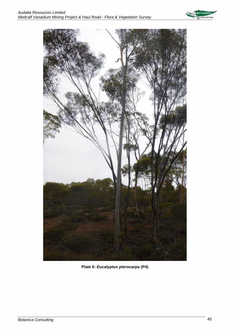
Audalia Resources Limited Medcalf Vanadium Mining Project & Haul Road - Flora & Vegetation Survey
Botanica Consulting 45
Plate 6: Eucalyptus pterocarpa (P4)

Audalia Resources Limited Medcalf Vanadium Mining Project & Haul Road - Flora & Vegetation Survey
Botanica Consulting 46
4.2.7 Eucalyptus rhomboidea (P4)
This taxon is described as a tree that grows between 8 to 10m high (Plate 7). It grows in gravelly
sand, and is found on slight rises (WAHERB, 2017). This taxon is listed by the DBCA as occurring
within the survey area. A total of 88 locations of this taxon have been recorded within the survey area,
one of which was a DBCA known location. Location details for this taxon have been previously
provided to DBCA for their records.
Plate 7: Eucalyptus rhomboidea (P4) (Image provided by Paul Armstrong, 2012)

Audalia Resources Limited Medcalf Vanadium Mining Project & Haul Road - Flora & Vegetation Survey
Botanica Consulting 47
4.2.8 Hakea pendens (P3)
This taxon is described as a shrub that grows between 2 to 3m high, and 2.5 to 3.1m wide. It produces
pink-white flowers in September (Plate 8). It grows in stony loam and is found on ironstone ridges
(WAHERB, 2017). A total of 545 locations of this taxon were recorded within the survey area none of
which are DBCA locations. Location details for this taxon have been previously provided to DBCA for
their records.
Plate 8: Hakea pendens (P3)

Audalia Resources Limited Medcalf Vanadium Mining Project & Haul Road - Flora & Vegetation Survey
Botanica Consulting 48
4.2.9 Microcybe sp. Windy Hill (G.F. Craig 6583) (P3)
There is no description from WAHERB available for this taxon (Plate 9). A total of three locations of
this taxon were recorded within the survey area, one of which is a DBCA known location. Location
details for this taxon have been previously provided to DBCA for their records.
Plate 9: Microcybe sp. Windy Hill (G.F. Craig 6583) (P3)

Audalia Resources Limited Medcalf Vanadium Mining Project & Haul Road - Flora & Vegetation Survey
Botanica Consulting 49
4.2.10 Stenanthemum bremerense (P4)
This taxon is described as an erect or a low and spreading shrub that can grow between 0.3 to 0.6m
high (Plate 10). It grows in orange-brown sandy loam, orange-red gravelly loam, skeletal red loam,
laterite and ironstone. It is found on the top or sides of outcrops and breakaways (WAHERB, 2017).
A total of 353 locations of this taxon were recorded within the survey area, four of which are DBCA
known locations. Location details for this taxon have been previously provided to DBCA for their
records.
Plate 10: Stenanthemum bremerense (P4)

Audalia Resources Limited Medcalf Vanadium Mining Project & Haul Road - Flora & Vegetation Survey
Botanica Consulting 50
4.2.11 Teucrium sp. dwarf (R. Davis 8813) (P1)
This species is described as a compact, dwarf shrub that grows up to 0.1m high and to 0.1m wide
(Plate 11). It has white flowers in April and is found on hills and road verges (WAHERB, 2017). A total
of 27 locations of this taxon were recorded within the survey area, four of which are DBCA known
locations. Location details for this taxon have been previously provided to DBCA for their records.
Plate 11: Teucrium sp. dwarf (R. Davis 8813) (P1)

Audalia Resources Limited Medcalf Vanadium Mining Project & Haul Road- Flora & Vegetation Survey
Botanica Consulting 51
Figure 11: Flora of Conservation Significance identified within the survey area

Audalia Resources Limited Medcalf Vanadium Mining Project & Haul Road-Flora & Vegetation Survey
Botanica Consulting 52
Floristic Communities
Fourteen floristic communities were identified within the survey area. These communities were
located within five different landform types and comprised of five major vegetation groups, which were
represented by a total of 58 Families, 162 Genera and 411 Taxa (Appendix 3). A map showing the
floristic communities present in the survey area is located in Appendix 2 and a summary of
communities is presented in Table 10.
Table 10: Summary of floristic communities within the survey area
Landform NVIS Vegetation
Group Floristic Community
Vegetation Code
Area (ha)
Area (%)
Clo
sed
De
pre
ssio
n
Chenopod Shrublands, Samphire Shrublands
and Forblands (MVG 22)
Low samphire shrubland of Tecticornia indica subsp. bidens over low open forbland
of Disphyma crassifolium on playa CD-CSSSF1 67 0.4
Cla
y-L
oa
m P
lain
Eucalypt Woodlands (MVG 5)
Low open woodland of Eucalyptus salmonophloia over mixed shrubs on clay-
loam plain CLP-EW1 100225 53.4
Mallee Woodlands and Shrublands (MVG 14)
Mid mallee shrubland of Eucalyptus spp. over mid shrubland of Melaleuca
pauperiflora and mixed low shrubland on clay-loam plain
CLP-MWS1 1975 10.5
Mid mallee woodland of Eucalyptus spp. over mixed low shrubland/ heathland on
clay-loam plain CLP-MWS2 2561 13.6
Gra
nite
Ou
tcro
p
Heathlands (MVG 18)
Heathland of Thryptomene spp. over sparse tussock grassland of Neurachne alopecuroidea on granite outcrop
G-H1 265 1.4
Hill
slo
pe
Eucalypt Woodlands (MVG 5)
Regrowth of low open forest of Eucalyptus sp. (Sterile) on hillslope
HS-EW1 15 0.1
Mallee Woodlands and Shrublands (MVG 14)
Regrowth mid open mallee woodland Eucalyptus livida over mid open shrubland of Hakea pendens and open low shrubland
of Goodia medicaginea on hillslope
HS-MWS1 150 0.8
Regrowth low open mallee shrubland of Eucalyptus spp. over low shrubland of
Acacia spp. and open tussock grassland of Schoenus breviculmis on hillslope
HS-MWS2 16 0.1
Mid open mallee woodland Eucalyptus livida over heathland of Allocasuarina/ Hakea/
Melaleuca and open low sedge of Lepidosperma sanguinolentum on hillslope
HS-MWS3 96 0.5
Other Shrublands (MVG 17)
Regrowth mixed low shrubland on hillslope HS-OS1 412 2.2
5 5381 ha comprised of mature woodland. Remaining area comprised of regrowth.

Audalia Resources Limited Medcalf Vanadium Mining Project & Haul Road-Flora & Vegetation Survey
Botanica Consulting 53
Landform NVIS Vegetation
Group Floristic Community
Vegetation Code
Area (ha)
Area (%)
Sa
nd
-Loa
m P
lain
Eucalypt Woodlands (MVG 5)
Low woodland of Eucalyptus salicola over low open shrubland of Phebalium filifolium
and low open sedgeland of Gahnia ancistrocarpa on sand-loam plain
SLP-EW1 1519 8.1
Mallee Woodlands and Shrublands (MVG 14)
Mid sparse mallee shrubland of Eucalyptus eremophila over heathland of Melaleuca
spp. on sand-loam plain SLP-MWS1 1436 7.7
Regrowth mid sparse mallee shrubland of Eucalyptus spp. over low open shrubland of Acacia / Grevillea spp. and open hummock grassland of Triodia scariosa on sand-loam
plain
SLP-MWS2 67 0.4
Other Shrublands (MVG 17)
Regrowth low open woodland of Codonocarpus cotinifolius over mid
shrubland of Acacia/ Melaleuca spp. and open tussock grassland of Schoenus
breviculmis on sand-loam plain
SLP-OS1 27 0.1
TOTAL 18770 100

Audalia Resources Limited Medcalf Vanadium Mining Project & Haul Road-Flora & Vegetation Survey
Botanica Consulting 54
Closed Depression: Chenopod Shrublands, Samphire Shrublands and Forblands
4.3.1 Low samphire shrubland of Tecticornia indica subsp. bidens over low open forbland of
Disphyma crassifolium on playa (CD-CSSSF1)
The total flora recorded within this community was represented by a total of 9 Families, 20 Genera
and 28 Taxa (Plate 12). No Threatened Flora taxa or Priority Flora taxa were identified within this
community. Dominant taxa from the vegetation assemblage are shown in Table 11. According to the
NVIS, this community is best represented by the MVG22- Chenopod Shrublands, Samphire
Shrublands and Forblands (DotEE, 2017b).
Table 11: Vegetation assemblage for Low samphire shrubland of Tecticornia indica subsp. bidens
over low open forbland of Disphyma crassifolium on playa
Life Form/Height Class Canopy Cover Dominant Taxa
Samphire Shrub <0.5m 30-70% Tecticornia indica subsp. bidens
Forbs <0.5m 10-30% Disphyma crassifolium
Plate 12: Low samphire shrubland of Tecticornia indica subsp. bidens over low open forbland of
Disphyma crassifolium on playa

Audalia Resources Limited Medcalf Vanadium Mining Project & Haul Road-Flora & Vegetation Survey
Botanica Consulting 55
Clay-Loam Plain: Eucalypt Woodlands
4.3.2 Low open woodland of Eucalyptus salmonophloia over mixed shrubs on clay-loam
plain (CLP-EW1)
The total flora recorded within this vegetation type was represented by a total of 38 Families, 98
Genera and 198 Taxa (Plate 13). No Threatened Flora taxa were identified within this community.
Seven Priority Flora taxa were recorded within this community; Stenanthemum bremerense (P4),
Hakea pendens (P3), Eucalyptus rhomboidea (P4), Eucalyptus pterocarpa (P4), Acacia hystrix subsp.
continua (P1), Acacia mutabilis subsp. stipulifera (P3) and Teucrium sp. Dwarf (R. Davis 8813) (P1).
Dominant taxa from the vegetation assemblage are shown in Table 12. According to the NVIS, this
community is best represented by the MVG5- Eucalypt Woodlands (DotEE, 2017b).
Table 12: Vegetation assemblage for Low open woodland of Eucalyptus salmonophloia over mixed
shrubs on clay-loam plain
Life Form/Height Class Canopy Cover Dominant Taxa
Tree <10m 5-10% Eucalyptus salmonophloia
Shrub 1-2m 10-30%
Dodonaea stenozyga Exocarpos aphyllus
Santalum acuminatum Scaevola spinescens
Shrub <1m 10-30%
Acacia merrallii Acacia poliochroa
Eremophila caerulea subsp. caerulea Melaleuca calyptroides Westringia cephalantha
Plate 13: Low open woodland of Eucalyptus salmonophloia over mixed shrubs on clay-loam plain

Audalia Resources Limited Medcalf Vanadium Mining Project & Haul Road-Flora & Vegetation Survey
Botanica Consulting 56
Approximately 4641 ha of this community (~46% of the total extent within the survey area) has been
disturbed by fire and comprised of regrowth vegetation (Plate 14; Appendix 2).
Plate 14: Regrowth Eucalyptus salmonophloia over mixed shrubs on clay-loam plain
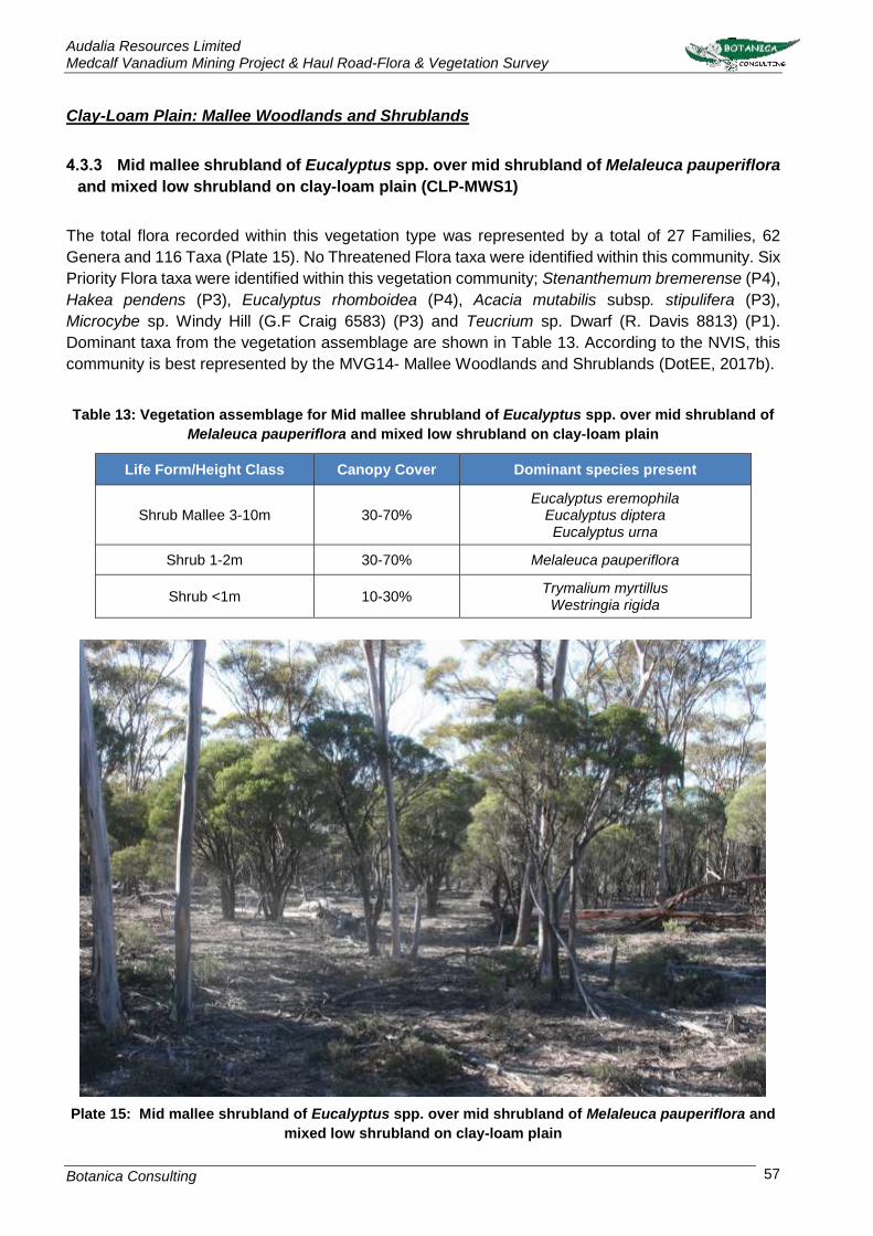
Audalia Resources Limited Medcalf Vanadium Mining Project & Haul Road-Flora & Vegetation Survey
Botanica Consulting 57
Clay-Loam Plain: Mallee Woodlands and Shrublands
4.3.3 Mid mallee shrubland of Eucalyptus spp. over mid shrubland of Melaleuca pauperiflora
and mixed low shrubland on clay-loam plain (CLP-MWS1)
The total flora recorded within this vegetation type was represented by a total of 27 Families, 62
Genera and 116 Taxa (Plate 15). No Threatened Flora taxa were identified within this community. Six
Priority Flora taxa were identified within this vegetation community; Stenanthemum bremerense (P4),
Hakea pendens (P3), Eucalyptus rhomboidea (P4), Acacia mutabilis subsp. stipulifera (P3),
Microcybe sp. Windy Hill (G.F Craig 6583) (P3) and Teucrium sp. Dwarf (R. Davis 8813) (P1).
Dominant taxa from the vegetation assemblage are shown in Table 13. According to the NVIS, this
community is best represented by the MVG14- Mallee Woodlands and Shrublands (DotEE, 2017b).
Table 13: Vegetation assemblage for Mid mallee shrubland of Eucalyptus spp. over mid shrubland of
Melaleuca pauperiflora and mixed low shrubland on clay-loam plain
Life Form/Height Class Canopy Cover Dominant species present
Shrub Mallee 3-10m 30-70% Eucalyptus eremophila
Eucalyptus diptera Eucalyptus urna
Shrub 1-2m 30-70% Melaleuca pauperiflora
Shrub <1m 10-30% Trymalium myrtillus
Westringia rigida
Plate 15: Mid mallee shrubland of Eucalyptus spp. over mid shrubland of Melaleuca pauperiflora and
mixed low shrubland on clay-loam plain

Audalia Resources Limited Medcalf Vanadium Mining Project & Haul Road-Flora & Vegetation Survey
Botanica Consulting 58
4.3.4 Mid mallee woodland of Eucalyptus spp. over mixed low shrubland/ heathland on clay-
loam plain (CLP-MWS2)
The total flora recorded within this vegetation type was represented by a total of 29 Families, 59
Genera and 120 Taxa (Plate 16). No Threatened Flora taxa were identified within this community.
Two Priority Flora taxa were identified within this vegetation community; Acacia mutabilis subsp.
stipulifera (P3) and Brachyloma stenolobum (P1). Dominant taxa from the vegetation assemblage
are shown in Table 14. According to the NVIS, this community is best represented by the MVG14-
Mallee Woodlands and Shrublands (DotEE, 2017b).
Table 14: Vegetation assemblage for Mid mallee woodland of Eucalyptus spp. over mixed low
shrubland/ heathland on clay-loam plain
Life Form/Height Class Canopy Cover Dominant species present
Tree Mallee 3-10m 30-70% Eucalyptus cylindrocarpa Eucalyptus eremophila
Eucalyptus urna
Shrub 1-2m 30-70% Dodonaea bursariifolia
Exocarpos sparteus Melaleuca lateriflora
Heath Shrub 1-2m 30-70% Melaleuca hamata
Shrub <1m 10-30% Cryptandra minutifolia Melaleuca calyptroides Westringia cephalantha
Plate 16: Mid mallee woodland of Eucalyptus spp. over mixed low shrubland/ heathland on clay-loam
plain

Audalia Resources Limited Medcalf Vanadium Mining Project & Haul Road-Flora & Vegetation Survey
Botanica Consulting 59
Granite Outcrop: Heathlands
4.3.5 Heathland of Thryptomene spp. over sparse tussock grassland of Neurachne
alopecuroidea on granite outcrop (G-H1)
The total flora recorded within this vegetation type was represented by a total of 13 Families, 22
Genera and 24 Taxa (Plate 17). No Threatened Flora or Priority Flora taxon were identified within this
community. Dominant taxa from the vegetation assemblage are shown in Table 15. According to the
NVIS, this community is best represented by the MVG18- Heathlands (DotEE, 2017b).
Table 15: Vegetation assemblage for Heathland of Thryptomene spp. over sparse tussock grassland
of Neurachne alopecuroidea on granite outcrop
Life Form/Height Class Canopy Cover Dominant Taxa
Heath Shrub >2m 30-70% Thryptomene australis
Heath Shrub 1-2m 10-30% Thryptomene kochii
Tussock grass <1m 5-10% Neurachne alopecuroidea
Plate 17: Heathland of Thryptomene spp. over sparse tussock grassland of Neurachne alopecuroidea
on granite outcrop

Audalia Resources Limited Medcalf Vanadium Mining Project & Haul Road-Flora & Vegetation Survey
Botanica Consulting 60
Hillslope: Eucalypt Woodlands
4.3.6 Regrowth of dense low forest of Eucalyptus sp. (Sterile) on hillslope (HS-EW1)
The total flora recorded within this vegetation type was represented by a total of 11 Families, 17
Genera and 22 Taxa (Plate 18). No Threatened Flora or Priority Flora taxa were identified within this
vegetation community. Dominant taxa from the vegetation assemblage are shown in Table 16.
According to the NVIS, this vegetation community is best represented by the MVG5-Eucalypt
Woodlands (DotEE, 2017b).
Table 16: Vegetation assemblage for Regrowth of dense low forest of Eucalyptus sp. (Sterile) on
hillslope
Life Form/Height Class Canopy Cover Dominant Taxa
Tree <3m 30-70% Eucalyptus sp. (sterile)
Plate 18: Regrowth of dense low forest of Eucalyptus sp. (Sterile) on hillslope

Audalia Resources Limited Medcalf Vanadium Mining Project & Haul Road-Flora & Vegetation Survey
Botanica Consulting 61
Hillslope: Mallee Woodlands and Shrublands
4.3.7 Regrowth mid open mallee woodland Eucalyptus livida over mid open shrubland of
Hakea pendens and open low shrubland of Goodia medicaginea on hillslope (HS-MWS1)
The total flora recorded within this vegetation type was represented by a total of 35 Families, 69
Genera and 89 Taxa (Plate 19). One Threatened Flora taxon was identified within this vegetation
community; Marianthus aquilonaris. Three Priority Flora taxa were identified within this vegetation
community; Stenanthemum bremerense (P4), Hakea pendens (P3) and Eucalyptus rhomboidea (P4).
Dominant taxa from the vegetation assemblage are shown in Table 17. According to the NVIS, this
vegetation community is best represented by the MVG14-Mallee Woodlands and Shrublands (DotEE,
2017b).
Table 17: Vegetation assemblage for Regrowth mid open mallee woodland Eucalyptus livida over mid
open shrubland of Hakea pendens and open low shrubland of Goodia medicaginea on hillslope
Life Form/Height Class Canopy Cover Dominant Taxa
Tree Mallee 3-10m 10-30% Eucalyptus livida
Shrub 1-2m 5-10% Hakea pendens (P3)
Shrub <1m 5-10% Goodenia medicaginea
Plate 19: Regrowth mid open mallee woodland Eucalyptus livida over mid open shrubland of Hakea
pendens and open low shrubland of Goodia medicaginea on hillslope

Audalia Resources Limited Medcalf Vanadium Mining Project & Haul Road-Flora & Vegetation Survey
Botanica Consulting 62
4.3.8 Regrowth low open mallee shrubland of Eucalyptus spp. over low shrubland of Acacia
spp. and open tussock grassland of Schoenus breviculmis on hillslope (HS-MWS2)
The total flora recorded within this vegetation type was represented by a total of 11 Families, 13
Genera and 15 Taxa (Plate 20). No Threatened Flora or Priority Flora taxa were identified within this
vegetation community. Dominant taxa from the vegetation assemblage are shown in Table 18.
According to the NVIS, this vegetation community is best represented by the MVG14-Mallee
Woodlands and Shrublands (DotEE, 2017b).
Table 18: Vegetation assemblage for Regrowth low open mallee shrubland of Eucalyptus spp. over
low shrubland of Acacia spp. and open tussock grassland of Schoenus breviculmis on hillslope
Life Form/Height Class Canopy Cover Dominant Taxa
Shrub Mallee <3m 10-30% Eucalyptus sp. (sterile)
Shrub <1m 10-30%
Acacia assimilis subsp. assimilis
Acacia yorkrakinensis
Duboisia hopwoodii
Tussock Grass <1m 10-30% Schoenus brevisetis
Plate 20: Regrowth low open mallee shrubland of Eucalyptus spp. over low shrubland of Acacia spp.
and open tussock grassland of Schoenus breviculmis on hillslope

Audalia Resources Limited Medcalf Vanadium Mining Project & Haul Road-Flora & Vegetation Survey
Botanica Consulting 63
4.3.9 Mid open mallee woodland Eucalyptus livida over heathland of Allocasuarina/ Hakea/
Melaleuca and open low sedge of Lepidosperma sanguinolentum on hillslope (HS-MWS3)
The total flora recorded within this vegetation type was represented by a total of 15 Families, 25
Genera and 35 Taxa (Plate 21). No Threatened Flora were identified within this vegetation
community. Three Priority Flora taxa were identified within this community; Stenanthemum
bremerense (P4), Eucalyptus rhomboidea (P4) and Teucrium sp. dwarf (R. Davis 8813) (P1).
Dominant taxa from the vegetation assemblage are shown in Table 19. According to the NVIS, this
vegetation community is best represented by the MVG14-Mallee Woodlands and Shrublands (DotEE,
2017b).
Table 19: Vegetation assemblage for Mid open mallee woodland Eucalyptus livida over heathland of
Allocasuarina/ Hakea/ Melaleuca and open low sedge of Lepidosperma sanguinolentum on hillslope
Life Form/Height Class Canopy Cover Dominant Taxa
Shrub Mallee <3m 10-30% Eucalyptus livida
Shrub 1-2m 10-30%
Allocasuarina campestris
Hakea francisiana
Melaleuca hamata
Sedge <0.5m 10-30% Lepidosperma sanguinolentum
Plate 21: Mid open mallee woodland Eucalyptus livida over heathland of Allocasuarina/ Hakea/
Melaleuca and open low sedge of Lepidosperma sanguinolentum on hillslope

Audalia Resources Limited Medcalf Vanadium Mining Project & Haul Road-Flora & Vegetation Survey
Botanica Consulting 64
Hillslope: Other Shrublands
4.3.10 Regrowth mixed low shrubland on hillslope (HS-OS1)
The total flora recorded within this vegetation type was represented by a total of 24 Families, 42
Genera and 55 Taxa (Plate 22). No Threatened Flora taxa were identified within this community. Four
Priority Flora taxon was identified within this community; Hakea pendens (P3), Stenanthemum
bremerense (P4), Microcybe sp. Windy Hill (G.F Craig 6583) (P3) and Teucrium sp. Dwarf (R. Davis
8813) (P1). Dominant taxa from the vegetation assemblage are shown in Table 20. According to the
NVIS, this community is best represented by the MVG17- Other Shrublands (DotEE, 2017b).
Table 20: Vegetation assemblage for Regrowth mixed low shrubland on hillslope
Life Form/Height Class Canopy Cover Dominant species present
Shrub 1-2m 30-70%
Anthocercis anisantha subsp. anisantha
Acacia poliochroa
Alyogyne hakeifolia
Dodonaea stenozyga
Plate 22: Regrowth mixed low shrubland on hillslope

Audalia Resources Limited Medcalf Vanadium Mining Project & Haul Road-Flora & Vegetation Survey
Botanica Consulting 65
Sand-Loam Plain: Eucalypt Woodlands
4.3.11 Low woodland of Eucalyptus salicola over low open shrubland of Phebalium filifolium
and low open sedgeland of Gahnia ancistrocarpa on sand-loam plain (SLP-EW1)
The total flora recorded within this vegetation type was represented by a total of 26 Families, 53
Genera and 79 Taxa (Plate 23). No Threatened Flora or Priority Flora taxa were identified within this
community. Dominant taxa from the vegetation assemblage are shown in Table 21. According to the
NVIS, this community is best represented by the MVG5- Eucalypt Woodland (DotEE, 2017b).
Table 21: Vegetation assemblage for Low woodland of Eucalyptus salicola over low open shrubland
of Phebalium filifolium and low open sedgeland of Gahnia ancistrocarpa on sand-loam plain
Life Form/Height Class Canopy Cover Dominant species present
Tree <10m 10-30% Eucalyptus salicola
Shrub <1m 10-30% Phebalium filifolium
Sedge <0.5m 10-30% Gahnia ancistrocarpa
Plate 23: Low woodland of Eucalyptus salicola over low open shrubland of Phebalium filifolium and
low open sedgeland of Gahnia ancistrocarpa on sand-loam plain

Audalia Resources Limited Medcalf Vanadium Mining Project & Haul Road-Flora & Vegetation Survey
Botanica Consulting 66
Sand-Loam Plain: Mallee Woodlands and Shrublands
4.3.12 Mid sparse mallee shrubland of Eucalyptus eremophila over heathland of Melaleuca
spp. on sand-loam plain (SLP-MWS1)
The total flora recorded within this vegetation type was represented by a total of 21 Families, 48
Genera and 98 Taxa (Plate 24). No Threatened Flora taxa were identified within this community. Two
Priority Flora taxa were identified within this community; Acacia mutabilis subsp. stipulifera (P3) and
Bossiaea flexuosa (P3). Dominant taxa from the vegetation assemblage are shown in Table 22.
According to the NVIS, this community is best represented by the MVG14- Mallee Woodlands and
Shrublands (DotEE, 2017b).
Table 22: Vegetation assemblage for Mid sparse mallee shrubland of Eucalyptus eremophila over
heathland of Melaleuca spp. on sand-loam plain
Life Form/Height Class Canopy Cover Dominant species present
Shrub Mallee <3m 5-10% Eucalyptus eremophila
Eucalyptus grossa
Heath Shrub 1-2m 30-70% Acacia fragilis
Melaleuca hamata
Heath Shrub <1m 10-30% Melaleuca cordata
Sedge <0.5m 10-30% Lepidosperma sanguinolentum
Plate 24: Mid sparse mallee shrubland of Eucalyptus eremophila over heathland of Melaleuca spp. on
sand-loam plain

Audalia Resources Limited Medcalf Vanadium Mining Project & Haul Road-Flora & Vegetation Survey
Botanica Consulting 67
4.3.13 Regrowth mid sparse mallee shrubland of Eucalyptus spp. over low open shrubland of
Acacia / Grevillea spp. and open hummock grassland of Triodia scariosa on sand-loam plain
(SLP-MWS2)
The total flora recorded within this vegetation type was represented by a total of 13 Families, 18
Genera and 24 Taxa (Plate 25). No Threatened Flora taxa were identified within this community. One
Priority Flora taxon was identified within this community; Acacia mutabilis subsp. stipulifera (P3).
Dominant taxa from the vegetation assemblage are shown in Table 23. According to the NVIS, this
community is best represented by the MVG14- Mallee Woodlands and Shrublands (DotEE, 2017b).
Table 23: Vegetation assemblage for Regrowth mid sparse mallee shrubland of Eucalyptus spp. over
low open shrubland of Acacia / Grevillea spp. and open hummock grassland of Triodia scariosa on
sand-loam plain
Life Form/Height Class Canopy Cover Dominant species present
Shrub Mallee <3m 5-10% Eucalyptus sp. (sterile)
Shrub <1m 10-30% Acacia acanthoclada
Grevillea huegelii
Hummock Grass <0.5m 10-30% Triodia scariosa
Plate 25: Regrowth mid sparse mallee shrubland of Eucalyptus spp. over low open shrubland of
Acacia / Grevillea spp. and open hummock grassland of Triodia scariosa on sand-loam plain

Audalia Resources Limited Medcalf Vanadium Mining Project & Haul Road-Flora & Vegetation Survey
Botanica Consulting 68
Sand-Loam Plain: Other Shrublands
4.3.14 Regrowth low open woodland of Codonocarpus cotinifolius over mid shrubland of
Acacia/ Melaleuca spp. and open tussock grassland of Schoenus breviculmis on sand-loam
plain (SLP-OS1)
The total flora recorded within this vegetation type was represented by a total of 10 Families, 15
Genera and 18 Taxa (Plate 26). No Threatened Flora taxa were identified within this community. One
Priority Flora taxon was identified within this community; Teucrium sp. Dwarf (R. Davis 8813) (P1).
Dominant taxa from the vegetation assemblage are shown in Table 24. According to the NVIS, this
community is best represented by the MVG17- Other Shrublands (DotEE, 2017b).
Table 24: Regrowth low open woodland of Codonocarpus cotinifolius over mid shrubland of Acacia/
Melaleuca spp. and open tussock grassland of Schoenus breviculmis on sand-loam plain
Life Form/Height Class Canopy Cover Dominant Taxa
Tree <3m 5-10% Codonocarpus cotinifolius
Shrub <1m 10-30% Acacia sp. (sterile)
Melaleuca hamata
Tussock Grass <0.5m 10-30% Schoenus brevisetis
Plate 26: Regrowth low open woodland of Codonocarpus cotinifolius over mid shrubland of Acacia/
Melaleuca spp. and open tussock grassland of Schoenus breviculmis on sand-loam plain

Audalia Resources Limited Medcalf Vanadium Mining Project & Haul Road-Flora & Vegetation Survey
Botanica Consulting 69
Vegetation Condition
Based on the vegetation condition rating scale adapted from Keighery, 1994 and Trudgen, 1988
(Appendix 6), eight communities were rated as ‘good’ and the remaining seven communities had a
vegetation condition rating of ‘very good’ (Table 25). A map of the vegetation condition within the
survey area is provided in Figure 12.
‘Good’ condition depicts that vegetation structure has been significantly altered by very obvious signs
of multiple disturbances, however it retains its basic vegetation structure or has ability to regenerate
it. Disturbance to vegetation structure caused by very frequent fires, the presence of very aggressive
weeds, partial clearing, dieback and grazing.
‘Very Good’ condition depicts that vegetation structure has been altered by obvious signs of
disturbance, caused by repeated fires, the presence of some more aggressive weeds, dieback,
logging and grazing.
The entire survey area has been subjected to a major fire in 2010 (Figure 13), with some areas
subjected to multiple successional fires in 2010. In February 2015, the area was again subjected to
fire (observed by Audalia staff in the area) however this fire has not been recorded on the Landgate
database. Vegetation within the area is in various stages of regrowth.
Table 25: Vegetation Condition Rating of the survey area
Landform NVIS Vegetation
Group Floristic Community
Vegetation Code
Vegetation Condition
Clo
sed
Dep
ressio
n Chenopod Shrublands,
Samphire Shrublands and Forblands
(MVG 22)
Low samphire shrubland of Tecticornia indica subsp. bidens over low open forbland
of Disphyma crassifolium on playa CD-CSSSF1 Very Good
N/A Playa (no vegetation) PLAYA N/A
Cla
y-L
oa
m P
lain
Eucalypt Woodlands (MVG 5)
Low open woodland of Eucalyptus salmonophloia over mixed shrubs on clay-
loam plain CLP-EW1 Good
Mallee Woodlands and Shrublands (MVG 14)
Mid mallee shrubland of Eucalyptus spp. over mid shrubland of Melaleuca
pauperiflora and mixed low shrubland on clay-loam plain
CLP-MWS1 Very Good
Mid mallee woodland of Eucalyptus spp. over mixed low shrubland/ heathland on
clay-loam plain CLP-MWS2 Very Good
Gra
nite
Ou
tcro
p
Heathlands (MVG 18)
Heathland of Thryptomene spp. over sparse tussock grassland of Neurachne alopecuroidea on granite outcrop
G-H1 Very Good
Hill
slo
pe
Eucalypt Woodlands (MVG 5)
Regrowth of low open forest of Eucalyptus sp. (Sterile) on hillslope
HS-EW1 Good
Mallee Woodlands and Shrublands (MVG 14)
Regrowth mid open mallee woodland Eucalyptus livida over mid open shrubland of Hakea pendens and open low shrubland
of Goodia medicaginea on hillslope
HS-MWS1 Good

Audalia Resources Limited Medcalf Vanadium Mining Project & Haul Road-Flora & Vegetation Survey
Botanica Consulting 70
Landform NVIS Vegetation
Group Floristic Community
Vegetation Code
Vegetation Condition
Regrowth low open mallee shrubland of Eucalyptus spp. over low shrubland of
Acacia spp. and open tussock grassland of Schoenus breviculmis on hillslope
HS-MWS2 Good
Mid open mallee woodland Eucalyptus livida over heathland of Allocasuarina/ Hakea/
Melaleuca and open low sedge of Lepidosperma sanguinolentum on hillslope
HS-MWS3 Good
Other Shrublands (MVG 17)
Regrowth mixed low shrubland on hillslope HS-OS1 Good
Sa
nd
-Loa
m P
lain
Eucalypt Woodlands (MVG 5)
Low woodland of Eucalyptus salicola over low open shrubland of Phebalium filifolium
and low open sedgeland of Gahnia ancistrocarpa on sand-loam plain
SLP-EW1 Very Good
Mallee Woodlands and Shrublands (MVG 14)
Mid sparse mallee shrubland of Eucalyptus eremophila over heathland of Melaleuca
spp. on sand-loam plain SLP-MWS1 Very Good
Regrowth mid sparse mallee shrubland of Eucalyptus spp. over low open shrubland of Acacia / Grevillea spp. and open hummock grassland of Triodia scariosa on sand-loam
plain
SLP-MWS2 Good
Other Shrublands (MVG 17)
Regrowth low open woodland of Codonocarpus cotinifolius over mid
shrubland of Acacia/ Melaleuca spp. and open tussock grassland of Schoenus
breviculmis on sand-loam plain
SLP-OS1 Good

Audalia Resources Limited Medcalf Vanadium Mining Project & Haul Road- Flora & Vegetation Survey
Botanica Consulting 71
Figure 12: Vegetation Condition Rating of the survey area

Audalia Resources Limited Medcalf Vanadium Mining Project & Haul Road- Flora & Vegetation Survey
Botanica Consulting 72
Figure 13: Map of fire history along the extent of the survey area obtained from Landgate fire watch database (Landgate, 2017)

Audalia Resources Limited Medcalf Vanadium Mining Project & Haul Road- Flora & Vegetation Survey
Botanica Consulting 73
Introduced Plant Species
Nine introduced species were identified in the survey area:
1. Asphodelus fistulosus (Onion Weed);
2. Bromus rubens (Red brome);
3. Carrichtera annua (Ward’s weed);
4. Centaurea melitensis (Maltese cockspur);
5. Lysimachia arvensis (Pimpernel);
6. Pentameris airoides;
7. Rostraria pumila (Roughtail);
8. Sonchus oleraceus (Common sowthistle); and
9. Vulpia ?muralis.
According to the DPRID, none of these taxa are listed as a Declared Plant under Section 22 of the
BAM Act 2007 (DPIRD, 2017).
4.5.1 Asphodelus fistulosus (Onion Weed)
This taxon is described as an annual or biennial, herb, which grows between 0.2-0.4 m high. It
produces white flowers from June to October (Plate 27). This taxon occurs on sand, clay and
calcareous soils (WAHERB, 2017). This taxon was identified within one vegetation community; CLP-
EW1.
Plate 27: Asphodelus fistulosus (Onion Weed)

Audalia Resources Limited Medcalf Vanadium Mining Project & Haul Road- Flora & Vegetation Survey
Botanica Consulting 74
4.5.2 Bromus rubens (Red brome)
This taxon is described as a tufted annual, grass-like or herb, that grows between 0.1-0.4m high
(Plate 28). It produces green/red-purple flowers from August to October. It grows in sand, red-brown
clay and calcareous loam (WAHERB, 2017). Bromus rubens was identified in one community; HS-
OS1.
Plate 28: Bromus rubens (Red Brome) (DPIRD, 2017)

Audalia Resources Limited Medcalf Vanadium Mining Project & Haul Road- Flora & Vegetation Survey
Botanica Consulting 75
4.5.3 Carrichtera annua (Ward’s Weed)
This taxon is described as an erect, annual herb that can grow between 0.05-0.4m high (Plate 29). It
produces yellow flowers from September to November. It can be found in semi-arid regions
(WAHERB, 2017). Carrichtera annua was identified within two communities: CLP-EW1 and HS-OS1.
Plate 29: Carrichtera annua (Ward’s Weed)

Audalia Resources Limited Medcalf Vanadium Mining Project & Haul Road- Flora & Vegetation Survey
Botanica Consulting 76
4.5.4 Centaurea melitensis (Maltese Cockspur)
This taxon is described as an erect annual or biennial herb that grows anywhere between 0.2 to 1m
high (Plate 30). It produces yellow flowers from September to December or from January to March.
It can be found along roadsides, cultivated areas or any other disturbed areas (WAHERB, 2017).
Centaurea melitensis was recorded within two communities; CLP-EW1 and HS-OS1.
Plate 30: Centaurea melitensis (Maltese Cockspur)

Audalia Resources Limited Medcalf Vanadium Mining Project & Haul Road- Flora & Vegetation Survey
Botanica Consulting 77
4.5.5 Lysimachia arvensis (Pimpernel)
No description is available for this taxon (Plate 31). Lysimachia arvensis was recorded within one
community; CLP-EW1.
Plate 31: Lysimachia arvensis (Pimpernel)

Audalia Resources Limited Medcalf Vanadium Mining Project & Haul Road- Flora & Vegetation Survey
Botanica Consulting 78
4.5.6 Pentameris airoides
No description is available for this taxon (Plate 32). Pentameris airoides was identified in one
community; CLP-EW1.
Plate 32: Pentameris airoides (False Hairgrass) (DPIRD, 2017)

Audalia Resources Limited Medcalf Vanadium Mining Project & Haul Road- Flora & Vegetation Survey
Botanica Consulting 79
4.5.7 Rostraria pumila (Roughtail)
This taxon is described as a tufted annual, grass-like or herb, that grows between 0.05-0.2m high
(Plate 33). It produces green flowers from July to October. It grows in grey, black or red sand, sandy
clay, clay and limestone. It is a weed of roadsides, sand dunes and cliff slopes (WAHERB, 2017).
Rostraria pumila was identified in one community; CLP-EW1.
Plate 33: Rostraria pumila (Roughtail)

Audalia Resources Limited Medcalf Vanadium Mining Project & Haul Road- Flora & Vegetation Survey
Botanica Consulting 80
4.5.8 Sonchus oleraceus (Common Sowthistle)
This taxon is described as an erect, annual herb that can grow to 1.5m high (Plate 34). It produces
yellow flowers from January to December. It grows in variety of soils, and is a weed of waste places
and disturbed ground (WAHERB, 2017). Sonchus oleraceus was identified in four communities: CLP-
EW1, CLP-MWS1, RH-OS1 and HS-EW1.
Plate 34: Sonchus oleraceus (Common Sowthistle)

Audalia Resources Limited Medcalf Vanadium Mining Project & Haul Road- Flora & Vegetation Survey
Botanica Consulting 81
4.5.9 Vulpia ?muralis
This taxon is described as a slender annual, grass-like or herb, that grows to 0.6m high (Plate 35). It
produces flowers from August to December (WAHERB, 2017). Vulpia ?muralis was identified in one
vegetation community; CLP-MWS1.
Plate 35: Vulpia muralis (Silver Grass-Wall Fescue) (DPIRD, 2017)

Audalia Resources Limited Medcalf Vanadium Mining Project & Haul Road- Flora & Vegetation Survey
Botanica Consulting 82
Floristic Composition of the Medcalf Vanadium Mining Project Quadrats
This analysis was used to determine the similarities or differences between vegetation types.
Appendix 7 provides the dendrogram and ordination graph for all generated from the PATN statistical
analysis. A list of the 127 quadrats and their respective vegetation communities are provided in Table
26 below. The PATN analysis produced a stress value of 0.2856.
Table 26: Vegetation communities with corresponding quadrats
Landform NVIS Vegetation
Group Floristic Community
Vegetation Code
Quadrat
Clo
sed
De
pre
ssio
n
Chenopod Shrublands, Samphire Shrublands
and Forblands (MVG 22)
Low samphire shrubland of Tecticornia indica subsp. bidens
over low open forbland of Disphyma crassifolium on playa
CD-CSSSF1 Q103, Q104, Q124
Cla
y-L
oa
m P
lain
Eucalypt Woodlands (MVG 5)
Low open woodland of Eucalyptus salmonophloia over mixed shrubs
on clay-loam plain CLP-EW1
Q2, Q3, Q4, Q6, Q8, Q9, Q11, Q15, Q24, Q27, Q28, Q32, Q35, Q39, Q66, Q78, Q83, Q84, Q85, Q88, Q89, Q92,
Q95, Q96, Q99, Q100, Q102, Q110, Q113, Q113, Q144, Q115, Q116, Q118, Q119,
Q121, Q122
Mallee Woodlands and Shrublands (MVG 14)
Mid mallee shrubland of Eucalyptus spp. over mid shrubland of
Melaleuca pauperiflora and mixed low shrubland on clay-loam plain
CLP-MWS1
Q7, Q10, Q12, Q18, Q19, Q20, Q29, Q30, Q31, Q34, Q37, Q38, Q40, Q41, Q69, Q74, Q75, Q77, Q79, Q80, Q81, Q86, Q87, Q90, Q91,
Q106, Q109
Mid mallee woodland of Eucalyptus spp. over mixed low shrubland/ heathland on clay-loam plain
CLP-MWS2 Q94, Q97, Q101, Q105,
Q111, Q112
Gra
nite
Ou
tcro
p
Heathlands (MVG 18)
Heathland of Thryptomene spp. over sparse tussock grassland of
Neurachne alopecuroidea on granite outcrop
G-H1 Q123, Q125, Q127
Hill
slo
pe
Eucalypt Woodlands (MVG 5)
Regrowth of low open forest of Eucalyptus sp. (Sterile) on hillslope
HS-EW1 Q54, Q59, Q61
Mallee Woodlands and Shrublands (MVG 14)
Regrowth mid open mallee woodland Eucalyptus livida over mid open shrubland of Hakea pendens and open low shrubland of Goodia
medicaginea on hillslope
HS-MWS1
Q1, Q5, Q13, Q14, Q16, Q17, Q21, Q22, Q23, Q25, Q26, Q33, Q36, Q55, Q56, Q58, Q60,
Q62
Regrowth low open mallee shrubland of Eucalyptus spp. over low shrubland of Acacia spp. and
open tussock grassland of Schoenus breviculmis on hillslope
HS-MWS2 Q71, Q72
Mid open mallee woodland Eucalyptus livida over heathland of Allocasuarina/ Hakea/ Melaleuca
and open low sedge of Lepidosperma sanguinolentum on
hillslope
HS-MWS3 Q63, Q64, Q65, Q67,
Q68, Q70

Audalia Resources Limited Medcalf Vanadium Mining Project & Haul Road- Flora & Vegetation Survey
Botanica Consulting 83
Landform NVIS Vegetation
Group Floristic Community
Vegetation Code
Quadrat
Other Shrublands (MVG 17)
Regrowth mixed low shrubland on hillslope
HS-OS1
Q42, Q43, Q44, Q45, Q46, Q47, Q48, Q49, Q50, Q51, Q52, Q53,
Q57
Sa
nd
-Loa
m P
lain
Eucalypt Woodlands (MVG 5)
Low woodland of Eucalyptus salicola over low open shrubland of Phebalium filifolium and low open
sedgeland of Gahnia ancistrocarpa on sand-loam plain
SLP-EW1 Q117, Q120, Q126
Mallee Woodlands and Shrublands (MVG 14)
Mid sparse mallee shrubland of Eucalyptus eremophila over
heathland of Melaleuca spp. on sand-loam plain
SLP-MWS1 Q93, Q98, Q107, Q108
Regrowth mid sparse mallee shrubland of Eucalyptus spp. over
low open shrubland of Acacia / Grevillea spp. and open hummock grassland of Triodia scariosa on
sand-loam plain
SLP-MWS2 Q76, Q82
Other Shrublands (MVG 17)
Regrowth low open woodland of Codonocarpus cotinifolius over mid shrubland of Acacia/ Melaleuca spp.
and open tussock grassland of Schoenus breviculmis on sand-loam
plain
SLP-OS1 Q73
Two ‘supergroups’ were identified in the PATN analysis:
1. Hillslopes (mallee woodland and shrubland), sand-loam plain (other shrubland/ eucalypt
woodland/ mallee woodland and shrubland), granite outcrop (other shrubland) and closed
depression (chenopod/ samphire shrubland), clay-loam plain (mallee woodland and
shrubland).
2. Hillslopes (eucalypt woodland/ other shrubland), clay-loam plain (eucalypt woodland/ mallee
woodland and shrubland), sand-loam plain (mallee woodland and shrubland).
The first supergroup was divided into eight floristic groups, comprising of quadrats from each of the
five different landform types and major vegetation groups. The hillslopes communities (mallee
woodland and shrubland), were divided into three groups, intermixed with quadrats from the clay-
loam plain communities. The clay-loam plain communities were divided into four groups. The sand-
loam plain (other shrubland/ eucalypt woodland/ mallee woodland and shrubland) communities were
divided into four groups, also intermixed with quadrats from the clay-loam plain communities. The
granite outcrop and closed depression community quadrats were grouped separately from all other
quadrats.
The second group was divided into six floristic groups, comprising of quadrats from three different
landform types hillslopes clay-loam plain and sand-loam plain) and three major vegetation groups
(eucalypt woodland, other shrubland and mallee woodland and shrubland).
Based on the results of the PATN analysis, there was minimal heterogeneity in species composition
across the survey area, with majority of vegetation types intermixed into floristic groups despite
differences in both dominant stratum taxa and landform. The two super groups were highly mixed
including quadrats from all the different landforms and major vegetation groups.

Audalia Resources Limited Medcalf Vanadium Mining Project & Haul Road- Flora & Vegetation Survey
Botanica Consulting 84
4.6.1 Species Richness and accumulation estimates
The Chaos 2 richness estimator provided an estimated species richness of 205 species in 127 sample
sites (quadrats). Species richness recorded for the 117 quadrats surveyed was 221 species (including
annuals) which indicates survey intensity was adequate.
A species accumulation curve was created to display the rate of species accumulation. The R² value
(0.95) suggests that the data “fits” the species accumulation curve shown in Figure 14. The rate of
species accumulation for the first 20 quadrats ranged from seven to three species per quadrat. The
rate of species accumulation between 20-45 quadrats was two species per quadrat. Species
accumulation reduced to ≤1 species per quadrat as quadrat number increased above 100. BC has
determined that according to this data a sufficient number of quadrats were established in the survey
area to adequately assess the floristic composition of the area.
Figure 14: Species accumulation curve
Vegetation of Conservation Significance
4.7.1 Matters of National Environmental Significance
None of the following matters of national environmental significance as defined by the Commonwealth
EPBC Act were identified within the survey area:
• world heritage properties
• national heritage places
• wetlands of international importance (often called ‘Ramsar’ wetlands after the international treaty under which such wetlands are listed)
• nationally threatened species and ecological communities
• Commonwealth marine areas
• the Great Barrier Reef Marine Park
• nuclear actions (including uranium mining) a water resource, in relation to coal seam gas development and large coal mining development.
y = 55.646ln(x) - 62.621R² = 0.952
0
20
40
60
80
100
120
140
160
180
200
220
240
1 11 21 31 41 51 61 71 81 91 101 111 121
Cu
mu
lati
ve N
o. o
f sp
ecie
s
No. of sample sites
Species
Estimated Species
Log. (Species)

Audalia Resources Limited Medcalf Vanadium Mining Project & Haul Road- Flora & Vegetation Survey
Botanica Consulting 85
4.7.2 Matters of State Environmental Significance
There are no wetlands of national importance (ANCA Wetlands) or conservation category wetlands
within the survey area. The survey area does not contain any TEC as listed under the WC Act or EP
Act. One Threatened Flora taxon listed under the WC Act was recorded within the survey area. The
survey area contains ESA which occur within a 50m radius of each Threatened Flora plant (covering
an area of 19.7 ha), listed under the EP Act. One un-named Class A Nature Reserve (Identifier R
42943) managed by DBCA is located within the eastern extremity of the survey area (approximately
301 ha of the survey area). This Nature Reserve is also listed as a Schedule 1 Area under the EP
Act.
Approximately 2236 ha of the western extremity of the survey area is located within the Bremer Range
Vegetation Complexes PEC1 as listed by DBCA. Ten Priority Flora taxa were recorded within the
survey area.
A map showing areas of conservation significance in relation to the survey area is provided in
Appendix 1.

Audalia Resources Limited Medcalf Vanadium Mining Project & Haul Road- Flora & Vegetation Survey
Botanica Consulting 86
5 Summary
Fourteen floristic communities were identified within the survey area. These communities were
located within five different landform types and comprised of five major vegetation groups, which were
represented by a total of 58 Families, 162 Genera and 411 Taxa.
One Threatened Flora taxon; Marianthus aquilonaris, listed under State legislation were recorded
within the survey area. This taxon is not listed as Threatened under or Commonwealth legislation.
Ten Priority Flora taxa as listed by DBCA were identified within the survey area.
No TEC pursuant to State or Commonwealth legislation were identified within the survey area. The
survey area does not contain any world or national heritage places, wetlands of international or
national importance. Approximately 2236 ha of the western extremity of the survey area is located
within the Bremer Range Vegetation Complexes PEC1 as listed by DBCA. The survey area contains
ESA which occur within a 50m radius of each Threatened Flora plant (covering an area of 19.7 ha),
listed under the EP Act. One un-named Class A Nature Reserve (Identifier R 42943) managed by
DBCA is located within the eastern extremity of the survey area (approximately 301 ha of the survey
area). This Nature Reserve is also listed as a Schedule 1 Area under the EP Act.
Desktop assessments indicate the survey area has potential to include five terrestrial Groundwater
Dependent Ecosystems, only one of which is considered to be of high potential for groundwater
interaction; bare areas; salt lakes.
Vegetation condition in the survey area ranged from ‘good’ to ‘very good’. Nine introduced species
were identified within the survey area.

Audalia Resources Limited Medcalf Vanadium Mining Project & Haul Road- Flora & Vegetation Survey
Botanica Consulting 87
6 Bibliography
Armstrong, (2012), Vegetation Survey and Rare Flora search on the Vesuvius Prospect Medcalf
Project Unpublished report prepared for Audalia Resources Limited. Paul Armstrong and Associates.
ASRIS (2014), Atlas of Australian Soils Database, Australian Soil Resource Information System.
Australian Government (2012), Atlas of Groundwater Dependent Ecosystems (GDE Atlas), Phase 2 Task 5 Report: Identifying and mapping GDEs. Prepared by Sinclair Knight Merz. BC (2013), Flora of Conservation Significance search of the Medcalf Exploration Project, May 2013,
Botanica Consulting, June 2013
Beard, J.S., (1990), Plant Life of Western Australia, Kangaroo Press Pty Ltd, NSW.
BoM, (2017a), Norseman Aero rainfall station (#12009), Bureau of Meteorology http://www.bom.gov.au/climate/data/ Accessed: 23/10/2017 BoM, (2017b), Atlas of Groundwater Dependent Ecosystems, Bureau of Meteorology http://www.bom.gov.au/water/groundwater/gde/map.shtml
Accessed: 22/10/2017
Brearley, D.R, Dunlop, N.J and Osborne, J.M, Biological Survey and Environmental Assessment of
the Emily Ann Project Area. School of Environmental Biology Curtin University of Technology
Campbell, R., Billing, N., Northcote, K., Hubble, G., Isbell, R., Thompson, C., and Bettenay, E., (1975), A description of Australian Soils, Canberra: C.S.I.R.O. Division of Soils.
Chinnock, R.J., (2007), Eremophila and allied Genera – A Monograph of the Myoporaceae, Rosenberg Publishing Pty. Ltd. NSW.
Cousens, R.D., Dodd, J., Lloyd, S.G., Hussey, B.M.J., and Keighery, G.J. (1997), Western Weeds – A guide to weeds of Western Australia, The Plant Protection society of Western Australia, Victoria Park
Cowan, M., Graham, G. & McKenzie, N. (2001). Coolgardie 2 (COO2 – Southern Cross subregion)
In A Biodiversity Audit of Western Australia’s 53 Biogeographical Subregions in 2002. Department of
Conservation and Land Management
Cowan, M. (2001), A Biodiversity Audit of Western Australia’s 53 Biogeographical Region in 2001- Eastern Goldfields (COO3) subregion, Department of Conservation and Land Management.
DAFWA (2011), Pre-European Vegetation - Western Australia (NVIS Compliant Version GIS file), Department of Agriculture and Food Western Australia.
DAFWA (2014), Soil Landscape System of Western Australia, Department of Agriculture and Food Western Australia.
DPIRD (2017), Declared Organism-database search, Department of Primary Industries and Regional Development, Western Australia. http://www.biosecurity.wa.gov.au/
Accessed: 20/10/2017
DotEE, (2012), Interim Biogeographic Regionalisation for Australia (IBRA), Version 7, Department of the Environment and Energy

Audalia Resources Limited Medcalf Vanadium Mining Project & Haul Road- Flora & Vegetation Survey
Botanica Consulting 88
DotEE, (2017a), Protected Matters Search Tool, Environment Protection and Biodiversity Conservation Act 1999, Department of the Environment
DotEE, (2017b), National Vegetation Information System (NVIS) Major Vegetation Groups, Version 4.2, Department of the Environment and Energy
DEC, (2010), Interim recovery plan No. 303 Bremer Marianthus (Marianthus aquilonaris) Interim
Recovery Plan 2010-2014. Department of Environment and Conservation
DEC, (2011), A biodiversity and cultural conservation strategy for the Great Western Woodlands, Department of Environment and Conservation DPaW (2015), 2015 Statewide Vegetation Statistics (formerly the CAR Reserve Analysis).
Department of Parks and Wildlife
DPaW, (2017a), Threatened and Priority Flora Database search results, Department of Parks and Wildlife
DPaW, (2017b), Threatened Ecological Community and Priority Ecological Community database search, Department of Parks and Wildlife
DPaW (2017c), Nature Map Database search, Department of Parks and Wildlife.
DPaW & EPA (2016), Technical Guide - Terrestrial Flora and Vegetation Surveys for Environmental Impact Assessment – December 2016. Department of Parks and Wildlife & Environmental Protection Authority.
Geoscience Australia (2017), Groundwater Dependent Ecosystems. Australian Government http://www.ga.gov.au/scientific-topics/water/groundwater/understanding-groundwater-resources/groundwater-dependant-ecosystems Accessed: 23/06/2017
Gibson, N. & Lyons, M.N (1998), Flora and Vegetation of the Eastern Goldfields Ranges: Part 2.
Bremer Range, Journal of the Royal Society of Western Australia, 81:107-117.
How, R.A, Newbey, K.R, Dell, J., Muir, B.G & Hnatiuk, R.J, (1988), The Biological survey of the
Eastern Goldfields of Western Australia: Part 4. Lake Johnston-Hyden Study Area Western Australian
Museum Supplement No. 30.
IUCN, (2008), Guidelines for Applying Protected Area Management Categories. International Union for Conservation of Nature
IUCN (2016), The IUCN Red List of Threatened Species. Version 2016-3. International Union for Conservation of Nature.
Landgate, (2017), Landgate fire watch database. Landgate Western Australian Government
http://firewatch.landgate.wa.gov.au/landgate_firewatch_public.asp
Accessed: 29/06/2017
McKenzie, N.L., May J.E. and McKenna, S, (2002) Bioregional Summary of the 2002 Biodiversity Audit for Western Australia.
Mc Donald, R.C, Isbell, R.F & Speight, J.G (1998), Australian Soil and Land Survey Field Handbook (3rd edn). CSIRO Publishing: Melbourne.
Tille, P. (2006), Soil Landscapes of Western Australia’s Rangelands and Arid Interior, Department of Agriculture and Food Western Australia.
WAHERB, (2017), Florabase – Information on the Western Australian Flora, Department of Biodiversity, Conservation and Attractions http://florabase.dbcawa.gov.au
Accessed 29/09/2017

Audalia Resources Limited Medcalf Vanadium Mining Project & Haul Road- Flora & Vegetation Survey
Botanica Consulting 89
Watson, A., Judd, S., Watson J., Lam, A. and Mackenzie, D., (2008) The Extraordinary Nature of The
Great Western Woodlands. The Wilderness Society of WA

Appendix 1: Regional map of the survey area including DBCA Flora of Conservation Significance and areas of Conservation Significance

Appendix 2: Vegetation maps of the survey area


Appendix 3: List of species identified within each floristic community
(A) Blue text Denotes Annual species; (W) Green text Denotes Introduced species; (T/P) Red text Denotes Flora of Conservation Significance.
Family Genus Taxon
CD
-CS
SS
F1
CL
P-E
W1
CL
P-M
WS
1
CL
P-M
WS
2
G-H
1
HS
-EW
1
HS
-MW
S1
HS
-MW
S2
HS
-MW
S3
HS
-OS
1
SL
P-E
W1
SL
P-M
WS
1
SL
P-M
WS
2
SL
P-O
S1
Aizoaceae Disphyma crassifolium * * *
Amaranthaceae Ptilotus holosericeus *
Apiaceae Platysace trachymenioides *
Apiaceae Platysace maxwellii *
Apocynaceae Alyxia buxifolia * * * * *
Asparagaceae Lomandra effusa * * *
Asphodelaceae Asphodelus fistulosus (W) *
Asphodelaceae Bulbine semibarbata (A) * *
Asteraceae Asteridea athrixioides (A) * * * * * *
Asteraceae Blennospora drummondii (A) *
Asteraceae Calotis hispidula (A) * *
Asteraceae Centaurea melitensis (W) *
Asteraceae Cratystylis conocephala *
Asteraceae Leiocarpa semicalva subsp. semicalva *
Asteraceae Leucochrysum fitzgibbonii (A) *
Asteraceae Millotia major (A) *
Asteraceae Millotia tenuifolia var. tenuifolia (A) *
Asteraceae Olearia muelleri * * * * *
Asteraceae Olearia ramosissima * * *
Asteraceae Olearia sp. Kennedy Range (G. Byrne 66) *
Asteraceae Olearia subspicata *
Asteraceae Podolepis capillaris (A) * * * *
Asteraceae Podotheca gnaphalioides (A) *
Asteraceae Rhodanthe pygmaea (A) *
Asteraceae Senecio pinnatifolius *
Asteraceae Senecio quadridentatus *
Asteraceae Sonchus oleraceus (W) * * * *
Asteraceae Waitzia acuminata (A) * * *
Asteraceae Waitzia fitzgibbonii (A) *
Boraginaceae Halgania andromedifolia * * * *
Boraginaceae Halgania cyanea *
Boraginaceae Halgania integerrima * * * * * * * *

Family Genus Taxon
CD
-CS
SS
F1
CL
P-E
W1
CL
P-M
WS
1
CL
P-M
WS
2
G-H
1
HS
-EW
1
HS
-MW
S1
HS
-MW
S2
HS
-MW
S3
HS
-OS
1
SL
P-E
W1
SL
P-M
WS
1
SL
P-M
WS
2
SL
P-O
S1
Boraginaceae Halgania lavandulacea *
Boryaceae Borya constricta * *
Brassicaceae Carrichtera annua (W) * *
Campanulaceae Lobelia anceps *
Casuarinaceae Allocasuarina acutivalvis subsp. acutivalvis * *
Casuarinaceae Allocasuarina campestris * * * * *
Casuarinaceae Allocasuarina corniculata * *
Casuarinaceae Allocasuarina sp. (sterile) * * * *
Casuarinaceae Allocasuarina spinosissima *
Celastraceae Psammomoya choretroides * *
Chenopodiaceae Atriplex acutibractea subsp. karoniensis *
Chenopodiaceae Atriplex vesicaria * *
Chenopodiaceae Chenopodium curvispicatum * *
Chenopodiaceae Dysphania cristata (A) *
Chenopodiaceae Enchylaena tomentosa * * *
Chenopodiaceae Eriochiton sclerolaenoides * * * *
Chenopodiaceae Maireana amoena *
Chenopodiaceae Maireana erioclada *
Chenopodiaceae Maireana radiata *
Chenopodiaceae Maireana trichoptera * *
Chenopodiaceae Rhagodia drummondii *
Chenopodiaceae Rhagodia preissii subsp. preissii * * * * *
Chenopodiaceae Sclerolaena eurotioides * *
Chenopodiaceae Sclerolaena diacantha * *
Chenopodiaceae Sclerolaena drummondii * *
Chenopodiaceae Sclerolaena parviflora * * * * *
Chenopodiaceae Sclerolaena uniflora * * * *
Chenopodiaceae Tecticornia doliiformis *
Chenopodiaceae Tecticornia indica subsp. bidens *
Chenopodiaceae Tecticornia lylei *
Chenopodiaceae Tecticornia pergranulata *
Chenopodiaceae Tecticornia sp. (sterile) *
Chenopodiaceae Tecticornia verrucosa *
Chenopodiaceae Threlkeldia diffusa *

Family Genus Taxon
CD
-CS
SS
F1
CL
P-E
W1
CL
P-M
WS
1
CL
P-M
WS
2
G-H
1
HS
-EW
1
HS
-MW
S1
HS
-MW
S2
HS
-MW
S3
HS
-OS
1
SL
P-E
W1
SL
P-M
WS
1
SL
P-M
WS
2
SL
P-O
S1
Colchicaceae Wurmbea tenella *
Convolvulaceae Wilsonia humilis * * * *
Crassulaceae Crassula colorata var. acuminata (A) *
Cupressaceae Callitris columellaris * *
Cupressaceae Callitris preissii * *
Cyperaceae Gahnia aristata * *
Cyperaceae Lepidosperma diurnum * * *
Cyperaceae Lepidosperma drummondii *
Cyperaceae Lepidosperma sanguinolentum * * * * * * * * * *
Cyperaceae Schoenus brevisetis * *
Cyperaceae Caustis dioica *
Cyperaceae Gahnia ancistrophylla * * * * *
Cyperaceae Mesomelaena preissii *
Cyperaceae Schoenus nanus * *
Dilleniaceae Dillwynia sp. (sterile) *
Dilleniaceae Hibbertia gracilipes *
Dilleniaceae Hibbertia pungens *
Dilleniaceae Hibbertia exasperata *
Dilleniaceae Hibbertia rostellata *
Droseraceae Drosera macrantha subsp. macrantha * *
Elaeocarpaceae Tetratheca efoliata *
Ericaceae Astroloma serratifolium * *
Ericaceae Brachyloma stenolobum (P1) *
Ericaceae Leucopogon cuneifolius * *
Ericaceae Lysinema ciliatum * *
Euphorbiaceae Beyeria brevifolia * * * *
Euphorbiaceae Beyeria sulcata *
Euphorbiaceae Monotaxis grandiflora var. obtusifolia * *
Euphorbiaceae Ricinocarpos stylosus * *
Fabaceae Acacia Acacia hystrix subsp. continua (P1) *
Fabaceae Acacia acanthaster *
Fabaceae Acacia acanthoclada subsp. acanthoclada * * * *
Fabaceae Acacia acuminata * *
Fabaceae Acacia ancistrophylla var. perarcuata *

Family Genus Taxon
CD
-CS
SS
F1
CL
P-E
W1
CL
P-M
WS
1
CL
P-M
WS
2
G-H
1
HS
-EW
1
HS
-MW
S1
HS
-MW
S2
HS
-MW
S3
HS
-OS
1
SL
P-E
W1
SL
P-M
WS
1
SL
P-M
WS
2
SL
P-O
S1
Fabaceae Acacia assimilis subsp. atroviridis * *
Fabaceae Acacia assimilis subsp. assimilis * * *
Fabaceae Acacia camptoclada * *
Fabaceae Acacia chrysella * *
Fabaceae Acacia colletioides * *
Fabaceae Acacia crassuloides * *
Fabaceae Acacia deficiens * * *
Fabaceae Acacia dempsteri *
Fabaceae Acacia duriuscula * *
Fabaceae Acacia enervia subsp. enervia * * *
Fabaceae Acacia eremophila *
Fabaceae Acacia erinacea * * * * * * *
Fabaceae Acacia evenulosa * *
Fabaceae Acacia hadrophylla * * *
Fabaceae Acacia heteroneura var. jutsonii *
Fabaceae Acacia hystrix subsp. hystrix * * * *
Fabaceae Acacia inamabilis *
Fabaceae Acacia intricata * *
Fabaceae Acacia jennerae * *
Fabaceae Acacia lasiocalyx *
Fabaceae Acacia ligulata * * *
Fabaceae Acacia merrallii * * *
Fabaceae Acacia multispicata * *
Fabaceae Acacia mutabilis subsp. stipulifera (P3) * * * * *
Fabaceae Acacia neurophylla subsp. neurophylla *
Fabaceae Acacia nigripilosa subsp. nigripilosa * *
Fabaceae Acacia nyssophylla * * * *
Fabaceae Acacia oswaldii *
Fabaceae Acacia pachypoda * *
Fabaceae Acacia pinguiculosa subsp. teretifolia *
Fabaceae Acacia poliochroa * * *
Fabaceae Acacia sp. (Sterile) * *
Fabaceae Acacia sphacelata subsp. sphacelata * *
Fabaceae Acacia sulcata var. platyphylla *

Family Genus Taxon
CD
-CS
SS
F1
CL
P-E
W1
CL
P-M
WS
1
CL
P-M
WS
2
G-H
1
HS
-EW
1
HS
-MW
S1
HS
-MW
S2
HS
-MW
S3
HS
-OS
1
SL
P-E
W1
SL
P-M
WS
1
SL
P-M
WS
2
SL
P-O
S1
Fabaceae Acacia tetragonophylla *
Fabaceae Acacia tetraptera * * *
Fabaceae Acacia uncinella *
Fabaceae Acacia verriculum *
Fabaceae Acacia yorkrakinensis * *
Fabaceae Acacia tetraptera *
Fabaceae Bossiaea barbarae *
Fabaceae Bossiaea cucullata * *
Fabaceae Bossiaea flexuosa (P3) *
Fabaceae Bossiaea leptacantha * *
Fabaceae Daviesia aphylla * * *
Fabaceae Daviesia argillacea * * * * * *
Fabaceae Daviesia articulata *
Fabaceae Daviesia benthamii * * * *
Fabaceae Daviesia nematophylla * * *
Fabaceae Daviesia rubiginosa *
Fabaceae Dillwynia sp. Coolgardie (V.E. Sands 637.3. 1) * *
Fabaceae Eutaxia neurocalyx subsp. papillosa *
Fabaceae Gastrolobium crassifolium * *
Fabaceae Gastrolobium parviflorum *
Fabaceae Gompholobium gompholobioides * * *
Fabaceae Goodia medicaginea *
Fabaceae Jacksonia nematoclada * * *
Fabaceae Labichea stellata * *
Fabaceae Leptosema daviesioides * * * *
Fabaceae Mirbelia granitica *
Fabaceae Mirbelia microphylla *
Fabaceae Mirbelia ramulosa *
Fabaceae Pultenaea arida * * *
Fabaceae Radyera farragei *
Fabaceae Senna artemisioides subsp. filifolia * * * * *
Fabaceae Templetonia sulcata * * *
Frankeniaceae Frankenia tetrapetala *
Frankeniaceae Frankenia interioris *

Family Genus Taxon
CD
-CS
SS
F1
CL
P-E
W1
CL
P-M
WS
1
CL
P-M
WS
2
G-H
1
HS
-EW
1
HS
-MW
S1
HS
-MW
S2
HS
-MW
S3
HS
-OS
1
SL
P-E
W1
SL
P-M
WS
1
SL
P-M
WS
2
SL
P-O
S1
Goodeniaceae Anthotium rubriflorum *
Goodeniaceae Coopernookia strophiolata * * *
Goodeniaceae Dampiera angulata * * * * *
Goodeniaceae Dampiera angulata subsp. Peak Charles (K.R. Newbey 5402) * * * * *
Goodeniaceae Goodenia affinis *
Goodeniaceae Goodenia concinna *
Goodeniaceae Goodenia dyeri (A) * * * *
Goodeniaceae Goodenia krauseana (A) *
Goodeniaceae Goodenia pinifolia * * * * * *
Goodeniaceae Goodenia scapigera subsp. scapigera *
Goodeniaceae Scaevola restiacea subsp. restiacea * *
Goodeniaceae Scaevola spinescens * * * * * * *
Goodeniaceae Scaevola bursariifolia *
Gyrostemonaceae Codonocarpus cotinifolius * * *
Gyrostemonaceae Gyrostemon racemiger *
Haloragaceae Glischrocaryon flavescens * *
Haloragaceae Glischrocaryon roei * * *
Hemerocallidaceae Dianella revoluta var. divaricata * * * * * * *
Lamiaceae Hemigenia teretiuscula *
Lamiaceae Hemigenia westringioides *
Lamiaceae Prostanthera grylloana * *
Lamiaceae Prostanthera althoferi *
Lamiaceae Prostanthera serpyllifolia subsp. microphylla *
Lamiaceae Teucrium sp. dwarf (R. Davis 8813) (P1) * * * * *
Lamiaceae Teucrium sp. Norseman (T.E.H. Aplin 1851) * *
Lamiaceae Westringia cephalantha * * * * * * *
Lamiaceae Westringia rigida * * * * * *
Lauraceae Cassytha melantha * *
Lauraceae Cassytha racemosa * * * *
Loganiaceae Phyllangium sulcatum *
Loranthaceae Amyema miquelii *
Malvaceae Alyogyne hakeifolia * * * *
Malvaceae Androcalva luteiflora * * *
Malvaceae Commersonia craurophylla * * * * *

Family Genus Taxon
CD
-CS
SS
F1
CL
P-E
W1
CL
P-M
WS
1
CL
P-M
WS
2
G-H
1
HS
-EW
1
HS
-MW
S1
HS
-MW
S2
HS
-MW
S3
HS
-OS
1
SL
P-E
W1
SL
P-M
WS
1
SL
P-M
WS
2
SL
P-O
S1
Malvaceae Lawrencia squamata *
Malvaceae Seringia cacaobrunnea * *
Myrtaceae Aluta appressa * * *
Myrtaceae Beaufortia interstans *
Myrtaceae Calothamnus quadrifidus subsp. seminudus * * * *
Myrtaceae Calytrix breviseta subsp. stipulosa *
Myrtaceae Calytrix leschenaultii *
Myrtaceae Calytrix duplistipulata *
Myrtaceae Chamelaucium sp. ?Bendering (T.J. Alford 110) *
Myrtaceae Chamelaucium ciliatum * *
Myrtaceae Cryptandra minutifolia *
Myrtaceae Cryptandra recurva *
Myrtaceae Cyathostemon ambiguus * *
Myrtaceae Darwinia inconspicua *
Myrtaceae Ericomyrtus serpyllifolia * *
Myrtaceae Eucalyptus aspratilis * *
Myrtaceae Eucalyptus calycogona * *
Myrtaceae Eucalyptus celastroides subsp. virella *
Myrtaceae Eucalyptus cylindriflora * * * *
Myrtaceae Eucalyptus cylindrocarpa * * * *
Myrtaceae Eucalyptus delicata * * *
Myrtaceae Eucalyptus depauperata *
Myrtaceae Eucalyptus diptera * * *
Myrtaceae Eucalyptus dundasii * *
Myrtaceae Eucalyptus eremophila * * * * * *
Myrtaceae Eucalyptus extensa * *
Myrtaceae Eucalyptus flocktoniae *
Myrtaceae Eucalyptus gracilis * *
Myrtaceae Eucalyptus grossa * *
Myrtaceae Eucalyptus horistes * * * *
Myrtaceae Eucalyptus incrassata *
Myrtaceae Eucalyptus livida * * * * *
Myrtaceae Eucalyptus longicornis * *
Myrtaceae Eucalyptus loxophleba subsp. lissophloia *

Family Genus Taxon
CD
-CS
SS
F1
CL
P-E
W1
CL
P-M
WS
1
CL
P-M
WS
2
G-H
1
HS
-EW
1
HS
-MW
S1
HS
-MW
S2
HS
-MW
S3
HS
-OS
1
SL
P-E
W1
SL
P-M
WS
1
SL
P-M
WS
2
SL
P-O
S1
Myrtaceae Eucalyptus melanoxylon *
Myrtaceae Eucalyptus moderata *
Myrtaceae Eucalyptus neutra * *
Myrtaceae Eucalyptus oleosa * *
Myrtaceae Eucalyptus olivina * *
Myrtaceae Eucalyptus pileata *
Myrtaceae Eucalyptus polita *
Myrtaceae Eucalyptus prolixa * *
Myrtaceae Eucalyptus protensa * *
Myrtaceae Eucalyptus pterocarpa (P4) *
Myrtaceae Eucalyptus rhomboidea (P4) * * * *
Myrtaceae Eucalyptus rigidula *
Myrtaceae Eucalyptus salicola * *
Myrtaceae Eucalyptus salmonophloia * * * *
Myrtaceae Eucalyptus salubris * * * *
Myrtaceae Eucalyptus sp. (Sterile Mallee) * * *
Myrtaceae Eucalyptus sp. (Sterile) * * * * * * * * * * *
Myrtaceae Eucalyptus tenuis *
Myrtaceae Eucalyptus transcontinentalis * * *
Myrtaceae Eucalyptus urna * * * * * * *
Myrtaceae Eucalyptus yilgarnensis * *
Myrtaceae Euryomyrtus maidenii * * *
Myrtaceae Leptospermum erubescens * * * *
Myrtaceae Leptospermum fastigiatum * *
Myrtaceae Leptospermum spinescens *
Myrtaceae Leptospermum subtenue * *
Myrtaceae Melaleuca johnsonii *
Myrtaceae Melaleuca ?villosisepala *
Myrtaceae Melaleuca acuminata * * *
Myrtaceae Melaleuca calyptroides * * *
Myrtaceae Melaleuca cardiophylla * * *
Myrtaceae Melaleuca cliffortioides *
Myrtaceae Melaleuca cordata * * * *
Myrtaceae Melaleuca cucullata *

Family Genus Taxon
CD
-CS
SS
F1
CL
P-E
W1
CL
P-M
WS
1
CL
P-M
WS
2
G-H
1
HS
-EW
1
HS
-MW
S1
HS
-MW
S2
HS
-MW
S3
HS
-OS
1
SL
P-E
W1
SL
P-M
WS
1
SL
P-M
WS
2
SL
P-O
S1
Myrtaceae Melaleuca eleuterostachya * * * *
Myrtaceae Melaleuca elliptica *
Myrtaceae Melaleuca glaberrima *
Myrtaceae Melaleuca halmaturorum *
Myrtaceae Melaleuca hamata * * * * * * * * * *
Myrtaceae Melaleuca johnsonii * *
Myrtaceae Melaleuca lateriflora * * * * *
Myrtaceae Melaleuca laxiflora *
Myrtaceae Melaleuca pauperiflora subsp. pauperiflora * * * * *
Myrtaceae Melaleuca pentagona *
Myrtaceae Melaleuca pungens *
Myrtaceae Melaleuca quadrifaria * *
Myrtaceae Melaleuca sp. (sterile) * * *
Myrtaceae Melaleuca sparsiflora * * * *
Myrtaceae Melaleuca spicigera *
Myrtaceae Melaleuca teuthidoides *
Myrtaceae Melaleuca thyoides *
Myrtaceae Melaleuca zeteticorum *
Myrtaceae Phymatocarpus interioris *
Myrtaceae Rinzia sessilis *
Myrtaceae Thryptomene australis *
Myrtaceae Thryptomene kochii * * *
Myrtaceae Verticordia chrysantha *
Myrtaceae Verticordia picta * *
Myrtaceae Verticordia sieberi var. sieberi *
Orchidaceae Caladenia sp. (Sterile) *
Orchidaceae Ericksonella saccharata *
Orchidaceae Pterostylis mutica *
Orchidaceae Thelymitra occidentalis *
Pittosporaceae Marianthus aquilonaris (T) *
Pittosporaceae Marianthus bicolor *
Pittosporaceae Pittosporum angustifolium *
Plantaginaceae Plantago debilis (A) *
Poaceae Aristida contorta (A) *

Family Genus Taxon
CD
-CS
SS
F1
CL
P-E
W1
CL
P-M
WS
1
CL
P-M
WS
2
G-H
1
HS
-EW
1
HS
-MW
S1
HS
-MW
S2
HS
-MW
S3
HS
-OS
1
SL
P-E
W1
SL
P-M
WS
1
SL
P-M
WS
2
SL
P-O
S1
Poaceae Austrostipa acrociliata * * * * *
Poaceae Austrostipa elegantissima * * *
Poaceae Austrostipa exilis * * * *
Poaceae Austrostipa hemipogon * * *
Poaceae Austrostipa nitida *
Poaceae Austrostipa variabilis * * *
Poaceae Bromus arenarius (A) *
Poaceae Bromus rubens (W) *
Poaceae Eragrostis falcata *
Poaceae Neurachne alopecuroidea *
Poaceae Pentameris airoides (W) *
Poaceae Rostraria pumila (W) *
Poaceae Rytidosperma caespitosum *
Poaceae Triodia irritans * *
Poaceae Triodia scariosa * *
Poaceae Vulpia ?muralis (W) *
Polygalaceae Comesperma volubile * * *
Polygalaceae Muehlenbeckia adpressa *
Portulacaceae Calandrinia eremaea (A) *
Portulacaceae Calandrinia quadrivalvis (A) *
Primulaceae Lysimachia arvensis (W) *
Proteaceae Banksia elderiana * *
Proteaceae Banksia laevigata subsp. fuscolutea *
Proteaceae Banksia media *
Proteaceae Grevillea cagiana * *
Proteaceae Grevillea decipiens *
Proteaceae Grevillea excelsior *
Proteaceae Grevillea huegelii * * *
Proteaceae Grevillea oligantha *
Proteaceae Grevillea oncogyne * * * *
Proteaceae Grevillea pterosperma *
Proteaceae Grevillea acuaria * * * * *
Proteaceae Hakea erecta *
Proteaceae Hakea pendens (P3) * * * *

Family Genus Taxon
CD
-CS
SS
F1
CL
P-E
W1
CL
P-M
WS
1
CL
P-M
WS
2
G-H
1
HS
-EW
1
HS
-MW
S1
HS
-MW
S2
HS
-MW
S3
HS
-OS
1
SL
P-E
W1
SL
P-M
WS
1
SL
P-M
WS
2
SL
P-O
S1
Proteaceae Hakea francisiana *
Proteaceae Hakea multilineata *
Proteaceae Hakea scoparia *
Proteaceae Hakea subsulcata * * * *
Proteaceae Isopogon scabriusculus subsp. pubifloris * *
Proteaceae Persoonia coriacea * *
Proteaceae Persoonia helix * * *
Proteaceae Persoonia teretifolia * *
Proteaceae Petrophile aculeata *
Proteaceae Petrophile scabriuscula *
Proteaceae Petrophile stricta *
Pteridaceae Cheilanthes sieberi subsp. sieberi *
Restionaceae Desmocladus myriocladus *
Rhamnaceae Cryptandra graniticola * *
Rhamnaceae Pomaderris forrestiana * *
Rhamnaceae Spyridium mucronatum subsp. mucronatum *
Rhamnaceae Stenanthemum bremerense (P4) * * * * *
Rhamnaceae Stenanthemum stipulosum * * *
Rhamnaceae Trymalium myrtillus subsp. myrtillus * * * *
Rutaceae Beyeria sulcata var. brevipes *
Rutaceae Boronia inornata subsp. inornata * * *
Rutaceae Boronia ternata var. austrofoliosa *
Rutaceae Boronia ternata var. ternata *
Rutaceae Drummondita hassellii * *
Rutaceae Geijera linearifolia *
Rutaceae Microcybe multiflora subsp. multiflora * *
Rutaceae Microcybe sp. Windy Hill (G.F. Craig 6583) (P3) * *
Rutaceae Phebalium filifolium * * * * *
Rutaceae Phebalium elegans *
Rutaceae Phebalium lepidotum *
Rutaceae Phebalium tuberculosum *
Rutaceae Philotheca gardneri * * *
Rutaceae Philotheca tomentella * *
Santalaceae Exocarpos aphyllus * * * *

Family Genus Taxon
CD
-CS
SS
F1
CL
P-E
W1
CL
P-M
WS
1
CL
P-M
WS
2
G-H
1
HS
-EW
1
HS
-MW
S1
HS
-MW
S2
HS
-MW
S3
HS
-OS
1
SL
P-E
W1
SL
P-M
WS
1
SL
P-M
WS
2
SL
P-O
S1
Santalaceae Exocarpos sparteus * * * * * *
Santalaceae Leptomeria preissiana * *
Santalaceae Santalum acuminatum * * * * * * * * * * *
Sapindaceae Dodonaea amblyophylla *
Sapindaceae Dodonaea bursariifolia * * * * * * *
Sapindaceae Dodonaea inaequifolia * * * *
Sapindaceae Dodonaea stenozyga * * * * * * *
Sapindaceae Dodonaea viscosa subsp. spatulata * *
Scrophulariaceae Eremophila caerulea subsp. caerulea * * * * * * * *
Scrophulariaceae Eremophila calorhabdos *
Scrophulariaceae Eremophila decipiens *
Scrophulariaceae Eremophila dempsteri *
Scrophulariaceae Eremophila densifolia subsp. pubiflora * *
Scrophulariaceae Eremophila deserti *
Scrophulariaceae Eremophila dichroantha *
Scrophulariaceae Eremophila gibbosa *
Scrophulariaceae Eremophila interstans *
Scrophulariaceae Eremophila ionantha * * *
Scrophulariaceae Eremophila labrosa *
Scrophulariaceae Eremophila psilocalyx * * * * * *
Scrophulariaceae Eremophila rugosa * * *
Scrophulariaceae Eremophila saligna * * * *
Scrophulariaceae Eremophila scoparia *
Scrophulariaceae Eremophila subfloccosa subsp. glandulosa * * * *
Solanaceae Anthocercis anisantha subsp. anisantha * * * * *
Solanaceae Duboisia hopwoodii *
Solanaceae Lycium australe *
Solanaceae Solanum hoplopetalum *
Solanaceae Solanum nummularium *
Solanaceae Solanum plicatile *
Thymelaeaceae Pimelea angustifolia * * *
Thymelaeaceae Pimelea microcephala * * *
Thymelaeaceae Pimelea suaveolens subsp. flava * * *
Thymelaeaceae Pimelea aeruginosa *

Family Genus Taxon
CD
-CS
SS
F1
CL
P-E
W1
CL
P-M
WS
1
CL
P-M
WS
2
G-H
1
HS
-EW
1
HS
-MW
S1
HS
-MW
S2
HS
-MW
S3
HS
-OS
1
SL
P-E
W1
SL
P-M
WS
1
SL
P-M
WS
2
SL
P-O
S1
Thymelaeaceae Pimelea microcephala * * *
Urticaceae Parietaria cardiostegia (A) *
Violaceae Hybanthus floribundus subsp. curvifolius * * * *
Zygophyllaceae Zygophyllum apiculatum *
Zygophyllaceae Zygophyllum fruticulosum * * *

Appendix 4: GPS coordinates of Flora of Conservation Significance locations within the survey area
(GDA94)
Taxon Conservation
Code Zone Easting Northing
Acacia hystrix subsp. continua P1 51 H 364311 6394178
Acacia hystrix subsp. continua P1 51 H 364335 6394103
Acacia hystrix subsp. continua P1 51 H 364339 6394087
Acacia hystrix subsp. continua P1 51 H 364354 6394034
Acacia mutabilis subsp. stipulifera P3 51 H 295411 6397060
Acacia mutabilis subsp. stipulifera P3 51 H 295433 6397555
Acacia mutabilis subsp. stipulifera P3 51 H 296307 6396725
Acacia mutabilis subsp. stipulifera P3 51 H 296363 6396733
Acacia mutabilis subsp. stipulifera P3 51 H 296386 6396723
Acacia mutabilis subsp. stipulifera P3 51 H 296394 6397291
Acacia mutabilis subsp. stipulifera P3 51 H 296428 6397334
Acacia mutabilis subsp. stipulifera P3 51 H 296433 6397082
Acacia mutabilis subsp. stipulifera P3 51 H 296439 6397020
Acacia mutabilis subsp. stipulifera P3 51 H 296440 6396991
Acacia mutabilis subsp. stipulifera P3 51 H 306326 6400407
Acacia mutabilis subsp. stipulifera P3 51 H 306502 6400342
Acacia mutabilis subsp. stipulifera P3 51 H 307693 6400484
Acacia mutabilis subsp. stipulifera P3 51 H 312480 6401508
Acacia mutabilis subsp. stipulifera P3 51 H 312573 6401535
Acacia mutabilis subsp. stipulifera P3 51 H 313214 6401540
Acacia mutabilis subsp. stipulifera P3 51 H 313817 6401400
Acacia mutabilis subsp. stipulifera P3 51 H 314200 6401441
Acacia mutabilis subsp. stipulifera P3 51 H 314200 6401441
Acacia mutabilis subsp. stipulifera P3 51 H 331116 6400733
Acacia mutabilis subsp. stipulifera P3 51 H 331633 6400290
Acacia mutabilis subsp. stipulifera P3 51 H 331886 6400229
Acacia mutabilis subsp. stipulifera P3 51 H 333452 6400766
Acacia mutabilis subsp. stipulifera P3 51 H 333988 6401082
Acacia mutabilis subsp. stipulifera P3 51 H 294648 6397759
Acacia mutabilis subsp. stipulifera P3 51 H 294897 6397313
Acacia mutabilis subsp. stipulifera P3 51 H 295970 6397770
Acacia mutabilis subsp. stipulifera P3 51 H 296060 6397855
Acacia mutabilis subsp. stipulifera P3 51 H 307955 6400171
Acacia mutabilis subsp. stipulifera P3 51 H 307781 6400297
Acacia mutabilis subsp. stipulifera P3 51 H 300733 6400801
Acacia mutabilis subsp. stipulifera P3 51 H 300121 6400797
Acacia mutabilis subsp. stipulifera P3 51 H 334495 6401106
Acacia mutabilis subsp. stipulifera P3 51 H 334673 6401204
Acacia mutabilis subsp. stipulifera P3 51 H 335141 6401241
Acacia mutabilis subsp. stipulifera P3 51 H 339038 6401272
Acacia mutabilis subsp. stipulifera P3 51 H 339405 6401261
Bossiaea flexuosa P3 51 H 293485 6398566
Brachyloma stenolobum P1 51 H 318841 6401265
Eucalyptus pterocarpa P4 51 H 314356 6401382
Eucalyptus rhomboidea P4 51 H 292585 6398227
Eucalyptus rhomboidea P4 51 H 292553 6398284
Eucalyptus rhomboidea P4 51 H 292566 6398288
Eucalyptus rhomboidea P4 51 H 292567 6398247
Eucalyptus rhomboidea P4 51 H 292569 6398282
Eucalyptus rhomboidea P4 51 H 292584 6398231
Eucalyptus rhomboidea P4 51 H 292584 6398639
Eucalyptus rhomboidea P4 51 H 292602 6398639
Eucalyptus rhomboidea P4 51 H 292609 6398257
Eucalyptus rhomboidea P4 51 H 292616 6398650
Eucalyptus rhomboidea P4 51 H 292617 6398603

Taxon Conservation
Code Zone Easting Northing
Eucalyptus rhomboidea P4 51 H 292618 6398263
Eucalyptus rhomboidea P4 51 H 292621 6398600
Eucalyptus rhomboidea P4 51 H 292623 6398276
Eucalyptus rhomboidea P4 51 H 293133 6398759
Eucalyptus rhomboidea P4 51 H 293137 6398735
Eucalyptus rhomboidea P4 51 H 293145 6398721
Eucalyptus rhomboidea P4 51 H 293189 6398692
Eucalyptus rhomboidea P4 51 H 293265 6398643
Eucalyptus rhomboidea P4 51 H 293690 6398513
Eucalyptus rhomboidea P4 51 H 290876 6397785
Eucalyptus rhomboidea P4 51 H 292661 6398531
Eucalyptus rhomboidea P4 51 H 291523 6398045
Eucalyptus rhomboidea P4 51 H 292661 6398531
Eucalyptus rhomboidea P4 51 H 290876 6397785
Eucalyptus rhomboidea P4 51 H 291523 6398045
Eucalyptus rhomboidea P4 51 H 292553 6398284
Eucalyptus rhomboidea P4 51 H 292566 6398288
Eucalyptus rhomboidea P4 51 H 292567 6398247
Eucalyptus rhomboidea P4 51 H 292569 6398282
Eucalyptus rhomboidea P4 51 H 292584 6398231
Eucalyptus rhomboidea P4 51 H 292584 6398639
Eucalyptus rhomboidea P4 51 H 292585 6398227
Eucalyptus rhomboidea P4 51 H 292602 6398639
Eucalyptus rhomboidea P4 51 H 292609 6398257
Eucalyptus rhomboidea P4 51 H 292616 6398650
Eucalyptus rhomboidea P4 51 H 292617 6398603
Eucalyptus rhomboidea P4 51 H 292618 6398263
Eucalyptus rhomboidea P4 51 H 292621 6398600
Eucalyptus rhomboidea P4 51 H 292623 6398276
Eucalyptus rhomboidea P4 51 H 293133 6398759
Eucalyptus rhomboidea P4 51 H 293137 6398735
Eucalyptus rhomboidea P4 51 H 293145 6398721
Eucalyptus rhomboidea P4 51 H 293189 6398692
Eucalyptus rhomboidea P4 51 H 293265 6398643
Eucalyptus rhomboidea P4 51 H 293690 6398513
Eucalyptus rhomboidea P4 51 H 293060 6398560
Eucalyptus rhomboidea P4 51 H 293079 6398547
Eucalyptus rhomboidea P4 51 H 293140 6398560
Eucalyptus rhomboidea P4 51 H 293140 6398800
Eucalyptus rhomboidea P4 51 H 293152 6398546
Eucalyptus rhomboidea P4 51 H 293460 6398640
Eucalyptus rhomboidea P4 51 H 293648 6398555
Eucalyptus rhomboidea P4 51 H 293195 6398500
Eucalyptus rhomboidea P4 51 H 293857 6398356
Eucalyptus rhomboidea P4 51 H 292081 6399855
Eucalyptus rhomboidea P4 51 H 292316 6399461
Eucalyptus rhomboidea P4 51 H 293184 6398584
Eucalyptus rhomboidea P4 51 H 293178 6398670
Eucalyptus rhomboidea P4 51 H 293655 6398591
Eucalyptus rhomboidea P4 51 H 293427 6398583
Eucalyptus rhomboidea P4 51 H 293191 6398493
Eucalyptus rhomboidea P4 51 H 293269 6398368
Eucalyptus rhomboidea P4 51 H 293194 6398238
Eucalyptus rhomboidea P4 51 H 293312 6398277
Eucalyptus rhomboidea P4 51 H 293273 6398348
Eucalyptus rhomboidea P4 51 H 292930 6398462
Eucalyptus rhomboidea P4 51 H 293148 6398573
Eucalyptus rhomboidea P4 51 H 293709 6398537

Taxon Conservation
Code Zone Easting Northing
Eucalyptus rhomboidea P4 51 H 293821 6398440
Eucalyptus rhomboidea P4 51 H 293465 6398605
Eucalyptus rhomboidea P4 51 H 293415 6398629
Eucalyptus rhomboidea P4 51 H 293175 6398655
Eucalyptus rhomboidea P4 51 H 293101 6398542
Eucalyptus rhomboidea P4 51 H 293061 6398524
Eucalyptus rhomboidea P4 51 H 293040 6398499
Eucalyptus rhomboidea P4 51 H 292631 6398495
Eucalyptus rhomboidea P4 51 H 293276 6398336
Eucalyptus rhomboidea P4 51 H 293233 6398303
Eucalyptus rhomboidea P4 51 H 293259 6398304
Eucalyptus rhomboidea P4 51 H 292720 6398143
Eucalyptus rhomboidea P4 51 H 292688 6398142
Eucalyptus rhomboidea P4 51 H 292637 6398175
Eucalyptus rhomboidea P4 51 H 292580 6398224
Eucalyptus rhomboidea P4 51 H 292606 6398190
Eucalyptus rhomboidea P4 51 H 293177 6398488
Eucalyptus rhomboidea P4 51 H 293129 6398502
Eucalyptus rhomboidea P4 51 H 290855 6396457
Hakea pendens P3 51 H 292524 6398251
Hakea pendens P3 51 H 292532 6398259
Hakea pendens P3 51 H 292555 6398288
Hakea pendens P3 51 H 292556 6398268
Hakea pendens P3 51 H 292565 6398237
Hakea pendens P3 51 H 292596 6398235
Hakea pendens P3 51 H 292605 6398265
Hakea pendens P3 51 H 292633 6398265
Hakea pendens P3 51 H 292700 6398200
Hakea pendens P3 51 H 292712 6398176
Hakea pendens P3 51 H 292964 6398081
Hakea pendens P3 51 H 292969 6398126
Hakea pendens P3 51 H 293049 6398445
Hakea pendens P3 51 H 292513 6398303
Hakea pendens P3 51 H 292526 6398282
Hakea pendens P3 51 H 292530 6398302
Hakea pendens P3 51 H 292534 6398289
Hakea pendens P3 51 H 292642 6398479
Hakea pendens P3 51 H 292662 6398482
Hakea pendens P3 51 H 292528 6398259
Hakea pendens P3 51 H 292546 6398268
Hakea pendens P3 51 H 292551 6398276
Hakea pendens P3 51 H 292552 6398242
Hakea pendens P3 51 H 292560 6398266
Hakea pendens P3 51 H 292562 6398281
Hakea pendens P3 51 H 292562 6398237
Hakea pendens P3 51 H 292602 6398272
Hakea pendens P3 51 H 292607 6398250
Hakea pendens P3 51 H 292673 6398342
Hakea pendens P3 51 H 292681 6398569
Hakea pendens P3 51 H 292685 6398563
Hakea pendens P3 51 H 292699 6398581
Hakea pendens P3 51 H 292700 6398225
Hakea pendens P3 51 H 292701 6398520
Hakea pendens P3 51 H 292704 6398198
Hakea pendens P3 51 H 292733 6398273
Hakea pendens P3 51 H 292765 6398403
Hakea pendens P3 51 H 292770 6398362
Hakea pendens P3 51 H 292771 6398392

Taxon Conservation
Code Zone Easting Northing
Hakea pendens P3 51 H 292777 6398345
Hakea pendens P3 51 H 292803 6398132
Hakea pendens P3 51 H 293177 6398714
Hakea pendens P3 51 H 293191 6398695
Hakea pendens P3 51 H 293192 6398754
Hakea pendens P3 51 H 293225 6398703
Hakea pendens P3 51 H 293255 6398678
Hakea pendens P3 51 H 293258 6398663
Hakea pendens P3 51 H 293258 6398613
Hakea pendens P3 51 H 293262 6398601
Hakea pendens P3 51 H 293269 6398613
Hakea pendens P3 51 H 293275 6398687
Hakea pendens P3 51 H 293278 6398671
Hakea pendens P3 51 H 293289 6398668
Hakea pendens P3 51 H 293333 6398686
Hakea pendens P3 51 H 293415 6398565
Hakea pendens P3 51 H 293423 6398443
Hakea pendens P3 51 H 293424 6398592
Hakea pendens P3 51 H 293537 6398886
Hakea pendens P3 51 H 293562 6398500
Hakea pendens P3 51 H 293721 6398456
Hakea pendens P3 51 H 293723 6398462
Hakea pendens P3 51 H 293744 6398452
Hakea pendens P3 51 H 293753 6398443
Hakea pendens P3 51 H 292469 6398383
Hakea pendens P3 51 H 292513 6398303
Hakea pendens P3 51 H 292524 6398251
Hakea pendens P3 51 H 292526 6398282
Hakea pendens P3 51 H 292528 6398259
Hakea pendens P3 51 H 292530 6398302
Hakea pendens P3 51 H 292532 6398259
Hakea pendens P3 51 H 292534 6398289
Hakea pendens P3 51 H 292546 6398268
Hakea pendens P3 51 H 292551 6398276
Hakea pendens P3 51 H 292552 6398242
Hakea pendens P3 51 H 292555 6398288
Hakea pendens P3 51 H 292556 6398268
Hakea pendens P3 51 H 292560 6398266
Hakea pendens P3 51 H 292562 6398237
Hakea pendens P3 51 H 292562 6398281
Hakea pendens P3 51 H 292565 6398237
Hakea pendens P3 51 H 292596 6398235
Hakea pendens P3 51 H 292602 6398272
Hakea pendens P3 51 H 292605 6398265
Hakea pendens P3 51 H 292607 6398250
Hakea pendens P3 51 H 292633 6398265
Hakea pendens P3 51 H 292642 6398479
Hakea pendens P3 51 H 292662 6398482
Hakea pendens P3 51 H 292673 6398342
Hakea pendens P3 51 H 292681 6398569
Hakea pendens P3 51 H 292685 6398563
Hakea pendens P3 51 H 292699 6398581
Hakea pendens P3 51 H 292700 6398200
Hakea pendens P3 51 H 292700 6398225
Hakea pendens P3 51 H 292701 6398520
Hakea pendens P3 51 H 292704 6398198
Hakea pendens P3 51 H 292712 6398176
Hakea pendens P3 51 H 292733 6398273

Taxon Conservation
Code Zone Easting Northing
Hakea pendens P3 51 H 292765 6398403
Hakea pendens P3 51 H 292770 6398362
Hakea pendens P3 51 H 292771 6398392
Hakea pendens P3 51 H 292777 6398345
Hakea pendens P3 51 H 292803 6398132
Hakea pendens P3 51 H 292964 6398081
Hakea pendens P3 51 H 292969 6398126
Hakea pendens P3 51 H 293049 6398445
Hakea pendens P3 51 H 293177 6398714
Hakea pendens P3 51 H 293191 6398695
Hakea pendens P3 51 H 293192 6398754
Hakea pendens P3 51 H 293225 6398703
Hakea pendens P3 51 H 293255 6398678
Hakea pendens P3 51 H 293258 6398613
Hakea pendens P3 51 H 293258 6398663
Hakea pendens P3 51 H 293262 6398601
Hakea pendens P3 51 H 293269 6398613
Hakea pendens P3 51 H 293275 6398687
Hakea pendens P3 51 H 293278 6398671
Hakea pendens P3 51 H 293289 6398668
Hakea pendens P3 51 H 293333 6398686
Hakea pendens P3 51 H 293415 6398565
Hakea pendens P3 51 H 293423 6398443
Hakea pendens P3 51 H 293424 6398592
Hakea pendens P3 51 H 293537 6398886
Hakea pendens P3 51 H 293562 6398500
Hakea pendens P3 51 H 293721 6398456
Hakea pendens P3 51 H 293723 6398462
Hakea pendens P3 51 H 293744 6398452
Hakea pendens P3 51 H 293753 6398443
Hakea pendens P3 51 H 292457 6398468
Hakea pendens P3 51 H 292500 6398480
Hakea pendens P3 51 H 292600 6398246
Hakea pendens P3 51 H 292614 6398397
Hakea pendens P3 51 H 292628 6398244
Hakea pendens P3 51 H 292638 6398479
Hakea pendens P3 51 H 292660 6398480
Hakea pendens P3 51 H 292769 6398393
Hakea pendens P3 51 H 292820 6398400
Hakea pendens P3 51 H 292827 6398394
Hakea pendens P3 51 H 292921 6398386
Hakea pendens P3 51 H 292968 6398077
Hakea pendens P3 51 H 292980 6398400
Hakea pendens P3 51 H 292988 6398397
Hakea pendens P3 51 H 293099 6398470
Hakea pendens P3 51 H 293140 6398480
Hakea pendens P3 51 H 293155 6398480
Hakea pendens P3 51 H 293165 6398230
Hakea pendens P3 51 H 293168 6398481
Hakea pendens P3 51 H 293220 6398640
Hakea pendens P3 51 H 293235 6398706
Hakea pendens P3 51 H 293236 6398728
Hakea pendens P3 51 H 293246 6398391
Hakea pendens P3 51 H 293255 6398339
Hakea pendens P3 51 H 293339 6398564
Hakea pendens P3 51 H 293563 6398401
Hakea pendens P3 51 H 293764 6398397
Hakea pendens P3 51 H 292552 6398300

Taxon Conservation
Code Zone Easting Northing
Hakea pendens P3 51 H 294171 6398129
Hakea pendens P3 51 H 293531 6398477
Hakea pendens P3 51 H 293266 6398624
Hakea pendens P3 51 H 293284 6398653
Hakea pendens P3 51 H 293297 6398437
Hakea pendens P3 51 H 293096 6398244
Hakea pendens P3 51 H 292938 6398111
Hakea pendens P3 51 H 292636 6398252
Hakea pendens P3 51 H 293076 6399092
Hakea pendens P3 51 H 293339 6399488
Hakea pendens P3 51 H 291972 6397402
Hakea pendens P3 51 H 291803 6397574
Hakea pendens P3 51 H 294174 6398130
Hakea pendens P3 51 H 293187 6398448
Hakea pendens P3 51 H 293188 6398453
Hakea pendens P3 51 H 293181 6398458
Hakea pendens P3 51 H 293180 6398464
Hakea pendens P3 51 H 293170 6398459
Hakea pendens P3 51 H 293152 6398447
Hakea pendens P3 51 H 293143 6398444
Hakea pendens P3 51 H 293108 6398462
Hakea pendens P3 51 H 293108 6398467
Hakea pendens P3 51 H 293118 6398487
Hakea pendens P3 51 H 293120 6398491
Hakea pendens P3 51 H 293121 6398496
Hakea pendens P3 51 H 293135 6398509
Hakea pendens P3 51 H 293293 6398353
Hakea pendens P3 51 H 293243 6398332
Hakea pendens P3 51 H 293046 6398220
Hakea pendens P3 51 H 292998 6398127
Hakea pendens P3 51 H 292601 6398212
Hakea pendens P3 51 H 292567 6398225
Hakea pendens P3 51 H 292565 6398216
Hakea pendens P3 51 H 292926 6398094
Hakea pendens P3 51 H 291814 6397489
Hakea pendens P3 51 H 291760 6397631
Hakea pendens P3 51 H 291717 6397628
Hakea pendens P3 51 H 293334 6399465
Hakea pendens P3 51 H 293314 6399500
Hakea pendens P3 51 H 293306 6399545
Hakea pendens P3 51 H 293311 6399550
Hakea pendens P3 51 H 293329 6399560
Hakea pendens P3 51 H 293330 6399557
Hakea pendens P3 51 H 293334 6399548
Hakea pendens P3 51 H 293336 6399541
Hakea pendens P3 51 H 293337 6399520
Hakea pendens P3 51 H 293343 6399517
Hakea pendens P3 51 H 293349 6399508
Hakea pendens P3 51 H 293348 6399499
Hakea pendens P3 51 H 293365 6399537
Hakea pendens P3 51 H 293334 6399590
Hakea pendens P3 51 H 293208 6398613
Hakea pendens P3 51 H 293201 6398643
Hakea pendens P3 51 H 293193 6398649
Hakea pendens P3 51 H 293187 6398658
Hakea pendens P3 51 H 293183 6398666
Hakea pendens P3 51 H 293178 6398670
Hakea pendens P3 51 H 293174 6398726

Taxon Conservation
Code Zone Easting Northing
Hakea pendens P3 51 H 293185 6398734
Hakea pendens P3 51 H 293762 6398451
Hakea pendens P3 51 H 293752 6398445
Hakea pendens P3 51 H 293744 6398451
Hakea pendens P3 51 H 293737 6398456
Hakea pendens P3 51 H 293719 6398477
Hakea pendens P3 51 H 293615 6398501
Hakea pendens P3 51 H 293572 6398514
Hakea pendens P3 51 H 293564 6398516
Hakea pendens P3 51 H 293557 6398523
Hakea pendens P3 51 H 293531 6398555
Hakea pendens P3 51 H 293264 6398663
Hakea pendens P3 51 H 293250 6398670
Hakea pendens P3 51 H 293244 6398668
Hakea pendens P3 51 H 293201 6398657
Hakea pendens P3 51 H 293232 6398636
Hakea pendens P3 51 H 293242 6398624
Hakea pendens P3 51 H 293253 6398609
Hakea pendens P3 51 H 293281 6398610
Hakea pendens P3 51 H 293270 6398572
Hakea pendens P3 51 H 293144 6398498
Hakea pendens P3 51 H 293135 6398494
Hakea pendens P3 51 H 293124 6398489
Hakea pendens P3 51 H 293104 6398473
Hakea pendens P3 51 H 293011 6398367
Hakea pendens P3 51 H 292651 6398514
Hakea pendens P3 51 H 292658 6398504
Hakea pendens P3 51 H 293143 6398440
Hakea pendens P3 51 H 293151 6398445
Hakea pendens P3 51 H 293166 6398487
Hakea pendens P3 51 H 293181 6398493
Hakea pendens P3 51 H 293438 6398416
Hakea pendens P3 51 H 293262 6398376
Hakea pendens P3 51 H 292725 6398305
Hakea pendens P3 51 H 292764 6398290
Hakea pendens P3 51 H 292918 6398266
Hakea pendens P3 51 H 292637 6398231
Hakea pendens P3 51 H 292607 6398256
Hakea pendens P3 51 H 292504 6398396
Hakea pendens P3 51 H 292858 6398298
Hakea pendens P3 51 H 292874 6398288
Hakea pendens P3 51 H 293142 6398461
Hakea pendens P3 51 H 293151 6398469
Hakea pendens P3 51 H 293165 6398486
Hakea pendens P3 51 H 293171 6398490
Hakea pendens P3 51 H 293180 6398494
Hakea pendens P3 51 H 293455 6398438
Hakea pendens P3 51 H 293170 6398226
Hakea pendens P3 51 H 293182 6398230
Hakea pendens P3 51 H 293022 6398153
Hakea pendens P3 51 H 292596 6398250
Hakea pendens P3 51 H 292789 6398052
Hakea pendens P3 51 H 291844 6397488
Hakea pendens P3 51 H 291835 6397546
Hakea pendens P3 51 H 291845 6397571
Hakea pendens P3 51 H 291737 6397605
Hakea pendens P3 51 H 291744 6397652
Hakea pendens P3 51 H 293100 6398554

Taxon Conservation
Code Zone Easting Northing
Hakea pendens P3 51 H 293102 6398554
Hakea pendens P3 51 H 293231 6398706
Hakea pendens P3 51 H 293226 6398723
Hakea pendens P3 51 H 293223 6398726
Hakea pendens P3 51 H 293211 6398748
Hakea pendens P3 51 H 293166 6398735
Hakea pendens P3 51 H 293169 6398720
Hakea pendens P3 51 H 293178 6398717
Hakea pendens P3 51 H 293182 6398717
Hakea pendens P3 51 H 293180 6398722
Hakea pendens P3 51 H 293183 6398725
Hakea pendens P3 51 H 293183 6398729
Hakea pendens P3 51 H 293405 6398617
Hakea pendens P3 51 H 293228 6398684
Hakea pendens P3 51 H 292650 6398515
Hakea pendens P3 51 H 293159 6398442
Hakea pendens P3 51 H 293162 6398440
Hakea pendens P3 51 H 293171 6398454
Hakea pendens P3 51 H 293173 6398462
Hakea pendens P3 51 H 293174 6398462
Hakea pendens P3 51 H 293180 6398467
Hakea pendens P3 51 H 293276 6398457
Hakea pendens P3 51 H 293282 6398461
Hakea pendens P3 51 H 293283 6398463
Hakea pendens P3 51 H 293454 6398494
Hakea pendens P3 51 H 293742 6398399
Hakea pendens P3 51 H 293758 6398397
Hakea pendens P3 51 H 293772 6398385
Hakea pendens P3 51 H 293819 6398303
Hakea pendens P3 51 H 293502 6398433
Hakea pendens P3 51 H 293477 6398428
Hakea pendens P3 51 H 293477 6398428
Hakea pendens P3 51 H 293460 6398431
Hakea pendens P3 51 H 293290 6398423
Hakea pendens P3 51 H 293286 6398419
Hakea pendens P3 51 H 293247 6398385
Hakea pendens P3 51 H 293237 6398387
Hakea pendens P3 51 H 292910 6398307
Hakea pendens P3 51 H 292854 6398294
Hakea pendens P3 51 H 292580 6398532
Hakea pendens P3 51 H 292918 6398272
Hakea pendens P3 51 H 293196 6398462
Hakea pendens P3 51 H 293196 6398465
Hakea pendens P3 51 H 293168 6398457
Hakea pendens P3 51 H 293146 6398449
Hakea pendens P3 51 H 293122 6398481
Hakea pendens P3 51 H 293145 6398502
Hakea pendens P3 51 H 293146 6398501
Hakea pendens P3 51 H 293297 6398283
Hakea pendens P3 51 H 293300 6398288
Hakea pendens P3 51 H 293299 6398290
Hakea pendens P3 51 H 293302 6398294
Hakea pendens P3 51 H 293342 6398295
Hakea pendens P3 51 H 293007 6398140
Hakea pendens P3 51 H 292594 6398228
Hakea pendens P3 51 H 292569 6398224
Hakea pendens P3 51 H 292566 6398207
Hakea pendens P3 51 H 291916 6397710

Taxon Conservation
Code Zone Easting Northing
Hakea pendens P3 51 H 291912 6397708
Hakea pendens P3 51 H 293330 6399485
Hakea pendens P3 51 H 293331 6399487
Hakea pendens P3 51 H 293330 6399491
Hakea pendens P3 51 H 293335 6399492
Hakea pendens P3 51 H 293330 6399493
Hakea pendens P3 51 H 293322 6399506
Hakea pendens P3 51 H 293315 6399529
Hakea pendens P3 51 H 293311 6399539
Hakea pendens P3 51 H 293317 6399567
Hakea pendens P3 51 H 293317 6399566
Hakea pendens P3 51 H 293317 6399554
Hakea pendens P3 51 H 293318 6399552
Hakea pendens P3 51 H 293323 6399550
Hakea pendens P3 51 H 293323 6399546
Hakea pendens P3 51 H 293325 6399542
Hakea pendens P3 51 H 293327 6399537
Hakea pendens P3 51 H 293327 6399531
Hakea pendens P3 51 H 293331 6399513
Hakea pendens P3 51 H 293333 6399506
Hakea pendens P3 51 H 293335 6399496
Hakea pendens P3 51 H 293348 6399486
Hakea pendens P3 51 H 292934 6398459
Hakea pendens P3 51 H 293250 6398612
Hakea pendens P3 51 H 293258 6398617
Hakea pendens P3 51 H 293263 6398648
Hakea pendens P3 51 H 293255 6398702
Hakea pendens P3 51 H 293249 6398714
Hakea pendens P3 51 H 293227 6398746
Hakea pendens P3 51 H 293164 6398744
Hakea pendens P3 51 H 293171 6398730
Hakea pendens P3 51 H 293170 6398725
Hakea pendens P3 51 H 293169 6398719
Hakea pendens P3 51 H 293176 6398715
Hakea pendens P3 51 H 293190 6398715
Hakea pendens P3 51 H 293201 6398710
Hakea pendens P3 51 H 293186 6398740
Hakea pendens P3 51 H 293217 6398730
Hakea pendens P3 51 H 293563 6398550
Hakea pendens P3 51 H 293253 6398713
Hakea pendens P3 51 H 293242 6398714
Hakea pendens P3 51 H 293215 6398697
Hakea pendens P3 51 H 293208 6398696
Hakea pendens P3 51 H 293180 6398687
Hakea pendens P3 51 H 293181 6398654
Hakea pendens P3 51 H 293200 6398656
Hakea pendens P3 51 H 293239 6398622
Hakea pendens P3 51 H 292645 6398474
Hakea pendens P3 51 H 292657 6398466
Hakea pendens P3 51 H 293168 6398413
Hakea pendens P3 51 H 293185 6398438
Hakea pendens P3 51 H 293198 6398460
Hakea pendens P3 51 H 293259 6398423
Hakea pendens P3 51 H 293270 6398421
Hakea pendens P3 51 H 293277 6398428
Hakea pendens P3 51 H 293529 6398465
Hakea pendens P3 51 H 293544 6398455
Hakea pendens P3 51 H 293568 6398439

Taxon Conservation
Code Zone Easting Northing
Hakea pendens P3 51 H 293738 6398383
Hakea pendens P3 51 H 293629 6398385
Hakea pendens P3 51 H 293532 6398456
Hakea pendens P3 51 H 293495 6398449
Hakea pendens P3 51 H 293296 6398441
Hakea pendens P3 51 H 293244 6398407
Hakea pendens P3 51 H 292910 6398311
Hakea pendens P3 51 H 292640 6398479
Hakea pendens P3 51 H 292638 6398484
Hakea pendens P3 51 H 292625 6398556
Hakea pendens P3 51 H 292642 6398561
Hakea pendens P3 51 H 292647 6398569
Hakea pendens P3 51 H 292680 6398563
Hakea pendens P3 51 H 292647 6398532
Hakea pendens P3 51 H 292734 6398268
Hakea pendens P3 51 H 292815 6398227
Hakea pendens P3 51 H 292727 6398237
Hakea pendens P3 51 H 292651 6398351
Hakea pendens P3 51 H 292770 6398272
Hakea pendens P3 51 H 293167 6398424
Hakea pendens P3 51 H 293171 6398457
Hakea pendens P3 51 H 293146 6398445
Hakea pendens P3 51 H 293130 6398459
Hakea pendens P3 51 H 293108 6398463
Hakea pendens P3 51 H 293102 6398469
Hakea pendens P3 51 H 293101 6398478
Hakea pendens P3 51 H 293105 6398488
Hakea pendens P3 51 H 293112 6398499
Hakea pendens P3 51 H 293128 6398514
Hakea pendens P3 51 H 293134 6398517
Hakea pendens P3 51 H 293476 6398336
Hakea pendens P3 51 H 293464 6398353
Hakea pendens P3 51 H 293317 6398362
Hakea pendens P3 51 H 293318 6398357
Hakea pendens P3 51 H 293313 6398350
Hakea pendens P3 51 H 293278 6398330
Hakea pendens P3 51 H 293277 6398309
Hakea pendens P3 51 H 293306 6398328
Hakea pendens P3 51 H 293310 6398293
Hakea pendens P3 51 H 293004 6398138
Hakea pendens P3 51 H 292980 6398125
Hakea pendens P3 51 H 292569 6398211
Hakea pendens P3 51 H 292939 6398103
Hakea pendens P3 51 H 291807 6397560
Hakea pendens P3 51 H 293326 6399596
Hakea pendens P3 51 H 293307 6399549
Hakea pendens P3 51 H 293311 6399556
Hakea pendens P3 51 H 293315 6399577
Hakea pendens P3 51 H 293338 6399577
Hakea pendens P3 51 H 293344 6399574
Hakea pendens P3 51 H 293345 6399562
Hakea pendens P3 51 H 293343 6399549
Hakea pendens P3 51 H 293352 6399541
Hakea pendens P3 51 H 293349 6399538
Hakea pendens P3 51 H 293350 6399525
Hakea pendens P3 51 H 293365 6399530
Hakea pendens P3 51 H 293357 6399544
Hakea pendens P3 51 H 293355 6399555

Taxon Conservation
Code Zone Easting Northing
Hakea pendens P3 51 H 293344 6399568
Hakea pendens P3 51 H 293335 6399580
Hakea pendens P3 51 H 293330 6399586
Hakea pendens P3 51 H 293284 6398318
Hakea pendens P3 51 H 293078 6399096
Hakea pendens P3 51 H 291957 6398380
Hakea pendens P3 51 H 291915 6398374
Hakea pendens P3 51 H 291952 6398383
Hakea pendens P3 51 H 291949 6398387
Hakea pendens P3 51 H 291947 6398393
Hakea pendens P3 51 H 291953 6398397
Hakea pendens P3 51 H 291956 6398397
Hakea pendens P3 51 H 291938 6398418
Hakea pendens P3 51 H 291947 6398433
Hakea pendens P3 51 H 291938 6398440
Hakea pendens P3 51 H 291989 6398547
Hakea pendens P3 51 H 291987 6398552
Hakea pendens P3 51 H 291984 6398554
Hakea pendens P3 51 H 292084 6398557
Hakea pendens P3 51 H 292088 6398560
Hakea pendens P3 51 H 292069 6398529
Hakea pendens P3 51 H 292064 6398532
Hakea pendens P3 51 H 292062 6398535
Hakea pendens P3 51 H 292061 6398534
Hakea pendens P3 51 H 292059 6398537
Hakea pendens P3 51 H 292052 6398532
Hakea pendens P3 51 H 292055 6398528
Hakea pendens P3 51 H 292057 6398529
Hakea pendens P3 51 H 292057 6398526
Hakea pendens P3 51 H 292057 6398525
Hakea pendens P3 51 H 292055 6398524
Hakea pendens P3 51 H 292056 6398521
Hakea pendens P3 51 H 292053 6398520
Hakea pendens P3 51 H 292050 6398523
Hakea pendens P3 51 H 292047 6398520
Hakea pendens P3 51 H 292053 6398518
Hakea pendens P3 51 H 292055 6398517
Hakea pendens P3 51 H 292057 6398519
Hakea pendens P3 51 H 292057 6398517
Hakea pendens P3 51 H 292054 6398508
Hakea pendens P3 51 H 292047 6398508
Hakea pendens P3 51 H 292044 6398509
Hakea pendens P3 51 H 292044 6398507
Hakea pendens P3 51 H 292043 6398506
Hakea pendens P3 51 H 292048 6398503
Hakea pendens P3 51 H 292048 6398501
Hakea pendens P3 51 H 292044 6398501
Hakea pendens P3 51 H 292038 6398501
Hakea pendens P3 51 H 292031 6398505
Hakea pendens P3 51 H 292041 6398487
Hakea pendens P3 51 H 291952 6398375
Hakea pendens P3 51 H 291951 6398378
Hakea pendens P3 51 H 291951 6398377
Hakea pendens P3 51 H 291950 6398379
Hakea pendens P3 51 H 291948 6398377
Hakea pendens P3 51 H 291948 6398377
Hakea pendens P3 51 H 291947 6398374
Hakea pendens P3 51 H 291949 6398374

Taxon Conservation
Code Zone Easting Northing
Hakea pendens P3 51 H 291946 6398383
Hakea pendens P3 51 H 291946 6398381
Hakea pendens P3 51 H 291944 6398383
Hakea pendens P3 51 H 291944 6398383
Hakea pendens P3 51 H 291945 6398382
Hakea pendens P3 51 H 291944 6398381
Hakea pendens P3 51 H 291948 6398384
Hakea pendens P3 51 H 291947 6398386
Hakea pendens P3 51 H 291943 6398391
Hakea pendens P3 51 H 291943 6398392
Hakea pendens P3 51 H 291938 6398397
Hakea pendens P3 51 H 291936 6398397
Hakea pendens P3 51 H 291936 6398393
Hakea pendens P3 51 H 291934 6398399
Hakea pendens P3 51 H 291933 6398400
Hakea pendens P3 51 H 291933 6398401
Hakea pendens P3 51 H 291934 6398403
Hakea pendens P3 51 H 291934 6398403
Hakea pendens P3 51 H 291934 6398406
Hakea pendens P3 51 H 291937 6398409
Hakea pendens P3 51 H 291936 6398412
Hakea pendens P3 51 H 291952 6398380
Hakea pendens P3 51 H 291951 6398388
Hakea pendens P3 51 H 292052 6398565
Hakea pendens P3 51 H 292058 6398556
Hakea pendens P3 51 H 292055 6398550
Hakea pendens P3 51 H 292062 6398552
Hakea pendens P3 51 H 292065 6398549
Hakea pendens P3 51 H 292069 6398551
Hakea pendens P3 51 H 292066 6398554
Hakea pendens P3 51 H 292065 6398556
Hakea pendens P3 51 H 292070 6398530
Hakea pendens P3 51 H 292066 6398528
Hakea pendens P3 51 H 292082 6398544
Hakea pendens P3 51 H 292084 6398541
Hakea pendens P3 51 H 292064 6398532
Hakea pendens P3 51 H 291937 6398421
Hakea pendens P3 51 H 292063 6398528
Hakea pendens P3 51 H 292025 6398439
Hakea pendens P3 51 H 292005 6398407
Hakea pendens P3 51 H 292076 6398525
Hakea pendens P3 51 H 292070 6398529
Microcybe sp. Windy Hill (G.F. Craig 6583) P1 51 H 291105 6397457
Microcybe sp. Windy Hill (G.F. Craig 6583) P1 51 H 291515 6397356
Stenanthemum bremerense P4 51 H 292501 6398349
Stenanthemum bremerense P4 51 H 292508 6398242
Stenanthemum bremerense P4 51 H 292509 6398246
Stenanthemum bremerense P4 51 H 292511 6398269
Stenanthemum bremerense P4 51 H 292514 6398271
Stenanthemum bremerense P4 51 H 292516 6398278
Stenanthemum bremerense P4 51 H 292526 6398237
Stenanthemum bremerense P4 51 H 292534 6398282
Stenanthemum bremerense P4 51 H 292540 6398268
Stenanthemum bremerense P4 51 H 292546 6398268
Stenanthemum bremerense P4 51 H 292546 6398279
Stenanthemum bremerense P4 51 H 292548 6398255
Stenanthemum bremerense P4 51 H 292549 6398366
Stenanthemum bremerense P4 51 H 292555 6398288

Taxon Conservation
Code Zone Easting Northing
Stenanthemum bremerense P4 51 H 292556 6398268
Stenanthemum bremerense P4 51 H 292560 6398266
Stenanthemum bremerense P4 51 H 292562 6398293
Stenanthemum bremerense P4 51 H 292563 6398246
Stenanthemum bremerense P4 51 H 292565 6398237
Stenanthemum bremerense P4 51 H 292569 6398282
Stenanthemum bremerense P4 51 H 292573 6398286
Stenanthemum bremerense P4 51 H 292575 6398329
Stenanthemum bremerense P4 51 H 292576 6398296
Stenanthemum bremerense P4 51 H 292582 6398240
Stenanthemum bremerense P4 51 H 292585 6398227
Stenanthemum bremerense P4 51 H 292593 6398357
Stenanthemum bremerense P4 51 H 292602 6398368
Stenanthemum bremerense P4 51 H 292605 6398265
Stenanthemum bremerense P4 51 H 292612 6398383
Stenanthemum bremerense P4 51 H 292614 6398278
Stenanthemum bremerense P4 51 H 292617 6398441
Stenanthemum bremerense P4 51 H 292620 6398283
Stenanthemum bremerense P4 51 H 292621 6398440
Stenanthemum bremerense P4 51 H 292623 6398276
Stenanthemum bremerense P4 51 H 292626 6398296
Stenanthemum bremerense P4 51 H 292630 6398412
Stenanthemum bremerense P4 51 H 292633 6398265
Stenanthemum bremerense P4 51 H 292633 6398450
Stenanthemum bremerense P4 51 H 292635 6398262
Stenanthemum bremerense P4 51 H 292640 6398425
Stenanthemum bremerense P4 51 H 292640 6398437
Stenanthemum bremerense P4 51 H 292642 6398479
Stenanthemum bremerense P4 51 H 292645 6398313
Stenanthemum bremerense P4 51 H 292649 6398436
Stenanthemum bremerense P4 51 H 292650 6398321
Stenanthemum bremerense P4 51 H 292651 6398477
Stenanthemum bremerense P4 51 H 292653 6398242
Stenanthemum bremerense P4 51 H 292662 6398482
Stenanthemum bremerense P4 51 H 292671 6398455
Stenanthemum bremerense P4 51 H 292673 6398334
Stenanthemum bremerense P4 51 H 292677 6398425
Stenanthemum bremerense P4 51 H 292680 6398487
Stenanthemum bremerense P4 51 H 292688 6398351
Stenanthemum bremerense P4 51 H 292695 6398201
Stenanthemum bremerense P4 51 H 292695 6398203
Stenanthemum bremerense P4 51 H 292699 6398359
Stenanthemum bremerense P4 51 H 292700 6398200
Stenanthemum bremerense P4 51 H 292710 6398336
Stenanthemum bremerense P4 51 H 292713 6398202
Stenanthemum bremerense P4 51 H 292715 6398729
Stenanthemum bremerense P4 51 H 292721 6398296
Stenanthemum bremerense P4 51 H 292722 6398283
Stenanthemum bremerense P4 51 H 292726 6398248
Stenanthemum bremerense P4 51 H 292731 6398126
Stenanthemum bremerense P4 51 H 292734 6398426
Stenanthemum bremerense P4 51 H 292740 6398206
Stenanthemum bremerense P4 51 H 292757 6398435
Stenanthemum bremerense P4 51 H 292760 6398202
Stenanthemum bremerense P4 51 H 292765 6398403
Stenanthemum bremerense P4 51 H 292767 6398378
Stenanthemum bremerense P4 51 H 292770 6398362
Stenanthemum bremerense P4 51 H 292771 6398392

Taxon Conservation
Code Zone Easting Northing
Stenanthemum bremerense P4 51 H 292774 6398204
Stenanthemum bremerense P4 51 H 292777 6398343
Stenanthemum bremerense P4 51 H 292778 6398224
Stenanthemum bremerense P4 51 H 292778 6398272
Stenanthemum bremerense P4 51 H 292779 6398438
Stenanthemum bremerense P4 51 H 292779 6398441
Stenanthemum bremerense P4 51 H 292780 6398175
Stenanthemum bremerense P4 51 H 292781 6398126
Stenanthemum bremerense P4 51 H 292782 6398345
Stenanthemum bremerense P4 51 H 292784 6398360
Stenanthemum bremerense P4 51 H 292785 6398151
Stenanthemum bremerense P4 51 H 292785 6398315
Stenanthemum bremerense P4 51 H 292787 6398293
Stenanthemum bremerense P4 51 H 292791 6398275
Stenanthemum bremerense P4 51 H 292803 6398132
Stenanthemum bremerense P4 51 H 292962 6398157
Stenanthemum bremerense P4 51 H 292969 6398104
Stenanthemum bremerense P4 51 H 292969 6398193
Stenanthemum bremerense P4 51 H 293017 6398281
Stenanthemum bremerense P4 51 H 293024 6398256
Stenanthemum bremerense P4 51 H 293042 6398303
Stenanthemum bremerense P4 51 H 293060 6399064
Stenanthemum bremerense P4 51 H 293085 6398358
Stenanthemum bremerense P4 51 H 293099 6398444
Stenanthemum bremerense P4 51 H 293384 6398528
Stenanthemum bremerense P4 51 H 293387 6398443
Stenanthemum bremerense P4 51 H 293389 6398478
Stenanthemum bremerense P4 51 H 293403 6398457
Stenanthemum bremerense P4 51 H 293408 6398415
Stenanthemum bremerense P4 51 H 293412 6398372
Stenanthemum bremerense P4 51 H 293412 6398454
Stenanthemum bremerense P4 51 H 293413 6398352
Stenanthemum bremerense P4 51 H 293417 6398547
Stenanthemum bremerense P4 51 H 293419 6398322
Stenanthemum bremerense P4 51 H 293422 6398285
Stenanthemum bremerense P4 51 H 293425 6398465
Stenanthemum bremerense P4 51 H 293459 6398294
Stenanthemum bremerense P4 51 H 293488 6398283
Stenanthemum bremerense P4 51 H 293516 6398278
Stenanthemum bremerense P4 51 H 293538 6398278
Stenanthemum bremerense P4 51 H 293554 6398509
Stenanthemum bremerense P4 51 H 293559 6398483
Stenanthemum bremerense P4 51 H 293577 6398444
Stenanthemum bremerense P4 51 H 293581 6398463
Stenanthemum bremerense P4 51 H 293582 6398286
Stenanthemum bremerense P4 51 H 293585 6398441
Stenanthemum bremerense P4 51 H 293603 6398284
Stenanthemum bremerense P4 51 H 293612 6398284
Stenanthemum bremerense P4 51 H 293615 6398446
Stenanthemum bremerense P4 51 H 293632 6398446
Stenanthemum bremerense P4 51 H 293664 6398466
Stenanthemum bremerense P4 51 H 293672 6398464
Stenanthemum bremerense P4 51 H 293677 6398274
Stenanthemum bremerense P4 51 H 293685 6398475
Stenanthemum bremerense P4 51 H 292092 6397335
Stenanthemum bremerense P4 51 H 292638 6398479
Stenanthemum bremerense P4 51 H 292660 6398160
Stenanthemum bremerense P4 51 H 292660 6398400

Taxon Conservation
Code Zone Easting Northing
Stenanthemum bremerense P4 51 H 292660 6398480
Stenanthemum bremerense P4 51 H 292740 6398240
Stenanthemum bremerense P4 51 H 292740 6398320
Stenanthemum bremerense P4 51 H 292740 6398400
Stenanthemum bremerense P4 51 H 292820 6398080
Stenanthemum bremerense P4 51 H 292820 6398240
Stenanthemum bremerense P4 51 H 292900 6398240
Stenanthemum bremerense P4 51 H 292900 6398320
Stenanthemum bremerense P4 51 H 292980 6398160
Stenanthemum bremerense P4 51 H 292980 6398320
Stenanthemum bremerense P4 51 H 293009 6398398
Stenanthemum bremerense P4 51 H 293060 6398160
Stenanthemum bremerense P4 51 H 293060 6398240
Stenanthemum bremerense P4 51 H 293060 6398320
Stenanthemum bremerense P4 51 H 293092 6398471
Stenanthemum bremerense P4 51 H 293099 6398470
Stenanthemum bremerense P4 51 H 293140 6398160
Stenanthemum bremerense P4 51 H 293140 6398240
Stenanthemum bremerense P4 51 H 293140 6398400
Stenanthemum bremerense P4 51 H 293220 6398400
Stenanthemum bremerense P4 51 H 293220 6398560
Stenanthemum bremerense P4 51 H 293220 6398640
Stenanthemum bremerense P4 51 H 293300 6398320
Stenanthemum bremerense P4 51 H 293300 6398400
Stenanthemum bremerense P4 51 H 293333 6398487
Stenanthemum bremerense P4 51 H 293380 6398320
Stenanthemum bremerense P4 51 H 293380 6398400
Stenanthemum bremerense P4 51 H 293380 6398480
Stenanthemum bremerense P4 51 H 293399 6398528
Stenanthemum bremerense P4 51 H 293460 6398320
Stenanthemum bremerense P4 51 H 293460 6398400
Stenanthemum bremerense P4 51 H 293460 6398480
Stenanthemum bremerense P4 51 H 293540 6398480
Stenanthemum bremerense P4 51 H 293620 6398400
Stenanthemum bremerense P4 51 H 293620 6398480
Stenanthemum bremerense P4 51 H 293700 6398320
Stenanthemum bremerense P4 51 H 293700 6398400
Stenanthemum bremerense P4 51 H 293764 6398397
Stenanthemum bremerense P4 51 H 293780 6398320
Stenanthemum bremerense P4 51 H 293940 6398480
Stenanthemum bremerense P4 51 H 292552 6398300
Stenanthemum bremerense P4 51 H 294171 6398129
Stenanthemum bremerense P4 51 H 293531 6398477
Stenanthemum bremerense P4 51 H 293297 6398437
Stenanthemum bremerense P4 51 H 293096 6398244
Stenanthemum bremerense P4 51 H 292636 6398252
Stenanthemum bremerense P4 51 H 293160 6400198
Stenanthemum bremerense P4 51 H 292014 6399912
Stenanthemum bremerense P4 51 H 292090 6397585
Stenanthemum bremerense P4 51 H 291159 6397732
Stenanthemum bremerense P4 51 H 290916 6397715
Stenanthemum bremerense P4 51 H 290353 6397986
Stenanthemum bremerense P4 51 H 290667 6398167
Stenanthemum bremerense P4 51 H 290825 6398084
Stenanthemum bremerense P4 51 H 292042 6398684
Stenanthemum bremerense P4 51 H 292005 6398705
Stenanthemum bremerense P4 51 H 291952 6398714
Stenanthemum bremerense P4 51 H 291861 6398800

Taxon Conservation
Code Zone Easting Northing
Stenanthemum bremerense P4 51 H 291874 6398319
Stenanthemum bremerense P4 51 H 291857 6398353
Stenanthemum bremerense P4 51 H 291855 6398337
Stenanthemum bremerense P4 51 H 291841 6398332
Stenanthemum bremerense P4 51 H 291859 6398321
Stenanthemum bremerense P4 51 H 291856 6398305
Stenanthemum bremerense P4 51 H 291847 6398356
Stenanthemum bremerense P4 51 H 291854 6398382
Stenanthemum bremerense P4 51 H 291847 6398386
Stenanthemum bremerense P4 51 H 292037 6398669
Stenanthemum bremerense P4 51 H 292020 6398673
Stenanthemum bremerense P4 51 H 291990 6398677
Stenanthemum bremerense P4 51 H 291951 6398690
Stenanthemum bremerense P4 51 H 291943 6398695
Stenanthemum bremerense P4 51 H 291928 6398696
Stenanthemum bremerense P4 51 H 291843 6398799
Stenanthemum bremerense P4 51 H 291827 6398816
Stenanthemum bremerense P4 51 H 291814 6398821
Stenanthemum bremerense P4 51 H 291825 6398903
Stenanthemum bremerense P4 51 H 291828 6398889
Stenanthemum bremerense P4 51 H 291829 6398873
Stenanthemum bremerense P4 51 H 291840 6398838
Stenanthemum bremerense P4 51 H 291855 6398821
Stenanthemum bremerense P4 51 H 291874 6398801
Stenanthemum bremerense P4 51 H 291935 6398715
Stenanthemum bremerense P4 51 H 291949 6398709
Stenanthemum bremerense P4 51 H 291973 6398693
Stenanthemum bremerense P4 51 H 292009 6398666
Stenanthemum bremerense P4 51 H 292038 6398635
Stenanthemum bremerense P4 51 H 291884 6398959
Stenanthemum bremerense P4 51 H 291839 6398944
Stenanthemum bremerense P4 51 H 291896 6398884
Stenanthemum bremerense P4 51 H 291942 6398832
Stenanthemum bremerense P4 51 H 291970 6398803
Stenanthemum bremerense P4 51 H 292011 6398743
Stenanthemum bremerense P4 51 H 290864 6397705
Stenanthemum bremerense P4 51 H 291003 6397503
Stenanthemum bremerense P4 51 H 291017 6397468
Stenanthemum bremerense P4 51 H 290997 6397412
Stenanthemum bremerense P4 51 H 293060 6399064
Stenanthemum bremerense P4 51 H 292540 6398268
Stenanthemum bremerense P4 51 H 292546 6398279
Stenanthemum bremerense P4 51 H 292555 6398288
Stenanthemum bremerense P4 51 H 292556 6398268
Stenanthemum bremerense P4 51 H 292563 6398246
Stenanthemum bremerense P4 51 H 292565 6398237
Stenanthemum bremerense P4 51 H 292573 6398286
Stenanthemum bremerense P4 51 H 292575 6398329
Stenanthemum bremerense P4 51 H 292576 6398296
Stenanthemum bremerense P4 51 H 292585 6398227
Stenanthemum bremerense P4 51 H 292605 6398265
Stenanthemum bremerense P4 51 H 292617 6398441
Stenanthemum bremerense P4 51 H 292620 6398283
Stenanthemum bremerense P4 51 H 292633 6398265
Stenanthemum bremerense P4 51 H 292635 6398262
Stenanthemum bremerense P4 51 H 292653 6398242
Stenanthemum bremerense P4 51 H 292677 6398425
Stenanthemum bremerense P4 51 H 292700 6398200

Taxon Conservation
Code Zone Easting Northing
Stenanthemum bremerense P4 51 H 292731 6398126
Stenanthemum bremerense P4 51 H 292734 6398426
Stenanthemum bremerense P4 51 H 292757 6398435
Stenanthemum bremerense P4 51 H 292779 6398441
Stenanthemum bremerense P4 51 H 292962 6398157
Stenanthemum bremerense P4 51 H 292969 6398193
Stenanthemum bremerense P4 51 H 292969 6398104
Stenanthemum bremerense P4 51 H 293017 6398281
Stenanthemum bremerense P4 51 H 293024 6398256
Stenanthemum bremerense P4 51 H 293042 6398303
Stenanthemum bremerense P4 51 H 293085 6398358
Stenanthemum bremerense P4 51 H 293099 6398444
Stenanthemum bremerense P4 51 H 292501 6398349
Stenanthemum bremerense P4 51 H 292508 6398242
Stenanthemum bremerense P4 51 H 292509 6398246
Stenanthemum bremerense P4 51 H 292511 6398269
Stenanthemum bremerense P4 51 H 292514 6398271
Stenanthemum bremerense P4 51 H 292516 6398278
Stenanthemum bremerense P4 51 H 292534 6398282
Stenanthemum bremerense P4 51 H 292549 6398366
Stenanthemum bremerense P4 51 H 292593 6398357
Stenanthemum bremerense P4 51 H 292602 6398368
Stenanthemum bremerense P4 51 H 292612 6398383
Stenanthemum bremerense P4 51 H 292621 6398440
Stenanthemum bremerense P4 51 H 292630 6398412
Stenanthemum bremerense P4 51 H 292633 6398450
Stenanthemum bremerense P4 51 H 292640 6398437
Stenanthemum bremerense P4 51 H 292640 6398425
Stenanthemum bremerense P4 51 H 292642 6398479
Stenanthemum bremerense P4 51 H 292649 6398436
Stenanthemum bremerense P4 51 H 292651 6398477
Stenanthemum bremerense P4 51 H 292662 6398482
Stenanthemum bremerense P4 51 H 292671 6398455
Stenanthemum bremerense P4 51 H 292680 6398487
Stenanthemum bremerense P4 51 H 292526 6398237
Stenanthemum bremerense P4 51 H 292546 6398268
Stenanthemum bremerense P4 51 H 292548 6398255
Stenanthemum bremerense P4 51 H 292560 6398266
Stenanthemum bremerense P4 51 H 292562 6398293
Stenanthemum bremerense P4 51 H 292569 6398282
Stenanthemum bremerense P4 51 H 292582 6398240
Stenanthemum bremerense P4 51 H 292614 6398278
Stenanthemum bremerense P4 51 H 292623 6398276
Stenanthemum bremerense P4 51 H 292626 6398296
Stenanthemum bremerense P4 51 H 292645 6398313
Stenanthemum bremerense P4 51 H 292650 6398321
Stenanthemum bremerense P4 51 H 292673 6398334
Stenanthemum bremerense P4 51 H 292688 6398351
Stenanthemum bremerense P4 51 H 292695 6398203
Stenanthemum bremerense P4 51 H 292695 6398201
Stenanthemum bremerense P4 51 H 292699 6398359
Stenanthemum bremerense P4 51 H 292710 6398336
Stenanthemum bremerense P4 51 H 292713 6398202
Stenanthemum bremerense P4 51 H 292715 6398729
Stenanthemum bremerense P4 51 H 292721 6398296
Stenanthemum bremerense P4 51 H 292722 6398283
Stenanthemum bremerense P4 51 H 292726 6398248
Stenanthemum bremerense P4 51 H 292740 6398206

Taxon Conservation
Code Zone Easting Northing
Stenanthemum bremerense P4 51 H 292760 6398202
Stenanthemum bremerense P4 51 H 292765 6398403
Stenanthemum bremerense P4 51 H 292767 6398378
Stenanthemum bremerense P4 51 H 292770 6398362
Stenanthemum bremerense P4 51 H 292771 6398392
Stenanthemum bremerense P4 51 H 292774 6398204
Stenanthemum bremerense P4 51 H 292777 6398343
Stenanthemum bremerense P4 51 H 292778 6398272
Stenanthemum bremerense P4 51 H 292778 6398224
Stenanthemum bremerense P4 51 H 292779 6398438
Stenanthemum bremerense P4 51 H 292780 6398175
Stenanthemum bremerense P4 51 H 292781 6398126
Stenanthemum bremerense P4 51 H 292782 6398345
Stenanthemum bremerense P4 51 H 292784 6398360
Stenanthemum bremerense P4 51 H 292785 6398315
Stenanthemum bremerense P4 51 H 292785 6398151
Stenanthemum bremerense P4 51 H 292787 6398293
Stenanthemum bremerense P4 51 H 292791 6398275
Stenanthemum bremerense P4 51 H 292803 6398132
Stenanthemum bremerense P4 51 H 293384 6398528
Stenanthemum bremerense P4 51 H 293387 6398443
Stenanthemum bremerense P4 51 H 293389 6398478
Stenanthemum bremerense P4 51 H 293403 6398457
Stenanthemum bremerense P4 51 H 293408 6398415
Stenanthemum bremerense P4 51 H 293412 6398372
Stenanthemum bremerense P4 51 H 293412 6398454
Stenanthemum bremerense P4 51 H 293413 6398352
Stenanthemum bremerense P4 51 H 293417 6398547
Stenanthemum bremerense P4 51 H 293419 6398322
Stenanthemum bremerense P4 51 H 293422 6398285
Stenanthemum bremerense P4 51 H 293425 6398465
Stenanthemum bremerense P4 51 H 293459 6398294
Stenanthemum bremerense P4 51 H 293488 6398283
Stenanthemum bremerense P4 51 H 293516 6398278
Stenanthemum bremerense P4 51 H 293538 6398278
Stenanthemum bremerense P4 51 H 293554 6398509
Stenanthemum bremerense P4 51 H 293559 6398483
Stenanthemum bremerense P4 51 H 293577 6398444
Stenanthemum bremerense P4 51 H 293581 6398463
Stenanthemum bremerense P4 51 H 293582 6398286
Stenanthemum bremerense P4 51 H 293585 6398441
Stenanthemum bremerense P4 51 H 293603 6398284
Stenanthemum bremerense P4 51 H 293612 6398284
Stenanthemum bremerense P4 51 H 293615 6398446
Stenanthemum bremerense P4 51 H 293632 6398446
Stenanthemum bremerense P4 51 H 293664 6398466
Stenanthemum bremerense P4 51 H 293672 6398464
Stenanthemum bremerense P4 51 H 293677 6398274
Stenanthemum bremerense P4 51 H 293685 6398475
Teucrium sp. dwarf (R. Davis 8813) P1 51 H 292830 6397963
Teucrium sp. dwarf (R. Davis 8813) P1 51 H 292838 6397951
Teucrium sp. dwarf (R. Davis 8813) P1 51 H 292842 6397991
Teucrium sp. dwarf (R. Davis 8813) P1 51 H 292879 6397940
Teucrium sp. dwarf (R. Davis 8813) P1 51 H 292908 6397946
Teucrium sp. dwarf (R. Davis 8813) P1 51 H 292936 6397945
Teucrium sp. dwarf (R. Davis 8813) P1 51 H 292830 6397963
Teucrium sp. dwarf (R. Davis 8813) P1 51 H 292838 6397951
Teucrium sp. dwarf (R. Davis 8813) P1 51 H 292842 6397991

Taxon Conservation
Code Zone Easting Northing
Teucrium sp. dwarf (R. Davis 8813) P1 51 H 292879 6397940
Teucrium sp. dwarf (R. Davis 8813) P1 51 H 292908 6397946
Teucrium sp. dwarf (R. Davis 8813) P1 51 H 292936 6397945
Teucrium sp. dwarf (R. Davis 8813) P1 51 H 292372 6397248
Teucrium sp. dwarf (R. Davis 8813) P1 51 H 292635 6397323
Teucrium sp. dwarf (R. Davis 8813) P1 51 H 292693 6397243
Teucrium sp. dwarf (R. Davis 8813) P1 51 H 291464 6397113
Teucrium sp. dwarf (R. Davis 8813) P1 51 H 292047 6397098
Teucrium sp. dwarf (R. Davis 8813) P1 51 H 291159 6397733
Teucrium sp. dwarf (R. Davis 8813) P1 51 H 295833 6398354
Teucrium sp. dwarf (R. Davis 8813) P1 51 H 295859 6398258
Teucrium sp. dwarf (R. Davis 8813) P1 51 H 295884 6398258
Teucrium sp. dwarf (R. Davis 8813) P1 51 H 295893 6398268
Teucrium sp. dwarf (R. Davis 8813) P1 51 H 295921 6398272
Teucrium sp. dwarf (R. Davis 8813) P1 51 H 296059 6398125
Teucrium sp. dwarf (R. Davis 8813) P1 51 H 296516 6398352
Teucrium sp. dwarf (R. Davis 8813) P1 51 H 291988 6398322
Teucrium sp. dwarf (R. Davis 8813) P1 51 H 291973 6398351

Appendix 5: GPS Coordinates of Quadrat Locations (GDA 94)
Quadrat Zone Easting Northing Vegetation Code
Q1 51 H 292552 6398300 HS-MWS1
Q2 51 H 292473 6398150 CLP-EW1
Q3 51 H 292460 6397913 CLP-EW1
Q4 51 H 292011 6397454 CLP-EW1
Q5 51 H 291972 6397402 HS-MWS1
Q6 51 H 292866 6397429 CLP-EW1
Q7 51 H 293435 6397935 CLP-MWS1
Q8 51 H 293532 6397393 CLP-EW1
Q9 51 H 294045 6398312 CLP-EW1
Q10 51 H 294677 6397679 CLP-MWS1
Q11 51 H 294674 6397286 CLP-EW1
Q12 51 H 294204 6397689 CLP-MWS1
Q13 51 H 294171 6398129 HS-MWS1
Q14 51 H 293531 6398477 HS-MWS1
Q15 51 H 293485 6398566 CLP-EW1
Q16 51 H 293266 6398624 HS-MWS1
Q17 51 H 293284 6398653 HS-MWS1
Q18 51 H 293195 6398500 CLP-MWS1
Q19 51 H 293297 6398437 CLP-MWS1
Q20 51 H 293096 6398244 CLP-MWS1
Q21 51 H 292938 6398111 HS-MWS1
Q22 51 H 292636 6398252 HS-MWS1
Q23 51 H 292670 6398645 HS-MWS1
Q24 51 H 292571 6398758 CLP-EW1
Q25 51 H 293076 6399092 HS-MWS1
Q26 51 H 293339 6399488 HS-MWS1
Q27 51 H 294218 6399275 CLP-EW1
Q28 51 H 294101 6400232 CLP-EW1
Q29 51 H 293857 6398356 CLP-MWS1
Q30 51 H 294198 6398343 CLP-MWS1
Q31 51 H 293677 6398574 CLP-MWS1
Q32 51 H 293064 6399515 CLP-EW1
Q33 51 H 293160 6400198 HS-MWS1
Q34 51 H 292852 6400067 CLP-MWS1
Q35 51 H 292270 6399913 CLP-EW1
Q36 51 H 292014 6399912 HS-MWS1
Q37 51 H 292081 6399855 CLP-MWS1
Q38 51 H 292316 6399461 CLP-MWS1
Q39 51 H 292471 6398867 CLP-EW1
Q40 51 H 292320 6398662 CLP-MWS1
Q41 51 H 292267 6398290 CLP-MWS1
Q42 51 H 293982 6398914 HS-OS1
Q43 51 H 294201 6398699 HS-OS1
Q44 51 H 294502 6398681 HS-OS1
Q45 51 H 294600 6398867 HS-OS1
Q46 51 H 294900 6398659 HS-OS1
Q47 51 H 294547 6398362 HS-OS1
Q48 51 H 294812 6398073 HS-OS1

Quadrat Zone Easting Northing Vegetation Code
Q49 51 H 293412 6399031 HS-OS1
Q50 51 H 293647 6399831 HS-OS1
Q51 51 H 292673 6399552 HS-OS1
Q52 51 H 292675 6399553 HS-OS1
Q53 51 H 292024 6398236 HS-OS1
Q54 51 H 291808 6397889 HS-EW1
Q55 51 H 291838 6397696 HS-MWS1
Q56 51 H 291803 6397574 HS-MWS1
Q57 51 H 292089 6397584 HS-OS1
Q58 51 H 292090 6397585 HS-MWS1
Q59 51 H 292595 6397712 HS-EW1
Q60 51 H 292765 6398065 HS-MWS1
Q61 51 H 293111 6397786 HS-EW1
Q62 51 H 292643 6398139 HS-MWS1
Q63 51 H 291159 6397733 HS-MWS3
Q64 51 H 291159 6397732 HS-MWS3
Q65 51 H 290916 6397715 HS-MWS3
Q66 51 H 290696 6397682 CLP-EW1
Q67 51 H 290353 6397986 HS-MWS3
Q68 51 H 290824 6398083 HS-MWS3
Q69 51 H 291105 6397457 CLP-MWS1
Q70 51 H 290990 6397366 HS-MWS3
Q71 51 H 295493 6398731 HS-MWS2
Q72 51 H 295583 6398507 HS-MWS2
Q73 51 H 296027 6398295 SLP-OS1
Q74 51 H 296059 6398125 CLP-MWS1
Q75 51 H 296432 6398448 SLP-OS1
Q76 51 H 296095 6397992 SLP-MWS2
Q77 51 H 295815 6397717 CLP-MWS1
Q78 51 H 295579 6397717 CLP-EW1
Q79 51 H 295380 6398298 CLP-MWS1
Q80 51 H 295443 6397561 CLP-MWS1
Q81 51 H 296124 6397061 CLP-MWS1
Q82 51 H 296317 6396863 SLP-MWS2
Q83 51 H 295667 6396671 CLP-EW1
Q84 51 H 295411 6396851 CLP-EW1
Q85 51 H 295086 6396671 CLP-EW1
Q86 51 H 294214 6396899 CLP-MWS1
Q87 51 H 294092 6396780 CLP-MWS1
Q88 51 H 293101 6396808 CLP-EW1
Q89 51 H 291456 6396796 CLP-EW1
Q90 51 H 290818 6396442 CLP-MWS1
Q91 51 H 290434 6396631 CLP-MWS1
Q92 51 H 290425 6398264 CLP-EW1
Q93 51 H 317314 6399925 SLP-MWS1
Q94 51 H 315797 6400845 CLP-MWS2
Q95 51 H 314356 6401382 CLP-EW1
Q96 51 H 312909 6401524 CLP-EW1
Q97 51 H 310842 6400384 CLP-MWS2
Q98 51 H 309908 6400622 SLP-MWS1

Quadrat Zone Easting Northing Vegetation Code
Q99 51 H 307251 6400342 CLP-EW1
Q100 51 H 304706 6399751 CLP-EW1
Q101 51 H 301565 6400625 CLP-MWS2
Q102 51 H 298940 6400214 CLP-EW1
Q103 51 H 296417 6400370 CD-CSSSF1
Q104 51 H 295333 6400501 CD-CSSSF1
Q105 51 H 317990 6400604 CLP-MWS2
Q106 51 H 319408 6401384 CLP-MWS1
Q107 51 H 320536 6400903 SLP-MWS1
Q108 51 H 322397 6400387 SLP-MWS1
Q109 51 H 325996 6400235 CLP-MWS1
Q110 51 H 329524 6400310 CLP-EW1
Q111 51 H 332202 6400305 CLP-MWS2
Q112 51 H 336893 6401824 CLP-MWS2
Q113 51 H 342546 6400640 CLP-EW1
Q114 51 H 347515 6398673 CLP-EW1
Q115 51 H 349075 6397708 CLP-EW1
Q116 51 H 350677 6396555 CLP-EW1
Q117 51 H 351226 6396346 SLP-EW1
Q118 51 H 351635 6396222 CLP-EW1
Q119 51 H 353587 6395427 CLP-EW1
Q120 51 H 358732 6393384 SLP-EW1
Q121 51 H 356086 6394538 CLP-EW1
Q122 51 H 364074 6391449 CLP-EW1
Q123 51 H 314565 6401266 G-H1
Q124 51 H 296319 6399094 CD-CSSSF1
Q125 51 H 316537 6401758 G-H1
Q126 51 H 364176 6390690 SLP-EW1
Q127 51 H 364037 6394852 G-H1

Appendix 6: Vegetation Condition Rating
Vegetation Condition
Rating South West and Interzone Botanical Provinces Eremaean and Northern Botanical Provinces
Pristine
Pristine or nearly so, no obvious signs of disturbance or damage caused by human activities since
European settlement.
Excellent
Vegetation structure intact, disturbance affecting individual species and weeds are non-aggressive
species. Damage to trees caused by fire, the presence of non-aggressive weeds and occasional
vehicle tracks.
Pristine or nearly so, no obvious signs of damage caused by human activities since European
settlement.
Very Good
Vegetation structure altered, obvious signs of disturbance. Disturbance to vegetation structure
caused by repeated fires, the presence of some more aggressive weeds, dieback, logging and grazing.
Some relatively slight signs of damage caused by human activities since European settlement. For example, some signs of damage to tree trunks caused by repeated fire, the presence of some relatively non-aggressive weeds, or occasional
vehicle tracks.
Good
Vegetation structure significantly altered by very obvious signs of multiple disturbances. Retains basic
vegetation structure or ability to regenerate it. Disturbance to vegetation structure caused by very
frequent fires, the presence of very aggressive weeds, partial clearing, dieback and grazing.
More obvious signs of damage caused by human activity since European settlement, including some obvious impact on the vegetation structure such as
that caused by low levels of grazing or slightly aggressive weeds.
Poor
Still retains basic vegetation structure or ability to regenerate it after very obvious impacts of human
activities since European settlement, such as grazing, partial clearing, frequent fires or aggressive
weeds.
Degraded
Basic vegetation structure severely impacted by disturbance. Scope for regeneration but not to a state
approaching good condition without intensive management. Disturbance to vegetation structure
caused by very frequent fires, the presence of very aggressive weeds at high density, partial clearing,
dieback and grazing.
Severely impacted by grazing, very frequent fires, clearing or a combination of these activities. Scope
for some regeneration but not to a state approaching good condition without intensive management. Usually with a number of weed
species present including very aggressive species.
Completely Degraded
The structure of the vegetation is no longer intact and the area is completely or almost completely without native species. These areas are often described as 'parkland cleared' with the flora comprising weed or crop species with isolated native trees and shrubs.
Areas that are completely or almost completely without native species in the structure of their
vegetation; i.e. areas that are cleared or ‘parkland cleared’ with their flora comprising weed or crop
species with isolated native trees or shrubs.

Appendix 7: PATN Analysis Results


Appendix 8: Quadrat Datasheets
Provided as separate document

Appendix 9: Quadrat Photographs
Provided as separate document