detailed site analysis bramham estate - bardsey...
TRANSCRIPT
T: 01904 [email protected]
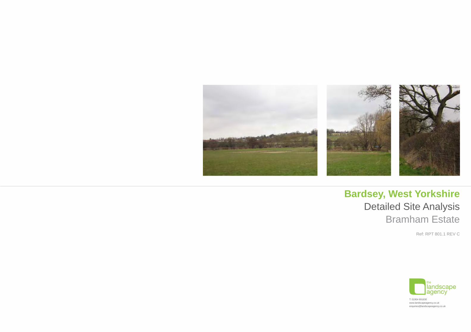
Bardsey, West YorkshireDetailed Site Analysis
Bramham EstateRef: RPT 801.1 REV C

Rev Date Description Initials Checked\ Mar 2013 Document issued to the Bramham Estate and design team for comment EH AR
A Mar 2013 Document revised following feedback from the design team. EH AR
B April 2013 Document revised following feedback from the design team for presentation to the Bardsey Neighbourhood Plan Steering Group. EH AR
C July 2013 Document revised to include Zoning Plan following workshop with the Prince’s Foundation and a consolidated zoning plan following further detailed analysis
of access and flood risk
EH AR
REVISION HISTORY
CONTENTS1.0 INTRODUCTION
2.0 DETAILED ANALYSIS 2.1 CONNECTIVITY & MOVEMENT
2.2 ACCESS
2.3 EXISTING LAND USE
2.4 VIEWS & RECEPTORS
2.5 FLOODING & DRAINAGE
2.6 VITALITY ANALYSIS
2.7 SUMMARY SITE OPPORTUNITIES
2.8 SUMMARY SITE CONSTRAINTS
3.0 DESIGN DEVELOPMENT3.1 INITIAL ZONING PLAN
3.2 PRINCE’S FOUNDATION WORKSHOP ZONING PLAN
3.3 CONSOLIDATED ZONING PLAN
4.0 ASSESSMENT AGAINST GREEN BELT PURPOSES
5.0 CONCLUSIONS
Bardsey Site Analysis
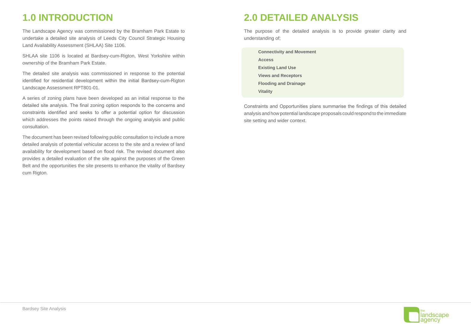
The purpose of the detailed analysis is to provide greater clarity and understanding of;
Connectivity and Movement
Access
Existing Land Use
Views and Receptors
Flooding and Drainage
Vitality
Constraints and Opportunities plans summarise the findings of this detailed analysis and how potential landscape proposals could respond to the immediate site setting and wider context.
The Landscape Agency was commissioned by the Bramham Park Estate to undertake a detailed site analysis of Leeds City Council Strategic Housing Land Availability Assessment (SHLAA) Site 1106.
SHLAA site 1106 is located at Bardsey-cum-Rigton, West Yorkshire within ownership of the Bramham Park Estate.
The detailed site analysis was commissioned in response to the potential identified for residential development within the initial Bardsey-cum-Rigton Landscape Assessment RPT801-01.
A series of zoning plans have been developed as an initial response to the detailed site analysis. The final zoning option responds to the concerns and constraints identified and seeks to offer a potential option for discussion which addresses the points raised through the ongoing analysis and public consultation.
The document has been revised following public consultation to include a more detailed analysis of potential vehicular access to the site and a review of land availability for development based on flood risk. The revised document also provides a detailed evaluation of the site against the purposes of the Green Belt and the opportunities the site presents to enhance the vitality of Bardsey cum Rigton.
1.0 INTRODUCTION 2.0 DETAILED ANALYSIS

Bardsey Site Analysis
▲ Vehicular access from The Drive ▲ View of the entrance from the A58 ▲ Informal access
Existing bus route and bus stop
Existing trunk road - Heavily used
Existing minor road - Reasonably broad, residential in character
Possible future cycle route
Garden gates onto site - Informal permissive access from adjacent residential properties
Vehicular access -
The Drive - Steep access, purpose built track
A58 - Agricultural entrance at road grade
Distance to Rail Station 9.8km
Distance to bus stop 280m
Please refer to the ‘Bardsey-cum-Rigton Landscape Assessment RPT801-01’ for detailed locations of PROW within proximity to the site.
12
2.1 CONNECTIVITY & MOVEMENT
1
2

Bardsey Site Analysis
2.2 ACCESSThe site has been reviewed by an engineering consultant and an illustrative access layout has been prepared.
This shows a priority ‘ghost island’ arrangement onto the trunk road A58 and indicates that there are no technical highway reasons why an acceptable access cannot be attained to the site.
There is also potential to provide two access points from the A58, subject to more detailed design development.
Access to the site from The Drive is proposed as emergency access only, to ensure there is no increase in the volume of traffic through this existing residential area.
▲ Illustrative highway alterations providing access to the site from the A58

Bardsey Site Analysis
▲ Agricultural land north of the A58
Agricultural land
Significant Open Space (non-agricultural in use)
Residential
Woodland
River Corridor
Education
Village Hall
Place of Worship
Public House
Local shop/service
2.3 EXISTING LAND USE

Bardsey Site Analysis
▲ View north from the A58 across the site ▲ View south-west from the A58 across the site
Private Visual Receptors
North-east:
Generally larger properties set back from the site with long • gardens and mature, high boundaries restricting field views from the ground floor
High proportion of bungalow and dormer bungalow properties • with limited views of the site.
South-east:
Elevated properties with clear views of the site and significant • long framed views along the valley
South-west:
Predominantly semi-detached properties with a mix of restricted • and unrestricted views of the site
Boundaries tend to be low and visually permeable•
North-west:
Potential glimpse views of the site from East Keswick•
Key Views from Public Receptors
The key public receptor is the A58 Wetherby Road. There are long framed views in both directions along the valley.
Potential Development should consider the visual relationship • with the nearby East Keswick Conservation Area.
For a detailed visual analysis and locations of the Conservation • Area please refer to the ‘Bardsey-cum-Rigton Landscape Assessment RPT801-01’ carried out by The Landscape Agency in February 2013.
(Views assessed in Winter when the trees were bare and • therefore presents a ‘worst case scenario’ for visual impacts)
2.4 VIEWS & RECEPTORS
1
2
3
4
2
1
1 2
1
23
4

Bardsey Site Analysis
2.5 FLOODING & DRAINAGEThe plan below shows the area of flood risk as taken from the Environment Agency website (http://maps.environment-agency.gov.uk).
The western edge of the site is in Environment Agency Flood Zone 1 (Low Flood Risk), which means:
The location is in an area that is unlikely to flood except in extreme • conditions.
The chance of flooding each year is 0.5% (1 in 200) or less. This • takes into account the effect of any flood defences that may be in this area, whether or not these are currently illustrated on the Flood Map.
Further Detailed Flood Risk Assessment
Following concerns raised during public consultation, further detailed analysis of the flood risk has been carried out using the Environment Agency flood level data for the Keswick Beck overlaid onto a topographical survey of the site. This plan opposite shows;
Environment Agency approximate extent of a 1 in 100 year flood
Observed river level in 2000
This data has informed the extent of development shown in the consolidated zoning plan.
Extract of the Flood Risk map from the Evironment Agency website ▲
Flood level plan based on flood level data from the Environment Agency ▲

Bardsey Site Analysis
2.6 VITALITY ANALYSISThe Government’s National Planning Policy Framework (NPPF) states (in paragraph 55) that
housing in rural areas should be located where it can maintain or enhance the vitality of the
settlement. Vitality is often used in a planning context in relation to retail centres or high streets
and is used to describe a successful centre where people are pleased to be and which captures
sufficient footfall and spending to support a diverse range of shops, cafes, bars and community
facilities. In the rural housing context vitality is taken to mean the ability of a community to function
successfully as a “good place to live” for people of all ages and social economic characteristics. A
“vital” community will be diverse, happy and healthy. It will offer a range of local cultural and social
activities and, critically, will include a range of housing that meets the current and future housing
needs of a diverse community.
Our analysis is based on data from the 2011 Census, from an analysis of premises based on
Valuation Office data on business rates, and from a review of the Mosaic Micro Marketing data set
produced and updated by Experian Ltd (Note: Mosaic is a tool used by commercial interests to
understand their customers. It is based on analysis of a large collection of statistical data, much
from the National Census and consumer surveys and provides an in depth analysis of the socio-
economic characteristics and behaviour of local people).
Our analysis shows that the Barsdey cum Rigton Parish and wider Harewood Ward is relatively
affluent and whilst the local population includes many school aged children there are far fewer
young adults and far more people of pensionable age than the local authority average. The housing
stock in the Parish and Harewood Ward is dominated by detached houses. The proportion of semi-
detached houses, terraces, bungalows and flats is far lower than in the local authority area as a
whole. Over 80% of houses are owner occupied and there is a low incidence of housing stock
available in the private or social rented sector.
The data on household incomes shows that 52% of households have incomes between £20,000
and £70,000 whilst 23% of households have incomes greater than £70,000. There are low income
families in the community however, 20% of households have an income below £20,000. The
occupational characteristics of those in work is dominated by the managerial and professional
classes; 44% of those economically active in the Harewood Ward are classified as Managers,
Directors, Senior Officials or in Professional occupations. The Mosaic 12 Group data set classifies
58% of the parish within its “Professional Rewards” group and a further 29% in its “Alpha Territory”
group. These are the two most affluent and aspirational groups of the 12 Mosaic Groups.
The village benefits from:
A range of local community services including a primary school, shop, sports club and bowls •
club and village hall, and
A range of commercial services including public house, contractors, professional services etc, •
and
Is rich with a vibrant network of active local interest groups/societies.•
Additional services are available in East Keswick and Collingham, situated within two miles of the
proposed development site and are accessible via the regular bus services and good public roads.
Good employment opportunities are provided by local businesses and by the nearby employment
at sites such as Thorpe Arch Trading Estate and Bowcliffe Hall.
Analysis of the data on the population, its socio economic characteristics and the current housing
stock suggests that the Parish has several weaknesses that need to be addressed.
Bardsey cum Rigton is a popular place to live that attracts successful and competent people. The
impact that this has had on the housing market however means that it is not as diverse a community
as some in the local authority area. Bardsey cum Rigton offers limited opportunity for people in the
earlier part of their working lives and those with lower incomes to live in the parish.
Consequently, there is a very limited supply of housing suitable and affordable by young adults,
young families, families on lower incomes and older people looking to downsize into a home that will
support long term independent living. There is also a very limited supply of housing for rent, either
in the private or social rental sector. These gaps in housing supply will exacerbate the homogenous
nature of the community and over time will increasingly undermine its sustainability.
The development of the land west of First Avenue, Barsdey by the Bramham Park Estate provides
an opportunity to redress this balance through the creation of an integrated scheme of new housing
of a range of sizes, types and tenures. The Estate is able, and willing, to retain and rent some of
the housing on a long term basis. This will provide an excellent opportunity to increase the stock of
housing available to rent in the local area.

Bardsey Site Analysis
The emerging development proposals for the site have been directly influenced by this analysis
and will seek to provide:
Additional smaller housing for young people and families•
Lower cost housing available to buy and to rent•
Housing suitable to support long term independent living by senior members of the community•
Housing that will attract and deliver a high quality of life to people in the early and late stages •
of their working life.
This approach to the style and housing mix on the development will ensure that the new housing
provided will make a positive contribution and help to enhance the vitality of the community. It will
create opportunities for younger people from a wider range of backgrounds and socio-economic
characteristics and attract more families. The development will also give more people an opportunity
to have a stake in, and subsequently contribute to, the village and local area, its facilities, businesses
and services.
It is understood that the key findings from the very recent Parish Housing Needs Study concurs
with our research i.e. there is a requirement for smaller houses/bungalows for the young and
retired. We look forward to viewing that study when it is made available.
The development will also generate additional benefits in terms of new managed public open
space, new permissive paths and access to the rights of way network and the potential for a district
heating network utilising wood fuel from the Bramham Park Estate.
Bardsey Site Analysis
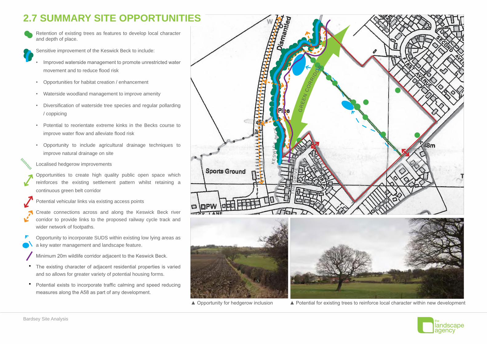
Retention of existing trees as features to develop local character and depth of place.
Sensitive improvement of the Keswick Beck to include:
Improved waterside management to promote unrestricted water •
movement and to reduce flood risk
Opportunities for habitat creation / enhancement•
Waterside woodland management to improve amenity•
Diversification of waterside tree species and regular pollarding •
/ coppicing
Potential to reorientate extreme kinks in the Becks course to •
improve water flow and alleviate flood risk
Opportunity to include agricultural drainage techniques to •
improve natural drainage on site
Localised hedgerow improvements
Opportunities to create high quality public open space which reinforces the existing settlement pattern whilst retaining a
continuous green belt corridor
Potential vehicular links via existing access points
Create connections across and along the Keswick Beck river corridor to provide links to the proposed railway cycle track and wider network of footpaths.
Opportunity to incorporate SUDS within existing low lying areas as a key water management and landscape feature.
Minimum 20m wildlife corridor adjacent to the Keswick Beck.
The existing character of adjacent residential properties is varied and so allows for greater variety of potential housing forms.
Potential exists to incorporate traffic calming and speed reducing measures along the A58 as part of any development.
KE
SW
ICK
BE
CK
TH
E D
RIV
E
▲ Opportunity for hedgerow inclusion ▲ Potential for existing trees to reinforce local character within new development
2.7 SUMMARY SITE OPPORTUNITIES
GR
EE
N C
OR
RID
OR
Bardsey Site Analysis
▲ Potential for existing trees to reinforce local character within new development
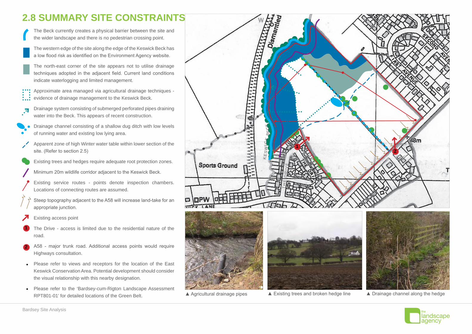
The Beck currently creates a physical barrier between the site and the wider landscape and there is no pedestrian crossing point.
The western edge of the site along the edge of the Keswick Beck has a low flood risk as identified on the Environment Agency website.
The north-east corner of the site appears not to utilise drainage techniques adopted in the adjacent field. Current land conditions indicate waterlogging and limited management.
Approximate area managed via agricultural drainage techniques - evidence of drainage management to the Keswick Beck.
Drainage system consisting of submerged perforated pipes draining water into the Beck. This appears of recent construction.
Drainage channel consisting of a shallow dug ditch with low levels of running water and existing low lying area.
Apparent zone of high Winter water table within lower section of the site. (Refer to section 2.5)
Existing trees and hedges require adequate root protection zones.
Minimum 20m wildlife corridor adjacent to the Keswick Beck.
Existing service routes - points denote inspection chambers. Locations of connecting routes are assumed.
Steep topography adjacent to the A58 will increase land-take for an appropriate junction.
Existing access point
The Drive - access is limited due to the residential nature of the road.
A58 - major trunk road. Additional access points would require Highways consultation.
Please refer to views and receptors for the location of the East Keswick Conservation Area. Potential development should consider the visual relationship with this nearby designation.
Please refer to the ‘Bardsey-cum-Rigton Landscape Assessment RPT801-01’ for detailed locations of the Green Belt.
KE
SW
ICK
BE
CK
TH
E D
RIV
E
12
▲ Agricultural drainage pipes ▲ Existing trees and broken hedge line ▲ Drainage channel along the hedge
2.8 SUMMARY SITE CONSTRAINTS
1
2

Bardsey Site Analysis
3.1 INITIAL ZONING PLAN
KESWICK BECK
2
5
1
3
3
3
2
4
8
7
6
7
KEYExisting & proposed trees reinforce character and frame viewsConceptual development blocks, green illustrates potential garden/open space
Village ponds fed by existing stream
Existing stream
Keswick Beck
Proposed pedestrian routes
Proposed future cycle route
Key views
Keswick Beck crossing points
Village Green at the heart of the setting.
Existing stream & hedgerow is incorporated to provide a waterside pedestrian route.
Existing mature specimen trees retained to provide depth and character.
Proposed public open space adjacent to the Keswick Beck.
Green buffer adjacent to existing properties to protect views.
Minor access from The Drive to a small proposed residential area.
Pedestrian & cycle links to the wider context and proposed cycle route.
Enhancement to existing Keswick Beck corridor with improved management & habitat creation.
8
7
6
4
3
2
1
5
N N N
N
Approximate extent of 1 in 100 year Flood Risk
Bardsey Site Analysis
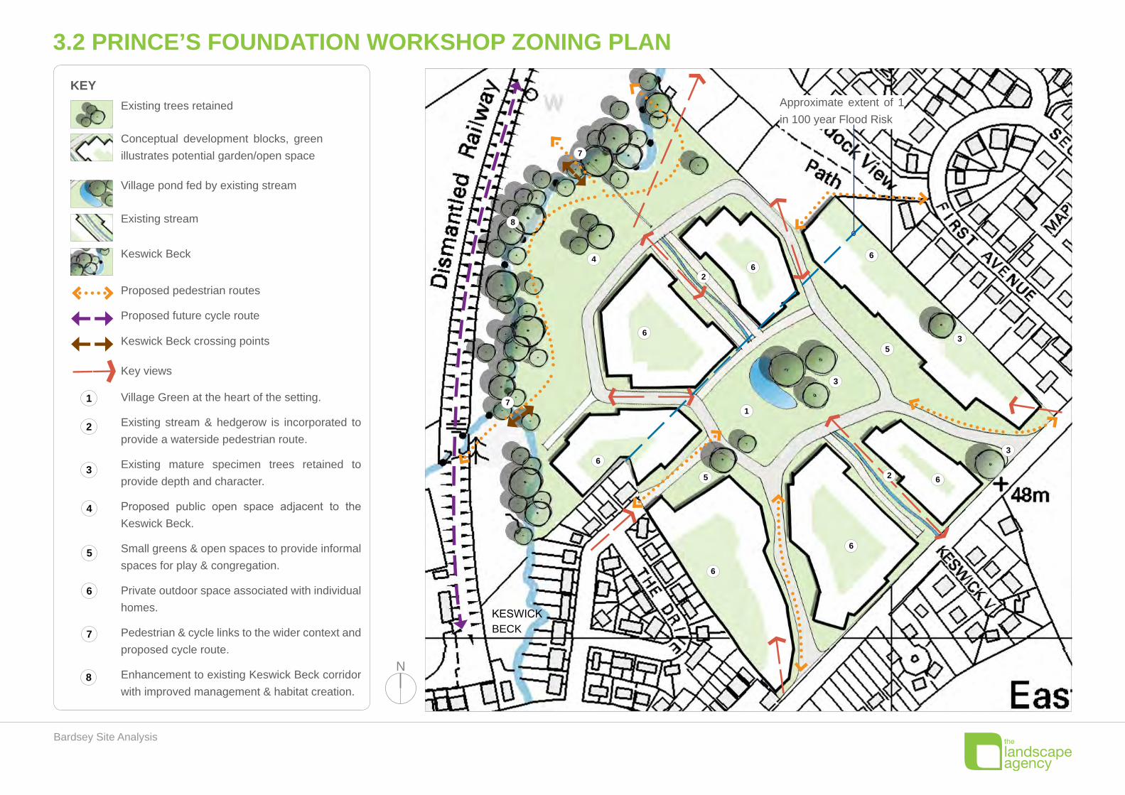
3.2 PRINCE’S FOUNDATION WORKSHOP ZONING PLAN
KESWICK BECK
6
6
625
1
3
35
3
66
2
6
4
8
7
6
7
N N N
N
KEYExisting trees retained
Conceptual development blocks, green illustrates potential garden/open space
Village pond fed by existing stream
Existing stream
Keswick Beck
Proposed pedestrian routes
Proposed future cycle route
Key views
Keswick Beck crossing points
Village Green at the heart of the setting.
Existing stream & hedgerow is incorporated to provide a waterside pedestrian route.
Existing mature specimen trees retained to provide depth and character.
Proposed public open space adjacent to the Keswick Beck.
Small greens & open spaces to provide informal spaces for play & congregation.
Private outdoor space associated with individual homes.
Pedestrian & cycle links to the wider context and proposed cycle route.
Enhancement to existing Keswick Beck corridor with improved management & habitat creation.
8
7
6
4
3
2
1
5
Approximate extent of 1 in 100 year Flood Risk

Bardsey Site Analysis
KESWICK BECK
6
6
6
2
5
1
3
3
5
3
6
6
2
6
4
8
7
6
7
N N N
N
KEYExisting trees retained
Conceptual development blocks, green illustrates potential garden/open space
Village pond fed by existing stream
Existing stream
Keswick Beck
Proposed pedestrian routes
Proposed future cycle route
Key views
Keswick Beck crossing points
Village Green at the heart of the setting.
Existing stream & hedgerow is incorporated to provide a waterside pedestrian route.
Existing mature specimen trees retained to provide depth and character.
Proposed public open space adjacent to the Keswick Beck.
Small greens & open spaces to provide informal spaces for play & congregation.
Private outdoor space associated with individual homes.
Pedestrian & cycle links to the wider context and proposed cycle route.
Enhancement to existing Keswick Beck corridor with improved management & habitat creation.
8
7
6
4
3
2
1
5
Approximate extent of 1 in 100 year Flood Risk
6
3.3 CONSOLIDATED ZONING PLAN
Bardsey Site Analysis
4.0 ASSESSMENT AGAINST GREEN BELT PURPOSESThe assessment below is based on the Green Belt purposes as set out in the National Planning
Policy Framework and used by Leeds City Council (CC) in the Green Belt Review process.
1. Check the unrestricted sprawl of large built up areas
Development of the site would not lead to ribbon development. The site is bounded on three •
sides by existing residential development. Development of the site could not therefore result in
isolated development.
Leeds CC concur that development of the site would result in effectively rounding off the existing •
settlement pattern. The existing built pattern is very ad hoc and does not constitute good land
use planning.
The contained site would not therefore lead to unrestricted sprawl of the built up area and Leeds •
CC concur with that assessment.
2. Prevent neighbouring towns from merging
The Leeds CC assessment is clear in stating that development of the site will not lead to the •
merging of settlements.
The layout strengthens the existing boundary with the Keswick Beck and disused railway line •
by creating a wide area of open space along this boundary to help contain development and
prevent future sprawl.
The layout would consolidate the existing settlement of Bardsey which is split into two halves •
(Bardsey and Bardsey Village).
3. Assist in safeguarding the countryside from encroachment
The Leeds CC conclusion is that this site does not perform an important role in safeguarding •
the countryside from encroachment.
The layout creates new open space with public footpaths and the potential to link these with a •
future route along the disused railway line. This would increase the value of the site in relation
to the Green Belt purposes and the development would perform a role in providing access to
the countryside.
The enhanced defensible boundary between the site and the Keswick Beck would increase the •
value of the site in safeguarding the countryside from encroachment.
The proposed tree planting and management of the river corridor would enhance the biodiversity •
and nature conservation value of the site.
4. Preserve the setting and special character of historic towns
The Leeds CC assessment provides no evidence to support its assessment of harm to the •
‘setting and special character of historic towns’. The accompanying Landscape Assessment and
this document provide for very detailed assessment of: landscape character, visual relationship
of the site with its wider setting, and the visibility of the site from key public receptors and
potential impacts.
The Landscape Assessment and this document confirm that the site will not cause adverse •
harm to the character or appearance of the setting of East Keswick, Bardsey or East Rigton.
The Leeds CC assessment does not qualify any potential unacceptable impact of residential •
development of the site on the setting of a listed building(s).
The enhanced landscape along the Keswick Beck will enhance the setting of the East Keswick •
Conservation Area to the north-west of the site. The Keswick Beck corridor is significant in scale
and provides a substantial visual buffer to East Keswick.
The proposed development continues the existing building line and when viewed from East •
Keswick will create a seamless consolidation of Bardsey.
Conclusion on Green Belt Assessment
The site therefore should be released from Green Belt designation on an exceptional basis to •
ensure the longer term vitality of the community is strategically secured through the release of
land for meeting identified housing need.
Development of the site would not lead to unrestricted sprawl or lead to the merging of •
settlements.
The site does not play an important role in safeguarding the countryside from encroachment •
and by careful and sensitive high quality design its development would not have a significant
effect on the setting and special character of acknowledged historic features.
The policy basis for the site’s Green Belt designations therefore falls. •
Bardsey Site Analysis
5.0 CONCLUSIONSThe Leeds CC assessment of the site (reference 1106) against the purposes of Green Belt is •
very cursory; it provides only limited evaluation of the character of the site and its relationship
to surrounding land and development.
This document and the accompanying Landscape Assessment provide for a very thorough •
character and impact assessment and concludes that by sensitive design, undertaken in
consultation with the community, there are the exceptional circumstances prevalent for altering
the Green Belt boundary in this location.
The subject site can make a significant contribution to meeting the long term development land •
supply needs in Barsdey cum Rigton Parish and the removal of this site from Green Belt would
be the least damaging of acknowledged local sites to the purposes and integrity of the Green
Belt.
It is clearly acknowledged in the Council’s own assessment that the site “would consolidate the •
existing settlement which is split into two halves (Bardsey and Bardsey Village).” The Council’s
own assessment, therefore, leads to a support to the conclusion for the release of the site from
the Green Belt designation.
The site will not cause adverse harm to the character or appearance of the setting of East •
Keswick, Bardsey or East Rigton.
The site has potential to enhance the vitality of Bardsey cum Rigton through the creation of an •
integrated scheme of new housing of a range of sizes, types and tenures and through significant
areas of new managed public open space.
Following review of the site by an engineering consultant, there are no technical highway •
reasons why an acceptable access(es) cannot be attained at the site.
Following public consultation and review of Environment Agency flood risk data, changes have •
been made to the extent of development to ensure the proposals do not increase flood risk.
The development area has been significantly reduced in scale following public consultation and •
can be phased and so would not adversely affect the existing character of Bardsey.
The consolidated zoning plan responds to all the concerns raised by the Leeds CC (and •
previously by the Parish) on its current consultation.