detailing the place - east cambridgeshire joint strategic masterplan 93-156.pdfdetailing the place...
TRANSCRIPT

9
Detailing the place
93

94

95
Detailing the place
North Ely is a development for the 21st Century, which
should deliver innovative, quality buildings and spaces.
Development Principles
■ Striving to meet the highest environmental standards
■ Reinforcing the special quality and character of Ely
through high quality design
Outcomes
■ Innovative, quality buildings and spaces at the
cutting edge of design, as well as respect for the
traditional urban form and character of Ely
■ Streets and public realm designed to create a
distinctive character for the community
■ Provision for different character areas within North
Ely
■ Retention of important views in and out of Ely and
creation of landmark features
■ Retention of Chettisham’s distinctive character and
separate identity.
Any new buildings and spaces will need to respect the
traditional urban form and character of Ely, and the sites
position on the edge of the built up area. To achieve this
design coding will promote the sensitive use of traditional
building materials in a contemporary manner.
Two streets will be critical in helping define the distinctive
character of North Ely - the existing Lynn Road and the
new tree lined ‘Highflyer Avenue’ (parts of which will be
designated as a Main Street where it coincides with the
Urban Village character area).
Appropriate set backs for development and avenues
of street trees will create a strong identity and green
character.
Creating Character
Development at North Ely should respond to the inherent
opportunities and constraints that the site presents.
Aspects such as the location within the site, views to the
Cathedral, accessibility of facilities, natural resources,
existing links, surrounding urban form, environmental
features and topography should form an integral part of
the masterplan development to maximise sustainability
and the identity of any proposed scheme.
The character of the development is described in terms of
‘neighbourhoods’ and a range of ‘character types’ within
these neighbourhoods.
These neighbourhoods and character types are
described in the latter part of this section, setting out
the key design principles for each neighbourhood within
North Ely, and the more detailed design objectives for
specific character types. Neighbourhoods and character
types are also identified on a series of illustrative plans.
It should be noted that whilst the neighbourhood areas
will be broadly reflected in outline applications, the
character types identified are for illustrative purposes
only and show how different parts of each neighbourhood
area could come forward at reserved matters stage.
Planning applications will need to demonstrate that
account has been taken of the design objectives of the
JSMP. At the grant of outline consent, design codes will
be required by condition and will be submitted prior to
determination of reserved matters applications.
Neighbourhoods
Each neighbourhood is spatial in nature and forms a
specific response to the site and existing features. North
Ely breaks up into a number of different neighbourhoods,
with the Lynn Road Local Centre forming the centrepiece
of the scheme.
The JSMP identifies the following neighbourhoods for
North Ely:
■ Lynn Road Local Centre
■ South West
■ West
■ North West
■ Highflyer Green
■ Highflyer Hall
■ Highflyer Orchards
■ Chettisham Business Park
■ Country Park

96
Character Types
Character areas allow the individual parts of the
development to be treated in a specific way and with
appropriate design parameters. The formulation of
character areas have been informed by traditional
development patterns of Ely, while incorporating
sustainable design and contemporary development
principles.
The JSMP identifies the following character types for
North Ely:
■ Urban village
■ Suburbia
■ Green living
■ Arcadia
■ Local centre
Overarching Design Principles
High Quality Design
The quality of North Ely will impact on all aspects of life
for its residents. How well it is designed will influence
how safe people feel, how easy it is to walk around,
whether they have shops, community facilities and
schools nearby and whether their children have safe
places to play. It will also affect whether there is good
access to public transport and a good choice of homes in
which to live.
North Ely must embody the principles of good urban
design.
Design quality is about more than appearance; it is a
combination of functionality (how well the development
achieves its purpose); impact (how well it creates a
sense of place); and build quality.
Understanding Design Scale
The important aspects of design are considered at
different scales – gradually focusing in from the overall
environment and surrounding area (the context of the
site), its setting and public realm, the building scale, and
finally the small details.
National Best Practice
The District Council’s vision for North Ely is for an
exemplar development of a quality that would be easily
recognised and that stands comparison with Ely’s
heritage. The District Council invites developers to strive
for award winning quality in design.
A comprehensive approach is required to achieve this
vision. This framework sets out the overall development
outcomes for North Ely. It will be completed by detailed
masterplanning to inform individual applications. Design
codes will be used at the reserved matters stage to guide
detailed design.
The District Council has adopted the Cambridgeshire
Quality Charter for Growth. This outlines 4 key principles:
community, connectivity, climate, and character.
These principles have guided the preparation of a
design guide for East Cambridgeshire. The Council will
use these documents in addition to this development
framework when assessing the quality of development
proposals.
The Council will also encourage the submission of draft
proposals to the Cambridgeshire Quality Panel.
Important Views
The City of Ely is visible over significant distances
due to its position on an island within a fen landscape.
The distinctive silhouette of the Cathedral stands out
on the skyline, with its single tower at the west end
and octagonal lantern to the east. There are other
distinguishing landmarks in Ely such as the water towers
and St Mary’s Church but without question it is the
Cathedral that dominates views.
The layout of Highflyer Avenue and other key streets and
the open spaces network, as proposed in this document,
will provide good visual links from North Ely to the
Cathedral and the surrounding fen landscape – it will be
important to maintain a visual connection with Ely’s rural
context.
The development framework also protects the
quintessential views identified by the Ely Environmental
Capacity Study (2001).

97
Detailing the place
Landmarks and Legibility
Clear landmarks and distinct features contribute to the
image and identity of a place, and help people identify
and remember different areas and thereby orientate
themselves.
Local landmarks can comprise key feature buildings,
spaces, mature trees, and public works of art placed at
points in the development. They should be located to
emphasise key vistas, or the termination of a view, or as
a focus to the area.
A landmark could be not only a distinctive building, group
or series of buildings but a taller one, designed to be
seen over a wider area (e.g. a church spire).
This development framework supports the provision of
new landmarks. The detailed masterplan prepared as
development goes forward will identify positions and
types of local landmarks. A public art strategy will also be
required at this stage.
Tree lined streets/ public realm
The quality of the public realm will play an important role
in defining the character of North Ely. This will include
street tree planting and open spaces/ squares on the key
streets within the development.
The design framework proposes a number of locations for
open spaces and squares. These provide opportunities
for social interaction. The best public spaces have areas
of activity complemented by quiet zones for people
watching.
What is urban design?
“the art of shaping the interaction between, people and
places, environment and urban form, and nature and
built fabric, and influencing the processes which lead to
successful villages, towns and cities.”
Source: Kevin Campbell & Robert Cowan in Planning
(Feb 1999)

98
Neighbourhoods
The term ‘neighbourhood’ describes diverse areas within
North Ely, mainly defined by the facilities and location
within the site. Each neighbourhood will feature a variety
of character types, describing streets and housing, and
overlaid with the unique features make an area a distinct
unit with its unique identity.
The following section lists the characteristics of each
neighbourhood with regard to character types, public
open space, facilities and special features. Definitions of
these key terms are provided in Table 9.1 below.
A plan of the proposed neighbourhoods is provide
overleaf.
Characteristic Defining elements
Character Types
Description of which character types are included in this neighbourhood,
giving an indication of the variety of a neighbourhood
Public open space
Location and character of open space and how dwellings front onto the
space; accessibility of open spaces
Facilities
Location and nature of central facilities within the neighbourhood
Special features
Taking the opportunity to retain, reveal, conserve or create non-development
features, and to link development to its landscape context by enabling or
focusing views in and out of the site; particularly relevant on edges, the main
street and open spaces throughout the development
Table 9.1: Neighbourhood Areas Terminology

99

100
NORTH WEST
LO
WEST
SOUTH WEST

Detailing the place
CHETTISHAM
BUSINESS
PARK
HIGHFLY
ER
ORCHAR
DS
HIGHFLY
ER HALL
COUNTR
Y PARK
CAL CENTRE
HIGHFLYER GREEN
Neighbourhoods

101

NORT
H
WEST
Playing L
Fields
LOC
WEST CEN
Allotments
Park
Allotments
SOUT
H
WEST
Work
Hub
School
LOCAL
CENTR
E
CAM
DRIVE

102

Detailing the place
CHETTISHAM
BUSINESS
PARK Allotment/
orchard
Country Park -
productive
HIGHFLY
ER
ORCHAR
DS
Park
HIGHFLY
ER HALL
Country Park -
fenland habitat
OCAL CENTRE
AL School
TRE
Playing
Fields
COUNTR
Y PARK
HIGHFLYER GREEN
Place of
worship/
community
hall
Country
Park - urban
Neighbourhoods

103


104
South
Characteristic – South Defining elements
Character Types ■ Neighbourhood Centre
■ Urban Village
■ Suburbia
■ Green Living
Public Open Space ■ Main parks
■ Main civic space
■ Green corridors with foot and cycle paths, coinciding with drainage
■ Green corridors along all southern edges with play and informal recreation as
well as access function
■ Green edges to A10
■ Main street with wide streetscape that allows for all modes of travel and equal
importance to ‘link’ and ‘place’ functions
Facilities ■ Local centre uses
■ School
■ Work hub/community facility
■ Potential for micro library within the work hub
■ Urban park
Special Features ■ Views to Ely Cathedral from the southeastern parts of the site
■ Continuous frontages
■ Retain existing trees and drainage pattern
■ Urban frontage onto prominent green areas
■ Strong space defining architecture
■ Retain existing trees and drainage pattern
■ Urban frontage onto prominent green areas
Park
Allotments
Work
Hub
School
LOCAL
CENTR
E
CAM DRIVE
105
Detailing the place
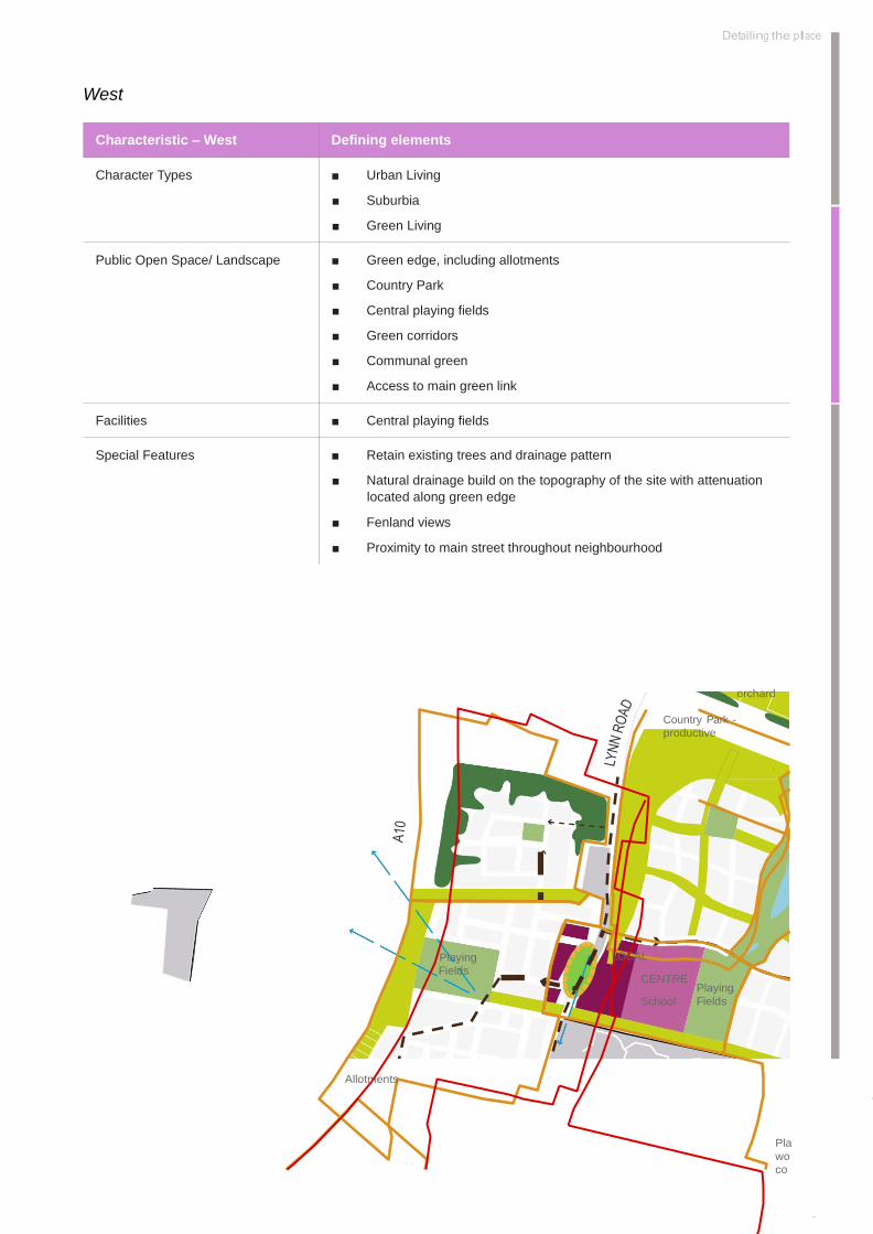
West
Characteristic – West Defining elements
Character Types ■ Urban Living
■ Suburbia
■ Green Living
Public Open Space/ Landscape ■ Green edge, including allotments
■ Country Park
■ Central playing fields
■ Green corridors
■ Communal green
■ Access to main green link
Facilities ■ Central playing fields
Special Features ■ Retain existing trees and drainage pattern
■ Natural drainage build on the topography of the site with attenuation
located along green edge
■ Fenland views
■ Proximity to main street throughout neighbourhood
orchard
Country Park -
productive
Playing
Fields
LOCAL
CENTRE
School
Playing
Fields
Allotments
Pla
wo
co

106
North
Characteristic - North Defining elements
Character Types ■ Arcadia
■ Large plots to facilitate rural lifestyle
Public Open Space/ Landscape ■ Village character
■ Village green in the centre
■ Plot based rural land uses such as horticulture and equestrian
■ Direct access to Country Park and nature reserve
■ Strong separation through wooded landscape
Special Features ■ Tree belt along northern boundary retained and strengthened to retain
Chettisham’s character as a distinct settlement
■ Increased tree cover and strong boundary vegetation to strengthen
countryside character
■ Distance retained to Lynn Road and to existing farm on Lynn Road
■ Retained hedgerow and ditch as division between fenland and
settlement
Allotment/
orchard
Country Park -
productive
Park
Playing
Fields
LOCAL
CENTRE
School
Playing
Fields

107
Detailing the place
Lynn Road Local Centre
Characteristic – Neighbourhood Centre Defining elements
Character Types ■ Local centre
■ Urban Village
■ Suburbia
Public Open Space/ Landscape ■ Main civic square that integrates traffic flows as well as
pedestrian/ cycle movement and social activities
■ Wider pavements in front of shops along the main street
■ Foot and cycle paths throughout green corridors
■ Access to main green link
Facilities ■ Local centre uses
■ School
■ Playing fields
■ Care home
■ Potential for health facilities, such as doctors and pharmacy
Special Features ■ Views to Ely Cathedral from Lynn Road
■ Gateway into Ely from Chettisham
■ Strong space defining architecture
Park
Playing
Fields
LOCAL
CENTRE
School
Playing
Fields
Allotments Coun
Park -
Park
Place of
worship/
community
hall
School

108
Highflyer Orchards
Characteristic – CC North Defining elements
Character Types ■ Urban Village
■ Suburbia
■ Green Living
■ Arcadia
Public Open Space/ Landscape ■ Linear green infrastructure
■ Country Park with allotments/ productive landscape
■ Frontage onto main park along the eastern edge
■ Network of pedestrian and cycle linkages
■ SUDS integrated within green ways
■ Green buffer to Lynn Road
Facilities ■ Largely residential in nature
Special Features ■ Central neighbourhood green
Allotment/
orchard
Country Park -
productive
Park
Country Park -
fenland habitat
Playing
Fields
LOCAL
CENTRE
School

109
Playing

110
Detailing the place
Highflyer Hall
Characteristic – CC East Defining elements
Character Types ■ Urban Village
■ Suburbia
■ Green Living
■ Arcadia
Public Open Space/ Landscape ■ Linear green infrastructure
■ Country Park with fenland habitat
■ Frontage onto main park along the western edge
■ Network of pedestrian and cycle linkages
■ SUDS integrated within green ways
Facilities ■ Largely residential in nature
Special Features ■ Central neighbourhood green
■ Protecting the setting of Highflyer Hall
Allotment/
orchard
Country Park -
productive
Park
Country Park -
fenland habitat
LOCAL CENTRE
School Playing
Fields
Country
Park - urban
Place of
worship/


110
Highflyer Green
Characteristic – CC South Defining elements
Character Types ■ Urban Village
■ Suburbia
■ Green Living
Public Open Space/ Landscape ■ Urban village with church around central neighbourhood green
■ Country Park with formal landscaping
■ Allotments towards existing neighbourhood
■ Access to main green link
■ Network of pedestrian and cycle linkages
■ SUDS integrated within green ways
Facilities ■ Visitor car park on the edge of Country Park
■ Place of worship/community hall
Special Features ■ Cathedral views
Park
Country Park -
fenland habitat
LOCAL CENTRE
School Playing
Fields
Country
Park - urban
Place of
worship/
community
hall

111
Detailing the place
Country Park
Characteristic – CC East Defining elements
Public Open Space/ Landscape ■ Wetland
■ Wildflower grassland
■ Activity zones
■ Orchards and allotments
■ Rural Edge Frontage onto Country Park
■ Network of pedestrian and cycle linkages
■ SUDS system
Facilities ■ Potential visitor centre
■ Visitor car parking
■ Natural play area
Special Features ■ Lake
orchard
Country Park -
productive
Park
Country Park -
fenland habitat
LOCAL CENTRE
School Playing
Fields
Country
Park - urban
Place of
worship/
community
hall

112
Chettisham Business Park
Characteristic – CC South Defining elements
Character Types ■ Employment
Public Open Space/ Landscape ■ Formal landscaping around employment
■ Potential for allotments and/or orchards
■ Green buffer to Lynn Road
■ Access to Country Park
Facilities ■ Parking for business use/allotments
Special Features ■ ‘Green’ setting for business uses with views across Country
Park
Allotment/
orchard
Country Park -
productive
Park
Country Park -
fenland habitat
113

114
Character Types
The character types which are described on the following
pages will need to be defined in more detail following
further site analysis and baseline work and will be
developed further and fixed at the detailed stage of the
planning process.
It is expected that this detailed work will result in a more
finely grained pattern of character areas.
An illustrative plan of the proposed character types is
provide overleaf.
Descriptions of Character Types
The aim of developing character types is to create
diversity based on existing opportunities, making the
place more varied and appropriate. There is, however,
a set of objectives that applies to all character types of
North Ely, which is outlined below.
Overall objectives for the scheme:
■ Encourage active travel patterns though the
creation of walkable neighbourhoods
■ Link up existing and proposed movement corridors
to maximise permeability
■ Location of proposed land uses and new facilities
close to where the demand
■ Incorporate a variety of housing typologies and
sizes to cater for a variety of demographic groups
■ Easy access to variety of green spaces, which, in
return will influence the face of each character area
■ A legible structure of routes and spaces, which also
combines a richness of character and detail, based
on a response to the range of traditional urban
forms in and around Ely
Key Terminology
In describing the character areas, a range of terminology
is used in to define the key elements of the design and
explain how these elements exert influence on character.
The terminology is summarised in Table 9.2 below.
Characteristic Defining elements Influence on character
Land Uses
Mixed use
Single use
Time of use; levels of activity a land use generates;
compatibility with other uses and potentially required
interfaces between them
Development
Typologies
Housing typologies
Retail/ commercial typologies
Integration of different uses
Number of storeys
Frontages
Parking arrangements
Private open space
Scale and proportions of built development and how it is
serviced or accessed on its plot
Streetscape
Carriageway/ pavement
Front zones
Quality of materials
Soft or hard landscaping
Quality of vegetation
Quality of boundary treatments
Pedestrian footpaths
The degree to which the area is defined as urban,
suburban or rural, depending on the use of non-built
space either as streets and urban spaces (predominantly
hard-paved), or well vegetated and softer less-urban
environments
Densities
Number of dwellings per
hectare
Relation between dwelling number and plot size; relation
between dwelling size and size and use of private open
space; car parking arrangements; number of storeys
Table 9.2: Character Types Terminology

115

116
Neighbourhood spine
(Highflyer Avenue)
Urban village
Suburbia
Green living
Arcadia
Local centre
Employment area
Schools
Long views to Cathedral
Landmark opportunity
Views to country park and lake
S
This map is reproduced from OS material with the permission of OS
on behalf of the Controller of HM Stationery Office ©. Unauthorised
reproduction infringes Crown Copyright and may lead to prosecution.
Church Commissioners. Licence Number 100002215. 2006

117
The Framework at a glance
S
Character Types

118
Urban Village
The character types of urban village aims to create a
dense and urban development pattern that builds on
some of the historic streets southeast of the city centre.
Here, narrow and linear streets with semi-detached
and terraced dwellings of varying sizes create a small
scale settlement pattern with a distinct feel of a small
city, where live/ work units are mixed in to the largely
residential background to evoke a feeling of diversity.
The Urban Village character type will be areas of medium
to higher density, where a variety of dwellings sizes will
allow for a tighter urban character and efficient use of
land, where easy access to main parks and public civic
and green space complement smaller gardens.
Each Urban Village area will provide mixed use
development with homes, services and potentially live/
work units. The mix of dwelling types and land uses
enables a sustainable type of development that will offer
community facilities to new and existing neighbourhoods,
combined with excellent public transport.
Streets are laid out more formally with tree planting and
materials to emphasise the hierarchy.
Appropriate locations have been identified close to The
Avenue and its extensions towards Cam Drive, given the
proximity of these locations to strategic highways, public
transport routes and nodes within the urban pattern.
Illustrative Layout of Development Block as part of ‘Urban Village’

119
Detailing the place
Characteristic – Urban Village Defining elements
Land Uses
■ Residential
■ Community
■ Education facilities close by
■ Employment facilities close by
Development Typologies
■ Terraced dwellings
■ Semi-detached dwellings
■ Potential for some apartments above ground floor uses
■ Residents parking mainly on plot and away from street frontage
■ Visitor parking on street
■ Some parking on plot on ground floor level
■ 2-3 storeys
■ Rear gardens for dwellings and shared garden space or roof gardens
for apartments
Streetscape
■ Formal streets that are well-connected to the street network of Ely
■ Primary routes: Highflyer Avenue with tree planting, wider carriageway
and pavements, parking along some stretches
■ Secondary routes: smaller streets with carriageway and pavements;
formal tree planting
■ Tertiary routes: Narrow streets with mews dwellings and shared surface
principles; largely hard surfaced with small trees and planting in places
Densities
■ Medium to higher densities of up to 40dph
Special Features
■ Retain existing trees and drainage pattern
■ Urban frontage onto prominent green areas
Comparable neighbourhoods
■ Riverside area of Ely; areas of relatively lower density
■ Acordia, Cambridge; smaller scale parts of the neighbourhood; mews
and roof terraces

120
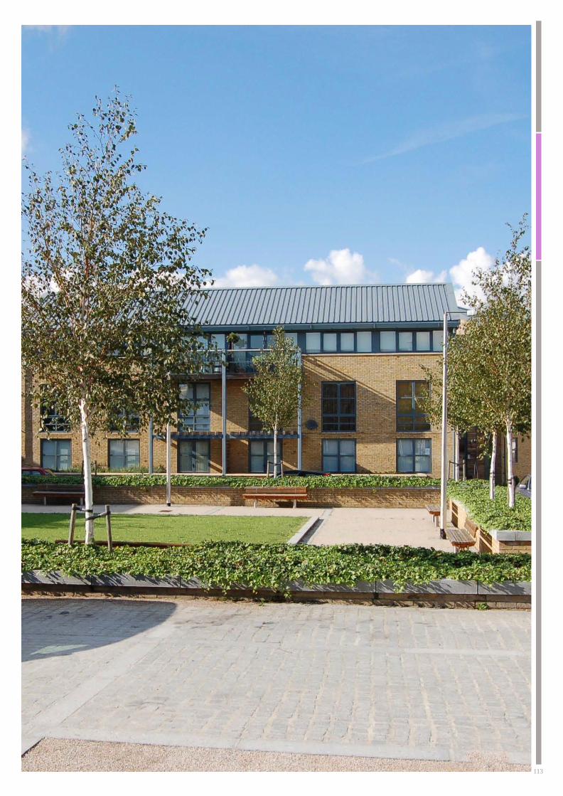
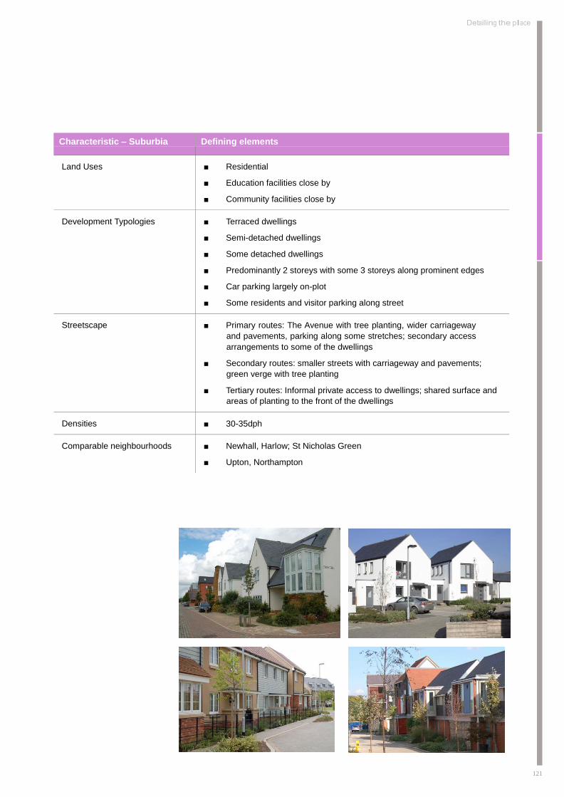
Suburbia
The character type of Suburbia will form the largest part
of the development with development patterns that cater
for families as parts of Ely around its edges already do.
Densities mean that generous gardens and streetscapes
will allow for a leafy atmosphere, while there is easy
access to parks, foot and cyclepaths. Streets are mostly
residential, with side streets creating a quiet living
environment.
The Suburbia character type is frequently located next
to the Urban Village character types, and is the interface
between the existing modern neighbourhoods of Ely
and the new development of North Ely. It also has a role
being located between other lower density character
types proposed towards the outer parts of North Ely
and the higher density Urban Village character type.
It will provide a suburban living environment that will
aim to achieve the best of this type and development
drawing elements from some of the favoured historic
and new suburban residential development in Ely,
Cambridgeshire, East Anglia and the UK.
The character type will need to provide for a range of
residents, with layout and land use ideal for families,
mixing well designed and adaptable family housing of
different types and sizes, with open space, safe streets
and routes to school and other community facilities. The
location of schools and central facilities in close proximity
to most of this character type will help to achieve this.
Illustrative Layout of Development Block as part of ‘Suburbia’
121
Detailing the place
Characteristic – Suburbia Defining elements
Land Uses
■ Residential
■ Education facilities close by
■ Community facilities close by
Development Typologies
■ Terraced dwellings
■ Semi-detached dwellings
■ Some detached dwellings
■ Predominantly 2 storeys with some 3 storeys along prominent edges
■ Car parking largely on-plot
■ Some residents and visitor parking along street
Streetscape
■ Primary routes: The Avenue with tree planting, wider carriageway
and pavements, parking along some stretches; secondary access
arrangements to some of the dwellings
■ Secondary routes: smaller streets with carriageway and pavements;
green verge with tree planting
■ Tertiary routes: Informal private access to dwellings; shared surface and
areas of planting to the front of the dwellings
Densities
■ 30-35dph
Comparable neighbourhoods
■ Newhall, Harlow; St Nicholas Green
■ Upton, Northampton
122
Green Living
The Green Living character type aims to provide an
alternative to people, who enjoy a more sustainable
and independent lifestyle, ranging from energy efficient
homes to growing food and being an active member of
the neighbourhood community. Individually designed
dwellings will be interspersed with others, with a treed
and vegetated environment providing the background.
Some of the green streets on the southern edge of Ely
already set a precedent with similar spatial qualities,
while modern and energy efficient ways of construction
will complement this.
The Green Living character type is located around the
peripheral areas of North Ely, focussing particularly
on the eastern and northern parts of North Ely and
some along the western edge. It will act as an interface
between the Arcadia and Suburbia.
The area will be characterised by a spacious suburban
environment with a strong character where trees and
hedges play an important role, together with gardens
and communal green areas. Some parts of the character
type focus around public open spaces, others are located
along the green edge of the development, where easy
access to green space has a significant impact on the
quality of the residential environment. A clear hierarchy
of street types is defined by their principle and detail
characteristics, varied by greens and street spaces,
street trees and termination of some street views with
green spaces or trees rather than buildings, giving the
term ‘green living’ a double meaning. Green spaces and
efficient buildings provide a living environment that allows
for sustainable methods of generating and consuming
energy and the recycling and disposing of waste.
The low to medium density allows for a range of dwelling
types that will be designed with high sustainability
credentials that can exploit the low to medium densities
proposed. Development is set in an easily permeable
loose and distorted grid of well-connected streets that
respond to the topography and solar orientation.
Pedestrian access
onto the East-West
Greenway
Community gardens; space enclosed by
hedgerows and owned and maintained by
local residents
On street
parking along
the green edge
Detached
dwellings create a
more permeable
frontages onto the
green edge
On plot parking
Corners defined by
detached dwellings with
positive frontages to two
sides
Detached dwellings
with integrated
garages
Frontages along
residential street
with semi-detached
dwellings
Illustrative Layout of Development Block as part of ‘Green Living’

123
Detailing the place
Characteristic – Green Living Defining elements
Land Uses
■ Residential
Development Typologies
■ Detached dwellings on medium plots
■ Semi-detached dwellings on medium plots
■ Predominantly two storeys
■ Allotments associated with individual dwellings
■ Communal green spaces
■ Provision for self build/ individually bespoke dwellings
■ Parking largely on plot; some parking along informal lanes
Streetscape
■ Primary routes: The Avenue with tree planting, wider carriageway
and pavements, parking along some stretches; secondary access
arrangements to some of the dwellings
■ Secondary routes: smaller streets with carriageway and narrow
pavements;
■ Tertiary routes: Informal private access to dwellings; shared surface
lanes
Densities
■ Low to medium densities of up to 30dph
Comparable neighbourhoods
■ Older houses along Witchford Road, Ely
■ Parkside, Upton, Northampton
■ Bed Zed
124
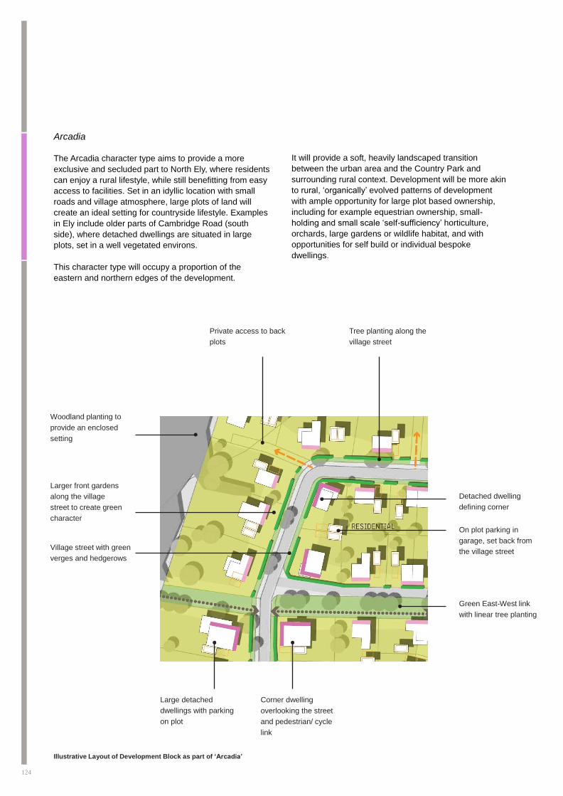
Arcadia
The Arcadia character type aims to provide a more
exclusive and secluded part to North Ely, where residents
can enjoy a rural lifestyle, while still benefitting from easy
access to facilities. Set in an idyllic location with small
roads and village atmosphere, large plots of land will
create an ideal setting for countryside lifestyle. Examples
in Ely include older parts of Cambridge Road (south
side), where detached dwellings are situated in large
plots, set in a well vegetated environs.
This character type will occupy a proportion of the
eastern and northern edges of the development.
It will provide a soft, heavily landscaped transition
between the urban area and the Country Park and
surrounding rural context. Development will be more akin
to rural, ‘organically’ evolved patterns of development
with ample opportunity for large plot based ownership,
including for example equestrian ownership, small-
holding and small scale ‘self-sufficiency’ horticulture,
orchards, large gardens or wildlife habitat, and with
opportunities for self build or individual bespoke
dwellings.
Private access to back
plots
Tree planting along the
village street
Woodland planting to
provide an enclosed
setting
Larger front gardens
along the village
street to create green
character
Village street with green
verges and hedgerows
Detached dwelling
defining corner
On plot parking in
garage, set back from
the village street
Green East-West link
with linear tree planting
Large detached
dwellings with parking
on plot
Corner dwelling
overlooking the street
and pedestrian/ cycle
link
Illustrative Layout of Development Block as part of ‘Arcadia’

125
Detailing the place
Characteristic - Arcadia
Defining elements
Land Uses
■ Residential with associated land uses
Development Typologies
■ Large detached dwellings
■ Some medium size detached dwellings in the core
■ Provision for self build/ individually bespoke dwellings
■ Residential parking on plot; visitor parking on –lane
■ Private gardens and additional land along edges
■ Predominantly two storeys
Streetscape
■ The character type is not served by primary routes
■ Secondary route: small village roads with green verges as main circulation
■ Tertiary route: lanes that respond to the topography and landscape/ field
cultivation pattern of the fen edge
■ Strong landscape structure with significant density of trees and hedgerows
■ Vegetation as boundary treatment
Densities
■ Up to 15dph
Comparable neighbourhoods
■ Older built structure with larger houses on the Cambridge Road, Ely, backing
onto the golf course

126
‘Local Centre’
The Local Centre character types form the densest
and most urban part of North Ely with the highest
levels of activity. Buildings with a variety of different
uses will ensure that North Ely will not just be a base
for commuters, but work as a part of town where
people want to live and work. Central areas around
Ely Cathedral already feature a similar character with
a small scale and plot based built structure with a mix
of residential, office and community uses and buildings
enclosing the street.
The Local Centre character type is focused in two
locations - at the Lynn Road junction and Cam Drive
junction. These areas will act as the focal point for
the local community with activity springing from
complementary small-scale retail, community and
adjacent education uses, which will serve the North Ely
community.
The areas will also include some residential elements.
This could be apartments above ground floor uses,
interspersed with residential units. Linked to the
neighbourhood centre character type and in a highly
accessible area, two primary schools will serve the local
community.
Indicative layouts of the two local centres are provided
overleaf, however, it should be noted that design work is
going and subject to further review.
Work hub with active
frontage to two sides
and parking to the side/
rear
Main street with avenue
tree planting and on
street parking
On street parking
Terraced dwellings
overlooking
pedestrian link/
parking to the front
Pedestrian link
from main street
to car park in the
back
Block of flats with
shared parking to the
rear
Terraced dwellings
with back gardens with
consistent frontage onto
the main street
Retail with
flats above
Block of flats
with shared
parking to the
rear
Potential location of
public house on
prominent corner plot,
visible from Cam Drive
Strong frontages onto
the main street and
Cam Drive Linear Park
Service
yard for
retail
Small food store
with strong corner
elevation
Main street, allowing
for pedestrian/ cycle
and vehicle movements
Illustrative Layout of Development Block as part of ‘Local Centre’

127
Detailing the place
Characteristic – Local
Centre Defining elements
Land Uses
■ Residential
■ Small scale retail
■ Offices
■ Care home (on the west side of Lynn Road)
■ Doctors/pharmacy (on the west side of Lynn Road)
■ Public houses (within both local centres)
■ Work hub (within the Cam Drive local centre)
■ Potential for work hub to support community functions such as a micro library
■ Education facilities close by
Development Typologies
■ Potentail for small terraced dwellings in mews
■ Potential for larger terraced town houses
■ Semi-detached dwellings
■ Potential for apartments above ground floor use
■ Small shop units on ground floor
■ Office
■ Residential : up to 2- 3 storeys
■ Mixed use: up to 3-4 storeys
Streetscape
■ Primary route: wider carriageway, parking, green strips, wider pavements and
boulevard tree planting; soft landscaped front zones in residential areas
■ Secondary streets: carriageway with medium pavements; some car parking
along street; tree planting; soft landscaped front zones
■ Tertiary streets: shared surface; smaller front zones in hard landscaping
Densities
■ Medium to higher densities of up to 40dph
Comparable neighbourhoods
■ St Mary’s Street, Ely for mixed use
■ Acordia, Cambridge; townhouses along the main street with high degree of
continuity and enclosure

128
1. Foodstore 7. Sports pitch available for community use
2. Small retail units 8. Bus stops
3. Public house/restaurant 9. Main greenway
4. Business units 10. Potentail future expansion of business units
5. Car parking
6. 2FE primary school and pre-school with space for
expansion to 3FE
Lynn Road Local Centre Illustrative Design - subject to further change
2
Lynn Road
Highflyer Avenue
3
13 8 1
5
11
12 6
2
4
2
10 5 7
9
1. Foodstore
2. Small retail units
3. Public house/restaurant
4. Business units
5. Car parking
6. 2FE primary school and pre-school with space for
expansion to 3FE
7. Sports pitch available for community use
8. Bus stop
9. Main greenway
10. Potential future expansion of business units
11. Pedestrian priority across Lynn Road
12. Public open space
13. Extra Care facility
Not to scale Not to scale

129
Detailing the place
Cam Drive Local Centre Illustrative Design - subject to further change
PRIMARY SCHOOL
RESIDENTIAL
WOR
K
HUB
RESIDENTIAL
RESIDENTIA
L
RESIDENTIAL
RESIDENTIAL
PUBLI
C CAR
PARK
SERVIC
E
YAR
D
RETAIL
PUBLIC
RESIDENTIA
L
SMAL
L
FOOD
STOR
E
PUBLIC
CAR
PARK
PUBLIC OPEN S ACE
SITE BOUNDARY LANDS FRONTAGE VIEWS
FROM CAM DRIVE TO CENTRE
Not to scale

130
Additional Areas
In addition to the character types described above, there
are other key areas within the framework plan, which
have to be designed carefully and to a more detailed
description. Particularly the design of the interface
between the character areas and these key areas will be
important and this section sets out the most important
principles.
School
The JSMP identifies two areas for primary schools, both
of them in accessible locations, close to the main street
and with connections to the pedestrian and cycle
network. Children will be able to walk and cycle to school
and the school will function as a social focus and thereby
adding vitality to the area.
The interface between the schools and development
should ideally fulfil the following design principles, which
should be established in dialogue with the County
Education appointed school design teams:
■ Frontage to the main street with prominent
entrance area to front onto the main street
■ Generally one storey with potential for two storeys
towards the main street
■ Pedestrian entrances into the school ground from
the main street and, at least, the ‘back’ of the
school, to encourage walking to school
■ Playing fields to be open to dual use by the local
community
■ Enclosure of school grounds to be kept as low key
and visually unobtrusive, made up by vegetation
where possible, to retain the notion that the school
is part of the community
Urban Parks
The JSMP identifies several urban parks within North Ely,
all of which are located in accessible locations. These
parks are in addition to the green corridors, green edges
and the extension to the Country Park that the new
development benefits from.
The interface between the parks and the surrounding
uses should fulfil the following design principles:
■ Where parks require enclosure, there should be
clearly identifiable entrance along the main street
■ Enclosure of the parks to be kept as low key and
visually unobtrusive, made up by vegetation where
possible
■ Where parks are located along the main street,
vegetation should help to provide a certain sense
of enclosure, without isolating parts of the park
from views
■ Smaller parks that are set within residential
squares should have open edges and should be
accessible from all directions

131
Detailing the place

132

10
summary of objectives
133

134
Creating a Green Structure
■ The masterplan will be framed by green infrastructure as a leading structuring element that helps to inform a strong
sense of Ely. The masterplan should demonstrate evidence of how green infrastructure has influenced the masterplan
in terms of layout, streets and public spaces. 30-40% of the site area should be allocated as multi functional green
infrastructure, as an integral part of the development.
■ The delivery of a high quality Country Park is central to the overall vision and must be seen as a key connecting thread
providing a multifunctional movement corridor fully connected into the development. In particular it will provide for a
gradual transition from the built up areas to the rural fen. The Country Park will change in character with a transition
from the south to the north with consideration given to the incorporation of a range of spaces including orchards,
paddocks and other ‘wild spaces’. A high quality visitor centre incorporating sustainable technologies and techniques
will be provided in close proximity so as to allow for community and educational use.
■ A long term future should be secured for the Country Park by building partnerships with local community groups and to
maximise community ownership/maintenance of the Country Park and visitor building.
■ Residential development along the edges of the development area will be designed to interface with the open
countryside in a traditional ‘Fen’ manner with evidence of ‘broken’ or intermittent edge treatment interspersed with
structural planting to create a soft, feathered edge to the built development. Overall, landscape will be more dominant
than built form at the edges.
■ Delivery of planting and landscaping will be an intrinsic element of the development, reflecting the green character of
existing development in Ely that provides an important visual setting and framework for the Cathedral, as well as
providing a physical and visual connectivity beyond the site across the surrounding fen. The provision of reasonable
sized gardens for the new dwellings will enable development of this ‘garden city’ concept and will be incorporated into
all of the residential character areas.
■ Key movement corridors will be emphasised and integrated through the use of green/wildlife corridors. The masterplan
should demonstrate how key routes have been enhanced, particularly, the links to the Leisure Village, country park,
hospital, Chettisham, and the green movement corridor to the town centre via the country park.
Building a balanced community - homes and community facilities
■ The masterplan will provide for a low /medium density development of up to 3,000 homes (final numbers will depend
upon the best solutions in terms of densities and built form) which provides for a balanced range of homes, community
facilities, employment, leisure and community services and facilities. Each phase of the development will be required
to reflect this balance.
■ Diversity of housing will be encouraged through, for example, provision of self build plots, provision of affordable
housing in clusters of 15 – 40 dwellings, live work homes, and provision for a retirement community. Similarly the
areas of mixed use development should focus on diversity and variety. A uniform and monotonous build form must be
avoided.
■ Community facilities will be expected to include a community centre, primary schools, youth facilities, play areas and
cemetery. The District Council is proposing the development of a leisure village to the south west of the site, and
footpath and cycle links should be incorporated into the development to provide easy access to this facility.

135
The Framework at a glance
Building a balanced community - local centres
■ The intersection of Lynn Road with Highflyer Avenue will be the focus for a mixed use local centre, providing key
facilities and day to day services for those living and working in North Ely. This area will provide a focal point for
activity within the community, and also presents an opportunity to establish a strong identity for North Ely. It should
complement rather than compete with Ely’s City Centre.
■ Similarly, the junction of Highflyer Avenue with Cam Drive provides another opportunity for a local centre, providing key
services and facilities.
■ The proposed layouts, loosely based on the model of the traditional fenland village High Street, will have mixed uses,
including a new primary school, grouped around and facing onto streets, community services and incorporating a high
quality public open space where local events, activities and community interaction can take place. Public transport
will be readily accessible, and discrete areas of public parking will be provided both on street and within development
blocks. Built form must be both robust and flexible in order to accommodate a variety of uses and be easily adaptable
to change and organic growth over time.
■ The local centres will provide a vibrant, active environment to encourage social interaction. It will create a sense of
place for passing traffic. Imaginative design of community buildings, open space, public art and landmark buildings
should be used to create a focus and sense of identity.
■ Subsidiary clusters of mixed use development can be located along Highflyer Avenue so that all parts of North Ely are
within 5 mins walk of a local centre or key facilities.
■ Overall, the density and built form profile should be maximised in these centres to provide interest and emphasise
public transport accessibility and other community or commercial functions. Typically, the density profile should be
reduced towards the edges to allow for a more organic built form.
■ Within these centres and along key routes the potential for a variety of ground floor uses is encouraged. Ground floor
uses along key routes should be designed to be flexible incorporating high floor to ceiling heights and by selecting a
construction technique that allows easy modifications to the layout.
Building a balanced community - diversity of local jobs
■ The North Ely development will be required to contribute towards the planned increase in the jobs density ratio in Ely
from the current 0.54 to the target 0.75 in order to provide a balanced sustainable community. The jobs target for the
new development will be between 1300 – 1500 new jobs by 2031 (an average of 0.6 jobs per dwelling).
■ The jobs target will not be delivered by the development of a single large employment hub or site within the
development. Instead, a more innovative approach to jobs delivery is sought. The development will be expected
to provide for pockets of high quality B1 light industrial/office uses across the overall development, potentially in
association with the neighbourhood and local centres or associated with attractive parkland settings with easy access
to childcare facilities. The green edge and Country Park could create jobs related to managing the land or associated
leisure facilities, and local commercial facilities and public services such as schools and shops will support further jobs.
Planning applications should make explicit how these jobs are to be delivered.
■ North Ely will also be expected to support the developing trend for home working, which has benefits in terms of
sustainable lifestyles and reducing traffic congestion. This will be achieved through the design and configuration of part
of the dwelling stock as live work homes, provision of the latest technology in broadband infrastructure, and provision
of opportunities for work hub buildings to offer communal business and working space for home workers and small
start up businesses

136
Setting the highest environmental standards
■ Innovative sustainable design technologies should be used for all types of buildings to develop the reputation of North
Ely as an ‘exemplar’ 21st century quality development, and reflect the reputation of Ely for excellent quality of life.
■ Design will provide for development to reflect high environmental standards. Homes will be delivered to reflect the
sustainable homes standards in force at the time of building and non-residential buildings will be expected to meet
the ‘very good’ and ‘excellent’ BREAM standards. The masterplan must also explore and build in options for waste
recycling, off site renewable and low carbon energy supplies, where feasible and viable.
■ The use of a range of Sustainable Urban Drainage techniques will be maximised and fully integrated into the street
layout so that it is: aesthetically pleasing; effectively manages water; accommodates and enhance biodiversity; and
provides amenity for local residents (ensuring a safe environment). These should be evidenced through the water,
biodiversity and creation of new habitats for wildlife strategies which should accompany planning applications for the
site.
■ Proposals for allotments will be made in order to promote local food production. These should be easily accessible for
residents, and can form attractive and interesting focal points within residential neighbourhoods.
■ Green space design and/or alternative technologies will be required to enable an effective buffer to noise/traffic
nuisance along the western edge of the development adjacent to the A10.
■ The use of innovative and sustainable building forms, including the use of self-build/custom build, will be embraced to
further enhance local distinctiveness and should be used to create interesting and varied edge forms and provide a
more organic interface with the countryside.
Making the Connections
■ A coherent urban design will be required for the whole site which prioritises movement on foot, cycle or by public
transport wherever possible.
■ A clear structure that provides legibility and connectivity through a movement framework with a hierarchy of routes
which distinguish between higher and lower order streets, and to facilitate easy walking and cycling within the
development and to the city centre. Visitors and residents will be able to find their way through North Ely effortlessly
through the use of landmarks, gateway features and high quality public realm that establish a sense of identity.
■ High quality public transport corridors will enable easy connections to destinations such as City Centre, Hospital,
Railway Station, new Leisure Centre, Country Park and Riverside area to priotitise a public transport orientated
development. A majority of the development will be within 400m (5 mins walk) of a bus stop.
■ A high quality cycle network will prioritise maximum use of this mode of transport. Segregated cycleways should be
able to be accomodated along primary connecting routes, and built form, lighting and landscaping designed to give
maximum surveillance along all footpaths and cycle routes. Safe, secure cycle parking will be provided at key
destinations and community facilities within the development.
■ The main spinal link road, Highflyer Avenue, connecting Thistle Corner to the A10 and Cam Drive, will act as an
integrator for the development and its design will be required to be co-ordinated across the site. The aim is to create
an attractive tree-lined avenue. In higher density areas this will generally be close to back of pavement to establish
prime frontages rich in architectural detail. In lower density areas this frontage can be less intensive. Green links that
cross the road along its route have visual and access priority over the primary road. These will act as traffic calming
measures with distinct changes in surface material.
■ Key connections into adjoining established residential areas will be identified, particularly around the hospital and
Defence estate to allow for future flexibility. Where practicable, meaningful connections should be realised in the form
of full adoptable streets to ensure the development feels part of North Ely.
137
The Framework at a glance
Detailing the Place - Reinforcing the special quality and character of Ely through high quality
design
■ Features of the existing character and urban form of Ely will be reflected in the structure and design of the new
development so that the new development seamlessly integrates into the existing city structure, rather than developing
as a separate and isolated city extension.
■ The styling of North Ely will embrace 21st century architecture. This will not only reflect its innovative nature in terms of
sustainability, creating a sense of place, but will also be a product of the incorporation of modern sustainable methods
of construction. Overall buildings should incorporate sufficient horizontal and vertical detailing to provide visual interest
that reflects their position within the development. Design codes will detail this style.
■ A range of reference points should be used to inform the built form and create a strong sense of Ely, including the local
Water Tower, existing water features, landscape topography, green corridors and views of the City Cathedral as well as
the fen landscape. Key nodes and corners should be identified and emphasised using high quality public space, public
art, or other interesting built form features. The important gateways from the A10, and at Thistle Corner should also be
emphasised using visually attractive building forms, and the gateway along Lynn Road from Littleport should be
designed to reflect the rural – urban transition.
■ A range of formal and informal views of the City Cathedral should be provided, including formal ‘vistas’ framed by
green movement corridors as well as more ‘glimpsed’ or unexpected views framed by finer grain development and/or
high quality public space.
■ Similarly the development should take advantage of the land form to maximise views out across the surrounding fen
landscape.
■ The masterplan identifies a range of neighbourhood and character areas to create a sense of place and neighbourhood
within the development. These character areas may be differentiated by density levels and green landscaping, focusing
higher densities of development (around 40dph) around local hubs, and lower densities of development (8-20 dph)
towards the outer edges of the development to promote a gradual transition from urban to rural.
■ The existing community of Chettisham must be integrated into the development in such a way that it is able to retain
its separate identity as a local rural hamlet within a green landscape. Similarly the existing Highflyer Hall should blend
into and help provide a sense of the site history within the overall development
■ Excessive areas of surface car parking must be avoided to minimise visual impact and improve the pedestrian
environment. In view of the importance of car ownership in this essentially rural area, residential on plot parking should
be the norm for the development.

138

11
implementation And Delivery
139

140

141
implementation And Delivery
Implementation & Delivery
This section sets out guidance for applicants regarding
the application process, design standards , strategic
phasing principles and the future management of the
North Ely development. The District Council will continue
to work with landowners and developers to ensure that
a coordinated and comprehensive approach is taken to
the development of the area . It is anticipated that
separate planning applications will be delivered for the
different areas of the site, but these should be in general
compliance with the principles of this overall development
framework document for North Ely.
Vision
High quality development that will be easily recognised,
that the residents of Ely can be proud of and that stands
comparison with the City’s existing heritage.
Outcomes
■ A planned approach to the delivery of
development, which complies with the North Ely
Development Framework proposals and principles
for the whole site.
■ Outline planning applications, supported by
strategic masterplanning, which demonstrate
how each planning application contributes to and
delivers the relevant aspects of the JSMP and
provide a clear basis for subsequent reserved
matters applications.
■ Appropriate provision for relevant infrastructure,
services and facilities, (e.g site wide transport,
green infrastructure and energy provision) to
support the new community created, as set out in
the SPD, and against which individual planning
applications can be assessed.
■ Appropriate contributions from developers towards
on and off site community facilities, services and
infrastructure developments that are essential
to serve this growth taking into account the
forthcoming Community Infrastructure Levy.
■ Viable development schemes where the mix of
uses, infrastructure delivery strategy, developer
contributions and phasing have been planned in
the most cost effective way.
■ Provision for future management and
maintenance of community facilities, public open
space, public realm and other infrastructure and
services in North Ely.
■ Provision for community engagement and
consultation.
Next Steps The JSMP is intended to be considered and potentially
be adopted as Council policy in late 2013. This will take
place alongside the District Council’s wider review of the
East Cambridgeshire Core Strategy (the Local Plan), a
draft of which was published in early 2013, with formal
approval of a new Local Plan expected in 2014.
Delivery Mechanisms – A Partnership
Approach
The District Council believes that successful delivery of
this site will be dependent upon appropriate co-operation
between the District Council, Cambridgeshire County
Council and the various landowners. Such co-operation
could also result in improved sustainability and potential
for economies of scale in the provision of infrastructure
and facilities.
In order to ensure delivery of all the infrastructure
requirements, which this development will require,
the District Council wishes to see individual planning
applications making an appropriate contribution to
infrastructure provision. Applications will set out how
each of the elements of the development, infrastructure,
services and facilities within the application site will be
brought forward at each phase.
It is recognised that the District Council will expect to
see evidence of joint working between the landowners
of the major North Ely sites in any individual planning
submissions, where appropriate. Specifically, the District
Council will expect the respective landowners to share
information and to demonstrate how infrastructure
provision will be delivered in a timely and effective
manner.
The District Council will set up a North Ely Delivery
Coordination Board to help facilitate the overall
development activity for the site, involving key
stakeholders for the site, including agencies such as
Cambridgeshire County Council, Anglian Water, the
Environment Agency and others as appropriate.

142
Development Management
It is recognised that planning applications for different
areas of the site will come forward separately according
to the different land ownerships either in whole or in part.
Pre-application discussions and Planning Performance
Agreements will be encouraged by the District Council to
guide discussions with applicants through both the pre-
application and application stages, and to encourage the
sharing of appropriate information and liaison between
the various parties through the promotion and build out of
development at North Ely.
The District Council will also encourage and place
weight on the continued use of the Cambridgeshire
Quality Review Panel throughout the plan development
and application process. This is an independent review
service through which peers can comment on major
development schemes.
Planning submissions should be supported in the
usual way by appropriate documentation, including,
for example: design and access statements, transport
assessments, environmental statements, flood risk
assessments and drainage strategies, sustainability
assessments, and waste/energy strategies. Applicants
will need to submit details of their infrastructure, facilities
and services proposals, demonstrating that they will
not prejudice the overall proposals and principles of the
JSMP.
In addition the following will be required:
■ At outline planning application stage – evidence
of strategic masterplanning which demonstrates
how the application contributes to and delivers
the key aspects of the JSMP, indicating the broad
location of land uses, primary roads, surface water
attenuation ponds, key footpath/cycle links, open
space, management proposals for public realm,
broad phasing and demonstrating how this fits
the North Ely SPD ; a series of parameter plans
which may cover land use, access and movement,
landscape and open space, maximum building
heights;
■ Design Evolution – following the approval of outline
applications it will be necessary for design codes
to be submitted (and approved) in accordance with
the principles set out in the outline planning
applications. These will secure high quality design
required in this historic city and will be required
by a condition of any outline permission, as
recommended by Atlas.
■ Reserved Matters Applications – demonstrating
compliance with the approved design codes. The
District Council will also require Building for Life
assessments to be completed at this stage. (www.
buildingsforlife.org)
The planning submission process is illustrated by the
diagram below and has been endorsed by ATLAS as an
appropriate approach.
Allocation supported by SPD
Outline Application including Design and Access Statement
Outline consent
Overall / area specific
design codes
Reserved matters for individual phases & compliance statement
143
implementation And Delivery
The Design and Access Statements submitted with
each outline planning application will provide indicative
information demonstrating how the quality of design
can be achieved through subsequent Design Codes
and Reserved Matters applications. Applicants will be
expected to demonstrate how they have incorporated
high standards of design throughout the design evolution
process and how these will be carried through to
completion.
Due to the size of the development area and type of
development proposed, the District Council considers
that Environmental Impact Assessments will be required
to support major applications. The District Council should
be approached for a Scoping Opinion at the outset of
each application which outlines the opinion of the local
authority and statutory / non-statutory bodies on the
approach and content of each EIA. The information
to be included in the EIA is provided in The Town and
Country Planning (Environmental Impact Assessment)
Regulations 2011 (EIA Regulations 2011) and cumulative
effects should be considered where appropriate.
In determining planning applications at North Ely there
will be, in part, a consistent approach to the formulation
of planning conditions and planning agreements in order
to achieve a common approach. That approach will
clearly need to be informed by site specific circumstances
and viability considerations of individual applications.
Phasing Strategy Principles
Currently the adopted Core Strategy (2009) makes
provision for 500 additional houses in North Ely. The
JSMP will accompany a review of the Core Strategy (the
East Cambridgeshire Local Plan), which is underway at
the time of writing, through which it is anticipated that
the site allocation for North Ely will be increased up to
approximately 3,000 dwellings, with provision for phased
development over the period to 2030.
Further research and testing is required to advise the
development of the detail of general phasing strategies
but the following principles are expected to be
demonstrated in applicants’ submissions and proposals:
■ A balance of provision between new housing,
employment, commercial and community facilities
to ensure that the new development is sustainable
and viable.
■ An appropriate mix of housing development within
each phase subject to market conditions
■ Delivery of a primary school facility and other
appropriate community facilities early in the first
development phase subject to viability, location and
infrastructure requirements
■ Appropriate phasing for the delivery of Highflyer
Avenue to avoid unacceptable traffic pressures
on Lynn Road/High Barns in the early stages of
the development. Appropriate phasing of public
transport, footpath/cycleway linkages to the rest
of Ely, including the City Centre, Station and
Lancaster Way, and innovative travel planning
measures to encourage new residents to adopt
more sustainable modes of transport proportionate
to the relevant level of housing.
■ Appropriate phasing of structural landscaping, tree
and shrub planting to enable the establishment of
green infrastructure.
■ Phasing of the development to take account of
the services, facilities and infrastructure available
on a city-wide basis and ensure that these have
the capacity to support the new levels of housing
proposed at each phase.
An indicative schedule of phasing and infrastructure
provision is provided overleaf, along with an indicative
phasing plan.
It should be noted that the schedule of phasing and
indicative phasing plan applies only to the
Commissioners proposals for land to the east of Lynn
Road. Endurance Estates are currently considering
phasing and delivery in further detail and will provide
further information to ECDC when available.

144
Approximate
Residential
Occupations 1
Transport
Contributions
(physical provision
delivered others)
Health
Contributions
(physical provision
by other)
Education -
Primary Provision
(provision by
others)
Community
Facility
200
400
Phase 1
600
800
*
*
*
*
*
*
*
*
*
*
*
*
*
*
*
*
*
*
* (to be
determined by
CCC)
*
(Community
hall)
* (subject to
need)
1000
Phase 2
1200
1400
Phase 3
1600
1800
North Ely - Indicative Phasing
Notes
1. Dwelling numbers beyond phase 1 are initial estimates only as detailed masterplanning of t
* Public transport improvements will be by way of ongoing contributions throughout the dev
** The need and timing of these potential improvements will be identified by future traffic m

145
Country Park
Extensions
Allotment
Provision
Sports Pitches Site Marketing Transport Infrastructure
Phase 1 (6.3ha)
Phase 2
Phase 3
Phase 1 (40
plots adjacent
to Watertower)
Phase 2
Phase 3
*
* (Downham
Road)
*
(local centre)
Employment land
Thistle corner 4th arm connection
Lynn Road - Prickwillow
connection
Introduction of orbital bus
service*
A10/Witchford Rd jctn
improvements**
A10 link/ junction**
The Framework at a glance
and Infrastructure Provision: Land East of Lynn Road
hese areas has not been undertaken
elopment and linked to the number of units until self-funding
odelling

146
To be updated - phasing plan for land to the
west of Lynn Road currently being prepared

147
implementation And Delivery
Phase 4
Phase 2
Phase 3
Phase 1
Phase 1
Indicative Phasing Plan

148
Developer Contributions
The Core Strategy establishes the requirement for
planning obligations relating to the phasing of
development and the provision of on-site and off -site
infrastructure and facilities, to include land, capital and
initial running costs (Policy S4 Developer Contributions).
Further details are set out in the Developer Contributions
and Planning Obligations SPD, approved February 2011.
This has partly been superseded by the introduction of a
CIL charging regime in the District.
Developers will be expected to make appropriate
contributions towards the cost of infrastructure and
community services and facilities where this is necessary
to make the development acceptable in planning terms
and complies with CIL Regulation 122 to address the
impacts of the site’s development on the local social,
economic and physical infrastructure apart from those
projects which will be directly funded by CIL.
Contributions may be required in one or more of four
ways:
■ Direct provision of essential, relevant and
necessary infrastructure and facilities by
developers, generally secured by S106 obligations
■ Provision of land for a specific community/specialist
use as agreed with individual developers where
there is a demonstrable need;
■ Payments to the Local Authorities in lieu
of provision of infrastructure through S106
agreements which may be pooled if appropriate
■ Payments via the Community Infrastructure Levy
(CIL).
Since early 2010, the District Council has been working
closely with Cambridgeshire Horizons, the County
Council and Huntingdonshire District Council as part of a
vanguard Community Infrastructure Levy (CIL)
Pilot Project and the CIL is now in place.
The likely range of infrastructure, services and facilities
that will need to be addressed is set out as follows.
However please note that this is intended as a
guideline only, and should not be regarded as binding
on any decision which the District Council may make
in respect of negotiations on contributions, nor is the
list comprehensive in terms of all the facilities and
infrastructure requirements which may apply.
Indicative list of items which may require developer
contributions, subject to viability:
■ On site highway infrastructure, pedestrian and
cycleway infrastructure, community transport, car
parks and travel planning and awareness raising
■ Proportionate off site highway infrastructure,
pedestrian and cycleway infrastructure where
required by modelling and impact assessments
■ Public transport provision linking directly from the
site – both bus and community transport
■ On site educational facilities, pre-school, primary
schools and potentially post-16 schooling,
encompassing capital, fitting and setting up costs
subject to CIL arrangements
■ Off -site educational facilities, including
combined, secondary and post-16 schooling and
encompassing capital, fitting and setting up costs
subject to CIL arrangements
■ Waste/recycling facilities
■ Country park facility, including both managed and
informal facilities
■ Utility services such as electricity, gas, water, foul
drainage, telecoms including broadband provision if
not provided by the developer
■ Up to 30% affordable housing where viable
■ Recreation and open space, including play
areas, playing fields, nature conservation, wildlife
mitigation measures, community woodlands,
allotments, meadows and paddocks
■ Community facilities including healthcare, micro-
library, meeting halls, community centres, childcare
facilities, youth activities, cultural services, and
emergency facilities
■ Public art
■ Long term management and maintenance of
selected facilities and infrastructure
■ Drainage and flood prevention The development of the whole of North Ely may require
strategic off-site highway improvements, such as A10
junctions for example. The need for such improvements
may arise as a result of cumulative impacts of the
wider development area and other growth in Ely. If such
improvements are required then an option is to fund
these through a simple ‘roof tax’ type arrangement
whereby each dwelling occupied (across the whole of
Ely) pays a sum to the Highway Authority which then

implementation And Delivery
implements the required works. The first phase of 500
dwellings east of Lynn Road would fall outside of such a
mechanism as that level of growth is already included in
the adopted East Cambridgeshire Core Strategy and has
been taken into account in the baseline traffic modelling
for all North Ely. As all Ely growth would be contributing
to such cumulative impacts it is vital that all dwellings
contribute such sums. An alternative approach would
be for the District Council to consider funding any such
works via CIL
Future Management and Maintenance
Consideration should be given at an early stage
to the future management arrangements for the
North Ely infrastructure and facilities. Long term
management arrangements will be crucial to the long
term sustainability of the new community. Planning
submissions will be required to provide details of the
proposed long term management and maintenance
delivery plans for the development. Long term
stewardship arrangements will be encouraged.
The management and maintenance of the various
facilities and land uses, particularly areas of open space,
woodland, community facilities and the country park will
require particular consideration.
It may be appropriate to consider community based
management solutions that allow residents / occupiers
to have a greater input into the long term stewardship of
the infrastructure, Country Park and community facilities.
Alternatively developers may wish to discuss what
arrangements can be made with the City of Ely Council
and other relevant local organisations to take over long
term responsibility for such areas. It is possible that the
District Council may wish to take over management of
significant assets.
149
